Mohammed Bila and Ahmed Sedick Lake Chad Basin Commission CBLT Si ége Rond Point de Grand Armees,...
18
Planning for the Lake Chad Basin Water Cycle Integrator 3 rd GEOSS African Water Cycle Coordination Initiative Mohammed Bila and Ahmed Sedick Lake Chad Basin Commission CBLT Siége Rond Point de Grand Armees, Ndjamena Republic of Chad [email protected]
-
Upload
vernon-phelps -
Category
Documents
-
view
226 -
download
0
Transcript of Mohammed Bila and Ahmed Sedick Lake Chad Basin Commission CBLT Si ége Rond Point de Grand Armees,...

Planning for the Lake Chad Basin Water Cycle Integrator
3rd GEOSS African Water Cycle Coordination Initiative
Mohammed Bila and Ahmed SedickLake Chad Basin Commission
CBLT Siége Rond Point de Grand Armees, Ndjamena Republic of [email protected]

Outline of Presentation Challenges and Resources Ongoing Plans and Programmes Needs

Hydrologic & Conventional Basin

Ecoregions of Active Watersheds
Eco-regions (14) of the Conventional Basin

Change in Climate Less Rainfall in the Active Watershed
Janu
ary
Febr
uary
March
April
MayJu
ne July
Augus
t
Sept
embe
r
Octob
er
Novem
ber
Decem
ber
0
50
100
150
200
250
300
Inter-Annual Average Monthly Rainfall at Sahr
Rainy Period (1950-1970) Arid Period (1971-2007)
March
April
MayJu
ne July
Augus
t
Sept
embe
r
Octob
er
Novem
ber
Decem
ber
020406080
100120140
Inter-Annual Average Monthly Rainfall at
Nguigmi
Rainy Period (1950-1970) Arid Period (1971-2007)

Change in Climate Temperature rise - an
increase of 0.7° C or 2.5% in the Sahelian Zone and an increase of 0.4° C or 1.4% in the Tropical Zone.
A decrease of 3% or 6.5% in relative humidity
Less Flow to the Lake Chad - 50% decrease since 1972
Localised periodic droughts in the Lake Chad Basin
Floods impacting cities and farmlands
Janu
ary
Febr
uary
March
April
MayJu
ne July
Augus
t
Sept
embe
r
Octob
er
Novem
ber
Decem
ber
0
500
1000
1500
2000
2500
3000
3500
Inter-Annual Monthly Av-erage Discharge at Ndja-
mena TP
Rainy Period (1934-1970) Arid Period (1971-2002)
Dis
charg
e (
m3/s
)

0
10
20
30
40
50km3
Rainfall
KYB
Chari-El Beid
Uses 2010
Mean inflow56-70 71-80 81-90 91-05
Mean inflow
Mean inflow
Mean inflow
Inflow
decrease
Total water uses
What are the max water abstractions for a limited impact
on lake levels?
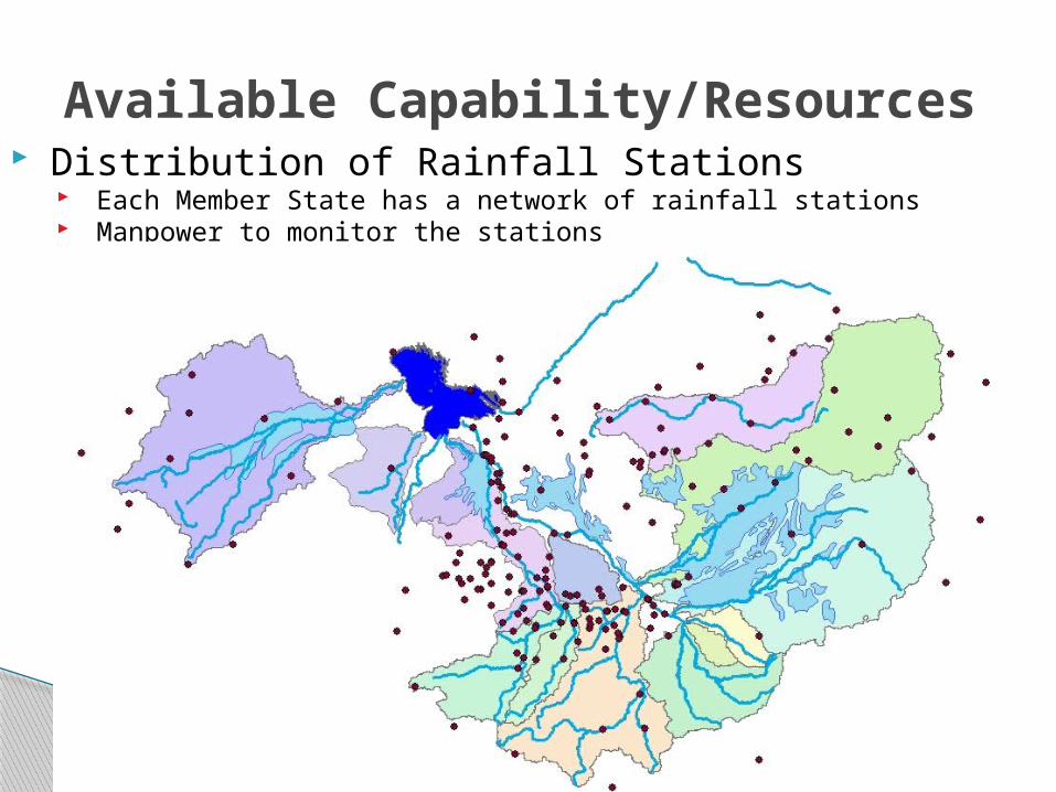
Available Capability/Resources Distribution of Rainfall Stations
Each Member State has a network of rainfall stations Manpower to monitor the stations

Available Capability/Resources Reference Discharge Stations
Eleven Selected Discharge stations with more than 50 years records Manpower to monitor the discharge stations

Programme & Plans to Address Impacts
Regional Strategic Action Programme & National Action Plans and an Investment Plan (IP) of the Lake Chad Basin (contains over 50 projects estimated to cost €107 million over the period 2012 – 2017).
Data Sharing Protocol agreed Lake Chad Basin Water Charter to
regulate water abstraction among users has been agreed.

Lake Chad Basin Water Charter Fundamental commitments of the
Water Charter;1. During low waters periods, reserve a minimum low
water flow for the tributaries flowing into Lake Chad2. During high water period, reserve a minimum
amount of flood waters to ensure that the basin's wetland areas are inundated
3. Restrict the proportion of abstractions from the inflow to the Lake Chad
4. Adapt groundwater abstraction to aquifer capacity
5. When necessary, create fishing reserves in part of Lake Chad and/or its tributaries.
6. Share data and ensure smoothly-run exchanges of information

LCBC Needs Formalising the generation and
exchange of information using GEO principles between Member States.
Data and models to enforce the Member States commitment to the Lake Chad Basin Water Charter
Data and information to monitor the implementation and progress of IWRM, actions and plans developed within the SAP framework.

Specific Needs Functions/Tools for Lake Chad WCI
◦ Observation network Initiate the adoption of new technologies in
water observation Build capacity by supporting the emergence
of new institutional structures and mechanism for basin-wide coordination
Select adequate number of reference in-situ rainfall stations for calibration (upgrade, operate and maintain by LCBC)
Identify/establish more discharge reference stations(establish/upgrade, operate and maintain by LCBC).

Specific Needs Data Access
Acquire regular water related EO products over the Conventional Basin of the LCBC
Acquire Numerical Weather Prediction, Reanalysis, and Climate Projection capacity
Models Develop rainfall-runoff model
Management systems Forecasting and Early Warning System at short
term and seasonal time frame Decision Support System for Water Resources
Development
Knowledge and data sharing portal

LCBC Collaborative Framework◦ The following Multi-Disciplinary Professional
Experts Committees are working with the LCBC to ensure collaboration by maintaining data quality, sharing data, information, exchanging ideas and experiences through regular meetings and publications. LCBC Technical Committee The Inter-Ministerial Technical Committees The Water Resources Expert Committee Committee on the Environment, Science and
Planning.

Implementation Proposal
Stakeholder Engagement◦ Identify and organise LCBC stakeholders,
develop common vision, Share objectives, collaborations, achievements and feasibility, Identify SBA
Establish a working group in the LCBC◦ Identify suitable demonstration
catchments◦ Identify and contact stakeholders in
the selected pilot catchments

Implementation Proposal Establish Lake Chad Basin Water Cycle Integrator Steering Committee comprising key stakeholders from pilot catchments◦ Support the implementation of pilot
WCI◦ Evaluate and disseminate result◦ Plan for basin wide expansion of the Lake
Chad WCI possibly with private sector involvement
Development of a regional based water management knowledge repository based on the output of the Lake Chad WCI.
Consisting of analysis, prediction, early warning, risk assessment and decision support

Thank you for the attention