Status of the CUAHSI Community Hydrologic Modeling Project ( CHyMP )
SUSTAINABLE, JUST & PRODUCTIVE
WATER RESOURCES DEVELOPMENT IN WESTERN NEPAL
UNDER CURRENT & FUTURE CONDITIONS
(DIGO JAL BIKAS – DJB)
Modeling Status UpdateReview of Data and Documents
Tuesday, 1ST August, 2017
Emily Pakhtigian—Duke University
2

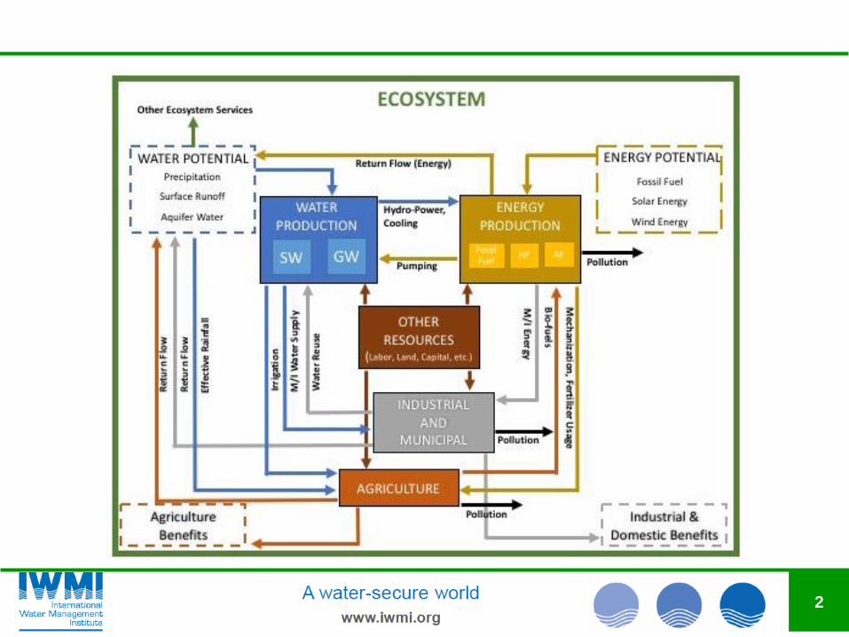
Data Sources: Groundwater and Inflows
Reassessment of the Groundwater Development Strategy
for Irrigation in the Terai (1994)
• Deep Tubewell Database
SWAT Modeling
3

Data Sources: Hydrological Modeling for Inflows
Basins Considered:
• Karnali-Mohana
• Mahakali
4
• Biophysical mapping
− Land use/cover
− Soil
− Topography
− Hydro-climatic
conditions
• Hydrological modelling
(SWAT)
− Karnali-Mohana
(49,889 km2; 6.9%
area in China)
− Mahakali (17,371 km2;
68% area in India)
• Water-infrastructures
− Hydropower projects
(150 nos; >0.5 MW)
− Irrigation Projects (57;
> 100 ha NCA)
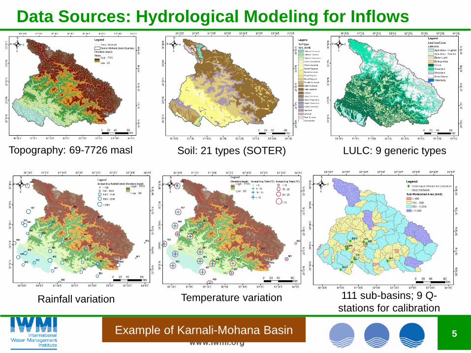
Data Sources: Hydrological Modeling for Inflows
5
Topography: 69-7726 masl Soil: 21 types (SOTER) LULC: 9 generic types
Rainfall variation Temperature variation 111 sub-basins; 9 Q-
stations for calibration
Example of Karnali-Mohana Basin
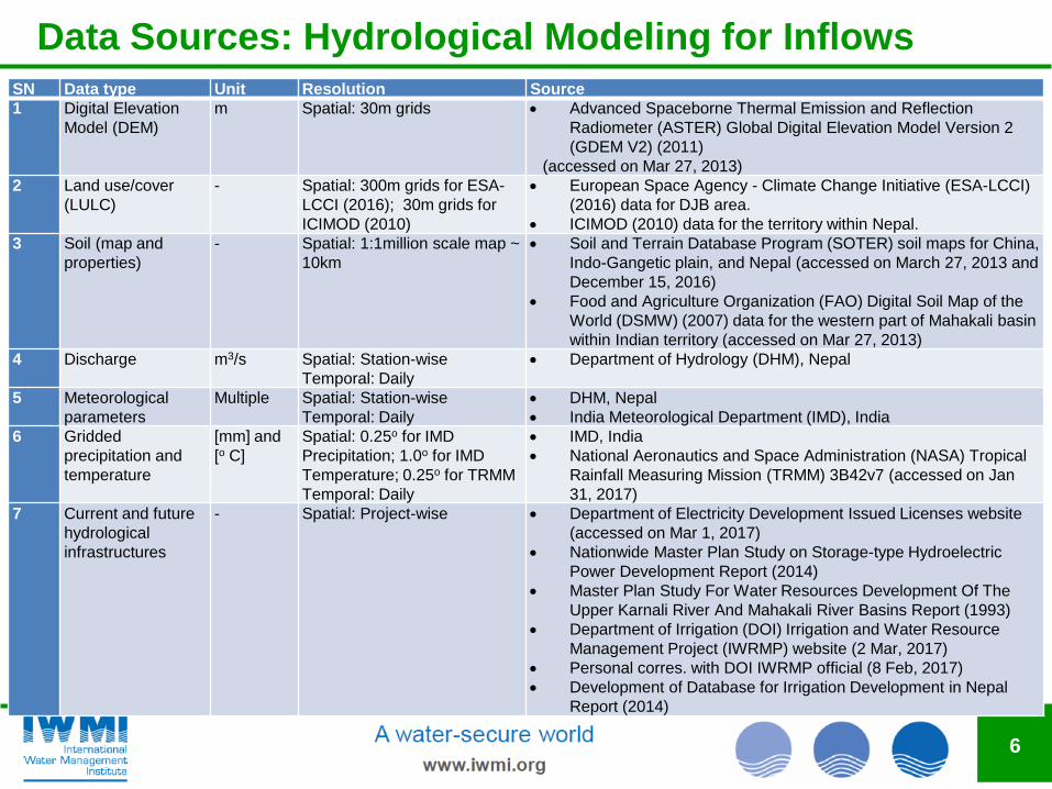
Data Sources: Hydrological Modeling for Inflows
6
SN Data type Unit Resolution Source
1 Digital Elevation
Model (DEM)
m Spatial: 30m grids Advanced Spaceborne Thermal Emission and Reflection
Radiometer (ASTER) Global Digital Elevation Model Version 2
(GDEM V2) (2011)
(accessed on Mar 27, 2013)
2 Land use/cover
(LULC)
- Spatial: 300m grids for ESA-
LCCI (2016); 30m grids for
ICIMOD (2010)
European Space Agency - Climate Change Initiative (ESA-LCCI)
(2016) data for DJB area.
ICIMOD (2010) data for the territory within Nepal.
3 Soil (map and
properties)
- Spatial: 1:1million scale map ~
10km
Soil and Terrain Database Program (SOTER) soil maps for China,
Indo-Gangetic plain, and Nepal (accessed on March 27, 2013 and
December 15, 2016)
Food and Agriculture Organization (FAO) Digital Soil Map of the
World (DSMW) (2007) data for the western part of Mahakali basin
within Indian territory (accessed on Mar 27, 2013)
4 Discharge m3/s Spatial: Station-wise
Temporal: Daily
Department of Hydrology (DHM), Nepal
5 Meteorological
parameters
Multiple Spatial: Station-wise
Temporal: Daily
DHM, Nepal
India Meteorological Department (IMD), India
6 Gridded
precipitation and
temperature
[mm] and
[o C]
Spatial: 0.25o for IMD
Precipitation; 1.0o for IMD
Temperature; 0.25o for TRMM
Temporal: Daily
IMD, India
National Aeronautics and Space Administration (NASA) Tropical
Rainfall Measuring Mission (TRMM) 3B42v7 (accessed on Jan
31, 2017)
7 Current and future
hydrological
infrastructures
- Spatial: Project-wise Department of Electricity Development Issued Licenses website
(accessed on Mar 1, 2017)
Nationwide Master Plan Study on Storage-type Hydroelectric
Power Development Report (2014)
Master Plan Study For Water Resources Development Of The
Upper Karnali River And Mahakali River Basins Report (1993)
Department of Irrigation (DOI) Irrigation and Water Resource
Management Project (IWRMP) website (2 Mar, 2017)
Personal corres. with DOI IWRMP official (8 Feb, 2017)
Development of Database for Irrigation Development in Nepal
Report (2014)
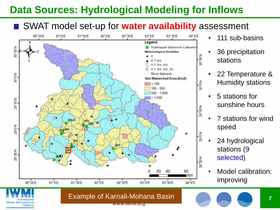
Data Sources: Hydrological Modeling for Inflows
7
SWAT model set-up for water availability assessment
• 111 sub-basins
• 36 precipitation
stations
• 22 Temperature &
Humidity stations
• 5 stations for
sunshine hours
• 7 stations for wind
speed
• 24 hydrological
stations (9
selected)
• Model calibration:
improving
Example of Karnali-Mohana Basin

Data Sources: Hydrological Modeling for Inflows
8
Daily > Cal: 1996-2002; Val:2003-2009Calibration Validation
R2 0.85 0.85NSE 0.83 0.83PSR 0.41 0.41
PBIAS -14.7 -15.7
Q280 – Chisapani, Karnali
Data Sources: Hydrological Modeling for Inflows
9
Daily > Cal: 1996-2002; Val:2003-2009Calibration Validation
R2 0.85 0.85NSE 0.83 0.83PSR 0.41 0.41
PBIAS -14.7 -15.7
Q280 – Chisapani, Karnali
Daily > Cal: 1996-2002; Val:2003-2009
Calibration Validation
R2 0.95 0.94
NSE 0.93 0.91
PSR 0.27 0.29
PBIAS -14.7 -15.2
Water Balance Analysis
• Evapotranspiration (ET): 34.5%
• Percolation: 10.4%
• Baseflow: 10.3% of total flow in river
FUTURE WORK
• Improve hydrograph @ outlet
• Check & improve performance at other
8 stations (key tributaries of Karnali)
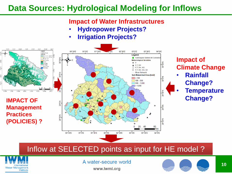
Data Sources: Hydrological Modeling for Inflows
10
Inflow at SELECTED points as input for HE model ?
IMPACT OF
Management
Practices
(POLICIES) ?
Impact of
Climate Change
• Rainfall
Change?
• Temperature
Change?
Impact of Water Infrastructures
• Hydropower Projects?
• Irrigation Projects?

Data Sources: Energy
Master Plan Study for Water Resources Development of the
Upper Karnali River and Mahakali River Basins (1993)
Nepal Hydropower Database (2009)
JICA Nationwide Master Plan Study on Storage-type
Hydroelectric Power Development in Nepal (2014)
Nepal Electricity Authority Annual Reports
Hydropower Project Reports for a limited number of projects
• Feasibility studies
• Expression of intent documents
• Environmental impact studies
GIS Hydrology Tools
11

Data Sources: Agriculture and Irrigation
Department of Irrigation Master Plan (1990)
National Irrigation Database (2009)
Various crop production and pricing reports
• Cost, Production, and Price Spread of Cereal Crops in Nepal
• Average Production Cost and Price Margin of Pulse, Oilseed, Spice, and
Commercial Crops
• Average Cost of Production and Gross Profit of Fruit Farming in Nepal
Statistical Information on Nepalese Agriculture Reports
Irrigation Project Reports for a limited number of projects
• Completion Reports and Project Documents
• Project Visits
• Subproject information provided by Irrigation and Water Resources
Management Project
FAO CropWat Tools
12

Data Sources: Municipal
National Water Plan (2005)
Promoting Financially Sustainable Regulatory Framework
for Water Tariff in South Asia—Nepal (2013)
Central Bureau of Statistics Statistical Yearbook
Water User Master Plan Reports
• HELVETAS, RVWRMP
13

WUMP VDC Locations
14

Data Sources: Environmental
Basin-Wide Survey
• Sample: 3600
• Ecosystem services valuation
− Trade-off: environmental conservation and expanded
development
• Reliance on natural resources
• Development priorities in the basin
Ecological Flows
• IWMI ecological flows calculator
• Focus of other DJB work
15

Modeling Status Update
16
Module Parameter Data Source
Water
Groundwater recharge, depth, seepage
Reassessment of the Groundwater Development Strategy for Irrigation in the Terai (1994), SWAT
Groundwater depth Reassessment of the Groundwater Development Strategy for Irrigation in the Terai (1994)
Aquifer storage SWAT
River flows SWAT
Reservoir and river evaporation
Modeling Status Update
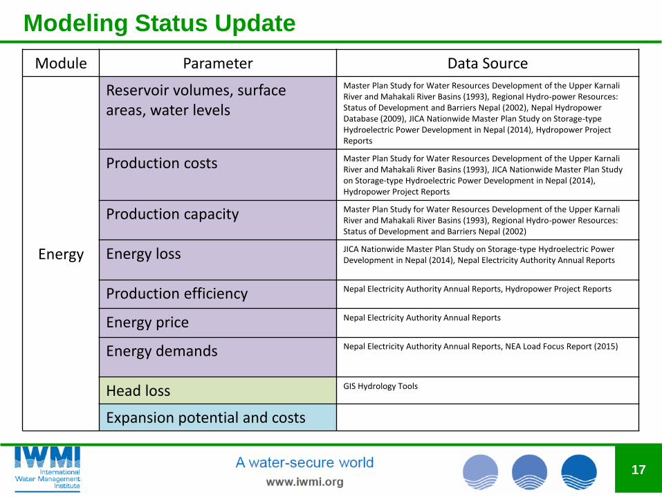
17
Module Parameter Data Source
Energy
Reservoir volumes, surfaceareas, water levels
Master Plan Study for Water Resources Development of the Upper Karnali River and Mahakali River Basins (1993), Regional Hydro-power Resources: Status of Development and Barriers Nepal (2002), Nepal Hydropower Database (2009), JICA Nationwide Master Plan Study on Storage-type Hydroelectric Power Development in Nepal (2014), Hydropower Project Reports
Production costs Master Plan Study for Water Resources Development of the Upper Karnali River and Mahakali River Basins (1993), JICA Nationwide Master Plan Study on Storage-type Hydroelectric Power Development in Nepal (2014), Hydropower Project Reports
Production capacity Master Plan Study for Water Resources Development of the Upper Karnali River and Mahakali River Basins (1993), Regional Hydro-power Resources: Status of Development and Barriers Nepal (2002)
Energy loss JICA Nationwide Master Plan Study on Storage-type Hydroelectric Power Development in Nepal (2014), Nepal Electricity Authority Annual Reports
Production efficiency Nepal Electricity Authority Annual Reports, Hydropower Project Reports
Energy price Nepal Electricity Authority Annual Reports
Energy demands Nepal Electricity Authority Annual Reports, NEA Load Focus Report (2015)
Head loss GIS Hydrology Tools
Expansion potential and costs

Modeling Status Update
18
Module Parameter Data Source
Agriculture
Command areas Department of Irrigation Master Plan (1990), Master Plan Study for Water Resources Development of the Upper Karnali River and Mahakali River Basins (1993), National Irrigation Database (2009), Subproject information provided by Irrigation and Water Resources Management Project
Irrigation efficiency Completion Reports, Subproject information provided by Irrigation and Water Resources Management Project
Rainfed and irrigated area National Water Plan (2005), Statistical Information on Nepalese Agriculture Reports
Pumping capacity Department of Irrigation Master Plan (1990)
Irrigation costs National Irrigation Database (2009), National Water Plan (2005)
Crop price Completion Reports, Statistical Information on Nepalese Agriculture Reports, Crop production and pricing reports
Production cost Statistical Information on Nepalese Agriculture Reports, Crop production and pricing reports
Crop yield Completion Reports, Subproject information provided by Irrigation and Water Resources Management Project, Statistical Information on Nepalese Agriculture Reports

Modeling Status Update
19
Module Parameter Data Source
Agriculture
Crop coefficients, water stress FAO CropWat Tools
Effective rainfall, potential evapotranspiration
FAO CropWat Tools
Expansion potential and costs
Distribution of ground and surface water
Disaggregated production costs
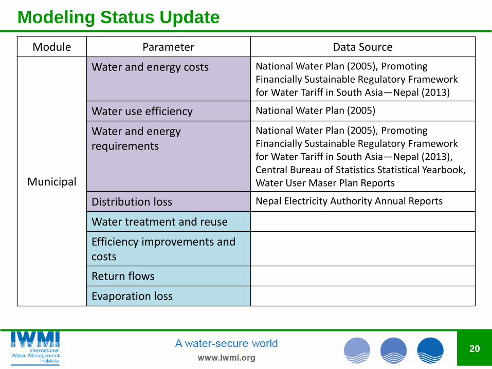
Modeling Status Update
20
Module Parameter Data Source
Municipal
Water and energy costs National Water Plan (2005), Promoting Financially Sustainable Regulatory Framework for Water Tariff in South Asia—Nepal (2013)
Water use efficiency National Water Plan (2005)
Water and energy requirements
National Water Plan (2005), Promoting Financially Sustainable Regulatory Framework for Water Tariff in South Asia—Nepal (2013), Central Bureau of Statistics Statistical Yearbook, Water User Maser Plan Reports
Distribution loss Nepal Electricity Authority Annual Reports
Water treatment and reuse
Efficiency improvements and costs
Return flows
Evaporation loss
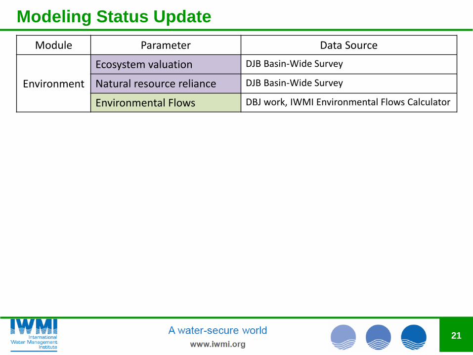
Modeling Status Update
21
Module Parameter Data Source
Environment
Ecosystem valuation DJB Basin-Wide Survey
Natural resource reliance DJB Basin-Wide Survey
Environmental Flows DBJ work, IWMI Environmental Flows Calculator
Modeling Goals
22
Our primary goal is to provide a comprehensive understanding of
trade-offs in the future development Karnali and Mahakali River
Basins
• This should speak to issues of interest and concern among basin
stakeholders and decision makers
• The goal of this workshop is to start that discussion
To achieve that, we are working on a model that includes energy,
agriculture, industrial/municipal, and ecosystem modules
• Requires compilation of a comprehensive database
• Use the model to obtain systematic understanding of different water
use priorities and how they affect resource access and allocation
• Quantify costs and benefits of different options
• Provide analysis that aligns with priorities and interests of
stakeholders and decision makers in the basins