Modeling, Simulation & Assessment of Purported A2AD ...
24
Modeling, Simulation & Assessment of Purported A2AD Systems Performance National Space Organization Taiwan Feng-Tai Hwang 2015/10/07 2015 AGI International Users Conference The views expressed in this material do not necessarily reflect the views of NSPO and other organizations
Transcript of Modeling, Simulation & Assessment of Purported A2AD ...
Modeling, Simulation & Assessment
of Purported A2AD Systems
Performance
National Space Organization
Taiwan
Feng-Tai Hwang
2015/10/07
2015 AGI International Users Conference
The views expressed in this material do not necessarily reflect the views of NSPO and other organizations

Contents
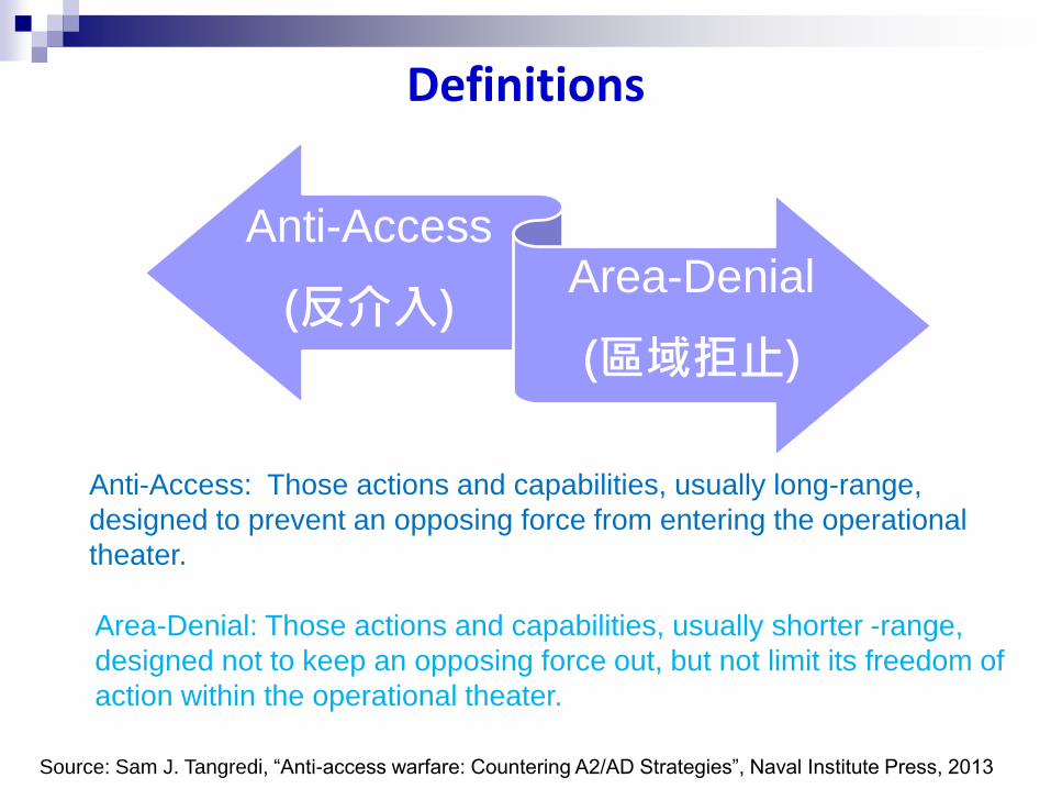
• Definition of Anti-Access/Area Denial (A2AD)
• A2AD systems
• Performance Index
Sensor-to-Shooter Timeline Equation
• Surveillance, Verification and Tracking system in
A2AD operation
Simulation Scenario
Total Error Estimations
Anti-Access Opportunities
• Conclusions
Definitions
Anti-Access
(反介入) Area-Denial
(區域拒止)
Anti-Access: Those actions and capabilities, usually long-range,
designed to prevent an opposing force from entering the operational
theater.
Area-Denial: Those actions and capabilities, usually shorter -range,
designed not to keep an opposing force out, but not limit its freedom of
action within the operational theater.
Source: Sam J. Tangredi, “Anti-access warfare: Countering A2/AD Strategies”, Naval Institute Press, 2013

A2AD - A System of Systems
• Radar
• Satellite
• Airplane/ UAV
• Ship/ Submarine
Surveillance, Verification,
Tracking (SVT) Systems
• Anti-Ship Cruise Missile
• Anti-Ship Ballistic Missile
• Torpedo
Strike Systems
Performance
Index
Sensor
Location/Velocity
Estimation Error
Weapon
Delivery Error

Performance Index (1/2)
Total System Error (TSE) and Sensor-to-Shooter timeline equation
TLE :Target Location Error
DE :Delivery Error
Static Target 𝑇𝑆𝐸 = 𝑇𝐿𝐸2 + 𝐷𝐸2
Dynamic Target
Elapsed time beginning when
sensor senses target and
ending at munition
VEE:Velocity Estimation Error
𝑇𝑆𝐸 = 𝑇𝐿𝐸2 + 𝑉𝐸𝐸 ∙ 𝑇 2 +𝐷𝐸2

Reference :Brig. General S. M. Cannon, PEO Tactical Missiles Sensor to Shooter Timeline
Equation, Precision Strike Summer PEO Forum, Arlington, VA, 7-8 July 2004.
Performance Index (2/2)
Example:
GPS+Laser Sensor
GPS/INS Guided Missile
Flight Time 240 s
Moving Target Velocity Estimation Error(VEE): 1.2 /s
Time from Target Identification to Launch 60 s
Start
End
360.7m
20300s1.2m/s10
DETVEETLETSE
222
222Target Moving
22.4m
2010
DETLETSE
22
22Target Stationary
𝑇𝑆𝐸Moving Target
𝑇𝑆𝐸Stationary Target= 16.1
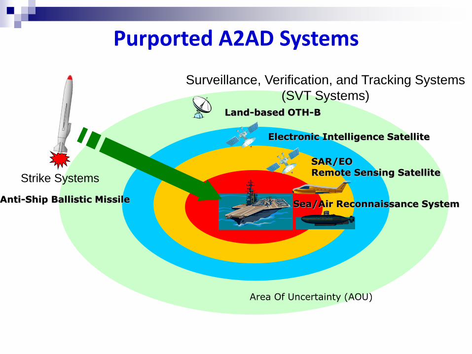
Electronic Intelligence Satellite
Land-based OTH-B
SAR/EO Remote Sensing Satellite
Sea/Air Reconnaissance System Anti-Ship Ballistic Missile
Area Of Uncertainty (AOU)
Purported A2AD Systems
Strike Systems
Surveillance, Verification, and Tracking Systems
(SVT Systems)

Land-Based OTH-B
OTH-B Radar Capability Range:800~3500 km Azimuth:60 degree
湖北襄陽
Xiāng-Yáng, Hú běi

Type Series Note
Remote
Sensing
Satellite
Yaogan (遙感)
Satellite
High-resolution Remote Sensing
Satellite
L-band SAR Satellite
HJ Satellite
(環境)
Satellites with Hyperspectral and IR
Multi-spectral imaging sensor
SAR satellite
Gaofen (高分)
Satellite
High-resolution Remote Sensing
Satellite
Data Relay
Satellite
TL Satellite
(天鏈)
Geosynchronous Orbit Satellite
ELINT
Satellite
Yaogan (遙感)
Satellite
Similar to USA NOSS system
Space-based Ocean Surveillance Systems (1/3)

Space-based Ocean Surveillance Systems (2/3)
Ground Receiving Stations
Elevation: 5 degree Orbit Altitude: 650 km
Kè shé Mì yún
Sān yǎ

Space-based Ocean Surveillance System (3/3)
Data Relay Satellite
TL-1 02 satellite may be
part of A2AD systems
TL-1 03
TL-1 01
TL-1 02

SVT Systems in A2AD operation
(1) Target Location Estimation
(2) Target Velocity Estimation
Step1 • Find possible locations of USA
CBG through OTH-B Radar
Step2 • Verify target using remote
sensing satellites.
Step3 • Launch ASBM, if CBG is
identified
Operational Scenario-2
Step1
• Find location of USA CBG through space-based surveillance satellites
Step2 • Monitor and Track target using
OTH-B Radar
Step3
• Launch ASBM after updated location of CBG provided by space-based surveillance satellites or UAV
Operational Scenario-1

Simulation Scenario
Hawaii
Guam
Okinawa
2015/8/1
UTC 00:00:00
2013/8/7
UTC 06:00:00

Satellites in Simulation
2015
Satellite Type
1 YG-16 ELINT
2 YG-17 ELINT
3 YG-18 SAR
4 YG-20 ELINT
5 YG-21 Optical
6 YG-23 SAR
7 YG-24 Optical
8 YG-25 ELINT
9 YG-26 Optical
10 GF-1 Optical
11 GF-2 Optical
12 HJ-1C SAR

Modeling & Simulation Using STK (1/4)
The departure time for the aircraft carrier
from Hawaii was assumed to be
2015/08/01 00:00:00 UTC

Modeling & Simulation Using STK (2/4)
Assume that ELINT satellites can
transmit the location of aircraft carrier
to OTH-B radar through TL-1-02
satellite

Modeling & Simulation Using STK (3/4)
An ELINT satellite update the location
of aircraft carrier for ASBM after
aircraft carrier entering the range of
OTH-B radar

Modeling & Simulation Using STK (4/4)

Simulation Results (1/2)
YG-26
YG-25
YG-24
YG-23
YG-21
YG-20
YG-18
YG-17
YG-16
GF-2
GF-1
SAR Satellite Optical Satellite ELINT Satellite

Simulation Results (2/2)
YG-26
YG-25
YG-24
YG-23
YG-21
YG-20
YG-18
YG-17
YG-16
GF-2
GF-1
First ELINT satellite enters OTH-B
radar acquisition range
SAR Satellite Optical Satellite ELINT Satellite
6 hours

ASBM Flight Time: 833 s
ELINT Satellite (YG-16)
Data Relay Satellite (TL- 1 )
OTH-B Radar
ASBM
Total System Error Analysis Operational Scenario-1
km
T = 900 + 833 = 1733 s
Time from target identification to launch: 900 s
77.402.0)17330015.0(4 222 TSE
The time for location determination
from ELINT satellites is ignored
(2)
(3-1)
(3-2)
2015/08/06
07:29 UTC
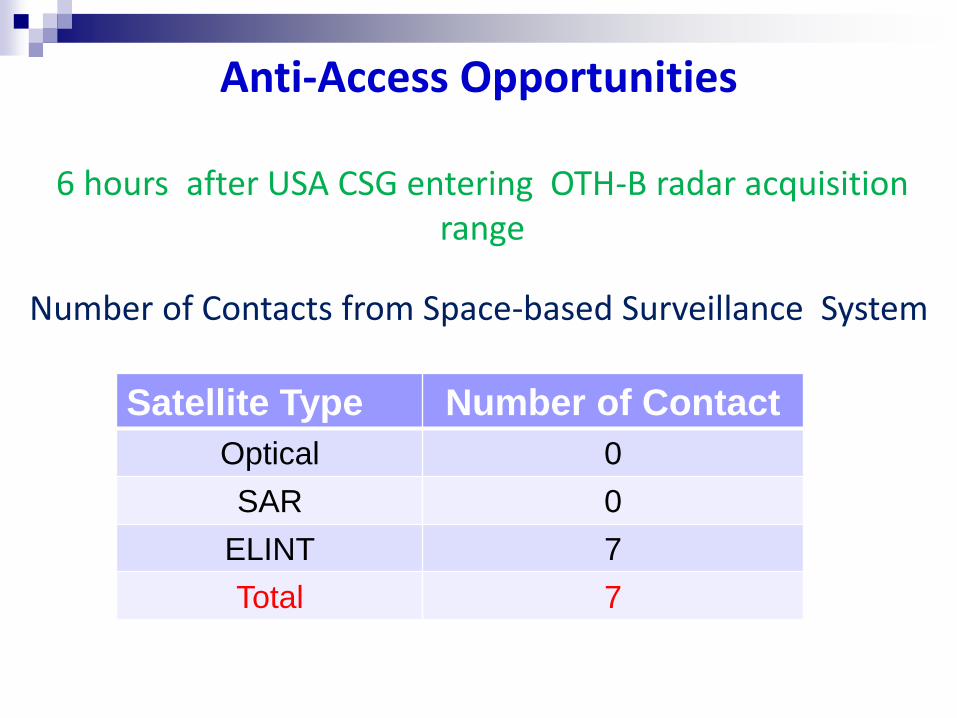
Anti-Access Opportunities
6 hours after USA CSG entering OTH-B radar acquisition range
Number of Contacts from Space-based Surveillance System
Satellite Type Number of Contact
Optical 0
SAR 0
ELINT 7
Total 7

Conclusions
• The comprehensive system error of the purported A2AD system is interpreted in the format of sensor-to-shooter timeline equation in a bid to systematically evaluate its performance.
• STK provides superb simulation and visualization tool to emulate such a complicated system of systems.

Thanks for your
attention