
Mappings , maps and tables : Towards formal semantics for associations in UML 2

Modeling of Business Process in Distributed Environment: a Case Study of
Issuance of Certificate of Occupancy in Tanzania
Nina Nimwesiga Rutakyamirwa
Enschede, The Netherlands
March, 2002
Modeling of Business Process in Distributed Environment: a Case Study of the Issuance of
Certificate of Occupancy in Tanzania
by
Nina Nimwesiga Rutakyamirwa
Thesis submitted to the International Institute for Geo-Information Science and Earth Observation in partial fulfilment of the requirements for the degree of
Master of Science in Geo-Information Science (Geo-Information Management/Cadastre and Land Registration)
Degree Assessment Board Chairman: Dr. M. M. Radwan
External Examiner: Prof. Dr. Ir. P van Oosterom Supervisors: Dr. M. M. Radwan
Ir. C. H.J. Lemmen Mr. A. M. Tuladhar, MSc.
INTERNATIONAL INSTITUTE FOR GEO-INFORMATION SCIENCE AND EARTH OBSERVATION ENSCHEDE, THE NETHERLANDS

Disclaimer
This document describes work undertaken as part of a programme of study at the International Institute for Geo-Information Science and Earth Observation.
All views and opinions expressed therein remain the sole responsibility of the author, and do not necessarily represent those of the institute.

This is for you parents……………. For all your faith, love and guidance.

i
Abstract The prime problem in the issuance of Certificate of Occupancy (CO) business process in Tanzania is the delivery time. This is due to factors like the exclusion of users requirements, poor record keeping, bureaucratic and cumbersome procedures. This research problem addresses the performance problem of the issuance of CO business process with a view to improving its performance. The process is modelled to illustrate its static and dynamic behaviour. Static behaviour means displaying interactions of the objects but not what happens when they do interact. Dynamic behaviour means displaying how the objects interact and what happens when they do interact. Analysis of the current situation has been carried out and found that it involves 16 individuals/departments/private companies/ministries. The proposed improvements in the performance to the process are based on the views given by staffs, stakeholders (actors) who were interviewed and the personal views of the author on the problem. Some of the actions to be taken are performing periodic actors analysis to understand their requirements, design and maintain databases and look for the funds from donors and sponsors. Unified Modeling Language (UML) has been used as the technique to model the process by taking into consideration only those activities, which add value to the actors. It gives the clarity of all the activities, resources involved and constraints/rules for the issuance of CO. It takes into consideration the static and dynamic behaviour of the objects participating in the process and that helps in reducing the complexity. Applying UML helps in allocating resources to the processes and apply rules/constraints on the resources and processes necessary in achieving the set goal. In this respect applying UML helps in identifying cost and budgeting which is useful for evaluating against the later outcome to allocated resources. UML is an object oriented technology so it takes advantages of object-oriented features, which are comprehensive, understandable, changeable and adaptable. It helps in visualizing the relationships between the processes. One of the limitations of the UML is the lack of precise semantics that supports rigorous semantics analyses. This can limit its effectiveness. The modelling of static and dynamic behaviour has been done for a part of the CO business process. The remaining part can be done applying the same techniques done in this research because it has proved to be robust. The study recommends modelling of the remaining parts of CO business system and carrying out performance evaluation before implementing so as to provide further insight.

ii
Acknowledgements I am deeply indebted to my supervisors Dr. M. M. Radwan, Ir. C.H.J. Lemmen and Mr. A. M. Tuladhar for their guidance and support throughout the study, and without whom the thesis completion would not have been possible. My sincere thanks to the Netherlands Fellowship Programme, which granted me with the scholarship that, supported my studies at the International Institute for Geo-information Science and Earth Observation. In addition to this, I wish to thank all staffs in the Geo-Informatics Management and Infrastructure Department for their support and dedication throughout the study period. Many thanks go to Mr. C. Paresi for his critical comments and scientific suggestions. Ir. W. de Vries for teaching us research techniques, which has been useful carrying this study. Mr. A. Blenke (Cluster Manager) for his technical support during the whole program. Liliana Alvarez, Mohamed Said, Richard Onchaga Bert Raidt and John Chome your inputs are highly appreciated. I appreciate the assistance accorded to me during my field trip in Tanzania by:
A. A. Msangi – Commissioner for Lands F. Mutakyamirwa – Lawyer of the MLHSD T. Mwakilema – Registrar of Title C.S. Mwaijande – Principal Land Surveyor J. kamaka - Principal Land Surveyor Dr. F. Lugoe – Licensed Surveyor E. Mugerezi – Managing Director InfoBridge Consultants Limited J. Kamuhabwa - Senior Land Surveyor T. Nyakwarkimori - Senior Valuer D. Rugaimukamu – Senior Land Surveyor H. Mpetula - Senior Town Planner Z. Mgaya - Senior Land Officer D. Wanzala – Senior Land Officer A. Kidata - Economist T.G. Mwendanunu - Senior Assistant Land Officer
Their valuable time and the extensive discussions were the basis for the research analysis. Special thanks go to Mr. Martin Geugis for his moral support and encouragement during whole time of my studies. My colleagues Rosal, Lupe, Kwon, Malin, Leslie and friends your encouragement and support gave me a lot of inspiration. Finally much gratitude to members of my family for all moral support they gave me during my studies. To my parents the faith that you have in me has made me strive to achieve a lot of things in life. Nina

iii
Table of contents
Abstract ................................................................................................................................ i
Acknowledgements............................................................................................................. ii
Table of contents................................................................................................................ iii
List of figures..................................................................................................................... vi
List of tables...................................................................................................................... vii
List of Appendices ........................................................................................................... viii
List of Abbreviations ......................................................................................................... ix
1. Introduction................................................................................................................. 1
1.1. Introduction......................................................................................................... 1 1.2. Background ......................................................................................................... 1 1.3. Research problem Definition .............................................................................. 2 1.4. Justification for research ..................................................................................... 3 1.5. Objective and Research questions ...................................................................... 4 1.6. Prior work ........................................................................................................... 4 1.7. Research methodology........................................................................................ 5
1.7.1. The need for fieldwork................................................................................ 6 1.8. Thesis structure ................................................................................................... 7 1.9. Research Schedule .............................................................................................. 8
2. Analysis of the Issuance of Certificate of Occupancy ................................................ 9
2.1. Introduction......................................................................................................... 9 2.2. Existing Situation................................................................................................ 9 2.3. Overview of Land Laws.................................................................................... 11 2.4. Organizational structure.................................................................................... 12 2.5. Flow of information – internal flow within departments.................................. 12 2.6. Overall task of three departments ..................................................................... 13
2.6.1. Surveys and Mapping Department............................................................ 13 2.6.2. Lands Department..................................................................................... 14 2.6.3. Human Settlements Development Department......................................... 15
2.7. Synthesis of fieldwork survey........................................................................... 15 2.8. Overall Problems .............................................................................................. 17
2.8.1. Problems encountered in issuance of Certificate of Occupancy............... 17 2.9. Actions for improvement and SWOT analysis ................................................. 18 2.10. Proposed improvements in the issuance of CO ............................................ 21
2.10.1. Sketch of a proposed top level diagram.................................................... 22 2.11. Concluding remarks ...................................................................................... 23

iv
3. Concepts of Coordination, Integration and Modeling .............................................. 24 3.1. Introduction....................................................................................................... 24 3.2. Coordination ..................................................................................................... 24 3.3. Integration ......................................................................................................... 26 3.4. Enterprise integration........................................................................................ 26 3.5. Enterprise modeling .......................................................................................... 27
3.5.1. Views to be considered in enterprise modeling ........................................ 28 3.5.1.1. Business Vision View..................................................................................... 28 3.5.1.2. Business Process View.................................................................................... 29 3.5.1.3. Business Structure View.................................................................................. 29 3.5.1.4. Business Behaviour View................................................................................ 29 3.5.2. Different modeling techniques.................................................................. 29
3.6. The advantages of using UML to model the process of issuance of CO.......... 30 3.7. Modeling Business Process using UML........................................................... 31
3.7.1. Use Case Diagram..................................................................................... 32 3.7.2. Object modeling........................................................................................ 32 3.7.2.1. Activity diagram ................................................................................... 33 3.7.2.2. Sequence diagram ................................................................................. 34 3.7.3. Class diagram............................................................................................ 34
3.8. The use of different views in designing the top-level model........................... 35 3.9. Reasons for modeling ....................................................................................... 36 3.10. Testing........................................................................................................... 37
3.10.1. Unit testing................................................................................................ 37 3.10.2. Integration testing ..................................................................................... 37 3.10.3. Verification and Validation....................................................................... 37
3.11. Concluding remarks ...................................................................................... 38
4. Certificate of Occupancy Model............................................................................... 39
4.1. Introduction....................................................................................................... 39 4.2. Certificate of Occupancy Model....................................................................... 39 4.3. Need for CO model........................................................................................... 39 4.4. The CO Business System.................................................................................. 40
4.4.1. Quality and performance........................................................................... 40 4.4.2. Users/stakeholders (Actors) ...................................................................... 41 4.4.3. Services and products ............................................................................... 42 4.4.4. Components of the CO business system................................................... 43
4.5. Modelling CO Business System ....................................................................... 43 4.5.1. Use Case Diagram..................................................................................... 43 4.5.1.1. Declaration of an area ..................................................................................... 44 4.5.1.2. Compensation ............................................................................................... 44 4.5.1.3. Preparation of Town Planning drawing .............................................................. 44 4.5.1.4. Surveying..................................................................................................... 45 4.5.1.5. Allocating Parcels .......................................................................................... 45 4.5.2. Activity diagram ....................................................................................... 46 4.5.3. Class diagram............................................................................................ 49 4.5.4. Sequence diagram ..................................................................................... 51

v
4.6. Concluding remarks .......................................................................................... 54
5. Implementation Requirements .................................................................................. 55
5.1. Introduction....................................................................................................... 55 5.2. Testing of the Allocating Parcels use case model............................................. 55
5.2.1. Unit testing................................................................................................ 55 5.2.2. Integration testing ..................................................................................... 55
5.3. Implementation requirements ........................................................................... 55 5.3.1. Factors to be considered............................................................................ 56 5.3.1.1. Institutional Issues ......................................................................................... 56 5.3.1.2. Technical Issues ............................................................................................ 57 5.3.1.3. Economic Issues ............................................................................................ 57 5.3.1.4. Legal Issues .................................................................................................. 58
5.4. Concluding remarks .......................................................................................... 59
6. Conclusions and Recommendations ......................................................................... 60
6.1. Introduction....................................................................................................... 60 6.2. Summary of research ........................................................................................ 60 6.3. Limitations ........................................................................................................ 62 6.4. Conclusions....................................................................................................... 62 6.5. Recommendations............................................................................................. 63
References......................................................................................................................... 64
Appendices......................................................................................................................... A
vi
List of figures
Figure 1-1: Business Requirement........................................................................................... 6
Figure 1-2: Requirements modeling cycle................................................................................. 7
Figure 2-1: Organizational Structure of the MLHSD ................................................................. 12
Figure 2-2: Information flow................................................................................................... 13
Figure 2-3: Activities carried in different departments/private companies/ministries/individuals .... 16
Figure 2-4: Situation analysis;-Environmental Scanning - Source Paresi (2001)......................... 19
Figure 2-5: Proposed top-level activity diagram....................................................................... 23
Figure 3-1: Products of departments on issuance of CO-adapted from Maleko (2000)................ 25
Figure 3-2: Business architecture as described with four views ................................................ 28
Figure 3-3: Structure of the Business System showing different views ...................................... 36
Figure 4-1: CO business system............................................................................................ 42
Figure 4-2: Allocating Parcels use case.................................................................................. 43
Figure 4-3: Activity Diagram .................................................................................................. 48
Figure 4-4: Class diagram (Information modelling) .................................................................. 50
Figure 4-5: Sequence diagram (object modeling) - Part I........................................................ 52
Figure 4-6: Sequence diagram (object modeling) - Part II ........................................................ 53

vii
List of tables Table 2-1: Summary of the laws related to land tenure ............................................................ 11
Table 2-2: SWOT analysis matrixes ....................................................................................... 20
Table 3-1: Comparison of modeling approaches according to business views ........................... 30

viii
List of Appendices Appendix A: List of Activities for issuance of Certificate of Occupancy ....................................... A
Appendix B: List of Use Classes groups .................................................................................. G
Appendix C: Activity Diagram ................................................................................................. H
Appendix D: List of Use Cases (Business Processes) in CO business model ............................. K
Appendix D1: Declaration of an area ……………………………………………………………...………K Appendix D2: Compensation…………………………………………………………….………..………..K Appendix D3: Preparation of Town Planning Drawing …………………………………………………..L Appendix D4: Surveying ……………………………………………………………………………….……L
Appendix E: Land Laws .........................................................................................................M
Appendix E1: Town and Country Planning Ordinance Act. Cap 378 …………………………………M Appendix E2: The Land Act. No. 4 of 1999…………………………………………………………….…O Appendix E3: The Village Land Act. No. 5 of 1999…………… ………………………………………..Q Appendix E4: Regulations of the Land Act. No. 4 of 1999 ……………………………………….…….R Appendix E5: Land Survey Cap 390…………………………….. ……………………………………….T
Appendix F: Dar es Salaam plots in digital form ....................................................................... U
Appendix G: CADastral PROgram (CAD PRO) Forms .............................................................. V
Appendix H: Questions (or indicators) for assessing the verity and validity of object modelling cycle
....................................................................................................................................W
Appendix H1: Use Case…………………………………………………………………………………….W Appendix H2: Use Case Diagrams………………………………………………………………………..W Appendix H3: Sequence Diagrams………………………………………………………………………..W Appendix H4: Class Diagrams……………………………………………………………………………...X Appendix I: Letter of Offer ...................................................................................................... Y
Appendix J: Certificate of Occupancy....................................................................................AA

ix
List of Abbreviations AC Allocating Committee LGLO Local Government Leaders Office ADL Accounts Department Lands LO Lands Officer ADM Administrator LoO Letter of Offer AG Attorney General LS Licensed Surveyor APP Applicant MCS Ministry of Civil Service BM Bench Marks MJCA Ministry of Justice and Constitution
Affairs CAF Chief Accountants Finance ML Minister for Lands CAL Chief Accountants Lands MLHSD Ministry of Lands and Human
Settlements Development CART Cartographer NCPS National Council of Professional
Surveyors CL Commissioner for Lands OC/C Officer in Charge Computation CLS City Land Surveyor OC/DP Officer in Charge Deed Plan CLSO City Land Surveyors Office OC/R Officer in Charge Records CO Certificate of Occupancy OC/S Officer in Charge surveys CS Compensation Schedule PC Private Company CVO Chief Valuation Officer PLS Private Land Surveyor DC District Commissioner RC Regional Commissioner DCO District Commissioner Office RCO Regional Commissioner Office DHS Director of Human Settlements Department RO Registrar Officer DP Deed Plan RT Registrar of Title DPO Deed Plan Officer SAPP Selected Applicants DSM Director of Surveys and Mapping SMD Surveys and Mapping Department DT Document Typist SPAPP Selected Paid Applicants EO Examination Officer STP Senior Town Planner GDP Gross Domestic Product TP Town Planner GLS Government Land Surveyor TP drg. Town Planning drawing GN Government Notice UML Unified Modeling Language HSD Human Settlements Development Department UPC Urban Planning Committee IDEF Integrated Definition Language UPCLGO Urban Planning Committee Local
Government Office L.O. No. Land Office Number VO Valuation Officer LD Lands Department ZRAO Zone Records Assistant officer LGL Local Government Leaders ZRO Zone Records Officer Synonyms The words Parcels and Plots have been used interchangeably in the thesis. They both play one and the same thing.

Chapter 1: Introduction
1
1. Introduction
1.1. Introduction
Land is one of the four pillars of Tanzania’s development philosophy together with people, good policies and good leadership. The Ministry of Lands and Human Settlement Development (MLHSD) is responsible for all land issues in Tanzania mainland. The ministry is composed of four departments namely Survey and Mapping Department (SMD), Human Settlement Development Department (HSD), Lands Department (LD) and Administration department. The ministry is responsible for promoting the best use of land to ensure that land is easily accessible to those who need it and also provide an urban and rural planning framework for coordinating spatial development so that land requirement of growing economy can be met with minimal adverse environmental impact. In realizing these responsibilities, the process of issuing the Certificate of Occupancy (CO) is a major and crucial task for the ministry. It is carried out by the three departments of the MLHSD which deal with land matters and other enterprises. Land is one of the most important elements in human settlements. It is the starting point for all development. Any constraint to its management invariably has immense negative impact on its human settlement development and thus on socio economic development generally (Dale and McLaughlin, 1999). In Tanzania, in order to show that you own land, the requirement is to have a CO. CO helps the owner to get the mortgage and most people depend on the mortgage for the investment like building of houses, doing business, etc. Land is the ultimate resource, for without it, life on earth, as well as economic development can not be sustained. Ministry of Lands and Human Settlements Development (2000), Economic activities directly related to land resource utilisation account for over 80% of Tanzania’s Gross Domestic Product (GDP).
1.2. Background Management of land usually involves many enterprises (organizations/departments), which are in a distributed environment and that leads to delay of services caused by the lack of coordination between them. This happens because the product of one enterprise acts as an input to another. In order to deliver quality services to the customer there is a need of coordinating the activities involved in the services. Vernadat, (1996) wrote that “business processes to be integrated or computer-controlled need to be formalized as well as the objects they use, handle or process, information accessed or generated, resources required to execute them, and responsibilities and authorities required for their control”. Coordination is to make things, people, parts, etc. function together efficiently and in an organized way (Hornby 1995).

Chapter 1: Introduction
2
Enterprises are supposed to look in their processes and remove those, which don’t add value to the customer or if possible outsource other responsibilities so as to work efficiently and effectively. Modeling and integration of enterprises are among the techniques helping enterprises to stay in business. Enterprise modeling is important in extending understanding of the organization by modeling its constituent parts, and allowing analysis of the ways in which various corporate function and interact (Vernadat, 1996). Also it supports investigation and construction of extended, revised or redesigned processes, which further improve the needs of the business. Enterprise integration is concerned with facilitating information, control, and material flows across organizational boundaries connecting all the necessary functions and heterogeneous functional entities (information systems, devices, applications, and people) in order to improve communication, cooperation, and coordination within this enterprise so that the enterprise behaves as an integrated whole, therefore enhancing its overall productivity, flexibility, and capacity for management of change or reactivity (Vernadat, 1996). Integration means combining two or more things in such a way that one becomes fully a part of the other. Business processes represent the flow of control of things happening in the enterprise. They materialize in management policies, flows of documents, operating procedures, manufacturing processes, administrative procedures, regulation rules, and the like. Hence, enterprise modeling is driven by business process modeling. There are many techniques for process modeling like Computer Integrated Manufacturing Open System Architecture (CIMOSA), Purdue Enterprises Reference Architecture (PERA) and Unified Modeling Language (UML). UML is becoming most popular because it is an object-oriented modeling technology. Its approach is very close to the way human beings themselves view the world and that’s why it supports best for building models. Object is abstraction of reality and all the components of the enterprise can be described as an object e.g. object can be the product, services, materials, information, workers, organization structure, etc. Complex system like enterprises can be modeled using a set of connected objects (Jacobson, 1995). Object oriented technology is also highly applicable to modeling organizations and their business processes. If the same technique is used to model a business as is used to build the supporting information system, the transition between two activities will be both easy and distinct.
1.3. Research problem Definition There is need to understand the weaknesses and strengths of the existing set up against the threats and opportunities in the enterprises’ external environment. This should provide a basis for setting strategies for improvement. Inevitably this will call for tools and techniques to define the architectures of the business. Eriksson & Penker (2000) wrote, “if the models are to be effective they must be also expressed in a common language”.

Chapter 1: Introduction
3
CO is the legal document which shows the occupier of the piece of land, the duration of occupation and the regulations attached. The processes involve three departments in the MLHSD, which are HSD, SMD and LD, the output of one department acts as input for the other. A number of studies have indicated the lack of coordination between departments to be one of the handicaps in the issuance of CO (Derby et al.1995, Isa 1999, Maleko 2000). Derby et al., (1995) in their report on cadastral operational, equipment, and needs assessment for Tanzania mentioned a numbers of problems associated with land delivery. The problems include land survey doesn’t precede the preparation of the Town Planning drawing (TP drg.), failure to pursue the process to obtain Certificate of Occupancy, takes too long to have deed plan prepared. They analyse the reviewing procedures for recording land information and recommend methods for strengthening administrative and cadastral capacity to support land registration functions. They also advice on technical requirements and system needed for maintaining a cadastre. The report analysed the physical requirements but did not deal with analysing the performance of the processes of issuance of CO in helping identifying problems. Improvement of the process of the issuance of CO requires looking at all the processes and modeling considering the processes and activities with their relationships, resources, rules and the goals to be achieved by each process.
1.4. Justification for research Enterprises whether they are governmental or non governmental, in order to stay in business, need
to meet customer requirements, reduce time to deliver the services and also products are supposed to be of low cost with increased quality. Objects to be integrated and coordinated need to be modeled. Thus, enterprise modeling is a
prerequisite for enterprise integration (Vernadat, 1996). To enhance performance and improve processes before implementing could be done by modeling the processes using techniques like UML. The research involves the departments in the MLHSD and other enterprises outside the ministry
participating in the issuance of the certificates of occupancy in Tanzania. This issue needs urgent attention, because there are a lot of cases of land disputes with people building in unplanned areas thus creating squatters. It is important for the ministry because it is one of the mission which is to provide effective and
efficient land delivery services as stated under the national development vision of 2025 of Tanzania.
The CO model will help the top management (e.g. Directors) to be able to allocate resources to each process. They must be able to identify cost and be able to budget and evaluate the budget against the later outcome to allocated resources. The CO model identifies clearly all the activities, resources involved and constraints/rules for the issuance of CO so as to achieve the goal. The top management will know comprehensive view of every single process and how they relate to each other. This will help them to

Chapter 1: Introduction
4
identify enterprise vision and goal. They will also be able to identify lead-time, quality of output to the customer. A Reengineering team is formed with some employees who take care of the CO model, they need to have access to the most thorough detail models. They do communicate with the management using the CO model. The Reengineering team must be able to judge what type of resources and how much type is needed. They must be able to identify potential bottlenecks and to know how to solve them. They need detailed description of every active process. The process owners normally are chosen from the top management, they have to understand their processes in more detail so as to contribute actively to their design. They also must understand other processes in a general way. Resource owners must be familiar with the business process and how they are implemented in terms of human resources, hardware and software. The issuance of CO process has been modelled so as to improve its performance. The CO model will help in allocating, managing and controlling resources. Some of the proposed improvements are involvement of the indigenous people in declaration of an area, preparation of TP drg. using simple-to-use GIS software, preparation of deed plans digitally. More proposed improvements are mentioned in chapter two section 2.10.
1.5. Objective and Research questions
The study has the following objective: To model the CO issuance business process with a view of improving performance at the MLHSD. To reach the stated objective the following research questions have been envisaged:
i. What are the current bottlenecks according to enterprises, users and potential users in the issuance of Certificate of Occupancy?
ii. What are the processes/activities with their related resources, rules and goals? iii. What needs to be taken into consideration when modeling processes in distributed environment? iv. What are the proposed improvements?
1.6. Prior work Bynoe (2001) has shown that there are possibilities to integrate decoupled business processes into
continuous business process. The implementation depends on the existence of a set of architectures, resources and commitments. Long-term continuity of a new method of work operations will only be realised with worker participation in the planning of change. Chimhamhiwa (2001), in his research the results obtained in private organisations (Notary, Planner and
Land Surveyor) were satisfactory but public organisation (Surveyor General, Municipality and Registry of Deeds) need urgent attention after modeling and evaluate the performance.

Chapter 1: Introduction
5
Onchaga (2000), he mentioned that performance evaluation is largely an art and therefore demands an intimate understanding of the system being modeled, careful selection of the methodology and workload. Sani (1998), in her research ‘Dynamic Modeling in the Reengineering of Geoinformation Production
Process’ where by she defined the measurable production parameters and tested the conceptual behaviour model and the decision were taken in light of time and resource constraint. Maleko (2000) looked in the existing processes and model using UT (University of Twente) modelling
technique before simulating by considering delivery time as the performance indicator. He assigned the time to each process and found out that the delivery time takes too long. He implemented Electronic Front Door (EFD) to help the customers to interact with the MLHSD without dealing with each individual department. Within departments there are local databases with agreed information to be shared in the metadata base. Metadata base is the one, which will provide the feedback to the customer if the requested information is available. There is coordination between departments, order of the request, update of the metadata base and delivery of the Certificate of Occupancy through the communication link. He looked in performance by considering time only but in order to identify problems clearly resources, rules and goals for each process need to be considered. Issa (1999) analyse the existing problems which hinder the efficiency of land delivery process and
comes with three problems as the centralization of the land delivery activities by the government, lack of funding for the various activities and lack of coordination within and between the departments. He also defines an improved land delivery process in respect of time by defining the strategies and guidelines for the implementation and then determines the extent to which spatial information technology can contribute towards the improvement. Rutayuga (1996) identified models for the establishment of Parcel-Based Information System (PBIS)
using object-technology where by he used Rational Rose CASE tool which has proved to be robust in analysing and modelling PBIS model.
1.7. Research methodology The following methodology was adopted in this research study: a. This research study began with an extensive literature review. The review was focused on previous
work touching on aspects of the issuance of CO process in Tanzania. Concepts of process coordination, integration and modelling were also reviewed.
b. A thorough fieldwork was carried out to identify the existing problems in the issuance of CO process. Semi-structured interviews were conducted in the fieldwork. Both customers and employees of the cooperating departments were interviewed.
c. A SWOT analysis was done to identify the weaknesses and strengths of process and establish the business opportunities available and threats existing. Proposed improvements were identified in some areas.

Chapter 1: Introduction
6
To facilitate the modeling of the processes, the following tasks were required: Document business process by identifying business events Describe the steps taken to respond to those events Organize processes into business scenarios Conduct baselining of current business Construct the future business process and function models
Figure 1-1 below shows the evolution cycle of a business process. This study focuses mainly on the business requirements of the CO business process and design one component of the process.
Business
Requirements
Business Design
BusinessImplementation
Figure 1-1: Business Requirement
1.7.1. The need for fieldwork
To achieve the objective of my research, there is a need of having a clear understanding and complete overview of the current process (e.g. surveying, preparation of town planning drawing, etc.), activities within the processes, related resources and the goal of each business process. The fieldwork has been by following the requirements modeling cycle as shown in figure 1-2 below. The information gathered will facilitate the development of a realistic and reliable model. The CO model will help in building the structure relation for the three departments deal in issuance of CO business process. The model to be developed will be based on the user requirements. Hawryszkiewycz (1997) wrote ‘ in defining the user requirements requires an understanding of how the system works and what its problems are’.

Chapter 1: Introduction
7
Figure 1-2: Requirements modeling cycle
1.8. Thesis structure Chapter 1: Introduction Introduction of thesis, tells about the background, explains about research problem, the justification which gives the reasons of doing this research and also how the problem can be solved. Also research objectives and questions. Chapter 2: Analysis of the issuance of Certificate of Occupancy This chapter analyses the current situation so as to see what are the problems and what are the improvements which gives the solution to the problem found in analysing. Chapter 3: Concepts of coordination, integration and modeling This chapter is going to explain how the departments involved in the issuance of CO business process will work effectively and efficiently. It gives the review of enterprise modeling and integration and also the importance of coordination. Also discusses the different views to be taken care of in modelling the issuance of CO business process. Chapter 4: Certificate of Occupancy Model It will explain the importance of the having the CO and discusses the improved overall business system. The chapter will take Allocating Parcels use case and model in more detail so as to show its static and dynamic behaviour. Chapter 5: Implementation Requirements This chapter will discuss the requirements needed to be taken care of when the CO model will be implemented. It discusses what needs to be looked at when validating the model. It will also looks at the impacts when it is implemented.
Requirements elicitation
Requirements analysis
Requirements specification
Requirements verification Verify with the users -validate against organizational standards, against business solution specification -review requirements with the users
Write down the result -how much does it cost you if the problem is not solved?
Analyze what gathered, to come with a coherent set of requirement - use case modeling
Gathering potential requirements - what are the goals, processes, resources, rules?
Chapter 1: Introduction
8
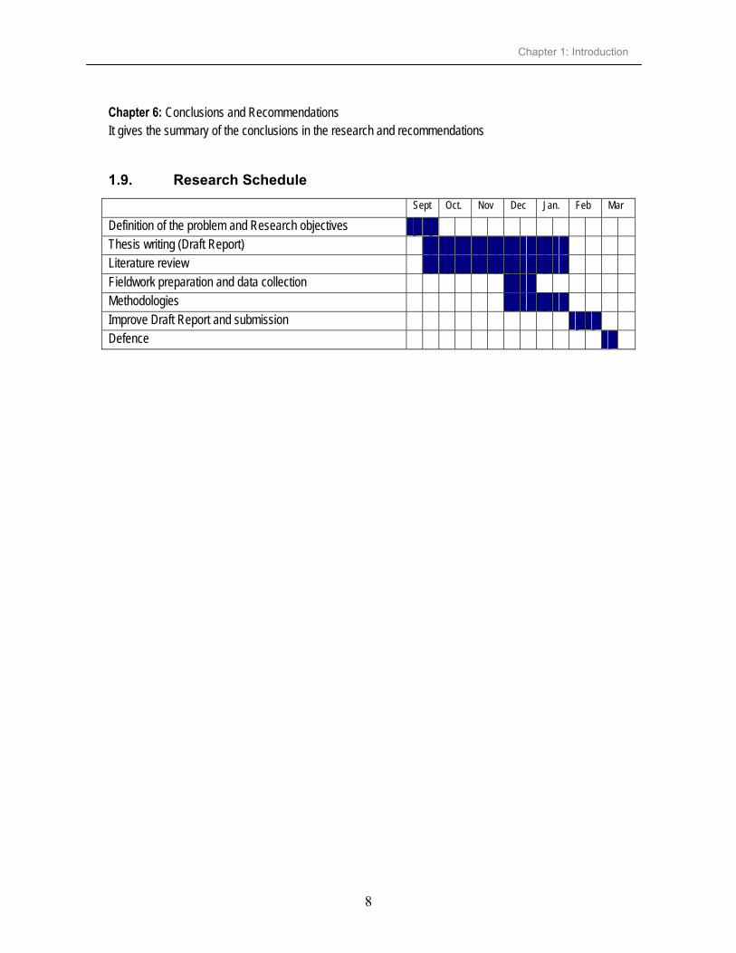
Chapter 6: Conclusions and Recommendations It gives the summary of the conclusions in the research and recommendations
1.9. Research Schedule
Sept Oct. Nov Dec Jan. Feb Mar
Definition of the problem and Research objectives Thesis writing (Draft Report) Literature review Fieldwork preparation and data collection Methodologies Improve Draft Report and submission Defence

Chapter 2: Analysis of the Issuance of Certificate of Occupancy
9
2. Analysis of the Issuance of Certificate of Occupancy
2.1. Introduction
This chapter analyses the issuance of CO business process at the MLHSD in Tanzania. Preliminary overviews on the laws in the land tenure are discussed. The whole existing business system, with its activities is discussed and more detail will be found in appendix A. Overall problems and those specific to the CO are reviewed. It also proposes improvements in the existing situation as suggested in the fieldwork.
2.2. Existing Situation The New National Land Policy was introduced so as to help in governing land tenure, land use management and administration. The National Land Policy of 1995; overall aim is to promote and ensure a secure land tenure system, encourage the optimal use of land resources and facilitate broad-based social and economic development without upsetting or endangering the ecological balance of the environment. The following are the specific objectives of the National Land Policy underscore equity, efficient and security of the land distribution process:
promote an equitable distribution of and access to land by all citizens; ensure that existing rights in land especially customary rights of small holders (i.e. peasants and
herdsmen who are the majority of the population in the country) are recognized, clarified, and secured in law; set ceilings on land ownership which will later be translated into statutory ceilings to prevent or
avoid the phenomenon of land concentration (i.e., land grabbing); ensure that land is put to its most productive use to promote rapid social and economic
development of the country modify and streamline the existing land management systems and improve the efficiency of land
delivery systems; streamline the institutional arrangements in land administration and land dispute adjudication and
also make them more transparent; promote sound land information management; promote land resources from degradation for sustainable development.
The Policy also looks at the access of women to land under the customary land law where by the women generally have inferior land rights relative to men and their access to land is indirect and insecure. Traditional provisions which used to protect women’s land use rights have been eroded. In allocating land village councils have been guided by custom and have continued to discriminate against women by

Chapter 2: Analysis of the Issuance of Certificate of Occupancy
10
allocating land to heads of household who are usually men. The policy statement about this issue is in order to enhance and guarantee women’s access to land and security of tenure, women will be entitled to acquire land in their own right not only through purchase but also through allocation. However inheritance of clan or family land will continue to be governed by custom and tradition and also the ownership between husband and wife shall not be the subject of legislation. Access is the right or opportunity to use, manage, or control land and its resources. It includes the ability to reach and make use of the resources. The policy statement about has been taken care of in the new Act which deals with Customary land tenure by including the issue of women access to land– The Village Land Act No. 5 of 1999 (see appendix E3) section 22. The rights women have to land have also become a major concern internationally, in part because women are now belatedly recognized as forming an important segment of a nation’s economic and social capital. Two world conferences on housing and human settlements have taken place in Beijing (UN 1995) and Istanbul (Habitat II 1996). Delegates from different parts of the world participated and stressed the need to improve women’s equitable access and control of land, property and settlement. Also a workshop was held in Gavle, Sweden, 1995 focusing entirely on women rights connected to land issues. In Tanzania, the agriculture sector earns about 90% of the country’s foreign exchange. Out of the total active population engaged in agriculture production, 75% are women (Ericsson, 1999). The women’s access to land becomes an issue when widows are quite often totally dispossessed immediately after the death of the husband. A widow is not even recognised as a person who earned part of the property or contributed to its existence. If the traditional family is dissolved, the woman usually takes care of the children. Beside the fact that her economic situation becomes problematic, her need for a secure place to stay in becomes even larger the moment her husband disappears. The least a woman needs is to have a place to stay in, in this situation. In order to be able to govern land tenure, land use management and administration as stated in the National Land Policy there must be laws guiding laws. The laws are more elaborated in section 2.3. Planning and control of development all buildings and uses of land are arranged in the various use classes as stated in the Town and Country Planning (Use Classes) Regulations, 1960. Appendix B shows the various use classes set for the purpose of planning and control of development of all buildings and uses of land. The issuance of CO is conducted in MLHSD by three departments involved in land matters and also other enterprises outside the ministry. The departments are inter-related because they are connected at the administration level; but they are independent contributors to the preparation of documents and data needed for the procedure of land delivery. The flows of information for the issuance of CO within and between the departments are discussed in detail in section 2.5. CO business process facilitates the private development of land, disposal of the property, mortgaging etc. Currently getting a CO takes long and leads to squatter development. People decide to build houses whenever they see appropriate for themselves without caring if the place is risk, or unplanned. Issa (1999) reported that the result of the failure of the existing system to satisfy the demand for building land is the proliferation of squatter areas in major towns although there are various other reasons for growth of squatter areas e.g. rural-urban migration, land speculation, etc. In Tanzania, in order to own land, the requirement is to have a CO.

Chapter 2: Analysis of the Issuance of Certificate of Occupancy
11
2.3. Overview of Land Laws
In Tanzania land is held under either customary law or by right of occupancy granted by the state. Customary land rights though recognized in law, were not provided with legal documentary evidence, but nowadays there is Village Land Act No. 5 of 1999 where by customary landholders can transfer their land and record is made in the registry.
Table 2-1: Summary of the laws related to land tenure
Legislation Description Freehold titles (conversion) and government leases Act 1963
Freehold converted to government leases not exceeding 99 years
Land Acquisition Act No. 47 of 1967 Compulsory acquisition of land for public purposes e.g. laying out of new towns Customary Leasehold (Enfranchisement) Act. Of 1968 Abolition of customary feudal system of land holding Rural farmlands (Acquisition and Regrant) Act. No. 47 of 1968
“Land to the Tiller” principle. Land transferred to occupier who tills it and not absent landlord. This was after nationalization of means of production following the policy of African socialism.
Urban Leaseholds (Acquisition and Regrant) Act Acquisition of urban leases-same principle as above. To discourage absentee landlordism
Government leaseholds (conversion of Right of Occupancy) Act No. 44 of 1969.
All government leases converted to granted rights of occupancy not exceeding 99 years. This was inline with granted rights under the Land Ordinance Act. Cap. 113
Survey Ordinance Act Cap. 390 For regulations of surveys and mapping activities. Professional Surveyors (Registration) Act No. 2 of 1977 For regulations of survey practices (registering licensed surveyors) The Local Government Act of 1982 Defines the role of City Commission as the administrator of the city’s resources Town and Country Planning Ordinance Cap 378 of 1956 (revised 1961)
It empowers the Minister for Lands to declare an area as a development area, prepare schemes for development and execute the schemes.
Land Act No. 4 of 1999 An act to provide for the basic law in relation to land other than village land, management of land, settlements of disputes and related matters
Village Land Act No. 5 of 1999 An act to provide for the management and administration of land in villages and related matters
Registration of documents Ordinance Cap. 117 Register all documents which are not Certificate e.g. letter of offer, deed poll, deed of rectification, etc.
Land Registration Ordinance Cap. 334 Register Certificate of Occupancy
Adapted from Issa (1999) The land laws used by the HSD and SMD have been around for decades since colonial times, inherited from the Germans in the early 1900s. Those laws don’t depict the reality like not taking into consideration involvement of user requirements, no decentralisation of power, etc. The LD has reviewed its Land Ordinance Act Cap. 113 of 1923 to Land Act No. 4 of 1999 and also introduce Village Land Act No. 5 of 1999 for customary law, so as to depict the reality. Following the enactment of Land Tenure Land Act No. 4 of 1999 section 4 states that all land in Tanzania shall continue to be public land and remain vested in the President as a trustee for and behalf of all the citizens of Tanzania. The National Land Policy looks at the land tenure systems and admits that there are some areas especially on land administration where shortcomings in the system hinder development and has raised concerns from the public. Thus while retaining the virtues of the existing tenure system, there is need for modifications to suit the present social and economic situation in Tanzania.

Chapter 2: Analysis of the Issuance of Certificate of Occupancy
12
2.4. Organizational structure
The enactment of these laws in land issues are governed by LD, HSD and SMD in the MLHSD see figure 2-1below. LD deals with all land administration matters like processing the applications for ownership of parcel of land and also monitoring if the development conditions granted to the applicants are met. The laws (Land Act No. 4 of 1999) declare all land to be under control and subject to the disposition of the president. Commissioner for Lands (CL) heads the division and is the executing officer for all matters pertaining to ownership of land in the country. HSD headed by the Director of Human Settlements Development (DHS), deals with planning of all land in Tanzania. The Town and Country Planning Act of 1956 (revised in 1961) defined responsibilities of the department as to declare planning areas, prepare general planning schemes and also controlling the development and execution of planning schemes. SMD deals with all surveying activities like cadastral, hydrographic, topographic and making maps. The Survey Ordinance of 1957 and the Surveyors Regulations of 1956 regulate surveys and mapping activities. The National Council of Professional Surveyors (NCPS) is a statutory body that licenses and regulates professional surveying activities. The head of the department is Director of Surveys and Mapping (DSM).
Figure 2-1: Organizational Structure of the MLHSD
2.5. Flow of information – internal flow within departments
The area declared has to be planned following the planning standards already laid down before surveying. If the planning standards are already developed then the process starts at the Urban Development Policy and legislation for the preparation of TP drg as shown in figure 2-2 below. Topographic and Geodetic section deals with the establishment and densification of national geodetic control network. Surveying of the planned area is based on the control points established by Topographic and Geodetic section. If the control points are already established then the surveying work is carried out by the cadastral section. Urban Land Management and Rural Land Management write Letter of Offer (LoO) and send it to the valuation section where by the valuation of the parcel is carried out. The Valuation Officer (VO) sends back the LoO for the preparation of CO, registration of CO is done in the Land Registration section.
Lands Department
Urban Land Management
Customary Land Tribunal
Land Registration
Rural Land Management
Legal Valuation
Human Settlements Department
Urban DevelopmentPolicy & Legislation
Urban StrategicDevelopment Plans
Planning of Prime Area and Records Keeping
Housing Policy
Revolving Housing Loan Fund
Surveys & Mapping Department
Cadastral
Topographic & Geodetic
Village & Hydrographic
Mapping
Ministry of Lands and Human Settlements Development

Chapter 2: Analysis of the Issuance of Certificate of Occupancy
13
Figure 2-2: Information flow
2.6. Overall task of three departments Other tasks are done by each department apart from the issuance of CO which involves three departments at the MLHSD. The following are the tasks done by each department.
2.6.1. Surveys and Mapping Department
Survey and mapping activities are carried out under Survey Ordinance Act Cap. 390 and the regulation of surveys practices (registering licensed surveyors) are under the Professional Surveyors (Registration) Act No. 2 of 1977. SMD has the following tasks: Measure and define property boundaries within specified accuracy and standards for various uses. Define geographical positions of natural and man-made features. Define territorial boundaries in order to maintain good relations with neighbours and settle boundary
disputes Establish primary surveying control points for mapping purposes Produce base maps for planning of various development projects Survey land in urban areas to allow orderly settlement and development of the infrastructure Administer and regulate all aerial photography exercises undertaken in the country Planning and execution of ground photo control surveys for base map making Planning, coordinating, and monitoring the implementation of the village mapping projects Take custody of all survey records. Provide the parcel number for all parcels in the country; this is done so that the number becomes
unique. Examining all surveyed jobs submitted at the records office.
Beginning of the process
Interaction in both ways
Flow of the process
End of the process
Lands Department
Urban Land Management
Customary Land Tribunal
Land Registration
Rural Land Management
Legal Valuation
Human Settlements Department
Urban DevelopmentPolicy & Legislation
Urban StrategicDevelopment Plans
Planning of Prime Area and Records Keeping
Housing Policy
Revolving Housing Loan Fund
Surveys & Mapping Department
Cadastral
Topographic & Geodetic
Village & Hydrographic
Mapping
Ministry of Lands and Human Settlements Development

Chapter 2: Analysis of the Issuance of Certificate of Occupancy
14
Registering approved surveyed jobs. Prepare deed plans. The department deals with planning, establishment and densification of the national control network.
The control points are classified according to their overall positional accuracy, primary control points have better accuracies than secondary control points. Levelling of the national benchmarks, the heights are needed in road constructions, establishment of
control points. Prepare and produce various types of base maps, e.g. cadastral base maps and national maps scales
are in 1:2500 to 1:20000 (large scale maps), 1:20000 to 1:100000 (medium scale maps) and 1:100000 and smaller (small scale maps), typical map scales are 1:2500 and 1:50000. Basic topographic mapping is at 1:50000 and urban base mapping at 1:2500. Other medium to small scales 1:100000 are derived from basic topographic map. The value of the map is determined by many factors and the major ones are geometric or position accuracy of the represented features; completeness of the representation and accuracy or up-to-date of the map (Masele, 1999)
2.6.2. Lands Department
The Land Act No. 4 of 1999 replaced the Land Ordinance Act Cap. 113 of 1923 introduced by the British colonial rule, state that all land in Tanzania shall continue to be public land and remain vested in the President as trustee for and behalf of all the citizens of Tanzania. The department work basing on Village Land Act No. 5 of 1999 for customary land tenure, Land Registration Ordinance Cap 334, Registration of Documents Ordinance Act Cap 117, Land Acquisition Act No. 47 of 1967. The department has the following tasks: Receive and process applications for land, which falls under jurisdiction of Ministerial Allocation
Committee as per Act. No. 4 of 1999 and process CO thereafter. Signing and sealing CO for the whole country The department is also responsible for disputes adjudication for all land conflicts, which are above the
district level and advise the Minister on relevant legal steps to be taken. Provide advice to the Government on all matters related to valuation of real properties and to do
valuation for different purposes such as insurance, market value, transfer, assessing compensation, mortgage, land rent etc. Grant consent for leases, mortgages, transfers and other related transactions for long-term rights of
occupancy ranging from 33 to 99 years. Maintains records of all land transactions, maintain copies of all applications for CO. Ensure adequate development of land held under a right of occupancy Registering CO, land-related transactions and collateral. Providing general legal advice, liase with Attorney General (AG) in court cases against the MLHSD.
Approve disposition of land rights, processing compulsory acquisition of land and revocations Providing information to the public and private companies (information on ownership) Provide better possibilities of finance since most financial institutions insist on plans and good title
before issuing mortgages.

Chapter 2: Analysis of the Issuance of Certificate of Occupancy
15
2.6.3. Human Settlements Development Department
Planning and Development of Urban are under Town and Country Planning Ordinance Act Cap. 378 of 1956. The ordinance is deployed as a regulatory tool to foster urban development in accordance with publicly defined or desired goals and objectives (Kombe, 1995). The following are various task carried in the department: Formulation and subsequent monitoring of the implementation of human settlements development
policies (i.e. housing and urban development) Formulation of planning standards and planning legislation e.g. high, medium or low density parcels,
industrial, residential or commercial, etc. Advice and assist local authorities on the formulation of plans for their respective areas or settlements Enforcement of development control Prepare planning redevelopment areas, renewal of the blighted urban areas, controlling the layout
design of the city and prepare strategic plans. Formulating policies governing the development of urban areas and environmental conservation and
management. Provides development conditions and declares areas ripe for urban development. Changing of the land use of the particular area can be done but needs to be approved by the Minister of
Lands. The department is also responsible for resolving all land conflicts, including those emanate as a result
of planning or allocation. Preparations of the village land use plans, to make sure that the village land use plans are done
promptly, also keeps its records.
2.7. Synthesis of fieldwork survey
The fieldwork has been carried out for the issuance of CO business process and has been found that the process has to pass through 16 individuals/departments/private company/ministries as can be seen in figure 2-3 below. Figure 2-3 shows the activities of the current situation of issuing CO where by it is carried out by different individuals/departments/private companies/ministries. The process starts by looking for an area to be declared at HSD and ends by delivering CO to the applicant. There are intermediate products involved in the accomplishment of the issuance of CO like Town Planning drawing, cadastral plan, letter of offer and deed plan. The CO is the legal document for occupation of land. Commissioner for Lands is the one who sign all CO. CO is attached in appendix J. Letter of Offer is prepared before CO, attached in appendix I. Issuance of CO business process involves Human Settlements Department, Minister for Lands, Ministry of Civil Service, Attorney General, Lands Department also the Applicant him/her self. Others involved also are Local Government Leaders, District Commissioner, Regional Commissioner, Accounts department in MLHSD even sometimes Ministry of Finance. Urban Planning Committee in Local Government Office, Surveys and Mapping Department, City Land surveyor, Private (Licensed Surveyors) and the last is Allocating Committee. For more details concerning figure 2-3 see appendices A and C.

Chapter 2: Analysis of the Issuance of Certificate of Occupancy
16
88878685848382818079787776757473727170696867666564636261605958575655545352515049484746454443424140393837363534333231302928272625242322212019181716151413121110987654321
HSD ML MCS MJCA LD APP LGL DC RC ADL MF UPC SMD CLS LS AC
16 participating departments/private companies /ministrie/ individuals
88 activities3 years
ARAC
Figure 2-3: Activities carried in different departments/private companies/ministries/individuals
Chapter 2: Analysis of the Issuance of Certificate of Occupancy
17
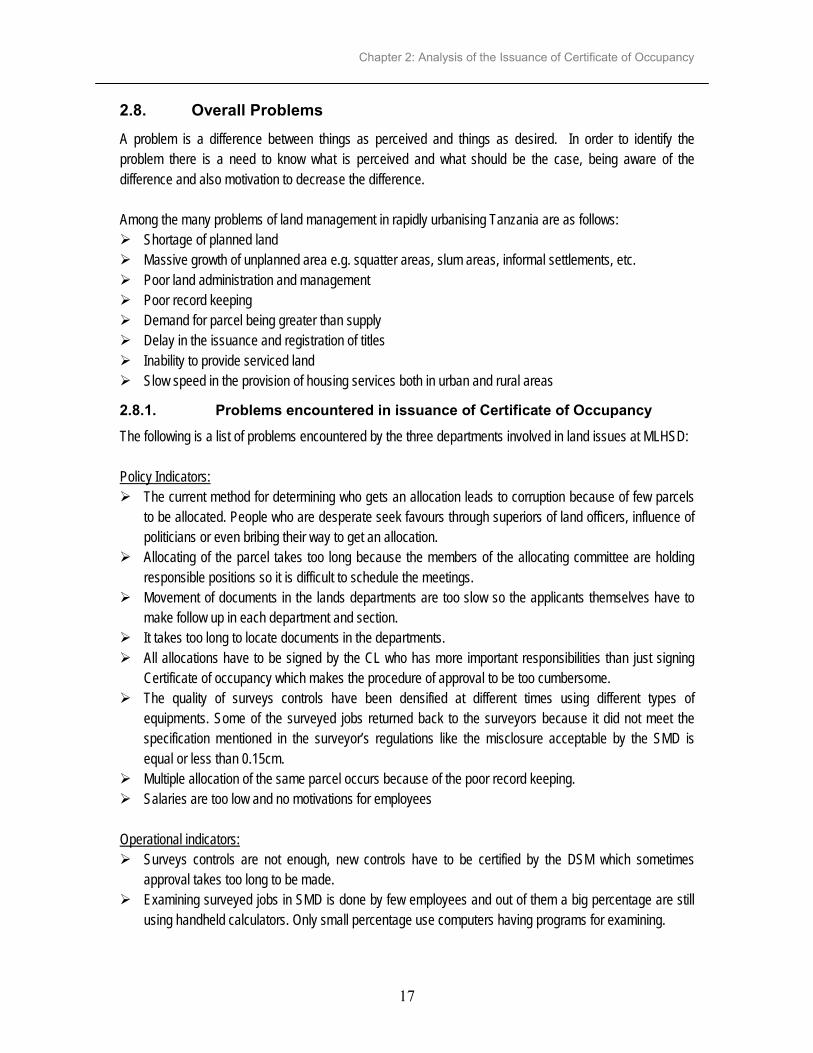
2.8. Overall Problems A problem is a difference between things as perceived and things as desired. In order to identify the problem there is a need to know what is perceived and what should be the case, being aware of the difference and also motivation to decrease the difference. Among the many problems of land management in rapidly urbanising Tanzania are as follows: Shortage of planned land Massive growth of unplanned area e.g. squatter areas, slum areas, informal settlements, etc. Poor land administration and management Poor record keeping Demand for parcel being greater than supply Delay in the issuance and registration of titles Inability to provide serviced land Slow speed in the provision of housing services both in urban and rural areas
2.8.1. Problems encountered in issuance of Certificate of Occupancy
The following is a list of problems encountered by the three departments involved in land issues at MLHSD: Policy Indicators: The current method for determining who gets an allocation leads to corruption because of few parcels
to be allocated. People who are desperate seek favours through superiors of land officers, influence of politicians or even bribing their way to get an allocation. Allocating of the parcel takes too long because the members of the allocating committee are holding
responsible positions so it is difficult to schedule the meetings. Movement of documents in the lands departments are too slow so the applicants themselves have to
make follow up in each department and section. It takes too long to locate documents in the departments. All allocations have to be signed by the CL who has more important responsibilities than just signing
Certificate of occupancy which makes the procedure of approval to be too cumbersome. The quality of surveys controls have been densified at different times using different types of
equipments. Some of the surveyed jobs returned back to the surveyors because it did not meet the specification mentioned in the surveyor’s regulations like the misclosure acceptable by the SMD is equal or less than 0.15cm. Multiple allocation of the same parcel occurs because of the poor record keeping. Salaries are too low and no motivations for employees
Operational indicators: Surveys controls are not enough, new controls have to be certified by the DSM which sometimes
approval takes too long to be made. Examining surveyed jobs in SMD is done by few employees and out of them a big percentage are still
using handheld calculators. Only small percentage use computers having programs for examining.

Chapter 2: Analysis of the Issuance of Certificate of Occupancy
18
Preparation of deed plans is done at the mapping section and survey plans are kept at the cadastral section. If another request is received and the parcel is on the same cadastral plans has to wait for the survey plan to be returned from the mapping section – this normally takes long. There is no feedback if the LoO has been rejected. The Land Officer (LO) assumes that everyone will
accept the offer. No effective way to verify if the 30days period mentioned for the payment of fees has elapsed. There is no effective way of knowing if the development conditions are being complied with, for example, developments of the parcel within three years. The base maps and standard sheet used for planning activities are old (not up-to-date) which cause
delays in the preparation of TP drg. or TP drg. are prepared which do not always depict the exact situation on the site. Misidentification of the parcels happens when the time between the allocation and when the applicant
develops the land can be so long to the extent of forgetting the actual plot that was allocated to him/her. This problem also happens because it takes long time between the surveying and allocating period. After approving the cadastral plan, surveyors shows the Land Officers the boundary of the parcels, but the allocation takes long and sometimes the LO forgets or doesn’t see the boundary marks which leads to the misidentification of the parcels and later land disputes.
2.9. Actions for improvement and SWOT analysis The SWOT analysis is necessary in order to obtain information that will highlight the critical issues that the enterprises involved in the issuance of CO business process faces and its strategic plans must be addressed. There is a need of looking for the internal (Strength and Weakness) and external (Opportunities and Threats) environments so as to identify the problems facing enterprises. External environments (opportunities and threats) are done looking at the actors, identify their concerns and analysing the trends affecting actors concerns. Opportunities are area of potential growth for the future of the business and threats are the conditions that might negatively affect the business (e.g. competitors, changes in technology, etc.) Internal environments (strength and weaknesses) strength provides the organization with the competitive advantage and weakness is the specific aspects of the business that require improvement.

Chapter 2: Analysis of the Issuance of Certificate of Occupancy
19
Figure 2-4: Situation analysis;-Environmental Scanning - Source Paresi (2001)
The following are the mission and vision of the Ministry of Lands and Human Settlements Development under the National Development Vision 2025 of Tanzania: Mission: To administer and manage land (ownership, value, use, etc.) To provide effective and efficient land delivery process To administer and regulate cadastral surveys in the country, hydrographic surveys and mapping
activities in the country To create enabling environment and institutional framework to support human settlements development
process Vision: To have excellent delivery of land development services and a multipurpose cadastral information system for sustainable economic development. The National Development Vision 2025 aim at maintaining the sustainable human development, which will enable the raising of the living standards of Tanzanians to the level of a medium developing country, come the year 2025. There must be a strategic fit between what environment wants and what the enterprise has to offer, as well as between what the enterprise needs and what the environment can provide for an enterprise to be successful over time. The SWOT analysis outcomes are objectives that state clearly the measurable targets of achievement. Opportunities should be exploited by using the enterprise internal strength (SO). Strength should be used to attack and defend the enterprise from the external threats (ST). Opportunities should be also explored to remove or minimize the weaknesses (WO) and threats should be avoided by minimizing weaknesses (WT).
organization
Strengths analysis
Internal environment
Externalenvironment
Weaknesses analysis
Threats analysis
Opportunities analysis
Strategiesdevelopment

Chapter 2: Analysis of the Issuance of Certificate of Occupancy
20
Strategies state how the organization will achieve its goals, Strategies describe what is to be done to the AS-IS situation to move to the TO-BE (Paresi, 2001). Strategies developed by looking at the external and internal environments have to be within the mission and vision of the MLHSD as stated above.
Table 2-2: SWOT analysis matrixes
Internal factors (IFAS) External factors (EFAS)
Strength • Ability to produce high accurate cadastral plans • Have already started putting data in digital form (computerization) • Staff are eager to learn
Weakness • Departments involved do not work as one cohesive unit • No decentralisation of power to make decisions – highly bureaucratic • Rigid standards enforcements which sometimes may not be required by users • Shortage of qualified personnel and working tools • Inadequate financial resources • Low morale of staffs – salary is too low • Loss of information because of poor record keeping • Some of land laws don’t depict the reality (e.g. no involvement of users, decentralisation of power etc.)
Opportunities • Growing number of customers • Government has more transparent process (good governance) • No competitor (monopoly) • Very capable licensed surveyor • New technology available e.g. GIS, GPS
OS strategies • To find a suitable technology to use with the digital data • To make training programs for learning new technology EXPLOIT
OW strategies • Enhance digital record keeping, retrieval of information and workflow between departments • Commercialise services to improve financial base to take advantage of monopoly and growing number of customers • Decentralise activities and decisions centres by involving licensed surveyors • To improve land laws to legally empower licensed surveyor EXPLORE
Threats • Shortage on fund from the government • Dissatisfaction of customers with response to time and also meet their specific needs • Economic situation regulate exchange of money (reduce purchasing power)
ST strategies • To use digital technology to speed up the process and tailor made products form ATTACK
WT strategies • Improve the workflow between the departments so as to satisfy customers. • Reviewing some land laws so as to depict the reality (e.g. Town and country Planning Ordinance Act. Cap 378, Survey Ordinance Act Cap 390) AVOID
The following are actions for improvement:
Perform periodic actors analysis to understand their requirements. Using existing resources and possibilities of the information and communication technology to put
spatial and non-spatial data in digital form Look for the funds from donors and sponsors Strengthen human resource by training in new technology Design and maintain databases Three departments (HSD, LD and SMD) should be combined to form a parastatal.

Chapter 2: Analysis of the Issuance of Certificate of Occupancy
21
2.10. Proposed improvements in the issuance of CO The proposed improvements are within the mission and vision of the MLHSD as stated above. The improvements have been raised from the views obtained from the fieldwork, SWOT analysis and from my personal views. The following are proposed improvements which need to be taken into consideration: Involvement of indigenous people staying in the area to be declared. Advertise in the local print and electronic media before and after declaration Signed Government Notice (GN) by the Minister for Lands to go to the Attorney General without
passing through Ministry of Civil Servant (MCS) Money for compensation has to be requested from the Ministry of Finance (MF) in advance at the
beginning of the budgeting year even for emergencies in paying compensation. Preparation of TP drg. using simple-to-use GIS software TP drg. to be submitted to the DHS for approval direct after amending by the Town Planner (TP) and
not passing through Senior Town Planner. Better enforcement of land laws Preparation of deed plans to be done digitally. SMD has already put in digital form many cadastral
plans of Dar es Salaam region (see appendix F). Create digital databases to enable retrieval of data to all users, enable linking and data sharing
between departments, also develop and maintain the databases. To make the issuance of CO working efficiently and effectively without the environments (actors) to
notice that it is done with different enterprises. To review the land laws to make the licensed surveyors are to be responsible/answerable for their own
jobs. Using existing resources and possibilities of IT, convert from analogue to digital source data through
digitising It has been found that there are sections doing the same tasks and the following are suggested: In LD, Urban Land Management, Rural land Management and Customary Land Tribunal sections are
almost doing similar tasks, although in different areas which are urban, rural and customary. It is better to have one section taking care of these tasks to avoid duplication. Housing Policy and Revolving Housing Loan Fund sections in HSD can also look at the duplicate tasks
and form the separate section. Both sections deal with housing issues like housing policy, housing development, facilitates human settlements. They also assess the performance of the housing sector and helping the civil servant to acquire loans for housing construction respectively. Planning of Prime Area and Records Keeping section is dealing with planning of redevelopment areas.
Urban Development Strategic Plans section prepares strategic urban plans for fast urbanizing human settlements. These two sections deal with development of urban areas, they have to look at common tasks and have them separately.

Chapter 2: Analysis of the Issuance of Certificate of Occupancy
22
The Urban Development Policy and Legislation section as the name appears seems to deal with only urban issues. It deals with rural areas like declaring planning areas for villages so the name has to change to show that it also accommodate rural areas. In Surveys and Mapping department one of its sections, Village and Hydrographic, also does the
cadastral surveys in villages, so village work can be shifted to cadastral section. Accelerating the process of CO business process will help in – Legal security – having the security of tenure. Taxation – government will get money to help in services like school, hospitals, roads, etc. Development – it is one of the collateral in getting mortgage. Many people in Tanzania depend on
mortgage for doing business. Nowadays there is the law for customary land tenure – The Village Land Act. 1999 No. 5 of 1999 (see
appendix E3) recognizes customary ownership. People are able to get the customary right of occupancy where by the land rent will be paid and government will get the money for the public services.
2.10.1. Sketch of a proposed top level diagram
Figure 2.5 below is a top-level diagram that shows some of the proposed improvements. Those improvements are: Indigenous people staying in the area to be declared are supposed to be involved before declaring an
area and if they won’t agree then president will acquire land by force (compulsory acquisition); Licensed surveyors to submit their surveyed jobs for extension of the database of SMD and also for
records keeping; Preparation of deed plans digitally and not manually, this will help in speeding up this process because
normally it takes time.

Chapter 2: Analysis of the Issuance of Certificate of Occupancy
23
look for an area to be declared
people disagree
people agree
acquire land by force[no]
[yes]
pay compensation
prepare Town Planning drawing
survey, compile, check
survey & compilecheck & approve
register surveyed job[Private Land Surveyor]
[Governm ent Land Surveyor]
prepare deed plans write Letter of O ffer
receive receipt
prepare CO deliver CO
Figure 2-5: Proposed top-level activity diagram
2.11. Concluding remarks
The issuance of CO involves many enterprises. The existing situation has been analysed and the improvements to be done mentioned by considering the external and internal environments, improvements suggested in the fieldwork and also from the personal views of the author. The top level diagram shows the proposed improvements at global level.

Chapter 3: Concepts of Coordination, Integration and Modeling
24
3. Concepts of Coordination, Integration and Modeling
3.1. Introduction
This chapter deals with three important issues namely coordination, integration and modelling that contribute in the issuance of CO process. This process is intra and inter organizational process scanning through various enterprises. It discusses different modeling techniques and the model can be tested.
3.2. Coordination
Coordination entails supporting collaborative information sharing and tool usage, concurrent development processes and data updates, intra and inter-team communication, and well formed composition of products. Coordination deals with the set-up and manages the links of the processes with their activities, resources and regulates the behaviour of the workflow. Coordination is referred to hierarchical and non hierarchical as stated by Bennett in (Robinson et al. 2000). Government has hierarchical form and non government organizations have non hierarchical forms of coordination. The problem in having coordination between the departments involved in land matters at the MLHSD is that every department is highly autonomous and is managing its own computing environment, tools, data and staff. This means that there is no central system, database or some other coordination mechanism that is sufficient to serve as the single integrating resource. Each department has to establish its own local database which will make it easier to be coordinated and work effectively and efficiently in issuance of CO business process. The attention has to be paid to the roles and responsibilities of each department that might have towards the structure and process of coordination. There is a need of having a process owner for the entire CO business system and process owners at the departmental level. Process owners at the departmental level have to make sure that all necessary activities contributing to their process are involved in their subsystems. Process owner for the entire CO business system is supposed to make sure that subsystems are coordinated. There is a problem of coordination between and within three departments involved in the issuance of CO business process (Derby et al. 1995, Issa 1999 & Maleko 2000). Figure 3.1 show that an applicant in order to get CO has to make follow-up in each department. This is for making sure that the application is proceeding, otherwise the application get stuck in the department without going to the next required department.

Chapter 3: Concepts of Coordination, Integration and Modeling
25
Figure 3-1: Products of departments on issuance of CO-adapted from Maleko (2000)
The departments need to agree to have one storage manager, same policies, etc. but each department should be able to modify/update its own data, documents, agendas. Effective implementation of the model requires coordination between several groups, including representatives from administration, legal, information technology (IT), etc. The following steps can facilitate coordination in implementation of CO model Risk assessment should be completed to identify specific vulnerabilities in the business model. There must be clear lines of communication and authority as well as a transparent working relationship
in order to encourage information sharing and coordination. Management should be committed to employee training and enforcement of changes in the business
process. Coordination should be highlighted as a policy priority to be encouraged and financed at all levels.
The distributed computing infrastructure required for Information Coordination and Sharing in distributed departments must be capable of supporting the requirements of interoperability, scalability, flexible application composition, dependability, privacy and autonomy, change management and auditability. Coordination must be established with an effective communication system which enables feedback and continuous adaptation to changing circumstances. The inclusion of government structures and line ministry officials cannot be merely perfunctory; transparency, adaptability and reciprocity are crucial to the success of all coordination endeavours (Bennett in Robinson et al. 2000). The challenge is to design a structure conducive to strengthening cooperation without limiting the freedom of any participant. The following are set of principles as stated by Bennett in (Robinson et al. 2000).
The primary objective of interagency co-ordination is to improve efficiency and effectiveness of a joint response to identified needs. Coordination agencies and their individual participant agencies should understand the factors,
barriers and dynamics which affect the success or otherwise of co-ordination modalities.
DB
Lands Development Processes
Town Planning drawing
Cadastral Plans Certificate of Occupancy
Cadastral Plans
Applicant
DB
Request/Delivery
Surveys & Mapping Processes
DB
Human Settlements Processes
Request/Delivery Request/Delivery
Request/Delivery Request/Delivery Request/Delivery
Chapter 3: Concepts of Coordination, Integration and Modeling
26
Coordination mechanisms and roles must remain flexible and responsive to the changing contexts in which they operate. Participation and consensus are the basis of a working model for decision making, agenda setting
and strategic planning. Interagency coordination should plan and implement strategies and programmes which build on
and strengthen existing local institutions, develop local capacity and incorporate a phasing out of foreign-nominated assistance.
3.3. Integration
Integration is a way of breaking down the organizational barriers which have resulted from the traditional hierarchical management principles. Integration consists of putting components together to form a synergistic whole (Vernadat, 1996). Integration concerns the business and enterprise organisation arena the problems require multidisciplinary solutions (Kosanke et al. 1999). Nowadays the enterprises are not dealing with artefacts only, but also recognizing the role, place and involvement of people as well. It means that enterprises move from the integration of rather deterministic and monolithic system to the integration of highly non-deterministic and heterogeneous systems. The issuance of CO business process from the declaration of an area to be allocated involves three departments in the MLHSD and other enterprises as explained in section 2.7. Departments at the MLHSD have several tasks apart from issuance of certificate of occupancy as shown in section 2.6 with its subsections. There is a need for departments to look at those processes involved in the issuance of CO business process and integrate so as to meet customers requirements (quality), reduce the time to give services (delay) and also services should be at low cost with increased quality (cost). Vernadat (1996) states that having high quality of services, low cost products in short delays needs high degree of automation, sometimes high precision and excellent management. The CO business process must be integrated and coordinated to ensure consistent overall operations of the enterprise with respect to its business objectives. The two major issues to consider in integration are how to motivate employees and how to provide employees with the right information to do their job.
3.4. Enterprise integration
Enterprise integration provides the right information at the right place and at the right time and thereby enables communication between people, machines and computers and their efficient cooperation and coordination (K. Kosanke et al. 1999). With the fairly complex system involved in the enterprise operations, the exchange of information has to be supported by Information and Communication Technology (ICT). ICT increases the operational transparency and reaction time and thereby improve efficiency and flexibility in the enterprise environment. It can facilitate the identification of relevant information and the use of current

Chapter 3: Concepts of Coordination, Integration and Modeling
27
information during the decision support, leads to better and faster decision making and, therefore increase the competitiveness of the enterprise. There is a need for enterprise integration because the business trends are clearly towards the need for managing organizational and operational changes in order to face global competition and fluctuating market conditions (Vernadat, 1996). Kosanke et al. (1999) states that the goal of integration is “to improve the overall system efficiency by linking its elements by means of communication networks and thereby obtaining higher responsiveness and effectiveness of the whole system compared with the isolated operation of its components”. Enterprise integration aims in enabling communication among the various functional entities of the enterprise, providing interoperability of IT applications and facilitating coordination of functional entities for executing business processes so that they synergistically contribute to the fulfilment of the enterprise goals. The goal of the enterprise integration is the development of solutions and computer-based tools to facilitate coordination of work and information flow across enterprises boundaries. The major motivations for integrating the enterprises are the need for real information sharing and improving task coordination.
3.5. Enterprise modeling Enterprise modeling is a set of activities or processes used to develop the various parts of an enterprise model to address some desired modeling finality. K. Kosanke & M. Zelm (1999) wrote, “Modeling methodologies will guide users through the rather complex enterprise modeling task”. Enterprise modeling is a crucial step both for Enterprise Engineering and Enterprise Integration (Berio & Vernadat, 1999). Enterprise Engineering define, structure, design and implement enterprise operations as communication networks of business processes. It comprises all their related business knowledge, operational information, resources and organisation relations. Enterprise modeling starts with the capture of user requirements in the form of business descriptions and business issues (e.g. explanation from user interviews, sketches of processes, example of data screens, samples of data and documents, etc.). The process ends with a formalized description of enterprise operations defining what has to be done in the enterprise. Also how it will be done, and by whom in specific contexts, i.e. normal and abnormal operating conditions. Enterprise modeling aims to provide a better understanding and uniform representation of the enterprise. It support for designing the new parts of the enterprise and also a model used to control and monitor enterprise operations. The main motivations of the enterprise modeling are managing of system complexity, better management of all types of processes. It looks also in capitalization of enterprise knowledge and knowhow, business process reengineering and also the enterprise integration.

Chapter 3: Concepts of Coordination, Integration and Modeling
28
Business processes to be integrated or computer-controlled need to be formalized as well as objects they use, handle or process. Also information accessed or generated, resources required to execute them, and responsibilities and authorities required for their execution. The enterprises dealing with the issuance of CO business process has to model all of their processes involved, integrate and then coordinate so as to work efficiently and effectively.
3.5.1. Views to be considered in enterprise modeling
Vernadat (1996) defines “Modeling view as a perspective or viewpoint from which the enterprise is considered for a given purpose, concentrating on some aspects to reduce complexity”. Views are not separate models but different perspectives or angles used to look at the model at each modeling level. (Eriksson & Penker 2000) defined “views as not separate models; they are different perspectives on one or more specific aspect of the business”. Views when combined create a complete model of the business.
Figure 3-2: Business architecture as described with four views
The following are four different views to be taken care when modelling a business system as written by Eriksson & Penker:
3.5.1.1. Business Vision View
Business vision describes the overall vision of the business. This view describes a goal structure for the company and illustrates problems that must be solved in order to reach those goals. It acts as the guide for modeling other views. In creation of business vision view it is very important to take into consideration know the customer requirements and what’s going on in the world to identify future changes and trends in the enterprises among competitors, in the market segment, in technology, or in regulations or policies. The ultimate result of business vision view is a definition of the desired future state of the enterprise and how that state can be reached. The techniques used for the business vision view is to define the overall strategy for the future (means that the business must be viewed in context of its surrounding world in order to identify
BusinessVision View
BusinessProcess
View
BusinessStructure
View
BusinessBehaviour
View

Chapter 3: Concepts of Coordination, Integration and Modeling
29
threats and opportunities that will require the business to change also its internal to identify weaknesses and threats).
3.5.1.2. Business Process View
The business process view is at the centre of business modeling. There are relationships between a process and its resources and between different processes that interact, and here is the coupling of processes to goals. It represents the activities and value created in the business and illustrates the interaction between the processes and resources in order to achieve the goal of each process. It demonstrates the interaction between different processes. It illustrates the activities of the system, the transformations and the functionality, while concentrating on the interactions among the resources, goals, and rules in the business. The business processes are modeled by utilizing interviews with people in the business, the results of which explains how the business works.
3.5.1.3. Business Structure View
Business structure represents structures among the resources in the business, such as organization of the business or the structure of the products created. It doesn’t represents the structures of the processes or the breakdown of processes into sub processes like in business process view. Business structure view is considered supplemental to the process view, depicting information that cannot be shown in the process diagram but that is vital to the operation of the enterprise.
3.5.1.4. Business Behaviour View
Business Behaviour describes the individual behaviour of each important resources and process in the business as well as the interaction between several different resources and processes. The behaviour of the resource object is governed by the Business Process view, which shows the overall main control flow of work performed. Business Behaviour view looks into each of the involved objects in more detail: their state, their behaviour in each state and possible state transitions. It also shows the interaction among different processes such as how they are synchronized. A business Behaviour view illustrates the dynamic behaviour of each of the object involved in the activities.
3.5.2. Different modeling techniques UML (Unified Modeling Language) is an approach that is very close to how human beings themselves
view the world. There is a close relation between the real life occurrence and the objects in the model (often a one to one relationship), the semantic gaps between the reality and the model is the small one Jacobson (1995). Object is abstraction of reality and all the components of the enterprise can be described as an object e.g. object can be the product, services, materials, information, workers, organization structure, etc CIMOSA (Computer Integrated Manufacturing Open System Architecture) view an enterprise as a set
of functional entities processing enterprise objects, operations of which are governed by a set of communicating concurrent processes performed to achieve business objectives. IDEF0 (Integrated Definition Language) is an activity based modeling language. It based on Structured
Analysis and Design Technique (SADT), which was developed for structured functional analysis. IDEF2 is a graphical formalism based on queuing networks to model the time dependent aspects of a
system previously modeled with IDEF0. Only valuable once programmed in SLAM language and only occasionally used in graphical form.
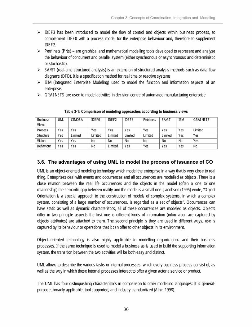
Chapter 3: Concepts of Coordination, Integration and Modeling
30
IDEF3 has been introduced to model the flow of control and objects within business process, to complement IDEF0 with a process model for the enterprise behaviour and, therefore to supplement IDEF2. Petri nets (PNs) – are graphical and mathematical modelling tools developed to represent and analyse
the behaviour of concurrent and parallel system (either synchronous or asynchronous and deterministic or stochastic). SA/RT (real-time structured analysis) is an extension of structured analysis methods such as data flow
diagrams (DFD). It is a specification method for real time or reactive systems IEM (Integrated Enterprise Modeling) used to model the function and information aspects of an
enterprise. GRAI NETS are used to model activities in decision centre of automated manufacturing enterprise
Table 3-1: Comparison of modeling approaches according to business views
Business Views
UML CIMOSA IDEF0 IDEF2 IDEF3 Petri nets SA/RT IEM GRAI NETS
Process Yes Yes Yes Yes Yes Yes Yes Yes Limited Structure Yes Limited Limited Limited Limited Limited Limited Yes Yes Vision Yes Yes No No No No No No Yes Behaviour Yes Yes No Limited Yes Yes Yes Yes No
3.6. The advantages of using UML to model the process of issuance of CO UML is an object-oriented modeling technology which model the enterprise in a way that is very close to real thing. Enterprises deal with events and occurrences and all occurrences are modelled as objects. There is a close relation between the real life occurrences and the objects in the model (often a one to one relationship) the semantic gap between reality and the model is a small one. Jacobson (1995) wrote, “Object Orientation is a special approach to the construction of models of complex systems, in which a complex system, consisting of a large number of occurrences, is regarded as a set of objects”. Occurrences can have static as well as dynamic characteristics, all of these occurrences are modeled as objects. Objects differ in two principle aspects the first one is different kinds of information (information are captured by objects attributes) are attached to them. The second principle is they are used in different ways, use is captured by its behaviour or operations that it can offer to other objects in its environment. Object oriented technology is also highly applicable to modelling organizations and their business processes. If the same technique is used to model a business as is used to build the supporting information system, the transition between the two activities will be both easy and distinct. UML allows to describe the various tasks or internal processes, which every business process consist of, as well as the way in which these internal processes interact to offer a given actor a service or product. The UML has four distinguishing characteristics in comparison to other modelling languages: It is general-purpose, broadly applicable, tool supported, and industry standardized (Alhir, 1998).

Chapter 3: Concepts of Coordination, Integration and Modeling
31
UML provides a number of graphical elements that are combined to form diagrams, which represents multiple views of a system to form a model. UML has different diagrams, which capture static and dynamic behaviours of the business system. The combination of these diagrams helps to model the system better and reduce complexity. UML is becoming industry standard for modelling. Many software vendors are directly or indirectly supporting it. UML is an object oriented so it takes advantages of object oriented features which are: comprehensive – it is possible to break down the classes hierarchically, so that an understandable
overall picture of the business being modelled can be obtained understandable – the business is described in terms of objects, which often have direct link to
occurrences in the real world. changeable – changes are usually local to a given class, can be introduced without affecting other
classes in the model. adaptable – it is possible to specialize, with the help of the inheritance mechanism, existing classes. reusable – classes can be built and handled as components. When new classes are created, properties
in already defined classes can be reused. The high quality experiences embedded in the UML certainly makes its application to complex systems desirable, but the lack of precise semantics can limit its effectiveness. The separation of view principle has proven to be an effective means of controlling complexity, and is well-supported by the UML. On the other hand, the formality and rigor principle that facilitates the detection of errors in requirements and designs is not well-supported in the UML (Jean-Michel Bruel et al, accessed on 15th Feb, 2002).
3.7. Modeling Business Process using UML The goal of business modeling is to define rules with which its resources can be used, consumed, or refined in each process. It also defines the goal to be achieved by each process and show the relationship and interactions among them. There are two main types of model descriptions for modelling the business process. These types are static (shows the model structure) and dynamic (shows the flow of events). Static structure of the model is depicted by the class diagram and dynamic by activity, sequence, state and collaboration diagrams. The identification of the relevant information can be done through the process model (Kosanke et al, 1999). UML was initially designed to describe aspects of a software system, it had to be extended to more clearly identify and visualize the important concepts of processes, goals, resources, and rules of the business system (Eriksson & Penker, 2000). Eriksson-Penker Business Extensions have been created based on the existing model elements of UML and provides symbols for modeling the processes, resources, rules and goals of a business system.
Chapter 3: Concepts of Coordination, Integration and Modeling
32
The standard extension mechanisms in UML allow adoption to accommodate new concepts. The extension mechanisms as proposed by Eriksson & Penker (2000) are as follows: Stereotype is an extension of the vocabulary of the UML, which allows in creating new building blocks
based on existing blocks but specific to the problem at hand. Tagged value (property) is an extension of the properties of a UML element which allows one to create
new information in that element’s specification. All models can be extended with tagged value that consist of a tag and a value (can be a version tag and version number (value) for a class. Another example is the modeller of the process and a value is a text string containing the name of the modeller. Constraint is an extension of the semantics of a UML element that enables to add new rules or modify
existing ones. Eriksson and Penker (2000) stated that ‘If the model will be used to improve or innovate the business, the interactions in the process should be emphasized, and possible changes that could improve the overall performance should be identified’. By working more systematically with good business models, you can guarantee that your company is comprehensible from top to bottom throughout the organization. You can explain your company, clarify new thoughts and ideas, evaluate them against the existing company, draw up scenarios on the environment – customers, competitors, products and so on. UML model the business process using three types of models as use case, static and dynamic models. The use case diagram depicts the business functions and the environments. The activity, state, sequence and collaboration diagrams depict dynamic behaviour of the business system. Objects identified in the use case have names, attributes and operations. Attributes and operations are taken care of in class diagram.
3.7.1. Use Case Diagram
A use case diagram illustrates the system’s intended functions (use cases), the boundary between the system and the outside world (actors), and the communication (relationships) between use cases and actors. Use cases represent the functionality provided by the system and collection of use cases for a system constitutes all the defined ways the system may be used. The purpose of a use case is to define a piece of behaviour of a system or subsystem or class without revealing the internal structure of the system. Use case model describes the business as it is seen externally, that is, how it is perceived by those who wish to use it (actors). Actors are not part of the system but define the environment of the system – they represent anyone or anything that must interact with the system under development. A use case is a series of transactions between an actor and the system that yields something of value to the actor. It is a summary of scenarios for a single task or goal.
3.7.2. Object modeling
Object models describe how the new business will offer use cases to the environment. There are essentially two different types of object model that can be produced to describe how the business system will implement the use cases: an ideal-object and a real-object model. Both of these models use the three object types as follows:
Entity object - represents occurrences such as products, deliverables, documents, and other things that are handled in the business.

Chapter 3: Concepts of Coordination, Integration and Modeling
33
Control object - represent specialist tasks that are performed without any direct contact with the environment of the business. Interface object - represents the tasks that are performed with a direct contact with the environment
of the business. Ideal-object model base the work on the use cases and with the real-object model the work is based on the ideal-object model in order to see the modifications required. The ideal model describes the objects that are to implement the use case model in the business in a simple and not too detailed way. The advantage of ideal object model is it is easy to communicate, simple to update with new changes in the organization and should not take long time to produce. Ideal objects describes how the business would operate in the best possible way. Disadvantage is with only this model you find out that there is only abstract level of the business in comparison to the actual state of the business. If no sufficient details are included in the model one runs on the risk of missing relevant interactions and the resultant model doesn’t promote understanding. The real-object model describes how restrictions in the business affect the implementation of the model. It shows how the ideal-object model will operate in practice. Disadvantage of real model is that it takes longer to be produced. If too much details are included in the model may become complicated and preclude the development of understanding. Whether a model is good or not depends on the extent to which it promotes the development of understanding. The following are the contractual rules that apply to an object and/or its features: Pre-conditions – which must be true prior to the operation or existence of an element; Post-conditions – which must be true after the use or destruction of an object; Invariants – which must always be true for the life and use of an object.
3.7.2.1. Activity diagram
An activity diagram is an ideal object model, shows the workflow description of the business. In order to install the new structure in the business the workflow description must be produced. Activity diagram shows how different workflows or processes in a system are constructed, how they start, the many decisions paths that can be taken from start to finish and where parallel processing may occur during execution. It is designed to be a simplified look at what happens during an operation or a process. Activities normally realised in one or more use cases. The key aspect of the activity diagrams is that they encourage finding parallel processes, which is important in eliminating unnecessary sequences in business processes. They help to figure out what needs to be done first and how to address who does what later. Activity diagram has behavioural constraints in its activity flow (e.g. which activity has to take place before another activity, or guard condition that must be true before an activity is initiated). A guard is rule defines the conditions for when a state transition occurs; that is, when the state of the object is changed from one state to another.

Chapter 3: Concepts of Coordination, Integration and Modeling
34
The workflow may have three types of activities which are direct (an activity directly involved in creating the product or the service, that is the value created by the process); indirect (an activity that supports the direct activities; includes maintenance, administration, planning activities) and quality assurance (an activity that ensures the quality of the other activities; for example inspections, controls or reviews).
3.7.2.2. Sequence diagram
A dynamic model may be described in a simplification of a real world system which changes through time and space. Time aspect is depicted in sequence diagram by following order of messages and the collaboration diagram show how the objects collaborate according to space. A sequence diagram is an interaction diagram that details how operations are carried out, what messages are sent and when. It is a real-object model, the restrictions on the business are taken into consideration. The real model is the one that will be implemented therefore more detail is required. Sequence diagram are organized according to time. It typically shows the interaction of objects with in the execution of a use case and as such correspond to the methods and events supported by a class/object. The objects may have the constraints/rules to make them perform. Sequence diagram may be anchored under a use case to further illustrate the sequence of steps taken to realise a use case. In a sequence diagram an object lifeline denotes an object playing a specific role and arrows between the lifelines denote communication between the objects playing those roles. Within a sequence diagram the existence and duration of the object in a role is shown. The time progresses as you go down the page. The objects involved in the operation are listed from left to right according to when they take part in the message sequence. Each vertical dotted line is a lifeline, representing the time that an object exists. Each arrow is a message call. An arrow goes from the sender to the top of the activation bar of the message on the receiver's lifeline. The activation bar represents the duration of execution of the message. The association in dynamic component is called communication association because it is only used when an object is active and sends a stimulus (message) to another object. Objects acts like little people (anthropomorphism), they respond to messages, send messages to other objects and also change their own state only in response of events. Objects are persistence mechanisms, because they control the lifetime of the information they encapsulate.
3.7.3. Class diagram
A class diagram gives an overview of the system (model structure) by showing its classes and relationships among them. They are static; display what interacts but not what happens when they do interact. All relationship in class diagram are declarative rules that specify how objects of those classes can be combined and related to each other. A class is a category or group of things that have similar attributes and common behaviours (operations). An attribute is a property of a class. It describes a range of value that the property may hold in objects of that class and operation is something a class can do. The type of association between two objects is static and is used to locate one object in relation to another, this kind of relationship is called acquaintance association. A class encapsulates state (attributes) and offers services to manipulate that state (behaviour).

Chapter 3: Concepts of Coordination, Integration and Modeling
35
Classifying and grouping objects into classes reduces the complexity and number of elements when modeling and facilitates describing more complicated systems. Classes are modeled and related to each other, and are described with names, attributes and operations. Class diagrams are used to describe the objects and relationships of a system. Class diagram is the logical model, which models the static structure elements. It captures and defines objects, entities and building blocks of the system. A logical model is a static view of the objects and classes that make up the design/analysis space (Sparks G, 2000). A class is a specification and object an instance of a class. Classes may be inherited from other classes (that is they inherit all the behaviour and state of their parent and add new functionality of their own), have other classes as attributes, delegate responsibilities to other classes and implement abstract interfaces. Class has three distinct areas as class name (and stereotype if applied); class attributes area (internal data elements) and behaviour (operations). Class diagram takes care of all resources participates in the use case. Resources are the objects within the business such as people, material, information and products that are used or produced in the business. Resources are manipulated (used, consumed, refined or produced) through processes; they are concepts, consumed, produced, transformed or used by the business processes. Eriksson and Penker (2000) categorized resources as: Physical - as an entity with material reality that occupies a volume of space e.g. commodities, raw
materials, parts or products. Abstract - as an idea or concept; often a composite of other objects e.g. contracts, roles, accounts and
energy. Information object - as a representation of concept, thing, or another information object. It holds
information about other resources and works as a surrogate for the resource. e.g. it can hold information about a bank account, a product, or a contract. People – a human being acting in the process. People are also sometimes more unpredictable than
machines. Modeling is an essential tool for decision making for several reasons as stated by Ghaffar (2001);
A model can be simulated to answer questions such as ‘what if’ and ‘where if’; A model is an abstraction of real world, that is if required data is efficiently abstracted would be a
better view for the decision maker(s); and A model serves as a blue print that could be used for discussions meetings.
3.8. The use of different views in designing the top-level model Designing of an improved system has to focus on the view of the business vision in an enterprise which gives changes from AS_IS to TO_BE by scanning its environment internally and externally. The business process view looks at the way business works by considering the vision of the business. Each process has activities to accomplish it so as to achieve the goal/s, CO business system is explained in terms of activities and depicted by using activity diagram. The business structure view drawn by using class diagram represents the resources in the business and shows the relationships between resources. The attributes

Chapter 3: Concepts of Coordination, Integration and Modeling
36
(information) of each resource, the operation (how it can be used), constraints/rule of a resource are all shown in business structure view. Business behaviour view is depicting the dynamic behaviour of every object by looking at their interaction by considering the time and space. This view is shown by using sequence and collaboration diagram. Figure 3-3 below shows how different views can be accommodated in modelling the business process using UML technology.
Figure 3-3: Structure of the Business System showing different views
3.9. Reasons for modeling The modeling of the process of issuance of CO is concerned with: the what refers to the operations performed and processes involved with their activities in the
enterprise; the how defines the enterprise behaviour, i.e. the way things are done; the when enforces the notion of time as being an essential component of the model. It can be
associated to events representing a change in the state of the enterprise at a certain time. This help in knowing how much does it take for an event to be performed; the who concerns the resources of the enterprise performing operations of CO business process. The
resources can be used, consumed, refined, etc. the how much (economic aspects) helps in knowing how much it cost for processing CO business
process; where (logistics aspects) the business process takes place.
new business objectives
informationmodelling
object modellingUse Case 1
Use Case 2
activ
ity m
odell
ing
BUSINESS VISION
BUSINESS PROCESS
BUSINESS BEHAVIOUR
Use Case 3
BUSINESS STRUCTURE

Chapter 3: Concepts of Coordination, Integration and Modeling
37
3.10. Testing
During modelling the business process, tests may be applied into five levels which are Unit testing and Integration testing, System testing, Acceptance and Scenario. All these levels of testing are supported by the Enterprise Architect, which is the graphical UML CASE tool for modeling, documenting and building object-oriented software systems. Only the first two levels of testing have been applied in this research because of the time limit.
3.10.1. Unit testing
This test is introduced by the Enterprise Architect which is the a graphical UML CASE tool for modeling, documenting and building object-oriented software systems. Unit tests are used to test attributes and operations of the object to fulfil the responsibility. Responsibilities of objects are done through the use of scenarios and Class Responsibility Collaboration (CRC) card. In CRC analysis there are two things to be considered responsibilities and collaborators. Responsibilities are the ability of objects to know things or do things and collaborating in a way object(s) carry out its responsibilities. Run through the scenario, for each message that comes into the system from an actor or from the system itself has to be checked and figure out which object receives the message. Classes are documented by giving the names, attributes and operations. In achieving unit test every object must be coherent and consistent internally. This can be made possible via joint efforts of human and a method-specific tool, such as MS Visio 2000, Rational Rose, etc.
3.10.2. Integration testing
This test is performed on information model and object model so as to check the consistency between associations in information model and interactions in object model. Integration is achieved if every object is coherent and consistent with Information model (class diagram). At this stage each object is compared and checked against information model to ensure its content is consistent with the Information model. Once an inconsistency has been found that requires updates in the information model, this update must also be propagated to the other objects which include this concept. Consistency on this update must be reached among all objects before resuming the integration testing checking. Once all objects are consistent with the information model then the integration testing is achieved. For each class an interaction diagram is created; starting the scenario properly so that the traceability links come out properly. Traceability here means the possibility of tracing the participating objects, from the architectural (the art and science of designing and constructing buildings) and functional (practical and useful) views within the models, and the messages which are the operations defined in respective classes. An object of the class from the architectural view is let to start the scenario by sending a message.
3.10.3. Verification and Validation
Verification deals with transformational accuracy and validation deals with representational or behavioural accuracy. One of the principles of the verification and validation (V&V) dictates that defects should be detected as early as possible in the development life cycle (Balci, 1997). One of the key advantages of the
Chapter 3: Concepts of Coordination, Integration and Modeling
38
object oriented approach is traceability. The traceability of object oriented artifacts results in traceability of defects. When a defect is identified in a model representation form (i.e. an artifact), it can be traced back, through the sequence of artefacts, to the origin of the defect in an earlier artifact. The verity and validity of object oriented artifacts can be assessed through the application of a series of assessment questions. Those questions assess correctness, completeness, consistency, clarity and testability of each artifact. Using the assessment questions presented by Carr, III and Balci 2000, the defects can be identified early in the development life cycle before the defect is propagated through the remainder of the development cycle (see appendix H). The purpose of validation is to verify whether the models and associated components that have been developed would work properly, and that the system has been logically designed, architecturally and functionally. Validation of the model can be done Link System tests to Use Cases, Link Acceptance tests to Use Cases or Link Scenario tests to high-level packages and the system as a whole (http://www.sparxsystems.com.au/testing.htm, January 2000). Link System tests to Use Cases is when a system tests check that a user can perform the required function in the system and get the expected results. It validates that the right system has been built and operates correctly. The second one links Acceptance tests to Use Cases which is similar testing as to system testing, but is carried out by the end-user, rather than the development team. Last is to link Scenario tests to high level packages and the system as a whole. Scenario tests are used to mimic real-world situations and may require many use cases in a sequence to perform a complete business function. Good validation that the system can cope with real-world problems and events The use case driven modelling constitute an excellent tool for the validation since they explicitly interconnect several classes and objects within the overall model (Rutayuga 1996). The objects are interacting with one another by means of message passing to carry out the behaviour of the operations in order to fulfil the functional aspect of models. This makes it possible to carry out the traceability from the use case to the scenarios, through classes and objects. Objects collaborate to provide this behaviour to the system and thus verify and validate would properly carry out its normal operational behaviour.
3.11. Concluding remarks
This chapter has discussed different modeling techniques and explained the reasons of selecting Unified Modeling Language to model the issuance of CO. Modelling of the issuance of CO needs to be integrated and coordinated so as to help in working efficient and effective. It also explained testing of the model and how can be verified and validated.

Chapter 4: Certificate of Occupancy Model
39
4. Certificate of Occupancy Model
4.1. Introduction
This chapter looks at CO model as a whole and starts by explaining its importance. CO model has five use cases, grouped into three subsystems. Allocating Parcels use case is going to be modelled into more detail so as to show the static and dynamic behaviour of the objects within the use case. Its goal is delivering of CO. The other four use cases, which are Declaration of an Area, Compensation, Preparation of Town Planning and Surveying, are not going to be modeled in detail because of the time limit.
4.2. Certificate of Occupancy Model
A model is a picture of precisely what you want to show, illustrate, explain, understand, discuss, or modify – nothing more and nothing less (Jacobson, 1995). It is an abstraction of the reality, and describes what a system has to do. CO business model can help the involved enterprises in making changes or developing. It shows the enterprises business processes and how they work to generate products and services to the outside world (actors). The CO model allows the analyst to capture the broad outline and procedures that govern how the CO business system conducts its business. It describes both the functionalities and operational behaviour (dynamics) of the enterprise. Also it identifies both operational activities, and the relevant information such as resources, rules/constraints, services/products, responsibilities and authorization as well as relationship with the internal and external environment.
4.3. Need for CO model “Things that are to be integrated and coordinated need to be modelled. Thus, enterprise modelling is clearly a prerequisite for enterprise integration” (Vernadat 1996). CO model will help to support analysis of an enterprise. It will help to understand the relevant business processes and enterprise objects concerned within the business. Also to know execution of which needs to be computer controlled. The CO model is important because it describes what a CO business system has to do although it doesn’t tell how to implement the CO business system. The CO model gives the support for designing new parts of the enterprise besides controlling and monitoring enterprise operations. It helps in managing system complexity and better management of all types of processes. It also helps in capitalization of enterprise knowledge and know-how, business process re-engineering, and enterprise integration itself. It provides a better understanding and uniform representation of the enterprise.

Chapter 4: Certificate of Occupancy Model
40
The CO business system will promote better product quality, increased efficiency and effectiveness, reduced costs and increased process flexibility when implemented. It has to look at the improvement of the actor’s satisfaction and thereby successfully delivering the CO. It can be used to make predictions about the enterprise future and thereby support the decision-making activities in the enterprise through evaluation of the CO business system. ‘In order for management to be able to make the right decisions in any given situation, models must be developed that clearly describe all the facets of the company and how they relate to another’ (Jacobson 1995). CO model will help to manage enterprise’s development in a systematic way instead of taking chances. It is important that these models capture the right factors in the enterprise, revealing what is essential and suppressing what is nonessential. It can help to reduce risks, avoid errors and increase the probability of success.
4.4. The CO Business System
A system is understood to be an entity which maintains its existence through the interaction of its parts. A CO business system model shows what the enterprise’s environment is and how the enterprise acts in relation to this environment, It comprises several different but related models. The models can either be exterior (use case diagram) or interior (class diagram, activity, sequence diagram etc.) to the business system they represent. The CO business system involves individuals/departments/private company allocated within and inside the MLHSD. The CO business system at the supeordinate use case model divided into three subsystems representing the departments at MLHSD as shown in figure 4-2 above. Those subsystems involve other departments/individuals/private company within and outside the MLHSD. Only Allocating Parcels use case is involved into two subsystems. Actors are modelled as stick figures and use cases are ovals. The type of relationship between an actor and a use case communicates association since it represents the communication between an actor and a use case. The structures inside the business that cannot be seen by actors should not be described in the use case model.
4.4.1. Quality and performance
Performance analysis is a management tool to ensure that organisation is achieving its goals. (Lemmen, 2001)The objective of this study is to propose improvements to CO business system by proposing some solutions to identified key problems of the system. Below is an attempt to describe the proposed improvements with a view to improving the quality of service in terms of time and innovation. The first problem lies with the rigidity of accuracy of the surveying of boundaries. The acceptable misclosures are often required to be equal or less than 0.15cm. This calls for use of precise and expensive equipment with the surveys taking too long. Such rigid standards should only be applied when necessary like in geodetic surveying but not for all surveys. Surveyed job is submitted to the MLHSD for checking which normally takes too long, because everything submitted has to be checked and there are few computers with programs for checking. The examiners who

Chapter 4: Certificate of Occupancy Model
41
check surveyed jobs for the whole country are few and a big percentage of the jobs are checked using handheld calculators. The MLHSD especially SMD may check just part of the surveyed job submitted by the government surveyors so as to speed up the issuance of CO business process. When found that there are ones who have a good record of doing their work then MLHSD has to award them certificate that states that the MLHSD can rely on them. For Private Surveyors is proposed to bring their surveyed jobs when it ready for being government property and also in an extension of the database. More explanation see section 4.5.1.4. Quality is the degree of user satisfaction in using the product or service and also in relation to timeliness and price (Doucette & Paresi in Groot & McLaughlin, 2000). In principle people who perform the activity should be responsible for their jobs and it will help in achieving one of the mission which is to provide effective and efficient land delivery process.
4.4.2. Users/stakeholders (Actors)
The CO business system has five use cases (business processes) The use cases are Declaration of an Area, Compensation, Preparation of Town Planning drawing, Surveying and Allocating Parcels. There are eight actors getting information and provides information to the CO business system, as figure 4-1 below shows. These actors are: The public actors involved in Preparation of Town Planning drawing, Allocating Parcels and Surveying
refer only to those who have legal occupation to plots. Whereas the public actor involves in Declaration of an Area are refers to the general public regardless of whether they occupy plots or not. Commissions involve district offices, municipalities’ and land use planning. These are actors who deal
with land issues outside the MLHSD. They need the information about the planned areas, surveyed areas and also owners of the plots as the input to perform their jobs. They do provide the information as well to the MLHSD. Financial institutions need CO as one of the collateral in getting mortgage. Judiciary needs cadastral plan and CO for legal purposes. Utility agencies (Ministry of Water, Ministry of Works, Tanzania Electricity Supply Company
(TANESCO) and Tanzania Telecommunication Company Limited (TTCL) need town planning drawing and cadastral plans to help in providing services of water, construction of roads, providing services of electricity and telecommunication. Applicant applies for a CO to the MLHSD and also to the Lawyer seeking legal services in helping
her/him to get CO. Lawyer provides legal services to the Applicant by signing a CO as a witness of the Applicant. Indigenous people needs to be compensated for any unexhausted improvement. The payment on the
compensation is stated in The Land Assessment of the Value of Land for Compensation, for more information see Appendix E4.

Chapter 4: Certificate of Occupancy Model
42
Survey and MappingSubystem
Human SettlementsDevelopment Subystem
Lands Subystem
Issuance of CO System
«subsystem»Human Settlements Development
«subsystem»Surveys and Mapping
«subsystem»Lands
Declaration ofan Area - A
Preparation ofTown Planning
drawing - C
Surveying - D
Allocating Parcels - E
Compensation- B
EsEl
BlDs
Ah
Ch
Utility AgenciesApplicant
Public
Indigeneous People
Judiciary Lawyer
Commissions
Financial Institutions
Figure 4-1: CO business system
4.4.3. Services and products
The CO business system involves many enterprises inside and outside the MLHSD to produce the end product which is CO. Delivering CO involves products like town planned areas, surveyed areas, deed plans, etc. so as to have the end product. Those products can be delivered to the actors as explained in section 4.4.2. Ideally the issuance of CO is supposed to be one stop shopping, that means the applicant is supposed to get her/his CO at one department without knowing what happens in other areas.
SUPERORDINATEUSE-CASE
MODEL
SUBORDINATEUSE-CASE
MODEL

Chapter 4: Certificate of Occupancy Model
43
4.4.4. Components of the CO business system
A subsystem is a package that contains functionally allied objects and or subsystems (Jacobson 1995). In the CO business system six use cases are divided into three subsystems as it is shown in the figure 4-1. A subsystem represents a behavioural unit in the physical system. The compensation and part of Allocating Parcels use case are in the Lands Subsystem. Allocating Parcels use case belongs to two subsystems because it involves preparation of deed plans, done by the SMD. Declaration of an area and Preparation of Town Planning drawings use cases are in HSD subsystem. Surveying and part of Allocating Parcels are in surveys and Mapping subsystem. Compensation and part of Allocating Parcels use cases in the Lands subsystem.
4.5. Modelling CO Business System The CO business system comprises five business processes (use cases). These are Declaration of an Area, Compensation, Preparation of Town Planning drawing, Surveying and Allocating Parcels. Each use case has the goal to be achieved as explained below in section 4.5.1.1 to 4.5.1.5.
4.5.1. Use Case Diagram
There are five use cases in the CO business system with eight actors (see fig 4-1). These five use cases have been grouped looking at the services to provide to the actors like cadastral plans, clearing third party interest, Town Planning drawing, CO etc. It also looks at the information from the actors to the business system like cadastral plans. The goal of the Allocating Parcels use case is to deliver CO and has six actors in figure 4-2 below.
Lands Subsystem
Allocating Parcels
Public
Commissions
Financial Institutions
Lawyer
Judiciary
Applicant
Figure 4-2: Allocating Parcels use case

Chapter 4: Certificate of Occupancy Model
44
The following are the five use cases listed in sequence to accomplish CO business model. The last use case which is Allocating Parcels is described with its scenarios because it is the one which is going to be modeled to show its static and dynamic behaviour. The scenarios of the other four use cases are explained in appendix D.
4.5.1.1. Declaration of an area
This is the first use case in the process of issuance of CO; its goal is to make the public aware that there is an area to be declared for development purposes. This use case is performed under the Town and Country Planning Act Cap. 378 (see appendix E1). HSD declares an area without involving indigenous people and advertises only after declaring. The advertisement is done in the government gazette and can be found in the Ministry of Justice and Constitution Affairs (MJCA), MCS and MLHSD. The GN has to go to the MCS to be scrutinised. After being signed by the Minister for Lands, this scrutiny does not normally discover any inaccuracies. The proposed improvements in this use case are
no need of GN to be scrutinised at the MCS, because there is no value added. there is a need of considering involvement of indigenous people to participate in the whole process
of declaration of an area as a development area. advertise before and after declaring in local print and electronic media. Also in public meetings,
posters etc.
4.5.1.2. Compensation
This use case takes care of clearing third party interest so as to avoid complaints before and after allocating parcels to people. The goal of this use case is to clear third party interest by compensating the indigenous people in the area declared. Payment of compensation is stated in Regulations of the Land Act No. 4 of 1999 section 3, 4, 7, 12 and 13 under the Land Assessment of the Value of Land for Compensation (see appendix E4). Explanation about the value of land for purpose of compensation is in appendix E1 section 50. Compensation normally takes long time and even longer when the MLHSD has to seek for funds from the MF. There is a need for MLHSD to seek for the funds in advance so as to speed up the compensation process.
4.5.1.3. Preparation of Town Planning drawing
This use case deals with the planning of an area before surveying and its goal is to have systematic planning of an area, by taking care of different types of use classes. This use case also performs its activities under the Town and Country Planning Act Cap. 378 (see appendix E1). Preparation of TP drg. is done manually; there is a need of preparing TP drg. digitally using simple-to-use GIS software because nowadays many base maps, which are the basis, for preparation of TP drg. are in digital form. The Urban Planning Committee (UPC) has to make modifications in the TP drg. if necessary

Chapter 4: Certificate of Occupancy Model
45
but unfortunately the UPC meets four times a year and sometimes less than that which delays the process. There is need of looks at the possibility of meeting more often.
4.5.1.4. Surveying
The goal of this use case is to have orderly surveyed plots, It is done under the Survey Ordinance Act Cap 390. All surveyed jobs within Tanzania mainland are submitted to the SMD - headquarter office for checking and approval. There is need to allow licensed surveyors to bring their surveyed jobs already checked and not being examined at the SMD. This will help in reducing the workload of examining surveyed jobs at the SMD. If there is any mistake found then the licensed surveyor will be responsible to the board as stated in section 29. There is a need of revising section 17 so as to empower licensed surveyors (see appendix E5). SMD is developing a CADastral Program (CAD Pro) for checking surveyed job and also to keep the track of surveyed job and keeping records of all surveyed jobs submitted (see appendix G).
4.5.1.5. Allocating Parcels
This is the last use case to accomplish the whole business system of issuing CO. Its goal is to deliver certificate of occupancy to applicants. It is done under the Land Act. No. 4 of 1999 (see appendix E2). Most of cadastral plans especially in Dar es Salaam region are in digital form (see appendix F), and this makes it easier to prepare deed plans digitally. The following are the steps with their alternatives for achieving the above-mentioned goal. The alternatives happen when there is a decision, if there is anything wrong or need to be clarified in the process. The bold italics steps are the ones which have proposed improvements. Step 1: Commissioner for Lands invite application letters by advertising in the local print and electronic media Step 2: Applicants sends application letters Step 3: Land Officer receives and evaluates application letters Step 4: Applicants receive accepted or rejected letters
Alternative 4: If the application letter is rejected then the use case is finished Step 5: Allocating Committee receive application letters with list of parcels and make Selection – Allocating Committee should meet as soon as the parcels are approved Step 6: Land Officer sends letters to selected applicants and non selected applicants
Alternative 6: If an applicant is not selected by the Allocating Committee. He/she is input on a waiting list for future selection.
Step 7: Commissioner for Lands advertise selected applicants in the local print and electronic media Step 8: Valuation Officer assesses land rent Step 9: Land Officer calculates fees for preparation of CO, registration fees, deed plans fees, stamp duty are all shown in letter of offer. Step 10: Land Officer prepares Letter of Offer and deliver to the Applicant– (payment listed in the letter of
offer are supposed to be paid within 28 days) Step 11: Applicants receive Letter of Offer Step 12: Applicants pays and others may not pay

Chapter 4: Certificate of Occupancy Model
46
Alternative 12: Applicants may not pay as demanded in the Letter of Offer. If so the Letter of Offer will expire and the use case is finished
Step 13: Chief Accountant Lands give the receipt showing payment to those who pay Step 14: Applicants submit receipt and filled Letter of Offer Step 15: Land Officer assigns Land Office No in the Letter of Offer Step 16: Land Officer fills request for deed plan form Step 17: Officer in Charge Deed Plan (OC/DP) check for completeness (availability of L.O. No., payment has been done, parcel no, block no and locality if is OK and register Step 18: Deed Plan Officer prepare 6 copies of deed plan for each request –deed plans should be
prepared digitally, most of cadastral plans now are in digital form. There is no need of sending the deed plans to (OC/DP) and then to (OC/S)
Step 19: Officer in Charge Surveys (OC/S) for examination and sign Step 20: Land Officer prepares CO and sends it with CO for signature Step 21: Applicants with lawyers sign and send CO but others may not sign CO even sending
Alternative 21: If the applicant will not sign CO then he/she won’t get CO and it will be end of the use case.
Step 22: Registrar of Title check if CO is OK Alternative 22: Applicants may make mistakes in signing CO then it has to go back to the applicant to be corrected.
Step 23: CO may not be signed correctly Alternative 23: If CO has not been signed properly then it has to go back to the applicant for corrections Step 24: Commissioner for Lands (authorized officer) sign and seal CO- the Commissioner for Lands has to authorize officers to sign CO on his behalf Step 25: Registrar of Title register CO Step 26: Registrar of Title send letter for collection of CO Step 27: Applicants receive letter for collecting CO Step 28: Registrar of Title deliver CO Step 29: Applicants sign and collect CO. The use case is then complete.
4.5.2. Activity diagram
Activity diagram is an ideal object model which shows the workflow description of the business. An activity diagram shows the steps mentioned in section 4.5.1.5. Those steps are to be followed to accomplish the Allocating Parcels use case so as to fulfil the goal required which is to deliver CO. A use case can follow different paths through its descriptions, depending on the choices that are made during its flow. The activities carried out to fulfil the Allocating Parcels use case mainly are carried with SMD and LD. Officer in Charge Deed Plan, Deed Plan Officer and Officer in Charge Surveys are the ones involved in this use case for the preparation of Deed Plan. The LD is dealing with the preparation of Letter of Offer and also preparation and deliver of CO.

Chapter 4: Certificate of Occupancy Model
47
Figure 4-3 shows how the Allocating Parcels use case as part of the CO business system operate in a simple way. There are in total of 34 activities including all alternatives from the invitation of applications letters which is done by the Commissioner for Lands to the collecting of CO by the applicant.
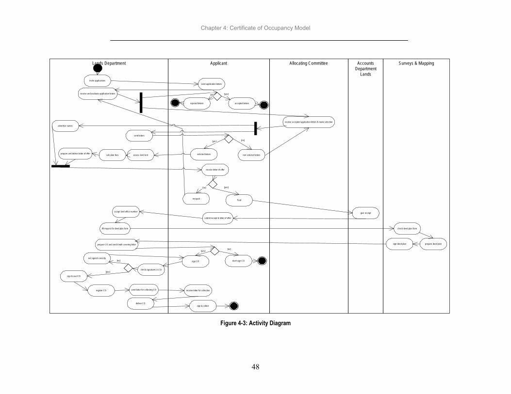
Chapter 4: Certificate of Occupancy Model
48
Surveys & MappingAccountsDepartment
Lands
Allocating CommitteeApplicantLands Department
invite applicationssend application letters
receive and evaluate application letters
rejected letters accepted letters
[no] [yes]
receive accepted application letters & make selectionadvertise names
send letters
selected letters non selected letters
[yes] [no]
assess land rentcalculate feesprepare and deliver letter of offer
receive letter of offer
not paid Paid
[yes]
give receipt
submit receipt & letter of offer
assign land office number
fill request for deed plan form check deed plan form
prepare deed plansign deed planprepare CO and send it with covering letter
sign CO don't sign CO
[yes][no]
not signed correctly
check signatures in CO[yes]
[no]
sign & seal CO
register CO receive letter for collection
deliver COsign & collect
[no]
send letter for collecting CO
Figure 4-3: Activity Diagram

Chapter 4: Certificate of Occupancy Model
49
4.5.3. Class diagram
Class diagram shows what objects interacts (static structure) within the Allocating Parcel use case but doesn’t show how (dynamic structure). In Allocating Parcels use case there are 16 objects which are entity objects, control objects and interface objects. Control objects are Allocating Committee, Officer in Charge Deed Plan, Officer in Charge Surveys, Deed Plan Officer and Valuation Officer. Interface Objects are Commissioner for Lands, Chief Accountant Lands, Registrar of Title and Land Officer. The entity object has more objects which are CO, Application letter, Letter of Offer, Receipt, Plot, Request for Deed Plan Form and Deed Plan. Figure 4-4 is the class diagram, shows the relationships between the objects. Each objects has the attributes and operations to perform. The important thing to be done in class diagram is identifying the right objects to be modelled in information model. Identification of objects is the main task in this process because is the one to be tested.
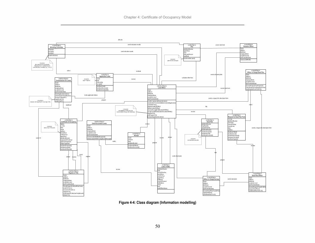
Chapter 4: Certificate of Occupancy Model
50
makeSelection()
chairmansecretarymembers
«controlObject»Allocating Committee
hasBeenSent()hasBeenReceived()hasBeenEvaluated()
nameagecitizenshipaccepted
«entityObject»Application Letter
inviteApplicationLetters()advertisedSelectedNames()receiveCOfromRT()sign&SealCO()sendCOtoRT()
nameaddressbirthDateemployedDateacademicLevellastPromotionDate
«interfaceObject»Commissioner for Lands
hasBeenPrepared()hasBeenSigned()hasBeenDelivered()
titleNo.L.O.No.datenameaddresstermOfUserentPerYeartypeOfUseplotIdentificationsignatureOfCL&SealapplicantSignaturelawyerSignature
«entityObject»Certificate of Occupancy
checkRequestForDeedPlanForm()sendCOToCL()receiveCOFromCL()registerCO()sendLetterOfCollectionToApllicant()deliverCO()
nameaddressbirthDateemployedDateacademicLevellastPromotionDate
«interfaceObject»Registar of Title
receiveLetterOfoffer&Payment()deliverLetterOfOfferToApplicant&Receipt()
nameaddressbirthDateemployedDateacademicLevellastPromotionDate
«interfaceObject»Chief Accountant Lands
plotIdentificationdateareaOfThePlottermOfUserentPerYeartypeOfUsefullNamenameOfSpousefullAddresssharefeeslandOfficerName
«entityObject»Letter of Offer
hasBeenWritten()hasBeenReceived()
nameamountdateplotIdentification
«entityObject»Receipt
sendAcceptance&RejectedLetter()sendLettersToSelected&NonSelectedApplicants()calculateFees()prepareLetterOfOffer()deliverLetterOfOffer()receiveReceipt&FilledLetterOfOffer()assignLandOfficeNumberOnLetterOfOffer()prepareCO()notPrepareCO()evaluateApplicationLetters()
nameaddressbirthDateemployedDateacademicLevellastPromotionDate
«interfaceObject»Land Officer
hasBeenAllocated()
plotIdentificationtypeOfUseareaallocatedPersonlandRent
«entityObject»Plot
assessLandRent()
nameaddressbirthDateemployedDateacademicLevellastPromotionDate
«controlObject»Valuation Officer
receiveRequestFormFromLO()checkRequestForDeedPlanForm()sendRequestFormToDPO()
nameaddressbirthDateemployedDateacademicLevellastPromotionDate
«controlObject»Officer in Charge Deed Plan
hasBeenFilled()hasBeenSent()hasBeenReceived()hasbeenChecked()hasBeenSigned()
L.O.NoplotIdentificationSDFileNo.surveyPlanNosurveyFeesdateaddress
«entityObject»Request for Deed Plan Form
receiveDeedPlanFromDPO()signDeedPlan()sendDeedPlanToLO()
nameaddressbirthDateacademicLevellastPromotionDate
«controlObject»Officer in Charge Surveys
receiveRequestFromOC/DP()prepareDeedPlan()sendDeedPlanToOC/S()
nameaddressbirthDateacademicLevellastPromotionDate
«controlObject»Deed Plan Officer
hasBeenDrawn()hasBeenSigned()hasBeenSent()hasBeenReceived()
plotIdentificationregdPlanNoareaOfThePlot
«entityObject»Deed Plan
allocate
select
receive
evaluate
assess land rent
calculate other fees
fills
receive
receive
prepare
sign
check
prepare
receive
receive
receive
writes
prepare
sign&seal
checkregisterdeliver
«invariant»{lawyer and applicant must sign CO}
«invariant»{term of use<=99 years}
«invariant»{age>=18years}
«invariant»{receipt&letter of offer has to be
received within 30 days after delivering }
«invariant»{six deed plans per plot}
«invariant»{plot must be surveyed}
«invariant»{the selection has to be doneby
following Part II - Establishment ofLand Allocation Committee Sec. 11& 12}
send evaluation results
send selection results
invite application letters
receive land rent
sends allocated plots
sends a request for deed plan form
sends a request for deed plan form
sends deed plan
sends deed plan
deliver
receive
send CO
Figure 4-4: Class diagram (Information modelling)

Chapter 4: Certificate of Occupancy Model
51
4.5.4. Sequence diagram
The object model is supposed to be in consistent with the information model. A sequence diagram is an interaction diagram that details how operations are carried out, what messages are sent and when. Sequence diagram is a real object model. The restrictions on the business are taken into consideration. In sequence diagram communications between objects in terms of messages have been shown and depicted in terms of time. The consistency between information model and object model has been achieved. The information model shows the static structure of the Allocating Parcels use case and object model the dynamic behaviour. Figure 4-5 below shows the communication between control objects, interface objects and entity objects. It shows the messages between Commissioner for Lands and Application Letters, which is the starting of the use case. Land Officer is the one who receive the Application Letters from the Applicant and after evaluating that is when the Allocating committee makes selection. The Deed Plan is prepared by SMD after receiving the request of Deed Plan from LD and then Letter of Offer is prepared. CO is prepared when the Applicant pay as stated in the Letter of Offer within 30 days after receiving Letter of Offer, otherwise there is no preparation of CO. Communication of objects in Allocating Parcels use case in terms of messages and time has to be shown in sequence diagram. Sequence diagram has to be consistent as steps (activities) defined in the activity diagram. If the sequence diagram is not consistent as the activity diagram the whole procedure has to start again. The modeling is an iterative process, needs to be repeated so as to make sure that the use case requirements has been fulfilled. The rationale is that although use case diagram, activity diagram, class diagram and sequence diagram cover different views of the business, since they are describing the same business system, they should together present a consistent view of that business system.

Chapter 4: Certificate of Occupancy Model
52
«in terfaceObject»Com m issioner for Lands
«entityO bject»Application Letter
«in terfaceO bject»Land O fficer
«entityO bject»Plo t
«contro lObject»A llocating Com m ittee
«contro lObject»Valuation O fficer
«entityO bject»Letter o f Offer
«entityO bject»Receip t
«in terfaceO bject»Chief Accountant Lands
invite()
receive()
evaluate()
send accepted applications()send evaluation results()
a llocate()
m ake selec tion()
assess land rent()
« invariant»{the selection has to be done by follow ing P art II -
E stablishment of Land Alloca tion Committee Sec. 11& 12}
ca lculate fees()
prepare()
deliver()
receive()
create()
receive()
receive()
«note»the flow continuee in Sequence-2
«invariant»{receiving <=30 days
after delivering}
«requirem ent»nam es & a ll deta ils w rittenin the le tter o f o ffer wil l bethe sam e to appear in C O
sends selection results ()
g ive feedback of selection() send allocated plots()
send assessed land rent()
Figure 4-5: Sequence diagram (object modeling) - Part I

Chapter 4: Certificate of Occupancy Model
53
«interfaceObject»Land Officer
«note»Flow originates in Sequence-1
«entityObject»Request for Deed Plan
Form
«controlObject»Officer in Charge Deed
Plan«controlObject»
Deed Plan Officer
«entityObject»Deed Plan
«controlObject»Officer in Charge Surveys
«entityObject»Certificate of Occupancy
«interfaceObject»Registrar of Title
«interfaceObject»Commissioner for Lands
fills()
check()
receive() prepare()
sign()
receive()
prepare()
check()
sign & seal()
register()
deliver()
«invariant»{six deed plans per plot}
«invariant»{lawyer and applicant
must sign CO}
sends request for deed plan form()
sends request for deed plan()
sends deed plan()
sends deed plan()
sends CO()
Figure 4-6: Sequence diagram (object modeling) - Part II

Chapter 4: Certificate of Occupancy Model
54
4.6. Concluding remarks
Certificate of occupancy business system has been modelled by considering the improvements mentioned in chapter two. Allocating Parcels use case has been modelled into class, activity and sequence diagrams to see the static and dynamic behaviour of the use case.

Chapter 5: Implementation Requirements
55
5. Implementation Requirements
5.1. Introduction
This chapter looks at the validity of the Allocating Parcels use case that has been modelled to show the static and dynamic behaviour of the part of the CO business system. It discusses the implementation requirements needed for the CO business system.
5.2. Testing of the Allocating Parcels use case model
Allocating Parcels use case have been modelled to show its static and dynamic behaviour. It belongs to two subsystems Surveys and Mapping department for the preparation of deed plan and Lands department for the rest of activities in the use case. There are two levels of testing used in this research for verification of the model which are unit testing and integration testing:
5.2.1. Unit testing
Unit test has been carried out to make sure that all sixteen objects have names, their attributes and operations defined. This unit test has been done by making sure that each object is coherent and consistency internally. It was modelled in MS Visio 2000. More explanation about the unit test is carried out see chapter three section 3.10.1
5.2.2. Integration testing
All objects defined in the Allocating Parcels use case communicate with other. There are series of message from and to each object depending on the communication. In the sequence diagram shows the messages objects send to each other according to the relationship shown in the information model. Objects in the sequence diagram are coherent and consistency as in the information model. The more explanation about integration testing is contained in section 3.10.2.
5.3. Implementation requirements Whether the CO business system is successful or not will depend upon a complex interaction of, often informal, political and social forces within and between the involved individuals departments/private company. If any employee cannot be persuaded to adopt a new system, the system is little more than very expensive junk. The success of the CO model depends on enlisting the support of radicals and assuaging the doubts of conservatives.
Chapter 5: Implementation Requirements
56
Before introducing this model an enterprise (three departments at the MLHSD) needs to be sensitive to its Information System/Information Technology (IS/IT) culture and particularly needs at an early stage to determine the nature of the hurdle over which a CO model has to jump to gain approval. The introduction of the CO business model implies a change in behavior that needs to be negotiated between employees, the outcomes of such negotiations will be contingent upon the relative strengths and attitudes of all employees involved. The implementation methodologies should base upon real expectations of the enterprise behaviour than assuming unrealistically rational behavior. In better management of the CO business system, there is a need of having one employee who is responsible for its management. The employee will be among the middle ranking officers and supposed to have career interest in the existence of the CO model. She has to make a mature view of both supporters and opponents and to have the interpersonal skills to negotiate successfully with both groups. There must be also a godfather within the executive level who is prepared to promote the CO model at the highest levels. Reeve & Petch (1999) stated that a godfather at a high level is required to maintain executive support once initial enthusiasm begins to wane. Staff involved must be committed so as to make the model successfully.
5.3.1. Factors to be considered
The factors to be considered in implementing CO model have to provide an easy means to keep an overview of all relevant activities that are necessary to be executed in order to solve the mentioned problem in chapter two concerning the issuance of CO. The factors have to ensure that no essential activities are omitted and only eliminate redundant activities in order to focus available resources on crucial issues. Institutional, technological, economic, legal and financial.
5.3.1.1. Institutional Issues
It has to take care of administrative protocols for the implementation of the CO model, access permissions; this is the responsibility for management. The management also has to put an eye on the users requirements so as to make changes when needed. The MLHSD should remain to be the owner and custodian for the data and all information which they produce and even the information received. The CO business system will help to coordinate the three departments at the MLHSD so as to work efficiently and effectively in the issuance of CO. Its success will depend on proper institutional arrangements, so as to work together in harmony and promote efficiency and effectiveness by satisfying actors. The CO business system also involves private sector so having stable institutional framework is really necessary. The MLHSD is supposed to have employees from each subsystem who will take care at the management level for CO business system. Copyright laws and intellectual property rights issues should be covered in the information Policy governing the CO business system. It also has to see what form of liability or responsibility is undertaken if one of the agencies involved in the issuance of CO business system or actors provides unreliable data.

Chapter 5: Implementation Requirements
57
5.3.1.2. Technical Issues
Implementation of the CO model will function effectively when reliable and efficient computing and communication technologies are in place. Client server architecture is very important in data processing and spatial handling. Kainz in (Groot & McLaughlin, 2000) mentioned the two important basic features of system architectures which are open systems architectures and inter-operability. Open system co-operate with each other using standards for access, processing, and transfer of data, are not hindered by system-specific structures. Radwan & Bishr in Groot & McLaughlin (2000) explained “Inter-operability as the ability of a system or components of a system to provide information sharing and inter-application co-operative process control”. The three departments HSD, SMD and LD are using each others information and their systems should be interoperable. Computer network is an interconnected collection of autonomous computers. Implementation of the CO model needs Local Area Networks (LANs) where by PCs will be connected, workstations and other devices such as printers. When computers connect together they must speak the same language, and implement correct procedures to establish and maintain a connection. Every agency involved in the issuance of Certificate of Occupancy business system has to make sure the information are in digital form so as to make it easier to share the information. Surveys and Mapping department have already started developing the program (see appendix G) which will make it easier for checking of surveyed jobs even tracing it’s progress after being submitted and then stored in digital form. Human Settlements department will access the information for updating the Town Planning drawing and even the actors who need the information digitally will be easier to serve them. Data quality, generally addresses issue like accuracy (in terms of position and attributes), completeness, currency (up-to-dateness) and appropriateness (relevant use, reliability). The quality of information or data usually justifies the quality of the system and its reliability in fulfilling users’ needs. Quality is a relevant issue to be considered in the issuance of CO because it is identified as the most important part of the user requirements. Different departments buy different computer hardware and software according to their requirements and this in return do hinder data sharing (Rweyemamu & Rutakyamirwa, 1997). This is the problem facing the HSD, LD and SMD in sharing the information for issuing CO it has to be considered before introducing CO model.
5.3.1.3. Economic Issues
There is a need of looking at the reasonable funding level the way it is supposed to be. Also to what extent innovation should be supported to improve effectiveness and efficiency of the enterprise in meeting the goals set for it by top level management in government. Is it possible to estimate the reduction in cost due to effective CO business system?
• Overall identification of costs/investment types • Operation and maintenance
Chapter 5: Implementation Requirements
58
How should the whole procedure being financed? CO business model needs funds for it to be successfully implemented. The MLHSD is funded by the government and the funds from the government are not enough as stated earlier on. The MLHSD has to find a way of getting some funds out of the services/products delivered. The MLHSD has to seek the support of donors like World Bank and also looks for sponsorship. Sponsorship may help in advertising for it to be known. It could involve external groups such as NGOs, private companies, etc. The MLHSD has to provide services at a reasonable price so that everyone will be able to pay by revising their pricing policy. Economic issues depend on the government policy. The government policy may have strategies like services should be provided at the lowest possible cost, integrated enterprise should become independent of government subsidies within a reasonable time, say 5 years. Analysis has to be carried out to determine if the benefits exceed the cost. The following question is likely to be asked at the beginning, how much does it cost to run?
The following costs has to be taken into account as written by Rhind in (Groot & McLaughlin, 2000): the cost of raw data capture or maintenance includes staffs and all direct costs, the cost of the physical infrastructure e.g. purchase and maintenance of PC equipment, software, use
of standard telecommunication, the cost of people e.g. salary, training new staffs, continuous development of new staff members other factors costs like regulations, development of standards and publications, etc.
5.3.1.4. Legal Issues
Implementation of the improved business process in integrated departments depends to a large extent on how the government successfully designs and implements a legal framework to deal with this issue effectively. Legal issues should look at the privacy of the integrated enterprise, protection of investments, access of data but also looking at the confidentiality of third party information, liability for incomplete or incorrect information, copyright (exclusive right to produce or reproduce copy), etc. Establishment of the required policy and legislative framework – needs to develop the pricing policy, legal policy, etc. It requires to review and select the relevant existing laws and policies, identifying the missing ones or those that need amendment and devising methods where by these could be made available. To address the above-mentioned factors, the following may be necessary: Forming a high powered steering committee –the committee will be responsible for formulating policies,
enforcing legislation and pioneering the coordination. It require to review and select the relevant existing laws and policies, identifying the missing ones or those that need amendment and devising methods where by these could be made available. Institutional (department) to assess the need of having three departments, if possible having only one
department takes care of all processes of Certificate of Occupancy. Establishing stable communication network so as to have stable and reliable flow of information and
cooperation.

Chapter 5: Implementation Requirements
59
Employees need to be trained because there will be changes in the way they work and manage resources. Data collection, storing and presentation techniques need to be upgraded. Most of data are in analogue
form, data must be in digital form and other stored in microfilm. Carrying out cost benefit analysis justification for the need to implement the model will enable an
application for financial support and political support too to be made. Reeve & Petch (1999) quoted Alter (1992) who wrote about the characteristics of a good job as skills, meaningfulness, autonomy, social relations, psychological demands and balance with life beyond work. The following are the characteristics of a good job needed by the employees involved in the CO model: 1. The CO model requires the employees to use and increase their skills. Employees are supposed to
look forward to gain new technological skills (reskilling) and not removing the traditional skills (deskilling).
2. Employees should feel that the jobs they work on contributes significantly (meaningfulness) to the success of the CO model.
3. Employees so long as they know their tasks and roles are supposed to have reasonable discretion in the way they organise their work without feeling under excessive supervision (autonomy). The CO model has to be implemented to the extent of empower some employees to take fuller and more independent, control of their working environment (e.g. process owner, etc.)
4. CO model should increase social relations among employees by allowing jobs to be an enjoyable social experience. The employees have to collaborate and communicate among themselves.
5. The CO model needs to be challenging and engaging but not excessively. Employees are supposed to have the mixture of novel and routine tasks (psychological demands) so that they wont feel permanently stressed.
6. The CO model has to allow the employees to balance with life beyond work. The assigned job to employees will not demand so much of the energy and time that interferes excessively with the ability to participate in family and community life.
5.4. Concluding remarks
This chapter looked at the validity of the model and it found out that the unit test fulfils its responsibilities and also there is consistency in integration test. It’s only the Land Officer as an interface object that was used in both tests.

Chapter 6: Conclusions and Recommendations
60
6. Conclusions and Recommendations
6.1. Introduction
This research is aimed at improving the performance of the issuance of Certificate of Occupancy (CO) business process so as to help in reducing the delivery time of CO. CO business process starts from the declaration of an area for development purposes to the delivering the CO to the applicants. Issuing of CO involves 16 individuals departments/private companies/ministries. Human Settlements Department (HSD), Lands Department (LD) Surveys and Mapping Department (SMD), Accounts department and Minister for Lands are from Ministry of Lands and Human Settlements Development (MLHSD). It involves other two ministries too, Ministry of Civil Service (MCS) and Ministry of Justice and Constitution Affairs (MJCA). Local Government Leaders (LGL), District Commissioner (DC) and Regional Commissioner (RC) in the area to be declared are also involved in the process. City Land Surveyor (CLS) and Licensed Surveyor (LS) are involved for surveying activities. Ministry of Finance (MF), Allocating Committee and Applicants are also among 16 participating. Models are useful in visualization, communication and managing complexity. Unified Modeling Language (UML) technique has been used in modeling CO business process by taking into consideration all proposed improvements for the TO_BE issuance of CO business process. UML helps in showing clearly what are the operations performed and processes involved with their activities in the issuance of CO, the way things are done, when and by whom in how much(refers to the economical aspects of the CO business process). The resources has to be allocated to the required processes so as to achieve the goals set by following the rules that constrain the possible states of a process or a resource. Modelling of CO business process will help in coordination and integration for a CO business process for it to work efficient and effective.
6.2. Summary of research Chapter one provides the framework of research tells about the background, research problem, research objectives and questions. Also explains justification of the research. Chapter two analysed the current situation to identify the problems and propose improvements. Some problems in delivering CO are identified in three departments (HSD, LD and SMD) mainly deals with land issues at the MLHSD. These problems are:
departments don’t work as one cohesive unit in issuing CO. there is no decentralisation of power in making decisions, which results in bureaucratic and
cumbersome procedures. SMD has rigid standards enforcement (concerning the accuracy of surveying work) sometimes
may not be required by users.

Chapter 6: Conclusions and Recommendations
61
As a result customers are dissatisfied with the delivery time. The SWOT analysis has been carried out to come out with proposed improvements; involvement of user requirements, empowering licensed surveyor to be responsible for their own jobs. This will help in reducing the workload for the examiners and speed up the process. Licensed Surveyor will be liable according to the law for any mistakes found in the submitted jobs at the SMD. The actions to be taken care of are the decentralisation of power especially for licensed surveyors, participation of users in the declaration of an area and quality of the products to be fit for use, etc. Those improvements look at reducing delivery time of CO, which is the prime problem. For more detail see chapter two. In chapter three actions for implementing the proposed improvements are incorporated in the TO_BE business process of issuance CO so as to improve its performance. Modeling of CO business process has to be done so as to indicate the clarity of the activities involved, resources allocated and rules to constrain the processes or resources involved in achieving the goals. Coordination is among the problem in the issuance of CO, so it is very important to be taken into consideration. Coordination is needed after modelling to set-up and manage the links of the processes with their activities, resources and regulates the behaviour of the workflow. Departments involved need to coordinate their activities only for the issuance of CO and remain independent for other tasks. Chapter three explains how the modelling, coordination and integration can promote the CO business model to work efficient and effective. CO business system will be effective and efficient if modeling of CO business process will incorporate coordination and integration. More explanation about modeling, coordination and integration see chapter three. Chapter four deals with modeling of the CO business process. The CO business process has been grouped to five business processes (called use cases in UML) which are Declaration of an Area, Compensation, Preparation of Town Planning drawing, Surveying and Allocating Parcels. The Allocating Parcels business process has been modelled in more detail to show its static and dynamic behaviour. Static behaviour means displaying interactions of the objects but not what happens when they do interact. Dynamic behaviour means displaying how the objects interact and what happens when they do interact. Objects are resources like people, physical or information. The associations and communications of objects in the Allocating Parcels use case have been shown clearly in chapter four. Chapter five looked at the consistency of the Allocating Parcels business process and the implementation requirements of the CO business system. Two levels of testing have been used to test the consistency. Unit testing is making sure that participating objects are consistent and coherent internally and can be achieved via joint efforts of human and a method-specific tool, such as Microsoft Visio 2000, Rational Rose, etc. Integration testing is performed if every object in the dynamic behaviour is coherent and consistent with the static behaviour. At this stage each object in the dynamic behaviour is compared and checked against static behaviour. Implementation of CO business model needs to take into account institutional, technical economical and legal issues for it to be introduced. Institutional issues deals with administrative protocols and technical is having reliable and efficient technologies in place. Economic issues look at how the CO model will be financed, legal issues look at the liability for incomplete or incorrect information, etc.

Chapter 6: Conclusions and Recommendations
62
6.3. Limitations
The time available for this research was not enough to cover the whole process of issuance CO. The Allocating Parcels business process is part of the CO business process, it has been modelled as an example to show how the CO business model will look like when all business processes will be modeled. However it should be noted that UML may not handle fully the semantics of the case being modelled and will often require extensive training for personnel to fruitfully apply it. The software, while being flexible in its capabilities is expensive.
6.4. Conclusions At the end of this research work, the following conclusions can be drawn: the objectives of this research which is modelling of the issuance CO business process with a view of improving performance can be considered to have been achieved (with the above mentioned limitation); and the following is a summary of the achievements realized: a. The review on the roles, objectives and requirements of the CO business process revealed that a CO
business model can act as a good framework for the effective and efficient process of issuance of CO. Proposals for the implementation of CO business model should be developed for it to be effective in assisting all individuals/departments/private companies involved. It has been recognized that the introduction of the CO Business System must not overlook the key issues of coordination and integration among individuals departments/private company/ involved. In most cases this introduction will certainly call for institutional changes and new user demands.
b. The analysis shows that the issuance of CO has bottlenecks like rigid standards sometimes not
required by the users. There is no decentralisation of power resulting in bureaucratic and cumbersome procedure and also poor records keeping all these contributing to the delivery time.
c. It is proposed to make some changes so as to improve the performance and reduce the time to deliver
CO. The changes are involvement of users requirements, decentralisation of power and having the information in digital form.
d. Unified Modeling Language (UML) technique was effective in demonstrating the consistency of the
static and dynamic behaviour of the participating object in achieving proposed improvements. Also it is useful in allocating resources to the processes and constraints to the resources and processes.
e. The high quality experiences embedded in the UML certainly makes its application to complex systems
desirable, but the lack of precise semantics can limit its effectiveness. The separation of view principle has proven to be an effective means of controlling complexity, and is well-supported by the UML. On the other hand, the formality and rigor principle that facilitates the detection of errors in requirements and designs is not well-supported in the UML (Jean-Michel Bruel et al, accessed on 15th Feb, 2002).

Chapter 6: Conclusions and Recommendations
63
f. There are some costs involved in using UML technology in terms of: Time to learn new concepts and software Financial in purchasing software and hardware
6.5. Recommendations
a. The land laws and regulations have to be revised in the context of the CO business system for it to be able to bring about effective issuance of CO.
b. It is recommended that this research to be continued to model the remaining four business processes (Declaration of an area, Compensation, Preparation of Town Planning drawing and Surveying) and then implement so as be able to enjoy the beauty of this modelling technique.
c. Before implementing the CO model, performance evaluation is necessary to provide further insight. d. The land transfer and titling process in many developing countries is cumbersome and takes long
periods of time. As these economies embrace technology in a bid to improve efficiency and effectiveness, modelling becomes an important tool to provide clarity of the process and aid optimal allocation of resources through performance analyses. As demonstrated in this study, the UML tool with its robust capabilities can prove very useful.

References
64
References Alhir Sinan Si (1998). Knowledge: The dictating factor of business success
http://home.earthlink.net/~salhir/TheTrueValueOfTheUML.PDF -O’Reilly & Associates, Inc., Balci O. (1997). Principles of Simulation Model Validation, Verification, and Testing, Transactions of the
Society for Computer Simulation International, Vol. 14 (No. 1), 3-12 pp. Berio G. & Vernadat F.B. (1999) New developments in enterprise modelling using CIMOSA: Computers in
Industry 40, 99-114 pp. Bynoe, B.V. (2001) Management of workflow and quality across organisations involved in land resettlement
projects: Unpublished Msc. thesis, International Institute of Geo-Information Science and Earth Observation (ITC), Enschede, The Netherlands.
Carr, III John T. and Balci O. (2000), "Verification and Validation of Object-Oriented Artifacts Throughout the Simulation Model Development Life Cycle,” In Proceedings of the 2000 Winter Simulation Conference (Orlando, FL, Dec. 10-13). IEEE, Piscataway, NJ, 866-871pp.
Chapter 390 of The Laws (Principal Legislation), 1959. Land Survey Ordinance Regulations. Government Printer Dar es Salaam
Chimhamhiwa, D. A. (2001) Performance analysis of cadastral processes: a case study of the process of parcel subdivision in Zimbabwe. Unpublished Msc. thesis, International Institute of Geo-Information Science and Earth Observation (ITC), Enschede, The Netherlands.
Dale P. & McLaughlin J. (1999), Land Administration: New York; Oxford University Press Derby F.W, Segu C., Kamala C, Silayo E.H. (1995) Cadastral Operational, Equipment and Needs
Assessment for Tanzania – Tropical research and development, Inc. Gainesville, Florida, USA Ericsson E. (25-27 October 1999) – Women’s Access to Land – UN-FIG Conference on Land Tenure and
cadastral Infrastructures for Sustainable Development Melbourne, Australia Eriksson Hans-Erik & Penker Magnus (2000) Business Modeling with UML: BusinessPatterns at Work
ISBN:0-471-29551-5 Ghaffar A.K.S.(2001) A Review of Conceptual Modeling Approaches – With focus on: Enterprise modelling,
ITC Report. Groot R. & McLaughlin J. (2000) Geospatial Data Infrastructure – Concepts, Cases and Good Practice: Hawryszkiewycz, I. T (1997), Introduction to System Analysis and Design (fourth edition), Prentice Hall,
Toronto. Hornby, A. S. Oxford Advanced Learner’s Dictionary of Current English: Oxford University Press http://www.sparxsystems.com.au/testing.htm Accessed on January 21st 2002 Issa A. A. (1999) Strategies and Guidelines to Improve the Quality of Land Delivery Process in Tanzania.
Unpublished Msc. thesis, International Institute of Geo-Information Science and Earth Observation (ITC), Enschede, The Netherlands.
Jacobson, I. (1995). The Object Advantage: Business Process Reengineering with Object Technology. NY: ACM Press

References
65
Jean-Michel Bruel, Brian Henderson-Sellers, Ana Moreira, Bernhard Rumpe, Modeling and Analysis with the UML: Challenges and Limitations
http://www.acm.org/sigplan/oopsla/oopsla99/2_ap/workshops/ws23.html accessed on 15th Feb, 2002 Kombe W.J. (1995), Formal and Informal land management in Tanzania: The case study of Dar es Salaam
City, Spring Research Series, Dortmund University, Germany. Kosanke K, Vernadat F. & Zelm M (1999) CIMOSA: enterprise engineering and integration: Computers in
Industry 40 : 83-97pp Kosanke K. & Zelm M. (1999) CIMOSA modelling processes: Computers in Industry 40 (1999) 141-153 Lemmen, C. (2001).Performance measurement: a short introduction (in Land Administration), ITC Handout Maleko T.I (2000) Improving Land Delivery Process at the Department of Lands in Tanzania: Unpublished
Msc. thesis, International Institute of Geo-Information Science and Earth Observation (ITC), Enschede, The Netherlands.
Masele Z. Y. (6-8 September, 1999)- Strategy for Improvement of Urban Mapping Situation in Tanzania – Paper Presented to the Surveyors Conference – Morogoro – Tanzania
Ministry of Lands and Human Settlements Development (2000): Mission and Development Vision of the Ministry of Lands and Human Settlements Development under the National Development Vision 2025 of Tanzania
National Land Policy (1995): United Republic of Tanzania: Printed by Surveys and Mapping, Dar es Salaam, Tanzania.
Onchaga, M.R. (2000) Performance Modeling of Geo-Information Production Processes, Unpublished Msc. thesis, International Institute of Geo-Information Science and Earth Observation (ITC), Enschede, The Netherlands.
Paresi C.M. (2001) Situation Analysis in the Framework of Strategic Planning, Lecture notes, ITC, Netherlands
Qvist E. (1995) Women’s Access, Control and Tenure of Land, Property and Settlements – International Workshop on Women’s Access, Control and Tenure of Land, Property and Settlements. In Gavle, Sweden.
Reeve D.E. & Petch J.R. (1999) GIS, Organisation and People A socio-technical Approach: Taylor & Francis
Regulations of Land Act (No. 4 OF 1999): Government Printer Dar es Salaam Robinson D., Hewitt T., Harris J. (2000) Managing Development Understanding Inter-Organizational
Relationship: Sage Publications in Association with Open University. Rutayuga, A. B, (1996). Identifying Models for the Establishment of Parcel-Based Information System
Using Object-Technology. Unpublished Msc. thesis, International Institute of Geo-Information Science and Earth Observation (ITC), Enschede, The Netherlands.
Rweyemamu A. Z. & Rutakyamirwa N. N. (1997): The Concept of Clearinghouse for Data Sharing, Specific Reference to the Ministry of Lands, Housing and Urban Development (MLHUD) and Ministry of Local Government in Tanzania. Unpublished Postgraduate diploma International Institute of Geo- Information Science and Earth Observation (ITC), Enschede, The Netherlands.
Sani R.M. (1998) Dynamic Modeling in the re-engineering of Geo-Information Production Processes. Unpublished Msc. thesis, International Institute of Geo-Information Science and Earth Observation (ITC), Enschede, The Netherlands.

References
66
Schmuller J. (1999). Teach yourself UML: University of Florida, USA: Sams Publishing The Land Act, 1999 No. 4 of 1999: Government Printer Dar es Salaam The Town and Country Planning Ordinance Act. Cap 378 – of the Laws of 1956 (revised 1961), Government
Printer Dar es Salaam, Tanzania Vernadat F.B. (1996). Enterprise Modeling and Integration: Principles and Applications, Chapman and Hall,
ISBN 0-412-60550-3 Village Land Act No. 5 of 1999: Government Printer Dar es Salaam

Appendix A
A
Appendices Appendix A: List of Activities for issuance of Certificate of Occupancy
Performer No
Activity Input Dept. Employee
Output Time to wait Comments to improve
1 Town Planner get the base map and choose an area to be declared
Aerial photo, Availability of an area to be planned, equipment, TP, OC/R
HSD TP An area to be declared 30 days -Many base maps are not up-to-date SMD has to provide up-to-date information for the preparation of TP drawing - Involvement of people in the area to be declared
2 Director of Human Settlements Development Department (DHS) draft Government Notice (GN)
Stationeries, Pen, DHS HSD DHS Drafted GN 7 days The time has to be reduced
3 Minister for Lands and Human Settlements Development (ML) sign GN Drafted GN paper, pen, ML HSD ML Signed GN 7 days 4 Administrator (ADM) scrutinise GN Drafted GN, pen, ADM MCS ADM Scrutinised GN 30 days to
60 days No need of GN to pass here it can go straight to AG
5 Attorney General (AG) approve GN Stamp, pen, scrutinised GN MJCA AG GN as a law 60 days 6 Land Officer (LO) & Valuation Officer (VO) go to an area to meet with people
owning the area and Local Government Leaders (LGL) LO, VO, Car, LD VO Meeting with people 4 days The same people whom
they met in declaration are supposed to be in the meeting
7 LO & VO record every permanent property Tape measure, camera, notebook, pen, LO, people, VO, chalk,
LD VO Recorded properties 45 days
8 VO make valuation and prepare a report Valuation book, notebook, pen, people, VO, LO LD VO Valuation report 45 days 9 Chief Valuation Officer (CVO) approve valuation report CVO, valuation report, pen LD CVO Approved valuation report 7 days 10 VO prepare a Compensation Schedule (CS) Valuation report, pen, VO LD VO Prepared CS 7 days 11 LGL check if the CS has the names of right owners CS, pen, LGL LGLO LGL Checked CS with right names 1 day 12 District Commissioner (DC) sign the CS CS, pen, DC DCO DC Signed CS with DC 7 days 13 Regional Commissioner (RC) approve CS CS, pen, RCO RCO RC Approved CS with RC 14 days

Appendix A
B
14 LO sign CS on behalf of Commissioner for Lands (CL)
Received compensation schedule, LO LD LO Approved CS on behalf of CL 2 days
15 Chief Accountant Lands (CAL) look for money
CS, file of compensation, pen, ADL CAL Checked if money is available or not for compensation
3 days
16 CAL prepares cheques CS, file of compensation, pen, unwritten cheques ADL CAL Written cheques 14 days 17 CA L send CS to the Ministry of Finance Accounts Department (MFAD) if there
is no money in the Ministry of Lands CS, file of compensation ADL CAL Submitted CS 30days Chief Accountant has to
request money from the Ministry of Finance in the budget for paying the compensation rather than sending compensation schedule to Ministry of Finance
18 Chief Accountant Finance (CAF) prepares cheques CS, file of compensation, pen, unwritten cheques MF CAF Written cheques 28 days 19 CL writes a letter to the LGL telling them the date for collecting cheques Papers, pen, car, LO LD LO Letter 3 days 20 LGL tell people to collect cheques Meeting, people, LGL, date fro collecting cheques LGO LGL People know the date to collect
cheques 5 days
21 TP go to the field and update the base maps Base map, TP, area to be allocated, pen, papers HSD TP Updated base maps 2 days 22 TP design TP drawing Designed paper, drawing table, pen, rubber, ink,
rural, T-square, razor blaze, TP HSD TP Designed TP drawing 7 days
23 Cartographer (CART) trace designed TP drawing Tracing paper, pencil, pen, CART HSD CART Traced TP drawing 30 days Using ARCVIEW 24 TP compute the total area e.g. road, residential, etc. Calculator, square paper, thread, transparent circle,
paper, TP HSD TP Traced TP drawing with legend
showing distribution of land 2 days Using ARCVIEW
25 TP make copies and send to UPC Printing paper, TP drawing, ammonium solution, printing machine, CART
HSD CART Copies of traced TP drawing 3 days Using ARCVIEW
26 Urban Planning Committee (UPC) makes suggestions concerning the Town Planning drawing and send back to Human Settlements Department (HSD)
Allowance, meeting room, Councillors, TP UPCLGO UPC Assessed copies of TP drawing 30 days to 120 days
The UPC members has to meet soon when there is a need and not following the schedule which is meeting four times a year
27 TP amend as suggested Designed paper, drawing table, pen, rubber, ink, rural, T-square, razor blaze, TP
HSD TP Amended TP drawing 2 days Using ARCVIEW
28 Senior Town Planner (STP) scrutinise Town Planning drawing TP drawing, Pen, pencil, rubber, STP HSD STP Finalised TP drawing 1 day There is no need of Town Planning drawing to submit to the head of section so long as TP knows what has to do
29 DHS approves Town Planning drawing Finalised TP drawing, Stamp, pen, DHS HSD DHS Approved TP drawing 3 day 30 TP make copies and send to the CL, DSM, TANESCO, TTCL, Infrastructure
agents, etc. Printing paper, TP drawing, ammonium solution, printing machine, CART, Messenger
HSD CART Copies of approved TP drawing 5 day
31 LO writes a request for survey Request for survey form, pen, TP drawing, LO LD LO Filled request for survey form 1 day 32 Officer in Charge Records (OC/R) receive request for survey from Lands
Department (LD), file in the required file attach Town Planning drawing, Request for survey form, TP drawing, file LO, OC/R SMD OC/R 5 days

Appendix A
C
33 Officer in Charge Surveys (OC/S) write instructions for survey Request for survey form, survey instruction form, Town Planning drawing, OC/S
SMD OC/S Instructions for survey 3 days
34 City Land Surveyor (CLS) receive survey instruction form and assign the responsible surveyor to survey
Survey instruction form, TP drawing, CLS CLSO CLS Assigned surveyors 3 days Private Land Surveyor to take the Survey Instructions from OC/S directly and not passing through CLS
35 Government Land Surveyor (GLS)/Private Land Surveyor (PLS) take the Town Planning drawing and look for a datum points for basing survey
TP drawing, beacons numbers, cadastral plan to base, adjacent cadastral plans
PC/SMD LS Co-ordinates, adjacent plans 5 days
36 PLS/GLS survey the area, compute and compile Panga, total station, technicians, PLS/GLS, survey forms, papers, pen, datum points, , adjacent survey cadastral plan, plan for basing, TP drawing, car, Calculator, observations, CART, tracing paper, extract of TP drawing, computations
PC/SMD LS co-ordinates, Signed cadastral plan, filled survey forms, computations, observations, covering letters,
60 days Using stake out method (having coordinates after digitising by Microstation) will speed up surveying processes and also compute by CARD PRO (Cadastral Program)
37 CLS check and sign Compiled surveyed job, covering letter, Town Planning drawing
CLSO CS Checked compiled job 3 days Here the PLS don’t submit to City Surveyor
38 OC/R register the job Register book, pen, OC/R DSM OC/R Registered surveyed job 2 days 39 Zone Records Officer (ZRO) registers received jobs Register book, pen, ZRO DSM ZRO Registered surveyed job 2 day ZRO should do what
ZRAO do 40 Zone Records Assistant Officer (ZRAO) give job identification no. Put the
documents in the relevant files (Survey Details, Computation Files), attach adjacent surveys if required, annotate plan number, CF, SD, parcel/farm nos., block no and if necessary amendment of the locality and then writes information in main card and then in sub card
SD file, CF file, pen, TP drawing, adjacent plans, ZRAO
DSM ZRAO Cadastral plan annotated CF, SD, plan No.
14 days -Having ZRO only and not with ZRAO -Register using Cadastral Survey Submission form- Survey Details, Cadastral Survey Submission form- Plan Details and also Survey Document Compilation form-SD File Entries, -No need of writing information in the main card or sub -Only surveyed jobs from GLS will be registered after checked by CLS and

Appendix A
D
the ones from PLS will be registered so that to keep the information and expand the database -Surveyed job remain in the same file and filed later in the required files
41 ZRO received main card and sub card for verification Main card, sub card, ZRO DSM ZRO Verified main cards and sub cards
1 day ZRO has to verify him/her self
42 ZRAO submit to OC/S Temporary SD file, temporary CF, covering letter, TP drawing, cadastral plan, ZRAO
DSM ZRAO Surveyed job ready for checking
1 day ZRO and not ZRAO
43 Officer in Charge Computation (OC/C) register the surveyed job SD file, CF, covering letter, TP drawing, cadastral plan, OC/C
DSM OC/C Surveyed job checked for omissions
2 days
44 EO check & write minutes the surveyed job
Compiled surveyed job, pen, calculator, computer with the computing software, EO
DSM EO Surveyed job checked technically and legally
5 days If there is any amendment done the EO has to write in CSR System form – Amendments completed
45 OC/C read minutes Checked surveyed job, minutes paper, pen, OC/C DSM OC/C 46 OC/C return the surveyed job to CLS
Compiled checked surveyed job, letter to return the surveyed jobs, OC/C
DSM OC/C Surveyed job returned for collection
1 day
47 CLS return job to GLS/PLS Surveyed job returned for collection
2 days
48 PLS/GLS make corrections Corrected surveyed job 7 days 49 CLS check and sign Corrected, checked and signed
surveyed job 2 days
50 OC/C write recommendation
Compiled checked surveyed job, pen, minutes papers, OC/C, papers to write recommendations
DSM OC/C Recommended surveyed job 2 days Register using Comps Office form – OC Comps
51 OC/S read recommendations
Compiled checked surveyed job, pen, minutes papers, OC/C, recommendations
DSM OC/S Read recommended surveyed job
2 days
52 OC/S give instructions
Compiled checked surveyed job, pen, minutes papers, OC/S, stamp, recommendations, written instructions
DSM OC/S Instructed surveyed job 2 days
53 OC/C read minutes 1 day 54 OC/S approve the job
Compiled checked surveyed job, pen, minutes papers, OC/S, stamp, recommendations
DSM OC/S Approved surveyed job 2 days Has to approve using CSR System: Surveyor i/c form – Approve Survey
55 ZRAO register approved cadastral plan Compiled checked surveyed job, pen, minutes papers, ZRAO
DSM ZRAO Registered approved cadastral plan
1 day ZRO and not ZRAO

Appendix A
E
56 ZRAO send the copies of cadastral plan and co-ordinates to LD, HSD, municipalities offices
Printing papers, ammonium solutions, machines, Town Planning drawing
DSM ZRAO Copies of cadastral plan and data sheets
3 days ZRO and not ZRAO
57 TP make amendment on TP drawing Town Planning drawing, approved cadastral plans, data sheets, pen, pencil, ruler, TP
HSD TP TP drawing shows the areas surveyed
2 days
58 CL invite applications Newspapers, radio, Television, Town Planning drawing
LD CL Advertised area for allocation 14 days
59 Applicant send application forms Pen, paper, stamp, envelope Applicants APP Sent application forms 7 days 60 Land Officer receive and evaluate application letters and then send acceptance
and/or rejected letters
61 LO receive and register accepted application letters by giving the serial number (SN). Serial numbers helps to know how many people have applied and also to know who has applied first and who is the last. Send the acceptance letters and rejected letters
Application letter, register book, serial number
LD LO Registered application letter 7 days
62 Check the list of applicants with the list of parcels and make selection
List of applicants with the reason of applying, members of allocation committee
AC Allocating Committee
Selected applicants 3 days The Allocating Committee should meet as son as the parcels are approved
63 CL informing selected applicants by putting in the newspapers and notice board at the ministry campus
Newspapers, notice board, radio and all other means of advertising
LD CL Publicised list of applicants 7 days
64 LO tell selected applicants when they are supposed to collect letter of offer Arrived applicants at the Ministry, papers, pen, stamp,
LD LO Selected applicants know the date for collecting letter of offer
2 days
65 VO assess land rent
Pen, size of parcel, use of the parcel, calculator, parcel number, VO
LD VO Assessed land rent for a parcel 7 days
66 LO calculates fees for preparation of CO, registration fees, deed plans fees, stamp duty are all shown in letter of offer.
Pen, calculator, forms of letter, LO LD LO Amount known for the preparation of CO, deed plans, stamp duty
21 days
67 LO prepare letter of offer. Payment listed in the letter of offer supposed to be paid within 28 days
Calculated fees for preparation of CO, registration fees, deed plans fees, stamp duty, land rent, letter of offer form, pen, LO
LD LO Finalised letter of offer 7 days
68 Selected applicants receive letter of offer Selected applicants pays within time and others are not paying
Letter of offer, Selected applicants, LO Applicants Selected applicants
Receipt of the payment
2 days
69 Selected applicants pays within time while there are others who may not pay 70 LO receive receipt of the payment Copies of the receipt, LO, selected paid applicants LD LO Submitted copies of the receipt 28 days 71 LO assign L.O. No Registration book with its serial number, pen, file,
letter of offer, payment of advise, LO LD LO Letter of offer filed and
assigned L.O. No. 7 days
72 LO fill the request for deed plan form Request for deed plan form, pen, file of a particular parcel, LO
LD LO Written request for deed plan form
3 days
73 Deed Plan Officer (DPO) check request for deed plan form for completeness (availability of L.O. No., payment has been done, parcel no, block no and locality if is OK) also attach required cadastral plan
Request for deed plan form, pen, receipt shows payment, DPO
SMD DPO Checked request for deed plan form
5 days

Appendix A
F
74 Officer in Charge Deed Plan (OC/DP) check for the L.O. No. if there is no repetition
Filled request for deed plan form, OC/DP SMD OC/DP Scrutinised request for deed plan form
2 days
There is repetition LO assign L.O. No Filled request for deed plan form, OC/DP SMD OC/DP Changed L.O. No. 1 day 75 CART. prepare 6 copies for each request
Filled request for deed plan form, Cadastral Plan, Ammonium solutions, traced papers, printing papers, Cartographer
SMD CART. Deed plans 21 days The deed plans should be prepared digitally so as to speed up the process
76 OC/DP check Deed Plans Deed Plans, OC/DP, filled request for deed plan form
SMD OC/DP Checked deed plans 5 days
77 DPO submit to OC/S Deed Plans, filled request for deed plan form, DPO, pen
SMD DPO submitted deed plans 2 days
78 OC/S examine and sign Deed Plans, filled request for deed plan form, pen SMD OC/S Approved deed plans 14 days 79 LO draft papers of CO
CO forms (LF 32), pen, file of a particular parcel LD LO Drafted CO form 10 minutes
80 DT type the drafted CO LF 32, file of a particular parcel, typing machine LD LO Typed CO form 15 minutes 81 LO send the covering letter with CO to the selected applicant for her/his
signature and also signature of Lawyer CO, covering letter LD LO Signed CO 30 days
82 Selected applicant sign and lawyer sign also Signed CO LD LO Submitted signed CO 1 day 83 LO writes minutes to the Registrar Officer (RO) so as to send the CO to RT and
CL Signed CO, minute sheets LD LO Signed CO, minute sheets 1 day
84 RT check if that particular CO has been registered already or there is anything relating to the particular parcel if it is OK then send to the CL
CO, covering letter (shows the stamps duty, registration fees has been paid)
LD RT CO given title number 2 days
85 CO has problems 86 CL sign the CO CO with title number LD CL Signed and sealed CO 14 days There is a need of
having the assistant to help CL in signing CO and other documents because he/she has many responsibilities
87 CO sent to the RT for registration Signed and sealed CO LD RT Registered CO 7 days 88 RT send the letter to the applicant to come and collect CO Signed, sealed and registered CO LD RT Delivered CO 14 days
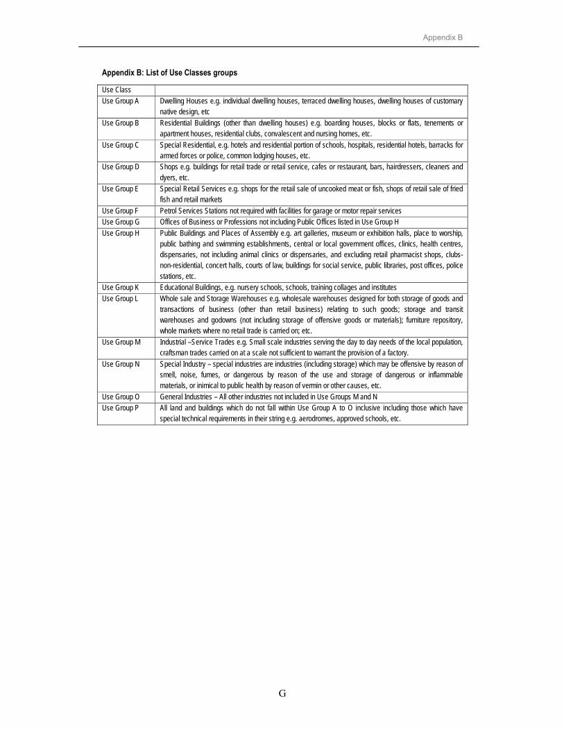
Appendix B
G
Appendix B: List of Use Classes groups
Use Class Use Group A Dwelling Houses e.g. individual dwelling houses, terraced dwelling houses, dwelling houses of customary
native design, etc Use Group B Residential Buildings (other than dwelling houses) e.g. boarding houses, blocks or flats, tenements or
apartment houses, residential clubs, convalescent and nursing homes, etc. Use Group C Special Residential, e.g. hotels and residential portion of schools, hospitals, residential hotels, barracks for
armed forces or police, common lodging houses, etc. Use Group D Shops e.g. buildings for retail trade or retail service, cafes or restaurant, bars, hairdressers, cleaners and
dyers, etc. Use Group E Special Retail Services e.g. shops for the retail sale of uncooked meat or fish, shops of retail sale of fried
fish and retail markets Use Group F Petrol Services Stations not required with facilities for garage or motor repair services Use Group G Offices of Business or Professions not including Public Offices listed in Use Group H Use Group H Public Buildings and Places of Assembly e.g. art galleries, museum or exhibition halls, place to worship,
public bathing and swimming establishments, central or local government offices, clinics, health centres, dispensaries, not including animal clinics or dispensaries, and excluding retail pharmacist shops, clubs-non-residential, concert halls, courts of law, buildings for social service, public libraries, post offices, police stations, etc.
Use Group K Educational Buildings, e.g. nursery schools, schools, training collages and institutes Use Group L Whole sale and Storage Warehouses e.g. wholesale warehouses designed for both storage of goods and
transactions of business (other than retail business) relating to such goods; storage and transit warehouses and godowns (not including storage of offensive goods or materials); furniture repository, whole markets where no retail trade is carried on; etc.
Use Group M Industrial –Service Trades e.g. Small scale industries serving the day to day needs of the local population, craftsman trades carried on at a scale not sufficient to warrant the provision of a factory.
Use Group N Special Industry – special industries are industries (including storage) which may be offensive by reason of smell, noise, fumes, or dangerous by reason of the use and storage of dangerous or inflammable materials, or inimical to public health by reason of vermin or other causes, etc.
Use Group O General Industries – All other industries not included in Use Groups M and N Use Group P All land and buildings which do not fall within Use Group A to O inclusive including those which have
special technical requirements in their string e.g. aerodromes, approved schools, etc.

Appendix C
H
Appendix C: Activity Diagram
AP P ACLSCLSS M DUP CA DL & M FLGL , DC & RCLDM L, M C S & M JC AHSD
T P choose an a rea in BM
DH S draft GN M L s ign GN
AD M scru tin ise GN
AG approvesLO&VO go to an a rea record properties
VO m ake valua tion & w rites a report
C VO approves a report VO prepares C S CS checked by LG L
C S s igned by D C
CS approved by R CLO rece ive C S on beha lf o f CLTP upda te BM
T P design T P d rg .
C AL prepares cheques
C ART . trace T P drg
T P com putes a reas
U PC m ake suggestionsT P am m end T P drg
ST P scru tin ise
[yes] C AL send to M F
[ no]
D H S approves T P drg.
C L write a letter to LGL
LGL te ll peop le to collect chequesC AF prepares cheques
C AL look for m oney
T P m ake copies

Appendix C
I
APP ADL &MF
ACLSCLSSMDUPCLGL,DC &RC
LDML,MCS &MJCA
HSD
LO write a request for survey
OC/R files a request for survey form
OC/S writes instructions for surveys
CLS assign required LS
PLS take TP drg & datum pointsGLS take TP drg & datum points
survey, compute and compile
survey, compute and compile
CLS check & sign
[ private][ government]
OC/R registerZRO registers
ZRAO work on it
ZRO verify
ZRAO submit OC/C check ommissions
EO check & write minutesOC/C read m inutes
writes recommendation to OC/S write letter to return a job
[ no][ yes]
OC/S read recommendation
return job[governement]
OC/S approvesOC/S gives instructions
[ no][ yes]
ZRAO registers
mak
e am
men
dmen
t on
TP d
rg
CL invite applications
chec
k lis
t of a
pplic
ants
& p
arce
ls a
nd m
ake
sele
ctio
n
CL informs selected applicants
send
app
licat
ion
lette
r
ZRAO makes copies
LO receive & register
TP m
ake
copi
es receive copy
receive copy
GLS make corrections
PLS make corrections
[ private]
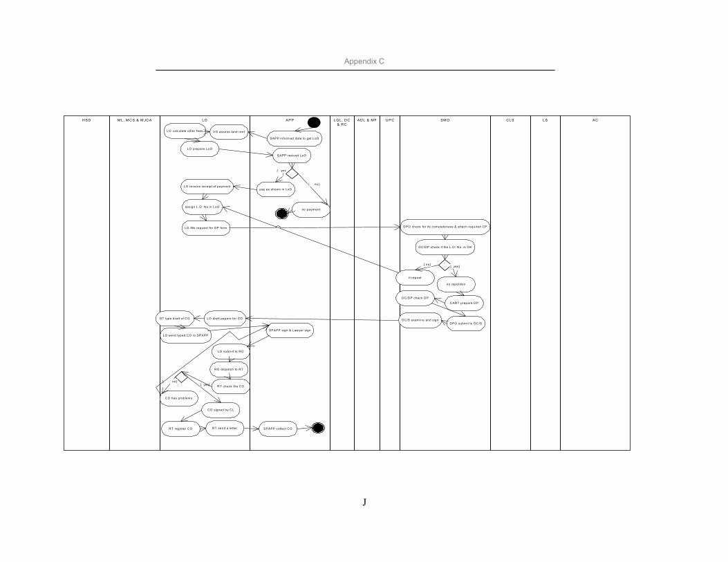
Appendix C
J
ACLSCLSSM DUPCADL & M FLG L, DC
& RCAPPLDM L, M CS & M JCAHSD
SAPP in form ed date to get LoO
V O assess land rentLO calculate other fees
S APP reeived LoO
LO prepare LoO
pay as shown in LoO
no paym ent
[ no]
[ yes ]
LO receive receipt of paym ent
assign L.O . No in LoO
LO fills request for DP form DPO check for its com pleteness & attach required CP
O C/DP check if the L.O . No. is O K
it repeat
[ no]
no repetition
[ yes]
CAR T prepare DP
O C/DP check DP
DPO subm it to O C/SO C/S exam ine and s ignLO draft papers for CODT type draft o f CO
LO send typed CO to SP APP
SP APP sign & Lawyer sign
R T check the CO
CO has problem s
CO signed by CL
[ yes][ no]
RT register CO S PAPP collect CO
RO dispatch to RT
RT send a le tter
LO subm it to RO
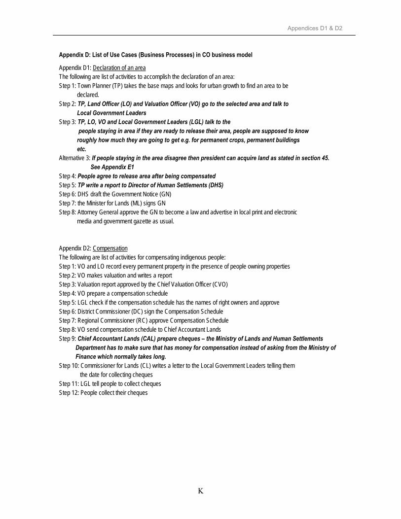
Appendices D1 & D2
K
Appendix D: List of Use Cases (Business Processes) in CO business model
Appendix D1: Declaration of an area The following are list of activities to accomplish the declaration of an area: Step 1: Town Planner (TP) takes the base maps and looks for urban growth to find an area to be declared. Step 2: TP, Land Officer (LO) and Valuation Officer (VO) go to the selected area and talk to Local Government Leaders Step 3: TP, LO, VO and Local Government Leaders (LGL) talk to the people staying in area if they are ready to release their area, people are supposed to know roughly how much they are going to get e.g. for permanent crops, permanent buildings etc. Alternative 3: If people staying in the area disagree then president can acquire land as stated in section 45. See Appendix E1 Step 4: People agree to release area after being compensated Step 5: TP write a report to Director of Human Settlements (DHS) Step 6: DHS draft the Government Notice (GN) Step 7: the Minister for Lands (ML) signs GN Step 8: Attorney General approve the GN to become a law and advertise in local print and electronic media and government gazette as usual. Appendix D2: Compensation The following are list of activities for compensating indigenous people: Step 1: VO and LO record every permanent property in the presence of people owning properties Step 2: VO makes valuation and writes a report Step 3: Valuation report approved by the Chief Valuation Officer (CVO) Step 4: VO prepare a compensation schedule Step 5: LGL check if the compensation schedule has the names of right owners and approve Step 6: District Commissioner (DC) sign the Compensation Schedule Step 7: Regional Commissioner (RC) approve Compensation Schedule Step 8: VO send compensation schedule to Chief Accountant Lands Step 9: Chief Accountant Lands (CAL) prepare cheques – the Ministry of Lands and Human Settlements Department has to make sure that has money for compensation instead of asking from the Ministry of Finance which normally takes long. Step 10: Commissioner for Lands (CL) writes a letter to the Local Government Leaders telling them the date for collecting cheques Step 11: LGL tell people to collect cheques Step 12: People collect their cheques
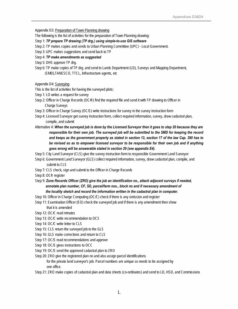
Appendices D3&D4
L
Appendix D3: Preparation of Town Planning drawing The following is the list of activities for the preparation of Town Planning drawing: Step 1: TP prepare TP drawing (TP drg.) using simple-to-use GIS software Step 2: TP makes copies and sends to Urban Planning Committee (UPC) - Local Government. Step 3: UPC makes suggestions and send back to TP Step 4: TP make amendments as suggested Step 5: DHS approve TP drg. Step 6: TP make copies of TP drg. and send to Lands Department (LD), Surveys and Mapping Department, (SMD),TANESCO, TTCL, Infrastructure agents, etc Appendix D4: Surveying This is the list of activities for having the surveyed plots: Step 1: LO writes a request for survey Step 2: Officer in Charge Records (OC/R) find the required file and send it with TP drawing to Officer in Charge Surveys Step 3: Officer in Charge Survey (OC/S) write instructions for survey in the survey instruction form Step 4: Licensed Surveyor get survey instruction form, collect required information, survey, draw cadastral plan, compile, and submit Alternative 4: When the surveyed job is done by the Licensed Surveyor then it goes to step 20 because they are
responsible for their own job. The surveyed job will be submitted to the SMD for keeping the record and keeps as the government property as stated in section 13, section 17 of the law Cap. 390 has to be revised so as to empower licensed surveyor to be responsible for their own job and if anything goes wrong will be answerable stated in section 29 (see appendix E4).
Step 5: City Land Surveyor (CLS) give the survey instruction form to responsible Government Land Surveyor Step 6: Government Land Surveyor (GLS) collect required information, survey, draw cadastral plan, compile, and submit to CLS Step 7: CLS check, sign and submit to the Officer in Charge Records Step 8: OCR register Step 9: Zone Records Officer (ZRO) give the job an identification no., attach adjacent surveys if needed, annotate plan number, CF, SD, parcel/farm nos., block no and if necessary amendment of the locality sketch and record the information written in the cadastral plan in computer. Step 10: Officer in Charge Computing (OC/C) check if there is any omission and register Step 11: Examination Officer (EO) check the surveyed job and if there is any amendment then show that it is amended Step 12: OC/C read minutes Step 13: OC/C write recommendation to OCS Step 14: OC/C write letter to CLS Step 15: CLS return the surveyed job to the GLS Step 16: GLS make corrections and return to CLS Step 17: OC/S read recommendations and approve Step 18: OC/S gives instructions to OCC Step 19: OC/S send the approved cadastral plan to ZRO Step 20: ZRO give the registered plan no and also assign parcel identifications for the private land surveyor’s job. Parcel numbers are unique so needs to be assigned by one office. Step 21: ZRO make copies of cadastral plan and data sheets (co-ordinates) and send to LD, HSD, and Commissions

Appendices D3&D4
M
Appendix E: Land Laws
This appendix is concerning with the land laws and land regulations. Appendix E1: TOWN AND COUNTRY PLANNING – CAP. 378 OF THE LAWS OF 1956 (REVISED 1961) PART II: PLANNING AREAS Declaration of planning areas Ord. 1961 s .6
13. - (1) If, after consultation with the Local Authority concerned, the Minister id of the opinion that a general planning scheme should be made in respect of any area, he ,may by order publish in the Gazette declare that area to be planning area (2) An order under this section shall come into operation on the material date. (3) A copy of every order made under this section, together with a plan of the area, shall be posted by the Local Authority Concerned at such places within the planning area as it may direct.
Validity of Order Ord. 1961 No. 14 s. 7
14. An order made under section 13 shall, unless it is sooner revoked, cease to have effect three after the material date if no scheme in respect of that planning area or any part thereof has been approved by the Minister in accordance with section 31 or 32 within the said period of three years
PART III: PREPARATION OF SCHEMES Preparation of planning schemes and amending schemes
23. - (1) The Preparatory Authority shall prepare a general planning schemes for the planning area for which it is responsible. (2) The Preparatory Authority shall may at any time after the coming into effect of a general scheme, prepare an amending scheme in respect of its planning area, as amended from time to time, or any part thereof.
PART V: ACQUISITION OF LAND AND COMPENSATION Acquisition of land Ord. 1961 No. 14 s. 2 and 7
45. - (1) Where it appears to the President that it is necessary to acquire land within a planning area for the purpose of securing its use in the manner provided in the scheme applicable thereto and agreement for the acquisition thereof between the Local Authority and the owner of such land cannot be reached, the president may acquire such land under any law relating to the compulsory acquisition of land. (2) Without prejudice to the generality of the provisions of subsection (1) of this section the power of the President thereunder shall extend to the acquisition of land which, in his opinion, it is necessary to acquire in order to secure its good development or the proper, orderly and continuous development of a planning area or any part of it or the good development of the neighbouring land: Provided that before acquiring any land under the provisions of this subsection, the President shall be satisfied that the owner of such land has taken no reasonable steps to develop such land in accordance with the provisions of the scheme applicable thereto. (3) Without prejudice to the provisions of any law relating to the compulsory acquisition of land, the purpose of which land may be acquired under the provisions of this Ordinance shall be deemed to be public purposes. (4) Nothing in this section or section 49 shall derogate from any express provision relating to the acquisition of land for a public purpose and the compensation payable therefore confined in any instrument under which such land is held.

Appendices D3&D4
N
Value of land for purpose of compensation
50. - (1) Subject to the provision of subsection (2) of this section, the value of any land within a planning area shall, for the purposes of determining the amount of compensation payable pursuant to the provisions of this Ordinance, be deemed to be the value of such land on the material development carried out there-after with planning consent. (2) In giving planning consent under the provisions of this Ordinance to the temporary development of any land with a planning area, the authority concerned may given such planning consent on the condition that the value of such temporary development shall not be taken into account for the purposes of assessing compensation payable.
Appendix E2
O
Appendix E2: THE LAND ACT NO. 4 OF 1999 PART VI
SUB-PART 1: GRANTED RIGHT OF OCCUPANCY Offer of a right of occupancy
27. – (1) The Commissioner shall, where it has been determined that a right of occupancy shall be granted to an applicant, make an offer in writing, hereinafter referred to as a letter of offer to that applicant setting out the terms and conditions upon which a grant may be made to an applicant (2) A letter of offer shall-
(a) be in a prescribed form; (b) contain all the terms and conditions subject to which a grant of a right of occupancy
may be made; (c) be signed by the Commissioner or an authorised officer; (d) bear an official stamp; (e) be delivered or sent by registered mail to the applicant or his dully authorised
representative or agent. (3) The Commissioner may withdraw a letter of offer after an affirmative reply to the offer has been received and shall be liable to compensate the applicant for any losses which the applicant has suffered by reason of the withdrawal of the letter of offer, unless within fourteen days of that withdrawal, he makes an alternative offer to the applicant which is in substantially the same terms as the offer which has been withdrawn.
Acceptance of right of occupancy
28. - (1) An acceptance of a right of occupancy in writing shall- (a) be in a prescribed form; (b) be accompanied by any fee or deposit, or nbankers draft, letter of credit or other
irrevocable commitment to pay such fee or deposit which has previously been agreed upon in writing as is required by the letter of offer; (c) be signed by the applicant or his dully authorised representative or agent. (2) A document which does not comply in every respect with the provisions of paragraphs (a) and (c) of subsection (1) and which is not accompanied by the necessary monies in one of the ways provided for in paragraph (b) of subsection (1), shall not be taken to be and shall have no effect whatsoever as an acceptance in writing.
Grant of a right of occupancy
29. - (1) Where the Commissioner determine to grant a right of occupancy to a person who- (a) has accepted a letter of offer of a right of occupancy; or (b) is in occupation of land under a right of occupancy or under an acceptance of
an offer of a right of occupancy; or (c) is otherwise entitled to a right of occupancy , he shall issue a certificate, referred to as “Certificate of Occupancy” to that person (2) A Certificate of Occupancy shall be issued in the name of the president and shall be in a prescribed form. (3) A Certificate of Occupancy shall be deemed to be dully and validly executed if it is signed by the Commissioner and sealed with his official seal and purports to be signed and sealed by the President and further proof of such execution shall not be required for the purpose of registration under the Land Registration Ordinance.

Appendix E2
P
SUB-PART 2: CONDITIONS ON RIGHT OF OCCUPANCY Payment of Premium on grant of right of occupancy
31. - (1) The Minister may require the payment of a premium on the grant of right of occupancy (2) A premium shall be paid in one or more instalments as may be determined by the Minister (3) In determining the amount of premium the Minister shall have regard to- (a) the use of land as permitted by the right of occupancy which has been granted; (b) the value of the land as evidenced by sales, leases, and other dispositions of land in the market in the area where the right of occupancy has been granted, whether those sales, leases and other dispositions are in accordance with this Act or any law relating to land which this Acts replaces; (c) the value of the land in the area as evidenced by the price paid for land at any auction conducted by or on behalf of the government; (d) the value of land as evidenced by the highest offer made in response to a request made by or on behalf of the government, a local authority or parastatal for a tender for the development of land in an area; (e) any unexhausted improvements on the land; (f) an assessment by a qualified valuer given in writing of the value of land in the open market (4) Where the payment of a premium is required, a demand for that payment shall be sent or delivered to the person to whom the Certificate of Occupancy is to be sent or delivered at the same time as or before the Certificate of Occupancy is sent or delivered (5) Failure to pay a premium or any instalment and on the date at which the payment of that premium or instalments falls due shall be deemed to be a breach of a condition of the right of occupancy which shall give rise to revocation of a right of occupancy.
Length of term of right of occupancy
32. – (1) A right of occupancy may be granted- (a) for a term up to but not exceeding ninety nine years
(b) for a term together with an option for a further term or terms which together with the original term may be up to but shall not exceed, ninety nine years (c) from year to year or for periods of less than a year determinable by the Commissioner by one year’s notice or less, whether or not the grant includes an initial fixed term, so long as that initial fixed term does not exceed four years (2) Where a right of occupancy has been granted for term certain, with or without an option for a further term or terms certain, no reduction in the length of that term certain or the term of terms certain contained in the option or options shall be made to or introduced into that right of occupancy by the Commissioner without the agreement of the occupier. (3) Where a right of occupancy comes to an end through affliction of time, the person or organisation occupying the land under that right of occupancy shall, if he has complied with the terms and conditions of that right of occupancy on any terms and conditions which the Commissioner may determine before that right of occupancy is offered to any other person or organisation. (4) The provisions of subsection (3) shall not operate to preclude the Government or a local authority or other public body from causing the land occupied under the right of occupancy to which subsection (3) refers to be developed or redeveloped in such a way it is impractical to grant a right of occupancy and where such development or redevelopment takes place, the former holder of the right of occupancy shall not be entitled to any compensation for the loss of any expectation created by the provision of subsection (3).

Appendix E3
Q
Appendix E3: THE VILLAGE LAND ACT, 1999 NO. 5 OF 1999 B: GRANT AND MANAGEMENT OF CUSTOMARY RIGHT OF OCCUPANCY Application for customary right of occupancy in village land
22. - (1) A person, a family unit, a group of persons recognised as such under customary law or who have formed themselves together as an association, a primary co-operative society or as any other body recognised by any law which permits that body to be formed, who is or are villagers, or if a married person who has been divorced from, or has left for not less than two years, his or her spouse, was prior to the marriage, a villager, and all of whom are citizens, may apply to the village council of that village for a customary right of occupancy. (2) A person or group of persons not ordinarily resident in a village may apply for a customary right of occupancy.
Grant of a customary right of occupancy
25. - (1) Where a contract for a grant of a customary right of occupancy has been concluded, a village council shall, within not more than ninety days of that conclusion, grant a customary right of occupancy to the applicant who accepted the offer referred to in section 23 (Determination of application for customary right of occupancy) by issuing a certificate, to be known as a certificate of customary right of occupancy to that applicant. (2) A certificate of customary right of occupancy shall be- (a) in a prescribed form; (b) signed by the chairman and secretary of the village council; (c) signed or marked with a personal mark by the grantee of the customary right of occupancy to which it relates at the foot of each page of the certificate; (d) signed, sealed and registered by the District Land Officer of the district in which the village is situate.

Appendix E4
R
Appendix E4: REGULATIONS OF THE LAND ACT (No. 4 OF 1999) THE LAND ASSESSMENT OF THE VALUE OF LAND FOR COMPENSATION)
REGULATIONS, 2001 Basis 3. The basis for assessment of the value of land and unexhausted improvement for purposes of
compensation, under the Act shall be the market value of such land. Market Value 4. The market value of any land and unexhausted improvement shall be arrived at by use of
comparative method evidenced by actual recent, sales of similar properties or by the use of income approach or replacement cost method where the property id of special nature and not saleable.
Compensation 7. Compensation for the loss of any interest in the land shall include value of unexhausted
improvement (a) disturbance allowance (shall be calculated by multiplying value of the land by average percentage rate of interest offered by commercial banks on fixed deposits for twelve months at the time of loss of interest in land; (b) transport allowance (shall be the actual costs of transporting twelve tons of luggage by rail or road (whichever is cheaper) within twenty kilometres from the point of displacement; (c) accommodation allowance ( the market rent for the building shall be assessed and multiplied by thirty six months in order to arrive at the accommodation allowance payable); (d) loss of profit ( the net monthly profit of the business carried out on land shall be assessed, evidenced by audited accounts where necessary and applicable, and multiplied by thirty six months in order to arrive at the profits payable).
Unoccupied land 12. The elements of transport allowance, accommodation allowance and loss of profits shall not be
payable for unoccupied land at the date of lost of interest in land. Interest 13. - (1) The interest upon any compensation shall be paid by the government or the local government
authority only where there is no prompt payment of compensation made. (2) For the purpose of computing interest payable upon compensation “prompt payment of compensation” means payment of compensation within six months after the subject land has been acquired or revoked. (3) where amount of compensation remains unpaid for six months after acquisition or revocation, interest at the average percentage rate of interest offered by commercial banks on fixed deposits shall be recoverable until such compensation is paid.

Appendix E4
S
PART II: ESTABLISHMENT OF LAND ALLOCATION COMMITTEES Approval or disapproval of application
11. Subject to the provisions of the Land Act, the committee may approve or disapprove an application for a right of occupancy.
Factors 12. Subject to the provisions of the Land Act, the Committee shall consider the following factors- (a) the applicants ability to develop the land in accordance with development conditions; (b) whether the applicant has attained the age of majority save where the minor’s application is accompanied by the guardian’s evidence of intention and ability to develop the land; (c) whether the applicant has the other land under a granted right of occupancy or customary right of occupancy; (d) basis of first in first out (e) principle of equity, reasonableness, fairness and gender balance (f) the needs of disadvantaged group

Appendix E5
T
Appendix E5: LAND SURVEY ORDINANCE ACTCAP.390 PART IV – SURVEY PLANS AND RECORDS Original cadastral plans and records to be deposited with the Director and become the property of the Government
13. - (1) Every land surveyor who makes a cadastral survey shall as soon is practicable send to the Director all original plans, original field notes and original computations and all such documents shall be deposited in the Survey Division of the Department of Lands and Surveys and shall become as the property of the Government. (2) Any person shall, on the payment of the prescribed fee, have access to such documents at all reasonable times. (3) Any person shall be entitled on payment of the prescribed fee to copy of such documents certified by the Chief Surveyor to be a true copy thereof.
Approval of plans 17. - (1) No plan made as the result of any survey to which Approval paragraphs (a) or (b) of subsection (1) of section 4 (prohibition of certain surveys by persons other than land surveyors) applies shall be admissible in evidence unless such plan has been approved by the Chief surveyor (2) Where in this or any other Ordinance it is provided that any plan shall be approved by the Chief Surveyor, the approval of the Chief surveyor shall be in writing thereon duly signed by the Chief Surveyor and such signature shall be evidence of such approval. (3) No such plan shall be approved by the Chief Surveyor- (a) until such plans has been compared with the field notes and computations deposited with the field notes and computations deposited with the Director by the land surveyor making such plan, and found to be free from error; and (b) unless the survey has been conducted in such manner as may have been specified under the proviso to section 5 (survey to be carried out in accordance with regulations) or in accordance with any regulations made under this ordinance
PART VI – DISCIPLINARY Complaint against licensed surveyor and how to dealt with
29. - (1) Every complaint against a licensed surveyor shall be submitted in writing to the Board and shall be signed by the person making the complaint and if it appears to the Board tat such complaint justifies an inquiry, the Board shall fix a time and place for the purpose of bearing and determine the complaint (2) At least thirty days prior to be date fixed for such inquiry, notice in writing shall be sent by the secretary by registered post to the last known address of the licensed surveyor against whom the complaint is made, informing him of the time and place fixed for the inquiry and supplying him with a copy of the complaint. (3) At such inquiry the licensed surveyor against whom the complaint is made shall be entitled to be heard in his defence either personally or by an advocate. (4) The board shall have full power to summon witnesses and to examine them upon oath or affirmation and to carry out any investigation concerning the complaint and may hold the inquiry whether or not such licensed surveyor appears before it or represented by an advocate or has filed any reply to the notice prescribed in subsection (2) of this section. (5) For the purpose of the last foregoing subsection any member of the Board may administer a oath or affirmation. (6) The findings and decision of the Board on such inquiry shall be made in writing and shall be signed by the Chairman.

Appendix F
U
Appendix F: Dar es Salaam plots in digital form
c:\dgn\dsm.dgn Sep. 13, 2001 09:27:01

Appendix G
V
Appendix G: CADastral PROgram (CAD PRO) Forms

Appendices H1, H2 & H3
W
Appendix H: Questions (or indicators) for assessing the verity and validity of object modelling cycle
Appendix H1: Use Case Is the use case diagram drawn using standard template? Do actors and use cases follow a standard naming convention and format? Are the actors external to the system? Are the actors external to the use case boundary? Does an action by a user start each use case? Is the start of each use case unambiguous? Does the use case makes sense? Does the use case accurately represent behaviour specified in the requirements? Does the use case cover all paths including decisions, alternates, and exceptions? Are the preconditions correct? Does the use case produce useful and appropriate results, i.e. are the postconditions correct? Are the requirements captured by the use case specified? Should similar use cases combined into a single use case? Should the use case and associated requirements be divided into several requirements and use cases? Is the functional requirement associated with at least one use case? Are use cases sharing one or more functional requirements consistent?
V & V of
Use Case
Can the use case be tested? Appendix H2: Use Case Diagrams
Is there a use case diagram for each use case? Are all use case diagrams drawn using the same, preferably the UML diagram notation? Is the actor presented in the use case diagram in which it is involved?
V & V of
Use Case Diagrams Should similar use case diagrams be combined using use case associations such as
extension of a use case and the use case by another? Appendix H3: Sequence Diagrams
Are the sequence diagram drawn using consistent, preferably UML notation? Is there a use case from which a sequence diagram is derives? Is there an actor that initiates each sequence diagram the same one that initiates the use case from which it is derived? Are all nouns, noun phrases, and verbs that imply creation represented as objects? Does a diagram have meaningful termination? Do all objects present in the sequence diagram have associated classes in the design class diagram? Do the diagram include alternatives and exceptions?
V & V of
Sequence Diagrams
Is there at least one sequence diagram for each use case?

Appendix H4
X
Appendix H4: Class Diagrams
Is the class diagram drawn using UML? Do all sequence diagram objects have associated classes in the class diagrams? Are there patterns used to create associations for common relationships? Are there classes other than containers for which there are no corresponding objects in the class diagrams? Are classes present not traceable to the requirements or use cases? Are roles identified? Are redundant classes present? Are multiplicities shown and correct? Are containment and aggregation used properly in the diagram? Are container, boundary, control, association, service, and creator classes that so not correspond to objects in the problem domain avoided? Is the design class diagram consistent with the conceptual model? Are multiplicities specified? Are containment and aggregation present in the diagram? Are container, boundary, control, association, service, and creator classes that do not correspond to objects in the problem domain present? Do the classes have low coupling? Do the classes have high cohesion?
V & V of
Class Diagrams
Are attributes mistaken for classes?

Appendix I
Y
Appendix I: Letter of Offer
Land Form No. 20
THE UNITED REPUBLIC OF TANZANIA
THE LAND ACT, 1999
(NO.4 OF 1999)
LETTER OF OFFER OF RIGHT OF OCCUPANCY (Under Section 27)
REF:………………………………………….. TO:…………………………………………… ………………………………………………… Sir/Gentlemen/Madam, RE: PLOT NO……………..BLOCK……………………………………….…………………... LOCATION………………………………………………………………………………………. AREA OF THE PLOT…………………………………………………………………………… Your application for a Long Term Right of Occupancy (later in this letter called “the right”) over this plot has been approved. The terms and conditions of the Rights are as follows:- 1. (i) Term…………………………….years………..………from…………………..……………..
(ii) Rent …………………………………………..per year which is revisable. (iii) User: The land shall be used for ……………………………………………………………………………..
…………………………………………………………………………………………………………………. as defined in the Town and Country Planning (Use Classes) Regulations, 1960. Only one main building/dwelling house together with the usual and necessary outbuildings shall be built. Commercial use shall not include the sale of vehicle fuels. (a) Building to be in permanent materials (b) Building plans to be submitted to the ……………..…………………………………...….Council within six months from the commencement of the Right. (c) Building construction to begin within six months after the approval of the plans. (d) Building to be completed within …………………… months from the commencement of the Right.
(iv) Further you must pay fees, charges etc. and refund any contribution in lieu of rates which may be paid by the government.
(v) You shall be responsible for the protection of all Beacons on the land throughout the term of Right. Missing Beacons will have to be re-established at any time at your expenses as assessed by the Director of Surveys and Mapping.
2. The following information is required by me:- (a) Your full name in block letters. Request to have Certificate of occupancy issued in the name of a person or person other than the offeree shall not be entertained. (b) Name of spouse (s). (c) Your full residential address, giving the house number, name of street and your
post office box number telephone, fax (if any) and your business address. (d) Whether you wish to hold the Right individually or as joint occupier or as occupiers in common. If it is occupancy in common, indicate the share to be taken by each of you.

Appendix I
Z
3. The amount payable on acceptance of offer is:-
Premium ………………………………………………………………….… Fees for Certificate of Occupancy …………………………………………………………………… Registration fees …………………………………………………………………… Survey fees …………………………………………………………………… Deed Plan fees …………………………………………………………………… Stamp Duty on certificate & duplicate …………………………………………………………………… Land Rent from ……………………………………….to……………………..………………………..……. 4. The amount shown above should be paid to the Commissioner for Lands or authorized officers. The
original exchequer receipts so obtained should then be sent to me with the information requested above.
5. This offer shall remain open for a period thirty days from the date of its receipt by you. Unless payment are made and receipt are returned to me within thirty (30) days this offer shall lapse.
Yours faithfully,
Name………..………………………… Signature…….…..………………….
COMMISSIONER FOR LANDS/AUTHORISED OFFICER Date:…………………………………………….
Copy to: The………………………………..…..Land Officer/Commissioner for Lands ………………………………………… ………………………………………… ………………………………………… ACCEPTANCE: 6. I/WE……………………………..hereby accept the offer of right of occupancy on the terms and
conditions contained HERE IN, this……………….day of ………………...20……………………… Name(s)……………………………………………………………………………………………………………. ………………………………………………………………………………………………………….……….…… Signature/Seal……………………………………………………………………………………………………… ……………………………………………………………………………………………………………………….. Photo: Fee. Official Stamp.

Appendix J
AA
Appendix J: Certificate of Occupancy
Land Form No. 22
THE UNITED REPUBLIC OF TANZANIA
THE LAND ACT, 1999 (NO.4 OF 1999)
CERTIFICATE OF OCCUPANCY
(Under Section 29) Title No:……………..…….
L.O. No…………………… L.D. No……………………
The …………………………………………….day of………………………….20……………….………… This is to certify that …………………………………………………………..…………………..….………. Of P.O. Box……………………………………………………………………………………………………… (hereinafter called “the occupier”) is entitled to the Right of Occupancy(hereinafter called the Right) in and over the land described in the Schedule hereto (hereinafter called “the Land”) for a term of …………………………..years from the first day of ………………………Two Thousand………….according to the true intent and meaning of the Land Act and subject to the provisions thereof and to any regulations made thereunder and to any enactment in substitution therefore or amendment thereof and to the following special conditions:- 1. The occupier having paid rent up to the …………………..day of…………20………….... shall thereafter
pay rent of shillings ………………..…..year in advance on the first day of July in every year of the term without deduction PROVIDED that the rent may be revised by the Commissioner for Lands.
2. The Occupier shall: (i) Be responsible for protection of all beacons on the Land throughout the term of Right. Missing beacons will have to be re-established at any time at the Occupier’s expenses as assessed by the Director responsible for Surveys and Mapping. (ii) Do everything necessary to preserve the environment and protect the soil and prevent soil erosion on the land and do all things which may be required by the authorities responsible for environment and to achieve such objective. (iii) ………………………………………………………………………………………….
………………………………………………………………………………………… (iv) …………………………………………………………………………………………
………………………………………………………………………………………… (v) ………………………………………………………………………………………… (vi) …………………………………………………………………………………………
3. USER:
………………………………………………………………………………………………………………………………………………………………………………………………………………………………………………………………………………………………………………………………………………………………………………………………………………………………………………………………………………………………
4. The Occupier(s) shall not assign the Right within three years of the date hereof without the prior approval of the Commissioner.

Appendix J
BB
5. The Occupier(s) shall deliver to the Commissioner notification of disposition in prescribed form before or at the time the disposition is carried out together with the payment of all premia, taxes and dues prescribed in connection with that disposition.
6. The President may revoke the right for good cause or in public interest.
SCHEDULE All land known as Plot No………Block………….situated at …………containing ……….square metres shown for identification only edged red on the plan attached to this certificate and defined on the registered Survey Plan Numbered ………… deposited at the Office of the Director for Surveys and Mapping at Dar es Salaam. Given under my hand and my official seal the day and the year first above written.
SEAL ……………………………………… COMMISSIONER FOR LANDS
I/We …………………………………………………………………………………….………………………… The within named HEREBY accept the terms and conditions contained in the foregoing Certificate of Occupancy. SIGNED and DELIVERY ) by the said………………………………….…..) who is known to me ) personally/identified to me ) by………………………………………………...) the later being known to me personally ) this……………………………………………….) day of …………………….…20……………….) Witness’s……………………………………….) Signature……………………………………….) Postal Address…………………………………) Qualification…………………………………….) SEALED with the common ) Seal of ……………………………………….…) And DELIVERED in the ) Presence of us this …………………………....) Day of ……………………………20….……....) Signature……………………………………….) Name…………………………………………....) Qualification…………………………………….) Signature………………………………………..) Name…………………………..………………..) Qualification…………………………………….)
SEAL


