
Modeling Flood Control Flexibility using the GENESYS Hydro Model Kyle Martin Mainstem Hydrologist...
14
Modeling Flood Modeling Flood Control Flexibility Control Flexibility using the GENESYS using the GENESYS Hydro Model Hydro Model Kyle Martin Mainstem Hydrologist Columbia River Inter-Tribal Fish Commission Portland, Oregon
-
date post
19-Dec-2015 -
Category
Documents
-
view
214 -
download
0
Transcript of Modeling Flood Control Flexibility using the GENESYS Hydro Model Kyle Martin Mainstem Hydrologist...

Modeling Flood Control Modeling Flood Control Flexibility using the Flexibility using the GENESYS Hydro ModelGENESYS Hydro Model
Kyle MartinMainstem HydrologistColumbia River Inter-Tribal Fish CommissionPortland, Oregon
IntroductionIntroduction
• A natural river reservoir operation promotes environmental conditions that are in harmony with the salmon’s biological timing. (Return of the River…Independent Science Group, 1996, http://www.nwppc.org/return_toc.htmhttp://www.nwppc.org/return_toc.htm)
• Altered flood control and earlier reservoir refill can achieve a more natural flow regime.

Natural Hydrograph Natural Hydrograph ConceptConcept• Natural flow regimes enhance salmon survival Natural flow regimes enhance salmon survival
with: increased turbidity, decreased travel with: increased turbidity, decreased travel time, increased habitat, higher river and time, increased habitat, higher river and estuary productivity. estuary productivity.
• More water is shifted from winter to late spring. More water is shifted from winter to late spring. Outflows modeled at minimum through May.Outflows modeled at minimum through May.
• Altered Flood Control uses less drafts during Altered Flood Control uses less drafts during late winter and early spring. Strategy takes late winter and early spring. Strategy takes advantage of expected global warming.advantage of expected global warming.

GENESYS Hydro-generation GENESYS Hydro-generation modelmodel
• This NPPC model uses monthly time steps.This NPPC model uses monthly time steps.
• Flow operations are specified at all PNW Flow operations are specified at all PNW dams.dams.
• Model runs sequentially from dam-to-dam.Model runs sequentially from dam-to-dam.
• Record spans Water Years 1929 - 1978.Record spans Water Years 1929 - 1978.
• Output: flow, pool elevations, generation.Output: flow, pool elevations, generation.
• New encoded storage Rule Curves can alter New encoded storage Rule Curves can alter flood control operations.flood control operations.

GENESYSEnergy Analyses, Economics
Multi-Dam Stand-Alone(Hydro-Sim model)
PLANT File:Physical Characteristics--
Min/Max flow, FB vs. StorageTail-Water vs. Discharge
PERIOD File:Rule Curves
OPERATIONS Files:Flow Limits, Spill, Storage Limits
“Operation-Exception”
Program Control Files-- Post-Processing
GENESYSMulti-Dam
Program Control Files-- Pre-Processing
Graphical Displays:Outflow, Pool Elevations, Storage Tabular Reports and Data Files
50 years historical, observed data
Proportional draft, PNCA specified
Prioritized operating parameters
Draft specific reservoirs, if desired

Altered Flood ControlAltered Flood Control• Global warming will reduce winter snow packs. Global warming will reduce winter snow packs.
Spring flood control drafts can be reduced. Spring flood control drafts can be reduced.
• Reservoir refill probability increases. Reservoir refill probability increases.
• As reservoirs fill by May 31, excess inflow is passed As reservoirs fill by May 31, excess inflow is passed and generates a higher seasonal peak.and generates a higher seasonal peak.
• Altered flood control reclaims 5.55 MaF at Grand Altered flood control reclaims 5.55 MaF at Grand Coulee, 2.7 MaF at Dworshak, & 0.35 MaF at Coulee, 2.7 MaF at Dworshak, & 0.35 MaF at Brownlee (total: 8.6 MaF).Brownlee (total: 8.6 MaF).
• Advanced river forecasting tools (eg, UW-DHSV or Advanced river forecasting tools (eg, UW-DHSV or NWSRFS) can reduce premature FC drafts. NWSRFS) can reduce premature FC drafts.
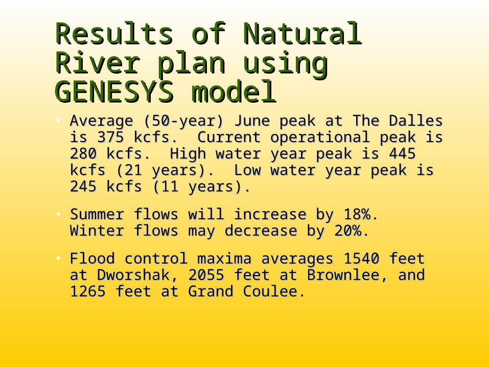
Results of Natural River Results of Natural River plan using GENESYS plan using GENESYS modelmodel• Average (50-year) June peak at The Dalles is Average (50-year) June peak at The Dalles is
375 kcfs. Current operational peak is 280 375 kcfs. Current operational peak is 280 kcfs. High water year peak is 445 kcfs (21 kcfs. High water year peak is 445 kcfs (21 years). Low water year peak is 245 kcfs (11 years). Low water year peak is 245 kcfs (11 years).years).
• Summer flows will increase by 18%. Winter Summer flows will increase by 18%. Winter flows may decrease by 20%.flows may decrease by 20%.
• Flood control maxima averages 1540 feet at Flood control maxima averages 1540 feet at Dworshak, 2055 feet at Brownlee, and 1265 Dworshak, 2055 feet at Brownlee, and 1265 feet at Grand Coulee.feet at Grand Coulee.

Grand Coulee pool: 50 year average
1,2401,2421,2441,2461,2481,2501,2521,2541,2561,2581,2601,2621,2641,2661,2681,2701,2721,2741,2761,2781,2801,2821,2841,2861,2881,290
OCT NOV DEC JAN FEB MAR AP1 AP2 MAY JUN JUL AG1 AG2 SEP
Ele
vatio
n (f
eet)
Federal Operations CRITFC Natural-Peak

Dworshak pool: 50 year average
1,5001,5051,5101,5151,5201,5251,5301,5351,5401,5451,5501,5551,5601,5651,5701,5751,5801,5851,5901,5951,600
OCT NOV DEC JAN FEB MAR AP1 AP2 MAY JUN JUL AG1 AG2 SEP
Ele
vatio
n (f
eet)
Federal Operations CRITFC Natural-Peak
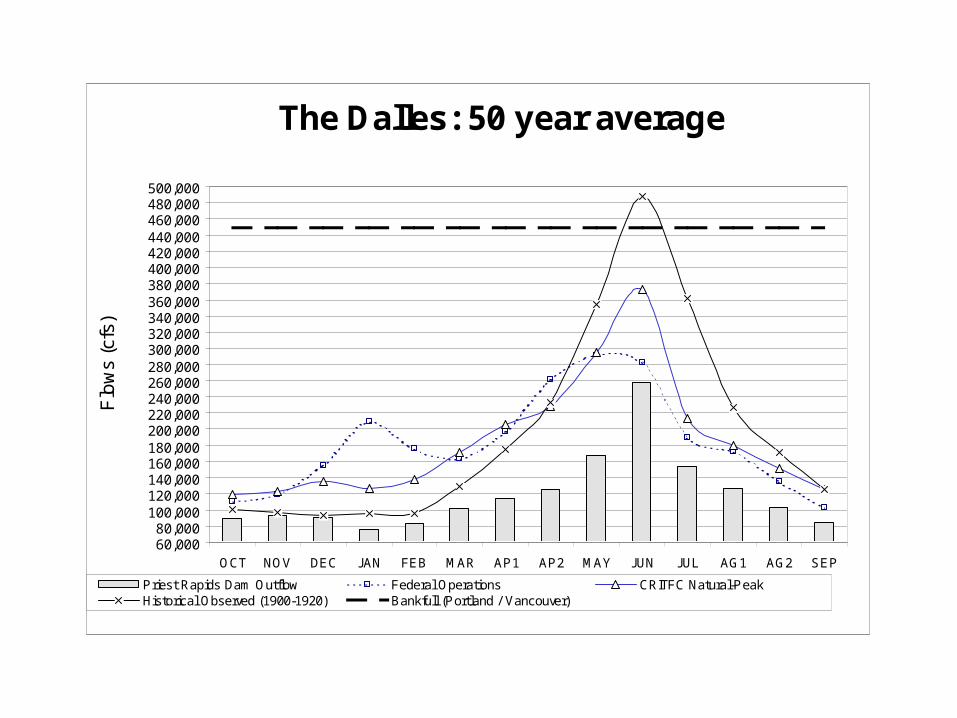
The Dalles: 50 year average
60,00080,000
100,000120,000140,000160,000180,000200,000220,000240,000260,000280,000300,000320,000340,000360,000380,000400,000420,000440,000460,000480,000500,000
OCT NOV DEC JAN FEB MAR AP1 AP2 MAY JUN JUL AG1 AG2 SEP
Flo
ws
(cfs
)
Priest Rapids Dam Outflow Federal Operations CRITFC Natural-PeakHistorical Observed (1900-1920) Bankfull (Portland / Vancouver)

Benefits to Northwest Benefits to Northwest SalmonSalmon• Enhanced ecosystem health and diversity. Enhanced ecosystem health and diversity.
Resident fish populations enjoy more habitat.Resident fish populations enjoy more habitat.
• Speed juvenile migrants to the estuary.Speed juvenile migrants to the estuary.
• Transport more woody and organic debris.Transport more woody and organic debris.
• Less predation. Cooler passage water.Less predation. Cooler passage water.
• Increase estuary plume--critical habitat. Increase estuary plume--critical habitat.
• Provide adequate flow for returning adults. Provide adequate flow for returning adults. Currently, flows are low in September.Currently, flows are low in September.

How a Natural River plan How a Natural River plan may Impact the Pacific may Impact the Pacific NorthwestNorthwest• More salmon return to spawn while Columbia More salmon return to spawn while Columbia
Tribal treaties are honored.Tribal treaties are honored.
• Flood risk to Portland is 18% (versus 10%). Flood risk to Portland is 18% (versus 10%). Top 5 years average to 550 kcfs flood flow. A Top 5 years average to 550 kcfs flood flow. A 600 kcfs flood flow gives 10% risk versus 6%.600 kcfs flood flow gives 10% risk versus 6%.
• Spring flood risk mitigated by global warming. Spring flood risk mitigated by global warming.
• Less winter generation will be offset by higher Less winter generation will be offset by higher summer generation (June-September).summer generation (June-September).

Spring Flood-Frequency (WY 1929-78): Columbia River at The Dalles
100,000
1,000,000
2 6 10 13 17 21 25 29 33 37 40 44 48 52 56 60 63 67 71 75 79 83 87 90 94
Probability of flow being equaled or exceeded
Flo
w (
cfs)
Historical Observed peak Federal Operation peak CRITFC Natural Hydrograph peak
Bank Full Flood Flow

SummarySummary
• Altered flood control can reclaim 8.6 MaF of Altered flood control can reclaim 8.6 MaF of storage to benefit salmon resources while storage to benefit salmon resources while restoring the Columbia and Snake rivers back to restoring the Columbia and Snake rivers back to a natural peaking hydrograph. River and a natural peaking hydrograph. River and estuary habitat would improve.estuary habitat would improve.
• Natural River plan shifts winter flow into spring, Natural River plan shifts winter flow into spring, refills by May 31st, and passes inflow in June. refills by May 31st, and passes inflow in June. Flood risk increases from 10% to 18% but will Flood risk increases from 10% to 18% but will decrease as global climate warming continues.decrease as global climate warming continues.
• Need to run daily flood risk & life-cycle studies.Need to run daily flood risk & life-cycle studies.


