Modeling Depth as a Constraining Factor for Optimum Groundwater Yield - A case Study
13
Journal of Environment and Earth Science www.iiste.org ISSN 2224-3216 (Paper) ISSN 2225-0948 (Online) Vol 2, No.10, 2012 15 Modeling Depth as a Constraining Factor for Optimum Groundwater Yield - A case Study Muraina Zaid Mohammed 1* & Martins Olusola Olorunfemi 2 1 Department of Geology & Applied Geophysics, Adekunle Ajasin University, Akungba-Akoko, Nigeria 2 Department of Geology, Obafemi Awolowo University, Ile-Ife, Nigeria *E-Mail of the correspondence: author: [email protected] Abstract This research work focused on the contribution of depth to the yield of boreholes for water supply project in parts of Fadama Floodplain West Chad Basin, Northeastern Nigeria. An integrated method involving geoelectric and borehole lithological analysis and record of yields and aquifer hydraulic properties from boreholes was employed. Four distinct subsurface geologic layers and corresponding depths were delineated. These included the topsoil, alluvial sand, Chad Formation/weathered column and the bedrock. The thicknesses of the upper three layers were 0.4 – 6.7; 1.6 - 32.2 and 15.9 -168.6 m respectively. The depth to rockheads varied from 18.4 to 175.5 m. The second layer presumably alluvium layer constitutes the main aquifer unit with optimum depth not greater than 30 m. However, within the upper 25 - 30 m, high groundwater yield of between 9 – 13.4 l/s (779.3 – 1163.8 m3/day ) with hydraulic conductivity and transmissivity values of 6.7 to 1329.4 m/day and 122.7 to 10427.5 m3/day respectively were obtained. Beyond this depth, yields were wholly retarded between 2.0 l/s (172.8 m3/day) and 6.9 l/s (602.2 m3/day) arising from the significant contribution of the poor hydrogeological materials . It is, therefore, concluded that borehole depth model (25 - 30 m) and not those terminated at rock heads or within bedrock depression zones as in general case gave an optimum groundwater yield with a cumulative discharge capacity greater than 420 l/s (36,288 m3/day) expected from a battery of maximum of 42 boreholes in this part of the Chad Basin. Keywords: Depth, Contribution, Yield, Borehole, Transmissivity, Permeable, Floodplain. 1. Introduction In the light of the River Jama’are floodplain water supply project initiated by the Federal Government of Nigeria, a cumulative discharge capacity of 420 l/s (36,288 m 3 /day) is required from a field of maximum of 42 boreholes. This requires an average groundwater discharge of 10 l/s (864 m 3 /day), but not less than 7.5 l/s (648 m 3 /day) for the servicing of the two major towns of Azare and Jama’are, and sub-rural communities in Katagum Local Government Area of Bauchi State, Northeastern Nigeria (Fig. 1). The statistics of the population figure of these communities is very important for the design of water supply scheme since the projected/expected yields are dependent on the population to be serviced. The population growth rate of 2.83% per year per urban area reported by the Central Bank of Nigeria (in its 1999 annual economic report), was adopted for a trial population projection to a period up to year 2015. This enables assumed growth rates of 2% and 1.5% for the period of 2016-2020 and 2021-2030 respectively for the projected population figures of Azare and Jama’are towns and the communities along the pipeline route (Table 1). The floodplain is located between Azare and Jama’are towns, 30 kilometres west of Azare (Figs. 1). The groundwater potential of the floodplain has been recognized for a long time following the initiatives of the FGN, 1978; GSN (1978) and Bauchi State Agriculture Development Project (1988) on Bauchi State Hydrogeology-Hydrogeological unit descriptions by Wardrop Engineering Inc. Winnipeg, Canada based on 1205 boreholes and 234 boreholes constructed under Contract BSADP-6 and BSADP-19 respectively. Site investigation with multiple techniques is key to the construction of depth model. Geophysical methods with borehole lithological investigation are commonly applied (Matheis, 1989; Olayinka and Olorunfemi, 1992; Olorunfemi and Fasuyi, 1991; Mohammed, 2007). Correlation of the geophysical data with the lithological data allows identification of relevant layers of hydrogeological interest and yield compliant. The optimum yield potential of an area can be mapped by using the depth model and knowledge of geological setting.
-
Upload
alexander-decker -
Category
Documents
-
view
218 -
download
2
description
Â
Transcript of Modeling Depth as a Constraining Factor for Optimum Groundwater Yield - A case Study

Journal of Environment and Earth Science www.iiste.org
ISSN 2224-3216 (Paper) ISSN 2225-0948 (Online)
Vol 2, No.10, 2012
15
Modeling Depth as a Constraining Factor for Optimum
Groundwater Yield - A case Study
Muraina Zaid Mohammed1*
& Martins Olusola Olorunfemi2
1 Department of Geology & Applied Geophysics, Adekunle Ajasin University, Akungba-Akoko, Nigeria
2 Department of Geology, Obafemi Awolowo University, Ile-Ife, Nigeria
*E-Mail of the correspondence: author: [email protected]
Abstract
This research work focused on the contribution of depth to the yield of boreholes for water supply project in parts of
Fadama Floodplain West Chad Basin, Northeastern Nigeria. An integrated method involving geoelectric and
borehole lithological analysis and record of yields and aquifer hydraulic properties from boreholes was employed.
Four distinct subsurface geologic layers and corresponding depths were delineated. These included the topsoil,
alluvial sand, Chad Formation/weathered column and the bedrock. The thicknesses of the upper three layers were 0.4
– 6.7; 1.6 - 32.2 and 15.9 -168.6 m respectively. The depth to rockheads varied from 18.4 to 175.5 m. The second
layer presumably alluvium layer constitutes the main aquifer unit with optimum depth not greater than 30 m.
However, within the upper 25 - 30 m, high groundwater yield of between 9 – 13.4 l/s (779.3 – 1163.8 m3/day ) with
hydraulic conductivity and transmissivity values of 6.7 to 1329.4 m/day and 122.7 to 10427.5 m3/day respectively
were obtained. Beyond this depth, yields were wholly retarded between 2.0 l/s (172.8 m3/day) and 6.9 l/s (602.2
m3/day) arising from the significant contribution of the poor hydrogeological materials . It is, therefore, concluded
that borehole depth model (25 - 30 m) and not those terminated at rock heads or within bedrock depression zones as
in general case gave an optimum groundwater yield with a cumulative discharge capacity greater than 420 l/s (36,288
m3/day) expected from a battery of maximum of 42 boreholes in this part of the Chad Basin.
Keywords: Depth, Contribution, Yield, Borehole, Transmissivity, Permeable, Floodplain.
1. Introduction
In the light of the River Jama’are floodplain water supply project initiated by the Federal Government of Nigeria, a
cumulative discharge capacity of 420 l/s (36,288 m3/day) is required from a field of maximum of 42 boreholes. This
requires an average groundwater discharge of 10 l/s (864 m3/day), but not less than 7.5 l/s (648 m
3/day) for the
servicing of the two major towns of Azare and Jama’are, and sub-rural communities in Katagum Local Government
Area of Bauchi State, Northeastern Nigeria (Fig. 1). The statistics of the population figure of these communities is
very important for the design of water supply scheme since the projected/expected yields are dependent on the
population to be serviced. The population growth rate of 2.83% per year per urban area reported by the Central Bank
of Nigeria (in its 1999 annual economic report), was adopted for a trial population projection to a period up to year
2015. This enables assumed growth rates of 2% and 1.5% for the period of 2016-2020 and 2021-2030 respectively
for the projected population figures of Azare and Jama’are towns and the communities along the pipeline route
(Table 1). The floodplain is located between Azare and Jama’are towns, 30 kilometres west of Azare (Figs. 1). The
groundwater potential of the floodplain has been recognized for a long time following the initiatives of the FGN,
1978; GSN (1978) and Bauchi State Agriculture Development Project (1988) on Bauchi State
Hydrogeology-Hydrogeological unit descriptions by Wardrop Engineering Inc. Winnipeg, Canada based on 1205
boreholes and 234 boreholes constructed under Contract BSADP-6 and BSADP-19 respectively. Site investigation
with multiple techniques is key to the construction of depth model. Geophysical methods with borehole lithological
investigation are commonly applied (Matheis, 1989; Olayinka and Olorunfemi, 1992; Olorunfemi and Fasuyi, 1991;
Mohammed, 2007). Correlation of the geophysical data with the lithological data allows identification of relevant
layers of hydrogeological interest and yield compliant. The optimum yield potential of an area can be mapped by
using the depth model and knowledge of geological setting.

Journal of Environment and Earth Science www.iiste.org
ISSN 2224-3216 (Paper) ISSN 2225-0948 (Online)
Vol 2, No.10, 2012
16
This paper presents borehole depth model from the outcomes of the two time-variant geophysical investigations and
borehole lithological investigation analysis. The earlier geophysical investigation of the study area (Belmont, 2003)
delineated seven geoelectrical layers and two aquifer units: upper alluvium and lower weathered/fractured basement
aquifers. The result of the geophysical investigation was used to determine borehole optimum drill depths and the
12.00 N
10.00 N 10.00 N
12.00 N
8.00 E
KADUNA
BAUCHI
KANO
YOBE
JIGAWA
GOMBE
PLATEAU
Katagum
Azare
Jama;are
Faggo
Misau
Ningi
Gubi
Madaki
Toro
Sakwa
PotiskumFrom DutseTo Maiduguri
JOS
To Kano
Udubo
To Gombe
Dindima
Mainamaji
Bara
MiyaZakara
Alkalere
WikkiYuli
Jagudi
T. Wada
Lame
Zalanga
Bure
Sandigalou
Kinsha
Gamawa
Burra
Kari
Darazo
Bula
Zungun
B. Kasa
Tafawa Balewa
Lere
Boi
10.00 E
10.00 E8.00 E
12.00 E
12.00 E 14.00 E
14.00 E
State Capital
Express/Major Road
State Boundary
Other Towns
Study Area
Kilometre
0 50 100
FCT
ABUJA
KANO
KADUNA
FCT
ABUJA
BAUCHI
JIGAWAKATSINA
BIRNIN KEBBI
NIGER
SOKOTO
ZAMFARA
YOBE
NIGER
BORNO
LAKE CHAD
L. Kanji
AZAREJam
a'are
BAUCHI
AzareJama;are
Kilometre
0 100
Fig. 1. Map of Bauchi State showing the Study Area
Table 1: Projected population figures of Azare, Jama’are and their regional communities
Year Azare township Azare regional
communities
Jama’are township Jama’are regional
communities
2000 110, 295 7, 578 39, 042 4, 017
2010 145, 798 10, 018 51, 608 5, 310
2020 185, 077 12, 717 65, 512 6, 740
2030 214, 789 14, 758 76, 029 7, 823
Source: Hadejia Jama’are River Basin Development Authority (2001)
choice of borehole sites (Table 2). A test hole was drilled to depth of 62 m with sustained groundwater yield of 3 l/s
(259.2 m3/day). Eight additional boreholes were drilled, to rock heads or within the basement rock to take advantage
of the two aquifer units predicted from the geophysical survey. Discharges from these wells (Table 2), vary from 2 l/s
(172.8 m3/day) to a moderate yield of 6.97 l/s (602.2 m
3/day). These groundwater yield values were considered much
less than the expected average of 10 l/s (864 m3/day) or acceptable minimum of 7.5 l/s (648 m
3/day). The lithological
logs obtained from the drilled well in show a sequence of clayey topsoil, silty/fine medium/coarse/gravelly sands and
the underlying basement bedrock in most cases, with the sandy columns intercalated with lenses of reddish/pinkish

Journal of Environment and Earth Science www.iiste.org
ISSN 2224-3216 (Paper) ISSN 2225-0948 (Online)
Vol 2, No.10, 2012
17
clay as well as plastic clay in most places.
Table 2: Characteristics of Boreholes Completion at Depths
Borehole Code
Borehole location
Geoelectric Depth to Rockhead (m) Belmont (2003)
Static Water Level (m)
Yield (l/s) : (m
3/day)
Obs.B/H 19 130 3.5 10.0
864
Test B/H 62 130 5.3 3.0
259.2
BH-3 50 120 3.7 5.82
502.85
BH-5 42.8 110 2.7 6.75
583.2
BH-10 45.1 30 3.9 6.97
602.21
BH-32 60 100 2.8 2.4
207.36
BH-41 53.4 125 3.8 2.7
233.28
BH-43 47.4 50 2.2 2.0
172.8
BH-46 53.8 50 2.8 2.5
216
BH-48 57 95 4.9 5.0
432
A correlation of the borehole depths with the groundwater yields for the boreholes shows that groundwater yields in
the basin generally decrease with increase in borehole depth (Fig. 2). This observation goes contrary to
productivity of aquifers of between 6.7 and 16.7 litres/second recorded in the floodplain area (BSADP, 1988).
20 30 40 50 60 70
2
4
6
8
10
Bore
hole
Gro
undw
ate
r Yie
ld, litr
e/se
c.
Borehole Depth, metre
Fig. 2: Borehole Groundwater Yield versus Borehole Depth for Preliminary (trial) Boreholes
2. Geology and Hydrogeology
The study area is underlain by Cretaceous-Tertiary Chad Formation and Recent alluvial Formation of Pleistocene age
(BSADP, 1988; Matheis, 1989). The two formations directly rest on the basement bedrock rock. However, rocky hills
and inselbergs of the basement rock occur around Geidam, Gumel and Shira, about 30 km southwest of the study
area. This suggests that the study area is located within a transitional sedimentary/basement terrain. The major
geological features in the area include approximately NW-SE trending geophysically identified suspected deeply
buried regional parallel faults/fractured zones in the basement bedrock.
The alluvium deposits with the flood plain consist of silts, clays, and sands, while the Chad Formation is composed

Journal of Environment and Earth Science www.iiste.org
ISSN 2224-3216 (Paper) ISSN 2225-0948 (Online)
Vol 2, No.10, 2012
18
of Quaternary sediments of lacustrine origin (Carter et al., 1963). The basis of gravels constitute the main aquifer
with which the silts clays the aquitard (GSN, 1978; BSADP, 1988; Matheis, 1989; Offodile, 1992, 2002).
3. Materials and Methods of Study
The data acquisition involved the records of the interpretation results of Schlumberger resistivity soundings, borehole
lithological logs, GPS geographic information and record of yields from 41 boreholes and their aquifer hydraulic
properties. Apparent resistivity data were collected at 106 stations at selected points and at the vicinity of the existing
boreholes (Mohammed 2007). The geographic co-ordinates of each of the sounding/borehole stations were recorded
with a GARMIN 12 Channel Personal Navigator (GPS). The geoelectric interpretation results containing the
resistivity and thickness and depth to bedrock extracted to aid the characterization of the aquifer system were
acquired and used for the analysis. Groundwater yield is often a complex function of aquifer thickness and resistivity
thresholds and usually form the basis a rational choice of drill sites may be made as in Table 3 (Mohammed 2007).
Forty one boreholes were subsequently drilled via the use of the direct hydraulic rotary drilling technique following
the recommendation (Table 3/Figure 3). As the drilling progressed, a careful record or logging (i.e. sampling of
bailed out cuttings of the boreholes was kept for various geologic formations encountered at depths. The record of
the penetration rate coupled with the physical properties of each formation encountered as drilling progressed
enabled proper positioning of the sequence of occurrence of the lithology. This constitutes the borehole lithological
log or simply the drillers’ log (Fig. 4) that were further used for analysis.
4. Results and Discussion
4.1 Results
Table 3 and Appendix I show the results of the geoelectric survey interpretation recorded from 69 borehole sites.
These sites were considered drillable for the overall success of the water supply scheme. The record contains among
others the geoelectric parameters ( i.e the layer thickness and resistivity) of the two saturated columns- alluvium and
clayey Chad Formation and the depth to bedrock.
Figure 4 shows the lithological logs for some of the boreholes drilled.
4.2 Discussion of Results
The lithological logs are characterized by a series of brown to grey fine grained/clayey texture as the topsoil,
alluvium, sandy clay/ clay and the basement unit. The observation borehole that gave the maximum yield of 10 l/s
(864 m3/day) was terminated at a shallow depth of 19 m within the upper alluvium aquifer. Borehole (BH 48), 57 m
deep gave a yield of 5 l/s (432 m3/day), transmissivity of 158.1 m
2/day, hydraulic conductivity of 11.1 m
2/day/m and
specific capacity of 91.5 m3/day/m as against a yield of 12.2 l/s (1054.1 m
3/day), transmissivity of 385.8 m
2/day,
hydraulic conductivity of 27.2 m2/day/m and specific capacity of 223.2 m
3/day/m for the same borehole BH-48
which was later backfilled to 32 m deep.
The sustained appreciable groundwater yield (3.0-5.0 litres/seconds or more) of the numerous shallow (not deeper
than 7.0 m) tube-wells located within the upper alluvial sand aquifer in the study area over the years indicates that
the alluvial sands have potentials for moderate to high groundwater yield. Thus, efforts are concentrated on the
thickness of the alluvium and its immediate underlying strata in characterizing the groundwater potential of the site.
The yield of boreholes in the present study area probably depends to some extent on the saturated thickness of the
alluvium aquifer, its storage and discharge capabilities. Alluvium deposit is generally known for its great storage
potential, particularly its gravelly horizons.

Journal of Environment and Earth Science www.iiste.org
ISSN 2224-3216 (Paper) ISSN 2225-0948 (Online)
Vol 2, No.10, 2012
19
Table 3. The selected borehole sites and their geoelectric parameters
S/N VES
Points
Resistivity
(ohm-m)
Thickness
(m)
Remark/Order of
Sites’ Priority
ALV CCF ALV CCF DTB
1 5 286 34 9.6 59.6 71 First order
2 6 790/248 33 12.2 76.1 86.8 First order
3 7 297 25 9.3 64.8 77.8 First order
4 10 840 62 9.2 38 48 First order
5 12 460 50 13.7 136.9 152.8 First order
6 26 1168/264 34 11 75 87.4 First order
7 27 280 27 9.9 42.2 52.9 First order
8 30 379 73 11.3 124.4 141.4 First order
9 34 469 27 9.1 59.9 70.2 First order
10 37 2763/84 13 21.8 45.9 74.1 First order
11 51 4067/374 22 12.1 82.1 95.2 First order
12 53 2398/344 17 21.4 37.8 60 First order
13 55 312 24 12.1 61.9 80.2 First order
14 56 441 55 10.1 120.4 133.8 First order
15 57 295 140 13.6 31.4 47.4 First order
16 77 842/312 15 21.8 24 46.5 First order
17 78 475 18 12 33.8 47.1 First order
18 81 252 29 10.5 59.9 72.8 First order
19 87 2106/566 58 15 87.4 103 First order
20 102 335 45 9.1 24.4 38.8 First order
21 104 602 31 28.8 53.4 85.9 First order
22 105 456/257 64 20.6 59 81 First order
23 4 272 27 8.4 76.7 86.4 Second order
24 24 295 51 7.5 44.2 56.4 Second order
25 35 5706/421 56 7.9 101.3 109.7 Second order
26 59 471 33 8.1 39.4 51.6 Second order
27 67 268 55 8 75.4 84.9 Second order
28 3 173 34 14.7 62.5 80.6 Third order
29 8 207 39 14.2 53.8 71.1 Third order
30 9 959/178 41 15.9 45.9 62.4 Third order
31 13 141 40 26.7 63.3 93.4 Third order
32 14 108 36 21 151.6 175 Third order
33 15 119 33 11.7 80.8 95.9 Third order
34 16 95 40 20.1 57.5 79.4 Third order
35 18 110 42 20.5 86.8 108.4 Third order
ALV - Alluvium Layer
CCF - Clayey Chad Formation/Weathered Basement
DTB - Depth to Basement

Journal of Environment and Earth Science www.iiste.org
ISSN 2224-3216 (Paper) ISSN 2225-0948 (Online)
Vol 2, No.10, 2012
20
YOLA
Digiza
Fulani Hut
Fulani Hut
HeadworksR
IVE
R J
AM
A'A
RE
From Azare
To J
am
a'a
re
Schl.
Sabon Gari
Disp. Schl.
N
A E
LK
JI
HG
F
D
B
603500 604000 604500 605000
1289000
1289500
1290000
1290500
1291000
1291500 1
23
4
5
6789
10
11
121314151617181920
21 22 23 24 25 26 27 28 29
3031
32333435363738
39
40
41
42
43
44
45
46
474849505152
53 54 55
565758596061626364
65 66 67 68 69 70 71 72 73
747576777879808182
83 84 85 86 87 88 89 90 91
9293949596979899100
101 102 103
104105106
0 m 225 m 450 m
C
LEGEND
TB
M
OB
Foot Path
River
Minor Road
Major Road
Drilled Borehole
Abandoned Borehole
VES Location 12
Hand Dug Well
A B Geophysical Traverse
Observation BoreholeOB
Test BoreholeTB
Fig. 3. Map showing locations of the boreholes drilled and completed

Journal of Environment and Earth Science www.iiste.org
ISSN 2224-3216 (Paper) ISSN 2225-0948 (Online)
Vol 2, No.10, 2012
21
0
20
40
60
Depth (m) BH-76BH-77BH-79 BH-16
80
100
Fresh Basement Bedrock (Unfractured basal unit)
Chad Formation (Clay/sandy clay/clayey weathered layer)
Alluvium (Sand/clayey sand)
Topsoil (clay/sandy clay/Laterite)
156 m
BH-78 BH-8
207
39
95
40
ohm-m ohm-m
ohm-m ohm-m
ohm-m
ohm-m
ohm-m
ohm-m
177
842/312
475120 ohm-m
ohm-m
ohm-m
ohm-m
11
15
18
33
G/S
BH
L
G/S
G/S
G/S
G/S
G/S
BH
L
BH
L
BH
L
BH
L
BH
L
207/22209/83124768719 /14
G/S = GEOELECTRIC SECTION
BHL = BOREHOLE LOG
ohm-m
ohm-m ohm-m
Fig. 4. Lithological logs and geoelectric parameters of some of the boreholes
The clay/sandy clay second layer belongs to the mainly argillaceous clayey Chad Formation. The formation grades
into the basal clayey weathered basement layer (Fig. 4/Table 3) with relatively low resistivity values that averaged
about 40 ohm-m. The layer matrix is appreciably clayey constituting an impermeable block with tendency for
limited or low groundwater yielding capacity, in spite of its significant thicknesses (up to 175 m) within deep
basement depressions, in some few areas. This unit as the second aquifer (sometimes interbedded with sand lenses)
is a poor aquifer and hence contributes minimally to the overall yield of wells and boreholes in the area.
In the light of the above considerations, the second layer (alluvium) remains the most important aquifer unit with a
groundwater potential of medium to high rating based on yields of several shallow tubewells and few test boreholes
in the study area. Discharge capacities of between 7.5 and 10.0 l/s have been achieved.

Journal of Environment and Earth Science www.iiste.org
ISSN 2224-3216 (Paper) ISSN 2225-0948 (Online)
Vol 2, No.10, 2012
22
The alluvium unit covers the mean interval of about 3 to 14 m depth. The unit is marked with about 60 – 70 % quartz
and is fine-medium grained in most places. The clay/sandy clay unit is found within the interval of about 14 to 78 m
which corresponds to the clayey Chad formation/weathered basement column in the basin. The unit consists of
interbedding series of thin gravels, sands silts and clays which constitutes. The observation borehole that gave the
maximum yield of 10 l/s (864 m3/day) was terminated at shallow depth (19 m) within the upper alluvium aquifer. It
is, therefore, suspected that the upper alluvial deposit may have constituted the major aquifer and the lower clayey
Chad Formation / weathered basement aquifer, an aquitard. The field transmissivity values range between 122.7 and
10427.5 m3/day with the exception of BH-55 with a value of 18783.7 m
2/day. The field hydraulic conductivity (K)
values range from 6.7 to 1329.4 m/day. The observation is in agreement with the range of known values of hydraulic
conductivity of 2 - 295 gpd/ft2, (8.3 x 10
-4 - 1.22 x 10
-3 m/day) and transmissivity of between 12.4 and 12400 m
3/day
for unconsolidated sediments as earlier observed by Driscol (1986). The entrance velocities vary between 0.0017 and
0.0075 m/s. These values lie within the recommended value of not greater than 0.03 m/s (Driscol, 1986; Roscoe,
1990). This provides a good measure of the effect of screen slot size on the yield. The results of the study reveal the
presence of an extremely poor clay/sandy clay/clayey Chad Formation/weathered aquifer with little transmissive
capacity across the study area, which signified a relatively low effective porosity and low permeable environment.
No indication of fracturing tendency was observed from the VES curves/results, and hence no fractures occurred
through the depths of wells. The permeable (alluvium) zone was found to occur at the top of the clayey Chad
Formation/weathered strata, just below the clayey topsoil. This unit may have formed from the meandering stream
flow deposition and has constituted the primary sustainable upper aquifer in the area, while directly below is the
Chad Formation/weathered aquifer which contributes minimally to the overall success of well yields. The resistivity
response of the subsurface geologic units in the area may have depended on the sand to clay ratio and the degree of
saturation. The alluvium unit with about 70 % quartz enhances the resistivity values and perhaps hydraulic
conductivity and transmissivity better than its immediate underlying clay Chad Formation/weathered unit. Where
alluvial sand materials predominate, is characterized by good hydraulic properties. Transmissivity and hydraulic
conductivity values obtained from deeper wells were significantly less than those from shallow depths (backfilled).
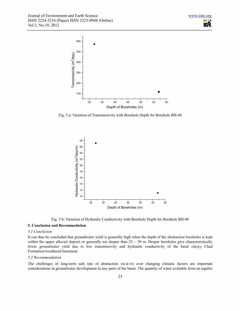
For example, in BH- 48, 57 metres deep, has a yield of 5 l/s (432 m3/day), transmissivity of 158.1 m
2/day, hydraulic
conductivity of 11.1 m2/day/m and specific capacity of 91.5 m
3/day/m as against a yield of 12.2 l/s (1054.1 m
3/day),
transmissivity of 385.8 m2/day, hydraulic conductivity of 27.2 m
2/day/m and specific capacity of 223.2 m
3/day/m for
the shallow (about 32 m deep) backfilled equivalent (Figs. 5 a and b). Information from the results, therefore,
showed that the hydraulic conductivity and transmissivity values within the upper 25 - 30 m are enhanced and thus
suggest zone of good infiltration coefficient and hydraulic conductivity. However, beyond this depth, the deposits
become more clayey matrixed and yields are wholly retarded arising from the significant contribution of the thick
clay matrix. However, no sand more permeable than alluvium was found beyond a depth of 25 - 30 m. It is,
therefore, suggested that an optimum borehole depth of 25 - 30 m below ground level is recommended for this part
of the Chad Basin.
Journal of Environment and Earth Science www.iiste.org
ISSN 2224-3216 (Paper) ISSN 2225-0948 (Online)
Vol 2, No.10, 2012
23
30 35 40 45 50 55 60
150
200
250
300
350
400
Tra
nsm
issiv
ity (
m2/d
ay)
Depth of Boreholes (m)
Fig. 5.a: Variation of Transmissivity with Borehole Depth for Borehole BH-48
30 35 40 45 50 55 60
10
12
14
16
18
20
22
24
26
28
Hyd
rau
lic C
on
du
ctivity (
m2/d
ay/m
)
Depth of Boreholes (m)
Fig. 5 b: Variation of Hydraulic Conductivity with Borehole Depth for Borehole BH-48
5. Conclusion and Recommedation
5.1 Conclusion
It can thus be concluded that groundwater yield is generally high when the depth of the abstraction boreholes is kept
within the upper alluvial deposit or generally not deeper than 25 – 30 m. Deeper boreholes give characteristically
lower groundwater yield due to low transmissivity and hydraulic conductivity of the basal clayey Chad
Formation/weathered basement.
5.2 Recommendation
The challenges of long-term safe rate of abstraction vis-à-vis ever changing climatic factors are important
considerations in groundwater development in any parts of the basin. The quantity of water available from an aquifer

Journal of Environment and Earth Science www.iiste.org
ISSN 2224-3216 (Paper) ISSN 2225-0948 (Online)
Vol 2, No.10, 2012
24
depends on the amount of natural recharge, the rate of abstraction and the underground storage available. It is,
therefore, recommended that further study be carried out to assess the prospectivity of the interbedded thin sandy
layers or lenses within the clayey Chad Formation/weathered basement layer at depth greater than 35 m for any
contribution to the volume of the underground storage. Geophysical borehole (resistivity) logging tool can be used in
such a study. Moreover, the degree of hydraulic connectivity between the aquifer and the underlying aquitard may
further be investigated since few shallow wells seemed to have intersected the underlying aquitard even at depth
model 25 – 30 m and or beyond. The long-term safe rate of abstraction should be determined from a combination of
hydro meteorological (water budget studies/river hydrographic analysis) and modeling techniques to assess annual
volume of groundwater recharge and perennial yield of aquifers/wells and/or the average value of long-term yield.
Finally, the methodology employed in this study has proven to enhance our understanding of the area and the
methodology be routinely employed to other parts of the basin and areas with similar geological settings.
Acknowledgements
The management of Aim Consultants, Lagos is appreciated for financing and providing logistic support for the data
acquisition.
References
Bauchi State Agriculture Development Project. (1988). Bauchi State Hydrogeology-Hydrogeological unit
descriptions by Wardrop Engineering Inc. Winnipeg, Canada, based on 1205 boreholes and 234 boreholes
constructed under Contract BSADP-6 and BSADP-19 respectively.
Central Bank of Nigeria, (1999). Central Bank of Nigeria annual economic report,
Driscol, F. G. (1986). Groundwater and wells, Second Edition. Johnson Infiltration systems Inc. St.Paul Minnesota
5112 Pp. 395-463.
Geological Survey of Nigeria. (1978). Geological Map of Nigeria, on scale 1:2,000,000. Printed and published by
Directorate of Federal Surveyors, Federal Ministry of Housing and Surveys, Nigeria.
Hadejia Jama’are River Basin Development Authority (2001). Projected population figures of Azare, Jama’are and
their regional communities
Matheis, G. (1989). Short review of the geology of the Chad Basin in Nigeria In Geology of Nigeria. In Kogbe, C. A.
(Ed.), Rockview International, Jos. Nig., 341-346.
Mohammed. (2007). Hydrogeophysical Investigation of parts of the River Jama are Floodplain, West Chad Basin,
Northeastern Nigeria (pp. 1-289). Unpubl. Ph.D Thesis Obafemi Awolowo University, Ile - Ife. Nigeria.
Offodile, M. E. (1992). An approach to Groundwater Study and Development in Nigeria. Mecon Services Ltd. Jos.
Nigeria.
Offodile, M. E. (2002). Groundwater study and development in Nigeria. Mecon Services Ltd. Jos. Nigeria (pp. 30-36,
76-103).
Olayinka. A. I., & Olorunfemi, M. O. (1992). Determination of geoelectrical characteristics in Okene area and
implications for Borehole siting. Journal of Mining and Geology, 28(2), 403-412.
Olorunfemi, M. O., & Fasuyi, S. A. (1993). Aquifer types and the geoelectric/hydrogeologic characteristics of part of
the central basement terrain of Nigeria (Niger State). Journal of African Earth Sciences, 16, 309-317.
http://dx.doi.org/10.1016/0899-5362(93)90051-Q
Roscoe Moss Company, (1990). Handbook of groundwater development. Printed in United State Pp. 12-16, 34-43,
467-470.

Journal of Environment and Earth Science www.iiste.org
ISSN 2224-3216 (Paper) ISSN 2225-0948 (Online)
Vol 2, No.10, 2012
25
Acknowledgements
AIMS Consultants Limited, Lagos- Nigeria is gratefully acknowledged for field assistance during data collection.
Muraina Zaid Mohammed born in Ogbagi Akoko Ondo state, southwestern Nigeria.
He received a B. Tech. (1992) and an M. Tech. (1997) Degrees in Applied/Exploration Geophysics from the Federal
University of Technology, Akure and a Ph.D (2007) Degree in Applied Geophysics from Obafemi Awolowo
Univesity, Ile – Ife, Nigeria. His major field of study is Exploration and Environmental Geophysics. His other
interests are in Applied /Exploration Geophysics; Control Source Electromagnetic (CSEM) for Hydrocarbon
Exploration and GPR studies of active faults.
Martins Olusola Olorunfemi hails from Ifaki Ekiti southwestern Nigeria.
He received a B. Sc. (1976) and an M. Sc. (1979)/PhD (1981) Degrees in Applied Geophysics from the Obafemi
Awolowo Univesity, Ile – Ife, Nigeria and University of Birmingham, Birmingham. England respectively. He is a
Professor of Applied/Exploration Geophysics. Field(s) of Expertise: Applied Geophysics
(Groundwater/Environmental/Engineering Geophysics and Mineral Exploration). Particular development
competencies: Technical-training, Field Project Design/Evaluation /Supervision.

Journal of Environment and Earth Science www.iiste.org
ISSN 2224-3216 (Paper) ISSN 2225-0948 (Online)
Vol 2, No.10, 2012
26
Appendix I. The selected borehole sites and their geoelectric parameters
S/N VES
Points
Resistivity
(ohm-m)
Thickness
(m)
Remark/Order of
Sites’ Priority
ALV CCF ALV CCF DTB
36 19 125 50 21.3 112.9 136.3 Third order
37 21 1313/172 33 19.2 71.8 91.4 Third order
38 29 242 44 15 117.4 134.7 Third order
39 43 180 12 16.4 30.9 50.1 Third order
40 44 113 40 11.7 70.4 87.1 Third order
41 47 156 29 23.9 43.9 71 Third order
42 52 105 24 13.6 116 133.1 Third order
43 58 136 46 32.2 100.4 137.4 Third order
44 65 150 27 16.9 33.9 60 Third order
45 68 127 44 10 68.7 83.3 Third order
46 70 189 30 13.4 61.5 77.6 Third order
47 76 1436/177 11 14.7 27.3 45 Third order
48 79 120 33 14.1 138.9 156.3 Third order
49 84 128 15 11.5 29.4 44.6 Third order
50 85 122 38 15.4 48.7 67.6 Third order
51 90 673/153 35 29.9 74.9 106.5 Third order
52 93 106 25 10.1 79.7 96.5 Third order
53 95 223/232 75 16.2 138.2 154.8 Third order
54 96 293/175 16 23.8 34.1 58.7 Third order
55 98 216 47 10.8 95.4 108 Third order
56 99 74 12 12.5 29.9 60.8 Third order
57 103 92 33 14 36 56 Third order
58 106 145 37 17 39.2 58.5 Third order
59 31 779 34 3.5 168.6 174.1 Wildcat
60 40 614 74 5.3 87.2 94.4 Wildcat
61 46 430 19 4.2 44.7 53.8 Wildcat
62 48 437 50 4.2 39.6 46 Wildcat
63 49 312 31 5.7 47.8 56 Wildcat
64 62 228 46 8.9 34.2 44.5 Wildcat
65 66 415 21 3.7 32.4 38.5 Wildcat
66 69 212 43 8.1 57.9 70.9 Wildcat
67 82 822 60 5.1 95.8 101.9 Wildcat
68 88 724 32 7.3 43.1 52 Wildcat
69 89 304 28 5.4 61.7 70.1 Wildcat
ALV - Alluvium Layer
CCF - Clayey Chad Formation/Weathered Basement
DTB - Depth to Basement

This academic article was published by The International Institute for Science,
Technology and Education (IISTE). The IISTE is a pioneer in the Open Access
Publishing service based in the U.S. and Europe. The aim of the institute is
Accelerating Global Knowledge Sharing.
More information about the publisher can be found in the IISTE’s homepage:
http://www.iiste.org
CALL FOR PAPERS
The IISTE is currently hosting more than 30 peer-reviewed academic journals and
collaborating with academic institutions around the world. There’s no deadline for
submission. Prospective authors of IISTE journals can find the submission
instruction on the following page: http://www.iiste.org/Journals/
The IISTE editorial team promises to the review and publish all the qualified
submissions in a fast manner. All the journals articles are available online to the
readers all over the world without financial, legal, or technical barriers other than
those inseparable from gaining access to the internet itself. Printed version of the
journals is also available upon request of readers and authors.
IISTE Knowledge Sharing Partners
EBSCO, Index Copernicus, Ulrich's Periodicals Directory, JournalTOCS, PKP Open
Archives Harvester, Bielefeld Academic Search Engine, Elektronische
Zeitschriftenbibliothek EZB, Open J-Gate, OCLC WorldCat, Universe Digtial
Library , NewJour, Google Scholar