Modèle standard de courrier (WORD6) -...
38
Point de contact Inspire, CGDD/DRI/MIG Tour Voltaire 92055 La Défense Cedex www.developpement-durable.gouv.fr INSPIRE Infrastructure for Spatial Information in Europe Member State Report: France 2013 (ref. 2010-2012) Title Report by France on the implementation of the INSPIRE Directive for the period 2010-2012 Creator French Contact Point Date 15 May 2013 Subject Status Final document Publisher Type Description Report by France on the implementation of Directive 2007/2/EC of the European Parliament and of the Council of 14 March 2007 establishing an Infrastructure for Spatial Information in the European Community (INSPIRE), drawn up following the Commission Decision of 5 June 2009 implementing Directive 2007/2/EC as regards monitoring and reporting [notified under document number C(2009) 4199] Contributor Format .pdf Source Rights Open licence Identifier Language French Relation Coverage These are Dublin Core metadata elements. See for more details and examples http://www.dublincore.org/
Transcript of Modèle standard de courrier (WORD6) -...

Point de contact Inspire, CGDD/DRI/MIG
Tour Voltaire 92055 La Défense Cedex
www.developpement-durable.gouv.fr
INSPIRE
Infrastructure for Spatial Information in Europe
Member State Report: France 2013 (ref. 2010-2012)
Title Report by France on the implementation of the INSPIRE Directive for the period 2010-2012
Creator French Contact Point
Date 15 May 2013
Subject
Status Final document
Publisher
Type
Description Report by France on the implementation of Directive 2007/2/EC of the European Parliament and of the Council of 14 March 2007 establishing an Infrastructure for Spatial Information in the European Community (INSPIRE), drawn up following the Commission Decision of 5 June 2009 implementing Directive 2007/2/EC as regards monitoring and reporting [notified under document number C(2009) 4199]
Contributor
Format .pdf
Source
Rights Open licence
Identifier
Language French
Relation
Coverage
These are Dublin Core metadata elements. See for more details and examples http://www.dublincore.org/

2/38
Table of contents 1. Executive summary ....................................................................................................................................... 3 2. Abbreviations and acronyms ......................................................................................................................... 4 3. Introduction ..................................................................................................................................................... 4 4. General provisions: list of spatial data sets and services corresponding to the themes listed in Annexes I, II and III (Article 2) .............................................................................................................................................. 5 5. Monitoring of the implementation of metadata requirements ........................................................................ 5
5.1 Monitoring of the existence of metadata (Article 3) .................................................................................. 5 5.2 Monitoring of the conformity of metadata (Article 4) ................................................................................ 6
6. Monitoring of the implementation of the requirements for interoperability of spatial data sets ...................... 7 6.1 Monitoring of the geographical coverage of spatial data sets (Article 5) ................................................. 7 6.2 Monitoring of the conformity of spatial data sets (Article 6) ..................................................................... 7
7. Monitoring of the implementation of network services requirements ............................................................. 7 7.1 Monitoring of the accessibility of metadata through discovery services (Article 7) .................................. 7 7.2 Monitoring of the accessibility of spatial data sets through view and download services (Article 8) ....... 8 7.3 Monitoring of the use of network services (Article 9) ............................................................................... 9 7.4 Monitoring of the conformity of network services (Article 10) ................................................................ 10
8. Coordination and quality assurance (Article 12) ........................................................................................... 11 8.1 Coordination (Article 12(1)) .................................................................................................................... 11
8.1.1 Member State contact point ............................................................................................... 11 8.1.2 The coordination structure .................................................................................................. 11 8.1.3 Local coordination structures ............................................................................................. 15 8.1.4 Comments on the monitoring and reporting process ......................................................... 16
8.2 Quality assurance (Article 12(2)) ............................................................................................................ 17 9. Contribution to the functioning and coordination of the infrastructure (Article 13) ....................................... 18
9.1 Contribution to the functioning and coordination of the infrastructure (Article 13(a)) ............................ 18 9.2 Description of the role of the various stakeholders in the development and maintenance of the infrastructure (Article 13(b)) .......................................................................................................................... 18 9.3 General description of the main measures taken to facilitate sharing (Article 13(c))............................. 20 9.4 Description of the access to the services through the Inspire geoportal (Article 13(e)) ........................ 21
10. Use of the infrastructure for spatial information (Article 14) ....................................................................... 21 10.1 The French service network ................................................................................................................. 21
10.1.1 Seen from the outside ...................................................................................................... 21 10.1.2 Seen from the inside ........................................................................................................ 23
11. Analysis of the general and specific indicators ........................................................................................... 23 11.1 Use of spatial data sets and services in the infrastructure for spatial information .............................. 24
11.1.1 At national level ................................................................................................................ 24 11.1.2 At territorial level ............................................................................................................... 27
11.2 Use of the infrastructure for spatial information by the general public ................................................. 29 11.3 Cross-border usage .............................................................................................................................. 30 11.4 Use of transformation services ............................................................................................................ 31
12. Data-sharing arrangements (Article 15) ..................................................................................................... 31 12.1 Data-sharing arrangements between public authorities ....................................................................... 31 12.2 Data-sharing arrangements between public authorities and Community institutions and bodies ....... 32 12.3 Barriers to the sharing of spatial data sets and services and actions taken to overcome them ......... 32
13. Costs and benefits (Article 16) ................................................................................................................... 33 13.1 Costs resulting from implementation of the INSPIRE Directive ........................................................... 33 13.2 Benefits observed ................................................................................................................................. 34
Annex: Methodology for extracting information from the Géocatalogue for the indicators ........................................... 36

3/38
1. Executive Summary
During recent years, a large number of stakeholders have set up spatial data infrastructures (SDI) in France to share and publish such data. In particular, almost all the regions, including overseas, have implemented such an infrastructure or plan to do so shortly. They have pooled their resources and established organisations usually bringing together the State (prefecture of the region and decentralised government departments) and the local and regional authorities (regional council in particular). The majority of the regional SDIs consult each other regularly, especially on the implementation of the INSPIRE Directive.
These SDIs often include a component devoted to the production or collection of new data, a field which does not come under the obligations of the INSPIRE Directive.
Moreover, the State, which, already in 2005, had gone beyond what was required for the transposition of the 2003 PSI Directive on public sector information, in 2011 took initiatives in favour of opening up and sharing public data, with the creation of the Etalab mission and the portal data.gouv.fr. In December 2012, it expanded its strategy in this field, which extends beyond the confines of spatial data alone.
In this field, the State has gone beyond the requirements of the INSPIRE Directive by creating a national cataloguing and discovery service, the Géocatalogue, assigned to the BRGM, and a national view service, the Géoportail, implemented by the IGN. It has assigned the task of coordination, provided for in Articles 18 and 19(2) of the Directive, to the Conseil national de l’information géographique (CNIG).
The State also set up thematic SDIs with partners, some of which are described in this report.
The initiatives by the public authorities face certain obstacles, which slow them down:
The difficulty to mobilise human and financial resources in a very tense budgetary situation.
The complexity of the necessary technical specifications. In general, the European regulations and their technical guides, drawn up by experts, are incomprehensible for those who have to implement them. It is regrettable that the Commission does not publish documents that are easier to understand, as now each Member State must do so. For the implementation of the Regulation concerning metadata, the French INSPIRE contact point therefore asked a working group of the Conseil national de l’information géographique (CNIG) to draw up three guides concerning data and services metadata and catalogues respectively. This group called on the services of some twenty experts for over a year.
Considering the insufficient maturity of the technologies required and the time needed for the software, generally developed at international level, to integrate the particularities of the regulations; the Commission should approach open source publishers and communities.
To overcome these difficulties, the State introduced a policy for the creation and distribution of open access tools free of charge to facilitate the implementation of the Directive as well as documentary resources, largely based on exchanges with professionals.
In 2012 there was strong growth in data set metadata: and it was the subject of awareness-raising campaigns among producers. The development of network services has not yet experienced the same growth on account of the immaturity and complexity of the technologies.
It was not possible to evaluate precisely the costs attributable to the implementation of the INSPIRE Directive, because this implementation is part of a general movement to open up public data. However, the information available would indicate that the costs are of the same magnitude as those estimated at the time of the Directive's transposition into French law.
However, the costs of implementing the INSPIRE Directive seem marginal compared to the cost of creating the data. The rapid rise in national, thematic and territorial initiatives, only some of which can be cited in this report, shows that the benefits associated with the spatial data infrastructures are real for the stakeholders. The first to benefit are the public authorities themselves, whose staff in this way obtain access to the data necessary for territorial and environmental management.

4/38
Despite the complexity, France is making progress in the implementation of the INSPIRE Directive and is reaping the benefit of this collective European intelligence.
It will be noted in particular that the SDIs established in the Member States and especially the interoperability of the data should be beneficial to the stakeholders covered by the thematic directives, who for that matter create the framework allowing governance issues to be dealt with prior to the implementation of semantic interoperability.
2. Abbreviations and acronyms
AFIGéO association française pour l’information géographique (French Association for Geographical Information)
CNIG Conseil national de l’information géographique (National Council for Geographical Information)
COVADIS Commission de validation des données pour l’information spatialisée (Data Validation Committee for Spatial Information)
SDI Spatial Data Infrastructure
RSDI Regional spatial data infrastructure
IGN Institut national de l'information géographique et forestière (National Institute of Geographical and Forestry Information)
INSPIRE Directive 2007/2/EC
MAAF Ministry of Agriculture, Agri-foodstuffs and Forestry
METL Ministry of Territorial Equality and Housing
MEDDE Ministry of Ecology, Sustainable Development and Energy
RGE Large-scale reference database
GIS Geographical information system
3. Introduction
Order No 2010-1232 of 21 October 2010, ratified by Law No 2011-12 of 5 January 2011, transposed at legislative level several European directives relating to the environment and notably Directive 2007/2/EC of 14 March 2007, known as the INSPIRE Directive, which aims to establish an infrastructure for spatial information in the European Community to promote environmental protection. In this capacity, the Order added to Title II of Book 1 of the Environmental Code a Chapter VII1 entitled ‘Infrastructure for Spatial Information’, introducing the new Articles L. 127-1 to L. 127-10 in this Code.
Two Decrees, of 1 March and 5 May 2011, transposed the INSPIRE Directive at regulatory level by creating 3 new articles (R. 127-8 to R. 127-10) in the Environmental Code. Decree No 2011-127 of 31 January 20112 reorganised the CNIG (Conseil national de l’information géographique) and assigned to it the role of national coordination structure provided for in Articles 18 and 19(2) of the INSPIRE Directive. Its transposition into French law is now complete.
The purpose of this report is to provide an account of the implementation of the INSPIRE Directive in France, in accordance with Commission Decision 2009/442/EC of 5 June 2009. It covers the period from 1 January 2010 to 31 December 2012.
The report was prepared by the IGN and the BRGM and supplemented by the national contact point. It was submitted for opinion to the Conseil national de l'information géographique (CNIG), the national coordination structure.
1 http://www.legifrance.gouv.fr/affichCode.do;jsessionid=02801ABB80C93BF10DBFBC6FE423C478.tpdjo09v_1?idSectionTA=LEGISCTA000022964018&cidTexte=LEGITEXT000006074220&dateTexte=20111130
2 http://www.legifrance.gouv.fr/affichTexte.do?cidTexte=JORFTEXT000023492390&fastPos=1&fastReqId=1234742862&categorieLien=cid&oldAction=rechTexte

5/38
4. General provisions: list of spatial data sets and services corresponding to the themes listed in Annexes I, II and III (Article 2)
‘Member States shall establish a list of the spatial data sets and spatial data services corresponding to the themes listed in Annexes I, II and III to Directive 2007/2/EC, grouped by theme and Annex, and of the network services referred to in Article 11(1) of that Directive, grouped by service type.’
This list is presented in the ‘list of data sets’ (data input) in the spreadsheet file annexed to this report.
5. Monitoring of the implementation of metadata requirements
5.1 Monitoring of the existence of metadata (Article 3)
The general indicator is calculated as follows:
MDi1: number of spatial data sets and services corresponding to the themes listed in Annexes I, II and III to Directive 2007/2/EC for which metadata exist, divided by the total number of spatial data sets and services corresponding to the themes listed in these Annexes.
MDi1=100% (with numerator = 4 026 and denominator = 4 026) Reminder 2012: MDi1=99% (with numerator = 1 631 and denominator = 1 649) Reminder 2011: MDi1=90% (with numerator = 747 and denominator = 834) Reminder 2010: MDi1=92% (with numerator = 594 and denominator = 643)
2010 2011 2012 20132010 2011 2012 2013
85
90
95
100
0
1000
2000
3000
4000
5000
Existence des métadonnées (MDi1)
Indicateur (%)
Numérateur
Dénominateur%
Key Existence des métadonnées = existence of metadata Indicateur = indicator Numérateur = numerator Dénominateur = denominator
The specific indicators are calculated as follows:
MDi1.1: number of spatial data sets corresponding to the themes listed in Annex I to Directive 2007/2/EC for which metadata exist, divided by the total number of spatial data sets corresponding to the themes listed in that Annex.
MDi1.1=100% (with numerator = 784 and denominator = 784) Reminder 2012: MDi1.1=99% (with numerator = 349 and denominator = 351) Reminder 2011: MDi1.1=80% (with numerator = 137 and denominator = 172) Reminder 2010: MDi1.1=100% (with numerator = 71 and denominator = 71)
MDi1.2: number of spatial data sets corresponding to the themes listed in Annex II to Directive 2007/2/EC for which metadata exist, divided by the total number of spatial data sets corresponding to the themes listed in that Annex.
MDi1.2= 100% (with numerator = 440 and denominator = 440) Reminder 2012: MDi1.2= 100% (with numerator = 80 and denominator = 80) Reminder 2011: MDi1.2= 94% (with numerator = 49 and denominator = 52) Reminder 2010: MDi1.2= 100% (with numerator = 48 and denominator = 48)

6/38
MDi1.3: number of spatial data sets corresponding to the themes listed in Annex III to Directive 2007/2/EC for which metadata exist [Num(MDi1.3)], divided by the total number of spatial data sets corresponding to the themes listed in that Annex.
MDi1.3= 100% (with numerator = 1 993 and denominator = 1 993) Reminder 2012: MDi1.3= 98% (with numerator = 775 and denominator = 791) Reminder 2011: MDi1.3= 88% (with numerator = 337 and denominator = 385) Reminder 2010: MDi1.3= 100% (with numerator = 312 and denominator = 312)
MDi1.4: number of spatial data services corresponding to the themes listed in Annexes I, II and III to Directive 2007/2/EC for which metadata exist [Num (MDi1.4)], divided by the total number of spatial data services corresponding to the themes listed in these Annexes.
MDi1.4= 100% (with numerator = 809 and denominator = 809) Reminder 2012: MDi1.4= 100% (with numerator = 427 and denominator = 427) Reminder 2011: MDi1.4= 100% (with numerator = 224 and denominator = 225) Reminder 2010: MDi1.4= 77% (with numerator = 163 and denominator = 212)
5.2 Monitoring of the conformity of metadata (Article 4)
The general indicator is calculated as follows:
MDi2: number of spatial data sets and services corresponding to the themes listed in Annexes I, II and III to Directive 2007/2/EC for which the metadata comply with the implementing rules referred to in Article 5(4) of the Directive, divided by the total number of spatial data sets and services corresponding to the themes listed in these Annexes.
MDi2 = 80% (with numerator = 3 209 and denominator = 4 026) Reminder 2012: MDi2 = 53% (with numerator = 868 and denominator = 1 649) Reminder 2011: MDi2 = 19% (with numerator = 161 and denominator = 834) Reminder 2010: MDi2 = 20% (with numerator = 127 and denominator = 643)
2010 2011 2012 20132010 2011 2012 2013
0
20
40
60
80
100
0
1000
2000
3000
4000
5000
Conformité des métadonnées (MDi2)
Indicateur (%)
Numérateur
Dénominateur%
Key Conformité des métadonnées = conformity of metadata Indicateur = indicator Numérateur = numerator Dénominateur = denominator
The specific indicators are calculated as follows:
MDi2.1: number of spatial data sets corresponding to the themes listed in Annex I to Directive 2007/2/EC for which the metadata comply with the implementing rules referred to in Article 5(4) of the Directive MDi2.1, divided by the total number of spatial data sets corresponding to the themes listed in the Annex in question.
MDi2.1=90% (with numerator = 703 and denominator = 784) Reminder 2012: MDi2.1=91% (with numerator = 321 and denominator = 351) Reminder 2011: MDi2.1=41% (with numerator = 71 and denominator = 172) Reminder 2010: MDi2.1=51% (with numerator = 36 and denominator = 71)

7/38
MDi2.2: number of spatial data sets corresponding to the themes listed in Annex II to Directive 2007/2/EC for which the metadata comply with the implementing rules referred to in Article 5(4) of the Directive [Num(MDi2.2)], divided by the total number of spatial data sets corresponding to the themes listed in the Annex in question.
MDi2.2=91% (with numerator = 402 and denominator = 440) Reminder 2012: MDi2.2=86% (with numerator = 69 and denominator = 80) Reminder 2011: MDi2.2=87% (with numerator = 45 and denominator = 52) Reminder 2010: MDi2.2=98% (with numerator = 47 and denominator = 48)
MDi2.3: number of spatial data sets corresponding to the themes listed in Annex III to Directive 2007/2/EC for which the metadata comply with the implementing rules referred to in Article 5(4) of the Directive [Num(MDi2.3)], divided by the total number of spatial data sets corresponding to the themes listed in the Annex in question.
MDi2.3=74% (with numerator = 1481 and denominator = 1993) Reminder 2012: MDi2.3=59% (with numerator = 465 and denominator = 791) Reminder 2011: MDi2.3=9% (with numerator = 34 and denominator = 385) Reminder 2010: MDi2.3=13% (with numerator = 41 and denominator = 312)
MDi2.4: number of spatial data sets corresponding to the themes listed in Annexes I, II and III to Directive 2007/2/EC for which the metadata comply with the implementing rules referred to in Article 5(4) of the Directive [Num(MDi2.4)], divided by the total number of spatial data services.
MDi2.4= 77% (with numerator = 623 and denominator = 809) Reminder 2012: MDi2.4= 3% (with numerator = 13 and denominator = 427) Reminder 2011: MDi2.4= 5% (with numerator = 11 and denominator = 225) Reminder 2010: MDi2.4= 1% (with numerator = 3 and denominator = 212)
6. Monitoring of the implementation of the requirements for interoperability of spatial data sets
6.1 Monitoring of the geographical coverage of spatial data sets (Article 5)
France is unable to provide information on such coverage.
6.2 Monitoring of the conformity of spatial data sets (Article 6)
All the indicators were set at zero on 31 December 2012.
It should be noted that European Regulation (EU) No 1089/20103 of 23 November 2010 as regards interoperability, amended and supplemented by Regulation (EU) No 102/20114 of 4 February 2011, currently concern only the themes listed in Annex I (the draft Regulation concerning the themes listed in Annexes II and III has not yet been published) and it entered into force only from 25 February 2013.
7. Monitoring of the implementation of network service requirements
7.1 Monitoring of the accessibility of metadata through discovery services (Article 7)
The general indicator is calculated as follows:
NSi1: number of spatial data sets and services corresponding to the themes listed in Annexes I, II and III to Directive 2007/2/EC for which a discovery service exists, divided by the total number of spatial data sets and services corresponding to the themes listed in these Annexes.
NSi1=100% (with numerator = 4 026 and denominator = 4 026) Reminder 2012: NSi1=96% (with numerator = 1 575 and denominator = 1 649) Reminder 2011: NSi1=90% (with numerator = 747 and denominator = 834) Reminder 2010: NSi1=67% (with numerator = 431 and denominator = 643)
The specific indicators are calculated as follows:
3 http://eur-lex.europa.eu/LexUriServ/LexUriServ.do?uri=OJ:L:2010:323:0011:0102:EN:PDF
4 http://eur-lex.europa.eu/LexUriServ/LexUriServ.do?uri=OJ:L:2011:031:0013:0034:EN:PDF
8/38
NSi1.1: number of spatial data sets corresponding to the themes listed in Annexes I, II and III to Directive 2007/2/EC for which a discovery service exists [Num(NSi1.1)], divided by the total number of spatial data sets corresponding to the themes listed in these Annexes.
NSi1.1=100% (with numerator = 3 217 and denominator = 3 217) Reminder 2012: NSi1.1=98% (with numerator = 1 197 and denominator = 1 222) Reminder 2011: NSi1.1=86% (with numerator = 523 and denominator = 609) Reminder 2010: NSi1.1=100% (with numerator = 431 and denominator = 431)
NSi1.2: number of spatial data services corresponding to the themes listed in Annexes I, II and III to Directive 2007/2/EC for which a discovery service exists [Num(NSi1.2)], divided by the total number of spatial data services corresponding to the themes listed in these Annexes.
Nsi1.2=100% (with numerator = 809 and denominator = 809) Reminder 2012: Nsi1.2=89% (with numerator = 378 and denominator = 427) Reminder 2011: Nsi1.2=100% (with numerator = 224 and denominator = 225) Reminder 2010: Nsi1.2=0% (with numerator = 0 and denominator = 212)
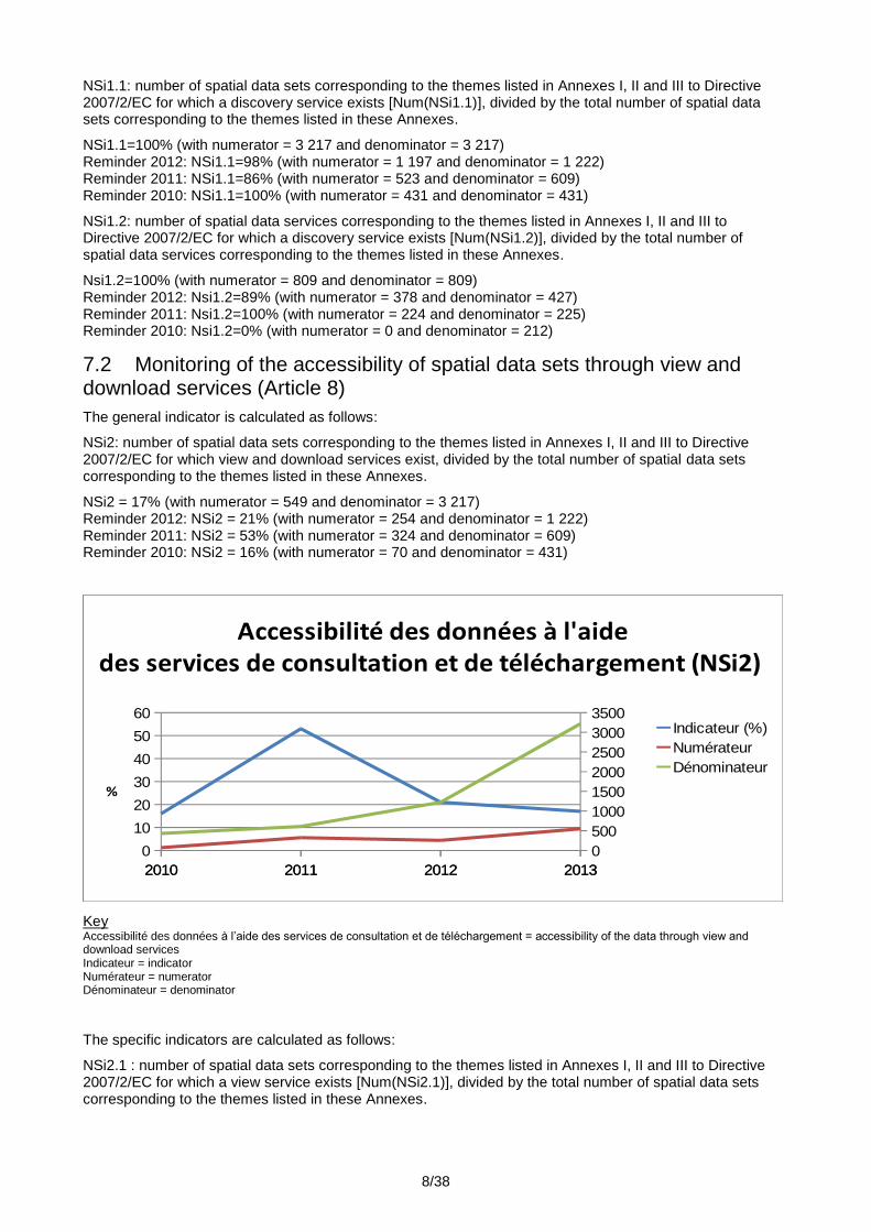
7.2 Monitoring of the accessibility of spatial data sets through view and download services (Article 8)
The general indicator is calculated as follows:
NSi2: number of spatial data sets corresponding to the themes listed in Annexes I, II and III to Directive 2007/2/EC for which view and download services exist, divided by the total number of spatial data sets corresponding to the themes listed in these Annexes.
NSi2 = 17% (with numerator = 549 and denominator = 3 217) Reminder 2012: NSi2 = 21% (with numerator = 254 and denominator = 1 222) Reminder 2011: NSi2 = 53% (with numerator = 324 and denominator = 609) Reminder 2010: NSi2 = 16% (with numerator = 70 and denominator = 431)
2010 2011 2012 20132010 2011 2012 2013
0
10
20
30
40
50
60
0
500
1000
1500
2000
2500
3000
3500
Accessibilité des données à l'aidedes services de consultation et de téléchargement (NSi2)
Indicateur (%)
Numérateur
Dénominateur
%
Key Accessibilité des données à l’aide des services de consultation et de téléchargement = accessibility of the data through view and download services Indicateur = indicator Numérateur = numerator Dénominateur = denominator
The specific indicators are calculated as follows:
NSi2.1 : number of spatial data sets corresponding to the themes listed in Annexes I, II and III to Directive 2007/2/EC for which a view service exists [Num(NSi2.1)], divided by the total number of spatial data sets corresponding to the themes listed in these Annexes.

9/38
NSi2.1= 33% (with numerator = 1 067 and denominator = 3217) Reminder 2012: NSi2.1= 53% (with numerator = 649 and denominator = 1 222) Reminder 2011: NSi2.1= 68% (with numerator = 412 and denominator = 609) Reminder 2010: NSi2.1= 16% (with numerator = 70 and denominator = 431)
NSi2.2: number of spatial data sets corresponding to the themes listed in Annexes I, II and III to Directive 2007/2/EC for which a download service exists [Num(NSi2.2)], divided by the total number of spatial data sets corresponding to the themes listed in these Annexes.
NSi2.2= 18% (with numerator = 572 and denominator = 3 217) Reminder 2012: NSi2.2= 24% (with numerator = 289 and denominator = 1 222) Reminder 2011: NSi2.2= 54% (with numerator = 328 and denominator = 609) Reminder 2010: NSi2.2= 16% (with numerator = 70 and denominator = 431)
7.3 Monitoring the use of network services (Article 9)
The indicators below are used to monitor the network services listed in Article 11(1) of Directive 2007/2/EC:
NSi3: total annual service requests for all network services, divided by the number of network services.
NSi3 = 3 019 286 (with numerator = 2 436 563 460 and denominator = 807) Reminder 2012: NSi3 = 4 025 950 (with numerator = 1 711 028 951 and denominator = 425) Reminder 2011: NSi3 = 6 110 979 (with numerator = 1 356 637 257 and denominator = 222) In 2010, it was not possible to collect overall statistics representing the monitoring of use.
2011 2012 2013
0
500000000
1000000000
1500000000
2000000000
2500000000
3000000000
Taux d'utilisation des services en réseau (NSi3)
Numérateur
Key Taux d’utilisation des services en réseau = rate of use of network services Numérateur = numerator
The specific indicators are calculated as follows:
Nsi3.1: total annual service requests for all discovery services, divided by the number of discovery services;
NSi3.1 = 2 500 816 (with numerator = 7 502 447 and denominator = 3) Reminder 2012: NSi3.1 = 2 578 001 (with numerator = 5 156 002 and denominator = 2) Reminder 2011: NSi3.1 = 1 366 516 (with numerator = 2 733 031 and denominator = 2) Reminder 2010: one discovery service received 9 548 602 service requests.
Nsi3.2 : total annual service requests for all view services, divided by the number of view services;
NSi3.2 = 5 532 375 (with numerator = 2 428 712 595 and denominator = 439) Reminder 2012: NSi3.2 = 5 821 997 (with numerator = 1 705 845 052 and denominator = 293) Reminder 2011: NSi3.2 = 14 242 908 (with numerator = 1 338 833 359 and denominator = 94) Reminder 2010: one view service received 7 353 845 043 service requests.

10/38
Nsi3.3: total annual service requests for all download services, divided by the number of download services;
NSi3.3 = 955 (with numerator = 348 418 and denominator = 365) Reminder 2012: NSi3.3 = 215 (with numerator = 27 897 and denominator = 130) Reminder 2011: NSi3.3 = 119 610 (with numerator = 15 070 867 and denominator = 126)
NSi3.4, which measures the use of transformation services;
No service of this type was registered in 2012.
NSi3.5, which measures the use of invoke services.
No service of this type was registered in 2012.
7.4 Monitoring of the conformity of network services (Article 10)
The general indicator is calculated as follows:
NSi4: number of network services which comply with the implementing rules referred to in Article 16 of Directive 2007/2/EC, divided by the total number of network services.
NSi4: 1% (with numerator = 11 and denominator = 807) Reminder 2012: NSi4: 2% (with numerator = 7 and denominator = 425) Reminder 2011: NSi4: 2% (with numerator = 5 and denominator = 222) Reminder 2010: NSi4: 1% (with numerator = 2 and denominator = 159)
The specific indicators are calculated as follows:
NSi4.1: number of discovery services which comply with the implementing rules referred to in Article 16 of Directive 2007/2/EC [Num(NSi4.1)], divided by the total number of discovery services [Den(NSi4.1)].
NSi4.1=67% (with numerator = 2 and denominator = 3) Reminder 2012: NSi4.1=50% (with numerator = 1 and denominator = 2) Reminder 2011: NSi4.1=50% (with numerator = 1 and denominator = 2) Reminder 2010: NSi4.1=100% (with numerator = 1 and denominator = 1)
NSi4.2: number of view services which comply with the implementing rules referred to in Article 16 of Directive 2007/2/EC [Num(NSi4.2)], divided by the total number of view services.
NSi4.2= 1% (with numerator = 6 and denominator = 439) Reminder 2012: NSi4.2= 2% (with numerator = 6 and denominator = 293) Reminder 2011: NSi4.2= 4% (with numerator = 4 and denominator = 94) Reminder 2010: NSi4.2= 1% (with numerator = 1 and denominator = 158)
NSi4.3: number of download services which comply with the implementing rules referred to in Article 16 of Directive 2007/2/EC [Num(NSi4.3)], divided by the total number of download services.
NSi4.3= 1% (with numerator = 3 and denominator = 365) Reminder 2012: NSi4.3= 0% (with numerator = 0 and denominator = 130) Reminder 2011: NSi4.3= 0% (with numerator = 0 and denominator = 126) Indicator not supplied in 2010.
NSi4.4: number of transformation services which comply with the implementing rules referred to in Article 16 of Directive 2007/2/EC Num(NSi4.4), divided by the total number of transformation services.
No service of this type was registered in 2012.
NSi4.5: number of invoke services which comply with the implementing rules referred to in Article 16 of Directive 2007/2/EC [Num(NSi4.5)], divided by the total number of invoke services.
No service of this type was registered in 2012.

11/38
8. Coordination and quality assurance (Article 12)
8.1 Coordination (Article 12(1))
8.1.1 Member State contact point
Name and contact information
Member State contact point
Name of the public authority Director of Research and Innovation at the Ministry of Sustainable Development
Mailing address Tour Voltaire, 92055 La Défense Cedex, France
Telephone number +33 (0)1 40 81 21 22
E-mail address Point-de-contact-inspire-france.dri.cgdd@developpement-durable.gouv.fr
Website www.developpement-durable.gouv.fr
Contact person Laurent TAPADINHAS
In his absence: Francis MERRIEN, Marc LEOBET
Role and responsibilities
The INSPIRE contact point for France is Mr Laurent TAPADINHAS, Director of Research and Innovation at the Ministry of Sustainable Development. In this capacity, he is permanent secretary to the Conseil national de l'Information géographique, the national coordination structure provided for in Articles 18 and 19(2) of the European INSPIRE Directive
8.1.2 The coordination structure
Coordination structure
Name of the coordination structure Conseil national de l’information géographique
Mailing address Tour Voltaire, 92055 La Défense Cedex, France
E-mail address Point-de-contact-inspire-france.dri.cgdd@developpement-durable.gouv.fr
Telephone number +33 (0)1 40 81 60 62
Website www.cnig.gouv.fr
Chairman Roland Courteau, Senator for Aude
Role and responsibilities
The national coordination structure for the implementation of the provisions of the INSPIRE Directive is the Conseil national de l’Information géographique (CNIG). Established in 1985, it was reorganised by Decree
No 2011-127 of 31 January 2011.5 The CNIG is placed under the Minister for Sustainable Development. Apart from the role of providing the government with clarifications with regard to spatial information, it acts as the national coordination structure provided for in Articles 18 and 19(2) of the European INSPIRE Directive
The CNIG is responsible, in the context of the INSPIRE Directive, for the implementation of the following actions:
consultation and coordination for the precise identification of the data concerned,
5 http://www.legifrance.gouv.fr/affichTexte.do?cidTexte=JORFTEXT000023492390&fastPos=1&fastReqId=1234742862&categorieLien=cid&oldAction=rechTexte

12/38
consultation for the implementation of the measures concerning data-sharing between the public authorities,
coordination and adaptation of the rules for the implementation of the Directive in France,
dissemination of information and exchanges of experience,
organisation of feedback on the implementation of the Directive.
Organisation chart
The CNIG brings together representatives of the Ministries, producer public institutions, regional and local authorities, professionals and staff of spatial information occupations, as detailed below. The CNIG is chaired by a Member of Parliament, Senator Roland Courteau. He has a permanent secretariat provided by the INSPIRE contact point for France. This benefits from the expertise and resources of the Institut national de l’information géographique et forestière (IGN).
The Conseil national de l'information géographique has thirty-five members, with the following breakdown:
1. In the capacity of the State and its public institutions involved in the field of spatial information:
a) Nine members designated by Decree of the Ministers respectively responsible for:
― sustainable development;
― housing;
― the Interior;
― the land registry;
― defence;
― land-use planning;
― agriculture;
― research;
― culture.
b) The Director-General of the Institut national de l'information géographique et forestière (National Institute of Geographical and Forestry Information)
c) The Director-General of the Service hydrographique et océanographique de la marine (French Naval Hydrographic and Oceanographic Service);
d) The Chairman of the Bureau de recherches géologiques et minières (Geological and Mining Research Office);
e) The Chairman of the Centre national d'études spatiales (French Space Agency);
f) The Chairman and CEO of the Institut français de recherche pour l'exploitation de la mer (French Institute for Exploitation of the Sea);
g) The Commissioner-General for sustainable development.
2. In the capacity of regional and local authorities and public establishments for cooperation between local authorities:
― the President of the Association of French Mayors;
― the President of the Assembly of French Departments;
― the President of the Association of the Regions of France;
― the President of the Association of Urban Communities of France;
― the President of the Association of the Mayors of the Large Cities of France;
― the President of the Federation of Mayors of Medium-sized Cities;
― the President of the Association of Small Towns of France;
― the President of the National Association of elected representatives of the coastal regions.
3. In the capacity of businesses and regulated professions:

13/38
― three representatives of businesses producing spatial information, using it or providing spatial information services;
― the President of the College of Chartered Surveyors.
4. In the capacity of associations:
― the President of the Association française pour l'information géographique (French Association for Geographical Information) ;
― the President of the Fédération nationale des agences d'urbanisme (National Federation of town planning agencies);
― the President of the Association des ingénieurs territoriaux de France (Association of French territorial engineers);
― a representative of an environmental protection association;
― a representative of a consumer association.
5. In the capacity of the employees, two representatives of the trade union organisations of representative employees at national level.
6. A qualified prominent person chosen on account of his competence.
The President of the CNIG is appointed by decree of the Minister for Sustainable Development for a five-year term of office. The Commissioner-General for Sustainable Development acts as Vice-President.
Relationship with third parties
On account of the broad representation of the thirty-five members of the CNIG, contacts are possible with all the parties concerned. Moreover, the committees and working groups set up by the CNIG are open to any stakeholder and especially the legally mandated interest groups and organisations registered with the European Commission.
Functioning
The Council meets in plenary session at least twice a year. The Council is convened by its Chairman. The Chairman establishes the agenda on the proposal of the permanent secretariat.
Any member of the Council may ask the Chairman to enter one or more items on the agenda at least eight days prior to the meeting.
The CNIG set up or renewed the mandate of the following six committees or working groups in 2012:
The ‘Data’ Committee, responsible for the precise identification of the data concerned by the INSPIRE Directive.
The ‘Implementing Rules’ Committee, responsible for ensuring the consultation necessary for the preparation of opinions by France on the draft European regulations and on the adaptation of the corresponding rules at national level. It takes over from the Liaison Group described below.
The ‘Territorial Coordination’ Committee, responsible for organising the taking stock of needs, the dissemination of information and exchanges of experience, especially with RSDIs.
The ‘National Place Names’ Committee, responsible for contributing to the conservation and consistent development of the heritage of geographical names in France.
The ‘Europe and International’ Working Group, responsible for ensuring consultation between the stakeholders with a view to bolstering adaptation to globalisation and the French presence on the European and international markets.
The ‘GeoPos’ Committee, responsible for deepening, pooling and disseminating knowledge of spatial positioning techniques on land, at se, underground, undersea, in the air or in space.
The Council has a website (www.cnig.gouv.fr), which is to be redesigned.
Review of the working procedure 2010-2012
The Liaison Group, which comes under the Conseil national de l'information géographique, brings together since 2005 the interest groups and legally mandated bodies representing the French stakeholders. It was consulted at the time of the preparation of the French positions for the INSPIRE regulatory committee as shown in the diagram below.

14/38
Key Processus pour le vote au Comité INSPIRE = Voting process at the INSPIRE Committee Proposition soumise au vote = Proposal submitted to the vote Avis du Comité (Etats membres) = Committee opinion (Member States) Conseil européen pour accord = European Council for agreement Parlement européen pour accord = European Parliament for agreement Journal Officiel = Official Journal Premier Ministre = Prime Minister Proposition de position française = Proposal for a French position SGAE = General Secretariat for European Affairs Ministères = Ministries Point de contact = contact point Représentants de la France au Comité = Representatives of France on the Committee Avis = opinion Parties prenantes = stakeholders
The Liaison Group met about four times a year. It held extraordinary meetings concerning the draft Regulation for Annexes II & III, on 13 and 14 January 2011. It also organised ten seminars covering eleven themes from July to November 2011, and in this way was able to contribute to a paper by the French authorities dated 28 November 2011 concerning the European Commission draft regulation.6
Moreover, the OGC France Forum, which brings together the French members of the Open Geospatial Consortium, was consulted regularly on the draft regulations concerning spatial data services. It was able to provide clarification for the contact point on certain IT subjects, such as the use of registers in a SDI.
Finally, in October 2011 and March 2012, the CNIG secretariat took over the task of relaying comments of stakeholders not registered as SDIC or LMO but nevertheless wishing to participate.
Through this procedure, the French authorities were able to provide a significant share of the comments relating to the European Commission drafts.
The CNIG Metadata Working Group
In November 2010, the CNIG set up a working group on metadata. This group consists of interested members of the Liaison Group and more generally of the representatives of groups and organisations with an interest in taking action in the field of metadata.
This group of twenty-eight members met seven times and in December 2011 produced the first version of the ‘Guide de saisie des éléments de métadonnées INSPIRE’7 (Guide to INSPIRE metadata element entry). An update is planned in June 2013.
6 http://inspire.ign.fr/france/donnees
7 http://inspire.ign.fr/sites/all/modules/pubdlcnt/pubdlcnt.php?file=/sites/all/files/guide-saisie-metadonnees-inspire_prj12_1.pdf&nid=241

15/38
It then met in different formats, depending on the skills required to deal with the subjects. It met five times during the first half of 2011 and in August 2011 produced the ‘Guide de gestion des catalogues de métadonnées INSPIRE’8 (INSPIRE metadata catalogue management guide). Then, after three meetings in the second half of the year, it published the ‘Guide de saisie des métadonnées de service INSPIRE’9 (INSPIRE service metadata entry guide) in December 2012.
Each of these guides was the subject of an invitation for the public to comment via the Internet.
8.1.3 Local coordination structures
Although the French State wished to establish a national coordination structure thanks to the CNIG, it nevertheless decided to liaise with the regional structures which already existed in the form of ‘regional spatial data infrastructures’ (RSDI), leaving the creation of other regional, departmental or local structures to the initiative of stakeholders wishing to take such initiatives. In this way several new RSDIs were created or are in the process of being created. These structures have pooled resources to guide the local stakeholders and to play a role in promoting better dissemination and use of the spatial information. They also provide better coordination of the stakeholders and users and the implementation of the provisions of the INSPIRE Directive. They meet regularly within the AFIGéO; they have, for example, published a guide on the implementation of INSPIRE at regional and local level and presented their work at the INSPIRE Conference held in Istanbul in 2012.
In fact, from 2008, the stakeholders and the French State have identified the regional level as the key level for the success of the implementation of INSPIRE. In 2011 and 2012, two surveys,10 conducted by the IGN, took stock of this implementation at regional level. They allow the deployment of the local coordination structures to be monitored. Moreover, the AFIGéO drew up a catalogue at the end of 2012 describing 44 sub-national SDIs, published on the occasion of the 7th regional dynamics in spatial information meetings on 4 and 5 April 2013 in Bordeaux. These meetings also took place in 2012 in Clermont-Ferrand and in 2010 in Orleans.
To sum up, in 2012, of the 27 administrative regions of France:
17 regions have a coordination structure, i.e. there is a group of partners who pool technical and human resources to share spatial information and to develop the potential of a geographical area;
3 regions have two coordination structures, one grouping together the government departments and the other the regional and local authorities;
6 regions are working on establishing coordination of the public authorities;
only 1 region has not taken any steps towards coordination so far.
8 http://inspire.ign.fr/sites/all/modules/pubdlcnt/pubdlcnt.php?file=/sites/all/files/2012-08-20_guide-catalogues-md-inspire-v1.0.pdf&nid=241
9 http://inspire.ign.fr/sites/all/modules/pubdlcnt/pubdlcnt.php?file=/sites/all/files/guide_saisie_elements_metadonnees_inspire_services_1-0.pdf&nid=241
10 2011 survey: http://inspire.ign.fr/actualit%C3%A9s/r%C3%A9sultats-de-lenqu%C3%AAte-nationale

16/38
Key Cartographie des structures de coordination en région = Map of the regional coordination structures D’après l’enquête nationale INSPIRE 2012 – Source IGN = according to the national INSPIRE survey 2012 – Source IGN Une région, une coordination = One region, one coordination structure Coordination régionale à l’étude = Regional coordination under examination Une région, deux coordinations = One region, two coordination structures Absence de coordination régionale = No regional coordination
8.1.4 Comments on the monitoring and reporting process
Since 2010, the national contact point has organised the monitoring and reporting, relying on the two operators that implement the national infrastructure: the BRGM (Bureau de Recherches Géologiques et Minières, Geological and Mining Research Office) and the IGN (Institut Géographique Nationale, National
Institute of Geographical and Forestry Information). The process is described in a procedure.11
Annual monitoring indicators
The contact point has defined a monitoring process based on the automatic collection of information for the indicators.
The automatic collection has been introduced gradually since 2009. In 2012, all the indicators, except that relating to the use of network services, are calculated automatically from the Géocatalogue.
Three-yearly reporting
11 http://inspire.ign.fr/france/suivi-et-rapportage
17/38
The components of the three-yearly report are prepared by the IGN for the contact point. This report is presented to the CNIG for opinion.
8.2 Quality assurance (Article 12(2))
The two Ministries most concerned by the implementation of the Directive, namely the Ministry of Ecology and the Ministry of Agriculture, set up the COmmission de VAlidation des Données pour l’Information Spatialisée (COVADIS, Data Validation Committee for Spatial Information) in 2008. This is an interministerial structure the purpose of which is to establish standards and to bring existing standards into line with the Directive. This structure helps to improve quality assurance for the infrastructure by developing provisions supplementing those of the Directive.
These standards are used by the departments of the two Ministries.
COVADIS is open to the regional and local authorities. It thus adopted the standard relating to the regional expansion of digital services initiated by the region of Aquitaine. Certain standards, such as that relating to town planning documents, are drawn up in close cooperation with a CNIG working group including the regional and local authorities.
Furthermore, the BRGM and the IGN, which are responsible for managing the Géocatalogue and the Géoportail respectively, are involved in quality assurance measures, as detailed below.
The BRGM12
is certified according to the international standard ISO 9001 (version 2008), awarded by AFAQ AFNOR Certification in 2004 and renewed in December 2010 for the activities: ‘Research, advice and expertise in the fields of geology, water, geothermal science, metrology, natural risks, mineral resources, post-mining, waste and contaminated land, digital information systems and CO2 storage’.
All the establishment’s activities in France and abroad, as well as its 33 decentralised entities are covered.
The IGN13 is fully ISO 9001-certified, with the exception of the Ecole nationale des sciences géographiques (ENSG, National School of Geographic Sciences) and research activities (undertaken under enhancement procedures specific to their field of activity, involving the Commission du titre d’ingénieur (Commission on the engineering diploma) and the Agence d'évaluation de la recherche et de l'enseignement supérieur (Agency for the evaluation of research and higher education) respectively).
Since the first certification obtained in 2007 for the activities of metrology of the geodesy and surveying service, the scope of the certification of the IGN has increased every year until obtaining the certificate in 2011 covering the ‘design, production, archiving, dissemination and marketing of databases and geographical and cartographical products and associated services and expertise’.
However, the work conducted at European level since 2010, and especially the workshop dedicated to quality which was held during the 2012 INSPIRE Conference, show major difficulties in the application of the quality assurance procedures to open infrastructures such as those introduced by the INSPIRE Directive.
The quality of the data in the various INSPIRE specifications documents is strictly based on certain criteria of standard ISO 19157. This standard is perfectly well-adapted to describing the quality of a spatial database which is first based on precise specifications, as practised by major national producers. On the other hand, these normative tools are intended for experts who are not usually to be found in the services of the various occupational sectors which will have to distribute their data. The MEDDE, together with the AFIGEO, conducted a survey of the RSDIs on the subject. The result was that the standard is little known and unused, as it is too costly in human and financial resources.
The analysis by the French authorities is that it is appropriate to consider the relevance of the criteria of standard ISO 19157 to be able to qualify the data, without precluding the implementation of the measures intended to inform and train the producers and users concerning these quality criteria that even professionals have difficulties in mastering. For instance, it is not always possible to measure correctly the criterion of exhaustiveness, which is nevertheless the criterion which is the most prominent in the INSPIRE technical guides.
An alternative would be to propose other methods which are simpler, less onerous and easier to implement by users. Furthermore, these methods would find a scope of application in open data. This should be one of the objectives of the work to be carried out at European level in the forthcoming period.
12 http://www.brgm.fr/brgm//includes/qui_sommes_nous/qualite.shtml
13 http://www.ign.fr/institut/institut/la-demarche-damelioration-de-lign

18/38
9. Contribution to the functioning and coordination of the infrastructure (Article 13)
9.1 Contribution to the functioning and coordination of the infrastructure (Article 13(a))
Four stakeholders contributing to the functioning and coordination of the infrastructure were identified, according to the following typology:
Users,
Data producers,
Service providers,
Coordinating bodies.
The users of the infrastructure are the following: the public authorities (the State, its decentralised departments, regional and local authorities, public institutions), societies and associations whether or not entrusted with a public service mission, chambers of commerce and industry, non-profit-making bodies, research and educational establishments. More specifically, mention can be made of spatial information professionals: geomatics specialists, consultancy firms, data administrators, architects, surveyors, general public, teaching professionals, students, etc.
The producers of data available in the infrastructure are the following: government departments, regional and local authorities, various public spatial information producers, public environmental institutions, private operators entrusted with a public service mission, such as surveyors, certain non-profit-making associations and bodies, chambers of commerce and industry and research laboratories.
The service providers of the infrastructure are the following: companies providing IT services, hosting companies, private spatial information producers, various service providers, applications maintenance companies, companies responsible for assistance to the contracting authority, providers of legal advice, consultancy services, communication and training of users, companies responsible for reference data administration, companies responsible for facilitation and communication to partners, etc.
The coordinating bodies of the infrastructure are the following: the CNIG, the RSDIs, the CRIGES national network (Commissions Régionales à l'Information Géographique, regional spatial information committees) organised by the AFIGEO,
The stakeholders described above play an active role in the functioning and coordination of the infrastructure in three essential ways:
by implementing professional networks and business lines using the spatial information,
by activating any institutional group or association within steering committees, coordination committees or working groups contributing to bring together the actions,
by establishing partnership framework agreements between government departments, the regional and local authorities and private sector bodies.
9.2 Description of the role of the various stakeholders in the development and maintenance of the infrastructure (Article 13(b))
The coordination of tasks has taken place essentially through the pooling of the human and financial resources of the members of the RSDIs, in association with the professionals of the business lines. Frequent meetings have been held between the administrators and the scope of the data managed by each regional producer has been defined. The data producer partners guide the coordination within committees through active participation in the occupation working parties and in co-facilitation of specific workshops.
Coordination of the tasks has been facilitated too by the establishment of technical advisors at all levels of the RSDIs. In this way, the member services users are represented on the various committees. The mandates and actions of each of the persons involved are decided there. This has led to distinct progress in the pooling of investments despite the large number of public authorities.
As regards the provision of data and metadata, the users contribute via the cataloguing tool: if they are able to do so, the data producers host their own data and draw up their own metadata sheets. If not, the RSDI can undertake this, according to the principle of subsidiarity. Measures for training and information concerning the use of the data catalogue have been launched among the many RSDIs and at national level. With regard to communication, the users participate in expressing their priority needs (data sharing and

19/38
dissemination) within working groups and committees, and more specifically on discovery in the catalogue, viewing and downloading of data, provision of a cataloguing service, harvesting INSPIRE-compatible data, acceptance, quality, integration, dissemination and monitoring of the use of data,
The RSDIs often organise inter-service workshops (metadata import, record entry, data import in the regional tool, making available the cataloguing tool and training for each producer, definition of the scope of the data).
The development and hosting of services are also undertaken according to the principle of subsidiarity; in this way the data producers are project partners and the RSDI takes care of the configuration, development and hosting, if the data producer is unable to do so.
The introduction of data stream services facilitates access to the data for the entire user group. However, this procedure is still exceptional on account of the lack of resources and the complexity of implementation of the services. For instance, the CRIGE PACA establishes both a process for data-sharing by stream (OGC), used by the largest authorities, such as the Nice-Côte-d'Azur Agglomeration, whilst ensuring the data integration of the smaller authorities, such as the Lubéron-Durance-Verdon association of local authorities, by more traditional methods (FTP).
Depending on the case, the providers are responsible for hosting the servers, taking care of updates, design, certain IT developments, the establishment and maintenance of tools, drawing up the specifications for hosting and development of services, preparing use manuals and tutorials, monitoring and acceptance of developments.
In view of the skills shortage, the State (through the MEDDE) has adopted a policy of creation and dissemination of an entire family of open source tools, free of charge, which permit the implementation of the Directive. As regards metadata, it uses Géosource, the French version of Geonetwork, with peripheral tools which are easier to use (for example, a Microsoft Excel spreadsheet). It created the possibility to open up an account ‘MonGéosource’ free of charge, in order to avoid the serious complication of installing a Géosource server.
As regards cataloguing, view and download services, it edits Prodige,14 a collaborative, open platform. Prodige is a software package under open source licence, free of charge and ready for use immediately, which permits rapid creation of regional, departmental or local platforms for the dissemination of spatial information on the Internet and sharing between public authorities.
The IGN makes the API of the Géoportail available to the public, which enables the IGN resources to be posted on a third-party site, free of charge, up to a certain use threshold. In this way, a public authority can implement the Directive without heavy investment in IT development.
To illustrate this, the French authorities wished to report on the testimony of an overseas RSDI, Géoguyane.
In fact, the development of spatial information in Guyana is a major cause for concern for public operators in this French and European Department of America. Guyana is a vast, rapidly developing region where the preservation of biodiversity and access to natural resources are major challenges.
To meet these optimally, the government departments must have information at their disposal which is as reliable as possible and up to date. Following a first initiative by the Departmental Directorates for Equipment and Agriculture and the Urban Planning Agency in the 1990s, there were a large number of data and producers, but the initial dynamism could not be maintained.
On implementing the INSPIRE Directive, the directorate for equipment, which had since become the Directorate for the Environment, Town and Country Planning and Housing (DEAL) and the Urban Planning Agency wished to renew the government services partnership on the basis of a simple tool which is easy to use at low cost.
At the end of 2009, when the principles linked to the INSPIRE Directive had not yet become widely known overseas, the PRODIGE Guyana project was launched to meet this local concern of sharing between public authorities. Since then, notably with the participation of the former regional Directorate for the Environment, the project objectives have been extended to cover the dissemination of public data.
14 http://adullact.net/projects/prodige/
20/38
The project is now part of a true partnership approach, with a stable operating framework. The practices have been formalised and are based on the PRODIGE tool. The application is promoted by the MEDDE, which guarantees development compatible with the services required by the Directive. Some twenty vary varied partners have signed up: armed forces, regional health agency, National Forestry Office, etc.
Although the contributions are still modest, good practices seem to have been adopted. The new data created are disseminated only by the RSDI, which ensures true economy of resources, and certain services have started to open their data to the public. The RSDI is now visible to the outside world, with its own domain name, Géoguyane.
The INSPIRE Directive has in this way given a formal framework to the initiatives of technicians and departmental heads in Guyana, who were convinced of the need to open up the data. The PRODIGE tool has enabled this to be implemented online, at low cost, in a region where the new information and communications technologies do not always benefit from optimum connections.
9.3 General description of the main measures taken to facilitate sharing (Article 13(c))
The data-sharing arrangements which are covered by the scope of the INSPIRE Directive were included in the legislative and regulatory framework established at the time of the transposition of Directive 2003/98/EC of the European Parliament and of the Council of 17 November 2003 on the reuse of public sector information (PSI). Chapter VII of the Environmental Code therefore refers to Law No 78-753 of 17 July 1978, as amended,15 establishing various measures to improve relations between the administration and the public and various administrative, social and tax provisions.
In 2011, the French State developed the regulatory framework relating to the reuse of public information: this development concerns a far more extensive field than that of the INSPIRE Directive since it applies to public information as a whole, but concerns only the services of the State and administrative public institutions. Provision free of charge becomes the norm and the payment of a charge the exception.
In fact, Decree No 2011-577 of 26 May 201116 on the reuse of public information held by the State and its public administrative institutions provides that from 1 July 2011, the information or categories of information for which reuse may be subject to payment of a charge for reuse, within the meaning of Chapter II of Title I of Law No 78-753 of 17 July 1978, must appear on a list established by decree, after opinion of the conseil d’orientation de l'édition publique et de l'information administrative (advisory council for public editing and administrative information),17 which is answerable to the Prime Minister. The decision to make a database or a set of public information subject to a charge is taken in the light of duly reasoned factors (Article 38 of the same Law).
The charges introduced before the entry into force of the Decree, i.e. before 1 July 2011, by the administrations of the State and its public administrative institutions could be maintained on condition that they were declared in a second list before 1 July 2012. This list is public and accessible via the Internet.18
The circular of 26 May 201119 relating to the creation of the single portal for State public information ‘data.gouv.fr’ by the ‘Etalab’ mission and the application of the provisions governing the right of reuse of public information, signed by the Prime Minister, describing the terms of application for the sharing of public data, was a major political signal, with significant consequences on spatial data-sharing at the highest level of the ministerial departments and their operators.
15 http://www.legifrance.gouv.fr/affichTexte.do?cidTexte=JORFTEXT000000339241
16 http://www.legifrance.gouv.fr/affichTexte.do;jsessionid=B94B85E58E535DE19145C1D6A717B785.tpdjo16v_2?cidTexte=LEGITEXT000024073976&dateTexte=20120619
17 http://www.legifrance.gouv.fr/affichTexte.do;jsessionid=9C459E80D030338B318688E5E7385CC9.tpdjo16v_2&dateTexte=?cidTexte=JORFTEXT000021658517&categorieLien=cid
18 http://www.data.gouv.fr/Redevances
19 http://www.legifrance.gouv.fr/affichTexte.do?cidTexte=JORFTEXT000024072788
21/38
9.4 Description of the access to the services through the INSPIRE geoportal (Article 13(e))
The public authorities have no knowledge of access to the services through the European portal.
10. Use of the infrastructure for spatial information (Article 14)
10.1 The French service network
The infrastructure for spatial information is a set of spatial data services available on the Internet, distributed over the sites of the various actors concerned, and enabling the dissemination and sharing of spatial data. In France, it relies on national services, thematic services and territorial, notably regional services.
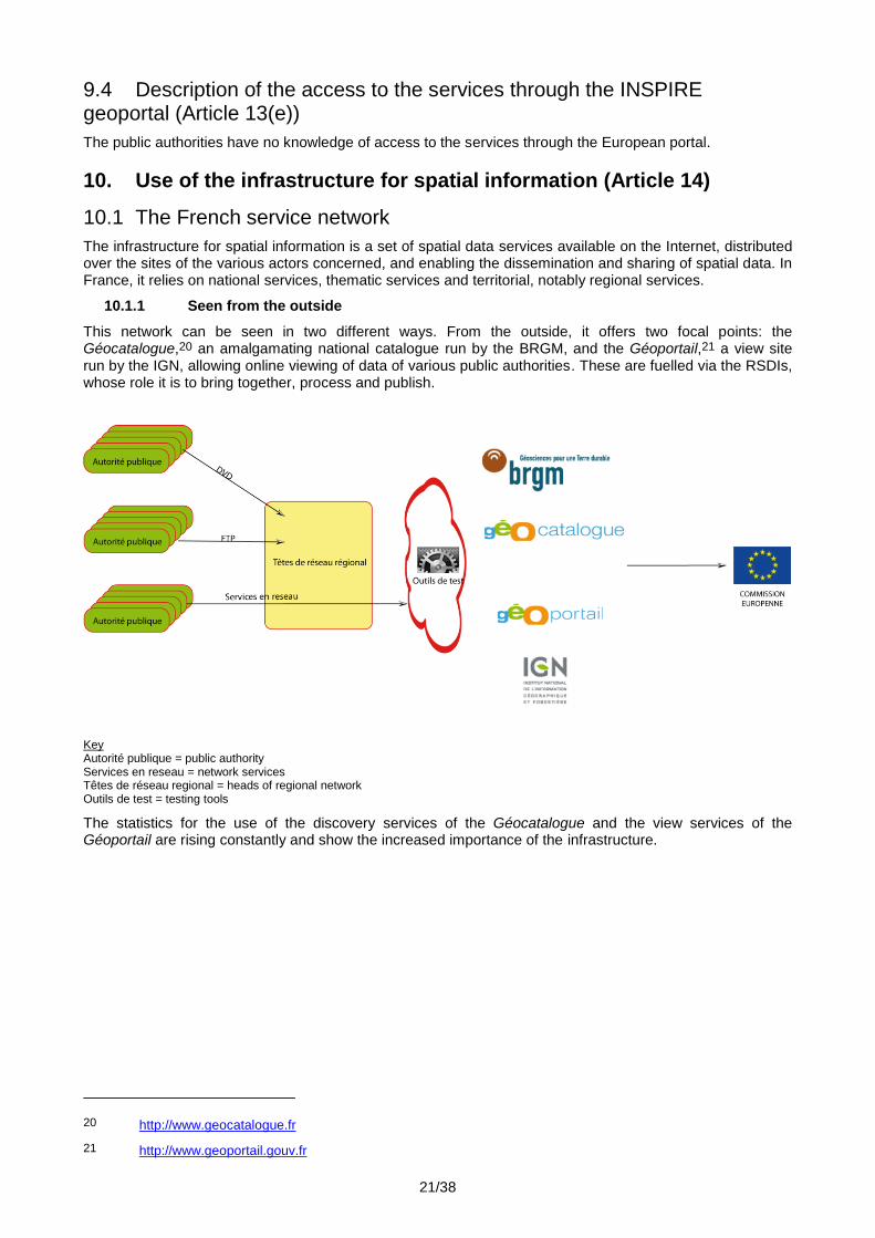
10.1.1 Seen from the outside
This network can be seen in two different ways. From the outside, it offers two focal points: the Géocatalogue,20 an amalgamating national catalogue run by the BRGM, and the Géoportail,21 a view site run by the IGN, allowing online viewing of data of various public authorities. These are fuelled via the RSDIs, whose role it is to bring together, process and publish.
Key Autorité publique = public authority Services en reseau = network services Têtes de réseau regional = heads of regional network Outils de test = testing tools
The statistics for the use of the discovery services of the Géocatalogue and the view services of the Géoportail are rising constantly and show the increased importance of the infrastructure.
20 http://www.geocatalogue.fr
21 http://www.geoportail.gouv.fr

22/38
Year
Rate of use of the discovery service of the Géocatalogue
(number of requests)
Rate of use of the view service of the Géoportail
(number of requests)
2010 2 697 997 1 224 913 316
2011 5 137 608 1 626 740 395
2012 7 211 970 2 384 117 604
Rate of use of the national services (taken from the annual reports 2010-2011-2012)
The increase in the use of the Géocatalogue is attributable to the enrichment of the catalogue. In 2012, the Géocatalogue was able to harvest more local or thematic unifying catalogues, which is reflected in a significant increase in the number of metadata in the national catalogue.
Likewise, the increase in Géoportail viewing derives from the regular enrichment of the available data. In this
way, at the end of 2012, the Géoportail permits the viewing of more than 90 types of information,22 from the IGN or other public authorities (for example: the protected sites of the National Natural History Museum).
The Géoportail programming interface (API23) allows the use of IGN data view services on various websites and in various applications, such as, for example, the GéoFoncier portal24 (one-stop-shop for spatial land-
use information, open since the end of 2010), the networks and pipelines portal25 run by INERIS (teleservice cartographic tool enabling network operators to be contacted before works, opened in 2012).
Since July 2012, version 3 of the Géoportail has enabled the performances and interoperability of the French infrastructure to be improved. For example, the town-planning documents of the Department of Hautes-Pyrénées (65) are accessible by co-viewing. A large number of data sets discovered in the Géocatalogue can also be co-viewed.
Local town-planning maps published by the Territorial Directorate of the Hautes-Pyrénées and viewed on the Géoportail
22 http://www.geoportail.gouv.fr/donnees
23 http://api.ign.fr
24 http://www.geofoncier.fr
25 http://www.reseaux-et-canalisations.ineris.fr

23/38
10.1.2 Seen from the inside
From the point of view of a French operator, the service network is decentralised and polycentric.
Key Fonds géographiques de reference = geographical reference resources Géologie = geology Autres fonds = other resources Plateformes de mutualisation = pooling platforms Catalogue regional = regional catalogue Référencier/Rechercher = reference/discovery Catalogues de producteurs territoriaux = catalogues of regional and local producers Catalogue de l’Etat départemental = departmental State catalogue Conseil Régional = regional council Commune = municipality Autres = other SIG littoral = shoreline GIS Thématiques transverses =cross-cutting themes
This means that each public authority has the metadata of its data and services at its disposal or has them harvested in the closest unifying catalogue on the institutional, geographic or thematic levels. Then the management of the harvesting between unifying catalogues allows the fuelling of the more distant catalogues, until the national Géocatalogue. This management is supported by the recommendations contained in a Conseil national de l'information géographique guide.
11. Analysis of the general and specific indicators
Overall, there has been considerable progress in the conformity of the metadata, especially for the services with a low level of conformity in 2011. It can also be noted that the obligations relating to the metadata of Annex III are established at the end of 2013 and that a certain number of operators have not yet undertaken all the updates.
However, for a large number of operators, the classification of a data set in a theme listed in Annexes II or III was quite a delicate matter. A thesaurus is currently being finalised to link the data sets produced by the services of the MEDDE, METL and MAAF to the themes listed in these Annexes.
Finally, Regulation No 2015/2008 of 3 December 2008 authorises the linking of a data set to several INSPIRE themes. In order to avoid misrepresentation of the indicators by counting a large number of data sets several times, the French authorities have decided to adopt only one.

24/38
It is therefore probable that certain allocations to a theme of the Directive will change in the coming years, with an impact on the specific indicators.
Between 2012 and 2013, indicator Nsi2 fell from 21% to 17%, masking an increase of 116% (254 to 549) in the data accessible through a view and download service.
Moreover:
the number of data sets accessible through view services only rose from 649 to 1 067 (indicator NSi2.1 fell from 53% to 33%);
the number of data set accessible through download services only rose from 289 to 572 (indicator NSi2.2 fell from 24% to 18%).
Despite a clear increase in the data accessible and the quadrupling of the downloadable data sets, the fall in these indicators can be explained by a greater increase in the total number of data (the denominator increased more than the numerator). It reflects a difficulty in the implementation of the network services.
It can be specified that data are considered to be accessible through a service where their metadata are linked to service metadata (view and/or download in the case of these indicators) via the ‘coupled resource’ field. This indicator is therefore undervalued in relation to the real number of data sets accessible directly from the sites of the producers or of data.gouv.fr. It depends on the proper entry of the services metadata. In practice, difficulties in comprehending the regulatory requirements and substantial variability in implementation, even though in conformity with the rules, are to be found. The insufficient maturity of the service chaining techniques in an infrastructure open to hundreds of public authorities is a serious complicating factor in its assessment.
In general, the European regulations and their technical guides, drawn up by experts, are incomprehensible for those who have to implement them. It is regrettable that the Commission does not have educational documents published facilitating their comprehension, which leaves each Member State the responsibility to do so. For the implementation of the Regulation concerning metadata, the French INSPIRE contact point therefore asked a working group of the CNIG to draw up three guides, concerning data and services metadata and catalogues respectively. This group called on the services of some twenty experts for over a year.
For the calculation of indicator NSi3, which corresponds to an average per service, the fall is attributable to the increase in total number of services, whereas the total number of hits is rising. This indicator provides only a partial reflection of the use of the French services network as, despite an online tool made available to them, few public authorities have supplied their hit statistics.
Beyond this difficulty, the structural trend in the indicator appears to be falling. In fact, services of medium-sized public authorities are now being added to the historical large-scale national services, namely those of the Géoportail, MEDDE, METL, MAAF, BRGM and the Water Information System. It is likely that the new services will have fewer hits.
Moreover, the indicator Nsi4 on the conformity of the services is evaluated according to the information provided in the corresponding metadata (field ‘conformity’). However, this information is not always entered correctly by the producers or even evaluated.
The low rate of conformity is also largely attributable to the fact that the majority of the software does not allow this bringing into conformity (for example, Mapserver, which is very popular in France, does not allow the addition of the compulsory elements ‘inspire_vs:ExtendedCapabilities’ in the getCapabilities). It seems desirable that the Commission should take action in relation to the open source editors and groups.
11.1 Use of spatial data sets and services in the infrastructure for spatial information
11.1.1 At national level
The practices, organisations and services introduced for the INSPIRE Directive are reused for the implementation of other directives, such as the Marine Strategy Framework Directive or the Directives on protection of biodiversity.
The Water Information System
First feedback is possible on the impact of the INSPIRE Directive on the Water Information System (SIE), on which the reporting for the Water Framework Directive (WFD) in particular is based. The SIE is the longest standing and the most advanced of the French environmental information systems. Launched in the 1990s, it focused in the 2000s on procedures for sharing and computer system and semantic interoperability which

25/38
would later be found in the INSPIRE Directive. It is under the technical direction of the Office national de l'eau et des milieux aquatiques (ONEMA, National Office for Water and Aquatic Environments).26
The implementation of this Directive provided the opportunity for a certain amount of bringing back into perspective, which is welcome but low-scale. The benefits are therefore considered to be low. On the other hand, the costs associated with the change in structuring of the data seem to be a little higher, since the SIE has for a long time defined at national level the modelling standardised by the Sandre (Service d’Administration Nationale des Données et Référentiels sur l’Eau, National Service for Water Data and Common Repositories Management). This means that the semantic interoperability is considerably better by exchanging the data according to the Sandre models, rather than through the INSPIRE infrastructure. The latter offers only a minimum basis for exchange, including for the theme ‘Hydrography’.
Cross-border exchanges nevertheless have undergone certain improvements thanks to the establishment of metadata and streams, but, here too, with data which are less rich than the Water Information System for Europe (WISE) allows.
In the end, the SIE is a good illustration of the complementarity between INSPIRE and the thematic directives. Through the establishment of a general framework for sharing, describing data by structured metadata and stream logic, INSPIRE creates a general framework for spatial data exchange infrastructure. However, only the thematic groups are able to define the useful objects and the data dictionaries allowing exchanges to be fully effective and the benefit of INSPIRE for the groups which are already largely organised may be low.
The first conclusion drawn by the French authorities from this is that the contribution of the IT aspects has been overestimated to the detriment of the organisational aspects. The second is that once an information system has been established, the benefits from technical developments are low compared to the costs which are less so. The most profitable contribution of interoperability should be supported by thematic directives.
Moreover, a study27 conducted in the context of measuring the impact of the INSPIRE Directive on the SIE points out that: ‘The governance of the lists proposed by INSPIRE clearly possess an implementation problem’. This comment can be generalised to the majority of the themes listed in the Annexes. General, and particularly semantic, interoperability of the data sets of Annexes II and III will therefore by confined to the most environmental themes, on which the communities have already invested a great deal in response to the existing directives.
Sextant – Marine geo-referenced data server28
Operated by the Institut français de recherche pour l'exploitation de la mer (Ifremer, French Institute for Exploitation of the Sea), Sextant has the objective of collecting and making available a catalogue and geo-referenced data concerning the marine sector. Accessible via the Internet, open access or, for certain specific data, limited, it groups together the vector and chained data produced by Ifremer and its partners.
The original objective was to respond to Ifremer’s internal needs to pool spatial information. This referred to:
providing support for the activities;
ensuring the sustainability and valorisation of the data supplied to Ifremer on a common server;
collecting, perpetuating and making available all the data;
pooling the costs, development and data;
maintaining consistency with the institutional partners.
It was rapidly opened to external partners. There was strong demand regarding projects involving several bodies, which gave rise to the establishment of agreements (especially for certain data subject to distribution restrictions or not covered by the INSPIRE Directive) and decentralised administration.
It now provides support for a large number of themes: environment (water quality by monitoring networks, marine habitats, etc.), aquaculture, fisheries (fishing fleet activities, resources, economic aspects, etc.), geosciences (bathymetry, morpho-sedimentary maps, ocean physics and hydrodynamics, etc.). It also provides access to photos and historical maps.
26 http://www.onema.fr/
27 Analyse des bases de données existantes du Système d’Information sur l’Eau français au regard des obligations de la directive européenne INSPIRE (Analysis of the existing databases of the French Water Information System in the light of the obligations of the European INSPIRE Directive): http://silat.teledetection.fr/component/docman/doc_download/145-rapport-jean-daniel-cesaro
28 http://www.ifremer.fr/sextant/

26/38
Sextant offers a specific profile as it is structured in thematic catalogues (over 70 catalogues), which group together data of interest to several types of actors: a coastal laboratory or an Ifremer department, an individual body (Ifremer, Marine Protected Areas Agency, French Naval Hydrographic and Oceanographic Service, universities, etc.), a specific project (marine aggregates, planning of marine energy, a few European projects, etc.) or a geographical area (Indian Ocean, etc.).
All the data collected and their metadata are perpetuated by means of a database management system. They are also valorised by means of tools enabling their discovery, viewing of their metadata, display and download.
Sextant in this way illustrates the valorisation of an infrastructure for spatial information. On the basis of an organisational and technical response to an internal need, it was possible to establish a thematic infrastructure at low cost. Facilitating the sharing of information between partners promotes understanding of marine environments. The French authorities consider that the use of the European infrastructure for spatial information will be of great use to the implementation of the Marine Environment Strategy Framework Directive.
The information system on nature and landscapes (SINP)29
The information system on nature and landscapes (SINP) comes under the priority ‘To develop, share and tap knowledge’ of the national biodiversity strategy (SNB) adopted in May 2011 for the period 2011-2020 and in particular corresponds to objective No 18 ‘To develop research, organise and perpetuate production, analysis, sharing and dissemination of knowledge’.
It constitutes the ‘nature, biodiversity and landscape’ aspect of the overall information system relating to the environment designed to ensure coherence between the various public policies of the Minister for Sustainable Development (nature, water, risks, pollution). Thus, the SINP, the Water Information System and the GBIF (Global Biodiversity Information Facility) are implemented in coordination to avoid duplicate requests to data providers.
The objective of the SINP is to facilitate the linkage of naturalist information whilst offering a methodological reference framework. It is designed as a collaborative mechanism for pooling resources, tools, methods and data. Its rules are collaborative work and interoperability. It is also a platform for promotion of the data producers belonging to it.
In fact, these producers have the particularity of not always being public authorities, since they include a large number of associations. Since their data are not public by law, they are outside the scope of the INSPIRE Directive, although they are valuable for environmental assessment. One of the modes of action therefore consisted in putting in place the tools useful for cataloguing metadata and for the dissemination of maps on biodiversity and landscapes, whilst ensuring the protection of the intellectual property of the rights holders. Ethical principles were also drawn up for the redistribution of the data.
As a collaborative organisation in the form of a network, the SINP has provided itself with governance adapted to the scientific and territorial challenges it faces.
The SINP enables reports to be drawn up on the application of the regulations of the European Union and those relating to international conventions and agreements. It meets the requirements of the INSPIRE Directive in the field of biodiversity and landscapes.
The SINP is being established gradually. The first protocol defining the policies and showing the will to share information was published in 2007 and has enabled the development of regional approaches in cooperation with the regional and local authorities. This first stage has been evaluated and a second protocol was drawn up under an extensive consultation process; it will enable improvements to be made in data-sharing between the actors and dissemination of these data to the public.
GéoFoncier – French land SDI
Supported by the Ordre des Géomètres-Experts (College of Chartered Surveyors), GéoFoncier is a completely new example in France of a national thematic SDI resulting from a non-governmental organisation delegated a public service. Its existence is based first and foremost on a shared need for valorisation of the geographical land data co-produced by the surveyors (reports and demarcation drawings or parcel division plans).
Brought into production in July 2010, it offers a single access point to the two geographical frames of reference produced by the profession: location to the nearest metre of works with impact on the land, on the one hand, and positioning to the nearest centimetre of the property boundaries resulting from these same works, on the other (Référentiel Foncier Unifié (combined land reference database)). These two spatial data
29 http://www.naturefrance.fr/sinp/presentation-du-sinp/contexte-et-enjeux-du-sinp

27/38
sets, referred to in Annex I, theme 6 of the Directive, are updated in real time by nearly 1 800 professionals. In this capacity, the platform has a specific API in order to authorise the interconnection of the production software.
Open access, free of charge, to the cadastral metadata and data in ‘discovery’ mode can be undertaken either from a portal (of which there is a version for the general public), or via access protocols to data streams (OGC streams). In 2013, it will be interconnected with the Géoportail (via its API) and with the portal of the Public Finances Directorate-General, mainly for purposes of co-viewing.
In just under three years, the SDI GéoFoncier has enabled the ‘making known’ of the existence of interventions concerning land to be boosted considerably by offering in particular the formal identification of the contact point of the author of these interventions (nearly 2 500 000 geolocations). The simultaneous launch of the Référentiel Foncier Unifié with, as a corollary, the systematic contribution of the dematerialised versions of the land documents, places it decisively in the position of main integrator of land spatial data on a parcel scale.
11.1.2 At territorial level
The RSDIs are developing increasingly and business applications are offered. Reference is made to the SDI catalogue published by the AFIGéO to give a fuller overview of the French SDIs.30
Four examples are presented.
Town planning portal of Loir et Cher:31 provides assistance in the examination of town planning approvals.
The municipalities have been assigned several tasks in the process of examination of applications for a planning certificate or approval. The articles cited below specify some of the obligations to be met:
Article R423-10 of the Building and Land Use Code provides: ‘where the application for a permit or the prior declaration relates to a building registered as a historical monument or to a building adjoining a classified building, one of the copies of the application and the dossier shall be forwarded by the competent authority to the Departmental Department of Architecture and Heritage within a week of the submission, for agreement by the prefect of the region’.
Article R423-11 of the Building and Land Use Code provides: ‘where the decision is subject to the opinion of the Architecte des Bâtiments de France (architectural review board), the mayor shall forward a dossier to it within a week of the submission’ (in particular the projects located within a protection area surrounding a historical monument).
Article R423-12 of the Building and Land Use Code provides: ‘in classified sites and natural reserves, the mayor shall forward an additional copy of the dossier to the prefect’.
The tool ‘portail Urbanisme’ assists the municipalities to meet these obligations. After having located the project, it allows viewing of the constraints, public utility easements and town-planning provisions in force on the site which is the subject of the application to be examined. In particular, the protection areas surrounding historical monuments are shown.
This cartographic tool is used to collect the main information needed to examine applications for planning certificates for information.
SIGES portals:
The SIGES (Système d’Information pour la Gestion des Eaux Souterraines – Groundwater Management Information System) is an Internet portal allowing the dissemination, publication and valorisation of public information in the field of groundwater for an administrative region (e.g. Aquitaine32) or according to a geographical breakdown associated with the river basins (e.g.: Seine Normandie33).
The objective is:
to make information on the groundwater of the river basin available;
30 http://www.afigeo.asso.fr/documentation/publications.html?download=630%3Acatalogue_idg_integral_2013
31 http://carto.geo-centre.fr/1/ddt41_portail_urbanisme.map
32 http://sigesaqi.brgm.fr: region of Aquitaine.
33 http://sigessn.brgm.fr: Seine-Normandie river basin.

28/38
to put in place a tool consisting of geo-referenced databases and associated cartographic documents;
to facilitate access to these data to assist in groundwater management, by promoting viewing and processing of this information;
to promote the valorisation of the data for assessments, diagnostic audits, etc.
Entirely free of charge and open access, the SIGES is designed to be user-friendly, comprehensible for all, and adaptable to the level of the user’s specialisations. The SIGES is committed to local development, on a regional or even departmental scale, according to the needs and motivations of the groundwater managers.
The dynamics in Pays de la Loire
Data-sharing measures have been taken by the Pays de la Loire for twenty years. The objective is to network the actors and ongoing development of skills. GéoVendée, the GIS on the Loire estuary, and the setting up of databases of town-planning documents (BDD PLU) are examples of these dynamics.
Today, GEOPAL34 promotes the synergy of geographical information actors in the Pays de la Loire region by bringing together regional and local authorities and decentralised government services in a RSDI.
The particularity of its organisation is that it comprises one part bringing together only the government services, SIGLOIRE. Operational since 2007, it has reached maturity. The contribution of INSPIRE has taken concrete form under strong guidance by the prefect of the region. This contributed in particular to the implementation of the Directive through four main aspects:
identification of the public service data,
cataloguing these data,
making them available in interoperable form,
sharing them between public authorities.
The DREAL acts as general contractor for the prefect. The workload is significant, daily activity is required and there is a need for animation which is ongoing and expected of the government services, but the return on the investment, although it cannot be calculated precisely, is real.
Within the public sphere, the INSPIRE label has allowed a clear improvement in the quality of the metadata and the creation of new data, the structuring and harmonisation of existing data, even though these latter points were not obligatory. The DREAL, which participates in the activities of COVADIS, also benefited from this to have a national standard produced, for example, in the field of onshore wind, thereby promoting the work of the regional and departmental thematic mapper technicians on the subject.
The business applications, such as that relating to the application of land use rights (SIGADS), the GIS for the social housing stock (SIGPLS) and the regional environmental profile (PER), have benefited to the full from this qualified, shared data heritage.
Finally, SIGLOIRE contributes to regional thematic groups, such as the biodiversity or coastal group, thereby facilitating public policies being taken into account on site.
The feedback from the RSDI Géobretagne
A contemporary of the INSPIRE Directive, the GéoBretagne partnership35 was created in 2007 to group together the localised data-sharing initiatives of the Breton public actors. The values of subsidiarity, sharing and transparency were inscribed in the charter uniting the partners. It won a EUROGI best practice award in 2011.36
‘Thanks to GéoBretagne, I can access the data produced by the office at the other end of the corridor’; this tweet, appearing as a joke, illustrates perfectly the first return on the investment, the effect of cataloguing and publication: the lifting of the structural and technical barriers to give the research officer, wherever he is, a simple procedure to discover and use the data without the need for training or cumbersome procedures.
The beneficial effect of sharing is measured by the elimination of intermediaries in access to information. This aspect is brought out when a data set created for a specific theme is turned to effect by the neighbouring service in a different context. This was the case for a series of historical orthophotos,
34 http://www.geopal.org/accueil
35 http://cms.geobretagne.fr/
36 http://www.eurogi.org/esdi-sdi-bestpractices/2011.html

29/38
developed initially for risks to the coastline: once visible to all, they have been used by all types of public to analyse the development of the lines of trees and hedges, the extension of town planning, the identification of ancient wetlands or the traces of ancient watercourses. Press coverage has increased traffic tenfold, leading to peaks of 600 hits per second.
This has two major consequences. Firstly: identifying the benefits in its structure, the data producer is more inclined to share, in his own interest. A virtuous circle of sharing-reuse becomes established. Secondly: it shows the near impossibility of drawing up an exhaustive list of foreseeable uses for data and therefore encourages opening them up as simply as possible whilst making the user deemed competent responsible. This second trend is the change which is the hardest to accept for the producer who knows his data and their limits perfectly and still feels responsible for them. In-depth sharing will involve work by the business lines, i.e. inter-structure groups specialised in deepening data-sharing on a theme.
The INSPIRE technical rules place heavy emphasis on data network services, which form the nervous system of the Directive. The regional spatial data infrastructure GéoBretagne has intentionally given priority to these Internet streams to the detriment of exchange in geomatic formats. The activity of the partnership and local guidance to a large extent concern comprehension and reuse in these architectures.
This distributed architecture results in a fall in the cost of the cartography software on the Internet. From the time of their design, this software benefits from data streams, reusing existing components where appropriate and sharing the same know-how. The supply of open access software is particularly abundant and of good quality in this field.
With this fall in costs comes the multiplication of viewing areas. The same data issued once in a stream may be used in different situations which each have their own public: from municipal level to regional level, from the expert tool to the layman’s portal. This eclipsing of the RSDI in favour of micro-communities (Concarneau-Cornouaille, Pays d'Aubigné, Côte d’Émeraude, Pays de Guingamp, etc.) contributes far more effectively to democratising the data than a single regional site which is either too general or too technical. Subsidiarity exists in both the production and the use.
Although generalisation of spatial information streams may frustrate the experts used to sharp, high-performance tools, it leads in very concrete terms to the democratisation of data access. In the economic sense of the term, we also learn to link the services to produce added value. The involvement of the Breton scientific community in the GéoBretagne partnership is particularly highly appreciated: the 'Agrocampus Ouest’, for example, has designed a dynamic service calculating all the river basins upstream from an existing scatter graph. Such services will in future constitute the toolbox of the research officer. It is therefore particularly important for all the basic services to be efficient and interoperable.
The opening up of the data and their availability in streams for reuse at low cost mean that, since recently, certain data are mentioned in the social networks. Each week, an additional viewing point appears. In spite of everything, it is early to estimate the consequences of this on the drawing up and impact of public policies, as a large number of projects are under way to improve the consistency of the data, other interested groups still have to be formed and more producers still need to be convinced.
11.2 Use of the infrastructure for spatial information by the general public
A large number of view services are made available to the general public to promote access by citizens, at both national and local levels.
There are a large number of examples: three of them are presented in this report.
Destinéo37
Destinéo is the name of a website providing an online multimodal information service on public transport located in the Pays de la Loire region; it integrates various functions, including a route planner.
Destinéo serves as both an information platform on public transport in the Pays de la Loire and a route planner capable of working out journeys from door to door. It provides a decisive contribution to the public transport system in the Pays de la Loire and meets several objectives:
it facilitates user information (the site in particular respects the accessibility standards for the blind),
it promotes sustainable means of transport,
37 www.destineo.fr

30/38
it combats pollution from cars,
it strengthens territorial cohesion.
Environmental information portal in Brittany:38
As part of the alignment of the regional policy concerning access to and dissemination of environmental information, the State and the Regional Council of Brittany have equipped themselves with a tool of community interest for the dissemination and use of environmental data concerning Brittany.
Confronted by ever more significant environmental challenges and the very strong social demand associated with this, information sources are mushrooming, sometimes without control or guarantee of their reliability. It is therefore essential firstly to keep tools free of charge available to all, listing the reference sources and secondly to draw up layman’s summaries transparently and in cooperation with the competent bodies, whether they are institutions or associations. This is the object of the Brittany environment portal.
This site aims to facilitate access for all to environmental information and knowledge (water, soil, air, natural heritage, waste, energy, etc.) and has the objective of wider use of all the data or information on the environment, whether it is produced by other public entities or other bodies with competence in the environmental field.
The object of GIP Bretagne environnement, which manages this site, is to develop partnerships, maintain relations with the environmental data producers and to work with the expert bodies to gather knowledge, use it and if necessary distribute it.
Walking, cycling and horse-riding at the Emerald Coast:39
The aim of the application ‘Randos et balades’ is to improve the organisation of tours on foot, by bike or on horseback. This is a communication tool intended for the general public.
In a few clicks on an interactive map, it is possible to choose and prepare a tour by displaying the route, the starting points, the sites to discover. A route, which can be printed with a descriptive sheet, is provided according to the chosen activity (walking, horse riding, mountain-biking or cycling). Different coloured icons enable the person to choose his route according to the distance to be covered and his aptitudes.
View service for the Var horse-riding itinerary: Equi’découverte:40
Equi'découverte consists of horse-riding itineraries in the Department of Var. This network of riding itineraries allows the territory of Cœur du Var and the massif des Maures to be explored. It is composed of itineraries and signposting. Each itinerary is assigned a name and a manager. The signposting consists of numbered signposts.
This site is based on the regional site of the RSDI (CRIGE PACA) and can be view on the national Géoportail.
11.3 Cross-border usage
Various cross-border services have been developed at both national and local levels.
Two local examples are presented.
ARCH Project41
The ARCH project (Assessing Regional Changes to Habitats) is a Franco-British partnership in the field of cross-border mapping of natural habitats receiving European support, in the context of the European programme ‘INTERREG IVA 2 Seas’. The project aims to map the natural habitats of the territories of Nord-Pas-de-Calais and Kent, on the basis of information which is homogeneous, accurate and consistent with the official European typologies.
The main partners are the County of Kent (England), the Regional Council of Nord-Pas-de-Calais and the Centre régional de phytosociologie agréé conservatoire botanique national de Bailleul.
38 http://www.bretagne-environnement.org
39 http://sig.cote-emeraude.fr/randosetbalades
40 http://www.chevalcoeurduvar.com/randonn%C3%A9es-equi-d%C3%A9couverte/les-itin%C3%A9raires/ et http://www.crige-paca.org/geoportail/geocatalogue.html?tx_crigeatolgeosignal_pi2[page]=2
41 http://arch.nordpasdecalais.fr

31/38
The project was launched in May 2010, for a period of three years.
In 2012, the cartographic portal was opened. It makes available data which support the regional environmental policy (green and blue fabric, regional strategy for biodiversity), providing backing for the regional biodiversity observatory and the suppliers of nature information, respond to the needs of environmental planners and professionals and inform the public interested.
Natural risks RiskNat,42 of the ALCOTRA programme
The RiskNat project, launched in 2009, aims to consolidate a cross-border network dedicated to natural risk management in mountain areas, in two French regions (Rhône-Alpes, Provence-Alpes-Côte-d'Azur) and three Italian regions (Valle d’Aosta, Piedmont, Liguria). It comes under the European programme ALCOTRA 2007-2013 (Alpes Latines Coopération TRAnsfrontalière France-Italie).
The RiskNat portal provides access to a great deal of information content managed by various bodies and created in the context of various measures under the project: maps, spatial data and 3D models of the territory. The services presented are managed and updated autonomously by the various bodies of the cross-border cooperation area, in accordance with the principles of cooperation and interoperability contained in the INSPIRE Directive.
11.4 Use of transformation services
The deadline for the first requirement for bringing the existing data into conformity, relating to the themes listed in Annex I to the Directive, is 25 February 2013. Hence no transformation service was developed for the period 2010-2012.
However, data-sharing exists and the use of common coordinate reference systems is a first step to facilitate the use of data.
The IGN makes available the parameters defining the reference systems and tools for coordinate transformation.43 Other entities also offer coordinate transformation tools (for example at regional level).
12. Data-sharing arrangements (Article15)
12.1 Data-sharing arrangements between public authorities
In 2011, the State made a significant effort by increasing the subsidy granted to the IGN to facilitate access by the public authorities to the reference data (large-scale reference database – RGE).
Since March 2009, the teaching licence and the research licence offered by the IGN allow persons working in these fields to have access free of charge to the IGN data and the Géoportail services.
Since 3 January 2011, the RGE can be used free of charge for the performance of public service missions other than those of an industrial or commercial nature. The State, regional and local authorities and other public law entities or private law entities entrusted with a public service mission, for the performance of their public service mission, other than those of an industrial or commercial nature, and the institutions of the European Union and the public authorities of the Member States of the Union are eligible for this measure.
These data are now accessible to all free of charge.
The detail of the data accessible and the categories of users concerned are published on the IGN website.44
Furthermore, the Service hydrographique et océanographique de la marine (French Naval Hydrographic and Oceanographic Service – SHOM) and the IGN produce a joint database with the aim of describing the altimetry of the coastal areas. The resulting product, Litto3D45, is an aggregated digital terrain model, ensuring the continuity between land and sea. It is available free of charge.
At regional level
A large number of French regions have regional SDIs bringing together the spatial data producer and user public authorities. Some of them have a membership charter with the objective of facilitating data-sharing,
42 http://www.risknat-alcotra.org/fr/index.cfm/a-2.html
43 http://geodesie.ign.fr
44 http://professionnels.ign.fr/gratuite-des-donnees
45 http://professionnels.ign.fr/litto3d

32/38
pooling acquisition and engineering capacities, improving the provision of the data and ensuring a technical mechanism for data storage and sharing. An example of a charter is available on the Géobretagne site.46
Partnership agreements are also concluded between various public authorities to contribute to updating reference databases and enriching environmental data. The general principle is to promote pooling, sharing and accountability of the producers on the basis of the general economy principle of subsidiarity. The data are accessible free of charge and are reusable according to the conditions laid down.47
For illustration, under the RSDI of the Pays de la Loire, the entire portal has been open since 30 May 2011 to all the actors in the public sector who are spatial data producers and users. Access to all the services is free of charge but subject to signing a charter.48 This charter defines the terms and conditions of operation of the portal and the rights and obligations of each partner for access to the portal and its use.
12.2 Data-sharing arrangements between public authorities and Community institutions and bodies
Few data-sharing arrangements have been created specifically between the public authorities and the Community institutions and bodies, as the latter benefit from the existing measures (for example, access to the IGN data free of charge for the performance of a public service mission – see above).
In 2012, two examples may be cited.
The first concerns the European Environment Agency (EEA). The IGN and its European counterparts signed an agreement with the EEA49 to make reference data available to the emergency service GMES (Global Monitoring for Environment and Security). This is a matter, in the case of a large-scale disaster, of ensuring the rapid production of maps for damage assessment for the benefit of the emergency and crisis management bodies.
The IGN offers immediate online access to its reference data (large-scale reference database and, on a case-by-case basis, to any other product that the IGN considers relevant) in favour of the operator of the emergency service. The INSPIRE download services and the Géoportail infrastructure view services are used to comply with this commitment. The IGN data are provided free of charge under this agreement.
The second brings together the IGN, its European counterparts and the European Commission. The objective of the ELF project (European Location Framework50) is to establish, in the INSPIRE context, an infrastructure providing the data of the national mapping and cadastral agencies of Europe on the basis of interoperability. This project is coordinated by Karverket, the Norwegian mapping agency, and carried out by a consortium of 30 European partners. It will be financed by the European Commission (launch in March 2013).
12.3 Barriers to the sharing of spatial data sets and services and actions taken to overcome them
The main barriers to sharing encountered by the public authorities are:
ignorance of the law in general, aggravated by in some cases obscure licences;
fear of improper usage potentially made of the shared data and the liability of the data producer;
technical problems associated with access to the shared infrastructure and with the instability of the tools and their compatibility.
46 https://cms.geobretagne/content/charte-partenariale
47 http://cms.geobretagne.fr/content/avertissement-relatif-%C3%A0-la-r%C3%A9utilisation-des-donn%C3%A9es-et-s%C3%A9rie-de-donn%C3%A9es-disponibles-sous
48 http://www.geopal.org/upload/charte_adhesion_portail_geopal.pdf
49 http://www.eurogeographics.org/news/eurogeographics-and-eea
50 http://www.eurogeographics.org/news/european-location-framework-white-paper

33/38
In the light of these barriers, various actions have been taken.
In October 2011, the State published an Open Licence51 to facilitate the unrestricted reuse free of charge of the public information. In this way it covers the spatial data sets covered by the scope of the INSPIRE Directive.
A large number of agreements on sharing, charters and framework agreements have been signed in order to overcome the cost barriers by proposing financial incentive measures.
For example, the IGN maintains about a hundred partnership agreements allowing data production costs to be pooled. The introduction of dissemination at marginal cost of the RGE has enabled a large number of public authorities, especially at local level, to have access more easily to the reference data.
In the Pays-de-la-Loire region, GéoPal (a joint spatial information programme for the public operators of the region) brings together 150 members who enter into a commitment via a charter (see above).
Measures to simplify technical access have been developed.
In 2011 and 2012, national recommendations were published by the CNIG to facilitate the implementation of the obligations concerning metadata (see Article 12).
In 2012, the AFIGEO published a document specifying the various rules of interoperability to be respected between spatial data infrastructures (SDIs) to be INSPIRE-compliant.52 It was drawn up by a working group involving certain RSDIs (in particular the APEM), the IGN, the BRGM and the MEDDE.
The regional structures are also developing tools to simplify technical access.
The establishment of the RSDI PEIGEO (Réunion) through the introduction of tools for sharing has enabled better exchange between the public authorities in terms of both good practices and data improvement (data up to date, elimination of duplications, cooperative data production dynamics, knowledge of the new tools, better use of the GIS, etc.).
For the RSDI Poitou-Charente, information of the project sponsors is facilitated by the provision of a service for viewing the zoning needed for the design of development projects. This has assisted in the implementation of the new Natura 2000 impact assessment system.
13. Costs and benefits (Article 16)
13.1 Costs resulting from implementation of the INSPIRE Directive
A cost estimate was made at the time of the transposition of the INSPIRE Directive into French law. The summary is recalled below:
Regions
(EUR) Departments (EUR)
Municipalities (EUR)
State (EUR)
Operators (EUR)
TOTAL (EUR)
Expenditure Over 5 years 10 102 000.00 5 000 000.00 39 000 000.00 3 500 000.00 4 600 000.00 62 202 000.00
Per year (average)
2 020 400 1 000 000.00 7 800 000.00 700 000.00 920 000.00 12 440 400.00
% 16% 8% 63% 6% 7% 100%
2010 2 020 400 1 000 000.00 6 000 000.00 700 000.00 920 000.00 10 640 400.00
2011 2 020 400 1 000 000.00 6 900 000.00 700 000.00 920 000.00 11 540 400.00
2012 2 020 400 1 000 000.00 7 800 000.00 700 000.00 920 000.00 12 440 400.00
2013 2 020 400 1 000 000.00 8 700 000.00 700 000.00 920 000.00 13 340 400.00
2014 2 020 400 1 000 000.00 9 600 000.00 700 000.00 920 000.00 14 240 400.00
Per year after 2014
2 020 400 1 000 000.00 9 600 000.00 700 000.00 920 000.00 14 240 400.00
Few cost items are available for the period covered by this report. In addition, it is often impossible to distinguish between the costs directly attributable to the implementation of the Directive and those which would have been incurred anyway.
Nevertheless, an estimate has been made for the main Ministries and operators concerned. It takes up the categories of the study published in 2008 by the Polytechnic University of Catalonia, on the infrastructure for spatial data of the Spanish Autonomous Community of Catalonia.53
51 http://www.data.gouv.fr/Licence-Ouverte-Open-Licence
52 http://www.afigeo.asso.fr/voir-toutes-les-news/658-publication-regles-pour-linteroperabilite-des-idg.html

34/38
Main Ministries concerned Coordination EUR 1 000 000.00
Software and developments EUR 1 500 000.00
Production and publication of metadata, data and maps
EUR 120 000.00
IGN Coordination EUR 600 000.00
Software and developments EUR 5 000 000.00
Production and publication of metadata, data and maps
EUR 200 000.00
European Commission support EUR 1 100 000.00
BRGM Coordination EUR 250 000.00
Software and developments EUR 335 000.00
Production and publication of metadata, data and maps
EUR 450 000.00
These items are in line with the forecasts, apart from the support of the IGN experts and Ministries to the European Commission working groups, which was not taken into account at the time of transposition, and the Géoportail costs (EUR 4.5 million), some of which are distinct from the INSPIRE Directive alone.
Ensuring the compliance of the tools and services implemented by the MEDDE is estimated at EUR 1.5 million over the period considered. This sum includes the updating of the tools made available free of charge.
Fourteen RSDIs were financed to the amount of EUR 56 million, of which EUR 8.8 million under the European Structural Funds. Here too, the bulk of these appropriations cannot be allocated strictly to INSPIRE. In fact, part of these funds has allowed the creation of missing data, such as the detailed land use databases.
Following a survey conducted in 2012, the French authorities estimate the following distribution of costs: 40% of the budget devoted by the public authorities to INSPIRE would be allocated to the coordination and horizontal measures, 22% would be devoted to ensuring the compliance of the metadata, 19% to ensuring the compliance of the data and 19% to the services.
13.2 Benefits observed
The French authorities consider that the implementation of the provisions of the INSPIRE Directive do not merely represent a cost, but also an investment which is rapidly turned to account in the light of the testimonies appearing in this report.
Firstly, it should be pointed out that the prime beneficiaries are the staff of the public authorities themselves, who in this way sometimes obtain access to their partners’ data.
The gains result from the following factors: faster discovery of the data, easier use of the data, limitation of the restrictions and reduction of the cost barriers thanks to mastering new tools and rising competence on environmental themes.
The optimisation of the business exchanges between partners and the reduction in duplications of data lead to an increase in dissemination, better reuse and finally time-saving for everyone.
An increase in the quality of the data and their accuracy and an increase in the interest of users are also benefits found.
Two examples of benefits are presented.
1 - Application for reporting creations and changes of address in the Brittany region:54
This application is the preferred solution in Brittany to centralise all the reporting of updates concerning the road network and addresses. It allows any local actor to indicate any change or creation concerning a road or an address which has come to his attention.
The information layer constituted in this way is available in OGC stream on the GéoBretagne site and any actor interested can subscribe to the RSS flow in order to be informed directly of any change in an area of
53 http://www.ec-gis.org/inspire/reports/Study_reports/catalonia_impact_study_report.pdf
54 http://geobretagne.fr/signalement/

35/38
his choice or for the entire territory of Brittany. Each manager of road-address databases can in this way be informed rapidly of the updates and reflect them in his background map.
2 – the land registry of the DGFIP:55
The French cadastral survey available online comprises 599 312 map sheets in image or vector format. This service allows the discovery, view and download of the 471 727 vector maps and the 127 585 image maps.
The site allows the cadastral maps to be viewed free of charge by simple display, but also the delivery, for payment of a charge, of the documents in digital or paper form. The scale of charges is laid down in the general conditions for use.56
The statistics below reflect the use of the site cadastre.gouv.fr:
number of annual hits: 11.7 million;
number of pages consulted: 102 million;
number of map extracts downloaded: 17.1 million.
55 http://www.cadastre.gouv.fr/scpc/accueil.do
56 http://www.cadastre.gouv.fr/scpc/html/CU_01_ConditionsGenerales_fr.html?dontSaveLastForward&keepVolatileSession

Point de contact Inspire, CGDD/DRI/MIG
Tour Voltaire 92055 La Défense Cedex
www.developpement-durable.gouv.fr
Annex: Methodology for extracting the information from the Géocatalogue for the indicators
Extractions are based on the elements available in the metadata, imposed by REGULATION (EC) No 1205/2008 of 3 December 2008.
It should be noted that all the years indicated in this document correspond to the reference years of the report, as year n-1.
Action No 1: Select the metadata of the spatial data sets concerning INSPIRE via the keywords.
The data referenced in the Géocatalogue (www.geocatalogue.fr) are not all covered by the INSPIRE Directive. Therefore a selection is made, based on the keywords.
The scope of INSPIRE covers the metadata of data sets or data set series which have:
- keywords from the GEMET thesaurus to designate the themes of the Directive (the thesaurus is GEMET, as provided for in the Metadata Regulation);
or
- keywords corresponding to the INSPIRE themes, the thesaurus of which is referenced ‘INSPIRE’ (recommendation in the Géocatalogue since 2008 pending a European rule).
In 2013, a single theme is associated with a data set or data set series. This theme then corresponds to the first theme listed in the metadata file.
Action No 2: Select the metadata for the services concerning INSPIRE
The services referenced in the Géocatalogue (www.geocatalogue.fr) do not all come under the INSPIRE Directive. A selection is therefore made based either:
- on the presence of a data set or data set series concerning INSPIRE (see action No 1) associated with this service via the element operatesOn (coupled resource) in the service metadata;
or
- on the presence of a category of INSPIRE services associated with the reference to the Metadata Regulation as thesaurus, in accordance with the CNIG recommendations guide on the entry of service metadata (the element thesaurusName contains the value ‘COMMISSION REGULATION (EU)’ OR ‘RÈGLEMENT (UE)’ OR ‘INSPIRE’ (case and accent-insensitive)).
Action No 3: Select the metadata of spatial data sets via the type of resource (HIERARCHYLEVEL)
In the absence of recommendations, each producer describes his data according to the granularity that suits him (data sets and/or data set series).
The request in the Géocatalogue therefore selects:
- the data described via metadata for data sets only (HIERARCHYLEVEL = ‘dataset’);
- the data described via metadata for data set series only (HIERARCHYLEVEL = ‘series’).
NB:
- if the data are described by both metadata for data sets (‘dataset’) and metadata for data set series (‘series’), this dual declaration is identified and the declaration given priority at the level of the data set series;
Action No 4: Select the metadata for services via the type of resource (HIERARCHYLEVEL)
The request in the Géocatalogue selects the INSPIRE services which have the value ‘service’ for the element HIERARCHYLEVEL.

Point de contact Inspire, CGDD/DRI/MIG
Tour Voltaire 92055 La Défense Cedex
www.developpement-durable.gouv.fr
Action No 5: Conformity of the metadata indicator MDi2
The BRGM assesses the conformity of the metadata with its own tools at the time of extraction for the reporting.
NB :
The conformity of the metadata is assessed on the basis of the validation language schematron. The validation tool accessible on the INSPIRE portal (metadata validator) cannot be used for the metadata of the Géocatalogue. In fact, several problems arise:
- it does not cope with multilingualism (for example on the lists of values);
- the ISO schema used is different from that of Géosource/Géocatalogue (for example language problem);
- it does not allow multi-file validation.
Action No 6: Sort the metadata for spatial data sets and spatial data set series by INSPIRE theme
For each INSPIRE theme, a filter is applied to the keywords (element KEYWORD).
The result enables the list of spatial data sets and spatial data set series to be drawn up.
Action No 7: Sort the metadata for services by type of INSPIRE services
For each type of INSPIRE services, a filter is applied (element SERVICETYPE).
The result enables the list to be completed with the spatial data services.
Action No 8: Extract the information concerning the conformity of the data sets, data set series and
services indicators DSi2 and NSi4
The conformity is determined on the basis of the element report in the quality information.
Before 2013, in the absence of any rule, this information was not extracted from the metadata (the value ‘0’ meaning ‘non-compliant’ was attributed automatically).
In 2013, the use of this element was implemented.
Therefore data or services are considered to be compliant if:
- the element specification//title contains the value ‘COMMISSION REGULATION (EU)’ OR ‘RÈGLEMENT (UE)’ OR ‘INSPIRE’ (case and accent-insensitive);
AND
- the element pass (degree of conformity) is attributed the value ‘true’ or ‘1’.
Action No 9: communicate automatically the accessibility of the spatial data sets/spatial data set series
indicator NSi2
The accessibility of the spatial data sets/spatial data set series consists of stating whether the data set or data set series is accessible:
- by a view service (Example: WMS or WMS-C);
- by a download service (Example: WFS or file download).
Before 2013, this information was collected using the link between the data sets and the services:
- either by the data set metadata (HIERARCHYLEVEL=‘dataset’) via the type of URL (element PROTOCOL);
- or by the service metadata (HIERARCHYLEVEL=‘service’) via the element OPERATESON or AGGREGATIONINFO.
In 2013, it is collected solely by using the link between the data and service metadata via the element operatesOn.
Action No 10: Extract the information concerning the rates of use of the network services indicator NSi3

Point de contact Inspire, CGDD/DRI/MIG
Tour Voltaire 92055 La Défense Cedex
www.developpement-durable.gouv.fr
In 2013, the statistics for the use of network services are extracted directly from the Géocatalogue, where the members input them directly at the level of each of their service metadata.
Action No 11: Extract the information on the data and services producers
Before 2013, the bodies responsible appearing in the table of indicators corresponded to the bodies with an account at the Géocatalogue.
In 2013, the bodies responsible correspond to the first element pointOfContact (responsible for the resource within the meaning of INSPIRE) contained in the metadata, whatever the associated element rôle.