
Mobility Assistance for People with Cognitive …...The Mobility Assistance for People with...
56
Smart Columbus Mobility Assistance for People with Cognitive Disabilities (MAPCD) Operations and Maintenance (O&M) Plan for the Smart Columbus Demonstration Program DRAFT REPORT | August 23, 2019
Transcript of Mobility Assistance for People with Cognitive …...The Mobility Assistance for People with...

Smart Columbus
Mobility Assistance for People with Cognitive Disabilities (MAPCD) Operations and Maintenance (O&M) Plan
for the Smart Columbus
Demonstration Program
DRAFT REPORT | August 23, 2019

Produced by City of Columbus
Notice
This document is disseminated under the sponsorship of the Department of Transportation
in the interest of information exchange. The United States Government assumes no liability
for its contents or use thereof.
The U.S. Government is not endorsing any manufacturers, products, or services
cited herein and any trade name that may appear in the work has been included
only because it is essential to the contents of the work.
Acknowledgment of Support
This material is based upon work supported by the U.S. Department of
Transportation under Agreement No. DTFH6116H00013.
Disclaimer
Any opinions, findings, and conclusions or recommendations expressed in this
publication are those of the Author(s) and do not necessarily reflect the view of the
U.S. Department of Transportation.

MAPCD O&M Plan – Draft Report | Smart Columbus Program | i
Acknowledgments
The Smart Columbus Program would like to thank the following entities for their valuable contributions to the
Mobility Assistance for People with Cognitive Disabilities (MAPCD) project and contributions to the
Operations and Maintenance Plan.
The Ohio State University The Central Ohio Transit
Authority
AbleLink Smart Living
Technologies, LLC


MAPCD O&M Plan – Draft Report | Smart Columbus Program | iii
Abstract
The purpose of this Operations and Maintenance (O&M) Plan is to explain operational and maintenance
activities for the Mobility Assistance for People with Cognitive Disabilities (MAPCD) project both during and
after the Smart Columbus grant period. This document provides a comprehensive view of the MAPCD
environment, the roles and responsibilities that make it work, and the processes and procedures for
maintaining optimum functionality.


MAPCD O&M Plan – Draft Report | Smart Columbus Program | v
Table of Contents
1.1. Scope and Purpose ............................................................................................................ 3
1.2. Organization ......................................................................................................................... 3
1.3. Project Description ............................................................................................................. 3
1.4. System Components .......................................................................................................... 4
1.4.1. SMART Route Builder ................................................................................................................ 5
1.4.2. SMART Route Library ................................................................................................................ 7
1.4.3. WayFinder ................................................................................................................................... 9
1.5. System Users ..................................................................................................................... 10
1.6. Stakeholders ...................................................................................................................... 11
1.7. References ......................................................................................................................... 11
2.1. Personnel ........................................................................................................................... 13
2.2. Equipment, Software, and Materials .............................................................................. 14
2.2.1. Equipment ................................................................................................................................. 14
2.2.2. Software ..................................................................................................................................... 14
2.2.3. Materials .................................................................................................................................... 15
2.3. Data Collection and Privacy Policies ............................................................................. 15
2.3.1. Data Collection .......................................................................................................................... 15
2.3.2. Access to WayFinder Data by Third Parties .......................................................................... 16
2.3.3. WayFinder Data Retention Policy ........................................................................................... 17
2.3.4. WayFinder Security .................................................................................................................. 17
3.1. Determining Level of Training ......................................................................................... 18
3.1.1. Level 1 Training Program ......................................................................................................... 18
3.1.2. Level 2 Training Program ......................................................................................................... 19
3.2. Smartphone Training ........................................................................................................ 19
3.3. WayFinder Training ........................................................................................................... 19
3.4. Public Transportation/COTA Training ............................................................................ 19
4.1. Goals and Expectations ................................................................................................... 21
4.2. Hours of Operation ........................................................................................................... 21

Table of Contents
vi | Smart Columbus Program | MAPCD O&M Plan – Draft Report
4.3. WayFinder Technical Support ......................................................................................... 21
4.4. Operating System Technical Support ............................................................................ 21
4.5. Interaction and Coordination .......................................................................................... 22
4.6. Operational Activities ....................................................................................................... 22
4.6.1. SMART Route Builder .............................................................................................................. 22
4.6.2. WayFinder ................................................................................................................................. 27
4.6.3. Smart Columbus Operating System ...................................................................................... 28
5.1. Preventative Maintenance Activities .............................................................................. 29
5.2. Data Updates ..................................................................................................................... 30
5.3. Corrective Maintenance Activities.................................................................................. 30
5.4. Data Ingestion Workflow to Operating System ............................................................ 30
5.4.1. Data Ingest Template ............................................................................................................... 31
5.4.2. Data Transform ......................................................................................................................... 31
5.4.3. Search and Analyze ................................................................................................................. 31
5.5. Application Programming Interfaces (APIs) ................................................................. 31
5.5.1. Introduction ................................................................................................................................ 31
5.5.2. Actions ....................................................................................................................................... 32
5.5.3. Return Messages ..................................................................................................................... 32
5.5.4. Client Actions ............................................................................................................................. 32
List of Tables
Table 1: References .................................................................................................................................... 11
Table 2: MAPCD Personnel ........................................................................................................................ 13
Table 3: Monthly/Yearly Recurring and Support Costs During Grant Period .............................................. 14
Table 4: Monthly/Yearly Recurring and Support Costs After Grant Period ................................................. 15
Table 5: MAPCD Responsibilities ............................................................................................................... 22
Table 6: SMART Route Builder Edit Options .............................................................................................. 23
Table 7: Uploading/Downloading Routes .................................................................................................... 24
Table 8: Importing/Exporting Routes ........................................................................................................... 24
Table 9: SMART Route Builder Troubleshooting ........................................................................................ 25
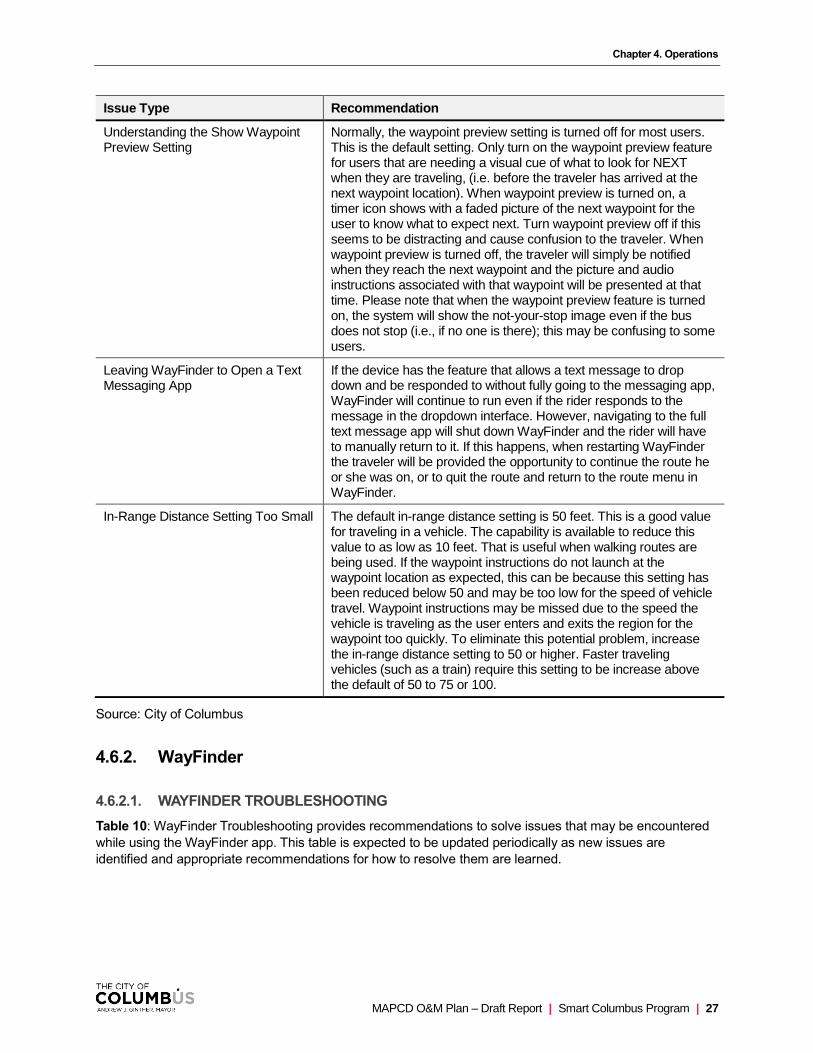
Table 10: WayFinder Troubleshooting ......................................................................................................... 28

Table of Contents
MAPCD O&M Plan – Draft Report | Smart Columbus Program | vii
Table 11: Preventative Maintenance Activities ............................................................................................ 29
Table 12: Data Update Activities ................................................................................................................. 30
Table 13: Corrective Maintenance Activities ............................................................................................... 30
Table 14: Stakeholders ................................................................................................................................ 37
Table 15: Acronym List ................................................................................................................................ 43
Table 16: Glossary ...................................................................................................................................... 45
List of Figures
Figure 1: Major System Components ........................................................................................................... 4
Figure 2: SMART Route Builder Login Screen ............................................................................................. 5
Figure 3: SMART Route Builder Main Menu Screen .................................................................................... 6
Figure 4: SMART Route Builder Edit Screen ................................................................................................ 7
Figure 5: COTA WayFinder Tracker Login Screen ........................................................................................ 8
Figure 6: COTA WayFinder Tracker Trips Screen ......................................................................................... 8
Figure 7: COTA WayFinder Tracker Historic Trip Details Screen ................................................................. 9
Figure 8: WayFinder Screens ..................................................................................................................... 10
Figure 9: Data Ingestion Workflow to Operating System ............................................................................ 31


MAPCD O&M Plan – Draft Report | Smart Columbus Program | 1
Executive Summary
Project Background
The Mobility Assistance for People with Cognitive Disabilities (MAPCD) project is one (1) of nine (9) projects
in the Smart Columbus portfolio. The project is meant to enable people with cognitive disabilities to travel
more independently on fixed-route bus service. The project team includes City of Columbus staff, subject
matter experts with the Central Ohio Transit Authority (COTA) and The Ohio State University (OSU), and
participating individuals with cognitive disabilities.
The goals of the MAPCD project are to:
• Allow travelers with cognitive disabilities to transition from using paratransit services to independent
travel using fixed-route bus service;
• Provide caregivers with an interface to create individual routes for travelers and be able to view
traveler’s progress on a map, and
• Collect anonymized data on app usage and travel behavior in the Smart Columbus Operating
System (OS) for performance measures and analytics.


MAPCD O&M Plan – Draft Report | Smart Columbus Program | 3
Introduction
1.1. SCOPE AND PURPOSE
This document identifies the scope and purpose of the Mobility Assistance for People with Cognitive
Disabilities (MAPCD) Operations and Maintenance (O&M) Plan. It explains how operational and
maintenance activities will be performed both during and after the Smart Columbus grant period. The
following sections discuss in detail the materials and resources, operational activities, and maintenance
tasks and routines taking place to operate and maintain the MAPCD program and other associated
systems. This document also specifies the stakeholders, such as agencies and departments within agencies
that rely on its successful operation. The purpose of this document is to provide a comprehensive view of
the MAPCD environment, the elements that make it work, and the processes and procedures for
maintaining optimum functionality.
The goals of the MAPCD project are to:
• Allow travelers with cognitive disabilities to transition from using paratransit services to independent
travel using fixed-route bus service
• Provide caregivers with an interface to create individual routes for travelers and be able to view
traveler’s progress on a map
• Collect anonymized data on app usage and travel behavior in the Smart Columbus Operating
System (OS) for performance measures and analytics
1.2. ORGANIZATION
The MAPCD O&M plan is organized into the following chapters:
• Introduction
• Material and Resources
• Training
• Operations
• Maintenance
• Appendix A: Stakeholders
• Appendix B: WayFinder Support Options
• Appendix C: Acronyms and Definitions
• Appendix D: Glossary
1.3. PROJECT DESCRIPTION
The MAPCD project consists of an innovative smartphone application (WayFinder) which is currently being
piloted to a maximum of 30 individuals in the Columbus region in partnership with the Central Ohio Transit
Authority (COTA) and The Ohio State University (OSU). WayFinder enables persons with cognitive
disabilities to travel independently on the fixed-route bus system. Phone-based GPS tracking allows
WayFinder to safely guide users with step-by-step visual and audio instructions. The WayFinder system was
developed by AbleLink Smart Living Technologies, LLC through research funding from the United States
Department of Education (USDOE) and the National Institutes of Health (NIH). Data generated by the
system is transmitted to the Smart Columbus Operating System to support data analysis and performance
measures during the grant period of the program.
Chapter 1. Introduction
4 | Smart Columbus Program | MAPCD O&M Plan – Draft Report
The key components of the MAPCD project are:
• WayFinder
o The WayFinder app is a mobile application which operates on iOS and Android
smartphones, using the global positioning system (GPS) on the device to provide
geolocation-based prompts to users of the system. The WayFinder app can have any
number of routes setup for a person based on his or her typical travel destinations.
• SMART Route Builder
o The SMART Route Builder is a web-based portal for simplifying the ability to create travel
routes for various destinations. The SMART Route Builder gives caregivers the ability to
create routes for WayFinder using a map-based interface and the ability to view real-time
location tracking to show an individual’s progress on a map.
• SMART Route Library
o The SMART Route Library is a cloud-based library of routes to specific destinations that will
provide easy access to cloud-based routes for specific geographic areas which can be
downloaded and used as is or modified to meet the needs of travelers with cognitive
disabilities.
• AbleLink Cloud Environment
o The AbleLink cloud environment hosts the SMART Route Library server application and
SMART Route Builder website. The environment also hosts secure Application
Programming Interfaces (APIs) to send de-identified travel information to the OS.
• Smart Columbus Operating System
o De-identified travel information for Smart Columbus participants is ingested into the OS via
a secure API, where it is available to City of Columbus users as a “restricted” dataset to
support project analysis and performance measures.
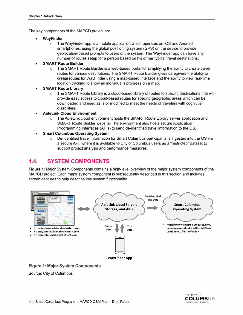
1.4. SYSTEM COMPONENTS
Figure 1: Major System Components contains a high-level overview of the major system components of the
MAPCD project. Each major system component is subsequently described in this section and includes
screen captures to help describe key system functionality.
Figure 1: Major System Components
Source: City of Columbus

Chapter 1. Introduction
MAPCD O&M Plan – Draft Report | Smart Columbus Program | 5
1.4.1. SMART Route Builder
To access the SMART Route Builder, enter https://piece-builder.ablelinktech.com/ in an HTML-5 compliant
web browser. This will display the login page (Figure 2: SMART Route Builder Login Screen) for the
SMART Route Builder application.
Figure 2: SMART Route Builder Login Screen
Source: City of Columbus
Once logged in, users have access to existing routes and the ability to edit and make changes. Note that
only a user with administrative permissions is able to manage accounts (refer to Section 4.6.1.4).

Chapter 1. Introduction
6 | Smart Columbus Program | MAPCD O&M Plan – Draft Report
Figure 3: SMART Route Builder Main Menu Screen
Source: City of Columbus
Selecting the option for new route in the SMART Route Builder interface brings up a map-based editing
screen. An existing route may be opened by selecting it in the table and selecting the option for edit route
(refer to Section 4.6.1.1 for more information).

Chapter 1. Introduction
MAPCD O&M Plan – Draft Report | Smart Columbus Program | 7
Figure 4: SMART Route Builder Edit Screen
Source: City of Columbus
1.4.2. SMART Route Library
After a route has been created using the SMART Route Builder, a user with administrative privileges can
upload the route to a selected SMART Route Library. Once the route is uploaded, the SMART Route Library
server application will open the route folder, condition all the media contained in the route, and reassemble
it. The reason for this step is to ensure media playback compliance across multiple platforms due to the
difference of supported file formats from one mobile operating system to the next. Once the route is
reassembled it is categorized based on location and made available for download. Another user can then
browse the SMART Route Library from his or her WayFinder app and select from routes available in the
user’s specific geographic area. When the user finds a route for a destination he or she is wanting to travel
to, the route can be downloaded to his or her smartphone or tablet and used immediately to travel to the
desired destination. Alternatively, the route instructions can be customized to meet the specific needs of a
particular user, such as by adding in instructions for getting from the user’s front door to a particular bus
stop.
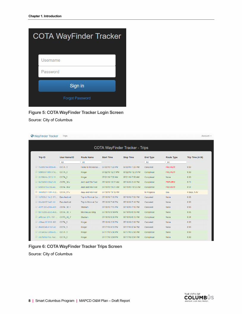
1.4.2.1. WAYFINDER TRACKER
The WayFinder Tracker provides caregivers with access to real-time traveler’s information and the ability to
view historic routes.
Chapter 1. Introduction
8 | Smart Columbus Program | MAPCD O&M Plan – Draft Report
Figure 5: COTA WayFinder Tracker Login Screen
Source: City of Columbus
Figure 6: COTA WayFinder Tracker Trips Screen
Source: City of Columbus

Chapter 1. Introduction
MAPCD O&M Plan – Draft Report | Smart Columbus Program | 9
Figure 7: COTA WayFinder Tracker Historic Trip Details Screen
Source: City of Columbus
1.4.3. WayFinder
The WayFinder app presents travel instructions to users with special needs. WayFinder is designed to work
with routes created with the SMART Route Builder application and interfaces with one or more SMART
Route Libraries to download routes for immediate use.
For specific information on using WayFinder, refer to the WayFinder 3 user manual in Table 1: References.

Chapter 1. Introduction
10 | Smart Columbus Program | MAPCD O&M Plan – Draft Report
Figure 8: WayFinder Screens
Source: City of Columbus
1.5. SYSTEM USERS
The following are the main user types interacting with the MAPCD systems:
• Traveler
o Has access to the WayFinder app on a smartphone; is connected to the SMART Route
Library download route information
• OSU/OSUMC
o Has read-write access to the SMART Route Builder for PIECE Program (https://piece-
builder.ablelinktech.com)
o Has read access to the SMART Tracker (https://wftracker.ablelinktech.com/)
o Has read-write access to the private SMART Route Library (https://piece-
smart.ablelinktech.com)
• COTA
o Has read-write access to the SMART Route Builder for COTA (https://cota-
builder.ablelinktech.com/)
o Has read access to the SMART Tracker (https://wftracker.ablelinktech.com/)
o Has read-write access to the public SMART Route Library (https://cota-
smart.ablelinktech.com)
• City of Columbus
o Has read-write access to all OSU/COTA resources
• Public
o Has access to de-identified trip summary data in JSON format
(https://www.smartcolumbusos.com/data?q=mapcd&x=0&y=0&c366234ea095f9b8f901ffa4
770f4dda=)
• Independent Evaluators (IE)

Chapter 1. Introduction
MAPCD O&M Plan – Draft Report | Smart Columbus Program | 11
o Has access to de-identified trip summary data in JSON format
(https://www.smartcolumbusos.com/data?q=mapcd&x=0&y=0&c366234ea095f9b8f901ffa4
770f4dda=)
1.6. STAKEHOLDERS
Appendix A contains a complete list of project stakeholders and their contact information. A summary of the
stakeholders’ roles and responsibilities is captured below:
• Product Owner
o Responsible for working with stakeholders to determine what features and functionality are
part of the WayFinder app
• Product Developer
o Responsible for developing the features and functionality to meet the needs of
stakeholders; responsible for maintenance of the WayFinder app
• Traveler
o Person with cognitive disabilities who is the end user of the WayFinder app
• Caregiver
o A guardian or family member who is responsible for creating and managing routes for the
traveler
• City of Columbus
o Representative of the Smart Columbus demonstration program
• The Ohio State University (OSU)
o Subject matter experts and responsible for recruiting and training activities
• The Ohio State University Wexner Medical Center (OSUMC)
o Subject matter experts and responsible for recruiting and training activities
• Central Ohio Transit Authority (COTA)
o Subject matter experts and responsible for recruiting and training activities
• HNTB (Consultant)
o Project coordinator and technical lead
1.7. REFERENCES
Table 1: References contains a list of all documents related to O&M of the MAPCD system.
Table 1: References
Document Number Title Author Revision
Publication Date
N/A Training Manual for Successful Use of Public Transportation Using the WayFinder App: Train the Traveler
Olivia Vega, OTS;
Carmen Digiovine
PhD, ATP/SMS,
RET; Julie Faieta,
OTR/L
Final 4/25/19
N/A WayFinder Ecosystem - Training Manual
Dan Davies Draft July 2019

Chapter 1. Introduction
12 | Smart Columbus Program | MAPCD O&M Plan – Draft Report
Document Number Title Author Revision
Publication Date
N/A • Initial Assessment of Abilities
• Travel Training Intake Form -
Individual with a disability
• Task Analysis Assessment of
a Smartphone
• Task Analysis Assessment of
the WayFinder App
• Public Transportation/COTA
Training quiz
Olivia Vega, OTS; Carmen Digiovine PhD, ATP/SMS, RET; Julie Faieta, OTR/L
Final April 2019
N/A Rehabilitation for Impairments of
Executive Functions. In L. Trexler
(Primary Ed) Cognitive
rehabilitation Manual (pg. 12)
Haskins, E. N/A 2012
N/A Enabling occupation in children:
The Cognitive Orientation to daily
Occupational Performance (CO-
OP) approach. Ottawa, ON: CAOT
Publications ACE
Polatajko, H. J., & Mandich, A.
N/A 2004
Source: City of Columbus

MAPCD O&M Plan – Draft Report | Smart Columbus Program | 13
Materials and Resources
This section identifies the equipment/materials and personnel used in operations and maintenance of the
MAPCD system. With respect to WayFinder physical facilities, the Amazon Web Services (AWS) cloud-
based Platform-as-a-service (PaaS) is being used for hosting WayFinder operations. Since these elements
are managed independently, only a high-level description is provided in this section; directly managed
materials and resources are covered in greater detail.
2.1. PERSONNEL
This section includes personnel, including positions, general qualifications, and specialty skills needed, and
a percentage of time dedicated to MAPCD operations or maintenance, if not full time.
Table 2: MAPCD Personnel
Name Role Qualification
Full Time Equivalent (%) Organization
Andy Wolpert Project Manager Smart Columbus Project Manager
10% Columbus
Carmen DiGiovine Project Research and Outreach
Associate Professor – Clinical – Occupational Therapy Division
Director of Rehabilitation Science and Technology - Assistive Technology Center
20% The Ohio State University
The Ohio State University Wexner Medical Center
Dan Davies Developer Founder and President of AbleLink Smart Living Technologies
10% AbleLink Smart Living Technologies
Sandra A. Metzler Project Engineer Associate Professor - Practice – Department of Mechanical and Aerospace Engineering
10% The Ohio State University
Julie Faieta Clinical Manager Occupational Therapist and Doctoral Student – School of Health and Rehabilitation Science
50% The Ohio State University

Chapter 2. Materials and Resources
14 | Smart Columbus Program | MAPCD O&M Plan – Draft Report
Name Role Qualification
Full Time Equivalent (%) Organization
Sarah Anderson Clinical Support Occupational Therapist and Doctoral Student – School of Health and Rehabilitation Science
25% The Ohio State University
Keatlyn Culter Research and Community Support
Health Science Student – School of Health and Rehabilitation Science
25% The Ohio State University
Ashley Stojkov Research and Community Support
Health Science Student – School of Health and Rehabilitation Science
25% The Ohio State University
Source: City of Columbus
2.2. EQUIPMENT, SOFTWARE, AND MATERIALS
This section discusses the operating equipment, software, and other computing facilities used for operating
the WayFinder and support options.
2.2.1. Equipment
WayFinder has been developed to run on any Android smartphone or tablet computer running Jelly Bean
(OS 4.2) or newer and that has GPS capability. However, the Marshmallow 6.0+ OS is preferable. For Apple
devices iOS 9.0 or better is required. Hardware devices do not require a calling plan or data plan unless the
notification and real-time tracking features are going to be used. Field testing has shown that performance
can vary from device to device, depending largely on the quality of the GPS technology in the device.
2.2.2. Software
Software licensing and support costs for the WayFinder app and support options are available in the tables
below. A detailed description of all support options is available in Appendix B.
Table 3: Monthly/Yearly Recurring and Support Costs During Grant Period
Description Quantity Cost Recurrence
WayFinder 3 Application/Licenses (includes Android smartphones)
30 $29,970 One-time fee
Support Options for Columbus
1. Travel Readiness Assessments
2. Self-Directed Travel Training Curriculum
3. SMART Route Library
4. SMART Route Builder
5. WayFinder Remote Tracker
- $0 No cost during grant period
Chapter 2. Materials and Resources
MAPCD O&M Plan – Draft Report | Smart Columbus Program | 15
Source: City of Columbus
Table 4: Monthly/Yearly Recurring and Support Costs After Grant Period
Description Quantity Cost Recurrence
WayFinder 3 App/License – No Phone 1 $349 One-time fee
WayFinder 3 Application/License – Android Phone 1 $999 One-time fee
WayFinder 3 Application/License – iOS Phone 1 $1,299 One-time fee
Support Options for Columbus
1. Travel Readiness Assessments
2. Self-Directed Travel Training Curriculum
3. SMART Route Library
4. SMART Route Builder
5. WayFinder Remote Tracker
- $2,500 - $25,0001
Annual
Source: City of Columbus
2.2.3. Materials
AbleLink Smart Living Technologies, LLC has furnished 30 Android devices pre-configured with the
WayFinder app. Additional pre-configured devices or separate licenses for existing devices can be
purchased in accordance with Table 4: Monthly/Yearly Recurring and Support Costs After Grant Period.
2.3. DATA COLLECTION AND PRIVACY POLICIES
The following privacy policies govern use of the WayFinder app for mobile devices that was created by
AbleLink Smart Living Technologies, LLC.
A copy of these policies can also be obtained at the following URL:
https://www.ablelinktech.com/assets/downloads/AbleLink%20Privacy%20Policy%20-
%20WayFInder%203.pdf
2.3.1. Data Collection
2.3.1.1. WAYFINDER REGISTRATION INFORMATION
The WayFinder app obtains user information when it is downloaded and registered. Registration with
AbleLink Smart Living Technologies, LLC is optional. However, not all of the features of WayFinder may be
available unless registration is complete.
When registering the app with AbleLink Smart Living Technologies, LLC, a user must provide the following
information:
• Name, email address, age, user name, password, and other registration information
1 Subject to change depending on combination of services needed.

Chapter 2. Materials and Resources
16 | Smart Columbus Program | MAPCD O&M Plan – Draft Report
• Transaction-related information, such as when you make purchases, respond to any offers, or
download or use applications from AbleLink
• Information a user provides when they contact AbleLink for help
• Credit card information for purchase and use of the app (if not supplied through the MAPCD project)
• Information a user enters into the system when using the app, such as contact information and
route management information
AbleLink Smart Living Technologies, LLC may use the information provided to contact users from time to
time to provide notices and marketing promotions.
2.3.1.2. WAYFINDER AUTOMATICALLY COLLECTED INFORMATION
WayFinder may collect certain types of information automatically, including, but not limited to:
• Type of mobile device
• Mobile device’s unique device ID
• IP address of the mobile device
• Mobile device operating system
• Mobile internet browsers used
• Information about the way the app is used
WayFinder does not collect precise information about the location of a mobile device.
2.3.1.3. OPERATING SYSTEM
The OS ingests trip summary information, but not individual trip information with location (due to location
information containing PII – Personally Identifiable Information). All data available in the OS is public and
can be queried through an API and exported as JSON.
The data available in the OS includes:
• contactHelp - This is an indicator as to whether the user pressed the help button to be contacted
anywhere in the trip
• elapsedTime - Time elapsed between startTime and stopTime of a trip (in seconds)
• endType - Status of the trip. Values include completed and canceled
• routeTitle - Title of the trip
• routeType - Type of travel mode chosen for a trip
• startTime - Timestamp at the start of a trip
• endTime - Timestamp at the end of a trip
• tripId - anonymized identification number of a trip
• userId - anonymized identification number of a user
• userName - Name of the user taking the trip
2.3.2. Access to WayFinder Data by Third Parties
Only aggregated, anonymized data is periodically transmitted to external services. AbleLink Smart Living
Technologies, LLC may disclose user provided and automatically collected information in the following ways:
• As required by law, such as to comply with a subpoena, or similar legal process.
• When AbleLink Smart Living Technologies, LLC believes in good faith that disclosure is necessary
to protect their rights, protect user safety or the safety of others, investigate fraud, or respond to a
government request.

Chapter 2. Materials and Resources
MAPCD O&M Plan – Draft Report | Smart Columbus Program | 17
• With AbleLink Smart Living Technologies, LLC’s trusted services providers who do not have an
independent use of the information disclosed to them and have agreed to adhere to the rules set
forth in their privacy statement (refer to Section 2.3).
• If AbleLink Smart Living Technologies, LLC is involved in a merger, acquisition, or sale of all or a
portion of its assets, users will be notified via email and/or a prominent notice on our website of any
change in ownership or uses of this information, as well as any choices users may have regarding
this information.
2.3.3. WayFinder Data Retention Policy
AbleLink Smart Living Technologies, LLC will retain user-provided data for as long as the WayFinder app is
used and for a reasonable time thereafter. AbleLink will retain automatically collected information for up to
24 months and thereafter may store it in aggregate.
To request that user-provided data be deleted, contact [email protected]. Note that some or all of the
user-provided data may be required in order for the app to function properly.
2.3.4. WayFinder Security
AbleLink Smart Living Technologies, LLC provides physical, electronic, and procedural safeguards to protect
information they process and maintain. Access to user information is limited to authorized employees and
contractors who need the information in order to operate, develop, or improve the app.

MAPCD O&M Plan – Draft Report | Smart Columbus Program | 18
Training
This section provides an overview of the assessment and training process for individuals who will be utilizing
smartphones and the WayFinder app to better access public transportation. The assessment and training
processes described in this section were created by OSU and are presented here only in part; contact OSU
for complete information or to request a copy of the individual training materials.
There are several phases involved in preparing an individual to use public transportation for independent
wayfinding. This section details the necessary trainings required to support the individual when they are out
in the community, such as reviewing important safety information, educating the individual on how to use a
smartphone, how to use the WayFinder app, and finally putting all this information together while practicing
using the COTA bus in a controlled setting.
Training may consist of one or many formats, such as PowerPoint presentations, interactive group
discussions, online training programs (such as ones provided by AbleLink), and quizzes to test retention of
the material presented.
Depending on the traveler’s initial abilities and skill-level, training can be provided at varying paces. It is
important to note that each traveler may come in with varying cognitive abilities and experiences. Repetition
has been found to be beneficial to demonstrating skills required to be successful when utilizing public
transportation; however, if a traveler is able to hear, understand and transfer the information to functional
use after receiving the information once, this will suffice.
The following section discusses the initial steps of training which begins the assessment of the traveler’s
baseline skills and abilities.
3.1. DETERMINING LEVEL OF TRAINING
Prior to the start of training, each traveler must complete the COTA transportation skills assessment forms
including the “Initial Assessment of Abilities” and the “Travel Training Intake Form - Individual with a
disability” (refer to Section 1.7). This will provide baseline information on the travelers travel readiness.
Using the information collected from these assessments, the individuals may be assigned to either a Level 1
or Level 2 training program as described in the following sections.
3.1.1. Level 1 Training Program
Individuals who are placed in the Level 1 training program will be trained using a behavioral learning
approach that has been found to be more effective with individuals who have very limited problem-solving
abilities (Haskins, 2012). Some of these training strategies include errorless learning, task-specific learning,
and chaining (Haskins, 2012).
Characteristics of individuals in Level 1 training program:
1. The participant is unaware of their deficits
2. The participant may have difficulty with problem-solving techniques even with assistance
3. The participant does not live independently and needs assistance with some daily tasks
4. The participant has difficultly with new or novel tasks even with assistance
5. Limited carry over even with repetition

Chapter 3. Training
MAPCD O&M Plan – Draft Report | Smart Columbus Program | 19
3.1.2. Level 2 Training Program
Individuals who are placed in the Level 2 training program will be trained using an adapted model of the CO-
OP which is a strategy that has been shown to be effective with individuals who have a mild to moderate
levels of cognitive impairments (Polatajko, 2004). The decision-making model of assigning these individuals
to their appropriate learning-style program has been adapted from the learning theory-based approach
presented by Haskins (Haskins, 2012) (Wolf, 2018).
Characteristics of individuals in Level 2 training program:
1. The participant is aware of their deficits
2. The participant is able to perform some problem-solving techniques with minimal assistance
3. The participant may live independently or at least performs a large portion of their daily activities
independently
4. The participant is able to navigate through new or novel tasks with minimal assistance
5. Fairly good carryover
3.2. SMARTPHONE TRAINING
For both the “Smartphone Training” and “WayFinder Training” it is important to split up travelers into their
Level 1 and Level 2 training groups. During this training session it is important to have only two to three
travelers in each group due to the complexity and novelty of these tasks. There should be one main trainer
for each group and then however many additional trainers to have one-on-one assistance for each traveler
in the group. If training is done individually, then only one trainer will be necessary. This training should take
approximately one hour to complete.
Items necessary for this training include:
• At least one charged smartphone per traveler
• At least one trainer per traveler
• Task Analysis Assessment of a Smartphone (refer to Section 1.7)
3.3. WAYFINDER TRAINING
During this training session it is important to have only two to three travelers in each group due to the
complexity and novelty of these tasks for some individuals. There should be one main trainer for each group
and then however many additional trainers to have one-on-one assistance for each traveler in the group. If
training is done individually, then only one trainer will be necessary.
This training should take approximately one hour to complete. Items necessary for this training include:
• At least one charged smartphone per traveler
• At least one trainer per traveler
• Task Analysis Assessment of the WayFinder App (refer to Section 1.7)
3.4. PUBLIC TRANSPORTATION/COTA TRAINING
The final training session involves practicing all the learned skills together in a controlled mock bus setting.
The session can be done in a larger group of about four travelers and no longer needs to be divided by
training level. There should be at least one main trainer and one to two additional trainers available for
individual support. During this training session, the individual will learn the etiquette of how to ride a COTA
bus.
This training session should take approximately one hour to an hour and 15 minutes to complete. Items
necessary for this training include:

Chapter 3. Training
20 | Smart Columbus Program | MAPCD O&M Plan – Draft Report
• Four tablets or computers for the individuals to perform the online sections (with sound)
• The AbleLink website (https://stcs.ablelinktech.com/) ***make sure using Google Chrome
• At least two trainers (one trainer for every individual)
• A bus pass
• The COTA transportation quiz (refer to Section 1.7)

MAPCD O&M Plan – Draft Report | Smart Columbus Program | 21
Operations
4.1. GOALS AND EXPECTATIONS
This section provides insight into the types of operational activities that are necessary to keep the MAPCD
system operational and should serve as a guide for addressing and resolving issues that come up regarding
the WayFinder suite of applications and integration with the Smart Columbus Operating System.
The primary goals and expectations of MAPCD operations and maintenance plan are as follows:
• To keep the WayFinder system operational and to provide optimal service to users
• To provide access to troubleshooting tips and common-user issues and how to resolve them
• To facilitate communications between the support teams and developers
4.2. HOURS OF OPERATION
The MAPCD system is expected to be operational continuously except for scheduled downtime for periodic
maintenance. Technical support from AbleLink Smart Living Technologies, LLC is available during daytime
hours.
4.3. WAYFINDER TECHNICAL SUPPORT
AbleLink Smart Living Technologies tech support can be contacted any of the following ways:
• Email: [email protected] (preferred)
• Phone: 719-592-0347 (follow prompts for technical support)
• Fax: 719-592-0348
The following information should be included in the correspondence:
• Contact person’s name and organization
• Number where contact person can be reached
• Contact person’s email address
• The AbleLink Smart Living Technologies product in question (software and version)
• The type and model of the device and Operating System version the software is running on, if
applicable
• A full description of the problem (including any error messages received)
Live support is generally available from 9 a.m. to 4 p.m., Mountain Standard Time, Monday-Friday.
4.4. OPERATING SYSTEM TECHNICAL SUPPORT
Smart Columbus Operating System tech support can be reached through the following URL:
https://www.smartcolumbusos.com/contact-us
The following information is required in the correspondence:
• Contact person’s name and organization
• Subject (Tech Help/Request)
• Message

Chapter 4. Operations
22 | Smart Columbus Program | MAPCD O&M Plan – Draft Report
• Verification (reCAPTCHA)
4.5. INTERACTION AND COORDINATION
Table 5: MAPCD Responsibilities provides key resources for operations and maintenance of the MAPCD
System.
Table 5: MAPCD Responsibilities
Individual Role Key Functions Availability
Andy Wolpert Project Manager, MAPCD Project Product owner; project management
8 a.m. – 4 p.m. EST, Monday – Friday
Carmen DiGiovine, PhD, ATP/SMS, RET
Associate Professor – Clinical – Occupational Therapy Division – The Ohio State University
Director of Rehabilitation Science and Technology - Assistive Technology Center – The Ohio State University Wexner Medical Center
Research, outreach, participant recruitment, and IRB
Ram Boyapati Data Curator, Smart Columbus Operating System
Responsible for creating the data structure/schema to import WayFinder data into the OS
8 a.m. – 4 p.m. EST, Monday – Friday
Dan Davies Responsible for WayFinder product and maintenance of the AbleLink Cloud Server and related services.
WayFinder support and maintenance; licensing and hosting issues
9 a.m. – 4 p.m. MT, Monday – Friday
Source: City of Columbus
4.6. OPERATIONAL ACTIVITIES
4.6.1. SMART Route Builder
This section provides a description of common operational activities and troubleshooting activities related to
the SMART Route Builder.

Chapter 4. Operations
MAPCD O&M Plan – Draft Report | Smart Columbus Program | 23
4.6.1.1. ADDING/REMOVING ROUTES
Table 6: SMART Route Builder Edit Options
Option Description
This button is used to create a new WayFinder route. The default starting
location for each new route will be the location identified in the settings dialog.
This button is used to edit the selected existing route in the route list. All aspects
of a route can be edited by clicking on this button, including the name of the
route. Canceling out of the editor before saving will discard all changes to a
route being edited.
This button is used to copy the selected route in the route list. The word “Copy”
will be appended to the name of the copied route. Everything else in the route
will be identical to the original route, with the exception of the route ID. A new
route ID is created for the copy of the route to distinguish the copy from the
original in the route list and when the routes(s) are uploaded to a SMART Route
Library for use with WayFinder.
This button is used to delete the selected route in the route list. A confirmation
dialog will appear before the route is deleted. Once a route is deleted, it is
permanently deleted in the Route Builder application and cannot be retrieved.
Routes that have been uploaded to a SMART Route Library or downloaded to
WayFinder will not be affected if the route is deleted in WayFinder. If you
accidentally delete a route that has been previously uploaded to a SMART
Route Library, you can import the route from the library if desired.
This button opens the settings page, where the user can enter his or her name
for identifying as the author of new routes created by the user. In addition, this
page is used to select which public SMART Route Library to connect to. In
settings, the user can also set the default starting location for all new routes
created while logged into the system.
This button is used to exit from the SMART Route Builder web application.
Please note that the site will log the user out after 20 minutes of inactivity for
security purposes.
This button is used to refresh the display of routes if a route that is imported
from a SMART Route Library does not immediately appear in the list.
Source: City of Columbus

Chapter 4. Operations
24 | Smart Columbus Program | MAPCD O&M Plan – Draft Report
4.6.1.2. UPLOADING/DOWNLOADING ROUTES
Table 7: Uploading/Downloading Routes
Option Description
This button opens a file selection dialog so that a Zipped file
of the route can be selected and uploaded to the route list. If
the selected file is a properly formatted SMART route, it will
be added to the route list and will be immediately available for
review of editing.
This button is used to download the selected route to the
downloads location on the local computer. The route will be
downloaded as a single Zip file and named with the title of the
route.
Source: City of Columbus
4.6.1.3. IMPORTING/EXPORTING ROUTES
Table 8: Importing/Exporting Routes
Option Description
This button is used to peruse the SMART Route Library so
that a route can be selected from the library and imported into
the SMART Route Builder application. If no public route library
has been selected in settings, the default private route library
for the user’s agency will be opened. If a public route library
has been selected in settings, the user will be presented with
the option to select routes from either the public library or the
private library after clicking this button.
This button is used to contribute a route created in SMART
Route Builder to the agency private route library. Select the
category to store the route and press the upload button. Note:
Only authorized parties are able to upload routes to a public
SMART Route Library to ensure that no personally identifying
information is added to a public library.
Source: City of Columbus
4.6.1.4. ADDING/REMOVING USERS
The accounts button is used to access the account manager within the application to manage user
accounts. This feature is only available to a user if the user level is set to staff or manager by the system
administrator.

Chapter 4. Operations
MAPCD O&M Plan – Draft Report | Smart Columbus Program | 25
4.6.1.5. SMART ROUTE BUILDER TROUBLESHOOTING
Table 9: SMART Route Builder Troubleshooting provides recommendations to solve issues that may be
encountered while using the SMART Route Builder or WayFinder app to create travel routes. This table is
expected to be updated periodically as new issues are identified and appropriate recommendations for how
to resolve are learned.
Table 9: SMART Route Builder Troubleshooting
Issue Type Recommendation
Route Creation Errors
Creating Routes Without Corridor Data Cannot Detect Off-Route Events
If a route is created with the WayFinder Route Editor (on the device) when the “Use Corridor Data” setting is turned off, then when travelers take those routes, the system will NOT be able to detect when individuals are off route. The use corridor data setting is turned on by default in WayFinder version 3.5 and higher. Page corridor data is required for a WayFinder route to be able to notify the traveler when he or she is off route and to send messages indicating that the traveler is off route.
Routes Created with Web-Based SMART Route Builder Do Not Include Corridor Data
Routes created with the online SMART Route Builder website require corridor data to be added to the route to be able to detect off route events for travelers. After a route is created online, it should then be downloaded to the WayFinder device. Before the route is used to track on-route/off-route events, corridor data needs to be added to the route. To add corridor data to a route, select the route in the route editor and ensure that the “Capture Corridor Data” setting is on. Then travel the route from beginning to end, being sure to stay in the normal travel corridor while traveling the route. This activity will capture and save corridor data for a previously created route. After corridor data has been added to a route in this way, on-route/off-route events will be able to be detected while the route is traveled.
GPS Signal Loss During Route Creation
WayFinder provides an icon indicating the strength of the GPS signal. If the GPS signal is lost during route creation, GPS coordinates may not be captured properly while the signal is low or lost. If GPS coordinates are not captured when the route is created, affected waypoints along the route will not play back correctly. To avoid this error, pay attention to the GPS signal icon to make sure there is sufficient GPS signal before creating the route. Use the route editor in WayFinder to recapture the GPS coordinates for any waypoints that do not appear at the location as expected.
Digital Photos Captured from Within WayFinder are not Available in the Photo Library
Digital photos obtained during route creation are not saved to the device’s photo library —The result is that users are unable to edit images (such as cropping) taken during route building. To avoid this situation, images may be obtained outside of the Route Builder application that can be edited if needed and integrated into the route using the route editor. Images captured during route creation can be copied to a connected computer, edited as needed, and then copied back over to the route folder on the mobile device. This is only recommended for users familiar with file transfer between Android devices and a desktop or notebook computer.
Chapter 4. Operations
26 | Smart Columbus Program | MAPCD O&M Plan – Draft Report
Issue Type Recommendation
Walking vs. Vehicle Routes WayFinder routes will typically involve both walking segments and segments traveling on public transit. It is good practice to create a single route for individuals for the entire route (including both walking segments and bus or train travel) so the individual can follow a single set of route instructions for his or her entire trip. For these types of routes, do not select the setting “On Foot Travel” in WayFinder, as this setting is not appropriate to use when a portion of the trip will be completed on a faster moving vehicle, such as a bus or train. The walking routes setting in WayFinder should only be selected when the ENTIRE route is a walking route.
Tips for Creating Waypoints for Walking vs. Vehicle Routes
For walking routes, waypoints should be set fairly closely to the intended action point (e.g., “you are at the corner of 4th and Elm, turn right and proceed down Elm Street”); for vehicle routes, waypoints should be set well in advance of an action point (e.g., “You are one block away from work, so pull the cord to indicate that you will be getting off the bus.”)
Failure to Provide Next-action Audio Prompts
Primarily on walking routes, the audio message should provide both information and direction (e.g., “you are at the corner of 4th and Elm, turn right and proceed down Elm Street.”). Information about where the individual is alone may be insufficient to direct a needed action by the traveler.
Audio Messages that are Excessive in Length
Primarily on vehicle routes, audio messages must be short enough to allow them to play completely before encountering the next waypoint; if audio messages are too long and waypoints are too close, the audio message may not play completely before the next waypoint message is triggered.
Route Playback Errors
Failure to Provide Clear Direction at the End of a Route
Users may be unsure of what to do once they arrive at the end of a route; this can be addressed by adding walking route (i.e., last mile) waypoint directions; by adding a general end-of-route message (e.g., “You have reached the doctor’s office. Go in the glass doors and Dr. Smith’s office is on the right in office number 112”); or through training and practice.
Device Volume while in a Noisy Environment
Some buses, for example, can be very loud when crowded; the use of earbuds or Bluetooth headphones can alleviate loud environments and also serve to help users to focus on travel directions.
General Inattention to Waypoint Instructions
For users that may be more easily distracted, using WayFinder’s vibration setting on devices that support vibration provides a tactile cue to attend to the instruction. Earbud use can also help with distracted travelers. Another useful strategy is to include additional waypoint instructions throughout the route (“Out the window, you can see Washington Park now,” “You are about halfway to work now,” “You are doing great. Just a few more minutes and it will be time to get off the bus.”). These additional messages serve to help the traveler pay attention to the device to receive important instructions.
Chapter 4. Operations
MAPCD O&M Plan – Draft Report | Smart Columbus Program | 27
Issue Type Recommendation
Understanding the Show Waypoint Preview Setting
Normally, the waypoint preview setting is turned off for most users. This is the default setting. Only turn on the waypoint preview feature for users that are needing a visual cue of what to look for NEXT when they are traveling, (i.e. before the traveler has arrived at the next waypoint location). When waypoint preview is turned on, a timer icon shows with a faded picture of the next waypoint for the user to know what to expect next. Turn waypoint preview off if this seems to be distracting and cause confusion to the traveler. When waypoint preview is turned off, the traveler will simply be notified when they reach the next waypoint and the picture and audio instructions associated with that waypoint will be presented at that time. Please note that when the waypoint preview feature is turned on, the system will show the not-your-stop image even if the bus does not stop (i.e., if no one is there); this may be confusing to some users.
Leaving WayFinder to Open a Text Messaging App
If the device has the feature that allows a text message to drop down and be responded to without fully going to the messaging app, WayFinder will continue to run even if the rider responds to the message in the dropdown interface. However, navigating to the full text message app will shut down WayFinder and the rider will have to manually return to it. If this happens, when restarting WayFinder the traveler will be provided the opportunity to continue the route he or she was on, or to quit the route and return to the route menu in WayFinder.
In-Range Distance Setting Too Small The default in-range distance setting is 50 feet. This is a good value for traveling in a vehicle. The capability is available to reduce this value to as low as 10 feet. That is useful when walking routes are being used. If the waypoint instructions do not launch at the waypoint location as expected, this can be because this setting has been reduced below 50 and may be too low for the speed of vehicle travel. Waypoint instructions may be missed due to the speed the vehicle is traveling as the user enters and exits the region for the waypoint too quickly. To eliminate this potential problem, increase the in-range distance setting to 50 or higher. Faster traveling vehicles (such as a train) require this setting to be increase above the default of 50 to 75 or 100.
Source: City of Columbus
4.6.2. WayFinder
4.6.2.1. WAYFINDER TROUBLESHOOTING
Table 10: WayFinder Troubleshooting provides recommendations to solve issues that may be encountered
while using the WayFinder app. This table is expected to be updated periodically as new issues are
identified and appropriate recommendations for how to resolve them are learned.

Chapter 4. Operations
28 | Smart Columbus Program | MAPCD O&M Plan – Draft Report
Table 10: WayFinder Troubleshooting
Issue Type Recommendation
WayFinder App Device Settings
Unable to Record Audio or Use Camera Upon First Use
This issue is due to failure to give WayFinder permission to access the audio recorder or camera. When first starting WayFinder, it will ask for permission to access the audio recording and camera features on the device; failure to provide these permissions will prevent recording of audio prompts and obtaining image cues during route creation.
Device Not Receiving GPS Signals Frequently
For Android users, the default GPS setting is often set to a battery saving mode which often causes the device to lose GPS connectivity frequently. Be sure to set the device to high accuracy in settings to minimize loss of GPS signal during use. This setting is a location mode setting in Android and may have different specific wording depending upon the version of Android on the device.
Source: City of Columbus
4.6.3. Smart Columbus Operating System
4.6.3.1. ACCESS TO DATA
Users of the OS will consume data in multiple ways:
• Downloading a file that contains the dataset (various formats will be available depending on the
dataset)
• Viewing structured data with an in-browser previewer/viewer
• Consuming the API to query the data
• Analyzing/visualizing data through analysis tools (currently in development)
Because all data is desired to be in a non-proprietary format, once retrieved, data will be able to be used
within many different tools as needed. Users do not need to register a user account to interact with the data
or API.
At this time, there is not a limit on the amount of data a given user can request through the website, but API
requests will have request throttling set based on originating Internet Protocol (IP) address to prevent
overloading the system with requests.
4.6.3.2. TROUBLESHOOTING
The OS generates statistics relative to the validity and completeness of the dataset as it is ingested. This will
provide a score that will be appended to the data page. The data provider will be contacted and asked to
remediate any anomalies detected. In the event of a data provider not abiding by the SLA, including
irresponsible inclusion of restricted data, datasets may be frozen or deleted from the OS by the system
administrator.

MAPCD O&M Plan – Draft Report | Smart Columbus Program | 29
Maintenance
The MAPCD solution is expected to be operational nearly 24 hours a day, seven days a week. Given that,
maintenance activities are necessary to keep the system running. This section outlines various maintenance
tasks, including preventive and corrective maintenance activities and other adjustments as needed.
5.1. PREVENTATIVE MAINTENANCE ACTIVITIES
Preventative maintenance is maintenance activity that is routinely performed to lessen the likelihood of
failure and to discover issues in a proactive manner to lessen their impact. AbleLink is responsible for
performing preventative maintenance on the WayFinder system (WayFinder app, SMART Route Builder,
and SMART Route Library), however, AbleLink is not responsible for performing preventative maintenance
on systems that are within the boundary of the Smart Columbus OS. Those preventative maintenance
activities are documented here.
Table 11: Preventative Maintenance Activities
Activities Description Frequency Effort
Check data availability in OS
Check the availability of data in the OS to ensure that services are up and running.
Weekly 0.5 hours
Wayfinder API availability check
Continuously monitor the availability of the Wayfinder Tracker API through an external monitor and notification service to ensure the service is available for use.
Continuous/Ongoing N/A
Wayfinder Tracker website availability check
Continuously monitor the availability of the Wayfinder Tracker website through an external monitor and notification service to ensure the service is available for use.
Continuous/Ongoing N/A
Wayfinder SMART API availability check
Continuously monitor the availability of the Wayfinder SMART API through an external monitor and notification service to ensure the service is available for use.
Continuous/Ongoing N/A
Wayfinder SMART website availability check
Continuously monitor the availability of the Wayfinder SMART website through an external monitor and notification service to ensure the service is available for use.
Continuous/Ongoing N/A
Wayfinder Builder website availability check
Continuously monitor the availability of the Wayfinder Builder website through an external monitor and notification service to ensure the service is available for use.
Continuous/Ongoing N/A
Chapter 5. Maintenance
30 | Smart Columbus Program | MAPCD O&M Plan – Draft Report
Activities Description Frequency Effort
GTFS Real-Time Updates middleware API availability check
Continuously monitor the availability of the GTFS Real-Time middleware API through an external monitor and notification service to ensure the service is available for use.
Continuous/Ongoing N/A
Server Operating System Upgrades
When new server operating system software and patches are released, upgrade and patch to keep current with the latest releases and security patches.
Semi-annually 2 hours
Source: City of Columbus
5.2. DATA UPDATES
The following are activities associated with updating data that is collected into the OS.
Table 12: Data Update Activities
Activities Description Frequency Effort
Update data structure/schema in OS
Data ingested into the OS has changed and requires updates to the existing data structure/schema.
Infrequent 1-2 days
Source: City of Columbus
5.3. CORRECTIVE MAINTENANCE ACTIVITIES
The following are corrective maintenance activities associated with addressing issues in the WayFinder
system or OS.
Table 13: Corrective Maintenance Activities
Activities Description Frequency Effort
Error in WayFinder app
Respond to error in the WayFinder app (refer to Section 4.6.2.1)
Infrequent TBD
Error in SMART Route Builder
Respond to error in the SMART Route Builder (refer to Section 4.6.1.5)
Infrequent TBD
Source: City of Columbus
5.4. DATA INGESTION WORKFLOW TO OPERATING SYSTEM
The OS uses Apache NiFi and KyloTM to ingest data from the AbleLink cloud server. The data is
transformed and stored in a Hadoop data lake, where it is searchable utilizing Apache Hive to end users of
the system through publicly accessible APIs.

Chapter 5. Maintenance
MAPCD O&M Plan – Draft Report | Smart Columbus Program | 31
Figure 9: Data Ingestion Workflow to Operating System
Source: City of Columbus
5.4.1. Data Ingest Template
The OS development team is responsible for creating the template (data structure/schema) to import
WayFinder data (trip data) from the AbleLink Cloud Server into the Hadoop Distributed File System (HDFS)
tables. Apache Hive is a data warehousing application that provides logical access to data being stored in
the Apache Hadoop infrastructure.
5.4.2. Data Transform
Once imported, WayFinder data is prepared for analytics using transformation features provided by Kylo.
The OS development team is responsible for data transformation that will be achieved in the Kylo front end.
5.4.3. Search and Analyze
Users can search the trip data in Hadoop and build Hive queries to support analysis. The OS development
team is responsible for maintaining the search and query interface to allow end users of the system to
analyze the data.
5.5. APPLICATION PROGRAMMING INTERFACES (APIS)
5.5.1. Introduction
The WayFinder TrackerTripInfo REST API is an HTTP server. It is accessed using standard HTTP[S] and all
HTTP[S] transactions that transmit data to the application must use the POST method.
Usage Example: https://wftracker.ablelinktech.com:8443/<action>
Where <action> is the action to be performed. The various actions and their parameters are described
below.

Chapter 5. Maintenance
32 | Smart Columbus Program | MAPCD O&M Plan – Draft Report
5.5.2. Actions
All of the actions require an API key.
5.5.3. Return Messages
After submitting an action, the application should return a JSON formatted message with the requested
information. The action may also return an error. See below for an example of an error.
Error Return Message Example:
{
"error": "Invalid tripId."
}
If the client does not authenticate properly with a valid API key, the system will return an HTTP 401
(access denied) with the string "Access denied."
5.5.4. Client Actions
5.5.4.1. GETTRIPS
Get a list of trip IDs available in the system. Get either all trips or, optionally, those specified within a
date range.
5.5.4.1.1 cURL Example:
# curl -k -d \
> 'apiKey=XXXXXXXXXX&start=1539807000&end=1539807005' \
> https://wftracker.ablelinktech.com:8443/getTrips
5.5.4.1.2 Parameters:
• apiKey: The API key is required in order to authenticate. Required: yes
o start: Specify the start date/time of the time range in epoch format for which to get a list of
trips. Required: no
• end: Specify the end date/time of the time range in epoch format for which to get a list of trips. Even
if a 'start' time is specified, the end time is still optional and will default to the current time.
o Required: no
• includePreview: A true/false value that indicates if trips with a ‘preview’ route type should be
included. Defaults to ‘false’ if not specified.
o Required: no
• deIdentify: A true/false value that indicates if the trip data should de-identified. Defaults to ‘false’ if
not specified.
o Required: no
• imp: Specify ‘true’ to only return COTA ‘implementation’ trips with a ‘-I’ suffix. Required: no
5.5.4.1.3 De-Identification Notes
The de-identification process, if used, will remove the route name and the user’s name from the trip
summary data.

Chapter 5. Maintenance
MAPCD O&M Plan – Draft Report | Smart Columbus Program | 33
5.5.4.1.4 Return Value
List of trip IDs and other information in JSON format or an error message.
5.5.4.1.5 Return Example
[
{
"elapsedTime": 29731,
"endType": null,
"routeType": "Car",
"startTime":
1548100715, "stopTime":
null,
"tripId": "df1f3347-f4f9-425a-8acc-
WFe24b72b38b", "tripTitle": "Home to the BF Post
Office", "userId": "Dan - MotoG 6"
},
{
"elapsedTime": 27,
"endType": "canceled",
"routeType": "Car",
"startTime":
1548100798,
"stopTime": 1548100825,
"tripId": "44bf25e3-862c-4e8e-9d59-
WFb89dbdaf4c", "tripTitle": "Home fron Pies and
Grinders", "userId": "Dan - MotoG 6"
}
]
5.5.4.2. GETTRIP
Get the details for a specific trip. If de-identification parameters are specified, the location data will be
replaced with skewed data within the location’s US census block. See de-identification notes.
5.5.4.2.1 cURL Example:
# curl -k -d \
> 'apiKey=XXXXXXXXXX&tripId= f85d3682-e226-4267-9686-WF0e09abc836' \
> https://wftracker.ablelinktech.com:8443/getTrip
5.5.4.2.2 Parameters:
• apiKey: The API key is required in order to authenticate.
o Required: yes
• tripId: A unique ID representing a WayFinder trip.
o Required: yes
• deIdentify: A true/false value that indicates if the location data should de-identified. Defaults to
‘false’ if not specified.
o Required: no
• deIdentifyStyle: A string of either ‘center’ or ‘edge’ to indicate if the de-identified location will use
the nearest edge or the center of the census block. Defaults to ‘center’ if not specified. This
parameter is ignored if the ‘deIdentify’ parameter is omitted or is set to ‘false.’

Chapter 5. Maintenance
34 | Smart Columbus Program | MAPCD O&M Plan – Draft Report
o Required: no
5.5.4.2.3 De-Identification Notes
The de-identification process, if used, will attempt to “skew” the latitude and longitude within the location’s
U.S. census block. If enabled, each location event will have a dictionary entry to indicate if that location
event is de-identified as well as an entry to list the style of de-identification (see example).
When the de-identification process uses the ‘center’ style, the original latitude and longitude will be replaced
with the center latitude and longitude of the census block.
When the de-identification process uses the ‘edge’ style, the original latitude and longitude will be replaced
with the latitude or longitude of the nearest edge. The other non-edge value will be randomized between the
two perpendicular edges of the block.
Since the census block data is read in real-time from a backend API provided by the U.S. government, it is
possible for there to be a communication error that does not allow for de-identification. In this case a de-
identification error entry will appear in the location event dictionary and the latitude and longitude data will be
omitted (see example).
As an added precaution the de-identification process also removes the first and last location from the data
as well as any point within 0.5 miles of the first and last points.
5.5.4.2.4 Return Value:
Normal success or error message.
5.5.4.2.5 Return Example:
{
"assistanceRequested":
0, "locationEvents": [
{
"batteryLevel": 9,
"cellCoverage": 50,
"eventTime": 1548101317,
"gpsAccuracy": 0,
"locationEvent":
"waypointResponded", "locationLat":
38.984946534,
"locationLong": -
104.700396106, "onRoute":
"true"
},
{
"batteryLevel": 9,
"cellCoverage": 50,
"eventTime": 1548101337,
"gpsAccuracy": 0,
"locationEvent": "none",
"locationLat":
38.988233746,
"locationLong": -
104.700376476, "onRoute":
"true"
},

Chapter 5. Maintenance
MAPCD O&M Plan – Draft Report | Smart Columbus Program | 35
{
"batteryLevel": 9,
"cellCoverage": 50,
"eventTime": 1548101357,
"gpsAccuracy": 0,
"locationEvent": "none",
"locationLat":
38.992232116,
"locationLong": -
104.70038326, "onRoute":
"true"
},
{
"batteryLevel": 9,
"cellCoverage": 50,
"eventTime": 1548101377,
"gpsAccuracy": 0,
"locationEvent": "none",
"locationLat":
38.996089556,
"locationLong": -
104.70038712, "onRoute":
"true"
}
],
"routeDownloaded":
"", "routeType": [
"Car"
],
"startTime": 1548101317,
"stopTime": 1548101380,
"tripEndType":
"canceled",
"tripId": "f85d3682-e226-4267-9686-WF0e09abc836",
"tripTitle": "Home to the BF Post
Office", "userId": "Dan - MotoG
6","wayfinderVersion": "1.0"
}
5.5.4.3. DELETETRIP
Delete a specific trip.
5.5.4.3.1 cURL Example:
# curl -k -d \
> 'apiKey=XXXXXXXXXX&tripId= f85d3682-e226-4267-9686-WF0e09abc836' \
> https://wftracker.ablelinktech.com:8443/deleteTrip
5.5.4.3.2 Parameters:
• apiKey: The API key is required in order to authenticate.
o Required: yes
• start: Specify the start date/time of the time range in epoch format for which to get a list of trips.
o Required: no

Chapter 5. Maintenance
36 | Smart Columbus Program | MAPCD O&M Plan – Draft Report
• end: Specify the end date/time of the time range in epoch format for which to get a list of trips. Even
if a 'start' time is specified, the end time is still optional and will default to the current time.
o Required: no
5.5.4.3.3 Return Value
List of trip IDs and other information in JSON format or an error message.
5.5.4.3.4 Return Example:
{ "status": “success” }
MAPCD O&M Plan – Draft Report | Smart Columbus Program | 37
Stakeholders
A.1 STAKEHOLDERS
Table 14: Stakeholders includes a list of stakeholders and contact information for the MAPCD project.
Table 14: Stakeholders
Name Role/Organization Email
Mandy K. Bishop City of Columbus, Smart Columbus Program Manager
Andrew Wolpert City of Columbus, Product Owner [email protected]
Alyssa N. Chenault City of Columbus, Smart Columbus Communications Project Manager
Sandra Metzler OSU [email protected]
Katie M. White OSU [email protected]
Carmen Digiovine OSU/OSUWMC [email protected]
Julie Faieta OSU [email protected]
Amy N. Hockman COTA [email protected]
Alex Kavanagh HNTB [email protected]
Diane Newton HNTB [email protected]
Dan Davies AbleLink Smart Living Technologies, LLC., WayFinder Developer
Source: City of Columbus

MAPCD O&M Plan – Draft Report | Smart Columbus Program | 39
WayFinder Support Options
The WayFinder system includes multiple levels of service options for individuals, human service agencies,
and public transit systems, which taken together comprise the WayFinder SMART Travel Ecosystem. This
document provides a description of these service options. Specific cost information included in this
document is subject to change. Hardware/software bundles do not include Wi-Fi or data services.
B.1 APP OPTIONS FOR INDIVIDUAL TRAVELERS
WayFinder App (Android or iOS Software)
The WayFinder app is available for purchase by specific individuals from the Google Play/ Apple App stores.
The version of the app available in these app stores allows routes to be created with the WayFinder device
that are compliant with the SMART Wayfinding Specification and used as desired to support travel in the
Columbus metro area. This version also allows routes to be downloaded from a local SMART Route Library
populated with routes for a local transit agency which has made a Public SMART Route Library available for
transit customers. Routes downloaded from the library can be used as is or customized with personalized
travel instructions on the device once the route has been downloaded.
App Cost: $349
B.1.1.1 WAYFINDER BUNDLE (ANDROID OR IOS SOFTWARE/HARDWARE)
The WayFinder app can be purchased directly from AbleLink Smart Living Technologies
(www.ablelinktech.com) as a bundled solution with an Android phone/tablet or an Apple iPhone/iPad.
Android bundles include pre-installation of the software on the device. Apple bundles are shipped with the
selected device and app codes for the user to install the app after receiving the device.
Bundle Cost: $999 (Android phone), $1,299 (iPhone)
B.1.1.2 COMMUNITY ACCESS SUITE
The Community Access Suite provides a bundled solution for WayFinder users which includes an
accessible personal scheduling app (AbleLink Endeavor) and step-by-step prompting app (AbleLink Visual
Impact), which can work seamlessly with the included WayFinder app. Personal schedules can be created
and customized directly on the device to provide the user with time-sensitive reminders for any activity as
well as for specific WayFinder routes at a desired time. This helps users who have difficulty with time
management to know when it is time to leave home to catch the bus and to automatically launch the
WayFinder app with a specific route needed for a particular time. In addition, the software can be used to
assist users with completing pre-trip checklists containing specific step-by-step instructions (using pictures,
audio and video) for accomplishing activities in preparation for a trip. The Community Access Suite turnkey
system includes the suite of applications mentioned above and a mobile device (either Android or Apple
tablet or smartphone).
Bundle Cost: $1,299 (Android tablet), $1,399 (Apple iPad)
$1,399 (Android phone), $1,499 (Apple iPhone)
Expected Outcomes for Individual WayFinder App Users
• Increased independence in accessing the community as a result of using public transportation

Appendix B. WayFinder Support Options
40 | Smart Columbus Program | MAPCD O&M Plan – Draft Report
• Decreased dependency on agency staff and paratransit to meet travel needs
• Increased frequency of engagement in community activities
• Increased social connectedness for individuals with cognitive disabilities and others with special
needs
• Increased variety of travel destinations (work, friends, activities, etc.) as a result of individuals
having much more personal control over transportation
B.2 SERVICE OPTIONS FOR HUMAN SERVICE AGENCIES
The WayFinder ecosystem includes a suite of services which provide the human services agency with
assessment, training, and productivity tools for supporting the travel needs of all the individuals served by
their agency in a specific metropolitan area. This section provides a summary description of each of the
services included.
Travel Readiness Assessments
The travel readiness assessments provide the agency a suite of travel readiness assessments which can be
used to identify travel training needs for individuals with cognitive disabilities and special needs served by
the agency. The assessments are web based, cognitively accessible assessments based on AbleLink’s
ATLAS technology which address five topics, including: travel skills and experience, light rail skills and
experience, street crossing skills, social skills, and vehicle identification skills.
Self-Directed Travel Training Curriculum
The self-directed travel training curriculum allows individuals with cognitive disabilities and others with
special needs to complete training sessions designed to teach important travel skills in a self-paced, self-
directed manner. There are 22 training sessions that correspond with the content included in the travel
readiness assessments. Tools are also provided to allow agency travel trainers to create custom training
modules and add them to the online library to provide location or agency specific training sessions.
Agency SMART Route Library
An Agency SMART Route Library is a private route library that interfaces directly with the agency’s SMART
Route Builder application and WayFinder users that are configured to access routes created by the agency.
This library is used by the agency to store routes created for individuals they serve. Routes added to the
agency’s private SMART Route Library typically include customized routes that include a combination of
local metro system transit waypoints and personalized waypoints that provide very detailed instructions for
travelers to travel from their own homes to desired destinations.
SMART Route Builder
SMART Route Builder is a web-based application that allows agency staff to create custom routes for use
with WayFinder to meet the travel needs of individuals served by the agency. The system allows new routes
to be created by dropping pins on a map and adding the specialized multimedia used to provide accessible
instructions to travelers with cognitive disabilities and others with special needs. The system interfaces with
any available public SMART Route Libraries and also includes a private SMART Route Library that is only
available to agency staff. Routes created with the SMART Route Builder can then be contributed to the
online library so that they can be downloaded directly by the WayFinder app user.

Appendix B. WayFinder Support Options
MAPCD O&M Plan – Draft Report | Smart Columbus Program | 41
WayFinder Remote Support System
The WayFinder Remote Support System (i.e. tracker) provides trip management tools to agencies, including
the ability to view real-time trip updates and historical trip data for individual WayFinder users participating in
their travel support program. Live trip data allows agency staff to receive location data and user interaction
updates as the trip progresses (updates provides every 30 seconds). This allows agency staff to be alerted
to travelers that go off route, user-initiated messages or requests for assistance, and battery level of the
device (with alerts for low-battery conditions). Historical trip data includes all of this same information for
completed or aborted trips, as well as filters for selecting all trips by a particular individual, all trips taken for
a particular route, as well as several other filters for trip end type and route type.
Cost for services described in B.2.1 – B.2.5: Varies depending on the number of individuals using the
WayFinder system within the agency to travel more independently. Estimated cost for a typical agency -
$2,500-$5,000/year.
Expected Outcomes for Human Service Agencies
• Reduction in staff-related costs for providing transportation (staff time, mileage for personal
vehicles, etc.).
• Reduction in costs (fuel costs, service, driver time, etc.) related to providing agency-based travel
support due to fewer requirements for staff-driven trips.
• Staff time can be shifted to higher-quality interactions with individuals, rather than having to spend
time driving people around town.
B.3 SERVICE OPTIONS FOR PUBLIC TRANSIT AGENCIES
A city’s transit system can employ a range of WayFinder services to support individuals with cognitive
disabilities and others with special needs starting with a basic set of WayFinder services (e.g. public SMART
Route Library) to a comprehensive set of services which can even include a branded custom WayFinder
app pre-set to connect to the agency’s local public SMART Route Library which can be offered for free to all
customers in the local region. Service options include initial population and regular updates of GTFS-based
routes for the entire metro system and other specialized routes, such as routes for local attractions (e.g.
walking tour of the city zoo, historical walking tour of downtown, etc.). Other services can include access to
de-identified trip data for use by the transit agency to analyze system usage and identify transit needs for
customers with disabilities. Additional service options can include online training resources, live periodic
training webinars, premium tech support, on-site evaluation and training, future recommendations and
identification of expansion opportunities.
Cost: Varies depending on size of the metropolitan area and the specific suite of services desired by the
transit agency. A customized proposal is developed for each transit agency which addresses the specific
services, support, and training options which will best enable the agency to support customers with cognitive
disabilities and others with special needs.
Expected Outcomes for Human Service Agencies:
1. Reduction in paratransit costs.
2. Increased ridership on public transit system.
3. Better compliance with federal regulations/laws regarding accessible transportation by serving
cognitive disability population more effectively.
4. Increased accessibility to city services and public recreational and tourist attractions.
5. Improved ability to meet travel needs of customers with cognitive disabilities and others with special
needs in areas not specifically served by existing transit routes.

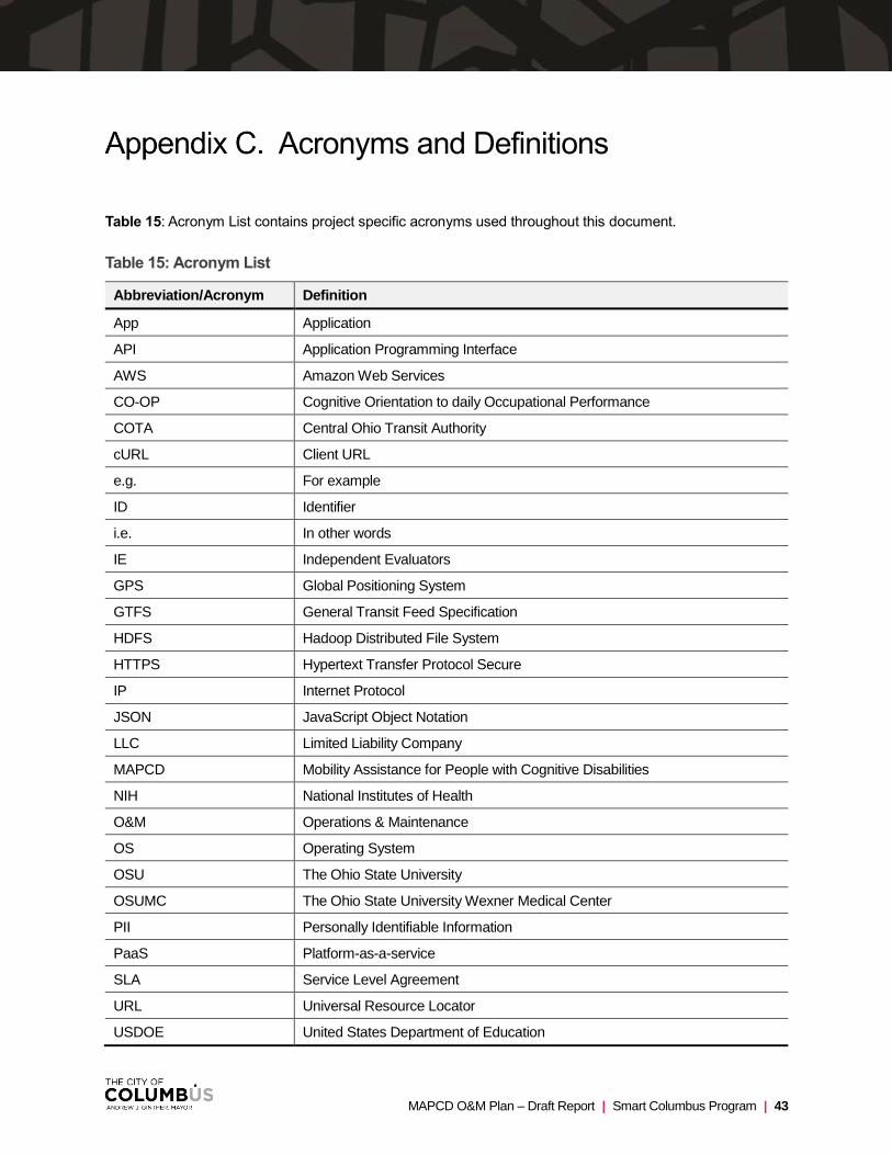
MAPCD O&M Plan – Draft Report | Smart Columbus Program | 43
Acronyms and Definitions
Table 15: Acronym List contains project specific acronyms used throughout this document.
Table 15: Acronym List
Abbreviation/Acronym Definition
App Application
API Application Programming Interface
AWS Amazon Web Services
CO-OP Cognitive Orientation to daily Occupational Performance
COTA Central Ohio Transit Authority
cURL Client URL
e.g. For example
ID Identifier
i.e. In other words
IE Independent Evaluators
GPS Global Positioning System
GTFS General Transit Feed Specification
HDFS Hadoop Distributed File System
HTTPS Hypertext Transfer Protocol Secure
IP Internet Protocol
JSON JavaScript Object Notation
LLC Limited Liability Company
MAPCD Mobility Assistance for People with Cognitive Disabilities
NIH National Institutes of Health
O&M Operations & Maintenance
OS Operating System
OSU The Ohio State University
OSUMC The Ohio State University Wexner Medical Center
PII Personally Identifiable Information
PaaS Platform-as-a-service
SLA Service Level Agreement
URL Universal Resource Locator
USDOE United States Department of Education
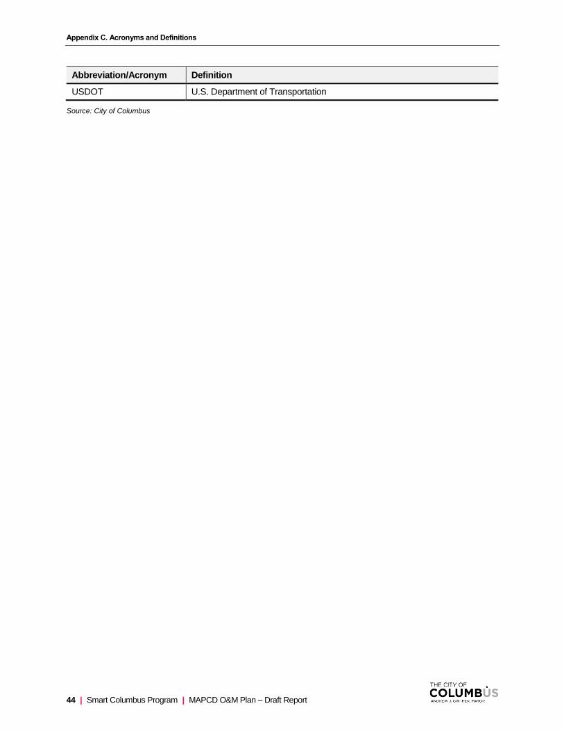
Appendix C. Acronyms and Definitions
44 | Smart Columbus Program | MAPCD O&M Plan – Draft Report
Abbreviation/Acronym Definition
USDOT U.S. Department of Transportation
Source: City of Columbus

MAPCD O&M Plan – Draft Report | Smart Columbus Program | 45
Glossary
Table 16: Glossary contains project specific terms used throughout this document.
Table 16: Glossary
Term Definition
Android An open-source operating system used for smartphones and tablet computers.
App A software application.
Caregiver Family member, guardian, or support person for person with cognitive disabilities. A caregiver is responsible for creating and managing routes for use by individual users of the WayFinder application.
iOS An operating system used for mobile devices manufactured by Apple Inc.
Multimodal Transportation Travel done via more than one mode of transportation.
Real-Time Data Information that is delivered immediately after collection.
reCAPTCHA reCAPTCHA is a free service from Google that helps protect websites from spam and abuse.
Third Party Organizations not affiliated with the Smart Columbus Program.
Travelers Travelers are users of the WayFinder application.
Source: City of Columbus


![Association between cognitive function and life-space mobility in … · 2018. 9. 24. · Life-space mobility (LSA) The Life-Space Assessment index [1] was used to investigate life-space](https://static.fdocuments.us/doc/165x107/613ba50bf8f21c0c82691cf7/association-between-cognitive-function-and-life-space-mobility-in-2018-9-24.jpg)
