MN 2578; ACC 6928A, 7210A, 7221A, 9086A, 9267A
13
MN 2578 Page 1 of 13 Copyright SLWA ©2010 FEILMAN, MARGARET ANNE, 1921-2013 Dr Margaret Anne Feilman, OBE, BA (1943), Registered Architect (1946), Dip.TP (Durham UK) 1950, was the first female architect cadet in the Public Works Department, Western Australia. Dr Feilman worked in Melbourne and took up a British Council Scholarship in the UK, before returning to Perth in 1950 to set up in private practice as an architect and town planning consultant. Her practice, Feilman Planning Consultants, was the only one of its kind operating in Western Australia at the time. With legal expertise provided by the late Gerald Keall (solicitor), she introduced the first environmental controls in local government town planning schemes in many areas including Northam, Albany, Busselton and Chapman Valley. Following her retirement from this practice in 1984 Dr Feilman was invited to become Chairman of the Town Planning Board in WA. She served in this position for over two years. Dr Feilman was heavily involved in voluntary community work. In the mid-1950s she assisted the foundation of the first natural environment organisation in W.A., The Tree Society. She was instrumental in establishing the National Trust of Australia (WA) and served on the Council and Executive of the Trust from 1959 to 1976. In 1973 she carried out a major part of the Trust’s contribution to the Federal Government initiated Hope Committee of Enquiry into the National Estate. In 1976 she was invited by the Federal Government to join the Australian Heritage Commission as one of the initial seven Commissioners and served for five years. In 1981 she was awarded the OBE for community service in the conservation field. From 1977 to 1981 she served as Deputy Chairman of the National Trust and from 1981 to 1990 she was Chairman of Council of the National Trust of Australia (WA). The State Government recognized Margaret’s contribution to the conservation of Western Australia’s heritage in 1995 with a Heritage Council of Western Australia award. Source: Eulogy Acc. 9267A/1 ACC 6928A Donated 31 October 1991 ACC 9267A Donated 17 November 2014 PRIVATE ARCHIVES MANUSCRIPT NOTE (MN 2578; ACC 6928A, 7210A, 7221A, 9086A, 9267A) SUMMARY OF CLASSES EULOGY FILES Town planning files spanning Dr Feilman’s forty-year professional life in Western Australia. The files are listed alphabetically by local government authority. The files include correspondence, plans, invitations, newspaper clippings, minutes, reports, petitions, jottings, photographs etc .Many of the folders are arranged by issues, rather than chronological. PLANS. Includes architectural plans and town planning drawings DESCRIPTION EULOGY 9267A/1 2013. Eulogy from Jenny Ethell. 6 pages. Also, booklet from the memorial service of celebration for the life of Dr Margaret Anne Feilman Items 9267A/2-66.5. Extra outsize. See item record for storage location ARCHITECTURAL PLANS and TOWN PLANNING DRAWINGS. Those drawn by Dr Feilman are marked with the letters MAF, and those other than Western Australian are marked accordingly.
Transcript of MN 2578; ACC 6928A, 7210A, 7221A, 9086A, 9267A

MN 2578 Page 1 of 13 Copyright SLWA ©2010
FEILMAN, MARGARET ANNE, 1921-2013 Dr Margaret Anne Feilman, OBE, BA (1943), Registered Architect (1946), Dip.TP (Durham UK) 1950, was the first female architect cadet in the Public Works Department, Western Australia. Dr Feilman worked in Melbourne and took up a British Council Scholarship in the UK, before returning to Perth in 1950 to set up in private practice as an architect and town planning consultant. Her practice, Feilman Planning Consultants, was the only one of its kind operating in Western Australia at the time. With legal expertise provided by the late Gerald Keall (solicitor), she introduced the first environmental controls in local government town planning schemes in many areas including Northam, Albany, Busselton and Chapman Valley. Following her retirement from this practice in 1984 Dr Feilman was invited to become Chairman of the Town Planning Board in WA. She served in this position for over two years. Dr Feilman was heavily involved in voluntary community work. In the mid-1950s she assisted the foundation of the first natural environment organisation in W.A., The Tree Society. She was instrumental in establishing the National Trust of Australia (WA) and served on the Council and Executive of the Trust from 1959 to 1976. In 1973 she carried out a major part of the Trust’s contribution to the Federal Government initiated Hope Committee of Enquiry into the National Estate. In 1976 she was invited by the Federal Government to join the Australian Heritage Commission as one of the initial seven Commissioners and served for five years. In 1981 she was awarded the OBE for community service in the conservation field. From 1977 to 1981 she served as Deputy Chairman of the National Trust and from 1981 to 1990 she was Chairman of Council of the National Trust of Australia (WA). The State Government recognized Margaret’s contribution to the conservation of Western Australia’s heritage in 1995 with a Heritage Council of Western Australia award.
Source: Eulogy Acc. 9267A/1 ACC 6928A Donated 31 October 1991 ACC 9267A Donated 17 November 2014 PRIVATE ARCHIVES MANUSCRIPT NOTE (MN 2578; ACC 6928A, 7210A, 7221A, 9086A, 9267A)
SUMMARY OF CLASSES
EULOGY
FILES Town planning files spanning Dr Feilman’s forty-year professional life in Western Australia. The files are listed alphabetically by local government authority. The files include correspondence, plans, invitations, newspaper clippings, minutes, reports, petitions, jottings, photographs etc .Many of the folders are arranged by issues, rather than chronological.
PLANS. Includes architectural plans and town planning drawings
DESCRIPTION
EULOGY
9267A/1 2013. Eulogy from Jenny Ethell. 6 pages. Also, booklet from the memorial service of celebration for the life of Dr Margaret Anne Feilman
Items 9267A/2-66.5. Extra outsize. See item record for storage location
ARCHITECTURAL PLANS and TOWN PLANNING DRAWINGS. Those drawn by Dr Feilman are marked with the letters MAF, and those other than Western Australian are marked accordingly.
MN 2578 Page 2 of 13 Copyright SLWA ©2010
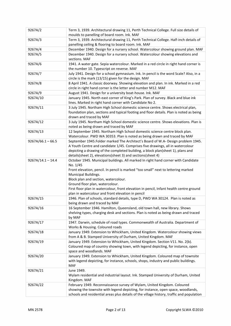
9267A/2 Term 3, 1939. Architectural drawing 11, Perth Technical College. Full size details of moulds to panelling of board room. Ink. MAF
9267A/3 Term 3, 1939. Architectural drawing 11, Perth Technical College. Half-inch details of panelling ceiling & flooring to board room. Ink. MAF
9267A/4 December 1940. Design for a nursery school. Watercolour showing ground plan. MAF
9267A/5 December 1940. Design for a nursery school. Watercolour showing elevations and sections. MAF
9267A/6 1941. A water gate. Sepia watercolour. Marked in a red circle in right hand corner is the number 10. Typescript on reverse. MAF
9267A/7 July 1941. Design for a school gymnasium. Ink. In pencil is the word Scale? Also, in a circle is the mark (13/15) given for the design. MAF
9267A/8 8 April 1941. A classic doorway. Showing elevation and plan. In ink. Marked in a red circle in right hand corner is the letter and number M12. MAF
9267A/9 August 1941. Design for a university boat-house. Ink. MAF
9267A/10 January 1945. North east corner of King’s Park. Plan of survey. Black and blue ink lines. Marked in right hand corner with Candidate No 2.
9267A/11 3 July 1945. Northam High School domestic science centre. Shows electrical plan, foundation plan, sections and typical footing and floor details. Plan is noted as being drawn and traced by MAF
9267A/12 3 July 1945. Northam High School domestic science centre. Shows elevations. Plan is noted as being drawn and traced by MAF
9267A/13 12 September 1945. Northam High School domestic science centre block plan. Watercolour. PWD WA 30353. Plan is noted as being drawn and traced by MAF
9267A/66.1 – 66.5 September 1945.Folder marked The Architect’s Board of W.A- Design problem 1945. A Youth Centre and candidate 1/45. Comprises five drawings, all in watercolour depicting a drawing of the completed building, a block plan(sheet 1), plans and details(sheet 2), elevations(sheet 3) and sections(sheet 4)
9267A/14.1 – 14.4 October 1945. Municipal buildings. All marked In right hand corner with Candidate No. 1/45 Front elevation, pencil. In pencil is marked “too small” next to lettering marked Municipal Buildings. Block plan and section, watercolour. Ground floor plan, watercolour. First floor plan in watercolour, front elevation in pencil, Infant health centre ground plan in watercolour and front elevation in pencil
9267A/15 1946. Plan of schools, standard details, type D, PWD WA 30124. Plan is noted as being drawn and traced by MAF
9267A/16 16 September 1946. Hamilton, Queensland, old town hall, new library. Shows shelving types, charging desk and sections. Plan is noted as being drawn and traced by MAF
9267A/17 1947. Darwin, schedule of road types. Commonwealth of Australia. Department of Works & Housing. Coloured roads
9267A/18 January 1949. Extension to Whickham, United Kingdom. Watercolour showing views from A & B. Stamped University of Durham, United Kingdom. MAF
9267A/19 January 1949. Extension to Whickham, United Kingdom. Section V11. No. 2(b). Coloured map of country showing town, with legend depicting, for instance, open space and woodlands. MAF
9267A/20 January 1949. Extension to Whickham, United Kingdom. Coloured map of townsite with legend depicting, for instance, schools, shops, industry and public buildings. MAF
9267A/21 June 1949. Wylam residential and industrial layout. Ink. Stamped University of Durham, United Kingdom. MAF
9267A/22 February 1949. Reconnaissance survey of Wylam, United Kingdom. Coloured showing the townsite with legend depicting, for instance, open space, woodlands, schools and residential areas plus details of the village history, traffic and population
MN 2578 Page 3 of 13 Copyright SLWA ©2010
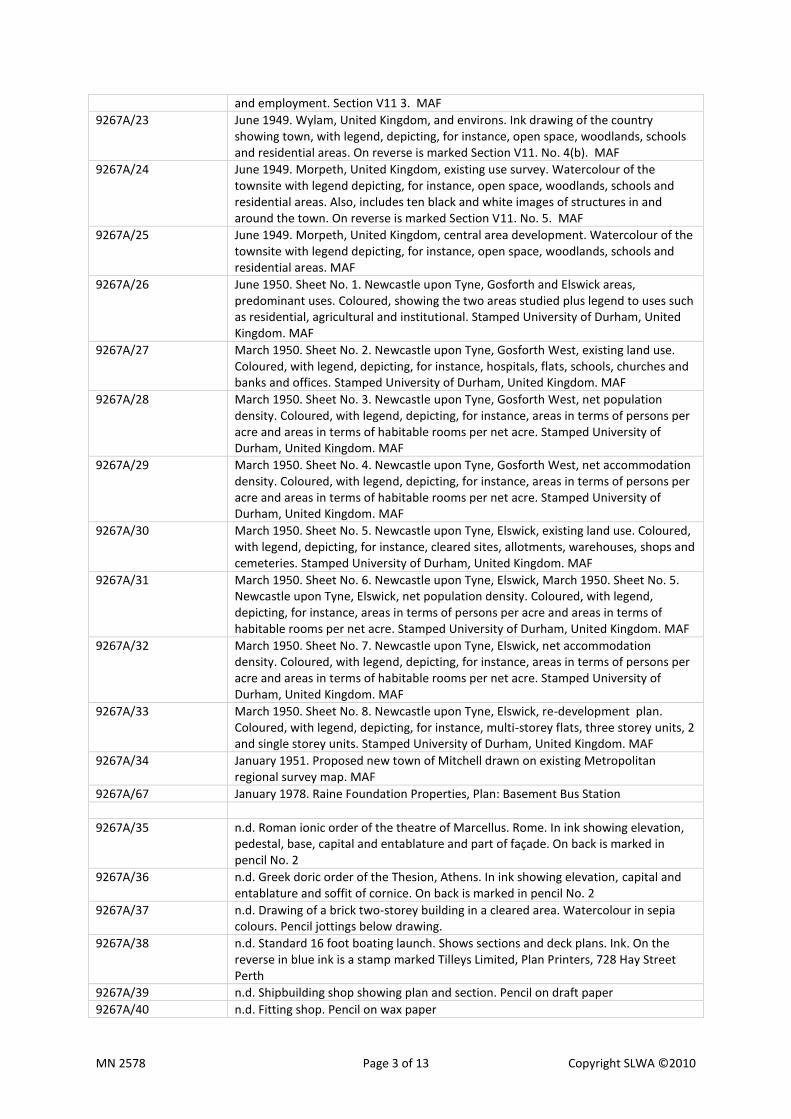
and employment. Section V11 3. MAF
9267A/23 June 1949. Wylam, United Kingdom, and environs. Ink drawing of the country showing town, with legend, depicting, for instance, open space, woodlands, schools and residential areas. On reverse is marked Section V11. No. 4(b). MAF
9267A/24 June 1949. Morpeth, United Kingdom, existing use survey. Watercolour of the townsite with legend depicting, for instance, open space, woodlands, schools and residential areas. Also, includes ten black and white images of structures in and around the town. On reverse is marked Section V11. No. 5. MAF
9267A/25 June 1949. Morpeth, United Kingdom, central area development. Watercolour of the townsite with legend depicting, for instance, open space, woodlands, schools and residential areas. MAF
9267A/26 June 1950. Sheet No. 1. Newcastle upon Tyne, Gosforth and Elswick areas, predominant uses. Coloured, showing the two areas studied plus legend to uses such as residential, agricultural and institutional. Stamped University of Durham, United Kingdom. MAF
9267A/27 March 1950. Sheet No. 2. Newcastle upon Tyne, Gosforth West, existing land use. Coloured, with legend, depicting, for instance, hospitals, flats, schools, churches and banks and offices. Stamped University of Durham, United Kingdom. MAF
9267A/28 March 1950. Sheet No. 3. Newcastle upon Tyne, Gosforth West, net population density. Coloured, with legend, depicting, for instance, areas in terms of persons per acre and areas in terms of habitable rooms per net acre. Stamped University of Durham, United Kingdom. MAF
9267A/29 March 1950. Sheet No. 4. Newcastle upon Tyne, Gosforth West, net accommodation density. Coloured, with legend, depicting, for instance, areas in terms of persons per acre and areas in terms of habitable rooms per net acre. Stamped University of Durham, United Kingdom. MAF
9267A/30 March 1950. Sheet No. 5. Newcastle upon Tyne, Elswick, existing land use. Coloured, with legend, depicting, for instance, cleared sites, allotments, warehouses, shops and cemeteries. Stamped University of Durham, United Kingdom. MAF
9267A/31 March 1950. Sheet No. 6. Newcastle upon Tyne, Elswick, March 1950. Sheet No. 5. Newcastle upon Tyne, Elswick, net population density. Coloured, with legend, depicting, for instance, areas in terms of persons per acre and areas in terms of habitable rooms per net acre. Stamped University of Durham, United Kingdom. MAF
9267A/32 March 1950. Sheet No. 7. Newcastle upon Tyne, Elswick, net accommodation density. Coloured, with legend, depicting, for instance, areas in terms of persons per acre and areas in terms of habitable rooms per net acre. Stamped University of Durham, United Kingdom. MAF
9267A/33 March 1950. Sheet No. 8. Newcastle upon Tyne, Elswick, re-development plan. Coloured, with legend, depicting, for instance, multi-storey flats, three storey units, 2 and single storey units. Stamped University of Durham, United Kingdom. MAF
9267A/34 January 1951. Proposed new town of Mitchell drawn on existing Metropolitan regional survey map. MAF
9267A/67 January 1978. Raine Foundation Properties, Plan: Basement Bus Station
9267A/35 n.d. Roman ionic order of the theatre of Marcellus. Rome. In ink showing elevation, pedestal, base, capital and entablature and part of façade. On back is marked in pencil No. 2
9267A/36 n.d. Greek doric order of the Thesion, Athens. In ink showing elevation, capital and entablature and soffit of cornice. On back is marked in pencil No. 2
9267A/37 n.d. Drawing of a brick two-storey building in a cleared area. Watercolour in sepia colours. Pencil jottings below drawing.
9267A/38 n.d. Standard 16 foot boating launch. Shows sections and deck plans. Ink. On the reverse in blue ink is a stamp marked Tilleys Limited, Plan Printers, 728 Hay Street Perth
9267A/39 n.d. Shipbuilding shop showing plan and section. Pencil on draft paper
9267A/40 n.d. Fitting shop. Pencil on wax paper

MN 2578 Page 4 of 13 Copyright SLWA ©2010
9267A/41 n.d. Pencil drawing. Entrance to back yard written in pencil in right hand corner. MAF
9267A/42.1 – 42.5 n.d. Moulds and panelling pencil drawings. Five in number and different shapes
9267A/43.1 – 43.2 n.d. Pencil drawing of a mould and a panel section. Both drawings are covered with wax paper and both have marked on the reverse in pencil, No. 2
9267A/44 n.d. Plan for the metropolitan region, Perth and Fremantle Western Australia. Development proposals. Coloured, with a key to the various colours. Extends from Yanchep to Safety Bay, east to Kalamunda.
9267A/68 n.d. Proposed subdivision of portion of Canning Loc. 617, scale 1:1250.
9267A/45 n.d. Parliament House, Perth. South portico. Shows arch and keystone plus door panel. Ink. . On back is marked in pencil No. 2.
9267A/46 n.d. Parliament House, Perth. First floor window. Shows hood and console plus cornice. Ink. On back is marked in pencil No. 2.
LOCALITIES
9267A/47.1 – 47.2 n.d. Two pencil hand drawings of unnamed roads, lots with residences and lot dimensions. Also, shows gradients. Unknown location.
9267A/48.1 – 48.2 n.d. Albany. Two pencil hand drawings of named roads, lots with their numbers and dimensions.
9267A/49.1 – 49.3 n.d. Belmont. Three ink drawings showing location numbers and roads with pencil markings such as lot numbers and road names.
9267A/50.1 – 50.2 n.d. Corrigin. Two pencil hand drawings of named roads, lots with their numbers and dimensions plus residences.
9267A/51.1 – 51.2 n.d. Eaton. Two ink drawings with road names and lot numbers and gradients in ink. Also, has unnamed roads and lots with their dimensions marked in pencil.. On the top edge in bold lettering is Pt Leschenault Loc 6 and in pencil is marked TM Burke Eaton.
9267A/52 n.d. Forrestfield. Ink drawing of named roads, lots with their numbers and dimensions.
9267A/53.1 – 53.2 n.d. High Wycombe. Two pencil hand drawings of lots with their dimensions with some named roads plus some facilities named. Also, shows gradients.
9267A/54 n.d. Kalamunda. Ink drawing showing lots and roads, with lot numbers and road names in pencil.
9267A/55.1 – 55.2 n.d. Kalamunda. Two Ink drawing showing road names and lot numbers and their dimensions. Some facilities are named and residences on lots are marked in pencil while other sites are marked in blue. Also, shows gradients.
9267A/56
n.d. Kalamunda. Ink drawing showing road names and lot numbers and their dimensions. Some residences on lots and proposed? lots are marked in pencil.
9267A/57 n.d. Kalamunda. Ink drawing of unnamed roads and lots with some lots marked out in pencil. Also, shows gradients.
9267A/58.1 – 58.2 n.d. Lesmurdie. Two ink drawings showing named road and lot numbers. Marked in pencil are roads, lots and their dimensions plus future facilities. Also, shows gradients.
9267A/59 n.d. Lesmurdie. Two ink drawings showing named road and lot numbers. Also, shows gradients.
9267A/60.1 – 60.2 n.d. Mount Barker. Two ink drawings showing lot numbers and their dimensions. Marked in pencil is road name, residences, some facilities and some proposed lots.
9267A/61 n.d. Mount Barker. Ink drawing showing road names, lot numbers and their dimensions. Residences and other facilities are marked in pencil.
9267A/62.1 – 62.3 n.d. Narrogin. Three pencil hand drawings of named roads, some lot numbers and their dimensions, some residences and parklands.
9267A/63.1 – 63.2 n.d. Safety Bay. Two ink drawings with some road names, lot numbers and some of their dimensions marked.
9267A/64.1 – 64.2 n.d. Waroona. Two ink drawings with some road names, lot numbers and some of their dimensions marked. Also, shows gradients, some in pencil.

MN 2578 Page 5 of 13 Copyright SLWA ©2010
9267A/65.1 – 65.18 n.d. Geographe Bay area. Includes Dunsborough(one drawing), Quindalup(two drawings), Marybrook(two drawings), Kealy(two drawings), Abbey(one drawing), Broadwater(three drawings), Beachlands(one drawing), West Busselton(two drawings), South Busselton(two drawings) and East Busselton(two drawings). n.d. Eighteen ink drawings with pencil markings showing lot numbers, lot sizes and dimensions, unnamed and named roads, physical features such as the bay area, ditches, vegetation, quarries and causeways, proposed new lots, residences on lots, sanitary sites and camping grounds.
FILES
7221A/34 1956 – 1960. Albany, Municipality of. Correspondence and documents relating to subdivisions and other planning issues including By-Law No 19 1958 (Land Use Zoning) and related correspondence from 1956; Light Industrial Area, 1959 and Sanford Rd, 1960; notes from minutes of Albany Progress Association, 1956/57; tree selection and planting,1957/58; Main Road Scheme,1957; Emu Point Reserve Report, 1957; Centennial Oval,1958; Caravan Parl Emu Point, Town Planning Scheme Draft 1960.
7210A/7 1956 and 1961-1963. Albany, Town of. Correspondence and documents relating to issues such as highway zoning, By-Law 19 of 1956 on land-use zoning, business area and light industrial area, proposals for hospital, cemetery, primary school, Forts holiday centre and service stations with by-law on petrol pumps, report on regional planning in the Albany District, hotel, service station, motel and drive-in theatre.
7210A/8 1963-1967. Albany, Town of. Correspondence and documents relating to issues such as civic centre, caravan parks with by-laws, Emu Point and Yakamia suburb, Albany District Regional Planning Committee, minutes of meetings, Plantagenet subdivision, Mt Melville Park, owners of relevant land, Town Planning Scheme No 1, zoning scheme, Spencer Park and Albany Forts Estate land sale brochure.
7210A/1 1953-1963 and 1970. Augusta-Margaret River Road Board. Documents on the preparation of the Planning Schemes including preliminary schemes for both town-sites and Final Scheme No 2 for Margaret River and notice of Gazettal of Scheme no 3-Amendment 2.
7210A/2 1953-1962. Augusta-Margaret River Road Board and Shire. Correspondence on Town Planning issues in Margaret River and Augusta, including Dr Feilman’s appointment as planning consultant for the road board, sites for various buildings such as post office, police station, court house, hospital, caravan park, PMG depot, agricultural school, recreation ground, RSL war memorial, Margaret River District Club, tree planting, street names, ring road, aerial survey, Kudardup town-site and proposed Cape Leeuwin Regional Park.
7210A/3 1955-1969. Augusta-Margaret River Road Board and Shire. Correspondence on matters concerning North Augusta, including preparation of Town Planning Scheme No 6 – North Augusta. Also includes street names, formation of Town Planning committee, Molloy monument, water supply and Kudardup town-site.
MN 2578 Page 6 of 13 Copyright SLWA ©2010
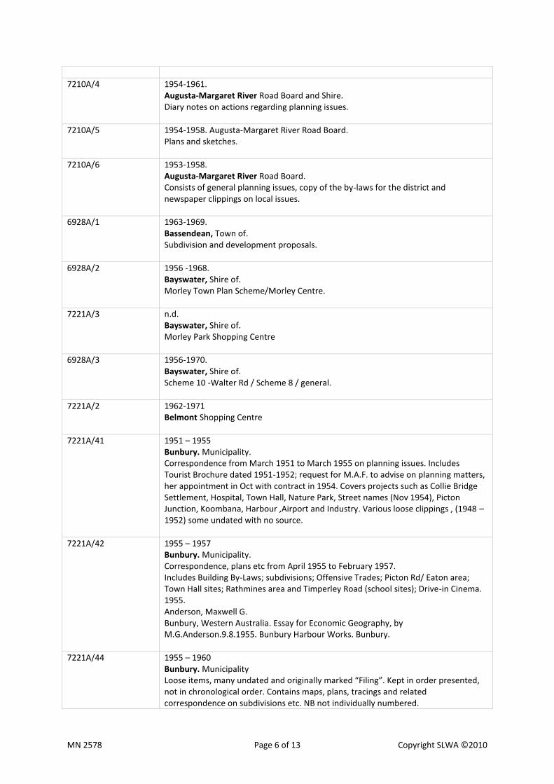
7210A/4 1954-1961. Augusta-Margaret River Road Board and Shire. Diary notes on actions regarding planning issues.
7210A/5 1954-1958. Augusta-Margaret River Road Board. Plans and sketches.
7210A/6 1953-1958. Augusta-Margaret River Road Board. Consists of general planning issues, copy of the by-laws for the district and newspaper clippings on local issues.
6928A/1 1963-1969. Bassendean, Town of. Subdivision and development proposals.
6928A/2 1956 -1968. Bayswater, Shire of. Morley Town Plan Scheme/Morley Centre.
7221A/3 n.d. Bayswater, Shire of. Morley Park Shopping Centre
6928A/3 1956-1970. Bayswater, Shire of. Scheme 10 -Walter Rd / Scheme 8 / general.
7221A/2 1962-1971 Belmont Shopping Centre
7221A/41 1951 – 1955 Bunbury. Municipality. Correspondence from March 1951 to March 1955 on planning issues. Includes Tourist Brochure dated 1951-1952; request for M.A.F. to advise on planning matters, her appointment in Oct with contract in 1954. Covers projects such as Collie Bridge Settlement, Hospital, Town Hall, Nature Park, Street names (Nov 1954), Picton Junction, Koombana, Harbour ,Airport and Industry. Various loose clippings , (1948 – 1952) some undated with no source.
7221A/42 1955 – 1957 Bunbury. Municipality. Correspondence, plans etc from April 1955 to February 1957. Includes Building By-Laws; subdivisions; Offensive Trades; Picton Rd/ Eaton area; Town Hall sites; Rathmines area and Timperley Road (school sites); Drive-in Cinema. 1955. Anderson, Maxwell G. Bunbury, Western Australia. Essay for Economic Geography, by M.G.Anderson.9.8.1955. Bunbury Harbour Works. Bunbury.
7221A/44 1955 – 1960 Bunbury. Municipality Loose items, many undated and originally marked “Filing”. Kept in order presented, not in chronological order. Contains maps, plans, tracings and related correspondence on subdivisions etc. NB not individually numbered.
MN 2578 Page 7 of 13 Copyright SLWA ©2010
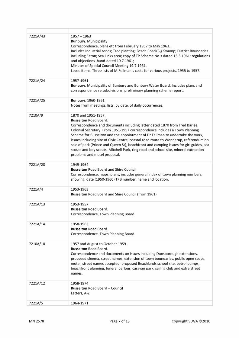
7221A/43 1957 – 1963 Bunbury. Municipality Correspondence, plans etc from February 1957 to May 1963. Includes Industrial zones; Tree planting; Beach Road/Big Swamp; District Boundaries including Eaton; Sea Links area; copy of TP Scheme No 3 dated 15.3.1961; regulations and objections ,hand-dated 19.7.1961; Minutes of Special Council Meeting 19.7.1961. Loose items. Three lists of M.Feilman’s costs for various projects, 1955 to 1957.
7221A/24 1957-1961 Bunbury. Municipality of Bunbury and Bunbury Water Board. Includes plans and correspondence re subdivisions; preliminary planning scheme report.
7221A/25 Bunbury. 1960-1961 Notes from meetings, lists, by date, of daily occurrences.
7210A/9 1870 and 1951-1957. Busselton Road Board. Correspondence and documents including letter dated 1870 from Fred Barlee, Colonial Secretary. From 1951-1957 correspondence includes a Town Planning Scheme for Busselton and the appointment of Dr Feilman to undertake the work, issues including site of Civic Centre, coastal road route to Wonnerup, referendum on sale of park (Prince and Queen St), beachfront and camping issues for girl guides, sea scouts and boy scouts, Mitchell Park, ring road and school site, mineral extraction problems and motel proposal.
7221A/28 1949-1964 Busselton Road Board and Shire Council Correspondence, maps, plans, includes general index of town planning numbers, showing, date (1950-1960) TPB number, name and location.
7221A/4 1953-1963 Busselton Road Board and Shire Council (from 1961)
7221A/13 1953-1957 Busselton Road Board. Correspondence, Town Planning Board
7221A/14 1958-1963 Busselton Road Board. Correspondence, Town Planning Board
7210A/10 1957 and August to October 1959. Busselton Road Board. Correspondence and documents on issues including Dunsborough extensions, proposed cinema, street names, extension of town boundaries, public open space, motel, street names accepted, proposed Beachlands school site, petrol pumps, beachfront planning, funeral parlour, caravan park, sailing club and extra street names.
7221A/12 1958-1974 Busselton Road Board – Council Letters, A-Z
7221A/5 1964-1971

MN 2578 Page 8 of 13 Copyright SLWA ©2010
Busselton Shire Council
7221A/29 1955-1965 Canning Road Board. Subdivisions, diary notes, East Riverton-Canning Vale rezoning, 1966-1968
7221A/30 1955-1965 Canning Road Board and Shire Council Correspondence, maps, plans
7221A/31 1957-1965 Canning Road Board and Shire Council Correspondence, maps, plans
7221A/8 1966-1969 Canning Shire and Town Council East Riverton. Scheme 23
7221A/6 1970-1978 Canning Shire and Town Council
7221A/7
Canning Shire and Town Council Plans re amendments to proposed Lynwood-Ferndale subdivision
7221A/35 Claremont, Municipality and Town of. 1959 – 1969 Lake Claremont. Trees, proposed hockey field and golf course. Draft Town Planning Schemes, 5 (1969) and 6 nd. Aerial photo of area, loose item nd.
6928A/4 1952-1970. Claremont, Municipality of.
7210A/14 1959-1971. Cockburn Town Council. Includes Spearwood scheme, formerly Gerald Road scheme, report on District Development Stultification, street names and proposal for University Land and Phoenix Park.
7221A/27 1959-1972. Cockburn. Shire Council. List of quarries, plans, maps, correspondence.
7221A/26 1959-1973. Cockburn. Hamilton Hill Scheme
6928A/5 1959-1974. Cockburn Shire Council. Zoning scheme.
7210A/11 1960-1971. Cockburn Road Board. Jandakot Wool Scouring Co. Cockburn Shire Council, Bibra Lake and East Coolbellup. Cockburn Town Council, Bibra Lake and Urban Development Area No 3.
7221A/9 1960-1973 Cockburn Road, Town Council, Shire of
MN 2578 Page 9 of 13 Copyright SLWA ©2010
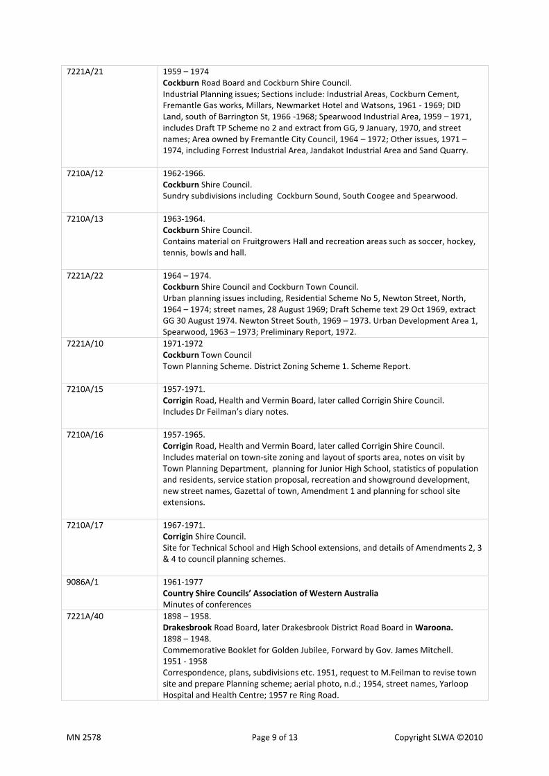
7221A/21 1959 – 1974 Cockburn Road Board and Cockburn Shire Council. Industrial Planning issues; Sections include: Industrial Areas, Cockburn Cement, Fremantle Gas works, Millars, Newmarket Hotel and Watsons, 1961 - 1969; DID Land, south of Barrington St, 1966 -1968; Spearwood Industrial Area, 1959 – 1971, includes Draft TP Scheme no 2 and extract from GG, 9 January, 1970, and street names; Area owned by Fremantle City Council, 1964 – 1972; Other issues, 1971 – 1974, including Forrest Industrial Area, Jandakot Industrial Area and Sand Quarry.
7210A/12 1962-1966. Cockburn Shire Council. Sundry subdivisions including Cockburn Sound, South Coogee and Spearwood.
7210A/13 1963-1964. Cockburn Shire Council. Contains material on Fruitgrowers Hall and recreation areas such as soccer, hockey, tennis, bowls and hall.
7221A/22 1964 – 1974. Cockburn Shire Council and Cockburn Town Council. Urban planning issues including, Residential Scheme No 5, Newton Street, North, 1964 – 1974; street names, 28 August 1969; Draft Scheme text 29 Oct 1969, extract GG 30 August 1974. Newton Street South, 1969 – 1973. Urban Development Area 1, Spearwood, 1963 – 1973; Preliminary Report, 1972.
7221A/10 1971-1972 Cockburn Town Council Town Planning Scheme. District Zoning Scheme 1. Scheme Report.
7210A/15 1957-1971. Corrigin Road, Health and Vermin Board, later called Corrigin Shire Council. Includes Dr Feilman’s diary notes.
7210A/16 1957-1965. Corrigin Road, Health and Vermin Board, later called Corrigin Shire Council. Includes material on town-site zoning and layout of sports area, notes on visit by Town Planning Department, planning for Junior High School, statistics of population and residents, service station proposal, recreation and showground development, new street names, Gazettal of town, Amendment 1 and planning for school site extensions.
7210A/17 1967-1971. Corrigin Shire Council. Site for Technical School and High School extensions, and details of Amendments 2, 3 & 4 to council planning schemes.
9086A/1 1961-1977 Country Shire Councils’ Association of Western Australia Minutes of conferences
7221A/40 1898 – 1958. Drakesbrook Road Board, later Drakesbrook District Road Board in Waroona. 1898 – 1948. Commemorative Booklet for Golden Jubilee, Forward by Gov. James Mitchell. 1951 - 1958 Correspondence, plans, subdivisions etc. 1951, request to M.Feilman to revise town site and prepare Planning scheme; aerial photo, n.d.; 1954, street names, Yarloop Hospital and Health Centre; 1957 re Ring Road.

MN 2578 Page 10 of 13 Copyright SLWA ©2010
1951 – 1955. Loose items; Waroona Town Plan, n.d.; plan of lots 18 & 20, 1951; locations 386, 1952, and contours of 319 & 320, 1955; and Land report (Waroona) 1953. 1955 – 1956. Correspondence & plans re subdivision of lots 215 – 216 owned by W. Johnston and 214 owned by Goldsbrough Mort & Co. 1953 – 1958 Diary notes of M.A. Feilman.
6928A/6 1962-1963. Esperance, Shire of. Heenan Street/Corry Street.
6928A/7 1953-1961. Esperance Road Board.
7221A/18 1961 – 1963. Esperance Road Board and Shire Council. General correspondence on Town Planning matters, By-Laws etc.
7210A/18 1961-1963. Esperance Shire Council. Contains material on Industrial Area, East Location 21, and zoning scheme, proposed caravan park, zoning of town site and letter from ME Mills requesting advice on land for children’s park.
7210A/19 1961-1963. Esperance Shire Council. Includes new development north of Pink Lake Road, report of visit by State Housing Commission, showground and recreation reserve, Police Boys Club and drive-in theatre.
7210A/20 1961-1963. Esperance Shire Council. Includes development of Newtown area, caravan park, motel, primary school, preliminary draft of scheme, lists of lot numbers and values, need for street names, copy of scheme and proposal to rename area Castletown.
6928A/8 1961-1964. Esperance Shire Council. Civic Centre and Town Centre.
7221A/32 A-M 1961-1965 Esperance Shire Council. Indexed file of correspondence, including minutes of meetings, maps and plans
7221A/33 M-Z 1961-1965 Esperance Shire Council. Indexed file of correspondence, including maps and plans
6928A/9 1957-1965. Gosnells Shire Council.
6928A/10 1955-1958. Kalamunda Shire, Darling Range.
7221A/23 1958 – 1966. Kalamunda Shire Council, also Darling Range Road Board (to 1960). Part 2. Includes issues such as 1958, By-Laws – Blasting, Quarry and Excavations;

MN 2578 Page 11 of 13 Copyright SLWA ©2010
1959, Proposed Anglican Church, CWA Building, Gravel Quarry, proposed street names, Maida Vale School site; 1960, Land Exchanges, Industrial Area, Civic Centre. 1961, Library site.1963, amended Town Planning Scheme. 1966, Business Zone. 1961 – 1964 M.Feilman’s Diary Notes. Envelope of loose plans, n.d.
6928A/11 1972-1974. Kalamunda Shire, Forrestfield Scheme No. 9.
6928A/12 1965-1972. Kalamunda Shire, Forrestfield.
7210A/21 1969-1973. Kalamunda Shire, Forrestfield. Includes correspondence with State Electricity Commission and The General Agency Co., proposed site for primary school, high school and technical school, Forrestfield urban development zone and street names listings.
7221A/1 1972-1976 Kalamunda Shire. Forrestfield Scheme 9, Wandoo Road, includes correspondence, plans.
6928A/13 1963-1976. Kojonup Shire Council.
7210A/22 1964-1976. Kojonup Shire Council. Sundry subdivisions, Bowler Place development, including Government Employees’ Housing Authority housing, Home for the Aged, industrial area, Thornbury and Bailey areas, general correspondence including Women’s Club, ring road/by-pass proposal, notice in Government Gazette re amendment 3 to Town Planning scheme.
6928A/14 1957-1971. Mandurah, Shire of.
7210A/23 1953-1974. Melville Road Board, Shire Council, Town Council and City Council. Includes material on various subdivisions, proposal for Town Hall site, proposed industrial area, Bull Creek racecourse proposal, Brentwood shopping centre, street and area names proposed, Ardross and Booragoon school sites proposed, proposed site in Booragoon for administration buildings, library for Canning Bridge, Fenton shopping centre, Queens Hall conversion to shops, Kitchener/Williams Rd shopping centre proposal, North Lake area part to be called Kardinya, proposed Civic Centre, meaning of Myaree, Blackwall Reach area, 1968 Civic centre opened and several extracts from Government Gazette on scheme amendments from 1972-1974.
7210A/24 1967-1973. Melville Town Council. Includes Town Planning Scheme report and proposed ordinance, diary notes and City of Melville programme for the Official Celebration Dinner on 2 May 1968.
7221A/19 1958 – 1960. Merredin Road Board. Planning matters relevant to Lots 38 – 44, for Government Offices, Rest Centre etc. M. Feilman’s diary notes from September 1958 – December 1960.
7210A/25 1951-1958. Midland Junction Municipality.
MN 2578 Page 12 of 13 Copyright SLWA ©2010
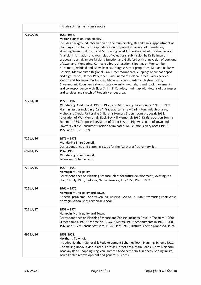
Includes Dr Feilman’s diary notes.
7210A/26 1951-1958. Midland Junction Municipality. Includes background information on the municipality, Dr Feilman’s appointment as planning consultant, correspondence on proposed expansion of boundaries, affecting Swan, Guildford and Mundaring Local Authorities, list of unrateable land, financial information and examples of valuations, submission by Dr Feilman on proposal to amalgamate Midland Junction and Guildford with annexation of portions of Swan and Mundaring, Carnegie Library alteration, clippings on Wexcombe, Hazelmere, Ashfield and Midvale areas, Burgess Street properties, Midland Railway Reserve, Metropolitan Regional Plan, Greenmount area, clippings on wheat depot and high school, Harper Park, open - air Cinema at Helena Street, Caltex service station and Ascension Park issues, Midvale Picture Gardens, Clayton Estate, Greenmount, Koongamia shops, state saw mills, neon signs and stock movements and correspondence with Elder Smith & Co. Also, mud map with details of businesses and services and sketch of Frederick street area.
7221A/20 1958 – 1969 Mundaring Road Board, 1958 – 1959, and Mundaring Shire Council, 1965 – 1969. Planning issues including : 1967, Kindergarten site – Darlington; Industrial area, Mahogany Creek; Parkerville Children’s Homes; Greenmount proposal; 1968, relocation of War Memorial; Black Boy Hill Memorial; 1967, Draft report on Zoning Scheme; 1969, Proposed deviation of Great Eastern Highway south of town and Sawyers Valley; Consultant Position terminated. M. Feilman’s diary notes 1958 – 1959 and 1965 – 1969.
7221A/36 1976 – 1978 Mundaring Shire Council. Correspondence and planning issues for the “Orchards” at Parkerville.
6928A/15 1967-1969. Mundaring Shire Council. Swanview. Scheme no 3.
7221A/15 1953 – 1959. Narrogin Municipality. Correspondence on Planning Scheme; plans for future development ; existing use plan, 14 July 1955; By-Laws; Native Reserve, July 1958; Plans 1959.
7221A/16 1961 – 1970. Narrogin Municipality and Town. “Special problems”; Sports Ground; Reserve 12080; R&I Bank; Swimming Pool; West Narrogin School site; Technical School.
7221A/17 1959 – 1974. Narrogin Municipality and Town. Correspondence on Planning Scheme and Zoning. Includes Drive-in-Theatres, 1960; Street names, 1960; Scheme No 1, GG. 2 March, 1962; Amendments in 1964, 1968, 1969 and 1972; Census Statistics, 1954; Plans 1969; District Scheme proposed, 1974.
6928A/16 1958-1971. Northam, Town of. Includes Northam General & Redevelopment Scheme: Town Planning Scheme No.1, Goomalling Road/Taylor St area, Throssell Street area, Main Roads, North Northam Toodyay Road Shopping Anglican Homes site/Scheme No.4 Kennedy Stirling Inkirn, Town Centre redevelopment and general business.
MN 2578 Page 13 of 13 Copyright SLWA ©2010
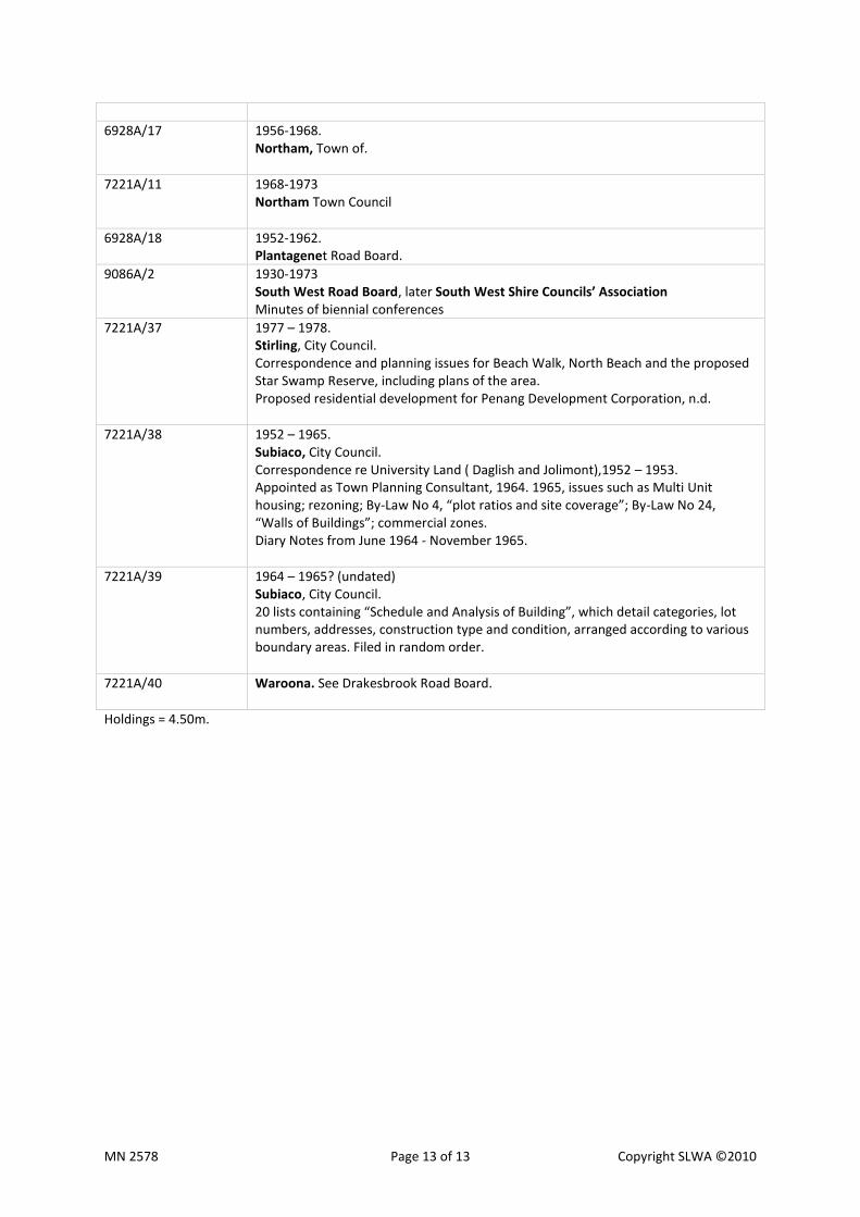
6928A/17 1956-1968. Northam, Town of.
7221A/11 1968-1973 Northam Town Council
6928A/18 1952-1962. Plantagenet Road Board.
9086A/2 1930-1973 South West Road Board, later South West Shire Councils’ Association Minutes of biennial conferences
7221A/37 1977 – 1978. Stirling, City Council. Correspondence and planning issues for Beach Walk, North Beach and the proposed Star Swamp Reserve, including plans of the area. Proposed residential development for Penang Development Corporation, n.d.
7221A/38 1952 – 1965. Subiaco, City Council. Correspondence re University Land ( Daglish and Jolimont),1952 – 1953. Appointed as Town Planning Consultant, 1964. 1965, issues such as Multi Unit housing; rezoning; By-Law No 4, “plot ratios and site coverage”; By-Law No 24, “Walls of Buildings”; commercial zones. Diary Notes from June 1964 - November 1965.
7221A/39 1964 – 1965? (undated) Subiaco, City Council. 20 lists containing “Schedule and Analysis of Building”, which detail categories, lot numbers, addresses, construction type and condition, arranged according to various boundary areas. Filed in random order.
7221A/40 Waroona. See Drakesbrook Road Board.
Holdings = 4.50m.