MJB North Yard Boring Log Explanation Anacortes, Washington
61
BORING LOCATION: KEYFORM (REV. 7/99) MEASURING POINT: TOTAL DEPTH (ft.): DATE FINISHED: DRILLING METHOD: REG. NO. LOGGED BY: 24 HRS. FIRST DEPTH TO 8. ND = No data. Notes 1. Soil descriptions are in accordance with the USCS as set forth by ASTM D2488-90 "Standard Practice for Description and Identification of Soils (Visual-Manual Procedure)." 2. Soil color described according to Munsell Color Chart. 3. Dashed lines separating soil strata represent inferred boundaries between sampled intervals that may be abrupt or gradual transitions. 4. Solid lines represent approximate boundaries observed within sample intervals. 5. OVM = organic vapor meter, reading in volumetric parts per million. Reading collected from baggie headspace. DRILLING CONTRACTOR: 7. NA = Not applicable. WATER Grab soil sample. Interval of recovered soil collected with split spoon sampler. Interval of recovered soil collected with direct push liner. Sample collected for chemical analysis and sample identification. Interval of no recovery. TP-1-9.0 PP-1-13.0 RESPONSIBLE PROFESSIONAL: 6. Odor, if noted is subjective and not necessarily indicative of specific compounds or concentrations. Sample SAMPLING METHOD: COMPL. (feet) SAMPLES REMARKS Blows/ Sample No. READING (ppm) OVM Foot NAME (USCS): color, moist, % by wt., plast. density, structure, DRILLING EQUIPMENT: DATE STARTED: ELEVATION AND DATUM: DROP: DEPTH Boring Log Explanation DESCRIPTION cementation, react. w/HCl, geo. inter. Page 1 of 1 1 2 3 4 5 6 7 8 9 10 11 12 13 14 15 PROJECT: Project No. 10131.000 Anacortes, Washington Surface Elevation: Geomatrix Consultants HAMMER WEIGHT: MJB North Yard
Transcript of MJB North Yard Boring Log Explanation Anacortes, Washington

BORING LOCATION:
KEYFORM (REV. 7/99)
MEASURING POINT:TOTAL DEPTH (ft.):
DATE FINISHED:
DRILLING METHOD:
REG. NO.
LOGGED BY:
24 HRS.FIRSTDEPTH TO
8. ND = No data.
Notes
1. Soil descriptions are in accordance with the USCS as set forthby ASTM D2488-90 "Standard Practice for Description andIdentification of Soils (Visual-Manual Procedure)."
2. Soil color described according to Munsell Color Chart.
3. Dashed lines separating soil strata represent inferredboundaries between sampled intervals that may be abrupt orgradual transitions.
4. Solid lines represent approximate boundaries observed withinsample intervals.
5. OVM = organic vapor meter, reading in volumetric parts permillion. Reading collected from baggie headspace.
DRILLING CONTRACTOR:
7. NA = Not applicable.
WATER
Grab soil sample.
Interval of recovered soil collected with split spoon sampler.
Interval of recovered soil collected with direct push liner.
Sample collected for chemical analysis and sample identification.
Interval of no recovery.
TP-1
-9.0
PP
-1-1
3.0
RESPONSIBLE PROFESSIONAL:
6. Odor, if noted is subjective and not necessarily indicative ofspecific compounds or concentrations.
Sam
ple
SAMPLING METHOD:
COMPL.
(feet
)
SAMPLESREMARKS
Blo
ws/
Sam
ple
No.
RE
AD
ING
(ppm
)
OV
M
Foot
NAME (USCS): color, moist, % by wt., plast. density, structure,
DRILLING EQUIPMENT:
DATE STARTED:
ELEVATION AND DATUM:
DROP:
DE
PTH
Boring Log Explanation
DESCRIPTION
cementation, react. w/HCl, geo. inter.
Page 1 of 1
1
2
3
4
5
6
7
8
9
10
11
12
13
14
15
PROJECT:
Project No. 10131.000
Anacortes, Washington
Surface Elevation:
Geomatrix Consultants
HAMMER WEIGHT:
MJB North Yard

16
19
21
N=40
3
4
3
N=7
13.42 feet MLLW
7/14/05 7/14/05
30
SPT split spoon drive sampler [18" x 2.5"]
POORLY GRADED GRAVEL with SILT and SAND
(GP-GM): very dark grayish brown (10YR 3/2), dry
to moist, 65% fine to coarse gravel, 25% fine to
coarse sand, 10% nonplastic fines, subangular to
angular, contains cobbles up to 1' diameter, gravel is
fine-grained dark gray rock
NA~8.5
7
13
13
N=26
4.22 to 14.0
DATE FINISHED:
SCREEN INTERVAL (ft.):
CASING:
2" Sched. 40 PVCCOMPL.
TOTAL DEPTH (ft.):
12.80 feet MLLW
2" diameter Schedule 40
PVC casing
8" diameter borehole
Bentonite chips
Concrete
2/12 filter pack sand
Schedule 40 PVC
endcap
wet
PEAT with SAND (PT): dark brown mottled yellowish
brown (10YR 3/3), wet, 85% fines, 15% fine sand,
nonplastic, firm, woody peat with interbeds of dark
gray fine sand, sulfitic odor
POORLY GRADED SAND with SILT and GRAVEL
(SP-SM): very dark greenish gray (10Y 3/1), moist,
50% fine to coarse sand, 40% fine to coarse
subrounded to rounded gravel, 10% nonplastic fines
POORLY GRADED SAND with GRAVEL (SP):
brown (10YR 4/3), moist, 50% fine to coarse sand,
45% fine to coarse subrounded to rounded gravel,
5% fines, contains round cobbles up to 4" diameter
MW-5-5.0
2" diameter, 0.010" slot,
Schedule 40 PVC screen
MW-5-10.0
MW-5-0.0
(feet)
DEPTH
OVM
Foot
No.
Blows/
Sample
ReadingSAMPLES
WELL CONSTRUCTION
DETAILS AND/OR
DRILLING REMARKS
N 554363.38; E 1210473.92Sample
PROJECT:
Project No. 10131.000
MJB North YardAnacortes, Washington
300 pounds
1
2
3
4
5
6
7
8
9
10
11
12
13
14
15
Geomatrix Consultants
Traffic Box
Page 1 of 2
LOGGED BY:
DRILLING CONTRACTOR:
BORING LOCATION:
21.5
DATE STARTED:
DROP:
DRILLING EQUIPMENT:
NAME (USCS): color, moist, % by wt., plast. density, structure,
SAMPLING METHOD:
HAMMER WEIGHT:
DESCRIPTION
GROUND SURFACE ELEVATION AND DATUM:
Log of Well No. MW-5
OAKWELLV (REV. 4/00)
L.Hg. 1786
Z. Satterwhite
Cascade Drilling, Inc.
CME-75FIRSTDEPTH TO
WATER:
K. GoodmanREG. NO.
Hollow-stem auger
Surface Elevation:
RESPONSIBLE PROFESSIONAL:
DRILLING METHOD:
cementation, react. w/HCl, geo. inter.

cementation, react. w/HCl, geo. inter.
4
5
9
N=14
12
13
23
N=36
NAME (USCS): color, moist, % by wt., plast. density, structure,
OAKWELLV (REV. 4/00)
Log of Well No. MW-5 (cont'd)
SILT with SAND (ML): dark greenish gray mottled
brown and yellowish-brown (10GY 4/1), moist to wet,
75% fines, 25% fine to coarse sand, low plasticity,
firm, contains pockets of dark gray fine sand, with
white shell fragments to 15.5'
DESCRIPTION
becoming firmer and blocky; less sand
Bottom of boring at 21.5 feet.
2/12 filter pack sand
*Pull augers up about 12
feet.
MW-5-15.0
MW-5-20.0
Bentonite chips
Anacortes, Washington
Geomatrix Consultants
16
17
18
19
20
21
22
23
24
25
26
27
28
29
30
31
32
33
Page 2 of 2
OVM
MJB North Yard
Project No. 10131.000
PROJECT:
Blows/
DRILLING REMARKS
DETAILS AND/OR
WELL CONSTRUCTIONSAMPLES
Sample
DEPTH
No.
Sample
(feet)
Foot
Reading

5
12
14
N=26
SCREEN INTERVAL (ft.):
SPT split spoon drive sampler [18" x 2.5"]
NA
POORLY GRADED GRAVEL with SILT and SAND
(GP-GM): very dark grayish brown (10YR 3/2), dry,
65% fine to coarse gravel, 25% fine to coarse sand,
10% nonplastic fines, subangular to angular, contains
cobbles up to 1' diameter, gravel is fine-grained dark
gray rock
4.20 to 14.0
29
34
25
N=59
DATE FINISHED:
26
50 for 6"
CASING:
2" Sched. 40 PVCCOMPL.
TOTAL DEPTH (ft.):
13.04 feet MLLW
13.42 feet MLLW
7/14/05
2" diameter Schedule 40
PVC casing
8" diameter borehole
Bentonite chips
Concrete
2/12 filter pack sand
SILT with SAND (ML): dark greenish gray mottled
brown and yellowish-brown (10GY 4/1), moist, 85%
fines, 10% fine sand, 5% fine gravel, contains
reddish rootlets/seams, low plasticity, firm to hard
less silty, wet, no odor
very slight mothball-like odor
mothball-like odor
POORLY GRADED SAND with SILT and GRAVEL
(SP-SM): greenish black (10Y 2.5/1), moist, 50%
fine to coarse sand, 40% subrounded to rounded fine
to coarse gravel, 10% nonplastic fines, occasional
cobbles up to 4" in diameter
POORLY GRADED SAND with GRAVEL (SP):
brown (10YR 4/3), moist, 50% fine to coarse sand,
45% fine to coarse gravel, 5% nonplastic fines,
subrounded to rounded, contains round cobbles up to
4" diameter
MW-6-0.0
2" diameter, 0.010" slot,
Schedule 40 PVC screen
MW-6-5.0
*Driller: water at about
10.0' at 10:45 AM
Schedule 40 PVC
endcap
N 554768.47; E 1210309.42MW-6-10.0
No.
DEPTH
OVM
Sample
300 pounds
(feet)
Blows/
Sample
ReadingSAMPLES
WELL CONSTRUCTION
DETAILS AND/OR
DRILLING REMARKS
~10
Foot
PROJECT:
Project No. 10131.000
MJB North YardAnacortes, Washington
Page 1 of 2
1
2
3
4
5
6
7
8
9
10
11
12
13
14
15
Geomatrix Consultants
Traffic Box
FIRST
DESCRIPTION
BORING LOCATION:
21.5
DATE STARTED:
DROP:
CME-75
NAME (USCS): color, moist, % by wt., plast. density, structure,
HAMMER WEIGHT:
DRILLING METHOD:
GROUND SURFACE ELEVATION AND DATUM:
Log of Well No. MW-6
OAKWELLV (REV. 4/00)
L.Hg. 1786
Z. Satterwhite
Cascade Drilling, Inc.
RESPONSIBLE PROFESSIONAL:
7/14/05
LOGGED BY:
K. Goodman30 inches
DEPTH TOWATER:DRILLING EQUIPMENT:
REG. NO.
Hollow-stem auger
SAMPLING METHOD:
Surface Elevation:
cementation, react. w/HCl, geo. inter.
DRILLING CONTRACTOR:

9
13
19
N=32
10
10
20
N=30
DESCRIPTIONNAME (USCS): color, moist, % by wt., plast. density, structure,
cementation, react. w/HCl, geo. inter.
Log of Well No. MW-6 (cont'd)
SILT with SAND (ML): Continued
OAKWELLV (REV. 4/00)
MW-6-15.0
Bottom of boring at 21.5 feet.
2/12 filter pack sand
Bentonite chips
MW-6-20.0
Geomatrix Consultants
16
17
18
19
20
21
22
23
24
25
26
27
28
29
30
31
32
33
Page 2 of 2
Anacortes, WashingtonMJB North Yard
Project No. 10131.000
PROJECT:
Blows/
DRILLING REMARKS
DETAILS AND/OR
WELL CONSTRUCTIONSAMPLES
Sample
No.
Sample
(feet)
Foot
OVM
DEPTH
Reading

13.24 feet MLLW
9
6
11
N=17
7
7
7
N=14
50 for 6"
Cascade Drilling, Inc.
RESPONSIBLE PROFESSIONAL:
7/14/05
30 inches
POORLY GRADED GRAVEL with SILT and SAND
(GP-GM): very dark grayish brown (10YR 3/2), dry,
65% fine to coarse gravel, 25% fine to coarse sand,
10% nonplastic fines, subangular to angular, contains
cobbles up to 1' diameter, gravel is fine-grained dark
gray rock
SPT split spoon drive sampler [18" x 2.5"]
N 555056.70; E 1209849.95 12.98 feet MLLW
NA
TOTAL DEPTH (ft.):
4.21 to 14.0
7/14/05DATE FINISHED:
SCREEN INTERVAL (ft.):
CASING:
2" Sched. 40 PVCCOMPL.
NA
Schedule 40 PVC
endcap
2/12 filter pack sand
2" diameter, 0.010" slot,
Schedule 40 PVC screen
2" diameter Schedule 40
PVC casing
8" diameter borehole
Bentonite chips
SILT with SAND (ML): dark greenish gray mottled
brown and yellowish-brown (10GY 4/1), moist, 75%
fines, 25% fine to coarse sand, low plasticity, soft to
firm, contains dark brown rootlets, also contains
inclusions of green mica/metallic sand
ORGANIC SOIL (OL): dark brown to black (10YR
2/1), moist, 80% fines, 20% fine to coarse sand,
contains woodshards, nonplastic, soft, woody
Concrete
MW-7-10.0
MW-7-5.0
MW-7-3.0
MW-7-0.0
(feet)
DEPTH
OVM
Foot
No.
Blows/
Sample
ReadingSAMPLES
WELL CONSTRUCTION
DETAILS AND/OR
DRILLING REMARKS
Sample
PROJECT:
Project No. 10131.000
MJB North YardAnacortes, Washington
1
2
3
4
5
6
7
8
9
10
11
12
13
14
15
Geomatrix Consultants
Traffic Box
Page 1 of 2
NAME (USCS): color, moist, % by wt., plast. density, structure,
DRILLING EQUIPMENT:
DRILLING METHOD:
DRILLING CONTRACTOR:
BORING LOCATION:
16.5
DATE STARTED:
CME-75
K. Goodman
LOGGED BY:
HAMMER WEIGHT:
DESCRIPTION
GROUND SURFACE ELEVATION AND DATUM:
Log of Well No. MW-7
OAKWELLV (REV. 4/00)
L.Hg. 1786DROP:
Hollow-stem auger
Z. Satterwhite
300 pounds
FIRSTDEPTH TOWATER:
cementation, react. w/HCl, geo. inter.
Surface Elevation:
SAMPLING METHOD:
REG. NO.
NAME (USCS): color, moist, % by wt., plast. density, structure,
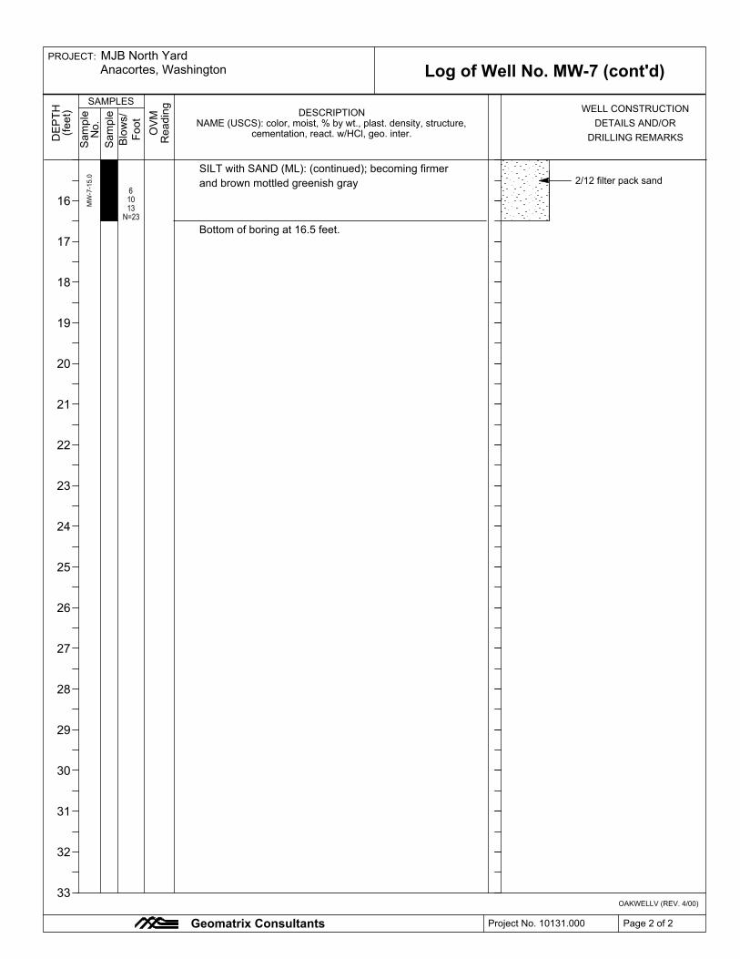
SILT with SAND (ML): (continued); becoming firmer
and brown mottled greenish gray
Log of Well No. MW-7 (cont'd)
DRILLING REMARKScementation, react. w/HCl, geo. inter.DETAILS AND/OR
DESCRIPTION
6
10
13
N=23
MW-7-15.0 2/12 filter pack sand
Bottom of boring at 16.5 feet.
OAKWELLV (REV. 4/00)
PROJECT:
Project No. 10131.000
MJB North YardAnacortes, Washington
Page 2 of 2
16
17
18
19
20
21
22
23
24
25
26
27
28
29
30
31
32
33
Foot
WELL CONSTRUCTIONSAMPLES
Reading
Sample
Blows/
No.
(feet)
OVM
DEPTH
Geomatrix Consultants
Sample

ELEVATION AND DATUM:
K. Goodman
Surface Elevation:
EXCAVATION BUCKET DIMENSIONS:
WATER
FIRST
Not surveyed; datum is ground surface
L.Hg. 1786
Test Pit Log No. TP-1
SAMPLING METHOD:
LOGGED BY:
OAKTESTPIT (REV. 6/03)
Gary Merlino Construction Company, Inc.
Kurt KamiusOVM
COMPL.
RI-TP-1-1.5
RI-TP-1-3.0
RI-TP-1-7.0
POORLY GRADED GRAVEL with SILT and SAND (GP-GM):
very dark grayish brown (10YR 3/2), dry, 65% fine to coarse
subangular to angular gravel with cobbles up to 1' diameter,
25% fine to coarse sand, 10% nonplastic fines, gravel is
fine-grained dark gray rock
POORLY GRADED SAND with SILT and GRAVEL (SP-SM):
greenish black (10Y 2.5/1), moist, 50% fine to coarse sand,
40% fine to coarse subrounded to rounded gravel up to 6" in
diameter, 10% nonplastic fines, odor
ORGANIC SOIL (OL): dark brown to black (10YR 2/1), moist,
90% fines, 10% fine gravel, nonplastic, firm, contains rootlets
and wood, fluffy like peat, contains brick or red paint gravel up
to 3" diameter
POORLY GRADED SAND with SILT (SP-SM): very dark gray
(10YR 3/1), dry to moist, 85% fine to coarse sand, 10%
nonplastic fines, 5% fine gravel, fluffy/light/ashy, speckled white
SILTY SAND with GRAVEL (SM): black (10YR 2/1), moist,
50% fine to coarse sand, 30% fine subangular to subrounded
gravel, 20% nonplastic fines, contains wood chunks
wet
Z. Satterwhite
Bottom of test pit at 11.25 feet. Excavation backfilled with
cuttings in reverse order to ground surface, and compacted
with backhoe bucket.
Rubber-tired backhoe
Case 580L Backhoe
7/12/05
NA
SILT with SAND (ML): dark greenish gray mottled brown and
yellowish-brown (10GY 4/1), moist, 75% fines, 20% fine to
coarse sand, 5% fine gravel, low plasticity, firm, contains
inclusions of coarse silica sand with gold flakes (mica?)
DATE STARTED:
Project No. 10131.000 Page 1 of 1
MJB North YardAnacortes, Washington
Geomatrix Consultants
DEPTH
(feet)
SAMPLESREMARKS
Sample
Sample
No.
READING
(ppm)
Not surveyed
RESPONSIBLE PROFESSIONAL: REG. NO.
DATE FINISHED:
TOTAL DEPTH (ft.): MEASURING POINT:
DEPTH TO
18 inches
11.0
PROJECT:
Ground surface
1
2
3
4
5
6
7
8
9
10
11
12
13
14
15
7/12/05
cementation, react. w/HCl, geo. inter.
8.5
NAME (USCS): color, moist, % by wt., plast. density, structure,
EXCAVATION EQUIPMENT:
OPERATOR:
EXCAVATION CONTRACTOR:
TEST PIT LOCATION:
DESCRIPTION

LOGGED BY:
FIRST
Not surveyed; datum is ground surface
COMPL.
L.Hg. 1786
OVM
Surface Elevation:
OAKTESTPIT (REV. 6/03)
Gary Merlino Construction Company, Inc.
Kurt Kamius
ELEVATION AND DATUM:
RESPONSIBLE PROFESSIONAL:SAMPLING METHOD:
RI-TP-2-1.0
RI-TP-2-3.5
SILTY GRAVEL with SAND (GM): brown (10YR 4/3), dry to
moist, 60% fine to coarse subrounded to angular gravel with
cobbles up to 1' diameter, 20% fine to coarse sand, 20%
nonplastic fines
POORLY GRADED SAND with GRAVEL (SP): brown
becoming gray (10YR 4/3), moist, 50% fine to coarse sand,
45% fine to coarse gravel, 5% nonplastic fines, subrounded to
rounded, contains round cobbles up to 4" diameter
ORGANIC SOIL (OL): dark brown to black (10YR 2/1), moist,
90% fines, 10% fine gravel, nonplastic, firm, contains rootlets
and wood, fluffy like peat, contains brick or red paint gravel up
to 3" diameter
POORLY GRADED SAND with GRAVEL (SP): gray (10YR
5/1),
SILT with SAND (ML): dark greenish gray mottled brown and
yellowish-brown (10GY 4/1), moist, 75% fines, 20% fine to
coarse sand, 5% fine gravel, low plasticity, firm, contains
inclusions of coarse silica sand with gold flakes (mica?)
Bottom of test pit at 9.0 feet. Excavation backfilled with
cuttings in reverse order to ground surface, and compacted
with backhoe bucket.
WATER
EXCAVATION BUCKET DIMENSIONS:
Rubber-tired backhoe
Case 580L Backhoe
7/12/05
NA
Test Pit Log No. TP-2
Z. Satterwhite
K. GoodmanREG. NO.
DATE FINISHED:
PROJECT:
DATE STARTED:
Page 1 of 1
MJB North YardAnacortes, Washington
Geomatrix Consultants
DEPTH
(feet)
SAMPLESREMARKS
Sample
Sample
No.
READING
(ppm) NAME (USCS): color, moist, % by wt., plast. density, structure,
TOTAL DEPTH (ft.): MEASURING POINT:
DEPTH TO
18 inches
9.0
NA
Ground surface
Not surveyed
Project No. 10131.000
cementation, react. w/HCl, geo. inter.
DESCRIPTION
1
2
3
4
5
6
7
8
9
10
11
12
13
14
15
7/12/05
TEST PIT LOCATION:
EXCAVATION EQUIPMENT:
OPERATOR:
EXCAVATION CONTRACTOR:

COMPL.
L.Hg. 1786SAMPLING METHOD:
TOTAL DEPTH (ft.):
OAKTESTPIT (REV. 6/03)
FIRST
Gary Merlino Construction Company, Inc.
Kurt Kamius
ELEVATION AND DATUM:
DATE STARTED:
RESPONSIBLE PROFESSIONAL: REG. NO.
LOGGED BY:
Case 580L Backhoe
RI-TP-3-5.0
POORLY GRADED GRAVEL with SILT and SAND (GP-GM):
very dark grayish brown (10YR 3/2), dry, 65% fine to coarse
subangular to angular gravel, 25% fine to coarse sand, 10%
nonplastic fines, contains cobbles up to 1' diameter, gravel is
fine-grained dark gray rock
POORLY GRADED SAND with GRAVEL (SP): brown (10YR
4/3), moist, 50% fine to coarse sand, 45% fine to coarse gravel,
5% nonplastic fines, subrounded to rounded, contains round
cobbles up to 4" diameter
POORLY GRADED SAND with SILT and GRAVEL (SP-SM):
greenish black (10Y 2.5/1), moist, 50% fine to coarse sand,
40% fine to coarse subrounded to rounded gravel with rounded
cobbles up to 4" diameter, 10% nonplastic fines
wet
Bottom of test pit at 7.0 feet due to caving. Excavation
backfilled with cuttings in reverse order to ground surface, and
compacted with backhoe bucket.
Rubber-tired backhoe
Not surveyed; datum is ground surface
7/12/05
NA
Test Pit Log No. TP-3
Z. Satterwhite
K. Goodman
Surface Elevation:
EXCAVATION BUCKET DIMENSIONS:
WATER
MEASURING POINT:
PROJECT:
DATE FINISHED:
Page 1 of 1
MJB North YardAnacortes, Washington
Geomatrix Consultants
OVM
DEPTH
(feet)
SAMPLESREMARKS
Sample
Sample
No.
READING
(ppm)
EXCAVATION CONTRACTOR:
DEPTH TO
18 inches
7.0
6.5
Ground surface
Not surveyed
7/12/05
cementation, react. w/HCl, geo. inter.NAME (USCS): color, moist, % by wt., plast. density, structure,
Project No. 10131.000
TEST PIT LOCATION:
OPERATOR:
EXCAVATION EQUIPMENT:
1
2
3
4
5
6
7
8
9
10
11
12
13
14
15
DESCRIPTION

L.Hg. 1786
Z. Satterwhite
K. Goodman
Surface Elevation:
EXCAVATION BUCKET DIMENSIONS:
WATER
FIRST
Not surveyed; datum is ground surface
COMPL.
7/12/05
SAMPLING METHOD:
LOGGED BY:
OAKTESTPIT (REV. 6/03)
Gary Merlino Construction Company, Inc.
OVM
RI-TP-4-0.0
RI-TP-4-1.0
RI-TP-4-4.5
POORLY GRADED GRAVEL with SILT and SAND (GP-GM):
very dark grayish brown (10YR 3/2), dry, 65% fine to coarse
subangular to angular gravel with cobbles up to 1' diameter,
25% fine to coarse sand, 10% nonplastic fines, gravel is
fine-grained dark gray rock
POORLY GRADED SAND with GRAVEL (SP): brown (10YR
4/3), moist, 50% fine to coarse sand, 45% fine to coarse
subrounded to rounded gravel with round cobbles up to 4"
diameter, 5% nonplastic fines
silty sand with gravel
POORLY GRADED SAND with SILT and GRAVEL (SP-SM):
greenish black (10Y 2.5/1), moist, 50% fine to coarse sand,
40% fine to coarse subrounded to rounded gravel up to 6" in
diameter, 10% nonplastic fines
matted wood material
wet
Test Pit Log No. TP-4
Bottom of test pit at 10.5 feet. Excavation backfilled with
cuttings in reverse order to ground surface, and compacted
with backhoe bucket.
NA
Rubber-tired backhoe
Case 580L Backhoe
SILT with SAND (ML): dark greenish gray mottled brown and
yellowish-brown (10GY 4/1), moist, 75% fines, 20% fine to
coarse sand, 5% fine gravel, low plasticity, firm, contains
inclusions of coarse silica sand with gold flakes (mica?)
ELEVATION AND DATUM:
Kurt Kamius
Project No. 10131.000 Page 1 of 1
MJB North YardAnacortes, Washington
Geomatrix Consultants
1
2
3
4
5
6
7
8
9
10
11
12
13
14
15
DEPTH
(feet)
SAMPLESREMARKS
Sample
Sample
No.
READING
(ppm)
Ground surface
DATE STARTED:
RESPONSIBLE PROFESSIONAL: REG. NO.
DATE FINISHED:
TOTAL DEPTH (ft.): MEASURING POINT:
DEPTH TO
18 inches
PROJECT:
6.5
Not surveyed
7/12/05
10.5
cementation, react. w/HCl, geo. inter.
EXCAVATION EQUIPMENT:
OPERATOR:
EXCAVATION CONTRACTOR:
TEST PIT LOCATION:
DESCRIPTIONNAME (USCS): color, moist, % by wt., plast. density, structure,

LOGGED BY:
FIRST
Not surveyed; datum is ground surface
COMPL.
L.Hg. 1786
OVM
Surface Elevation:
OAKTESTPIT (REV. 6/03)
Gary Merlino Construction Company, Inc.
Kurt Kamius
ELEVATION AND DATUM:
RESPONSIBLE PROFESSIONAL:SAMPLING METHOD:
RI-TP-5-4.0
RI-TP-5-5.5
POORLY GRADED GRAVEL with SILT and SAND (GP-GM):
very dark grayish brown (10YR 3/2), dry to moist, 65% fine to
coarse subangular to angular gravel with cobbles up to 1'
diameter, 25% fine to coarse sand, 10% nonplastic fines,
gravel is fine-grained dark gray rock
POORLY GRADED SAND with GRAVEL (SP): brown (10YR
4/3), moist, 50% fine to coarse sand, 45% fine to coarse gravel,
5% nonplastic fines, subrounded to rounded, contains round
cobbles up to 4" diameter
POORLY GRADED SAND with SILT and GRAVEL (SP-SM):
greenish black (10Y 2.5/1), moist, 50% fine to coarse sand,
40% fine to coarse subrounded to rounded cobbles up to 6"
diameter, 10% nonplastic fines
SILTY SAND with GRAVEL (SM): black (10YR 2/1), moist to
wet, 50% fine to coarse sand, 30% fine subangular to
subrounded gravel, 20% nonplastic fines, contains wood
chunks, metal pipe debris, rope, yellow sulfur chunks
wood piling (?)
Bottom of test pit at 8.5 feet due to caving. Excavation
backfilled with cuttings in reverse order to ground surface, and
compacted with backhoe bucket.
WATER
EXCAVATION BUCKET DIMENSIONS:
Rubber-tired backhoe
Case 580L Backhoe
7/12/05
NA
Test Pit Log No. TP-5
Z. Satterwhite
K. GoodmanREG. NO.
DATE FINISHED:
PROJECT:
DATE STARTED:
Page 1 of 1
MJB North YardAnacortes, Washington
Geomatrix Consultants
DEPTH
(feet)
SAMPLESREMARKS
Sample
Sample
No.
READING
(ppm) NAME (USCS): color, moist, % by wt., plast. density, structure,
TOTAL DEPTH (ft.): MEASURING POINT:
DEPTH TO
18 inches
8.5
8.0
Ground surface
Not surveyed
Project No. 10131.000
cementation, react. w/HCl, geo. inter.
DESCRIPTION
1
2
3
4
5
6
7
8
9
10
11
12
13
14
15
7/12/05
TEST PIT LOCATION:
EXCAVATION EQUIPMENT:
OPERATOR:
EXCAVATION CONTRACTOR:

OAKTESTPIT (REV. 6/03)
Not surveyed; datum is ground surface
COMPL.
L.Hg. 1786SAMPLING METHOD:
DATE FINISHED:
LOGGED BY:EXCAVATION BUCKET DIMENSIONS:
Gary Merlino Construction Company, Inc.
Kurt Kamius
DATE STARTED:
OVM
REG. NO.
RI-TP-6-0.0
RI-TP-6-1.0
RI-TP-6-6.0
POORLY GRADED GRAVEL with SILT and SAND (GP-GM):
very dark grayish brown (10YR 3/2), dry, 50% fine to coarse
subangular to angular gravel with cobbles up to 1' diameter,
40% fine to coarse sand, 10% fines, gravel is fine-grained dark
gray rock
POORLY GRADED SAND with GRAVEL (SP): brown (10YR
4/3), moist, 50% fine to coarse sand, 45% fine to coarse gravel,
5% nonplastic fines, subrounded to rounded, contains round
cobbles up to 4" diameter
SILTY GRAVEL with SAND (GM): greenish black (10Y 2.5/1),
moist, 45% fine to coarse subangular to subrounded gravel,
35% fine to coarse sand, 20% nonplastic fines, contains trace
wood shards, mothball-like odor, concrete chunks (1.5' diam),
orange rusty slag chunks at 6.5' (8" diam), twine or rope at 7'
SILT with SAND (ML): dark greenish gray mottled brown and
yellowish-brown (10GY 4/1), moist, 75% fines, 20% fine to
coarse sand, 5% fine gravel, low plasticity, firm, contains
inclusions of coarse silica sand with gold flakes (mica?)
Bottom of test pit at 10.0 feet. Excavation backfilled with
cuttings in reverse order to ground surface, and compacted
with backhoe bucket.
FIRST
WATER
Rubber-tired backhoe
Case 580L Backhoe
7/12/05
NA
Test Pit Log No. TP-6
Z. Satterwhite
K. Goodman
Surface Elevation:
RESPONSIBLE PROFESSIONAL:
TOTAL DEPTH (ft.):
Project No. 10131.000
ELEVATION AND DATUM:
MJB North YardAnacortes, Washington
Geomatrix Consultants
PROJECT:DEPTH
(feet)
SAMPLESREMARKS
Sample
Sample
No.
READING
(ppm) NAME (USCS): color, moist, % by wt., plast. density, structure,
MEASURING POINT:
DEPTH TO
18 inches
10.0
8.0
Ground surface
Not surveyed
Page 1 of 1
cementation, react. w/HCl, geo. inter.
DESCRIPTION
TEST PIT LOCATION:
1
2
3
4
5
6
7
8
9
10
11
12
13
14
15
7/12/05EXCAVATION CONTRACTOR:
EXCAVATION EQUIPMENT:
OPERATOR:
REG. NO.
FIRST
Not surveyed; datum is ground surface
COMPL.
L.Hg. 1786
EXCAVATION BUCKET DIMENSIONS:
SAMPLING METHOD:
Surface Elevation:
LOGGED BY:
OAKTESTPIT (REV. 6/03)
Gary Merlino Construction Company, Inc.
Kurt Kamius
DATE STARTED:
OVM
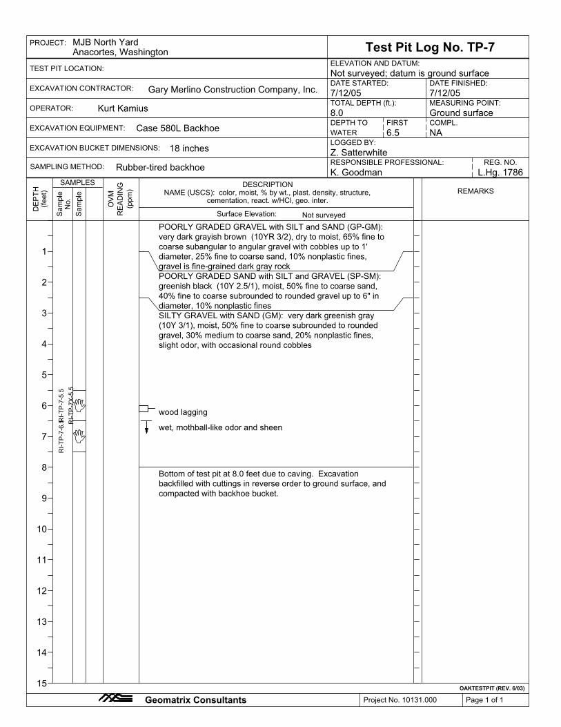
RI-TP-7-5.5
RI-TP-7X-5.5
RI-TP-7-6.5
POORLY GRADED GRAVEL with SILT and SAND (GP-GM):
very dark grayish brown (10YR 3/2), dry to moist, 65% fine to
coarse subangular to angular gravel with cobbles up to 1'
diameter, 25% fine to coarse sand, 10% nonplastic fines,
gravel is fine-grained dark gray rock
POORLY GRADED SAND with SILT and GRAVEL (SP-SM):
greenish black (10Y 2.5/1), moist, 50% fine to coarse sand,
40% fine to coarse subrounded to rounded gravel up to 6" in
diameter, 10% nonplastic fines
SILTY GRAVEL with SAND (GM): very dark greenish gray
(10Y 3/1), moist, 50% fine to coarse subrounded to rounded
gravel, 30% medium to coarse sand, 20% nonplastic fines,
slight odor, with occasional round cobbles
wood lagging
wet, mothball-like odor and sheen
Bottom of test pit at 8.0 feet due to caving. Excavation
backfilled with cuttings in reverse order to ground surface, and
compacted with backhoe bucket.
WATER
RESPONSIBLE PROFESSIONAL:Rubber-tired backhoe
Case 580L Backhoe
7/12/05
NA
Test Pit Log No. TP-7
Z. Satterwhite
K. Goodman
DATE FINISHED:
PROJECT:
ELEVATION AND DATUM:
Page 1 of 1
MJB North YardAnacortes, Washington
Geomatrix Consultants
DEPTH
(feet)
SAMPLESREMARKS
Sample
Sample
No.
READING
(ppm) NAME (USCS): color, moist, % by wt., plast. density, structure,
TOTAL DEPTH (ft.): MEASURING POINT:
DEPTH TO
18 inches
8.0
6.5
Ground surface
Not surveyed
Project No. 10131.000
cementation, react. w/HCl, geo. inter.
DESCRIPTION
1
2
3
4
5
6
7
8
9
10
11
12
13
14
15
7/12/05
TEST PIT LOCATION:
EXCAVATION EQUIPMENT:
OPERATOR:
EXCAVATION CONTRACTOR:

COMPL.
Z. Satterwhite
K. Goodman
Surface Elevation:
EXCAVATION BUCKET DIMENSIONS:
WATER
FIRST
Not surveyed; datum is ground surface
Test Pit Log No. TP-8
NA
L.Hg. 1786SAMPLING METHOD:
LOGGED BY:
OAKTESTPIT (REV. 6/03)
Sample
Gary Merlino Construction Company, Inc.
Sample
ORGANIC SOIL (OL): dark brown to black (10YR 2/1), moist,
90% fines, 10% fine sand, nonplastic, firm, wood matting on
top, contains rootlets, becomes brown (7.5YR 4/4) towards
bottom
No.
READING
(ppm)
OVM
RI-TP-8-0.0
RI-TP-8-1.5
RI-TP-8-3.5
POORLY GRADED SAND with SILT and GRAVEL (SP-SM):
greenish black (10Y 2.5/1), moist, 50% fine to coarse sand,
40% fine subrounded to rounded gravel, 10% nonplastic fines
Kurt Kamius
SILT with SAND (ML): dark greenish gray mottled brown and
yellowish-brown (10GY 4/1), moist, 75% fines, 25% fine to
coarse sand, low plasticity, soft to firm
Bottom of test pit at 9.0 feet. Excavation backfilled with
cuttings in reverse order to ground surface, and compacted
with backhoe bucket.
Note: asphalt and white 6"
diameter (sewer?) pipe to
east of test pit.
Tin can lid at 5 feet.
Rubber-tired backhoe
Case 580L Backhoe
7/12/05
SILTY GRAVEL with SAND (GM): brown (10YR 4/3), dry to
moist, 60% fine to coarse gravel, 20% fine to coarse sand, 20%
nonplastic fines, subrounded to angular, contains cobbles up to
1' diameter
Geomatrix Consultants
1
2
3
4
5
6
7
8
9
10
11
12
13
14
15
PROJECT:
Project No. 10131.000 Page 1 of 1
Anacortes, Washington
DEPTH
(feet)
SAMPLESREMARKS
MJB North Yard
9.0
ELEVATION AND DATUM:
DATE STARTED:
RESPONSIBLE PROFESSIONAL: REG. NO.
DATE FINISHED:
TOTAL DEPTH (ft.): MEASURING POINT:
18 inches
6.5
Ground surface
EXCAVATION CONTRACTOR:7/12/05
cementation, react. w/HCl, geo. inter.NAME (USCS): color, moist, % by wt., plast. density, structure,
DESCRIPTION
TEST PIT LOCATION:
Not surveyed
DEPTH TOEXCAVATION EQUIPMENT:
OPERATOR:

L.Hg. 1786SAMPLING METHOD:
LOGGED BY:
OAKTESTPIT (REV. 6/03)
Gary Merlino Construction Company, Inc.
OVM
ELEVATION AND DATUM:
DATE STARTED:
RESPONSIBLE PROFESSIONAL: REG. NO.
DATE FINISHED:
TOTAL DEPTH (ft.):
DEPTH TO
Kurt Kamius
RI-TP-9-0.0
POORLY GRADED GRAVEL with SILT and SAND (GP-GM):
very dark grayish brown (10YR 3/2), moist, 75% fine to coarse
gravel, 15% fine to coarse sand, 10% nonplastic fines,
subangular to angular, contains cobbles up to 1' diameter,
gravel is fine-grained dark gray rock, contains wood fragments
SILT with SAND (ML): dark greenish gray mottled brown and
yellowish-brown (10GY 4/1), moist, 75% fines, 20% fine to
coarse sand, 5% fine gravel, low plasticity, soft, contains
inclusions of coarse silica sand with gold flakes (mica?)
Bottom of test pit at 10.0 feet. Excavation backfilled with
cuttings in reverse order to ground surface, and compacted
with backhoe bucket.
Rubber-tired backhoe
Case 580L Backhoe
7/12/05
COMPL.
Test Pit Log No. TP-9
Z. Satterwhite
K. Goodman
Surface Elevation:
EXCAVATION BUCKET DIMENSIONS:
WATER
FIRST
Not surveyed; datum is ground surface
18 inches
NA
MEASURING POINT:
MJB North YardAnacortes, Washington
Geomatrix Consultants Project No. 10131.000
PROJECT:DEPTH
(feet)
SAMPLESREMARKS
Sample
Sample
No.
READING
(ppm)
EXCAVATION EQUIPMENT:NA
Ground surface
Not surveyed
7/12/05
cementation, react. w/HCl, geo. inter.NAME (USCS): color, moist, % by wt., plast. density, structure,
DESCRIPTION
TEST PIT LOCATION:
Page 1 of 1
OPERATOR:10.0
1
2
3
4
5
6
7
8
9
10
11
12
13
14
15
EXCAVATION CONTRACTOR:

SAMPLING METHOD:RESPONSIBLE PROFESSIONAL:
WATER
FIRST
Not surveyed; datum is ground surface
COMPL.
L.Hg. 1786
Surface Elevation:
K. Goodman
LOGGED BY:
OAKTESTPIT (REV. 6/03)
Gary Merlino Construction Company, Inc.
Kurt Kamius
ELEVATION AND DATUM:RI-TP-10-6.5
POORLY GRADED GRAVEL with SILT and SAND (GP-GM):
very dark grayish brown (10YR 3/2), dry, 65% fine to coarse
subangular to angular gravel with cobbles up to 1' diameter,
25% fine to coarse sand, 10% nonplastic fines, gravel is
fine-grained dark gray rock
POORLY GRADED SAND with GRAVEL (SP): brown (10YR
4/3), moist, 50% fine to coarse sand, 45% fine to coarse gravel,
5% nonplastic fines, subrounded to rounded, contains round
cobbles up to 4" diameter
POORLY GRADED SAND with SILT and GRAVEL (SP-SM):
greenish black (10Y 2.5/1), moist, 50% fine to coarse sand,
40% fine to coarse subrounded to rounded gravel up to 6" in
diameter, 10% nonplastic fines
concrete chunk @ west of hole (>4' in diam, left in place).
SILTY GRAVEL with SAND (GM): greenish black (10Y 2.5/1),
moist, 40% fine to coarse subangular to subrounded gravel,
35% fine to coarse sand, 25% nonplastic fines, contains trace
wood shards, concrete chunks, orange rusty slag chunks, twine
and rope, slight mothball-like odor
rebar
wet
Bottom of test pit at 8.0 feet due to caving. Excavation
backfilled with cuttings in reverse order to ground surface, and
compacted with backhoe bucket.
EXCAVATION BUCKET DIMENSIONS:
REG. NO.Rubber-tired backhoe
Case 580L Backhoe
7/12/05
NA
Test Pit Log No. TP-10
Z. Satterwhite
DATE STARTED:
PROJECT:
Project No. 10131.000 Page 1 of 1
MJB North YardAnacortes, Washington
Geomatrix Consultants
DEPTH
(feet)
SAMPLESREMARKS
Sample
Sample
No.
READING
(ppm)
DESCRIPTION
DATE FINISHED:
TOTAL DEPTH (ft.): MEASURING POINT:
DEPTH TO
18 inches
8.0
7.5
Ground surface
Not surveyed
7/12/05
NAME (USCS): color, moist, % by wt., plast. density, structure,
1
2
3
4
5
6
7
8
9
10
11
12
13
14
15
cementation, react. w/HCl, geo. inter.
OVM
EXCAVATION EQUIPMENT:
OPERATOR:
EXCAVATION CONTRACTOR:
TEST PIT LOCATION:

REG. NO.K. Goodman L.Hg. 1786
Log of Boring No. PP-1
NA
NAME (USCS): color, moist, % by wt., plast. density, structure,
Direct push
SAMPLING METHOD:LOGGED BY:Z. Satterwhite
OAKBOREV (REV. 3/00)
DRILLING METHOD:
RESPONSIBLE PROFESSIONAL:
Geoprobe macro-core sampler [4’ x 1.5"]
OV
MCOMPL.
4.0
TOTAL DEPTH (ft.):
BORING LOCATION:
DRILLING CONTRACTOR:
Ground surface
POORLY GRADED GRAVEL with SILT and SAND (GP-GM):very dark gray (10YR 3/1), dry, 65% fine to coarse gravel, 25%fine to coarse sand, 10% nonplastic fines, subangular to angular,contains cobbles up to 1' diameter, gravel is fine-grained darkgray rockSILTY SAND with GRAVEL (SM): brown (10YR 4/3), moist,55% fine to coarse sand, 30% rounded to subangular fine tocoarse gravel, 15% low plasticity fines
SILTY GRAVEL with SAND (GM): dark gray (10Y 3/1), moist,45% fine to coarse subrounded to rounded gravel, 30% fine tocoarse sand, 25% low plasticity fineswet
SILT with SAND (ML): greenish gray mottled yellowish brown(10GY 5/1), moist, 70% fines, 20% fine to coarse sand, 10%subangular fine to coarse gravel, low plasticity, hard, containstrace dark brown rootlets, also contains inclusions of greenmica/metallic sand
PP
-1-0
.0P
P-1
-4.0
PP
-1-8
.0
NA
Bottom of boring at 12.0 feet. Boring backfilled with hydratedbentonite chips.
PROJECT:
Project No. 10131.000 Page 1 of 1
MEASURING POINT:
Anacortes, WashingtonMJB North Yard
DE
PTH
(feet
)
SAMPLESREMARKS
Blo
ws/
Foot
Sam
ple
Sam
ple
No.
RE
AD
ING
(ppm
)
cementation, react. w/HCl, geo. inter.
NA
DATE STARTED:2/9/06 2/9/06
ELEVATION AND DATUM:
Geomatrix Consultants
1
2
3
4
5
6
7
8
9
10
11
12
13
14
15
DEPTH TO WATER (ft.)
12.0Power Probe 9630 Pro-D
DESCRIPTION
FIRST
HAMMER WEIGHT:
Surface Elevation:
DROP:
N 555188.99; E 1210202.95 Not surveyed; datum is ground surfaceDATE FINISHED:
Not surveyed
Cascade Drilling, Inc.
DRILLING EQUIPMENT:

Z. Satterwhite
TOTAL DEPTH (ft.):
K. Goodman L.Hg. 1786
Log of Boring No. PP-2
NA
NAME (USCS): color, moist, % by wt., plast. density, structure,
Direct push
LOGGED BY:
OAKBOREV (REV. 3/00)
Ground surface
RESPONSIBLE PROFESSIONAL: REG. NO.
OV
M
NACOMPL.
4.0SAMPLING METHOD:
Bottom of boring at 12.0 feet. Boring backfilled with hydratedbentonite chips.
POORLY GRADED GRAVEL with SILT and SAND (GP-GM):very dark gray (10YR 3/1), dry, 65% fine to coarse gravel, 25%fine to coarse sand, 10% nonplastic fines, subangular to angular,contains cobbles up to 1' diameter, gravel is fine-grained darkgray rock
wet
SILT (ML): gray (10YR 5/1), moist, 90% fines, 10% fine sand,low plasticity, soft
dark brown
SILT with SAND (ML): greenish gray mottled yellowish brown(10GY 5/1), moist, 70% fines, 20% fine to coarse sand, 10%subangular fine to coarse gravel, low plasticity, hard, containstrace dark brown rootlets, also contains inclusions of greenmica/metallic sand
PP
-2-0
.0P
P-2
-4.0
PP
-2-5
.0P
P-2
-8.5
SANDY SILT (ML) (wet)
PROJECT:
Project No. 10131.000 Page 1 of 1
BORING LOCATION:
MJB North Yard
Geoprobe macro-core sampler [4’ x 1.5"]
Geomatrix Consultants
1
2
3
4
5
6
7
8
9
10
11
12
13
14
15
DE
PTH
(feet
)
SAMPLESREMARKS
Blo
ws/
Foot
Sam
ple
Sam
ple
No.
RE
AD
ING
(ppm
)
12.0
ELEVATION AND DATUM:
MEASURING POINT:
DATE STARTED:
DRILLING METHOD:
Power Probe 9630 Pro-D
NA
DRILLING CONTRACTOR:
Anacortes, Washington
2/9/06
DEPTH TO WATER (ft.)
2/9/06
Surface Elevation:
DESCRIPTION
Not surveyed; datum is ground surface
FIRST
N 555180.98; E 1210216.24
cementation, react. w/HCl, geo. inter.
DATE FINISHED:
Not surveyed
Cascade Drilling, Inc.
DRILLING EQUIPMENT:
DROP:HAMMER WEIGHT:

SAMPLING METHOD:
COMPL.
K. Goodman L.Hg. 1786
Log of Boring No. PP-3
NA
OV
M
NA
NAME (USCS): color, moist, % by wt., plast. density, structure,
Geoprobe macro-core sampler [4’ x 1.5"]
Direct push
RESPONSIBLE PROFESSIONAL:
OAKBOREV (REV. 3/00)
Z. SatterwhiteLOGGED BY:
SILT with GRAVEL (ML): dark greenish gray mottled yellowishbrown (5G 4/1), moist, 80% fines, 20% rounded fine to coarsegravel, low plasticity, hard, contains trace dark brown rootlets,also contains inclusions of green mica/metallic sand
POORLY GRADED GRAVEL with SILT and SAND (GP-GM):very dark gray (10YR 3/1), dry, 65% fine to coarse gravel, 25%fine to coarse sand, 10% nonplastic fines, subangular to angular,contains cobbles up to 1' diameter, gravel is fine-grained darkgray rockSILTY SAND with GRAVEL (SM): brown (10YR 4/3), moist,55% fine to coarse sand, 30% rounded to subangular fine tocoarse gravel, 15% low plasticity finesPOORLY GRADED SAND with GRAVEL (SP): black (10YR2/1), moist, 70% fine to coarse sand, 30% fine to coarse gravel,with wood and brick fragmentsSILTY SAND (SM): dark gray (10YR 4/1), wet, 80% fine tocoarse sand, 20% low plasticity fines
PP
-3-1
0.5
PP
-3-8
.0P
P-3
-4.0
PP
-3-0
.0
SILT (ML): brown (10YR 3/2), moist, 90% fines, 10% fine sand,low plasticity, soft, contains wood
sandy silt (wet)
Bottom of boring at 12.0 feet. Boring backfilled with hydratedbentonite chips.
matted woody fibers
REG. NO.
1
2
3
4
5
6
7
8
9
10
11
12
13
14
15
PROJECT:
Project No. 10131.000 Page 1 of 1
4.0
MJB North Yard
Ground surface
Geomatrix Consultants
REMARKS
(ppm
)R
EA
DIN
G
No.
Sam
ple
Sam
ple
Blo
ws/
SAMPLES
(feet
)D
EP
TH
Foot
TOTAL DEPTH (ft.):12.0DEPTH TO WATER (ft.)Power Probe 9630 Pro-D
2/9/06DRILLING METHOD:
Surface Elevation:
FIRST
Anacortes, Washington
DATE STARTED:
BORING LOCATION:ELEVATION AND DATUM:
DRILLING CONTRACTOR:
MEASURING POINT:
NA
Not surveyed
2/9/06
DESCRIPTION
DATE FINISHED:
N 555169.00; E 1210202.19
Cascade Drilling, Inc.
DRILLING EQUIPMENT:
DROP:HAMMER WEIGHT:
cementation, react. w/HCl, geo. inter.
Not surveyed; datum is ground surface

RESPONSIBLE PROFESSIONAL:
DRILLING CONTRACTOR:
K. Goodman L.Hg. 1786
Log of Boring No. PP-4
NA
NAME (USCS): color, moist, % by wt., plast. density, structure,
Direct push
SAMPLING METHOD:LOGGED BY:Z. Satterwhite
Ground surface
REG. NO.
Geoprobe macro-core sampler [4’ x 1.5"]
OV
M
NACOMPL.
~4.0
TOTAL DEPTH (ft.):
BORING LOCATION:
OAKBOREV (REV. 3/00)
POORLY GRADED GRAVEL with SILT and SAND (GP-GM):very dark gray (10YR 3/1), dry, 65% fine to coarse gravel, 25%fine to coarse sand, 10% nonplastic fines, subangular to angular,contains cobbles up to 1' diameter, gravel is fine-grained darkgray rockSILTY SAND with GRAVEL (SM): brown (10YR 4/3), moist,55% fine to coarse sand, 30% rounded to subangular fine tocoarse gravel, 15% low plasticity finesbecoming very dark gray (N 3/)
SILT (ML): very dark greenish gray mottled dark brown (10Y3/1), wet, 90% fines, 10% fine to coarse sand, low plasticity, soft,contains woody fibrous matter
SILTY SAND (SM): dark greenish gray mottled very dark brown(10GY 4/1), wet, 50% fine to coarse sand, 40% low plasticityfines, 10% fine gravel
Bottom of boring at 12.0 feet. Boring backfilled with hydratedbentonite chips.
PP
-4-0
.0P
P-4
-4.0
PP
-4-8
.0
SILT (ML): greenish gray mottled yellowish brown (10GY 5/1),moist, 90% fines, 10% subangular fine to coarse gravel, lowplasticity, hard, contains trace dark brown rootlets, also containsinclusions of green mica/metallic sand
PROJECT:
Project No. 10131.000 Page 1 of 1
DRILLING METHOD:
MJB North Yard
Geomatrix Consultants
DE
PTH
(feet
)
SAMPLESREMARKS
Blo
ws/
Foot
Sam
ple
Sam
ple
No.
RE
AD
ING
(ppm
) DESCRIPTION
Power Probe 9630 Pro-D
ELEVATION AND DATUM:
NA
2/9/06MEASURING POINT:
Anacortes, Washington
1
2
3
4
5
6
7
8
9
10
11
12
13
14
15
FIRSTDEPTH TO WATER (ft.)
DATE STARTED:
Surface Elevation:
2/9/06
cementation, react. w/HCl, geo. inter.
HAMMER WEIGHT:
12.0
DROP:
N 555180.06; E 1210192.78 Not surveyed; datum is ground surfaceDATE FINISHED:
Not surveyed
Cascade Drilling, Inc.
DRILLING EQUIPMENT:

Z. Satterwhite
TOTAL DEPTH (ft.):
K. Goodman L.Hg. 1786
Log of Boring No. PP-5
NA
NAME (USCS): color, moist, % by wt., plast. density, structure,
Direct push
LOGGED BY:
OAKBOREV (REV. 3/00)
Ground surface
RESPONSIBLE PROFESSIONAL: REG. NO.
OV
M
NACOMPL.
~8.0SAMPLING METHOD:
Bottom of boring at 12.0 feet. Boring backfilled with hydratedbentonite chips.
POORLY GRADED GRAVEL with SILT and SAND (GP-GM):very dark gray (10YR 3/1), dry, 65% fine to coarse gravel, 25%fine to coarse sand, 10% nonplastic fines, subangular to angular,contains cobbles up to 1' diameter, gravel is fine-grained darkgray rockSILTY SAND with GRAVEL (SM): brown (10YR 4/3), moist,55% fine to coarse sand, 30% rounded to subangular fine tocoarse gravel, 15% low plasticity finesPOORLY GRADED SAND with SILT and GRAVEL (SP-SM):very dark greenish gray (10Y 3/1), moist, 50% fine to coarsesand, 40% fine to coarse subangular to angular gravel, 10% lowplasticity finesSILTY GRAVEL with SAND (GM): dark gray (10Y 3/1), moist,45% fine to coarse subrounded to rounded gravel, 30% fine tocoarse sand, 25% low plasticity fines
SILT with SAND (ML): greenish gray mottled yellowish brown(10GY 5/1), moist, 70% fines, 20% fine to coarse sand, 10%subangular fine to coarse gravel, low plasticity, hard, containstrace dark brown rootlets, also contains inclusions of greenmica/metallic sand
PP
-5-0
.0P
P-5
-4.0
PP
-5-8
.0P
P-5
-9.0
Driller call: very rocky
Driller call: poor recoverydue to rocks
wet?
PROJECT:
Project No. 10131.000 Page 1 of 1
BORING LOCATION:
MJB North Yard
Geoprobe macro-core sampler [4’ x 1.5"]
Geomatrix Consultants
1
2
3
4
5
6
7
8
9
10
11
12
13
14
15
DE
PTH
(feet
)
SAMPLESREMARKS
Blo
ws/
Foot
Sam
ple
Sam
ple
No.
RE
AD
ING
(ppm
)
12.0
ELEVATION AND DATUM:
MEASURING POINT:
DATE STARTED:
DRILLING METHOD:
Power Probe 9630 Pro-D
NA
DRILLING CONTRACTOR:
Anacortes, Washington
2/9/06
DEPTH TO WATER (ft.)
2/9/06
Surface Elevation:
DESCRIPTION
Not surveyed; datum is ground surface
FIRST
N 555210.416; E 1210202.96
cementation, react. w/HCl, geo. inter.
DATE FINISHED:
Not surveyed
Cascade Drilling, Inc.
DRILLING EQUIPMENT:
DROP:HAMMER WEIGHT:

Z. Satterwhite
TOTAL DEPTH (ft.):
K. Goodman L.Hg. 1786
Log of Boring No. PP-6
NA
NAME (USCS): color, moist, % by wt., plast. density, structure,
Direct push
LOGGED BY:
OAKBOREV (REV. 3/00)
Ground surface
RESPONSIBLE PROFESSIONAL:
Geoprobe macro-core sampler [4’ x 1.5"]
OV
M
NACOMPL.
4.5SAMPLING METHOD:
SILT with SAND (ML): greenish gray mottled yellowish brown(10GY 5/1), moist, 70% fines, 20% fine to coarse sand, 10%subangular fine to coarse gravel, low plasticity, hard, containstrace dark brown rootlets, also contains inclusions of greenmica/metallic sand
POORLY GRADED GRAVEL with SILT and SAND (GP-GM):very dark gray (10YR 3/1), dry, 65% fine to coarse gravel, 25%fine to coarse sand, 10% nonplastic fines, subangular to angular,contains cobbles up to 1' diameter, gravel is fine-grained darkgray rockSILTY SAND with GRAVEL (SM): brown (10YR 4/3), moist,55% fine to coarse sand, 30% rounded to subangular fine tocoarse gravel, 15% low plasticity fines
wet
SILT (ML): very dark greenish gray (10Y 3/1), moist, 90% fines,10% fine to coarse sand, low plasticity, soft
Bottom of boring at 12.0 feet. Boring backfilled with hydratedbentonite chips.
PP
-6-0
.0P
P-6
-4.0
PP
-6-5
.0P
P-6
-8.5
silty sand (SM) with matted wood fibers
PROJECT:
Project No. 10131.000 Page 1 of 1
BORING LOCATION:
Anacortes, Washington
REG. NO.
1
2
3
4
5
6
7
8
9
10
11
12
13
14
15
MJB North YardD
EP
TH(fe
et)
SAMPLESREMARKS
Blo
ws/
Foot
Sam
ple
Sam
ple
No.
RE
AD
ING
(ppm
)
12.0
DATE STARTED:
MEASURING POINT:
Power Probe 9630 Pro-D
DRILLING METHOD:
NA
Geomatrix Consultants
DRILLING CONTRACTOR: 2/9/06
ELEVATION AND DATUM:
DEPTH TO WATER (ft.)
2/9/06
Surface Elevation:
DESCRIPTION
DATE FINISHED:
FIRST
cementation, react. w/HCl, geo. inter.
Not surveyed; datum is ground surface
Not surveyed
Cascade Drilling, Inc.
DRILLING EQUIPMENT:
DROP:HAMMER WEIGHT:
N 555182.37; E 1210234.87

DRILLING CONTRACTOR: 2/9/062/9/06
NA
Power Probe 9630 Pro-D
DATE STARTED:
ELEVATION AND DATUM:
DRILLING METHOD: 12.0
BORING LOCATION:
TOTAL DEPTH (ft.):
4.5COMPL.NA
MEASURING POINT:
Cascade Drilling, Inc.
N 555144.80; E 1210201.18 Not surveyed; datum is ground surface
FIRST
Not surveyed
DEPTH TO WATER (ft.)DRILLING EQUIPMENT:
DROP:HAMMER WEIGHT:
cementation, react. w/HCl, geo. inter.
DESCRIPTION
Surface Elevation:
DATE FINISHED:
REMARKS
OV
M
(ppm
)R
EA
DIN
G
No.
Sam
ple
Sam
ple
Blo
ws/
K. GoodmanSAMPLES
(feet
)D
EP
TH
Foot
LOGGED BY:Geoprobe macro-core sampler [4’ x 1.5"]REG. NO.RESPONSIBLE PROFESSIONAL:
Ground surface
Z. SatterwhiteSAMPLING METHOD:
Direct push
NAME (USCS): color, moist, % by wt., plast. density, structure,
NA
Log of Boring No. PP-7
L.Hg. 1786
OAKBOREV (REV. 3/00)
PP
-7-8
.0P
P-7
-6.0
PP
-7-4
.5P
P-7
-0.0
contains woodshards
Bottom of boring at 12.0 feet. Boring backfilled with hydratedbentonite chips.
SILTY GRAVEL with SAND (GM): black (10YR 2/1), wet, 45%subangular to angular fine to coarse gravel, 35% fine to coarsesand, 20% low plasticity fines, odor
POORLY GRADED GRAVEL with SILT and SAND (GP-GM):very dark gray (10YR 3/1), dry, 65% fine to coarse gravel, 25%fine to coarse sand, 10% nonplastic fines, subangular to angular,contains cobbles up to 1' diameter, gravel is fine-grained darkgray rockSILTY SAND with GRAVEL (SM): brown (10YR 4/3), moist,55% fine to coarse sand, 30% rounded to subangular fine tocoarse gravel, 15% low plasticity fines
SILTY SAND with GRAVEL (SM): black (10YR 2/1), moist, 50%fine to coarse sand, 30% subrounded to rounded fine to coarsegravel, 20% low plasticity fines
wet
1
2
3
4
5
6
7
8
9
10
11
12
13
14
15
PROJECT:
Project No. 10131.000 Page 1 of 1
MJB North Yard
Geomatrix Consultants
Anacortes, Washington

Direct push
K. Goodman L.Hg. 1786
Log of Boring No. PP-8
NA
RESPONSIBLE PROFESSIONAL:NA REG. NO.
NAME (USCS): color, moist, % by wt., plast. density, structure,
OV
M
OAKBOREV (REV. 3/00)
LOGGED BY:SAMPLING METHOD:
Refusal and 2 and 4' bgs infirst two boring locations(concrete in bottom ofsampler), so move north 4'of first locations.
Geoprobe macro-core sampler [4’ x 1.5"]
becoming very dark gray with subangular gravel
SILTY SAND with GRAVEL (SM): brown (10YR 4/3), moist,55% fine to coarse sand, 30% rounded to subrounded fine tocoarse gravel, 15% low plasticity fines
POORLY GRADED GRAVEL with SILT and SAND (GP-GM):very dark gray (10YR 3/1), dry, 65% fine to coarse gravel, 25%fine to coarse sand, 10% nonplastic fines, subangular to angular,contains cobbles up to 1' diameter, gravel is fine-grained darkgray rock
SILT (ML): greenish gray (10Y 5/1), moist, 100% fines, lowplasticity, soft, with rootlets
wet
Ground surface
PP
-8-8
.0P
P-8
-6.0
PP
-8-4
.5P
P-8
-0.0
PEAT (PT): very dark brown (10YR 2/2), moist, 60% fibrouswoodchips and rootlets, 20% fine to coarse sand, 20% lowplasticity fines, non-plastic, soft, odor
Bottom of boring at 12.0 feet. Boring backfilled with hydratedbentonite chips.
SILT with SAND (ML): greenish gray mottled yellowish brown(10GY 5/1), moist, 70% fines, 20% fine to coarse sand, 10%subangular fine to coarse gravel, low plasticity, soft, containstrace dark brown rootlets, also contains inclusions of greenmica/metallic sand
SILTY SAND (SM): dark greenish gray mottled very dark brown(10GY 4/1), wet, 50% fine to coarse sand, 40% low plasticityfines, 10% fine gravel
Project No. 10131.000
Z. Satterwhite
Anacortes, Washington
COMPL.
Page 1 of 1
PROJECT:
1
2
3
4
5
6
7
8
9
10
11
12
13
14
15
REMARKS
(ppm
)R
EA
DIN
G
No.
Sam
ple
Sam
ple
Blo
ws/
MJB North Yard
SAMPLES
(feet
)D
EP
TH
Foot
Geomatrix Consultants
FIRSTPower Probe 9630 Pro-D
2/9/06DRILLING CONTRACTOR:
NA
DEPTH TO WATER (ft.)
2/9/06DATE STARTED:
TOTAL DEPTH (ft.):
ELEVATION AND DATUM:BORING LOCATION:
MEASURING POINT:DRILLING METHOD:
~7.5
DATE FINISHED:
N 555189.12; E 1210171.70 Not surveyed; datum is ground surface
12.0
Not surveyed
Cascade Drilling, Inc.
DRILLING EQUIPMENT:
DROP:HAMMER WEIGHT:
cementation, react. w/HCl, geo. inter.
DESCRIPTION
Surface Elevation:

RESPONSIBLE PROFESSIONAL:
DRILLING CONTRACTOR:
K. Goodman L.Hg. 1786
Log of Boring No. PP-9
NA
NAME (USCS): color, moist, % by wt., plast. density, structure,
Direct push
SAMPLING METHOD:LOGGED BY:Z. Satterwhite
Ground surface
REG. NO.
OV
M
NACOMPL.
~7.5
TOTAL DEPTH (ft.):
BORING LOCATION:
OAKBOREV (REV. 3/00)
Bottom of boring at 12.0 feet. Boring backfilled with hydratedbentonite chips.
SILTY SAND with GRAVEL (SM): very dark brown (10YR 2/2),moist, 45% fine to coarse sand, 30% subangular to angular fineto coarse gravel, 25% low plasticity fines, contains woodchips
PEAT (PT): very dark brown mottled black and brown (10YR2/2), moist, 60% fines, 20% wood shards, 20% fine to coarsesand, non plastic, soft
SILT (ML): very soft, wet, sludgy, odor
PP
-9-0
.0P
P-9
-4.5
PP
-9-6
.0P
P-9
-9.0
POORLY GRADED GRAVEL with SAND (GP): greenish gray(10Y 5/1), wet, 60% fine to coarse sand, 40% subangular torounded fine to coarse gravel
PROJECT:
Project No. 10131.000 Page 1 of 1
MJB North YardAnacortes, Washington
DRILLING METHOD:
Geoprobe macro-core sampler [4’ x 1.5"]
Geomatrix Consultants
DE
PTH
(feet
)
SAMPLESREMARKS
Blo
ws/
Foot
Sam
ple
Sam
ple
No.
RE
AD
ING
(ppm
)
HAMMER WEIGHT:
2/10/062/10/06
ELEVATION AND DATUM:
1
2
3
4
5
6
7
8
9
10
11
12
13
14
15
DEPTH TO WATER (ft.)
MEASURING POINT:12.0
Power Probe 9630 Pro-D
NA
FIRST
DATE STARTED:
cementation, react. w/HCl, geo. inter.
Surface Elevation:
DESCRIPTION
DROP:
N 555251.11; E 1210482.12 Not surveyed; datum is ground surfaceDATE FINISHED:
Not surveyed
Cascade Drilling, Inc.
DRILLING EQUIPMENT:

Z. Satterwhite
K. Goodman L.Hg. 1786
Log of Boring No. PP-10
NA
NAME (USCS): color, moist, % by wt., plast. density, structure,
Direct push TOTAL DEPTH (ft.):
LOGGED BY:
OAKBOREV (REV. 3/00)
Ground surface
RESPONSIBLE PROFESSIONAL:
Geoprobe macro-core sampler [4’ x 1.5"]
OV
M
NACOMPL.
~7.5SAMPLING METHOD:
Bottom of boring at 12.0 feet. Boring backfilled with hydratedbentonite chips.
SILTY GRAVEL with SAND (GM): dark grayish brown (10YR4/2), moist, 40% fine to coarse gravel, 30% fine to coarse sand,30% low plasticity fines, contains metal stapleSILTY SAND with GRAVEL (SM): very dark brown (10YR 2/2),moist, 50% fine to coarse sand, 35% low plasticity fines, 15%subangular to angular fine to coarse gravel
SILT (ML): very dark brown (10YR 2/2), moist, 50% fines, 30%wood, 20% fine to coarse sand, low plasticity, soft
wood (odor)
POORLY GRADED SAND (SP): pale brown (10YR 6/3), moist,100% fine to coarse sand or crushed rock
PP
-10-
0.0
PP
-10-
9.0
wet
PP
-10-
4.0
WOOD black (10YR 2/1), wet, 50% wood, 30% low plasticityfines, 20% fine to coarse sand, odor, stains things black
PP
-10-
6.0
PROJECT:
Project No. 10131.000 Page 1 of 1
BORING LOCATION:
MJB North Yard
REG. NO.
Geomatrix Consultants
1
2
3
4
5
6
7
8
9
10
11
12
13
14
15
DE
PTH
(feet
)
SAMPLESREMARKS
Blo
ws/
Foot
Sam
ple
Sam
ple
No.
RE
AD
ING
(ppm
)
12.0
ELEVATION AND DATUM:
MEASURING POINT:
DATE STARTED:
DRILLING METHOD:
Power Probe 9630 Pro-D
NA
DRILLING CONTRACTOR:
Anacortes, Washington
2/10/06
DEPTH TO WATER (ft.)
2/10/06
Surface Elevation:
DESCRIPTION
Not surveyed; datum is ground surface
FIRST
N 555224.50; E 1210454.89
cementation, react. w/HCl, geo. inter.
DATE FINISHED:
Not surveyed
Cascade Drilling, Inc.
DRILLING EQUIPMENT:
DROP:HAMMER WEIGHT:

REG. NO.K. Goodman L.Hg. 1786
Log of Boring No. PP-11
NA
NAME (USCS): color, moist, % by wt., plast. density, structure,
Direct push
SAMPLING METHOD:LOGGED BY:Z. Satterwhite
OAKBOREV (REV. 3/00)
DRILLING METHOD:
RESPONSIBLE PROFESSIONAL:
Geoprobe macro-core sampler [4’ x 1.5"]
OV
M
NACOMPL.
~7.5
TOTAL DEPTH (ft.):
BORING LOCATION:
DRILLING CONTRACTOR:
Ground surface
POORLY GRADED SAND (SP): dark olive gray (5Y 3/2), moist,95% fine to medium sand, 5% fines, contains rootlets
WOOD very dark brown (10YR 2/2), moist, 40% wood, 20% fineto medium sand, 20% non-plastic fines, trace subangular toangular fine to coarse gravel, soft
PEAT (PT): dark reddish brown (5YR 3/3), moist, wood
SILTY SAND with GRAVEL (SM): black (10YR 2/1), moist, 50%fine to medium sand, 20% non-plastic fines, 15% subangular toangular fine to medium gravel, 15% wood
Bottom of boring at 12.0 feet. Boring backfilled with hydratedbentonite chips.
PP
-11-
0.0
PP
-11-
5.0
PP
-11-
8.0
WOOD black mottled dark reddish brown (10YR 2/1), wet, 70%woodchips, 20% fine to coarse sand, 10% fine to coarse gravel,soft, odor, trace fine angular pale yellow sulfur gravel throughout
PROJECT:
Project No. 10131.000 Page 1 of 1
MJB North Yard
MEASURING POINT:
Geomatrix Consultants
Anacortes, Washington
DE
PTH
(feet
)
SAMPLESREMARKS
Blo
ws/
Foot
Sam
ple
Sam
ple
No.
RE
AD
ING
(ppm
) DESCRIPTION
NA
Power Probe 9630 Pro-D
2/9/06DATE STARTED:
2/9/06
FIRST
ELEVATION AND DATUM:
1
2
3
4
5
6
7
8
9
10
11
12
13
14
15
Surface Elevation:
DEPTH TO WATER (ft.)
cementation, react. w/HCl, geo. inter.
HAMMER WEIGHT:
12.0
DROP:
N 555195.28; E 1210431.01 Not surveyed; datum is ground surfaceDATE FINISHED:
Not surveyed
Cascade Drilling, Inc.
DRILLING EQUIPMENT:

Z. Satterwhite
K. Goodman L.Hg. 1786
Log of Boring No. PP-12
NA
NAME (USCS): color, moist, % by wt., plast. density, structure,
Direct push TOTAL DEPTH (ft.):
LOGGED BY:
OAKBOREV (REV. 3/00)
Ground surface
REG. NO.
OV
M
NACOMPL.
~7.5SAMPLING METHOD:
Bottom of boring at 12.0 feet. Boring backfilled with hydratedbentonite chips.
SILTY GRAVEL with SAND (GM): dark grayish brown mottleddark gray, yellowish-brown, and brown (10YR 4/2), moist, 40%fine to coarse subangular to angular gravel, 30% fine to coarsesand, 30% low plasticity fines
WOOD very dark brown mottled olive gray (10YR 2/2), moist,50% wood, 30% non-plastic fines, 20% fine to coarse sand,peaty, soft
WOOD very dark brown mottled reddish brown (10YR 2/2),moist, 100% peaty woodchips, odorred stained (painted?) wood
PP
-12-
6.0
Geoprobe macro-core sampler [4’ x 1.5"]
wet
PP
-12-
9.0
red stained (painted?) wood
PP
-12-
4.5
PP
-12-
0.0
PROJECT:
Project No. 10131.000 Page 1 of 1
BORING LOCATION:
Anacortes, Washington
RESPONSIBLE PROFESSIONAL:
1
2
3
4
5
6
7
8
9
10
11
12
13
14
15
MJB North YardD
EP
TH(fe
et)
SAMPLESREMARKS
Blo
ws/
Foot
Sam
ple
Sam
ple
No.
RE
AD
ING
(ppm
)
12.0
DATE STARTED:
MEASURING POINT:
Power Probe 9630 Pro-D
DRILLING METHOD:
NA
Geomatrix Consultants
DRILLING CONTRACTOR: 2/10/06
ELEVATION AND DATUM:
DEPTH TO WATER (ft.)
2/10/06
Surface Elevation:
DESCRIPTION
DATE FINISHED:
FIRST
cementation, react. w/HCl, geo. inter.
Not surveyed; datum is ground surface
Not surveyed
Cascade Drilling, Inc.
DRILLING EQUIPMENT:
DROP:HAMMER WEIGHT:
N 555265.23; E 1210480.22

Geoprobe macro-core sampler [4’ x 1.5"]
K. Goodman L.Hg. 1786
Log of Boring No. PP-13
NA
NAME (USCS): color, moist, % by wt., plast. density, structure,
Direct push
SAMPLING METHOD:LOGGED BY:Z. Satterwhite
OAKBOREV (REV. 3/00)
Ground surfaceMEASURING POINT:
REG. NO.
NA
OV
M
NA
TOTAL DEPTH (ft.):
BORING LOCATION:
DRILLING CONTRACTOR:
DRILLING METHOD:
RESPONSIBLE PROFESSIONAL:
GRAVELLY SILT with SAND (ML): dark grayish brown (10YR4/2), moist, 50% fines, 30% subangular to rounded fine to coarsegravel, 20% fine to coarse sand, low plasticity, softSILTY SAND with GRAVEL (SM): dark brown (10YR 3/3),moist, 55% fine to coarse sand, 30% subangular to angular fineto coarse gravel, 15% low plasticity fines, contains woodchips
WOOD dark reddish brown (5YR 3/3), moist, 75% largewoodchips, 15% fine to coarse sand, 10% non-plastic fines, slightodor
POORLY GRADED SAND (SP): pale yellow (2.5Y 8/3), moist,100% fine to coarse sand or crushed rock
WOODmoist, 100% large woodchips, odor
Bottom of boring at 12.0 feet. Boring backfilled with hydratedbentonite chips.
PP
-13-
0.0
PP
-13-
4.0
PP
-13-
8.0
PP
-13-
9.0
COMPL.
PROJECT:
Project No. 10131.000 Page 1 of 1
ELEVATION AND DATUM:
MJB North Yard
Geomatrix Consultants
DE
PTH
(feet
)
SAMPLESREMARKS
Blo
ws/
Foot
Sam
ple
Sam
ple
No.
RE
AD
ING
(ppm
)
12.0
DATE STARTED:
Power Probe 9630 Pro-D
NA
2/10/06 2/10/06
FIRST
Anacortes, Washington
DEPTH TO WATER (ft.)
Surface Elevation:
DESCRIPTION
cementation, react. w/HCl, geo. inter.
HAMMER WEIGHT: DROP:
Cascade Drilling, Inc.
Not surveyed
DATE FINISHED:Not surveyed; datum is ground surfaceN 555246.06; E 1210459.16
1
2
3
4
5
6
7
8
9
10
11
12
13
14
15
DRILLING EQUIPMENT:

LOGGED BY:
K. Goodman L.Hg. 1786
Log of Boring No. PP-14
NA
NAME (USCS): color, moist, % by wt., plast. density, structure,
~7.0SAMPLING METHOD: Z. Satterwhite
OAKBOREV (REV. 3/00)
Ground surface
REG. NO.
OV
M
NACOMPL.
Direct push
PEAT (PT): black (10YR 2/1), wet, silty, woody, odor
GRAVELLY SILT (ML): very dark gray (10YR 3/1), moist, 55%fines, 40% subangular to subrounded fine to coarse gravel, 5%fine to coarse sand, low plasticity, soft
off-white sandy gravel or crushed rockSILT with SAND (ML): very dark brown (10YR 2/2), moist, 40%low plasticity fines, 40% wood, 20% fine to coarse sand,non-plastic, soft
SILTY SAND (SM): very dark grayish brown mottled black(10YR 3/2), moist, 60% fine to coarse sand, 30% low plasticityfines, 10% fine to coarse gravel, contains wood chunks
PP
-14-
0.0
Geoprobe macro-core sampler [4’ x 1.5"]
pale yellow crushed rockPP
-14-
4.5
wood
Bottom of boring at 12.0 feet. Boring backfilled with hydratedbentonite chips.
PP
-14-
8.0
1
2
3
4
5
6
7
8
9
10
11
12
13
14
15
PROJECT:
Project No. 10131.000 Page 1 of 1
TOTAL DEPTH (ft.):
Anacortes, Washington
RESPONSIBLE PROFESSIONAL:
REMARKS
(ppm
)R
EA
DIN
G
No.
Sam
ple
Sam
ple
Blo
ws/
SAMPLES
(feet
)D
EP
THMJB North Yard
Foot
DEPTH TO WATER (ft.)
ELEVATION AND DATUM:
DRILLING METHOD:
DATE STARTED:DRILLING CONTRACTOR:
Power Probe 9630 Pro-D
Geomatrix Consultants
BORING LOCATION:
2/9/06MEASURING POINT:
FIRST
NA
12.0
Surface Elevation: Not surveyed
2/9/06
DESCRIPTION
DATE FINISHED:
N 555229.40; E 1210445.91
Cascade Drilling, Inc.
DRILLING EQUIPMENT:
DROP:HAMMER WEIGHT:
cementation, react. w/HCl, geo. inter.
Not surveyed; datum is ground surface

RESPONSIBLE PROFESSIONAL:
DRILLING CONTRACTOR:
K. Goodman L.Hg. 1786
Log of Boring No. PP-15
NA
NAME (USCS): color, moist, % by wt., plast. density, structure,
Direct push
SAMPLING METHOD:LOGGED BY:Z. Satterwhite
Ground surface
REG. NO.
Geoprobe macro-core sampler [4’ x 1.5"]
OV
M
NACOMPL.
~7.0
TOTAL DEPTH (ft.):
BORING LOCATION:
OAKBOREV (REV. 3/00)
GRAVELLY SILT (ML): very dark gray (10YR 3/1), moist, 55%fines, 40% subangular to subrounded fine to coarse gravel, 5%fine to coarse sand, low plasticity, softSILTY SAND with GRAVEL (SM): black (10YR 2/1), moist, 50%fine to coarse sand, 30% low plasticity fines, 20% fine to coarsegravel, contains wood
large yellow wood chunks
SILT (ML): black (10YR 2/1), moist, 70% fines, 20% wood, 10%fine to coarse sand, low plasticity, very soft, odor
Bottom of boring at 12.0 feet. Boring backfilled with hydratedbentonite chips.
PP
-15-
0.0
PP
-15-
4.5
PP
-15-
8.0
wet
PROJECT:
Project No. 10131.000 Page 1 of 1
DRILLING METHOD:
Anacortes, WashingtonMJB North Yard
DE
PTH
(feet
)
SAMPLESREMARKS
Blo
ws/
Foot
Sam
ple
Sam
ple
No.
RE
AD
ING
(ppm
) DESCRIPTION
Power Probe 9630 Pro-D
DATE STARTED:
NA
ELEVATION AND DATUM:
2/9/06 2/9/06
Geomatrix Consultants
MEASURING POINT:
1
2
3
4
5
6
7
8
9
10
11
12
13
14
15
DEPTH TO WATER (ft.)
Surface Elevation:
FIRST
cementation, react. w/HCl, geo. inter.
HAMMER WEIGHT:
12.0
DROP:
N 555218.16; E 1210433.96 Not surveyed; datum is ground surfaceDATE FINISHED:
Not surveyed
Cascade Drilling, Inc.
DRILLING EQUIPMENT:

OAKBOREV (REV. 3/00)
BORING LOCATION:
K. Goodman L.Hg. 1786
Log of Boring No. PP-16
NA
NAME (USCS): color, moist, % by wt., plast. density, structure,
Direct push
SAMPLING METHOD: Z. Satterwhite
Ground surface
RESPONSIBLE PROFESSIONAL:
Geoprobe macro-core sampler [4’ x 1.5"]
OV
M
NACOMPL.
~7.5
TOTAL DEPTH (ft.):
LOGGED BY:
WOOD black mottled dark reddish brown (10YR 2/1), wet, 70%woodchips, 20% fine to coarse sand, 10% fine to coarse gravel,nonplastic, soft, odor, trace fine angular pale yellow sulfur gravelthroughout
SILTY SAND with GRAVEL (SM): black (10YR 2/1), moist, 50%fine to medium sand, 30% fine to coarse gravel and cobbles, 20%low plasticity finesSILTY SAND (SM): dark gray mottled yellowish-brown, green,pale yellow, and black (10YR 4/1), moist, 50% fine to coarsesand, 40% low plasticity fines, 10% fine to coarse gravel
pale yellow silty fine gravel (sulfur?)
SILTY SAND with GRAVEL (SM): black (10YR 2/1), moist, 45%fine to coarse sand, 35% subrounded to rounded fine to mediumgravel, 20% low plasticity fines, odor
Bottom of boring at 12.0 feet. Boring backfilled with hydratedbentonite chips.
PP
-16-
0.0
PP
-16-
4.0
PP
-16-
6.5
PP
-16-
8.0
PEAT (PT): dark reddish brown (5YR 3/3), moist, woody,non-plastic, soft
PROJECT:
Project No. 10131.000 Page 1 of 1
MJB North Yard
DRILLING CONTRACTOR:
Geomatrix Consultants
REG. NO.
1
2
3
4
5
6
7
8
9
10
11
12
13
14
15
Anacortes, Washington
DE
PTH
(feet
)
SAMPLESREMARKS
Blo
ws/
Foot
Sam
ple
Sam
ple
No.
RE
AD
ING
(ppm
)
12.0Power Probe 9630 Pro-D
ELEVATION AND DATUM:
NA
MEASURING POINT:2/9/06
DRILLING METHOD:
FIRST
DATE STARTED:
DEPTH TO WATER (ft.)
2/9/06
Surface Elevation:
DESCRIPTION
DATE FINISHED:
cementation, react. w/HCl, geo. inter.
Not surveyed; datum is ground surface
Not surveyed
Cascade Drilling, Inc.
DRILLING EQUIPMENT:
DROP:HAMMER WEIGHT:
N 555190.45; E 1210404.11

Z. Satterwhite
K. Goodman L.Hg. 1786
Log of Boring No. PP-17
NA
NAME (USCS): color, moist, % by wt., plast. density, structure,
Direct push TOTAL DEPTH (ft.):
LOGGED BY:
OAKBOREV (REV. 3/00)
Ground surface
RESPONSIBLE PROFESSIONAL:
Geoprobe macro-core sampler [4’ x 1.5"]
OV
M
NACOMPL.
4.5SAMPLING METHOD:
SILT (ML): black (10YR 2/1), wet, 70% fines, 20% wood, 10%fine to coarse sand, low plasticity, very soft, odor
POORLY GRADED GRAVEL with SILT and SAND (GP-GM):very dark gray (10YR 3/1), dry, 65% fine to coarse gravel, 25%fine to coarse sand, 10% nonplastic fines, subangular to angular,contains cobbles up to 1' diameter, gravel is fine-grained darkgray rockSANDY SILT (ML): dark gray mottled yellowish-brown, green,pale yellow, and black (10YR 4/1), moist, 50% low plasticity fines,40% fine to coarse sand, 10% fine to coarse gravel, low plasticity,very firmblack woodshardsSILTY SAND (SM): black mottled brown (10YR 2/1), moist, 65%fine to medium sand, 35% low plasticity fines, with woodshardsSANDY SILT (ML): very dark grayish brown (10YR 3/2), moist,65% fines, 35% fine to coarse sand, with woodshards, lowplasticity, soft
PP
-17-
8.0
PP
-17-
4.5
PP
-17-
0.0
SILTY SAND with GRAVEL (SM): black (10YR 2/1), wet, 60%fine to coarse sand, 20% dark yellow bubbly slag gravel, 20% lowplasticity finesWOOD black mottled dark red (10YR 2/1),
Bottom of boring at 12.0 feet. Boring backfilled with hydratedbentonite chips.
PROJECT:
Project No. 10131.000 Page 1 of 1
BORING LOCATION:
MJB North Yard
REG. NO.
Geomatrix Consultants
1
2
3
4
5
6
7
8
9
10
11
12
13
14
15
DE
PTH
(feet
)
SAMPLESREMARKS
Blo
ws/
Foot
Sam
ple
Sam
ple
No.
RE
AD
ING
(ppm
)
12.0
ELEVATION AND DATUM:
MEASURING POINT:
DATE STARTED:
DRILLING METHOD:
Power Probe 9630 Pro-D
NA
DRILLING CONTRACTOR:
Anacortes, Washington
2/9/06
DEPTH TO WATER (ft.)
2/9/06
Surface Elevation:
DESCRIPTION
Not surveyed; datum is ground surface
FIRST
N 555223.30; E 1210406.18
cementation, react. w/HCl, geo. inter.
DATE FINISHED:
Not surveyed
Cascade Drilling, Inc.
DRILLING EQUIPMENT:
DROP:HAMMER WEIGHT:

RESPONSIBLE PROFESSIONAL:
DRILLING CONTRACTOR:
K. Goodman L.Hg. 1786
Log of Boring No. PP-18
NA
NAME (USCS): color, moist, % by wt., plast. density, structure,
Direct push
SAMPLING METHOD:LOGGED BY:Z. Satterwhite
Ground surface
REG. NO.
Geoprobe macro-core sampler [4’ x 1.5"]
OV
M
NACOMPL.
6.75
TOTAL DEPTH (ft.):
BORING LOCATION:
OAKBOREV (REV. 3/00)
Bottom of boring at 12.0 feet. Boring backfilled with hydratedbentonite chips.
SILTY GRAVEL (GM): very dark gray (10YR 3/1), moist, 55%subangular to subrounded fine to coarse gravel, 40% fines, 5%fine to coarse sandyellowish brown fine sandy siltSILT (ML): very dark brown (10YR 2/2), moist, 80% woodyfines, 10% fine to coarse sand, 10% fine to coarse gravel, lowplasticity, soft
PEAT (PT): very dark brown (10YR 2/2), wet, woody, withred-stained wood chunks, odor
PP
-18-
0.0
PP
-18-
4.5
PP
-18-
6.0
SILTY GRAVEL (GM): very dark brown (10YR 2/2), wet, 80%fine to coarse subangular to angular gravel, 20% low plasticityfines
PROJECT:
Project No. 10131.000 Page 1 of 1
MJB North Yard
DRILLING METHOD:
Geomatrix Consultants
Anacortes, Washington
DE
PTH
(feet
)
SAMPLESREMARKS
Blo
ws/
Foot
Sam
ple
Sam
ple
No.
RE
AD
ING
(ppm
)
Surface Elevation:
NA
DATE STARTED:2/9/06
ELEVATION AND DATUM:
2/9/06
1
2
3
4
5
6
7
8
9
10
11
12
13
14
15
MEASURING POINT:
DEPTH TO WATER (ft.)Power Probe 9630 Pro-D12.0
FIRST
DESCRIPTION
cementation, react. w/HCl, geo. inter.
Not surveyed; datum is ground surface
HAMMER WEIGHT:
N 555259.14; E 1210426.85DATE FINISHED:
Not surveyed
Cascade Drilling, Inc.
DRILLING EQUIPMENT:
DROP:

L.Hg. 1786K. GoodmanNA
NAME (USCS): color, moist, % by wt., plast. density, structure,
NA
RESPONSIBLE PROFESSIONAL:
Log of Boring No. PP-19
REG. NO.
OV
M
OAKBOREV (REV. 3/00)
LOGGED BY:SAMPLING METHOD:
Direct push
Geoprobe macro-core sampler [4’ x 1.5"]
wet
WOOD dark brown to reddish brown (10YR 3/3), moist, odor
SANDY SILT (ML): very dark greenish gray mottled brown andblack (10Y 3/1), moist, 45% fines, 40% fine to coarse sand, 15%fine to coarse gravel, trace woodchips, low plasticity, soft
SILTY SAND with GRAVEL (SM): dark grayish brown (10YR3/2), moist, 40% fine to coarse sand, 35% fine to coarse gravel,25% low plasticity fines, with woodchips
fine sulfur gravel
red stain
PP
-19-
4.5
black
PP
-19-
6.0
Ground surface
PP
-19-
0.0
Bottom of boring at 12.0 feet. Boring backfilled with hydratedbentonite chips.
silty
PP
-19-
9.5
Project No. 10131.000Geomatrix Consultants
Z. Satterwhite
MJB North Yard
Page 1 of 1
PROJECT:
1
2
3
4
5
6
7
8
9
10
11
12
13
14
15
COMPL.
REMARKS
(ppm
)R
EA
DIN
G
No.
Sam
ple
Sam
ple
Blo
ws/
SAMPLES
(feet
)D
EP
TH
Foot
~7.5DEPTH TO WATER (ft.)FIRST
DATE STARTED:2/10/06DRILLING CONTRACTOR:
12.0
2/10/06
Anacortes, WashingtonELEVATION AND DATUM:
TOTAL DEPTH (ft.): MEASURING POINT:
BORING LOCATION:
DRILLING METHOD:
Power Probe 9630 Pro-D
Cascade Drilling, Inc.
N 555266.89; E 1210445.09
NA
Surface Elevation: Not surveyed
Not surveyed; datum is ground surface
DRILLING EQUIPMENT:
DROP:HAMMER WEIGHT:
cementation, react. w/HCl, geo. inter.
DESCRIPTION
DATE FINISHED:

SILTY SAND with GRAVEL (SM): light yellowish brown (2.5Y6/3), moist, 40% fine to coarse sand, 35% low plasticity fines,25% fine to coarse rounded to angular gravel
Ground surface
RESPONSIBLE PROFESSIONAL:
TOTAL DEPTH (ft.):
POORLY GRADED GRAVEL with SILT and SAND (GP-GM):brown (10YR 4/3), moist, 50% subrounded to rounded fine tocoarse gravel, 40% fine to coarse sand, 10% low plasticity fines
LOGGED BY:
POORLY GRADED SAND with GRAVEL (SP): very dark graymottled dark yellowish-brown (10YR 3/1), wet, 80% fine tocoarse sand, 20% fine to coarse gravelpale yellow rock
red painted wood chips
REG. NO.
OV
M
NACOMPL.
5.0
SILTY SAND with GRAVEL (SM): black (10YR 2/1), moist, 40%fine to coarse sand, 35% low plasticity fines, 25% subangular toangular fine to coarse gravel
Bottom of boring at 12.0 feet. Boring backfilled with hydratedbentonite chips.
PP
-20-
0.0
PP
-20-
4.5
PP
-20-
9.0
OAKBOREV (REV. 3/00)
K. Goodman
Geoprobe macro-core sampler [4’ x 1.5"]SAMPLING METHOD:
Direct push
NAME (USCS): color, moist, % by wt., plast. density, structure,
NA L.Hg. 1786
Z. Satterwhite
Log of Boring No. PP-20D
EP
TH
Not surveyed; datum is ground surfaceN 555101.15; E 1210378.36BORING LOCATION:
WOOD dark brown to reddish brown (10YR 3/3), wet, 60%peaty woodchips, 20% fine to coarse sand, 20% non-plasticfines, soft to firm, odor
Anacortes, Washington
Geomatrix Consultants
SAMPLES
1
2
3
4
5
6
7
8
9
10
11
12
13
14
15
PROJECT:
Project No. 10131.000 Page 1 of 1
MJB North Yard
HAMMER WEIGHT:
DRILLING CONTRACTOR:
DRILLING METHOD:MEASURING POINT:
ELEVATION AND DATUM:
DATE STARTED:
Power Probe 9630 Pro-D
NA
2/10/06 2/10/06
FIRSTDEPTH TO WATER (ft.)
12.0
Surface Elevation:
DATE FINISHED:
DRILLING EQUIPMENT:
Not surveyed
REMARKS
Blo
ws/
Cascade Drilling, Inc.
DESCRIPTION
Sam
ple
cementation, react. w/HCl, geo. inter.
Sam
ple
No.
DROP:
RE
AD
ING
(ppm
)
(feet
)
Foot

Z. Satterwhite
TOTAL DEPTH (ft.):
K. Goodman L.Hg. 1786
Log of Boring No. PP-21
NA
NAME (USCS): color, moist, % by wt., plast. density, structure,
Direct push
LOGGED BY:
OAKBOREV (REV. 3/00)
Ground surface
REG. NO.
OV
M
NACOMPL.
~4.5SAMPLING METHOD:
POORLY GRADED SAND with GRAVEL (SP): very dark graymottled dark yellowish-brown (10YR 3/1), wet, 80% fine tocoarse sand, 20% fine to coarse gravel, contains wood
POORLY GRADED GRAVEL with SILT and SAND (GP-GM):very dark gray (10YR 3/1), dry, 65% fine to coarse gravel, 25%fine to coarse sand, 10% nonplastic fines, subangular to angular,contains cobbles up to 1' diameter, gravel is fine-grained darkgray rockPOORLY GRADED GRAVEL with SILT and SAND (GP-GM):brown (10YR 4/3), moist, 50% subrounded to rounded fine tocoarse gravel, 40% fine to coarse sand, 10% low plasticity fines
SILTY SAND (SM): very dark brown (10YR 2/2), moist, 65% fineto coarse sand, 25% low plasticity fines, 10% fine to coarse gravel
Geoprobe macro-core sampler [4’ x 1.5"]
SILTY SAND with GRAVEL (SM): very dark brown to black(10YR 2/1), wet, 55% fine to coarse sand, 30% fine to coarsegravel, 15% low plasticity fines, contains trace yellow fine sulfurgravel, odor
Bottom of boring at 12.0 feet. Boring backfilled with hydratedbentonite chips.
PP
-21-
0.0
PP
-21-
4.5
PP
-21-
6.0
PP
-21-
8.5
wet
PROJECT:
Project No. 10131.000 Page 1 of 1
MJB North Yard
BORING LOCATION:
Geomatrix Consultants
RESPONSIBLE PROFESSIONAL:
1
2
3
4
5
6
7
8
9
10
11
12
13
14
15
Anacortes, Washington
DE
PTH
(feet
)
SAMPLESREMARKS
Blo
ws/
Foot
Sam
ple
Sam
ple
No.
RE
AD
ING
(ppm
)
Surface Elevation:
2/10/06
DEPTH TO WATER (ft.)
ELEVATION AND DATUM:
FIRST
DESCRIPTION
12.0
2/10/06DRILLING METHOD:
NA
MEASURING POINT:
Power Probe 9630 Pro-D
DATE STARTED:DRILLING CONTRACTOR:
N 555077.95; E 1210372.88
cementation, react. w/HCl, geo. inter.
Not surveyed; datum is ground surfaceDATE FINISHED:
Not surveyed
Cascade Drilling, Inc.
DRILLING EQUIPMENT:
DROP:HAMMER WEIGHT:

OAKBOREV (REV. 3/00)
BORING LOCATION:
K. Goodman L.Hg. 1786
Log of Boring No. PP-22
NA
NAME (USCS): color, moist, % by wt., plast. density, structure,
Direct push
SAMPLING METHOD: Z. Satterwhite
Ground surface
RESPONSIBLE PROFESSIONAL: REG. NO.
OV
M
NACOMPL.
~5.0
TOTAL DEPTH (ft.):
LOGGED BY:
Bottom of boring at 12.0 feet. Boring backfilled with hydratedbentonite chips.
POORLY GRADED GRAVEL with SILT and SAND (GP-GM):very dark gray (10YR 3/1), dry, 65% fine to coarse gravel, 25%fine to coarse sand, 10% nonplastic fines, subangular to angular,contains cobbles up to 1' diameter, gravel is fine-grained darkgray rockPOORLY GRADED GRAVEL with SILT and SAND (GP-GM):brown mottled gray (10YR 4/3), moist, 50% subrounded torounded fine to coarse gravel, 40% fine to coarse sand, 10% lowplasticity fines
wet
SILTY GRAVEL (GM): greenish black (10Y 2.5/1), wet, 70% fineto coarse gravel, 30% low plasticity fines
red stained wood
PP
-22-
1.5
PP
-22-
4.0
PP
-22-
8.0
PP
-22-
9.0
WOOD black and dark brown and reddish brown (10YR 2/1),moist, silty and peaty woodchips, odor
PROJECT:
Project No. 10131.000 Page 1 of 1
DRILLING CONTRACTOR:
Anacortes, Washington
Geoprobe macro-core sampler [4’ x 1.5"]
1
2
3
4
5
6
7
8
9
10
11
12
13
14
15
MJB North YardD
EP
TH(fe
et)
SAMPLESREMARKS
Blo
ws/
Foot
Sam
ple
Sam
ple
No.
RE
AD
ING
(ppm
)
Surface Elevation:
DATE STARTED:
ELEVATION AND DATUM:
Power Probe 9630 Pro-D
MEASURING POINT:
NA
2/10/06
Geomatrix Consultants
DRILLING METHOD:
FIRST12.0
2/10/06
DESCRIPTION
cementation, react. w/HCl, geo. inter.
N 555050.28; E 1210368.58
DEPTH TO WATER (ft.)
HAMMER WEIGHT:
Not surveyed; datum is ground surfaceDATE FINISHED:
Not surveyed
Cascade Drilling, Inc.
DRILLING EQUIPMENT:
DROP:

POORLY GRADED GRAVEL with SILT and SAND (GP-GM):brown mottled gray (10YR 4/3), moist, 50% subrounded torounded fine to coarse gravel, 40% fine to coarse sand, 10% lowplasticity fines
NA
DRILLING CONTRACTOR:
POORLY GRADED GRAVEL with SILT and SAND (GP-GM):very dark gray (10YR 3/1), dry, 65% fine to coarse gravel, 25%fine to coarse sand, 10% nonplastic fines, subangular to angular,contains cobbles up to 1' diameter, gravel is fine-grained darkgray rock
wet
PP
-23-
2.0
PEAT (PT): dark brown (10YR 2/2), wet, silty and woody, 20%fine to coarse subangular to angular gravel, odor
OV
MCOMPL.
5.0
TOTAL DEPTH (ft.):
BORING LOCATION:
L.Hg. 1786
PP
-23-
4.0
PP
-23-
8.0
PP
-23-
9.0
K. Goodman
Log of Boring No. PP-23
NA
NAME (USCS): color, moist, % by wt., plast. density, structure,
Direct push
SAMPLING METHOD:LOGGED BY:Z. Satterwhite
OAKBOREV (REV. 3/00)
Ground surface
RESPONSIBLE PROFESSIONAL: REG. NO.
Geoprobe macro-core sampler [4’ x 1.5"]
Bottom of boring at 12.0 feet. Boring backfilled with hydratedbentonite chips.
Not surveyed; datum is ground surfaceN 555044.22; E 1210354.77
DRILLING METHOD:
SILTY GRAVEL with SAND (GM): greenish black (5GY 2.5/1),wet, 60% fine to coarse subangular to angular gravel, 20% fine tocoarse sand, 20% low plasticity fines, contains woodshards
Anacortes, Washington(fe
et)
1
2
3
4
5
6
7
8
9
10
11
12
13
14
15
PROJECT:
Project No. 10131.000 Page 1 of 1
MJB North Yard
Geomatrix Consultants
(ppm
)
MEASURING POINT:
ELEVATION AND DATUM:
DATE STARTED:
Power Probe 9630 Pro-D
NA
2/10/06 2/10/06
FIRSTDEPTH TO WATER (ft.)
12.0
Surface Elevation:
DESCRIPTION
DE
PTH
HAMMER WEIGHT:
DATE FINISHED:
RE
AD
ING
DROP:
No.
Sam
ple
DRILLING EQUIPMENT:
Sam
ple
Foot
Cascade Drilling, Inc.B
low
s/
REMARKS
Not surveyed
SAMPLES
cementation, react. w/HCl, geo. inter.

Ground surface
K. Goodman L.Hg. 1786
Log of Boring No. PP-24
NA
NAME (USCS): color, moist, % by wt., plast. density, structure,
Direct push
SAMPLING METHOD:LOGGED BY:
BORING LOCATION:
OAKBOREV (REV. 3/00)
RESPONSIBLE PROFESSIONAL: REG. NO.
Geoprobe macro-core sampler [4’ x 1.5"]
OV
M
NACOMPL.
4.5
TOTAL DEPTH (ft.):
Z. Satterwhite
POORLY GRADED GRAVEL with SILT and SAND (GP-GM):very dark gray (10YR 3/1), dry, 65% fine to coarse gravel, 25%fine to coarse sand, 10% nonplastic fines, subangular to angular,contains cobbles up to 1' diameter, gravel is fine-grained darkgray rockPOORLY GRADED GRAVEL with SILT and SAND (GP-GM):brown mottled gray (10YR 4/3), moist, 50% subrounded torounded fine to coarse gravel, 40% fine to coarse sand, 10% lowplasticity finesSILTY SAND with GRAVEL (SM): very dark gray mottled brown(10YR 3/1), moist, 50% fine to coarse sand, 30% low plasticityfines, 20% fine to coarse gravel
SILTY GRAVEL with SAND (GM): greenish black (5GY 2.5/1),wet, 60% fine to coarse subangular to angular gravel, 20% fine tocoarse sand, 20% low plasticity fines, contains woodshards, odorwoodshards
Bottom of boring at 12.0 feet. Boring backfilled with hydratedbentonite chips.
PP
-24-
2.0
PP
-24-
4.5
PP
-24-
8.0 Sample could be just
cuttingswoodshard
PROJECT:
Project No. 10131.000 Page 1 of 1
DRILLING CONTRACTOR:
MJB North Yard
Geomatrix Consultants
1
2
3
4
5
6
7
8
9
10
11
12
13
14
15
DE
PTH
(feet
)
SAMPLESREMARKS
Blo
ws/
Foot
Sam
ple
Sam
ple
No.
RE
AD
ING
(ppm
)
Surface Elevation:
DATE STARTED:
MEASURING POINT:
Power Probe 9630 Pro-D
NA
DRILLING METHOD:
Anacortes, Washington
2/10/06
FIRST
ELEVATION AND DATUM:
12.0
2/10/06
DESCRIPTION
cementation, react. w/HCl, geo. inter.
DEPTH TO WATER (ft.)
HAMMER WEIGHT:
N 555056.25; E 1210339.47 Not surveyed; datum is ground surfaceDATE FINISHED:
Not surveyed
Cascade Drilling, Inc.
DRILLING EQUIPMENT:
DROP:

Geoprobe macro-core sampler [4’ x 1.5"]
MEASURING POINT:
L.Hg. 1786
Log of Boring No. PP-25
NA
NAME (USCS): color, moist, % by wt., plast. density, structure,
Direct push
SAMPLING METHOD:LOGGED BY:Z. Satterwhite
OAKBOREV (REV. 3/00)
Ground surface
REG. NO.
COMPL.O
VM
TOTAL DEPTH (ft.):
BORING LOCATION:
DRILLING CONTRACTOR:
DRILLING METHOD:
RESPONSIBLE PROFESSIONAL:
POORLY GRADED GRAVEL with SILT and SAND (GP-GM):very dark gray (10YR 3/1), dry, 65% fine to coarse gravel, 25%fine to coarse sand, 10% nonplastic fines, subangular to angular,contains cobbles up to 1' diameter, gravel is fine-grained darkgray rockPOORLY GRADED GRAVEL with SILT and SAND (GP-GM):brown mottled gray (10YR 4/3), moist, 50% subrounded torounded fine to coarse gravel, 40% fine to coarse sand, 10% lowplasticity finesSILTY SAND (SM): black (10YR 2/1), moist, 65% fine to coarsesand, 25% low plasticity fines, 10% fine to coarse gravel, odor
SILTY GRAVEL with SAND (GM): greenish black (5GY 2.5/1),wet, 60% fine to coarse subangular to angular gravel, 20% fine tocoarse sand, 20% low plasticity fines, contains woodshards
SANDY SILT (ML): greenish gray mottled yellowish brown(10GY 5/1), moist, 70% fines, 30% fine to coarse sand, lowplasticity, very firm, contains trace dark brown rootlets, alsocontains inclusions of green mica/metallic sand
K. Goodman
4.5
PP
-25-
1.0
PP
-25-
4.0
PP
-25-
8.0
Bottom of boring at 12.0 feet. Boring backfilled with hydratedbentonite chips.
PROJECT:
Project No. 10131.000 Page 1 of 1
ELEVATION AND DATUM:
MJB North Yard
NA
Geomatrix Consultants
DE
PTH
(feet
)
SAMPLESREMARKS
Blo
ws/
Foot
Sam
ple
Sam
ple
No.
RE
AD
ING
(ppm
)
12.0
DATE STARTED:
Power Probe 9630 Pro-D
NA
2/10/06 2/10/06
FIRST
Anacortes, Washington
DEPTH TO WATER (ft.)
Surface Elevation:
DESCRIPTION
cementation, react. w/HCl, geo. inter.
HAMMER WEIGHT: DROP:
Cascade Drilling, Inc.
Not surveyed
DATE FINISHED:Not surveyed; datum is ground surfaceN 555078.82; E 1210305.98
1
2
3
4
5
6
7
8
9
10
11
12
13
14
15
DRILLING EQUIPMENT:

ELEVATION AND DATUM:
Log of Boring No. PP-26
NA
NAME (USCS): color, moist, % by wt., plast. density, structure,
Direct push
SAMPLING METHOD:LOGGED BY:Z. Satterwhite
OAKBOREV (REV. 3/00)
Ground surface
RESPONSIBLE PROFESSIONAL:K. Goodman
Geoprobe macro-core sampler [4’ x 1.5"]
COMPL.O
VM
TOTAL DEPTH (ft.):
BORING LOCATION:
DRILLING CONTRACTOR:
DRILLING METHOD:MEASURING POINT:
REG. NO.
POORLY GRADED GRAVEL with SILT and SAND (GP-GM):very dark gray (10YR 3/1), dry, 65% fine to coarse gravel, 25%fine to coarse sand, 10% nonplastic fines, subangular to angular,contains cobbles up to 1' diameter, gravel is fine-grained darkgray rockSILTY SAND with GRAVEL (SM): brown mottled dark gray(10YR 4/3), moist, 50% fine to coarse sand, 35% subangular fineto coarse gravel, 15% low plasticity fines
wet, dark yellowish brown (10YR 4/4); with subrounded torounded gravel
SILTY GRAVEL with SAND (GM): greenish black (10Y 2.5/1),wet, 50% subrounded to rounded fine to coarse gravel, 35% fineto coarse sand, 15% low plasticity fines
Bottom of boring at 12.0 feet. Boring backfilled with hydratedbentonite chips.
L.Hg. 1786
5.0
PP
-26-
1.5
PP
-26-
4.0
PP
-26-
8.0
PROJECT:
Project No. 10131.000 Page 1 of 1
DATE STARTED:
Anacortes, Washington
NA
MJB North YardD
EP
TH(fe
et)
SAMPLESREMARKS
Blo
ws/
Foot
Sam
ple
Sam
ple
No.
RE
AD
ING
(ppm
)
DROP: NA
2/10/06
FIRSTPower Probe 9630 Pro-D DEPTH TO WATER (ft.)
Geomatrix Consultants
Surface Elevation:
DESCRIPTION
2/10/06
HAMMER WEIGHT:
12.0DRILLING EQUIPMENT:
1
2
3
4
5
6
7
8
9
10
11
12
13
14
15
cementation, react. w/HCl, geo. inter.
Cascade Drilling, Inc.
N 555018.56; E 1210352.72 Not surveyed; datum is ground surfaceDATE FINISHED:
Not surveyed

Geoprobe macro-core sampler [4’ x 1.5"]
K. Goodman L.Hg. 1786
Log of Boring No. PP-27
NA
NAME (USCS): color, moist, % by wt., plast. density, structure,
Direct push
SAMPLING METHOD:LOGGED BY:Z. Satterwhite
OAKBOREV (REV. 3/00)
Ground surfaceMEASURING POINT:
REG. NO.
OV
M
NACOMPL.
~6.5
TOTAL DEPTH (ft.):
BORING LOCATION:
DRILLING CONTRACTOR:
DRILLING METHOD:
RESPONSIBLE PROFESSIONAL:
POORLY GRADED GRAVEL with SILT and SAND (GP-GM):very dark gray (10YR 3/1), dry, 65% fine to coarse gravel, 25%fine to coarse sand, 10% nonplastic fines, subangular to angular,contains cobbles up to 1' diameter, gravel is fine-grained darkgray rockPOORLY GRADED GRAVEL with SILT and SAND (GP-GM):brown (10YR 4/3), moist, 50% subrounded to rounded fine tocoarse gravel, 40% fine to coarse sand, 10% low plasticity fines
WOOD dark brown (10YR 2/2), wet, peaty, 10% fine to coarsesand, woodchips, odor, with yellow angular sulfur pieces
SANDY SILT (ML): very greenish gray mottled yellowish brown(10GY 4/1), moist, 80% fines, 20% fine to coarse sand, lowplasticity, firm, contains trace dark brown rootlets, also containsinclusions of green mica/metallic sand
PP
-27-
4.0
PP
-27-
8.0
PP
-27-
9.0
2-inch diameter gray PVCelectrical conduitencountered at 3 inchesbgs - leads to oldtransformer to east.
Bottom of boring at 12.0 feet. Boring backfilled with hydratedbentonite chips.
PROJECT:
Project No. 10131.000 Page 1 of 1
MJB North Yard
ELEVATION AND DATUM:
Geomatrix Consultants
Anacortes, Washington
DE
PTH
(feet
)
SAMPLESREMARKS
Blo
ws/
Foot
Sam
ple
Sam
ple
No.
RE
AD
ING
(ppm
)
cementation, react. w/HCl, geo. inter.
2/10/06
NA
2/10/06
Power Probe 9630 Pro-D FIRSTDEPTH TO WATER (ft.)
DATE STARTED:
DESCRIPTION
12.0
HAMMER WEIGHT: DROP:
1
2
3
4
5
6
7
8
9
10
11
12
13
14
15
Surface Elevation:
DRILLING EQUIPMENT:
N 554983.75; E 1210337.41 Not surveyed; datum is ground surfaceDATE FINISHED:
Not surveyed
Cascade Drilling, Inc.

SAMPLING METHOD:
K. Goodman L.Hg. 1786
Log of Boring No. PP-28
NA
COMPL.O
VM
NA
NAME (USCS): color, moist, % by wt., plast. density, structure,
Geoprobe macro-core sampler [4’ x 1.5"]
Direct push
RESPONSIBLE PROFESSIONAL:
OAKBOREV (REV. 3/00)
Z. SatterwhiteLOGGED BY:
2.5Y 6/4 light yellowish brown gravelly f-c sand
POORLY GRADED GRAVEL with SAND (GP): pinkish gray(5YR 6/2), moist, 60% subangular to angular fine to mediumgravel or broken brick, 40% fine to coarse sand
SILTY SAND with GRAVEL (SM): very dark gray (N 4/), moist,50% fine to coarse sand, 30% fine to coarse gravel, 20%nonplastic fines
POORLY GRADED GRAVEL with SILT and SAND (GP-GM):brown (10YR 4/3), moist, 50% subrounded to rounded fine tocoarse gravel, 40% fine to coarse sand, 10% low plasticity fines
POORLY GRADED GRAVEL with SAND (GP): black (10YR2/1), moist, 60% subrounded to rounded fine to coarse gravel,40% fine to coarse sand
subangular to angular gravel with some broken seashells
POORLY GRADED GRAVEL with SILT and SAND (GP-GM):very dark gray (10YR 3/1), dry, 65% fine to coarse gravel, 25%fine to coarse sand, 10% nonplastic fines, subangular to angular,contains cobbles up to 1' diameter, gravel is fine-grained darkgray rock
REG. NO.
Hit refusal at 5' bgs on firstattempt; move 3' to N.
PP
-28-
9.0
wet
Bottom of boring at 12.0 feet. Boring backfilled with hydratedbentonite chips.
SANDY SILT (ML): dark greenish gray mottled yellowish-brown(5GY 4/1), moist, 80% fines, 20% fine to coarse sand, lowplasticity, hard, contains trace dark brown rootlets, also containsinclusions of green mica/metallic sand
PP
-28-
6.0
1
2
3
4
5
6
7
8
9
10
11
12
13
14
15
PROJECT:
Project No. 10131.000
6.0
Ground surface
Anacortes, Washington
Geomatrix Consultants
REMARKS
(ppm
)R
EA
DIN
G
No.
Sam
ple
Sam
ple
Blo
ws/
SAMPLES
(feet
)D
EP
TH
Page 1 of 1
Foot
TOTAL DEPTH (ft.):12.0
Power Probe 9630 Pro-D FIRST
2/10/06
NA
Surface Elevation:
MJB North Yard
DEPTH TO WATER (ft.)
DATE STARTED:
ELEVATION AND DATUM:BORING LOCATION:
MEASURING POINT:
DRILLING CONTRACTOR:
DRILLING METHOD:
DATE FINISHED:2/10/06
Not surveyed; datum is ground surface
DESCRIPTION
Not surveyed
Cascade Drilling, Inc.
DRILLING EQUIPMENT:
DROP:HAMMER WEIGHT:
cementation, react. w/HCl, geo. inter.
N 554371.80; E 1210369.75

Ground surface
K. Goodman L.Hg. 1786
Log of Boring No. PP-29
NA
NAME (USCS): color, moist, % by wt., plast. density, structure,
Direct push
SAMPLING METHOD:LOGGED BY:
BORING LOCATION:
OAKBOREV (REV. 3/00)
RESPONSIBLE PROFESSIONAL: REG. NO.
Geoprobe macro-core sampler [4’ x 1.5"]
OV
M
NACOMPL.
9.25
TOTAL DEPTH (ft.):
Z. Satterwhite
POORLY GRADED GRAVEL with SILT and SAND (GP-GM):very dark gray (10YR 3/1), dry, 65% fine to coarse gravel, 25%fine to coarse sand, 10% nonplastic fines, subangular to angular,contains cobbles up to 1' diameter, gravel is fine-grained darkgray rockbrown sandy gravelSILTY SAND with GRAVEL (SM): very dark greenish gray (5GY3/1), moist, 60% fine to coarse sand, 20% low plasticity fines,20% subrounded to subangular fine to coarse gravel
very dark grayish brown (10YR 3/2)
wet
Bottom of boring at 12.0 feet. Boring backfilled with hydratedbentonite chips.
PP
-29-
8.0
PP
-29-
9.0
Driller call: cobbly androcky
WOOD dark brown to black (10YR 2/1), wet, woodchips, soft
PROJECT:
Project No. 10131.000 Page 1 of 1
DRILLING CONTRACTOR:
MJB North Yard
Geomatrix Consultants
1
2
3
4
5
6
7
8
9
10
11
12
13
14
15
DE
PTH
(feet
)
SAMPLESREMARKS
Blo
ws/
Foot
Sam
ple
Sam
ple
No.
RE
AD
ING
(ppm
)
Surface Elevation:
DATE STARTED:
MEASURING POINT:
Power Probe 9630 Pro-D
NA
DRILLING METHOD:
Anacortes, Washington
2/10/06
FIRST
ELEVATION AND DATUM:
12.0
2/10/06
DESCRIPTION
cementation, react. w/HCl, geo. inter.
DEPTH TO WATER (ft.)
HAMMER WEIGHT:
N 554355.79; E 1210395.70 Not surveyed; datum is ground surfaceDATE FINISHED:
Not surveyed
Cascade Drilling, Inc.
DRILLING EQUIPMENT:
DROP:

Geoprobe macro-core sampler [4’ x 1.5"]
MEASURING POINT:
L.Hg. 1786
Log of Boring No. PP-30
NA
NAME (USCS): color, moist, % by wt., plast. density, structure,
Direct push
SAMPLING METHOD:LOGGED BY:Z. Satterwhite
OAKBOREV (REV. 3/00)
Ground surface
REG. NO.
NA
OV
M
5.5
TOTAL DEPTH (ft.):
BORING LOCATION:
DRILLING CONTRACTOR:
DRILLING METHOD:
RESPONSIBLE PROFESSIONAL:
POORLY GRADED GRAVEL with SILT and SAND (GP-GM):very dark gray (10YR 3/1), dry, 65% fine to coarse gravel, 25%fine to coarse sand, 10% nonplastic fines, subangular to angular,contains cobbles up to 1' diameter, gravel is fine-grained darkgray rockPOORLY GRADED GRAVEL with SILT and SAND (GP-GM):brown (10YR 4/3), moist, 50% subrounded to rounded fine tocoarse gravel, 40% fine to coarse sand, 10% low plasticity finesSILTY SAND with GRAVEL (SM): very dark gray (N 4/), moist,50% fine to coarse sand, 30% fine to coarse gravel, 20%nonplastic fines
WOOD dark brown to light brown (10 YR 2/2), wet, largewoodchips
K. Goodman
COMPL.
PP
-30-
6.0
PP
-30-
9.0
Driller call: very hard from 4to 8.
Driller says wood is"pushing through" (norecovery on first attempt).Second boring nearby wasperformed in order toobtain 8 to 12' sample (3'w).
Bottom of boring at 12.0 feet. Boring backfilled with hydratedbentonite chips.
PROJECT:
Project No. 10131.000 Page 1 of 1
ELEVATION AND DATUM:Anacortes, WashingtonMJB North Yard
DE
PTH
(feet
)
SAMPLESREMARKS
Blo
ws/
Foot
Sam
ple
Sam
ple
No.
RE
AD
ING
(ppm
)
HAMMER WEIGHT:
2/10/06
Power Probe 9630 Pro-D
2/10/06
FIRST
DATE STARTED:
Geomatrix Consultants
12.0
Surface Elevation:
NA
cementation, react. w/HCl, geo. inter.
DEPTH TO WATER (ft.)
DROP:
1
2
3
4
5
6
7
8
9
10
11
12
13
14
15
DESCRIPTION
DRILLING EQUIPMENT:
N 554366.29; E 1210422.55 Not surveyed; datum is ground surfaceDATE FINISHED:
Not surveyed
Cascade Drilling, Inc.

REG. NO.
DRILLING METHOD:
K. Goodman L.Hg. 1786
Log of Boring No. PP-31
NA
NAME (USCS): color, moist, % by wt., plast. density, structure,
Direct push
SAMPLING METHOD:LOGGED BY:Z. Satterwhite
OAKBOREV (REV. 3/00)
RESPONSIBLE PROFESSIONAL:
Geoprobe macro-core sampler [4’ x 1.5"]
OV
M
NACOMPL.
5.0
TOTAL DEPTH (ft.):
BORING LOCATION:
DRILLING CONTRACTOR:
Ground surface
SILTY SAND with GRAVEL (SM): dark greenish gray (5GY 4/1),moist, 50% fine to coarse sand, 30% fine to coarse gravel, 20%nonplastic fines
becoming N 4/ (dark gray)
wetWOOD dark brown (10YR 3/3), moist, slight odor, woodchips
black silty woodchips (odor)
PP
-31-
6.0
PP
-31-
9.0
Bottom of boring at 12.0 feet. Boring backfilled with hydratedbentonite chips.
PROJECT:
Project No. 10131.000 Page 1 of 1
MEASURING POINT:
Anacortes, WashingtonMJB North Yard
DE
PTH
(feet
)
SAMPLESREMARKS
Blo
ws/
Foot
Sam
ple
Sam
ple
No.
RE
AD
ING
(ppm
)
cementation, react. w/HCl, geo. inter.
NA
DATE STARTED:2/10/06 2/10/06
ELEVATION AND DATUM:
Geomatrix Consultants
1
2
3
4
5
6
7
8
9
10
11
12
13
14
15
DEPTH TO WATER (ft.)
12.0Power Probe 9630 Pro-D
DESCRIPTION
FIRST
HAMMER WEIGHT:
Surface Elevation:
DROP:
N 554398.65; E 1210397.57 Not surveyed; datum is ground surfaceDATE FINISHED:
Not surveyed
Cascade Drilling, Inc.
DRILLING EQUIPMENT:

OAKBOREV (REV. 3/00)
BORING LOCATION:
K. Goodman L.Hg. 1786
Log of Boring No. PP-32
NA
NAME (USCS): color, moist, % by wt., plast. density, structure,
Direct push
SAMPLING METHOD: Z. Satterwhite
Ground surface
RESPONSIBLE PROFESSIONAL: REG. NO.
OV
M
NACOMPL.
5.5
TOTAL DEPTH (ft.):
LOGGED BY:
Bottom of boring at 12.0 feet. Boring backfilled with hydratedbentonite chips.
POORLY GRADED GRAVEL with SILT and SAND (GP-GM):very dark gray (10YR 3/1), dry to moist, 65% fine to coarsegravel, 25% fine to coarse sand, 10% nonplastic fines,subangular to angular, contains cobbles up to 1' diameter, gravelis fine-grained dark gray rockSILTY SAND with GRAVEL (SM): very dark gray (N 4/), moist,50% fine to coarse sand, 35% subrounded to rounded fine tocoarse gravel, 15% nonplastic fines
odor
wet
odor
PP
-32-
5.5
PP
-32-
8.0
PP
-32-
9.0
WOOD very dark brown to black (10YR 2/1), wet, 25%nonplastic fines, woodchips
PROJECT:
Project No. 10131.000 Page 1 of 1
DRILLING CONTRACTOR:
Anacortes, Washington
Geoprobe macro-core sampler [4’ x 1.5"]
1
2
3
4
5
6
7
8
9
10
11
12
13
14
15
MJB North YardD
EP
TH(fe
et)
SAMPLESREMARKS
Blo
ws/
Foot
Sam
ple
Sam
ple
No.
RE
AD
ING
(ppm
)
Surface Elevation:
DATE STARTED:
ELEVATION AND DATUM:
Power Probe 9630 Pro-D
MEASURING POINT:
NA
2/10/06
Geomatrix Consultants
DRILLING METHOD:
FIRST12.0
2/10/06
DESCRIPTION
cementation, react. w/HCl, geo. inter.
N 554432.45; E 1210399.93
DEPTH TO WATER (ft.)
HAMMER WEIGHT:
Not surveyed; datum is ground surfaceDATE FINISHED:
Not surveyed
Cascade Drilling, Inc.
DRILLING EQUIPMENT:
DROP:
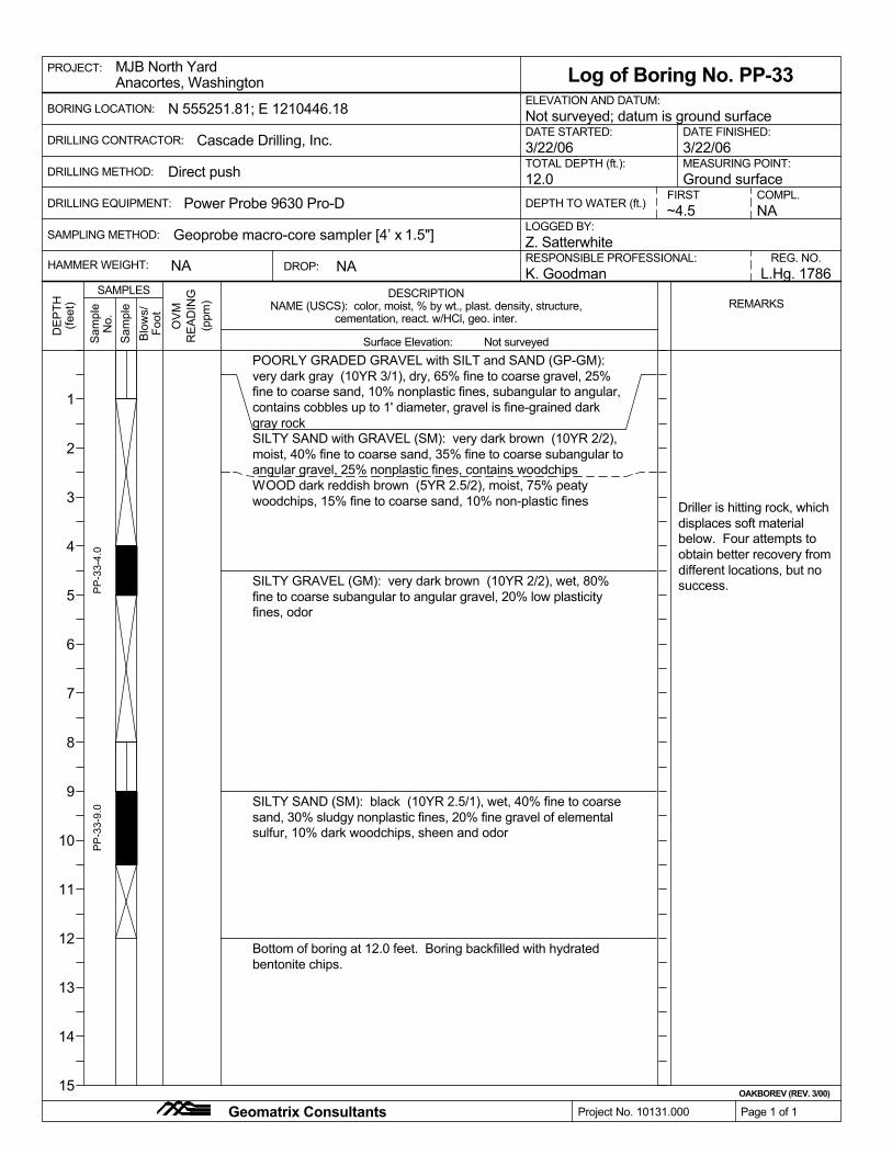
Geoprobe macro-core sampler [4’ x 1.5"]
MEASURING POINT:
L.Hg. 1786
Log of Boring No. PP-33
NA
NAME (USCS): color, moist, % by wt., plast. density, structure,
Direct push
SAMPLING METHOD:LOGGED BY:Z. Satterwhite
OAKBOREV (REV. 3/00)
Ground surface
REG. NO.
COMPL.O
VM
TOTAL DEPTH (ft.):
BORING LOCATION:
DRILLING CONTRACTOR:
DRILLING METHOD:
RESPONSIBLE PROFESSIONAL:
POORLY GRADED GRAVEL with SILT and SAND (GP-GM):very dark gray (10YR 3/1), dry, 65% fine to coarse gravel, 25%fine to coarse sand, 10% nonplastic fines, subangular to angular,contains cobbles up to 1' diameter, gravel is fine-grained darkgray rockSILTY SAND with GRAVEL (SM): very dark brown (10YR 2/2),moist, 40% fine to coarse sand, 35% fine to coarse subangular toangular gravel, 25% nonplastic fines, contains woodchipsWOOD dark reddish brown (5YR 2.5/2), moist, 75% peatywoodchips, 15% fine to coarse sand, 10% non-plastic fines
SILTY GRAVEL (GM): very dark brown (10YR 2/2), wet, 80%fine to coarse subangular to angular gravel, 20% low plasticityfines, odor
SILTY SAND (SM): black (10YR 2.5/1), wet, 40% fine to coarsesand, 30% sludgy nonplastic fines, 20% fine gravel of elementalsulfur, 10% dark woodchips, sheen and odor
K. Goodman
~4.5
PP
-33-
4.0
PP
-33-
9.0
Driller is hitting rock, whichdisplaces soft materialbelow. Four attempts toobtain better recovery fromdifferent locations, but nosuccess.
Bottom of boring at 12.0 feet. Boring backfilled with hydratedbentonite chips.
PROJECT:
Project No. 10131.000 Page 1 of 1
ELEVATION AND DATUM:
MJB North Yard
NA
Geomatrix Consultants
DE
PTH
(feet
)
SAMPLESREMARKS
Blo
ws/
Foot
Sam
ple
Sam
ple
No.
RE
AD
ING
(ppm
)
12.0
DATE STARTED:
Power Probe 9630 Pro-D
NA
3/22/06 3/22/06
FIRST
Anacortes, Washington
DEPTH TO WATER (ft.)
Surface Elevation:
DESCRIPTION
cementation, react. w/HCl, geo. inter.
HAMMER WEIGHT: DROP:
Cascade Drilling, Inc.
Not surveyed
DATE FINISHED:Not surveyed; datum is ground surfaceN 555251.81; E 1210446.18
1
2
3
4
5
6
7
8
9
10
11
12
13
14
15
DRILLING EQUIPMENT:

REG. NO.K. Goodman L.Hg. 1786
Log of Boring No. PP-34
NA
NAME (USCS): color, moist, % by wt., plast. density, structure,
Direct push
SAMPLING METHOD:LOGGED BY:Z. Satterwhite
OAKBOREV (REV. 3/00)
DRILLING METHOD:
RESPONSIBLE PROFESSIONAL:
Geoprobe macro-core sampler [4’ x 1.5"]NA
OV
M
~10.5
TOTAL DEPTH (ft.):
BORING LOCATION:
DRILLING CONTRACTOR:
Ground surface
POORLY GRADED GRAVEL with SILT and SAND (GP-GM):very dark gray (10YR 3/1), dry, 65% fine to coarse gravel, 25%fine to coarse sand, 10% nonplastic fines, subangular to angular,contains cobbles up to 1' diameter, gravel is fine-grained darkgray rock
WOOD yellow moist, fine like sawdust, odor
becoming dark brown to reddish brown and slightly coarser
fine sulfur gravel (<1/2" diam) with odor
SILTY SAND (SM): greenish black (10Y 2.5/1), wet, 60% fine tocoarse sand, 40% sludgy nonplastic fines
Bottom of boring at 12.0 feet. Boring backfilled with hydratedbentonite chips.
PP
-34-
4.0
PP
-34-
8.0
PP
-34-
9.0
COMPL.
PROJECT:
Project No. 10131.000 Page 1 of 1
MEASURING POINT:
MJB North Yard
Geomatrix Consultants
DE
PTH
(feet
)
SAMPLESREMARKS
Blo
ws/
Foot
Sam
ple
Sam
ple
No.
RE
AD
ING
(ppm
)DEPTH TO WATER (ft.)
ELEVATION AND DATUM:
DATE STARTED:
Power Probe 9630 Pro-D
NA
3/22/06 3/22/06
Anacortes, Washington
FIRST
1
2
3
4
5
6
7
8
9
10
11
12
13
14
15
12.0
Surface Elevation:
DESCRIPTION
cementation, react. w/HCl, geo. inter.
HAMMER WEIGHT:
DRILLING EQUIPMENT:
Cascade Drilling, Inc.
Not surveyed
DATE FINISHED:Not surveyed; datum is ground surfaceN 555286.43; E 1210437.86
DROP:

Z. Satterwhite
K. Goodman L.Hg. 1786
Log of Boring No. PP-35
NA
NAME (USCS): color, moist, % by wt., plast. density, structure,
Direct push TOTAL DEPTH (ft.):
LOGGED BY:
OAKBOREV (REV. 3/00)
Ground surface
RESPONSIBLE PROFESSIONAL: REG. NO.
Geoprobe macro-core sampler [4’ x 1.5"]
OV
M
NACOMPL.
~3.5SAMPLING METHOD:
SILTY GRAVEL with SAND (GM): very dark grayish brown(10YR 3/2), dry, 55% fine to coarse gravel, 25% fine to coarsesand, 20% nonplastic fines, subangular to angular, containscobbles up to 1' diameter, gravel is fine-grained dark gray rock
POORLY-GRADED SAND (SP): fine, olive (5Y 5/4)SANDY SILT (ML): very dark gray mottled brown (10YR 3/1),moist, 60% fines, 30% fine sand, 10% woodchips, low plasticity,soft
less sand; wet
WOOD black (10YR 2.5/1), wet, shardy
with fine to coarse gravel
SILTY SAND with GRAVEL (SM): very dark greenish gray (10Y3/1), wet, 50% fine to coarse sand, 30% low plasticity fines, 20%fine to coarse gravel, contains white seashell fragments
PP
-35-
8.0
WOOD dark reddish brown (5YR 2.5/2), moist, slight odor
PP
-35-
9.0
Bottom of boring at 12.0 feet. Boring backfilled with hydratedbentonite chips.
PP
-35-
4.0
PROJECT:
BORING LOCATION:
Page 1 of 1
MJB North YardAnacortes, Washington
Geomatrix Consultants
1
2
3
4
5
6
7
8
9
10
11
12
13
14
15
Project No. 10131.000
DE
PTH
(feet
)
SAMPLESREMARKS
Blo
ws/
Foot
Sam
ple
Sam
ple
No.
RE
AD
ING
(ppm
)
3/22/06DRILLING CONTRACTOR:
DRILLING METHOD:MEASURING POINT:
ELEVATION AND DATUM:
DATE STARTED:
Power Probe 9630 Pro-D
3/22/06
FIRSTDEPTH TO WATER (ft.)
12.0
Surface Elevation:
DESCRIPTION
Not surveyed; datum is ground surface
cementation, react. w/HCl, geo. inter.
NA
N 555282.67; E 1210399.49DATE FINISHED:
Not surveyed
Cascade Drilling, Inc.
DRILLING EQUIPMENT:
DROP:HAMMER WEIGHT:

Z. Satterwhite
TOTAL DEPTH (ft.):
K. Goodman L.Hg. 1786
Log of Boring No. PP-36
NA
NAME (USCS): color, moist, % by wt., plast. density, structure,
Direct push
LOGGED BY:
OAKBOREV (REV. 3/00)
Ground surface
RESPONSIBLE PROFESSIONAL: REG. NO.
Geoprobe macro-core sampler [4’ x 1.5"]
OV
M
NACOMPL.
~7.0SAMPLING METHOD:
WOOD black mottled dark red (10YR 2/1), wet, fine and peaty,slight odor
POORLY GRADED GRAVEL with SILT and SAND (GP-GM):very dark gray (10YR 3/1), dry, 65% fine to coarse gravel, 25%fine to coarse sand, 10% nonplastic fines, subangular to angular,contains cobbles up to 1' diameter, gravel is fine-grained darkgray rockSILTY SAND with GRAVEL (SM): black mottled gray and brown(10YR 2.5/1), moist, 50% fine to coarse sand, 30% fine to coarsegravel, 20% low plasticity finesPOORLY GRADED SAND with GRAVEL (SP): brown (10YR5/3), moist, 50% fine to coarse sand, 45% fine to coarse gravel,5% nonplastic fines, subrounded to roundedSILTY SAND with GRAVEL (SM): black mottled gray and brown(10YR 2.5/1), moist, 50% fine to coarse sand, 30% fine to coarsegravel, 20% low plasticity fines, white speckles
WOOD light brown moist, large chunks, not peaty
dark greenish-black sulfur odor horizon with red paint-likewoodchips
Bottom of boring at 12.0 feet. Boring backfilled with hydratedbentonite chips.
PP
-36-
4.0
PP
-36-
8.0
becoming silty and wet
PROJECT:
Project No. 10131.000
BORING LOCATION:
Anacortes, Washington
Geomatrix Consultants
1
2
3
4
5
6
7
8
9
10
11
12
13
14
15
Page 1 of 1
DE
PTH
(feet
)
SAMPLESREMARKS
Blo
ws/
Foot
Sam
ple
Sam
ple
No.
RE
AD
ING
(ppm
)
Surface Elevation:
ELEVATION AND DATUM:
DRILLING METHOD:
DATE STARTED:
Power Probe 9630 Pro-D
DRILLING CONTRACTOR:
NA
MJB North Yard
3/22/06
FIRST
MEASURING POINT:12.0
3/22/06
DESCRIPTION
DEPTH TO WATER (ft.)
cementation, react. w/HCl, geo. inter.
N 555240.01; E 1210378.56 Not surveyed; datum is ground surfaceDATE FINISHED:
Not surveyed
Cascade Drilling, Inc.
DRILLING EQUIPMENT:
DROP:HAMMER WEIGHT:

NAME (USCS): color, moist, % by wt., plast. density, structure,
K. Goodman L.Hg. 1786NA
PP
-37-
5.0
Direct push
SAMPLING METHOD:LOGGED BY:
Foot
OAKBOREV (REV. 3/00)
Blo
ws/
RESPONSIBLE PROFESSIONAL: REG. NO.
Geoprobe macro-core sampler [4’ x 1.5"]
Log of Boring No. PP-37
SILTY GRAVEL with SAND (GM): very dark gray mottled brown(10YR 3/1), dry, 45% fine to coarse gravel, 35% fine to coarsesand, 20% nonplastic fines, subrounded to angular, containscobbles up to 1' diameter, gravel is fine-grained dark gray rock
Sam
ple
Sam
ple
No.
RE
AD
ING
(ppm
)
OV
M
no recovery from 4 to 8' onfirst attempt.
PP
-37-
8.0
SILTY SAND (SM): greenish black (10Y 2.5/1), wet, 50% fine tocoarse sand, 40% low plasticity fines, 10% fine to coarse gravel
WOOD dark reddish brown and black moist, fine, very slight odor,contains red bits like paint
SILTY SAND with GRAVEL (SM): very dark gray (5Y 3/1), wet,50% fine to coarse sand, 30% fine to coarse gravel, 20% lowplasticity fines, white speckles
1-inch hc-like odor and sheenWOOD dark reddish brown and black moist, fine, very slight odor,contains red bits like paint
Bottom of boring at 12.0 feet. Boring backfilled with hydratedbentonite chips.
PP
-37-
4.0
Ground surface
Anacortes, Washington
Z. Satterwhite
PROJECT:
Project No. 10131.000 Page 1 of 1
MJB North Yard
1
2
3
4
5
6
7
8
9
10
11
12
13
14
15
Geomatrix Consultants
DE
PTH
(feet
)
SAMPLESREMARKS
NA
MEASURING POINT:
DATE STARTED:
Power Probe 9630 Pro-D
DRILLING METHOD:
DRILLING CONTRACTOR:
BORING LOCATION:
3/22/06TOTAL DEPTH (ft.):
~3.0
ELEVATION AND DATUM:
COMPL.
NA
DRILLING EQUIPMENT:
N 555211.76; E 1210358.13 Not surveyed; datum is ground surfaceDATE FINISHED:3/22/06Cascade Drilling, Inc.
FIRST
DROP:HAMMER WEIGHT:
cementation, react. w/HCl, geo. inter.
DESCRIPTION
Surface Elevation:
12.0DEPTH TO WATER (ft.)
Not surveyed
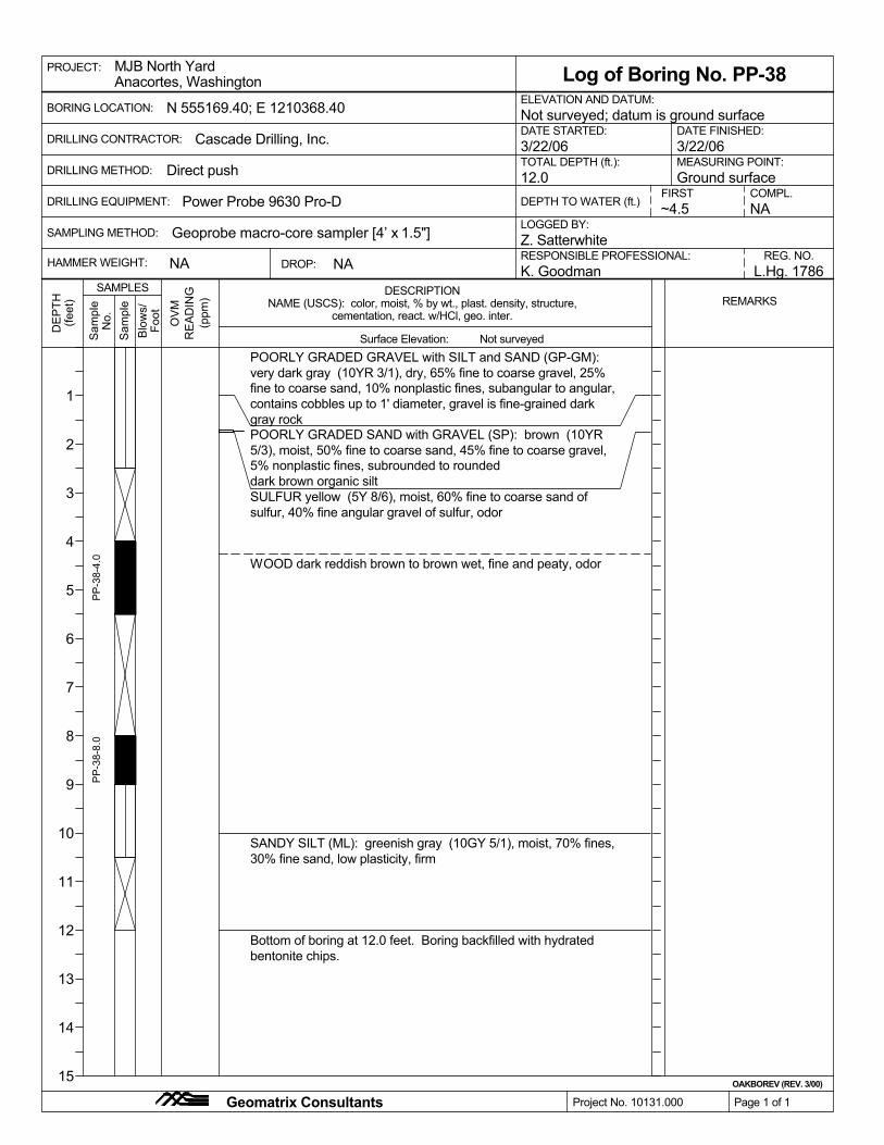
REG. NO.K. Goodman L.Hg. 1786
Log of Boring No. PP-38
NA
NAME (USCS): color, moist, % by wt., plast. density, structure,
Direct push
SAMPLING METHOD:LOGGED BY:Z. Satterwhite
OAKBOREV (REV. 3/00)
DRILLING METHOD:
RESPONSIBLE PROFESSIONAL:
Geoprobe macro-core sampler [4’ x 1.5"]NA
OV
M
~4.5
TOTAL DEPTH (ft.):
BORING LOCATION:
DRILLING CONTRACTOR:
Ground surface
POORLY GRADED GRAVEL with SILT and SAND (GP-GM):very dark gray (10YR 3/1), dry, 65% fine to coarse gravel, 25%fine to coarse sand, 10% nonplastic fines, subangular to angular,contains cobbles up to 1' diameter, gravel is fine-grained darkgray rockPOORLY GRADED SAND with GRAVEL (SP): brown (10YR5/3), moist, 50% fine to coarse sand, 45% fine to coarse gravel,5% nonplastic fines, subrounded to roundeddark brown organic siltSULFUR yellow (5Y 8/6), moist, 60% fine to coarse sand ofsulfur, 40% fine angular gravel of sulfur, odor
WOOD dark reddish brown to brown wet, fine and peaty, odor
SANDY SILT (ML): greenish gray (10GY 5/1), moist, 70% fines,30% fine sand, low plasticity, firm
PP
-38-
4.0
PP
-38-
8.0
COMPL.
Bottom of boring at 12.0 feet. Boring backfilled with hydratedbentonite chips.
PROJECT:
Project No. 10131.000 Page 1 of 1
MEASURING POINT:
MJB North Yard
Geomatrix Consultants
DE
PTH
(feet
)
SAMPLESREMARKS
Blo
ws/
Foot
Sam
ple
Sam
ple
No.
RE
AD
ING
(ppm
)DEPTH TO WATER (ft.)
ELEVATION AND DATUM:
DATE STARTED:
Power Probe 9630 Pro-D
NA
3/22/06 3/22/06
Anacortes, Washington
FIRST
1
2
3
4
5
6
7
8
9
10
11
12
13
14
15
12.0
Surface Elevation:
DESCRIPTION
cementation, react. w/HCl, geo. inter.
HAMMER WEIGHT:
DRILLING EQUIPMENT:
Cascade Drilling, Inc.
Not surveyed
DATE FINISHED:Not surveyed; datum is ground surfaceN 555169.40; E 1210368.40
DROP:

RESPONSIBLE PROFESSIONAL:
DRILLING CONTRACTOR:
K. Goodman L.Hg. 1786
Log of Boring No. PP-39
NA
NAME (USCS): color, moist, % by wt., plast. density, structure,
Direct push
SAMPLING METHOD:LOGGED BY:Z. Satterwhite
Ground surface
REG. NO.
Geoprobe macro-core sampler [4’ x 1.5"]
OV
M
NACOMPL.
~5.5
TOTAL DEPTH (ft.):
BORING LOCATION:
OAKBOREV (REV. 3/00)
Bottom of boring at 12.0 feet. Boring backfilled with hydratedbentonite chips.
POORLY GRADED GRAVEL with SILT and SAND (GP-GM):very dark gray (10YR 3/1), dry, 65% fine to coarse gravel, 25%fine to coarse sand, 10% nonplastic fines, subangular to angular,contains cobbles up to 1' diameter, gravel is fine-grained darkgray rockSILTY SAND with GRAVEL (SM): brown (10YR 4/3), moist,55% fine to coarse sand, 30% rounded to subrounded fine tocoarse gravel, 15% low plasticity fines
SILTY GRAVEL with SAND (GM): dark greenish gray (5GY4/1), moist to wet, 55% fine to coarse gravel, 30% fine to coarsesand, 15% low plasticity fines, subrounded to subangular
SILT with SAND (ML): greenish gray mottled yellowish brown(10GY 5/1), moist, 70% fines, 20% fine to coarse sand, 10%subangular fine to coarse gravel, low plasticity, hard, containstrace dark brown rootlets, also contains inclusions of greenmica/metallic sand
PP
-39-
0.0
PP
-39-
4.5
PP
-39-
6.5
PP
-39-
8.0
SILT (ML): greenish black (10Y 2.5/1), moist, 100% fines, lowplasticity, soft
PROJECT:
Project No. 10131.000 Page 1 of 1
MJB North Yard
DRILLING METHOD:
Geomatrix Consultants
Anacortes, Washington
DE
PTH
(feet
)
SAMPLESREMARKS
Blo
ws/
Foot
Sam
ple
Sam
ple
No.
RE
AD
ING
(ppm
)
Surface Elevation:
NA
DATE STARTED:3/22/06
ELEVATION AND DATUM:
3/22/06
1
2
3
4
5
6
7
8
9
10
11
12
13
14
15
MEASURING POINT:
DEPTH TO WATER (ft.)Power Probe 9630 Pro-D12.0
FIRST
DESCRIPTION
cementation, react. w/HCl, geo. inter.
Not surveyed; datum is ground surface
HAMMER WEIGHT:
N 555180.95; E 1210135.41DATE FINISHED:
Not surveyed
Cascade Drilling, Inc.
DRILLING EQUIPMENT:
DROP:

HAMMER WEIGHT:
N 555156.56; E 1210163.65 Not surveyed; datum is ground surfaceDATE FINISHED:
Not surveyed
Cascade Drilling, Inc.
DROP:
cementation, react. w/HCl, geo. inter.
DESCRIPTION
Surface Elevation:
12.0DEPTH TO WATER (ft.)
FIRSTDRILLING EQUIPMENT:
Geomatrix Consultants
Anacortes, WashingtonMJB North Yard
Page 1 of 1
PROJECT:
1
2
3
4
5
6
7
8
9
10
11
12
13
14
15
NA
Project No. 10131.000
NAME (USCS): color, moist, % by wt., plast. density, structure,
3/22/06
RESPONSIBLE PROFESSIONAL:
Ground surface
OAKBOREV (REV. 3/00)
Z. SatterwhiteLOGGED BY:Geoprobe macro-core sampler [4’ x 1.5"]
Direct push
NA
Log of Boring No. PP-40
L.Hg. 1786K. Goodman
SAMPLING METHOD:
TOTAL DEPTH (ft.):
Power Probe 9630 Pro-D
DATE STARTED:
ELEVATION AND DATUM:
MEASURING POINT:DRILLING METHOD:
REG. NO.
BORING LOCATION:
3/22/06
~7.5COMPL.NA
DRILLING CONTRACTOR:
PP
-40-
8.0
PP
-40-
6.0
PP
-40-
4.5
LEAN CLAY (CL): dark gray moist, low plasticity, firm
Bottom of boring at 12.0 feet. Boring backfilled with hydratedbentonite chips.
SILT with SAND (ML): greenish gray mottled yellowish brown(10GY 5/1), moist, 70% fines, 20% fine to coarse sand, 10%subangular fine to coarse gravel, low plasticity, hard, containstrace dark brown rootlets, also contains inclusions of greenmica/metallic sand
PP
-40-
0.0
SAMPLES
(ppm
)R
EA
DIN
G
No.
Sam
ple
Sam
ple
Foot
REMARKS
(feet
)D
EP
TH
WOOD black to dark reddish brown (10YR 2/1), moist
Blo
ws/
OV
M
SILTY SAND (SM): olive gray (5Y 4/2), moist to wet, 80% fine tocoarse sand, 20% low plasticity fines, contains dark brownwoodshards, sheen and odor
POORLY GRADED GRAVEL with SILT and SAND (GP-GM):very dark gray (10YR 3/1), dry, 65% fine to coarse gravel, 25%fine to coarse sand, 10% nonplastic fines, subangular to angular,contains cobbles up to 1' diameter, gravel is fine-grained darkgray rockSILTY SAND with GRAVEL (SM): brown mottled gray and olive(10YR 4/3), moist, 55% fine to coarse sand, 30% rounded tosubangular fine to coarse gravel, 15% low plasticity fines

SAMPLING METHOD:LOGGED BY:Z. Satterwhite
OAKBOREV (REV. 3/00)
Ground surface
RESPONSIBLE PROFESSIONAL: REG. NO.
Geoprobe macro-core sampler [4’ x 1.5"]
NANA
NACOMPL.
NA
TOTAL DEPTH (ft.):
BORING LOCATION:
DRILLING METHOD:O
VM
ELEVATION AND DATUM:
DATE STARTED:
Power Probe 9630 Pro-D
POORLY GRADED GRAVEL with SILT and SAND (GP-GM):very dark gray (10YR 3/1), dry, 65% fine to coarse gravel, 25%fine to coarse sand, 10% nonplastic fines, subangular to angular,contains cobbles up to 1' diameter, gravel is fine-grained darkgray rockPOORLY GRADED GRAVEL with SILT and SAND (GP-GM):brown (10YR 4/3), moist, 50% subrounded to rounded fine tocoarse gravel, 40% fine to coarse sand, 10% low plasticity fines
SILTY GRAVEL with SAND (GM): dark brown mottled gray andgreenish gray moist, 60% fine to coarse subangular to angulargravel, 20% fine to coarse sand, 20% low plasticity fines
Bottom of boring at 6.0 feet due to refusal. Boring backfilled withhydrated bentonite chips.
Direct push
PP
-41-
4.0
NAME (USCS): color, moist, % by wt., plast. density, structure,
K. Goodman L.Hg. 1786
Log of Boring No. PP-41
MEASURING POINT:
PP
-41-
1.5
Project No. 10131.000 Page 1 of 1
3/22/06
MJB North Yard
DRILLING CONTRACTOR:
Geomatrix Consultants
PROJECT:D
EP
TH(fe
et)
SAMPLESREMARKS
Blo
ws/
Foot
Sam
ple
Sam
ple
No.
RE
AD
ING
(ppm
)
DROP:
3/22/06
FIRSTDEPTH TO WATER (ft.)
6.0
Surface Elevation:
DESCRIPTION
Anacortes, Washington
HAMMER WEIGHT:
DRILLING EQUIPMENT:
Cascade Drilling, Inc.
Not surveyed
Not surveyed; datum is ground surfaceN 555078.90; E 1210275.33DATE FINISHED:
cementation, react. w/HCl, geo. inter.
1
2
3
4
5
6
7
8
9
10
11
12
13
14
15

REG. NO.
DRILLING METHOD:
K. Goodman L.Hg. 1786
Log of Boring No. PP-42
NA
NAME (USCS): color, moist, % by wt., plast. density, structure,
Direct push
SAMPLING METHOD:LOGGED BY:Z. Satterwhite
OAKBOREV (REV. 3/00)
RESPONSIBLE PROFESSIONAL:
Geoprobe macro-core sampler [4’ x 1.5"]
OV
MCOMPL.
~7.0
TOTAL DEPTH (ft.):
BORING LOCATION:
DRILLING CONTRACTOR:
Ground surface
POORLY GRADED GRAVEL with SILT and SAND (GP-GM):very dark gray (10YR 3/1), dry, 65% fine to coarse gravel, 25%fine to coarse sand, 10% nonplastic fines, subangular to angular,contains cobbles up to 1' diameter, gravel is fine-grained darkgray rockPOORLY GRADED GRAVEL with SILT and SAND (GP-GM):brown (10YR 4/3), moist, 50% subrounded to rounded fine tocoarse gravel, 40% fine to coarse sand, 10% low plasticity fines
greenish gray and black with concrete gravel
POORLY GRADED GRAVEL with SAND (GP): black (10YR2/1), wet, 80% fine to coarse angular gravel, 20% fine to coarsesand
dark brown woody layer with silt
SILT with SAND (ML): greenish gray mottled yellowish brown(10GY 5/1), moist, 70% fines, 20% fine to coarse sand, 10%subangular fine to coarse gravel, low plasticity, hard, containstrace dark brown rootlets, also contains inclusions of greenmica/metallic sand
NA
PP
-42-
4.0
PP
-42-
8.0
Bottom of boring at 12.0 feet. Boring backfilled with hydratedbentonite chips.
PROJECT:
Project No. 10131.000 Page 1 of 1
MEASURING POINT:
MJB North Yard
Geomatrix Consultants
DE
PTH
(feet
)
SAMPLESREMARKS
Blo
ws/
Foot
Sam
ple
Sam
ple
No.
RE
AD
ING
(ppm
)DEPTH TO WATER (ft.)
ELEVATION AND DATUM:
DATE STARTED:
Power Probe 9630 Pro-D
NA
3/22/06 3/22/06
Anacortes, Washington
FIRST
1
2
3
4
5
6
7
8
9
10
11
12
13
14
15
12.0
Surface Elevation:
DESCRIPTION
cementation, react. w/HCl, geo. inter.
HAMMER WEIGHT:
DRILLING EQUIPMENT:
Cascade Drilling, Inc.
Not surveyed
DATE FINISHED:Not surveyed; datum is ground surfaceN 555105.54; E 1210307.90
DROP:

Geoprobe macro-core sampler [4’ x 1.5"]
K. Goodman L.Hg. 1786
Log of Boring No. PP-43
NA
NAME (USCS): color, moist, % by wt., plast. density, structure,
Direct push
SAMPLING METHOD:LOGGED BY:Z. Satterwhite
OAKBOREV (REV. 3/00)
Ground surfaceMEASURING POINT:
REG. NO.
OV
MCOMPL.
~7.0
TOTAL DEPTH (ft.):
BORING LOCATION:
DRILLING CONTRACTOR:
DRILLING METHOD:
RESPONSIBLE PROFESSIONAL:
PP
-43-
4.0
POORLY GRADED GRAVEL with SILT and SAND (GP-GM):dark grayish brown mottled greenish gray and dark brown (10YR3/2), moist, 65% fine to coarse gravel, 25% fine to coarse sand,10% nonplastic fines, subangular to angular, contains cobbles upto 1' diameter, gravel is fine-grained dark gray rock, containscrushed concrete
WOOD yellow moist, large
wet, slight odor
gray and silty
Bottom of boring at 12.0 feet. Boring backfilled with hydratedbentonite chips.
PP
-43-
6.0
Driller says lots of refusaldue to concrete chunks.Two attempts to obtaindecent recovery from 0 to4'.
NA
PROJECT:
Project No. 10131.000 Page 1 of 1
ELEVATION AND DATUM:Anacortes, WashingtonMJB North Yard
DE
PTH
(feet
)
SAMPLESREMARKS
Blo
ws/
Foot
Sam
ple
Sam
ple
No.
RE
AD
ING
(ppm
)
HAMMER WEIGHT:
3/22/06
Power Probe 9630 Pro-D
3/22/06
FIRST
DATE STARTED:
Geomatrix Consultants
12.0
Surface Elevation:
NA
cementation, react. w/HCl, geo. inter.
DEPTH TO WATER (ft.)
DROP:
1
2
3
4
5
6
7
8
9
10
11
12
13
14
15
DESCRIPTION
DRILLING EQUIPMENT:
N 555078.28; E 1210334.54 Not surveyed; datum is ground surfaceDATE FINISHED:
Not surveyed
Cascade Drilling, Inc.

NA
NAME (USCS): color, moist, % by wt., plast. density, structure,
Direct push
SAMPLING METHOD:LOGGED BY:Z. Satterwhite
OAKBOREV (REV. 3/00)
Ground surface
RESPONSIBLE PROFESSIONAL: REG. NO.
Geoprobe macro-core sampler [4’ x 1.5"]
DATE STARTED:
K. Goodman
NA~3.0
OV
M
BORING LOCATION:
DRILLING CONTRACTOR:
DRILLING METHOD:MEASURING POINT:
ELEVATION AND DATUM:P
P-4
4-8.
0
POORLY GRADED GRAVEL with SILT and SAND (GP-GM):dark grayish brown mottled greenish gray and dark brown (10YR3/2), moist, 65% fine to coarse gravel, 25% fine to coarse sand,10% nonplastic fines, subrounded to angular, contains cobblesup to 1' diameter, gravel is fine-grained dark gray rock, containscrushed concreteblack concrety asphalt layer
SILTY GRAVEL (GM): greenish black (10Y 2.5/1), wet, 50% fineto coarse gravel, 30% low plasticity fines, 15% fine to coarsesand, 5% woodshards, subangular to angular
Bottom of boring at 12.0 feet. Boring backfilled with hydratedbentonite chips.
Log of Boring No. PP-44P
P-4
4-4.
0
L.Hg. 1786
rock in bottom of sampler.
TOTAL DEPTH (ft.):
PROJECT:
Project No. 10131.000 Page 1 of 1
Power Probe 9630 Pro-D
Anacortes, Washington
COMPL.
MJB North YardD
EP
TH(fe
et)
SAMPLESREMARKS
Blo
ws/
Foot
Sam
ple
Sam
ple
No.
RE
AD
ING
(ppm
)DRILLING EQUIPMENT:
3/22/06
FIRSTDEPTH TO WATER (ft.)
NA
12.0
Geomatrix Consultants
DESCRIPTION
cementation, react. w/HCl, geo. inter.
3/22/06
DROP:
Surface Elevation:
Cascade Drilling, Inc.
1
2
3
4
5
6
7
8
9
10
11
12
13
14
15
HAMMER WEIGHT:
Not surveyed
N 555053.71; E 1210304.85 Not surveyed; datum is ground surfaceDATE FINISHED: