Misty Valley - Classic Custom Homes, Madison, WI · Misty Valley Specific Implementation Plan Mayo...
50
Misty Valley PDD Specific Implementation Plan February 20, 2007
Transcript of Misty Valley - Classic Custom Homes, Madison, WI · Misty Valley Specific Implementation Plan Mayo...

Misty Valley PDD Specific Implementation Plan
February 20, 2007

Misty Valley Specific Implementation PlanMayo CorporationFebruary 2007HL-04-05
Holley Development/Urban Solutions, Inc 1
MISTY VALLEY SIP - SPECIFIC IMPLEMENTATION PLAN
February 20, 2007
Project OwnerGraber Valley, LLCc/o Bill HolleyHolley Development LLC1828 Parmenter StreetMiddleton WI 53562
Submitted by Mayo Corporation
ContactsDevelopers: Graber Valley LLC William Holley 1828 Parmenter Street [email protected]
Middleton WI 53562 608-831-4066
www.holleydevelopment.com
Urban Solutions, Inc. Michael Hershberger 700 Rayovac Drive [email protected] Madison, WI 53711 608-274-3100 www.urbanresults.com
Planning & Engineering: Mayo Corporation Jim Bricker, AICP 600 Grand Canyon Drive [email protected] Madison WI 53719 Sarah Gaskell, ASLA 608-833-0628 [email protected] www.mayocorporation.com Architecture: Knothe Bruce Architects J. Randy Bruce 7601 University Avenue [email protected] Suite 201 Middleton WI 53562 608-836-3690 www.knothebruce.com
Misty Valley Specific Implementation PlanMayo CorporationFebruary 2007HL-04-05
Holley Development/Urban Solutions, Inc 2
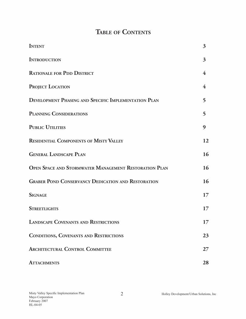
TABLE OF CONTENTS
INTENT 3
INTRODUCTION 3
RATIONALE FOR PDD DISTRICT 4
PROJECT LOCATION 4
DEVELOPMENT PHASING AND SPECIFIC IMPLEMENTATION PLAN 5
PLANNING CONSIDERATIONS 5
PUBLIC UTILITIES 9
RESIDENTIAL COMPONENTS OF MISTY VALLEY 12
GENERAL LANDSCAPE PLAN 16
OPEN SPACE AND STORMWATER MANAGEMENT RESTORATION PLAN 16
GRABER POND CONSERVANCY DEDICATION AND RESTORATION 16
SIGNAGE 17
STREETLIGHTS 17
LANDSCAPE COVENANTS AND RESTRICTIONS 17
CONDITIONS, COVENANTS AND RESTRICTIONS 23
ARCHITECTURAL CONTROL COMMITTEE 27
ATTACHMENTS 28

Misty Valley Specific Implementation PlanMayo CorporationFebruary 2007HL-04-05
Holley Development/Urban Solutions, Inc 3
INTENTThis Specific Implementation Plan outlines the intended mix of residential land uses and provides the proposed layout for Misty Valley, a new Middleton neighborhood.
INTRODUCTIONHolley Development and Urban Solutions, Inc. are submitting a Specific Implementation Plan that provides the framework for the development of a 53 acre, 281 unit mixed residential neighborhood called Misty Valley. The subject property was recently annexed to the City and is located in the southwest quadrant of the High Road and Greenbriar Road intersection.
The project team includes: Holley Development, developer of Pine Hill Farms, Urban Solutions Inc., developer of Blackhawk Lofts, Knothe Bruce Architects and Mayo Corporation, project plan-ners and civil engineers.
Prior to the annexation of this property in 2005, conceptual plans were reviewed by the City of Middleton Staff, Plan Commission, Public Works Committee, Park Commission, Water Resources Commission, and the Town of Springfield, and found to be compatible with the City’s Master Plan, the City’s Conservancy Lands Plan 2005, the Northwest Quadrant Plan, and the Town of Spring-field Comprehensive Plan. The subject property is located within the urban growth/annexation area jointly recognized by the City of Middleton and the Town of Springfield. The General Implementa-tion Plan and Preliminary Plat were approved in January 2007.
Since 2005, the project team has worked closely with the City’s Plan Commission, Staff, and Con-sultants (Strand, regarding the alignment and scope of the planned Schneider Road extension; Ken Saiki, regarding the master plan update and expansion of Graber Pond Park), and the Dane County Community Analysis and Planning Division (regarding expanding the Urban Service Area) to iden-tify issues and formulate appropriate plans and improvements to facilitate and support the develop-ment of this area.
In the course of formulating the plan for Misty Valley and the planning evolutions from the initial concept sketch plans in 2005, to the Specific Implementation Plan, the project team periodically has met with City officials to coordinate progress and share information on various aspects of the project and to gain committee approval.
Misty Valley Specific Implementation PlanMayo CorporationFebruary 2007HL-04-05
Holley Development/Urban Solutions, Inc 4
RATIONALE FOR PDD DISTRICT Planned Development District (PDD) zoning is proposed for the Misty Valley Neighborhood in order to develop a viable mixed-use residential neighborhood that provides an equitable return to private investors while also creating the variety of housing opportunities desired by the City of Middleton.
In general terms, the natural features of the subject property and the City’s mandates for open space, stormwater management areas (including infiltration), and construction of the Schneider Road extension, make the strict application of the zoning and subdivision ordinance requirements relating to items such as setbacks, minimum lot area, maximum lot coverage, and street pavement widths, a constraint to creating a viable mixed residential neighborhood.
The flexibility afforded through the use of a Planned Development District will facilitate the devel-opment of an efficient, pedestrian scale neighborhood that provides a range of housing opportuni-ties, effectively addresses open space and groundwater infiltration goals, and creates a transportation network that smoothly integrates into the City’s planned system of streets and bike/pedestrian paths.
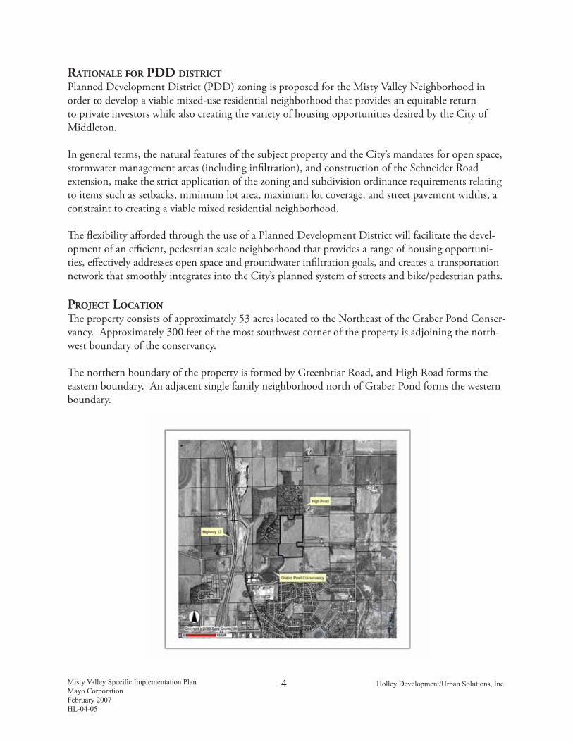
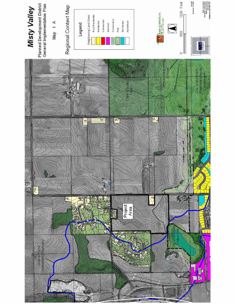
PROJECT LOCATIONThe property consists of approximately 53 acres located to the Northeast of the Graber Pond Conser-vancy. Approximately 300 feet of the most southwest corner of the property is adjoining the north-west boundary of the conservancy.
The northern boundary of the property is formed by Greenbriar Road, and High Road forms the eastern boundary. An adjacent single family neighborhood north of Graber Pond forms the western boundary.

Misty Valley Specific Implementation PlanMayo CorporationFebruary 2007HL-04-05
Holley Development/Urban Solutions, Inc 5
The Misty Valley neighborhood is uniquely situated on the northern edge of the City of Middleton. The lands encompassed by the development offer features that are both challenges and opportunities for the City in terms of managing community infrastructure needs such as water, sewer and trans-portation, and environmental protection. Additionally, these challenges and opportunities include addressing the impacts inherent in a growing community and metropolitan area, like housing, civic facilities and parks and recreation. Planning for this neighborhood focused on finding a suitable balance between these various issues with consideration of both public sector goals and private sector objectives.
The Master Plan for Misty Valley creates a vibrant residential neighborhood with housing opportuni-ties for 281 households, while also increasing the City’s open space system by 9.5 acres and extending critical water and transportation infrastructure to accommodate planned future community growth to the north.
When completed, Misty Valley will be home to a variety of housing including modestly sized lots for single family homes, duplexes, townhouses and two to four story, high density residential buildings. As the north side of Middleton grows, this neighborhood will provide pedestrian and bicycle path linkages to parks and commercial areas as well as efficient street connection to commercial, employ-ment and civic locations in both the City and the greater metropolitan area. Map 3 illustrates the Neighborhood Master Plan for Misty Valley.
DEVELOPMENT PHASING AND SPECIFIC IMPLEMENTATION PLANConstruction of Misty Valley is proposed to commence in the spring of 2007 upon approval of the SIP(s) for the single family and duplex portion of the property (Map areas A, B, C), and portions of the multi-family lots. Initial construction activity will involve grading the entire site and the creation of stormwater management facilities, followed by construction of streets and utilities. Each of the medium and high density residential lots will be subject to the City approval of a future SIP address-ing units, architectural design and landscaping.
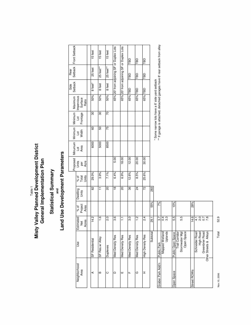
Tables 1 and 2 in the attachments present statistical data about the proposed Misty Valley neighbor-hood.
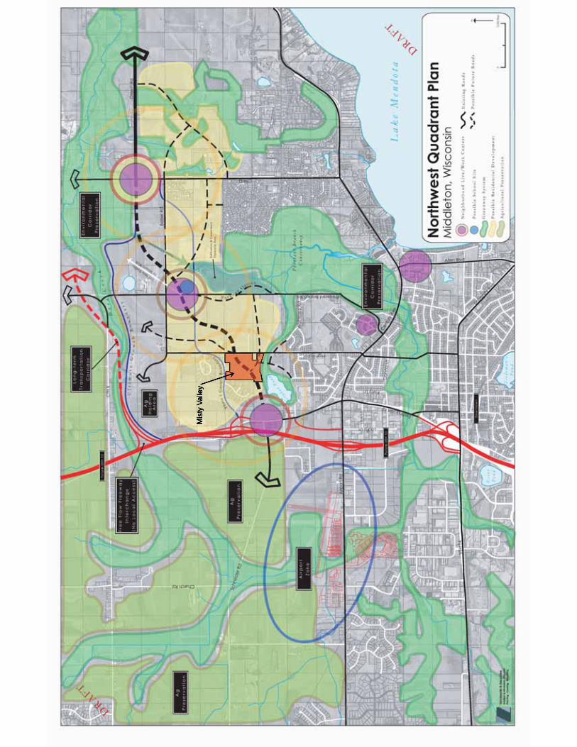
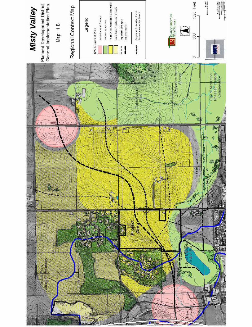
PLANNING CONSIDERATIONS Neighborhood ContextThis property is bounded by the intersection of Greenbriar and High Roads and is within the Phase I Growth Boundary of the City of Middleton Northwest Quadrant Plan. It is also located between two proposed “Neighborhood Live/Work Centers” and will be serviced by the proposed Schneider Road Extension.
Maps 1A, 1B and 2 illustrate various planning considerations relating to Misty Valley and can be found in the attachments.

Misty Valley Specific Implementation PlanMayo CorporationFebruary 2007HL-04-05
Holley Development/Urban Solutions, Inc 6
The recreational trail corridor through Misty Valley will connect from High Road to Graber Pond Conservancy and will be the first segment of a trail linking the Pheasant Branch Conservancy trail system and the new Highway 12 trail.
Natural & Cultural FeaturesMisty Valley encompasses 53 acres of open land. The majority of the site has been continuously cultivated for many years. The terrain includes a relatively steep slope decreasing from a high point at elevation 926 in the northwest corner of the property to a broad swale across the southerly third of the property. There is no defined channel to this swale and it has been typically cultivated for hay production. The low point of the property is located in the southeasterly corner of the property at the culvert underneath High Road, at elevation 820. The terrain and soils are characteristic of a glaciated hillside. Soils are relatively thin on the slopes and top of the hillside. In the lower portions of the slope and the swale areas, the soils are thicker silty and loamy clays.
The southwesterly corner of the property adjoins Graber Pond Conservancy but none of the prop-erty actually drains to Graber Pond. There is a small wetland in the area adjoining Graber Pond that appears to have been created when a dike was constructed by the City to prevent Graber Pond from overflowing into the cultivated fields on the property.
The northwesterly and westerly portions of the City of Middleton encompass areas that were notable Native American and historic Euro-American settlements in this portion of Dane County. Several archeological sites have been reported within a 1.5 kilometer radius around Misty Valley and two mi-nor sites were noted within the Misty Valley property. One of the sites is on a small rise near Graber Pond and the other is along the northwesterly edge of the property. These two sites held evidence of Native American occupation and were investigated by Archeological Consulting Services, Inc in 1992, with the construction of the City’s Pheasant Branch Interceptor Sewer, and again in 2006 as part of the planning for Misty Valley. Experts have deemed that neither site is eligible for inclusion on the National Register of Historic Places and that no additional research is recommended.
The site near Graber Pond is included in lands which will be dedicated to the City for conservancy land and will not be disturbed by the development of Misty Valley.
Water Resources Management Two significant surface water features are located in the vicinity of Misty Valley: Graber Pond, located immediately southwest of the property and Pheasant Branch Spring and Creek, located ap-proximately one-half mile east of the property.
Graber Pond ConservancyA 16 acre kettle pond and wetlands area comprises the majority of an existing 27 acre conservancy and is a unique and desirable open space resource for the City. The City intends to manage the area as a passive recreation facility. None of the land within the Misty Valley property drains to Graber Pond. A recreational trail in Misty Valley will connect the neighborhood to the conservancy.

Misty Valley Specific Implementation PlanMayo CorporationFebruary 2007HL-04-05
Holley Development/Urban Solutions, Inc 7
Pheasant Branch Creek/Pheasant Branch SpringLocated approximately one-half mile east of the Misty Valley property, this 514 acre habitat conser-vancy encompasses a significant natural resource for the Metropolitan Area. Pheasant Branch Spring (formerly known as Fredrick Spring) and seeps produce 1800 gallons per minute and support Pheas-ant Branch Creek, an important water source and fisheries habitat for Lake Mendota. Misty Valley is located within the 23 square mile watershed of Pheasant Branch Creek. Hydrologic modeling stud-ies in 2001, completed by Randall J. Hunt and Jeffrey J. Stuer, indicate that Misty Valley is located within an area that is believed to capture a significant volume of rainfall that recharges the aquifer supporting the springs.
Managing water quality and optimizing stormwater infiltration are critically important design con-siderations in the Misty Valley plan. Given the site terrain and soils conditions, NR 151 requires infiltrating 90% of the existing runoff for the average annual rainfall. An infiltration basin needed to meet this requirement would need to be 6,000 square feet in area. The City of Middleton requires infiltrating the difference between the proposed and the existing volume of runoff generated by the 1 year, 24 hour rainfall event. The infiltration device needed to meet this requirement must be 25,000 square feet. As such, the infiltration system designed for Misty Valley meets the City of Middleton’s requirements and is 4 times larger than the NR 151 requirements for the system.
Consistency with City PlansConsistency with NW Quadrant Plan In concert with the Town of Springfield, the City of Middleton prepared a general planning guide-line for the areas northwest of the developed portions of City in 2005. Referred to as the Northwest Quadrant Plan, this guideline acknowledges the development of residential neighborhoods north-erly to Balzer Road and easterly from the new US Highway 12 corridor. The ultimate development boundary is forecast to be Dorn Creek and the future North Mendota Parkway Corridor. Northerly and westerly from this boundary, land uses would remain rural, consistent with the Agricultural Preservation policies of the Town of Springfield. The Northwest Quadrant Plan can be found in the attachments.
The development area is characterized as residential neighborhoods with “Live-Work Centers” locat-ed near the intersections of Schneider Road and Old Highway 12/Parmenter Street, Pheasant Branch Road and Balzer Road, and Onken Road and County Trunk Highway Q. Traffic circulation in this area would be supported by a transportation network consisting of Schneider Road extended easterly to Onken Road as a major collector street (to provide an east-west travel corridor across the northerly portion of the City) with north/south linkages to Century Avenue provided by upgraded High Road, Pheasant Branch Road, and CTH Q. The NW Quadrant Plan also illustrates the goal of intercon-necting the greenway system between the Graber Pond and Pheasant Branch Conservancies.
The Misty Valley project, as the first development proposal in this area, implements the NW Quad-rant Plan by incorporating a segment of the planned Schneider Road extension, preserving and restoring significant open space along the greenway system between Graber Pond and the Pheas-ant Branch Conservancy, providing rights-of-way for future improvements to Greenbriar and High Roads, and by establishing a mixed use residential neighborhood incorporating a variety of housing opportunities.
Misty Valley Specific Implementation PlanMayo CorporationFebruary 2007HL-04-05
Holley Development/Urban Solutions, Inc 8
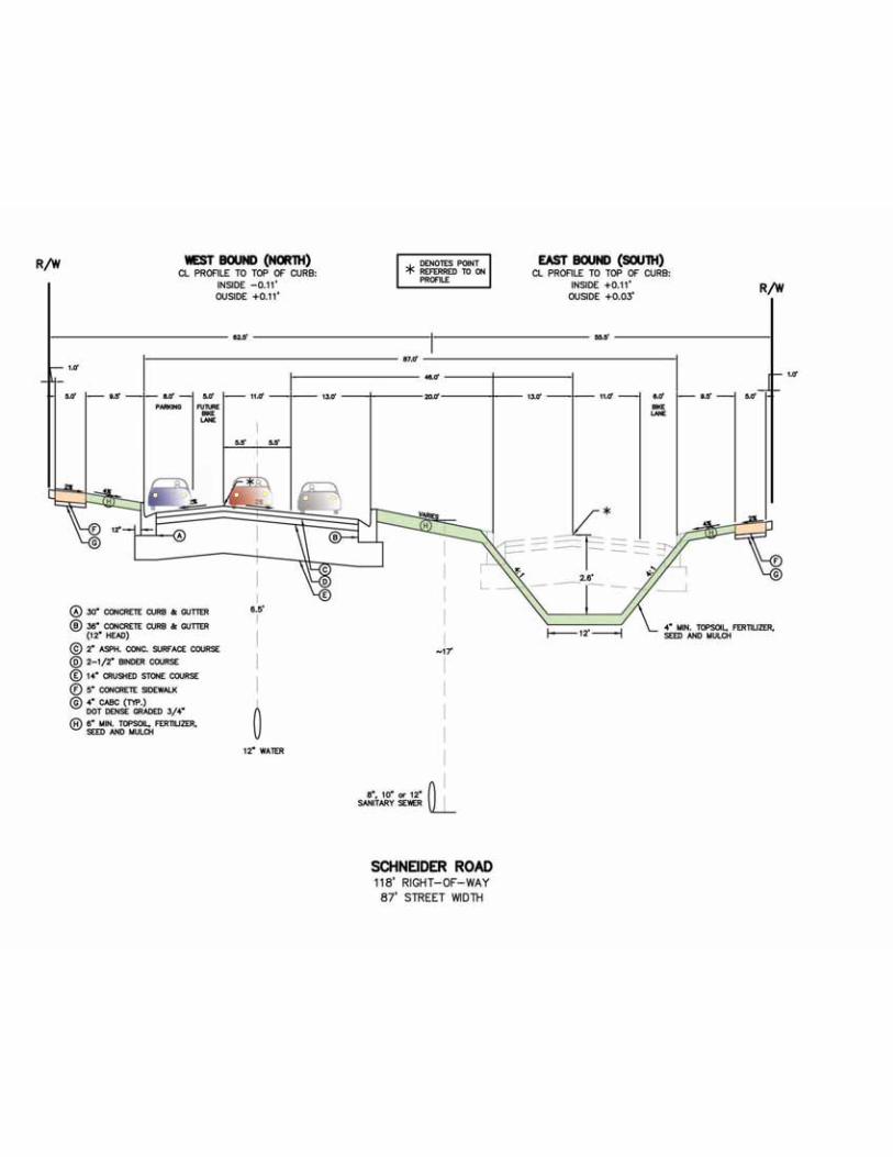
Schneider Road (extended) Corridor StudyIn 2006, Strand Associates completed a study recommending an alignment for the proposed Sch-neider Road Corridor extending from the Schneider Road / Old Highway 12 intersection easterly to County Highway Q. This corridor is expected to function as a major east-west collector route for the eventual traffic network serving the growing north side of the City. Three alternate alignments were evaluated in the study. A hybrid of the three alignments was recommended by the Plan Com-mission and has been incorporated into the Misty Valley Plan.
Schneider Road is foreseen to eventually be a 4 lane boulevard urban street with bike lanes and parking that will be integrated into the fabric of the various neighborhoods that will develop along its route. It is expected to carry significant volumes of traffic but is not intended to bisect the new north side neighborhoods as a concrete barrier nor supplant the necessity of the planned North Men-dota Parkway. In order for this street to remain consistent with the plan, it will be important that the street incorporate amenities such as an attractively landscaped boulevard, walkable sidewalks with a comfortable terrace between the sidewalks and curb, and to visually and functionally be part of the neighborhood with front doors and porches both visible and accessible from the street.
The first phase of the Schneider Road extension will be constructed by the Developer and will consist of the travel and parking lanes that are north of the boulevard. After Schneider Road is extended (by others) to connect northerly to Parmenter Street and when warranted by traffic, the City of Middle-ton will be responsible for the construction of the travel lands south of the boulevard.
Graber Road Extension via Ziegler TractDue to its location northeast of Graber Pond Conservancy, and the motivation and situation of the Ziegler Tract immediately to the south of the Misty Valley neighborhood, extension of water and the local street network requires a formal pre-development plan to be formulated with respect to locat-ing the water main and street connections between Misty Valley and the existing facilities located in Graber Road. This water main and street extension/interconnection has been conceptually shown on City plans for many years but has never been planned and engineered with consideration to func-tionality (developable lots and Graber Pond Conservancy expansion) or practicality (terrain, street grades, and soil conditions). As part of the planning for Misty Valley, a suitable route for the water main and street extension has been selected with the collaboration of City Staff and the property owner. This concept sketch is shown on Map 2 in the attachments.
City of Middleton Comprehensive Park and Open Space Plan; Graber Pond Conservancy ExpansionThe Park and Open Space Plan and discussions with the Park Commission indicate that the pre-ferred location for a neighborhood park to serve this part of the community is east of High Road.
The Plan for Graber Pond Conservancy (and the draft of the current update to the Graber Pond Conservancy Plan) indicates the City’s goal of expanding the conservancy. The 1987 plan recom-mended acquiring an additional 200 foot wide area along the northern boundary (1987) and ad-ditional lands to the east and west of the conservancy. The conservancy plan draft currently under discussion proposes acquisition of the same area along the northern boundary and more extensive acquisition to the east and west of the conservancy (lands that are not within the Misty Valley property). Graber Park is intended to be a passive recreation area with walking paths and restored
Misty Valley Specific Implementation PlanMayo CorporationFebruary 2007HL-04-05
Holley Development/Urban Solutions, Inc 9
wetland and wet prairie habitats.
Misty Valley incorporates these objectives by dedicating 3.7 acres for conservancy expansion. This park dedication incorporates the larger of the archeological sites noted previously – the small knoll immediately northeast of the pond. This dedication is consistent with the discussions and agree-ments made with the City during the annexation of this area. See the attached Draft Master Plan provided by Ken Saiki Design.
In addition to the Graber Pond Conservancy dedication, a 0.50 acre mini-park will be located north of Schneider Road, adjacent to Lot 73, as requested by the Middleton Parks, Recreation and Forestry Commission. This mini-park will contain play equipment, seating options and landscaping. Please see the attached Park Master Plan.
PUBLIC UTILITIESWaterWater service to Misty Valley will be provided by a looped 10 inch main. The main will extend north from the existing hydrant on High Road to Greenbriar Road, and then back through the neighbor-hood along Graber Road, through the Ziegler property to the existing main at the Graber Road and Lynn Street intersection. This looped main system enables water infrastructure to be extended effi-ciently in support of developments that may be proposed to the north, south, east and west of Misty Valley. The Public Utilities Map can be found in the attachments.
At the northwest most corner of Misty Valley, the proposed water main system is projected to pro-vide a minimum of 500 gpm at 33.0 psi which exceeds the minimum required by the City standards for fire protection.
Sanitary SewerResidential units in Misty Valley will utilize the Pheasant Branch Sanitary Sewer Interceptor, an 18 inch sewer constructed in 1998 to serve this area of the City.
Traffic and Transportation The plan for Misty Valley incorporates facilities for efficient and safe motor vehicle, bicycle and pedestrian travel. A Traffic Impact Analysis report has been conditionally approved by City Staff. In addition, future bus routes may be located along Schneider and Graber Roads.
ConnectivityThe transportation system layout in Misty Valley provides for connectivity with adjoining lands via future extension and interconnection of streets and the path network. Given the constraints of existing developments, topography and drainage, the following street and intersection locations are proposed.
North: Misty Valley Drive (formerly Graber Road) provides the only access to Greenbriar Road.
Misty Valley Specific Implementation PlanMayo CorporationFebruary 2007HL-04-05
Holley Development/Urban Solutions, Inc 10
The proposed intersection location is the only option due to the steep gradient of Greenbriar Road as it approaches the High Road intersection.
East: The primary access to the east is the Schneider Road intersection per the approved align-ment. Schneider Road will continue easterly (and westerly) from Misty Valley. Two secondary street access points to Schneider have been established. Charis Trail (Street D) located 400+ feet south of Greenbriar was created after City Staff prohibited all street access to Schneider Road except for Misty Valley Drive (Graber Road). Caneel Trail (Street E) also connects to High Road, located at the southeasterly corner of the neighborhood. This intersection not only provides secondary access to the neighborhood, but is also the location of the bike path connection to High Road and the future trail extension to the east.
South: Misty Valley Drive (Graber Road) will eventually extend across the Ziegler property to the existing Graber/Lynn Street intersection. The proposed location optimizes grading, utility location and potential future park expansion and development of the Ziegler parcel.
West: The alignment of the Schneider Road extension was determined by the City.
Schneider Road (extended) is the primary element of the street network planned for this area of the City. Schneider Road is proposed to be a 4 lane divided street with striped bike lanes, on-street park-ing, and 5 foot wide sidewalks.
The duplex units and the medium density residential area (Area E) along the north side of Schneider Road will be served by an alley so there will not be driveways accessing directly onto Schneider Road. Residential Area F & H will have a drive connection to Schneider and Misty Valley Drive (Graber) and High Roads respectively. Residential Area G will have a connection to Misty Valley Drive (Graber Road) only.
Parking is proposed along the northerly side of Schneider Road for several important reasons:
1. It will maintain the visual character of the street as a neighborhood street with an active residential edge.
2. It will provide a traffic calming influence resulting in safer vehicle speeds.
3. It provides more efficient land use since additional pavement is not needed to support residential visitor parking.
The proposed right-of-way (ROW) for Schneider road is 125 feet wide. Sufficient ROW is also be-ing dedicated along the west side of High Road and the south side of Greenbriar Road to accommo-date a 100 and 66 foot wide ROW respectively.
Adequate ROW is also proposed to be dedicated to provide for the future development of a round-about at the Schneider Road/High Road intersection.
Until the extension of Schneider Road is ultimately completed between Parmenter Street and Coun-
Misty Valley Specific Implementation PlanMayo CorporationFebruary 2007HL-04-05
Holley Development/Urban Solutions, Inc 11
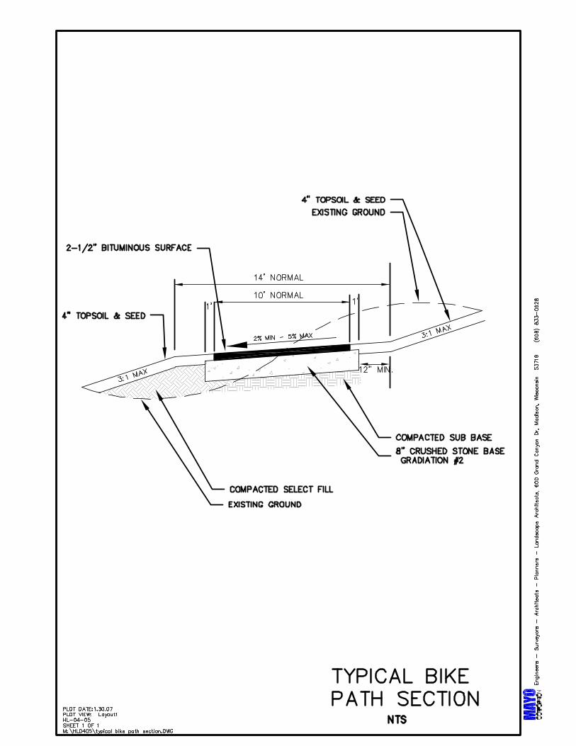
ty Highway Q, traffic volumes on this segment of Schneider Road are not anticipated to warrant four travel lanes. Therefore, it is proposed that the initial improvement of Schneider Road include the street improvements located north of the boulevard (sidewalk, parking and travel lanes) and the sidewalk along the southerly right-of-way. When traffic volumes justify the need for the additional travel lanes, the street could be widened. The 125’ wide right of way is adequate to accommodate this future widening. See the proposed typical cross-section illustration in the attachments.
Sidewalks and PedestrianwaysSidewalks will be 5 feet wide and will be constructed on both sides of all streets within the neighbor-hood.
A pedestrianway will connect from Calla Pass (Street A) to Schneider Road as shown on the Master Plan. This will be a combination of a 5 foot wide concrete sidewalk within a 20 foot easement and a 5 foot wide carriage walk along one side of the alley connection to Calla Pass (Street A) at this loca-tion. The pedestrianway passes through the the mini-park approved by the PRFC as well. South of Schneider Road, opposite the mini-park, there will be a grass walking trail that will connect to the paved Northwest multi-use trail. This trail connects to Graber Pond Conservancy, which will even-tually link the Pheasant Branch Trail System to the Highway 12 multi-use trail.
Pedestrian crosswalks will be placed at four locations within Misty Valley. The locations are as fol-lows:
Each corner at the intersection of Graber Road and Schneider Roads The intersection of the multi-use trail and Graber Road. Across Schneider Road at High Road Across Schneider Road from the pedestrianway to provide access to the greenspace walking path
••••

Misty Valley Specific Implementation PlanMayo CorporationFebruary 2007HL-04-05
Holley Development/Urban Solutions, Inc 12
RESIDENTIAL COMPONENTS OF MISTY VALLEYDevelopment Guidelines for Residential Lot Development The gross residential density of Misty Valley is 281/53 acres or 5.3 units per acre. The Planned Development District enable the creative use of smaller lots and moderately higher densities that al-low Misty Valley to provide a variety of housing choices. City of Middleton R-1 standards are to be referenced for anything not covered in this document or a future SIP.
Single Family Category A lotsMinimum 60 feet wide – no alley.
Building Placement:Except for open front steps from a private walkway up to the front door or front porch, or eaves un-der 3 feet, no portion of the principal building shall encroach into the yards created by the following setback lines:
Front setback (Build-to Line) : 15 feet from the front lot line to the foundation.
The width of the house on the build-to line must occupy a minimum of 25% of the width of the lot measured along the build-to line. Exception: lots where the front lot line is curved due to street curva-ture may substitute a straight line passing through the midpoint of and perpendicu-lar to the Medial Ordinate of the curved build-to line.
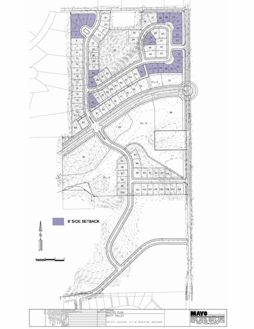
Side setback: 8 feet from the lot line, exceptions apply for narrow lots (please see Attachment)
Street side setback (corner lots): 15 feet
Rear setback: 25 feet
Garage doors The face of the garage door(s) shall be set back no less than 20 feet from any side or rear property line and shall be no less than 17 feet back from the front property line. The garage door must be offset a minimum of 2 feet from the front of the house if the garage is front loading, unless the lot is sloping from back to front based on the final grading plan.
Accessory structuresNo accessory structures (attached or detached decks, patios, sports courts, detached garages, storage sheds, swimming pools, play structures which are anchored into the ground, dog runs, etc) are per-mitted within the front, side, and street side yards created by the setbacks. Accessory structures shall be set back no less than 5 feet from the rear lot line.
Misty Valley Specific Implementation PlanMayo CorporationFebruary 2007HL-04-05
Holley Development/Urban Solutions, Inc 13
Maximum Impervious Surface : 50% of lot areaImpervious surface includes the horizontal roof area of the house and all impervious surfaces that are not under the roof such as the driveway, walks, decks, patios, swimming pools, storage sheds, and sports courts.
Corner LotsClear vision area. An area of unobstructed view must be maintained across the corner of lots that adjoin street intersections. This clear vision area is a triangle is delineated by a line connecting points 15 feet from the lot corner and extending to the curb of the adjoining streets. No buildings or fences are permitted within the clear vision area. Grading and landscaping installed within the area must be placed so that the view between the intersecting streets is not obstructed and landscaping within the area shall be maintained to not exceed a height of 30 inches above the curb elevation of each street.
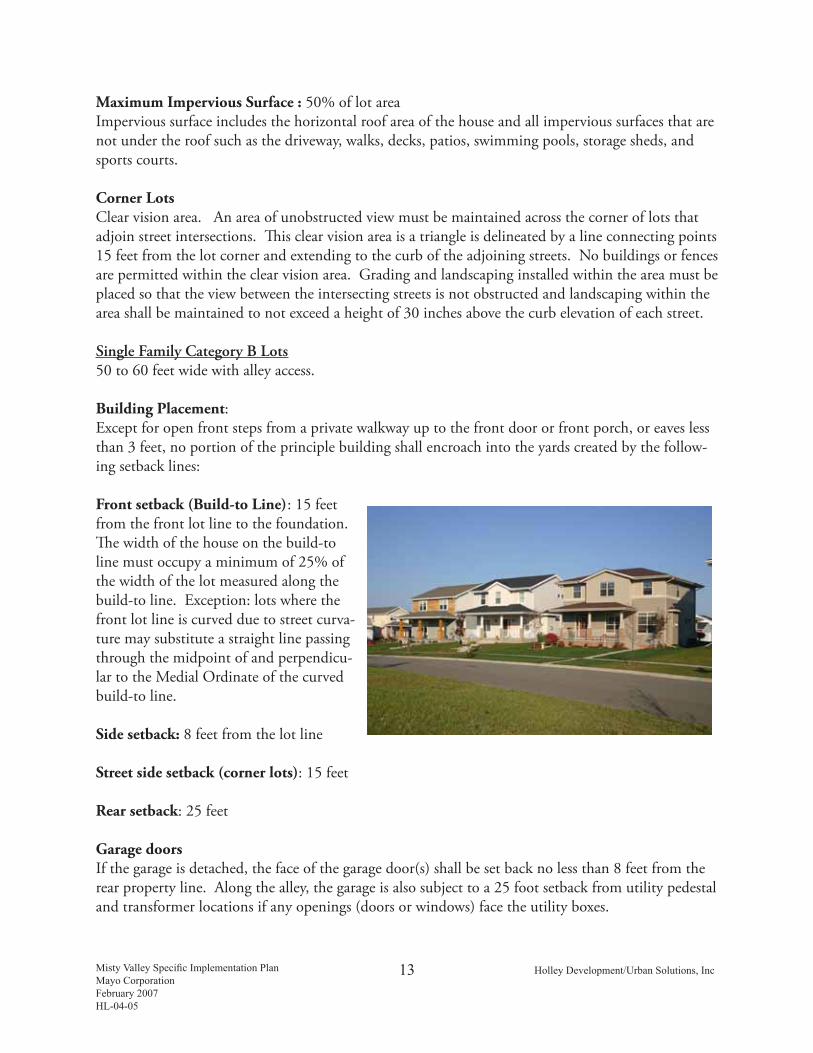
Single Family Category B Lots 50 to 60 feet wide with alley access.
Building Placement:Except for open front steps from a private walkway up to the front door or front porch, or eaves less than 3 feet, no portion of the principle building shall encroach into the yards created by the follow-ing setback lines:
Front setback (Build-to Line) : 15 feet from the front lot line to the foundation.The width of the house on the build-to line must occupy a minimum of 25% of the width of the lot measured along the build-to line. Exception: lots where the front lot line is curved due to street curva-ture may substitute a straight line passing through the midpoint of and perpendicu-lar to the Medial Ordinate of the curved build-to line.
Side setback: 8 feet from the lot line
Street side setback (corner lots): 15 feet
Rear setback: 25 feet
Garage doors If the garage is detached, the face of the garage door(s) shall be set back no less than 8 feet from the rear property line. Along the alley, the garage is also subject to a 25 foot setback from utility pedestal and transformer locations if any openings (doors or windows) face the utility boxes.
Misty Valley Specific Implementation PlanMayo CorporationFebruary 2007HL-04-05
Holley Development/Urban Solutions, Inc 14
Accessory structures No accessory structures (attached or detached decks, patios, sports courts, detached garages, stor-age sheds, swimming pools, play structures which are anchored into the ground, dog runs, etc) are permitted within the front, side, and street side yards created by the setbacks. Accessory structures shall be set back no less than 5 feet from the rear lot line. Along the alley, accessory structures are also subject to a 25 foot setback from utility pedestal and transformer locations.
Maximum Impervious Surface: 50% of lot area Impervious surface includes the horizontal roof area of the house and all impervious surfaces that are not under the roof such as the driveway, walks, decks, patios, swimming pools, storage sheds, and sports courts.
Corner LotsClear vision area. An area of unobstructed view must be maintained across the corner of lots that adjoin street intersections. This clear vision area is a triangle is delineated by a line connecting points 15 feet from the lot corner and extending to the curb of the adjoining streets. No buildings or fences are permitted within the clear vision area. Grading and landscaping installed within the area must be placed so that the view between the intersecting streets is not obstructed and landscaping within the area shall be maintained to not exceed a height of 30 inches above the curb elevation of each street.
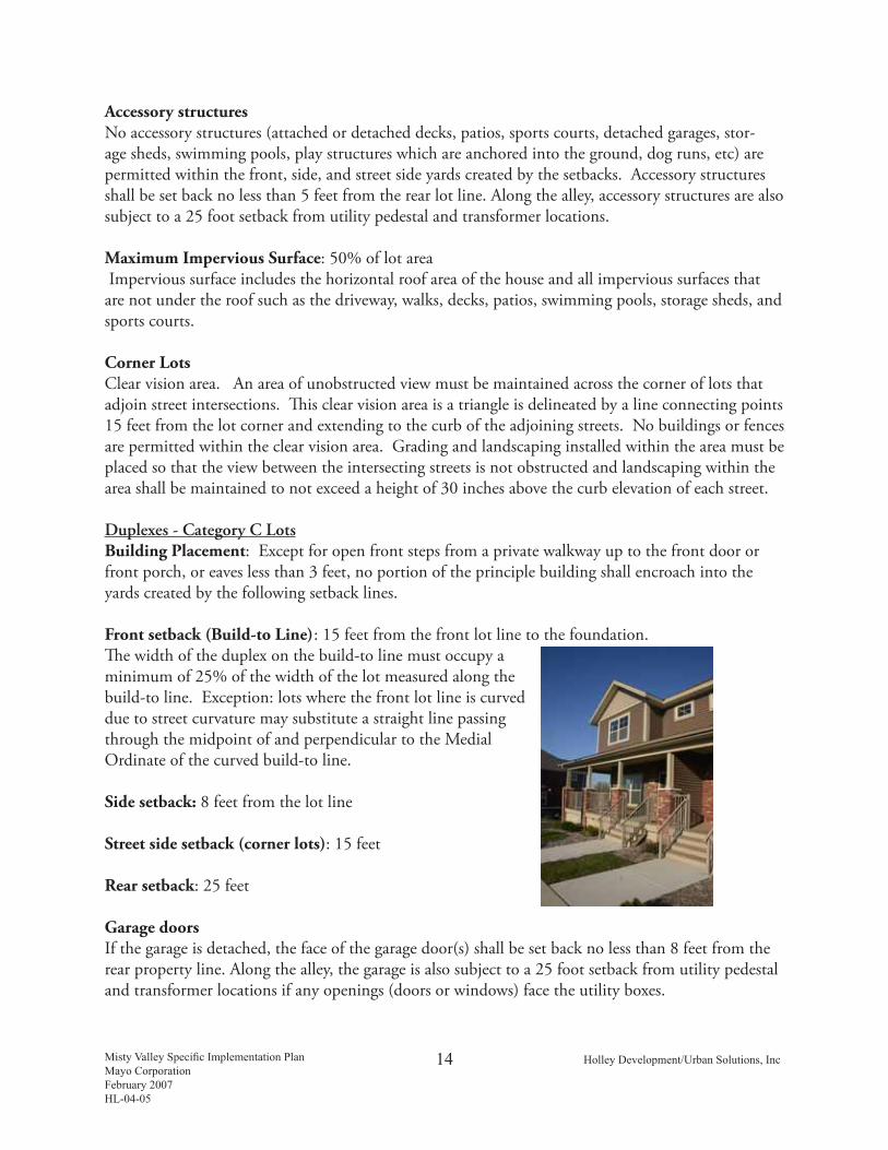
Duplexes - Category C LotsBuilding Placement: Except for open front steps from a private walkway up to the front door or front porch, or eaves less than 3 feet, no portion of the principle building shall encroach into the yards created by the following setback lines.
Front setback (Build-to Line) : 15 feet from the front lot line to the foundation.The width of the duplex on the build-to line must occupy a minimum of 25% of the width of the lot measured along the build-to line. Exception: lots where the front lot line is curved due to street curvature may substitute a straight line passing through the midpoint of and perpendicular to the Medial Ordinate of the curved build-to line.
Side setback: 8 feet from the lot line
Street side setback (corner lots): 15 feet
Rear setback: 25 feet
Garage doors If the garage is detached, the face of the garage door(s) shall be set back no less than 8 feet from the rear property line. Along the alley, the garage is also subject to a 25 foot setback from utility pedestal and transformer locations if any openings (doors or windows) face the utility boxes.

Misty Valley Specific Implementation PlanMayo CorporationFebruary 2007HL-04-05
Holley Development/Urban Solutions, Inc 15
Accessory Structures No accessory structures (attached or detached decks, patios, sports courts, detached garages, stor-age sheds, swimming pools, play structures which are anchored into the ground, dog runs, etc) are permitted within the front, side, and street side yards created by the setbacks. Accessory structures shall be set back no less than 5 feet from the rear lot line. Along the alley, accessory structures are also subject to a 25 foot setback from utility pedestal and transformer locations.
Maximum Impervious Surface: 50% of lot areaImpervious surface includes the horizontal roof area of the house and all impervious surfaces that are not under the roof such as the driveway, walks, decks, patios, swimming pools, storage sheds, and sports courts.
Corner LotsClear vision area. An area of unobstructed view must be maintained across the corner of lots that adjoin street intersections. This clear vision area is a triangle is delineated by a line connecting points 15 feet from the lot corner and extending to the curb of the adjoining streets. No buildings or fences are permitted within the clear vision area. Grading and landscaping installed within the area must be placed so that the view between the intersecting streets is not obstructed and landscaping within the area shall be maintained to not exceed a height of 30 inches above the curb elevation of each street.
Medium and High Density Residential - Category D, E LotsBuilding Placement:No encroachment of any portion of the building (eaves or balconies) is allowed into the setback areas. There is a 20’ setback from any property line that adjoins a residential single family or duplex lot.
Accessory Structures No accessory structures (attached or detached decks, patios, sports courts, detached garages, stor-age sheds, swimming pools, play structures which are anchored into the ground, dog runs, etc) are permitted within the front, side, and street side yards created by the setbacks. Accessory structures shall be set back no less than 5 feet from the rear lot line. Visitor parking areas shall be set back no less than 5 feet from any lot line and 10 feet from principal structures.
Maximum Impervious Surface: 65% of lot areaImpervious surface includes the horizontal roof area of the building and all impervious surfaces that are not under the roof such as the driveway, walks, decks, patios, swimming pools, storage sheds, and sports courts.
Medium and High Density Residential - Category F, G, H LotsBuilding Placement:No encroachment of any portion of the building (eaves or balconies) is allowed into the setback areas.

Misty Valley Specific Implementation PlanMayo CorporationFebruary 2007HL-04-05
Holley Development/Urban Solutions, Inc 16
Front setback (Build-to Line) : to be determined at the time of SIP approval for the multi-family lots
Side setback: to be determined at the time of SIP approval for the multi-family lots
Rear setback: to be determined at the time of SIP approval for the multi-family lots
Accessory structures No accessory structures (attached or detached decks, patios, sports courts, detached garages, stor-age sheds, swimming pools, play structures which are anchored into the ground, dog runs, etc) are permitted within the front, side, and street side yards created by the setbacks. Accessory structures shall be set back no less than 5 feet from the rear lot line. Visitor parking areas shall be set back no less than 5 feet from any lot line and 10 feet from principal structures.
Maximum Impervious Surface: 65% of lot areaImpervious surface includes the horizontal roof area of the building and all impervious surfaces that are not under the roof such as the driveway, walks, decks, patios, swimming pools, storage sheds, and sports courts.
GENERAL LANDSCAPE PLANThe landscape plan will be in accordance with City of Middleton Standards and Ordinances. Street trees will be planted in the time and manner determined by the City. Please see the attached Street Tree Landscape Plan.
High & Greenbriar Road Buffer A landscape buffer is provided along both High and Greenbriar Roads to provide residents with some privacy and screening. A mix of evergreen and ornamental shrubs and trees will be used to provide aesthetic interest to the neighborhood. Please see the attached Landscape Plan.
Plant ListAll species used will be in accordance with City of Middleton Standards and Ordinances. See Land-scape Covenants below.
OPEN SPACE AND STORMWATER MANAGEMENT RESTORATION PLAN The stormwater management areas will be seeded with a Prairie Nursery’s (Westfield WI) “Detention Basin Wet Prairie Mix” or equivalent at a rate of 4 oz. per 1000 square feet. Annual Ryegrass shall be added to the mixtures at a rate of 1.5 lbs per 1000 square feet. Further information can be found in the Stormwater Management Report for Preliminary Plan Submittal, November 2, 2006.
GRABER POND CONSERVANCY DEDICATION AND RESTORATIONA dedication of 3.7 acres to the Graber Pond Conservancy will occur with the creation of the Misty Valley Neighborhood. This acreage includes the knoll mentioned previously and will allow for direct pedestrian/bicycle access to the conservancy from the neighborhood via the neighborhood trail sys-tem.

Misty Valley Specific Implementation PlanMayo CorporationFebruary 2007HL-04-05
Holley Development/Urban Solutions, Inc 17
SIGNAGEAny neighborhood signage will be in accordance with City of Middleton Standard Specifications and Ordinances.
STREET LIGHTSStreet lights will be in accordance with City of Middleton Standard Specifications and Ordinances, and use ‘cut-off’ fixtures. LANDSCAPE COVENANTS AND RESTRICTIONSEstablishmentLandscaping must be completed within three (3) months of the issuance of the occupancy permit, weather permitting. If occupancy is established during winter, landscape should be installed no later than June 1st of following year.
Landscape plantings and maintenance of the premises shall be the responsibility of the lot owner.
Landscape maintenance of the right-of way shall be the responsibility of the Lot Owner. Any trees or shrubs which die shall be removed by the Owner and replaced with a similar size and variety as the original plant at the time of planting, so as to maintain the original landscaping elements.
All lots are required to plant 200 points worth of plants for foundation screenings, four plants of which must be evergreen shrubs. In addition, two ornamental trees, two shade trees and two ever-green trees per lot are required. See below for approved plant lists and details.
Required SeedingAll lot Owners are required to sod the front and side yards. Lot Owners may seed the backyard.
Design StandardsFoundation ScreeningAll lots are required to have significant foundation screening around all sides of the homes. Plants should incorporate perennials, native grasses, and evergreens and provide year-round interest.
Misty Valley Specific Implementation PlanMayo CorporationFebruary 2007HL-04-05
Holley Development/Urban Solutions, Inc 18
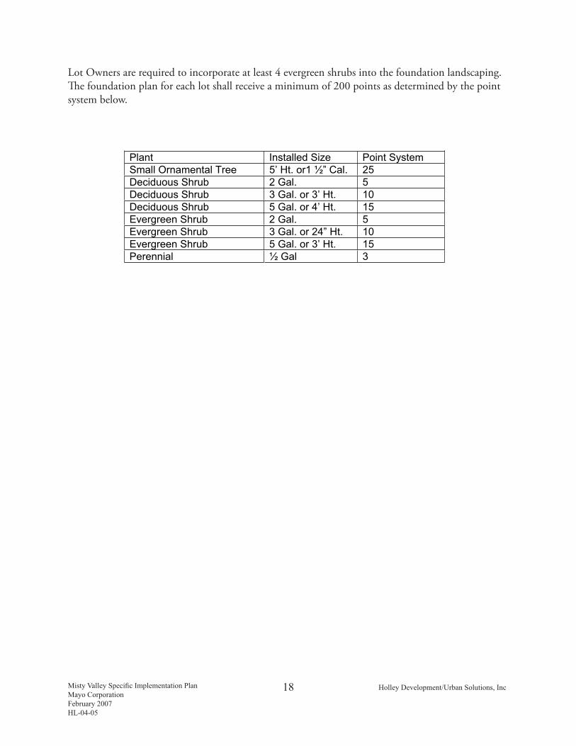
Lot Owners are required to incorporate at least 4 evergreen shrubs into the foundation landscaping.The foundation plan for each lot shall receive a minimum of 200 points as determined by the point system below.
Plant Installed Size Point System Small Ornamental Tree 5’ Ht. or1 ½” Cal. 25Deciduous Shrub 2 Gal. 5Deciduous Shrub 3 Gal. or 3’ Ht. 10Deciduous Shrub 5 Gal. or 4’ Ht. 15Evergreen Shrub 2 Gal. 5Evergreen Shrub 3 Gal. or 24” Ht. 10Evergreen Shrub 5 Gal. or 3’ Ht. 15Perennial ½ Gal 3
Misty Valley Specific Implementation PlanMayo CorporationFebruary 2007HL-04-05
Holley Development/Urban Solutions, Inc 19
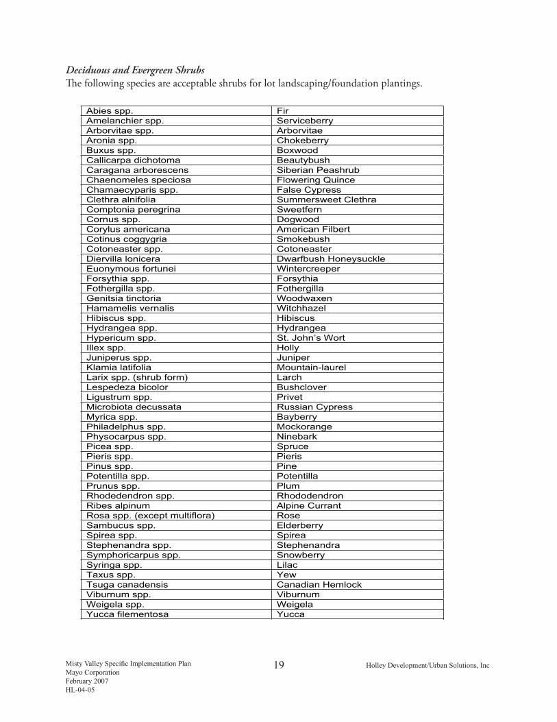
Deciduous and Evergreen ShrubsThe following species are acceptable shrubs for lot landscaping/foundation plantings.
Abies spp. FirAmelanchier spp. Serviceberry Arborvitae spp. ArborvitaeAronia spp. Chokeberry Buxus spp. BoxwoodCallicarpa dichotoma BeautybushCaragana arborescens Siberian Peashrub Chaenomeles speciosa Flowering Quince Chamaecyparis spp. False Cypress Clethra alnifolia Summersweet Clethra Comptonia peregrina SweetfernCornus spp. Dogwood Corylus americana American Filbert Cotinus coggygria Smokebush Cotoneaster spp. Cotoneaster Diervilla lonicera Dwarfbush Honeysuckle Euonymous fortunei Wintercreeper Forsythia spp. ForsythiaFothergilla spp. FothergillaGenitsia tinctoria Woodwaxen Hamamelis vernalis Witchhazel Hibiscus spp. Hibiscus Hydrangea spp. Hydrangea Hypericum spp. St. John’s Wort Illex spp. HollyJuniperus spp. Juniper Klamia latifolia Mountain-laurel Larix spp. (shrub form) LarchLespedeza bicolor Bushclover Ligustrum spp. PrivetMicrobiota decussata Russian Cypress Myrica spp. BayberryPhiladelphus spp. Mockorange Physocarpus spp. Ninebark Picea spp. Spruce Pieris spp. PierisPinus spp. PinePotentilla spp. PotentillaPrunus spp. PlumRhodedendron spp. Rhododendron Ribes alpinum Alpine Currant Rosa spp. (except multiflora) Rose Sambucus spp. Elderberry Spirea spp. SpireaStephenandra spp. Stephenandra Symphoricarpus spp. Snowberry Syringa spp. LilacTaxus spp. Yew Tsuga canadensis Canadian Hemlock Viburnum spp. Viburnum Weigela spp. Weigela Yucca filementosa Yucca
Misty Valley Specific Implementation PlanMayo CorporationFebruary 2007HL-04-05
Holley Development/Urban Solutions, Inc 20
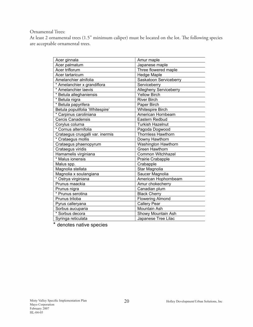
Ornamental Trees:At least 2 ornamental trees (1.5” minimum caliper) must be located on the lot. The following species are acceptable ornamental trees.
Acer ginnala Amur maple Acer palmatum Japanese maple Acer triflorum Three flowered maple Acer tartaricum Hedge Maple Amelanchier alnifolia Saskatoon Serviceberry * Amelanchier x grandiflora Serviceberry * Amelanchier laevis Allegheny Serviceberry * Betula alleghaniensis Yellow Birch * Betula nigra River Birch * Betula papyrifera Paper Birch Betula populifolia ‘Whitespire’ Whitespire Birch * Carpinus caroliniana American Hornbeam Cercis Canadensis Eastern Redbud Corylus colurna Turkish Hazelnut * Cornus alternifolia Pagoda Dogwood Crataegus crusgalli var. inermis Thornless Hawthorn * Crataegus mollis Downy Hawthorn Crataegus phaenopyrum Washington Hawthorn Crataegus viridis Green Hawthorn Hamamelis virginiana Common Witchhazel * Malus ionensis Prairie Crabapple Malus spp. Crabapple Magnolia stellata Star Magnolia Magnolia x soulangiana Saucer Magnolia * Ostrya virginiana American Hophornbeam Prunus maackia Amur chokecherry Prunus nigra Canadian plum * Prunus serotina Black Cherry Prunus triloba Flowering Almond Pyrus calleryana Callery Pear Sorbus aucuparia Mountain Ash * Sorbus decora Showy Mountain Ash Syringa reticulata Japanese Tree Lilac
* denotes native species
Misty Valley Specific Implementation PlanMayo CorporationFebruary 2007HL-04-05
Holley Development/Urban Solutions, Inc 21
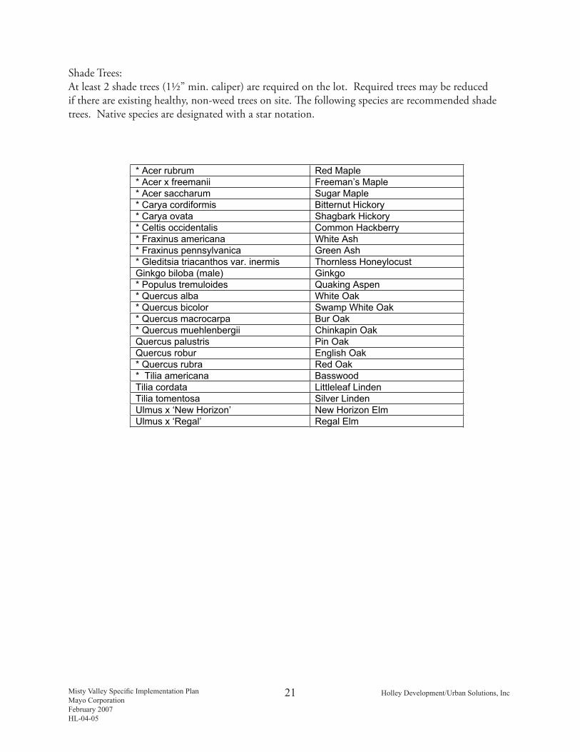
Shade Trees:At least 2 shade trees (1½” min. caliper) are required on the lot. Required trees may be reduced if there are existing healthy, non-weed trees on site. The following species are recommended shade trees. Native species are designated with a star notation.
* Acer rubrum Red Maple * Acer x freemanii Freeman’s Maple * Acer saccharum Sugar Maple * Carya cordiformis Bitternut Hickory * Carya ovata Shagbark Hickory * Celtis occidentalis Common Hackberry * Fraxinus americana White Ash * Fraxinus pennsylvanica Green Ash * Gleditsia triacanthos var. inermis Thornless Honeylocust Ginkgo biloba (male) Ginkgo* Populus tremuloides Quaking Aspen * Quercus alba White Oak * Quercus bicolor Swamp White Oak * Quercus macrocarpa Bur Oak * Quercus muehlenbergii Chinkapin Oak Quercus palustris Pin Oak Quercus robur English Oak * Quercus rubra Red Oak * Tilia americana Basswood Tilia cordata Littleleaf Linden Tilia tomentosa Silver Linden Ulmus x ‘New Horizon’ New Horizon Elm Ulmus x ‘Regal’ Regal Elm
Misty Valley Specific Implementation PlanMayo CorporationFebruary 2007HL-04-05
Holley Development/Urban Solutions, Inc 22
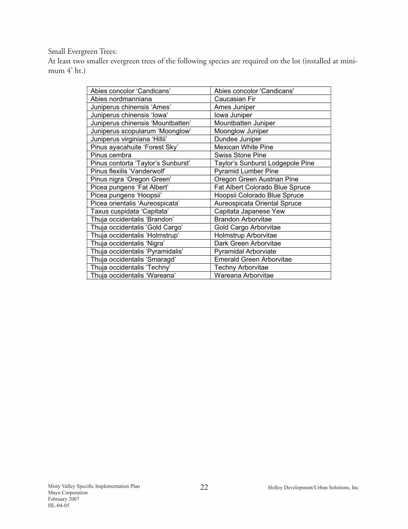
Small Evergreen Trees:At least two smaller evergreen trees of the following species are required on the lot (installed at mini-mum 4’ ht.)
Abies concolor ‘Candicans’ Abies concolor 'Candicans' Abies nordmanniana Caucasian Fir Juniperus chinensis ‘Ames’ Ames Juniper Juniperus chinensis ‘Iowa’ Iowa Juniper Juniperus chinensis ‘Mountbatten’ Mountbatten Juniper Juniperus scopularum ‘Moonglow’ Moonglow Juniper Juniperus virginiana ‘Hillii’ Dundee Juniper Pinus ayacahuite ‘Forest Sky’ Mexican White Pine Pinus cembra Swiss Stone Pine Pinus contorta ‘Taylor’s Sunburst’ Taylor’s Sunburst Lodgepole Pine Pinus flexilis ‘Vanderwolf’ Pyramid Lumber Pine Pinus nigra ‘Oregon Green’ Oregon Green Austrian Pine Picea pungens ‘Fat Albert’ Fat Albert Colorado Blue Spruce Picea pungens ‘Hoopsii’ Hoopsii Colorado Blue Spruce Picea orientalis ‘Aureospicata’ Aureospicata Oriental Spruce Taxus cuspidata ‘Capitata’ Capitata Japanese Yew Thuja occidentalis ‘Brandon’ Brandon Arborvitae Thuja occidentalis ‘Gold Cargo’ Gold Cargo Arborvitae Thuja occidentalis ‘Holmstrup’ Holmstrup Arborvitae Thuja occidentalis ‘Nigra’ Dark Green Arborvitae Thuja occidentalis ‘Pyramidalis’ Pyramidal Arborviate Thuja occidentalis ‘Smaragd’ Emerald Green Arborvitae Thuja occidentalis ‘Techny’ Techny Arborvitae Thuja occidentalis ‘Wareana’ Wareana Arborvitae
Misty Valley Specific Implementation PlanMayo CorporationFebruary 2007HL-04-05
Holley Development/Urban Solutions, Inc 23
CONDITIONS, COVENANTS AND RESTRICTIONSLand Use and Building TypeThe Lots contained within the Property shall be used for the purposes of Single Family or Multi-Family Residential. With respect to these lots, no building shall be erected, altered, placed or permit-ted to remain on any such Lot other than one detached single family dwelling unit not to exceed 2.5 stories in height or a duplex dwelling unit. Each single family dwelling unit located on a Single Fam-ily Residential Lot shall have a private garage of two (2) cars attached to or located in a lower level of the dwelling unit for those lots that are not alley fed. The size of a dwelling unit to be constructed on Single Family Residential Lots shall not be less than the minimum size of 1200 square feet for a ranch and 1600 square feet for a two story building. All construction on a Lot must be completed within nine (9) months from issuance of building permit except for construction items, such as land-scaping, which may be delayed due to weather. When vacant, all Lots shall be maintained in a neat and clean manner, free of refuse and noxious weeds, and regularly mowed.
Architectural ControlNo building shall be erected, placed or altered on any Lot until the construction plans and specifica-tions and a plan showing the location of the structure have been approved by a majority of the Archi-tectural Control Committee (the “Committee”) as to quality of workmanship and materials, har-mony of external design with existing structures, and location with respect to topography and finish grade elevation. There shall be a variation in building elevations on adjacent lots. Approval shall be as provided below. The dimensions of front, side and rear yards shall be as required under applicable zoning codes.
Dwellings And Landscaping The landscaping to be installed on all Lots must meet or exceed the landscaping requirements set forth in the Specific Implementation Plan. The structure and the minimum landscaping require-ments shall be fully completed within three (3) months after issuance of a occupancy permit, weather permitting. If occupancy is established during winter, landscape should be installed no later than June 1st of following year. All driveways shall be of concrete and shall be installed within nine (9) months after substantial completion of the structure. No outbuilding or accessory building of any nature shall be erected on any Lot. No above-ground swimming pools shall be permitted. A family garden may be located within the rear yard provided it does not exceed 5% of the total Lot size and is maintained in a clean and orderly condition.
Natural and prairie lawns are permitted in rear yards only. Rear yards may be planted with grass seed or sodded. All front and side yards shall be sodded. All landscaping and yards shall be maintained on a regular seasonal basis, including regular lawn mowing during the lawn growing season. Main-tenance of all improvements on a Lot is the responsibility of the Owner. Maintenance shall include, but not be limited to, watering, pruning and routine fertilizing and mulching of all plantings and plant beds, replacement of dead, dying and/or diseased trees and shrubs, prompt removal of weeds, trash and debris from plant beds and areas adjacent to shrubs and trees so as to keep said landscaping and lawn areas in a healthy, attractive, neat and clean condition.
An Owner may, with the advance written consent of the Committee, install a natural prairie lawn
Misty Valley Specific Implementation PlanMayo CorporationFebruary 2007HL-04-05
Holley Development/Urban Solutions, Inc 24
in the rear yard or a rain garden (“Prairie Lawns” and “Rain Garden” respectively), subject to any conditions imposed upon the same by the Committee, compliance with all rules, regulations and ordinances of the City of Middleton, and the following conditions. Prairie Lawns shall not exceed five (5’) feet in height. Prairie Lawns shall be a mixture of prairie grass and prairie flowers, regularly maintained by the Owner so as to minimize weeds and other unsightly conditions. Prairie Lawns shall be planted and maintained in accordance with sound landscape maintenance practices. The Committee reserves the right to require Owners to remove Prairie Lawns that are not properly main-tained or which become unsightly and detrimental to the neighborhood.
Rain Gardens may be installed by Owners as a bio-retention system dealing with rain water runoff from paved areas and other impervious surfaces, in accordance with plans approved by the City of Middleton Engineer, if such approval is required by the City of Middleton, and by the Commit-tee. The Owner shall maintain records of installation, inspections, cleaning and other maintenance. Visual inspection of the Rain Garden system shall be performed, at a minimum, annually. Main-tenance shall be required when the system shows standing water beyond 72 hours of the rain event. Maintenance shall consist of removal of sediment, two (2’) foot undercut, undercut replacement with material consisting of one-third topsoil, one-third compost, and one-third sand, and restoration in kind. Restoration of plant material shall be by plugging, not seeding alone. Any alterations to an approved Rain Garden shall be approved by the City Engineer (if required by the City of Middleton) and the Committee. The Committee reserves the right to require an Owner to remove any Rain Garden that is not being properly operated and maintained by the Owner in accordance with this Declaration and the Middleton Ordinances.
The Committee reserves the right to adopt further rules and regulations regarding Prairie Lawns and Rain Gardens as future circumstances require.
If the Owner of any Lot, after reasonable notice, fails or refuses to install landscaping as described herein, or maintain it as required above, the Committee, or the Association, as the case may be, through its duly authorized agents or employees, shall have the right to enter upon said Lot at rea-sonable hours to perform said landscaping and/or maintenance. The costs of the materials and labor to perform such landscaping and/or maintenance shall be assessed against said Lot, which assessment may be foreclosed or collected in accordance.
Vehicle and/or Equipment Storage No inoperable, dilapidated or junk vehicles of any nature may be kept upon any Lot except in a fully enclosed garage. The exterior storage of boats, trailers, travel trailers, campers, motorcycles, recre-ational vehicles, automobiles or trucks (collectively, without limitation by reason of enumeration “Equipment”), of any nature is prohibited whether or not screened from public view. No Equip-ment shall be parked or stored on lawns. The temporary storage of Equipment in a drive area for the purpose of loading or unloading for a period not to exceed twelve (12) hours is permitted. No commercial vehicles, including trucks, semi-trailers or trailers, may be stored or parked overnight on or in front of said Lots except in an enclosed garage.
Construction On Adjoining LotsNothing contained herein shall be construed to prohibit the construction of a residential dwelling

Misty Valley Specific Implementation PlanMayo CorporationFebruary 2007HL-04-05
Holley Development/Urban Solutions, Inc 25
or private garage partially on one Lot and partially on an adjoining Lot without regard to side yards between adjoining Lots, provided that all such Lots are owned by the same person or persons.
Easements/DrainageNo structure, planting, or other materials shall be placed or permitted to remain within any ease-ment of record which may damage or interfere with the installation and maintenance of utilities, or which may change the direction or flow of drainage channels in the easement, or which may obstruct or retard the flow of water through drainage channels in the easement. The easement area of each Lot, if any, and all improvements located therein, shall be maintained continuously by the owner of the Lot, except for those improvements for which a public authority or utility company is respon-sible. No drainage swale shall be graded or obstructed so as to impede the flow of water from other Lots or outlots through such swale.
NuisancesNo noxious or offensive activity shall be carried on upon any Lot, nor shall anything be done thereon which may be or may become an annoyance or nuisance to the neighborhood or which may have a detrimental effect on the value of other Lots and/or improvements.
Temporary Structures No structure of a temporary character, trailer, basement, tent, shack, garage, barn or other outbuild-ing shall be used on any Lot at any time as a residence or for any other purpose, either temporarily or permanently.
Developer shall be permitted to maintain a sales trailer on the Development to be used in connection with the sale and marketing of Lots in the Development.
Temporary construction trailers may be maintained on Lots in the Development for use by contrac-tors in connection with Construction on such Lots provided said trailers be promptly removed after they are no longer needed for such purposes.
SignsNo sign of any kind shall be displayed to the public view on any Lot except as approved by the Architectural Control Committee. Signs without regard to size used by the Developer, to advertise the property during the construction and sales period or to identify the subdivision and/or its Devel-oper are permitted without such approval so long as Developer owns any part of the Property. Notwithstanding the foregoing, for sale signs advertising that the real property on which the sign is located is for sale shall be permitted provided that the size and type of sign utilized by the Owner of said Property is in conformance with normal and typical real estate sales industry practices.
Animals No animals, livestock or poultry of any kind shall be raised, bred or kept on any Lot, with the excep-tion of up to three (3) dogs, cats or other domestic household pets may be kept, provided that they are not kept, bred or maintained for any commercial purpose. No exterior animal enclosure, house, pen or similar device shall be permitted.
Misty Valley Specific Implementation PlanMayo CorporationFebruary 2007HL-04-05
Holley Development/Urban Solutions, Inc 26
Garbage And Refuse Disposal No Lot shall be used or maintained as a dumping ground for rubbish. Trash, garbage or other waste shall not be kept except in sanitary containers. No incinerators shall be permitted. Other equipment for the storage or disposal of such material shall be kept in a clean and sanitary condition. No trash, building materials, debris, leaves, lawn clippings, rocks or earth shall be placed in any Lot.
Fences No fences over four (4’) feet in height from ground to uppermost part of fence shall ever be permit-ted (with the exception of compliance with local ordinances with respect to enclosing private swim-ming pool areas) unless such fences are approved by the Committee or its designated approving authority. All fences shall be constructed of wood only. All permitted fences shall be first approved in terms of material and location by the Committee. Fencing is permitted with the prior written ap-proval of the Committee which may require the installation and maintenance of landscape materials for screening and aesthetic purposes.
Outbuildings No outbuilding or accessory building of any nature shall be erected on any Lot.
Antennae/Wind Powered Electric GeneratorsNo wind powered electric generators, exterior television, radio receiving or transmission antennae or flagpoles shall be placed or maintained upon any portion of a Lot without prior written approval of the Committee.
Firewood StorageNo firewood or wood pile shall be kept outside a structure unless it is neatly stacked, placed on a non-street side yard or rear yard and screened from street or neighbor view by plantings or a fence approved by the Committee.
Solar Collectors No active solar collector or apparatus may be installed on any Lot unless such installation is first ap-proved in writing by the Committee which shall consider the aesthetic and sun reflection effects on neighboring structures. Solar collectors or apparatus installed flat against or parallel to the plane of the roof shall be preferred.
LightingExterior lighting installed on any Lot shall either be indirect or of such controlled focus and intensity that such lighting will not disturb the residents of adjacent Lots. Cut-off light fixtures of average maintained foot candles are recommended.
Mailboxes Standard mailbox and post.
Professional or Business Offices An Owner may use the single family residential home constructed on a Lot for a professional or busi-ness office when such office is incidental to the principal use as a single family residence, is less than

Misty Valley Specific Implementation PlanMayo CorporationFebruary 2007HL-04-05
Holley Development/Urban Solutions, Inc 27
three hundred (300) gross square feet in area, the business is conducted without an identification sign or label displayed on the Lot or building and the business is conducted without any outside em-ployees. Any professional or business office or use on a Lot which does not comply with the forego-ing conditions is prohibited.
Street Trees Street trees will be planted by the City of Middleton and specially assessed to the Owner of the Lot on which the street tree has been planted.
Swimming PoolsAbove ground swimming pools are prohibited.
Subdivisons No Lot may be further subdivided, without the advance written consent of the Committee and City of Middleton approval.
ARCHITECTURAL CONTROL COMMITTEEMembership From time-to-time hereafter, Developer shall appoint the members of the Committee who initially, during the term of Developer’s control of the Association, may be employees or other affiliates of Developer, or third parties with an interest in and skill related to the work of the Committee, includ-ing and architect, engineer or other person with specialized knowledge that will be of assistance to the Committee and the performance of its duties.
Misty Valley Specific Implementation PlanMayo CorporationFebruary 2007HL-04-05
Holley Development/Urban Solutions, Inc 28
ATTACHMENTSRegional Context Map 1-ARegional Context Map 1-BPlanning Considerations Map 2Neighborhood Master Plan Map 3Misty Valley PDD GIP Statistical Summary and Land Use Development Parameters Table 1Misty Valley PDD GIP Estimated Population and Students at Project Buildout Table 2Northwest Quadrant Master PlanGraber Pond Master Plan DraftMisty Valley Mini-Park Draft Master PlanGeneral Utility PlanSchneider Road Typical Cross Sections Typical Multi-Use Path Cross SectionsSide Setback Map Typical Berm Planting Plan for Schneider and High RoadsPreliminary Plat


Pro
pose
dM
inum
umM
inim
umM
inim
umM
axim
umS
ide
Set
back
Rea
r S
etba
ckF
ront
Set
back
Nei
ghbo
rhoo
dU
seE
stim
ated
% o
fD
wel
ling
% o
fU
nits
Lo
t Lo
tLo
tIm
perv
ious
A
rea
Net
Pro
ject
Uni
tsT
otal
per
Are
aW
idth
Fro
ntag
eS
urfa
ceA
cres
Are
aU
nits
Acr
eR
atio
AS
F R
esid
entia
l14
.282
29.0
%60
0060
3050
%8
feet
*25
feet
15 fe
et
BS
F R
es.w
/ Alle
y1.
611
3.9%
5000
5030
50%
8 fe
et25
feet
**15
feet
CD
uple
xes
2.0
207.
1%85
0075
7050
%8
feet
25 fe
et**
15 fe
et
DM
ed D
ensi
ty R
es3.
618
6.4%
5.00
65%
20' f
rom
adj
oini
ng S
F o
r D
uple
x Lo
ts
EM
ed D
ensi
ty R
es1.
120
6.9%
18.0
065
%20
' fro
m a
djoi
ning
SF
or
Dup
lex
Lots
FM
ed D
ensi
ty R
es3.
036
12.6
%12
.00
65%
TB
DT
BD
TB
D
GM
ed D
ensi
ty R
es1.
224
8.5%
20.0
065
%T
BD
TB
DT
BD
HH
igh
Den
sity
Res
2.4
7225
.6%
30.0
065
%T
BD
TB
DT
BD
Sub
tota
l29
.155
%28
3*
Som
e na
rrow
lots
hav
e a
6' s
ide
yard
set
back
Gra
ber
Par
k A
dd'n
Pub
lic P
ark
3.7
7%**
If g
arag
e is
atta
ched
, det
ache
d ga
rage
s ha
ve 8
' rea
r se
tbac
k fr
om a
lley
Map
ped
Wet
land
0.4
Upl
ands
3.3
Ope
n S
pace
Pub
lic O
pen
Spa
ce5.
510
%T
rail
Cor
ridor
Sto
rmw
ater
Mgt
5.5
Ope
n S
pace
Str
eet R
OW
s14
.628
%S
chne
ider
Roa
d4.
1H
igh
Roa
d2.
0G
reen
brie
r R
oad
0.7
Oth
er S
tree
ts &
Alle
ys7.
8
Nov
.10,
200
6T
otal
52.9
Tab
le 1
Mis
ty V
alle
y P
lan
ned
Dev
elo
pm
ent
Dis
tric
tG
ener
al Im
ple
men
tati
on
Pla
n
Sta
tist
ical
Su
mm
ary
and
Lan
d U
se D
evel
op
men
t P
aram
eter
s

Est
imat
edE
stim
ated
Dw
ellin
gP
erso
nsP
roje
cted
Chi
ldre
nP
roje
cted
Uni
tspe
r U
nit
Pop
ulat
ion
per
Uni
tC
hild
ren
%#
w/ c
hild
ren
Sm
all L
ot S
ingl
e F
amily
Hou
ses
933.
229
860
%56
2.1
117
Med
ium
Den
sity
Res
iden
tial
116
2.4
279
30%
351.
552
Hig
h D
ensi
ty R
esid
entia
l72
1.5
108
1%1
1.0
1
Tot
al28
12.
468
532
%91
170
Tab
le 2
Mis
ty V
alle
yP
lan
ned
Dev
elo
pm
ent
Dis
tric
t
Pro
ject
edU
nits
w/ C
hild
ren
Gen
eral
Imp
lem
enta
tio
n P
lan
Est
imat
ed P
op
ula
tio
n a
nd
Stu
den
ts a
t P
roje
ct B
uild
-ou
t