MISSOURI STATE EMERGENCY MANAGEMENT … STATE EMERGENCY MANAGEMENT AGENCY ... • Canine Search...
27
Current Conditions MISSOURI STATE EMERGENCY MANAGEMENT AGENCY 6/15/2018 www.sema.dps.mo.gov @MoSEMA_ MissouriSEMA Email: [email protected] Phone: 573-526-9100 Toll-Free: 800-298-6289 For Official Use Only Last Update: 08:45 6/15/2018
Transcript of MISSOURI STATE EMERGENCY MANAGEMENT … STATE EMERGENCY MANAGEMENT AGENCY ... • Canine Search...
Current Conditions
MISSOURI STATE EMERGENCY MANAGEMENT AGENCY
6/15/2018 www.sema.dps.mo.gov @MoSEMA_ MissouriSEMA
Email: [email protected] Phone: 573-526-9100 Toll-Free: 800-298-6289
For Official Use OnlyLast Update: 08:45 6/15/2018
6/15/2018
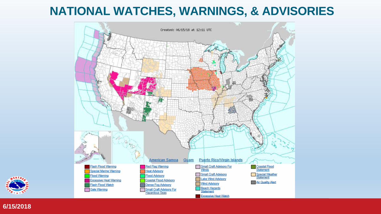
NATIONAL WATCHES, WARNINGS, & ADVISORIES
6/15/2018

6/15/2018
WATCHES, WARNINGS, & ADVISORIES
6/15/2018
NWS Kansas City NWS St. Louis
NWS Springfield NWS Paducah
NWS Quad Cities, IA/IL
NWS Memphis

6/15/2018
Hazardous Weather Outlook (Today):
Days Two Through Seven:
• Limited hail, lightning and thunderstorm wind damage risk for portions of Missouri today.
• Elevated excessive heat risk for Missouri.
WATCHES, WARNINGS, & ADVISORIES
6/15/2018
• Isolated thunderstorms possible for portions of the state through early next week.
• Afternoon heat indices in the upper 90s to over 100 through Monday.
Current Watches, Warnings & Advisories in Effect:• Heat Advisory in effect for the northern half of Missouri.• Excessive Heat Warning in effect for Jefferson, St. Charles and St. Louis
Counties and the City of St. Louis.

6/15/2018
WEATHER STORYNWS Kansas City
NWS Springfield
6/15/2018
Hot weather will continue into the upcoming weekend with isolated thunderstorms possible during the
afternoon and early evening. Most areas will remain dry. Better chances for storms along with slightly cooler temperatures are expected for next week.
Temperatures today and into the weekend will rise into the middle to upper 90s with heat index readings between 100 and 105 degrees. A heat advisory will be in effect from noon on Friday through Sunday at 8PM, mainly along
and north of I-70. A few action items to consider during this stretch of dangerous heat include: staying hydrated if working outdoors with breaks in the shade as often as possible, checking on elderly or those who are without
AC, NEVER leave your children or pets in the vehicle, and limit strenuous outdoor activities if possible.
6/15/2018
NWS Paducah
NWS St. Louis
6/15/2018
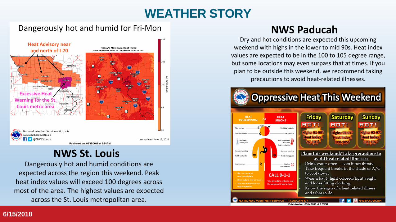
Dangerously hot and humid conditions are expected across the region this weekend. Peak
heat index values will exceed 100 degrees across most of the area. The highest values are expected
across the St. Louis metropolitan area.
Dry and hot conditions are expected this upcoming weekend with highs in the lower to mid 90s. Heat index
values are expected to be in the 100 to 105 degree range, but some locations may even surpass that at times. If you plan to be outside this weekend, we recommend taking
precautions to avoid heat-related illnesses.
WEATHER STORY

6/15/2018
NWS Memphis
NWS Quad Cities, IA/IL
6/15/2018
Temperatures will rise into the 90s during the afternoon, with heat index readings as high as 100 to 105 degrees. At night, temperatures will
only cool down into the 70s. These conditions will be very uncomfortable and potentially hazardous for outdoor activities. Thus a Heat Advisory has been issued for the entire area and is in effect from
this afternoon through Sunday evening. A cool front and associated thunderstorms may break the heat later on Monday.
Afternoon heat indices may exceed 105 degrees Saturday over portions of the Mid South. Heat
advisories may be needed.
WEATHER STORY

6/15/2018
SEVERE WEATHER OUTLOOK
Day 1Day 2
Day 3
6/15/2018

6/15/20186/15/2018
PRECIPITATION LAST 24 HOURS
6/15/20186/15/2018
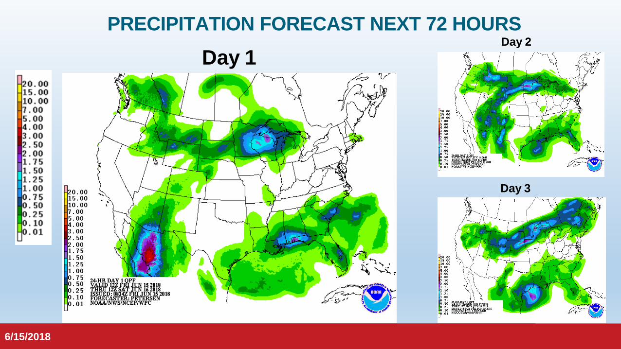
PRECIPITATION FORECAST NEXT 72 HOURSDay 1
Day 3
Day 2

6/15/2018
MISSOURI DEPT OF TRANSPORTATION
6/15/2018
Current Road Conditions6/15/2018 at 08:39 hours

6/15/2018
ELECTRIC POWER DASHBOARD
6/15/2018
6/15/2018
ELECTRIC COOPERATIVE OUTAGES
6/15/2018
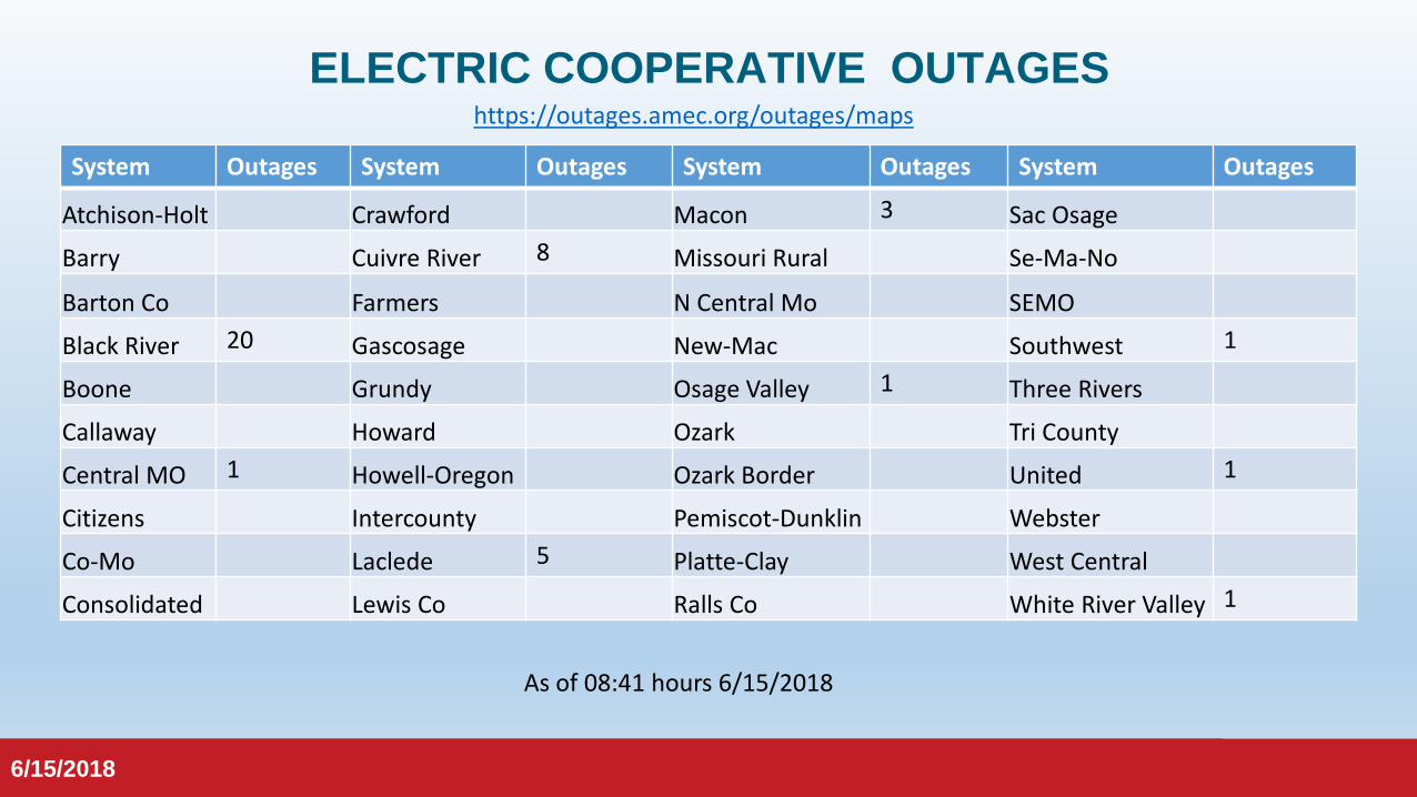
System Outages System Outages System Outages System Outages
Atchison-Holt Crawford Macon 3 Sac Osage
Barry Cuivre River 8 Missouri Rural Se-Ma-No
Barton Co Farmers N Central Mo SEMO
Black River 20 Gascosage New-Mac Southwest 1
Boone Grundy Osage Valley 1 Three Rivers
Callaway Howard Ozark Tri County
Central MO 1 Howell-Oregon Ozark Border United 1
Citizens Intercounty Pemiscot-Dunklin Webster
Co-Mo Laclede 5 Platte-Clay West Central
Consolidated Lewis Co Ralls Co White River Valley 1
As of 08:41 hours 6/15/2018
https://outages.amec.org/outages/maps
6/15/2018
ELECTRIC SYSTEM OUTAGES
6/15/2018
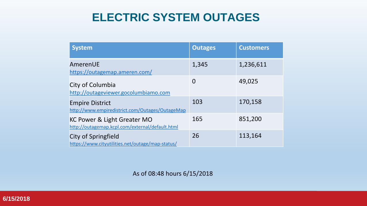
As of 08:48 hours 6/15/2018
System Outages Customers
AmerenUEhttps://outagemap.ameren.com/
1,345 1,236,611
City of Columbiahttp://outageviewer.gocolumbiamo.com
0 49,025
Empire Districthttp://www.empiredistrict.com/Outages/OutageMap
103 170,158
KC Power & Light Greater MOhttp://outagemap.kcpl.com/external/default.html
165 851,200
City of Springfieldhttps://www.cityutilities.net/outage/map-status/
26 113,164

6/15/2018
CYBER SECURITY
6/15/2018
6/15/2018
Missouri State Emergency Management Agency
Statewide Activity Report6/15/2018
For Official Use Only
6/15/2018

6/15/2018
WEATHER REPORTS (MISCELLANEOUS)Most Recent:
6/15/2018 Moderate to Major Flooding Wind Damage
Golf Ball and Larger Hail Reported
Tornado Damage Wildland Fire Activity
• 6/14/18-Scott County – multiple trees and power lines down• 6/14/18-Delta – trees and power lines down with minor
building damage• 6/14/18-Greene County – Golf ball size hail lasting appx 5
minutes• 6/14/18-Leadwood – 10 in maple tree blown down• 6/14/18-Hillsboro – Large tree limb down on power lines• 6/14/18-Jefferson County – Large partially rotten tree
snapped and fell onto mobile home, considerable damage• 6/14/18-Franklin County – Trees downed• 6/14/18-Danville – Semi truck blown over on I-70• 6/14/18-Dent County – trees with large branches down,
siding blown off of house.• 6/14/18-Texas County – tree blown down over road• 6/14/18-Marion County – estimated 70mph winds with debris
and trees down• 6/12/18-Poplar Bluff – Rain blown under doors causing
flooding at local church; few trees down, one on a house.• 6/12/18-Cape Girardeau County – Trees down in Jackson;
several power outages in Jackson and Cape Girardeau.• 6/11/18-Vernon County – Large tree limb down.• 6/11/18-St. Joseph – Large tree limb fell on fire truck, no
injuries.• 6/11/18-Tarkio – Trees uprooted

6/15/2018
DEPT. OF NATURAL RESOURCES EVENTS
Most Recent:• 6/13/18-Kansas City: rail engine lost appx 20-50
gallons of diesel fuel in rail yard• 6/13/18-Kansas City: Non-hazardous release of nut
oil in NFFF yard (Union Pacific Railroad)• 6/12/18-Ste. Genevieve: train struck pickup truck at
crossing, no fatalities or injuries• 6/11/18-Kansas City: release of diesel to pavement
of rail yard lot.• 6/7/18-King City: Blade failure on wind turbine
causing transformer to release appx 150 gallons of mineral oil.
• 6/5/18-North Kansas City: release of 75 gallons of diesel fuel due to locomotive.
6/15/2018
* Markers shown on map are cumulative for the current month.

6/15/2018
MAY 2018 INCIDENTSMISSOURI
STATE EMERGENCY MANAGEMENTSTATE WATCH CENTER
6/15/2018
Weather Reports Environmental Reports

6/15/2018
Missouri State Emergency Management Agency
Resource Status, Alert Messages,& Long-Term Outlooks
For Official Use Only
6/15/2018
6/15/2018
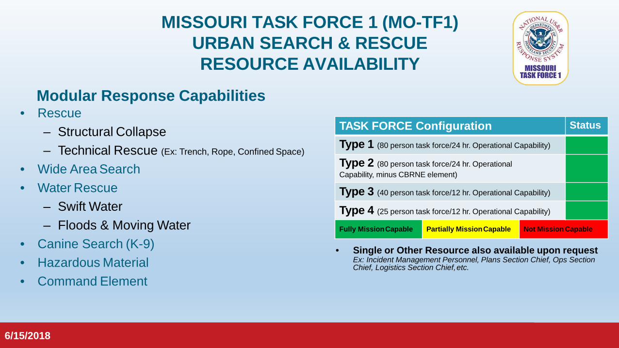
MISSOURI TASK FORCE 1 (MO-TF1) URBAN SEARCH & RESCUE RESOURCE AVAILABILITY
TASK FORCE Configuration Status
Type 1 (80 person task force/24 hr. Operational Capability)
Type 2 (80 person task force/24 hr. Operational Capability,.minus CBRNE element)
Type 3 (40 person task force/12 hr. Operational Capability)
Type 4 (25 person task force/12 hr. Operational Capability)
Fully MissionCapable Partially MissionCapable Not Mission Capable
• Single or Other Resource also available upon requestEx: Incident Management Personnel, Plans Section Chief, Ops Section Chief, Logistics Section Chief,etc.
Modular Response Capabilities• Rescue
– Structural Collapse– Technical Rescue (Ex: Trench, Rope, Confined Space)
• Wide Area Search• Water Rescue
– Swift Water– Floods & Moving Water
• Canine Search (K-9)• Hazardous Material• Command Element
6/15/2018
6/15/2018
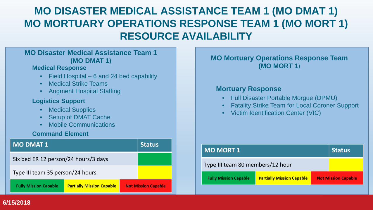
MO DISASTER MEDICAL ASSISTANCE TEAM 1 (MO DMAT 1)MO MORTUARY OPERATIONS RESPONSE TEAM 1 (MO MORT 1)
RESOURCE AVAILABILITY
• Field Hospital – 6 and 24 bed capability• Medical Strike Teams• Augment Hospital Staffing
6/15/2018
• Medical Supplies• Setup of DMAT Cache• Mobile Communications
MO DMAT 1 Status
Six bed ER 12 person/24 hours/3 days
Type III team 35 person/24 hours
Fully Mission Capable Partially Mission Capable Not Mission Capable
MO Disaster Medical Assistance Team 1 (MO DMAT 1) MO Mortuary Operations Response Team
(MO MORT 1)
MO MORT 1 Status
Type III team 80 members/12 hour
Fully Mission Capable Partially Mission Capable Not Mission Capable
• Full Disaster Portable Morgue (DPMU)• Fatality Strike Team for Local Coroner Support• Victim Identification Center (VIC)
Logistics Support
Medical Response
Command Element
Mortuary Response
6/15/2018
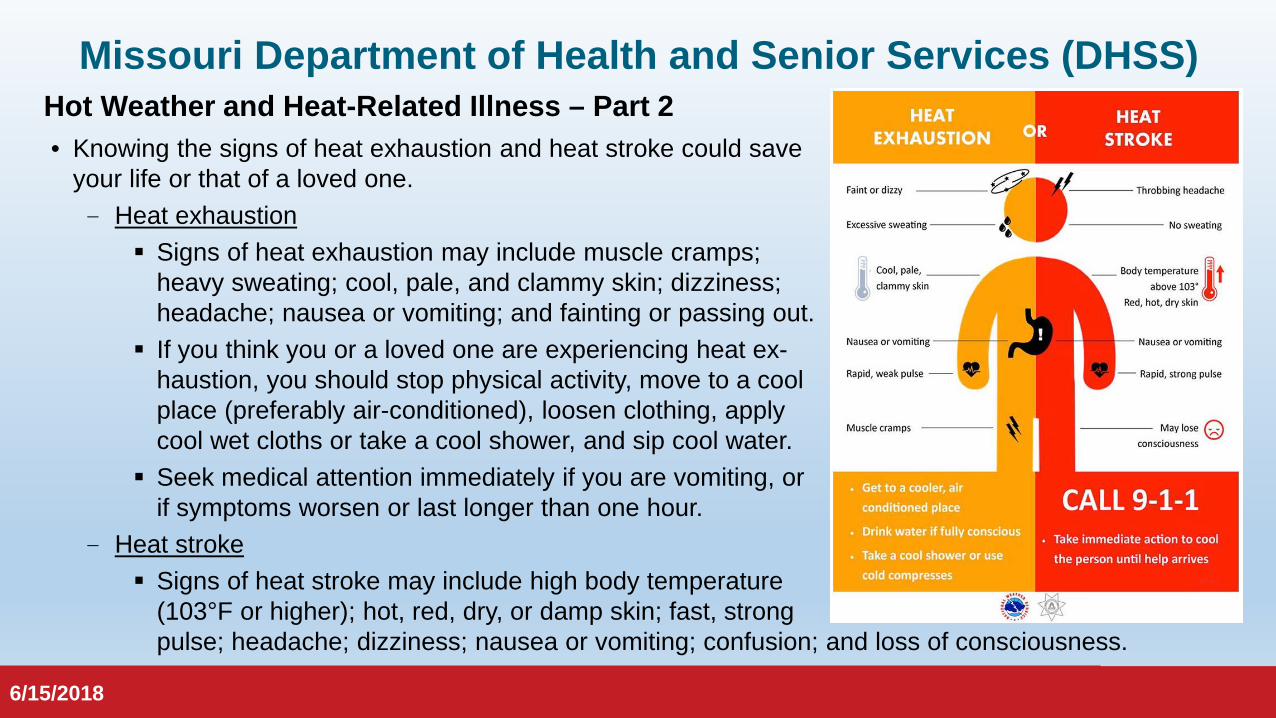
Missouri Department of Health and Senior Services (DHSS)Hot Weather and Heat-Related Illness – Part 2• Knowing the signs of heat exhaustion and heat stroke could save
your life or that of a loved one. - Heat exhaustion
Signs of heat exhaustion may include muscle cramps; heavy sweating; cool, pale, and clammy skin; dizziness; headache; nausea or vomiting; and fainting or passing out.
If you think you or a loved one are experiencing heat ex-haustion, you should stop physical activity, move to a cool place (preferably air-conditioned), loosen clothing, apply cool wet cloths or take a cool shower, and sip cool water.
Seek medical attention immediately if you are vomiting, or if symptoms worsen or last longer than one hour.
- Heat stroke Signs of heat stroke may include high body temperature
(103°F or higher); hot, red, dry, or damp skin; fast, strong pulse; headache; dizziness; nausea or vomiting; confusion; and loss of consciousness.
6/15/2018

6/15/2018
Missouri Department of Health and Senior Services (DHSS)Hot Weather and Heat-Related Illness – Part 2
- Heat stroke (continued) If you think you or a loved one are experiencing heat stroke, you should call 911 immediately.
Heat stroke is a medical emergency. Move the person to a cool place—preferably air-conditioned. Help lower the person’s body
temperature with cool cloths or a cool bath until medical personnel arrive. Do not give the person anything to drink.
• For more information on hot weather and heat-related illness, go to:- Hyperthermia (DHSS)
https://health.mo.gov/living/healthcondiseases/hyperthermia/index.php
- Heat-Related Resources (DHSS) https://health.mo.gov/emergencies/ert/naturaldisasters.php#heat
6/15/2018
6/15/2018
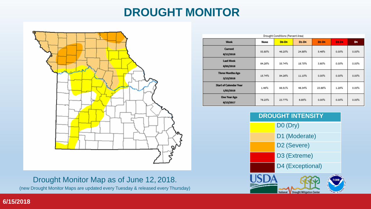
DROUGHT MONITOR
DROUGHT INTENSITYD0 (Dry)
D1 (Moderate)D2 (Severe)D3 (Extreme)D4 (Exceptional)
Drought Monitor Map as of June 12, 2018.(new Drought Monitor Maps are updated every Tuesday & released every Thursday)
6/15/2018

6/15/2018
FIRE POTENTIAL OUTLOOK
An extended outlook forecasts significant wildland fire potential to be “Normal” for Missouri for the month of July.
The potential for significantwildland fire is expected to beat “Normal” levels in Missouri for the month of June.
6/15/2018
6/15/2018
STATE WATCH CENTER
www.sema.dps.mo.gov@MoSEMA_
MissouriSEMA on Facebook
Email: Phone: Toll-Free:
6/15/2018