Mississippi River Venice to New Orleans - Quick Links · BookletChart Mississippi River Venice to ....
20
BookletChart ™ Mississippi River – Venice to New Orleans NOAA Chart 11364 A reduced-scale NOAA nautical chart for small boaters When possible, use the full-size NOAA chart for navigation.
-
Upload
duongquynh -
Category
Documents
-
view
215 -
download
0
Transcript of Mississippi River Venice to New Orleans - Quick Links · BookletChart Mississippi River Venice to ....

BookletChart™ Mississippi River – Venice to New Orleans NOAA Chart 11364
A reduced-scale NOAA nautical chart for small boaters When possible, use the full-size NOAA chart for navigation.

2
Published by the National Oceanic and Atmospheric Administration
National Ocean Service Office of Coast Survey
www.NauticalCharts.NOAA.gov 888-990-NOAA
What are Nautical Charts?
Nautical charts are a fundamental tool of marine navigation. They show water depths, obstructions, buoys, other aids to navigation, and much more. The information is shown in a way that promotes safe and efficient navigation. Chart carriage is mandatory on the commercial ships that carry America’s commerce. They are also used on every Navy and Coast Guard ship, fishing and passenger vessels, and are widely carried by recreational boaters.
What is a BookletChart?
This BookletChart is made to help recreational boaters locate themselves on the water. It has been reduced in scale for convenience, but otherwise contains all the information of the full-scale nautical chart. The bar scales have also been reduced, and are accurate when used to measure distances in this BookletChart. See the Note at the bottom of page 5 for the reduction in scale applied to this chart.
Whenever possible, use the official, full scale NOAA nautical chart for navigation. Nautical chart sales agents are listed on the Internet at http://www.NauticalCharts.NOAA.gov.
This BookletChart does NOT fulfill chart carriage requirements for regulated commercial vessels under Titles 33 and 44 of the Code of Federal Regulations.
Notice to Mariners Correction Status
This BookletChart has been updated for chart corrections published in the U.S. Coast Guard Local Notice to Mariners, the National Geospatial Intelligence Agency Weekly Notice to Mariners, and, where applicable, the Canadian Coast Guard Notice to Mariners. Additional chart corrections have been made by NOAA in advance of their publication in a Notice to Mariners. The last Notices to Mariners applied to this chart are listed in the Note at the bottom of page 7. Coast Pilot excerpts are not being corrected.
For latest Coast Pilot excerpt visit the Office of Coast Survey website at http://www.nauticalcharts.noaa.gov/nsd/searchbychart.php?chart=11364
[Coast Pilot 5, Chapter 9 excerpts] Mississippi River empties into the N central part of the Gulf of Mexico through a number of mouths or passes which, taken together, form the delta of the river. The river and its tributaries form the largest network of navigable waters in the world. The two principal passes, South Pass and Southwest Pass, are about 1,600 nautical miles from New York, 500 nautical miles from Key West, 300 nautical miles E of Galveston, and 440 nautical miles E of
Corpus Christi. The river is the access to the Ports of New Orleans and
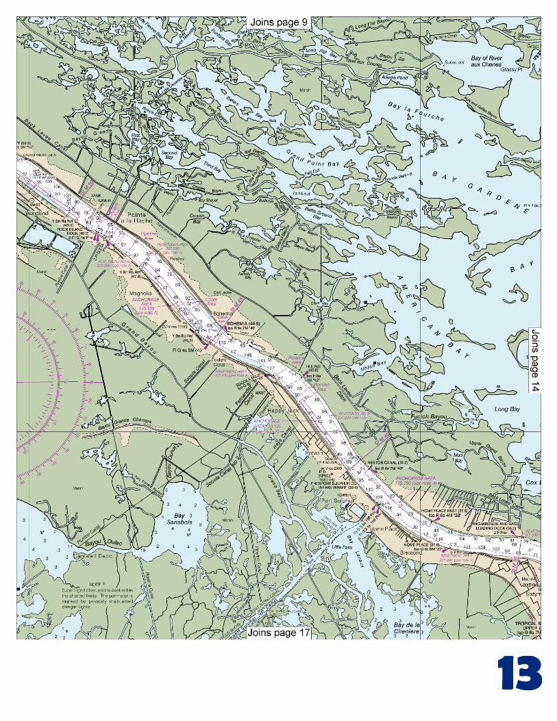
Baton Rouge, and the numerous cities in the central part of the United States located in the Mississippi River Valley and along its tributaries, the Ohio, Missouri, Red, Tennessee, and other rivers flowing into it. From the mouth, at the entrance to Southwest Pass, it is about 1,840 miles to Minneapolis, 1,960 miles to Pittsburgh, 1,680 miles to Knoxville, and 1,530 miles to Chicago via the Illinois Waterway. Mississippi River-Gulf Outlet Canal is a 66-mile-long deepwater channel that extends NW from deep water in the Gulf of Mexico to the Inner Harbor Navigation Canal at New Orleans. Venice is a fishing and marine repair center on the W side of Grand Pass just inside The Jump. Oil companies have service and repair bases, and drilling mud, pipe, and equipment are loaded here for the offshore drilling rigs in the Gulf. Boatyards have a 150-ton lift and cranes to 100 tons; hull and engine repairs are made. Boothville is a small town on the W side of the river about 16.1 miles Above Head of Passes (AHP). A public wharf 100 feet long is 14.7 miles AHP. Jackson is on the W side of the river at the bend in the river about 19.6 miles AHP. Here the river takes a SW trend for about 2.3 miles, then trends WNW. Ostrica is a small village on the N side of the river about 24.7 miles AHP. The State-owned Ostrica Canal, which connects the river with Quarantine Bay, enters the river 25 miles AHP. Buras is a small town and fruit shipping center on the S side of the river about 25.7 miles AHP. A water tank is prominent. (Empire is a town on the W side of the river about 29.5 miles AHP. A tank and a church spire are prominent. Empire Canal leads from the river at Empire to the Gulf W of the river. Port Sulphur is on the W side of the river about 39.4 miles AHP. The loading towers, two tanks, and conveyor galleries of the sulfur plant are very conspicuous. Two ship docks are operated by Freeport Sulphur Co. for the shipment of liquid and dry bulk sulfur. The docks are 458 and 800 feet long and have 50 feet reported alongside. The wharves are marked by privately maintained lights. Bohemia is a small village on the E side of the river about 45.8 miles AHP. State Route 39 leads along the E side of the river behind the levee from Bohemia to New Orleans. Pointe a la Hache, 49 miles AHP and about 46 miles below New Orleans, is the seat of Plaquemine Parish which embraces most of the lower Mississippi River. Belle Chasse is on the W side of the river about 75.5 miles AHP. A T-shaped molasses handling wharf operated by Red Star Yeast and Products Co. has 240 feet of berthing space with dolphins and depths of 25 feet reported alongside. The dolphins are marked by private lights. A ferry crosses the river from Belle Chasse Scarsdale on the E side of the river. The ferry landings are marked by privately maintained lights. Vessels should approach the Empire Waterway from the Gulf through the Empire Safety Fairway. (See 166.100 through 166.200, chapter 2.) Vessels should approach Bastian Bay and Grand Bayou from the Gulf through Grand Bayou Pass Safety Fairway. (See 166.100 through 166.200, chapter 2.)
U.S. Coast Guard Rescue Coordination Center 24 hour Regional Contact for Emergencies
RCC New Orleans Commander
8th CG District (504) 589-6225 New Orleans, LA

G
NOAA’s navigation managers serve as ambassadors to the maritime community. They help identify navigational challenges facing professional and recreational mariners, and provide NOAA resources and information for safe navigation. For additional information, please visit nauticalcharts.noaa.gov/service/navmanagers
To make suggestions or ask questions online, go to nauticalcharts.noaa.gov/inquiry. To report a chart discrepancy, please use ocsdata.ncd.noaa.gov/idrs/discrepancy.aspx.
Lateral System As Seen Entering From Seaward on navigable waters except Western Rivers
PORT SIDE
ODD NUMBERED AIDS
GREEN LIGHT ONLY
FLASHING (2)
PREFERRED CHANNEL
NO NUMBERS – MAY BE LETTERED
PREFERRED CHANNEL TO
STARBOARD
TOPMOST BAND GREEN
PREFERRED CHANNEL
NO NUMBERS – MAY BE LETTERED
PREFERRED CHANNEL
TO PORT
TOPMOST BAND RED
STARBOARD SIDE
EVEN NUMBERED AIDS
RED LIGHT ONLY
FLASHING (2)
FLASHING FLASHING
OCCULTING GREEN LIGHT ONLY RED LIGHT ONLY OCCULTING QUICK FLASHING QUICK FLASHING
ISO COMPOSITE GROUP FLASHING (2+1) COMPOSITE GROUP FLASHING (2+1) ISO
"1"
Fl G 6s
G "9"
Fl G 4s
GR "A"
Fl (2+1) G 6s
RG "B"
Fl (2+1) R 6s
"2"
Fl R 6s
8
R "8"
Fl R 4s
LIGHT
G
C "1"
LIGHTED BUOY
G
"5"
GR
"U"
GR
C "S"
RG
N "C"
RG
"G"
LIGHT
6
R
N "6"
LIGHTED BUOY
R
"2
"
CAN DAYBEACON
CAN NUN NUN
DAYBEACON
For more information on aids to navigation, including those on Western Rivers, please consult the latest USCG Light List for your area.
These volumes are available online at http://www.navcen.uscg.gov
Navigation Managers Area of Responsibility
Northeast
Lt. Meghan McGovern
Northwest and
Pacific Islands
Crescent Moegling
Great Lakes Region
Tom Loeper
Chesapeake and
Delaware Bay
Steve Soherr
California
Jeff Ferguson
[email protected] Mid-Atlantic
Lt. Ryan Wartick
Alaska
Lt. Timothy M. Smith
Western Gulf Coast
Alan Bunn
Central Gulf Coast
Tim Osborn
[email protected] South Florida
Puerto Rico
U.S. Virgin Islands
Michael Henderson
Southeast
Kyle Ward
2
2 C U 5
1


VHF Marine Radio channels for use on the waterways:Channel 6 – Inter-ship safety communications.Channel 9 – Communications between boats and ship-to-coast.Channel 13 – Navigation purposes at bridges, locks, and harbors.Channel 16 – Emergency, distress and safety calls to Coast Guard and others, and to initiate calls to other
vessels. Contact the other vessel, agree to another channel, and then switch.Channel 22A – Calls between the Coast Guard and the public. Severe weather warnings, hazards to navigation and safety warnings are broadcast here.Channels 68, 69, 71, 72 and 78A – Recreational boat channels.
Getting and Giving Help — Signal other boaters using visual distress signals (flares, orange flag, lights, arm signals); whistles; horns; and on your VHF radio. You are required by law to help boaters in trouble. Respond to distress signals, but do not endanger yourself.
EMERGENCY INFORMATION
Distress Call Procedures
• Make sure radio is on.• Select Channel 16.• Press/Hold the transmit button.• Clearly say: “MAYDAY, MAYDAY, MAYDAY.”• Also give: Vessel Name and/or Description;Position and/or Location; Nature of Emergency; Number of People on Board.• Release transmit button.• Wait for 10 seconds — If no responseRepeat MAYDAY call.
HAVE ALL PERSONS PUT ON LIFE JACKETS!
This Booklet chart has been designed for duplex printing (printed on front and back of one sheet). If a duplex option is not available on your printer, you may print each sheet and arrange them back-to-back to allow for the proper layout when viewing.
QR
Quick ReferencesNautical chart related products and information - http://www.nauticalcharts.noaa.gov
Interactive chart catalog - http://www.charts.noaa.gov/InteractiveCatalog/nrnc.shtmlReport a chart discrepancy - http://ocsdata.ncd.noaa.gov/idrs/discrepancy.aspx
Chart and chart related inquiries and comments - http://ocsdata.ncd.noaa.gov/idrs/inquiry.aspx?frompage=ContactUs
Chart updates (LNM and NM corrections) - http://www.nauticalcharts.noaa.gov/mcd/updates/LNM_NM.html
Coast Pilot online - http://www.nauticalcharts.noaa.gov/nsd/cpdownload.htm
Tides and Currents - http://tidesandcurrents.noaa.gov
Marine Forecasts - http://www.nws.noaa.gov/om/marine/home.htm
National Data Buoy Center - http://www.ndbc.noaa.gov/
NowCoast web portal for coastal conditions - http://www.nowcoast.noaa.gov/
National Weather Service - http://www.weather.gov/
National Hurrican Center - http://www.nhc.noaa.gov/
Pacific Tsunami Warning Center - http://ptwc.weather.gov/
Contact Us - http://www.nauticalcharts.noaa.gov/staff/contact.htm
NOAA’s Office of Coast Survey The Nation’s Chartmaker
For the latest news from Coast Survey, follow @NOAAcharts
NOAA Weather Radio All Hazards (NWR) is a nationwide network of radio stations broadcasting continuous weather information directly from the nearest National Weather Service office. NWR broadcasts official Weather Service warnings, watches, forecasts and other hazard information 24 hours a day, 7 days a week. http://www.nws.noaa.gov/nwr/