Minta Farm Precinct Structure Plan - Amazon Web Services · Concept road design plans for both...
26
Minta Farm Precinct Structure Plan Concept Road Design Report Client: Victorian Planning Authority Project No. 161910 Final Report – 05/10/17 1 st Floor 132 Upper Heidelberg Road Ivanhoe Vic 3079 PO Box 417 Ivanhoe Vic 3079 Ph: (03) 9490 5900 Fax: (03) 9490 5910 www.trafficworks.com.au
Transcript of Minta Farm Precinct Structure Plan - Amazon Web Services · Concept road design plans for both...

Minta Farm Precinct Structure Plan
Concept Road Design Report
Client:
Victorian Planning Authority
Project No. 161910
Final Report – 05/10/17
1st Floor 132 Upper Heidelberg Road Ivanhoe Vic 3079
PO Box 417 Ivanhoe Vic 3079 Ph: (03) 9490 5900 Fax: (03) 9490 5910
www.trafficworks.com.au
161910: Minta Farm Precinct – Concept Road Design Report
Final_3: 05/10/2017 i
DOCUMENT CONTROL RECORD
Document prepared by:
Trafficworks Pty Ltd
ABN 59 125 488 977
1st Floor 132 Upper Heidelberg Rd Ivanhoe Vic 3079
PO Box 417 Ivanhoe Vic 3079
Ph (03) 9490 5900
Fax (03) 9490 5910
www.trafficworks.com.au
DISCLAIMER
The information contained in this document is intended to be received, used and relied upon by
the named addressee or client only for the purpose for which it has been prepared. Trafficworks
Pty Ltd does not warrant the accuracy or relevance of the information, including by implication,
contained in this document if it is used or relied upon by any person other than the named
addressee or client. Copying, reproduction including by electronic means, unauthorised use or
disclosure of this document is prohibited except with the express written authorisation of
Trafficworks Pty Ltd.
Document Control
Report Title Minta Farm PSP – Concept Road Design Report
Project Number 161910
Client Victorian Planning Authority
Client Contact Cath Olive / Elizabeth McIntosh
Rev Date
Issued
Revision Details
/ Status Prepared by Authorised by
Draft 24/11/16 Draft Alison Corcoran / Renney Kratky Ali Abdou
Draft_2 25/01/17 Draft_2 Alison Corcoran / Renney Kratky Ali Abdou
Draft_3 27/04/17 Draft_3 Alison Corcoran / Renney Kratky Ali Abdou
Final 28/06/17 Final Alison Corcoran / Renney Kratky Ali Abdou
Final_2 14/08/17 Final_2 Alison Corcoran / Renney Kratky Ali Abdou
Final_3 05/10/17 Final_3 Alison Corcoran / Renney Kratky Ali Abdou

161910: Minta Farm Precinct – Concept Road Design Report
Final_3: 05/10/2017 ii
TABLE OF CONTENTS
1 INTRODUCTION ................................................................................................................. 1
2 BACKGROUND ................................................................................................................... 2
3 DESIGN PHILOSOPHY ....................................................................................................... 4
3.1 Road Cross Sections .............................................................................................................. 4
3.2 Lane Geometry ....................................................................................................................... 7
3.3 Intersection Geometry ........................................................................................................... 8
3.4 Road Alignment ...................................................................................................................... 9
3.5 Interim and Ultimate Layout Interaction ............................................................................... 9
3.6 Pedestrian and Cyclist Facilities ........................................................................................ 10
3.7 Land Acquisition .................................................................................................................. 10
3.8 Services Affected by Proposed Works ............................................................................... 11
ATTACHMENT A – CONCEPT ROAD DESIGN
161910: Minta Farm Precinct – Concept Road Design Report
Final_3: 05/10/2017 1 1 1
1 INTRODUCTION
Trafficworks has been engaged by the Victorian Planning Authority (VPA) to undertake concept
designs for key intersections and road lengths within the Minta Farm precinct in Berwick. This
includes six intersections and four road segments, as follows:
• IN-01 – North-south Arterial / O’Shea Road
• IN-02 – North-south Arterial / East-west connector (north)
• IN-03 – North-south Arterial / East-west connector (central)
• IN-04 – North-south Arterial / East-west connector (south)
• IN-05 – North-south Arterial / Grices Road
• IN-06 – North-south Connector / Grices Road
• RD-01, RD-02, RD-03, RD-04 – North-South Arterial, between O’Shea Road (north) and Grices
Road / Soldiers Road (south).
The Minta Farm precinct concept designs have been prepared in line with the following documents
to ensure the appropriate standards, regulations and guidelines are satisfied.
• GAA Engineering Design and Constructing Manual for Subdivision in Growth Areas
• the VicRoads Guidelines for Planning Road Networks in Growth Areas
• Austroads Guide to Road Design Part 3: Geometric Design
• Austroads Guide to Road Design Part 4A: Unsignalised and Signalised Intersections
• Australian Standards
• VPA standard cross-sections for Minta Farm Precinct
This report has been prepared to outline the methodology applied in relation to design vehicles,
geometric design parameters, cross sections etc. and to determine the existing services that may
impact on the design.

161910: Minta Farm Precinct – Concept Road Design Report
Final_3: 05/10/2017 2 2 2
2 BACKGROUND
The Minta Farm is a single property previously used for farming purposes and covers an
approximate area of 286 hectares. The properties surrounding the site comprise a combination of
existing residential dwellings, parklands and schools, as well as additional proposed future
residential development, generally to the south of the site. The site is also bordered by the Princes
Freeway to the north and Cardinia Creek to the east.
The VPA is in the process of preparing a precinct structure plan (PSP) to guide the future
development of this site. The PSP seeks to provide a mix of residential and employment
opportunities, a local town centre, school and a range of parks and sporting facilities. These
concept design plans will inform the Minta Farm PSP.
The subject site and the surrounding road environment is shown in Figure 1.
Figure 1: Site Location (reproduced with permission from Melway Publishing Pty Ltd)
The Minta Farm development area will gain access to the surrounding network via an extension of
O’Shea Road to the north, Grices Road to the south and Soldiers Road to the west. O’Shea Road
is currently classified as a local road, configured with one traffic lane in each direction. Future
planning for O’Shea Road indicates that it will become a six-lane arterial road.
A new north-south arterial through the development site will provide the last link in the major north-
south arterial network. This north-south arterial will provide access to the Princes Freeway at the
Beaconsfield interchange (via O’Shea Road) for the south-east development corridor, including the
Clyde North PSP area located south of the Minta Farm development site.
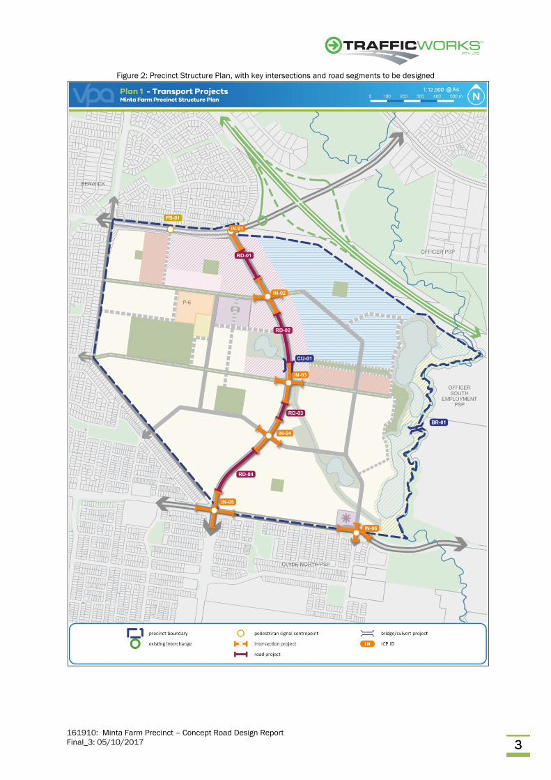
The draft precinct structure plan for the site is shown in Figure 2. This plan indicates the key
features and land uses within the precinct, as well as the key arterial and collector roads to be
developed.
SUBJECT SITE
161910: Minta Farm Precinct – Concept Road Design Report
Final_3: 05/10/2017 3 3 3
Figure 2: Precinct Structure Plan, with key intersections and road segments to be designed

161910: Minta Farm Precinct – Concept Road Design Report
Final_3: 05/10/2017 4 4 4
3 DESIGN PHILOSOPHY
Concept road design plans for both interim and ultimate arrangements have been prepared for
the five key intersections and four road segments to be considered within the Minta Farm
precinct. This design philosophy report provides guidance on the principles, guidelines and
standards applied in preparing the concept designs.
3.1 Road Cross Sections
The VPA has prepared a series of standard cross sections for roads of varying function for the Minta
Farm Precinct. All concept road and intersection designs have been developed in line with these
standard road cross sections. The function of the road has been used when considering which
cross section to apply (primary arterial, secondary arterial or connector street).
3.1.1 Primary Arterial Road (6 lanes)
The VPA has provided a standard cross section for a six-lane primary arterial road, with an operating
speed of 80km/h (refer to Figure 3). This specifies a 41m wide road reserve, with two 10.5m wide
carriageways separated by a 6m wide central median. There is also provision for two-way off-road
bicycle paths and separate pedestrian paths on both sides of the road.
The north-south arterial and O’Shea Road function as primary arterials.
Figure 3: Primary Arterial Road standard cross section

161910: Minta Farm Precinct – Concept Road Design Report
Final_3: 05/10/2017 5 5 5
3.1.2 Secondary Arterial Road (4 lanes)
The VPA has provided a standard cross section for a four-lane secondary arterial road, with an
operating speed of 60km/h (refer to Figure 4). This specifies a 34m wide road reserve, with two
7.0m wide carriageways separated by a 6m wide central median. There is also provision for on-
road bicycle lanes in each direction and shared paths on both sides of the road.
Grices Road functions as a secondary arterial.
Figure 4: Secondary Arterial Road standard cross section
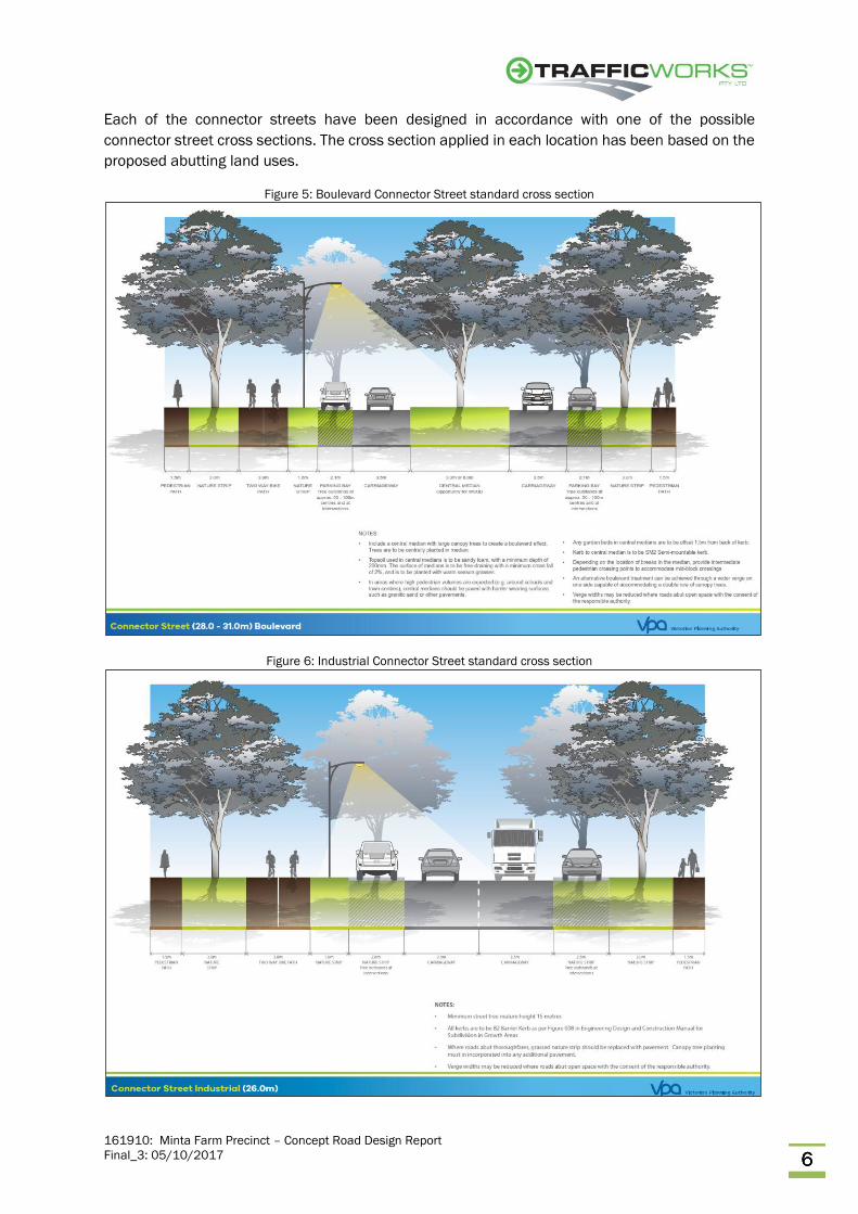
3.1.3 Connector Streets
The VPA has provided a standard cross section for a boulevard connector street, an industrial
connector street and a residential connector street. The type of cross section applied will rely on
the abutting land use.
The VPA standard cross sections for connector streets specify a 25m road reserve for connector
streets, a 26m road reserve for industrial connector streets and a 28 – 31m wide road reserve for
connector boulevards. Additionally, cross sections comprise two 3.5m wide traffic lanes (separated
by a central median for a boulevard) and an indented parking lane on both sides of the road. The
parking lane is either 2.1m wide (connector streets and connector boulevards) or 2.6m wide
(industrial connector streets). There is also provision for a two-way off-road bicycle path on one
side of the road and separate pedestrian paths on both sides of the road.
The standard cross sections for the three types of connector street are shown in Figure 5, Figure
6 and Figure 7.
161910: Minta Farm Precinct – Concept Road Design Report
Final_3: 05/10/2017 6 6 6
Each of the connector streets have been designed in accordance with one of the possible
connector street cross sections. The cross section applied in each location has been based on the
proposed abutting land uses.
Figure 5: Boulevard Connector Street standard cross section
Figure 6: Industrial Connector Street standard cross section

161910: Minta Farm Precinct – Concept Road Design Report
Final_3: 05/10/2017 7 7 7
Figure 7: Residential Connector Street standard cross section
3.2 Lane Geometry
The intersection layouts include turn lanes to accommodate left and right turning vehicles at
each of the intersections. VicRoads Guide for Planning Road Networks in Growth Areas specifies
lengths for turn lanes to be provided along arterial and connector streets. Table 1 (reproduced
from Table 4-1 in VicRoads Guide for Planning Road Networks in Growth Areas) indicates the
typical turn lane lengths to be implemented for the ultimate intersection configurations.
The turn lane lengths specified in Table 1 have been applied when designing each of the
intersection concept designs. The north-south arterial and O’Shea Road are classified as primary
arterials and Grices Road is classified as a secondary arterial. Each of the remaining intersecting
roads are classified as connector streets.
Table 1: Typical Turn Lane Lengths – Ultimate intersection configuration

161910: Minta Farm Precinct – Concept Road Design Report
Final_3: 05/10/2017 8 8 8
Austroads Guide to Road Design – Part 4A: Unsignalised and Signalised Intersections (AGRD4A)
also provides guidance on the required length of deceleration turn lanes. AGRD4A specifies the
required dimensions of deceleration turn lanes in terms of the deceleration length to ensure
vehicles can safely slow to a stop from the approach speed and the additional length required to
store a design vehicle while waiting to turn. As per AGRD4A:
• turn lanes along primary arterial roads (80km/h speed) should be 120m long (100m
deceleration plus 19m storage)
• turn lanes along secondary arterial roads (60km/h) should be 75m long (55m deceleration
plus 19m storage)
• turn lanes along connector streets (50km/h) should be 60m long (40m deceleration plus
19m storage).
It is noted that turn lane lengths as per AGRD4A are shorter than indicated by the VicRoads Guide.
Hence, the turn lane lengths have been designed in accordance with Table 1.
3.3 Intersection Geometry
3.3.1 Slip Lanes
Slip lanes have been considered at the intersections along the primary arterial road (north-south
arterial). Slip lanes have been included in the design at the north-south arterial / Grices Road
intersection (IN-05). However, slip lanes have not be included at IN-02, IN-03 and IN-04, as per the
brief.
3.3.2 O’Shea Road and North-South Arterial intersection - VicRoads concept design
O’Shea Road has been designed by VicRoads. The design of the intersection with the north-south
arterial included a left turn slip lane from east to south which provided three traffic lanes. The
design also resulted in the north-south arterial and O’Shea Road intersection being skewed (i.e. at
70 degrees). Trafficworks design of the north-south arterial at O’Shea Road accommodates these
three left turn lanes and the intersection skew.
As a result of the alignment of the O’Shea Road and the north-south arterial intersection, the design
of IN-02 is also at 70 degrees. This can affect the opposing right turns along the north-south arterial
at the intersection. These turns have been accommodated at the intersection, but particular
consideration should be given to the opposing right turns during detailed design.

161910: Minta Farm Precinct – Concept Road Design Report
Final_3: 05/10/2017 9 9 9
3.3.3 Swept Paths
Swept path assessments at each of the intersections have been undertaken to ensure the
following design (and check) vehicles can safely perform turning manoeuvres:
• The north-south arterial / O’Shea Road intersection and the north-south arterial / Grices Road
intersection (two arterial roads) have been designed to allow two 19m semi-trailers to
concurrently perform opposing (diamond) right turns
• Intersections between an arterial road and a connector road have been designed to allow:
o one 12.5m rigid truck and one 19m semi-trailer to concurrently perform opposing
(diamond) right turns
o a 12.5m rigid truck (design vehicle) to perform a left turn at the intersection
o a 19m semi-trailer (check vehicle) to perform a left turn at the intersection,
however will be required to encroach into the through lane
o Industrial connector roads have been design to accommodate 19m semi-trailers.
3.4 Road Alignment
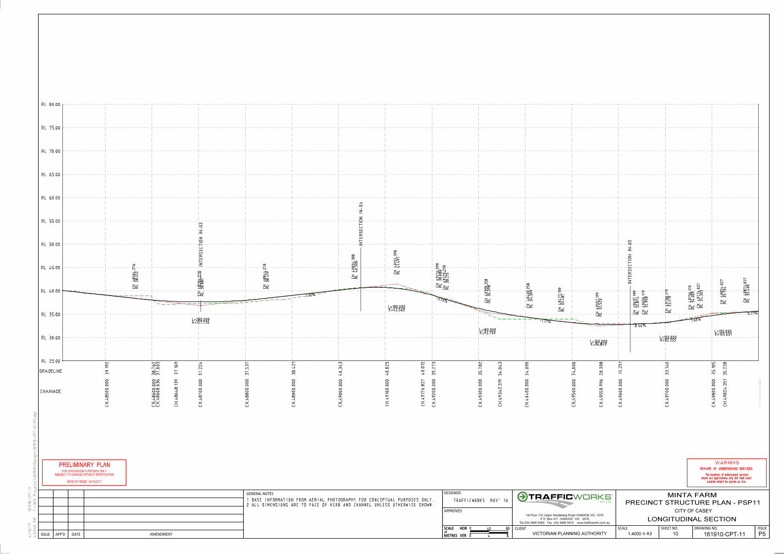
3.4.1 Vertical Alignment
Grade lines have been checked along the north-south arterial. The grade is undulating, generally
follows the topography of the land and review indicates grades of up to 4% along its length.
3.4.2 Horizontal Road Alignment
The horizontal curve radii in the road alignment along the north-south arterial have been designed
in excess of the desirable requirements for V80 design speeds on urban roads (desirable 230m
minimum radius).
3.5 Interim and Ultimate Layout Interaction
The interim intersection and road layouts have been designed to fit within the ultimate layouts in
order to minimise the rework required to implement the ultimate layout.
The north-south arterial, O’Shea Road and Grices Road comprise divided carriageways in the
ultimate condition.
The interim layout of these roads (mid-block) is to be designed to ensure that the interim two-way
traffic lanes will fit within a single carriageway in the ultimate condition. This will result in the interim
carriageway being shifted to one side of the road reserve, rather than being centrally placed.
The interim layout at intersections should be designed so that the intersection is located in its
ultimate position. This involves shifting traffic lanes along the single undivided carriageway to
match in with the ultimate divided carriageway intersection layout in advance of the intersection.
Implementation of this also involves creating the interim right turn lane in the ultimate location of
the central through lane. Installation of a wider central median adjacent to the interim right turn
lane allows for the ultimate right turn lane to be widened into the median.
161910: Minta Farm Precinct – Concept Road Design Report
Final_3: 05/10/2017 10 10 10
To match in with existing road infrastructure and carriageway locations, the interim layout will
utilise the following carriageways:
• eastbound carriageway along O’Shea Road
• southbound carriageway along the north-south arterial
• eastbound carriageway along Grices Road
3.6 Pedestrian and Cyclist Facilities
The proposed road network within the Minta Farm Precinct indicates that pedestrian and cyclist
facilities are to be provided along all arterial and connector type roads. This includes a combination
of pedestrian footpaths, shared paths, off-road bicycle paths and on-road bicycle lanes.
• The north-south arterial and O’Shea Road (primary arterial roads) propose an off-road bicycle
path to be provided along both sides of the road, with an adjacent pedestrian footpath.
• Grices Road (secondary arterial road) proposes on-road bicycle lanes, with a 0.5m painted
buffer zone, along both sides of the road and shared paths on both sides of the road.
• All other connector roads propose an off-road bicycle path to be provided along one side of
the road and pedestrian footpaths to be provided on both sides of the road.
The above facilities should be provided as per the standard cross sections and provide suitable
connections between shared paths, off-road bicycle paths and footpaths at intersections to ensure
confusion is minimised and the function of each paths is clearly understood.
Connectivity needs to be provided between shared paths / off-road bicycle paths across
intersections. This has been designed in accordance with VicRoads Guide for Planning Road
Networks in Growth Areas. Crosswalks at intersections are at least 3.0m wide, to accommodate
both pedestrians and cyclists at the intersection. In addition, the installation of bicycle lanterns at
crosswalks and/or implementation of cut-through islands to safely accommodate bicycles should
be considered.
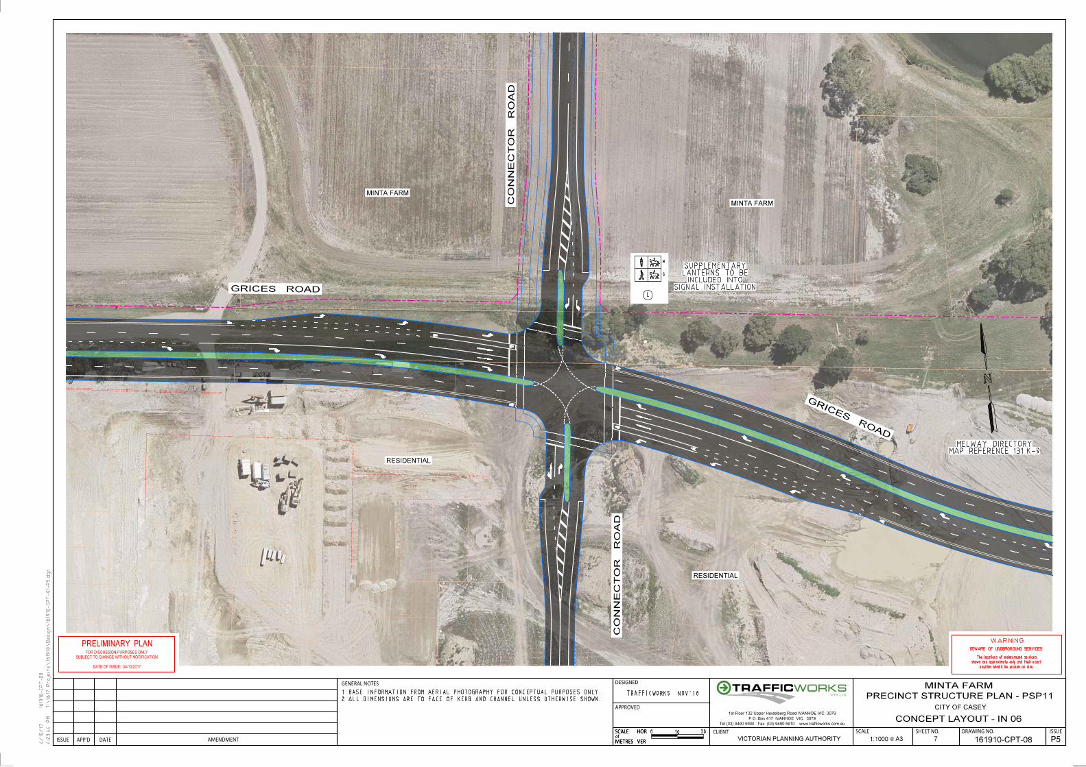
3.6.1 IN-06 Grices Road
At IN-06 (Grices Road), an equestrian lantern should be installed at the crossing alongside the
pedestrian lantern.
3.7 Land Acquisition
All land required to accommodate the road reserves is located within the existing Minta Farm
property (single property). Hence, no external land acquisition is required for other properties.

161910: Minta Farm Precinct – Concept Road Design Report
Final_3: 05/10/2017 11 11 11
3.8 Services Affected by Proposed Works
A “Dial Before You Dig” enquiry of the services in the vicinity of the proposed works has been
undertaken. A review of the services / utilities information indicates the following notable services
are located within the vicinity of the Soldiers Road / Grices Road intersection:
• Soldiers Road / Grices Road intersection
o APA Gas – distribution gas main (south side of Grices Road, crossing Solders Road
on south side of intersection)
o Ausnet Electricity – underground high voltage cable (south side of Grices Road,
crossing Solders Road on south side of intersection)
o Casey City Council – drainage channel (south side of Grices Road, crossing Solders
Road on south side of intersection)
o South East Water - water main (south-west side of Soldiers Road north and south
side of Grices Road)
o South East Water - sewer main (west side of Soldiers Road south, crossing Grices
Road west of the intersection)
o South East Water – recycled water main (east and west sides of Soldiers Road
south and south side of Grices Road, crossing Soldiers Road south of the
intersection)
o NBN cable – cable and duct (south side of Grices Road west, north side of Grices
Road east, crosses Soldiers Road on the south side of the intersection)
Locations of underground services need to be verified on-site and approvals to work within the
vicinity of these services sought from the relevant service authority / company.
161910: Minta Farm Precinct – Concept Road Design Report
Final_3: 05/10/2017
ATTACHMENT A – CONCEPT ROAD DESIGN

DESIGNED
APPROVED
HOR
VER
SHEET NO. DRAWING NO. ISSUE
GENERAL NOTES
AMENDMENTDATEAPP'DISSUE
SCALE
METRESof
VERMETRES
HORof
SCALE CLIENT SCALE
4/10/17
4:2
3:11
PM
1619
10-CP
T-01
T:\
1617 Proje
cts\16
1910\
Desig
n\16
1910-CP
T-01-
P5.d
gn
PTY LTD
TM
Tel (03) 9490 5900 Fax (03) 9490 5910 www.trafficworks.com.au
P.O. Box 417 IVANHOE VIC. 3079
1st Floor 132 Upper Heidelberg Road IVANHOE VIC. 3079
W
W
W
W
W
W
W
W
W
W
W
W
W
W
W
W
W
W
W
W
W
W
W
W
W
W
W
W
W
W
W
W
W
W
W
W
W
W
W
W
W
W
W
W
W
W
W
W
W
W
W
W
W
W
W
W
W
W
W
W
W
W
W
W
W
W
W
W
W
W
W
W
W
W
W
W
W
W
W
W
W
W
W
W
W
W
W
W
W
W
W
W
W
W
W
W
W
W
W
W
W
W
W
W
W
W
W
W
W
W
W
W
W
W
W
W
W
W
W
W
W
W
W
W
W
W
W
W
W
W
W
W
W
W
W
W
W
W
W
W
W
W
W
W
W
W
W
W
W
W
W
W
W
W
W
W
W
W
W
W
W
W
W
W
W
W
W
W
RESIDENTIAL
RESIDENTIAL
RESIDENTIAL
MINTA FARM
CJ-01
WO
RD
SW
OR
TH D
R
SO
LDIE
RS R
OA
D
BR-01
0
2 ALL DIMENSIONS ARE TO FACE OF KERB AND CHANNEL UNLESS OTHERWISE SHOWN.
1 BASE INFORMATION FROM AERIAL PHOTOGRAPHY FOR CONCEPTUAL PURPOSES ONLY.
MAP REFERENCE 131 J-6MELWAY DIRECTORY
CITY OF CASEY
MINTA FARM
PRECINCT STRUCTURE PLAN - PSP11
VICTORIAN PLANNING AUTHORITY
100 200
161910-CPT-01 A3@1:10000
PRIN
CES
FREEW
AY
SO
LDIE
RS
RO
AD
SOLDIE
RS
RO
AD
GLASSCOCKS RD
ROADGRICES
IN-02
O'SHEA RD
RD-0
2
RD-0
3
RD-04
CONCEPT LOCALITY PLAN
1 P5
RD-01
TRAFFICWORKS NOV'16
IN-01
PS-01
IN-03
IN-04
IN-05
IN-06

DESIGNED
APPROVED
HOR
VER
SHEET NO. DRAWING NO. ISSUE
GENERAL NOTES
AMENDMENTDATEAPP'DISSUE
SCALE
METRESof
VERMETRES
HORof
SCALE CLIENT SCALE
4/10/17
4:2
3:2
4 P
M
1619
10-CP
T-03
T:\
1617 Proje
cts\16
1910\
Desig
n\16
1910-CP
T-01-
P5.d
gn
MINTA FARM
MINTA FARM
PROPOSED
O'SHEA R
OAD
NO
RT
H S
OU
TH A
RTE
RIA
L - R
D 0
1
PTY LTD
TM
Tel (03) 9490 5900 Fax (03) 9490 5910 www.trafficworks.com.au
P.O. Box 417 IVANHOE VIC. 3079
1st Floor 132 Upper Heidelberg Road IVANHOE VIC. 3079
0
2 ALL DIMENSIONS ARE TO FACE OF KERB AND CHANNEL UNLESS OTHERWISE SHOWN.
1 BASE INFORMATION FROM AERIAL PHOTOGRAPHY FOR CONCEPTUAL PURPOSES ONLY.
CITY OF CASEY
MINTA FARM
VICTORIAN PLANNING AUTHORITY A3@
MAP REFERENCE 131 J-5MELWAY DIRECTORY
10 20
1:1000 2 161910-CPT-03
WARNING
BEWARE OF UNDERGROUND SERVICES
The locations of underground services
shown are approximate only and their exact
position should be proven on site.
FOR DISCUSSION PURPOSES ONLY
SUBJECT TO CHANGE WITHOUT NOTIFICATION
PRELIMINARY PLAN
DATE OF ISSUE: 04/10/2017
PRECINCT STRUCTURE PLAN - PSP11
P5
TRAFFICWORKS NOV'16
CONCEPT LAYOUT - O'SHEA ROAD - IN 01

DESIGNED
APPROVED
HOR
VER
SHEET NO. DRAWING NO. ISSUE
GENERAL NOTES
AMENDMENTDATEAPP'DISSUE
SCALE
METRESof
VERMETRES
HORof
SCALE CLIENT SCALE
4/10/17
4:2
3:2
8 P
M
1619
10-CP
T-04
T:\
1617 Proje
cts\16
1910\
Desig
n\16
1910-CP
T-01-
P5.d
gn
MINTA FARM
MINTA FARM
MINTA FARM
MINTA FARM
CONNECTOR ROAD
CONNECTOR ROAD
NO
RT
H S
OU
TH A
RTE
RIA
L - R
D 0
1
NO
RT
H S
OU
TH A
RTE
RIA
L - R
D 0
2
PTY LTD
TM
Tel (03) 9490 5900 Fax (03) 9490 5910 www.trafficworks.com.au
P.O. Box 417 IVANHOE VIC. 3079
1st Floor 132 Upper Heidelberg Road IVANHOE VIC. 3079
0
2 ALL DIMENSIONS ARE TO FACE OF KERB AND CHANNEL UNLESS OTHERWISE SHOWN.
1 BASE INFORMATION FROM AERIAL PHOTOGRAPHY FOR CONCEPTUAL PURPOSES ONLY.
CITY OF CASEY
MINTA FARM
VICTORIAN PLANNING AUTHORITY A3@
MAP REFERENCE 131 J-5MELWAY DIRECTORY
10 20
1:1000 3 161910-CPT-04
CONCEPT LAYOUT - IN 02
WARNING
BEWARE OF UNDERGROUND SERVICES
The locations of underground services
shown are approximate only and their exact
position should be proven on site.
FOR DISCUSSION PURPOSES ONLY
PRELIMINARY PLAN
DATE OF ISSUE: 04/10/2017
PRECINCT STRUCTURE PLAN - PSP11
P5
TRAFFICWORKS NOV'16
SUBJECT TO CHANGE WITHOUT NOTIFICATION

DESIGNED
APPROVED
HOR
VER
SHEET NO. DRAWING NO. ISSUE
GENERAL NOTES
AMENDMENTDATEAPP'DISSUE
SCALE
METRESof
VERMETRES
HORof
SCALE CLIENT SCALE
4/10/17
4:2
3:3
2 P
M
1619
10-CP
T-05
T:\
1617 Proje
cts\16
1910\
Desig
n\16
1910-CP
T-01-
P5.d
gn
MINTA FARMMINTA FARM
MINTA FARMMINTA FARM
CONNECTOR ROAD
CONNECTOR ROAD
NO
RT
H S
OU
TH A
RT
ERIA
L - R
D 0
2N
OR
TH S
OU
TH A
RT
ERIA
L - R
D 0
3
PTY LTD
TM
Tel (03) 9490 5900 Fax (03) 9490 5910 www.trafficworks.com.au
P.O. Box 417 IVANHOE VIC. 3079
1st Floor 132 Upper Heidelberg Road IVANHOE VIC. 3079
0
2 ALL DIMENSIONS ARE TO FACE OF KERB AND CHANNEL UNLESS OTHERWISE SHOWN.
1 BASE INFORMATION FROM AERIAL PHOTOGRAPHY FOR CONCEPTUAL PURPOSES ONLY.
CITY OF CASEY
MINTA FARM
VICTORIAN PLANNING AUTHORITY A3@
MAP REFERENCE 131 J-6MELWAY DIRECTORY
10 20
1:1000 4 161910-CPT-05
CONCEPT LAYOUT - IN 03
WARNING
BEWARE OF UNDERGROUND SERVICES
The locations of underground services
shown are approximate only and their exact
position should be proven on site.
FOR DISCUSSION PURPOSES ONLY
SUBJECT TO CHANGE WITHOUT NOTIFICATION
PRELIMINARY PLAN
DATE OF ISSUE: 04/10/2017
PRECINCT STRUCTURE PLAN - PSP11
P5
TRAFFICWORKS NOV'16

DESIGNED
APPROVED
HOR
VER
SHEET NO. DRAWING NO. ISSUE
GENERAL NOTES
AMENDMENTDATEAPP'DISSUE
SCALE
METRESof
VERMETRES
HORof
SCALE CLIENT SCALE
4/10/17
4:2
3:3
6 P
M
1619
10-CP
T-06
T:\
1617 Proje
cts\16
1910\
Desig
n\16
1910-CP
T-01-
P5.d
gn
MINTA FARM
MINTA FARM
MINTA FARM
MINTA FARMCO
NNECTOR R
OAD
CONNECTOR ROAD
NO
RT
H S
OU
TH A
RT
ERIA
L - R
D 0
3
NO
RT
H S
OU
TH A
RTE
RIA
L-
RD 0
4
PTY LTD
TM
Tel (03) 9490 5900 Fax (03) 9490 5910 www.trafficworks.com.au
P.O. Box 417 IVANHOE VIC. 3079
1st Floor 132 Upper Heidelberg Road IVANHOE VIC. 3079
0
2 ALL DIMENSIONS ARE TO FACE OF KERB AND CHANNEL UNLESS OTHERWISE SHOWN.
1 BASE INFORMATION FROM AERIAL PHOTOGRAPHY FOR CONCEPTUAL PURPOSES ONLY.
CITY OF CASEY
MINTA FARM
VICTORIAN PLANNING AUTHORITY A3@
MAP REFERENCE 131 J-7MELWAY DIRECTORY
10 20
1:1000 5 161910-CPT-06
CONCEPT LAYOUT - IN 04
WARNING
BEWARE OF UNDERGROUND SERVICES
The locations of underground services
shown are approximate only and their exact
position should be proven on site.
FOR DISCUSSION PURPOSES ONLY
SUBJECT TO CHANGE WITHOUT NOTIFICATION
PRELIMINARY PLAN
DATE OF ISSUE: 04/10/2017
PRECINCT STRUCTURE PLAN - PSP11
P5
TRAFFICWORKS NOV'16

GG
GG
G
G G G G G G
G
G
G
G
G
G
G
G
G
G
G
G
G
G
G
G
G
G
G
G
G
G
G
G
G
G
G
GG
GG
GG
GG
GG
G
G
G
G
G
GG G G G G G G G G G
GG
GG
G
G
G
G
G
G
G
G
GG G G G G G G G G G G G G G G G G G G G G G G G G G G G G G G G G G G G G G G G G G G
G
G
E
E
E
E
E
E
E
E
E
E
E
E
E
E
E
E
E
E
E
E
E
E
E
E
E
E
E
E
E
E
E
E
E
E E E E E E
E
E
E
E
E
E
E
E
W
W
W
W
W
W
W
W
W
W
W
W
W
W
W
W
W
WW
WW
W W W W W W W W W W W W W W W W W W W W W
WW
WW
WW
WW
WW
W
W
W
WW
WW
WW
W
W W W W W W W W W W W W W W W W W
S
S
S
S
S
S
S
S
S
S
S
S
S
S
S
S
S
S
S
S S S S S S S
S
S
S
S
S
S
S
S
S
S
S
S
S
S
S
S
SS
SS
SS
SS
SS
SS
SS
SS
SS
SS
W
W
W
W W W W W W W W W W W W W W W W W
W
W
W
W
W
WW
WW
W W W W W W W W W W W W W W W W W W W W W
WW
WW
WW
WW
WW
W
W
WW
WW
WW
W
T
T
T
T
T
T
T
T
T
T
T
T
T
T
T
T
T
T
T
T
T
T
T
T
T
T
T
T
T
T
T
TT T T T T T T T T T T T T T T T T T T T T T
TT
TT
T
TT
TT
TT
TT
T
T
T
T
TT T T T T T T T T T T T T T T T T T T T T
D
D
D
DD
DD D D D D D D D
D
D
D
D
D
D
DD
DD
DD
D
D
D
D
D
D
D
D
D
D
D
D
D
D
D
D
D
D
D
D
D
D
D
D
D
D
D
D
D
DD
D D D D D D D D D D
D
D
D
D
D
D
D
D
D
D
D
D
D
D
D
D
D
D
D
D
D
D
D
D
D
D
D
D
D
D
D
D
D
D
D
D
D
D
D D D
D
D
D
D
D D D D D D D D D D D D D
D
D
DESIGNED
APPROVED
HOR
VER
SHEET NO. DRAWING NO. ISSUE
GENERAL NOTES
AMENDMENTDATEAPP'DISSUE
SCALE
METRESof
VERMETRES
HORof
SCALE CLIENT SCALE
4/10/17
4:2
3:4
0 P
M
1619
10-CP
T-07
T:\
1617 Proje
cts\16
1910\
Desig
n\16
1910-CP
T-01-
P5.d
gn
MINTA FARM
MINTA FARM
RESIDENTIAL
RESIDENTIAL
RESIDENTIAL
GRICES ROAD
GRICES ROAD
SOLDIE
RS R
OAD
SO
LDIE
RS R
OA
D
NO
RT
H S
OU
TH A
RT
ERIA
L - R
D 0
4
PTY LTD
TM
Tel (03) 9490 5900 Fax (03) 9490 5910 www.trafficworks.com.au
P.O. Box 417 IVANHOE VIC. 3079
1st Floor 132 Upper Heidelberg Road IVANHOE VIC. 3079
0
2 ALL DIMENSIONS ARE TO FACE OF KERB AND CHANNEL UNLESS OTHERWISE SHOWN.
1 BASE INFORMATION FROM AERIAL PHOTOGRAPHY FOR CONCEPTUAL PURPOSES ONLY.
CITY OF CASEY
MINTA FARM
VICTORIAN PLANNING AUTHORITY A3@
MAP REFERENCE 131 H-8MELWAY DIRECTORY
10 20
1:1000 6 161910-CPT-07
CONCEPT LAYOUT - IN 05
WARNING
BEWARE OF UNDERGROUND SERVICES
The locations of underground services
shown are approximate only and their exact
position should be proven on site.
FOR DISCUSSION PURPOSES ONLY
SUBJECT TO CHANGE WITHOUT NOTIFICATION
PRELIMINARY PLAN
DATE OF ISSUE: 04/10/2017
PRECINCT STRUCTURE PLAN - PSP11
P5
TRAFFICWORKS NOV'16
G G G G G G G G G G G
GG
GG
GG
G
G G G G G G G
W W W W W W W W
W W W W W W W W
T T T T T T T
DESIGNED
APPROVED
HOR
VER
SHEET NO. DRAWING NO. ISSUE
GENERAL NOTES
AMENDMENTDATEAPP'DISSUE
SCALE
METRESof
VERMETRES
HORof
SCALE CLIENT SCALE
4/10/17
4:2
3:4
4 P
M
1619
10-CP
T-08
T:\
1617 Proje
cts\16
1910\
Desig
n\16
1910-CP
T-01-
P5.d
gn
MINTA FARM
MINTA FARM
RESIDENTIAL
RESIDENTIAL
GRICES ROAD
GRICES RO
AD
CO
NN
EC
TO
R R
OA
D
CO
NN
EC
TO
R R
OA
D
PTY LTD
TM
Tel (03) 9490 5900 Fax (03) 9490 5910 www.trafficworks.com.au
P.O. Box 417 IVANHOE VIC. 3079
1st Floor 132 Upper Heidelberg Road IVANHOE VIC. 3079
L
R
G
0
2 ALL DIMENSIONS ARE TO FACE OF KERB AND CHANNEL UNLESS OTHERWISE SHOWN.
1 BASE INFORMATION FROM AERIAL PHOTOGRAPHY FOR CONCEPTUAL PURPOSES ONLY.
CITY OF CASEY
MINTA FARM
VICTORIAN PLANNING AUTHORITY A3@
MAP REFERENCE 131 K-9MELWAY DIRECTORY
10 20
1:1000 7 161910-CPT-08
CONCEPT LAYOUT - IN 06
WARNING
BEWARE OF UNDERGROUND SERVICES
The locations of underground services
shown are approximate only and their exact
position should be proven on site.
FOR DISCUSSION PURPOSES ONLY
SUBJECT TO CHANGE WITHOUT NOTIFICATION
PRELIMINARY PLAN
DATE OF ISSUE: 04/10/2017
PRECINCT STRUCTURE PLAN - PSP11
P5
TRAFFICWORKS NOV'16
SIGNAL INSTALLATIONINCLUDED INTO
LANTERNS TO BESUPPLEMENTARY

SEM1
AUSTROADS (A
U)
SE
M1
AUSTR
OAD
S (AU)
SEM1
AUSTROADS (AU)
SE
M1
AUSTR
OAD
S (AU)
SE
M1
AUSTROADS (AU)
SEM1
AUSTROADS (A
U)
SE
M1
AUSTROADS (AU)
SEM1
AUSTROADS (AU)
SE
M1
AUSTRO
ADS (A
U)
SEM1
AUSTROADS (AU)
SEM1AUSTROADS (AU)
SE
M1
AUSTR
OAD
S (AU)
TRUCK
AUSTROADS (AU)
TR
UC
K
AUSTR
OAD
S (AU)
DESIGNED
APPROVED
HOR
VER
SHEET NO. DRAWING NO. ISSUE
GENERAL NOTES
AMENDMENTDATEAPP'DISSUE
SCALE
METRESof
VERMETRES
HORof
SCALE CLIENT SCALE
4/10/17
4:2
3:4
4 P
M
1619
10-CP
T-09
T:\
1617 Proje
cts\16
1910\
Desig
n\16
1910-CP
T-01-
P5.d
gn
MINTA FARM
MINTA FARM
MINTA FARM
MINTA FARM
CONNECTOR ROAD
CONNECTOR ROAD
NO
RT
H S
OU
TH A
RTE
RIA
L - R
D 0
1
NO
RT
H S
OU
TH A
RT
ERIA
L - R
D 0
2
PTY LTD
TM
Tel (03) 9490 5900 Fax (03) 9490 5910 www.trafficworks.com.au
P.O. Box 417 IVANHOE VIC. 3079
1st Floor 132 Upper Heidelberg Road IVANHOE VIC. 3079
0
2 ALL DIMENSIONS ARE TO FACE OF KERB AND CHANNEL UNLESS OTHERWISE SHOWN.
1 BASE INFORMATION FROM AERIAL PHOTOGRAPHY FOR CONCEPTUAL PURPOSES ONLY.
CITY OF CASEY
MINTA FARM
VICTORIAN PLANNING AUTHORITY A3@
MAP REFERENCE 131 J-5MELWAY DIRECTORY
10 20
1:1000 8 161910-CPT-09
WARNING
BEWARE OF UNDERGROUND SERVICES
The locations of underground services
shown are approximate only and their exact
position should be proven on site.
FOR DISCUSSION PURPOSES ONLY
SUBJECT TO CHANGE WITHOUT NOTIFICATION
PRELIMINARY PLAN
DATE OF ISSUE: 04/10/2017
PRECINCT STRUCTURE PLAN - PSP11
CONCEPT LAYOUT - TURNING MOVEMENTS
P5
TRAFFICWORKS NOV'16

RL 25.00
RL 30.00
RL 35.00
RL 40.00
RL 45.00
RL 50.00
RL 55.00
RL 60.00
RL 65.00
RL 70.00
RL 75.00
RL 80.00RL 80.00
D
CH 46810.6
52
RL 72.7
13
CH 46830.6
52
RL 73.4
59
D
CH 46850.6
52
RL 72.5
70
D
CH 46904.8
50
RL 70.160
CH 46964.8
50
RL 67.4
92
D
CH 47024.8
50
RL 63.8
07
D
CH 4713
0.4
16
RL 57.3
23
CH 47250.4
16
RL 49.9
52
D
CH 47370.4
16
RL 48.8
04
D
CH 47469.164
RL 47.8
59
CH 47569.164
RL 46.9
02
D
CH 47669.164
RL 46.3
51
D
CH 47859.9
16
RL 45.3
00
CH 48009.9
16
RL 44.4
74
D
CH 4815
9.9
16
RL 42.8
34
3.73%
-4.45%
-6.14%
-0.96%
-0.55%
L=40.000K=4.892
L=120.000K=70.756
L=240.000K=46.283
L=200.000K=492.871
L=300.000K=552.994
EXISTING LEVELS
72.3
16
70.3
04
66.2
84
65.3
48
64.5
77
58.9
89
53.4
74
49.7
30
48.2
23
47.7
91
47.0
72
46.6
66
46.0
43
46.142
45.3
36
44.5
77
43.9
56
42.8
03
42.2
44
42.2
12
CHAINAGE
CH.4
6800.0
00
CH.4
6900.0
00
CH.4
6985.0
79
CH.4
7000.0
00
CH.4
7012.4
32
CH.4
710
0.0
00
CH.4
7200.0
00
CH.4
7300.0
00
CH.4
7400.0
00
CH.4
7500.0
00
CH.4
7553.3
33
CH.4
7600.0
00
CH.4
7700.0
00
CH.4
7718.5
28
CH.4
7800.0
00
CH.4
7900.0
00
CH.4
8000.0
00
CH.4
810
0.0
00
CH.4
8200.0
00
CH.4
8206.2
30
DESIGNED
APPROVED
HOR
VER
SHEET NO. DRAWING NO. ISSUE
GENERAL NOTES
AMENDMENTDATEAPP'DISSUE
SCALE
METRESof
VERMETRES
HORof
SCALE CLIENT SCALE
4/10/17
4:2
3:4
4 P
M
1619
10-CP
T-10
T:\
1617 Proje
cts\16
1910\
Desig
n\16
1910-CP
T-01-
P5.d
gn
SO
LDIE
RS
RO
AD
WO
RDS
WO
RT
H
DRIV
E
INT
ERS
ECTIO
N IN-02
INT
ERS
ECTIO
N IN-01
PTY LTD
TM
Tel (03) 9490 5900 Fax (03) 9490 5910 www.trafficworks.com.au
P.O. Box 417 IVANHOE VIC. 3079
1st Floor 132 Upper Heidelberg Road IVANHOE VIC. 3079
0
2 ALL DIMENSIONS ARE TO FACE OF KERB AND CHANNEL UNLESS OTHERWISE SHOWN.
1 BASE INFORMATION FROM AERIAL PHOTOGRAPHY FOR CONCEPTUAL PURPOSES ONLY.
CITY OF CASEY
MINTA FARM
VICTORIAN PLANNING AUTHORITY A3@
WARNING
BEWARE OF UNDERGROUND SERVICES
The locations of underground services
shown are approximate only and their exact
position should be proven on site.
FOR DISCUSSION PURPOSES ONLY
SUBJECT TO CHANGE WITHOUT NOTIFICATION
PRELIMINARY PLAN
PRECINCT STRUCTURE PLAN - PSP11
40 80
9 161910-CPT-10
LONGITUDINAL SECTION
1:40000 4 8
DATE OF ISSUE: 04/10/2017
P5
TRAFFICWORKS NOV'16
D
CH 48564.2
76
RL 38.4
12
CH 48704.2
76
RL 36.8
81
D
CH 48844.2
76
RL 38.4
19
D
CH 49034.3
98
RL 40.5
08
CH 4912
4.3
98
RL 41.497
D
CH 49214.3
98
RL 38.6
80
D
CH 49229.2
58
RL 38.2
15
CH 49319.2
58
RL 35.3
98
D
CH 49409.2
58
RL 34.3
09
D
CH 49477.199
RL 33.4
87
CH 49557.199
RL 32.5
20
D
CH 49637.199
RL 32.8
74
D
CH 49656.179
RL 32.9
58
CH 49706.179
RL 33.179
D
CH 49756.179
RL 34.0
09
D
CH 49774.0
27
RL 34.3
05
CH 49824.0
27
RL 35.134
D
CH 49874.0
27
RL 35.4
90
1.10%-3.13%
-1.21%
0.44%
1.66%
0.71%
L=280.000K=127.720
L=180.000K=42.563
L=180.000K=93.709
L=160.000K=96.849
L=100.000K=82.255
L=100.000K=105.631
40.2
25
39.192
38.7
62
37.6
03
37.169
37.2
24
37.5
37
38.4
21
40.3
43
40.8
25
40.0
12
39.2
73
35.7
82
34.0
43
34.0
00
34.0
00
28.3
08
15.2
51
33.140
35.105
35.2
28
CH.4
8400.0
00
CH.4
8500.0
00
CH.4
8600.0
00
CH.4
8608.6
36
CH.4
8648.139
CH.4
8700.0
00
CH.4
8800.0
00
CH.4
8900.0
00
CH.4
9000.0
00
CH.4
910
0.0
00
CH.4
917
6.8
27
CH.4
9200.0
00
CH.4
9300.0
00
CH.4
9342.3
19
CH.4
9400.0
00
CH.4
9500.0
00
CH.4
9558.9
96
CH.4
9600.0
00
CH.4
9700.0
00
CH.4
9800.0
00
CH.4
9824.3
51
CH.4
9900.0
00
DESIGNED
APPROVED
HOR
VER
SHEET NO. DRAWING NO. ISSUE
GENERAL NOTES
AMENDMENTDATEAPP'DISSUE
SCALE
METRESof
VERMETRES
HORof
SCALE CLIENT SCALE
4/10/17
4:2
3:4
5 P
M
1619
10-CP
T-11
T:\
1617 Proje
cts\16
1910\
Desig
n\16
1910-CP
T-01-
P5.d
gn
RL 35.00
RL 25.00
RL 30.00
RL 40.00
RL 45.00
RL 50.00
RL 55.00
RL 60.00
RL 65.00
RL 70.00
RL 75.00
GRADELINE
CHAINAGE
INT
ERS
ECTIO
N IN-03
RL 80.00
INT
ERS
ECTIO
N IN-04
INT
ERS
ECTIO
N IN-05
PTY LTD
TM
Tel (03) 9490 5900 Fax (03) 9490 5910 www.trafficworks.com.au
P.O. Box 417 IVANHOE VIC. 3079
1st Floor 132 Upper Heidelberg Road IVANHOE VIC. 3079
0
2 ALL DIMENSIONS ARE TO FACE OF KERB AND CHANNEL UNLESS OTHERWISE SHOWN.
1 BASE INFORMATION FROM AERIAL PHOTOGRAPHY FOR CONCEPTUAL PURPOSES ONLY.
CITY OF CASEY
MINTA FARM
VICTORIAN PLANNING AUTHORITY A3@
WARNING
BEWARE OF UNDERGROUND SERVICES
The locations of underground services
shown are approximate only and their exact
position should be proven on site.
FOR DISCUSSION PURPOSES ONLY
SUBJECT TO CHANGE WITHOUT NOTIFICATION
PRELIMINARY PLAN
PRECINCT STRUCTURE PLAN - PSP11
40 80
10 161910-CPT-11
LONGITUDINAL SECTION
0 4 81:4000 P5
DATE OF ISSUE: 04/10/2017
TRAFFICWORKS NOV' 16

1st Floor 132 Upper Heidelberg Rd Ivanhoe Vic 3079
PO Box 417 Ivanhoe Vic 3079
ABN: 59 125 488 977
Ph: (03) 9490 5900 Fax: (03) 9490 5910
www.trafficworks.com.au