Minsud 2014
8
TSX-V: MSR January 30, 2014 Exploration update on the Minas de Pinto Sector, Chita Valley Cu-Mo-Ag-Au Project, San Juan, Argentina TORONTO, ONTARIO - Minsud Resources Corp. ("Minsud" or the "Company") announces geological mapping and surface channel sampling results from the Minas de Pinto sector of the Chita Valley diatreme volcanic vent/porphyry complex (the “Chita Valley Complex”). The following is an update on recent exploration work conducted in the Minas de Pinto sector of the Chita Valley Project (the “Project”) located in San Juan Province, Argentina. The Project is a large exploration stage Tertiary diatreme volcanic vent/porphyry complex with classic alteration features, widespread porphyry style Cu-Mo-Ag-Au mineralization, and associated gold and silver-bearing veins. The Minas de Pinto sector is essentially an easterly trending swarm of discontinuous quartz veins containing variable concentrations of polymetallic sulphides and widespread localized Au-Ag mineralization that has been traced for 4.0 kilometers along strike. This is part of the 12 km strike length Chita Valley Complex trend. The vein swarm cuts various lithologies including Devonian-Carboniferous sediments (Agua Negra Formation), Carboniferous-Permian granodiorite (Colanguil Batholith), and Mid to Upper Tertiary volcaniclastics and andesitic porphyry (Chita Valley Complex). Several corridors comprising multiple veins and stockworks are present. In the western part of the area, from north to south, these are termed; the Barba, Amparo, Fatima, Fatima Sur, Branca, Maria, Carmen and Carmen Sur vein assemblages. In the east and south parts of the area are additional corridors including the Candela, Johanna, Esperanza, Josephina, Argentina, Pulenta and Glenda vein sets. The Minas de Pinto corridor contains various artisanal diggings of unknown age and an early 20 th Century exploration adit. Silex Argentina S.A., an unrelated company, optioned the Minas de Pinto property in the mid-2000’s, completing extensive geological mapping and surface grab and channel sampling for a total of 1,631 samples by 2007. In 2008 the company drilled 22 diamond drill holes totalling 2,631.25 metres. The full data set pertaining to the latter work was turned over to the property owner upon termination of the option agreement. In 2011, Minsud completed two diamond drill holes totalling 435.5 metres to test the earlier results, with one (CHT11-24) being a twin of previous hole CHT-004 (see press release dated February 9, 2012). The current program includes detailed geological and alteration mapping together with selective surface channel sampling. Exploration Work in 2013 Minsud’s current strategy for the Project is primarily geological mapping (Map 1), alteration studies (Map 2) with selective sampling and ground magnetic surveying (Map 3). The Agua Negra Formation exposures in the Minas de Pinto sector are predominantly shallow marine black shales and siltstones with subordinate sandstone/quartzite layers. The Agua Negra Formation is intruded by the Carboniferous-Permian granodiorite (Colanguil Batholith) in parts of the study area or juxtaposed by late faults in others. The Tertiary Chita Valley Complex in the area comprises three main lithological units including mafic volcaniclastic rocks, andesitic porphyry and porphyritic andesite dykes that cut both units.
-
Upload
bueno-buono-good -
Category
Technology
-
view
592 -
download
2
Transcript of Minsud 2014

TSX-V: MSR January 30, 2014
Exploration update on the Minas de Pinto Sector, Chita Valley Cu-Mo-Ag-Au
Project, San Juan, Argentina
TORONTO, ONTARIO - Minsud Resources Corp. ("Minsud" or the "Company") announces
geological mapping and surface channel sampling results from the Minas de Pinto sector of the
Chita Valley diatreme volcanic vent/porphyry complex (the “Chita Valley Complex”).
The following is an update on recent exploration work conducted in the Minas de Pinto sector of the Chita
Valley Project (the “Project”) located in San Juan Province, Argentina. The Project is a large exploration
stage Tertiary diatreme volcanic vent/porphyry complex with classic alteration features, widespread
porphyry style Cu-Mo-Ag-Au mineralization, and associated gold and silver-bearing veins.
The Minas de Pinto sector is essentially an easterly trending swarm of discontinuous quartz veins
containing variable concentrations of polymetallic sulphides and widespread localized Au-Ag
mineralization that has been traced for 4.0 kilometers along strike. This is part of the 12 km strike length
Chita Valley Complex trend. The vein swarm cuts various lithologies including Devonian-Carboniferous
sediments (Agua Negra Formation), Carboniferous-Permian granodiorite (Colanguil Batholith), and Mid to
Upper Tertiary volcaniclastics and andesitic porphyry (Chita Valley Complex). Several corridors
comprising multiple veins and stockworks are present. In the western part of the area, from north to
south, these are termed; the Barba, Amparo, Fatima, Fatima Sur, Branca, Maria, Carmen and Carmen
Sur vein assemblages. In the east and south parts of the area are additional corridors including the
Candela, Johanna, Esperanza, Josephina, Argentina, Pulenta and Glenda vein sets.
The Minas de Pinto corridor contains various artisanal diggings of unknown age and an early 20th Century
exploration adit. Silex Argentina S.A., an unrelated company, optioned the Minas de Pinto property in the
mid-2000’s, completing extensive geological mapping and surface grab and channel sampling for a total
of 1,631 samples by 2007. In 2008 the company drilled 22 diamond drill holes totalling 2,631.25 metres.
The full data set pertaining to the latter work was turned over to the property owner upon termination of
the option agreement. In 2011, Minsud completed two diamond drill holes totalling 435.5 metres to test
the earlier results, with one (CHT11-24) being a twin of previous hole CHT-004 (see press release dated
February 9, 2012). The current program includes detailed geological and alteration mapping together with
selective surface channel sampling.
Exploration Work in 2013
Minsud’s current strategy for the Project is primarily geological mapping (Map 1), alteration studies (Map
2) with selective sampling and ground magnetic surveying (Map 3).
The Agua Negra Formation exposures in the Minas de Pinto sector are predominantly shallow marine
black shales and siltstones with subordinate sandstone/quartzite layers. The Agua Negra Formation is
intruded by the Carboniferous-Permian granodiorite (Colanguil Batholith) in parts of the study area or
juxtaposed by late faults in others. The Tertiary Chita Valley Complex in the area comprises three main
lithological units including mafic volcaniclastic rocks, andesitic porphyry and porphyritic andesite dykes
that cut both units.

Map1: Geology Map Minas de Pinto Property

Map2: Alteration Map Minas de Pinto Property
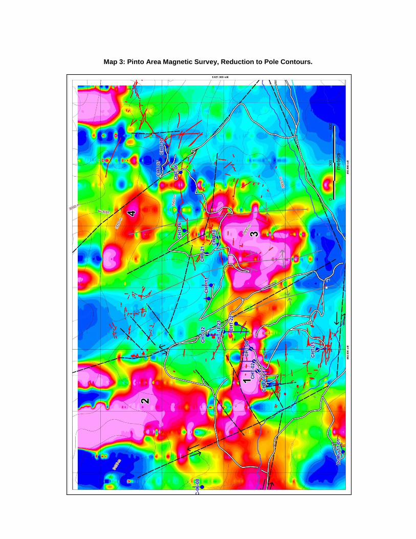
Map 3: Pinto Area Magnetic Survey, Reduction to Pole Contours.
More detailed maps are available on the Company’s website at www.minsud.com .
Mid to Upper Tertiary mafic to intermediate volcaniclastics and andesitic porphyry of the Chita Valley
Complex are exposed in the western half of the map area. Three lithological units have been mapped:
andesite porphyry, mafic volcaniclastics and late andesitic porphyry dykes that cut both previous units.
The distribution of alteration features is summarized as follows:
Agua Negra Formation units are characterized by weak silicification with areas of moderate to
strong argillic alteration in the vicinity of epithermal vein systems and possible intrusions at depth.
Colanguil Batholith granodiorite is exposed in two areas. The southern exposure is characterized
by moderate argillic alteration while the northern area is weakly to strongly silicified with an area
of moderate argillic alteration near the northern property boundary.
The Chita Valley Complex andesite porphyry units are moderate to strongly silicified with
localized argillic alteration bordering vein systems. The mafic volcaniclastics in the north-western
corner of the map area are typified by moderate propylitic alteration.
Structurally the Chita Valley area is part of the Andean Frontal Cordillera and is typified by upright
concentric folding and thrust faulting. The Chita Valley Complex is exposed along an ENE trending
corridor of epizonal intrusions, hydrothermal alteration, breccias and mineralized vein systems. The
system is interrupted by a set of NNW oriented set of sinestral faults or shears. Finally a late sinestral
fault system runs NW to E-W along the Chita Valley.
The 2012 Minsud magnetic survey has covered about half of the Minas de Pinto area (Map 3). Even at
relatively wide 200 metre line spacing, the magnetic data clearly illustrates the main structural directions
as well as several important lithological/alteration features. The magnetic high feature in western part of
the map shows the eastern part of the previously described Chita South and North porphyry sectors.
Proceeding eastward a group of additional magnetic highs (indicated by numbers 1 to 4 on the map) are
discussed as follows:
1. This feature is coincident with outcropping Tertiary post-mineral dacitic porphyry near the Fatima
Vein.
2. This feature coincides with outcrops of Tertiary andesitic volcaniclastic rocks intruded by post-
mineral andesitic dykes, so it could indicate a porphyry body at depth.
3. Anomaly 3 likely indicates a hitherto unknown Tertiary or possibly Permo-Carboniferous intrusive
body at depth beneath Agua Negra Formation cover rocks. This anomaly, like others in the Chita
valley, occupies the core of a prominent cylindrical or concentric-fold feature herein termed the
Pinto Anticline Hill anticline. Further evidence for a buried intrusion here is localized porphyry
dykes and extensive areas of spotted and banded hornfels in Agua Negra sediments.
4. Sector 4 shows a two fairly large and several localized magnetic high features that have not yet
been investigated.
The main inference to be drawn from the magnetic data is that the Chita Valley Complex continues to be traceable eastward to the limits of current data.
The 2013 geochemical sampling program consisted of 43 sawn channel sample sections for a cumulative
total of 526 samples. Sampling highlights including all sections averaging > 1 g/t Au or >30 g/t Ag are
shown in Table 1. Maps showing the various sample locations and the distribution of gold and silver
values are available on the company’s website.

Table 1: Minas de Pinto 2013 Channel Sampling Highlights (>1 g/t Au, or >30 g/t Ag)
Vein Trench From To Interval Au Ag As Cu Pb Zn
ID m m M g/t g/t % % % %
Amparo Vein (*)
AMP-13-16 1.0 4.0 3.0 3.71 69.4 0.041 0.008 0.204 0.116
Angelitos Vein ANG-13-02 6.0 10.0 4.0 1.46 9.5 0.059 0.014 0.079 0.004
Angelitos Vein ANG-13-04 7.0 8.0 1.0 2.53 28.8 0.028 0.015 0.029 0.005
Angelitos Vein ANG-13-05 2.0 4.0 2.0 2.12 73.9 0.024 0.006 0.014 0.002
Argentina Vein ARG-13-01 2.0 7.0 5.0 0.82 198.8 0.072 0.019 0.243 0.059
Argentina Vein ARG-13-02 6.0 17.0 11.0 1.38 84.3 0.034 0.009 0.242 0.088
Argentina Vein ARG-13-03 2.0 3.0 1.0 1.09 50.9 0.034 0.004 0.032 0.017
Argentina Vein ARG-13-04 8.0 9.0 1.0 0.57 124.5 0.074 0.004 0.04 0.011
Barba Vein (*)
BAR-13-17 0.0 1.0 1.0 1.61 34.9 0.126 0.031 0.211 0.005
Branca Vein (*)
BRA-13-06 8.0 10.0 2.0 0.79 131.8 0.049 0.035 0.162 0.006
Branca Vein(*)
BRA-13-07 6.0 9.0 3.0 3.08 25.9 0.058 0.013 0.056 0.007
Candella Vein CAN-13-01 6.0 7.0 1.0 2.07 109.5 0.071 0.004 0.073 0.032
Carmen Vein (*)
CAR-13-02 1.0 4.0 3.0 11.69 23.4 0.275 0.005 0.081 0.013
Carmen Vein (*)
CAR-13-03 2.0 4.0 2.0 7.01 21.3 0.548 0.011 0.186 0.02
Carmen Vein CAR-13-04 7.0 9.0 2.0 1.31 60.6 0.086 0.039 0.066 0.04
Carmen Vein CAR-13-05 7.0 8.0 1.0 1.85 31.5 0.256 0.025 0.061 0.049
Carmen Vein CAR-13-06 3.0 4.0 1.0 1.09 42.4 0.123 0.009 0.068 0.034
Carmen Vein CAR-13-06 9.0 10.0 1.0 1.38 10.8 0.129 0.009 0.149 0.053
Carmen Sur Vein (*)
CARS-13-01 27.0 28.0 1.0 1.06 20.2 0.039 0.006 0.157 0.007
Carmen Sur Vein (*)
CARS-13-01 42.0 43.0 1.0 1.44 15.6 0.053 0.003 0.058 0.016
Fátima Vein (*)
FAT-13-11 16.4 17.4 1.0 1.99 20 0.041 0.003 0.011 0.002
Fátima Vein (*)
FAT-13-14 0.0 2.0 2.0 1.44 82.8 0.016 0.029 0.202 0.055
María Vein (*)
MARY-13-10 10.0 12.0 2.0 1.74 79 0.044 0.019 0.06 0.003
Pulenta Vein PUL-13-01 4.0 7.0 3.0 2.30 143.2 0.038 0.007 0.142 0.01
Pulenta Vein PUL-13-02 2.0 3.0 1.0 0.67 88.3 0.026 0.005 0.035 0.016
Pulenta Vein PUL-13-03 4.0 5.0 1.0 1.04 12.6 0.039 0.004 0.017 0.024
Pulenta Vein PUL-13-04 6.0 10.0 4.0 1.07 53.7 0.039 0.006 0.093 0.063
Pulenta Vein PUL-13-05 4.0 7.0 3.0 2.14 75.9 0.043 0.003 0.161 0.02
Pulenta Vein PUL-13-06 4.0 5.0 1.0 2.53 202 0.042 0.011 0.188 0.09
Pulenta Vein PUL-13-07 4.0 5.0 1.0 1.64 130 0.091 0.005 0.049 0.016
Pulenta Vein PUL-13-08 8.0 13.0 5.0 1.35 40.9 0.033 0.002 0.037 0.01
Pulenta Vein PUL-13-09 6.0 7.0 1.0 1.13 26.5 0.019 0.002 0.009 0.015
Pulenta Vein PUL-13-10 6.0 7.0 1.0 0.95 139.7 0.015 0.006 0.043 0.037
(*) These trenches were previously disclosed in the Minsud´s Press Release dated September 17, 2013
All surface rock samples were submitted to the Alex Stewart (Assayers) Argentina S. A. laboratory in
Mendoza, Argentina for preparation and analysis. The laboratory is certified to ISO-9001 international
standards. All geochemical grab and channel rock samples were analyzed for Au by fire assay/ AA finish,
50 g, (Au4-50) plus a 39-element ICP scan (AR-39).
Conclusions and Recommendations
Two important conclusions may be drawn from the 2013 work on the Minas de Pinto Property:
1. With respect to sediment-hosted vein-type mineralization, the relatively competent and brittle
sandstone stratigraphic horizons within the Agua Negra Formation are more conducive to hosting
mineralized veins and breccias than the more plastic finer grained shales and siltstones. Thus it
is postulated that the intersections between the various sub-vertical vein structures and the
shallow to moderately dipping sandstone units might be favourable locations for economically
significant Au-Ag concentrations.
2. With respect to igneous-hosted porphyry and epithermal mineralization, the recent mapping and
2012 magnetic data combine to indicate unexposed but relatively near surface potential host
rocks for these important mineral deposit styles.
The recommended ongoing work program in the Minas de Pinto area is threefold:
1. A short to medium term objective to further develop some of the more promising targets such as
the Argentina, Carmen, and Pulenta Vein target areas to the outline drilling stage if warranted.
This will require more accurate survey control than is currently available utilizing DGPS
methodology, detailed geological mapping at 1:500 scale, mechanical trenching for mapping and
sampling purposes, careful geological and structural analysis to develop drilling targets, and
finally, if warranted, the implementation of a drilling program.
2. In the short term, to continue the systematic mapping and sampling program into the remainder of
the property.
3. In the medium to long term, to conduct geophysical surveys including additional magnetic
surveying together with IP/Resistivity and/or other surveys, as warranted, to develop porphyry
and epithermal mineralization targets in both Tertiary and Permo-Carboniferous intrusive bodies.
Mr. Howard Coates, Professional Geoscientist, Director and Vice President Exploration of the Company
and a geological consultant, is a qualified person as defined by National Instrument 43-101. Mr. Coates
visited the property and has read and approved the contents of this release.
Carlos Massa Minsud´s President & CEO, states: “Even under very difficult market conditions Minsud was
able to develop a systematic exploration approach for the Chita Valley Project, mapping and sampling the
main areas of interest during 2012 -2013. We expect increased challenges for 2014 in advancing the
exploration of this enigmatic complex of 12 km long and 2 to 4 km wide corridor featuring three
outcropping multiphase porphyries, extensive alteration features and literally hundreds of epithermal
veins”.
About Minsud Resources Corp Minsud is a mineral exploration company focused on exploring its flagship Chita Valley Project, primarily
for gold, silver and copper in San Juan Province, as well as advancing its La Rosita gold and silver
project at the Deseado Massif – Santa Cruz Province, República Argentina. The Company also holds a
100% owned portfolio of selected early stage prospects, approximately 60,000 hectares distributed within
the Provinces of Santa Cruz, Chubut and Rio Negro, República Argentina.
FOR FURTHER INFORMATION PLEASE CONTACT
Carlos Massa President and Chief Executive Officer (+54) 11-4328-4067 [email protected]
Mike Johnston 416-479-4466 [email protected]
CAUTIONARY STATEMENT REGARDING FORWARD-LOOKING INFORMATION:
This news release includes certain information that may constitute forward-looking information under applicable
Canadian securities laws. Forward-looking information includes, but is not limited to, statements about strategic
plans, spending commitments, future operations, results of exploration, anticipated financial results, future work
programs, capital expenditures and objectives. Forward-looking information is necessarily based upon a number of
estimates and assumptions that, while considered reasonable, are subject to known and unknown risks,
uncertainties, and other factors which may cause the actual results and future events to differ materially from those
expressed or implied by such forward-looking information including, but not limited to: fluctuations in the currency
markets (such as the Canadian dollar, Argentina peso, and the U.S. dollar); changes in national and local
government, legislation, taxation, controls, regulations and political or economic developments in Canada and
Argentina or other countries in which the Corporation may carry on business in the future; operating or technical
difficulties in connection with exploration and development activities; risks and hazards associated with the
business of mineral exploration and development (including environmental hazards or industrial accidents); risks
relating to the credit worthiness or financial condition of suppliers and other parties with whom the Company does
business; presence of laws and regulations that may impose restrictions on mining, including those currently
enacted in Argentina; employee relations; relationships with and claims by local communities; availability and
increasing costs associated with operational inputs and labour; the speculative nature of mineral exploration and
development, including the risks of obtaining necessary licenses, permits and approvals from government
authorities; business opportunities that may be presented to, or pursued by, the Company; challenges to, or
difficulty in maintaining, the Company’s title to properties; risks relating to the Company’s ability to raise funds;
and the factors identified under “Risk Factors” in the Company's Filing Statement dated April 27, 2011. There can
be no assurance that such information will prove to be accurate, as actual results and future events could differ
materially from those anticipated in such information. Accordingly, readers should not place undue reliance on
forward-looking information. All forward-looking-information contained in this news release is given as of the date
hereof and is based upon the opinions and estimates of management and information available to management as at
the date hereof. The Company disclaims any intention or obligation to update or revise any forward-looking
information, whether as a result of new information, future events or otherwise, except as required by law.
Neither the TSX Venture Exchange nor its Regulation Services Provider (as that term is defined in the policies of the
TSX Venture Exchange) accepts responsibility for the adequacy or accuracy of this release.