Minnesota Statewide Regional ITS Architecture · providing visibility into the relationship between...
204
Minnesota Statewide Regional ITS Architecture Version 2014 Volume 10: Turbo Architecture Outputs of the Regional ITS Architecture
Transcript of Minnesota Statewide Regional ITS Architecture · providing visibility into the relationship between...

Minnesota Statewide RegionalITS ArchitectureVersion 2014
Volume 10: Turbo Architecture Outputs of the Regional ITS Architecture

Minnesota Statewide Regional ITS Architecture Version 2014 Volume 10: Turbo Architecture Outputs of the Regional ITS Architecture
September 2014
Minnesota Statewide Regional ITS Architecture Version 2014
Table of Contents
1 INTRODUCTION .................................................................................................................. 1
2 ARCHITECTURE SCOPE .................................................................................................... 3
3 RELATIONSHIP TO REGIONAL PLANNING ....................................................................... 4
4 ITS STAKEHOLDERS .......................................................................................................... 6
5 ITS INVENTORY .................................................................................................................. 9
6 SERVICE PACKAGES ....................................................................................................... 27
7 OPERATIONAL CONCEPT ................................................................................................ 40
8 FUNCTIONAL REQUIREMENTS ....................................................................................... 56
9 INTERFACES BETWEEN SYSTEMS .............................................................................. 135
10 ITS STANDARDS ............................................................................................................. 200
Minnesota Statewide Regional ITS Architecture Version 2014
1
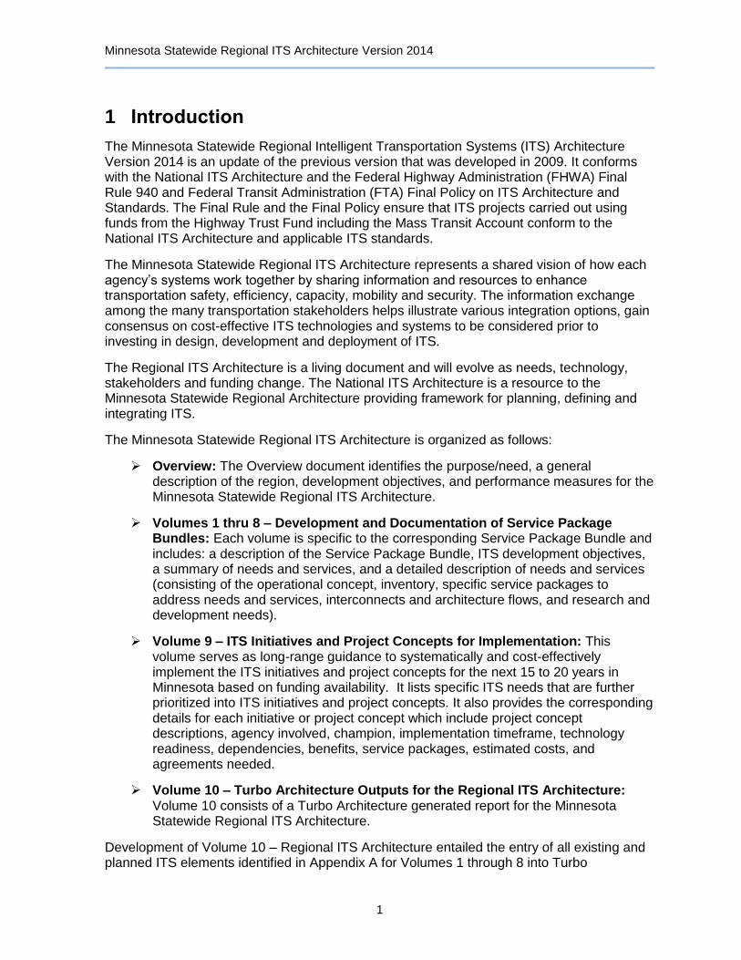
1 Introduction
The Minnesota Statewide Regional Intelligent Transportation Systems (ITS) Architecture Version 2014 is an update of the previous version that was developed in 2009. It conforms with the National ITS Architecture and the Federal Highway Administration (FHWA) Final Rule 940 and Federal Transit Administration (FTA) Final Policy on ITS Architecture and Standards. The Final Rule and the Final Policy ensure that ITS projects carried out using funds from the Highway Trust Fund including the Mass Transit Account conform to the National ITS Architecture and applicable ITS standards.
The Minnesota Statewide Regional ITS Architecture represents a shared vision of how each agency’s systems work together by sharing information and resources to enhance transportation safety, efficiency, capacity, mobility and security. The information exchange among the many transportation stakeholders helps illustrate various integration options, gain consensus on cost-effective ITS technologies and systems to be considered prior to investing in design, development and deployment of ITS.
The Regional ITS Architecture is a living document and will evolve as needs, technology, stakeholders and funding change. The National ITS Architecture is a resource to the Minnesota Statewide Regional Architecture providing framework for planning, defining and integrating ITS.
The Minnesota Statewide Regional ITS Architecture is organized as follows:
Overview: The Overview document identifies the purpose/need, a general description of the region, development objectives, and performance measures for the Minnesota Statewide Regional ITS Architecture.
Volumes 1 thru 8 – Development and Documentation of Service Package Bundles: Each volume is specific to the corresponding Service Package Bundle and includes: a description of the Service Package Bundle, ITS development objectives, a summary of needs and services, and a detailed description of needs and services (consisting of the operational concept, inventory, specific service packages to address needs and services, interconnects and architecture flows, and research and development needs).
Volume 9 – ITS Initiatives and Project Concepts for Implementation: This volume serves as long-range guidance to systematically and cost-effectively implement the ITS initiatives and project concepts for the next 15 to 20 years in Minnesota based on funding availability. It lists specific ITS needs that are further prioritized into ITS initiatives and project concepts. It also provides the corresponding details for each initiative or project concept which include project concept descriptions, agency involved, champion, implementation timeframe, technology readiness, dependencies, benefits, service packages, estimated costs, and agreements needed.
Volume 10 – Turbo Architecture Outputs for the Regional ITS Architecture: Volume 10 consists of a Turbo Architecture generated report for the Minnesota Statewide Regional ITS Architecture.
Development of Volume 10 – Regional ITS Architecture entailed the entry of all existing and planned ITS elements identified in Appendix A for Volumes 1 through 8 into Turbo

Minnesota Statewide Regional ITS Architecture Version 2014
2
Architecture Software Version 7.0. This information included the ITS element names, descriptions, appropriate stakeholders, existing/planned status, and relevant market packages in which the ITS elements can be categorized. Additional inputs into Turbo Architecture not included in Volumes 1 through 8 consist of Operational Concepts, in which all ITS stakeholders are assigned roles and responsibilities for operating and maintaining ITS elements.
Given the ITS elements in Appendix A of Volumes 1 through 8, Turbo Architecture identifies all potential flows of communication between ITS elements. These flows are based on the categorization of ITS elements into the Service Packages identified in Appendix A and the assignment of ITS elements as a subsystem(s) and/or terminator(s).
The reports generated by Turbo Architecture are designed to meet FHWA Rule 940 which requires agencies to develop a regional ITS architecture based on the National ITS Architecture that reflects the local needs, issues, and objectives for ITS implementation and is consistent with the transportation planning process for statewide, metropolitan and local planning practice. ITS projects receiving federal-aid funding are required to have developed a regional ITS architecture for the projects, systems integration, and future implementation.
Minnesota Statewide Regional ITS Architecture Version 2014
3
2 Architecture Scope
The Minnesota Statewide Regional ITS Architecture is a roadmap for transportation systems integration. The architecture was developed through a cooperative effort by the region's transportation agencies, covering all modes and all roads in the region. It represents a shared vision of how each agency's systems will work together in the future, sharing information and resources to provide a safer, more efficient, and more effective transportation system for travelers in the region.
The architecture provides an overarching framework that spans all of the region's transportation organizations and individual transportation projects. Using the architecture, each transportation project can be viewed as an element of the overall transportation system, providing visibility into the relationship between individual transportation projects and ways to cost-effectively build an integrated transportation system over time. This chapter establishes the scope of the architecture in terms of its geographic breadth, the scope of services that are covered, and the time horizon that is addressed.
Description
The Minnesota Statewide Regional ITS Architecture represents a shared vision of how each agency's system works together by sharing information and resources to enhance transportation safety, efficiency, capacity, mobility, and security. The information exchange among the many transportation stakeholders helps illustrate various integration options, gain consensus on cost-effective ITS technologies and systems to be considered prior to investing in the design, development and deployment of ITS.
Timeframe
2015 - 2030
Geographic Scope
Entire State of Minnesota
Service Scope
Archived Data Management Systems (ADMS), Advanced Public Transportation Systems (APTS), Advanced Traveler Information Systems (ATIS), Advanced Traffic Management Systems (ATMS), Advanced Vehicle Safety Systems (AVSS), Commercial Vehicle Operations (CVO), Emergency Management (EM), and Maintenance and Construction Management (MCM).

Minnesota Statewide Regional ITS Architecture Version 2014
4
3 Relationship to Regional Planning
The Minnesota Statewide Regional ITS Architecture is an integral part of planning for the operations and maintenance strategies that are addressed by the regional transportation planning process. The architecture provides a framework that connects operations and maintenance objectives and strategies with the integrated transportation system improvements that are implemented as a progressive series of ITS projects. The architecture also is used to define the data needs associated with performance monitoring that supports an informed planning process. The planning objectives, strategies, and associated performance measures from the regional plan are detailed in the Overview Volume. The high-level Minnesota ITS Development Objectives are categorized in eight areas and are presented below. These planning elements are connected with ITS services in the Minnesota Statewide Regional ITS Architecture.
Minnesota ITS Development Objectives
A. Improve the Safety of the State's Transportation System
A-1 Reduce crash frequency (ATIS, ATMS, APTS, CVO, EM, MCM & AVSS)
A-2 Reduce fatalities and life changing injuries (ATIS, ATMS, APTS, CVO, EM, MCM & AVSS)
A-3 Reduce crashes in work zones (ATIS, ATMS, EM, MCM & AVSS)
B. Increase Operational Efficiency and Reliability of the Transportation System
B-1 Reduce overall delay associated with congestion (ATIS, ATMS, MCM & AVSS)
B-2 Increase average vehicle occupancy and facility throughput (ATMS & APTS)
B-3 Reduce delays due to work zones (ATIS, ATMS, EM, MCM & AVSS)
B-4 Reduce traffic delays during evacuation from homeland security and Hazmat incidents (ATIS, ATMS, APTS, CVO, EM, MCM & AVSS)
C. Enhance Mobility, Convenience, and Comfort for Transportation System Users
C-1 Reduce congestion and incident-related delay for travelers (ATIS, ATMS, APTS, EM & AVSS)
C-2 Improve travel time reliability (ATIS, ATMS, APTS & AVSS)
C-3 Increase choice of travel modes (ATIS, ATMS & APTS)
C-4 Reduce stress caused by transportation (ATIS, ATMS, APTS, EM, MCM & AVSS)

Minnesota Statewide Regional ITS Architecture Version 2014
5
Minnesota ITS Development Objectives (Continued)
D. Improve the Security of the Transportation System
D-1 Enhance traveler security (APTS & EM)
D-2 Safeguard the motoring public from homeland security and/or Hazmat incidents (ATIS, ATMS, APTS, CVO, EM, MCM & AVSS)
E. Support Regional Economic Productivity and Development
E-1 Reduce travel time for freight, transit and businesses (ATIS, ATMS, APTS, CVO & AVSS)
E-2 Improve the efficiency of freight movement, permitting and credentials process (ATIS & CVO)
E-3 Improve travel time reliability for freight, transit and businesses (ATMS, APTS, CVO & AVSS)
E-4 Increase agency efficiency (ADMS, ATMS, APTS, CVO, EM & MCM)
E-5 Reduce vehicle operating costs (ATMS, APTS, CVO & AVSS)
E-6 Enhance efficiency at borders (ATIS & CVO)
F. Preserve the Transportation System
F-1 Safeguard existing infrastructure (ATMS, CVO, EM & MCM)
G. Enhance the Integration and Connectivity of the Transportation System
G-1 Aid in transportation infrastructure and operations planning (All)
G-2 Reduce need for new facilities (ATMS, CVO, MCM & AVSS)
H. Reduce Environmental Impacts
H-1 Reduce emissions/energy impacts and use associated with congestion (ATIS, ATMS, CVO & AVSS)
H-2 Reduce negative impacts of the transportation system on communities (ATMS, APTS, EM & MCM)

Minnesota Statewide Regional ITS Architecture Version 2014
6
4 ITS Stakeholders
Identifying stakeholders is an important task in ITS architecture development since effective ITS involves the integration of multiple stakeholders and their transportation systems. This section describes the stakeholders who either participated in the creation of the Minnesota Statewide Regional ITS Architecture or whom the participating stakeholders felt were needed to be included in the architecture. Some stakeholders have been grouped in order to better reflect mutual participation or involvement in transportation services and elements. Every stakeholder in this section is related to one or more of the transportation inventory elements described in the next chapter, either as an individual stakeholder or as a member of a stakeholder group.
Table 1: ITS Stakeholders
Stakeholder Name Stakeholder Description
Account Management Providers
Provide invoicing and payment tracking services for private companies or public agencies. Examples of the Account Management Provider include: Service Billing Companies and Credit Card Companies.
Airports Represents airports throughout the state of Minnesota. Airports receive important traveler, weather, and construction information from other agencies, and coordinate with emergency management.
City of Minneapolis City of Minneapolis is a part of the Minneapolis-St. Paul MPO. City operates a traffic management center through which CCTV cameras and traffic signal timings are controlled and traffic flows are monitored. City also participates in Integrated Corridor Traffic Management (ICTM) program. City operates a parking management system and uses dynamic message signs to notify drivers of parking space availability.
Event Promoters Special Event Sponsors that have knowledge of events that may impact travel on roadways or other modal means.
FHWA This represents the Federal Highway Administration (FHWA). This agency leads the Clarus Initiative, which is an initiative to develop and demonstrate an integrated surface transportation weather observing, forecasting and data management system.
FMCSA Federal Motor Carrier Safety Administration (FMCSA) is a federal agency responsible for the administration of safety-related initiatives and programs for the motor carrier industry.
IFTA, Inc. The IFTA, Inc. (International Fuel Tax Association) administers the International Fuel Tax Agreement.
Intercity Transit Providers
This stakeholder represents Northstar Commuter Coach traveling between Elk River and Minneapolis and Greyhound and Jefferson Lines buses traveling throughout the state.
IRP, Inc. The IRP (International Registration Plan), Inc. administers International Registration Plan. For motor carriers operating under the International Registration Plan, registering a fleet of inter-jurisdictional vehicles becomes a one-stop process for motor
Local Agencies This represents Minnesota county-level and city-level agencies.
Local Media Represents all local media outlets.
Local Transit Providers
This stakeholder group includes the St. Cloud Metropolitan Transit Commission (MTC), Duluth Transit Authority (DTA), City of Rochester Public Transit, Metro Area Transit (MAT -- serving Moorhead), Cities Area Transit (CAT -- serving East Grand Forks), and various county and city-level transit operations centers.
Major Employers This represents major employers in large and small urban areas of Minnesota.
Map Update Providers Agencies that provide information to, or receive information from, Minnesota public agencies and private companies providing ITS services.
Metro Area Transit Providers
This stakeholder group includes Metro Transit and Suburban Transit Providers, independent of Metro Transit, that connect outer-ring metro-area suburbs with Minneapolis and St. Paul metro areas.
Metro Transit Provides fixed-route and demand response public transit service for the Minneapolis-St. Paul metro area. This is a service of the Metropolitan Council of the Twin Cities.
Metropolitan Council The Metropolitan Council is the regional planning agency serving the Twin Cities seven-county metropolitan area and providing essential services to the region, such as public transportation (Metro Transit), wastewater collection and treatment, and planning for housing and community development.

Minnesota Statewide Regional ITS Architecture Version 2014
7
Stakeholder Name Stakeholder Description
Minnesota Ambulance Association
Minnesota Ambulance Association
Minnesota Chiefs of Police Association
Minnesota Chiefs of Police Association
Minnesota DPS The Minnesota Department of Public Safety (DPS) is comprised of several divisions and services, including the Minnesota State Patrol, Driver and Vehicle Services, and Homeland Security and Emergency Management.
Minnesota DVS This stakeholder represents the Driver and Vehicle Services Division of the Minnesota Department of Public Safety, which sends commercial vehicle operations credentials information to the Truck Center.
Minnesota EMSRB The Minnesota Emergency Medical Services Regulatory Board (EMSRB) is the state agency responsible for licensing ambulance services, certifying emergency medical personnel, approving emergency medical services training programs, designating and funding eight regional EMS organizations that support emergency medical services, funding the Comprehensive Advanced Life Support (CALS) Program for training rural emergency room teams, and administering the volunteer ambulance training grant program, the longevity program for volunteer ambulance personnel and the EMS for Children (EMSC) grant program.
Minnesota Homeland Security and Emergency Management
This agency is responsible for operating the Minnesota AMBER Alert System and the Minnesota State Emergency Operations Center (SEOC).
Minnesota State Fire Chiefs Association
Minnesota State Fire Chiefs Association
Minnesota State Patrol
Represents the 12 State Patrol districts that manage resources and communicate incident data and resource requests to other public and private agencies.
MnDOT Department of Transportation for the State of Minnesota. MnDOT operates a Regional Transportation Management Center (RTMC) for the metro area and nine Transportation and Operation Communication Centers (TOCCs) throughout the state.
MnDOT OFCVO MnDOT Office of Freight and Commercial Vehicles (OFCVO).
MnDOT Office of Aeronautics
MnDOT Office of Aeronautics Navigation Systems Section has installed Automated Weather Observation Systems (AWOS) and Automated Surface Observation Systems (ASOS) throughout the state. The equipment, installation, and maintenance of these systems is funded entirely by this office.
MnDOT Office of Maintenance
MnDOT Office of Maintenance coordinates roadway maintenance and construction activity throughout Minnesota.
MnDOT OTDS MnDOT Office of Transportation Data and Analysis is responsible for the collection, creation, storage, maintenance, and dissemination of transportation-related data to the general public through various means.
Neighboring States This group includes agencies representing the states of Iowa, Wisconsin, North Dakota and South Dakota. Agencies coordinate traffic management, emergency management, and roadway information systems with MnDOT and Minnesota State Patrol.
NOAA The National Weather Service, a branch of the National Oceanic and Atmospheric Administration (NOAA), provides weather forecast and issues warnings related to adverse weather conditions.
North/West Passage Corridor Members
The North/West Passage Corridor encompasses the states along I-90/I-94 from Wisconsin to Washington. The eight states are: Wisconsin, Minnesota, North Dakota, South Dakota, Montana, Idaho, Wyoming, and Washington.
Northstar Corridor Development Authority
This stakeholder represents the agency primarily responsible for commuter rail operations extending northwest from downtown Minneapolis to Big Lake.
Private Information Service Providers
Private Information Service Providers that provide value-added information, such as Rideshare Matching Services.
Private Mayday Service Providers
This stakeholder represents private mayday service providers, such as the OnStar system.
Private Parking Operators
Operate Parking Management Systems for public or private parking facilities, including park-and-ride facilities.
Private Trucking Companies
Private trucking companies represent those companies that own and manage their own commercial fleets of vehicles traveling through the state of Minnesota.
Private Weather Service Providers
This stakeholder represents private weather service providers.
Minnesota Statewide Regional ITS Architecture Version 2014
8
Stakeholder Name Stakeholder Description
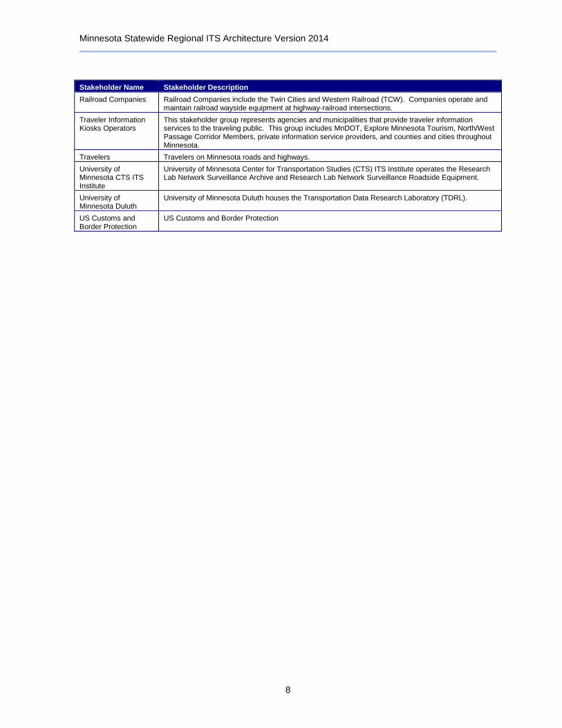
Railroad Companies Railroad Companies include the Twin Cities and Western Railroad (TCW). Companies operate and maintain railroad wayside equipment at highway-railroad intersections.
Traveler Information Kiosks Operators
This stakeholder group represents agencies and municipalities that provide traveler information services to the traveling public. This group includes MnDOT, Explore Minnesota Tourism, North/West Passage Corridor Members, private information service providers, and counties and cities throughout Minnesota.
Travelers Travelers on Minnesota roads and highways.
University of Minnesota CTS ITS Institute
University of Minnesota Center for Transportation Studies (CTS) ITS Institute operates the Research Lab Network Surveillance Archive and Research Lab Network Surveillance Roadside Equipment.
University of Minnesota Duluth
University of Minnesota Duluth houses the Transportation Data Research Laboratory (TDRL).
US Customs and Border Protection
US Customs and Border Protection
Minnesota Statewide Regional ITS Architecture Version 2014
9
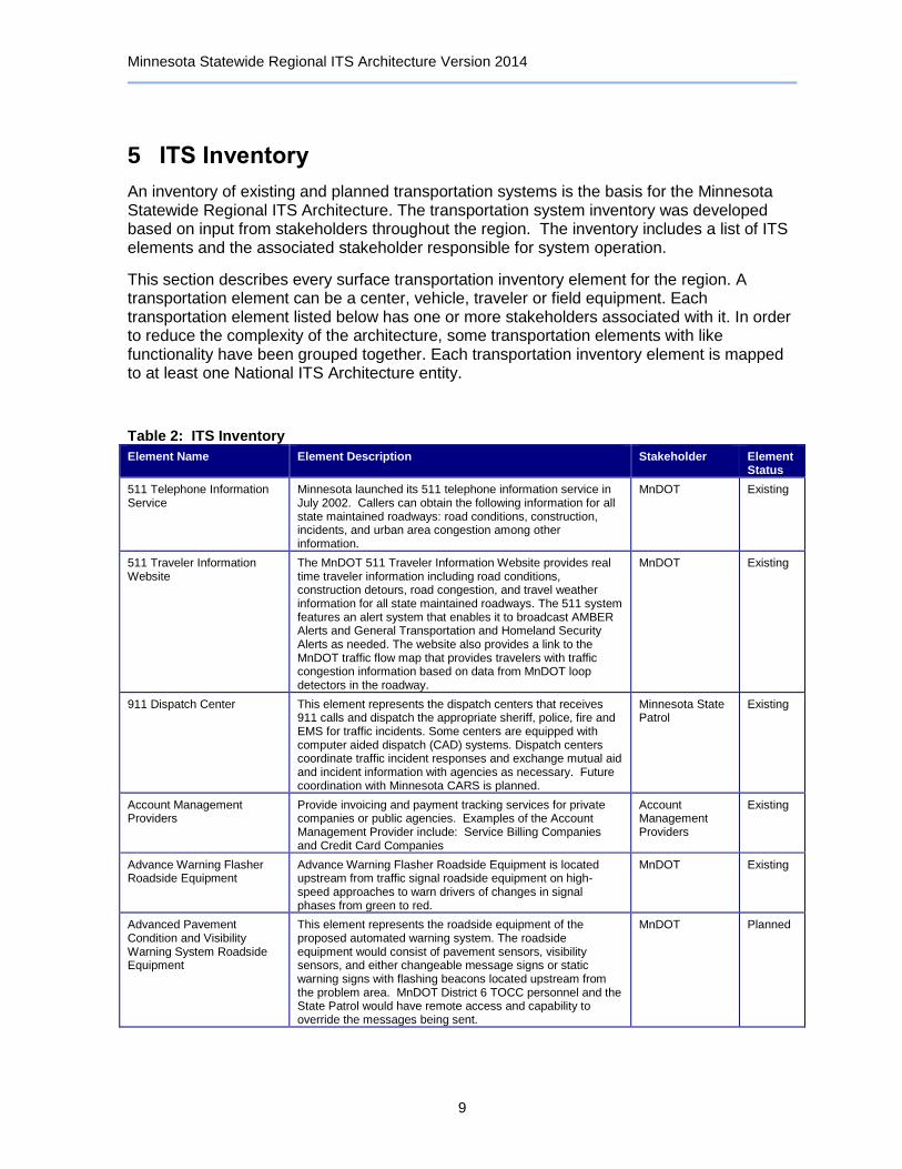
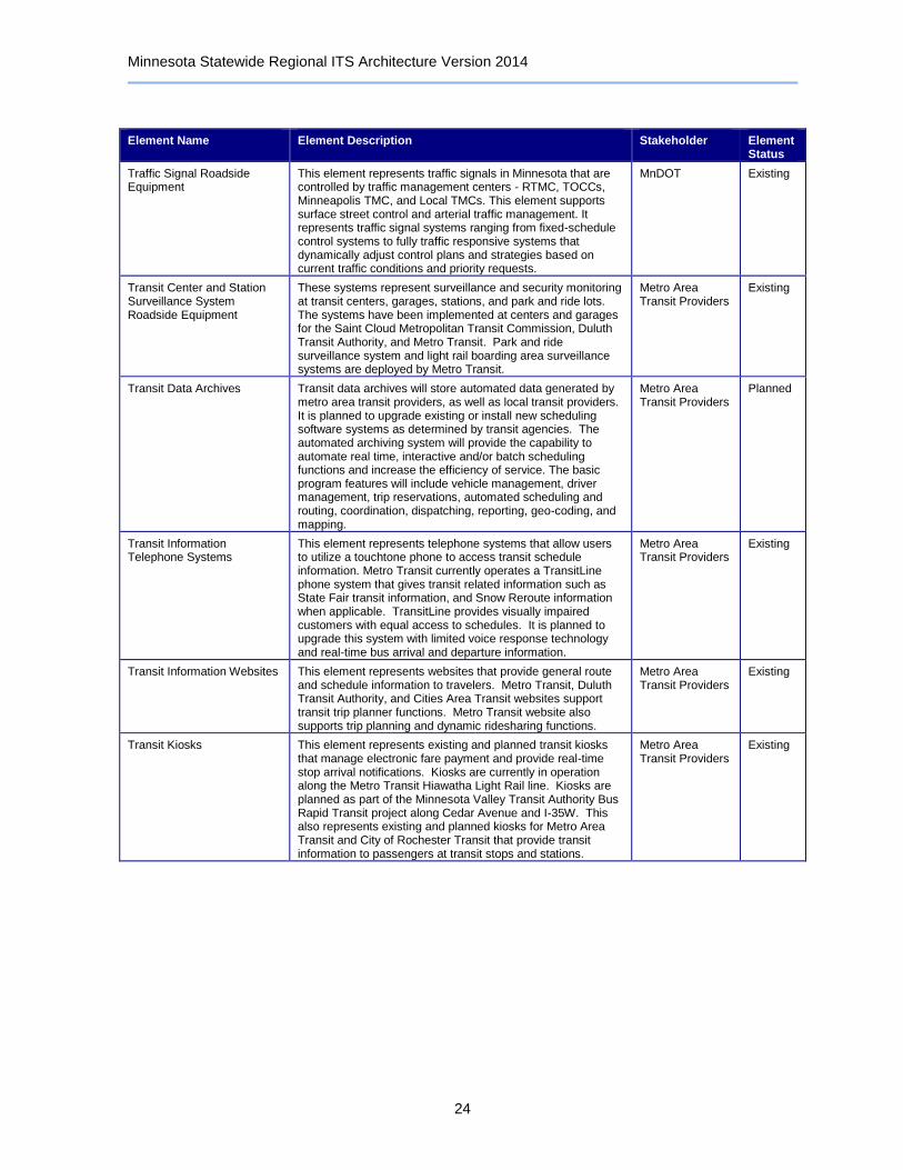
5 ITS Inventory
An inventory of existing and planned transportation systems is the basis for the Minnesota Statewide Regional ITS Architecture. The transportation system inventory was developed based on input from stakeholders throughout the region. The inventory includes a list of ITS elements and the associated stakeholder responsible for system operation.
This section describes every surface transportation inventory element for the region. A transportation element can be a center, vehicle, traveler or field equipment. Each transportation element listed below has one or more stakeholders associated with it. In order to reduce the complexity of the architecture, some transportation elements with like functionality have been grouped together. Each transportation inventory element is mapped to at least one National ITS Architecture entity.
Table 2: ITS Inventory
Element Name Element Description Stakeholder Element Status
511 Telephone Information Service
Minnesota launched its 511 telephone information service in July 2002. Callers can obtain the following information for all state maintained roadways: road conditions, construction, incidents, and urban area congestion among other information.
MnDOT Existing
511 Traveler Information Website
The MnDOT 511 Traveler Information Website provides real time traveler information including road conditions, construction detours, road congestion, and travel weather information for all state maintained roadways. The 511 system features an alert system that enables it to broadcast AMBER Alerts and General Transportation and Homeland Security Alerts as needed. The website also provides a link to the MnDOT traffic flow map that provides travelers with traffic congestion information based on data from MnDOT loop detectors in the roadway.
MnDOT Existing
911 Dispatch Center This element represents the dispatch centers that receives 911 calls and dispatch the appropriate sheriff, police, fire and EMS for traffic incidents. Some centers are equipped with computer aided dispatch (CAD) systems. Dispatch centers coordinate traffic incident responses and exchange mutual aid and incident information with agencies as necessary. Future coordination with Minnesota CARS is planned.
Minnesota State Patrol
Existing
Account Management Providers
Provide invoicing and payment tracking services for private companies or public agencies. Examples of the Account Management Provider include: Service Billing Companies and Credit Card Companies
Account Management Providers
Existing
Advance Warning Flasher Roadside Equipment
Advance Warning Flasher Roadside Equipment is located upstream from traffic signal roadside equipment on high-speed approaches to warn drivers of changes in signal phases from green to red.
MnDOT Existing
Advanced Pavement Condition and Visibility Warning System Roadside Equipment
This element represents the roadside equipment of the proposed automated warning system. The roadside equipment would consist of pavement sensors, visibility sensors, and either changeable message signs or static warning signs with flashing beacons located upstream from the problem area. MnDOT District 6 TOCC personnel and the State Patrol would have remote access and capability to override the messages being sent.
MnDOT Planned

Minnesota Statewide Regional ITS Architecture Version 2014
10
Element Name Element Description Stakeholder Element Status
Airport Located throughout the state, Minnesota Airports receive important traveler, weather, and construction information from other agencies, and coordinate with emergency management.
Airports Existing
Animal Crossing Warning Roadside Equipment
This represents roadside equipment that includes laser/light emitters along the roadway, along with a series of static deer warning signs with light flashers. When an animal breaks the beam, the flashers on the three signs nearest the deer are activated, providing additional warning to motorists. Equipment is installed near Camden State Park in MnDOT District 8 along TH 23.
MnDOT Existing
Automated Crash Notification System
This system provides immediate notification of crashes to responders and provides access to driver, passenger, and vehicle information. This would assist emergency responders in quickly and efficiently locating crash or other road safety related incidents.
MnDOT Planned
Automated Permit Routing System
This element represents an automated system that will allow for the provision of real time route information data to commercial vehicle operators. Permitted commercial vehicle operators and oversize/ overweight vehicles currently use the Automated Permit Routing System to generate route information based on size and weight requirements.
MnDOT OFCVO Existing
AWOS Central Control System
MnDOT Office of Aeronautics has installed and currently maintains Automated Weather Observation Systems (AWOS) throughout the state. AWOS data is gathered and re-distributed over the Federal Aviation Administration (FAA) National Airspace Data Interchange Network (NADIN), allowing these reports to become available through computer weather systems. Current weather information can be obtained by telephoning the AWOS site, where a computer generated voice relays up-to-the-minute observations. The AWOS data is visually displayed on a remote computer monitor at local airports, and is simultaneously broadcast over the local radio navigation aid or a VHF transmitter for in-flight use.
MnDOT Office of Aeronautics
Existing
AWOS Roadside Equipment This element represents the roadside equipment of AWOS. MnDOT Office of Aeronautics
Existing
Basic Vehicle This represents the basic vehicle platform that interfaces with and hosts ITS electronics. It provides an interface to the drive train, driver convenience and entertainment systems, and other non-ITS electronics on-board the vehicle. This interface allows general vehicle systems (e.g., the stereo speaker system) to be shared by ITS and non-ITS systems. It also allows monitoring and control of the vehicle platform for advanced vehicle control system applications.
Travelers Existing
Bridge Inspection / Structural Monitoring Roadside Equipment
This element represents roadside cameras and sensors that are planned to be utilized for maintenance inspections of key bridges in Minnesota. Roadside equipment is planned to be controlled by MnDOT RTMC, TOCCs, and Maintenance and Construction Management Centers for maintenance inspections. Initial testing on I-35W bridge in Minneapolis will test sensors such as linear potentiometers to measure bridge movements, accelerometers to monitor bridge deflections under loads, and acoustical sensors to detect unusual sounds of a specific frequency. Data on inspection activity can be archived to indicate dates of inspection and exactly what was inspected.
MnDOT Planned
CCTV Roadside Equipment This element represents CCTV cameras deployed along the roadside by various agencies and municipalities throughout Minnesota. Cameras are controlled and monitored by TMCs.
MnDOT Existing

Minnesota Statewide Regional ITS Architecture Version 2014
11
Element Name Element Description Stakeholder Element Status
Clarus Weather System The Clarus Weather System is an FHWA-led initiative that plans to collect atmospheric and surface weather data from environmental sensor stations throughout the US and Canada and share the data with the general public and private information service providers. Eight U.S. states, including Minnesota and three Canadian territories, currently upload information to a map interface on the Clarus Initiative project website.
FHWA Existing
Commercial Vehicle Administration Center
This center accepts and investigates all complaints made against carriers and service providers under its jurisdiction. The center reviews and issues transportation permits for oversize and/or overweight load movements which meet appropriate requirements and restrictions for travel on MN Trunk Highways.
MnDOT OFCVO Existing
Commercial Vehicles This ITS element represents commercial vehicles equipped with the sensory, processing, storage, and communications functions to promote the safe and efficient operation of commercial vehicles in the state of Minnesota. These vehicles may be equipped with two-way communications allowing commercial vehicle drivers to communicate with their fleet managers, and roadside officials. The vehicle may also have the capability to collect and process vehicle, cargo information from the attached freight equipment, and driver safety data and status and alert the driver whenever there is a potential safety or security problem. Basic identification, security and safety status data may be supplied to inspection facilities at mainline speeds.
Private Trucking Companies
Existing
Commuter Rail Operations Center
This element represents the Northstar Commuter Rail operations center that will operate and maintain commuter rail vehicles between downtown Minneapolis and Big Lake beginning in 2009. Commuter rail vehicle maintenance facility will be located in Big Lake. Stations are planned in Minneapolis, Fridley, Coon Rapids, Anoka, Elk River, and Big Lake. Future plans are to expand the commuter rail line northwest to downtown Saint Cloud and the VA Medical Center.
Northstar Corridor Development Authority
Planned
Condition Acquisition and Reporting System (CARS)
This system represents a central source of roadway event information for both the management and dissemination of traffic-related information to the traveling public. The system is maintained by the MnDOT OTSO (Office of Traffic, Safety, and Operations) and data is input throughout MnDOT at District Offices and District TOCC's. Minnesota State Patrol users also enter information to CARS on road conditions and incidents each day. CARS also manages automated data entry for congestion in the Twin Cities metro area based on information from loop detector roadside equipment. Data entered into CARS is available to the public to use for traveler information services through an XML feed. In MnDOT District 7, data entry occurs via web-enabled cellular telephones with approximately 75 users, primarily snow plow operators. Similar deployment is planned for MnDOT District 6. Integration of CARS with 911 Computer Aided Dispatch System is planned.
MnDOT Office of Maintenance
Existing
County Emergency Operations Centers
Each Minnesota county and various Minnesota cities have an emergency operations center (EOC). These EOCs range from minimally equipped, stand-by facilities to centers that operate on a daily basis. The EOCs operate for emergency operations and homeland security practices during emergencies and disasters.
Local Agencies Existing
County Sheriff and City Police Offices
This element represents local law enforcement agencies throughout the state of Minnesota at the county and city level.
Local Agencies Existing
Minnesota Statewide Regional ITS Architecture Version 2014
12
Element Name Element Description Stakeholder Element Status
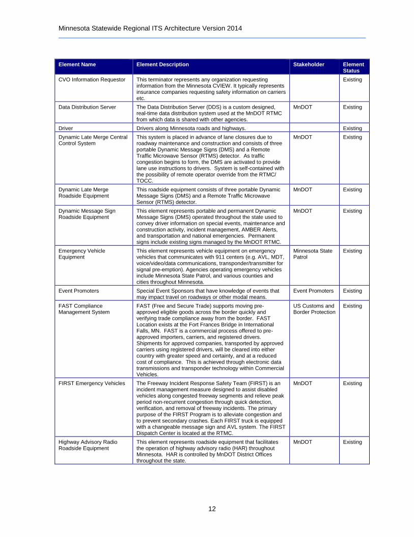
CVO Information Requestor This terminator represents any organization requesting information from the Minnesota CVIEW. It typically represents insurance companies requesting safety information on carriers etc.
Existing
Data Distribution Server The Data Distribution Server (DDS) is a custom designed, real-time data distribution system used at the MnDOT RTMC from which data is shared with other agencies.
MnDOT Existing
Driver Drivers along Minnesota roads and highways. Existing
Dynamic Late Merge Central Control System
This system is placed in advance of lane closures due to roadway maintenance and construction and consists of three portable Dynamic Message Signs (DMS) and a Remote Traffic Microwave Sensor (RTMS) detector. As traffic congestion begins to form, the DMS are activated to provide lane use instructions to drivers. System is self-contained with the possibility of remote operator override from the RTMC/ TOCC.
MnDOT Existing
Dynamic Late Merge Roadside Equipment
This roadside equipment consists of three portable Dynamic Message Signs (DMS) and a Remote Traffic Microwave Sensor (RTMS) detector.
MnDOT Existing
Dynamic Message Sign Roadside Equipment
This element represents portable and permanent Dynamic Message Signs (DMS) operated throughout the state used to convey driver information on special events, maintenance and construction activity, incident management, AMBER Alerts, and transportation and national emergencies. Permanent signs include existing signs managed by the MnDOT RTMC.
MnDOT Existing
Emergency Vehicle Equipment
This element represents vehicle equipment on emergency vehicles that communicates with 911 centers (e.g. AVL, MDT, voice/video/data communications, transponder/transmitter for signal pre-emption). Agencies operating emergency vehicles include Minnesota State Patrol, and various counties and cities throughout Minnesota.
Minnesota State Patrol
Existing
Event Promoters Special Event Sponsors that have knowledge of events that may impact travel on roadways or other modal means.
Event Promoters Existing
FAST Compliance Management System
FAST (Free and Secure Trade) supports moving pre-approved eligible goods across the border quickly and verifying trade compliance away from the border. FAST Location exists at the Fort Frances Bridge in International Falls, MN. FAST is a commercial process offered to pre-approved importers, carriers, and registered drivers. Shipments for approved companies, transported by approved carriers using registered drivers, will be cleared into either country with greater speed and certainty, and at a reduced cost of compliance. This is achieved through electronic data transmissions and transponder technology within Commercial Vehicles.
US Customs and Border Protection
Existing
FIRST Emergency Vehicles The Freeway Incident Response Safety Team (FIRST) is an incident management measure designed to assist disabled vehicles along congested freeway segments and relieve peak period non-recurrent congestion through quick detection, verification, and removal of freeway incidents. The primary purpose of the FIRST Program is to alleviate congestion and to prevent secondary crashes. Each FIRST truck is equipped with a changeable message sign and AVL system. The FIRST Dispatch Center is located at the RTMC.
MnDOT Existing
Highway Advisory Radio Roadside Equipment
This element represents roadside equipment that facilitates the operation of highway advisory radio (HAR) throughout Minnesota. HAR is controlled by MnDOT District Offices throughout the state.
MnDOT Existing

Minnesota Statewide Regional ITS Architecture Version 2014
13
Element Name Element Description Stakeholder Element Status
IFTA Clearinghouse The IFTA Clearinghouse supports the IFTA base state agreement electronically. The IFTA Clearinghouse coordinates IFTA carrier information and transmittal records between participated jurisdictions.
IFTA, Inc. Existing
In Vehicle Signing Roadside Equipment
This represents roadside equipment that emits a radio signal to In-Vehicle Signing Vehicle Equipment equipped with the proper receivers at railroad crossings and other intersections.
Railroad Companies
Existing
In Vehicle Signing Vehicle Equipment
This represents an in-vehicle signing system that was installed in 29 school buses in the City of Glencoe. The system is activated when a receiver on the school bus traveling toward the crossing comes within range of a radio signal emitted at the crossing. The system operates by providing the school bus driver with two types of information on rail crossings: the bus's proximity to an at-grade railroad crossing (crossing alert) and whether or not a train is present at or near the crossing (train warning). Both visual and variable audio signals are given. The system was operational for the 1997/1998 school year. The system was initially installed at signalized railroad crossings but the test was later expanded to evaluate the technology for use at unsignalized or passive crossings.
MnDOT Existing
Infrastructure GIS Database Systems
This represents GIS mapping systems utilized by MnDOT and local agencies. It is planned to enhance these systems by adding infrastructure data. The enhanced systems will keep up-to-date records and allow agencies and contractors to use the data to target and record replacement and repair of infrastructure.
MnDOT Planned
Intelligent Work Zone System Roadside Equipment
This element represents an automated system of devices that provides motorists and/or workers real-time information for improved safety and mobility through a work zone. The information is categorized into 3 levels: (1) Conflict Warning - high priority information to warn motorists of eminent traffic and roadway hazards; (2) Traffic Control - provides important driving information such as advisory speeds, merging instructions, and lane control directions; and (3) Travel Information - provides information which the motorist may use to make route decisions, such as travel times, alternate route info, incident warnings and work zone staging information.
MnDOT Existing
Intercity Transit Management Centers
This element represents transit management centers that operate intercity fixed routes traveling long distances. These centers include the Northstar Commuter Coach traveling between Elk River and Minneapolis and Greyhound and Jefferson Lines buses traveling throughout the state.
Intercity Transit Providers
Existing
Intermodal Freight Depots This represents a depot operated either by a depot manager or an alternate mode freight shipper which represents the point of exchange where freight is moved from one mode to another. The depot has knowledge about activities that may impact travel on roadways such as large groups of trucks entering the highway after unloading a ship or freight train. The depot coordinates freight movement with Fleet-Freight Managers, gathers information on traffic conditions affecting the depot, and provides information on intermodal freight activities that is pertinent to traffic movement in the surrounding area.
Private Trucking Companies
Planned
Intersection Collision Warning Roadside Equipment
This represents roadside equipment that provides drivers on rural roadways with advance warning information, indicating when entry into an intersection is not safe. Roadside equipment will be designed to detect vehicles within a specified zone and send messages to other roadside equipment located upstream of the detection zone, which will alert oncoming motorists of vehicle presence that cannot be seen by the driver on the roadway.
MnDOT Planned
Minnesota Statewide Regional ITS Architecture Version 2014
14
Element Name Element Description Stakeholder Element Status
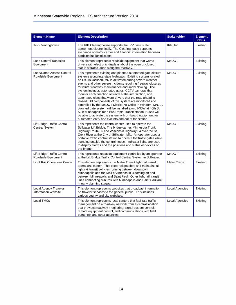
IRP Clearinghouse The IRP Clearinghouse supports the IRP base state agreement electronically. The Clearinghouse supports exchange of motor carrier and financial information between participating jurisdictions.
IRP, Inc. Existing
Lane Control Roadside Equipment
This element represents roadside equipment that warns drivers with electronic displays about the open or closed status of traffic lanes along the roadway.
MnDOT Existing
Lane/Ramp Access Control Roadside Equipment
This represents existing and planned automated gate closure systems along interstate highways. Existing system located on I-90 in Jackson, MN is activated during severe weather events and other severe incidents requiring freeway closures for winter roadway maintenance and snow plowing. The system includes automated gates, CCTV cameras that monitor each direction of travel at the intersection, and automated signs that warn drivers that the road ahead is closed. All components of this system are monitored and controlled by the MnDOT District 7B Office in Windom, MN. A planned gate system will be installed along I-35W at 46th St. S. in Minneapolis for a Bus Rapid Transit station. Buses will be able to activate the system with on-board equipment for automated entry and exit into and out of the station.
MnDOT Existing
Lift Bridge Traffic Control Central System
This represents the control center used to operate the Stillwater Lift Bridge. The bridge carries Minnesota Trunk Highway Route 36 and Wisconsin Highway 64 over the St. Croix River at the City of Stillwater, MN. An operator uses a portable traffic control station to operate the traffic gates while standing outside the control house. Indicator lights are used to display alarms and the positions and status of devices on the bridge.
MnDOT Existing
Lift Bridge Traffic Control Roadside Equipment
This represents roadside equipment controlled by an operator at the Lift Bridge Traffic Control Central System in Stillwater.
MnDOT Existing
Light Rail Operations Center This element represents the Metro Transit light rail transit operations center. This center dispatches and maintains all light rail transit vehicles running between downtown Minneapolis and the Mall of America in Bloomington and between Minneapolis and Saint Paul. Other light rail transit lines connecting suburbs with Minneapolis and Saint Paul are in early planning stages.
Metro Transit Existing
Local Agency Traveler Information Website
This element represents websites that broadcast information on traveler services to the general public. This includes various county and city websites.
Local Agencies Existing
Local TMCs This element represents local centers that facilitate traffic management on a roadway network from a central location that provides roadway monitoring, signal system control, remote equipment control, and communications with field personnel and other agencies.
Local Agencies Existing
Minnesota Statewide Regional ITS Architecture Version 2014
15
Element Name Element Description Stakeholder Element Status
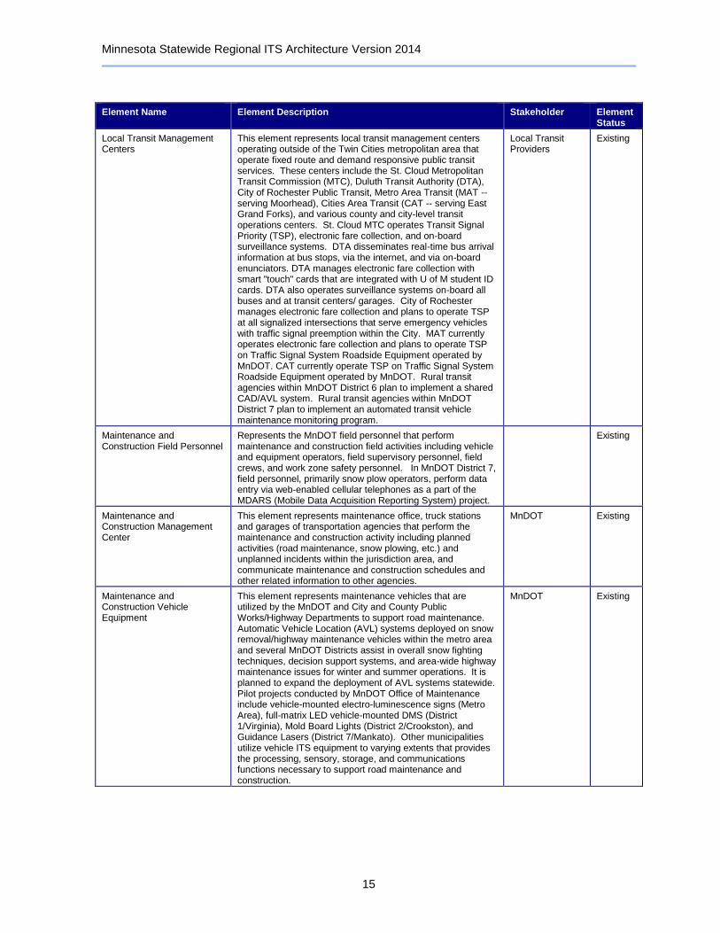
Local Transit Management Centers
This element represents local transit management centers operating outside of the Twin Cities metropolitan area that operate fixed route and demand responsive public transit services. These centers include the St. Cloud Metropolitan Transit Commission (MTC), Duluth Transit Authority (DTA), City of Rochester Public Transit, Metro Area Transit (MAT -- serving Moorhead), Cities Area Transit (CAT -- serving East Grand Forks), and various county and city-level transit operations centers. St. Cloud MTC operates Transit Signal Priority (TSP), electronic fare collection, and on-board surveillance systems. DTA disseminates real-time bus arrival information at bus stops, via the internet, and via on-board enunciators. DTA manages electronic fare collection with smart "touch" cards that are integrated with U of M student ID cards. DTA also operates surveillance systems on-board all buses and at transit centers/ garages. City of Rochester manages electronic fare collection and plans to operate TSP at all signalized intersections that serve emergency vehicles with traffic signal preemption within the City. MAT currently operates electronic fare collection and plans to operate TSP on Traffic Signal System Roadside Equipment operated by MnDOT. CAT currently operate TSP on Traffic Signal System Roadside Equipment operated by MnDOT. Rural transit agencies within MnDOT District 6 plan to implement a shared CAD/AVL system. Rural transit agencies within MnDOT District 7 plan to implement an automated transit vehicle maintenance monitoring program.
Local Transit Providers
Existing
Maintenance and Construction Field Personnel
Represents the MnDOT field personnel that perform maintenance and construction field activities including vehicle and equipment operators, field supervisory personnel, field crews, and work zone safety personnel. In MnDOT District 7, field personnel, primarily snow plow operators, perform data entry via web-enabled cellular telephones as a part of the MDARS (Mobile Data Acquisition Reporting System) project.
Existing
Maintenance and Construction Management Center
This element represents maintenance office, truck stations and garages of transportation agencies that perform the maintenance and construction activity including planned activities (road maintenance, snow plowing, etc.) and unplanned incidents within the jurisdiction area, and communicate maintenance and construction schedules and other related information to other agencies.
MnDOT Existing
Maintenance and Construction Vehicle Equipment
This element represents maintenance vehicles that are utilized by the MnDOT and City and County Public Works/Highway Departments to support road maintenance. Automatic Vehicle Location (AVL) systems deployed on snow removal/highway maintenance vehicles within the metro area and several MnDOT Districts assist in overall snow fighting techniques, decision support systems, and area-wide highway maintenance issues for winter and summer operations. It is planned to expand the deployment of AVL systems statewide. Pilot projects conducted by MnDOT Office of Maintenance include vehicle-mounted electro-luminescence signs (Metro Area), full-matrix LED vehicle-mounted DMS (District 1/Virginia), Mold Board Lights (District 2/Crookston), and Guidance Lasers (District 7/Mankato). Other municipalities utilize vehicle ITS equipment to varying extents that provides the processing, sensory, storage, and communications functions necessary to support road maintenance and construction.
MnDOT Existing

Minnesota Statewide Regional ITS Architecture Version 2014
16
Element Name Element Description Stakeholder Element Status
Maintenance Decision Support System
Maintenance Decision Support System (MDSS) is a server- and Client-side hardware and software package that provides winter maintenance support. MDSS offers visualizations of the real time maintenance data integrated from many sources and reports actual road conditions to establish appropriate maintenance treatments. It enables weather and roadway conditions predictions and identifies an optimal maintenance plan given user-configurable resources. Road and weather conditions, location of snowplows, and recommended chemical type and application rate are available to supervisors and dispatchers on desk-top computers. The same information is available to snow plow operators via on-board equipment.
MnDOT Existing
Mayday System Mayday System can provide data to the State Patrol and emergency hospitals in the Twin Cities and Greater Minnesota.
Private Mayday Service Providers
Existing
Mayday System Vehicle Equipment
These are vehicles equipped with Mayday systems. Travelers Existing
MCMIS Motor Carrier Management Information System (MCMIS) is a national system to consolidate and process motor carrier safety data from sources throughout the US. MCMIS contains safety records of active intrastate and interstate motor carriers, safety and compliance reviews, and roadside inspection records and crash records. MCMIS also carries a Safety Fitness Rating based on algorithms that evaluate all of a carrier's safety data. It supplies carrier ID and safety data history for each interstate carrier via the SAFER system to the Aspen ISS.
FMCSA Existing
Media Information Release System
This system has been created to keep the media and the public more up to date in case of serious and fatal accidents that happen within the state of Minnesota. This system contains only those accidents in which the Minnesota State Patrol is the primary reporting law enforcement agency. Records displayed here are as current as the last time State Patrol Personnel edited data. However due to extenuating circumstances such as heavy-accident periods like ice and snow storms, data entry may get back-logged and may not be up to the minute.
Minnesota State Patrol
Existing
Media Outlets Represents the information systems that provide traffic reports, travel conditions, and other transportation-related news services to the traveling public through radio, TV, and other media.
Local Media Existing

Minnesota Statewide Regional ITS Architecture Version 2014
17
Element Name Element Description Stakeholder Element Status
Metro Area Transit Management Centers
This element represents transit management centers operating within the Twin Cities metropolitan area that operate fixed route and demand responsive public transit services. This includes the Metro Transit Control Center and Suburban Transit Provider Operations Centers, independent of Metro Transit, that connect outer-ring metro-area suburbs with Minneapolis and St. Paul metro areas. Metro Transit Control Center utilizes Global Position System (GPS) technology to identify the location of all transit vehicles and also uses an 800-megahertz regional radio system, which allows Metro Transit to interact with police and fire departments and emergency response teams. Within the metro area, door-to-door demand response transit service is provided by Metro Mobility (serving Minneapolis, St. Paul and many surrounding suburbs), Anoka County Traveler (serving Anoka County), DARTS (serving Dakota County), Scott County (Scott County) and H.S.I. (serving Washington County). Transit fare coordination exists between Metro Transit and all Suburban Transit Providers. As a suburban transit provider, Minnesota Valley Transit Authority implemented Bus Rapid Transit components, such as transit signal priority and transit kiosks at transit stations along the Cedar Avenue/I-35W Corridor. Other Suburban Transit Providers include Maple Grove Transit, Southwest Metro Transit Commission, Prior Lake Laker Lines, Plymouth Transit, and Scott County Transit.
Metro Area Transit Providers
Existing
Minneapolis TMC The City of Minneapolis operates a Traffic Management Center that provides traffic-responsive and time-of-day operation and an extensive selection of on-line database operations. City of Minneapolis plans to upgrade signal controllers throughout the City, implement an adaptive signal timing plan generation algorithm for the existing traffic control system in Minneapolis, and allow for CCTV video sharing between key stakeholders.
City of Minneapolis
Existing
Minnesota CVIEW Minnesota's Commercial Vehicle Information Exchange Window (CVIEW) allows users to search for information pertaining to: For-Hire and Private Motor Carriers, Household Goods Movers, Building or House Movers, Limousine Operators, Special Transportation Service (STS) Providers, and Motor Carrier of Passengers. Minnesota CVIEW query results provide a snapshot of the following motor carrier information: Company name, address, and telephone number; USDOT, MnDOT, and ICC numbers; Safety fitness and ratings as provided by FMCSA; and Minnesota operating authority status. Minnesota CVIEW has been in continuous operation since 2000, and holds Federal and state data on more than 1.5 million carriers and 2.2 million vehicles.
MnDOT OFCVO Existing
Minnesota CVO Online Minnesota CVO Online is a collaboration of the MnDOT OFCVO and the Minnesota Department of Public Safety. This website provides commercial vehicle operation and management information, as well as electronic permit application, license renewals, and IRP and IFTA electronic applications. The system includes the processes for accepting and reviewing applications issuing credentials, auditing, and reporting.
MnDOT OFCVO Existing
Minnesota Emergency Alert System
Information system to alert the public in emergency situations such as child abductions. The alert includes information and instructions for transportation system operators and the traveling public, improving public safety and enlisting the public's help in some scenarios. Minnesota Homeland Security and Emergency Management and Minnesota Bureau of Criminal Apprehension are key stakeholders of this system.
Minnesota Homeland Security and Emergency Management
Existing

Minnesota Statewide Regional ITS Architecture Version 2014
18
Element Name Element Description Stakeholder Element Status
Minnesota Emergency Responder Database
This element represents an online database to route on-the-scene incident data, road condition, or other data through a single dispatch center or system for processing. The project area would include the seven-county metro area and 10 out-state counties.
Minnesota EMSRB
Planned
Minnesota State Emergency Operations Center (SEOC)
Through the Minnesota DPS Office of Homeland Security and Emergency Management, the state EOC coordinates notifications to the public with county EOCs through the Emergency Alert System (EAS). Personnel from state agencies report to the SEOC to be a liaison between the EOC and their agency and to aid in any decisions. County EOCs coordinate with the SEOC and the nuclear power plants to perform actions needed to ensure public safety. Local police, fire, and other public agencies may be called upon. A county EOC may request assistance from the state.
Minnesota Homeland Security and Emergency Management
Existing
Minnesota State Patrol Databases
This represents Minnesota State Patrol databases that contains information on crash and dispatching. An Automated Field Reporting (AFR) System is planned to interface with the Records Management System (RMS). With the implementation of the AFR System, four documents that are currently manually filled out and submitted by the Troopers will be electronically transferred from Troopers' laptop computers (called Mobile Data Computers or MDC's) to a central repository.
Minnesota State Patrol
Existing
Minnesota State Patrol District Office
This element represents the 12 State Patrol district offices that manage resources and communicate incident data and resource requests to other public and private agencies. Emergency vehicle components are connected to and operated by the State Patrol Dispatch Center. Central office in St. Paul coordinates alert notifications and emergency plans with the NDDES SOC and also coordinates incident response and threat information with the North Dakota State Radio. It is planned to monitor information received from the Minnesota State Patrol Computer Aided Dispatching (CAD) System and process the transmission of this information to the MnDOT 511 Telephone Information Service and Traveler Information Website (511mn.org). Integration of State Patrol CAD system with MnDOT CARS is planned.
Minnesota State Patrol
Existing
MnPASS Roadside Equipment
Roadside equipment includes variable message signs to display toll amounts that vary by time of day and/or levels of traffic congestion on toll facility and flashing roadside beacons to indicate that proper toll amounts have been paid for use of the HOT (High-Occupancy Toll) Lane facility. Equipment also includes ramp access controls to prevent drivers from entering the HOT Lane facility. MnPASS is designed to improve I-394 efficiency by increasing person and vehicle-carrying capabilities in the HOV lane. The High-Occupancy Vehicle (HOV) lanes along I-35W between I-494 and Burnsville Parkway were converted into HOT lanes. In addition, the HOT Lanes were extended north from I-494 to 46th Street. HOT lane tolls were priced dynamically based on the level of demand for the HOT lanes.
MnDOT Existing
MnPASS Service Center This element represents the center that performs administrative functions relating to I-394 and I-35W MnPASS operations.
MnDOT Existing
MnPASS Vehicle Equipment This element represents the transponder that supports automated payment of tolls along the I-394 and I-35W MnPASS Lanes.
Travelers Existing
Minnesota Statewide Regional ITS Architecture Version 2014
19
Element Name Element Description Stakeholder Element Status
Motor Carrier Registration System
This system is responsible for the administration of Minnesota ’s driver’s license and vehicle registration programs. Its primary functions include driver’s license testing and issuance, driver safety compliance, motor vehicle title and registration, commercial vehicle registration, and auto dealer licensing and regulation. The Motor Carrier Registration System sends commercial vehicle operations credentials information to Truck Center.
Minnesota DVS Existing
National Weather Service The National Oceanic and Atmospheric Administration's (NOAA) National Weather Service provides weather, hydrologic, and climate forecasts and warnings for the United States, its territories, adjacent waters and ocean areas.
NOAA Existing
Neighboring State CARS/ Roadway Information Systems
This element represents an existing Conditions Acquisition and Reporting System (CARS) for the state of Iowa and a planned CARS for the state of Wisconsin. This also represents an roadway information systems for North Dakota and South Dakota. ISP coordination with the MnDOT CARS is planned.
Neighboring States
Existing
Neighboring State Emergency Management Agencies
This element represents neighboring state agencies that coordinate alert notifications, emergency plans, evacuation plans, incident response, resources, and incident command information with Minnesota State Patrol and MnDOT District TOCCs. These agencies include: Iowa State Patrol, Wisconsin State Patrol, North Dakota State Operations Center, Northwest Wisconsin Emergency Service Providers, and US Coast Guard.
Neighboring States
Existing
Neighboring State Traffic Management Centers
This element represents traffic management centers located outside the state of Minnesota that plan to coordinate traffic control and information in border areas. This includes the North Dakota DOT Traffic Operations Center, the North Dakota DOT Maintenance Office, the Fargo Traffic Operations Center, the Wisconsin DOT Traffic Operations Center in Superior, and the Iowa DOT.
Neighboring States
Existing
Neighboring State Traffic Management Centers Roadside Equipment
This element represents roadside equipment whose control plans to be shared between Minnesota Traffic Management Centers and Neighboring State Traffic Management Centers. This includes signal system roadside equipment in Fargo, ND and additional roadside equipment operated by the North Dakota and Wisconsin DOT's.
Neighboring States
Existing
North/West Passage Corridor Traveler Information Website
As a project included in the North/West Passage Corridor Phase 3 Work Plan, the initial information presented for the website would focus on Major Event Descriptions (also a project defined in the Phase 3 Work Plan) affecting travel along the Corridor. The website would be linked to/from each of the individual state 511 (or related state-wide traveler information) web sites to encourage use. The site could also be developed to serve as a foundation for providing similar information at kiosks in rest areas, restaurants or other venues along the corridor. The North/West Passage Corridor encompasses eight states along the I-90/I-94 Corridor (WI, MN, ND, SD, MT, WY, ID, WA).
North/West Passage Corridor Members
Planned
Oversize Warning Roadside Equipment
This represents roadside detectors and electronic warning signs that warn drivers of vehicles that are too tall or too wide to pass under bridges or through tunnels. Operated by MnDOT District 7 TOCC.
MnDOT Existing
Park-and-Ride Parking Information System Roadside Equipment
Real-time information on availability of parking spaces at Metro Transit Park-and-Rides will be displayed to drivers via electronic message signs at various Metro Transit park-and-ride stations.
Metro Transit Existing
Minnesota Statewide Regional ITS Architecture Version 2014
20
Element Name Element Description Stakeholder Element Status
Parking Management Roadside Equipment
This represents roadside equipment that detects vehicle traffic in parking facilities and informs motorists of parking space availability. Roadside equipment is controlled by Parking Management Systems.
Local Agencies Existing
Parking Management System
This represents the central control system of the parking management system. This system monitors parking operations and controls electronic display signs to notify drivers of parking availability.
Local Agencies Existing
Parking Operator Parking Operator that controls electronic display signs to notify drivers of parking availability.
Private Parking Operators
Existing
PRISM Links to interstate commercial motor vehicle registration to safety and safety fitness of motor carriers. Identifies motor carriers and improves safety through a comprehensive system of education, awareness, performance monitoring, and treatment.
FMCSA Existing
Private Fleet and Freight Management Center
Private trucking companies represent those companies that own and manage their own commercial fleets of vehicles traveling through the state of Minnesota. They provide route plans for oversized and overweight vehicles based on information received from the CARS database.
Private Trucking Companies
Existing
Private Information Service Providers
This element represents private information service providers that provide specific directions to travelers by receiving origin and destination requests from travelers, generate route plans, and return the calculated plans to travelers.
Private Information Service Providers
Existing
Queue Detection Roadside Equipment
This element represents roadside equipment that detects lengthy queues of traffic downstream of Ramp Meter Roadside Equipment, incident locations, and work zones.
MnDOT Existing
Railroad Active Warning Roadside Equipment
This element represents roadside equipment that alerts motorists of railroad crossings at at-grade intersections. Gates are activated and de-activated as trains are detected approaching and clearing the intersection.
MnDOT Existing
Railroad Wayside Equipment This element represents wayside equipment at various highway-railroad crossing systems.
Railroad Companies
Existing
Ramp Meter Roadside Equipment
This element represents the system of ramp meters used by the RTMC to increase freeway volumes, trip reliability, and freeway speeds, while decreasing travel time and crashes. Ramp meters have the potential to operate during the morning and evening peak traffic periods. Timing and operation of ramp meters is controlled by Intelligent Roadway Information System at the MnDOT RTMC.
MnDOT Existing
Real-Time Bus Arrival Time Display Roadside Equipment
Real-time information on bus and light rail arrival/departure times is displayed to passengers via electronic message signs at Metro Transit bus stops and light rail stations. Signs are also installed at key decision points for drivers along arterial roads and freeways prior to entrances to park-and-ride facilities. Commuter rail arrival/departure times could also be displayed to travelers in the future.
Metro Transit Existing
Real-Time Transit Travel Time Notification
Real-time information on transit travel times as compared passenger-vehicle travel times is displayed to passengers via dynamic message signs prior to arriving at select Metro Transit park-and-ride locations.
Metro Transit Existing
Red Light Monitoring/Enforcement Roadside Equipment
This element represents portable or permanent photo/surveillance systems located at intersections with high crash rates. Purpose is to inform and educate the traveling public of the dangers of running red lights. Planned for MnDOT District 6.
MnDOT Planned
Minnesota Statewide Regional ITS Architecture Version 2014
21
Element Name Element Description Stakeholder Element Status
Research Lab Network Surveillance Archive
This represents the data archive maintained by Minnesota Traffic Observatory (MTO). The archive stores data on freeway traffic flows through a fully independent network of video detectors covering the I-35W/I-94 Commons freeway area in Minneapolis. Portable monitoring stations deployed on the roofs of several high-rise buildings overlooking the freeway transmit data back to the MTO.
University of Minnesota CTS ITS Institute
Existing
Research Lab Network Surveillance Roadside Equipment
This element represents the network of video detectors providing space- and time-continuous coverage of the I-35W/I-94 Commons freeway area in Minneapolis (the Beholder system). Portable monitoring stations deployed on the roofs of several high-rise buildings overlooking the freeway transmit data back to the MTO via a high-speed IEEE 802.16 wireless network.
University of Minnesota CTS ITS Institute
Existing
Research Lab New Surveillance Control System
This represents the Minnesota Traffic Observatory (MTO) - a transportation laboratory that gathers data on freeway traffic flows through a fully independent network of video detectors providing space- and time-continuous coverage of the I-35W/I-94 Commons freeway area in Minneapolis. Portable monitoring stations deployed on the roofs of several high-rise buildings overlooking the freeway transmit data back to the MTO via a high-speed IEEE 802.16 wireless network. MnDOT supplies eight switchable compressed/streamed Internet video feeds to the MTO. Researchers have the ability to switch between any of the MnDOT CCTV cameras monitoring the metropolitan freeway network.
University of Minnesota CTS ITS Institute
Existing
Rest Area Wi-Fi RASAWI (Rest Area Sponsorship, Advertising, and Wireless Internet) Program aims to deploy wireless internet access at a number of rest areas throughout the state of Minnesota.
MnDOT Planned
Roadway Automated Treatment System
Automated treatment systems remotely apply roadway chemicals due to ice conditions that may form on bridges, bridge approaches, or curves. Systems can also be controlled and operated by a system operator at either the RTMC or TOCCs throughout the state. Treatment systems exist in the metro area and MnDOT Districts 1 (Duluth), 6, (Rochester and Winona) and 7 (Worthington and Beaver Creek). Similar systems are planned for MnDOT Districts 2 and 4. Treatment systems in the metro area are connected to Advanced Warning Flashers to alert drivers of system operation. Further deployment is planned in District 6 on I-35 on the Albert Lea Lake Bridge. Mobile anti-icing systems are being tested in the metro area. Hennepin County and City of Duluth currently operate roadway automated treatment systems. Cities of Moorhead and East Grand Forks plan to operate roadway automated treatment systems.
MnDOT Existing
Roadway Environment Roadway Environment includes weather and other roadway information that can be used to send notifications to roadway equipment for traffic control strategies.
Existing
Roadway Flooding Warning Roadside Equipment
This element represents roadside equipment on TH 59 and TH 60 near Worthington that automatically detects a rise in water level and issues an alert based on commands from the Mankato Signal Center in District 7. It also represents planned roadside equipment in Mower County that would alert the Mower County dispatch center and trigger advanced warning signs (static signs with flashing beacons) to alert approaching vehicles. The proposed equipment includes sensors in the field which report to a central receiver/decoder located which would likely be located at the Mower County dispatch center. The system would also include communication and utilities at both the flood-warning sensor and the static warning signs with flashing beacons.
Local Agencies Existing
Minnesota Statewide Regional ITS Architecture Version 2014
22
Element Name Element Description Stakeholder Element Status
Roadway Lighting Management Central Monitoring Equipment
This element represents the central location at which Roadway Lighting Management Roadside Equipment is monitored.
City of Minneapolis
Planned
Roadway Lighting Management Roadside Equipment
This represents roadside equipment that will apply an optimal amount of roadway lighting based on current road and weather conditions. System is planned in the City of Minneapolis, which will allow operational control of the City's street lighting system from a central location, delivering light intelligently based upon real-time conditions. Through a wireless network and existing power and cable lines, the user can efficiently and effectively control the operation of all street lights maintained by the City of Minneapolis from one central location, mobile or stationary.
City of Minneapolis
Planned
RTMC The Traffic Operations unit is responsible for managing traffic on the Twin Cities metro freeways with the use of ramp meters, variable message signs, lane control signals and loop detectors. Additional RTMC components include the HOV system, MnPASS, and airborne surveillance systems. They monitor traffic conditions, assist in incident management and provide traveler information. Traffic Operations staff also continually perform systems analysis of field equipment, the ramp meter algorithm and Operations Center equipment. They also analyze and research traffic flow trends, new technologies and other issues that affect congestion. RTMC Maintenance Dispatch provides maintenance communications for the Metro District. Staff handles phone calls and monitor electronic communications and bridge anti-icing systems, roadway surface and sub-surface systems. RTMC Maintenance dispatches appropriate personnel for road emergencies such as snow and ice, potholes and incidents that may affect traffic flow. Maintenance Dispatch coordinates and initiates traffic management systems with the RTMC, traffic management personnel and the State Patrol. The RTMC integrates MnDOT's Metro District Maintenance Dispatch and MnDOT's Office of Traffic, Security and Operations with the Minnesota State Patrol Dispatch into a unified communications center. The integration provides the communications and computer infrastructure necessary for coordinated transportation management on metro freeways during normal commuting periods, as well as during special events and major incidents. In addition, the RTMC houses the FIRST Dispatch Center. The RTMC is also designated as the primary EOC for the Metro area.
MnDOT Existing
RWIS Central Control System
The RWIS Central Control System collects, verifies, processes, and formats environmental and road pavement surface condition data. Data is then made available to maintenance personnel, law enforcement, vendors providing value-added services, and the general public via the 511 information system. It is planned to send RWIS data to the MnCARS database.
MnDOT Office of Maintenance
Existing
RWIS Stations MnDOT's RWIS Stations include 96 environmental sensor sites, designed to measure environmental conditions and road pavement surface conditions, and over 50 airport sites, designed just to measure environmental conditions, connected via statewide network. Environmental sensors are planned to be equipped with pan/tilt cameras to provide maintenance crews with additional road condition data. All data is communicated to the MnDOT RWIS Central Control System for verification, processing, and formatting. Camera images from RWIS stations are posted on the MnDOT 511 Traveler Information Website (www.511mn.org).
MnDOT Office of Maintenance
Existing

Minnesota Statewide Regional ITS Architecture Version 2014
23
Element Name Element Description Stakeholder Element Status
SAFER The FMCSA Safety and Fitness Electronic Records (SAFER) System offers company safety data and related services to industry and the public over the Internet. Users can search FMCSA databases, register for a USDOT number, pay fines online, order company safety profiles, challenge FMCSA data using the DataQs system, access the Hazardous Material Route registry, obtain National Crash and Out of Service rates for Hazmat Permit Registration, get printable registration forms and find information about other FMCSA Information Systems.
FMCSA Existing
Security Monitoring Roadside Equipment
This element represents threat detection, CCTV surveillance, and emergency alert systems at critical infrastructure areas (bridges, ports, tunnels, etc…) throughout the state. Surveillance cameras and threat sensors will monitor critical facilities and when suspicious activity or objects in restricted areas detected an alert will automatically be sent to RTMC, TOCC, and emergency management personnel. This element includes the Tunnel Alarm Monitoring System is currently operated by MnDOT District 1 and the State Patrol dispatchers and includes the monitoring of the Lief Erickson Tunnel within Segment 10 and the Silver Creek and Lafayette Bluff tunnels along Highway 61 north of Duluth (along the North Shore). Roadside equipment monitors for carbon monoxide (CO) levels, fire, fan and generator operation and communications and power.
MnDOT Planned
Speed Monitoring Roadside Equipment
This system will provide photo enforcement for speeding at locations where there is a history of crashes with excessive speed as a contributing factor or in work zones.
Minnesota State Patrol
Planned
Surface Transportation Weather Service Providers
Providers of value-added sector specific meteorological services. These providers utilize National Weather Service data and predictions, road condition information and local environmental data to provide weather observations and forecasts. Examples include the Data Transmission Network (DTN).
Private Weather Service Providers
Existing
TOCCs MnDOT District TOCCs (Transportation and Communication Centers) are regional centers for 24-hour incident and emergency response, multi-agency dispatching and fleet management, interagency communications, and collection and dissemination of road conditions. TOCCs are located in Duluth, Baxter, St. Cloud, Detroit Lakes, Rochester, Mankato, Virginia, Marshall, and Thief River Falls. TOCCs dispatch MnDOT Maintenance Dispatch Vehicles.
MnDOT Existing
Traffic Traffic characteristics Existing
Traffic Data and Video Archive
This element represents the database in which Automated Traffic Recorder (ATR) data is stored. The ATR data is compiled from several sources into a single accessible database managed by the MnDOT Office of Transportation Data Analysis to answer data requests and provide reports to others. This element also represents the database in which CCTV video is stored.
MnDOT Existing
Traffic Detector Roadside Equipment
This element represents roadside equipment that collects data on traffic patterns and volumes. Data is communicated back to the Automated Traffic Recorder (ATR) central systems reside in TMCs (i.e. RTMC, TOCCs, and local TMCs). Data is also collected, processed, and archived by TMCs.
MnDOT Existing
Minnesota Statewide Regional ITS Architecture Version 2014
24
Element Name Element Description Stakeholder Element Status
Traffic Signal Roadside Equipment
This element represents traffic signals in Minnesota that are controlled by traffic management centers - RTMC, TOCCs, Minneapolis TMC, and Local TMCs. This element supports surface street control and arterial traffic management. It represents traffic signal systems ranging from fixed-schedule control systems to fully traffic responsive systems that dynamically adjust control plans and strategies based on current traffic conditions and priority requests.
MnDOT Existing
Transit Center and Station Surveillance System Roadside Equipment
These systems represent surveillance and security monitoring at transit centers, garages, stations, and park and ride lots. The systems have been implemented at centers and garages for the Saint Cloud Metropolitan Transit Commission, Duluth Transit Authority, and Metro Transit. Park and ride surveillance system and light rail boarding area surveillance systems are deployed by Metro Transit.
Metro Area Transit Providers
Existing
Transit Data Archives Transit data archives will store automated data generated by metro area transit providers, as well as local transit providers. It is planned to upgrade existing or install new scheduling software systems as determined by transit agencies. The automated archiving system will provide the capability to automate real time, interactive and/or batch scheduling functions and increase the efficiency of service. The basic program features will include vehicle management, driver management, trip reservations, automated scheduling and routing, coordination, dispatching, reporting, geo-coding, and mapping.
Metro Area Transit Providers
Planned
Transit Information Telephone Systems
This element represents telephone systems that allow users to utilize a touchtone phone to access transit schedule information. Metro Transit currently operates a TransitLine phone system that gives transit related information such as State Fair transit information, and Snow Reroute information when applicable. TransitLine provides visually impaired customers with equal access to schedules. It is planned to upgrade this system with limited voice response technology and real-time bus arrival and departure information.
Metro Area Transit Providers
Existing
Transit Information Websites This element represents websites that provide general route and schedule information to travelers. Metro Transit, Duluth Transit Authority, and Cities Area Transit websites support transit trip planner functions. Metro Transit website also supports trip planning and dynamic ridesharing functions.
Metro Area Transit Providers
Existing
Transit Kiosks This element represents existing and planned transit kiosks that manage electronic fare payment and provide real-time stop arrival notifications. Kiosks are currently in operation along the Metro Transit Hiawatha Light Rail line. Kiosks are planned as part of the Minnesota Valley Transit Authority Bus Rapid Transit project along Cedar Avenue and I-35W. This also represents existing and planned kiosks for Metro Area Transit and City of Rochester Transit that provide transit information to passengers at transit stops and stations.
Metro Area Transit Providers
Existing

Minnesota Statewide Regional ITS Architecture Version 2014
25
Element Name Element Description Stakeholder Element Status
Transit Vehicle Equipment This element represents all transit vehicles operated by transit service providers. This element also represents ITS equipment on board of transit vehicles, including AVL, MDT, radio communications, TSP, passenger counter, electronic fare collection equipment, surveillance and security monitoring devices, and traveler information annunciation. Transit Signal Priority (TSP) exists on vehicles serving St. Cloud and East Grand Forks. TSP is planned for vehicles serving Minneapolis, Rochester, Duluth, and Moorhead. Transit vehicles for Metro Transit, MTC, and DTA support on-board surveillance cameras. Transit vehicles for Metro Transit, MTC, and DTA support on-board Automated Vehicle Location (AVL) devices. Transit vehicles for Metro Transit, MTC, DTA, MAT, CAT, and Rochester support electronic fare collection devices. Transit vehicles for Metro Transit and DTA support automated passenger counting. Light Rail transit vehicles support automated next stop annunciation. Metro Transit plans to deploy transit vehicle lateral and longitudinal vehicle safety warning systems for shoulder-running buses to improve transit travel safety.
Metro Area Transit Providers
Existing
Transit Vehicle Operator This element represents operators of transit vehicles. Existing
Transportation Information System (TIS)
MnDOT Office of Transportation Data Analysis (OTDS) is responsible for the collection, creation, storage, maintenance, and dissemination of transportation-related data to the general public through various means. Interconnects with MnDOT RTMC and TOCCs, RWIS Central Server, and MnCARS. Archive coordination exists with the RTMC, TOCCs, and RWIS.
MnDOT OTDS Existing
Traveler Travelers along Minnesota roads and highways. Travelers Existing
Traveler Cards This element represents traveler cards that facilitate electronic payment of transit fares on board Transit Vehicles. Traveler cards are also used in the electronic payment of parking fees at parking ramps.
Travelers Existing
Traveler Information and Parking Kiosks
MnDOT Traveler Information Kiosks at major parking ramps. MnDOT Planned
Truck Center Collects and distributes planned event information (i.e., road maintenance) and unplanned event information (i.e., road surface conditions). It is also responsible for granting trucking permits for oversized and overweight vehicles and provides route plans for oversized and overweight vehicles based on information it receives from CARS. Examples of the Truck Center include: MnDOT Metro Region Truck Center) and Other Regional Truck Centers.
MnDOT OFCVO Existing
UMD Transportation Data Research Laboratory (TDRL)
Transportation Data Research Laboratory (TDRL) server located at the University of Minnesota-Duluth (UMD) campus downloads data from the MnDOT RWIS Central Server. The TDRL server daily archives this RWIS data using the Unified Transportation Sensor Data Format (UTSDF) and makes them available to the public through Internet. This archived historic data is presently only available through TDRL.
University of Minnesota Duluth
Existing
User Personal Portable and Computing Devices
This element represents personal computers and other personal devices (such as PDA's and cell phones) used by travelers to obtain travel-related information. It is planned to obtain traffic data from cell phone usage on roads and highways.
Travelers Existing

Minnesota Statewide Regional ITS Architecture Version 2014
26
Element Name Element Description Stakeholder Element Status
Variable Speed Limit Roadside Equipment
This element represents Variable Speed Limit (VSL) systems that will provide real-time information on appropriate speed for current conditions based on traffic flow, traffic speed, weather and other inputs and integration with law enforcement. Can be used to manage traffic under a number of variable conditions. MnDOT will select a corridor for deployment of VSL system in conjunction with a dynamic lane control system based on traffic data analysis.
MnDOT Planned
Vehicle In-vehicle systems may record vehicle operating information, including speed, seat belt use, brake use, impact, etc. Operational Test is being conducted by MnDOT to utilize vehicles as traffic sensors to gather travel time estimations. It is planned to develop in-vehicle safety systems as part of the Minnesota ITS Safety Plan over the coming years. These systems include ignition interlocks with seat belt systems, BAC (Blood-Alcohol Content) measurements for repeat offender drunk drivers, and driver distraction detection systems. The area along the I-94 corridor between Saint Cloud, MN and Maple Grove, MN is being considered as a test bed for Vehicle-Infrastructure Integration projects involving vehicle to roadside communications. High-speed, Dedicated Short-Range Communications (DSRC) systems needed for vehicle-roadside safety-critical communications will require substantial network speed.
Travelers Existing
Vehicle Occupancy Monitoring/Enforcement Roadside Equipment
This element represents roadside equipment that is planned to monitor vehicle occupancies along designated HOV/MnPASS lanes and signal for enforcement when violations are detected.
MnDOT Planned
Virtual Weigh Stations Virtual Weigh-in-Motion (WIM) Stations will allow for real-time identification of trucks violating weight restrictions using a weigh-in-motion (WIM) scale and other enhancements. Virtual WIM sites will flag potential violators for enforcement officers to perform further checks. Virtual WIM sites can either act as standalone WIM sites or be connected to a central operating network. Virtual WIM Stations will also investigate the use of a dynamic feedback system that will present a weight compliance message to vehicles immediately after they have passed over a WIM scale.
MnDOT OFCVO Existing
Weigh In Motion (WIM) Stations
This element represents scales that weigh trucks while they are moving so that they do not have to pull off the road.
MnDOT OFCVO Existing
Weigh Station Roadside Equipment
This element represents roadside equipment operated by the Minnesota State Patrol that ensures commercial vehicles comply with weight restrictions along Minnesota roads and highways. These stations do not have the functionality of Weigh-in-Motion (WIM) Stations deployed elsewhere in Minnesota.
Minnesota State Patrol
Existing
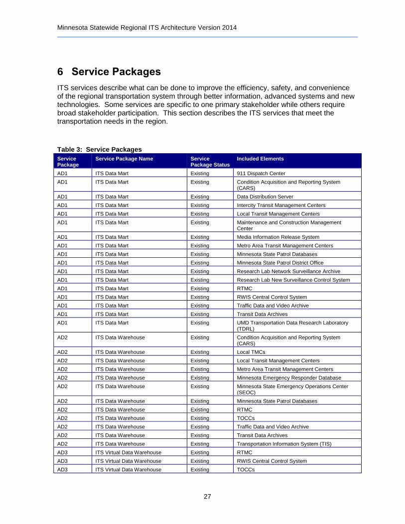
Minnesota Statewide Regional ITS Architecture Version 2014
27
6 Service Packages
ITS services describe what can be done to improve the efficiency, safety, and convenience of the regional transportation system through better information, advanced systems and new technologies. Some services are specific to one primary stakeholder while others require broad stakeholder participation. This section describes the ITS services that meet the transportation needs in the region.
Table 3: Service Packages
Service Package
Service Package Name Service Package Status
Included Elements
AD1 ITS Data Mart Existing 911 Dispatch Center
AD1 ITS Data Mart Existing Condition Acquisition and Reporting System (CARS)
AD1 ITS Data Mart Existing Data Distribution Server
AD1 ITS Data Mart Existing Intercity Transit Management Centers
AD1 ITS Data Mart Existing Local Transit Management Centers
AD1 ITS Data Mart Existing Maintenance and Construction Management Center
AD1 ITS Data Mart Existing Media Information Release System
AD1 ITS Data Mart Existing Metro Area Transit Management Centers
AD1 ITS Data Mart Existing Minnesota State Patrol Databases
AD1 ITS Data Mart Existing Minnesota State Patrol District Office
AD1 ITS Data Mart Existing Research Lab Network Surveillance Archive
AD1 ITS Data Mart Existing Research Lab New Surveillance Control System
AD1 ITS Data Mart Existing RTMC
AD1 ITS Data Mart Existing RWIS Central Control System
AD1 ITS Data Mart Existing Traffic Data and Video Archive
AD1 ITS Data Mart Existing Transit Data Archives
AD1 ITS Data Mart Existing UMD Transportation Data Research Laboratory (TDRL)
AD2 ITS Data Warehouse Existing Condition Acquisition and Reporting System (CARS)
AD2 ITS Data Warehouse Existing Local TMCs
AD2 ITS Data Warehouse Existing Local Transit Management Centers
AD2 ITS Data Warehouse Existing Metro Area Transit Management Centers
AD2 ITS Data Warehouse Existing Minnesota Emergency Responder Database
AD2 ITS Data Warehouse Existing Minnesota State Emergency Operations Center (SEOC)
AD2 ITS Data Warehouse Existing Minnesota State Patrol Databases
AD2 ITS Data Warehouse Existing RTMC
AD2 ITS Data Warehouse Existing TOCCs
AD2 ITS Data Warehouse Existing Traffic Data and Video Archive
AD2 ITS Data Warehouse Existing Transit Data Archives
AD2 ITS Data Warehouse Existing Transportation Information System (TIS)
AD3 ITS Virtual Data Warehouse Existing RTMC
AD3 ITS Virtual Data Warehouse Existing RWIS Central Control System
AD3 ITS Virtual Data Warehouse Existing TOCCs

Minnesota Statewide Regional ITS Architecture Version 2014
28
Service Package
Service Package Name Service Package Status
Included Elements
AD3 ITS Virtual Data Warehouse Existing Transportation Information System (TIS)
APTS01 Transit Vehicle Tracking Existing Local Transit Management Centers
APTS01 Transit Vehicle Tracking Existing Metro Area Transit Management Centers
APTS01 Transit Vehicle Tracking Existing Transit Vehicle Equipment
APTS02 Transit Fixed-Route Operations Existing Commuter Rail Operations Center
APTS02 Transit Fixed-Route Operations Existing Intercity Transit Management Centers
APTS02 Transit Fixed-Route Operations Existing Light Rail Operations Center
APTS02 Transit Fixed-Route Operations Existing Local Transit Management Centers
APTS02 Transit Fixed-Route Operations Existing Maintenance and Construction Management Center
APTS02 Transit Fixed-Route Operations Existing Metro Area Transit Management Centers
APTS02 Transit Fixed-Route Operations Existing RWIS Central Control System
APTS02 Transit Fixed-Route Operations Existing Transit Vehicle Equipment
APTS02 Transit Fixed-Route Operations Existing Transit Vehicle Operator
APTS03 Demand Response Transit Operations
Existing Local Transit Management Centers
APTS03 Demand Response Transit Operations
Existing Maintenance and Construction Management Center
APTS03 Demand Response Transit Operations
Existing Metro Area Transit Management Centers
APTS03 Demand Response Transit Operations
Existing Transit Information Websites
APTS03 Demand Response Transit Operations
Existing Transit Vehicle Equipment
APTS04 Transit Fare Collection Management Existing Account Management Providers
APTS04 Transit Fare Collection Management Existing Commuter Rail Operations Center
APTS04 Transit Fare Collection Management Existing Intercity Transit Management Centers
APTS04 Transit Fare Collection Management Existing Local Transit Management Centers
APTS04 Transit Fare Collection Management Existing Metro Area Transit Management Centers
APTS04 Transit Fare Collection Management Existing Transit Kiosks
APTS04 Transit Fare Collection Management Existing Transit Vehicle Equipment
APTS04 Transit Fare Collection Management Existing Traveler
APTS04 Transit Fare Collection Management Existing Traveler Cards
APTS05 Transit Security Existing County Emergency Operations Centers
APTS05 Transit Security Existing County Sheriff and City Police Offices
APTS05 Transit Security Existing Intercity Transit Management Centers
APTS05 Transit Security Existing Light Rail Operations Center
APTS05 Transit Security Existing Local Transit Management Centers
APTS05 Transit Security Existing Metro Area Transit Management Centers
APTS05 Transit Security Existing Transit Center and Station Surveillance System Roadside Equipment
APTS05 Transit Security Existing Transit Vehicle Equipment
APTS06 Transit Fleet Management Existing Commuter Rail Operations Center
APTS06 Transit Fleet Management Existing Light Rail Operations Center
APTS06 Transit Fleet Management Existing Local Transit Management Centers
APTS06 Transit Fleet Management Existing Metro Area Transit Management Centers
APTS06 Transit Fleet Management Existing Transit Vehicle Equipment
APTS07 Multi-modal Coordination Planned Commuter Rail Operations Center
APTS07 Multi-modal Coordination Planned Intercity Transit Management Centers
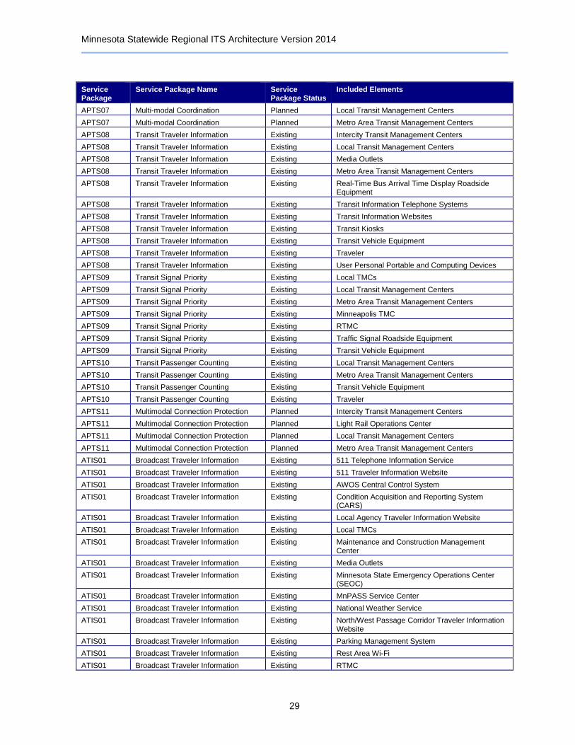
Minnesota Statewide Regional ITS Architecture Version 2014
29
Service Package
Service Package Name Service Package Status
Included Elements
APTS07 Multi-modal Coordination Planned Local Transit Management Centers
APTS07 Multi-modal Coordination Planned Metro Area Transit Management Centers
APTS08 Transit Traveler Information Existing Intercity Transit Management Centers
APTS08 Transit Traveler Information Existing Local Transit Management Centers
APTS08 Transit Traveler Information Existing Media Outlets
APTS08 Transit Traveler Information Existing Metro Area Transit Management Centers
APTS08 Transit Traveler Information Existing Real-Time Bus Arrival Time Display Roadside Equipment
APTS08 Transit Traveler Information Existing Transit Information Telephone Systems
APTS08 Transit Traveler Information Existing Transit Information Websites
APTS08 Transit Traveler Information Existing Transit Kiosks
APTS08 Transit Traveler Information Existing Transit Vehicle Equipment
APTS08 Transit Traveler Information Existing Traveler
APTS08 Transit Traveler Information Existing User Personal Portable and Computing Devices
APTS09 Transit Signal Priority Existing Local TMCs
APTS09 Transit Signal Priority Existing Local Transit Management Centers
APTS09 Transit Signal Priority Existing Metro Area Transit Management Centers
APTS09 Transit Signal Priority Existing Minneapolis TMC
APTS09 Transit Signal Priority Existing RTMC
APTS09 Transit Signal Priority Existing Traffic Signal Roadside Equipment
APTS09 Transit Signal Priority Existing Transit Vehicle Equipment
APTS10 Transit Passenger Counting Existing Local Transit Management Centers
APTS10 Transit Passenger Counting Existing Metro Area Transit Management Centers
APTS10 Transit Passenger Counting Existing Transit Vehicle Equipment
APTS10 Transit Passenger Counting Existing Traveler
APTS11 Multimodal Connection Protection Planned Intercity Transit Management Centers
APTS11 Multimodal Connection Protection Planned Light Rail Operations Center
APTS11 Multimodal Connection Protection Planned Local Transit Management Centers
APTS11 Multimodal Connection Protection Planned Metro Area Transit Management Centers
ATIS01 Broadcast Traveler Information Existing 511 Telephone Information Service
ATIS01 Broadcast Traveler Information Existing 511 Traveler Information Website
ATIS01 Broadcast Traveler Information Existing AWOS Central Control System
ATIS01 Broadcast Traveler Information Existing Condition Acquisition and Reporting System (CARS)
ATIS01 Broadcast Traveler Information Existing Local Agency Traveler Information Website
ATIS01 Broadcast Traveler Information Existing Local TMCs
ATIS01 Broadcast Traveler Information Existing Maintenance and Construction Management Center
ATIS01 Broadcast Traveler Information Existing Media Outlets
ATIS01 Broadcast Traveler Information Existing Minnesota State Emergency Operations Center (SEOC)
ATIS01 Broadcast Traveler Information Existing MnPASS Service Center
ATIS01 Broadcast Traveler Information Existing National Weather Service
ATIS01 Broadcast Traveler Information Existing North/West Passage Corridor Traveler Information Website
ATIS01 Broadcast Traveler Information Existing Parking Management System
ATIS01 Broadcast Traveler Information Existing Rest Area Wi-Fi
ATIS01 Broadcast Traveler Information Existing RTMC
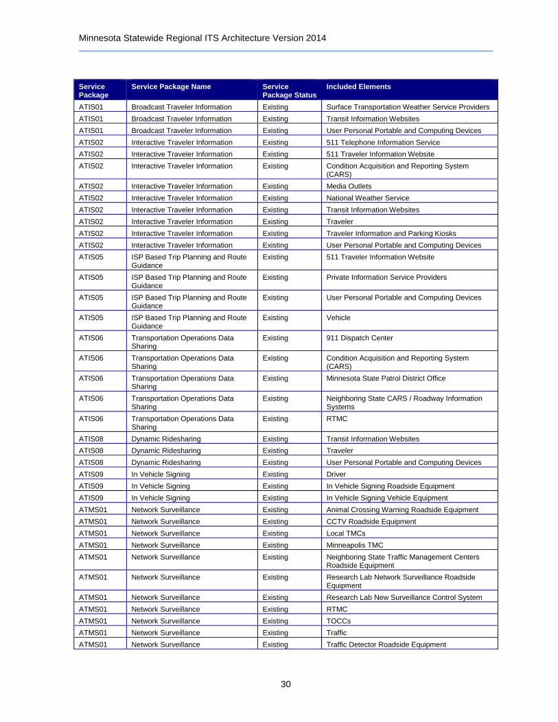
Minnesota Statewide Regional ITS Architecture Version 2014
30
Service Package
Service Package Name Service Package Status
Included Elements
ATIS01 Broadcast Traveler Information Existing Surface Transportation Weather Service Providers
ATIS01 Broadcast Traveler Information Existing Transit Information Websites
ATIS01 Broadcast Traveler Information Existing User Personal Portable and Computing Devices
ATIS02 Interactive Traveler Information Existing 511 Telephone Information Service
ATIS02 Interactive Traveler Information Existing 511 Traveler Information Website
ATIS02 Interactive Traveler Information Existing Condition Acquisition and Reporting System (CARS)
ATIS02 Interactive Traveler Information Existing Media Outlets
ATIS02 Interactive Traveler Information Existing National Weather Service
ATIS02 Interactive Traveler Information Existing Transit Information Websites
ATIS02 Interactive Traveler Information Existing Traveler
ATIS02 Interactive Traveler Information Existing Traveler Information and Parking Kiosks
ATIS02 Interactive Traveler Information Existing User Personal Portable and Computing Devices
ATIS05 ISP Based Trip Planning and Route Guidance
Existing 511 Traveler Information Website
ATIS05 ISP Based Trip Planning and Route Guidance
Existing Private Information Service Providers
ATIS05 ISP Based Trip Planning and Route Guidance
Existing User Personal Portable and Computing Devices
ATIS05 ISP Based Trip Planning and Route Guidance
Existing Vehicle
ATIS06 Transportation Operations Data Sharing
Existing 911 Dispatch Center
ATIS06 Transportation Operations Data Sharing
Existing Condition Acquisition and Reporting System (CARS)
ATIS06 Transportation Operations Data Sharing
Existing Minnesota State Patrol District Office
ATIS06 Transportation Operations Data Sharing
Existing Neighboring State CARS / Roadway Information Systems
ATIS06 Transportation Operations Data Sharing
Existing RTMC
ATIS08 Dynamic Ridesharing Existing Transit Information Websites
ATIS08 Dynamic Ridesharing Existing Traveler
ATIS08 Dynamic Ridesharing Existing User Personal Portable and Computing Devices
ATIS09 In Vehicle Signing Existing Driver
ATIS09 In Vehicle Signing Existing In Vehicle Signing Roadside Equipment
ATIS09 In Vehicle Signing Existing In Vehicle Signing Vehicle Equipment
ATMS01 Network Surveillance Existing Animal Crossing Warning Roadside Equipment
ATMS01 Network Surveillance Existing CCTV Roadside Equipment
ATMS01 Network Surveillance Existing Local TMCs
ATMS01 Network Surveillance Existing Minneapolis TMC
ATMS01 Network Surveillance Existing Neighboring State Traffic Management Centers Roadside Equipment
ATMS01 Network Surveillance Existing Research Lab Network Surveillance Roadside Equipment
ATMS01 Network Surveillance Existing Research Lab New Surveillance Control System
ATMS01 Network Surveillance Existing RTMC
ATMS01 Network Surveillance Existing TOCCs
ATMS01 Network Surveillance Existing Traffic
ATMS01 Network Surveillance Existing Traffic Detector Roadside Equipment
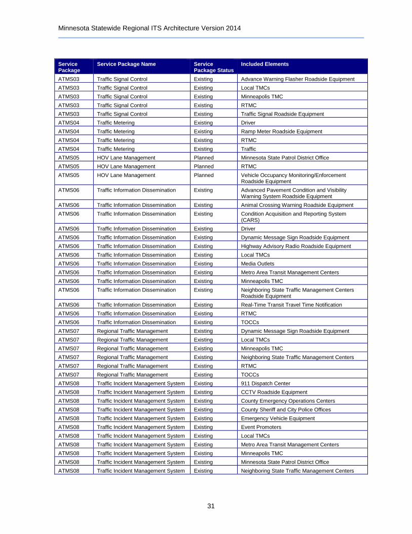
Minnesota Statewide Regional ITS Architecture Version 2014
31
Service Package
Service Package Name Service Package Status
Included Elements
ATMS03 Traffic Signal Control Existing Advance Warning Flasher Roadside Equipment
ATMS03 Traffic Signal Control Existing Local TMCs
ATMS03 Traffic Signal Control Existing Minneapolis TMC
ATMS03 Traffic Signal Control Existing RTMC
ATMS03 Traffic Signal Control Existing Traffic Signal Roadside Equipment
ATMS04 Traffic Metering Existing Driver
ATMS04 Traffic Metering Existing Ramp Meter Roadside Equipment
ATMS04 Traffic Metering Existing RTMC
ATMS04 Traffic Metering Existing Traffic
ATMS05 HOV Lane Management Planned Minnesota State Patrol District Office
ATMS05 HOV Lane Management Planned RTMC
ATMS05 HOV Lane Management Planned Vehicle Occupancy Monitoring/Enforcement Roadside Equipment
ATMS06 Traffic Information Dissemination Existing Advanced Pavement Condition and Visibility Warning System Roadside Equipment
ATMS06 Traffic Information Dissemination Existing Animal Crossing Warning Roadside Equipment
ATMS06 Traffic Information Dissemination Existing Condition Acquisition and Reporting System (CARS)
ATMS06 Traffic Information Dissemination Existing Driver
ATMS06 Traffic Information Dissemination Existing Dynamic Message Sign Roadside Equipment
ATMS06 Traffic Information Dissemination Existing Highway Advisory Radio Roadside Equipment
ATMS06 Traffic Information Dissemination Existing Local TMCs
ATMS06 Traffic Information Dissemination Existing Media Outlets
ATMS06 Traffic Information Dissemination Existing Metro Area Transit Management Centers
ATMS06 Traffic Information Dissemination Existing Minneapolis TMC
ATMS06 Traffic Information Dissemination Existing Neighboring State Traffic Management Centers Roadside Equipment
ATMS06 Traffic Information Dissemination Existing Real-Time Transit Travel Time Notification
ATMS06 Traffic Information Dissemination Existing RTMC
ATMS06 Traffic Information Dissemination Existing TOCCs
ATMS07 Regional Traffic Management Existing Dynamic Message Sign Roadside Equipment
ATMS07 Regional Traffic Management Existing Local TMCs
ATMS07 Regional Traffic Management Existing Minneapolis TMC
ATMS07 Regional Traffic Management Existing Neighboring State Traffic Management Centers
ATMS07 Regional Traffic Management Existing RTMC
ATMS07 Regional Traffic Management Existing TOCCs
ATMS08 Traffic Incident Management System Existing 911 Dispatch Center
ATMS08 Traffic Incident Management System Existing CCTV Roadside Equipment
ATMS08 Traffic Incident Management System Existing County Emergency Operations Centers
ATMS08 Traffic Incident Management System Existing County Sheriff and City Police Offices
ATMS08 Traffic Incident Management System Existing Emergency Vehicle Equipment
ATMS08 Traffic Incident Management System Existing Event Promoters
ATMS08 Traffic Incident Management System Existing Local TMCs
ATMS08 Traffic Incident Management System Existing Metro Area Transit Management Centers
ATMS08 Traffic Incident Management System Existing Minneapolis TMC
ATMS08 Traffic Incident Management System Existing Minnesota State Patrol District Office
ATMS08 Traffic Incident Management System Existing Neighboring State Traffic Management Centers
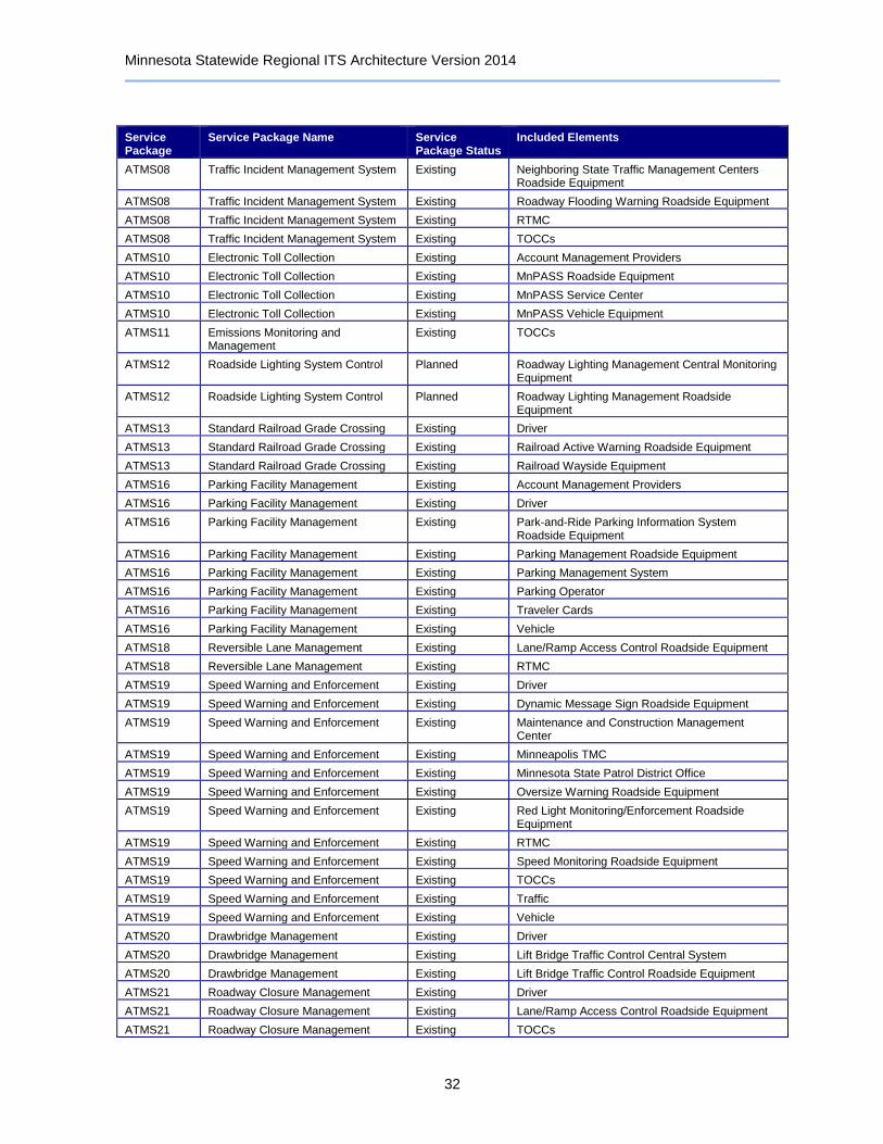
Minnesota Statewide Regional ITS Architecture Version 2014
32
Service Package
Service Package Name Service Package Status
Included Elements
ATMS08 Traffic Incident Management System Existing Neighboring State Traffic Management Centers Roadside Equipment
ATMS08 Traffic Incident Management System Existing Roadway Flooding Warning Roadside Equipment
ATMS08 Traffic Incident Management System Existing RTMC
ATMS08 Traffic Incident Management System Existing TOCCs
ATMS10 Electronic Toll Collection Existing Account Management Providers
ATMS10 Electronic Toll Collection Existing MnPASS Roadside Equipment
ATMS10 Electronic Toll Collection Existing MnPASS Service Center
ATMS10 Electronic Toll Collection Existing MnPASS Vehicle Equipment
ATMS11 Emissions Monitoring and Management
Existing TOCCs
ATMS12 Roadside Lighting System Control Planned Roadway Lighting Management Central Monitoring Equipment
ATMS12 Roadside Lighting System Control Planned Roadway Lighting Management Roadside Equipment
ATMS13 Standard Railroad Grade Crossing Existing Driver
ATMS13 Standard Railroad Grade Crossing Existing Railroad Active Warning Roadside Equipment
ATMS13 Standard Railroad Grade Crossing Existing Railroad Wayside Equipment
ATMS16 Parking Facility Management Existing Account Management Providers
ATMS16 Parking Facility Management Existing Driver
ATMS16 Parking Facility Management Existing Park-and-Ride Parking Information System Roadside Equipment
ATMS16 Parking Facility Management Existing Parking Management Roadside Equipment
ATMS16 Parking Facility Management Existing Parking Management System
ATMS16 Parking Facility Management Existing Parking Operator
ATMS16 Parking Facility Management Existing Traveler Cards
ATMS16 Parking Facility Management Existing Vehicle
ATMS18 Reversible Lane Management Existing Lane/Ramp Access Control Roadside Equipment
ATMS18 Reversible Lane Management Existing RTMC
ATMS19 Speed Warning and Enforcement Existing Driver
ATMS19 Speed Warning and Enforcement Existing Dynamic Message Sign Roadside Equipment
ATMS19 Speed Warning and Enforcement Existing Maintenance and Construction Management Center
ATMS19 Speed Warning and Enforcement Existing Minneapolis TMC
ATMS19 Speed Warning and Enforcement Existing Minnesota State Patrol District Office
ATMS19 Speed Warning and Enforcement Existing Oversize Warning Roadside Equipment
ATMS19 Speed Warning and Enforcement Existing Red Light Monitoring/Enforcement Roadside Equipment
ATMS19 Speed Warning and Enforcement Existing RTMC
ATMS19 Speed Warning and Enforcement Existing Speed Monitoring Roadside Equipment
ATMS19 Speed Warning and Enforcement Existing TOCCs
ATMS19 Speed Warning and Enforcement Existing Traffic
ATMS19 Speed Warning and Enforcement Existing Vehicle
ATMS20 Drawbridge Management Existing Driver
ATMS20 Drawbridge Management Existing Lift Bridge Traffic Control Central System
ATMS20 Drawbridge Management Existing Lift Bridge Traffic Control Roadside Equipment
ATMS21 Roadway Closure Management Existing Driver
ATMS21 Roadway Closure Management Existing Lane/Ramp Access Control Roadside Equipment
ATMS21 Roadway Closure Management Existing TOCCs

Minnesota Statewide Regional ITS Architecture Version 2014
33
Service Package
Service Package Name Service Package Status
Included Elements
ATMS22 Variable Speed Limits Planned RTMC
ATMS22 Variable Speed Limits Planned TOCCs
ATMS22 Variable Speed Limits Planned Variable Speed Limit Roadside Equipment
ATMS23 Dynamic Lane Management and Shoulder Use
Existing Driver
ATMS23 Dynamic Lane Management and Shoulder Use
Existing Lane Control Roadside Equipment
ATMS23 Dynamic Lane Management and Shoulder Use
Existing MnPASS Roadside Equipment
ATMS23 Dynamic Lane Management and Shoulder Use
Existing RTMC
ATMS23 Dynamic Lane Management and Shoulder Use
Existing Vehicle
ATMS24 Dynamic Roadway Warning Existing Advance Warning Flasher Roadside Equipment
ATMS24 Dynamic Roadway Warning Existing Advanced Pavement Condition and Visibility Warning System Roadside Equipment
ATMS24 Dynamic Roadway Warning Existing Animal Crossing Warning Roadside Equipment
ATMS24 Dynamic Roadway Warning Existing CCTV Roadside Equipment
ATMS24 Dynamic Roadway Warning Existing Driver
ATMS24 Dynamic Roadway Warning Existing Queue Detection Roadside Equipment
ATMS24 Dynamic Roadway Warning Existing Roadway Flooding Warning Roadside Equipment
ATMS24 Dynamic Roadway Warning Existing RTMC
ATMS24 Dynamic Roadway Warning Existing TOCCs
ATMS24 Dynamic Roadway Warning Existing Traffic
ATMS24 Dynamic Roadway Warning Existing Traffic Detector Roadside Equipment
AVSS01 Vehicle Safety Monitoring Planned Basic Vehicle
AVSS01 Vehicle Safety Monitoring Planned Driver
AVSS01 Vehicle Safety Monitoring Planned Vehicle
AVSS02 Driver Safety Monitoring Planned Basic Vehicle
AVSS02 Driver Safety Monitoring Planned Driver
AVSS02 Driver Safety Monitoring Planned Vehicle
AVSS03 Longitudinal Safety Warning Planned Basic Vehicle
AVSS03 Longitudinal Safety Warning Planned Driver
AVSS03 Longitudinal Safety Warning Planned Transit Vehicle Equipment
AVSS03 Longitudinal Safety Warning Planned Vehicle
AVSS04 Lateral Safety Warning Planned Basic Vehicle
AVSS04 Lateral Safety Warning Planned Driver
AVSS04 Lateral Safety Warning Planned Roadway Environment
AVSS04 Lateral Safety Warning Planned Transit Vehicle Equipment
AVSS05 Intersection Safety Warning Planned Driver
AVSS05 Intersection Safety Warning Planned Intersection Collision Warning Roadside Equipment
CVO01 Carrier Operations and Fleet Management
Existing 511 Traveler Information Website
CVO01 Carrier Operations and Fleet Management
Existing Automated Permit Routing System
CVO01 Carrier Operations and Fleet Management
Existing Commercial Vehicle Administration Center
CVO01 Carrier Operations and Fleet Management
Existing Commercial Vehicles
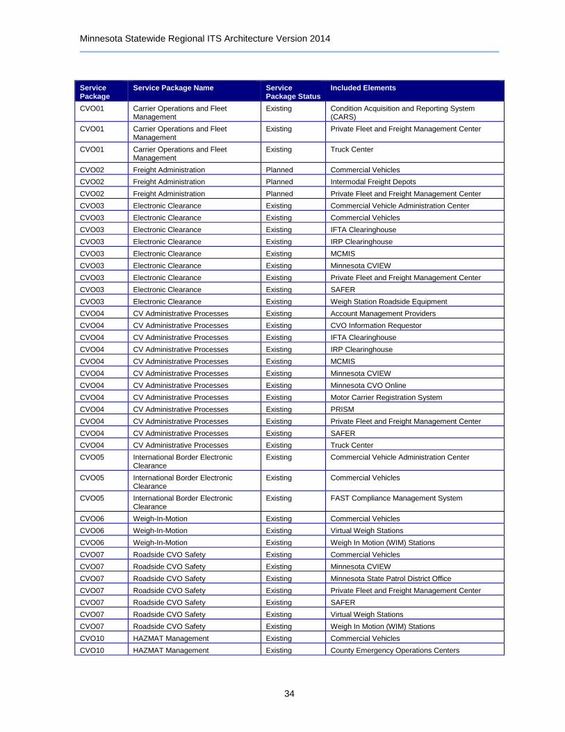
Minnesota Statewide Regional ITS Architecture Version 2014
34
Service Package
Service Package Name Service Package Status
Included Elements
CVO01 Carrier Operations and Fleet Management
Existing Condition Acquisition and Reporting System (CARS)
CVO01 Carrier Operations and Fleet Management
Existing Private Fleet and Freight Management Center
CVO01 Carrier Operations and Fleet Management
Existing Truck Center
CVO02 Freight Administration Planned Commercial Vehicles
CVO02 Freight Administration Planned Intermodal Freight Depots
CVO02 Freight Administration Planned Private Fleet and Freight Management Center
CVO03 Electronic Clearance Existing Commercial Vehicle Administration Center
CVO03 Electronic Clearance Existing Commercial Vehicles
CVO03 Electronic Clearance Existing IFTA Clearinghouse
CVO03 Electronic Clearance Existing IRP Clearinghouse
CVO03 Electronic Clearance Existing MCMIS
CVO03 Electronic Clearance Existing Minnesota CVIEW
CVO03 Electronic Clearance Existing Private Fleet and Freight Management Center
CVO03 Electronic Clearance Existing SAFER
CVO03 Electronic Clearance Existing Weigh Station Roadside Equipment
CVO04 CV Administrative Processes Existing Account Management Providers
CVO04 CV Administrative Processes Existing CVO Information Requestor
CVO04 CV Administrative Processes Existing IFTA Clearinghouse
CVO04 CV Administrative Processes Existing IRP Clearinghouse
CVO04 CV Administrative Processes Existing MCMIS
CVO04 CV Administrative Processes Existing Minnesota CVIEW
CVO04 CV Administrative Processes Existing Minnesota CVO Online
CVO04 CV Administrative Processes Existing Motor Carrier Registration System
CVO04 CV Administrative Processes Existing PRISM
CVO04 CV Administrative Processes Existing Private Fleet and Freight Management Center
CVO04 CV Administrative Processes Existing SAFER
CVO04 CV Administrative Processes Existing Truck Center
CVO05 International Border Electronic Clearance
Existing Commercial Vehicle Administration Center
CVO05 International Border Electronic Clearance
Existing Commercial Vehicles
CVO05 International Border Electronic Clearance
Existing FAST Compliance Management System
CVO06 Weigh-In-Motion Existing Commercial Vehicles
CVO06 Weigh-In-Motion Existing Virtual Weigh Stations
CVO06 Weigh-In-Motion Existing Weigh In Motion (WIM) Stations
CVO07 Roadside CVO Safety Existing Commercial Vehicles
CVO07 Roadside CVO Safety Existing Minnesota CVIEW
CVO07 Roadside CVO Safety Existing Minnesota State Patrol District Office
CVO07 Roadside CVO Safety Existing Private Fleet and Freight Management Center
CVO07 Roadside CVO Safety Existing SAFER
CVO07 Roadside CVO Safety Existing Virtual Weigh Stations
CVO07 Roadside CVO Safety Existing Weigh In Motion (WIM) Stations
CVO10 HAZMAT Management Existing Commercial Vehicles
CVO10 HAZMAT Management Existing County Emergency Operations Centers
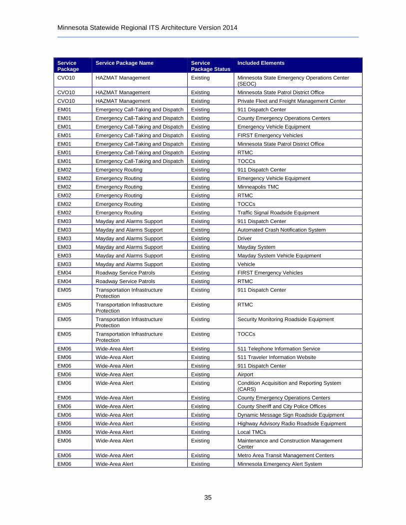
Minnesota Statewide Regional ITS Architecture Version 2014
35
Service Package
Service Package Name Service Package Status
Included Elements
CVO10 HAZMAT Management Existing Minnesota State Emergency Operations Center (SEOC)
CVO10 HAZMAT Management Existing Minnesota State Patrol District Office
CVO10 HAZMAT Management Existing Private Fleet and Freight Management Center
EM01 Emergency Call-Taking and Dispatch Existing 911 Dispatch Center
EM01 Emergency Call-Taking and Dispatch Existing County Emergency Operations Centers
EM01 Emergency Call-Taking and Dispatch Existing Emergency Vehicle Equipment
EM01 Emergency Call-Taking and Dispatch Existing FIRST Emergency Vehicles
EM01 Emergency Call-Taking and Dispatch Existing Minnesota State Patrol District Office
EM01 Emergency Call-Taking and Dispatch Existing RTMC
EM01 Emergency Call-Taking and Dispatch Existing TOCCs
EM02 Emergency Routing Existing 911 Dispatch Center
EM02 Emergency Routing Existing Emergency Vehicle Equipment
EM02 Emergency Routing Existing Minneapolis TMC
EM02 Emergency Routing Existing RTMC
EM02 Emergency Routing Existing TOCCs
EM02 Emergency Routing Existing Traffic Signal Roadside Equipment
EM03 Mayday and Alarms Support Existing 911 Dispatch Center
EM03 Mayday and Alarms Support Existing Automated Crash Notification System
EM03 Mayday and Alarms Support Existing Driver
EM03 Mayday and Alarms Support Existing Mayday System
EM03 Mayday and Alarms Support Existing Mayday System Vehicle Equipment
EM03 Mayday and Alarms Support Existing Vehicle
EM04 Roadway Service Patrols Existing FIRST Emergency Vehicles
EM04 Roadway Service Patrols Existing RTMC
EM05 Transportation Infrastructure Protection
Existing 911 Dispatch Center
EM05 Transportation Infrastructure Protection
Existing RTMC
EM05 Transportation Infrastructure Protection
Existing Security Monitoring Roadside Equipment
EM05 Transportation Infrastructure Protection
Existing TOCCs
EM06 Wide-Area Alert Existing 511 Telephone Information Service
EM06 Wide-Area Alert Existing 511 Traveler Information Website
EM06 Wide-Area Alert Existing 911 Dispatch Center
EM06 Wide-Area Alert Existing Airport
EM06 Wide-Area Alert Existing Condition Acquisition and Reporting System (CARS)
EM06 Wide-Area Alert Existing County Emergency Operations Centers
EM06 Wide-Area Alert Existing County Sheriff and City Police Offices
EM06 Wide-Area Alert Existing Dynamic Message Sign Roadside Equipment
EM06 Wide-Area Alert Existing Highway Advisory Radio Roadside Equipment
EM06 Wide-Area Alert Existing Local TMCs
EM06 Wide-Area Alert Existing Maintenance and Construction Management Center
EM06 Wide-Area Alert Existing Metro Area Transit Management Centers
EM06 Wide-Area Alert Existing Minnesota Emergency Alert System

Minnesota Statewide Regional ITS Architecture Version 2014
36
Service Package
Service Package Name Service Package Status
Included Elements
EM06 Wide-Area Alert Existing Minnesota State Emergency Operations Center (SEOC)
EM06 Wide-Area Alert Existing Minnesota State Patrol District Office
EM06 Wide-Area Alert Existing Neighboring State Emergency Management Agencies
EM06 Wide-Area Alert Existing RTMC
EM06 Wide-Area Alert Existing TOCCs
EM06 Wide-Area Alert Existing User Personal Portable and Computing Devices
EM07 Early Warning System Existing 911 Dispatch Center
EM07 Early Warning System Existing Airport
EM07 Early Warning System Existing County Emergency Operations Centers
EM07 Early Warning System Existing County Sheriff and City Police Offices
EM07 Early Warning System Existing Maintenance and Construction Management Center
EM07 Early Warning System Existing Metro Area Transit Management Centers
EM07 Early Warning System Existing Minnesota Emergency Alert System
EM07 Early Warning System Existing Minnesota State Emergency Operations Center (SEOC)
EM07 Early Warning System Existing Minnesota State Patrol District Office
EM07 Early Warning System Existing National Weather Service
EM07 Early Warning System Existing RTMC
EM07 Early Warning System Existing Security Monitoring Roadside Equipment
EM07 Early Warning System Existing TOCCs
EM08 Disaster Response and Recovery Existing County Emergency Operations Centers
EM08 Disaster Response and Recovery Existing County Sheriff and City Police Offices
EM08 Disaster Response and Recovery Existing Maintenance and Construction Management Center
EM08 Disaster Response and Recovery Existing Minnesota State Emergency Operations Center (SEOC)
EM08 Disaster Response and Recovery Existing Neighboring State Emergency Management Agencies
EM08 Disaster Response and Recovery Existing RTMC
EM09 Evacuation and Reentry Management
Existing County Emergency Operations Centers
EM09 Evacuation and Reentry Management
Existing County Sheriff and City Police Offices
EM09 Evacuation and Reentry Management
Existing Maintenance and Construction Management Center
EM09 Evacuation and Reentry Management
Existing Minnesota State Emergency Operations Center (SEOC)
EM09 Evacuation and Reentry Management
Existing Minnesota State Patrol District Office
EM09 Evacuation and Reentry Management
Existing Neighboring State Emergency Management Agencies
EM09 Evacuation and Reentry Management
Existing RTMC
EM09 Evacuation and Reentry Management
Existing TOCCs
EM10 Disaster Traveler Information Existing 511 Telephone Information Service
EM10 Disaster Traveler Information Existing 511 Traveler Information Website

Minnesota Statewide Regional ITS Architecture Version 2014
37
Service Package
Service Package Name Service Package Status
Included Elements
EM10 Disaster Traveler Information Existing Condition Acquisition and Reporting System (CARS)
EM10 Disaster Traveler Information Existing County Emergency Operations Centers
EM10 Disaster Traveler Information Existing County Sheriff and City Police Offices
EM10 Disaster Traveler Information Existing Maintenance and Construction Management Center
EM10 Disaster Traveler Information Existing Media Outlets
EM10 Disaster Traveler Information Existing Minnesota State Emergency Operations Center (SEOC)
EM10 Disaster Traveler Information Existing National Weather Service
EM10 Disaster Traveler Information Existing Rest Area Wi-Fi
EM10 Disaster Traveler Information Existing RTMC
EM10 Disaster Traveler Information Existing TOCCs
EM10 Disaster Traveler Information Existing User Personal Portable and Computing Devices
MC01 Maintenance and Construction Vehicle and Equipment Tracking
Existing Maintenance and Construction Management Center
MC01 Maintenance and Construction Vehicle and Equipment Tracking
Existing Maintenance and Construction Vehicle Equipment
MC01 Maintenance and Construction Vehicle and Equipment Tracking
Existing RTMC
MC01 Maintenance and Construction Vehicle and Equipment Tracking
Existing TOCCs
MC03 Road Weather Data Collection Existing Advanced Pavement Condition and Visibility Warning System Roadside Equipment
MC03 Road Weather Data Collection Existing AWOS Central Control System
MC03 Road Weather Data Collection Existing AWOS Roadside Equipment
MC03 Road Weather Data Collection Existing Clarus Weather System
MC03 Road Weather Data Collection Existing Maintenance and Construction Vehicle Equipment
MC03 Road Weather Data Collection Existing RWIS Central Control System
MC03 Road Weather Data Collection Existing RWIS Stations
MC03 Road Weather Data Collection Existing TOCCs
MC04 Weather Information Processing and Distribution
Existing AWOS Central Control System
MC04 Weather Information Processing and Distribution
Existing Clarus Weather System
MC04 Weather Information Processing and Distribution
Existing Condition Acquisition and Reporting System (CARS)
MC04 Weather Information Processing and Distribution
Existing Maintenance and Construction Management Center
MC04 Weather Information Processing and Distribution
Existing Media Outlets
MC04 Weather Information Processing and Distribution
Existing National Weather Service
MC04 Weather Information Processing and Distribution
Existing RTMC
MC04 Weather Information Processing and Distribution
Existing RWIS Central Control System
MC04 Weather Information Processing and Distribution
Existing Surface Transportation Weather Service Providers
MC04 Weather Information Processing and Distribution
Existing TOCCs
MC05 Roadway Automated Treatment Existing Driver
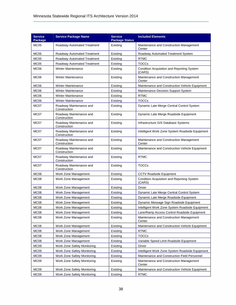
Minnesota Statewide Regional ITS Architecture Version 2014
38
Service Package
Service Package Name Service Package Status
Included Elements
MC05 Roadway Automated Treatment Existing Maintenance and Construction Management Center
MC05 Roadway Automated Treatment Existing Roadway Automated Treatment System
MC05 Roadway Automated Treatment Existing RTMC
MC05 Roadway Automated Treatment Existing TOCCs
MC06 Winter Maintenance Existing Condition Acquisition and Reporting System (CARS)
MC06 Winter Maintenance Existing Maintenance and Construction Management Center
MC06 Winter Maintenance Existing Maintenance and Construction Vehicle Equipment
MC06 Winter Maintenance Existing Maintenance Decision Support System
MC06 Winter Maintenance Existing RTMC
MC06 Winter Maintenance Existing TOCCs
MC07 Roadway Maintenance and Construction
Existing Dynamic Late Merge Central Control System
MC07 Roadway Maintenance and Construction
Existing Dynamic Late Merge Roadside Equipment
MC07 Roadway Maintenance and Construction
Existing Infrastructure GIS Database Systems
MC07 Roadway Maintenance and Construction
Existing Intelligent Work Zone System Roadside Equipment
MC07 Roadway Maintenance and Construction
Existing Maintenance and Construction Management Center
MC07 Roadway Maintenance and Construction
Existing Maintenance and Construction Vehicle Equipment
MC07 Roadway Maintenance and Construction
Existing RTMC
MC07 Roadway Maintenance and Construction
Existing TOCCs
MC08 Work Zone Management Existing CCTV Roadside Equipment
MC08 Work Zone Management Existing Condition Acquisition and Reporting System (CARS)
MC08 Work Zone Management Existing Driver
MC08 Work Zone Management Existing Dynamic Late Merge Central Control System
MC08 Work Zone Management Existing Dynamic Late Merge Roadside Equipment
MC08 Work Zone Management Existing Dynamic Message Sign Roadside Equipment
MC08 Work Zone Management Existing Intelligent Work Zone System Roadside Equipment
MC08 Work Zone Management Existing Lane/Ramp Access Control Roadside Equipment
MC08 Work Zone Management Existing Maintenance and Construction Management Center
MC08 Work Zone Management Existing Maintenance and Construction Vehicle Equipment
MC08 Work Zone Management Existing RTMC
MC08 Work Zone Management Existing TOCCs
MC08 Work Zone Management Existing Variable Speed Limit Roadside Equipment
MC09 Work Zone Safety Monitoring Existing Driver
MC09 Work Zone Safety Monitoring Existing Intelligent Work Zone System Roadside Equipment
MC09 Work Zone Safety Monitoring Existing Maintenance and Construction Field Personnel
MC09 Work Zone Safety Monitoring Existing Maintenance and Construction Management Center
MC09 Work Zone Safety Monitoring Existing Maintenance and Construction Vehicle Equipment
MC09 Work Zone Safety Monitoring Existing RTMC
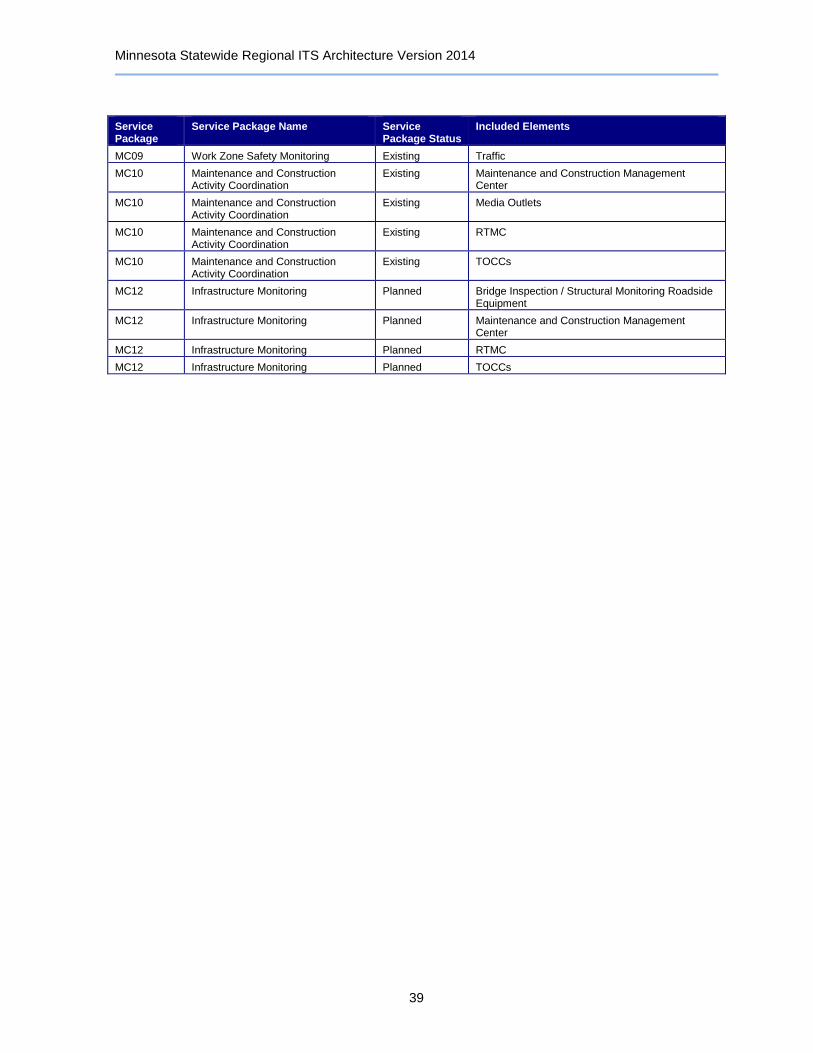
Minnesota Statewide Regional ITS Architecture Version 2014
39
Service Package
Service Package Name Service Package Status
Included Elements
MC09 Work Zone Safety Monitoring Existing Traffic
MC10 Maintenance and Construction Activity Coordination
Existing Maintenance and Construction Management Center
MC10 Maintenance and Construction Activity Coordination
Existing Media Outlets
MC10 Maintenance and Construction Activity Coordination
Existing RTMC
MC10 Maintenance and Construction Activity Coordination
Existing TOCCs
MC12 Infrastructure Monitoring Planned Bridge Inspection / Structural Monitoring Roadside Equipment
MC12 Infrastructure Monitoring Planned Maintenance and Construction Management Center
MC12 Infrastructure Monitoring Planned RTMC
MC12 Infrastructure Monitoring Planned TOCCs

Minnesota Statewide Regional ITS Architecture Version 2014
40
7 Operational Concept
The Operational Concept lists the roles and responsibilities that each participating agency must take on to provide the ITS services included in the ITS Architecture. Changing needs may arise that will require an agreement to be formed between all affected parties that defines new or additional roles. Defining the roles and responsibilities of the participating stakeholders in the region and the willingness of agencies to accept their roles and responsibilities is an important step in realizing the common goal of an interoperable ITS system throughout the region.
Table 4: Operational Concept
RR Area Name Stakeholder RR Description RR Status
Archived Data Systems for Minnesota Regional ITS Architecture
Account Management Providers
Archived Data Systems for Minnesota Regional ITS Architecture
Airports
Archived Data Systems for Minnesota Regional ITS Architecture
City of Minneapolis
Archived Data Systems for Minnesota Regional ITS Architecture
FHWA
Archived Data Systems for Minnesota Regional ITS Architecture
Intercity Transit Providers
Archived Data Systems for Minnesota Regional ITS Architecture
Local Agencies
Archived Data Systems for Minnesota Regional ITS Architecture
Local EM Agencies
Archived Data Systems for Minnesota Regional ITS Architecture
Local Transit Providers
Archived Data Systems for Minnesota Regional ITS Architecture
Map Update Providers
Archived Data Systems for Minnesota Regional ITS Architecture
Metro Area Transit Providers
Archived Data Systems for Minnesota Regional ITS Architecture
Metro Transit
Archived Data Systems for Minnesota Regional ITS Architecture
Minnesota Homeland Security and Emergency Management
Archived Data Systems for Minnesota Regional ITS Architecture
Minnesota State Patrol
Archived Data Systems for Minnesota Regional ITS Architecture
MnDOT
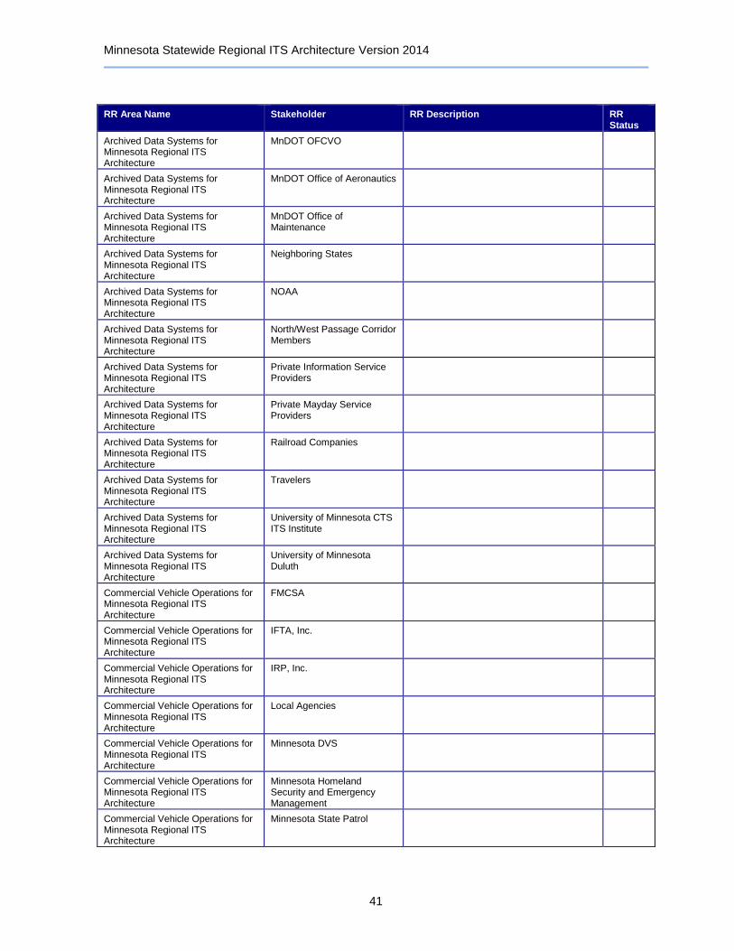
Minnesota Statewide Regional ITS Architecture Version 2014
41
RR Area Name Stakeholder RR Description RR Status
Archived Data Systems for Minnesota Regional ITS Architecture
MnDOT OFCVO
Archived Data Systems for Minnesota Regional ITS Architecture
MnDOT Office of Aeronautics
Archived Data Systems for Minnesota Regional ITS Architecture
MnDOT Office of Maintenance
Archived Data Systems for Minnesota Regional ITS Architecture
Neighboring States
Archived Data Systems for Minnesota Regional ITS Architecture
NOAA
Archived Data Systems for Minnesota Regional ITS Architecture
North/West Passage Corridor Members
Archived Data Systems for Minnesota Regional ITS Architecture
Private Information Service Providers
Archived Data Systems for Minnesota Regional ITS Architecture
Private Mayday Service Providers
Archived Data Systems for Minnesota Regional ITS Architecture
Railroad Companies
Archived Data Systems for Minnesota Regional ITS Architecture
Travelers
Archived Data Systems for Minnesota Regional ITS Architecture
University of Minnesota CTS ITS Institute
Archived Data Systems for Minnesota Regional ITS Architecture
University of Minnesota Duluth
Commercial Vehicle Operations for Minnesota Regional ITS Architecture
FMCSA
Commercial Vehicle Operations for Minnesota Regional ITS Architecture
IFTA, Inc.
Commercial Vehicle Operations for Minnesota Regional ITS Architecture
IRP, Inc.
Commercial Vehicle Operations for Minnesota Regional ITS Architecture
Local Agencies
Commercial Vehicle Operations for Minnesota Regional ITS Architecture
Minnesota DVS
Commercial Vehicle Operations for Minnesota Regional ITS Architecture
Minnesota Homeland Security and Emergency Management
Commercial Vehicle Operations for Minnesota Regional ITS Architecture
Minnesota State Patrol
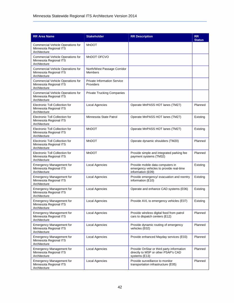
Minnesota Statewide Regional ITS Architecture Version 2014
42
RR Area Name Stakeholder RR Description RR Status
Commercial Vehicle Operations for Minnesota Regional ITS Architecture
MnDOT
Commercial Vehicle Operations for Minnesota Regional ITS Architecture
MnDOT OFCVO
Commercial Vehicle Operations for Minnesota Regional ITS Architecture
North/West Passage Corridor Members
Commercial Vehicle Operations for Minnesota Regional ITS Architecture
Private Information Service Providers
Commercial Vehicle Operations for Minnesota Regional ITS Architecture
Private Trucking Companies
Electronic Toll Collection for Minnesota Regional ITS Architecture
Local Agencies Operate MnPASS HOT lanes (TM27) Planned
Electronic Toll Collection for Minnesota Regional ITS Architecture
Minnesota State Patrol Operate MnPASS HOT lanes (TM27) Existing
Electronic Toll Collection for Minnesota Regional ITS Architecture
MnDOT Operate MnPASS HOT lanes (TM27) Existing
Electronic Toll Collection for Minnesota Regional ITS Architecture
MnDOT Operate dynamic shoulders (TM20) Planned
Electronic Toll Collection for Minnesota Regional ITS Architecture
MnDOT Provide simple and integrated parking fee payment systems (TM32)
Planned
Emergency Management for Minnesota Regional ITS Architecture
Local Agencies Provide mobile data computers in emergency vehicles to provide real-time information (E09)
Existing
Emergency Management for Minnesota Regional ITS Architecture
Local Agencies Provide emergency/ evacuation and reentry information (E10)
Existing
Emergency Management for Minnesota Regional ITS Architecture
Local Agencies Operate and enhance CAD systems (E06) Existing
Emergency Management for Minnesota Regional ITS Architecture
Local Agencies Provide AVL to emergency vehicles (E07) Existing
Emergency Management for Minnesota Regional ITS Architecture
Local Agencies Provide wireless digital feed from patrol cars to dispatch centers (E12)
Planned
Emergency Management for Minnesota Regional ITS Architecture
Local Agencies Provide dynamic routing of emergency vehicles (E02)
Planned
Emergency Management for Minnesota Regional ITS Architecture
Local Agencies Provide enhanced Mayday services (E03) Planned
Emergency Management for Minnesota Regional ITS Architecture
Local Agencies Provide OnStar or third party information directly to MSP or other PSAP's CAD systems (E13)
Planned
Emergency Management for Minnesota Regional ITS Architecture
Local Agencies Provide surveillance to monitor transportation infrastructure (E05)
Planned
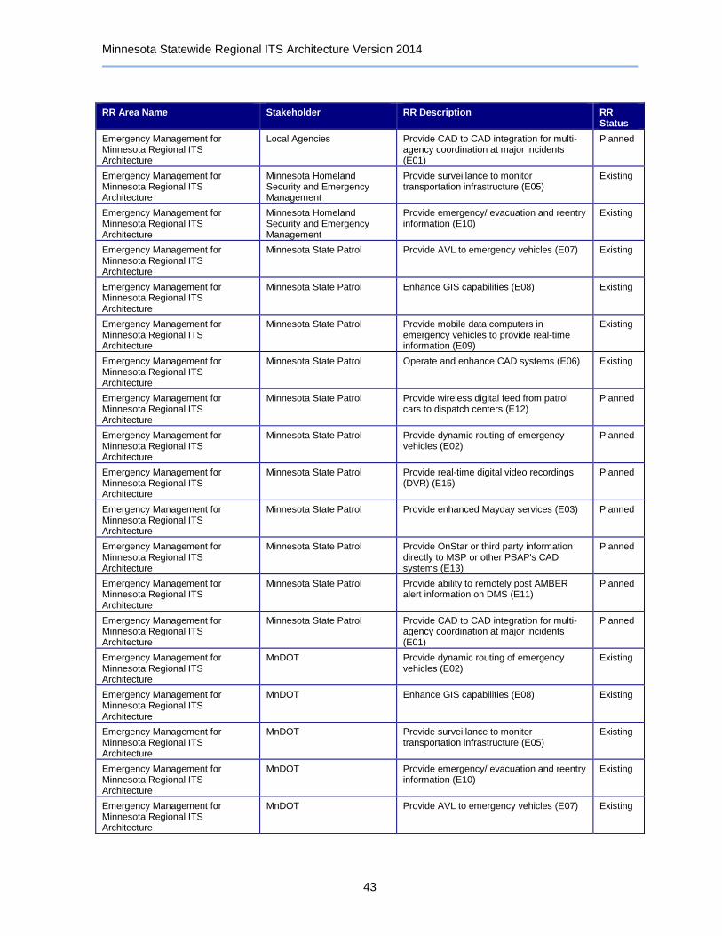
Minnesota Statewide Regional ITS Architecture Version 2014
43
RR Area Name Stakeholder RR Description RR Status
Emergency Management for Minnesota Regional ITS Architecture
Local Agencies Provide CAD to CAD integration for multi-agency coordination at major incidents (E01)
Planned
Emergency Management for Minnesota Regional ITS Architecture
Minnesota Homeland Security and Emergency Management
Provide surveillance to monitor transportation infrastructure (E05)
Existing
Emergency Management for Minnesota Regional ITS Architecture
Minnesota Homeland Security and Emergency Management
Provide emergency/ evacuation and reentry information (E10)
Existing
Emergency Management for Minnesota Regional ITS Architecture
Minnesota State Patrol Provide AVL to emergency vehicles (E07) Existing
Emergency Management for Minnesota Regional ITS Architecture
Minnesota State Patrol Enhance GIS capabilities (E08) Existing
Emergency Management for Minnesota Regional ITS Architecture
Minnesota State Patrol Provide mobile data computers in emergency vehicles to provide real-time information (E09)
Existing
Emergency Management for Minnesota Regional ITS Architecture
Minnesota State Patrol Operate and enhance CAD systems (E06) Existing
Emergency Management for Minnesota Regional ITS Architecture
Minnesota State Patrol Provide wireless digital feed from patrol cars to dispatch centers (E12)
Planned
Emergency Management for Minnesota Regional ITS Architecture
Minnesota State Patrol Provide dynamic routing of emergency vehicles (E02)
Planned
Emergency Management for Minnesota Regional ITS Architecture
Minnesota State Patrol Provide real-time digital video recordings (DVR) (E15)
Planned
Emergency Management for Minnesota Regional ITS Architecture
Minnesota State Patrol Provide enhanced Mayday services (E03) Planned
Emergency Management for Minnesota Regional ITS Architecture
Minnesota State Patrol Provide OnStar or third party information directly to MSP or other PSAP's CAD systems (E13)
Planned
Emergency Management for Minnesota Regional ITS Architecture
Minnesota State Patrol Provide ability to remotely post AMBER alert information on DMS (E11)
Planned
Emergency Management for Minnesota Regional ITS Architecture
Minnesota State Patrol Provide CAD to CAD integration for multi-agency coordination at major incidents (E01)
Planned
Emergency Management for Minnesota Regional ITS Architecture
MnDOT Provide dynamic routing of emergency vehicles (E02)
Existing
Emergency Management for Minnesota Regional ITS Architecture
MnDOT Enhance GIS capabilities (E08) Existing
Emergency Management for Minnesota Regional ITS Architecture
MnDOT Provide surveillance to monitor transportation infrastructure (E05)
Existing
Emergency Management for Minnesota Regional ITS Architecture
MnDOT Provide emergency/ evacuation and reentry information (E10)
Existing
Emergency Management for Minnesota Regional ITS Architecture
MnDOT Provide AVL to emergency vehicles (E07) Existing
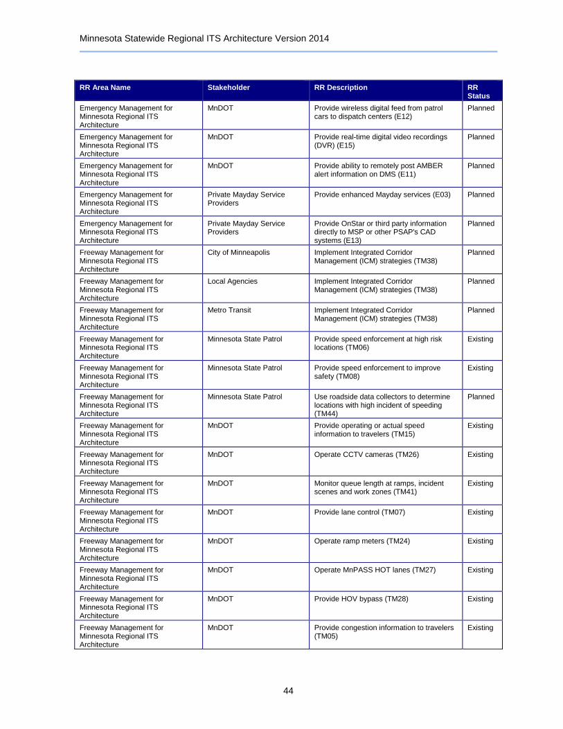
Minnesota Statewide Regional ITS Architecture Version 2014
44
RR Area Name Stakeholder RR Description RR Status
Emergency Management for Minnesota Regional ITS Architecture
MnDOT Provide wireless digital feed from patrol cars to dispatch centers (E12)
Planned
Emergency Management for Minnesota Regional ITS Architecture
MnDOT Provide real-time digital video recordings (DVR) (E15)
Planned
Emergency Management for Minnesota Regional ITS Architecture
MnDOT Provide ability to remotely post AMBER alert information on DMS (E11)
Planned
Emergency Management for Minnesota Regional ITS Architecture
Private Mayday Service Providers
Provide enhanced Mayday services (E03) Planned
Emergency Management for Minnesota Regional ITS Architecture
Private Mayday Service Providers
Provide OnStar or third party information directly to MSP or other PSAP's CAD systems (E13)
Planned
Freeway Management for Minnesota Regional ITS Architecture
City of Minneapolis Implement Integrated Corridor Management (ICM) strategies (TM38)
Planned
Freeway Management for Minnesota Regional ITS Architecture
Local Agencies Implement Integrated Corridor Management (ICM) strategies (TM38)
Planned
Freeway Management for Minnesota Regional ITS Architecture
Metro Transit Implement Integrated Corridor Management (ICM) strategies (TM38)
Planned
Freeway Management for Minnesota Regional ITS Architecture
Minnesota State Patrol Provide speed enforcement at high risk locations (TM06)
Existing
Freeway Management for Minnesota Regional ITS Architecture
Minnesota State Patrol Provide speed enforcement to improve safety (TM08)
Existing
Freeway Management for Minnesota Regional ITS Architecture
Minnesota State Patrol Use roadside data collectors to determine locations with high incident of speeding (TM44)
Planned
Freeway Management for Minnesota Regional ITS Architecture
MnDOT Provide operating or actual speed information to travelers (TM15)
Existing
Freeway Management for Minnesota Regional ITS Architecture
MnDOT Operate CCTV cameras (TM26) Existing
Freeway Management for Minnesota Regional ITS Architecture
MnDOT Monitor queue length at ramps, incident scenes and work zones (TM41)
Existing
Freeway Management for Minnesota Regional ITS Architecture
MnDOT Provide lane control (TM07) Existing
Freeway Management for Minnesota Regional ITS Architecture
MnDOT Operate ramp meters (TM24) Existing
Freeway Management for Minnesota Regional ITS Architecture
MnDOT Operate MnPASS HOT lanes (TM27) Existing
Freeway Management for Minnesota Regional ITS Architecture
MnDOT Provide HOV bypass (TM28) Existing
Freeway Management for Minnesota Regional ITS Architecture
MnDOT Provide congestion information to travelers (TM05)
Existing
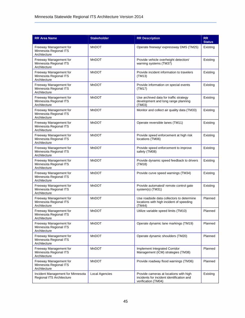
Minnesota Statewide Regional ITS Architecture Version 2014
45
RR Area Name Stakeholder RR Description RR Status
Freeway Management for Minnesota Regional ITS Architecture
MnDOT Operate freeway/ expressway DMS (TM25) Existing
Freeway Management for Minnesota Regional ITS Architecture
MnDOT Provide vehicle overheight detection/ warning systems (TM37)
Existing
Freeway Management for Minnesota Regional ITS Architecture
MnDOT Provide incident information to travelers (TM13)
Existing
Freeway Management for Minnesota Regional ITS Architecture
MnDOT Provide information on special events (TM17)
Existing
Freeway Management for Minnesota Regional ITS Architecture
MnDOT Use archived data for traffic strategy development and long range planning (TM03)
Existing
Freeway Management for Minnesota Regional ITS Architecture
MnDOT Monitor and collect air quality data (TM33) Existing
Freeway Management for Minnesota Regional ITS Architecture
MnDOT Operate reversible lanes (TM11) Existing
Freeway Management for Minnesota Regional ITS Architecture
MnDOT Provide speed enforcement at high risk locations (TM06)
Existing
Freeway Management for Minnesota Regional ITS Architecture
MnDOT Provide speed enforcement to improve safety (TM08)
Existing
Freeway Management for Minnesota Regional ITS Architecture
MnDOT Provide dynamic speed feedback to drivers (TM18)
Existing
Freeway Management for Minnesota Regional ITS Architecture
MnDOT Provide curve speed warnings (TM34) Existing
Freeway Management for Minnesota Regional ITS Architecture
MnDOT Provide automated/ remote control gate system(s) (TM31)
Existing
Freeway Management for Minnesota Regional ITS Architecture
MnDOT Use roadside data collectors to determine locations with high incident of speeding (TM44)
Planned
Freeway Management for Minnesota Regional ITS Architecture
MnDOT Utilize variable speed limits (TM10) Planned
Freeway Management for Minnesota Regional ITS Architecture
MnDOT Operate dynamic lane markings (TM19) Planned
Freeway Management for Minnesota Regional ITS Architecture
MnDOT Operate dynamic shoulders (TM20) Planned
Freeway Management for Minnesota Regional ITS Architecture
MnDOT Implement Integrated Corridor Management (ICM) strategies (TM38)
Planned
Freeway Management for Minnesota Regional ITS Architecture
MnDOT Provide roadway flood warnings (TM36) Planned
Incident Management for Minnesota Regional ITS Architecture
Local Agencies Provide cameras at locations with high incidents for incident identification and verification (TM04)
Existing
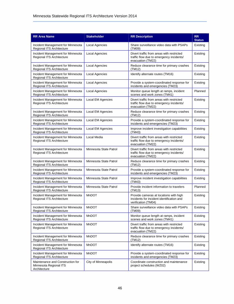
Minnesota Statewide Regional ITS Architecture Version 2014
46
RR Area Name Stakeholder RR Description RR Status
Incident Management for Minnesota Regional ITS Architecture
Local Agencies Share surveillance video data with PSAPs (TM09)
Existing
Incident Management for Minnesota Regional ITS Architecture
Local Agencies Divert traffic from areas with restricted traffic flow due to emergency incidents/ evacuation (TM22)
Existing
Incident Management for Minnesota Regional ITS Architecture
Local Agencies Reduce clearance time for primary crashes (TM12)
Existing
Incident Management for Minnesota Regional ITS Architecture
Local Agencies Identify alternate routes (TM16) Existing
Incident Management for Minnesota Regional ITS Architecture
Local Agencies Provide a system-coordinated response for incidents and emergencies (TM23)
Existing
Incident Management for Minnesota Regional ITS Architecture
Local Agencies Monitor queue length at ramps, incident scenes and work zones (TM41)
Planned
Incident Management for Minnesota Regional ITS Architecture
Local EM Agencies Divert traffic from areas with restricted traffic flow due to emergency incidents/ evacuation (TM22)
Existing
Incident Management for Minnesota Regional ITS Architecture
Local EM Agencies Reduce clearance time for primary crashes (TM12)
Existing
Incident Management for Minnesota Regional ITS Architecture
Local EM Agencies Provide a system-coordinated response for incidents and emergencies (TM23)
Existing
Incident Management for Minnesota Regional ITS Architecture
Local EM Agencies Improve incident investigation capabilities (TM43)
Existing
Incident Management for Minnesota Regional ITS Architecture
Local Media Divert traffic from areas with restricted traffic flow due to emergency incidents/ evacuation (TM22)
Existing
Incident Management for Minnesota Regional ITS Architecture
Minnesota State Patrol Divert traffic from areas with restricted traffic flow due to emergency incidents/ evacuation (TM22)
Existing
Incident Management for Minnesota Regional ITS Architecture
Minnesota State Patrol Reduce clearance time for primary crashes (TM12)
Existing
Incident Management for Minnesota Regional ITS Architecture
Minnesota State Patrol Provide a system-coordinated response for incidents and emergencies (TM23)
Existing
Incident Management for Minnesota Regional ITS Architecture
Minnesota State Patrol Improve incident investigation capabilities (TM43)
Existing
Incident Management for Minnesota Regional ITS Architecture
Minnesota State Patrol Provide incident information to travelers (TM13)
Planned
Incident Management for Minnesota Regional ITS Architecture
MnDOT Provide cameras at locations with high incidents for incident identification and verification (TM04)
Existing
Incident Management for Minnesota Regional ITS Architecture
MnDOT Share surveillance video data with PSAPs (TM09)
Existing
Incident Management for Minnesota Regional ITS Architecture
MnDOT Monitor queue length at ramps, incident scenes and work zones (TM41)
Existing
Incident Management for Minnesota Regional ITS Architecture
MnDOT Divert traffic from areas with restricted traffic flow due to emergency incidents/ evacuation (TM22)
Existing
Incident Management for Minnesota Regional ITS Architecture
MnDOT Reduce clearance time for primary crashes (TM12)
Existing
Incident Management for Minnesota Regional ITS Architecture
MnDOT Identify alternate routes (TM16) Existing
Incident Management for Minnesota Regional ITS Architecture
MnDOT Provide a system-coordinated response for incidents and emergencies (TM23)
Existing
Maintenance and Construction for Minnesota Regional ITS Architecture
City of Minneapolis Coordinate construction and maintenance project schedules (WZ02)
Existing
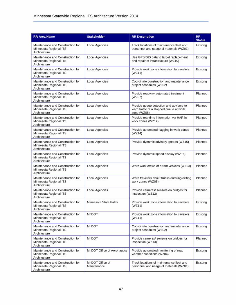
Minnesota Statewide Regional ITS Architecture Version 2014
47
RR Area Name Stakeholder RR Description RR Status
Maintenance and Construction for Minnesota Regional ITS Architecture
Local Agencies Track locations of maintenance fleet and personnel and usage of materials (WZ01)
Existing
Maintenance and Construction for Minnesota Regional ITS Architecture
Local Agencies Use GPS/GIS data to target replacement and repair of infrastructure (WZ10)
Existing
Maintenance and Construction for Minnesota Regional ITS Architecture
Local Agencies Provide work zone information to travelers (WZ11)
Existing
Maintenance and Construction for Minnesota Regional ITS Architecture
Local Agencies Coordinate construction and maintenance project schedules (WZ02)
Existing
Maintenance and Construction for Minnesota Regional ITS Architecture
Local Agencies Provide roadway automated treatment (WZ07)
Planned
Maintenance and Construction for Minnesota Regional ITS Architecture
Local Agencies Provide queue detection and advisory to warn traffic of a stopped queue at work zone (WZ06)
Planned
Maintenance and Construction for Minnesota Regional ITS Architecture
Local Agencies Provide real-time information via HAR in work zones (WZ12)
Planned
Maintenance and Construction for Minnesota Regional ITS Architecture
Local Agencies Provide automated flagging in work zones (WZ14)
Planned
Maintenance and Construction for Minnesota Regional ITS Architecture
Local Agencies Provide dynamic advisory speeds (WZ15) Planned
Maintenance and Construction for Minnesota Regional ITS Architecture
Local Agencies Provide dynamic speed display (WZ16) Planned
Maintenance and Construction for Minnesota Regional ITS Architecture
Local Agencies Warn work crews of errant vehicles (WZ03) Planned
Maintenance and Construction for Minnesota Regional ITS Architecture
Local Agencies Warn travelers about trucks entering/exiting work zones (WZ05)
Planned
Maintenance and Construction for Minnesota Regional ITS Architecture
Local Agencies Provide cameras/ sensors on bridges for inspection (WZ13)
Planned
Maintenance and Construction for Minnesota Regional ITS Architecture
Minnesota State Patrol Provide work zone information to travelers (WZ11)
Existing
Maintenance and Construction for Minnesota Regional ITS Architecture
MnDOT Provide work zone information to travelers (WZ11)
Existing
Maintenance and Construction for Minnesota Regional ITS Architecture
MnDOT Coordinate construction and maintenance project schedules (WZ02)
Existing
Maintenance and Construction for Minnesota Regional ITS Architecture
MnDOT Provide cameras/ sensors on bridges for inspection (WZ13)
Planned
Maintenance and Construction for Minnesota Regional ITS Architecture
MnDOT Office of Aeronautics Provide automated monitoring of road weather conditions (WZ04)
Existing
Maintenance and Construction for Minnesota Regional ITS Architecture
MnDOT Office of Maintenance
Track locations of maintenance fleet and personnel and usage of materials (WZ01)
Existing

Minnesota Statewide Regional ITS Architecture Version 2014
48
RR Area Name Stakeholder RR Description RR Status
Maintenance and Construction for Minnesota Regional ITS Architecture
MnDOT Office of Maintenance
Provide automated monitoring of road weather conditions (WZ04)
Existing
Maintenance and Construction for Minnesota Regional ITS Architecture
MnDOT Office of Maintenance
Provide roadway automated treatment (WZ07)
Existing
Maintenance and Construction for Minnesota Regional ITS Architecture
MnDOT Office of Maintenance
Use GPS/GIS data to target replacement and repair of infrastructure (WZ10)
Existing
Maintenance and Construction for Minnesota Regional ITS Architecture
MnDOT Office of Maintenance
Provide queue detection and advisory to warn traffic of a stopped queue at work zone (WZ06)
Existing
Maintenance and Construction for Minnesota Regional ITS Architecture
MnDOT Office of Maintenance
Provide dynamic late merge systems for construction/ maintenance activities (WZ09)
Existing
Maintenance and Construction for Minnesota Regional ITS Architecture
MnDOT Office of Maintenance
Provide work zone information to travelers (WZ11)
Existing
Maintenance and Construction for Minnesota Regional ITS Architecture
MnDOT Office of Maintenance
Provide automated flagging in work zones (WZ14)
Existing
Maintenance and Construction for Minnesota Regional ITS Architecture
MnDOT Office of Maintenance
Provide dynamic advisory speeds (WZ15) Existing
Maintenance and Construction for Minnesota Regional ITS Architecture
MnDOT Office of Maintenance
Provide dynamic speed display (WZ16) Existing
Maintenance and Construction for Minnesota Regional ITS Architecture
MnDOT Office of Maintenance
Warn travelers about trucks entering/exiting work zones (WZ05)
Existing
Maintenance and Construction for Minnesota Regional ITS Architecture
MnDOT Office of Maintenance
Coordinate construction and maintenance project schedules (WZ02)
Existing
Maintenance and Construction for Minnesota Regional ITS Architecture
MnDOT Office of Maintenance
Provide maintenance decision support (WZ08)
Planned
Maintenance and Construction for Minnesota Regional ITS Architecture
MnDOT Office of Maintenance
Provide real-time information via HAR in work zones (WZ12)
Planned
Maintenance and Construction for Minnesota Regional ITS Architecture
MnDOT Office of Maintenance
Warn work crews of errant vehicles (WZ03) Planned
Maintenance and Construction for Minnesota Regional ITS Architecture
MnDOT Office of Maintenance
Provide cameras/ sensors on bridges for inspection (WZ13)
Planned
Maintenance and Construction for Minnesota Regional ITS Architecture
University of Minnesota Duluth
Provide automated monitoring of road weather conditions (WZ04)
Existing
Parking Management for Minnesota Regional ITS Architecture
City of Minneapolis Provide information on parking availability (TM21)
Existing
Parking Management for Minnesota Regional ITS Architecture
City of Minneapolis Provide simple and integrated parking fee payment systems (TM32)
Planned
Parking Management for Minnesota Regional ITS Architecture
Local Agencies Provide information on parking availability (TM21)
Existing
Parking Management for Minnesota Regional ITS Architecture
Private Parking Operators Provide information on parking availability (TM21)
Existing

Minnesota Statewide Regional ITS Architecture Version 2014
49
RR Area Name Stakeholder RR Description RR Status
Regional Transportation Operations for Minnesota Regional ITS Architecture
MnDOT
Regional Transportation Operations for Minnesota Regional ITS Architecture
Neighboring States
Surface Street Management for Minnesota Regional ITS Architecture
City of Minneapolis Monitor operation and performance of traffic signals (TM14)
Existing
Surface Street Management for Minnesota Regional ITS Architecture
City of Minneapolis Operate CCTV cameras (TM26) Existing
Surface Street Management for Minnesota Regional ITS Architecture
City of Minneapolis Provide efficient signal timing (TM01) Existing
Surface Street Management for Minnesota Regional ITS Architecture
City of Minneapolis Provide information on special events (TM17)
Existing
Surface Street Management for Minnesota Regional ITS Architecture
City of Minneapolis Provide safe signal phase transition (TM39) Existing
Surface Street Management for Minnesota Regional ITS Architecture
City of Minneapolis Utilize/ improve signal coordination operation (TM29)
Existing
Surface Street Management for Minnesota Regional ITS Architecture
City of Minneapolis Implement Integrated Corridor Management (ICM) strategies (TM38)
Planned
Surface Street Management for Minnesota Regional ITS Architecture
City of Minneapolis Implement red-light running technology (TM02)
Planned
Surface Street Management for Minnesota Regional ITS Architecture
Local Agencies Operate CCTV cameras (TM26) Existing
Surface Street Management for Minnesota Regional ITS Architecture
Local Agencies Provide efficient signal timing (TM01) Existing
Surface Street Management for Minnesota Regional ITS Architecture
Local Agencies Monitor operation and performance of traffic signals (TM14)
Existing
Surface Street Management for Minnesota Regional ITS Architecture
Local Agencies Utilize/ improve signal coordination operation (TM29)
Existing
Surface Street Management for Minnesota Regional ITS Architecture
Local Agencies Provide safe signal phase transition (TM39) Existing
Surface Street Management for Minnesota Regional ITS Architecture
Local Agencies Provide roadway flood warnings (TM36) Existing
Surface Street Management for Minnesota Regional ITS Architecture
Local Agencies Provide information on special events (TM17)
Existing
Surface Street Management for Minnesota Regional ITS Architecture
Local Agencies Provide incident information to travelers (TM13)
Existing
Surface Street Management for Minnesota Regional ITS Architecture
Local Agencies Use archived data for traffic strategy development and long range planning (TM03)
Existing
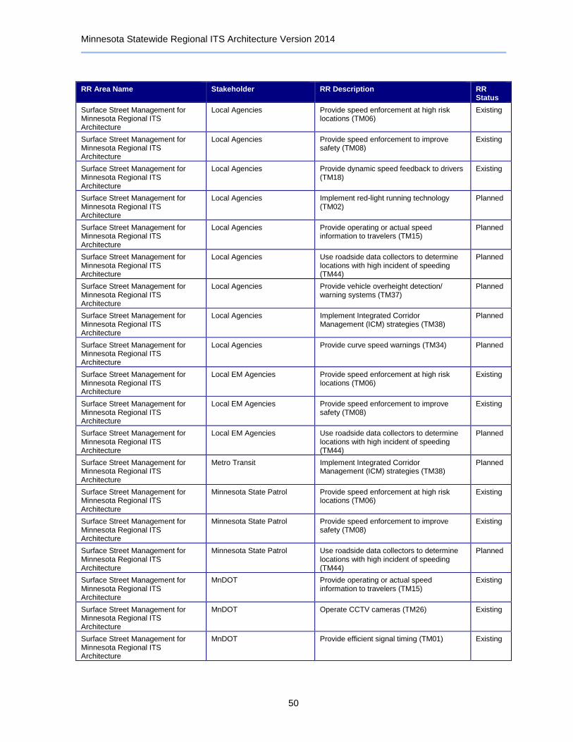
Minnesota Statewide Regional ITS Architecture Version 2014
50
RR Area Name Stakeholder RR Description RR Status
Surface Street Management for Minnesota Regional ITS Architecture
Local Agencies Provide speed enforcement at high risk locations (TM06)
Existing
Surface Street Management for Minnesota Regional ITS Architecture
Local Agencies Provide speed enforcement to improve safety (TM08)
Existing
Surface Street Management for Minnesota Regional ITS Architecture
Local Agencies Provide dynamic speed feedback to drivers (TM18)
Existing
Surface Street Management for Minnesota Regional ITS Architecture
Local Agencies Implement red-light running technology (TM02)
Planned
Surface Street Management for Minnesota Regional ITS Architecture
Local Agencies Provide operating or actual speed information to travelers (TM15)
Planned
Surface Street Management for Minnesota Regional ITS Architecture
Local Agencies Use roadside data collectors to determine locations with high incident of speeding (TM44)
Planned
Surface Street Management for Minnesota Regional ITS Architecture
Local Agencies Provide vehicle overheight detection/ warning systems (TM37)
Planned
Surface Street Management for Minnesota Regional ITS Architecture
Local Agencies Implement Integrated Corridor Management (ICM) strategies (TM38)
Planned
Surface Street Management for Minnesota Regional ITS Architecture
Local Agencies Provide curve speed warnings (TM34) Planned
Surface Street Management for Minnesota Regional ITS Architecture
Local EM Agencies Provide speed enforcement at high risk locations (TM06)
Existing
Surface Street Management for Minnesota Regional ITS Architecture
Local EM Agencies Provide speed enforcement to improve safety (TM08)
Existing
Surface Street Management for Minnesota Regional ITS Architecture
Local EM Agencies Use roadside data collectors to determine locations with high incident of speeding (TM44)
Planned
Surface Street Management for Minnesota Regional ITS Architecture
Metro Transit Implement Integrated Corridor Management (ICM) strategies (TM38)
Planned
Surface Street Management for Minnesota Regional ITS Architecture
Minnesota State Patrol Provide speed enforcement at high risk locations (TM06)
Existing
Surface Street Management for Minnesota Regional ITS Architecture
Minnesota State Patrol Provide speed enforcement to improve safety (TM08)
Existing
Surface Street Management for Minnesota Regional ITS Architecture
Minnesota State Patrol Use roadside data collectors to determine locations with high incident of speeding (TM44)
Planned
Surface Street Management for Minnesota Regional ITS Architecture
MnDOT Provide operating or actual speed information to travelers (TM15)
Existing
Surface Street Management for Minnesota Regional ITS Architecture
MnDOT Operate CCTV cameras (TM26) Existing
Surface Street Management for Minnesota Regional ITS Architecture
MnDOT Provide efficient signal timing (TM01) Existing

Minnesota Statewide Regional ITS Architecture Version 2014
51
RR Area Name Stakeholder RR Description RR Status
Surface Street Management for Minnesota Regional ITS Architecture
MnDOT Monitor operation and performance of traffic signals (TM14)
Existing
Surface Street Management for Minnesota Regional ITS Architecture
MnDOT Utilize/ improve signal coordination operation (TM29)
Existing
Surface Street Management for Minnesota Regional ITS Architecture
MnDOT Provide safe signal phase transition (TM39) Existing
Surface Street Management for Minnesota Regional ITS Architecture
MnDOT Provide congestion information to travelers (TM05)
Existing
Surface Street Management for Minnesota Regional ITS Architecture
MnDOT Provide vehicle overheight detection/ warning systems (TM37)
Existing
Surface Street Management for Minnesota Regional ITS Architecture
MnDOT Provide information on special events (TM17)
Existing
Surface Street Management for Minnesota Regional ITS Architecture
MnDOT Provide incident information to travelers (TM13)
Existing
Surface Street Management for Minnesota Regional ITS Architecture
MnDOT Use archived data for traffic strategy development and long range planning (TM03)
Existing
Surface Street Management for Minnesota Regional ITS Architecture
MnDOT Provide railroad flashing light signals and gates (TM30)
Existing
Surface Street Management for Minnesota Regional ITS Architecture
MnDOT Provide health monitoring of rail crossings (TM40)
Existing
Surface Street Management for Minnesota Regional ITS Architecture
MnDOT Provide speed enforcement at high risk locations (TM06)
Existing
Surface Street Management for Minnesota Regional ITS Architecture
MnDOT Provide speed enforcement to improve safety (TM08)
Existing
Surface Street Management for Minnesota Regional ITS Architecture
MnDOT Provide dynamic speed feedback to drivers (TM18)
Existing
Surface Street Management for Minnesota Regional ITS Architecture
MnDOT Provide curve speed warnings (TM34) Existing
Surface Street Management for Minnesota Regional ITS Architecture
MnDOT Implement red-light running technology (TM02)
Planned
Surface Street Management for Minnesota Regional ITS Architecture
MnDOT Implement Integrated Corridor Management (ICM) strategies (TM38)
Planned
Surface Street Management for Minnesota Regional ITS Architecture
MnDOT Use roadside data collectors to determine locations with high incident of speeding (TM44)
Planned
Surface Street Management for Minnesota Regional ITS Architecture
MnDOT Provide roadway flood warnings (TM36) Planned
Surface Street Management for Minnesota Regional ITS Architecture
MnDOT Monitor and collect air quality data (TM33) Planned
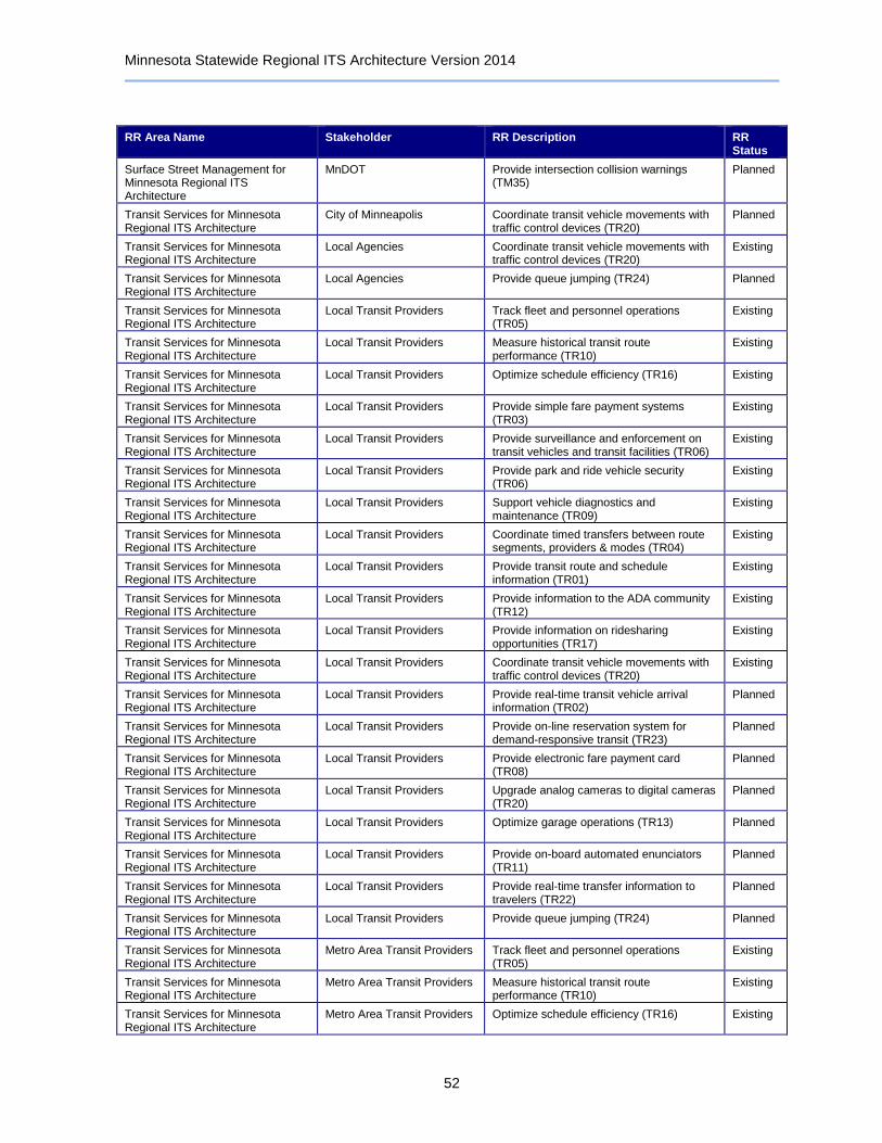
Minnesota Statewide Regional ITS Architecture Version 2014
52
RR Area Name Stakeholder RR Description RR Status
Surface Street Management for Minnesota Regional ITS Architecture
MnDOT Provide intersection collision warnings (TM35)
Planned
Transit Services for Minnesota Regional ITS Architecture
City of Minneapolis Coordinate transit vehicle movements with traffic control devices (TR20)
Planned
Transit Services for Minnesota Regional ITS Architecture
Local Agencies Coordinate transit vehicle movements with traffic control devices (TR20)
Existing
Transit Services for Minnesota Regional ITS Architecture
Local Agencies Provide queue jumping (TR24) Planned
Transit Services for Minnesota Regional ITS Architecture
Local Transit Providers Track fleet and personnel operations (TR05)
Existing
Transit Services for Minnesota Regional ITS Architecture
Local Transit Providers Measure historical transit route performance (TR10)
Existing
Transit Services for Minnesota Regional ITS Architecture
Local Transit Providers Optimize schedule efficiency (TR16) Existing
Transit Services for Minnesota Regional ITS Architecture
Local Transit Providers Provide simple fare payment systems (TR03)
Existing
Transit Services for Minnesota Regional ITS Architecture
Local Transit Providers Provide surveillance and enforcement on transit vehicles and transit facilities (TR06)
Existing
Transit Services for Minnesota Regional ITS Architecture
Local Transit Providers Provide park and ride vehicle security (TR06)
Existing
Transit Services for Minnesota Regional ITS Architecture
Local Transit Providers Support vehicle diagnostics and maintenance (TR09)
Existing
Transit Services for Minnesota Regional ITS Architecture
Local Transit Providers Coordinate timed transfers between route segments, providers & modes (TR04)
Existing
Transit Services for Minnesota Regional ITS Architecture
Local Transit Providers Provide transit route and schedule information (TR01)
Existing
Transit Services for Minnesota Regional ITS Architecture
Local Transit Providers Provide information to the ADA community (TR12)
Existing
Transit Services for Minnesota Regional ITS Architecture
Local Transit Providers Provide information on ridesharing opportunities (TR17)
Existing
Transit Services for Minnesota Regional ITS Architecture
Local Transit Providers Coordinate transit vehicle movements with traffic control devices (TR20)
Existing
Transit Services for Minnesota Regional ITS Architecture
Local Transit Providers Provide real-time transit vehicle arrival information (TR02)
Planned
Transit Services for Minnesota Regional ITS Architecture
Local Transit Providers Provide on-line reservation system for demand-responsive transit (TR23)
Planned
Transit Services for Minnesota Regional ITS Architecture
Local Transit Providers Provide electronic fare payment card (TR08)
Planned
Transit Services for Minnesota Regional ITS Architecture
Local Transit Providers Upgrade analog cameras to digital cameras (TR20)
Planned
Transit Services for Minnesota Regional ITS Architecture
Local Transit Providers Optimize garage operations (TR13) Planned
Transit Services for Minnesota Regional ITS Architecture
Local Transit Providers Provide on-board automated enunciators (TR11)
Planned
Transit Services for Minnesota Regional ITS Architecture
Local Transit Providers Provide real-time transfer information to travelers (TR22)
Planned
Transit Services for Minnesota Regional ITS Architecture
Local Transit Providers Provide queue jumping (TR24) Planned
Transit Services for Minnesota Regional ITS Architecture
Metro Area Transit Providers Track fleet and personnel operations (TR05)
Existing
Transit Services for Minnesota Regional ITS Architecture
Metro Area Transit Providers Measure historical transit route performance (TR10)
Existing
Transit Services for Minnesota Regional ITS Architecture
Metro Area Transit Providers Optimize schedule efficiency (TR16) Existing

Minnesota Statewide Regional ITS Architecture Version 2014
53
RR Area Name Stakeholder RR Description RR Status
Transit Services for Minnesota Regional ITS Architecture
Metro Area Transit Providers Provide on-line reservation system for demand-responsive transit (TR23)
Existing
Transit Services for Minnesota Regional ITS Architecture
Metro Area Transit Providers Provide simple fare payment systems (TR03)
Existing
Transit Services for Minnesota Regional ITS Architecture
Metro Area Transit Providers Provide electronic fare payment card (TR08)
Existing
Transit Services for Minnesota Regional ITS Architecture
Metro Area Transit Providers Provide surveillance and enforcement on transit vehicles and transit facilities (TR06)
Existing
Transit Services for Minnesota Regional ITS Architecture
Metro Area Transit Providers Provide park and ride vehicle security (TR06)
Existing
Transit Services for Minnesota Regional ITS Architecture
Metro Area Transit Providers Coordinate timed transfers between route segments, providers & modes (TR04)
Existing
Transit Services for Minnesota Regional ITS Architecture
Metro Area Transit Providers Provide transit route and schedule information (TR01)
Existing
Transit Services for Minnesota Regional ITS Architecture
Metro Area Transit Providers Provide information to the ADA community (TR12)
Existing
Transit Services for Minnesota Regional ITS Architecture
Metro Area Transit Providers Provide information on ridesharing opportunities (TR17)
Existing
Transit Services for Minnesota Regional ITS Architecture
Metro Area Transit Providers Provide real-time transit vehicle arrival information (TR02)
Planned
Transit Services for Minnesota Regional ITS Architecture
Metro Area Transit Providers Upgrade analog cameras to digital cameras (TR20)
Planned
Transit Services for Minnesota Regional ITS Architecture
Metro Area Transit Providers Support vehicle diagnostics and maintenance (TR09)
Planned
Transit Services for Minnesota Regional ITS Architecture
Metro Area Transit Providers Optimize garage operations (TR13) Planned
Transit Services for Minnesota Regional ITS Architecture
Metro Area Transit Providers Provide on-board automated enunciators (TR11)
Planned
Transit Services for Minnesota Regional ITS Architecture
Metro Area Transit Providers Provide real-time transfer information to travelers (TR22)
Planned
Transit Services for Minnesota Regional ITS Architecture
Metro Area Transit Providers Coordinate transit vehicle movements with traffic control devices (TR20)
Planned
Transit Services for Minnesota Regional ITS Architecture
Metro Area Transit Providers Provide queue jumping (TR24) Planned
Transit Services for Minnesota Regional ITS Architecture
Metro Transit Provide real-time transit vehicle arrival information (TR02)
Existing
Transit Services for Minnesota Regional ITS Architecture
Metro Transit Track fleet and personnel operations (TR05)
Existing
Transit Services for Minnesota Regional ITS Architecture
Metro Transit Measure historical transit route performance (TR10)
Existing
Transit Services for Minnesota Regional ITS Architecture
Metro Transit Optimize schedule efficiency (TR16) Existing
Transit Services for Minnesota Regional ITS Architecture
Metro Transit Provide on-line reservation system for demand-responsive transit (TR23)
Existing
Transit Services for Minnesota Regional ITS Architecture
Metro Transit Provide simple fare payment systems (TR03)
Existing
Transit Services for Minnesota Regional ITS Architecture
Metro Transit Provide electronic fare payment card (TR08)
Existing
Transit Services for Minnesota Regional ITS Architecture
Metro Transit Provide surveillance and enforcement on transit vehicles and transit facilities (TR06)
Existing
Transit Services for Minnesota Regional ITS Architecture
Metro Transit Provide park and ride vehicle security (TR06)
Existing
Transit Services for Minnesota Regional ITS Architecture
Metro Transit Support vehicle diagnostics and maintenance (TR09)
Existing

Minnesota Statewide Regional ITS Architecture Version 2014
54
RR Area Name Stakeholder RR Description RR Status
Transit Services for Minnesota Regional ITS Architecture
Metro Transit Coordinate timed transfers between route segments, providers & modes (TR04)
Existing
Transit Services for Minnesota Regional ITS Architecture
Metro Transit Provide transit route and schedule information (TR01)
Existing
Transit Services for Minnesota Regional ITS Architecture
Metro Transit Provide on-board automated enunciators (TR11)
Existing
Transit Services for Minnesota Regional ITS Architecture
Metro Transit Provide information to the ADA community (TR12)
Existing
Transit Services for Minnesota Regional ITS Architecture
Metro Transit Provide information on ridesharing opportunities (TR17)
Existing
Transit Services for Minnesota Regional ITS Architecture
Metro Transit Provide real-time transfer information to travelers (TR22)
Existing
Transit Services for Minnesota Regional ITS Architecture
Metro Transit Upgrade analog cameras to digital cameras (TR20)
Planned
Transit Services for Minnesota Regional ITS Architecture
Metro Transit Optimize garage operations (TR13) Planned
Transit Services for Minnesota Regional ITS Architecture
Metro Transit Coordinate transit vehicle movements with traffic control devices (TR20)
Planned
Transit Services for Minnesota Regional ITS Architecture
Metro Transit Provide queue jumping (TR24) Planned
Transit Services for Minnesota Regional ITS Architecture
MnDOT Coordinate transit vehicle movements with traffic control devices (TR20)
Planned
Transit Services for Minnesota Regional ITS Architecture
MnDOT Provide queue jumping (TR24) Planned
Traveler Information for Minnesota Regional ITS Architecture
Airports
Traveler Information for Minnesota Regional ITS Architecture
City of Minneapolis Provide incident information on freeways and major arterials (TI01)
Existing
Traveler Information for Minnesota Regional ITS Architecture
City of Minneapolis Provide information on roadway maintenance and construction activities
Existing
Traveler Information for Minnesota Regional ITS Architecture
Intercity Transit Providers
Traveler Information for Minnesota Regional ITS Architecture
Local Agencies
Traveler Information for Minnesota Regional ITS Architecture
Local EM Agencies
Traveler Information for Minnesota Regional ITS Architecture
Local Media
Traveler Information for Minnesota Regional ITS Architecture
Local Transit Providers
Traveler Information for Minnesota Regional ITS Architecture
Map Update Providers
Traveler Information for Minnesota Regional ITS Architecture
Metro Area Transit Providers
Traveler Information for Minnesota Regional ITS Architecture
Metro Transit
Traveler Information for Minnesota Regional ITS Architecture
Minnesota Homeland Security and Emergency Management
Traveler Information for Minnesota Regional ITS Architecture
Minnesota State Patrol
Traveler Information for Minnesota Regional ITS Architecture
MnDOT
Traveler Information for Minnesota Regional ITS Architecture
MnDOT OFCVO

Minnesota Statewide Regional ITS Architecture Version 2014
55
RR Area Name Stakeholder RR Description RR Status
Traveler Information for Minnesota Regional ITS Architecture
MnDOT Office of Aeronautics
Traveler Information for Minnesota Regional ITS Architecture
MnDOT Office of Maintenance
Traveler Information for Minnesota Regional ITS Architecture
Neighboring States
Traveler Information for Minnesota Regional ITS Architecture
NOAA
Traveler Information for Minnesota Regional ITS Architecture
North/West Passage Corridor Members
Traveler Information for Minnesota Regional ITS Architecture
Private Information Service Providers
Traveler Information for Minnesota Regional ITS Architecture
Private Mayday Service Providers
Traveler Information for Minnesota Regional ITS Architecture
Private Trucking Companies
Traveler Information for Minnesota Regional ITS Architecture
Railroad Companies
Traveler Information for Minnesota Regional ITS Architecture
Traveler Information Kiosks Operators
Traveler Information for Minnesota Regional ITS Architecture
University of Minnesota CTS ITS Institute
Traveler Information for Minnesota Regional ITS Architecture
University of Minnesota Duluth
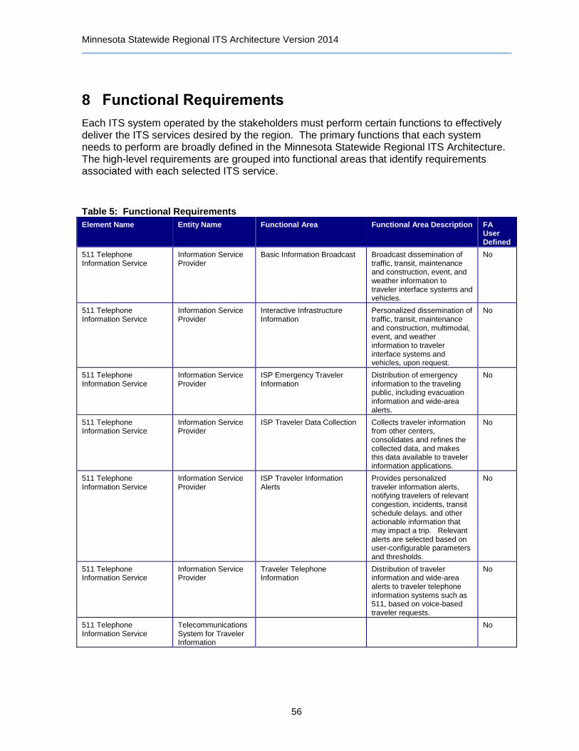
Minnesota Statewide Regional ITS Architecture Version 2014
56
8 Functional Requirements
Each ITS system operated by the stakeholders must perform certain functions to effectively deliver the ITS services desired by the region. The primary functions that each system needs to perform are broadly defined in the Minnesota Statewide Regional ITS Architecture. The high-level requirements are grouped into functional areas that identify requirements associated with each selected ITS service.
Table 5: Functional Requirements
Element Name Entity Name Functional Area Functional Area Description FA User Defined
511 Telephone Information Service
Information Service Provider
Basic Information Broadcast Broadcast dissemination of traffic, transit, maintenance and construction, event, and weather information to traveler interface systems and vehicles.
No
511 Telephone Information Service
Information Service Provider
Interactive Infrastructure Information
Personalized dissemination of traffic, transit, maintenance and construction, multimodal, event, and weather information to traveler interface systems and vehicles, upon request.
No
511 Telephone Information Service
Information Service Provider
ISP Emergency Traveler Information
Distribution of emergency information to the traveling public, including evacuation information and wide-area alerts.
No
511 Telephone Information Service
Information Service Provider
ISP Traveler Data Collection Collects traveler information from other centers, consolidates and refines the collected data, and makes this data available to traveler information applications.
No
511 Telephone Information Service
Information Service Provider
ISP Traveler Information Alerts
Provides personalized traveler information alerts, notifying travelers of relevant congestion, incidents, transit schedule delays. and other actionable information that may impact a trip. Relevant alerts are selected based on user-configurable parameters and thresholds.
No
511 Telephone Information Service
Information Service Provider
Traveler Telephone Information
Distribution of traveler information and wide-area alerts to traveler telephone information systems such as 511, based on voice-based traveler requests.
No
511 Telephone Information Service
Telecommunications System for Traveler Information
No

Minnesota Statewide Regional ITS Architecture Version 2014
57
Element Name Entity Name Functional Area Functional Area Description FA User Defined
511 Traveler Information Website
Information Service Provider
Basic Information Broadcast Broadcast dissemination of traffic, transit, maintenance and construction, event, and weather information to traveler interface systems and vehicles.
No
511 Traveler Information Website
Information Service Provider
Infrastructure Provided Trip Planning
Generation of pre-trip and enroute trip plans for travelers (and vehicles) based on current traffic conditions, work zones, weather, and travelers constraints and preferences. Includes end-to-end trips using multiple modes, such as bicycle, transit, etc.
No
511 Traveler Information Website
Information Service Provider
Interactive Infrastructure Information
Personalized dissemination of traffic, transit, maintenance and construction, multimodal, event, and weather information to traveler interface systems and vehicles, upon request.
No
511 Traveler Information Website
Information Service Provider
ISP Emergency Traveler Information
Distribution of emergency information to the traveling public, including evacuation information and wide-area alerts.
No
511 Traveler Information Website
Information Service Provider
ISP Traveler Data Collection Collects traveler information from other centers, consolidates and refines the collected data, and makes this data available to traveler information applications.
No
511 Traveler Information Website
Information Service Provider
ISP Traveler Information Alerts
Provides personalized traveler information alerts, notifying travelers of relevant congestion, incidents, transit schedule delays. and other actionable information that may impact a trip. Relevant alerts are selected based on user-configurable parameters and thresholds.
No
511 Traveler Information Website
Information Service Provider
Traveler Telephone Information
Distribution of traveler information and wide-area alerts to traveler telephone information systems such as 511, based on voice-based traveler requests.
No
911 Dispatch Center Emergency Management
Center Secure Area Alarm Support
Collection and response to silent and audible alarms received from travelers in secure areas (such as transit stops, rest areas, park-and-ride lots) and from on-board transit vehicles.
No

Minnesota Statewide Regional ITS Architecture Version 2014
58
Element Name Entity Name Functional Area Functional Area Description FA User Defined
911 Dispatch Center Emergency Management
Center Secure Area Sensor Management
Management of security sensors, analysis of sensor data, correlation with surveillance data and alerts from other agencies to detect potential threats, and dissemination of threat information to other agencies. Sensors may be placed in areas such as transit stops, transit stations, rest areas, park and ride lots, modal interchange facilities, on-board a transit vehicle, etc.
No
911 Dispatch Center Emergency Management
Center Secure Area Surveillance
Management of security surveillance devices and analysis of that data to detect potential threats. Areas under surveillance may include transit stops, transit stations, rest areas, park and ride lots, modal interchange facilities, on-board a transit vehicle, etc.
No
911 Dispatch Center Emergency Management
Emergency Call-Taking Provides interface to the emergency call-taking systems such as the Emergency Telecommunications System (e.g., 911) that correlate call information with emergencies reported by transit agencies, commercial vehicle operators, or other public safety agencies. Allows the operator to verify the incident and forward the information to the responding agencies.
No
911 Dispatch Center Emergency Management
Emergency Data Collection Collection and storage of information related to Emergency Management. For use by operations personnel or data archives in the region.
No
911 Dispatch Center Emergency Management
Emergency Dispatch Dispatch emergency vehicles to incidents, tracking their location and status. Pertinent incident information is gathered and relayed to the responding units.
No
911 Dispatch Center Emergency Management
Emergency Early Warning System
Monitors alerting and advisory systems, information collected by ITS surveillance and sensors, and reports from other agencies in order to identify potential, imminent, or in-progress major incidents or disasters. Notification is provided to other ITS centers to notify the traveling public.
No
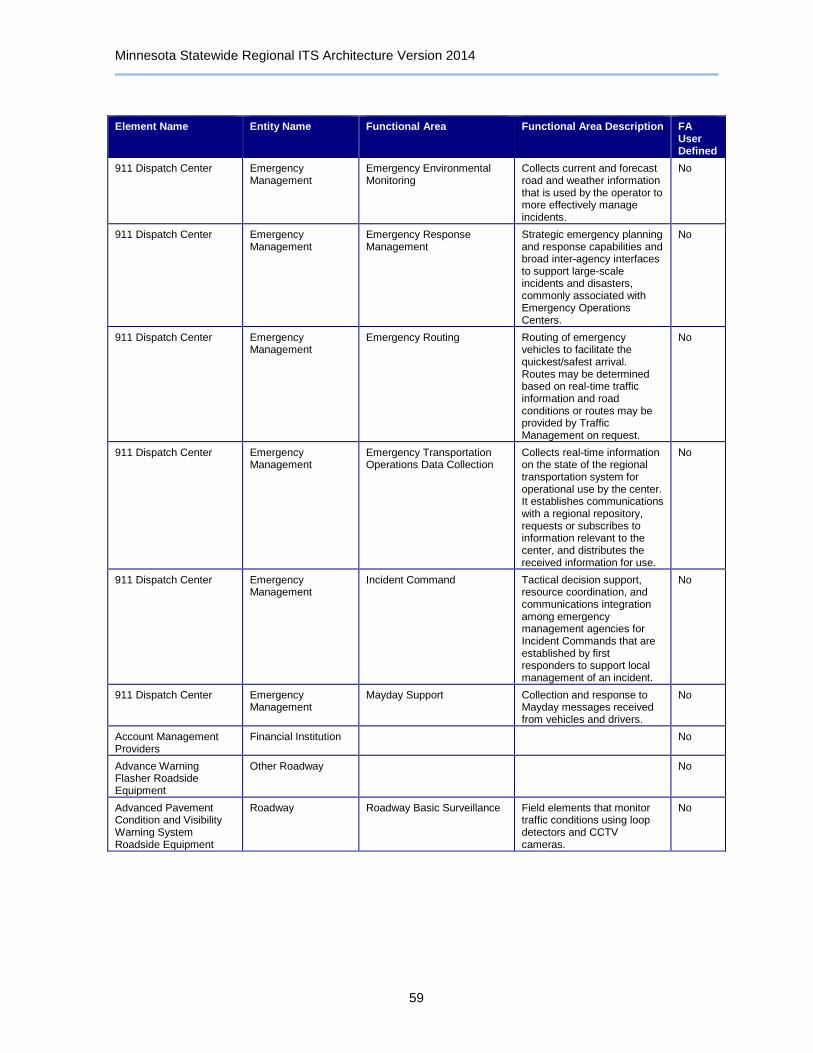
Minnesota Statewide Regional ITS Architecture Version 2014
59
Element Name Entity Name Functional Area Functional Area Description FA User Defined
911 Dispatch Center Emergency Management
Emergency Environmental Monitoring
Collects current and forecast road and weather information that is used by the operator to more effectively manage incidents.
No
911 Dispatch Center Emergency Management
Emergency Response Management
Strategic emergency planning and response capabilities and broad inter-agency interfaces to support large-scale incidents and disasters, commonly associated with Emergency Operations Centers.
No
911 Dispatch Center Emergency Management
Emergency Routing Routing of emergency vehicles to facilitate the quickest/safest arrival. Routes may be determined based on real-time traffic information and road conditions or routes may be provided by Traffic Management on request.
No
911 Dispatch Center Emergency Management
Emergency Transportation Operations Data Collection
Collects real-time information on the state of the regional transportation system for operational use by the center. It establishes communications with a regional repository, requests or subscribes to information relevant to the center, and distributes the received information for use.
No
911 Dispatch Center Emergency Management
Incident Command Tactical decision support, resource coordination, and communications integration among emergency management agencies for Incident Commands that are established by first responders to support local management of an incident.
No
911 Dispatch Center Emergency Management
Mayday Support Collection and response to Mayday messages received from vehicles and drivers.
No
Account Management Providers
Financial Institution No
Advance Warning Flasher Roadside Equipment
Other Roadway No
Advanced Pavement Condition and Visibility Warning System Roadside Equipment
Roadway Roadway Basic Surveillance Field elements that monitor traffic conditions using loop detectors and CCTV cameras.
No

Minnesota Statewide Regional ITS Architecture Version 2014
60
Element Name Entity Name Functional Area Functional Area Description FA User Defined
Advanced Pavement Condition and Visibility Warning System Roadside Equipment
Roadway Roadway Environmental Monitoring
Environmental sensors, surface and sub-surface, that collect weather and road surface information. Weather conditions measured include temperature, wind, humidity, precipitation, and visibility. Sensors measure road surface temperature, moisture, icing, salinity, etc.
No
Advanced Pavement Condition and Visibility Warning System Roadside Equipment
Roadway Roadway Equipment Coordination
Field elements that control and send data to other field elements (such as environmental sensors that send data to a DMS or coordination between traffic controllers on adjacent intersections), without center control.
No
Advanced Pavement Condition and Visibility Warning System Roadside Equipment
Roadway Roadway Traffic Information Dissemination
Driver information systems, such as dynamic message signs and Highway Advisory Radio (HAR).
No
Advanced Pavement Condition and Visibility Warning System Roadside Equipment
Roadway Roadway Warning Field elements used to warn drivers approaching hazards including adverse road weather conditions, traffic conditions including queues, and obstacles or animals in the road.
No
Airport Emergency Management
Center Secure Area Sensor Management
Management of security sensors, analysis of sensor data, correlation with surveillance data and alerts from other agencies to detect potential threats, and dissemination of threat information to other agencies. Sensors may be placed in areas such as transit stops, transit stations, rest areas, park and ride lots, modal interchange facilities, on-board a transit vehicle, etc.
No
Airport Emergency Management
Center Secure Area Surveillance
Management of security surveillance devices and analysis of that data to detect potential threats. Areas under surveillance may include transit stops, transit stations, rest areas, park and ride lots, modal interchange facilities, on-board a transit vehicle, etc.
No
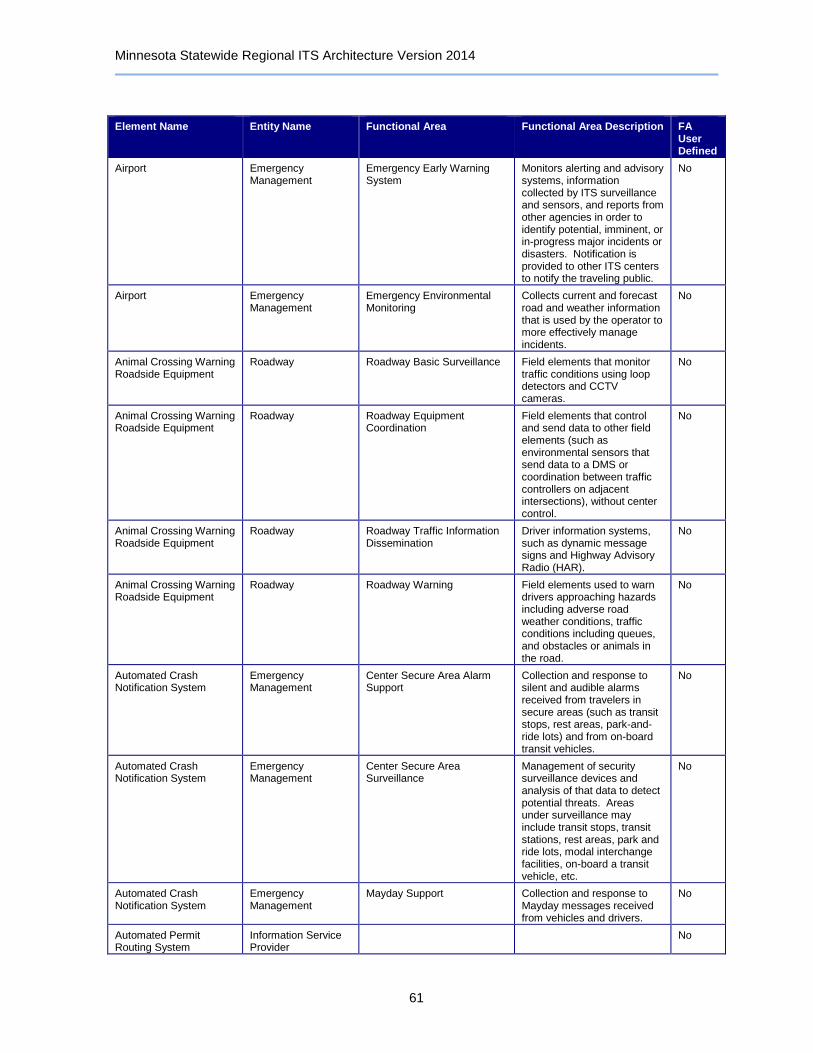
Minnesota Statewide Regional ITS Architecture Version 2014
61
Element Name Entity Name Functional Area Functional Area Description FA User Defined
Airport Emergency Management
Emergency Early Warning System
Monitors alerting and advisory systems, information collected by ITS surveillance and sensors, and reports from other agencies in order to identify potential, imminent, or in-progress major incidents or disasters. Notification is provided to other ITS centers to notify the traveling public.
No
Airport Emergency Management
Emergency Environmental Monitoring
Collects current and forecast road and weather information that is used by the operator to more effectively manage incidents.
No
Animal Crossing Warning Roadside Equipment
Roadway Roadway Basic Surveillance Field elements that monitor traffic conditions using loop detectors and CCTV cameras.
No
Animal Crossing Warning Roadside Equipment
Roadway Roadway Equipment Coordination
Field elements that control and send data to other field elements (such as environmental sensors that send data to a DMS or coordination between traffic controllers on adjacent intersections), without center control.
No
Animal Crossing Warning Roadside Equipment
Roadway Roadway Traffic Information Dissemination
Driver information systems, such as dynamic message signs and Highway Advisory Radio (HAR).
No
Animal Crossing Warning Roadside Equipment
Roadway Roadway Warning Field elements used to warn drivers approaching hazards including adverse road weather conditions, traffic conditions including queues, and obstacles or animals in the road.
No
Automated Crash Notification System
Emergency Management
Center Secure Area Alarm Support
Collection and response to silent and audible alarms received from travelers in secure areas (such as transit stops, rest areas, park-and-ride lots) and from on-board transit vehicles.
No
Automated Crash Notification System
Emergency Management
Center Secure Area Surveillance
Management of security surveillance devices and analysis of that data to detect potential threats. Areas under surveillance may include transit stops, transit stations, rest areas, park and ride lots, modal interchange facilities, on-board a transit vehicle, etc.
No
Automated Crash Notification System
Emergency Management
Mayday Support Collection and response to Mayday messages received from vehicles and drivers.
No
Automated Permit Routing System
Information Service Provider
No
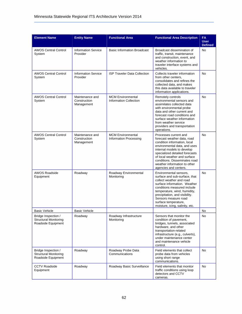
Minnesota Statewide Regional ITS Architecture Version 2014
62
Element Name Entity Name Functional Area Functional Area Description FA User Defined
AWOS Central Control System
Information Service Provider
Basic Information Broadcast Broadcast dissemination of traffic, transit, maintenance and construction, event, and weather information to traveler interface systems and vehicles.
No
AWOS Central Control System
Information Service Provider
ISP Traveler Data Collection Collects traveler information from other centers, consolidates and refines the collected data, and makes this data available to traveler information applications.
No
AWOS Central Control System
Maintenance and Construction Management
MCM Environmental Information Collection
Remotely controls environmental sensors and assimilates collected data with environmental probe data and other current and forecast road conditions and surface weather information from weather service providers and transportation operations.
No
AWOS Central Control System
Maintenance and Construction Management
MCM Environmental Information Processing
Processes current and forecast weather data, road condition information, local environmental data, and uses internal models to develop specialized detailed forecasts of local weather and surface conditions. Disseminates road weather information to other agencies and centers.
No
AWOS Roadside Equipment
Roadway Roadway Environmental Monitoring
Environmental sensors, surface and sub-surface, that collect weather and road surface information. Weather conditions measured include temperature, wind, humidity, precipitation, and visibility. Sensors measure road surface temperature, moisture, icing, salinity, etc.
No
Basic Vehicle Basic Vehicle No
Bridge Inspection / Structural Monitoring Roadside Equipment
Roadway Roadway Infrastructure Monitoring
Sensors that monitor the condition of pavement, bridges, tunnels, associated hardware, and other transportation-related infrastructure (e.g., culverts), under maintenance center and maintenance vehicle control.
No
Bridge Inspection / Structural Monitoring Roadside Equipment
Roadway Roadway Probe Data Communications
Field elements that collect probe data from vehicles using short range communications.
No
CCTV Roadside Equipment
Roadway Roadway Basic Surveillance Field elements that monitor traffic conditions using loop detectors and CCTV cameras.
No

Minnesota Statewide Regional ITS Architecture Version 2014
63
Element Name Entity Name Functional Area Functional Area Description FA User Defined
CCTV Roadside Equipment
Roadway Roadway Equipment Coordination
Field elements that control and send data to other field elements (such as environmental sensors that send data to a DMS or coordination between traffic controllers on adjacent intersections), without center control.
No
CCTV Roadside Equipment
Roadway Roadway Incident Detection Field elements that monitor traffic conditions to identify incidents. It includes traffic detectors that collect traffic flow information and identify unusual traffic conditions and advanced CCTV cameras with built-in incident detection algorithms.
No
CCTV Roadside Equipment
Roadway Roadway Warning Field elements used to warn drivers approaching hazards including adverse road weather conditions, traffic conditions including queues, and obstacles or animals in the road.
No
CCTV Roadside Equipment
Roadway Roadway Work Zone Traffic Control
Field elements in maintenance and construction areas including CCTV cameras, driver information systems (such as DMS), and gates/barriers that monitor and control traffic and provide information directly to drivers in affected areas.
No
Clarus Weather System Weather Service No
Commercial Vehicle Administration Center
Commercial Vehicle Administration
CV Information Exchange Exchange information concerning safety, credentialing, and operations of commercial vehicles between the center and the roadside check stations, across jurisdictions, with fleet operators and other information requestors.
No
Commercial Vehicle Administration Center
Commercial Vehicle Administration
CV Safety and Security Administration
Provides commercial vehicle safety and security criteria to roadside check facilities, collects and reviews safety and security data from the field, conducts wireless roadside inspections, and distributes safety and security information to other centers, carriers, and enforcement agencies.
No

Minnesota Statewide Regional ITS Architecture Version 2014
64
Element Name Entity Name Functional Area Functional Area Description FA User Defined
Commercial Vehicle Administration Center
Commercial Vehicle Administration
International CV Administration
Generate and process entry documentation for commercial vehicles and their shipments across international borders. Interface with customs and border protection, immigration, carriers, and brokers.
No
Commercial Vehicles Commercial Vehicle On-board Cargo Monitoring On-board systems monitoring the location and status of the commercial vehicle and its cargo. Sends the data on to appropriate centers and roadside facilities, including emergency management in the case of HAZMAT incidents.
No
Commercial Vehicles Commercial Vehicle On-board CV Electronic Data On-board systems exchanging information between the vehicle and the roadside facility with the information such as status of driver, vehicle, carrier IDs and cargo information identified via an electronic tag.
No
Commercial Vehicles Commercial Vehicle On-board CV Safety and Security
On-board systems collect and process on-board vehicle and driver safety and security information; exchanging information with roadside and remote facilities at mainline speeds and while stopped for inspections.
No
Commercial Vehicles Commercial Vehicle On-board Trip Monitoring On-board systems to provide automatic vehicle location and automated mileage and fuel reporting and auditing. In addition, monitors the planned route and notifies the fleet and freight management center of any deviations.
No
Commercial Vehicles Vehicle Characteristics
No
Commuter Rail Operations Center
Other Transit Management
No
Commuter Rail Operations Center
Transit Management Transit Center Fare Management
Management of fare collection at the center - includes setting and distributing fare information, central processing of fares for transit as well as other ITS services, links to financial institutions and enforcement agencies.
No

Minnesota Statewide Regional ITS Architecture Version 2014
65
Element Name Entity Name Functional Area Functional Area Description FA User Defined
Commuter Rail Operations Center
Transit Management Transit Center Fixed-Route Operations
Management of fixed route transit operations. Planning, scheduling, and dispatch associated with fixed and flexible route transit services. Updates customer service operator systems, and provides current vehicle schedule adherence and optimum scenarios for schedule adjustment.
No
Commuter Rail Operations Center
Transit Management Transit Center Multi-Modal Coordination
Coordinate schedules with other agencies and modes, including transit transfer cluster and transfer point information.
No
Commuter Rail Operations Center
Transit Management Transit Garage Maintenance Collect operational and maintenance data from transit vehicles, manage vehicle service histories, automatically generate preventative maintenance schedules, and provide information to service personnel.
No
Commuter Rail Operations Center
Transit Management Transit Vehicle Assignment Assigns individual transit vehicles to vehicle blocks and downloads this information to the transit vehicle, updating assignments as necessitated by changes. It also provides an inventory management function that stores attributes about each of the transit vehicles.
No
Commuter Rail Operations Center
Transit Management Transit Vehicle Operator Assignment
Assignment of transit operators to runs in a fair manner while minimizing labor and overtime services, considering operator preferences, qualifications, accumulated work hours, and other information about each operator.
No
Condition Acquisition and Reporting System (CARS)
Archived Data Management
Government Reporting Systems Support
Selects and formats data residing in an ITS archive to facilitate local, state, and federal government data reporting requirements.
No
Condition Acquisition and Reporting System (CARS)
Archived Data Management
ITS Data Repository Collect and maintain data and data catalogs from one or more data sources. May include quality checks, error notification, and archive coordination.
No
Condition Acquisition and Reporting System (CARS)
Archived Data Management
On-Line Analysis and Mining Advanced data analysis and mining features to support discovery of information, patterns, and correlations in large ITS archives.
No

Minnesota Statewide Regional ITS Architecture Version 2014
66
Element Name Entity Name Functional Area Functional Area Description FA User Defined
Condition Acquisition and Reporting System (CARS)
Archived Data Management
Traffic and Roadside Data Archival
Collects and archives traffic and environmental information directly from the roadside for use in off-line planning, research, and analysis.
No
Condition Acquisition and Reporting System (CARS)
Information Service Provider
Basic Information Broadcast Broadcast dissemination of traffic, transit, maintenance and construction, event, and weather information to traveler interface systems and vehicles.
No
Condition Acquisition and Reporting System (CARS)
Information Service Provider
Interactive Infrastructure Information
Personalized dissemination of traffic, transit, maintenance and construction, multimodal, event, and weather information to traveler interface systems and vehicles, upon request.
No
Condition Acquisition and Reporting System (CARS)
Information Service Provider
ISP Data Collection Collection and storage of information supporting the operations of traveler information service providers. For use by operations personnel or data archives in the region.
No
Condition Acquisition and Reporting System (CARS)
Information Service Provider
ISP Emergency Traveler Information
Distribution of emergency information to the traveling public, including evacuation information and wide-area alerts.
No
Condition Acquisition and Reporting System (CARS)
Information Service Provider
ISP Operational Data Repository
Processes, stores, and distributes real-time information on the state of the regional transportation system to transportation system operators.
No
Condition Acquisition and Reporting System (CARS)
Information Service Provider
ISP Traveler Data Collection Collects traveler information from other centers, consolidates and refines the collected data, and makes this data available to traveler information applications.
No
Condition Acquisition and Reporting System (CARS)
Information Service Provider
ISP Traveler Information Alerts
Provides personalized traveler information alerts, notifying travelers of relevant congestion, incidents, transit schedule delays. and other actionable information that may impact a trip. Relevant alerts are selected based on user-configurable parameters and thresholds.
No
Condition Acquisition and Reporting System (CARS)
Information Service Provider
Traveler Telephone Information
Distribution of traveler information and wide-area alerts to traveler telephone information systems such as 511, based on voice-based traveler requests.
No
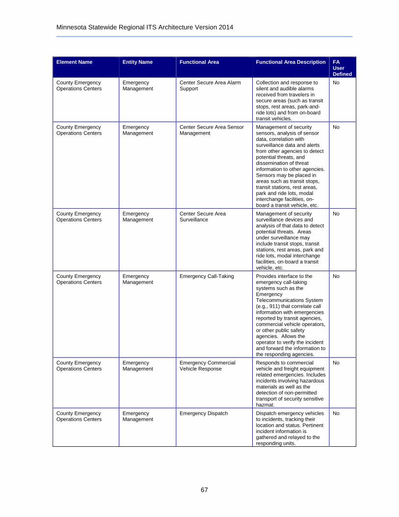
Minnesota Statewide Regional ITS Architecture Version 2014
67
Element Name Entity Name Functional Area Functional Area Description FA User Defined
County Emergency Operations Centers
Emergency Management
Center Secure Area Alarm Support
Collection and response to silent and audible alarms received from travelers in secure areas (such as transit stops, rest areas, park-and-ride lots) and from on-board transit vehicles.
No
County Emergency Operations Centers
Emergency Management
Center Secure Area Sensor Management
Management of security sensors, analysis of sensor data, correlation with surveillance data and alerts from other agencies to detect potential threats, and dissemination of threat information to other agencies. Sensors may be placed in areas such as transit stops, transit stations, rest areas, park and ride lots, modal interchange facilities, on-board a transit vehicle, etc.
No
County Emergency Operations Centers
Emergency Management
Center Secure Area Surveillance
Management of security surveillance devices and analysis of that data to detect potential threats. Areas under surveillance may include transit stops, transit stations, rest areas, park and ride lots, modal interchange facilities, on-board a transit vehicle, etc.
No
County Emergency Operations Centers
Emergency Management
Emergency Call-Taking Provides interface to the emergency call-taking systems such as the Emergency Telecommunications System (e.g., 911) that correlate call information with emergencies reported by transit agencies, commercial vehicle operators, or other public safety agencies. Allows the operator to verify the incident and forward the information to the responding agencies.
No
County Emergency Operations Centers
Emergency Management
Emergency Commercial Vehicle Response
Responds to commercial vehicle and freight equipment related emergencies. Includes incidents involving hazardous materials as well as the detection of non-permitted transport of security sensitive hazmat.
No
County Emergency Operations Centers
Emergency Management
Emergency Dispatch Dispatch emergency vehicles to incidents, tracking their location and status. Pertinent incident information is gathered and relayed to the responding units.
No
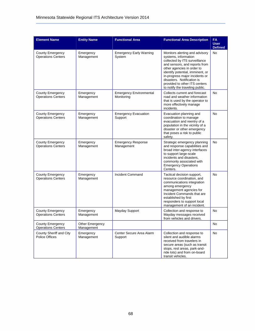
Minnesota Statewide Regional ITS Architecture Version 2014
68
Element Name Entity Name Functional Area Functional Area Description FA User Defined
County Emergency Operations Centers
Emergency Management
Emergency Early Warning System
Monitors alerting and advisory systems, information collected by ITS surveillance and sensors, and reports from other agencies in order to identify potential, imminent, or in-progress major incidents or disasters. Notification is provided to other ITS centers to notify the traveling public.
No
County Emergency Operations Centers
Emergency Management
Emergency Environmental Monitoring
Collects current and forecast road and weather information that is used by the operator to more effectively manage incidents.
No
County Emergency Operations Centers
Emergency Management
Emergency Evacuation Support
Evacuation planning and coordination to manage evacuation and reentry of a population in the vicinity of a disaster or other emergency that poses a risk to public safety.
No
County Emergency Operations Centers
Emergency Management
Emergency Response Management
Strategic emergency planning and response capabilities and broad inter-agency interfaces to support large-scale incidents and disasters, commonly associated with Emergency Operations Centers.
No
County Emergency Operations Centers
Emergency Management
Incident Command Tactical decision support, resource coordination, and communications integration among emergency management agencies for Incident Commands that are established by first responders to support local management of an incident.
No
County Emergency Operations Centers
Emergency Management
Mayday Support Collection and response to Mayday messages received from vehicles and drivers.
No
County Emergency Operations Centers
Other Emergency Management
No
County Sheriff and City Police Offices
Emergency Management
Center Secure Area Alarm Support
Collection and response to silent and audible alarms received from travelers in secure areas (such as transit stops, rest areas, park-and-ride lots) and from on-board transit vehicles.
No
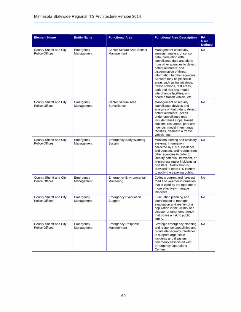
Minnesota Statewide Regional ITS Architecture Version 2014
69
Element Name Entity Name Functional Area Functional Area Description FA User Defined
County Sheriff and City Police Offices
Emergency Management
Center Secure Area Sensor Management
Management of security sensors, analysis of sensor data, correlation with surveillance data and alerts from other agencies to detect potential threats, and dissemination of threat information to other agencies. Sensors may be placed in areas such as transit stops, transit stations, rest areas, park and ride lots, modal interchange facilities, on-board a transit vehicle, etc.
No
County Sheriff and City Police Offices
Emergency Management
Center Secure Area Surveillance
Management of security surveillance devices and analysis of that data to detect potential threats. Areas under surveillance may include transit stops, transit stations, rest areas, park and ride lots, modal interchange facilities, on-board a transit vehicle, etc.
No
County Sheriff and City Police Offices
Emergency Management
Emergency Early Warning System
Monitors alerting and advisory systems, information collected by ITS surveillance and sensors, and reports from other agencies in order to identify potential, imminent, or in-progress major incidents or disasters. Notification is provided to other ITS centers to notify the traveling public.
No
County Sheriff and City Police Offices
Emergency Management
Emergency Environmental Monitoring
Collects current and forecast road and weather information that is used by the operator to more effectively manage incidents.
No
County Sheriff and City Police Offices
Emergency Management
Emergency Evacuation Support
Evacuation planning and coordination to manage evacuation and reentry of a population in the vicinity of a disaster or other emergency that poses a risk to public safety.
No
County Sheriff and City Police Offices
Emergency Management
Emergency Response Management
Strategic emergency planning and response capabilities and broad inter-agency interfaces to support large-scale incidents and disasters, commonly associated with Emergency Operations Centers.
No
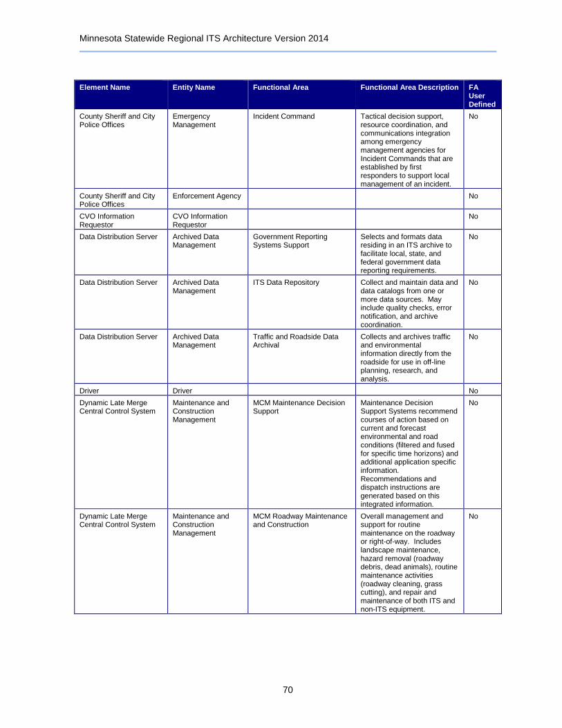
Minnesota Statewide Regional ITS Architecture Version 2014
70
Element Name Entity Name Functional Area Functional Area Description FA User Defined
County Sheriff and City Police Offices
Emergency Management
Incident Command Tactical decision support, resource coordination, and communications integration among emergency management agencies for Incident Commands that are established by first responders to support local management of an incident.
No
County Sheriff and City Police Offices
Enforcement Agency No
CVO Information Requestor
CVO Information Requestor
No
Data Distribution Server Archived Data Management
Government Reporting Systems Support
Selects and formats data residing in an ITS archive to facilitate local, state, and federal government data reporting requirements.
No
Data Distribution Server Archived Data Management
ITS Data Repository Collect and maintain data and data catalogs from one or more data sources. May include quality checks, error notification, and archive coordination.
No
Data Distribution Server Archived Data Management
Traffic and Roadside Data Archival
Collects and archives traffic and environmental information directly from the roadside for use in off-line planning, research, and analysis.
No
Driver Driver No
Dynamic Late Merge Central Control System
Maintenance and Construction Management
MCM Maintenance Decision Support
Maintenance Decision Support Systems recommend courses of action based on current and forecast environmental and road conditions (filtered and fused for specific time horizons) and additional application specific information. Recommendations and dispatch instructions are generated based on this integrated information.
No
Dynamic Late Merge Central Control System
Maintenance and Construction Management
MCM Roadway Maintenance and Construction
Overall management and support for routine maintenance on the roadway or right-of-way. Includes landscape maintenance, hazard removal (roadway debris, dead animals), routine maintenance activities (roadway cleaning, grass cutting), and repair and maintenance of both ITS and non-ITS equipment.
No

Minnesota Statewide Regional ITS Architecture Version 2014
71
Element Name Entity Name Functional Area Functional Area Description FA User Defined
Dynamic Late Merge Central Control System
Maintenance and Construction Management
MCM Work Zone Management
Remotely monitors and supports work zone activities, controlling traffic through dynamic message signs (DMS), highway advisory radio, gates and barriers, and informing other groups of activity (e.g., traveler information systems, traffic management centers, other maintenance and construction centers).
No
Dynamic Late Merge Roadside Equipment
Roadway Roadway Field Device Monitoring
Monitors field equipment operational status and detects and reports fault conditions. Device status, configuration, and fault information are provided to a remote center and a user interface provides information locally to field personnel.
No
Dynamic Late Merge Roadside Equipment
Roadway Roadway Work Zone Traffic Control
Field elements in maintenance and construction areas including CCTV cameras, driver information systems (such as DMS), and gates/barriers that monitor and control traffic and provide information directly to drivers in affected areas.
No
Dynamic Message Sign Roadside Equipment
Other Roadway No
Dynamic Message Sign Roadside Equipment
Remote Traveler Support
Remote Basic Information Reception
Public traveler interface, such as a kiosk, that provides formatted traffic advisories, transit, event, and other traveler information, as well as broadcast alerts.
No
Dynamic Message Sign Roadside Equipment
Remote Traveler Support
Remote Transit Information Services
Public traveler interface that provides real-time travel-related information at transit stops and multi-modal transfer points, including general annunciation, display of imminent arrival information, the latest available information on transit routes, schedules, transfer options, available services, fares, and real-time schedule adherence.
No
Dynamic Message Sign Roadside Equipment
Roadway Roadway Equipment Coordination
Field elements that control and send data to other field elements (such as environmental sensors that send data to a DMS or coordination between traffic controllers on adjacent intersections), without center control.
No
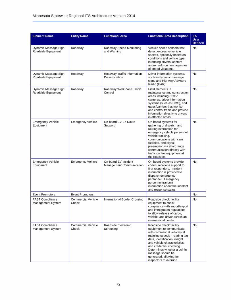
Minnesota Statewide Regional ITS Architecture Version 2014
72
Element Name Entity Name Functional Area Functional Area Description FA User Defined
Dynamic Message Sign Roadside Equipment
Roadway Roadway Speed Monitoring and Warning
Vehicle speed sensors that detect excessive vehicle speeds, optionally based on conditions and vehicle type, informing drivers, centers and/or enforcement agencies of speed violations.
No
Dynamic Message Sign Roadside Equipment
Roadway Roadway Traffic Information Dissemination
Driver information systems, such as dynamic message signs and Highway Advisory Radio (HAR).
No
Dynamic Message Sign Roadside Equipment
Roadway Roadway Work Zone Traffic Control
Field elements in maintenance and construction areas including CCTV cameras, driver information systems (such as DMS), and gates/barriers that monitor and control traffic and provide information directly to drivers in affected areas.
No
Emergency Vehicle Equipment
Emergency Vehicle On-board EV En Route Support
On-board systems for gathering of dispatch and routing information for emergency vehicle personnel, vehicle tracking, communications with care facilities, and signal preemption via short range communication directly with traffic control equipment at the roadside.
No
Emergency Vehicle Equipment
Emergency Vehicle On-board EV Incident Management Communication
On-board systems provide communications support to first responders. Incident information is provided to dispatch emergency personnel. Emergency personnel transmit information about the incident and response status.
No
Event Promoters Event Promoters No
FAST Compliance Management System
Commercial Vehicle Check
International Border Crossing Roadside check facility equipment to check compliance with import/export and immigration regulations to allow release of cargo, vehicle, and driver across an international border.
No
FAST Compliance Management System
Commercial Vehicle Check
Roadside Electronic Screening
Roadside check facility equipment to communicate with commercial vehicles at mainline speeds - reading tag data, identification, weight and vehicle characteristics, and credential checking. Determines whether a pull-in message should be generated, allowing for inspectors to override.
No
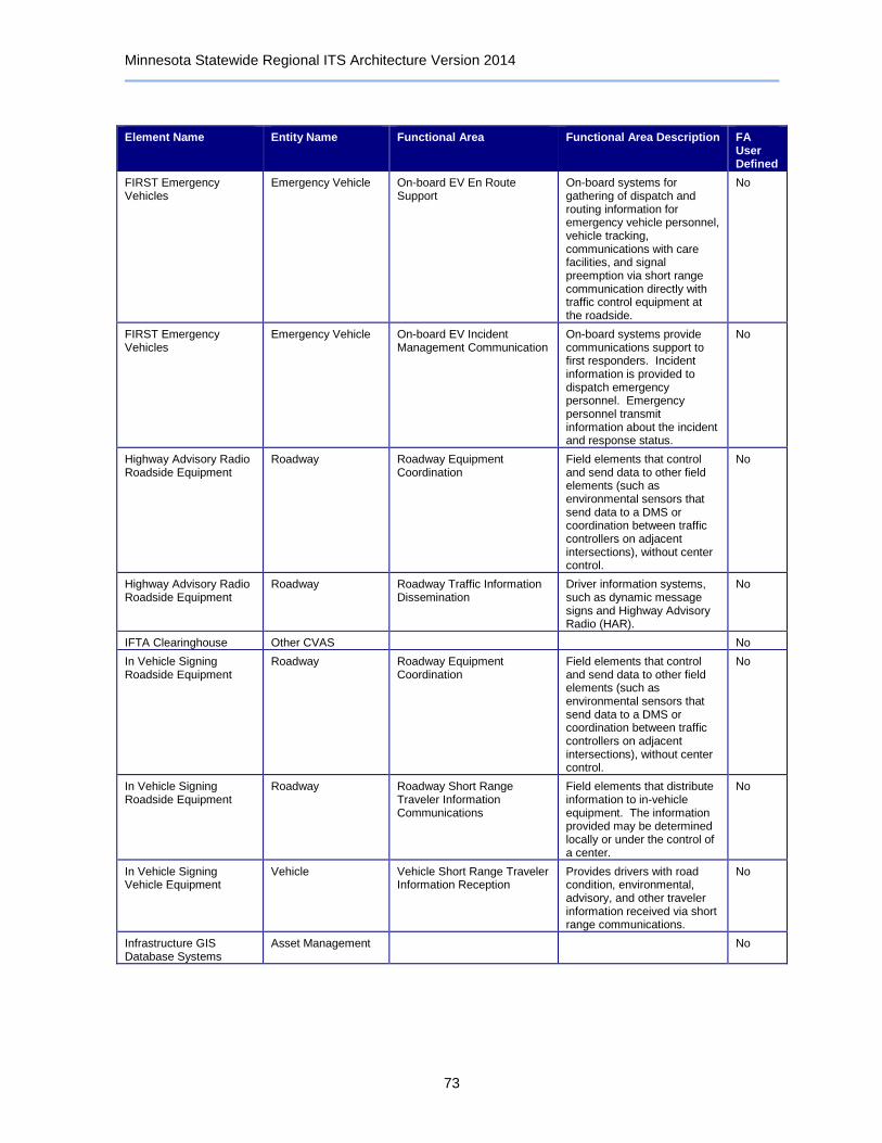
Minnesota Statewide Regional ITS Architecture Version 2014
73
Element Name Entity Name Functional Area Functional Area Description FA User Defined
FIRST Emergency Vehicles
Emergency Vehicle On-board EV En Route Support
On-board systems for gathering of dispatch and routing information for emergency vehicle personnel, vehicle tracking, communications with care facilities, and signal preemption via short range communication directly with traffic control equipment at the roadside.
No
FIRST Emergency Vehicles
Emergency Vehicle On-board EV Incident Management Communication
On-board systems provide communications support to first responders. Incident information is provided to dispatch emergency personnel. Emergency personnel transmit information about the incident and response status.
No
Highway Advisory Radio Roadside Equipment
Roadway Roadway Equipment Coordination
Field elements that control and send data to other field elements (such as environmental sensors that send data to a DMS or coordination between traffic controllers on adjacent intersections), without center control.
No
Highway Advisory Radio Roadside Equipment
Roadway Roadway Traffic Information Dissemination
Driver information systems, such as dynamic message signs and Highway Advisory Radio (HAR).
No
IFTA Clearinghouse Other CVAS No
In Vehicle Signing Roadside Equipment
Roadway Roadway Equipment Coordination
Field elements that control and send data to other field elements (such as environmental sensors that send data to a DMS or coordination between traffic controllers on adjacent intersections), without center control.
No
In Vehicle Signing Roadside Equipment
Roadway Roadway Short Range Traveler Information Communications
Field elements that distribute information to in-vehicle equipment. The information provided may be determined locally or under the control of a center.
No
In Vehicle Signing Vehicle Equipment
Vehicle Vehicle Short Range Traveler Information Reception
Provides drivers with road condition, environmental, advisory, and other traveler information received via short range communications.
No
Infrastructure GIS Database Systems
Asset Management No
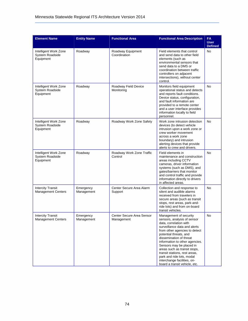
Minnesota Statewide Regional ITS Architecture Version 2014
74
Element Name Entity Name Functional Area Functional Area Description FA User Defined
Intelligent Work Zone System Roadside Equipment
Roadway Roadway Equipment Coordination
Field elements that control and send data to other field elements (such as environmental sensors that send data to a DMS or coordination between traffic controllers on adjacent intersections), without center control.
No
Intelligent Work Zone System Roadside Equipment
Roadway Roadway Field Device Monitoring
Monitors field equipment operational status and detects and reports fault conditions. Device status, configuration, and fault information are provided to a remote center and a user interface provides information locally to field personnel.
No
Intelligent Work Zone System Roadside Equipment
Roadway Roadway Work Zone Safety Work zone intrusion detection devices (to detect vehicle intrusion upon a work zone or crew worker movement across a work zone boundary) and intrusion alerting devices that provide alerts to crew and drivers.
No
Intelligent Work Zone System Roadside Equipment
Roadway Roadway Work Zone Traffic Control
Field elements in maintenance and construction areas including CCTV cameras, driver information systems (such as DMS), and gates/barriers that monitor and control traffic and provide information directly to drivers in affected areas.
No
Intercity Transit Management Centers
Emergency Management
Center Secure Area Alarm Support
Collection and response to silent and audible alarms received from travelers in secure areas (such as transit stops, rest areas, park-and-ride lots) and from on-board transit vehicles.
No
Intercity Transit Management Centers
Emergency Management
Center Secure Area Sensor Management
Management of security sensors, analysis of sensor data, correlation with surveillance data and alerts from other agencies to detect potential threats, and dissemination of threat information to other agencies. Sensors may be placed in areas such as transit stops, transit stations, rest areas, park and ride lots, modal interchange facilities, on-board a transit vehicle, etc.
No
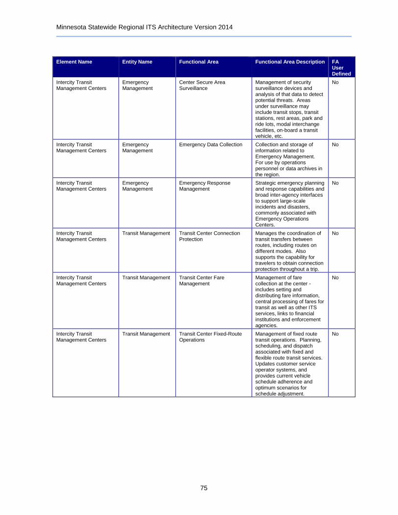
Minnesota Statewide Regional ITS Architecture Version 2014
75
Element Name Entity Name Functional Area Functional Area Description FA User Defined
Intercity Transit Management Centers
Emergency Management
Center Secure Area Surveillance
Management of security surveillance devices and analysis of that data to detect potential threats. Areas under surveillance may include transit stops, transit stations, rest areas, park and ride lots, modal interchange facilities, on-board a transit vehicle, etc.
No
Intercity Transit Management Centers
Emergency Management
Emergency Data Collection Collection and storage of information related to Emergency Management. For use by operations personnel or data archives in the region.
No
Intercity Transit Management Centers
Emergency Management
Emergency Response Management
Strategic emergency planning and response capabilities and broad inter-agency interfaces to support large-scale incidents and disasters, commonly associated with Emergency Operations Centers.
No
Intercity Transit Management Centers
Transit Management Transit Center Connection Protection
Manages the coordination of transit transfers between routes, including routes on different modes. Also supports the capability for travelers to obtain connection protection throughout a trip.
No
Intercity Transit Management Centers
Transit Management Transit Center Fare Management
Management of fare collection at the center - includes setting and distributing fare information, central processing of fares for transit as well as other ITS services, links to financial institutions and enforcement agencies.
No
Intercity Transit Management Centers
Transit Management Transit Center Fixed-Route Operations
Management of fixed route transit operations. Planning, scheduling, and dispatch associated with fixed and flexible route transit services. Updates customer service operator systems, and provides current vehicle schedule adherence and optimum scenarios for schedule adjustment.
No

Minnesota Statewide Regional ITS Architecture Version 2014
76
Element Name Entity Name Functional Area Functional Area Description FA User Defined
Intercity Transit Management Centers
Transit Management Transit Center Information Services
Provide interactive traveler information to travelers (on-board transit vehicles, at stops/stations, using personal devices), traveler information service providers, media, and other transit organizations. Includes routes, schedules, transfer options, fares, real-time schedule adherence, current incidents, weather conditions, yellow pages, and special events.
No
Intercity Transit Management Centers
Transit Management Transit Center Multi-Modal Coordination
Coordinate schedules with other agencies and modes, including transit transfer cluster and transfer point information.
No
Intercity Transit Management Centers
Transit Management Transit Center Security Monitor transit vehicle operator or traveler activated alarms; authenticate transit vehicle operators; remotely disable a transit vehicle; alert operators, travelers, and police to potential incidents identified by these security features.
No
Intercity Transit Management Centers
Transit Management Transit Data Collection Collection and storage of transit management data. For use by operations personnel or data archives in the region.
No
Intercity Transit Management Centers
Transit Management Transit Vehicle Operator Assignment
Assignment of transit operators to runs in a fair manner while minimizing labor and overtime services, considering operator preferences, qualifications, accumulated work hours, and other information about each operator.
No
Intermodal Freight Depots
Intermodal Freight Depot
No
Intersection Collision Warning Roadside Equipment
Roadway Roadway Equipment Coordination
Field elements that control and send data to other field elements (such as environmental sensors that send data to a DMS or coordination between traffic controllers on adjacent intersections), without center control.
No
Intersection Collision Warning Roadside Equipment
Roadway Roadway Intersection Safety Warning
Field elements that determine the probability of a collision in an intersection or at a railroad crossing and inform approaching vehicles using short-range wireless communications to the vehicles and traffic signal controls.
No

Minnesota Statewide Regional ITS Architecture Version 2014
77
Element Name Entity Name Functional Area Functional Area Description FA User Defined
IRP Clearinghouse Other CVAS No
Lane Control Roadside Equipment
Roadway Roadway Basic Surveillance Field elements that monitor traffic conditions using loop detectors and CCTV cameras.
No
Lane Control Roadside Equipment
Roadway Roadway Dynamic Lane Management and Shoulder Use
Field elements including physical overhead lane signs and associated control electronics that are used to manage and control specific lanes, including temporary use of shoulders as travel lanes.
No
Lane Control Roadside Equipment
Roadway Roadway Equipment Coordination
Field elements that control and send data to other field elements (such as environmental sensors that send data to a DMS or coordination between traffic controllers on adjacent intersections), without center control.
No
Lane/Ramp Access Control Roadside Equipment
Roadway Field Barrier System Control Field elements that control barrier systems such as gates and other systems that manage entry to roadways, transportation facilities and infrastructure.
No
Lane/Ramp Access Control Roadside Equipment
Roadway Roadway Basic Surveillance Field elements that monitor traffic conditions using loop detectors and CCTV cameras.
No
Lane/Ramp Access Control Roadside Equipment
Roadway Roadway Equipment Coordination
Field elements that control and send data to other field elements (such as environmental sensors that send data to a DMS or coordination between traffic controllers on adjacent intersections), without center control.
No
Lane/Ramp Access Control Roadside Equipment
Roadway Roadway Reversible Lanes Traffic sensors, surveillance, and automated reversible lane equipment and lane control signals to control traffic in reversible lanes.
No
Lane/Ramp Access Control Roadside Equipment
Roadway Roadway Traffic Information Dissemination
Driver information systems, such as dynamic message signs and Highway Advisory Radio (HAR).
No
Lane/Ramp Access Control Roadside Equipment
Roadway Roadway Work Zone Traffic Control
Field elements in maintenance and construction areas including CCTV cameras, driver information systems (such as DMS), and gates/barriers that monitor and control traffic and provide information directly to drivers in affected areas.
No
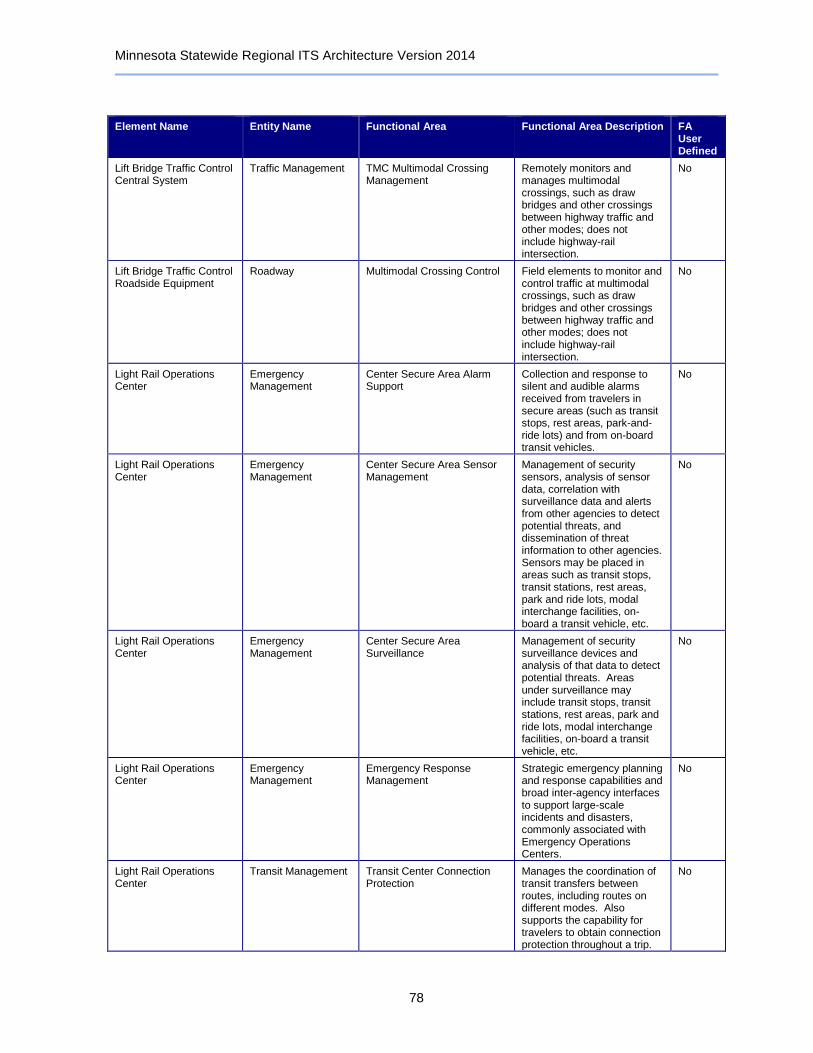
Minnesota Statewide Regional ITS Architecture Version 2014
78
Element Name Entity Name Functional Area Functional Area Description FA User Defined
Lift Bridge Traffic Control Central System
Traffic Management TMC Multimodal Crossing Management
Remotely monitors and manages multimodal crossings, such as draw bridges and other crossings between highway traffic and other modes; does not include highway-rail intersection.
No
Lift Bridge Traffic Control Roadside Equipment
Roadway Multimodal Crossing Control Field elements to monitor and control traffic at multimodal crossings, such as draw bridges and other crossings between highway traffic and other modes; does not include highway-rail intersection.
No
Light Rail Operations Center
Emergency Management
Center Secure Area Alarm Support
Collection and response to silent and audible alarms received from travelers in secure areas (such as transit stops, rest areas, park-and-ride lots) and from on-board transit vehicles.
No
Light Rail Operations Center
Emergency Management
Center Secure Area Sensor Management
Management of security sensors, analysis of sensor data, correlation with surveillance data and alerts from other agencies to detect potential threats, and dissemination of threat information to other agencies. Sensors may be placed in areas such as transit stops, transit stations, rest areas, park and ride lots, modal interchange facilities, on-board a transit vehicle, etc.
No
Light Rail Operations Center
Emergency Management
Center Secure Area Surveillance
Management of security surveillance devices and analysis of that data to detect potential threats. Areas under surveillance may include transit stops, transit stations, rest areas, park and ride lots, modal interchange facilities, on-board a transit vehicle, etc.
No
Light Rail Operations Center
Emergency Management
Emergency Response Management
Strategic emergency planning and response capabilities and broad inter-agency interfaces to support large-scale incidents and disasters, commonly associated with Emergency Operations Centers.
No
Light Rail Operations Center
Transit Management Transit Center Connection Protection
Manages the coordination of transit transfers between routes, including routes on different modes. Also supports the capability for travelers to obtain connection protection throughout a trip.
No
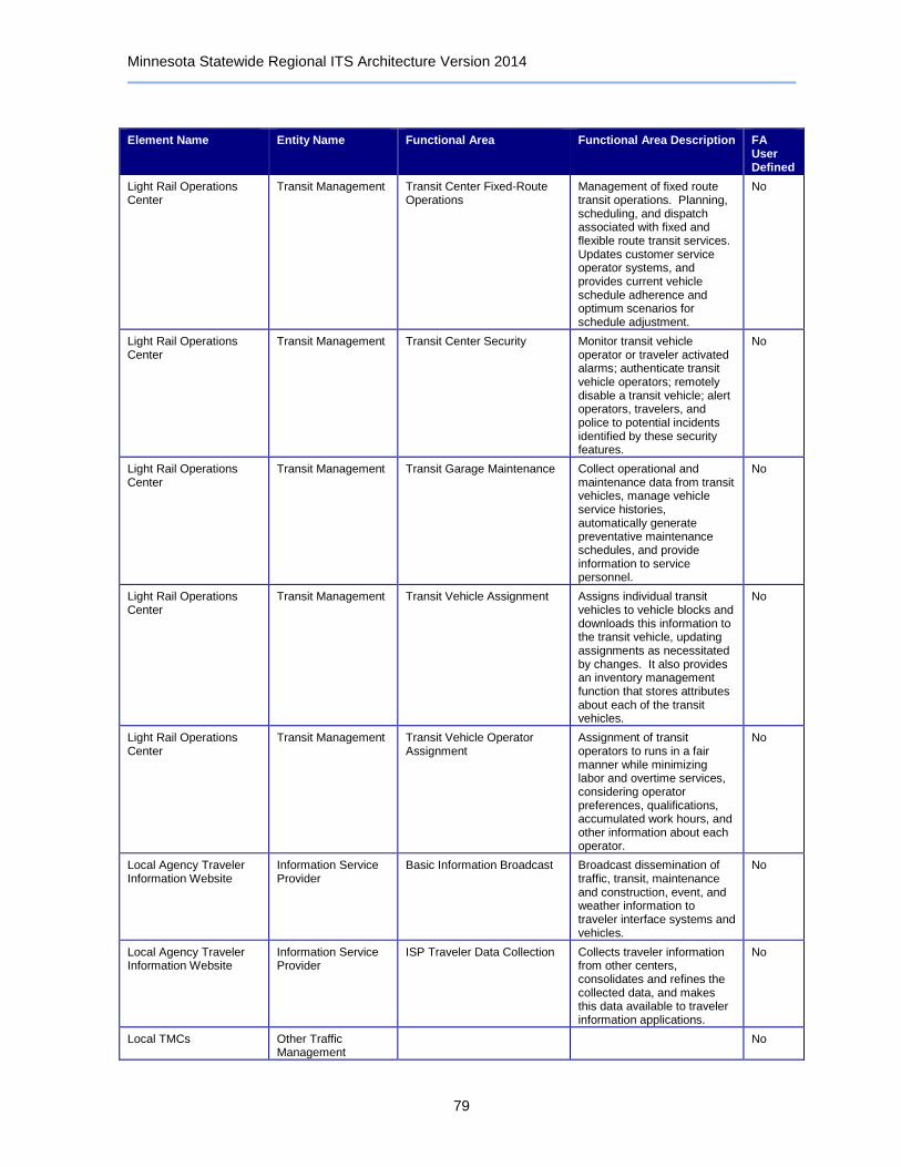
Minnesota Statewide Regional ITS Architecture Version 2014
79
Element Name Entity Name Functional Area Functional Area Description FA User Defined
Light Rail Operations Center
Transit Management Transit Center Fixed-Route Operations
Management of fixed route transit operations. Planning, scheduling, and dispatch associated with fixed and flexible route transit services. Updates customer service operator systems, and provides current vehicle schedule adherence and optimum scenarios for schedule adjustment.
No
Light Rail Operations Center
Transit Management Transit Center Security Monitor transit vehicle operator or traveler activated alarms; authenticate transit vehicle operators; remotely disable a transit vehicle; alert operators, travelers, and police to potential incidents identified by these security features.
No
Light Rail Operations Center
Transit Management Transit Garage Maintenance Collect operational and maintenance data from transit vehicles, manage vehicle service histories, automatically generate preventative maintenance schedules, and provide information to service personnel.
No
Light Rail Operations Center
Transit Management Transit Vehicle Assignment Assigns individual transit vehicles to vehicle blocks and downloads this information to the transit vehicle, updating assignments as necessitated by changes. It also provides an inventory management function that stores attributes about each of the transit vehicles.
No
Light Rail Operations Center
Transit Management Transit Vehicle Operator Assignment
Assignment of transit operators to runs in a fair manner while minimizing labor and overtime services, considering operator preferences, qualifications, accumulated work hours, and other information about each operator.
No
Local Agency Traveler Information Website
Information Service Provider
Basic Information Broadcast Broadcast dissemination of traffic, transit, maintenance and construction, event, and weather information to traveler interface systems and vehicles.
No
Local Agency Traveler Information Website
Information Service Provider
ISP Traveler Data Collection Collects traveler information from other centers, consolidates and refines the collected data, and makes this data available to traveler information applications.
No
Local TMCs Other Traffic Management
No

Minnesota Statewide Regional ITS Architecture Version 2014
80
Element Name Entity Name Functional Area Functional Area Description FA User Defined
Local TMCs Traffic Management Collect Traffic Surveillance Management of traffic sensors and surveillance (CCTV) equipment, collection of current traffic conditions, and distribution of the collected information to other centers and operators.
No
Local TMCs Traffic Management TMC Incident Detection Remotely monitors traffic sensor and surveillance systems to detect and verify incidents. Also monitors external advisory and incident reporting systems, intermodal freight depots, and border crossings for additional incident information. Identified incidents are reported to operations personnel and other centers.
No
Local TMCs Traffic Management TMC Incident Dispatch Coordination/Communication
Formulates an incident response that takes into account the incident potential, incident impacts, and/or resources required for incident management. Facilitates the dispatch of emergency response and service vehicles and coordinates the response with cooperating agencies.
No
Local TMCs Traffic Management TMC Multimodal Coordination Provides traffic signal priority for transit vehicles based on center-to-center communications with the transit management center; also exchange traffic and transit information.
No
Local TMCs Traffic Management TMC Regional Traffic Management
Coordination between traffic management centers in order to share traffic information between centers as well as control of traffic management field equipment. This may be used during incidents and special events and during day-to-day operations.
No
Local TMCs Traffic Management TMC Signal Control Remotely controls traffic signal controllers to implement traffic management strategies at signalized intersections based on traffic conditions, incidents, emergency vehicle preemptions, pedestrian crossings, etc.
No
Local TMCs Traffic Management TMC Traffic Information Dissemination
Controls dissemination of traffic-related data to other centers, the media, and travelers via the driver information systems (DMS, HAR) that it operates.
No

Minnesota Statewide Regional ITS Architecture Version 2014
81
Element Name Entity Name Functional Area Functional Area Description FA User Defined
Local TMCs Traffic Management TMC Traffic Metering Remotely controls ramp meters, interchange connector meters, and mainline meters, covering all types of metering as well as management of bypass lanes.
No
Local TMCs Traffic Management Traffic Data Collection Collection and storage of traffic management data. For use by operations personnel or data archives in the region.
No
Local TMCs Traffic Management Traffic Equipment Maintenance
Monitoring and remote diagnostics of field equipment - detect failures, issue problem reports, and track the repair or replacement of the failed equipment.
No
Local Transit Management Centers
Emergency Management
Center Secure Area Alarm Support
Collection and response to silent and audible alarms received from travelers in secure areas (such as transit stops, rest areas, park-and-ride lots) and from on-board transit vehicles.
No
Local Transit Management Centers
Emergency Management
Center Secure Area Sensor Management
Management of security sensors, analysis of sensor data, correlation with surveillance data and alerts from other agencies to detect potential threats, and dissemination of threat information to other agencies. Sensors may be placed in areas such as transit stops, transit stations, rest areas, park and ride lots, modal interchange facilities, on-board a transit vehicle, etc.
No
Local Transit Management Centers
Emergency Management
Center Secure Area Surveillance
Management of security surveillance devices and analysis of that data to detect potential threats. Areas under surveillance may include transit stops, transit stations, rest areas, park and ride lots, modal interchange facilities, on-board a transit vehicle, etc.
No
Local Transit Management Centers
Emergency Management
Emergency Data Collection Collection and storage of information related to Emergency Management. For use by operations personnel or data archives in the region.
No
Local Transit Management Centers
Emergency Management
Emergency Response Management
Strategic emergency planning and response capabilities and broad inter-agency interfaces to support large-scale incidents and disasters, commonly associated with Emergency Operations Centers.
No
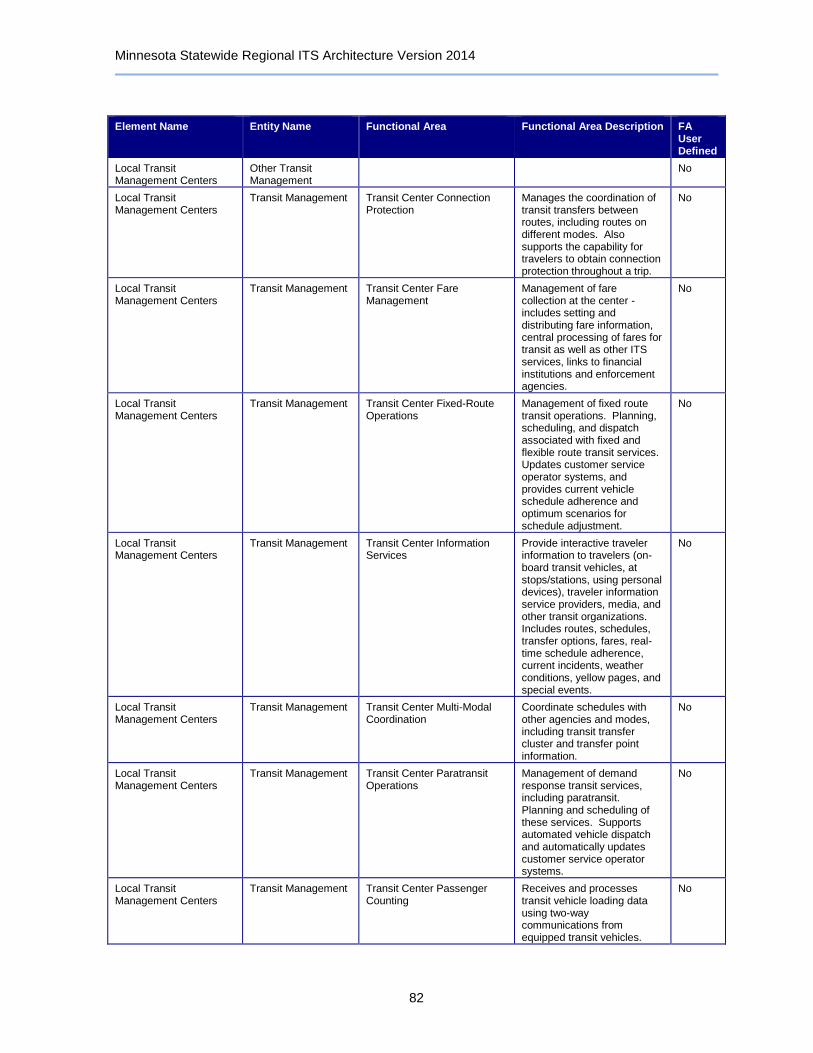
Minnesota Statewide Regional ITS Architecture Version 2014
82
Element Name Entity Name Functional Area Functional Area Description FA User Defined
Local Transit Management Centers
Other Transit Management
No
Local Transit Management Centers
Transit Management Transit Center Connection Protection
Manages the coordination of transit transfers between routes, including routes on different modes. Also supports the capability for travelers to obtain connection protection throughout a trip.
No
Local Transit Management Centers
Transit Management Transit Center Fare Management
Management of fare collection at the center - includes setting and distributing fare information, central processing of fares for transit as well as other ITS services, links to financial institutions and enforcement agencies.
No
Local Transit Management Centers
Transit Management Transit Center Fixed-Route Operations
Management of fixed route transit operations. Planning, scheduling, and dispatch associated with fixed and flexible route transit services. Updates customer service operator systems, and provides current vehicle schedule adherence and optimum scenarios for schedule adjustment.
No
Local Transit Management Centers
Transit Management Transit Center Information Services
Provide interactive traveler information to travelers (on-board transit vehicles, at stops/stations, using personal devices), traveler information service providers, media, and other transit organizations. Includes routes, schedules, transfer options, fares, real-time schedule adherence, current incidents, weather conditions, yellow pages, and special events.
No
Local Transit Management Centers
Transit Management Transit Center Multi-Modal Coordination
Coordinate schedules with other agencies and modes, including transit transfer cluster and transfer point information.
No
Local Transit Management Centers
Transit Management Transit Center Paratransit Operations
Management of demand response transit services, including paratransit. Planning and scheduling of these services. Supports automated vehicle dispatch and automatically updates customer service operator systems.
No
Local Transit Management Centers
Transit Management Transit Center Passenger Counting
Receives and processes transit vehicle loading data using two-way communications from equipped transit vehicles.
No
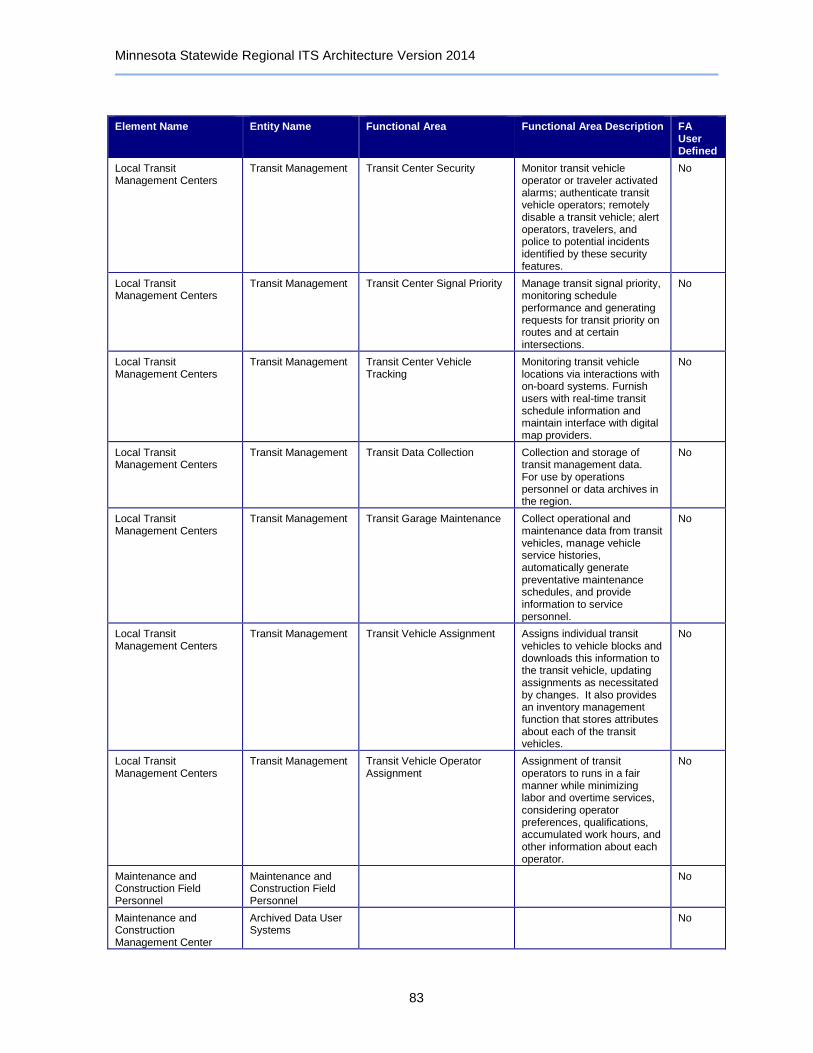
Minnesota Statewide Regional ITS Architecture Version 2014
83
Element Name Entity Name Functional Area Functional Area Description FA User Defined
Local Transit Management Centers
Transit Management Transit Center Security Monitor transit vehicle operator or traveler activated alarms; authenticate transit vehicle operators; remotely disable a transit vehicle; alert operators, travelers, and police to potential incidents identified by these security features.
No
Local Transit Management Centers
Transit Management Transit Center Signal Priority Manage transit signal priority, monitoring schedule performance and generating requests for transit priority on routes and at certain intersections.
No
Local Transit Management Centers
Transit Management Transit Center Vehicle Tracking
Monitoring transit vehicle locations via interactions with on-board systems. Furnish users with real-time transit schedule information and maintain interface with digital map providers.
No
Local Transit Management Centers
Transit Management Transit Data Collection Collection and storage of transit management data. For use by operations personnel or data archives in the region.
No
Local Transit Management Centers
Transit Management Transit Garage Maintenance Collect operational and maintenance data from transit vehicles, manage vehicle service histories, automatically generate preventative maintenance schedules, and provide information to service personnel.
No
Local Transit Management Centers
Transit Management Transit Vehicle Assignment Assigns individual transit vehicles to vehicle blocks and downloads this information to the transit vehicle, updating assignments as necessitated by changes. It also provides an inventory management function that stores attributes about each of the transit vehicles.
No
Local Transit Management Centers
Transit Management Transit Vehicle Operator Assignment
Assignment of transit operators to runs in a fair manner while minimizing labor and overtime services, considering operator preferences, qualifications, accumulated work hours, and other information about each operator.
No
Maintenance and Construction Field Personnel
Maintenance and Construction Field Personnel
No
Maintenance and Construction Management Center
Archived Data User Systems
No

Minnesota Statewide Regional ITS Architecture Version 2014
84
Element Name Entity Name Functional Area Functional Area Description FA User Defined
Maintenance and Construction Management Center
Maintenance and Construction Management
MCM Automated Treatment System Control
Remotely controls automated roadway treatment systems (to disperse anti-icing chemicals, etc.) directly, or via control of the environmental sensors that activate the treatment systems automatically in the field.
No
Maintenance and Construction Management Center
Maintenance and Construction Management
MCM Data Collection Collection and storage of maintenance and construction information. For use by operations personnel or data archives in the region.
No
Maintenance and Construction Management Center
Maintenance and Construction Management
MCM Environmental Information Processing
Processes current and forecast weather data, road condition information, local environmental data, and uses internal models to develop specialized detailed forecasts of local weather and surface conditions. Disseminates road weather information to other agencies and centers.
No
Maintenance and Construction Management Center
Maintenance and Construction Management
MCM Incident Management Supports coordinated response to incidents - share incident notifications, manage incident response resources, and coordinate overall incident situation and response among allied response organizations.
No
Maintenance and Construction Management Center
Maintenance and Construction Management
MCM Infrastructure Monitoring
Remotely monitors the condition of pavement, bridges, tunnels, associated hardware, and other transportation-related infrastructure (e.g., culverts) using vehicle-based and roadway-based infrastructure monitoring sensors.
No
Maintenance and Construction Management Center
Maintenance and Construction Management
MCM Maintenance Decision Support
Maintenance Decision Support Systems recommend courses of action based on current and forecast environmental and road conditions (filtered and fused for specific time horizons) and additional application specific information. Recommendations and dispatch instructions are generated based on this integrated information.
No
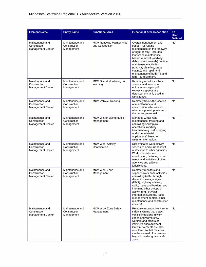
Minnesota Statewide Regional ITS Architecture Version 2014
85
Element Name Entity Name Functional Area Functional Area Description FA User Defined
Maintenance and Construction Management Center
Maintenance and Construction Management
MCM Roadway Maintenance and Construction
Overall management and support for routine maintenance on the roadway or right-of-way. Includes landscape maintenance, hazard removal (roadway debris, dead animals), routine maintenance activities (roadway cleaning, grass cutting), and repair and maintenance of both ITS and non-ITS equipment.
No
Maintenance and Construction Management Center
Maintenance and Construction Management
MCM Speed Monitoring and Warning
Remotely monitors vehicle speeds, and informs an enforcement agency if excessive speeds are detected; primarily used in work zones.
No
Maintenance and Construction Management Center
Maintenance and Construction Management
MCM Vehicle Tracking Remotely tracks the location of maintenance and construction vehicles and other equipment; presented to the center personnel.
No
Maintenance and Construction Management Center
Maintenance and Construction Management
MCM Winter Maintenance Management
Manages winter road maintenance, tracking and controlling snow plow operations, roadway treatment (e.g., salt spraying and other material applications) based on weather information.
No
Maintenance and Construction Management Center
Maintenance and Construction Management
MCM Work Activity Coordination
Disseminates work activity schedules and current asset restrictions to other agencies. Work schedules are coordinated, factoring in the needs and activities of other agencies and adjacent jurisdictions.
No
Maintenance and Construction Management Center
Maintenance and Construction Management
MCM Work Zone Management
Remotely monitors and supports work zone activities, controlling traffic through dynamic message signs (DMS), highway advisory radio, gates and barriers, and informing other groups of activity (e.g., traveler information systems, traffic management centers, other maintenance and construction centers).
No
Maintenance and Construction Management Center
Maintenance and Construction Management
MCM Work Zone Safety Management
Remotely monitors work zone safety systems that detect vehicle intrusions in work zones and warns crew workers and drivers of imminent encroachment. Crew movements are also monitored so that the crew can be warned of movement beyond the designated safe zone.
No
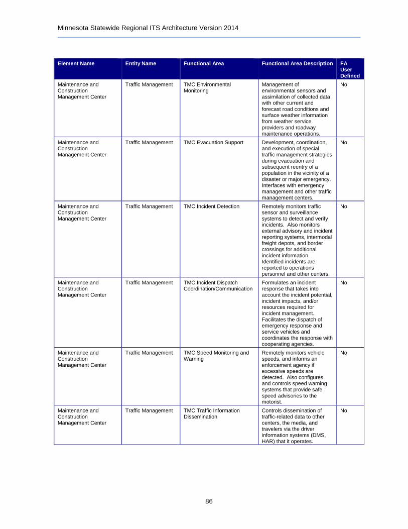
Minnesota Statewide Regional ITS Architecture Version 2014
86
Element Name Entity Name Functional Area Functional Area Description FA User Defined
Maintenance and Construction Management Center
Traffic Management TMC Environmental Monitoring
Management of environmental sensors and assimilation of collected data with other current and forecast road conditions and surface weather information from weather service providers and roadway maintenance operations.
No
Maintenance and Construction Management Center
Traffic Management TMC Evacuation Support Development, coordination, and execution of special traffic management strategies during evacuation and subsequent reentry of a population in the vicinity of a disaster or major emergency. Interfaces with emergency management and other traffic management centers.
No
Maintenance and Construction Management Center
Traffic Management TMC Incident Detection Remotely monitors traffic sensor and surveillance systems to detect and verify incidents. Also monitors external advisory and incident reporting systems, intermodal freight depots, and border crossings for additional incident information. Identified incidents are reported to operations personnel and other centers.
No
Maintenance and Construction Management Center
Traffic Management TMC Incident Dispatch Coordination/Communication
Formulates an incident response that takes into account the incident potential, incident impacts, and/or resources required for incident management. Facilitates the dispatch of emergency response and service vehicles and coordinates the response with cooperating agencies.
No
Maintenance and Construction Management Center
Traffic Management TMC Speed Monitoring and Warning
Remotely monitors vehicle speeds, and informs an enforcement agency if excessive speeds are detected. Also configures and controls speed warning systems that provide safe speed advisories to the motorist.
No
Maintenance and Construction Management Center
Traffic Management TMC Traffic Information Dissemination
Controls dissemination of traffic-related data to other centers, the media, and travelers via the driver information systems (DMS, HAR) that it operates.
No

Minnesota Statewide Regional ITS Architecture Version 2014
87
Element Name Entity Name Functional Area Functional Area Description FA User Defined
Maintenance and Construction Management Center
Traffic Management TMC Work Zone Traffic Management
Coordination with maintenance systems using work zone images and traveler information systems (such as DMS), and distribution of work plans so that work zones are established that have minimum traffic impact.
No
Maintenance and Construction Management Center
Traffic Management Traffic Data Collection Collection and storage of traffic management data. For use by operations personnel or data archives in the region.
No
Maintenance and Construction Management Center
Traffic Management Traffic Equipment Maintenance
Monitoring and remote diagnostics of field equipment - detect failures, issue problem reports, and track the repair or replacement of the failed equipment.
No
Maintenance and Construction Vehicle Equipment
Maintenance and Construction Vehicle
MCV Barrier System Control Control automatic or remotely controlled gates and other barrier systems from a maintenance and construction vehicle.
No
Maintenance and Construction Vehicle Equipment
Maintenance and Construction Vehicle
MCV Environmental Monitoring
On-board systems that collect environmental and road condition data (including road surface or air temperature, wind speed, and road traction information - spatially located and time stamped) from sensors on-board the maintenance vehicle or located at the roadway.
No
Maintenance and Construction Vehicle Equipment
Maintenance and Construction Vehicle
MCV Roadway Maintenance and Construction
On-board systems that support routine non-winter maintenance on the roadway or right-of-way. Includes landscape maintenance, hazard removal (roadway debris, dead animals), routine maintenance activities (roadway cleaning, grass cutting), and repair and maintenance of equipment on the roadway.
No
Maintenance and Construction Vehicle Equipment
Maintenance and Construction Vehicle
MCV Vehicle Location Tracking
On-board systems to track vehicle location and reports the position and timestamp information to the dispatch center.
No
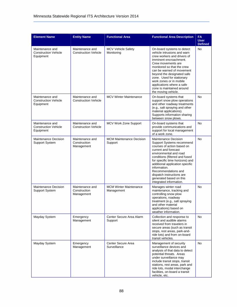
Minnesota Statewide Regional ITS Architecture Version 2014
88
Element Name Entity Name Functional Area Functional Area Description FA User Defined
Maintenance and Construction Vehicle Equipment
Maintenance and Construction Vehicle
MCV Vehicle Safety Monitoring
On-board systems to detect vehicle intrusions and warn crew workers and drivers of imminent encroachment. Crew movements are monitored so that the crew can be warned of movement beyond the designated safe zone. Used for stationary work zones or in mobile applications where a safe zone is maintained around the moving vehicle.
No
Maintenance and Construction Vehicle Equipment
Maintenance and Construction Vehicle
MCV Winter Maintenance On-board systems that support snow plow operations and other roadway treatments (e.g., salt spraying and other material applications). Supports information sharing between snow plows.
No
Maintenance and Construction Vehicle Equipment
Maintenance and Construction Vehicle
MCV Work Zone Support On-board systems that provide communications and support for local management of a work zone.
No
Maintenance Decision Support System
Maintenance and Construction Management
MCM Maintenance Decision Support
Maintenance Decision Support Systems recommend courses of action based on current and forecast environmental and road conditions (filtered and fused for specific time horizons) and additional application specific information. Recommendations and dispatch instructions are generated based on this integrated information.
No
Maintenance Decision Support System
Maintenance and Construction Management
MCM Winter Maintenance Management
Manages winter road maintenance, tracking and controlling snow plow operations, roadway treatment (e.g., salt spraying and other material applications) based on weather information.
No
Mayday System Emergency Management
Center Secure Area Alarm Support
Collection and response to silent and audible alarms received from travelers in secure areas (such as transit stops, rest areas, park-and-ride lots) and from on-board transit vehicles.
No
Mayday System Emergency Management
Center Secure Area Surveillance
Management of security surveillance devices and analysis of that data to detect potential threats. Areas under surveillance may include transit stops, transit stations, rest areas, park and ride lots, modal interchange facilities, on-board a transit vehicle, etc.
No
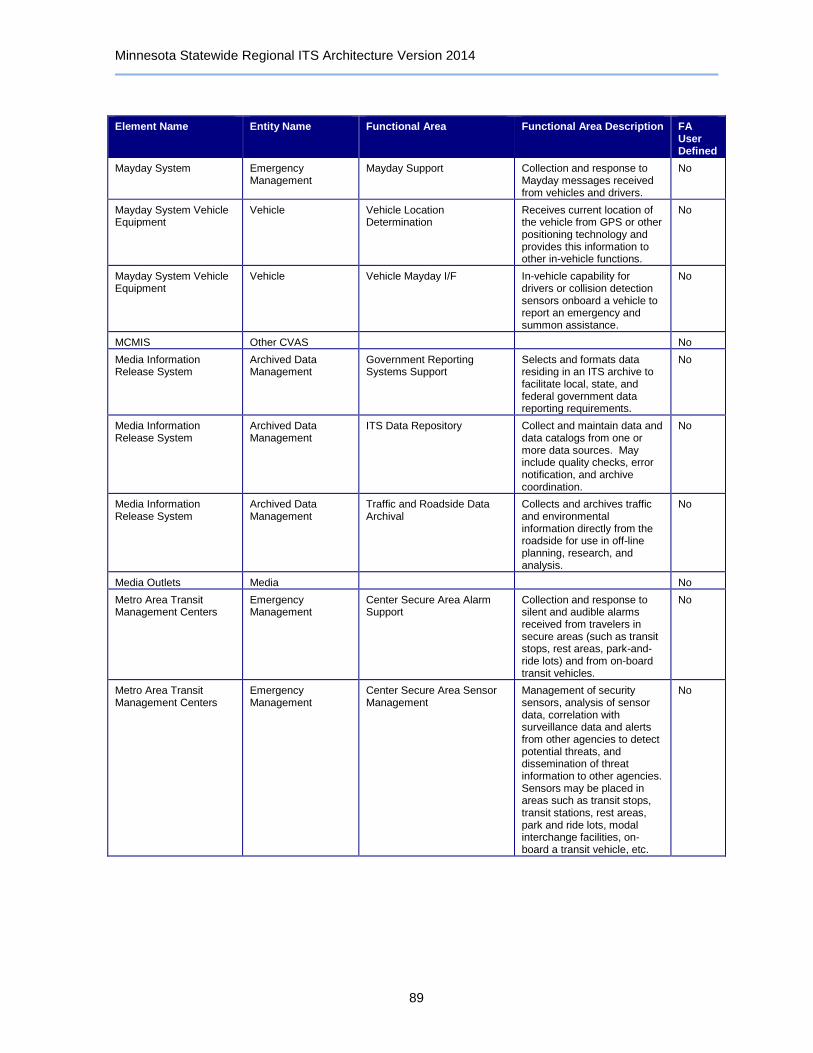
Minnesota Statewide Regional ITS Architecture Version 2014
89
Element Name Entity Name Functional Area Functional Area Description FA User Defined
Mayday System Emergency Management
Mayday Support Collection and response to Mayday messages received from vehicles and drivers.
No
Mayday System Vehicle Equipment
Vehicle Vehicle Location Determination
Receives current location of the vehicle from GPS or other positioning technology and provides this information to other in-vehicle functions.
No
Mayday System Vehicle Equipment
Vehicle Vehicle Mayday I/F In-vehicle capability for drivers or collision detection sensors onboard a vehicle to report an emergency and summon assistance.
No
MCMIS Other CVAS No
Media Information Release System
Archived Data Management
Government Reporting Systems Support
Selects and formats data residing in an ITS archive to facilitate local, state, and federal government data reporting requirements.
No
Media Information Release System
Archived Data Management
ITS Data Repository Collect and maintain data and data catalogs from one or more data sources. May include quality checks, error notification, and archive coordination.
No
Media Information Release System
Archived Data Management
Traffic and Roadside Data Archival
Collects and archives traffic and environmental information directly from the roadside for use in off-line planning, research, and analysis.
No
Media Outlets Media No
Metro Area Transit Management Centers
Emergency Management
Center Secure Area Alarm Support
Collection and response to silent and audible alarms received from travelers in secure areas (such as transit stops, rest areas, park-and-ride lots) and from on-board transit vehicles.
No
Metro Area Transit Management Centers
Emergency Management
Center Secure Area Sensor Management
Management of security sensors, analysis of sensor data, correlation with surveillance data and alerts from other agencies to detect potential threats, and dissemination of threat information to other agencies. Sensors may be placed in areas such as transit stops, transit stations, rest areas, park and ride lots, modal interchange facilities, on-board a transit vehicle, etc.
No
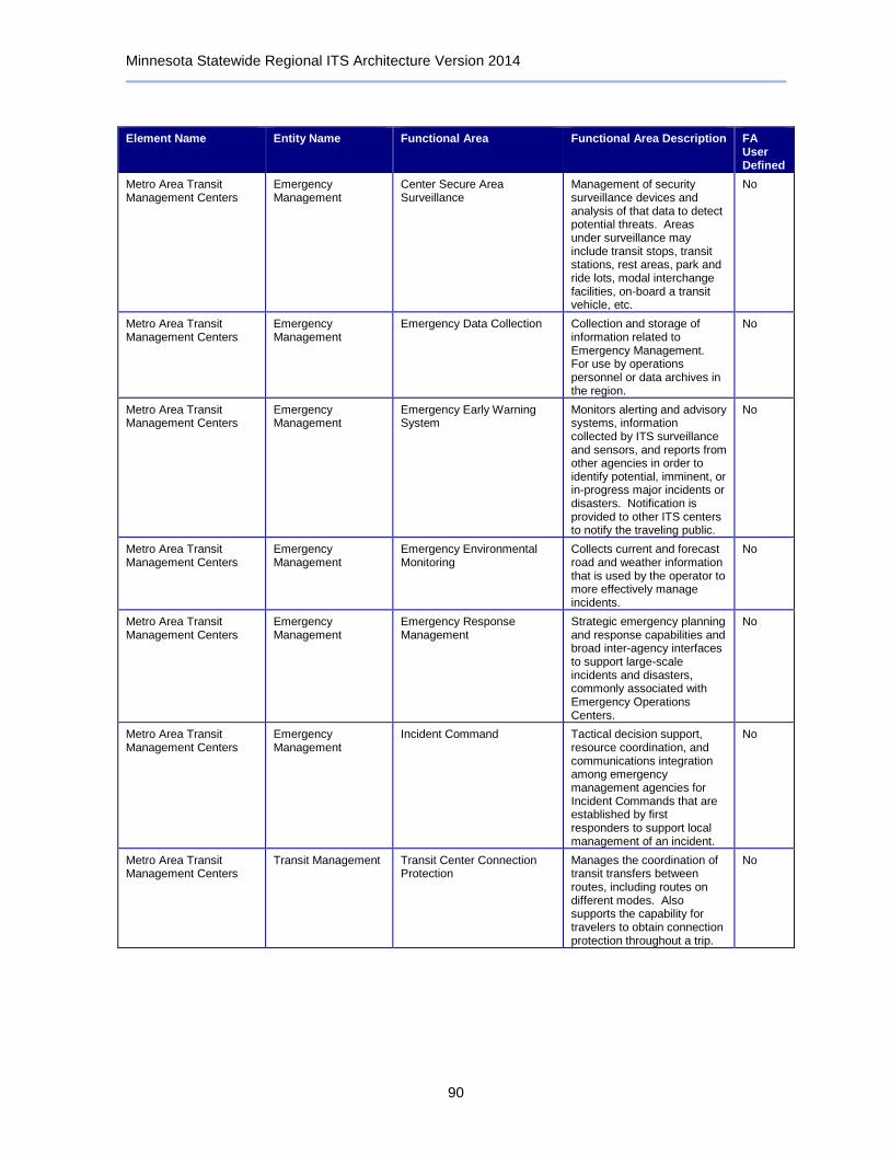
Minnesota Statewide Regional ITS Architecture Version 2014
90
Element Name Entity Name Functional Area Functional Area Description FA User Defined
Metro Area Transit Management Centers
Emergency Management
Center Secure Area Surveillance
Management of security surveillance devices and analysis of that data to detect potential threats. Areas under surveillance may include transit stops, transit stations, rest areas, park and ride lots, modal interchange facilities, on-board a transit vehicle, etc.
No
Metro Area Transit Management Centers
Emergency Management
Emergency Data Collection Collection and storage of information related to Emergency Management. For use by operations personnel or data archives in the region.
No
Metro Area Transit Management Centers
Emergency Management
Emergency Early Warning System
Monitors alerting and advisory systems, information collected by ITS surveillance and sensors, and reports from other agencies in order to identify potential, imminent, or in-progress major incidents or disasters. Notification is provided to other ITS centers to notify the traveling public.
No
Metro Area Transit Management Centers
Emergency Management
Emergency Environmental Monitoring
Collects current and forecast road and weather information that is used by the operator to more effectively manage incidents.
No
Metro Area Transit Management Centers
Emergency Management
Emergency Response Management
Strategic emergency planning and response capabilities and broad inter-agency interfaces to support large-scale incidents and disasters, commonly associated with Emergency Operations Centers.
No
Metro Area Transit Management Centers
Emergency Management
Incident Command Tactical decision support, resource coordination, and communications integration among emergency management agencies for Incident Commands that are established by first responders to support local management of an incident.
No
Metro Area Transit Management Centers
Transit Management Transit Center Connection Protection
Manages the coordination of transit transfers between routes, including routes on different modes. Also supports the capability for travelers to obtain connection protection throughout a trip.
No
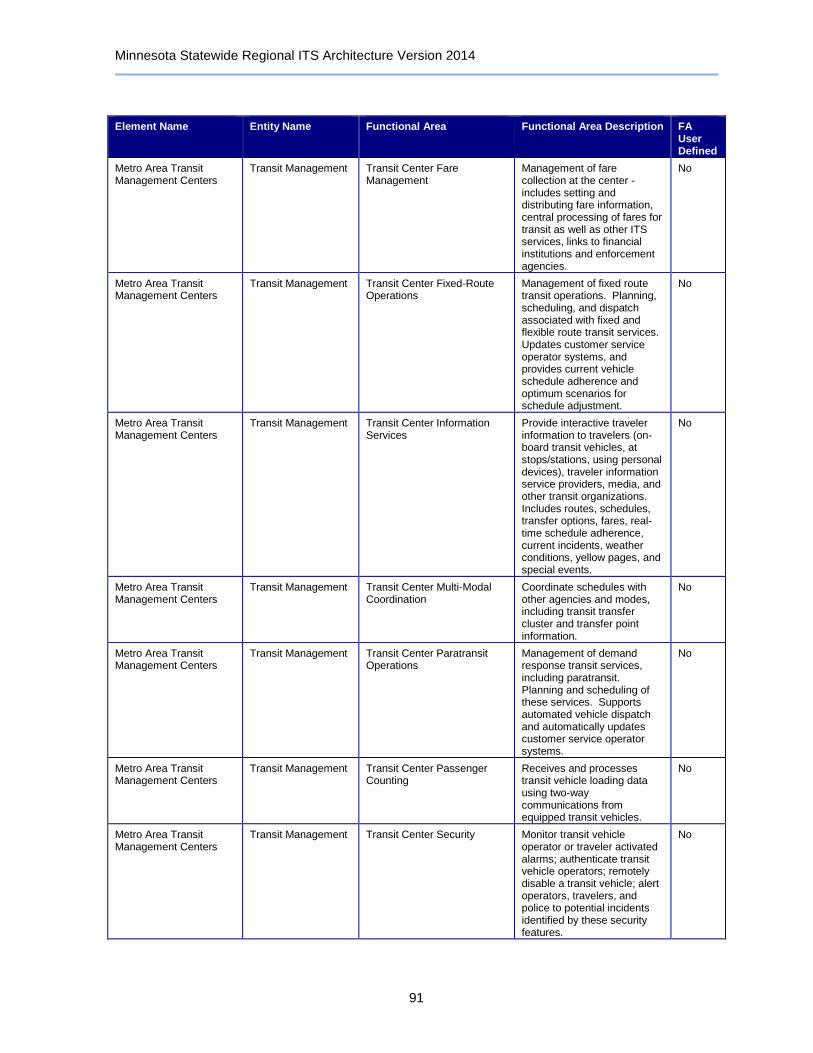
Minnesota Statewide Regional ITS Architecture Version 2014
91
Element Name Entity Name Functional Area Functional Area Description FA User Defined
Metro Area Transit Management Centers
Transit Management Transit Center Fare Management
Management of fare collection at the center - includes setting and distributing fare information, central processing of fares for transit as well as other ITS services, links to financial institutions and enforcement agencies.
No
Metro Area Transit Management Centers
Transit Management Transit Center Fixed-Route Operations
Management of fixed route transit operations. Planning, scheduling, and dispatch associated with fixed and flexible route transit services. Updates customer service operator systems, and provides current vehicle schedule adherence and optimum scenarios for schedule adjustment.
No
Metro Area Transit Management Centers
Transit Management Transit Center Information Services
Provide interactive traveler information to travelers (on-board transit vehicles, at stops/stations, using personal devices), traveler information service providers, media, and other transit organizations. Includes routes, schedules, transfer options, fares, real-time schedule adherence, current incidents, weather conditions, yellow pages, and special events.
No
Metro Area Transit Management Centers
Transit Management Transit Center Multi-Modal Coordination
Coordinate schedules with other agencies and modes, including transit transfer cluster and transfer point information.
No
Metro Area Transit Management Centers
Transit Management Transit Center Paratransit Operations
Management of demand response transit services, including paratransit. Planning and scheduling of these services. Supports automated vehicle dispatch and automatically updates customer service operator systems.
No
Metro Area Transit Management Centers
Transit Management Transit Center Passenger Counting
Receives and processes transit vehicle loading data using two-way communications from equipped transit vehicles.
No
Metro Area Transit Management Centers
Transit Management Transit Center Security Monitor transit vehicle operator or traveler activated alarms; authenticate transit vehicle operators; remotely disable a transit vehicle; alert operators, travelers, and police to potential incidents identified by these security features.
No

Minnesota Statewide Regional ITS Architecture Version 2014
92
Element Name Entity Name Functional Area Functional Area Description FA User Defined
Metro Area Transit Management Centers
Transit Management Transit Center Signal Priority Manage transit signal priority, monitoring schedule performance and generating requests for transit priority on routes and at certain intersections.
No
Metro Area Transit Management Centers
Transit Management Transit Center Vehicle Tracking
Monitoring transit vehicle locations via interactions with on-board systems. Furnish users with real-time transit schedule information and maintain interface with digital map providers.
No
Metro Area Transit Management Centers
Transit Management Transit Data Collection Collection and storage of transit management data. For use by operations personnel or data archives in the region.
No
Metro Area Transit Management Centers
Transit Management Transit Garage Maintenance Collect operational and maintenance data from transit vehicles, manage vehicle service histories, automatically generate preventative maintenance schedules, and provide information to service personnel.
No
Metro Area Transit Management Centers
Transit Management Transit Vehicle Assignment Assigns individual transit vehicles to vehicle blocks and downloads this information to the transit vehicle, updating assignments as necessitated by changes. It also provides an inventory management function that stores attributes about each of the transit vehicles.
No
Metro Area Transit Management Centers
Transit Management Transit Vehicle Operator Assignment
Assignment of transit operators to runs in a fair manner while minimizing labor and overtime services, considering operator preferences, qualifications, accumulated work hours, and other information about each operator.
No
Minneapolis TMC Archived Data User Systems
No
Minneapolis TMC Other Traffic Management
No
Minneapolis TMC Traffic Management Collect Traffic Surveillance Management of traffic sensors and surveillance (CCTV) equipment, collection of current traffic conditions, and distribution of the collected information to other centers and operators.
No

Minnesota Statewide Regional ITS Architecture Version 2014
93
Element Name Entity Name Functional Area Functional Area Description FA User Defined
Minneapolis TMC Traffic Management TMC Incident Detection Remotely monitors traffic sensor and surveillance systems to detect and verify incidents. Also monitors external advisory and incident reporting systems, intermodal freight depots, and border crossings for additional incident information. Identified incidents are reported to operations personnel and other centers.
No
Minneapolis TMC Traffic Management TMC Incident Dispatch Coordination/Communication
Formulates an incident response that takes into account the incident potential, incident impacts, and/or resources required for incident management. Facilitates the dispatch of emergency response and service vehicles and coordinates the response with cooperating agencies.
No
Minneapolis TMC Traffic Management TMC Multimodal Coordination Provides traffic signal priority for transit vehicles based on center-to-center communications with the transit management center; also exchange traffic and transit information.
No
Minneapolis TMC Traffic Management TMC Regional Traffic Management
Coordination between traffic management centers in order to share traffic information between centers as well as control of traffic management field equipment. This may be used during incidents and special events and during day-to-day operations.
No
Minneapolis TMC Traffic Management TMC Signal Control Remotely controls traffic signal controllers to implement traffic management strategies at signalized intersections based on traffic conditions, incidents, emergency vehicle preemptions, pedestrian crossings, etc.
No
Minneapolis TMC Traffic Management TMC Speed Monitoring and Warning
Remotely monitors vehicle speeds, and informs an enforcement agency if excessive speeds are detected. Also configures and controls speed warning systems that provide safe speed advisories to the motorist.
No

Minnesota Statewide Regional ITS Architecture Version 2014
94
Element Name Entity Name Functional Area Functional Area Description FA User Defined
Minneapolis TMC Traffic Management TMC Traffic Information Dissemination
Controls dissemination of traffic-related data to other centers, the media, and travelers via the driver information systems (DMS, HAR) that it operates.
No
Minneapolis TMC Traffic Management TMC Traffic Metering Remotely controls ramp meters, interchange connector meters, and mainline meters, covering all types of metering as well as management of bypass lanes.
No
Minneapolis TMC Traffic Management Traffic Equipment Maintenance
Monitoring and remote diagnostics of field equipment - detect failures, issue problem reports, and track the repair or replacement of the failed equipment.
No
Minnesota CVIEW Commercial Vehicle Administration
Credentials and Taxes Administration
Manage electronic filing of credentials, tax filing, and driver licensing for commercial vehicle operators. Provides commercial vehicle (including HAZMAT) route restrictions.
No
Minnesota CVIEW Commercial Vehicle Administration
CV Information Exchange Exchange information concerning safety, credentialing, and operations of commercial vehicles between the center and the roadside check stations, across jurisdictions, with fleet operators and other information requestors.
No
Minnesota CVIEW Commercial Vehicle Administration
CV Safety and Security Administration
Provides commercial vehicle safety and security criteria to roadside check facilities, collects and reviews safety and security data from the field, conducts wireless roadside inspections, and distributes safety and security information to other centers, carriers, and enforcement agencies.
No
Minnesota CVO Online Commercial Vehicle Administration
Credentials and Taxes Administration
Manage electronic filing of credentials, tax filing, and driver licensing for commercial vehicle operators. Provides commercial vehicle (including HAZMAT) route restrictions.
No
Minnesota CVO Online Commercial Vehicle Administration
CV Information Exchange Exchange information concerning safety, credentialing, and operations of commercial vehicles between the center and the roadside check stations, across jurisdictions, with fleet operators and other information requestors.
No
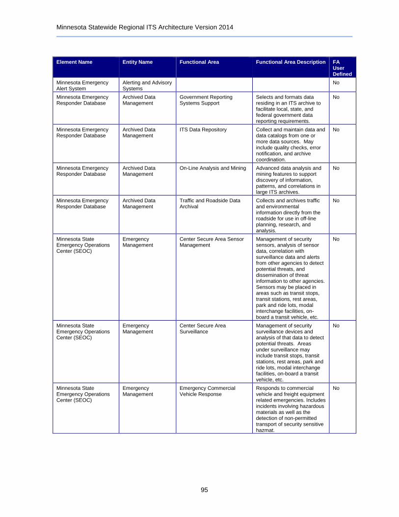
Minnesota Statewide Regional ITS Architecture Version 2014
95
Element Name Entity Name Functional Area Functional Area Description FA User Defined
Minnesota Emergency Alert System
Alerting and Advisory Systems
No
Minnesota Emergency Responder Database
Archived Data Management
Government Reporting Systems Support
Selects and formats data residing in an ITS archive to facilitate local, state, and federal government data reporting requirements.
No
Minnesota Emergency Responder Database
Archived Data Management
ITS Data Repository Collect and maintain data and data catalogs from one or more data sources. May include quality checks, error notification, and archive coordination.
No
Minnesota Emergency Responder Database
Archived Data Management
On-Line Analysis and Mining Advanced data analysis and mining features to support discovery of information, patterns, and correlations in large ITS archives.
No
Minnesota Emergency Responder Database
Archived Data Management
Traffic and Roadside Data Archival
Collects and archives traffic and environmental information directly from the roadside for use in off-line planning, research, and analysis.
No
Minnesota State Emergency Operations Center (SEOC)
Emergency Management
Center Secure Area Sensor Management
Management of security sensors, analysis of sensor data, correlation with surveillance data and alerts from other agencies to detect potential threats, and dissemination of threat information to other agencies. Sensors may be placed in areas such as transit stops, transit stations, rest areas, park and ride lots, modal interchange facilities, on-board a transit vehicle, etc.
No
Minnesota State Emergency Operations Center (SEOC)
Emergency Management
Center Secure Area Surveillance
Management of security surveillance devices and analysis of that data to detect potential threats. Areas under surveillance may include transit stops, transit stations, rest areas, park and ride lots, modal interchange facilities, on-board a transit vehicle, etc.
No
Minnesota State Emergency Operations Center (SEOC)
Emergency Management
Emergency Commercial Vehicle Response
Responds to commercial vehicle and freight equipment related emergencies. Includes incidents involving hazardous materials as well as the detection of non-permitted transport of security sensitive hazmat.
No
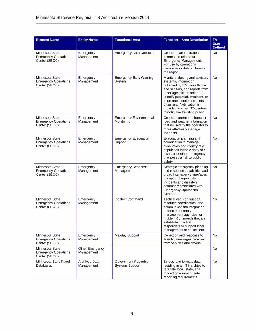
Minnesota Statewide Regional ITS Architecture Version 2014
96
Element Name Entity Name Functional Area Functional Area Description FA User Defined
Minnesota State Emergency Operations Center (SEOC)
Emergency Management
Emergency Data Collection Collection and storage of information related to Emergency Management. For use by operations personnel or data archives in the region.
No
Minnesota State Emergency Operations Center (SEOC)
Emergency Management
Emergency Early Warning System
Monitors alerting and advisory systems, information collected by ITS surveillance and sensors, and reports from other agencies in order to identify potential, imminent, or in-progress major incidents or disasters. Notification is provided to other ITS centers to notify the traveling public.
No
Minnesota State Emergency Operations Center (SEOC)
Emergency Management
Emergency Environmental Monitoring
Collects current and forecast road and weather information that is used by the operator to more effectively manage incidents.
No
Minnesota State Emergency Operations Center (SEOC)
Emergency Management
Emergency Evacuation Support
Evacuation planning and coordination to manage evacuation and reentry of a population in the vicinity of a disaster or other emergency that poses a risk to public safety.
No
Minnesota State Emergency Operations Center (SEOC)
Emergency Management
Emergency Response Management
Strategic emergency planning and response capabilities and broad inter-agency interfaces to support large-scale incidents and disasters, commonly associated with Emergency Operations Centers.
No
Minnesota State Emergency Operations Center (SEOC)
Emergency Management
Incident Command Tactical decision support, resource coordination, and communications integration among emergency management agencies for Incident Commands that are established by first responders to support local management of an incident.
No
Minnesota State Emergency Operations Center (SEOC)
Emergency Management
Mayday Support Collection and response to Mayday messages received from vehicles and drivers.
No
Minnesota State Emergency Operations Center (SEOC)
Other Emergency Management
No
Minnesota State Patrol Databases
Archived Data Management
Government Reporting Systems Support
Selects and formats data residing in an ITS archive to facilitate local, state, and federal government data reporting requirements.
No

Minnesota Statewide Regional ITS Architecture Version 2014
97
Element Name Entity Name Functional Area Functional Area Description FA User Defined
Minnesota State Patrol Databases
Archived Data Management
ITS Data Repository Collect and maintain data and data catalogs from one or more data sources. May include quality checks, error notification, and archive coordination.
No
Minnesota State Patrol Databases
Archived Data Management
On-Line Analysis and Mining Advanced data analysis and mining features to support discovery of information, patterns, and correlations in large ITS archives.
No
Minnesota State Patrol Databases
Archived Data Management
Traffic and Roadside Data Archival
Collects and archives traffic and environmental information directly from the roadside for use in off-line planning, research, and analysis.
No
Minnesota State Patrol District Office
Emergency Management
Center Secure Area Sensor Management
Management of security sensors, analysis of sensor data, correlation with surveillance data and alerts from other agencies to detect potential threats, and dissemination of threat information to other agencies. Sensors may be placed in areas such as transit stops, transit stations, rest areas, park and ride lots, modal interchange facilities, on-board a transit vehicle, etc.
No
Minnesota State Patrol District Office
Emergency Management
Center Secure Area Surveillance
Management of security surveillance devices and analysis of that data to detect potential threats. Areas under surveillance may include transit stops, transit stations, rest areas, park and ride lots, modal interchange facilities, on-board a transit vehicle, etc.
No
Minnesota State Patrol District Office
Emergency Management
Emergency Call-Taking Provides interface to the emergency call-taking systems such as the Emergency Telecommunications System (e.g., 911) that correlate call information with emergencies reported by transit agencies, commercial vehicle operators, or other public safety agencies. Allows the operator to verify the incident and forward the information to the responding agencies.
No

Minnesota Statewide Regional ITS Architecture Version 2014
98
Element Name Entity Name Functional Area Functional Area Description FA User Defined
Minnesota State Patrol District Office
Emergency Management
Emergency Commercial Vehicle Response
Responds to commercial vehicle and freight equipment related emergencies. Includes incidents involving hazardous materials as well as the detection of non-permitted transport of security sensitive hazmat.
No
Minnesota State Patrol District Office
Emergency Management
Emergency Data Collection Collection and storage of information related to Emergency Management. For use by operations personnel or data archives in the region.
No
Minnesota State Patrol District Office
Emergency Management
Emergency Dispatch Dispatch emergency vehicles to incidents, tracking their location and status. Pertinent incident information is gathered and relayed to the responding units.
No
Minnesota State Patrol District Office
Emergency Management
Emergency Early Warning System
Monitors alerting and advisory systems, information collected by ITS surveillance and sensors, and reports from other agencies in order to identify potential, imminent, or in-progress major incidents or disasters. Notification is provided to other ITS centers to notify the traveling public.
No
Minnesota State Patrol District Office
Emergency Management
Emergency Environmental Monitoring
Collects current and forecast road and weather information that is used by the operator to more effectively manage incidents.
No
Minnesota State Patrol District Office
Emergency Management
Emergency Evacuation Support
Evacuation planning and coordination to manage evacuation and reentry of a population in the vicinity of a disaster or other emergency that poses a risk to public safety.
No
Minnesota State Patrol District Office
Emergency Management
Emergency Response Management
Strategic emergency planning and response capabilities and broad inter-agency interfaces to support large-scale incidents and disasters, commonly associated with Emergency Operations Centers.
No
Minnesota State Patrol District Office
Emergency Management
Emergency Transportation Operations Data Collection
Collects real-time information on the state of the regional transportation system for operational use by the center. It establishes communications with a regional repository, requests or subscribes to information relevant to the center, and distributes the received information for use.
No
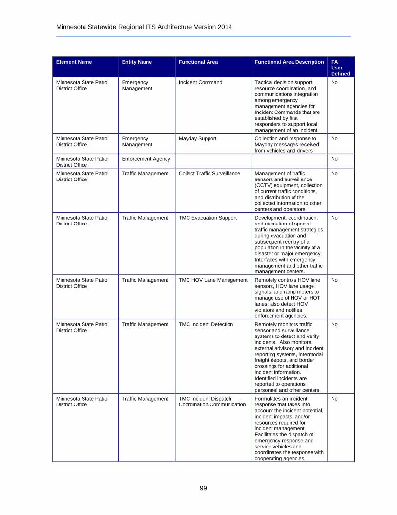
Minnesota Statewide Regional ITS Architecture Version 2014
99
Element Name Entity Name Functional Area Functional Area Description FA User Defined
Minnesota State Patrol District Office
Emergency Management
Incident Command Tactical decision support, resource coordination, and communications integration among emergency management agencies for Incident Commands that are established by first responders to support local management of an incident.
No
Minnesota State Patrol District Office
Emergency Management
Mayday Support Collection and response to Mayday messages received from vehicles and drivers.
No
Minnesota State Patrol District Office
Enforcement Agency No
Minnesota State Patrol District Office
Traffic Management Collect Traffic Surveillance Management of traffic sensors and surveillance (CCTV) equipment, collection of current traffic conditions, and distribution of the collected information to other centers and operators.
No
Minnesota State Patrol District Office
Traffic Management TMC Evacuation Support Development, coordination, and execution of special traffic management strategies during evacuation and subsequent reentry of a population in the vicinity of a disaster or major emergency. Interfaces with emergency management and other traffic management centers.
No
Minnesota State Patrol District Office
Traffic Management TMC HOV Lane Management Remotely controls HOV lane sensors, HOV lane usage signals, and ramp meters to manage use of HOV or HOT lanes; also detect HOV violators and notifies enforcement agencies.
No
Minnesota State Patrol District Office
Traffic Management TMC Incident Detection Remotely monitors traffic sensor and surveillance systems to detect and verify incidents. Also monitors external advisory and incident reporting systems, intermodal freight depots, and border crossings for additional incident information. Identified incidents are reported to operations personnel and other centers.
No
Minnesota State Patrol District Office
Traffic Management TMC Incident Dispatch Coordination/Communication
Formulates an incident response that takes into account the incident potential, incident impacts, and/or resources required for incident management. Facilitates the dispatch of emergency response and service vehicles and coordinates the response with cooperating agencies.
No
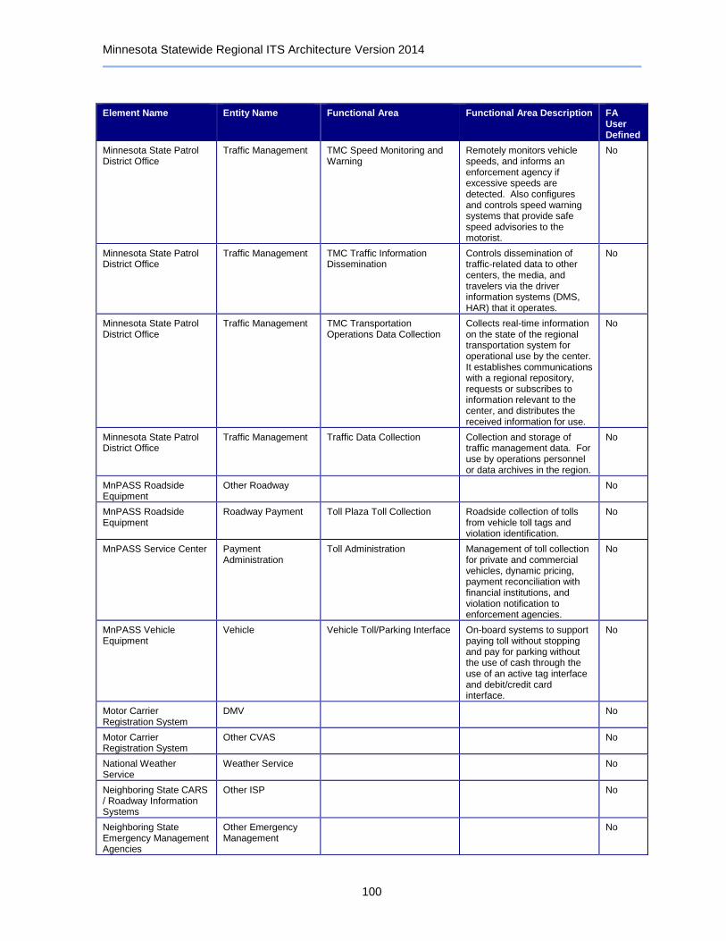
Minnesota Statewide Regional ITS Architecture Version 2014
100
Element Name Entity Name Functional Area Functional Area Description FA User Defined
Minnesota State Patrol District Office
Traffic Management TMC Speed Monitoring and Warning
Remotely monitors vehicle speeds, and informs an enforcement agency if excessive speeds are detected. Also configures and controls speed warning systems that provide safe speed advisories to the motorist.
No
Minnesota State Patrol District Office
Traffic Management TMC Traffic Information Dissemination
Controls dissemination of traffic-related data to other centers, the media, and travelers via the driver information systems (DMS, HAR) that it operates.
No
Minnesota State Patrol District Office
Traffic Management TMC Transportation Operations Data Collection
Collects real-time information on the state of the regional transportation system for operational use by the center. It establishes communications with a regional repository, requests or subscribes to information relevant to the center, and distributes the received information for use.
No
Minnesota State Patrol District Office
Traffic Management Traffic Data Collection Collection and storage of traffic management data. For use by operations personnel or data archives in the region.
No
MnPASS Roadside Equipment
Other Roadway No
MnPASS Roadside Equipment
Roadway Payment Toll Plaza Toll Collection Roadside collection of tolls from vehicle toll tags and violation identification.
No
MnPASS Service Center Payment Administration
Toll Administration Management of toll collection for private and commercial vehicles, dynamic pricing, payment reconciliation with financial institutions, and violation notification to enforcement agencies.
No
MnPASS Vehicle Equipment
Vehicle Vehicle Toll/Parking Interface On-board systems to support paying toll without stopping and pay for parking without the use of cash through the use of an active tag interface and debit/credit card interface.
No
Motor Carrier Registration System
DMV No
Motor Carrier Registration System
Other CVAS No
National Weather Service
Weather Service No
Neighboring State CARS / Roadway Information Systems
Other ISP No
Neighboring State Emergency Management Agencies
Other Emergency Management
No
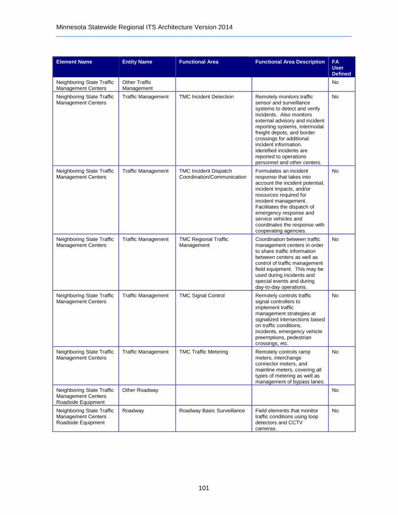
Minnesota Statewide Regional ITS Architecture Version 2014
101
Element Name Entity Name Functional Area Functional Area Description FA User Defined
Neighboring State Traffic Management Centers
Other Traffic Management
No
Neighboring State Traffic Management Centers
Traffic Management TMC Incident Detection Remotely monitors traffic sensor and surveillance systems to detect and verify incidents. Also monitors external advisory and incident reporting systems, intermodal freight depots, and border crossings for additional incident information. Identified incidents are reported to operations personnel and other centers.
No
Neighboring State Traffic Management Centers
Traffic Management TMC Incident Dispatch Coordination/Communication
Formulates an incident response that takes into account the incident potential, incident impacts, and/or resources required for incident management. Facilitates the dispatch of emergency response and service vehicles and coordinates the response with cooperating agencies.
No
Neighboring State Traffic Management Centers
Traffic Management TMC Regional Traffic Management
Coordination between traffic management centers in order to share traffic information between centers as well as control of traffic management field equipment. This may be used during incidents and special events and during day-to-day operations.
No
Neighboring State Traffic Management Centers
Traffic Management TMC Signal Control Remotely controls traffic signal controllers to implement traffic management strategies at signalized intersections based on traffic conditions, incidents, emergency vehicle preemptions, pedestrian crossings, etc.
No
Neighboring State Traffic Management Centers
Traffic Management TMC Traffic Metering Remotely controls ramp meters, interchange connector meters, and mainline meters, covering all types of metering as well as management of bypass lanes.
No
Neighboring State Traffic Management Centers Roadside Equipment
Other Roadway No
Neighboring State Traffic Management Centers Roadside Equipment
Roadway Roadway Basic Surveillance Field elements that monitor traffic conditions using loop detectors and CCTV cameras.
No

Minnesota Statewide Regional ITS Architecture Version 2014
102
Element Name Entity Name Functional Area Functional Area Description FA User Defined
Neighboring State Traffic Management Centers Roadside Equipment
Roadway Roadway Equipment Coordination
Field elements that control and send data to other field elements (such as environmental sensors that send data to a DMS or coordination between traffic controllers on adjacent intersections), without center control.
No
Neighboring State Traffic Management Centers Roadside Equipment
Roadway Roadway Incident Detection Field elements that monitor traffic conditions to identify incidents. It includes traffic detectors that collect traffic flow information and identify unusual traffic conditions and advanced CCTV cameras with built-in incident detection algorithms.
No
Neighboring State Traffic Management Centers Roadside Equipment
Roadway Roadway Traffic Information Dissemination
Driver information systems, such as dynamic message signs and Highway Advisory Radio (HAR).
No
North/West Passage Corridor Traveler Information Website
Information Service Provider
Basic Information Broadcast Broadcast dissemination of traffic, transit, maintenance and construction, event, and weather information to traveler interface systems and vehicles.
No
North/West Passage Corridor Traveler Information Website
Information Service Provider
ISP Traveler Data Collection Collects traveler information from other centers, consolidates and refines the collected data, and makes this data available to traveler information applications.
No
Oversize Warning Roadside Equipment
Roadway Roadway Equipment Coordination
Field elements that control and send data to other field elements (such as environmental sensors that send data to a DMS or coordination between traffic controllers on adjacent intersections), without center control.
No
Oversize Warning Roadside Equipment
Roadway Roadway Speed Monitoring and Warning
Vehicle speed sensors that detect excessive vehicle speeds, optionally based on conditions and vehicle type, informing drivers, centers and/or enforcement agencies of speed violations.
No
Park-and-Ride Parking Information System Roadside Equipment
Parking Management Parking Electronic Payment Parking payment collection using in-vehicle equipment (tags) or contact or proximity traveler cards used for electronic payment. Includes field elements and back-office functionality.
No

Minnesota Statewide Regional ITS Architecture Version 2014
103
Element Name Entity Name Functional Area Functional Area Description FA User Defined
Park-and-Ride Parking Information System Roadside Equipment
Parking Management Parking Management Monitor vehicles and current parking availability within parking facilities. Use driver information systems (e.g., DMS) to provide parking availability and other parking facility information to drivers. Support local traffic control coordination around the parking facility.
No
Parking Management Roadside Equipment
Parking Management Parking Electronic Payment Parking payment collection using in-vehicle equipment (tags) or contact or proximity traveler cards used for electronic payment. Includes field elements and back-office functionality.
No
Parking Management Roadside Equipment
Parking Management Parking Management Monitor vehicles and current parking availability within parking facilities. Use driver information systems (e.g., DMS) to provide parking availability and other parking facility information to drivers. Support local traffic control coordination around the parking facility.
No
Parking Management System
Parking Management Parking Electronic Payment Parking payment collection using in-vehicle equipment (tags) or contact or proximity traveler cards used for electronic payment. Includes field elements and back-office functionality.
No
Parking Management System
Parking Management Parking Management Monitor vehicles and current parking availability within parking facilities. Use driver information systems (e.g., DMS) to provide parking availability and other parking facility information to drivers. Support local traffic control coordination around the parking facility.
No
Parking Operator Parking Operator No
PRISM Other CVAS No
Private Fleet and Freight Management Center
Fleet and Freight Management
Commercial Vehicle and Freight Security
Coordinated response for commercial vehicle and freight security incidents. Remote monitoring of commercial vehicle driver and freight equipment to vehicle assignments as well as detection of breaches or tampering.
No

Minnesota Statewide Regional ITS Architecture Version 2014
104
Element Name Entity Name Functional Area Functional Area Description FA User Defined
Private Fleet and Freight Management Center
Fleet and Freight Management
Fleet Administration Commercial vehicle fleet tracking, dispatch, and reporting - includes interfaces to state/federal commercial vehicle administration, toll administration, emergency management, and traveler information service providers. Supports pre-hiring checks and performance monitoring for drivers.
No
Private Fleet and Freight Management Center
Fleet and Freight Management
Fleet Credentials and Taxes Management and Reporting
Commercial vehicle fleet support systems for the purchase and filing of electronic credentials, status reporting, tax audit data, and compliance reviews. Electronic interfaces with the appropriate state or federal commercial vehicle administration centers.
No
Private Fleet and Freight Management Center
Fleet and Freight Management
Fleet HAZMAT Management Notification of hazardous materials (HAZMAT) shipments to emergency management centers for commercial vehicles managed by the center - includes information on the nature of the cargo, the vehicle, and its expected route.
No
Private Fleet and Freight Management Center
Fleet and Freight Management
Fleet Maintenance Management
Commercial vehicle fleet tracking and monitoring of on-board data sent to the center to support scheduling of maintenance and repair activities.
No
Private Fleet and Freight Management Center
Fleet and Freight Management
Freight Administration and Management
Management of the movement of cargo from source to destination via links to intermodal freight shippers, government agencies, and depots as well as links out to the freight equipment.
No
Private Information Service Providers
Information Service Provider
Infrastructure Provided Trip Planning
Generation of pre-trip and enroute trip plans for travelers (and vehicles) based on current traffic conditions, work zones, weather, and travelers constraints and preferences. Includes end-to-end trips using multiple modes, such as bicycle, transit, etc.
No
Private Information Service Providers
Information Service Provider
ISP Traveler Data Collection Collects traveler information from other centers, consolidates and refines the collected data, and makes this data available to traveler information applications.
No
Queue Detection Roadside Equipment
Other Roadway No

Minnesota Statewide Regional ITS Architecture Version 2014
105
Element Name Entity Name Functional Area Functional Area Description FA User Defined
Queue Detection Roadside Equipment
Roadway Roadway Basic Surveillance Field elements that monitor traffic conditions using loop detectors and CCTV cameras.
No
Queue Detection Roadside Equipment
Roadway Roadway Equipment Coordination
Field elements that control and send data to other field elements (such as environmental sensors that send data to a DMS or coordination between traffic controllers on adjacent intersections), without center control.
No
Queue Detection Roadside Equipment
Roadway Roadway Warning Field elements used to warn drivers approaching hazards including adverse road weather conditions, traffic conditions including queues, and obstacles or animals in the road.
No
Railroad Active Warning Roadside Equipment
Roadway Standard Rail Crossing Field elements at highway-rail intersections (HRIs) where operational requirements do not dictate advanced features (e.g., where rail operational speeds are less than 80 miles per hour). Includes traditional HRI warning systems augmented with other standard traffic management devices.
No
Railroad Wayside Equipment
Wayside Equipment No
Ramp Meter Roadside Equipment
Roadway Roadway Basic Surveillance Field elements that monitor traffic conditions using loop detectors and CCTV cameras.
No
Ramp Meter Roadside Equipment
Roadway Roadway Equipment Coordination
Field elements that control and send data to other field elements (such as environmental sensors that send data to a DMS or coordination between traffic controllers on adjacent intersections), without center control.
No
Ramp Meter Roadside Equipment
Roadway Roadway Traffic Information Dissemination
Driver information systems, such as dynamic message signs and Highway Advisory Radio (HAR).
No
Ramp Meter Roadside Equipment
Roadway Roadway Traffic Metering Control equipment including ramp, interchange, and mainline meters and the dynamic message signs that provide information about the meters and any special bypass lanes.
No
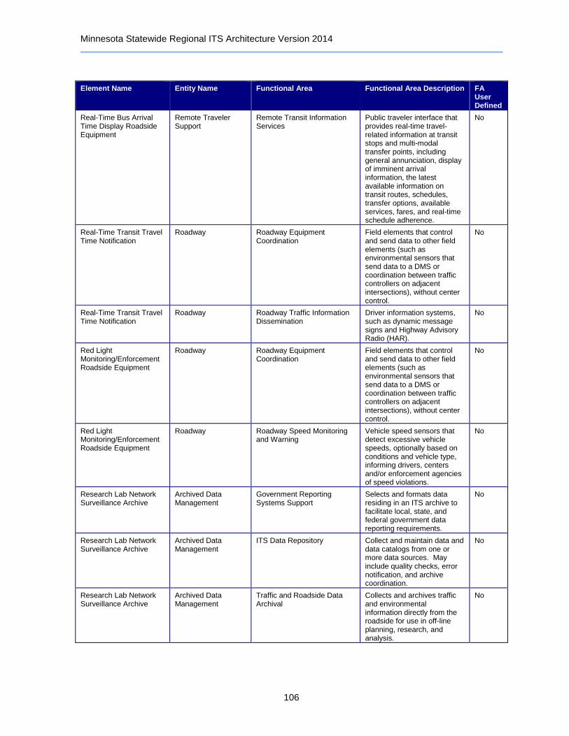
Minnesota Statewide Regional ITS Architecture Version 2014
106
Element Name Entity Name Functional Area Functional Area Description FA User Defined
Real-Time Bus Arrival Time Display Roadside Equipment
Remote Traveler Support
Remote Transit Information Services
Public traveler interface that provides real-time travel-related information at transit stops and multi-modal transfer points, including general annunciation, display of imminent arrival information, the latest available information on transit routes, schedules, transfer options, available services, fares, and real-time schedule adherence.
No
Real-Time Transit Travel Time Notification
Roadway Roadway Equipment Coordination
Field elements that control and send data to other field elements (such as environmental sensors that send data to a DMS or coordination between traffic controllers on adjacent intersections), without center control.
No
Real-Time Transit Travel Time Notification
Roadway Roadway Traffic Information Dissemination
Driver information systems, such as dynamic message signs and Highway Advisory Radio (HAR).
No
Red Light Monitoring/Enforcement Roadside Equipment
Roadway Roadway Equipment Coordination
Field elements that control and send data to other field elements (such as environmental sensors that send data to a DMS or coordination between traffic controllers on adjacent intersections), without center control.
No
Red Light Monitoring/Enforcement Roadside Equipment
Roadway Roadway Speed Monitoring and Warning
Vehicle speed sensors that detect excessive vehicle speeds, optionally based on conditions and vehicle type, informing drivers, centers and/or enforcement agencies of speed violations.
No
Research Lab Network Surveillance Archive
Archived Data Management
Government Reporting Systems Support
Selects and formats data residing in an ITS archive to facilitate local, state, and federal government data reporting requirements.
No
Research Lab Network Surveillance Archive
Archived Data Management
ITS Data Repository Collect and maintain data and data catalogs from one or more data sources. May include quality checks, error notification, and archive coordination.
No
Research Lab Network Surveillance Archive
Archived Data Management
Traffic and Roadside Data Archival
Collects and archives traffic and environmental information directly from the roadside for use in off-line planning, research, and analysis.
No

Minnesota Statewide Regional ITS Architecture Version 2014
107
Element Name Entity Name Functional Area Functional Area Description FA User Defined
Research Lab Network Surveillance Roadside Equipment
Roadway Roadway Basic Surveillance Field elements that monitor traffic conditions using loop detectors and CCTV cameras.
No
Research Lab Network Surveillance Roadside Equipment
Roadway Roadway Equipment Coordination
Field elements that control and send data to other field elements (such as environmental sensors that send data to a DMS or coordination between traffic controllers on adjacent intersections), without center control.
No
Research Lab New Surveillance Control System
Traffic Management Collect Traffic Surveillance Management of traffic sensors and surveillance (CCTV) equipment, collection of current traffic conditions, and distribution of the collected information to other centers and operators.
No
Research Lab New Surveillance Control System
Traffic Management Traffic Data Collection Collection and storage of traffic management data. For use by operations personnel or data archives in the region.
No
Research Lab New Surveillance Control System
Traffic Management Traffic Equipment Maintenance
Monitoring and remote diagnostics of field equipment - detect failures, issue problem reports, and track the repair or replacement of the failed equipment.
No
Rest Area Wi-Fi Information Service Provider
Basic Information Broadcast Broadcast dissemination of traffic, transit, maintenance and construction, event, and weather information to traveler interface systems and vehicles.
No
Rest Area Wi-Fi Information Service Provider
ISP Emergency Traveler Information
Distribution of emergency information to the traveling public, including evacuation information and wide-area alerts.
No
Rest Area Wi-Fi Information Service Provider
ISP Traveler Data Collection Collects traveler information from other centers, consolidates and refines the collected data, and makes this data available to traveler information applications.
No
Rest Area Wi-Fi Information Service Provider
Traveler Telephone Information
Distribution of traveler information and wide-area alerts to traveler telephone information systems such as 511, based on voice-based traveler requests.
No
Roadway Automated Treatment System
Roadway Roadway Automated Treatment
Field elements that activate automated roadway treatment systems (to disperse anti-icing chemicals, etc.) based on environmental or atmospheric conditions, or under center control.
No
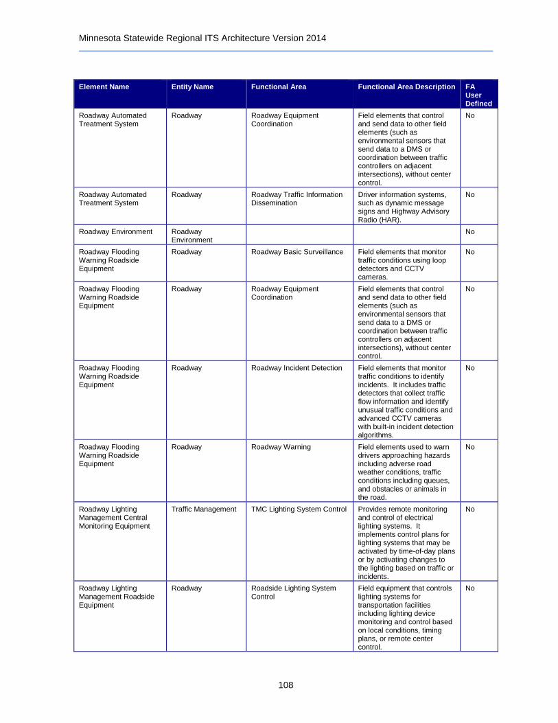
Minnesota Statewide Regional ITS Architecture Version 2014
108
Element Name Entity Name Functional Area Functional Area Description FA User Defined
Roadway Automated Treatment System
Roadway Roadway Equipment Coordination
Field elements that control and send data to other field elements (such as environmental sensors that send data to a DMS or coordination between traffic controllers on adjacent intersections), without center control.
No
Roadway Automated Treatment System
Roadway Roadway Traffic Information Dissemination
Driver information systems, such as dynamic message signs and Highway Advisory Radio (HAR).
No
Roadway Environment Roadway Environment
No
Roadway Flooding Warning Roadside Equipment
Roadway Roadway Basic Surveillance Field elements that monitor traffic conditions using loop detectors and CCTV cameras.
No
Roadway Flooding Warning Roadside Equipment
Roadway Roadway Equipment Coordination
Field elements that control and send data to other field elements (such as environmental sensors that send data to a DMS or coordination between traffic controllers on adjacent intersections), without center control.
No
Roadway Flooding Warning Roadside Equipment
Roadway Roadway Incident Detection Field elements that monitor traffic conditions to identify incidents. It includes traffic detectors that collect traffic flow information and identify unusual traffic conditions and advanced CCTV cameras with built-in incident detection algorithms.
No
Roadway Flooding Warning Roadside Equipment
Roadway Roadway Warning Field elements used to warn drivers approaching hazards including adverse road weather conditions, traffic conditions including queues, and obstacles or animals in the road.
No
Roadway Lighting Management Central Monitoring Equipment
Traffic Management TMC Lighting System Control Provides remote monitoring and control of electrical lighting systems. It implements control plans for lighting systems that may be activated by time-of-day plans or by activating changes to the lighting based on traffic or incidents.
No
Roadway Lighting Management Roadside Equipment
Roadway Roadside Lighting System Control
Field equipment that controls lighting systems for transportation facilities including lighting device monitoring and control based on local conditions, timing plans, or remote center control.
No
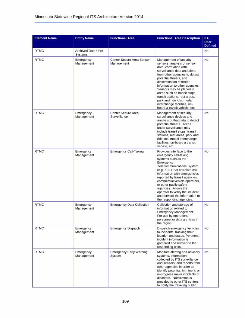
Minnesota Statewide Regional ITS Architecture Version 2014
109
Element Name Entity Name Functional Area Functional Area Description FA User Defined
RTMC Archived Data User Systems
No
RTMC Emergency Management
Center Secure Area Sensor Management
Management of security sensors, analysis of sensor data, correlation with surveillance data and alerts from other agencies to detect potential threats, and dissemination of threat information to other agencies. Sensors may be placed in areas such as transit stops, transit stations, rest areas, park and ride lots, modal interchange facilities, on-board a transit vehicle, etc.
No
RTMC Emergency Management
Center Secure Area Surveillance
Management of security surveillance devices and analysis of that data to detect potential threats. Areas under surveillance may include transit stops, transit stations, rest areas, park and ride lots, modal interchange facilities, on-board a transit vehicle, etc.
No
RTMC Emergency Management
Emergency Call-Taking Provides interface to the emergency call-taking systems such as the Emergency Telecommunications System (e.g., 911) that correlate call information with emergencies reported by transit agencies, commercial vehicle operators, or other public safety agencies. Allows the operator to verify the incident and forward the information to the responding agencies.
No
RTMC Emergency Management
Emergency Data Collection Collection and storage of information related to Emergency Management. For use by operations personnel or data archives in the region.
No
RTMC Emergency Management
Emergency Dispatch Dispatch emergency vehicles to incidents, tracking their location and status. Pertinent incident information is gathered and relayed to the responding units.
No
RTMC Emergency Management
Emergency Early Warning System
Monitors alerting and advisory systems, information collected by ITS surveillance and sensors, and reports from other agencies in order to identify potential, imminent, or in-progress major incidents or disasters. Notification is provided to other ITS centers to notify the traveling public.
No

Minnesota Statewide Regional ITS Architecture Version 2014
110
Element Name Entity Name Functional Area Functional Area Description FA User Defined
RTMC Emergency Management
Emergency Environmental Monitoring
Collects current and forecast road and weather information that is used by the operator to more effectively manage incidents.
No
RTMC Emergency Management
Emergency Evacuation Support
Evacuation planning and coordination to manage evacuation and reentry of a population in the vicinity of a disaster or other emergency that poses a risk to public safety.
No
RTMC Emergency Management
Emergency Response Management
Strategic emergency planning and response capabilities and broad inter-agency interfaces to support large-scale incidents and disasters, commonly associated with Emergency Operations Centers.
No
RTMC Emergency Management
Emergency Routing Routing of emergency vehicles to facilitate the quickest/safest arrival. Routes may be determined based on real-time traffic information and road conditions or routes may be provided by Traffic Management on request.
No
RTMC Emergency Management
Emergency Transportation Operations Data Collection
Collects real-time information on the state of the regional transportation system for operational use by the center. It establishes communications with a regional repository, requests or subscribes to information relevant to the center, and distributes the received information for use.
No
RTMC Emergency Management
Incident Command Tactical decision support, resource coordination, and communications integration among emergency management agencies for Incident Commands that are established by first responders to support local management of an incident.
No
RTMC Emergency Management
Service Patrol Management Dispatch and communication with roadway service patrol vehicles that monitor roads to aid motorists, offering rapid response to minor incidents.
No
RTMC Maintenance and Construction Management
MCM Automated Treatment System Control
Remotely controls automated roadway treatment systems (to disperse anti-icing chemicals, etc.) directly, or via control of the environmental sensors that activate the treatment systems automatically in the field.
No
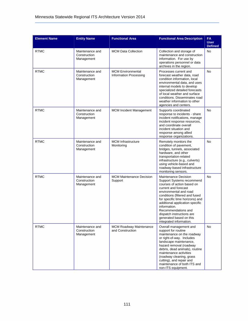
Minnesota Statewide Regional ITS Architecture Version 2014
111
Element Name Entity Name Functional Area Functional Area Description FA User Defined
RTMC Maintenance and Construction Management
MCM Data Collection Collection and storage of maintenance and construction information. For use by operations personnel or data archives in the region.
No
RTMC Maintenance and Construction Management
MCM Environmental Information Processing
Processes current and forecast weather data, road condition information, local environmental data, and uses internal models to develop specialized detailed forecasts of local weather and surface conditions. Disseminates road weather information to other agencies and centers.
No
RTMC Maintenance and Construction Management
MCM Incident Management Supports coordinated response to incidents - share incident notifications, manage incident response resources, and coordinate overall incident situation and response among allied response organizations.
No
RTMC Maintenance and Construction Management
MCM Infrastructure Monitoring
Remotely monitors the condition of pavement, bridges, tunnels, associated hardware, and other transportation-related infrastructure (e.g., culverts) using vehicle-based and roadway-based infrastructure monitoring sensors.
No
RTMC Maintenance and Construction Management
MCM Maintenance Decision Support
Maintenance Decision Support Systems recommend courses of action based on current and forecast environmental and road conditions (filtered and fused for specific time horizons) and additional application specific information. Recommendations and dispatch instructions are generated based on this integrated information.
No
RTMC Maintenance and Construction Management
MCM Roadway Maintenance and Construction
Overall management and support for routine maintenance on the roadway or right-of-way. Includes landscape maintenance, hazard removal (roadway debris, dead animals), routine maintenance activities (roadway cleaning, grass cutting), and repair and maintenance of both ITS and non-ITS equipment.
No
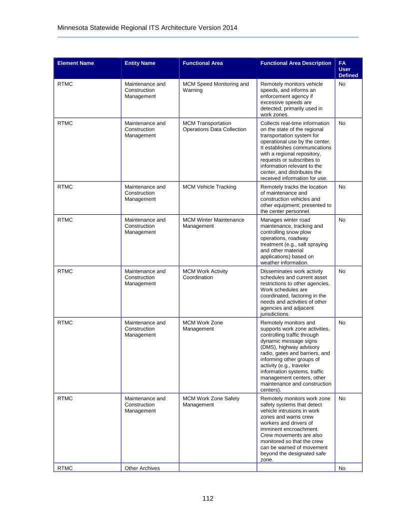
Minnesota Statewide Regional ITS Architecture Version 2014
112
Element Name Entity Name Functional Area Functional Area Description FA User Defined
RTMC Maintenance and Construction Management
MCM Speed Monitoring and Warning
Remotely monitors vehicle speeds, and informs an enforcement agency if excessive speeds are detected; primarily used in work zones.
No
RTMC Maintenance and Construction Management
MCM Transportation Operations Data Collection
Collects real-time information on the state of the regional transportation system for operational use by the center. It establishes communications with a regional repository, requests or subscribes to information relevant to the center, and distributes the received information for use.
No
RTMC Maintenance and Construction Management
MCM Vehicle Tracking Remotely tracks the location of maintenance and construction vehicles and other equipment; presented to the center personnel.
No
RTMC Maintenance and Construction Management
MCM Winter Maintenance Management
Manages winter road maintenance, tracking and controlling snow plow operations, roadway treatment (e.g., salt spraying and other material applications) based on weather information.
No
RTMC Maintenance and Construction Management
MCM Work Activity Coordination
Disseminates work activity schedules and current asset restrictions to other agencies. Work schedules are coordinated, factoring in the needs and activities of other agencies and adjacent jurisdictions.
No
RTMC Maintenance and Construction Management
MCM Work Zone Management
Remotely monitors and supports work zone activities, controlling traffic through dynamic message signs (DMS), highway advisory radio, gates and barriers, and informing other groups of activity (e.g., traveler information systems, traffic management centers, other maintenance and construction centers).
No
RTMC Maintenance and Construction Management
MCM Work Zone Safety Management
Remotely monitors work zone safety systems that detect vehicle intrusions in work zones and warns crew workers and drivers of imminent encroachment. Crew movements are also monitored so that the crew can be warned of movement beyond the designated safe zone.
No
RTMC Other Archives No

Minnesota Statewide Regional ITS Architecture Version 2014
113
Element Name Entity Name Functional Area Functional Area Description FA User Defined
RTMC Other Emergency Management
No
RTMC Traffic Management Barrier System Management Remotely controls barrier systems such as gates and other systems that manage entry to roadways, transportation facilities and infrastructure.
No
RTMC Traffic Management Collect Traffic Surveillance Management of traffic sensors and surveillance (CCTV) equipment, collection of current traffic conditions, and distribution of the collected information to other centers and operators.
No
RTMC Traffic Management Safeguard System Management
Remotely controls safeguard systems such as blast shields and tunnel exhaust systems that are used to mitigate the impact of incidents on transportation infrastructure.
No
RTMC Traffic Management TMC Dynamic Lane Management and Shoulder Use
Remotely monitors and controls dynamically managed travel lanes, including temporary use of shoulders. It monitors conditions and determines and manages lane configuration changes. Includes intersection reconfiguration, special designated lanes, temporary shoulder use, and lane use restrictions.
No
RTMC Traffic Management TMC Environmental Monitoring
Management of environmental sensors and assimilation of collected data with other current and forecast road conditions and surface weather information from weather service providers and roadway maintenance operations.
No
RTMC Traffic Management TMC Evacuation Support Development, coordination, and execution of special traffic management strategies during evacuation and subsequent reentry of a population in the vicinity of a disaster or major emergency. Interfaces with emergency management and other traffic management centers.
No
RTMC Traffic Management TMC HOV Lane Management Remotely controls HOV lane sensors, HOV lane usage signals, and ramp meters to manage use of HOV or HOT lanes; also detect HOV violators and notifies enforcement agencies.
No
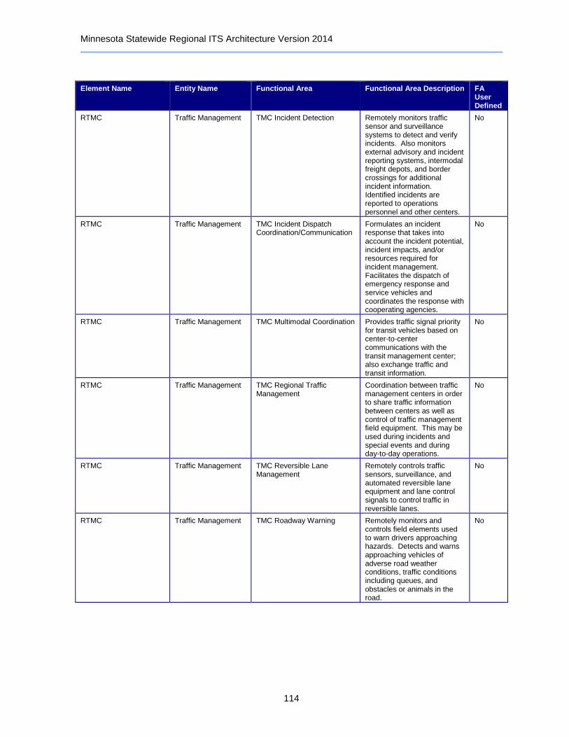
Minnesota Statewide Regional ITS Architecture Version 2014
114
Element Name Entity Name Functional Area Functional Area Description FA User Defined
RTMC Traffic Management TMC Incident Detection Remotely monitors traffic sensor and surveillance systems to detect and verify incidents. Also monitors external advisory and incident reporting systems, intermodal freight depots, and border crossings for additional incident information. Identified incidents are reported to operations personnel and other centers.
No
RTMC Traffic Management TMC Incident Dispatch Coordination/Communication
Formulates an incident response that takes into account the incident potential, incident impacts, and/or resources required for incident management. Facilitates the dispatch of emergency response and service vehicles and coordinates the response with cooperating agencies.
No
RTMC Traffic Management TMC Multimodal Coordination Provides traffic signal priority for transit vehicles based on center-to-center communications with the transit management center; also exchange traffic and transit information.
No
RTMC Traffic Management TMC Regional Traffic Management
Coordination between traffic management centers in order to share traffic information between centers as well as control of traffic management field equipment. This may be used during incidents and special events and during day-to-day operations.
No
RTMC Traffic Management TMC Reversible Lane Management
Remotely controls traffic sensors, surveillance, and automated reversible lane equipment and lane control signals to control traffic in reversible lanes.
No
RTMC Traffic Management TMC Roadway Warning Remotely monitors and controls field elements used to warn drivers approaching hazards. Detects and warns approaching vehicles of adverse road weather conditions, traffic conditions including queues, and obstacles or animals in the road.
No
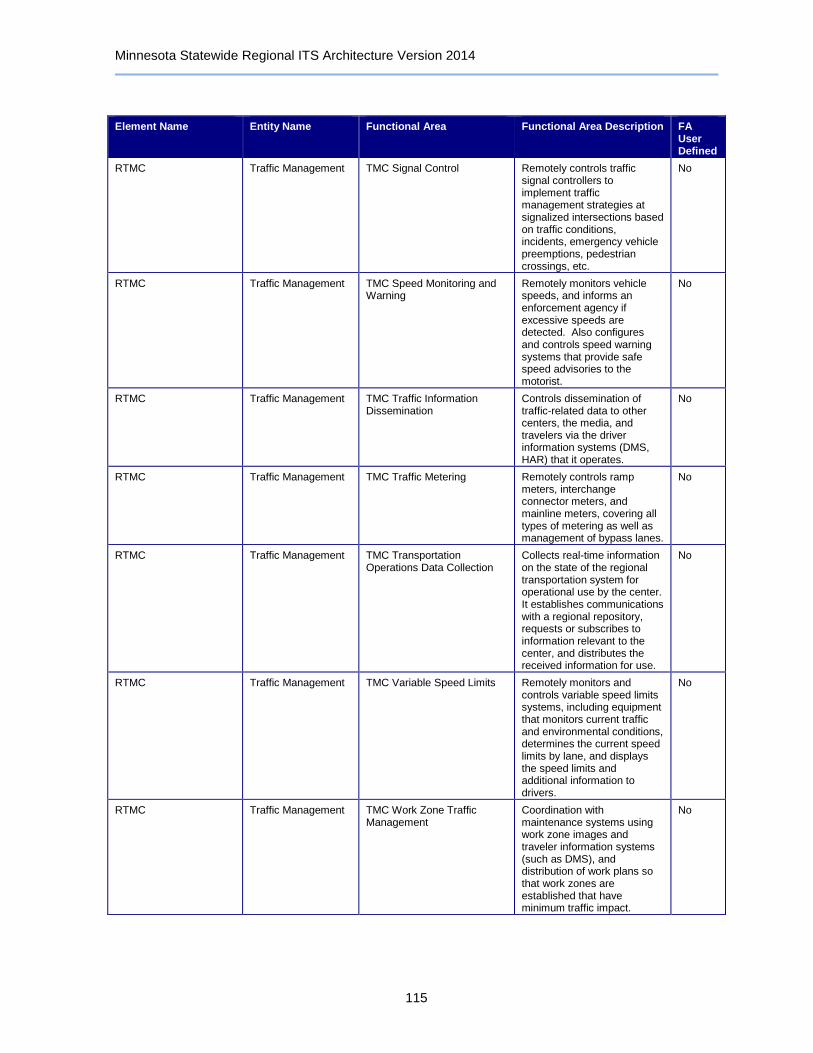
Minnesota Statewide Regional ITS Architecture Version 2014
115
Element Name Entity Name Functional Area Functional Area Description FA User Defined
RTMC Traffic Management TMC Signal Control Remotely controls traffic signal controllers to implement traffic management strategies at signalized intersections based on traffic conditions, incidents, emergency vehicle preemptions, pedestrian crossings, etc.
No
RTMC Traffic Management TMC Speed Monitoring and Warning
Remotely monitors vehicle speeds, and informs an enforcement agency if excessive speeds are detected. Also configures and controls speed warning systems that provide safe speed advisories to the motorist.
No
RTMC Traffic Management TMC Traffic Information Dissemination
Controls dissemination of traffic-related data to other centers, the media, and travelers via the driver information systems (DMS, HAR) that it operates.
No
RTMC Traffic Management TMC Traffic Metering Remotely controls ramp meters, interchange connector meters, and mainline meters, covering all types of metering as well as management of bypass lanes.
No
RTMC Traffic Management TMC Transportation Operations Data Collection
Collects real-time information on the state of the regional transportation system for operational use by the center. It establishes communications with a regional repository, requests or subscribes to information relevant to the center, and distributes the received information for use.
No
RTMC Traffic Management TMC Variable Speed Limits Remotely monitors and controls variable speed limits systems, including equipment that monitors current traffic and environmental conditions, determines the current speed limits by lane, and displays the speed limits and additional information to drivers.
No
RTMC Traffic Management TMC Work Zone Traffic Management
Coordination with maintenance systems using work zone images and traveler information systems (such as DMS), and distribution of work plans so that work zones are established that have minimum traffic impact.
No

Minnesota Statewide Regional ITS Architecture Version 2014
116
Element Name Entity Name Functional Area Functional Area Description FA User Defined
RTMC Traffic Management Traffic Data Collection Collection and storage of traffic management data. For use by operations personnel or data archives in the region.
No
RTMC Traffic Management Traffic Equipment Maintenance
Monitoring and remote diagnostics of field equipment - detect failures, issue problem reports, and track the repair or replacement of the failed equipment.
No
RWIS Central Control System
Information Service Provider
ISP Data Collection Collection and storage of information supporting the operations of traveler information service providers. For use by operations personnel or data archives in the region.
No
RWIS Central Control System
Information Service Provider
ISP Traveler Data Collection Collects traveler information from other centers, consolidates and refines the collected data, and makes this data available to traveler information applications.
No
RWIS Central Control System
Maintenance and Construction Management
MCM Data Collection Collection and storage of maintenance and construction information. For use by operations personnel or data archives in the region.
No
RWIS Central Control System
Maintenance and Construction Management
MCM Environmental Information Collection
Remotely controls environmental sensors and assimilates collected data with environmental probe data and other current and forecast road conditions and surface weather information from weather service providers and transportation operations.
No
RWIS Central Control System
Maintenance and Construction Management
MCM Environmental Information Processing
Processes current and forecast weather data, road condition information, local environmental data, and uses internal models to develop specialized detailed forecasts of local weather and surface conditions. Disseminates road weather information to other agencies and centers.
No
RWIS Central Control System
Other Archives No
RWIS Central Control System
Weather Service No
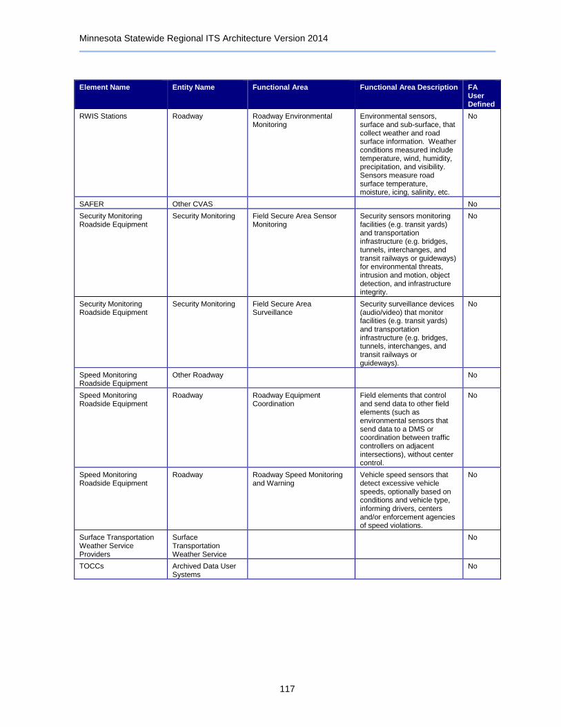
Minnesota Statewide Regional ITS Architecture Version 2014
117
Element Name Entity Name Functional Area Functional Area Description FA User Defined
RWIS Stations Roadway Roadway Environmental Monitoring
Environmental sensors, surface and sub-surface, that collect weather and road surface information. Weather conditions measured include temperature, wind, humidity, precipitation, and visibility. Sensors measure road surface temperature, moisture, icing, salinity, etc.
No
SAFER Other CVAS No
Security Monitoring Roadside Equipment
Security Monitoring Field Secure Area Sensor Monitoring
Security sensors monitoring facilities (e.g. transit yards) and transportation infrastructure (e.g. bridges, tunnels, interchanges, and transit railways or guideways) for environmental threats, intrusion and motion, object detection, and infrastructure integrity.
No
Security Monitoring Roadside Equipment
Security Monitoring Field Secure Area Surveillance
Security surveillance devices (audio/video) that monitor facilities (e.g. transit yards) and transportation infrastructure (e.g. bridges, tunnels, interchanges, and transit railways or guideways).
No
Speed Monitoring Roadside Equipment
Other Roadway No
Speed Monitoring Roadside Equipment
Roadway Roadway Equipment Coordination
Field elements that control and send data to other field elements (such as environmental sensors that send data to a DMS or coordination between traffic controllers on adjacent intersections), without center control.
No
Speed Monitoring Roadside Equipment
Roadway Roadway Speed Monitoring and Warning
Vehicle speed sensors that detect excessive vehicle speeds, optionally based on conditions and vehicle type, informing drivers, centers and/or enforcement agencies of speed violations.
No
Surface Transportation Weather Service Providers
Surface Transportation Weather Service
No
TOCCs Archived Data User Systems
No

Minnesota Statewide Regional ITS Architecture Version 2014
118
Element Name Entity Name Functional Area Functional Area Description FA User Defined
TOCCs Emergency Management
Center Secure Area Sensor Management
Management of security sensors, analysis of sensor data, correlation with surveillance data and alerts from other agencies to detect potential threats, and dissemination of threat information to other agencies. Sensors may be placed in areas such as transit stops, transit stations, rest areas, park and ride lots, modal interchange facilities, on-board a transit vehicle, etc.
No
TOCCs Emergency Management
Center Secure Area Surveillance
Management of security surveillance devices and analysis of that data to detect potential threats. Areas under surveillance may include transit stops, transit stations, rest areas, park and ride lots, modal interchange facilities, on-board a transit vehicle, etc.
No
TOCCs Emergency Management
Emergency Call-Taking Provides interface to the emergency call-taking systems such as the Emergency Telecommunications System (e.g., 911) that correlate call information with emergencies reported by transit agencies, commercial vehicle operators, or other public safety agencies. Allows the operator to verify the incident and forward the information to the responding agencies.
No
TOCCs Emergency Management
Emergency Data Collection Collection and storage of information related to Emergency Management. For use by operations personnel or data archives in the region.
No
TOCCs Emergency Management
Emergency Dispatch Dispatch emergency vehicles to incidents, tracking their location and status. Pertinent incident information is gathered and relayed to the responding units.
No
TOCCs Emergency Management
Emergency Early Warning System
Monitors alerting and advisory systems, information collected by ITS surveillance and sensors, and reports from other agencies in order to identify potential, imminent, or in-progress major incidents or disasters. Notification is provided to other ITS centers to notify the traveling public.
No
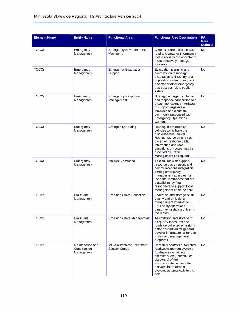
Minnesota Statewide Regional ITS Architecture Version 2014
119
Element Name Entity Name Functional Area Functional Area Description FA User Defined
TOCCs Emergency Management
Emergency Environmental Monitoring
Collects current and forecast road and weather information that is used by the operator to more effectively manage incidents.
No
TOCCs Emergency Management
Emergency Evacuation Support
Evacuation planning and coordination to manage evacuation and reentry of a population in the vicinity of a disaster or other emergency that poses a risk to public safety.
No
TOCCs Emergency Management
Emergency Response Management
Strategic emergency planning and response capabilities and broad inter-agency interfaces to support large-scale incidents and disasters, commonly associated with Emergency Operations Centers.
No
TOCCs Emergency Management
Emergency Routing Routing of emergency vehicles to facilitate the quickest/safest arrival. Routes may be determined based on real-time traffic information and road conditions or routes may be provided by Traffic Management on request.
No
TOCCs Emergency Management
Incident Command Tactical decision support, resource coordination, and communications integration among emergency management agencies for Incident Commands that are established by first responders to support local management of an incident.
No
TOCCs Emissions Management
Emissions Data Collection Collection and storage of air quality and emissions management information. For use by operations personnel or data archives in the region.
No
TOCCs Emissions Management
Emissions Data Management Assimilation and storage of air quality measures and roadside collected emissions data; distribution for general traveler information or for use in demand management programs.
No
TOCCs Maintenance and Construction Management
MCM Automated Treatment System Control
Remotely controls automated roadway treatment systems (to disperse anti-icing chemicals, etc.) directly, or via control of the environmental sensors that activate the treatment systems automatically in the field.
No

Minnesota Statewide Regional ITS Architecture Version 2014
120
Element Name Entity Name Functional Area Functional Area Description FA User Defined
TOCCs Maintenance and Construction Management
MCM Data Collection Collection and storage of maintenance and construction information. For use by operations personnel or data archives in the region.
No
TOCCs Maintenance and Construction Management
MCM Environmental Information Collection
Remotely controls environmental sensors and assimilates collected data with environmental probe data and other current and forecast road conditions and surface weather information from weather service providers and transportation operations.
No
TOCCs Maintenance and Construction Management
MCM Environmental Information Processing
Processes current and forecast weather data, road condition information, local environmental data, and uses internal models to develop specialized detailed forecasts of local weather and surface conditions. Disseminates road weather information to other agencies and centers.
No
TOCCs Maintenance and Construction Management
MCM Incident Management Supports coordinated response to incidents - share incident notifications, manage incident response resources, and coordinate overall incident situation and response among allied response organizations.
No
TOCCs Maintenance and Construction Management
MCM Infrastructure Monitoring
Remotely monitors the condition of pavement, bridges, tunnels, associated hardware, and other transportation-related infrastructure (e.g., culverts) using vehicle-based and roadway-based infrastructure monitoring sensors.
No
TOCCs Maintenance and Construction Management
MCM Maintenance Decision Support
Maintenance Decision Support Systems recommend courses of action based on current and forecast environmental and road conditions (filtered and fused for specific time horizons) and additional application specific information. Recommendations and dispatch instructions are generated based on this integrated information.
No

Minnesota Statewide Regional ITS Architecture Version 2014
121
Element Name Entity Name Functional Area Functional Area Description FA User Defined
TOCCs Maintenance and Construction Management
MCM Roadway Maintenance and Construction
Overall management and support for routine maintenance on the roadway or right-of-way. Includes landscape maintenance, hazard removal (roadway debris, dead animals), routine maintenance activities (roadway cleaning, grass cutting), and repair and maintenance of both ITS and non-ITS equipment.
No
TOCCs Maintenance and Construction Management
MCM Speed Monitoring and Warning
Remotely monitors vehicle speeds, and informs an enforcement agency if excessive speeds are detected; primarily used in work zones.
No
TOCCs Maintenance and Construction Management
MCM Vehicle Tracking Remotely tracks the location of maintenance and construction vehicles and other equipment; presented to the center personnel.
No
TOCCs Maintenance and Construction Management
MCM Winter Maintenance Management
Manages winter road maintenance, tracking and controlling snow plow operations, roadway treatment (e.g., salt spraying and other material applications) based on weather information.
No
TOCCs Maintenance and Construction Management
MCM Work Activity Coordination
Disseminates work activity schedules and current asset restrictions to other agencies. Work schedules are coordinated, factoring in the needs and activities of other agencies and adjacent jurisdictions.
No
TOCCs Maintenance and Construction Management
MCM Work Zone Management
Remotely monitors and supports work zone activities, controlling traffic through dynamic message signs (DMS), highway advisory radio, gates and barriers, and informing other groups of activity (e.g., traveler information systems, traffic management centers, other maintenance and construction centers).
No
TOCCs Other Archives No
TOCCs Other Traffic Management
No
TOCCs Traffic Management Barrier System Management Remotely controls barrier systems such as gates and other systems that manage entry to roadways, transportation facilities and infrastructure.
No
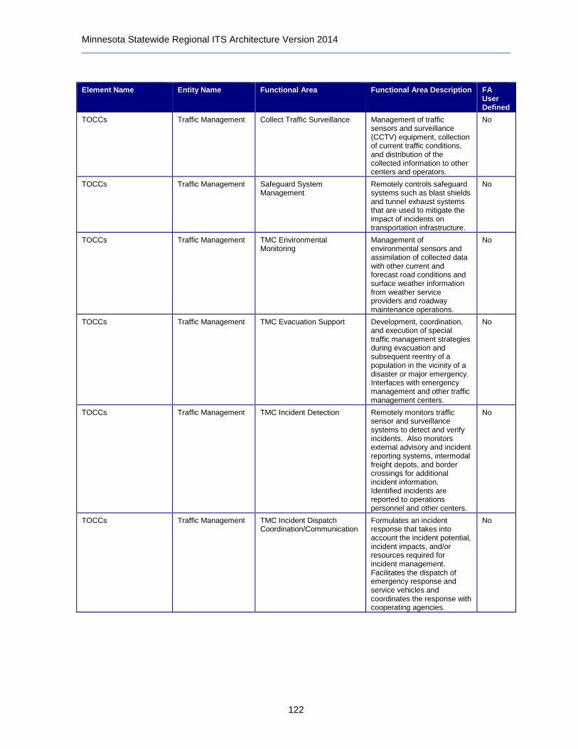
Minnesota Statewide Regional ITS Architecture Version 2014
122
Element Name Entity Name Functional Area Functional Area Description FA User Defined
TOCCs Traffic Management Collect Traffic Surveillance Management of traffic sensors and surveillance (CCTV) equipment, collection of current traffic conditions, and distribution of the collected information to other centers and operators.
No
TOCCs Traffic Management Safeguard System Management
Remotely controls safeguard systems such as blast shields and tunnel exhaust systems that are used to mitigate the impact of incidents on transportation infrastructure.
No
TOCCs Traffic Management TMC Environmental Monitoring
Management of environmental sensors and assimilation of collected data with other current and forecast road conditions and surface weather information from weather service providers and roadway maintenance operations.
No
TOCCs Traffic Management TMC Evacuation Support Development, coordination, and execution of special traffic management strategies during evacuation and subsequent reentry of a population in the vicinity of a disaster or major emergency. Interfaces with emergency management and other traffic management centers.
No
TOCCs Traffic Management TMC Incident Detection Remotely monitors traffic sensor and surveillance systems to detect and verify incidents. Also monitors external advisory and incident reporting systems, intermodal freight depots, and border crossings for additional incident information. Identified incidents are reported to operations personnel and other centers.
No
TOCCs Traffic Management TMC Incident Dispatch Coordination/Communication
Formulates an incident response that takes into account the incident potential, incident impacts, and/or resources required for incident management. Facilitates the dispatch of emergency response and service vehicles and coordinates the response with cooperating agencies.
No

Minnesota Statewide Regional ITS Architecture Version 2014
123
Element Name Entity Name Functional Area Functional Area Description FA User Defined
TOCCs Traffic Management TMC Regional Traffic Management
Coordination between traffic management centers in order to share traffic information between centers as well as control of traffic management field equipment. This may be used during incidents and special events and during day-to-day operations.
No
TOCCs Traffic Management TMC Roadway Warning Remotely monitors and controls field elements used to warn drivers approaching hazards. Detects and warns approaching vehicles of adverse road weather conditions, traffic conditions including queues, and obstacles or animals in the road.
No
TOCCs Traffic Management TMC Signal Control Remotely controls traffic signal controllers to implement traffic management strategies at signalized intersections based on traffic conditions, incidents, emergency vehicle preemptions, pedestrian crossings, etc.
No
TOCCs Traffic Management TMC Speed Monitoring and Warning
Remotely monitors vehicle speeds, and informs an enforcement agency if excessive speeds are detected. Also configures and controls speed warning systems that provide safe speed advisories to the motorist.
No
TOCCs Traffic Management TMC Traffic Information Dissemination
Controls dissemination of traffic-related data to other centers, the media, and travelers via the driver information systems (DMS, HAR) that it operates.
No
TOCCs Traffic Management TMC Traffic Metering Remotely controls ramp meters, interchange connector meters, and mainline meters, covering all types of metering as well as management of bypass lanes.
No
TOCCs Traffic Management TMC Variable Speed Limits Remotely monitors and controls variable speed limits systems, including equipment that monitors current traffic and environmental conditions, determines the current speed limits by lane, and displays the speed limits and additional information to drivers.
No
Minnesota Statewide Regional ITS Architecture Version 2014
124
Element Name Entity Name Functional Area Functional Area Description FA User Defined
TOCCs Traffic Management TMC Work Zone Traffic Management
Coordination with maintenance systems using work zone images and traveler information systems (such as DMS), and distribution of work plans so that work zones are established that have minimum traffic impact.
No
TOCCs Traffic Management Traffic Data Collection Collection and storage of traffic management data. For use by operations personnel or data archives in the region.
No
TOCCs Traffic Management Traffic Equipment Maintenance
Monitoring and remote diagnostics of field equipment - detect failures, issue problem reports, and track the repair or replacement of the failed equipment.
No
Traffic Traffic No
Traffic Data and Video Archive
Archived Data Management
Government Reporting Systems Support
Selects and formats data residing in an ITS archive to facilitate local, state, and federal government data reporting requirements.
No
Traffic Data and Video Archive
Archived Data Management
ITS Data Repository Collect and maintain data and data catalogs from one or more data sources. May include quality checks, error notification, and archive coordination.
No
Traffic Data and Video Archive
Archived Data Management
On-Line Analysis and Mining Advanced data analysis and mining features to support discovery of information, patterns, and correlations in large ITS archives.
No
Traffic Data and Video Archive
Archived Data Management
Traffic and Roadside Data Archival
Collects and archives traffic and environmental information directly from the roadside for use in off-line planning, research, and analysis.
No
Traffic Detector Roadside Equipment
Other Roadway No
Traffic Detector Roadside Equipment
Roadway Roadway Basic Surveillance Field elements that monitor traffic conditions using loop detectors and CCTV cameras.
No
Traffic Detector Roadside Equipment
Roadway Roadway Equipment Coordination
Field elements that control and send data to other field elements (such as environmental sensors that send data to a DMS or coordination between traffic controllers on adjacent intersections), without center control.
No
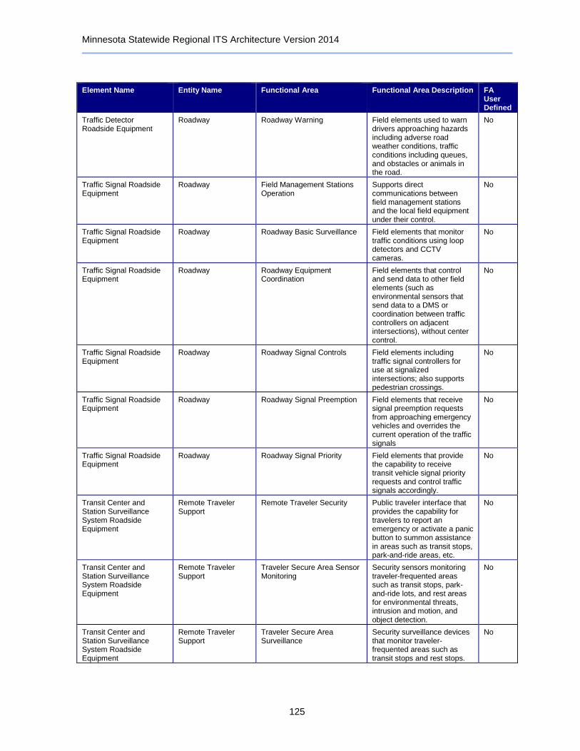
Minnesota Statewide Regional ITS Architecture Version 2014
125
Element Name Entity Name Functional Area Functional Area Description FA User Defined
Traffic Detector Roadside Equipment
Roadway Roadway Warning Field elements used to warn drivers approaching hazards including adverse road weather conditions, traffic conditions including queues, and obstacles or animals in the road.
No
Traffic Signal Roadside Equipment
Roadway Field Management Stations Operation
Supports direct communications between field management stations and the local field equipment under their control.
No
Traffic Signal Roadside Equipment
Roadway Roadway Basic Surveillance Field elements that monitor traffic conditions using loop detectors and CCTV cameras.
No
Traffic Signal Roadside Equipment
Roadway Roadway Equipment Coordination
Field elements that control and send data to other field elements (such as environmental sensors that send data to a DMS or coordination between traffic controllers on adjacent intersections), without center control.
No
Traffic Signal Roadside Equipment
Roadway Roadway Signal Controls Field elements including traffic signal controllers for use at signalized intersections; also supports pedestrian crossings.
No
Traffic Signal Roadside Equipment
Roadway Roadway Signal Preemption Field elements that receive signal preemption requests from approaching emergency vehicles and overrides the current operation of the traffic signals
No
Traffic Signal Roadside Equipment
Roadway Roadway Signal Priority Field elements that provide the capability to receive transit vehicle signal priority requests and control traffic signals accordingly.
No
Transit Center and Station Surveillance System Roadside Equipment
Remote Traveler Support
Remote Traveler Security Public traveler interface that provides the capability for travelers to report an emergency or activate a panic button to summon assistance in areas such as transit stops, park-and-ride areas, etc.
No
Transit Center and Station Surveillance System Roadside Equipment
Remote Traveler Support
Traveler Secure Area Sensor Monitoring
Security sensors monitoring traveler-frequented areas such as transit stops, park-and-ride lots, and rest areas for environmental threats, intrusion and motion, and object detection.
No
Transit Center and Station Surveillance System Roadside Equipment
Remote Traveler Support
Traveler Secure Area Surveillance
Security surveillance devices that monitor traveler-frequented areas such as transit stops and rest stops.
No

Minnesota Statewide Regional ITS Architecture Version 2014
126
Element Name Entity Name Functional Area Functional Area Description FA User Defined
Transit Data Archives Archived Data Management
Government Reporting Systems Support
Selects and formats data residing in an ITS archive to facilitate local, state, and federal government data reporting requirements.
No
Transit Data Archives Archived Data Management
ITS Data Repository Collect and maintain data and data catalogs from one or more data sources. May include quality checks, error notification, and archive coordination.
No
Transit Data Archives Archived Data Management
On-Line Analysis and Mining Advanced data analysis and mining features to support discovery of information, patterns, and correlations in large ITS archives.
No
Transit Data Archives Archived Data Management
Traffic and Roadside Data Archival
Collects and archives traffic and environmental information directly from the roadside for use in off-line planning, research, and analysis.
No
Transit Information Telephone Systems
Personal Information Access
Personal Interactive Information Reception
Personal traveler interface that provides traffic, transit, yellow pages, event, and trip planning information, and other personalized traveler information services upon request. Devices include personal computers and personal portable devices such as PDAs.
No
Transit Information Telephone Systems
Transit Management Transit Center Information Services
Provide interactive traveler information to travelers (on-board transit vehicles, at stops/stations, using personal devices), traveler information service providers, media, and other transit organizations. Includes routes, schedules, transfer options, fares, real-time schedule adherence, current incidents, weather conditions, yellow pages, and special events.
No
Transit Information Websites
Information Service Provider
Basic Information Broadcast Broadcast dissemination of traffic, transit, maintenance and construction, event, and weather information to traveler interface systems and vehicles.
No
Transit Information Websites
Information Service Provider
Infrastructure Provided Dynamic Ridesharing
Dynamic rideshare matching, including traveler eligibility, preference information, connections to transit or other multimodal services, confirmation, and payment of rideshare matching services.
No

Minnesota Statewide Regional ITS Architecture Version 2014
127
Element Name Entity Name Functional Area Functional Area Description FA User Defined
Transit Information Websites
Information Service Provider
Infrastructure Provided Trip Planning
Generation of pre-trip and enroute trip plans for travelers (and vehicles) based on current traffic conditions, work zones, weather, and travelers constraints and preferences. Includes end-to-end trips using multiple modes, such as bicycle, transit, etc.
No
Transit Information Websites
Information Service Provider
Interactive Infrastructure Information
Personalized dissemination of traffic, transit, maintenance and construction, multimodal, event, and weather information to traveler interface systems and vehicles, upon request.
No
Transit Information Websites
Information Service Provider
ISP Traveler Data Collection Collects traveler information from other centers, consolidates and refines the collected data, and makes this data available to traveler information applications.
No
Transit Information Websites
Information Service Provider
ISP Traveler Information Alerts
Provides personalized traveler information alerts, notifying travelers of relevant congestion, incidents, transit schedule delays. and other actionable information that may impact a trip. Relevant alerts are selected based on user-configurable parameters and thresholds.
No
Transit Information Websites
Information Service Provider
Traveler Telephone Information
Distribution of traveler information and wide-area alerts to traveler telephone information systems such as 511, based on voice-based traveler requests.
No
Transit Kiosks Remote Traveler Support
Remote Transit Fare Management
Public traveler interface, such as a kiosk, that provides the capability for the traveler to use a common fare medium for transit fares, tolls, and/or parking lot charges, to calculate the amount due and identify payment problems.
No
Transit Kiosks Remote Traveler Support
Remote Transit Information Services
Public traveler interface that provides real-time travel-related information at transit stops and multi-modal transfer points, including general annunciation, display of imminent arrival information, the latest available information on transit routes, schedules, transfer options, available services, fares, and real-time schedule adherence.
No

Minnesota Statewide Regional ITS Architecture Version 2014
128
Element Name Entity Name Functional Area Functional Area Description FA User Defined
Transit Vehicle Equipment
Transit Vehicle On-board Maintenance On-board systems to collect and process transit vehicle maintenance data including mileage and vehicle operating conditions for use in scheduling future vehicle maintenance.
No
Transit Vehicle Equipment
Transit Vehicle On-board Paratransit Operations
On-board systems to manage paratransit and flexible-route dispatch requests, including multi-stop runs. Passenger data is collected and provided to the center.
No
Transit Vehicle Equipment
Transit Vehicle On-board Passenger Counting
On-board systems collect transit vehicle loading data and make it available to the center.
No
Transit Vehicle Equipment
Transit Vehicle On-board Schedule Management
Collecting of data for schedule generation and adjustment on-board a transit vehicle. Supports communication between the vehicle, operator, and center.
No
Transit Vehicle Equipment
Transit Vehicle On-board Transit Fare Management
On-board systems provide fare collection using a travelers non-monetary fare medium. Collected fare data are made available to the center.
No
Transit Vehicle Equipment
Transit Vehicle On-board Transit Information Services
On-board systems to furnish next-stop annunciation as well as interactive travel-related information, including routes, schedules, transfer options, fares, real-time schedule adherence, current incidents, weather conditions, non-motorized transportation services, and special events.
No
Transit Vehicle Equipment
Transit Vehicle On-board Transit Security On-board video/audio surveillance systems, threat sensors, and object detection sensors to enhance security and safety on-board a transit vehicles. Also includes silent alarms activated by transit user or vehicle operator, operator authentication, and remote vehicle disabling.
No
Transit Vehicle Equipment
Transit Vehicle On-board Transit Signal Priority
On-board systems request signal priority through short range communication directly with traffic control equipment at the roadside (intersections, ramps, interchanges, etc.).
No
Transit Vehicle Equipment
Transit Vehicle On-board Transit Trip Monitoring
Support fleet management with automatic vehicle location (AVL) and automated mileage and fuel reporting and auditing.
No
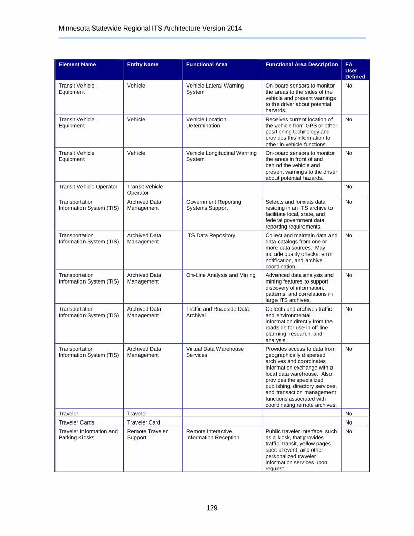
Minnesota Statewide Regional ITS Architecture Version 2014
129
Element Name Entity Name Functional Area Functional Area Description FA User Defined
Transit Vehicle Equipment
Vehicle Vehicle Lateral Warning System
On-board sensors to monitor the areas to the sides of the vehicle and present warnings to the driver about potential hazards.
No
Transit Vehicle Equipment
Vehicle Vehicle Location Determination
Receives current location of the vehicle from GPS or other positioning technology and provides this information to other in-vehicle functions.
No
Transit Vehicle Equipment
Vehicle Vehicle Longitudinal Warning System
On-board sensors to monitor the areas in front of and behind the vehicle and present warnings to the driver about potential hazards.
No
Transit Vehicle Operator Transit Vehicle Operator
No
Transportation Information System (TIS)
Archived Data Management
Government Reporting Systems Support
Selects and formats data residing in an ITS archive to facilitate local, state, and federal government data reporting requirements.
No
Transportation Information System (TIS)
Archived Data Management
ITS Data Repository Collect and maintain data and data catalogs from one or more data sources. May include quality checks, error notification, and archive coordination.
No
Transportation Information System (TIS)
Archived Data Management
On-Line Analysis and Mining Advanced data analysis and mining features to support discovery of information, patterns, and correlations in large ITS archives.
No
Transportation Information System (TIS)
Archived Data Management
Traffic and Roadside Data Archival
Collects and archives traffic and environmental information directly from the roadside for use in off-line planning, research, and analysis.
No
Transportation Information System (TIS)
Archived Data Management
Virtual Data Warehouse Services
Provides access to data from geographically dispersed archives and coordinates information exchange with a local data warehouse. Also provides the specialized publishing, directory services, and transaction management functions associated with coordinating remote archives.
No
Traveler Traveler No
Traveler Cards Traveler Card No
Traveler Information and Parking Kiosks
Remote Traveler Support
Remote Interactive Information Reception
Public traveler interface, such as a kiosk, that provides traffic, transit, yellow pages, special event, and other personalized traveler information services upon request.
No

Minnesota Statewide Regional ITS Architecture Version 2014
130
Element Name Entity Name Functional Area Functional Area Description FA User Defined
Truck Center Commercial Vehicle Administration
Credentials and Taxes Administration
Manage electronic filing of credentials, tax filing, and driver licensing for commercial vehicle operators. Provides commercial vehicle (including HAZMAT) route restrictions.
No
Truck Center Commercial Vehicle Administration
CV Information Exchange Exchange information concerning safety, credentialing, and operations of commercial vehicles between the center and the roadside check stations, across jurisdictions, with fleet operators and other information requestors.
No
Truck Center Information Service Provider
No
UMD Transportation Data Research Laboratory (TDRL)
Archived Data Management
Government Reporting Systems Support
Selects and formats data residing in an ITS archive to facilitate local, state, and federal government data reporting requirements.
No
UMD Transportation Data Research Laboratory (TDRL)
Archived Data Management
ITS Data Repository Collect and maintain data and data catalogs from one or more data sources. May include quality checks, error notification, and archive coordination.
No
UMD Transportation Data Research Laboratory (TDRL)
Archived Data Management
Traffic and Roadside Data Archival
Collects and archives traffic and environmental information directly from the roadside for use in off-line planning, research, and analysis.
No
UMD Transportation Data Research Laboratory (TDRL)
Information Service Provider
ISP Data Collection Collection and storage of information supporting the operations of traveler information service providers. For use by operations personnel or data archives in the region.
No
User Personal Portable and Computing Devices
Archived Data User Systems
No
User Personal Portable and Computing Devices
Personal Information Access
Personal Basic Information Reception
Personal traveler interface that provides formatted traffic advisories, transit, event, and other traveler information, as well as broadcast alerts. Devices include personal computers and personal portable devices such as PDAs and pagers.
No

Minnesota Statewide Regional ITS Architecture Version 2014
131
Element Name Entity Name Functional Area Functional Area Description FA User Defined
User Personal Portable and Computing Devices
Personal Information Access
Personal Interactive Information Reception
Personal traveler interface that provides traffic, transit, yellow pages, event, and trip planning information, and other personalized traveler information services upon request. Devices include personal computers and personal portable devices such as PDAs.
No
User Personal Portable and Computing Devices
Personal Information Access
Personal Location Determination
Provides current location of a personal device from GPS or similar technology and uses this information for navigation, guidance, and emergency notification systems.
No
User Personal Portable and Computing Devices
Personal Information Access
Personal Trip Planning and Route Guidance
Personal traveler interface that coordinates with a traveler information center to provide a trip plan that is tailored to the traveler's preferences. During the trip, the route plan can be modified to account for new information. Devices include desktop computers at home, work, or at major trip generation sites, plus personal portable devices such as PDAs and pagers.
No
Variable Speed Limit Roadside Equipment
Roadway Roadway Basic Surveillance Field elements that monitor traffic conditions using loop detectors and CCTV cameras.
No
Variable Speed Limit Roadside Equipment
Roadway Roadway Equipment Coordination
Field elements that control and send data to other field elements (such as environmental sensors that send data to a DMS or coordination between traffic controllers on adjacent intersections), without center control.
No
Variable Speed Limit Roadside Equipment
Roadway Roadway Traffic Information Dissemination
Driver information systems, such as dynamic message signs and Highway Advisory Radio (HAR).
No
Variable Speed Limit Roadside Equipment
Roadway Roadway Variable Speed Limits
Field elements including physical overhead lane signs and associated monitoring, communications, and control electronics that are used to manage and control variable speed limits systems.
No
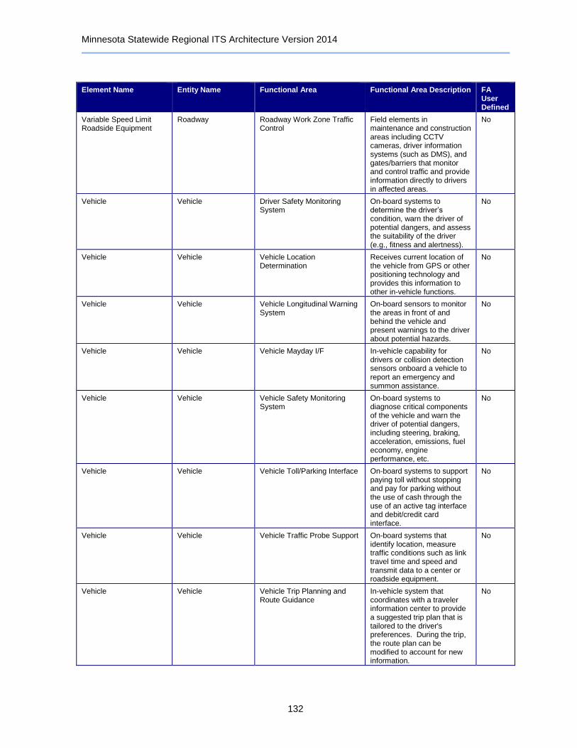
Minnesota Statewide Regional ITS Architecture Version 2014
132
Element Name Entity Name Functional Area Functional Area Description FA User Defined
Variable Speed Limit Roadside Equipment
Roadway Roadway Work Zone Traffic Control
Field elements in maintenance and construction areas including CCTV cameras, driver information systems (such as DMS), and gates/barriers that monitor and control traffic and provide information directly to drivers in affected areas.
No
Vehicle Vehicle Driver Safety Monitoring System
On-board systems to determine the driver’s condition, warn the driver of potential dangers, and assess the suitability of the driver (e.g., fitness and alertness).
No
Vehicle Vehicle Vehicle Location Determination
Receives current location of the vehicle from GPS or other positioning technology and provides this information to other in-vehicle functions.
No
Vehicle Vehicle Vehicle Longitudinal Warning System
On-board sensors to monitor the areas in front of and behind the vehicle and present warnings to the driver about potential hazards.
No
Vehicle Vehicle Vehicle Mayday I/F In-vehicle capability for drivers or collision detection sensors onboard a vehicle to report an emergency and summon assistance.
No
Vehicle Vehicle Vehicle Safety Monitoring System
On-board systems to diagnose critical components of the vehicle and warn the driver of potential dangers, including steering, braking, acceleration, emissions, fuel economy, engine performance, etc.
No
Vehicle Vehicle Vehicle Toll/Parking Interface On-board systems to support paying toll without stopping and pay for parking without the use of cash through the use of an active tag interface and debit/credit card interface.
No
Vehicle Vehicle Vehicle Traffic Probe Support On-board systems that identify location, measure traffic conditions such as link travel time and speed and transmit data to a center or roadside equipment.
No
Vehicle Vehicle Vehicle Trip Planning and Route Guidance
In-vehicle system that coordinates with a traveler information center to provide a suggested trip plan that is tailored to the driver's preferences. During the trip, the route plan can be modified to account for new information.
No
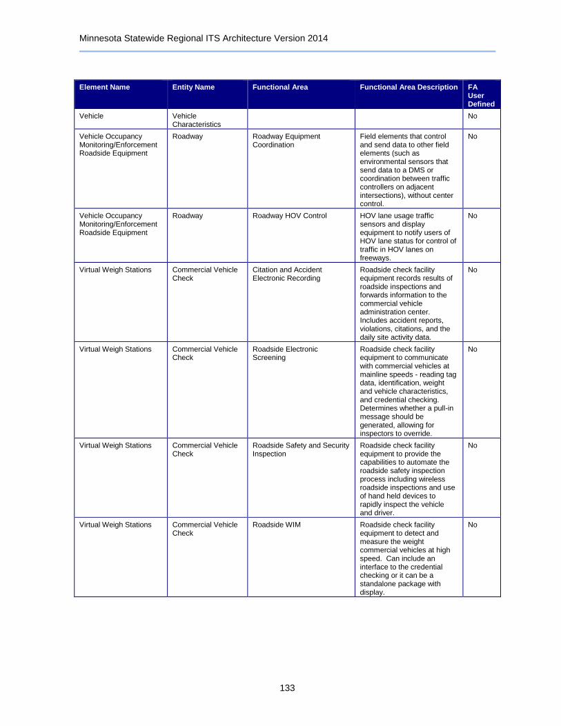
Minnesota Statewide Regional ITS Architecture Version 2014
133
Element Name Entity Name Functional Area Functional Area Description FA User Defined
Vehicle Vehicle Characteristics
No
Vehicle Occupancy Monitoring/Enforcement Roadside Equipment
Roadway Roadway Equipment Coordination
Field elements that control and send data to other field elements (such as environmental sensors that send data to a DMS or coordination between traffic controllers on adjacent intersections), without center control.
No
Vehicle Occupancy Monitoring/Enforcement Roadside Equipment
Roadway Roadway HOV Control HOV lane usage traffic sensors and display equipment to notify users of HOV lane status for control of traffic in HOV lanes on freeways.
No
Virtual Weigh Stations Commercial Vehicle Check
Citation and Accident Electronic Recording
Roadside check facility equipment records results of roadside inspections and forwards information to the commercial vehicle administration center. Includes accident reports, violations, citations, and the daily site activity data.
No
Virtual Weigh Stations Commercial Vehicle Check
Roadside Electronic Screening
Roadside check facility equipment to communicate with commercial vehicles at mainline speeds - reading tag data, identification, weight and vehicle characteristics, and credential checking. Determines whether a pull-in message should be generated, allowing for inspectors to override.
No
Virtual Weigh Stations Commercial Vehicle Check
Roadside Safety and Security Inspection
Roadside check facility equipment to provide the capabilities to automate the roadside safety inspection process including wireless roadside inspections and use of hand held devices to rapidly inspect the vehicle and driver.
No
Virtual Weigh Stations Commercial Vehicle Check
Roadside WIM Roadside check facility equipment to detect and measure the weight commercial vehicles at high speed. Can include an interface to the credential checking or it can be a standalone package with display.
No
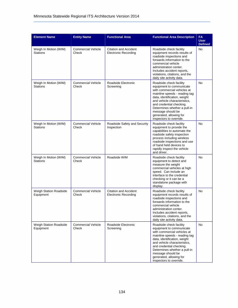
Minnesota Statewide Regional ITS Architecture Version 2014
134
Element Name Entity Name Functional Area Functional Area Description FA User Defined
Weigh In Motion (WIM) Stations
Commercial Vehicle Check
Citation and Accident Electronic Recording
Roadside check facility equipment records results of roadside inspections and forwards information to the commercial vehicle administration center. Includes accident reports, violations, citations, and the daily site activity data.
No
Weigh In Motion (WIM) Stations
Commercial Vehicle Check
Roadside Electronic Screening
Roadside check facility equipment to communicate with commercial vehicles at mainline speeds - reading tag data, identification, weight and vehicle characteristics, and credential checking. Determines whether a pull-in message should be generated, allowing for inspectors to override.
No
Weigh In Motion (WIM) Stations
Commercial Vehicle Check
Roadside Safety and Security Inspection
Roadside check facility equipment to provide the capabilities to automate the roadside safety inspection process including wireless roadside inspections and use of hand held devices to rapidly inspect the vehicle and driver.
No
Weigh In Motion (WIM) Stations
Commercial Vehicle Check
Roadside WIM Roadside check facility equipment to detect and measure the weight commercial vehicles at high speed. Can include an interface to the credential checking or it can be a standalone package with display.
No
Weigh Station Roadside Equipment
Commercial Vehicle Check
Citation and Accident Electronic Recording
Roadside check facility equipment records results of roadside inspections and forwards information to the commercial vehicle administration center. Includes accident reports, violations, citations, and the daily site activity data.
No
Weigh Station Roadside Equipment
Commercial Vehicle Check
Roadside Electronic Screening
Roadside check facility equipment to communicate with commercial vehicles at mainline speeds - reading tag data, identification, weight and vehicle characteristics, and credential checking. Determines whether a pull-in message should be generated, allowing for inspectors to override.
No

Minnesota Statewide Regional ITS Architecture Version 2014
135
9 Interfaces Between Systems
The interfaces of the transportation systems in Minnesota Statewide Regional ITS Architecture are based on the National ITS Architecture and tailored to reflect the plan for the region. Architecture diagrams display the transportation systems in the Minnesota Statewide Regional ITS Architecture, and more importantly, how these systems are and will be connected with one another so information can be exchanged and transportation services can be coordinated. Stakeholders may use these diagrams to identify integration opportunities. Each system in the region is represented with two types of diagrams, a context diagram and an architecture flow diagram.
A context diagram shows a particular system and all other systems with which it shares information. Interconnects are represented as single lines and indicate information sharing without specifying the type of information being shared or the direction of the information movement.
Following each interconnect context diagram are a series of architecture flow diagrams showing the information (i.e. architecture flows) movement between the various systems. Descriptions of the architecture flows are included at the end of the chapter.
Information about the interfaces of the systems in the region is contained in the Turbo Architecture™ database. Turbo Architecture™ can be used to create tailored interconnect and architecture flow diagrams for any system in the database.
Table 6: Information Flows
Source Element Destination Element Flow Name Flow Status
511 Telephone Information Service
Condition Acquisition and Reporting System (CARS)
emergency traveler information
Planned
511 Telephone Information Service
Condition Acquisition and Reporting System (CARS)
incident information Planned
511 Telephone Information Service
Condition Acquisition and Reporting System (CARS)
multimodal information
Planned
511 Telephone Information Service
Condition Acquisition and Reporting System (CARS)
parking information Planned
511 Telephone Information Service
Condition Acquisition and Reporting System (CARS)
road network conditions
Planned
511 Telephone Information Service
Condition Acquisition and Reporting System (CARS)
traffic images Planned
511 Telephone Information Service
Condition Acquisition and Reporting System (CARS)
transit service information
Planned
511 Telephone Information Service
Condition Acquisition and Reporting System (CARS)
voice-based traveler request
Existing
511 Telephone Information Service
User Personal Portable and Computing Devices
interactive traveler information
Existing
511 Traveler Information Website
Condition Acquisition and Reporting System (CARS)
emergency traveler information
Existing

Minnesota Statewide Regional ITS Architecture Version 2014
136
Source Element Destination Element Flow Name Flow Status
511 Traveler Information Website
Condition Acquisition and Reporting System (CARS)
incident information Existing
511 Traveler Information Website
Condition Acquisition and Reporting System (CARS)
multimodal information
Existing
511 Traveler Information Website
Condition Acquisition and Reporting System (CARS)
parking information Existing
511 Traveler Information Website
Condition Acquisition and Reporting System (CARS)
road network conditions
Existing
511 Traveler Information Website
Condition Acquisition and Reporting System (CARS)
traffic images Existing
511 Traveler Information Website
Condition Acquisition and Reporting System (CARS)
transit service information
Existing
511 Traveler Information Website
MnPASS Service Center toll data request Planned
511 Traveler Information Website
North/West Passage Corridor Traveler Information Website
emergency traveler information
Planned
511 Traveler Information Website
North/West Passage Corridor Traveler Information Website
incident information Planned
511 Traveler Information Website
North/West Passage Corridor Traveler Information Website
multimodal information
Planned
511 Traveler Information Website
North/West Passage Corridor Traveler Information Website
parking information Planned
511 Traveler Information Website
North/West Passage Corridor Traveler Information Website
road network conditions
Planned
511 Traveler Information Website
North/West Passage Corridor Traveler Information Website
traffic images Planned
511 Traveler Information Website
North/West Passage Corridor Traveler Information Website
transit service information
Planned
511 Traveler Information Website
Rest Area Wi-Fi broadcast traveler information
Planned
511 Traveler Information Website
Rest Area Wi-Fi emergency traveler information
Planned
511 Traveler Information Website
User Personal Portable and Computing Devices
broadcast traveler information
Existing
511 Traveler Information Website
User Personal Portable and Computing Devices
emergency traveler information
Existing
511 Traveler Information Website
User Personal Portable and Computing Devices
interactive traveler information
Existing
511 Traveler Information Website
User Personal Portable and Computing Devices
trip plan Planned
911 Dispatch Center Condition Acquisition and Reporting System (CARS)
incident information Planned
911 Dispatch Center County Emergency Operations Centers
incident response coordination
Existing
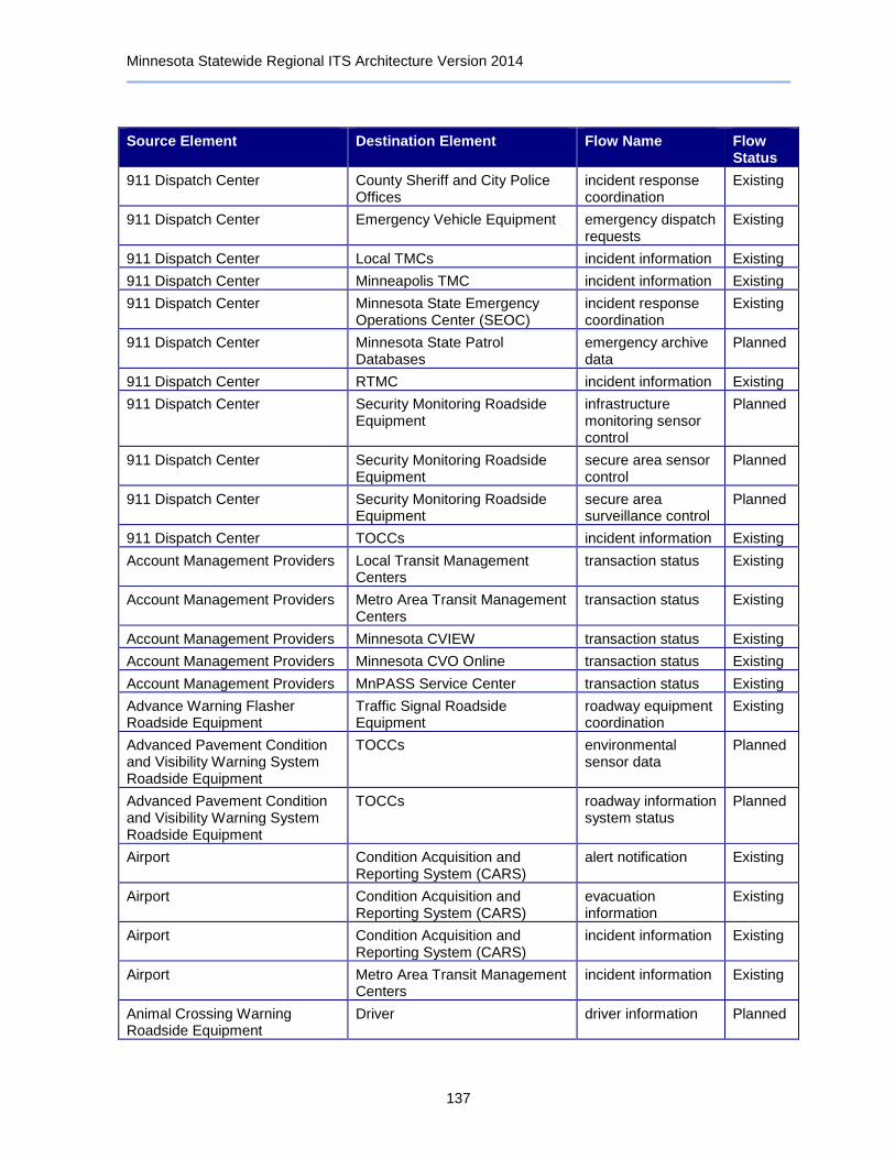
Minnesota Statewide Regional ITS Architecture Version 2014
137
Source Element Destination Element Flow Name Flow Status
911 Dispatch Center County Sheriff and City Police Offices
incident response coordination
Existing
911 Dispatch Center Emergency Vehicle Equipment emergency dispatch requests
Existing
911 Dispatch Center Local TMCs incident information Existing
911 Dispatch Center Minneapolis TMC incident information Existing
911 Dispatch Center Minnesota State Emergency Operations Center (SEOC)
incident response coordination
Existing
911 Dispatch Center Minnesota State Patrol Databases
emergency archive data
Planned
911 Dispatch Center RTMC incident information Existing
911 Dispatch Center Security Monitoring Roadside Equipment
infrastructure monitoring sensor control
Planned
911 Dispatch Center Security Monitoring Roadside Equipment
secure area sensor control
Planned
911 Dispatch Center Security Monitoring Roadside Equipment
secure area surveillance control
Planned
911 Dispatch Center TOCCs incident information Existing
Account Management Providers Local Transit Management Centers
transaction status Existing
Account Management Providers Metro Area Transit Management Centers
transaction status Existing
Account Management Providers Minnesota CVIEW transaction status Existing
Account Management Providers Minnesota CVO Online transaction status Existing
Account Management Providers MnPASS Service Center transaction status Existing
Advance Warning Flasher Roadside Equipment
Traffic Signal Roadside Equipment
roadway equipment coordination
Existing
Advanced Pavement Condition and Visibility Warning System Roadside Equipment
TOCCs environmental sensor data
Planned
Advanced Pavement Condition and Visibility Warning System Roadside Equipment
TOCCs roadway information system status
Planned
Airport Condition Acquisition and Reporting System (CARS)
alert notification Existing
Airport Condition Acquisition and Reporting System (CARS)
evacuation information
Existing
Airport Condition Acquisition and Reporting System (CARS)
incident information Existing
Airport Metro Area Transit Management Centers
incident information Existing
Animal Crossing Warning Roadside Equipment
Driver driver information Planned

Minnesota Statewide Regional ITS Architecture Version 2014
138
Source Element Destination Element Flow Name Flow Status
Automated Crash Notification System
911 Dispatch Center incident report Planned
Automated Crash Notification System
FIRST Emergency Vehicles emergency dispatch requests
Planned
Automated Crash Notification System
FIRST Emergency Vehicles suggested route Planned
Automated Crash Notification System
RTMC incident information Planned
Automated Crash Notification System
RTMC incident report Planned
Automated Crash Notification System
TOCCs incident information Planned
Automated Crash Notification System
Vehicle emergency acknowledge
Planned
Automated Crash Notification System
Vehicle emergency data request
Planned
Automated Permit Routing System
Condition Acquisition and Reporting System (CARS)
emergency traveler information
Planned
Automated Permit Routing System
Condition Acquisition and Reporting System (CARS)
incident information Planned
Automated Permit Routing System
Condition Acquisition and Reporting System (CARS)
multimodal information
Planned
Automated Permit Routing System
Condition Acquisition and Reporting System (CARS)
parking information Planned
Automated Permit Routing System
Condition Acquisition and Reporting System (CARS)
road network conditions
Planned
Automated Permit Routing System
Condition Acquisition and Reporting System (CARS)
traffic images Planned
Automated Permit Routing System
Condition Acquisition and Reporting System (CARS)
transit service information
Planned
Automated Permit Routing System
Private Fleet and Freight Management Center
route plan Planned
AWOS Central Control System AWOS Roadside Equipment environmental sensors control
Existing
AWOS Central Control System Clarus Weather System environmental sensor data
Existing
AWOS Central Control System Maintenance and Construction Management Center
road weather information
Existing
AWOS Central Control System User Personal Portable and Computing Devices
broadcast traveler information
Existing
AWOS Roadside Equipment AWOS Central Control System environmental sensor data
Existing
Basic Vehicle Vehicle basic vehicle measures
Planned

Minnesota Statewide Regional ITS Architecture Version 2014
139
Source Element Destination Element Flow Name Flow Status
Bridge Inspection / Structural Monitoring Roadside Equipment
Maintenance and Construction Management Center
infrastructure monitoring sensor data
Planned
Bridge Inspection / Structural Monitoring Roadside Equipment
RTMC infrastructure monitoring sensor data
Planned
Bridge Inspection / Structural Monitoring Roadside Equipment
TOCCs infrastructure monitoring sensor data
Planned
CCTV Roadside Equipment 911 Dispatch Center traffic image data Planned
CCTV Roadside Equipment County Emergency Operations Centers
traffic image data Planned
CCTV Roadside Equipment Local TMCs traffic images Existing
CCTV Roadside Equipment Local Transit Management Centers
traffic image data Planned
CCTV Roadside Equipment Metro Area Transit Management Centers
traffic image data Planned
CCTV Roadside Equipment Minneapolis TMC traffic images Existing
CCTV Roadside Equipment Minnesota State Emergency Operations Center (SEOC)
traffic image data Planned
CCTV Roadside Equipment RTMC traffic images Existing
CCTV Roadside Equipment TOCCs traffic images Existing
CCTV Roadside Equipment Traffic Data and Video Archive roadside archive data
Existing
Clarus Weather System AWOS Central Control System qualified environmental conditions data
Existing
Clarus Weather System RWIS Central Control System qualified environmental conditions data
Existing
Clarus Weather System Surface Transportation Weather Service Providers
weather information Existing
Commercial Vehicle Administration Center
Private Fleet and Freight Management Center
route restrictions Existing
Commercial Vehicles County Emergency Operations Centers
hazmat spill notification
Existing
Commercial Vehicles FAST Compliance Management System
tag data Existing
Commercial Vehicles Minnesota State Emergency Operations Center (SEOC)
hazmat spill notification
Existing
Commercial Vehicles Minnesota State Patrol District Office
hazmat spill notification
Existing
Commercial Vehicles Oversize Warning Roadside Equipment
vehicle characteristics
Existing

Minnesota Statewide Regional ITS Architecture Version 2014
140
Source Element Destination Element Flow Name Flow Status
Commercial Vehicles Private Fleet and Freight Management Center
driver to fleet request
Existing
Commercial Vehicles Virtual Weigh Stations safety inspection record
Planned
Commercial Vehicles Virtual Weigh Stations screening event record
Planned
Commercial Vehicles Virtual Weigh Stations tag data Planned
Commercial Vehicles Weigh In Motion (WIM) Stations safety inspection record
Existing
Commercial Vehicles Weigh In Motion (WIM) Stations screening event record
Existing
Commercial Vehicles Weigh In Motion (WIM) Stations tag data Existing
Commercial Vehicles Weigh Station Roadside Equipment
safety inspection record
Existing
Commercial Vehicles Weigh Station Roadside Equipment
tag data Existing
Commuter Rail Operations Center
Metro Area Transit Management Centers
transit service coordination
Planned
Commuter Rail Operations Center
Transit Vehicle Equipment alarm acknowledge Planned
Commuter Rail Operations Center
Transit Vehicle Equipment request for vehicle measures
Planned
Commuter Rail Operations Center
Transit Vehicle Equipment transit schedule information
Planned
Commuter Rail Operations Center
Transit Vehicle Equipment transit vehicle operator information
Planned
Condition Acquisition and Reporting System (CARS)
511 Telephone Information Service
emergency traveler information
Planned
Condition Acquisition and Reporting System (CARS)
511 Telephone Information Service
incident information Planned
Condition Acquisition and Reporting System (CARS)
511 Telephone Information Service
multimodal information
Planned
Condition Acquisition and Reporting System (CARS)
511 Telephone Information Service
parking information Planned
Condition Acquisition and Reporting System (CARS)
511 Telephone Information Service
road network conditions
Planned
Condition Acquisition and Reporting System (CARS)
511 Telephone Information Service
traffic images Planned
Condition Acquisition and Reporting System (CARS)
511 Telephone Information Service
transit service information
Planned
Condition Acquisition and Reporting System (CARS)
511 Telephone Information Service
voice-based alert notification
Existing
Condition Acquisition and Reporting System (CARS)
511 Telephone Information Service
voice-based traveler information
Existing

Minnesota Statewide Regional ITS Architecture Version 2014
141
Source Element Destination Element Flow Name Flow Status
Condition Acquisition and Reporting System (CARS)
511 Traveler Information Website
emergency traveler information
Existing
Condition Acquisition and Reporting System (CARS)
511 Traveler Information Website
incident information Existing
Condition Acquisition and Reporting System (CARS)
511 Traveler Information Website
multimodal information
Existing
Condition Acquisition and Reporting System (CARS)
511 Traveler Information Website
parking information Existing
Condition Acquisition and Reporting System (CARS)
511 Traveler Information Website
road network conditions
Existing
Condition Acquisition and Reporting System (CARS)
511 Traveler Information Website
traffic images Existing
Condition Acquisition and Reporting System (CARS)
511 Traveler Information Website
transit service information
Existing
Condition Acquisition and Reporting System (CARS)
511 Traveler Information Website
work zone information
Existing
Condition Acquisition and Reporting System (CARS)
911 Dispatch Center transportation information for operations
Planned
Condition Acquisition and Reporting System (CARS)
Airport alert status Existing
Condition Acquisition and Reporting System (CARS)
Automated Permit Routing System
emergency traveler information
Planned
Condition Acquisition and Reporting System (CARS)
Automated Permit Routing System
incident information Planned
Condition Acquisition and Reporting System (CARS)
Automated Permit Routing System
multimodal information
Planned
Condition Acquisition and Reporting System (CARS)
Automated Permit Routing System
parking information Planned
Condition Acquisition and Reporting System (CARS)
Automated Permit Routing System
road network conditions
Planned
Condition Acquisition and Reporting System (CARS)
Automated Permit Routing System
traffic images Planned
Condition Acquisition and Reporting System (CARS)
Automated Permit Routing System
transit service information
Planned
Condition Acquisition and Reporting System (CARS)
Minnesota State Patrol District Office
transportation information for operations
Planned
Condition Acquisition and Reporting System (CARS)
Neighboring State CARS / Roadway Information Systems
emergency traveler information
Existing
Condition Acquisition and Reporting System (CARS)
Neighboring State CARS / Roadway Information Systems
incident information Existing
Condition Acquisition and Reporting System (CARS)
Neighboring State CARS / Roadway Information Systems
multimodal information
Existing
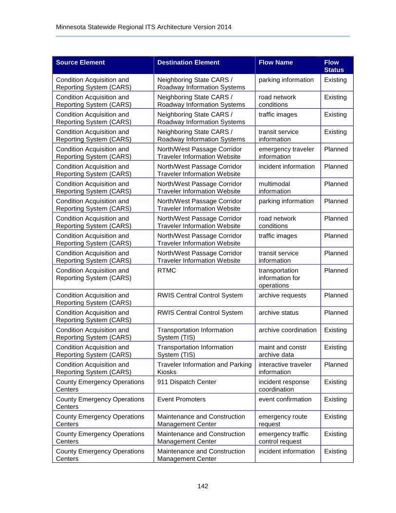
Minnesota Statewide Regional ITS Architecture Version 2014
142
Source Element Destination Element Flow Name Flow Status
Condition Acquisition and Reporting System (CARS)
Neighboring State CARS / Roadway Information Systems
parking information Existing
Condition Acquisition and Reporting System (CARS)
Neighboring State CARS / Roadway Information Systems
road network conditions
Existing
Condition Acquisition and Reporting System (CARS)
Neighboring State CARS / Roadway Information Systems
traffic images Existing
Condition Acquisition and Reporting System (CARS)
Neighboring State CARS / Roadway Information Systems
transit service information
Existing
Condition Acquisition and Reporting System (CARS)
North/West Passage Corridor Traveler Information Website
emergency traveler information
Planned
Condition Acquisition and Reporting System (CARS)
North/West Passage Corridor Traveler Information Website
incident information Planned
Condition Acquisition and Reporting System (CARS)
North/West Passage Corridor Traveler Information Website
multimodal information
Planned
Condition Acquisition and Reporting System (CARS)
North/West Passage Corridor Traveler Information Website
parking information Planned
Condition Acquisition and Reporting System (CARS)
North/West Passage Corridor Traveler Information Website
road network conditions
Planned
Condition Acquisition and Reporting System (CARS)
North/West Passage Corridor Traveler Information Website
traffic images Planned
Condition Acquisition and Reporting System (CARS)
North/West Passage Corridor Traveler Information Website
transit service information
Planned
Condition Acquisition and Reporting System (CARS)
RTMC transportation information for operations
Planned
Condition Acquisition and Reporting System (CARS)
RWIS Central Control System archive requests Planned
Condition Acquisition and Reporting System (CARS)
RWIS Central Control System archive status Planned
Condition Acquisition and Reporting System (CARS)
Transportation Information System (TIS)
archive coordination Existing
Condition Acquisition and Reporting System (CARS)
Transportation Information System (TIS)
maint and constr archive data
Existing
Condition Acquisition and Reporting System (CARS)
Traveler Information and Parking Kiosks
interactive traveler information
Planned
County Emergency Operations Centers
911 Dispatch Center incident response coordination
Existing
County Emergency Operations Centers
Event Promoters event confirmation Existing
County Emergency Operations Centers
Maintenance and Construction Management Center
emergency route request
Existing
County Emergency Operations Centers
Maintenance and Construction Management Center
emergency traffic control request
Existing
County Emergency Operations Centers
Maintenance and Construction Management Center
incident information Existing

Minnesota Statewide Regional ITS Architecture Version 2014
143
Source Element Destination Element Flow Name Flow Status
County Emergency Operations Centers
Maintenance and Construction Management Center
incident response status
Existing
County Emergency Operations Centers
Maintenance and Construction Management Center
maint and constr resource request
Existing
County Emergency Operations Centers
Maintenance and Construction Management Center
resource request Existing
County Emergency Operations Centers
Media Outlets incident information for media
Existing
County Emergency Operations Centers
Metro Area Transit Management Centers
emergency transit service request
Existing
County Emergency Operations Centers
Minnesota State Emergency Operations Center (SEOC)
alert notification coordination
Existing
County Emergency Operations Centers
Minnesota State Emergency Operations Center (SEOC)
emergency plan coordination
Existing
County Emergency Operations Centers
Minnesota State Emergency Operations Center (SEOC)
evacuation coordination
Existing
County Emergency Operations Centers
Minnesota State Emergency Operations Center (SEOC)
incident command information coordination
Existing
County Emergency Operations Centers
Minnesota State Emergency Operations Center (SEOC)
incident response coordination
Existing
County Emergency Operations Centers
Minnesota State Patrol Databases
emergency archive data
Planned
County Emergency Operations Centers
Private Fleet and Freight Management Center
hazmat information request
Existing
County Sheriff and City Police Offices
911 Dispatch Center incident response coordination
Existing
County Sheriff and City Police Offices
Intercity Transit Management Centers
incident response status
Planned
County Sheriff and City Police Offices
Local Transit Management Centers
incident response status
Planned
County Sheriff and City Police Offices
Maintenance and Construction Management Center
alert notification Existing
County Sheriff and City Police Offices
Maintenance and Construction Management Center
evacuation information
Existing
County Sheriff and City Police Offices
Maintenance and Construction Management Center
incident information Existing
County Sheriff and City Police Offices
Metro Area Transit Management Centers
incident response status
Planned
County Sheriff and City Police Offices
Minnesota State Patrol District Office
incident command information coordination
Existing
County Sheriff and City Police Offices
Minnesota State Patrol District Office
incident response coordination
Existing

Minnesota Statewide Regional ITS Architecture Version 2014
144
Source Element Destination Element Flow Name Flow Status
County Sheriff and City Police Offices
Transit Center and Station Surveillance System Roadside Equipment
secure area surveillance control
Planned
Data Distribution Server Local TMCs archived data products
Existing
Data Distribution Server Maintenance and Construction Management Center
archived data products
Existing
Data Distribution Server Metro Area Transit Management Centers
archived data products
Existing
Data Distribution Server Minneapolis TMC archived data products
Existing
Data Distribution Server TOCCs archived data products
Existing
Driver Vehicle driver inputs Planned
Dynamic Late Merge Central Control System
Dynamic Late Merge Roadside Equipment
roadway information system data
Existing
Dynamic Late Merge Central Control System
Maintenance and Construction Management Center
work zone information
Planned
Dynamic Late Merge Central Control System
RTMC work zone information
Planned
Dynamic Late Merge Central Control System
TOCCs work zone information
Planned
Dynamic Late Merge Roadside Equipment
Driver driver information Existing
Dynamic Late Merge Roadside Equipment
Dynamic Late Merge Central Control System
field device status Existing
Dynamic Late Merge Roadside Equipment
Dynamic Late Merge Central Control System
roadway information system status
Existing
Dynamic Message Sign Roadside Equipment
Driver driver information Existing
Dynamic Message Sign Roadside Equipment
Intelligent Work Zone System Roadside Equipment
roadway equipment coordination
Existing
Dynamic Message Sign Roadside Equipment
Local TMCs roadway information system status
Planned
Dynamic Message Sign Roadside Equipment
Maintenance and Construction Management Center
speed monitoring information
Planned
Dynamic Message Sign Roadside Equipment
Minneapolis TMC roadway information system status
Existing
Dynamic Message Sign Roadside Equipment
Neighboring State Traffic Management Centers
roadway information system status
Planned
Dynamic Message Sign Roadside Equipment
RTMC roadway information system status
Existing
Dynamic Message Sign Roadside Equipment
Speed Monitoring Roadside Equipment
roadway equipment coordination
Planned
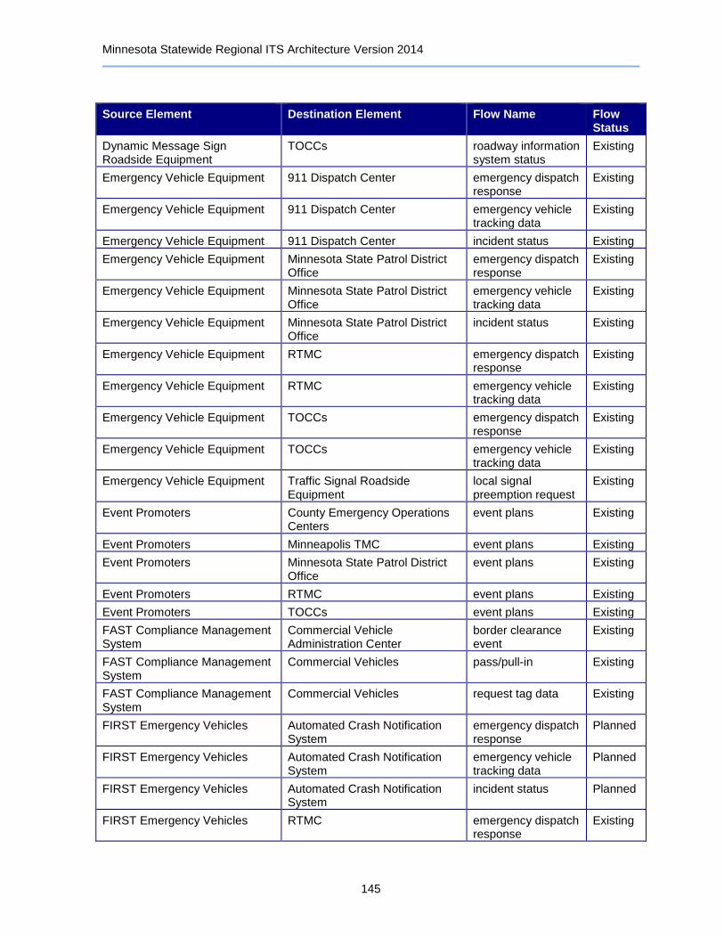
Minnesota Statewide Regional ITS Architecture Version 2014
145
Source Element Destination Element Flow Name Flow Status
Dynamic Message Sign Roadside Equipment
TOCCs roadway information system status
Existing
Emergency Vehicle Equipment 911 Dispatch Center emergency dispatch response
Existing
Emergency Vehicle Equipment 911 Dispatch Center emergency vehicle tracking data
Existing
Emergency Vehicle Equipment 911 Dispatch Center incident status Existing
Emergency Vehicle Equipment Minnesota State Patrol District Office
emergency dispatch response
Existing
Emergency Vehicle Equipment Minnesota State Patrol District Office
emergency vehicle tracking data
Existing
Emergency Vehicle Equipment Minnesota State Patrol District Office
incident status Existing
Emergency Vehicle Equipment RTMC emergency dispatch response
Existing
Emergency Vehicle Equipment RTMC emergency vehicle tracking data
Existing
Emergency Vehicle Equipment TOCCs emergency dispatch response
Existing
Emergency Vehicle Equipment TOCCs emergency vehicle tracking data
Existing
Emergency Vehicle Equipment Traffic Signal Roadside Equipment
local signal preemption request
Existing
Event Promoters County Emergency Operations Centers
event plans Existing
Event Promoters Minneapolis TMC event plans Existing
Event Promoters Minnesota State Patrol District Office
event plans Existing
Event Promoters RTMC event plans Existing
Event Promoters TOCCs event plans Existing
FAST Compliance Management System
Commercial Vehicle Administration Center
border clearance event
Existing
FAST Compliance Management System
Commercial Vehicles pass/pull-in Existing
FAST Compliance Management System
Commercial Vehicles request tag data Existing
FIRST Emergency Vehicles Automated Crash Notification System
emergency dispatch response
Planned
FIRST Emergency Vehicles Automated Crash Notification System
emergency vehicle tracking data
Planned
FIRST Emergency Vehicles Automated Crash Notification System
incident status Planned
FIRST Emergency Vehicles RTMC emergency dispatch response
Existing

Minnesota Statewide Regional ITS Architecture Version 2014
146
Source Element Destination Element Flow Name Flow Status
FIRST Emergency Vehicles RTMC emergency vehicle tracking data
Existing
FIRST Emergency Vehicles RTMC incident status Existing
Highway Advisory Radio Roadside Equipment
Driver driver information Existing
Highway Advisory Radio Roadside Equipment
RTMC roadway information system status
Existing
Highway Advisory Radio Roadside Equipment
TOCCs roadway information system status
Existing
IFTA Clearinghouse Minnesota CVIEW credential fee coordination
Existing
IFTA Clearinghouse Minnesota CVIEW credentials information
Existing
IFTA Clearinghouse Minnesota CVIEW credentials status information
Existing
IFTA Clearinghouse Minnesota CVIEW safety inspection report
Existing
IFTA Clearinghouse Minnesota CVO Online credential fee coordination
Existing
IFTA Clearinghouse Minnesota CVO Online credentials information
Existing
IFTA Clearinghouse Minnesota CVO Online credentials status information
Existing
IFTA Clearinghouse Truck Center credential fee coordination
Existing
IFTA Clearinghouse Truck Center credentials information
Existing
IFTA Clearinghouse Truck Center credentials status information
Existing
IFTA Clearinghouse Truck Center safety inspection report
Existing
In Vehicle Signing Roadside Equipment
In Vehicle Signing Vehicle Equipment
driver information Existing
In Vehicle Signing Roadside Equipment
In Vehicle Signing Vehicle Equipment
vehicle signage data
Planned
In Vehicle Signing Vehicle Equipment
Driver driver updates Planned
Infrastructure GIS Database Systems
Maintenance and Construction Management Center
asset inventory Planned
Infrastructure GIS Database Systems
Maintenance and Construction Management Center
asset restrictions Planned
Infrastructure GIS Database Systems
Maintenance and Construction Management Center
maintenance and repair needs
Planned
Infrastructure GIS Database Systems
RTMC asset inventory Planned

Minnesota Statewide Regional ITS Architecture Version 2014
147
Source Element Destination Element Flow Name Flow Status
Infrastructure GIS Database Systems
RTMC asset restrictions Planned
Infrastructure GIS Database Systems
RTMC maintenance and repair needs
Planned
Infrastructure GIS Database Systems
TOCCs asset inventory Planned
Infrastructure GIS Database Systems
TOCCs asset restrictions Planned
Infrastructure GIS Database Systems
TOCCs maintenance and repair needs
Planned
Intelligent Work Zone System Roadside Equipment
Dynamic Message Sign Roadside Equipment
roadway equipment coordination
Planned
Intelligent Work Zone System Roadside Equipment
Maintenance and Construction Field Personnel
work zone warning Planned
Intelligent Work Zone System Roadside Equipment
Maintenance and Construction Management Center
roadway treatment system status
Planned
Intelligent Work Zone System Roadside Equipment
Maintenance and Construction Management Center
work zone warning status
Planned
Intelligent Work Zone System Roadside Equipment
Maintenance and Construction Vehicle Equipment
roadway information system status
Planned
Intelligent Work Zone System Roadside Equipment
Queue Detection Roadside Equipment
roadway equipment coordination
Existing
Intelligent Work Zone System Roadside Equipment
RTMC field device status Existing
Intelligent Work Zone System Roadside Equipment
RTMC roadway information system status
Existing
Intelligent Work Zone System Roadside Equipment
RTMC work zone warning status
Existing
Intelligent Work Zone System Roadside Equipment
TOCCs roadway information system status
Planned
Intelligent Work Zone System Roadside Equipment
TOCCs work zone warning status
Planned
Intercity Transit Management Centers
County Sheriff and City Police Offices
transit emergency data
Planned
Intercity Transit Management Centers
Local Transit Management Centers
transit service coordination
Planned
Intercity Transit Management Centers
Real-Time Bus Arrival Time Display Roadside Equipment
transit traveler information
Planned
Intercity Transit Management Centers
Transit Center and Station Surveillance System Roadside Equipment
secure area surveillance control
Planned
Intercity Transit Management Centers
Transit Information Telephone Systems
personal transit information
Planned
Intercity Transit Management Centers
Transit Information Websites transit and fare schedules
Planned

Minnesota Statewide Regional ITS Architecture Version 2014
148
Source Element Destination Element Flow Name Flow Status
Intercity Transit Management Centers
Transit Kiosks transit traveler information
Planned
Intercity Transit Management Centers
Transit Vehicle Equipment alarm acknowledge Planned
Intercity Transit Management Centers
Transit Vehicle Equipment transit schedule information
Existing
Intercity Transit Management Centers
User Personal Portable and Computing Devices
personal transit information
Planned
Intermodal Freight Depots Private Fleet and Freight Management Center
freight transportation status
Planned
Intersection Collision Warning Roadside Equipment
Driver driver information Planned
Intersection Collision Warning Roadside Equipment
Driver intersection warning Planned
Intersection Collision Warning Roadside Equipment
Maintenance and Construction Management Center
automated roadway status
Planned
Intersection Collision Warning Roadside Equipment
Maintenance and Construction Management Center
barrier system status
Planned
Intersection Collision Warning Roadside Equipment
Maintenance and Construction Management Center
environmental probe data
Planned
Intersection Collision Warning Roadside Equipment
Maintenance and Construction Management Center
environmental sensor data
Planned
Intersection Collision Warning Roadside Equipment
Maintenance and Construction Management Center
field device status Planned
Intersection Collision Warning Roadside Equipment
Maintenance and Construction Management Center
hov data Planned
Intersection Collision Warning Roadside Equipment
Maintenance and Construction Management Center
hri status Planned
Intersection Collision Warning Roadside Equipment
Maintenance and Construction Management Center
infrastructure monitoring sensor data
Planned
Intersection Collision Warning Roadside Equipment
Maintenance and Construction Management Center
intersection blockage notification
Planned
Intersection Collision Warning Roadside Equipment
Maintenance and Construction Management Center
lighting system status
Planned
Intersection Collision Warning Roadside Equipment
Maintenance and Construction Management Center
reversible lane status
Planned
Intersection Collision Warning Roadside Equipment
Maintenance and Construction Management Center
right-of-way request notification
Planned
Intersection Collision Warning Roadside Equipment
Maintenance and Construction Management Center
roadway information system status
Planned
Intersection Collision Warning Roadside Equipment
Maintenance and Construction Management Center
roadway treatment system status
Planned
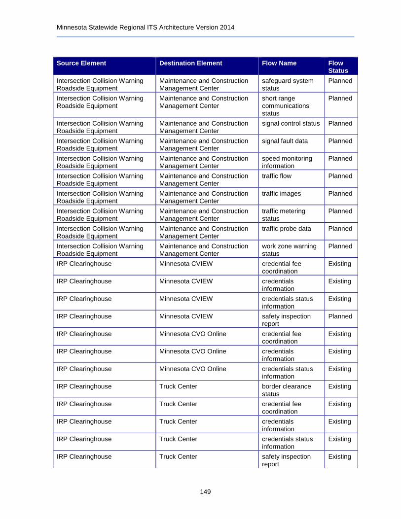
Minnesota Statewide Regional ITS Architecture Version 2014
149
Source Element Destination Element Flow Name Flow Status
Intersection Collision Warning Roadside Equipment
Maintenance and Construction Management Center
safeguard system status
Planned
Intersection Collision Warning Roadside Equipment
Maintenance and Construction Management Center
short range communications status
Planned
Intersection Collision Warning Roadside Equipment
Maintenance and Construction Management Center
signal control status Planned
Intersection Collision Warning Roadside Equipment
Maintenance and Construction Management Center
signal fault data Planned
Intersection Collision Warning Roadside Equipment
Maintenance and Construction Management Center
speed monitoring information
Planned
Intersection Collision Warning Roadside Equipment
Maintenance and Construction Management Center
traffic flow Planned
Intersection Collision Warning Roadside Equipment
Maintenance and Construction Management Center
traffic images Planned
Intersection Collision Warning Roadside Equipment
Maintenance and Construction Management Center
traffic metering status
Planned
Intersection Collision Warning Roadside Equipment
Maintenance and Construction Management Center
traffic probe data Planned
Intersection Collision Warning Roadside Equipment
Maintenance and Construction Management Center
work zone warning status
Planned
IRP Clearinghouse Minnesota CVIEW credential fee coordination
Existing
IRP Clearinghouse Minnesota CVIEW credentials information
Existing
IRP Clearinghouse Minnesota CVIEW credentials status information
Existing
IRP Clearinghouse Minnesota CVIEW safety inspection report
Planned
IRP Clearinghouse Minnesota CVO Online credential fee coordination
Existing
IRP Clearinghouse Minnesota CVO Online credentials information
Existing
IRP Clearinghouse Minnesota CVO Online credentials status information
Existing
IRP Clearinghouse Truck Center border clearance status
Existing
IRP Clearinghouse Truck Center credential fee coordination
Existing
IRP Clearinghouse Truck Center credentials information
Existing
IRP Clearinghouse Truck Center credentials status information
Existing
IRP Clearinghouse Truck Center safety inspection report
Existing
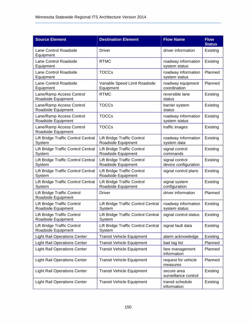
Minnesota Statewide Regional ITS Architecture Version 2014
150
Source Element Destination Element Flow Name Flow Status
Lane Control Roadside Equipment
Driver driver information Existing
Lane Control Roadside Equipment
RTMC roadway information system status
Existing
Lane Control Roadside Equipment
TOCCs roadway information system status
Planned
Lane Control Roadside Equipment
Variable Speed Limit Roadside Equipment
roadway equipment coordination
Planned
Lane/Ramp Access Control Roadside Equipment
RTMC reversible lane status
Existing
Lane/Ramp Access Control Roadside Equipment
TOCCs barrier system status
Existing
Lane/Ramp Access Control Roadside Equipment
TOCCs roadway information system status
Existing
Lane/Ramp Access Control Roadside Equipment
TOCCs traffic images Existing
Lift Bridge Traffic Control Central System
Lift Bridge Traffic Control Roadside Equipment
roadway information system data
Existing
Lift Bridge Traffic Control Central System
Lift Bridge Traffic Control Roadside Equipment
signal control commands
Existing
Lift Bridge Traffic Control Central System
Lift Bridge Traffic Control Roadside Equipment
signal control device configuration
Existing
Lift Bridge Traffic Control Central System
Lift Bridge Traffic Control Roadside Equipment
signal control plans Existing
Lift Bridge Traffic Control Central System
Lift Bridge Traffic Control Roadside Equipment
signal system configuration
Existing
Lift Bridge Traffic Control Roadside Equipment
Driver driver information Planned
Lift Bridge Traffic Control Roadside Equipment
Lift Bridge Traffic Control Central System
roadway information system status
Existing
Lift Bridge Traffic Control Roadside Equipment
Lift Bridge Traffic Control Central System
signal control status Existing
Lift Bridge Traffic Control Roadside Equipment
Lift Bridge Traffic Control Central System
signal fault data Existing
Light Rail Operations Center Transit Vehicle Equipment alarm acknowledge Existing
Light Rail Operations Center Transit Vehicle Equipment bad tag list Planned
Light Rail Operations Center Transit Vehicle Equipment fare management information
Planned
Light Rail Operations Center Transit Vehicle Equipment request for vehicle measures
Planned
Light Rail Operations Center Transit Vehicle Equipment secure area surveillance control
Existing
Light Rail Operations Center Transit Vehicle Equipment transit schedule information
Existing
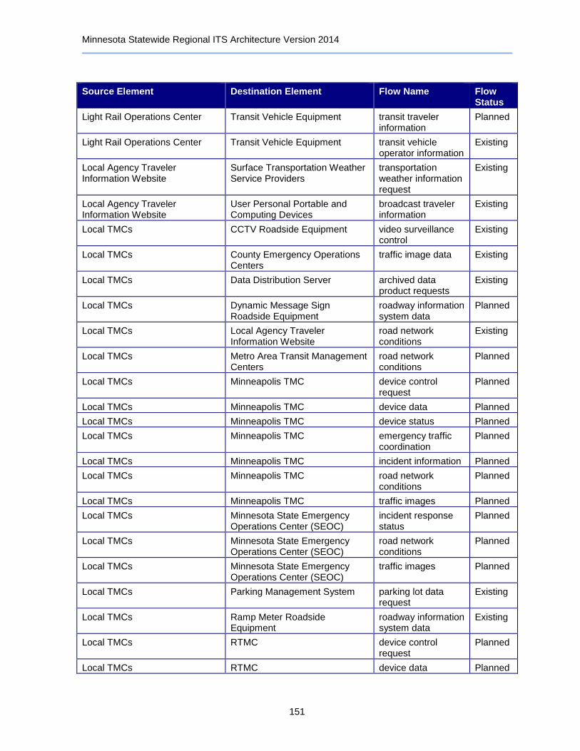
Minnesota Statewide Regional ITS Architecture Version 2014
151
Source Element Destination Element Flow Name Flow Status
Light Rail Operations Center Transit Vehicle Equipment transit traveler information
Planned
Light Rail Operations Center Transit Vehicle Equipment transit vehicle operator information
Existing
Local Agency Traveler Information Website
Surface Transportation Weather Service Providers
transportation weather information request
Existing
Local Agency Traveler Information Website
User Personal Portable and Computing Devices
broadcast traveler information
Existing
Local TMCs CCTV Roadside Equipment video surveillance control
Existing
Local TMCs County Emergency Operations Centers
traffic image data Existing
Local TMCs Data Distribution Server archived data product requests
Existing
Local TMCs Dynamic Message Sign Roadside Equipment
roadway information system data
Planned
Local TMCs Local Agency Traveler Information Website
road network conditions
Existing
Local TMCs Metro Area Transit Management Centers
road network conditions
Planned
Local TMCs Minneapolis TMC device control request
Planned
Local TMCs Minneapolis TMC device data Planned
Local TMCs Minneapolis TMC device status Planned
Local TMCs Minneapolis TMC emergency traffic coordination
Planned
Local TMCs Minneapolis TMC incident information Planned
Local TMCs Minneapolis TMC road network conditions
Planned
Local TMCs Minneapolis TMC traffic images Planned
Local TMCs Minnesota State Emergency Operations Center (SEOC)
incident response status
Planned
Local TMCs Minnesota State Emergency Operations Center (SEOC)
road network conditions
Planned
Local TMCs Minnesota State Emergency Operations Center (SEOC)
traffic images Planned
Local TMCs Parking Management System parking lot data request
Existing
Local TMCs Ramp Meter Roadside Equipment
roadway information system data
Existing
Local TMCs RTMC device control request
Planned
Local TMCs RTMC device data Planned

Minnesota Statewide Regional ITS Architecture Version 2014
152
Source Element Destination Element Flow Name Flow Status
Local TMCs RTMC device status Planned
Local TMCs RTMC emergency traffic coordination
Planned
Local TMCs TOCCs device control request
Planned
Local TMCs TOCCs device data Planned
Local TMCs TOCCs device status Planned
Local TMCs TOCCs emergency traffic coordination
Planned
Local TMCs Traffic Data and Video Archive archived data product requests
Planned
Local TMCs Traffic Data and Video Archive traffic archive data Planned
Local TMCs Traffic Detector Roadside Equipment
traffic sensor control Existing
Local TMCs Traffic Signal Roadside Equipment
signal control commands
Existing
Local TMCs Traffic Signal Roadside Equipment
signal control device configuration
Existing
Local TMCs Traffic Signal Roadside Equipment
signal control plans Existing
Local TMCs Traffic Signal Roadside Equipment
signal system configuration
Existing
Local Transit Management Centers
911 Dispatch Center transit emergency data
Planned
Local Transit Management Centers
Account Management Providers payment request Existing
Local Transit Management Centers
County Sheriff and City Police Offices
transit emergency data
Planned
Local Transit Management Centers
Intercity Transit Management Centers
transit service coordination
Planned
Local Transit Management Centers
Media Outlets transit information for media
Existing
Local Transit Management Centers
Real-Time Bus Arrival Time Display Roadside Equipment
transit traveler information
Planned
Local Transit Management Centers
RTMC transit emergency data
Planned
Local Transit Management Centers
TOCCs transit emergency data
Planned
Local Transit Management Centers
Transit Center and Station Surveillance System Roadside Equipment
secure area surveillance control
Planned
Local Transit Management Centers
Transit Data Archives archived data product requests
Planned
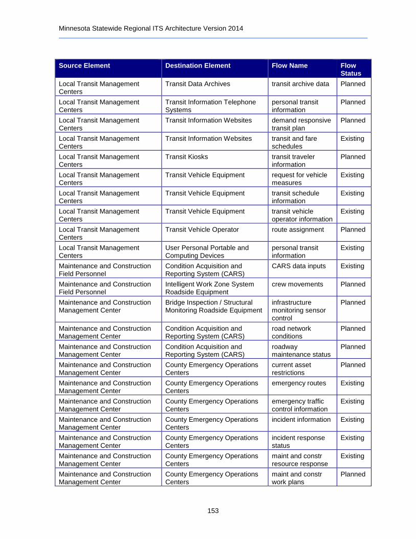
Minnesota Statewide Regional ITS Architecture Version 2014
153
Source Element Destination Element Flow Name Flow Status
Local Transit Management Centers
Transit Data Archives transit archive data Planned
Local Transit Management Centers
Transit Information Telephone Systems
personal transit information
Planned
Local Transit Management Centers
Transit Information Websites demand responsive transit plan
Planned
Local Transit Management Centers
Transit Information Websites transit and fare schedules
Existing
Local Transit Management Centers
Transit Kiosks transit traveler information
Planned
Local Transit Management Centers
Transit Vehicle Equipment request for vehicle measures
Existing
Local Transit Management Centers
Transit Vehicle Equipment transit schedule information
Existing
Local Transit Management Centers
Transit Vehicle Equipment transit vehicle operator information
Existing
Local Transit Management Centers
Transit Vehicle Operator route assignment Planned
Local Transit Management Centers
User Personal Portable and Computing Devices
personal transit information
Existing
Maintenance and Construction Field Personnel
Condition Acquisition and Reporting System (CARS)
CARS data inputs Existing
Maintenance and Construction Field Personnel
Intelligent Work Zone System Roadside Equipment
crew movements Planned
Maintenance and Construction Management Center
Bridge Inspection / Structural Monitoring Roadside Equipment
infrastructure monitoring sensor control
Planned
Maintenance and Construction Management Center
Condition Acquisition and Reporting System (CARS)
road network conditions
Planned
Maintenance and Construction Management Center
Condition Acquisition and Reporting System (CARS)
roadway maintenance status
Planned
Maintenance and Construction Management Center
County Emergency Operations Centers
current asset restrictions
Planned
Maintenance and Construction Management Center
County Emergency Operations Centers
emergency routes Existing
Maintenance and Construction Management Center
County Emergency Operations Centers
emergency traffic control information
Existing
Maintenance and Construction Management Center
County Emergency Operations Centers
incident information Existing
Maintenance and Construction Management Center
County Emergency Operations Centers
incident response status
Existing
Maintenance and Construction Management Center
County Emergency Operations Centers
maint and constr resource response
Existing
Maintenance and Construction Management Center
County Emergency Operations Centers
maint and constr work plans
Planned
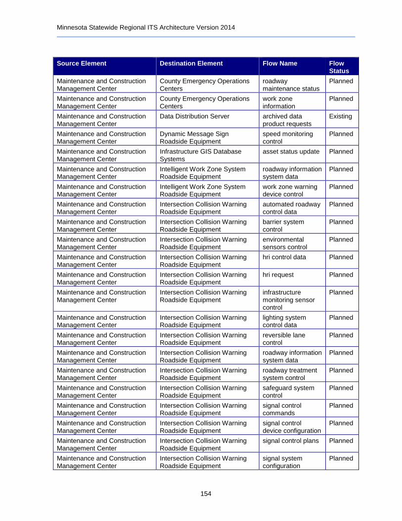
Minnesota Statewide Regional ITS Architecture Version 2014
154
Source Element Destination Element Flow Name Flow Status
Maintenance and Construction Management Center
County Emergency Operations Centers
roadway maintenance status
Planned
Maintenance and Construction Management Center
County Emergency Operations Centers
work zone information
Planned
Maintenance and Construction Management Center
Data Distribution Server archived data product requests
Existing
Maintenance and Construction Management Center
Dynamic Message Sign Roadside Equipment
speed monitoring control
Planned
Maintenance and Construction Management Center
Infrastructure GIS Database Systems
asset status update Planned
Maintenance and Construction Management Center
Intelligent Work Zone System Roadside Equipment
roadway information system data
Planned
Maintenance and Construction Management Center
Intelligent Work Zone System Roadside Equipment
work zone warning device control
Planned
Maintenance and Construction Management Center
Intersection Collision Warning Roadside Equipment
automated roadway control data
Planned
Maintenance and Construction Management Center
Intersection Collision Warning Roadside Equipment
barrier system control
Planned
Maintenance and Construction Management Center
Intersection Collision Warning Roadside Equipment
environmental sensors control
Planned
Maintenance and Construction Management Center
Intersection Collision Warning Roadside Equipment
hri control data Planned
Maintenance and Construction Management Center
Intersection Collision Warning Roadside Equipment
hri request Planned
Maintenance and Construction Management Center
Intersection Collision Warning Roadside Equipment
infrastructure monitoring sensor control
Planned
Maintenance and Construction Management Center
Intersection Collision Warning Roadside Equipment
lighting system control data
Planned
Maintenance and Construction Management Center
Intersection Collision Warning Roadside Equipment
reversible lane control
Planned
Maintenance and Construction Management Center
Intersection Collision Warning Roadside Equipment
roadway information system data
Planned
Maintenance and Construction Management Center
Intersection Collision Warning Roadside Equipment
roadway treatment system control
Planned
Maintenance and Construction Management Center
Intersection Collision Warning Roadside Equipment
safeguard system control
Planned
Maintenance and Construction Management Center
Intersection Collision Warning Roadside Equipment
signal control commands
Planned
Maintenance and Construction Management Center
Intersection Collision Warning Roadside Equipment
signal control device configuration
Planned
Maintenance and Construction Management Center
Intersection Collision Warning Roadside Equipment
signal control plans Planned
Maintenance and Construction Management Center
Intersection Collision Warning Roadside Equipment
signal system configuration
Planned
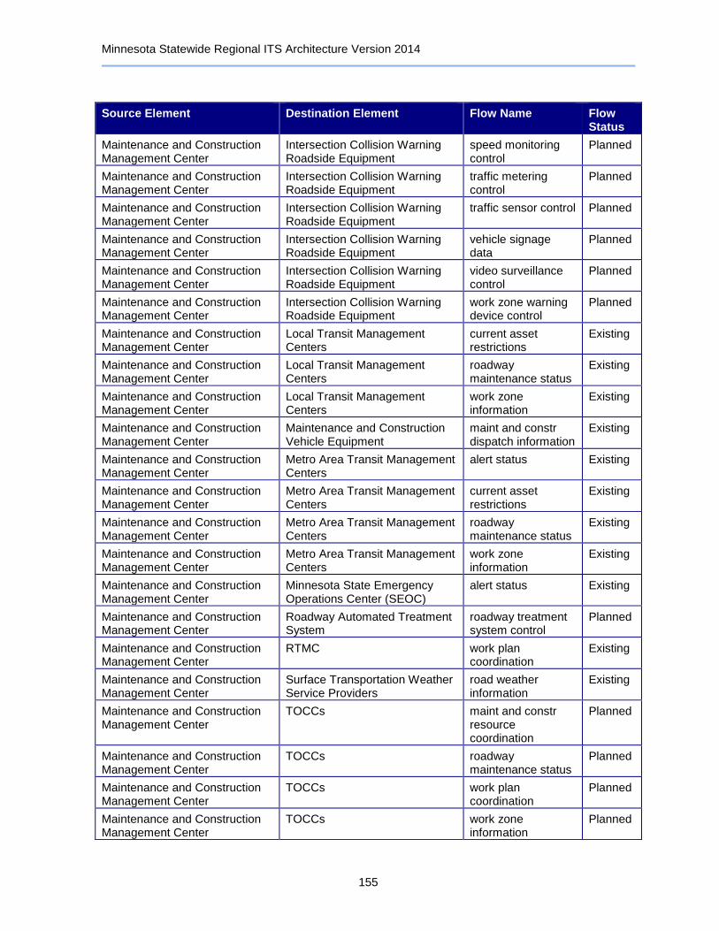
Minnesota Statewide Regional ITS Architecture Version 2014
155
Source Element Destination Element Flow Name Flow Status
Maintenance and Construction Management Center
Intersection Collision Warning Roadside Equipment
speed monitoring control
Planned
Maintenance and Construction Management Center
Intersection Collision Warning Roadside Equipment
traffic metering control
Planned
Maintenance and Construction Management Center
Intersection Collision Warning Roadside Equipment
traffic sensor control Planned
Maintenance and Construction Management Center
Intersection Collision Warning Roadside Equipment
vehicle signage data
Planned
Maintenance and Construction Management Center
Intersection Collision Warning Roadside Equipment
video surveillance control
Planned
Maintenance and Construction Management Center
Intersection Collision Warning Roadside Equipment
work zone warning device control
Planned
Maintenance and Construction Management Center
Local Transit Management Centers
current asset restrictions
Existing
Maintenance and Construction Management Center
Local Transit Management Centers
roadway maintenance status
Existing
Maintenance and Construction Management Center
Local Transit Management Centers
work zone information
Existing
Maintenance and Construction Management Center
Maintenance and Construction Vehicle Equipment
maint and constr dispatch information
Existing
Maintenance and Construction Management Center
Metro Area Transit Management Centers
alert status Existing
Maintenance and Construction Management Center
Metro Area Transit Management Centers
current asset restrictions
Existing
Maintenance and Construction Management Center
Metro Area Transit Management Centers
roadway maintenance status
Existing
Maintenance and Construction Management Center
Metro Area Transit Management Centers
work zone information
Existing
Maintenance and Construction Management Center
Minnesota State Emergency Operations Center (SEOC)
alert status Existing
Maintenance and Construction Management Center
Roadway Automated Treatment System
roadway treatment system control
Planned
Maintenance and Construction Management Center
RTMC work plan coordination
Existing
Maintenance and Construction Management Center
Surface Transportation Weather Service Providers
road weather information
Existing
Maintenance and Construction Management Center
TOCCs maint and constr resource coordination
Planned
Maintenance and Construction Management Center
TOCCs roadway maintenance status
Planned
Maintenance and Construction Management Center
TOCCs work plan coordination
Planned
Maintenance and Construction Management Center
TOCCs work zone information
Planned
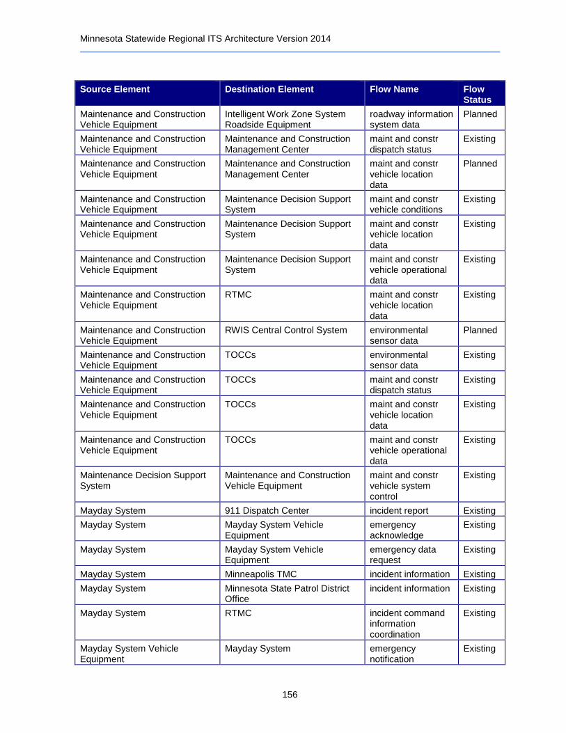
Minnesota Statewide Regional ITS Architecture Version 2014
156
Source Element Destination Element Flow Name Flow Status
Maintenance and Construction Vehicle Equipment
Intelligent Work Zone System Roadside Equipment
roadway information system data
Planned
Maintenance and Construction Vehicle Equipment
Maintenance and Construction Management Center
maint and constr dispatch status
Existing
Maintenance and Construction Vehicle Equipment
Maintenance and Construction Management Center
maint and constr vehicle location data
Planned
Maintenance and Construction Vehicle Equipment
Maintenance Decision Support System
maint and constr vehicle conditions
Existing
Maintenance and Construction Vehicle Equipment
Maintenance Decision Support System
maint and constr vehicle location data
Existing
Maintenance and Construction Vehicle Equipment
Maintenance Decision Support System
maint and constr vehicle operational data
Existing
Maintenance and Construction Vehicle Equipment
RTMC maint and constr vehicle location data
Existing
Maintenance and Construction Vehicle Equipment
RWIS Central Control System environmental sensor data
Planned
Maintenance and Construction Vehicle Equipment
TOCCs environmental sensor data
Existing
Maintenance and Construction Vehicle Equipment
TOCCs maint and constr dispatch status
Existing
Maintenance and Construction Vehicle Equipment
TOCCs maint and constr vehicle location data
Existing
Maintenance and Construction Vehicle Equipment
TOCCs maint and constr vehicle operational data
Existing
Maintenance Decision Support System
Maintenance and Construction Vehicle Equipment
maint and constr vehicle system control
Existing
Mayday System 911 Dispatch Center incident report Existing
Mayday System Mayday System Vehicle Equipment
emergency acknowledge
Existing
Mayday System Mayday System Vehicle Equipment
emergency data request
Existing
Mayday System Minneapolis TMC incident information Existing
Mayday System Minnesota State Patrol District Office
incident information Existing
Mayday System RTMC incident command information coordination
Existing
Mayday System Vehicle Equipment
Mayday System emergency notification
Existing

Minnesota Statewide Regional ITS Architecture Version 2014
157
Source Element Destination Element Flow Name Flow Status
MCMIS Minnesota CVIEW credentials information
Planned
MCMIS Minnesota CVIEW credentials status information
Planned
MCMIS Minnesota CVIEW safety inspection report
Planned
MCMIS Minnesota CVIEW safety status information
Planned
Media Information Release System
Media Outlets traveler information for media
Existing
Media Information Release System
Minnesota State Patrol District Office
archive requests Existing
Media Information Release System
Minnesota State Patrol District Office
archive status Existing
Media Outlets Maintenance and Construction Management Center
external reports Existing
Media Outlets Minneapolis TMC external reports Existing
Media Outlets RTMC external reports Existing
Media Outlets TOCCs external reports Existing
Metro Area Transit Management Centers
911 Dispatch Center transit emergency data
Planned
Metro Area Transit Management Centers
Account Management Providers payment request Existing
Metro Area Transit Management Centers
Commuter Rail Operations Center
transit service coordination
Planned
Metro Area Transit Management Centers
County Emergency Operations Centers
emergency transit service response
Existing
Metro Area Transit Management Centers
County Sheriff and City Police Offices
transit emergency data
Planned
Metro Area Transit Management Centers
Data Distribution Server archived data product requests
Existing
Metro Area Transit Management Centers
Dynamic Message Sign Roadside Equipment
transit traveler information
Planned
Metro Area Transit Management Centers
Media Outlets incident information for media
Existing
Metro Area Transit Management Centers
Media Outlets transit information for media
Existing
Metro Area Transit Management Centers
Minneapolis TMC incident information Planned
Metro Area Transit Management Centers
Real-Time Bus Arrival Time Display Roadside Equipment
transit traveler information
Existing
Metro Area Transit Management Centers
Real-Time Transit Travel Time Notification
transit travel time estimates
Existing
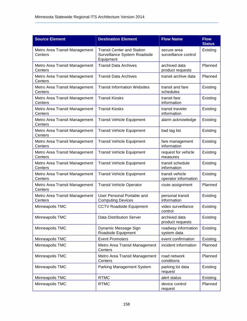
Minnesota Statewide Regional ITS Architecture Version 2014
158
Source Element Destination Element Flow Name Flow Status
Metro Area Transit Management Centers
Transit Center and Station Surveillance System Roadside Equipment
secure area surveillance control
Existing
Metro Area Transit Management Centers
Transit Data Archives archived data product requests
Planned
Metro Area Transit Management Centers
Transit Data Archives transit archive data Planned
Metro Area Transit Management Centers
Transit Information Websites transit and fare schedules
Existing
Metro Area Transit Management Centers
Transit Kiosks transit fare information
Existing
Metro Area Transit Management Centers
Transit Kiosks transit traveler information
Existing
Metro Area Transit Management Centers
Transit Vehicle Equipment alarm acknowledge Existing
Metro Area Transit Management Centers
Transit Vehicle Equipment bad tag list Existing
Metro Area Transit Management Centers
Transit Vehicle Equipment fare management information
Existing
Metro Area Transit Management Centers
Transit Vehicle Equipment request for vehicle measures
Existing
Metro Area Transit Management Centers
Transit Vehicle Equipment transit schedule information
Existing
Metro Area Transit Management Centers
Transit Vehicle Equipment transit vehicle operator information
Existing
Metro Area Transit Management Centers
Transit Vehicle Operator route assignment Planned
Metro Area Transit Management Centers
User Personal Portable and Computing Devices
personal transit information
Existing
Minneapolis TMC CCTV Roadside Equipment video surveillance control
Existing
Minneapolis TMC Data Distribution Server archived data product requests
Existing
Minneapolis TMC Dynamic Message Sign Roadside Equipment
roadway information system data
Existing
Minneapolis TMC Event Promoters event confirmation Existing
Minneapolis TMC Metro Area Transit Management Centers
incident information Planned
Minneapolis TMC Metro Area Transit Management Centers
road network conditions
Planned
Minneapolis TMC Parking Management System parking lot data request
Existing
Minneapolis TMC RTMC alert status Existing
Minneapolis TMC RTMC device control request
Planned
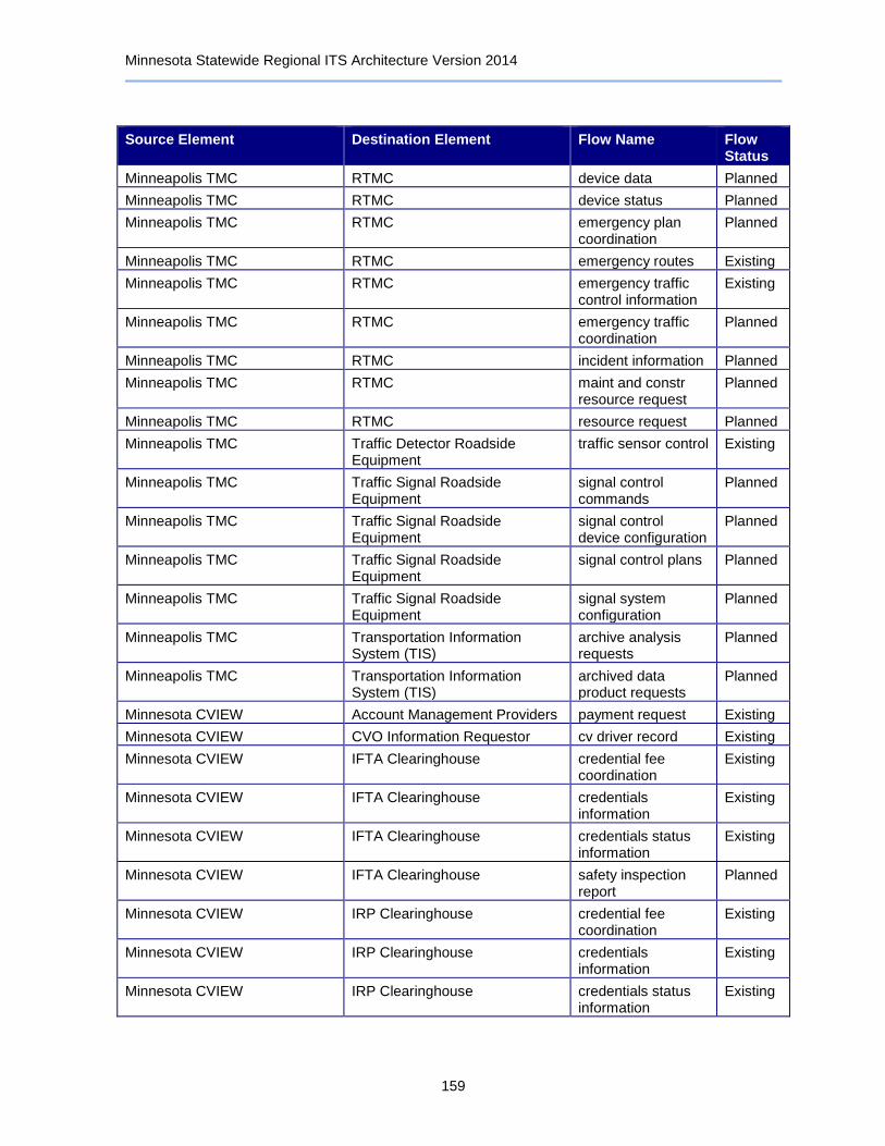
Minnesota Statewide Regional ITS Architecture Version 2014
159
Source Element Destination Element Flow Name Flow Status
Minneapolis TMC RTMC device data Planned
Minneapolis TMC RTMC device status Planned
Minneapolis TMC RTMC emergency plan coordination
Planned
Minneapolis TMC RTMC emergency routes Existing
Minneapolis TMC RTMC emergency traffic control information
Existing
Minneapolis TMC RTMC emergency traffic coordination
Planned
Minneapolis TMC RTMC incident information Planned
Minneapolis TMC RTMC maint and constr resource request
Planned
Minneapolis TMC RTMC resource request Planned
Minneapolis TMC Traffic Detector Roadside Equipment
traffic sensor control Existing
Minneapolis TMC Traffic Signal Roadside Equipment
signal control commands
Planned
Minneapolis TMC Traffic Signal Roadside Equipment
signal control device configuration
Planned
Minneapolis TMC Traffic Signal Roadside Equipment
signal control plans Planned
Minneapolis TMC Traffic Signal Roadside Equipment
signal system configuration
Planned
Minneapolis TMC Transportation Information System (TIS)
archive analysis requests
Planned
Minneapolis TMC Transportation Information System (TIS)
archived data product requests
Planned
Minnesota CVIEW Account Management Providers payment request Existing
Minnesota CVIEW CVO Information Requestor cv driver record Existing
Minnesota CVIEW IFTA Clearinghouse credential fee coordination
Existing
Minnesota CVIEW IFTA Clearinghouse credentials information
Existing
Minnesota CVIEW IFTA Clearinghouse credentials status information
Existing
Minnesota CVIEW IFTA Clearinghouse safety inspection report
Planned
Minnesota CVIEW IRP Clearinghouse credential fee coordination
Existing
Minnesota CVIEW IRP Clearinghouse credentials information
Existing
Minnesota CVIEW IRP Clearinghouse credentials status information
Existing
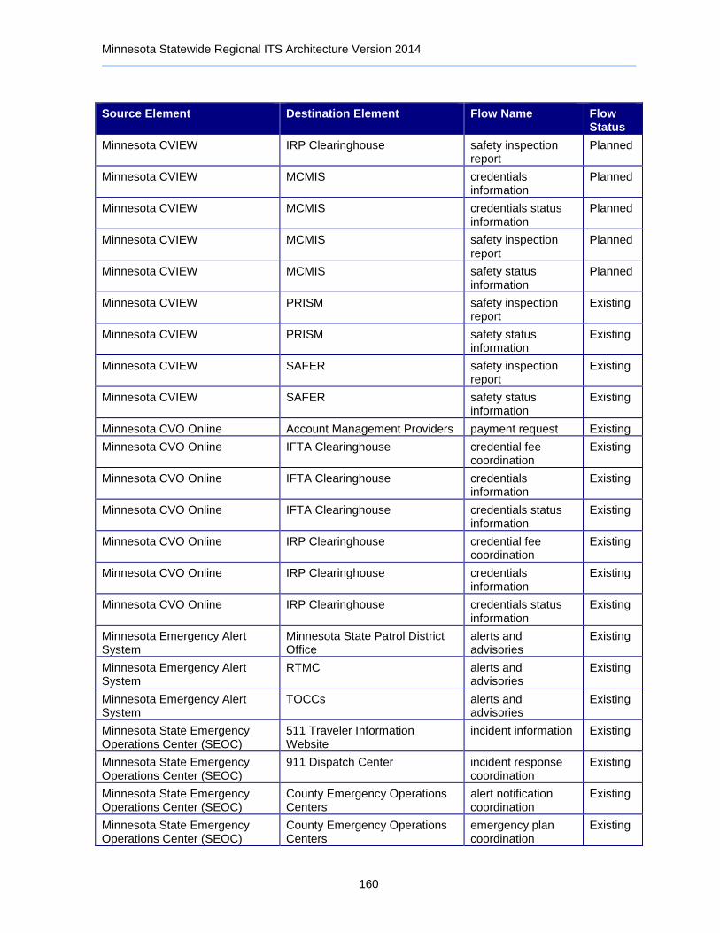
Minnesota Statewide Regional ITS Architecture Version 2014
160
Source Element Destination Element Flow Name Flow Status
Minnesota CVIEW IRP Clearinghouse safety inspection report
Planned
Minnesota CVIEW MCMIS credentials information
Planned
Minnesota CVIEW MCMIS credentials status information
Planned
Minnesota CVIEW MCMIS safety inspection report
Planned
Minnesota CVIEW MCMIS safety status information
Planned
Minnesota CVIEW PRISM safety inspection report
Existing
Minnesota CVIEW PRISM safety status information
Existing
Minnesota CVIEW SAFER safety inspection report
Existing
Minnesota CVIEW SAFER safety status information
Existing
Minnesota CVO Online Account Management Providers payment request Existing
Minnesota CVO Online IFTA Clearinghouse credential fee coordination
Existing
Minnesota CVO Online IFTA Clearinghouse credentials information
Existing
Minnesota CVO Online IFTA Clearinghouse credentials status information
Existing
Minnesota CVO Online IRP Clearinghouse credential fee coordination
Existing
Minnesota CVO Online IRP Clearinghouse credentials information
Existing
Minnesota CVO Online IRP Clearinghouse credentials status information
Existing
Minnesota Emergency Alert System
Minnesota State Patrol District Office
alerts and advisories
Existing
Minnesota Emergency Alert System
RTMC alerts and advisories
Existing
Minnesota Emergency Alert System
TOCCs alerts and advisories
Existing
Minnesota State Emergency Operations Center (SEOC)
511 Traveler Information Website
incident information Existing
Minnesota State Emergency Operations Center (SEOC)
911 Dispatch Center incident response coordination
Existing
Minnesota State Emergency Operations Center (SEOC)
County Emergency Operations Centers
alert notification coordination
Existing
Minnesota State Emergency Operations Center (SEOC)
County Emergency Operations Centers
emergency plan coordination
Existing

Minnesota Statewide Regional ITS Architecture Version 2014
161
Source Element Destination Element Flow Name Flow Status
Minnesota State Emergency Operations Center (SEOC)
County Emergency Operations Centers
evacuation coordination
Existing
Minnesota State Emergency Operations Center (SEOC)
County Emergency Operations Centers
incident command information coordination
Existing
Minnesota State Emergency Operations Center (SEOC)
County Emergency Operations Centers
incident response coordination
Existing
Minnesota State Emergency Operations Center (SEOC)
Local Agency Traveler Information Website
incident information Existing
Minnesota State Emergency Operations Center (SEOC)
Local TMCs incident information Planned
Minnesota State Emergency Operations Center (SEOC)
Local TMCs resource request Planned
Minnesota State Emergency Operations Center (SEOC)
Local Transit Management Centers
alert notification Planned
Minnesota State Emergency Operations Center (SEOC)
Maintenance and Construction Management Center
alert notification Existing
Minnesota State Emergency Operations Center (SEOC)
Media Outlets incident information for media
Existing
Minnesota State Emergency Operations Center (SEOC)
Metro Area Transit Management Centers
alert notification Existing
Minnesota State Emergency Operations Center (SEOC)
Minnesota State Patrol Databases
emergency archive data
Planned
Minnesota State Emergency Operations Center (SEOC)
Minnesota State Patrol District Office
alert notification Existing
Minnesota State Emergency Operations Center (SEOC)
Minnesota State Patrol District Office
alert notification coordination
Existing
Minnesota State Emergency Operations Center (SEOC)
Minnesota State Patrol District Office
emergency route request
Existing
Minnesota State Emergency Operations Center (SEOC)
Minnesota State Patrol District Office
incident command information coordination
Existing
Minnesota State Emergency Operations Center (SEOC)
Neighboring State Emergency Management Agencies
incident response coordination
Existing
Minnesota State Emergency Operations Center (SEOC)
Neighboring State Emergency Management Agencies
resource coordination
Existing
Minnesota State Emergency Operations Center (SEOC)
North/West Passage Corridor Traveler Information Website
incident information Planned
Minnesota State Emergency Operations Center (SEOC)
Private Fleet and Freight Management Center
hazmat information request
Existing
Minnesota State Emergency Operations Center (SEOC)
RTMC emergency traffic control request
Existing
Minnesota State Emergency Operations Center (SEOC)
RTMC evacuation information
Existing

Minnesota Statewide Regional ITS Architecture Version 2014
162
Source Element Destination Element Flow Name Flow Status
Minnesota State Emergency Operations Center (SEOC)
RTMC incident information Existing
Minnesota State Emergency Operations Center (SEOC)
RTMC incident response status
Existing
Minnesota State Emergency Operations Center (SEOC)
RTMC resource request Existing
Minnesota State Emergency Operations Center (SEOC)
RTMC threat information Existing
Minnesota State Emergency Operations Center (SEOC)
RTMC transportation system status
Existing
Minnesota State Patrol Databases
911 Dispatch Center archive requests Planned
Minnesota State Patrol Databases
911 Dispatch Center archive status Planned
Minnesota State Patrol Databases
County Emergency Operations Centers
archive requests Planned
Minnesota State Patrol Databases
County Emergency Operations Centers
archive status Planned
Minnesota State Patrol Databases
Minnesota State Emergency Operations Center (SEOC)
archive requests Planned
Minnesota State Patrol Databases
Minnesota State Emergency Operations Center (SEOC)
archive status Planned
Minnesota State Patrol District Office
Automated Crash Notification System
incident report Planned
Minnesota State Patrol District Office
Condition Acquisition and Reporting System (CARS)
incident information Existing
Minnesota State Patrol District Office
Condition Acquisition and Reporting System (CARS)
road network conditions
Planned
Minnesota State Patrol District Office
County Sheriff and City Police Offices
incident command information coordination
Existing
Minnesota State Patrol District Office
County Sheriff and City Police Offices
incident response coordination
Existing
Minnesota State Patrol District Office
Emergency Vehicle Equipment emergency dispatch requests
Existing
Minnesota State Patrol District Office
Event Promoters event confirmation Existing
Minnesota State Patrol District Office
Media Information Release System
emergency archive data
Existing
Minnesota State Patrol District Office
Media Information Release System
incident information Existing
Minnesota State Patrol District Office
Minnesota State Emergency Operations Center (SEOC)
alert notification coordination
Existing
Minnesota State Patrol District Office
Minnesota State Emergency Operations Center (SEOC)
alert status Existing
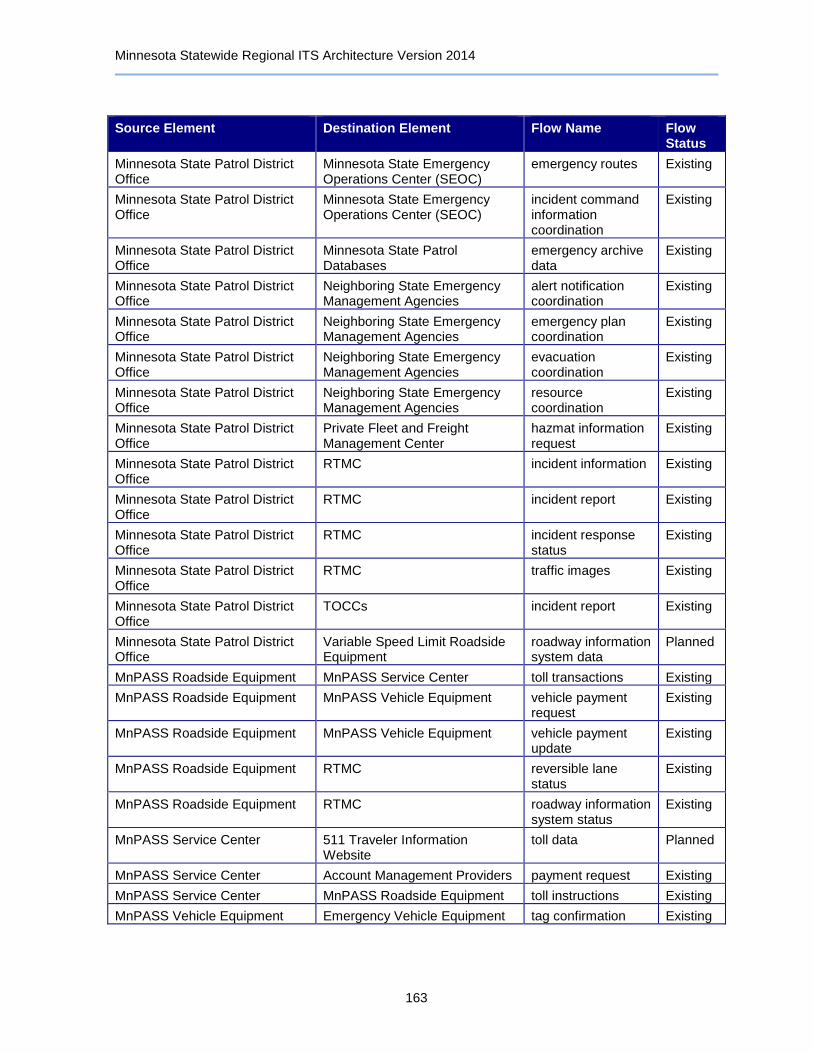
Minnesota Statewide Regional ITS Architecture Version 2014
163
Source Element Destination Element Flow Name Flow Status
Minnesota State Patrol District Office
Minnesota State Emergency Operations Center (SEOC)
emergency routes Existing
Minnesota State Patrol District Office
Minnesota State Emergency Operations Center (SEOC)
incident command information coordination
Existing
Minnesota State Patrol District Office
Minnesota State Patrol Databases
emergency archive data
Existing
Minnesota State Patrol District Office
Neighboring State Emergency Management Agencies
alert notification coordination
Existing
Minnesota State Patrol District Office
Neighboring State Emergency Management Agencies
emergency plan coordination
Existing
Minnesota State Patrol District Office
Neighboring State Emergency Management Agencies
evacuation coordination
Existing
Minnesota State Patrol District Office
Neighboring State Emergency Management Agencies
resource coordination
Existing
Minnesota State Patrol District Office
Private Fleet and Freight Management Center
hazmat information request
Existing
Minnesota State Patrol District Office
RTMC incident information Existing
Minnesota State Patrol District Office
RTMC incident report Existing
Minnesota State Patrol District Office
RTMC incident response status
Existing
Minnesota State Patrol District Office
RTMC traffic images Existing
Minnesota State Patrol District Office
TOCCs incident report Existing
Minnesota State Patrol District Office
Variable Speed Limit Roadside Equipment
roadway information system data
Planned
MnPASS Roadside Equipment MnPASS Service Center toll transactions Existing
MnPASS Roadside Equipment MnPASS Vehicle Equipment vehicle payment request
Existing
MnPASS Roadside Equipment MnPASS Vehicle Equipment vehicle payment update
Existing
MnPASS Roadside Equipment RTMC reversible lane status
Existing
MnPASS Roadside Equipment RTMC roadway information system status
Existing
MnPASS Service Center 511 Traveler Information Website
toll data Planned
MnPASS Service Center Account Management Providers payment request Existing
MnPASS Service Center MnPASS Roadside Equipment toll instructions Existing
MnPASS Vehicle Equipment Emergency Vehicle Equipment tag confirmation Existing
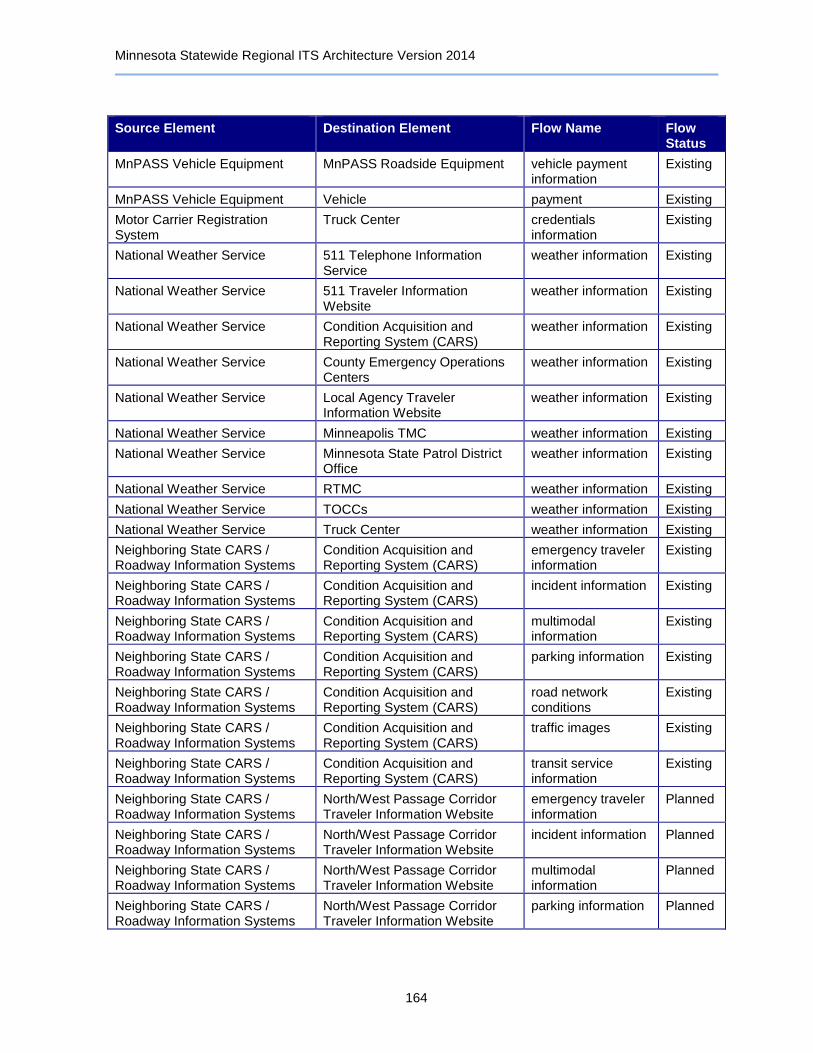
Minnesota Statewide Regional ITS Architecture Version 2014
164
Source Element Destination Element Flow Name Flow Status
MnPASS Vehicle Equipment MnPASS Roadside Equipment vehicle payment information
Existing
MnPASS Vehicle Equipment Vehicle payment Existing
Motor Carrier Registration System
Truck Center credentials information
Existing
National Weather Service 511 Telephone Information Service
weather information Existing
National Weather Service 511 Traveler Information Website
weather information Existing
National Weather Service Condition Acquisition and Reporting System (CARS)
weather information Existing
National Weather Service County Emergency Operations Centers
weather information Existing
National Weather Service Local Agency Traveler Information Website
weather information Existing
National Weather Service Minneapolis TMC weather information Existing
National Weather Service Minnesota State Patrol District Office
weather information Existing
National Weather Service RTMC weather information Existing
National Weather Service TOCCs weather information Existing
National Weather Service Truck Center weather information Existing
Neighboring State CARS / Roadway Information Systems
Condition Acquisition and Reporting System (CARS)
emergency traveler information
Existing
Neighboring State CARS / Roadway Information Systems
Condition Acquisition and Reporting System (CARS)
incident information Existing
Neighboring State CARS / Roadway Information Systems
Condition Acquisition and Reporting System (CARS)
multimodal information
Existing
Neighboring State CARS / Roadway Information Systems
Condition Acquisition and Reporting System (CARS)
parking information Existing
Neighboring State CARS / Roadway Information Systems
Condition Acquisition and Reporting System (CARS)
road network conditions
Existing
Neighboring State CARS / Roadway Information Systems
Condition Acquisition and Reporting System (CARS)
traffic images Existing
Neighboring State CARS / Roadway Information Systems
Condition Acquisition and Reporting System (CARS)
transit service information
Existing
Neighboring State CARS / Roadway Information Systems
North/West Passage Corridor Traveler Information Website
emergency traveler information
Planned
Neighboring State CARS / Roadway Information Systems
North/West Passage Corridor Traveler Information Website
incident information Planned
Neighboring State CARS / Roadway Information Systems
North/West Passage Corridor Traveler Information Website
multimodal information
Planned
Neighboring State CARS / Roadway Information Systems
North/West Passage Corridor Traveler Information Website
parking information Planned

Minnesota Statewide Regional ITS Architecture Version 2014
165
Source Element Destination Element Flow Name Flow Status
Neighboring State CARS / Roadway Information Systems
North/West Passage Corridor Traveler Information Website
road network conditions
Planned
Neighboring State CARS / Roadway Information Systems
North/West Passage Corridor Traveler Information Website
traffic images Planned
Neighboring State CARS / Roadway Information Systems
North/West Passage Corridor Traveler Information Website
transit service information
Planned
Neighboring State Emergency Management Agencies
Minnesota State Emergency Operations Center (SEOC)
incident response coordination
Existing
Neighboring State Emergency Management Agencies
Minnesota State Emergency Operations Center (SEOC)
resource coordination
Existing
Neighboring State Emergency Management Agencies
Minnesota State Patrol District Office
alert notification coordination
Existing
Neighboring State Emergency Management Agencies
Minnesota State Patrol District Office
emergency plan coordination
Existing
Neighboring State Emergency Management Agencies
Minnesota State Patrol District Office
evacuation coordination
Existing
Neighboring State Emergency Management Agencies
Minnesota State Patrol District Office
resource coordination
Existing
Neighboring State Traffic Management Centers
Dynamic Message Sign Roadside Equipment
roadway information system data
Planned
Neighboring State Traffic Management Centers
TOCCs device control request
Planned
Neighboring State Traffic Management Centers
TOCCs device data Planned
Neighboring State Traffic Management Centers
TOCCs device status Planned
Neighboring State Traffic Management Centers
TOCCs emergency traffic coordination
Existing
Neighboring State Traffic Management Centers Roadside Equipment
TOCCs roadway information system status
Planned
Neighboring State Traffic Management Centers Roadside Equipment
TOCCs traffic images Planned
North/West Passage Corridor Traveler Information Website
511 Traveler Information Website
emergency traveler information
Planned
North/West Passage Corridor Traveler Information Website
511 Traveler Information Website
incident information Planned
North/West Passage Corridor Traveler Information Website
511 Traveler Information Website
multimodal information
Planned
North/West Passage Corridor Traveler Information Website
511 Traveler Information Website
parking information Planned
North/West Passage Corridor Traveler Information Website
511 Traveler Information Website
road network conditions
Planned
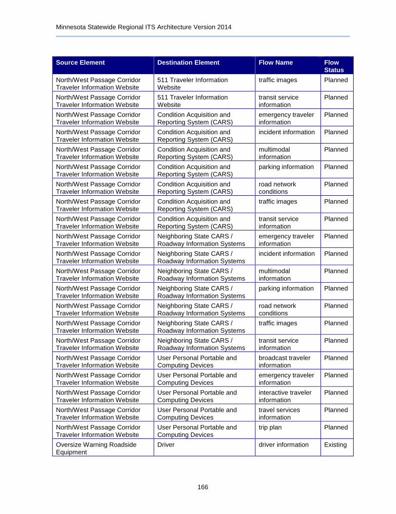
Minnesota Statewide Regional ITS Architecture Version 2014
166
Source Element Destination Element Flow Name Flow Status
North/West Passage Corridor Traveler Information Website
511 Traveler Information Website
traffic images Planned
North/West Passage Corridor Traveler Information Website
511 Traveler Information Website
transit service information
Planned
North/West Passage Corridor Traveler Information Website
Condition Acquisition and Reporting System (CARS)
emergency traveler information
Planned
North/West Passage Corridor Traveler Information Website
Condition Acquisition and Reporting System (CARS)
incident information Planned
North/West Passage Corridor Traveler Information Website
Condition Acquisition and Reporting System (CARS)
multimodal information
Planned
North/West Passage Corridor Traveler Information Website
Condition Acquisition and Reporting System (CARS)
parking information Planned
North/West Passage Corridor Traveler Information Website
Condition Acquisition and Reporting System (CARS)
road network conditions
Planned
North/West Passage Corridor Traveler Information Website
Condition Acquisition and Reporting System (CARS)
traffic images Planned
North/West Passage Corridor Traveler Information Website
Condition Acquisition and Reporting System (CARS)
transit service information
Planned
North/West Passage Corridor Traveler Information Website
Neighboring State CARS / Roadway Information Systems
emergency traveler information
Planned
North/West Passage Corridor Traveler Information Website
Neighboring State CARS / Roadway Information Systems
incident information Planned
North/West Passage Corridor Traveler Information Website
Neighboring State CARS / Roadway Information Systems
multimodal information
Planned
North/West Passage Corridor Traveler Information Website
Neighboring State CARS / Roadway Information Systems
parking information Planned
North/West Passage Corridor Traveler Information Website
Neighboring State CARS / Roadway Information Systems
road network conditions
Planned
North/West Passage Corridor Traveler Information Website
Neighboring State CARS / Roadway Information Systems
traffic images Planned
North/West Passage Corridor Traveler Information Website
Neighboring State CARS / Roadway Information Systems
transit service information
Planned
North/West Passage Corridor Traveler Information Website
User Personal Portable and Computing Devices
broadcast traveler information
Planned
North/West Passage Corridor Traveler Information Website
User Personal Portable and Computing Devices
emergency traveler information
Planned
North/West Passage Corridor Traveler Information Website
User Personal Portable and Computing Devices
interactive traveler information
Planned
North/West Passage Corridor Traveler Information Website
User Personal Portable and Computing Devices
travel services information
Planned
North/West Passage Corridor Traveler Information Website
User Personal Portable and Computing Devices
trip plan Planned
Oversize Warning Roadside Equipment
Driver driver information Existing
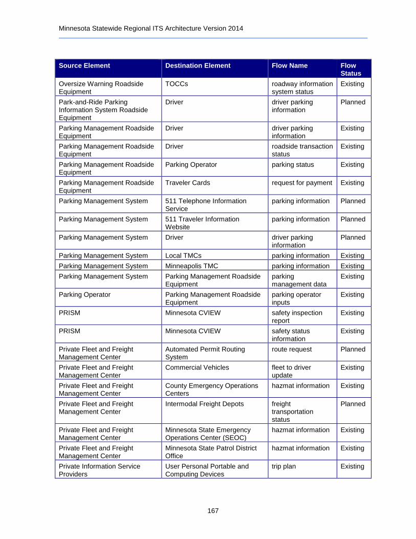
Minnesota Statewide Regional ITS Architecture Version 2014
167
Source Element Destination Element Flow Name Flow Status
Oversize Warning Roadside Equipment
TOCCs roadway information system status
Existing
Park-and-Ride Parking Information System Roadside Equipment
Driver driver parking information
Planned
Parking Management Roadside Equipment
Driver driver parking information
Existing
Parking Management Roadside Equipment
Driver roadside transaction status
Existing
Parking Management Roadside Equipment
Parking Operator parking status Existing
Parking Management Roadside Equipment
Traveler Cards request for payment Existing
Parking Management System 511 Telephone Information Service
parking information Planned
Parking Management System 511 Traveler Information Website
parking information Planned
Parking Management System Driver driver parking information
Planned
Parking Management System Local TMCs parking information Existing
Parking Management System Minneapolis TMC parking information Existing
Parking Management System Parking Management Roadside Equipment
parking management data
Existing
Parking Operator Parking Management Roadside Equipment
parking operator inputs
Existing
PRISM Minnesota CVIEW safety inspection report
Existing
PRISM Minnesota CVIEW safety status information
Existing
Private Fleet and Freight Management Center
Automated Permit Routing System
route request Planned
Private Fleet and Freight Management Center
Commercial Vehicles fleet to driver update
Existing
Private Fleet and Freight Management Center
County Emergency Operations Centers
hazmat information Existing
Private Fleet and Freight Management Center
Intermodal Freight Depots freight transportation status
Planned
Private Fleet and Freight Management Center
Minnesota State Emergency Operations Center (SEOC)
hazmat information Existing
Private Fleet and Freight Management Center
Minnesota State Patrol District Office
hazmat information Existing
Private Information Service Providers
User Personal Portable and Computing Devices
trip plan Existing
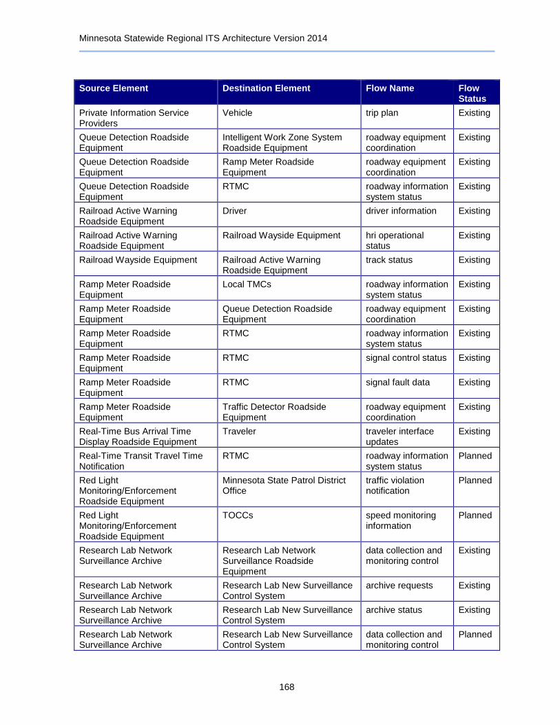
Minnesota Statewide Regional ITS Architecture Version 2014
168
Source Element Destination Element Flow Name Flow Status
Private Information Service Providers
Vehicle trip plan Existing
Queue Detection Roadside Equipment
Intelligent Work Zone System Roadside Equipment
roadway equipment coordination
Existing
Queue Detection Roadside Equipment
Ramp Meter Roadside Equipment
roadway equipment coordination
Existing
Queue Detection Roadside Equipment
RTMC roadway information system status
Existing
Railroad Active Warning Roadside Equipment
Driver driver information Existing
Railroad Active Warning Roadside Equipment
Railroad Wayside Equipment hri operational status
Existing
Railroad Wayside Equipment Railroad Active Warning Roadside Equipment
track status Existing
Ramp Meter Roadside Equipment
Local TMCs roadway information system status
Existing
Ramp Meter Roadside Equipment
Queue Detection Roadside Equipment
roadway equipment coordination
Existing
Ramp Meter Roadside Equipment
RTMC roadway information system status
Existing
Ramp Meter Roadside Equipment
RTMC signal control status Existing
Ramp Meter Roadside Equipment
RTMC signal fault data Existing
Ramp Meter Roadside Equipment
Traffic Detector Roadside Equipment
roadway equipment coordination
Existing
Real-Time Bus Arrival Time Display Roadside Equipment
Traveler traveler interface updates
Existing
Real-Time Transit Travel Time Notification
RTMC roadway information system status
Planned
Red Light Monitoring/Enforcement Roadside Equipment
Minnesota State Patrol District Office
traffic violation notification
Planned
Red Light Monitoring/Enforcement Roadside Equipment
TOCCs speed monitoring information
Planned
Research Lab Network Surveillance Archive
Research Lab Network Surveillance Roadside Equipment
data collection and monitoring control
Existing
Research Lab Network Surveillance Archive
Research Lab New Surveillance Control System
archive requests Existing
Research Lab Network Surveillance Archive
Research Lab New Surveillance Control System
archive status Existing
Research Lab Network Surveillance Archive
Research Lab New Surveillance Control System
data collection and monitoring control
Planned

Minnesota Statewide Regional ITS Architecture Version 2014
169
Source Element Destination Element Flow Name Flow Status
Research Lab Network Surveillance Archive
RTMC archived data products
Planned
Research Lab Network Surveillance Roadside Equipment
Research Lab Network Surveillance Archive
roadside archive data
Existing
Research Lab Network Surveillance Roadside Equipment
Research Lab New Surveillance Control System
traffic images Existing
Research Lab New Surveillance Control System
Research Lab Network Surveillance Archive
probe archive data Planned
Research Lab New Surveillance Control System
Research Lab Network Surveillance Archive
roadside archive data
Planned
Research Lab New Surveillance Control System
Research Lab Network Surveillance Archive
traffic archive data Existing
Research Lab New Surveillance Control System
Research Lab Network Surveillance Roadside Equipment
video surveillance control
Existing
Rest Area Wi-Fi 511 Traveler Information Website
emergency traveler information request
Planned
Rest Area Wi-Fi Traveler traveler interface updates
Planned
Rest Area Wi-Fi User Personal Portable and Computing Devices
broadcast traveler information
Planned
Roadway Automated Treatment System
Driver driver information Existing
Roadway Automated Treatment System
Maintenance and Construction Management Center
roadway treatment system status
Planned
Roadway Automated Treatment System
RTMC roadway treatment system status
Existing
Roadway Automated Treatment System
TOCCs roadway treatment system status
Existing
Roadway Environment Transit Vehicle Equipment roadway characteristics
Planned
Roadway Environment Vehicle roadway characteristics
Planned
Roadway Flooding Warning Roadside Equipment
Driver driver information Existing
Roadway Flooding Warning Roadside Equipment
Maintenance and Construction Management Center
flood warning alert Planned
Roadway Lighting Management Central Monitoring Equipment
Roadway Lighting Management Roadside Equipment
lighting system control data
Planned
Roadway Lighting Management Roadside Equipment
Roadway Lighting Management Central Monitoring Equipment
lighting system status
Planned
RTMC 511 Traveler Information Website
incident information Existing
Minnesota Statewide Regional ITS Architecture Version 2014
170
Source Element Destination Element Flow Name Flow Status
RTMC 511 Traveler Information Website
road network conditions
Existing
RTMC Bridge Inspection / Structural Monitoring Roadside Equipment
infrastructure monitoring sensor control
Planned
RTMC CCTV Roadside Equipment video surveillance control
Existing
RTMC Condition Acquisition and Reporting System (CARS)
alert notification Existing
RTMC Condition Acquisition and Reporting System (CARS)
maint and constr work plans
Existing
RTMC Condition Acquisition and Reporting System (CARS)
road network conditions
Existing
RTMC Condition Acquisition and Reporting System (CARS)
road weather information
Existing
RTMC Condition Acquisition and Reporting System (CARS)
work zone information
Existing
RTMC County Emergency Operations Centers
traffic image data Planned
RTMC Dynamic Late Merge Roadside Equipment
work zone warning device control
Existing
RTMC Dynamic Message Sign Roadside Equipment
roadway information system data
Existing
RTMC Emergency Vehicle Equipment emergency dispatch requests
Existing
RTMC Event Promoters event confirmation Existing
RTMC FIRST Emergency Vehicles emergency dispatch requests
Existing
RTMC FIRST Emergency Vehicles suggested route Existing
RTMC Highway Advisory Radio Roadside Equipment
roadway information system data
Existing
RTMC Infrastructure GIS Database Systems
asset status update Planned
RTMC Intelligent Work Zone System Roadside Equipment
roadway information system data
Existing
RTMC Intelligent Work Zone System Roadside Equipment
work zone warning device control
Existing
RTMC Lane Control Roadside Equipment
roadway information system data
Existing
RTMC Lane/Ramp Access Control Roadside Equipment
reversible lane control
Existing
RTMC Maintenance and Construction Management Center
maint and constr resource coordination
Existing
Minnesota Statewide Regional ITS Architecture Version 2014
171
Source Element Destination Element Flow Name Flow Status
RTMC Maintenance and Construction Management Center
road network conditions
Existing
RTMC Maintenance and Construction Management Center
work plan coordination
Existing
RTMC Mayday System incident command information coordination
Existing
RTMC Media Outlets maint and constr work plans
Existing
RTMC Media Outlets road weather information
Existing
RTMC Media Outlets roadway maintenance status
Existing
RTMC Media Outlets traffic information for media
Existing
RTMC Media Outlets traveler information for media
Existing
RTMC Media Outlets work zone information
Existing
RTMC Metro Area Transit Management Centers
current asset restrictions
Existing
RTMC Metro Area Transit Management Centers
road network conditions
Existing
RTMC Metro Area Transit Management Centers
roadway maintenance status
Existing
RTMC Metro Area Transit Management Centers
work zone information
Existing
RTMC Minneapolis TMC device control request
Planned
RTMC Minneapolis TMC device data Planned
RTMC Minneapolis TMC device status Planned
RTMC Minneapolis TMC emergency plan coordination
Planned
RTMC Minneapolis TMC emergency traffic control request
Existing
RTMC Minneapolis TMC emergency traffic coordination
Planned
RTMC Minneapolis TMC evacuation information
Planned
RTMC Minneapolis TMC incident information Planned
RTMC Minneapolis TMC maint and constr resource response
Planned
RTMC Minneapolis TMC remote surveillance control
Planned
Minnesota Statewide Regional ITS Architecture Version 2014
172
Source Element Destination Element Flow Name Flow Status
RTMC Minneapolis TMC resource request Planned
RTMC Minneapolis TMC road network conditions
Planned
RTMC Minneapolis TMC road weather information
Planned
RTMC Minneapolis TMC traffic images Planned
RTMC Minnesota State Emergency Operations Center (SEOC)
emergency traffic control information
Existing
RTMC Minnesota State Emergency Operations Center (SEOC)
resource deployment status
Existing
RTMC Minnesota State Emergency Operations Center (SEOC)
road network conditions
Existing
RTMC Minnesota State Emergency Operations Center (SEOC)
road network status assessment
Existing
RTMC Minnesota State Emergency Operations Center (SEOC)
traffic images Existing
RTMC Minnesota State Patrol District Office
incident information Existing
RTMC Minnesota State Patrol District Office
incident report Existing
RTMC Minnesota State Patrol District Office
road network conditions
Existing
RTMC Minnesota State Patrol District Office
traffic violation notification
Planned
RTMC MnPASS Roadside Equipment reversible lane control
Existing
RTMC North/West Passage Corridor Traveler Information Website
current asset restrictions
Planned
RTMC North/West Passage Corridor Traveler Information Website
maint and constr work plans
Planned
RTMC North/West Passage Corridor Traveler Information Website
road network conditions
Planned
RTMC North/West Passage Corridor Traveler Information Website
road weather information
Planned
RTMC North/West Passage Corridor Traveler Information Website
roadway maintenance status
Planned
RTMC North/West Passage Corridor Traveler Information Website
work zone information
Planned
RTMC Private Information Service Providers
incident information Planned
RTMC Private Information Service Providers
road network conditions
Planned
RTMC Queue Detection Roadside Equipment
roadway information system data
Existing

Minnesota Statewide Regional ITS Architecture Version 2014
173
Source Element Destination Element Flow Name Flow Status
RTMC Ramp Meter Roadside Equipment
signal control commands
Existing
RTMC Ramp Meter Roadside Equipment
signal control device configuration
Existing
RTMC Ramp Meter Roadside Equipment
signal control plans Existing
RTMC Ramp Meter Roadside Equipment
signal system configuration
Existing
RTMC Real-Time Transit Travel Time Notification
roadway information system data
Planned
RTMC Research Lab Network Surveillance Archive
archived data product requests
Planned
RTMC Roadway Automated Treatment System
roadway treatment system control
Existing
RTMC Security Monitoring Roadside Equipment
infrastructure monitoring sensor control
Planned
RTMC Security Monitoring Roadside Equipment
secure area sensor control
Planned
RTMC Security Monitoring Roadside Equipment
secure area surveillance control
Planned
RTMC Surface Transportation Weather Service Providers
road weather information
Existing
RTMC Traffic Data and Video Archive archive analysis requests
Planned
RTMC Traffic Data and Video Archive archive coordination Planned
RTMC Traffic Data and Video Archive archived data product requests
Planned
RTMC Traffic Data and Video Archive traffic archive data Existing
RTMC Traffic Detector Roadside Equipment
traffic sensor control Existing
RTMC Traffic Signal Roadside Equipment
signal control commands
Existing
RTMC Traffic Signal Roadside Equipment
signal control device configuration
Existing
RTMC Traffic Signal Roadside Equipment
signal control plans Existing
RTMC Traffic Signal Roadside Equipment
signal system configuration
Existing
RTMC Transportation Information System (TIS)
archive coordination Existing
RTMC Transportation Information System (TIS)
maint and constr archive data
Existing
RTMC Transportation Information System (TIS)
traffic archive data Existing

Minnesota Statewide Regional ITS Architecture Version 2014
174
Source Element Destination Element Flow Name Flow Status
RTMC Variable Speed Limit Roadside Equipment
roadway information system data
Planned
RTMC Vehicle Occupancy Monitoring/Enforcement Roadside Equipment
traffic sensor control Planned
RTMC Vehicle Occupancy Monitoring/Enforcement Roadside Equipment
video surveillance control
Planned
RWIS Central Control System 511 Telephone Information Service
weather information Existing
RWIS Central Control System 511 Traveler Information Website
weather information Existing
RWIS Central Control System Clarus Weather System environmental conditions data
Planned
RWIS Central Control System Condition Acquisition and Reporting System (CARS)
road weather information
Planned
RWIS Central Control System Condition Acquisition and Reporting System (CARS)
weather information Planned
RWIS Central Control System Maintenance and Construction Management Center
environmental conditions data status
Planned
RWIS Central Control System Maintenance and Construction Management Center
road weather information
Planned
RWIS Central Control System Minnesota State Patrol District Office
weather information Existing
RWIS Central Control System RTMC weather information Existing
RWIS Central Control System RWIS Stations environmental sensors control
Existing
RWIS Central Control System Surface Transportation Weather Service Providers
weather information Existing
RWIS Central Control System Transportation Information System (TIS)
archive coordination Existing
RWIS Central Control System UMD Transportation Data Research Laboratory (TDRL)
weather archive data
Existing
RWIS Stations Clarus Weather System environmental sensor data
Existing
RWIS Stations RWIS Central Control System environmental sensor data
Existing
SAFER Minnesota CVIEW safety inspection report
Existing
SAFER Minnesota CVIEW safety status information
Existing
Security Monitoring Roadside Equipment
911 Dispatch Center infrastructure monitoring sensor data
Planned

Minnesota Statewide Regional ITS Architecture Version 2014
175
Source Element Destination Element Flow Name Flow Status
Security Monitoring Roadside Equipment
911 Dispatch Center secure area sensor data
Planned
Security Monitoring Roadside Equipment
911 Dispatch Center secure area surveillance data
Planned
Security Monitoring Roadside Equipment
RTMC infrastructure monitoring sensor data
Planned
Security Monitoring Roadside Equipment
RTMC secure area sensor data
Planned
Security Monitoring Roadside Equipment
RTMC secure area surveillance data
Planned
Security Monitoring Roadside Equipment
TOCCs infrastructure monitoring sensor data
Planned
Security Monitoring Roadside Equipment
TOCCs secure area sensor data
Planned
Security Monitoring Roadside Equipment
TOCCs secure area surveillance data
Planned
Speed Monitoring Roadside Equipment
Dynamic Message Sign Roadside Equipment
roadway equipment coordination
Planned
Speed Monitoring Roadside Equipment
Minneapolis TMC speed monitoring information
Planned
Speed Monitoring Roadside Equipment
Minneapolis TMC traffic images Planned
Speed Monitoring Roadside Equipment
Minnesota State Patrol District Office
speed monitoring information
Planned
Speed Monitoring Roadside Equipment
Minnesota State Patrol District Office
traffic violation notification
Planned
Speed Monitoring Roadside Equipment
RTMC speed monitoring information
Planned
Surface Transportation Weather Service Providers
Local Agency Traveler Information Website
transportation weather information
Existing
Surface Transportation Weather Service Providers
Maintenance and Construction Management Center
transportation weather information
Existing
Surface Transportation Weather Service Providers
RTMC transportation weather information
Existing
Surface Transportation Weather Service Providers
TOCCs transportation weather information
Existing
TOCCs 511 Telephone Information Service
incident information Planned
TOCCs 511 Telephone Information Service
road network conditions
Planned
TOCCs 511 Traveler Information Website
incident information Planned
Minnesota Statewide Regional ITS Architecture Version 2014
176
Source Element Destination Element Flow Name Flow Status
TOCCs 511 Traveler Information Website
road network conditions
Planned
TOCCs Advanced Pavement Condition and Visibility Warning System Roadside Equipment
environmental sensors control
Planned
TOCCs Advanced Pavement Condition and Visibility Warning System Roadside Equipment
roadway information system data
Planned
TOCCs Animal Crossing Warning Roadside Equipment
traffic sensor control Planned
TOCCs Bridge Inspection / Structural Monitoring Roadside Equipment
infrastructure monitoring sensor control
Planned
TOCCs CCTV Roadside Equipment video surveillance control
Existing
TOCCs Condition Acquisition and Reporting System (CARS)
alert notification Existing
TOCCs Condition Acquisition and Reporting System (CARS)
maint and constr work plans
Planned
TOCCs Condition Acquisition and Reporting System (CARS)
road network conditions
Existing
TOCCs Condition Acquisition and Reporting System (CARS)
road weather information
Existing
TOCCs Condition Acquisition and Reporting System (CARS)
work zone information
Existing
TOCCs County Emergency Operations Centers
traffic image data Planned
TOCCs Data Distribution Server archived data product requests
Existing
TOCCs Dynamic Late Merge Roadside Equipment
work zone warning device control
Existing
TOCCs Dynamic Message Sign Roadside Equipment
roadway information system data
Existing
TOCCs Emergency Vehicle Equipment emergency dispatch requests
Existing
TOCCs Event Promoters event confirmation Existing
TOCCs Highway Advisory Radio Roadside Equipment
roadway information system data
Existing
TOCCs Infrastructure GIS Database Systems
asset status update Planned
TOCCs Intelligent Work Zone System Roadside Equipment
roadway information system data
Planned
TOCCs Intelligent Work Zone System Roadside Equipment
work zone warning device control
Planned

Minnesota Statewide Regional ITS Architecture Version 2014
177
Source Element Destination Element Flow Name Flow Status
TOCCs Lane Control Roadside Equipment
roadway information system data
Planned
TOCCs Lane/Ramp Access Control Roadside Equipment
barrier system control
Existing
TOCCs Lane/Ramp Access Control Roadside Equipment
roadway information system data
Existing
TOCCs Lane/Ramp Access Control Roadside Equipment
video surveillance control
Existing
TOCCs Local TMCs device control request
Planned
TOCCs Local TMCs device data Planned
TOCCs Local TMCs device status Planned
TOCCs Local TMCs emergency traffic coordination
Planned
TOCCs Local TMCs road network conditions
Planned
TOCCs Local TMCs traffic images Planned
TOCCs Maintenance and Construction Management Center
maint and constr resource coordination
Planned
TOCCs Maintenance and Construction Management Center
road network conditions
Existing
TOCCs Maintenance and Construction Management Center
work plan coordination
Planned
TOCCs Maintenance and Construction Vehicle Equipment
environmental sensors control
Existing
TOCCs Maintenance and Construction Vehicle Equipment
maint and constr dispatch information
Existing
TOCCs Maintenance and Construction Vehicle Equipment
maint and constr vehicle system control
Existing
TOCCs Media Outlets maint and constr work plans
Existing
TOCCs Media Outlets road weather information
Existing
TOCCs Media Outlets roadway maintenance status
Existing
TOCCs Minnesota State Emergency Operations Center (SEOC)
traffic images Existing
TOCCs Minnesota State Patrol District Office
incident report Existing
TOCCs Neighboring State Traffic Management Centers
device control request
Planned
TOCCs Neighboring State Traffic Management Centers
device data Planned
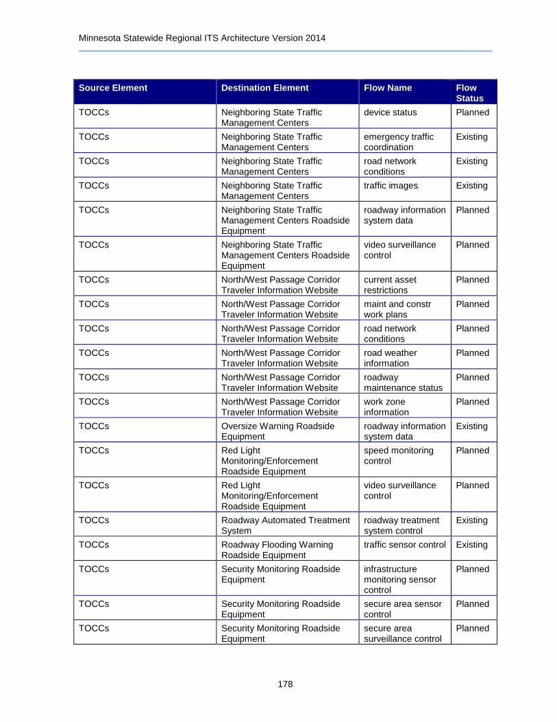
Minnesota Statewide Regional ITS Architecture Version 2014
178
Source Element Destination Element Flow Name Flow Status
TOCCs Neighboring State Traffic Management Centers
device status Planned
TOCCs Neighboring State Traffic Management Centers
emergency traffic coordination
Existing
TOCCs Neighboring State Traffic Management Centers
road network conditions
Existing
TOCCs Neighboring State Traffic Management Centers
traffic images Existing
TOCCs Neighboring State Traffic Management Centers Roadside Equipment
roadway information system data
Planned
TOCCs Neighboring State Traffic Management Centers Roadside Equipment
video surveillance control
Planned
TOCCs North/West Passage Corridor Traveler Information Website
current asset restrictions
Planned
TOCCs North/West Passage Corridor Traveler Information Website
maint and constr work plans
Planned
TOCCs North/West Passage Corridor Traveler Information Website
road network conditions
Planned
TOCCs North/West Passage Corridor Traveler Information Website
road weather information
Planned
TOCCs North/West Passage Corridor Traveler Information Website
roadway maintenance status
Planned
TOCCs North/West Passage Corridor Traveler Information Website
work zone information
Planned
TOCCs Oversize Warning Roadside Equipment
roadway information system data
Existing
TOCCs Red Light Monitoring/Enforcement Roadside Equipment
speed monitoring control
Planned
TOCCs Red Light Monitoring/Enforcement Roadside Equipment
video surveillance control
Planned
TOCCs Roadway Automated Treatment System
roadway treatment system control
Existing
TOCCs Roadway Flooding Warning Roadside Equipment
traffic sensor control Existing
TOCCs Security Monitoring Roadside Equipment
infrastructure monitoring sensor control
Planned
TOCCs Security Monitoring Roadside Equipment
secure area sensor control
Planned
TOCCs Security Monitoring Roadside Equipment
secure area surveillance control
Planned
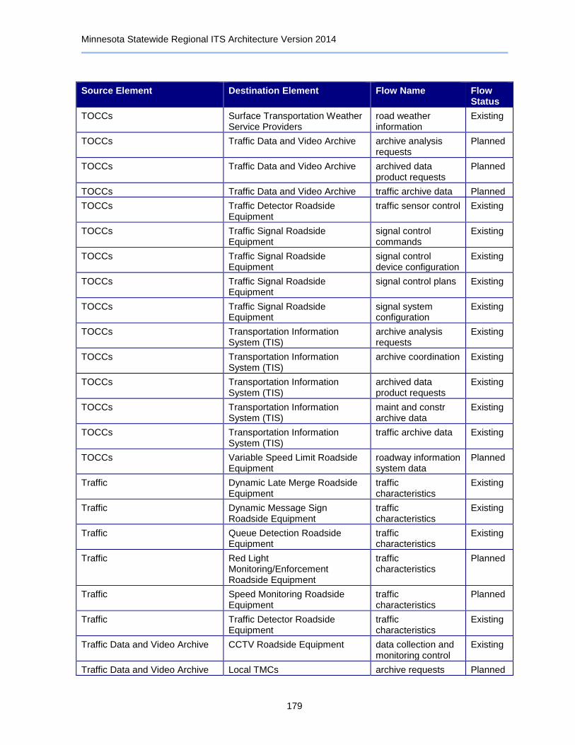
Minnesota Statewide Regional ITS Architecture Version 2014
179
Source Element Destination Element Flow Name Flow Status
TOCCs Surface Transportation Weather Service Providers
road weather information
Existing
TOCCs Traffic Data and Video Archive archive analysis requests
Planned
TOCCs Traffic Data and Video Archive archived data product requests
Planned
TOCCs Traffic Data and Video Archive traffic archive data Planned
TOCCs Traffic Detector Roadside Equipment
traffic sensor control Existing
TOCCs Traffic Signal Roadside Equipment
signal control commands
Existing
TOCCs Traffic Signal Roadside Equipment
signal control device configuration
Existing
TOCCs Traffic Signal Roadside Equipment
signal control plans Existing
TOCCs Traffic Signal Roadside Equipment
signal system configuration
Existing
TOCCs Transportation Information System (TIS)
archive analysis requests
Existing
TOCCs Transportation Information System (TIS)
archive coordination Existing
TOCCs Transportation Information System (TIS)
archived data product requests
Existing
TOCCs Transportation Information System (TIS)
maint and constr archive data
Existing
TOCCs Transportation Information System (TIS)
traffic archive data Existing
TOCCs Variable Speed Limit Roadside Equipment
roadway information system data
Planned
Traffic Dynamic Late Merge Roadside Equipment
traffic characteristics
Existing
Traffic Dynamic Message Sign Roadside Equipment
traffic characteristics
Existing
Traffic Queue Detection Roadside Equipment
traffic characteristics
Existing
Traffic Red Light Monitoring/Enforcement Roadside Equipment
traffic characteristics
Planned
Traffic Speed Monitoring Roadside Equipment
traffic characteristics
Planned
Traffic Traffic Detector Roadside Equipment
traffic characteristics
Existing
Traffic Data and Video Archive CCTV Roadside Equipment data collection and monitoring control
Existing
Traffic Data and Video Archive Local TMCs archive requests Planned

Minnesota Statewide Regional ITS Architecture Version 2014
180
Source Element Destination Element Flow Name Flow Status
Traffic Data and Video Archive Local TMCs archive status Planned
Traffic Data and Video Archive Local TMCs archived data products
Planned
Traffic Data and Video Archive RTMC archive analysis results
Planned
Traffic Data and Video Archive RTMC archive coordination Planned
Traffic Data and Video Archive RTMC archive request confirmation
Planned
Traffic Data and Video Archive RTMC archive requests Existing
Traffic Data and Video Archive RTMC archive status Existing
Traffic Data and Video Archive RTMC archived data products
Existing
Traffic Data and Video Archive TOCCs archive analysis results
Planned
Traffic Data and Video Archive TOCCs archive request confirmation
Planned
Traffic Data and Video Archive TOCCs archive requests Planned
Traffic Data and Video Archive TOCCs archive status Planned
Traffic Data and Video Archive TOCCs archived data products
Planned
Traffic Data and Video Archive Traffic Detector Roadside Equipment
data collection and monitoring control
Existing
Traffic Detector Roadside Equipment
Local TMCs traffic flow Existing
Traffic Detector Roadside Equipment
Minneapolis TMC traffic flow Existing
Traffic Detector Roadside Equipment
Ramp Meter Roadside Equipment
roadway equipment coordination
Existing
Traffic Detector Roadside Equipment
RTMC traffic flow Existing
Traffic Detector Roadside Equipment
TOCCs traffic flow Existing
Traffic Detector Roadside Equipment
Traffic Data and Video Archive roadside archive data
Existing
Traffic Signal Roadside Equipment
Advance Warning Flasher Roadside Equipment
roadway equipment coordination
Existing
Traffic Signal Roadside Equipment
Local TMCs signal control status Existing
Traffic Signal Roadside Equipment
Local TMCs signal fault data Existing
Traffic Signal Roadside Equipment
Minneapolis TMC right-of-way request notification
Planned
Traffic Signal Roadside Equipment
Minneapolis TMC signal control status Planned
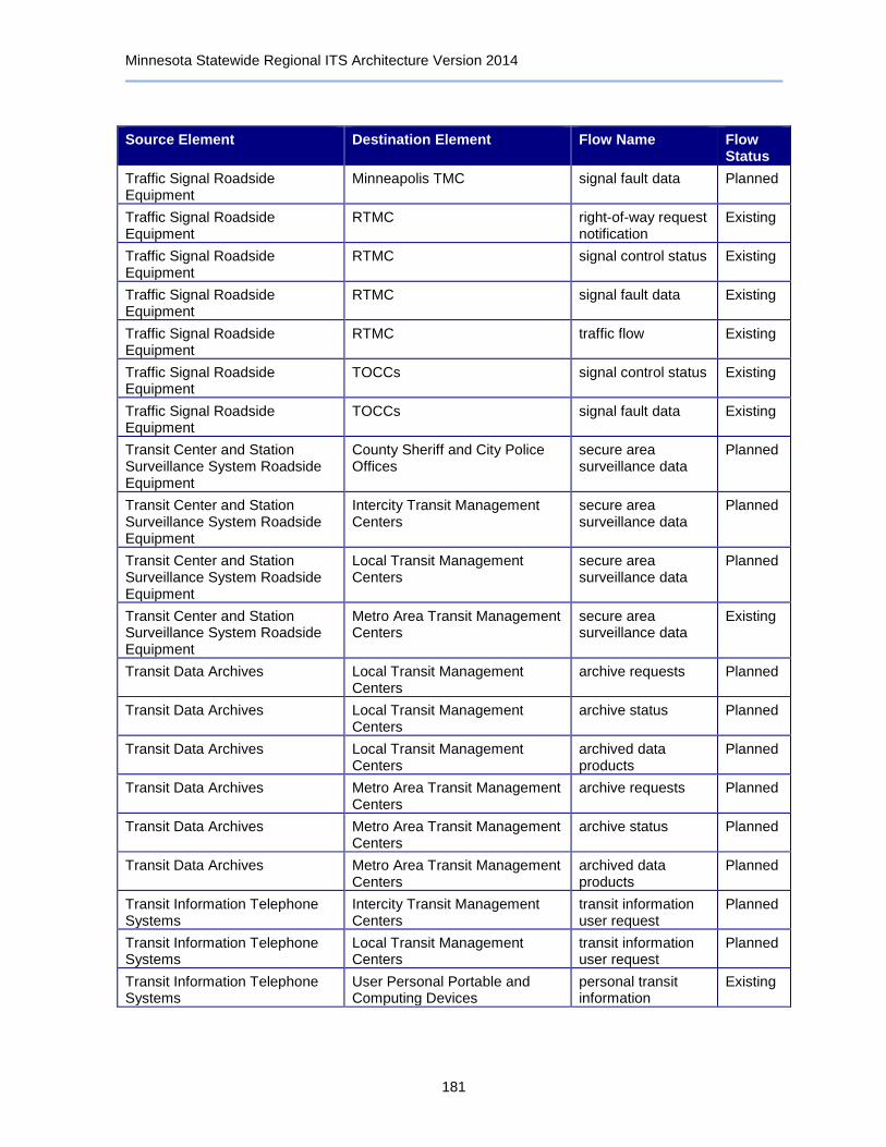
Minnesota Statewide Regional ITS Architecture Version 2014
181
Source Element Destination Element Flow Name Flow Status
Traffic Signal Roadside Equipment
Minneapolis TMC signal fault data Planned
Traffic Signal Roadside Equipment
RTMC right-of-way request notification
Existing
Traffic Signal Roadside Equipment
RTMC signal control status Existing
Traffic Signal Roadside Equipment
RTMC signal fault data Existing
Traffic Signal Roadside Equipment
RTMC traffic flow Existing
Traffic Signal Roadside Equipment
TOCCs signal control status Existing
Traffic Signal Roadside Equipment
TOCCs signal fault data Existing
Transit Center and Station Surveillance System Roadside Equipment
County Sheriff and City Police Offices
secure area surveillance data
Planned
Transit Center and Station Surveillance System Roadside Equipment
Intercity Transit Management Centers
secure area surveillance data
Planned
Transit Center and Station Surveillance System Roadside Equipment
Local Transit Management Centers
secure area surveillance data
Planned
Transit Center and Station Surveillance System Roadside Equipment
Metro Area Transit Management Centers
secure area surveillance data
Existing
Transit Data Archives Local Transit Management Centers
archive requests Planned
Transit Data Archives Local Transit Management Centers
archive status Planned
Transit Data Archives Local Transit Management Centers
archived data products
Planned
Transit Data Archives Metro Area Transit Management Centers
archive requests Planned
Transit Data Archives Metro Area Transit Management Centers
archive status Planned
Transit Data Archives Metro Area Transit Management Centers
archived data products
Planned
Transit Information Telephone Systems
Intercity Transit Management Centers
transit information user request
Planned
Transit Information Telephone Systems
Local Transit Management Centers
transit information user request
Planned
Transit Information Telephone Systems
User Personal Portable and Computing Devices
personal transit information
Existing

Minnesota Statewide Regional ITS Architecture Version 2014
182
Source Element Destination Element Flow Name Flow Status
Transit Information Websites Intercity Transit Management Centers
transit information request
Planned
Transit Information Websites Local Transit Management Centers
demand responsive transit request
Planned
Transit Information Websites Local Transit Management Centers
transit information request
Existing
Transit Information Websites Metro Area Transit Management Centers
transit information request
Existing
Transit Information Websites User Personal Portable and Computing Devices
broadcast traveler information
Existing
Transit Information Websites User Personal Portable and Computing Devices
interactive traveler information
Planned
Transit Information Websites User Personal Portable and Computing Devices
trip plan Existing
Transit Kiosks Intercity Transit Management Centers
transit information user request
Planned
Transit Kiosks Local Transit Management Centers
transit information user request
Planned
Transit Kiosks Metro Area Transit Management Centers
transit fare and passenger status
Existing
Transit Kiosks Metro Area Transit Management Centers
transit information user request
Existing
Transit Kiosks Traveler traveler interface updates
Existing
Transit Kiosks Traveler Cards request for payment Existing
Transit Vehicle Equipment Commuter Rail Operations Center
alarm notification Planned
Transit Vehicle Equipment Commuter Rail Operations Center
transit vehicle conditions
Planned
Transit Vehicle Equipment Commuter Rail Operations Center
transit vehicle location data
Planned
Transit Vehicle Equipment Commuter Rail Operations Center
transit vehicle schedule performance
Planned
Transit Vehicle Equipment Driver driver updates Planned
Transit Vehicle Equipment Intercity Transit Management Centers
alarm notification Planned
Transit Vehicle Equipment Intercity Transit Management Centers
transit vehicle schedule performance
Existing
Transit Vehicle Equipment Lane/Ramp Access Control Roadside Equipment
gate system activation
Planned
Transit Vehicle Equipment Light Rail Operations Center alarm notification Existing

Minnesota Statewide Regional ITS Architecture Version 2014
183
Source Element Destination Element Flow Name Flow Status
Transit Vehicle Equipment Light Rail Operations Center demand response passenger and use data
Planned
Transit Vehicle Equipment Light Rail Operations Center fare collection data Planned
Transit Vehicle Equipment Light Rail Operations Center request for bad tag list
Planned
Transit Vehicle Equipment Light Rail Operations Center secure area surveillance data
Existing
Transit Vehicle Equipment Light Rail Operations Center transit traveler request
Planned
Transit Vehicle Equipment Light Rail Operations Center transit vehicle conditions
Existing
Transit Vehicle Equipment Light Rail Operations Center transit vehicle loading data
Planned
Transit Vehicle Equipment Light Rail Operations Center transit vehicle location data
Existing
Transit Vehicle Equipment Light Rail Operations Center transit vehicle schedule performance
Existing
Transit Vehicle Equipment Local Transit Management Centers
transit vehicle conditions
Existing
Transit Vehicle Equipment Local Transit Management Centers
transit vehicle schedule performance
Planned
Transit Vehicle Equipment Metro Area Transit Management Centers
alarm notification Existing
Transit Vehicle Equipment Metro Area Transit Management Centers
demand response passenger and use data
Existing
Transit Vehicle Equipment Metro Area Transit Management Centers
fare collection data Existing
Transit Vehicle Equipment Metro Area Transit Management Centers
request for bad tag list
Existing
Transit Vehicle Equipment Metro Area Transit Management Centers
transit vehicle conditions
Existing
Transit Vehicle Equipment Metro Area Transit Management Centers
transit vehicle location data
Existing
Transit Vehicle Equipment Metro Area Transit Management Centers
transit vehicle schedule performance
Existing
Transit Vehicle Equipment Traffic Signal Roadside Equipment
local signal priority request
Existing
Transit Vehicle Equipment Traveler traveler interface updates
Planned
Transit Vehicle Equipment Traveler Cards request for payment Existing

Minnesota Statewide Regional ITS Architecture Version 2014
184
Source Element Destination Element Flow Name Flow Status
Transit Vehicle Operator Local Transit Management Centers
transit vehicle operator availability
Planned
Transit Vehicle Operator Metro Area Transit Management Centers
transit vehicle operator availability
Planned
Transportation Information System (TIS)
Condition Acquisition and Reporting System (CARS)
archive coordination Existing
Transportation Information System (TIS)
Condition Acquisition and Reporting System (CARS)
archive requests Existing
Transportation Information System (TIS)
Condition Acquisition and Reporting System (CARS)
archive status Existing
Transportation Information System (TIS)
Minneapolis TMC archive analysis results
Planned
Transportation Information System (TIS)
Minneapolis TMC archived data products
Planned
Transportation Information System (TIS)
RTMC archive analysis results
Existing
Transportation Information System (TIS)
RTMC archive coordination Existing
Transportation Information System (TIS)
RTMC archive requests Existing
Transportation Information System (TIS)
RTMC archive status Existing
Transportation Information System (TIS)
RTMC archived data products
Existing
Transportation Information System (TIS)
RWIS Central Control System archive coordination Existing
Transportation Information System (TIS)
TOCCs archive analysis results
Existing
Transportation Information System (TIS)
TOCCs archive coordination Existing
Transportation Information System (TIS)
TOCCs archive requests Existing
Transportation Information System (TIS)
TOCCs archive status Existing
Transportation Information System (TIS)
TOCCs archived data products
Existing
Traveler Rest Area Wi-Fi traveler inputs Planned
Traveler Transit Kiosks traveler inputs Existing
Traveler Transit Vehicle Equipment boarding and alighting
Existing
Traveler Traveler Information and Parking Kiosks
traveler inputs Planned
Traveler User Personal Portable and Computing Devices
traveler inputs Existing

Minnesota Statewide Regional ITS Architecture Version 2014
185
Source Element Destination Element Flow Name Flow Status
Traveler Cards Parking Management Roadside Equipment
payment Existing
Traveler Cards Transit Kiosks payment Existing
Traveler Cards Transit Vehicle Equipment payment Existing
Traveler Information and Parking Kiosks
Condition Acquisition and Reporting System (CARS)
traveler request Planned
Traveler Information and Parking Kiosks
Traveler traveler interface updates
Planned
Truck Center CVO Information Requestor cv driver record Existing
Truck Center IFTA Clearinghouse credential fee coordination
Existing
Truck Center IFTA Clearinghouse credentials information
Existing
Truck Center IFTA Clearinghouse credentials status information
Existing
Truck Center IFTA Clearinghouse safety inspection report
Planned
Truck Center IRP Clearinghouse border clearance status
Existing
Truck Center IRP Clearinghouse credential fee coordination
Existing
Truck Center IRP Clearinghouse credentials information
Existing
Truck Center IRP Clearinghouse credentials status information
Existing
Truck Center IRP Clearinghouse safety inspection report
Existing
Truck Center Motor Carrier Registration System
credentials information
Existing
Truck Center Private Fleet and Freight Management Center
route plan Existing
Truck Center Private Fleet and Freight Management Center
route restrictions Existing
UMD Transportation Data Research Laboratory (TDRL)
RWIS Central Control System archive requests Existing
UMD Transportation Data Research Laboratory (TDRL)
RWIS Central Control System archive status Existing
UMD Transportation Data Research Laboratory (TDRL)
User Personal Portable and Computing Devices
archived data products
Existing
User Personal Portable and Computing Devices
511 Telephone Information Service
traveler profile Planned
User Personal Portable and Computing Devices
511 Telephone Information Service
traveler request Existing

Minnesota Statewide Regional ITS Architecture Version 2014
186
Source Element Destination Element Flow Name Flow Status
User Personal Portable and Computing Devices
511 Traveler Information Website
emergency traveler information request
Existing
User Personal Portable and Computing Devices
511 Traveler Information Website
traveler request Existing
User Personal Portable and Computing Devices
511 Traveler Information Website
trip confirmation Planned
User Personal Portable and Computing Devices
511 Traveler Information Website
trip request Planned
User Personal Portable and Computing Devices
Intercity Transit Management Centers
transit information user request
Planned
User Personal Portable and Computing Devices
Local Transit Management Centers
transit information user request
Existing
User Personal Portable and Computing Devices
Metro Area Transit Management Centers
transit information user request
Existing
User Personal Portable and Computing Devices
MnPASS Vehicle Equipment traveler card update Existing
User Personal Portable and Computing Devices
North/West Passage Corridor Traveler Information Website
emergency traveler information request
Planned
User Personal Portable and Computing Devices
North/West Passage Corridor Traveler Information Website
travel services request
Planned
User Personal Portable and Computing Devices
North/West Passage Corridor Traveler Information Website
traveler profile Planned
User Personal Portable and Computing Devices
North/West Passage Corridor Traveler Information Website
traveler request Planned
User Personal Portable and Computing Devices
North/West Passage Corridor Traveler Information Website
trip confirmation Planned
User Personal Portable and Computing Devices
North/West Passage Corridor Traveler Information Website
trip request Planned
User Personal Portable and Computing Devices
Private Information Service Providers
trip request Existing
User Personal Portable and Computing Devices
Transit Information Telephone Systems
transit information user request
Existing
User Personal Portable and Computing Devices
Transit Information Websites traveler profile Existing
User Personal Portable and Computing Devices
Transit Information Websites traveler request Existing
User Personal Portable and Computing Devices
Transit Information Websites trip request Existing
User Personal Portable and Computing Devices
Traveler traveler interface updates
Existing
Variable Speed Limit Roadside Equipment
Driver driver information Planned
Variable Speed Limit Roadside Equipment
Lane Control Roadside Equipment
roadway equipment coordination
Planned

Minnesota Statewide Regional ITS Architecture Version 2014
187
Source Element Destination Element Flow Name Flow Status
Variable Speed Limit Roadside Equipment
Minnesota State Patrol District Office
roadway information system status
Planned
Variable Speed Limit Roadside Equipment
RTMC roadway information system status
Planned
Variable Speed Limit Roadside Equipment
TOCCs roadway information system status
Planned
Vehicle Automated Crash Notification System
emergency notification
Planned
Vehicle Driver driver updates Planned
Vehicle MnPASS Vehicle Equipment request for payment Existing
Vehicle Oversize Warning Roadside Equipment
vehicle characteristics
Existing
Vehicle Park-and-Ride Parking Information System Roadside Equipment
vehicle characteristics
Planned
Vehicle Parking Management Roadside Equipment
vehicle characteristics
Existing
Vehicle Private Information Service Providers
trip request Existing
Vehicle Occupancy Monitoring/Enforcement Roadside Equipment
Minnesota State Patrol District Office
traffic violation notification
Planned
Virtual Weigh Stations Commercial Vehicles electronic screening request
Planned
Virtual Weigh Stations Commercial Vehicles request tag data Planned
Virtual Weigh Stations Commercial Vehicles screening event record
Planned
Virtual Weigh Stations Minnesota CVIEW safety inspection report
Planned
Weigh In Motion (WIM) Stations Commercial Vehicles electronic screening request
Existing
Weigh In Motion (WIM) Stations Commercial Vehicles request tag data Existing
Weigh In Motion (WIM) Stations Commercial Vehicles screening event record
Existing
Weigh In Motion (WIM) Stations Minnesota CVIEW safety inspection report
Existing
Weigh Station Roadside Equipment
Commercial Vehicles pass/pull-in Existing
Weigh Station Roadside Equipment
Commercial Vehicles safety inspection request
Existing
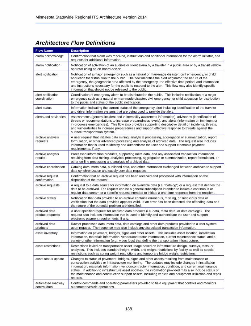
Minnesota Statewide Regional ITS Architecture Version 2014
188
Architecture Flow Definitions
Flow Name Description
alarm acknowledge Confirmation that alarm was received, instructions and additional information for the alarm initiator, and requests for additional information.
alarm notification Notification of activation of an audible or silent alarm by a traveler in a public area or by a transit vehicle operator using an on-board device.
alert notification Notification of a major emergency such as a natural or man-made disaster, civil emergency, or child abduction for distribution to the public. The flow identifies the alert originator, the nature of the emergency, the geographic area affected by the emergency, the effective time period, and information and instructions necessary for the public to respond to the alert. This flow may also identify specific information that should not be released to the public.
alert notification coordination
Coordination of emergency alerts to be distributed to the public. This includes notification of a major emergency such as a natural or man-made disaster, civil emergency, or child abduction for distribution to the public and status of the public notification.
alert status Information indicating the current status of the emergency alert including identification of the traveler and driver information systems that are being used to provide the alert.
alerts and advisories Assessments (general incident and vulnerability awareness information), advisories (identification of threats or recommendations to increase preparedness levels), and alerts (information on imminent or in-progress emergencies). This flow also provides supporting descriptive detail on incidents, threats, and vulnerabilities to increase preparedness and support effective response to threats against the surface transportation system.
archive analysis requests
A user request that initiates data mining, analytical processing, aggregation or summarization, report formulation, or other advanced processing and analysis of archived data. The request also includes information that is used to identify and authenticate the user and support electronic payment requirements, if any.
archive analysis results
Processed information products, supporting meta data, and any associated transaction information resulting from data mining, analytical processing, aggregation or summarization, report formulation, or other on-line processing and analysis of archived data.
archive coordination Catalog data, meta data, published data, and other information exchanged between archives to support data synchronization and satisfy user data requests.
archive request confirmation
Confirmation that an archive request has been received and processed with information on the disposition of the request.
archive requests A request to a data source for information on available data (i.e. "catalog") or a request that defines the data to be archived. The request can be a general subscription intended to initiate a continuous or regular data stream or a specific request intended to initiate a one-time response from the recipient.
archive status Notification that data provided to an archive contains erroneous, missing, or suspicious data or verification that the data provided appears valid. If an error has been detected, the offending data and the nature of the potential problem are identified.
archived data product requests
A user-specified request for archived data products (i.e. data, meta data, or data catalogs). The request also includes information that is used to identify and authenticate the user and support electronic payment requirements, if any.
archived data products
Raw or processed data, meta data, data catalogs and other data products provided to a user system upon request. The response may also include any associated transaction information.
asset inventory Information on pavement, bridges, signs and other assets. This includes asset location, installation information, materials information, vendor/contractor information, current maintenance status, and a variety of other information (e.g., video logs) that define the transportation infrastructure.
asset restrictions Restrictions levied on transportation asset usage based on infrastructure design, surveys, tests, or analyses. This includes standard height, width, and weight restrictions by facility as well as special restrictions such as spring weight restrictions and temporary bridge weight restrictions.
asset status update Changes to status of pavement, bridges, signs and other assets resulting from maintenance or construction activities or infrastructure monitoring. The updates may include changes in installation information, materials information, vendor/contractor information, condition, and current maintenance status. In addition to infrastructure asset updates, the information provided may also include status of the maintenance and construction support assets, including vehicle and equipment utilization and repair records.
automated roadway control data
Control commands and operating parameters provided to field equipment that controls and monitors automated vehicle operations.

Minnesota Statewide Regional ITS Architecture Version 2014
189
Flow Name Description
automated roadway status
Current operational status of an automated vehicle operations facility, including the status of the field equipment and vehicles using the facility.
bad tag list List of invalid transit user tags which may have previously failed a fare payment transaction.
barrier system control
Information used to configure and control barrier systems that are represented by gates, barriers and other automated or remotely controlled systems used to manage entry to roadways.
barrier system status Current operating status of barrier systems. Barrier systems represent gates, barriers and other automated or remotely controlled systems used to manage entry to roadways. Status of the systems includes operating condition and current operational state.
basic vehicle measures
Information provided to on-board ITS equipment from the vehicle platform indicating current vehicle status.
boarding and alighting
Detection of transit passenger boarding and alighting. This flow represents the travelers' physical presence as they board a transit vehicle that can be detected or monitored by on-board sensors.
border clearance event
Reports clearance event data regarding action taken at border, including acceptance or override of system decision, and date/time stamp
border clearance status
Notification regarding the crossing status of commercial freight shipment scheduled to enter the U.S. Includes portions of border agency and transportation agency clearance results, as they become available.
broadcast traveler information
General traveler information that contains traffic and road conditions, link travel times, incidents, advisories, restrictions, transit service information, weather information, parking information, and other related traveler information.
CARS data inputs Data input from Maintenance and Construction Field Personnel from the field into the Minnesota CARS database. Data can include incident information, road network conditions, and maintenance and construction information.
credential fee coordination
Jurisdiction's rates for various credentials (IRP, IFTA, etc.) that are exchanged between agencies.
credentials information
Response containing full vehicle fuel tax and registration credentials information. "Response" may be provided in reaction to a real-time query or a standing request for updated information. The query flow is not explicitly shown.
credentials status information
Credentials information such as registration, licensing, insurance, check flags, and electronic screening enrollment data. A unique identifier is included. Corresponds to the credentials portion of CVISN "snapshots." The status information may be provided as a response to a real-time query or as a result of a standing request for updated information (subscription). This may also include information about non-U.S. fleets for use by U.S. authorities, and information regarding U.S. fleets made available to Mexican and Canadian authorities. The query flow is not explicitly shown.
crew movements Visual or sensed presence of field crew location within a work zone that is monitored to enhance work zone safety.
current asset restrictions
Restrictions levied on transportation asset usage based on infrastructure design, surveys, tests, or analyses. This includes standard facility design height, width, and weight restrictions, special restrictions such as spring weight restrictions, and temporary facility restrictions that are imposed during maintenance and construction.
cv driver record Information typically maintained by a state driver licensing agency about a driver of a commercial vehicle including driver identification data, license data, permit data, and driving history details. The query flow is not explicitly shown.
data collection and monitoring control
Information used to configure and control data collection and monitoring systems.
demand response passenger and use data
Data collected on board a demand response vehicle relating to the picking up and discharging of passengers.
demand responsive transit plan
Plan regarding overall demand responsive transit schedules and deployment.
demand responsive transit request
Request for paratransit support.
device control request
Request for device control action
device data Data from detectors, environmental sensor stations, and traffic control devices including device inventory information.
device status Status information from devices
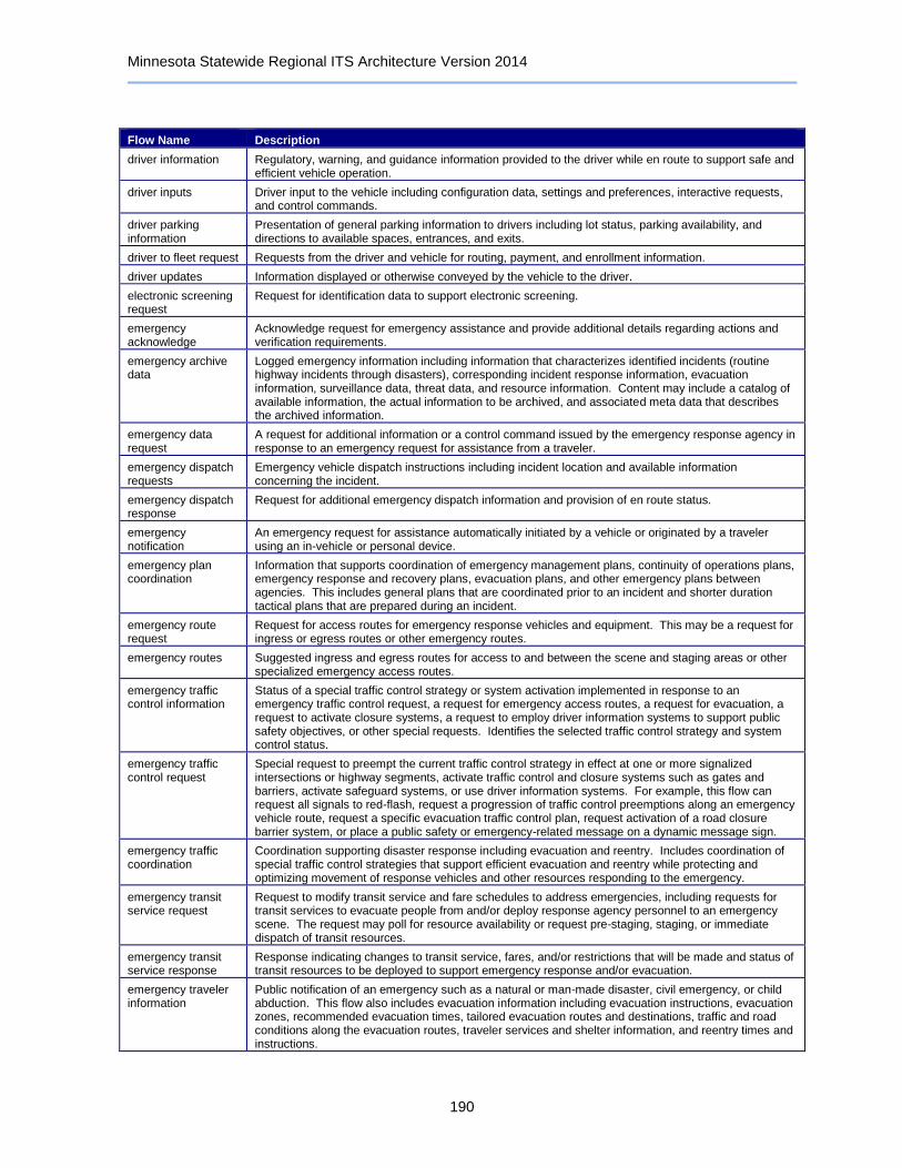
Minnesota Statewide Regional ITS Architecture Version 2014
190
Flow Name Description
driver information Regulatory, warning, and guidance information provided to the driver while en route to support safe and efficient vehicle operation.
driver inputs Driver input to the vehicle including configuration data, settings and preferences, interactive requests, and control commands.
driver parking information
Presentation of general parking information to drivers including lot status, parking availability, and directions to available spaces, entrances, and exits.
driver to fleet request Requests from the driver and vehicle for routing, payment, and enrollment information.
driver updates Information displayed or otherwise conveyed by the vehicle to the driver.
electronic screening request
Request for identification data to support electronic screening.
emergency acknowledge
Acknowledge request for emergency assistance and provide additional details regarding actions and verification requirements.
emergency archive data
Logged emergency information including information that characterizes identified incidents (routine highway incidents through disasters), corresponding incident response information, evacuation information, surveillance data, threat data, and resource information. Content may include a catalog of available information, the actual information to be archived, and associated meta data that describes the archived information.
emergency data request
A request for additional information or a control command issued by the emergency response agency in response to an emergency request for assistance from a traveler.
emergency dispatch requests
Emergency vehicle dispatch instructions including incident location and available information concerning the incident.
emergency dispatch response
Request for additional emergency dispatch information and provision of en route status.
emergency notification
An emergency request for assistance automatically initiated by a vehicle or originated by a traveler using an in-vehicle or personal device.
emergency plan coordination
Information that supports coordination of emergency management plans, continuity of operations plans, emergency response and recovery plans, evacuation plans, and other emergency plans between agencies. This includes general plans that are coordinated prior to an incident and shorter duration tactical plans that are prepared during an incident.
emergency route request
Request for access routes for emergency response vehicles and equipment. This may be a request for ingress or egress routes or other emergency routes.
emergency routes Suggested ingress and egress routes for access to and between the scene and staging areas or other specialized emergency access routes.
emergency traffic control information
Status of a special traffic control strategy or system activation implemented in response to an emergency traffic control request, a request for emergency access routes, a request for evacuation, a request to activate closure systems, a request to employ driver information systems to support public safety objectives, or other special requests. Identifies the selected traffic control strategy and system control status.
emergency traffic control request
Special request to preempt the current traffic control strategy in effect at one or more signalized intersections or highway segments, activate traffic control and closure systems such as gates and barriers, activate safeguard systems, or use driver information systems. For example, this flow can request all signals to red-flash, request a progression of traffic control preemptions along an emergency vehicle route, request a specific evacuation traffic control plan, request activation of a road closure barrier system, or place a public safety or emergency-related message on a dynamic message sign.
emergency traffic coordination
Coordination supporting disaster response including evacuation and reentry. Includes coordination of special traffic control strategies that support efficient evacuation and reentry while protecting and optimizing movement of response vehicles and other resources responding to the emergency.
emergency transit service request
Request to modify transit service and fare schedules to address emergencies, including requests for transit services to evacuate people from and/or deploy response agency personnel to an emergency scene. The request may poll for resource availability or request pre-staging, staging, or immediate dispatch of transit resources.
emergency transit service response
Response indicating changes to transit service, fares, and/or restrictions that will be made and status of transit resources to be deployed to support emergency response and/or evacuation.
emergency traveler information
Public notification of an emergency such as a natural or man-made disaster, civil emergency, or child abduction. This flow also includes evacuation information including evacuation instructions, evacuation zones, recommended evacuation times, tailored evacuation routes and destinations, traffic and road conditions along the evacuation routes, traveler services and shelter information, and reentry times and instructions.

Minnesota Statewide Regional ITS Architecture Version 2014
191
Flow Name Description
emergency traveler information request
Request for alerts, evacuation information, and other emergency information provided to the traveling public.
emergency vehicle tracking data
The current location and operating status of the emergency vehicle.
environmental conditions data
Current road conditions (e.g., surface temperature, subsurface temperature, moisture, icing, treatment status) and surface weather conditions (e.g., air temperature, wind speed, precipitation, visibility) as measured and reported by fixed and/or mobile environmental sensors and aggregated by the data collector. Attributes relating to the data collection (and aggregation) are also included.
environmental conditions data status
Status of the data quality of environmental conditions data provided by a data contributor. Includes not only status by sensor, but statistical data regarding the quality checking of data provided.
environmental probe data
Data from vehicle safety and convenience systems that can be used to estimate environmental conditions, including measured air temperature, exterior light status, wiper status, sun sensor status, rain sensor status, traction control status, anti-lock brake status, and other collected vehicle system status and sensor information. The collected data is reported along with the location, heading, and time that the data was collected. Both current data and snapshots of recent events (e.g., traction control or anti-lock brake system activations) may be reported.
environmental sensor data
Current road conditions (e.g., surface temperature, subsurface temperature, moisture, icing, treatment status) and surface weather conditions (e.g., air temperature, wind speed, precipitation, visibility) as measured and reported by fixed and/or mobile environmental sensors. Operational status of the sensors is also included.
environmental sensors control
Data used to configure and control environmental sensors.
evacuation coordination
Coordination of information regarding a pending or in-process evacuation. Includes evacuation zones, evacuation times, evacuation routes, forecast network conditions, and reentry times.
evacuation information
Evacuation instructions and information including evacuation zones, evacuation times, and reentry times.
event confirmation Confirmation that special event details have been received and processed.
event plans Plans for major events possibly impacting traffic.
external reports Traffic and incident information that is collected by the media through a variety of mechanisms (e.g., radio station call-in programs, air surveillance).
fare collection data Fare collection information including the summary of on-board fare system data and financial payment transaction data.
fare management information
Transit fare information and transaction data used to manage transit fare processing on the transit vehicle.
field device status Reports from field equipment (sensors, signals, signs, controllers, etc.) which indicate current operational status.
fleet to driver update Updated instructions to the driver including dispatch, routing, and special instructions.
flood warning alert Issues an alert to MnDOT regarding high water levels.
freight transportation status
A time-stamped status of a freight shipment as it passes through the supply chain from manufacturer through arrival at its final destination; including cargo movement logs, routing information, and cargo ID’s.
gate system activation
This flow represents an automated request from transit vehicles to open and close gates for access into and out of Bus Rapid Transit stations along major roadways.
hazmat information Information about a particular hazmat load including nature of the load and unloading instructions. May also include hazmat vehicle route and route update information.
hazmat information request
Request for information about a particular hazmat load.
hazmat spill notification
Information provided to emergency response organizations when cargo sensors detect a release of hazardous material. This information will include sensor information, vehicle location and identification, and carrier identification.
hov data Current HOV lane information including both standard traffic flow measures and information regarding vehicle occupancy in HOV lanes, and operational status of the HOV monitoring equipment.
hri control data Data required for HRI information transmitted at railroad grade crossings and within railroad operations.
hri operational status Status of the highway-rail grade crossing equipment including both the current state or mode of operation and the current equipment condition.
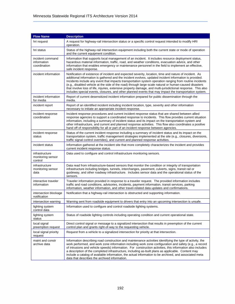
Minnesota Statewide Regional ITS Architecture Version 2014
192
Flow Name Description
hri request A request for highway-rail intersection status or a specific control request intended to modify HRI operation.
hri status Status of the highway-rail intersection equipment including both the current state or mode of operation and the current equipment condition.
incident command information coordination
Information that supports local management of an incident. It includes resource deployment status, hazardous material information, traffic, road, and weather conditions, evacuation advice, and other information that enables emergency or maintenance personnel in the field to implement an effective, safe incident response.
incident information Notification of existence of incident and expected severity, location, time and nature of incident. As additional information is gathered and the incident evolves, updated incident information is provided. Incidents include any event that impacts transportation system operation ranging from routine incidents (e.g., disabled vehicle at the side of the road) through large-scale natural or human-caused disasters that involve loss of life, injuries, extensive property damage, and multi-jurisdictional response. This also includes special events, closures, and other planned events that may impact the transportation system.
incident information for media
Report of current desensitized incident information prepared for public dissemination through the media.
incident report Report of an identified incident including incident location, type, severity and other information necessary to initiate an appropriate incident response.
incident response coordination
Incident response procedures and current incident response status that are shared between allied response agencies to support a coordinated response to incidents. This flow provides current situation information, including a summary of incident status and its impact on the transportation system and other infrastructure, and current and planned response activities. This flow also coordinates a positive hand off of responsibility for all or part of an incident response between agencies.
incident response status
Status of the current incident response including a summary of incident status and its impact on the transportation system, traffic management strategies implemented at the site (e.g., closures, diversions, traffic signal control overrides), and current and planned response activities.
incident status Information gathered at the incident site that more completely characterizes the incident and provides current incident response status.
infrastructure monitoring sensor control
Data used to configure and control infrastructure monitoring sensors.
infrastructure monitoring sensor data
Data read from infrastructure-based sensors that monitor the condition or integrity of transportation infrastructure including bridges, tunnels, interchanges, pavement, culverts, signs, transit rail or guideway, and other roadway infrastructure. Includes sensor data and the operational status of the sensors.
interactive traveler information
Traveler information provided in response to a traveler request. The provided information includes traffic and road conditions, advisories, incidents, payment information, transit services, parking information, weather information, and other travel-related data updates and confirmations.
intersection blockage notification
Notification that a highway-rail intersection is obstructed and supporting information.
intersection warning Warning sent from roadside equipment to drivers that entry into an upcoming intersection is unsafe.
lighting system control data
Information used to configure and control roadside lighting systems.
lighting system status
Status of roadside lighting controls including operating condition and current operational state.
local signal preemption request
Direct control signal or message to a signalized intersection that results in preemption of the current control plan and grants right-of-way to the requesting vehicle.
local signal priority request
Request from a vehicle to a signalized intersection for priority at that intersection.
maint and constr archive data
Information describing road construction and maintenance activities identifying the type of activity, the work performed, and work zone information including work zone configuration and safety (e.g., a record of intrusions and vehicle speeds) information. For construction activities, this information also includes a description of the completed infrastructure, including as-built plans as applicable. Content may include a catalog of available information, the actual information to be archived, and associated meta data that describes the archived information.
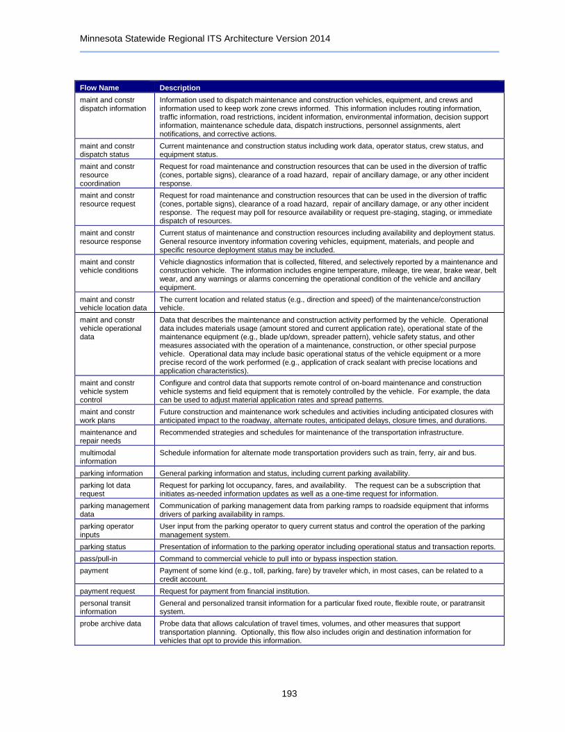
Minnesota Statewide Regional ITS Architecture Version 2014
193
Flow Name Description
maint and constr dispatch information
Information used to dispatch maintenance and construction vehicles, equipment, and crews and information used to keep work zone crews informed. This information includes routing information, traffic information, road restrictions, incident information, environmental information, decision support information, maintenance schedule data, dispatch instructions, personnel assignments, alert notifications, and corrective actions.
maint and constr dispatch status
Current maintenance and construction status including work data, operator status, crew status, and equipment status.
maint and constr resource coordination
Request for road maintenance and construction resources that can be used in the diversion of traffic (cones, portable signs), clearance of a road hazard, repair of ancillary damage, or any other incident response.
maint and constr resource request
Request for road maintenance and construction resources that can be used in the diversion of traffic (cones, portable signs), clearance of a road hazard, repair of ancillary damage, or any other incident response. The request may poll for resource availability or request pre-staging, staging, or immediate dispatch of resources.
maint and constr resource response
Current status of maintenance and construction resources including availability and deployment status. General resource inventory information covering vehicles, equipment, materials, and people and specific resource deployment status may be included.
maint and constr vehicle conditions
Vehicle diagnostics information that is collected, filtered, and selectively reported by a maintenance and construction vehicle. The information includes engine temperature, mileage, tire wear, brake wear, belt wear, and any warnings or alarms concerning the operational condition of the vehicle and ancillary equipment.
maint and constr vehicle location data
The current location and related status (e.g., direction and speed) of the maintenance/construction vehicle.
maint and constr vehicle operational data
Data that describes the maintenance and construction activity performed by the vehicle. Operational data includes materials usage (amount stored and current application rate), operational state of the maintenance equipment (e.g., blade up/down, spreader pattern), vehicle safety status, and other measures associated with the operation of a maintenance, construction, or other special purpose vehicle. Operational data may include basic operational status of the vehicle equipment or a more precise record of the work performed (e.g., application of crack sealant with precise locations and application characteristics).
maint and constr vehicle system control
Configure and control data that supports remote control of on-board maintenance and construction vehicle systems and field equipment that is remotely controlled by the vehicle. For example, the data can be used to adjust material application rates and spread patterns.
maint and constr work plans
Future construction and maintenance work schedules and activities including anticipated closures with anticipated impact to the roadway, alternate routes, anticipated delays, closure times, and durations.
maintenance and repair needs
Recommended strategies and schedules for maintenance of the transportation infrastructure.
multimodal information
Schedule information for alternate mode transportation providers such as train, ferry, air and bus.
parking information General parking information and status, including current parking availability.
parking lot data request
Request for parking lot occupancy, fares, and availability. The request can be a subscription that initiates as-needed information updates as well as a one-time request for information.
parking management data
Communication of parking management data from parking ramps to roadside equipment that informs drivers of parking availability in ramps.
parking operator inputs
User input from the parking operator to query current status and control the operation of the parking management system.
parking status Presentation of information to the parking operator including operational status and transaction reports.
pass/pull-in Command to commercial vehicle to pull into or bypass inspection station.
payment Payment of some kind (e.g., toll, parking, fare) by traveler which, in most cases, can be related to a credit account.
payment request Request for payment from financial institution.
personal transit information
General and personalized transit information for a particular fixed route, flexible route, or paratransit system.
probe archive data Probe data that allows calculation of travel times, volumes, and other measures that support transportation planning. Optionally, this flow also includes origin and destination information for vehicles that opt to provide this information.
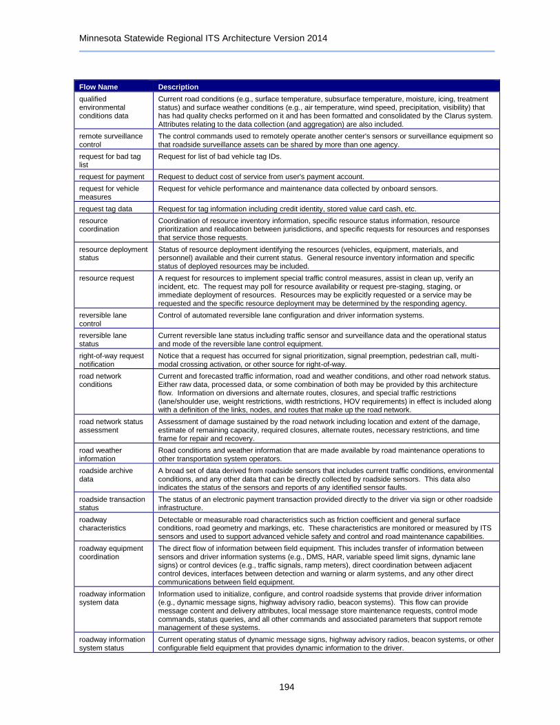
Minnesota Statewide Regional ITS Architecture Version 2014
194
Flow Name Description
qualified environmental conditions data
Current road conditions (e.g., surface temperature, subsurface temperature, moisture, icing, treatment status) and surface weather conditions (e.g., air temperature, wind speed, precipitation, visibility) that has had quality checks performed on it and has been formatted and consolidated by the Clarus system. Attributes relating to the data collection (and aggregation) are also included.
remote surveillance control
The control commands used to remotely operate another center's sensors or surveillance equipment so that roadside surveillance assets can be shared by more than one agency.
request for bad tag list
Request for list of bad vehicle tag IDs.
request for payment Request to deduct cost of service from user's payment account.
request for vehicle measures
Request for vehicle performance and maintenance data collected by onboard sensors.
request tag data Request for tag information including credit identity, stored value card cash, etc.
resource coordination
Coordination of resource inventory information, specific resource status information, resource prioritization and reallocation between jurisdictions, and specific requests for resources and responses that service those requests.
resource deployment status
Status of resource deployment identifying the resources (vehicles, equipment, materials, and personnel) available and their current status. General resource inventory information and specific status of deployed resources may be included.
resource request A request for resources to implement special traffic control measures, assist in clean up, verify an incident, etc. The request may poll for resource availability or request pre-staging, staging, or immediate deployment of resources. Resources may be explicitly requested or a service may be requested and the specific resource deployment may be determined by the responding agency.
reversible lane control
Control of automated reversible lane configuration and driver information systems.
reversible lane status
Current reversible lane status including traffic sensor and surveillance data and the operational status and mode of the reversible lane control equipment.
right-of-way request notification
Notice that a request has occurred for signal prioritization, signal preemption, pedestrian call, multi-modal crossing activation, or other source for right-of-way.
road network conditions
Current and forecasted traffic information, road and weather conditions, and other road network status. Either raw data, processed data, or some combination of both may be provided by this architecture flow. Information on diversions and alternate routes, closures, and special traffic restrictions (lane/shoulder use, weight restrictions, width restrictions, HOV requirements) in effect is included along with a definition of the links, nodes, and routes that make up the road network.
road network status assessment
Assessment of damage sustained by the road network including location and extent of the damage, estimate of remaining capacity, required closures, alternate routes, necessary restrictions, and time frame for repair and recovery.
road weather information
Road conditions and weather information that are made available by road maintenance operations to other transportation system operators.
roadside archive data
A broad set of data derived from roadside sensors that includes current traffic conditions, environmental conditions, and any other data that can be directly collected by roadside sensors. This data also indicates the status of the sensors and reports of any identified sensor faults.
roadside transaction status
The status of an electronic payment transaction provided directly to the driver via sign or other roadside infrastructure.
roadway characteristics
Detectable or measurable road characteristics such as friction coefficient and general surface conditions, road geometry and markings, etc. These characteristics are monitored or measured by ITS sensors and used to support advanced vehicle safety and control and road maintenance capabilities.
roadway equipment coordination
The direct flow of information between field equipment. This includes transfer of information between sensors and driver information systems (e.g., DMS, HAR, variable speed limit signs, dynamic lane signs) or control devices (e.g., traffic signals, ramp meters), direct coordination between adjacent control devices, interfaces between detection and warning or alarm systems, and any other direct communications between field equipment.
roadway information system data
Information used to initialize, configure, and control roadside systems that provide driver information (e.g., dynamic message signs, highway advisory radio, beacon systems). This flow can provide message content and delivery attributes, local message store maintenance requests, control mode commands, status queries, and all other commands and associated parameters that support remote management of these systems.
roadway information system status
Current operating status of dynamic message signs, highway advisory radios, beacon systems, or other configurable field equipment that provides dynamic information to the driver.

Minnesota Statewide Regional ITS Architecture Version 2014
195
Flow Name Description
roadway maintenance status
Summary of maintenance fleet operations affecting the road network. This includes the status of winter maintenance (snow plow schedule and current status).
roadway treatment system control
Control data for remotely located, automated devices, that affect the roadway surface (e.g. de-icing applications).
roadway treatment system status
Current operational status of automated roadway treatment devices (e.g., anti-icing systems).
route assignment Route assignment information for transit vehicle operator.
route plan Tailored route provided by ISP in response to a specific request.
route request Request for a tailored route based on given constraints.
route restrictions Information about routes, road segments, and areas that do not allow the transport of security sensitive hazmat cargoes or include other restrictions (such as height or weight limits).
safeguard system control
Data that controls safeguard systems (remotely controlled equipment used to mitigate the impact of incidents on transportation infrastructure, such as blast shields, exhaust systems, etc.).
safeguard system status
Current operating status of safeguard systems (remotely controlled equipment used to mitigate the impact of incidents on transportation infrastructure, such as blast shields, exhaust systems, etc.). Status of the systems includes operating condition and current operational state.
safety inspection record
Record containing results of commercial vehicle safety inspection.
safety inspection report
Report containing results of commercial vehicle safety inspection. The information may be provided as a response to a real-time query or proactively by the source. The query flow is not explicitly shown.
safety inspection request
Request for safety inspection record.
safety status information
Safety information such as safety ratings, security ratings or flags, inspection summaries, and violation summaries. A unique identifier is included. Corresponds to the safety and security portion of CVISN "snapshots." The status information may be provided as a response to a real-time query or as a result of a standing request for updated information (subscription). This may also include information about non-U.S. fleets for use by U.S. authorities, and information regarding U.S. fleets made available to Mexican and Canadian authorities. The query flow is not explicitly shown.
screening event record
Results of CVO electronic screening activity.
secure area sensor control
Information used to configure and control threat sensors (e.g., thermal, acoustic, radiological, chemical), object, motion and intrusion detection sensors. The provided information controls sensor data collection, aggregation, filtering, and other local processing.
secure area sensor data
Data provided by threat sensors (e.g., thermal, acoustic, radiological, chemical), and intrusion, motion, and object detection sensors in secure areas indicating the sensor's operational status, raw and processed sensor data, and alarm indicators when a threat has been detected.
secure area surveillance control
Information used to configure and control audio and video surveillance systems used for transportation infrastructure security in secure areas. The provided information controls surveillance data collection, aggregation, filtering, and other local processing.
secure area surveillance data
Data collected from surveillance systems used to monitor secure areas. Includes video, audio, processed surveillance data, equipment operational status, and alarm indicators when a threat has been detected.
short range communications status
Status of the short range communications equipment including the current state or mode of operation and the current equipment status.
signal control commands
Control of traffic signal controllers or field masters including clock synchronization.
signal control device configuration
Data used to configure traffic signal control equipment including local controllers and system masters.
signal control plans Traffic signal timing parameters including minimum green time and interval durations for basic operation and cycle length, splits, offset, phase sequence, etc. for coordinated systems.
signal control status Operational and status data of traffic signal control equipment including operating condition and current indications.
signal fault data Faults from traffic signal control equipment.
signal system configuration
Data used to configure traffic signal systems including configuring control sections and mode of operation (time based or traffic responsive).
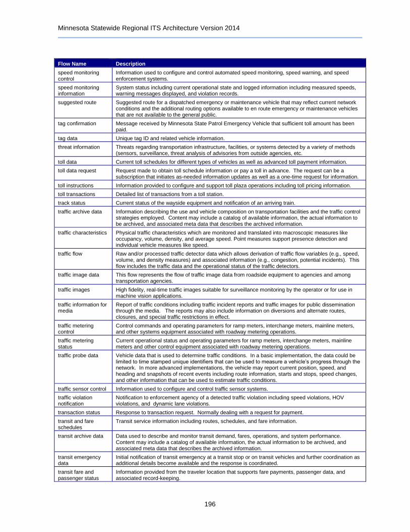
Minnesota Statewide Regional ITS Architecture Version 2014
196
Flow Name Description
speed monitoring control
Information used to configure and control automated speed monitoring, speed warning, and speed enforcement systems.
speed monitoring information
System status including current operational state and logged information including measured speeds, warning messages displayed, and violation records.
suggested route Suggested route for a dispatched emergency or maintenance vehicle that may reflect current network conditions and the additional routing options available to en route emergency or maintenance vehicles that are not available to the general public.
tag confirmation Message received by Minnesota State Patrol Emergency Vehicle that sufficient toll amount has been paid.
tag data Unique tag ID and related vehicle information.
threat information Threats regarding transportation infrastructure, facilities, or systems detected by a variety of methods (sensors, surveillance, threat analysis of advisories from outside agencies, etc.
toll data Current toll schedules for different types of vehicles as well as advanced toll payment information.
toll data request Request made to obtain toll schedule information or pay a toll in advance. The request can be a subscription that initiates as-needed information updates as well as a one-time request for information.
toll instructions Information provided to configure and support toll plaza operations including toll pricing information.
toll transactions Detailed list of transactions from a toll station.
track status Current status of the wayside equipment and notification of an arriving train.
traffic archive data Information describing the use and vehicle composition on transportation facilities and the traffic control strategies employed. Content may include a catalog of available information, the actual information to be archived, and associated meta data that describes the archived information.
traffic characteristics Physical traffic characteristics which are monitored and translated into macroscopic measures like occupancy, volume, density, and average speed. Point measures support presence detection and individual vehicle measures like speed.
traffic flow Raw and/or processed traffic detector data which allows derivation of traffic flow variables (e.g., speed, volume, and density measures) and associated information (e.g., congestion, potential incidents). This flow includes the traffic data and the operational status of the traffic detectors.
traffic image data This flow represents the flow of traffic image data from roadside equipment to agencies and among transportation agencies.
traffic images High fidelity, real-time traffic images suitable for surveillance monitoring by the operator or for use in machine vision applications.
traffic information for media
Report of traffic conditions including traffic incident reports and traffic images for public dissemination through the media. The reports may also include information on diversions and alternate routes, closures, and special traffic restrictions in effect.
traffic metering control
Control commands and operating parameters for ramp meters, interchange meters, mainline meters, and other systems equipment associated with roadway metering operations.
traffic metering status
Current operational status and operating parameters for ramp meters, interchange meters, mainline meters and other control equipment associated with roadway metering operations.
traffic probe data Vehicle data that is used to determine traffic conditions. In a basic implementation, the data could be limited to time stamped unique identifiers that can be used to measure a vehicle’s progress through the network. In more advanced implementations, the vehicle may report current position, speed, and heading and snapshots of recent events including route information, starts and stops, speed changes, and other information that can be used to estimate traffic conditions.
traffic sensor control Information used to configure and control traffic sensor systems.
traffic violation notification
Notification to enforcement agency of a detected traffic violation including speed violations, HOV violations, and dynamic lane violations.
transaction status Response to transaction request. Normally dealing with a request for payment.
transit and fare schedules
Transit service information including routes, schedules, and fare information.
transit archive data Data used to describe and monitor transit demand, fares, operations, and system performance. Content may include a catalog of available information, the actual information to be archived, and associated meta data that describes the archived information.
transit emergency data
Initial notification of transit emergency at a transit stop or on transit vehicles and further coordination as additional details become available and the response is coordinated.
transit fare and passenger status
Information provided from the traveler location that supports fare payments, passenger data, and associated record-keeping.

Minnesota Statewide Regional ITS Architecture Version 2014
197
Flow Name Description
transit fare information
Information provided by transit management that supports fare payment transactions and passenger data collection.
transit information for media
Report of transit schedule deviations for public dissemination through the media.
transit information request
Request for transit operations information including schedule and fare information. The request can be a subscription that initiates as-needed information updates as well as a one-time request for information.
transit information user request
Request for special transit routing, real-time schedule information, and availability information.
transit schedule information
Current and projected transit schedule information used to initialize the transit vehicle with a vehicle assignment, monitor schedule performance, and develop corrective actions on-board.
transit service coordination
Schedule coordination information shared between local/regional transit organizations.
transit service information
Transit service information including routes, schedules, and fare information as well as dynamic transit schedule adherence and transit vehicle location information.
transit travel time estimates
Transit travel time estimates sent from the Metro Transit Control Center to roadside equipment displaying transit travel times alongside vehicular travel times that are estimated by MnDOT RTMC.
transit traveler information
Transit information prepared to support transit users and other travelers. It contains transit schedules, real-time arrival information, fare schedules, alerts and advisories, and general transit service information.
transit traveler request
Request by a Transit traveler to summon assistance, request transit information, or request any other transit services.
transit vehicle conditions
Operating conditions of transit vehicle (e.g., engine running, oil pressure, fuel level and usage).
transit vehicle loading data
Data collected on board the transit vehicle relating to passenger boarding and alighting.
transit vehicle location data
Current transit vehicle location and related operational conditions data provided by a transit vehicle.
transit vehicle operator availability
Transit vehicle operator availability data that can be used to develop vehicle operator assignments and detailed operations schedules.
transit vehicle operator information
Transit service instructions, wide area alerts, traffic information, road conditions, and other information for both transit and paratransit operators.
transit vehicle schedule performance
Estimated times of arrival and anticipated schedule deviations reported by a transit vehicle.
transportation information for operations
Information on the state of transportation system operations including traffic and road conditions, advisories, incidents, transit service information, weather information, parking information, and other related data.
transportation system status
Current status and condition of transportation infrastructure (e.g., tunnels, bridges, interchanges, TMC offices, maintenance facilities). In case of disaster or major incident, this flow provides an assessment of damage sustained by the surface transportation system including location and extent of the damage, estimate of remaining capacity and necessary restrictions, and time frame for repair and recovery.
transportation weather information
Current and forecast road conditions and weather information (e.g., surface condition, flooding, wind advisories, visibility, etc.) associated with the transportation network. This information is of a resolution, timeliness, and accuracy to be useful in transportation decision making.
transportation weather information request
A request for transportation weather information that may specify the area of interest (a geographic region, particular routes within a region, specific road segments), the type of information that is required, the desired spatial resolution of the information, and time horizon.
travel services information
Travel service information and reservations for tourist attractions, lodging, dining, service stations, emergency services, and other services and businesses of interest to the traveler.
travel services request
Request for travel service information including tourist attractions, lodging, restaurants, service stations, and emergency services. The request identifies the type of service, the area of interest, optional reservation request information, parameters that are used to prioritize or filter the returned information, and sorting preferences.
traveler card update Information updated concerning traveler's personal data including items such as address, trip records, and profile data.

Minnesota Statewide Regional ITS Architecture Version 2014
198
Flow Name Description
traveler information for media
General traveler information regarding incidents, unusual traffic conditions, transit issues, or other advisory information that has been desensitized and provided to the media.
traveler inputs User input from a traveler to summon assistance, request travel information, make a reservation, or request any other traveler service.
traveler interface updates
Visual or audio information (e.g., routes, messages, guidance, emergency information) that is provided to the traveler.
traveler profile Information about a traveler including equipment capabilities, personal preferences, and traveler alert subscriptions.
traveler request A request for traveler information including traffic, transit, toll, parking, road weather conditions, event, and passenger rail information. The request identifies the type of information, the area of interest, parameters that are used to prioritize or filter the returned information, and sorting preferences.
trip confirmation Acknowledgement by the driver/traveler of acceptance of a trip plan with associated personal and payment information required to confirm reservations.
trip plan A travel itinerary identifying a route and associated traveler information and instructions identifying recommended modes and transfer information, ride sharing options, and transit and parking reservation information.
trip request Request for trip planning services that identifies the trip origin, destination(s), timing, preferences, and constraints. The request may also include a request for transit and parking reservations and ridesharing options associated with the trip.
vehicle characteristics
The physical or visible characteristics of an individual vehicle that can be measured to classify a vehicle and imaged to uniquely identify a vehicle.
vehicle payment information
Information provided for payment of tolls and parking fees including identification that can be used to identify the payment account or source and related vehicle and service information that are used to determine the type and price of service requested.
vehicle payment request
Request for information supporting toll and parking payments.
vehicle payment update
Data written to vehicle equipment to support electronic toll collection or parking payment.
vehicle signage data In-vehicle signing data that augments regulatory, warning, and informational road signs and signals. The information provided would include static sign information (e.g., stop, curve warning, guide signs, service signs, and directional signs) and dynamic information (e.g., current signal states, grade crossing information, local traffic and road conditions, advisories, and detours).
video surveillance control
Information used to configure and control video surveillance systems.
voice-based alert notification
Information to be distributed to the traveling public via voice regarding a major emergency such as a natural or man-made disaster, civil emergency, severe weather or child abduction. The flow may identify the alert originator, the nature of the emergency, the geographic area affected by the emergency, the effective time period, and information and instructions necessary for the public to respond to the alert. The content of this architecture flow may be specially formatted for voice-based traveler information.
voice-based traveler information
Traveler information sent to the telecommunications systems for traveler information terminator. This flow may represent the bulk transfer of traveler information, including traffic conditions, incident information, transit information and weather and road condition information. It may be specially formatted for voice-based traveler information.
voice-based traveler request
The electronic traveler information request from the telecommunications systems for traveler information terminator. It may be specifically formatted for voice-based traveler requests. The request can be a general subscription intended to initiate a continuous or regular data stream or a specific request intended to initiate a one-time response from the recipient.
weather archive data Accumulated forecasted and current weather data (e.g., temperature, pressure, wind speed, wind direction, humidity, precipitation, visibility, light conditions, etc.) as well as qualified environmental sensor data. Content may include a catalog of available information, the actual information to be archived, and associated meta data that describes the archived information.
weather information Accumulated forecasted and current weather data (e.g., temperature, pressure, wind speed, wind direction, humidity, precipitation, visibility, light conditions, etc.).
work plan coordination
Coordination of work plan schedules and activities between maintenance and construction organizations or systems. This information includes the work plan schedules and comments and suggested changes that are exchanged as work plans are coordinated and finalized.
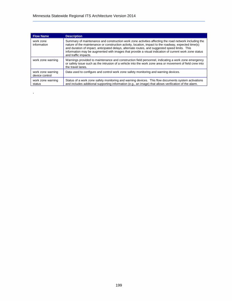
Minnesota Statewide Regional ITS Architecture Version 2014
199
Flow Name Description
work zone information
Summary of maintenance and construction work zone activities affecting the road network including the nature of the maintenance or construction activity, location, impact to the roadway, expected time(s) and duration of impact, anticipated delays, alternate routes, and suggested speed limits. This information may be augmented with images that provide a visual indication of current work zone status and traffic impacts.
work zone warning Warnings provided to maintenance and construction field personnel, indicating a work zone emergency or safety issue such as the intrusion of a vehicle into the work zone area or movement of field crew into the travel lanes.
work zone warning device control
Data used to configure and control work zone safety monitoring and warning devices.
work zone warning status
Status of a work zone safety monitoring and warning devices. This flow documents system activations and includes additional supporting information (e.g., an image) that allows verification of the alarm.
.

Minnesota Statewide Regional ITS Architecture Version 2014
200
10 ITS Standards
Standardizing the flow of information between the systems is essential to cost-effectively integrating ITS throughout the region. ITS standards are fundamental to the establishment of an open ITS environment that achieves the goal of interoperability for ITS. Standards facilitate deployment of interoperable systems at local, regional, and national levels without impeding innovation as technology advances and new approaches evolve.
Establishing standards for exchanging information among ITS systems is important not only from an interoperability point of view; it also provides interchangeability and expandability thereby reducing risk and cost. Since an agency using standardized interfaces can select among multiple vendors for products and applications, competition is maintained and prices are lower in the long term.
Standards Development Organizations (SDO) are developing ITS standards that support interoperability and interchangeability. Several of the communication standards overlap in applicability. This provides flexibility in the design of ITS systems allowing agencies to choose the most applicable standard for their needs. Before systems are designed, all stakeholders involved in the applicable ITS service(s) should decide upon the standards and their specifics that will be used. Once a decision is made, all future systems should use the agreed upon standards.
Table 7: ITS Standards
SDO Document ID Standard Title Standard Type
AASHTO/ITE ITE TMDD Traffic Management Data Dictionary (TMDD) and Message Sets for External Traffic Management Center Communications (MS/ETMCC)
Message/Data
AASHTO/ITE/NEMA NTCIP 1201 Global Object Definitions Message/Data
AASHTO/ITE/NEMA NTCIP 1202 Object Definitions for Actuated Traffic Signal Controller (ASC) Units
Message/Data
AASHTO/ITE/NEMA NTCIP 1203 Object Definitions for Dynamic Message Signs (DMS) Message/Data
AASHTO/ITE/NEMA NTCIP 1204 Object Definitions for Environmental Sensor Stations (ESS) Message/Data
AASHTO/ITE/NEMA NTCIP 1205 Object Definitions for Closed Circuit Television (CCTV) Camera Control
Message/Data
AASHTO/ITE/NEMA NTCIP 1206 Object Definitions for Data Collection and Monitoring (DCM) Devices
Message/Data
AASHTO/ITE/NEMA NTCIP 1207 Object Definitions for Ramp Meter Control (RMC) Units Message/Data
AASHTO/ITE/NEMA NTCIP 1208 Object Definitions for Closed Circuit Television (CCTV) Switching
Message/Data
AASHTO/ITE/NEMA NTCIP 1209 Data Element Definitions for Transportation Sensor Systems (TSS)
Message/Data
AASHTO/ITE/NEMA NTCIP 1210 Field Management Stations (FMS) - Part 1: Object Definitions for Signal System Masters
Message/Data
AASHTO/ITE/NEMA NTCIP 1211 Object Definitions for Signal Control and Prioritization (SCP) Message/Data
AASHTO/ITE/NEMA NTCIP 1213 Object Definitions for Electrical and Lighting Management Systems (ELMS)
Message/Data
AASHTO/ITE/NEMA NTCIP 1214 Object Definitions for Conflict Monitor Units (CMU) Message/Data
AASHTO/ITE/NEMA NTCIP C2C NTCIP Center-to-Center Standards Group Group
AASHTO/ITE/NEMA NTCIP C2F NTCIP Center-to-Field Standards Group Group

Minnesota Statewide Regional ITS Architecture Version 2014
201
SDO Document ID Standard Title Standard Type
APTA APTA TCIP-S-001 3.0.4
Standard for Transit Communications Interface Profiles Message/Data
ASTM ASTM E2468-05
Object Definitions for Signal Control and Prioritization (SCP) Other
ASTM ASTM E2665-08
Standard Specifications for Archiving ITS-Generated Traffic Monitoring Data
Message/Data
ASTM DSRC 915MHz Dedicated Short Range Communication at 915 MHz Standards Group
Group
ASTM/IEEE/SAE DSRC 5GHz Dedicated Short Range Communication at 5.9 GHz Standards Group
Group
IEEE IEEE 1455-1999
Standard for Message Sets for Vehicle/Roadside Communications
Message/Data
IEEE IEEE 1570-2002
Standard for the Interface Between the Rail Subsystem and the Highway Subsystem at a Highway Rail Intersection
Message/Data
IEEE IEEE IM Incident Management Standards Group Group
IEEE IEEE P1609.11 Standard for Wireless Access in Vehicular Environments (WAVE) - Over- the-Air Data Exchange Protocol for Intelligent Transportation Systems (ITS)
Communications Protocol
SAE ATIS General Use
Advanced Traveler Information Systems (ATIS) General Use Standards Group
Group
SAE ATIS Low Bandwidth
Advanced Traveler Information Systems (ATIS) Bandwidth Limited Standards Group
Group
SAE Mayday On-board Vehicle Mayday Standards Group Group
SAE SAE J2395 ITS In-Vehicle Message Priority Other
SAE SAE J2396 Definitions and Experimental Measures Related to the Specification of Driver Visual Behavior Using Video Based Techniques
Other
SAE SAE J2399 Adaptive Cruise Control (ACC) Operating Characteristics and User Interface
Other
SAE SAE J2400 Human Factors in Forward Collision Warning Systems: Operating Characteristics and User Interface Requirements
Other