Ministry of Transportation Highway 401/Mavis Road ... DCR 602… · highway 401 mavis road...
142
Ministry of Transportation Highway 401/Mavis Road Interchange and New Ramps at the Highway 401/410/403 Interchange Detail Design Design and Construction Report G.W.P. 2152-01-00 and 2150-01-00
Transcript of Ministry of Transportation Highway 401/Mavis Road ... DCR 602… · highway 401 mavis road...

Ministry of Transportation
Highway 401/Mavis Road Interchange and New Ramps at the Highway 401/410/403 Interchange Detail Design Design and Construction Report G.W.P. 2152-01-00 and 2150-01-00

HIGHWAY 401 MAVIS ROAD INTERCHANGE AND
NEW RAMPS AT THE HIGHWAY 401/410/403 INTERCHANGE
DETAIL DESIGN STUDY
CITY OF MISSISSAUGA, REGIONAL MUNICIPALITY OF PEEL
CLASS ENVIRONMENTAL ASSESSMENT FOR PROVNCIAL TRANSPORTATION FACILITIES
GROUP ‘B’ PROJECT
MINISTRY OF TRANSPORTATION
CENTRAL REGION
G.W.P. 2152-01-00 and 2150-01-00
DESIGN AND CONSTRUCTION REPORT
January 2014

RPT-2014 01 28 Mavis DCR 0213979 Final.Doc

AECOM Ministry of Transportation Highway 401/Mavis Road Interchange and New Ramps at the Highway 401/410/403 Interchange Detail Design - Design and Construction Report GWP 2152-01-00 and 2150-01-00
RPT-2014 01 28 Mavis DCR 0213979 Final.Doc
The Public Record A copy of this document has been submitted to the following office of the Ministry of the Environment to be placed on the Public Record: Ministry of the Environment Central Region 5775 Yonge Street, 8th Floor Toronto, ON M2M 4J1 This Design and Construction Report is also available for review at the following locations: Ministry of Transportation Central Region Planning & Environmental Office 1201 Wilson Avenue Building D, 3rd Floor, Downsview, ON M3M 1J8 Telephone: 416.235.5412 Monday-Friday: 8:30am to 4:30pm Weekends: Closed
The City of Mississauga Office of the City Clerk 300 City Centre Drive, 2nd Floor Mississauga, ON L5B 3C1 Telephone: 905.615.4311 Monday–Friday: 8:30am to 4:30pm Weekends: Closed
Courtneypark Branch Library 730 Courtneypark Drive West Mississauga, ON L5W 1L9 Telephone: 905.615.4745
Monday-Friday: 8:00am to 9:00pm Saturday: 9:00 am to 5:00 pm Sunday: 1:00 pm to 5:00 pm
Region of Peel Clerk’s Office 10 Peel Centre Drive Brampton, ON L6T 4B9 Telephone: 905.791.7800 Monday-Friday: 8:00am to 5:00pm Weekends: Closed
Ce document hautement specialise n'est disponsible qu'en anglais en vertue du reglement 411/97, qui en exempte I'application de Ia Loi sur les services en français. Pour de I'aide en français, veuillez communiquer avec le ministere des Transports, Bureau des services en français au: 905-704-2045 ou 905-704-2046.

AECOM Ministry of Transportation Highway 401/Mavis Road Interchange and New Ramps at the Highway 401/410/403 Interchange Detail Design - Design and Construction Report GWP 2152-01-00 and 2150-01-00
RPT-2014 01 28 Mavis DCR 0213979 Final.Doc i
Executive Summary In 2011, the Ministry of Transportation (the Ministry, or MTO) retained AECOM Canada Limited (AECOM) to carry out the Detail Design for the ultimate widening of Highway 401 from the Highway 403/410 interchange to the Credit River, a distance of 7 km under GWP 2150-01-00. The project will complete the expansion of Highway 401 within the project limits from its current 6 lanes to a 12-lane core/collector system, as documented in the Transportation Environmental Study Report (TESR) for the Preliminary Design of Highway 401 From Highway 410/403 Interchange to East of the Credit River (GWP 2149-01-00 and GWP 2150-01-00), August 2005. In order to accelerate the construction schedule, the Detail Design for the lengthening of the Mavis Road bridge (Site #24-736 1&2) over Highway 401, including associated interchange improvements, has been completed and will be undertaken as a separate advance contract (GWP 2152-01-00). This will facilitate construction of the upcoming Highway 401 widening from west of Hurontario Street to the Credit River. The project area for GWP 2152-01-00 is located approximately four (4) kilometres (km) west of the Highway 403/410 interchange. In addition, the Detail Design for two (2) new ramps from Highway 401 eastbound to Highway 403 southbound and from Highway 403 northbound to Highway 401 westbound at the Highway 401/410/401 interchange has been completed and formulates part of this DCR to take advantage of improvements occurring under other contracts in this area. A second DCR will subsequently be prepared to document the Detail Design for the remainder of the highway expansion work (i.e., from west of Hurontario Street to the Credit River). A TESR Addendum will be prepared for the proposed extension of Belgrave Road to connect to Mavis Road. Details regarding the release of these documents will be provided in future notices (GWP 2150-01-00). The above mentioned Transportation Environmental Study Report, Highway 401 Improvements [GWP 2149-01-00 and GWP 2150-01-00] (August 2005, MMM/Ecoplans) received environmental clearance from the Minister of the Environment on July 17, 2007. This DCR documents the design and construction contract requirements and fulfills commitments made during the Preliminary Design phase, as provided in the 2005 TESR. The DCR will be made available for a 30-day review period for external agencies and for the public. Any concerns raised by members of the public, interested groups or technical and external agencies during this review period should be discussed with the MTO or their consultant and all comments received during the review period will be considered by the MTO. As this project has already met the requirements of the Ontario Environmental Assessment Act, the DCR is not eligible for a request that the Minister of the Environment make a Part II Order ("bump-up") of the project, thereby requiring an individual environmental assessment. Agency and public consultation has occurred through a Public Information Centre that was held on Wednesday November 13, 2013. Notification of the event occurred through advertisements in newspapers and direct mailings to the project contact list. The proposed work for the lengthening of the Highway 401 bridge at Mavis Road will include: • Lengthening of the Mavis Road bridge (Site #24-736 1&2) to accommodate the upcoming Highway 401 collector
lanes. The extension of the structure will match the current cross section of Mavis Road. • Earth moving and advanced grading for the future realigned Mavis Road N-E and S-W loop ramps • Rehabilitation of existing bridge piers and pier caps • Lighting improvements to incorporate high mast lighting to minimize light trespass onto private properties

AECOM Ministry of Transportation Highway 401/Mavis Road Interchange and New Ramps at the Highway 401/410/403 Interchange Detail Design - Design and Construction Report GWP 2152-01-00 and 2150-01-00
RPT-2014 01 28 Mavis DCR 0213979 Final.Doc ii
• Widening of the W-N/S and E-N/S ramp terminals to their ultimate configurations.
The proposed work for the new ramps from Highway 401 eastbound to Highway 403 southbound (E-S) and from Highway 403 northbound to Highway 401 westbound (N-W) at the 401/410/403 interchange will include: • Construction of two (2) new single lane freeway to freeway ramps • Construction of new retaining walls • Relocation of High Mast Lighting Poles (HMLP) • Relocation of MTO electrical and ATMS buried cables • Underpass lighting along S-W Ramp where it travels under existing bridges • Construction of new concrete barrier between the N-W Ramp and Highway 410 northbound lanes • Earth excavation and grading to construct the new ramps • Preparation of granular base and sub base to construct the new ramps • Placement of hot mix paving to construct the new ramps • Construction of a new Overhead Sign support structure (OHS) • Replacement of four (4) OHS sign panels along Highway 403 eastbound south of Highway 401 • Construction of ATMS related infrastructure.
The following table summarizes the identified concerns and proposed mitigation for the proposed work. During construction, the on-site contract administrator will ensure the environmental measures outlined in this report and in the subsequent contract documents/specifications are carried out. If the impacts of construction differ from those anticipated, or the method is such that there are greater than anticipated impacts, the Contractor’s method of operation will be changed or modified in consultation with the MTO to reduce those impacts.

AECOM Ministry of Transportation Highway 401/Mavis Road Interchange and New Ramps at the Highway 401/410/403 Interchange Detail Design - Design and Construction Report GWP 2152-01-00 and 2150-01-00
RPT-2014 01 28 Mavis DCR 0213979 Final.Doc iii
Table E. Summary of Environmental Protection / Mitigation Requirements during Construction
I.D.# Issues/Concerns Potential Effects Concerned Agencies I.D.# Mitigation/Protection/Monitoring General Environmental Protection Requirements 1 General Environmental Protection MTO 1.1 • The general requirement to protect the natural environment from impacts and damage,
including physical damage, emissions, and local access; and • Control of materials, equipment, construction method, construction disturbance limits,
and work timing/staging duration, in order to achieve the foregoing.
Natural Environment Concerns and Commitments 2 Fisheries and Watercourse Impacts CVC/TRCA/MNR 2.1 • No watercourse within Project Area
• No mitigation required
3 Wildlife Impacts (low probability in the Project Area)
CVC/TRCA/MNR 3.1 • Temporary vegetation protection fencing installed at the edge of the clearing / grubbing limits.
• Requirement that construction equipment and vehicles give a right-of-way to wildlife, allowing wildlife to pass and proceed to a safe distance prior to construction equipment/vehicles commencing construction activities; and
• Requirement the work cease and Contract Administrator be notified In the event wildlife is injured during construction activities.
4 Bird Impacts (on or adjacent to structure) 4.1 • Vegetation and site clearing will take place between September and March 31st and avoid the months of April until August, in accordance with the Migratory Birds Convention Act.
• A nesting survey will be completed for the existing Mavis Road bridge and in the southwest quadrant of the Highway 401/410/403 interchange prior to commencement of construction.
• Bird netting/screening will be placed under the structure in advance of construction to deter rock pigeons from nesting.
5 Potential to encounter Species at Risk during construction
MTO/MNR 5.1 • If Species at Risk is encountered a qualified biologist should be contacted in order to determine how to proceed without contravening the ESA (2007).
6 Vegetation impacts CVC/TRCA/MNR 6.1 • Vegetation removal will be kept to a minimum and exposed soils will be re-vegetated with an approved MTO seed mix that suits the area soils, immediately following the completion of required work and the final grade has been established.
• Graded areas within the Mavis Road interchange area will be covered with topsoil, seed and mulch.
• Graded areas within the Highway 401/410/403 interchange will be re-planted with species represented by the vegetation communities that occur within the woodlot. Appropriate species will be discussed and confirmed with MNR and provided on the final landscape plan

AECOM Ministry of Transportation Highway 401/Mavis Road Interchange and New Ramps at the Highway 401/410/403 Interchange Detail Design - Design and Construction Report GWP 2152-01-00 and 2150-01-00
RPT-2014 01 28 Mavis DCR 0213979 Final.Doc iv
I.D.# Issues/Concerns Potential Effects Concerned Agencies I.D.# Mitigation/Protection/Monitoring 7 Erosion and sediment control 7.1 • An erosion and sediment control plan for construction shall be developed and
effectively implemented. It will include: • Limiting vegetation removal to only what is required for grading and ditching
operations; • Constructing embankment slopes at a maximum ratio of 2:1; and • Establishing cover as soon as possible after excavation.
• Sediment fences around construction activities
Socio-Economic Environment Concerns and Commitments 8 Construction Noise MTO/MOE 8.1 • A noise by-law exemption is not required for night-time construction activities outside
the permitted hours for noise (as per confirmation with the City of Mississauga) Affected residents (within 500m radius of construction) will be notified 3-4 weeks prior to night-time activities.
8.2 • Idling of construction equipment will be kept to a minimum and maintained in good working order.
• Contract documents provided to the contractor will contain general noise control measures to mitigate the noise impact at noise sensitive areas including two standard clauses regarding equipment noise.
8.3 • Respond to construction noise complaints according to MTO/MOE “Noise Protocol”.
9 Dust Control during Construction MTO/MOE 9.1 • A dust control plan for construction shall be developed and effectively implemented.
10 Spill Prevention and Response MTO 10.1 • Contractor shall have a spill prevention and response contingency plan that addresses procedures for preventing and responding to spills, and the equipment (including a spill response kit) and resources that will be available.
10.2 • Refuelling precautions will be taken. • Refueling will be conducted only in designated areas preferably situated on an
impermeable surface.
10.3 • Construction equipment required to be in good condition.
11 Management of Surplus Material and Debris
MTO 11.1 • Management materials will be dealt with in accordance with normal MTO practices (regulated by OPSS 180).
11.2 • Lead paint on guard rails will be managed in accordance with the Ontario Occupational Health and Safety Act (Reg. 843) and Ontario Environmental Protection Act (Reg. 347).
12 Potential for Property Impacts MTO 12.1 • MTO will coordinate with individual owners (Infrastructure Ontario and the City of Mississauga) for property transfer/purchase in accordance with standard MTO procedures.
13 Potential for temporary or permanent change to emergency access
OPP/Peel Region 13.1 • MTO will notify OPP and emergency medical services of construction staging, start of construction etc. to minimize delay in emergency response times during and after construction.

AECOM Ministry of Transportation Highway 401/Mavis Road Interchange and New Ramps at the Highway 401/410/403 Interchange Detail Design - Design and Construction Report GWP 2152-01-00 and 2150-01-00
RPT-2014 01 28 Mavis DCR 0213979 Final.Doc v
I.D.# Issues/Concerns Potential Effects Concerned Agencies I.D.# Mitigation/Protection/Monitoring 14 Potential impacts to existing utilities Bell Canada
Rogers Communications Enbridge Gas Enersource Hydro Mississauga
14.1 • Utility relocation will be coordinated prior to construction.
15 Traffic delays and disruption during construction
15.1 • Traffic along Mavis Road will be reduced to two lanes per direction during construction, however access to and from Highway 401 will be maintained at all times.
• Night-time lane closures may be required during the construction of the two ramps at the Highway 401/410/403 interchange.
Cultural Environment Concerns and Commitments 16 Response to archaeological finds during
construction MTCS 16.1 • A Stage 2 Archaeological Assessment recommended that no further archaeological
concern is warranted for lands within the project area. • If any archaeological and/or historical resources are discovered during construction,
they may be a new archaeological site and therefore subject to Section 48(1) of the Ontario Heritage Act. Construction must cease immediately and a licensed consultant archaeologist must be engaged to carry out archaeological fieldwork in compliance with Section 48(1) of the Ontario Heritage Act.
• Work in the area would not resume until cleared by the Ministry of Tourism, Culture and Sport.
17 Impact to cultural heritage landscape (Highway 401 Roadscape)
MTCS 17.1 • No mitigation required.

AECOM Ministry of Transportation Highway 401/Mavis Road Interchange and New Ramps at the Highway 401/410/403 Interchange Detail Design - Design and Construction Report GWP 2152-01-00 and 2150-01-00
RPT-2014 01 28 Mavis DCR 0213979 Final.Doc
Table of Contents MTO Signature Page Public Record Executive Summary
page
1. Introduction .................................................................................................................................. 1 1.1 Summary Description of the Undertaking ............................................................................................ 1 1.2 Overview of the Class Environmental Assessment Process ............................................................... 3
1.2.1 Ministry of Transportation Class Environmental Assessment for Provincial Transportation Facilities ......................................................................................................... 3
1.2.2 Transportation Environmental Study Report (August 2005)................................................... 3 1.2.3 Purpose of the Design and Construction Report .................................................................... 3 1.2.4 Canadian Environmental Assessment Act 2012 .................................................................... 4
1.3 Environmental Protection Requirements ............................................................................................. 4 1.3.1 Endangered Species Act 2007 ............................................................................................... 4 1.3.2 Migratory Birds Convention Act, 1994 .................................................................................... 5
2. Consultation Process .................................................................................................................. 6 2.1 Consultation Plan ................................................................................................................................. 6 2.2 Project Contact .................................................................................................................................... 6 2.3 Notification of Project Commencement ............................................................................................... 7 2.4 Project Website .................................................................................................................................... 7 2.5 Consultation with External Agencies ................................................................................................... 7 2.6 Consultation with First Nations ............................................................................................................ 8 2.7 Consultation with Utility Companies .................................................................................................... 9 2.8 Public Information Centre (PIC) ........................................................................................................... 9
2.8.1 Notification of the PIC ............................................................................................................. 9 2.8.2 PIC Organization and Logistics ............................................................................................ 10 2.8.3 PIC Attendance ..................................................................................................................... 10 2.8.4 Summary of PIC Participant Feedback ................................................................................ 11
2.8.4.1 Comments Received .......................................................................................... 11 2.9 Filing of the DCR ............................................................................................................................... 12
2.9.1 Notification of Filing of the DCR ........................................................................................... 12
3. Detailed Description of the Recommended Design ................................................................. 13 3.1 Major Features of the Proposed Work ............................................................................................... 13
3.1.1 Road Construction ................................................................................................................ 14 3.1.2 Road Side Safety Improvements .......................................................................................... 14 3.1.3 Structural Construction ......................................................................................................... 14 3.1.4 Drainage ............................................................................................................................... 15 3.1.5 Electrical ............................................................................................................................... 15 3.1.6 Utilities .................................................................................................................................. 15 3.1.7 Property ................................................................................................................................ 16
3.2 Construction Staging and Traffic Management ................................................................................. 16 3.3 Environmental Protection/Mitigation and Environmental Monitoring are Integral Components
of the Recommended Plan ................................................................................................................ 17

AECOM Ministry of Transportation Highway 401/Mavis Road Interchange and New Ramps at the Highway 401/410/403 Interchange Detail Design - Design and Construction Report GWP 2152-01-00 and 2150-01-00
RPT-2014 01 28 Mavis DCR 0213979 Final.Doc
4. Environmental Concerns and Protection / Mitigation Incorporated During Construction............................................................................................................................... 18 4.1 Natural Environment .......................................................................................................................... 18
4.1.1 Fisheries and Aquatic Habitat ............................................................................................... 18 4.1.2 Wildlife .................................................................................................................................. 18 4.1.3 Vegetation ............................................................................................................................. 19 4.1.4 Wetlands ............................................................................................................................... 20 4.1.5 Drainage ............................................................................................................................... 20 4.1.6 Erosion and Sediment Control .............................................................................................. 20
4.2 Socio-Economic Environment ........................................................................................................... 21 4.2.1 Noise ..................................................................................................................................... 21 4.2.2 Property Waste and Contamination ...................................................................................... 21 4.2.3 Air Quality ............................................................................................................................. 22 4.2.4 Cultural Environment ............................................................................................................ 22
4.2.4.1 Archaeological Resources .................................................................................. 22 4.2.4.2 Built and Cultural Heritage Resources ............................................................... 23
4.3 Construction Contract Provisions ...................................................................................................... 23 4.3.1 Ontario Provincial Standard Specifications (OPSS) ............................................................. 23 4.3.2 Standard Special Provisions (SSPs) .................................................................................... 24 4.3.3 Non-Standard Special Provisions (NSSP) ........................................................................... 24
4.4 Summary of Environmental Protection / Mitigation Requirements during Construction ................... 25
5. Environmental Monitoring / Inspection Program for Project Implementation ....................... 28 5.1 Overview of Environmental Monitoring / Inspection Program for Project Implementation ................ 28 5.2 Environmental Monitoring / Inspection During Construction ............................................................. 28 5.3 Post-Construction Environmental Monitoring / Inspection ................................................................. 28
List of Figures
Figure 1. Project Area ................................................................................................................................................ 2 List of Tables
Table 1. Agency Correspondence from Public Information Centre Notification ..................................................... 11 Table 2. Verbal Comments Received at the Public Information Centre ................................................................ 12 Table 3. Summary of Public Comments Received Following the Public Information Centre ................................ 12 Table 4. Wildlife Observations ............................................................................................................................... 18 Table 5. Summary of Issues of Potential Environmental Concern......................................................................... 22 Table 6. Summary of Environmental Protection / Mitigation Requirements during Construction .......................... 25
Appendices
Appendix A. Consultation Appendix B. Recommended Plan Drawings

AECOM Ministry of Transportation Highway 401/Mavis Road Interchange and New Ramps at the Highway 401/410/403 Interchange Detail Design - Design and Construction Report GWP 2152-01-00 and 2150-01-00
RPT-2014 01 28 Mavis DCR 0213979 Final.Doc 1
1. Introduction 1.1 Summary Description of the Undertaking
In 2011, the Ministry of Transportation (the Ministry, or MTO) retained AECOM Canada Limited (AECOM) to carry out the Detail Design for the ultimate widening of Highway 401 from the Highway 403/410 interchange to the Credit River, a distance of 7 km under GWP 2150-01-00. The project will complete the expansion of Highway 401 within the project limits from its current 6 lanes to a 12-lane core/collector system, as documented in the Transportation Environmental Study Report (TESR) for the Preliminary Design of Highway 401 From Highway 410/403 Interchange to East of the Credit River (GWP 2149-01-00 and GWP 2150-01-00), August 2005. The proposed improvements are required to address deteriorating operating conditions, create opportunities for high occupancy vehicle infrastructure and incorporate existing and future traffic demands. The project will assist in facilitating the efficient and safe movement of goods and people to ensure the economic vitality of communities along the highway and throughout the province. In order to accelerate the construction schedule, the detail design for the lengthening of the Mavis Road bridge over Highway 401, including associated interchange improvements, has been completed and will be undertaken as a separate advance contract (GWP 2152-01-00). This will facilitate construction of the upcoming Highway 401 widening from west of Hurontario Street to the Credit River. The project area for GWP 2152-01-00 is located approximately four (4) kilometres (km) west of the Highway 403/410 interchange. In addition, the Detail Design for two (2) new ramps from Highway 401 eastbound to Highway 403 southbound and from Highway 403 northbound to Highway 401 westbound at the Highway 401/410/401 interchange has been completed and formulates part of this DCR to take advantage of improvements occurring under other contracts in this area. A second DCR will subsequently be prepared to document the Detail Design for the remainder of the highway expansion work (i.e., from west of Hurontario Street to the Credit River). A TESR Addendum will be prepared for the proposed extension of Belgrave Road to connect to Mavis Road. Details regarding the release of these documents will be provided in future notices (GWP 2150-01-00). The Recommended Plan includes: • Lengthening of the Mavis Road bridge (Site #24-736 1&2) to accommodate the upcoming construction of the
Highway 401 collector lanes. The extension of the structure will match the current cross section of Mavis Road • Earth moving and advanced grading for the future realigned Mavis Road N-E and S-W loop ramps • Rehabilitation of existing bridge piers and pier caps • Widening of the W-N/S and E-N/S ramp terminals to their ultimate configurations • Lighting improvements to incorporate high mast lighting to minimize light trespass onto private properties • Construction of new ramps from Highway 401 eastbound to Highway 403 southbound and from Highway 403
northbound to Highway 401 westbound at the 401/410/403 interchange to their ultimate configurations. Further details are provided in Section 3 of this report. The project area is shown on Figure 1.

AECOM Ministry of Transportation Highway 401/Mavis Road Interchange and New Ramps at the Highway 401/410/403 Interchange Detail Design - Design and Construction Report GWP 2152-01-00 and 2150-01-00
RPT-2014 01 28 Mavis DCR 0213979 Final.Doc 2
Figure 1. Project Area

AECOM Ministry of Transportation Highway 401/Mavis Road Interchange and New Ramps at the Highway 401/410/403 Interchange Detail Design - Design and Construction Report GWP 2152-01-00 and 2150-01-00
RPT-2014 01 28 Mavis DCR 0213979 Final.Doc 3
1.2 Overview of the Class Environmental Assessment Process
1.2.1 Ministry of Transportation Class Environmental Assessment for Provincial Transportation Facilities
The Ministry of Transportation (MTO) Class Environmental Assessment for Provincial Transportation Facilities (Class EA) was approved under the Ontario Environmental Assessment Act (OEAA) in the Fall of 1999 and amended in 2000. This planning document defines the group of projects and activities and the environmental assessment processes that MTO has committed to follow for these projects. Provided that this process is followed, projects and activities included under the Class EA do not require formal review and approval under the OEAA. The projects and activities in the Class EA are classified into four groups; this project is following the Class EA process for Group 'B' projects, which include: improvements to existing highways and freeways, new interchanges or modifications to traffic access, improvements to provincial transitways and ferryboat docks/terminals, and the establishment/improvement of provincial transportation facilities. As required under the Class EA, two formal EA documents have been developed for this project. They include: • Transportation Environmental Study Report (TESR), prepared in 2005 to document Preliminary Design • This Design and Construction Report (DCR), prepared to document Detail Design.
1.2.2 Transportation Environmental Study Report (August 2005)
The Ministry of Transportation has previously undertaken a review of Highway 401 improvements from the Highway 401/403/410 interchange to east of the Credit River. The recommended improvements were outlined in the Transportation Environmental Study Report, Highway 401 Improvements [GWP 2149-01-00 and GWP 2150-01-00] (August 2005) which received environmental clearance from the Minister of the Environment on July 17, 2007.
1.2.3 Purpose of the Design and Construction Report
This Design and Construction Report (DCR) has been prepared to document the development of the transportation plan to the design implementation level of detail and includes the process requirements of the Class EA for Provincial Transportation Facilities. The Class EA and detail design process includes the following: • EA study process that complies with the Class EA for Provincial Transportation Facilities • Consultation with stakeholders • Development of the recommended plan (building on the preferred preliminary plan) • Identification of key environmental concerns associated with the recommended plan • Incorporation of the environmental protection/mitigation into the design • Development of environmental protection/mitigation requirements during construction • An environmental monitoring/inspection program for project implementation • Post-construction environmental protection/mitigation. In undertaking the above, this DCR documents the design and construction contract requirements and fulfills commitments made during the preliminary design phase, as provided in the 2005 TESR. The DCR will be made available for a 30-day review period for external agencies and for the public. Any concerns raised by members of the public, interested groups or technical and external agencies during this review period should be discussed with the MTO or their consultant and all comments received during the review period will be

AECOM Ministry of Transportation Highway 401/Mavis Road Interchange and New Ramps at the Highway 401/410/403 Interchange Detail Design - Design and Construction Report GWP 2152-01-00 and 2150-01-00
RPT-2014 01 28 Mavis DCR 0213979 Final.Doc 4
considered by the MTO. As this project has already met the requirements of the OEAA, the DCR is not eligible for a request that the Minister of the Environment make a Part II Order ("bump-up") of the project, thereby requiring an individual environmental assessment. Additional information about this project is also available by contacting key Project Team members, as follows:
Miao Zhou, P.Eng., M.Eng. Senior Project Engineer Ontario Ministry of Transportation Central Region Building ‘D’, 4th Floor, 1201 Wilson Avenue Downsview, ON M3M 1J8 Phone: (416) 235-4277 Fax: (416) 235-3576 Email: [email protected]
Brian Ruck, P. Eng. C.V.S., Consultant Project Manager AECOM Canada Ltd. 300 Water Street Whitby, ON L1N 9J2 Toll Free : 1-800-668-1983 or Phone: (905) 668-4021 extension 2250 Fax: (905) 665-4867 E-mail: [email protected]
1.2.4 Canadian Environmental Assessment Act 2012
The Canadian Environmental Assessment Act (CEAA) was repealed and replaced with CEAA 2012 which received Royal Assent on July 6, 2012. Changes to CEAA include replacing “triggers” with the CEAA 2012 Regulation Designating Physical Activities list. A proponent is not required to complete the federal EA Process if a project is not on this list. It has been determined that the Highway 401/Mavis Interchange and new Highway 401/403 ramps does not include physical activities identified on the list and is therefore not a Designated Project. Therefore this project is not subject to the new federal EA process.
1.3 Environmental Protection Requirements
1.3.1 Endangered Species Act 2007
Endangered’ is defined as a species facing imminent extinction or extirpation in Ontario. Subsection 9(1) of the Endangered Species Act, 2007 (ESA) states in part that:
No person shall, (a) Kill, harm, harass, capture or take a living member of a species that is listed on the Species at Risk in Ontario List as an extirpated, endangered or threatened species.
Clause 10(1)(a) of the ESA states that:
No person shall damage or destroy the habitat of a species that is listed on the Species at Risk in Ontario list as an endangered or threatened species.
Provided the applicable legislated requirements in subsection 17(2) of the ESA are met, the Minister may issue a permit to a person under subsection 17(1) of the Act that authorizes the person to engage in an activity that would otherwise be prohibited by subsection 9(1) or 10(1) of the Act. Of relevance to the proposed Highway 401 undertaking is the 17(2)(c) permit. This permit may be issued for authorizing activities where the activity:
Has the main purpose not to assist in the protection or recovery of the species, but through specific and mandatory conditions outlined in the permit will result in an overall benefit to the species within a reasonable time.
As discussed in Section 3 of this Report, field investigations in 2011 and 2012 confirmed that there are no Species at Risk within the Highway 401/Mavis Road interchange or Highway 401/410/403 interchange project area. Therefore,

AECOM Ministry of Transportation Highway 401/Mavis Road Interchange and New Ramps at the Highway 401/410/403 Interchange Detail Design - Design and Construction Report GWP 2152-01-00 and 2150-01-00
RPT-2014 01 28 Mavis DCR 0213979 Final.Doc 5
no permits under the Endangered Species Act, 2007 will be required. In addition, previous discussions with the Ministry of Natural Resources have confirmed that the proposed works do not require approval under the Act.
1.3.2 Migratory Birds Convention Act, 1994
The federal Migratory Birds Convention Act is applied through: The Regulations Respecting the Protection of Migratory Birds that states that “[…] no person shall disturb, destroy or take a nest, egg […] of a migratory bird.” This law protects all birds aside from the introduced species European Starling (Sturnis vulgaris), House Sparrow (Passer domesticus), and Rock Pigeon (Columba livia). Bird nests that are destroyed during the course of construction and other related activities is referred to as “incidental take” and is illegal except under the authority of a permit obtained through the Canadian Wildlife Service (CWS). Requirements under the Migratory Birds Convention Act would apply to this project at the time of pre-construction vegetation clearing and during construction, should nests be found. No vegetation clearing will be permitted during the nesting period. Generally, the period during which vegetation clearing is prohibited is between the end of March and the end of July 15. It should be noted that field reconnaissance activities in 2011 and 2012 did not observe any active nests within the Highway 401/Mavis Road interchange or Highway 401/410/403 interchange project area.

AECOM Ministry of Transportation Highway 401/Mavis Road Interchange and New Ramps at the Highway 401/410/403 Interchange Detail Design - Design and Construction Report GWP 2152-01-00 and 2150-01-00
RPT-2014 01 28 Mavis DCR 0213979 Final.Doc 6
2. Consultation Process The consultation for this Class EA and Detail Design project that is described in the following sub-sections builds upon the consultation undertaken during the preliminary design and EA documented in Section 1.
2.1 Consultation Plan
A consultation plan for this Detail Design assignment was prepared in recognition of the integral role that stakeholders play in the project process. The stakeholders groups include the following: • General public, including adjacent property owners • Federal and provincial government agencies (including conservation authorities) • Municipal staff and councils • Utility companies.
In keeping with the MTO protocol, First Nations were consulted as nations rather than stakeholders. The consultation plan was designed to fulfill the following objectives: • Ensure that the stakeholder groups identified above and First Nations have an opportunity to participate in the
project process, as well as contribute to decisions at an appropriate time • Ensure that factual information was provided to stakeholders and First Nations, as soon as reasonably possible • Make contact with government agencies to obtain background technical information and policy advice • Make contact with owners of adjacent property that may be impacted by the project recommendations. The details of the consultation plan were consistent with the consultation requirements of MTO’s Class Environmental Assessment for Provincial Transportation Facilities (2000) and Environmental Reference for Highway Design (2013) and are provided in the following subsections. Stakeholder input was incorporated into the project findings and recommendations, as appropriate and written responses were provided to all written stakeholders input (letters, emails, Public Information Centres (PICs), comment sheets). All project correspondence to/from the public was collected in accordance with the Freedom of Information and Protection of Privacy Act. Accordingly, with the exception of person contact information, all public comments are part of the public record.
2.2 Project Contact
A project contact/mailing list was developed and continually updated to support mailing out of letters at the following points of the study: • Notice of Commencement • Notice of Public Information Centre (PIC) • Notice of DCR Filing. The project contact/mailing list initially included First Nations, federal government agencies, area Members of Provincial Parliament (MPP), Members of Parliament (MP), provincial government agencies (including conservation authorities), municipal staff and politicians, the owners of property from who land is required and members of the

AECOM Ministry of Transportation Highway 401/Mavis Road Interchange and New Ramps at the Highway 401/410/403 Interchange Detail Design - Design and Construction Report GWP 2152-01-00 and 2150-01-00
RPT-2014 01 28 Mavis DCR 0213979 Final.Doc 7
public who had requested to be kept on the mailing list from the 2005 EA. The project mailing list was also updated from comments received following the issuance of the Notice of Commencement, Notice of PIC and those received through the project website. The number of contacts on this list increased as the overall project proceeded.
2.3 Notification of Project Commencement
The Notice of Commencement of Detail Design was placed in the following newspapers: • Toronto Star (English) – Tuesday, June 21, 2011 • Mississauga News (English) – Wednesday, June 22, 2011 • L’Express de Toronto (French) – Tuesday, June 28, 2011 The Notice provided details regarding the process to be followed, solicited input from interested and affected parties, requested members of the public to identify themselves if they wished to be added to the project mailing lists and provided the address, telephone number and email address of both the MTO and AECOM Project Managers. External agencies (including government agencies, municipalities) and utility companies were first notified of the start of detail design electronically, via e-mail on June 21, 2011 due to a nation-wide Canada Post strike. Once Canada Post resumed mailing operations, a hard-copy notification, which included a map and External Agency Comment Sheet, was mailed on June 27, 2011. Input was requested by July 25, 2011. First Nations were notified of project commencement on June 20, 2011. Copies of the notice, emails and letters are provided in Appendix A.
2.4 Project Website
A website for the overall project was developed to provide background information and project updates: www.401expansion-mississauga.ca. Visitors to the website were also given an opportunity to submit comments directly to the MTO Project Manager.
2.5 Consultation with External Agencies
The federal, provincial and municipal governments, along with MPs and MPPs that were contacted during this project include the following: Federal Agencies
• Canadian Environmental Assessment Agency • Fisheries and Oceans Canada • Environment Canada • Aboriginal Affairs and Northern Development
Canada • Transport Canada • Canadian Transportation Agency
Provincial Agencies
• Ministry of Aboriginal Affairs • Ministry of Agriculture and Food • Ministry of Energy and Infrastructure • Ministry of Environment
Municipal Agencies • Region of Peel • Peel Region Police • City of Mississauga • City of Brampton • Peel District School Board • Dufferin-Peel Catholic District School Board • TransHelp • Mississauga Board of Trade
MP & MPPs
• MPP, Mississauga-Streetsville • MP, Mississauga-Streetsville • MPP, Mississauga-Brampton South • MP, Mississauga-Brampton South

AECOM Ministry of Transportation Highway 401/Mavis Road Interchange and New Ramps at the Highway 401/410/403 Interchange Detail Design - Design and Construction Report GWP 2152-01-00 and 2150-01-00
RPT-2014 01 28 Mavis DCR 0213979 Final.Doc 8
• Ministry of Natural Resources • Ministry of Municipal Affairs and Housing • Ministry of Tourism, Culture and Sport • Credit Valley Conservation Authority • Toronto Region Conservation Authority • Ontario Provincial Police • GO Transit and Metrolinx
Consultation with government agencies facilitated identification of key issues/concerns and working to cooperatively develop mutually agreeable planning solutions/strategies in a timely manner. As the project progressed, government agencies were provided with notification of the PIC and notification of the filing of the DCR. Follow-up was undertaken during the project as appropriate, with respect to issues and concerns that were identified. A summary of specific issues raised (including reference to the respective agency) during the project is provided below. City of Mississauga Meetings were held with the City of Mississauga to discuss opportunities for the City and MTO to work together and identify issues and solutions to benefit both parties. Items of discussion directly related to this project included traffic staging during reconstruction of the Mavis Road interchange and a future extension of Belgrave Road from the Highway 401 eastbound off-ramp at Mavis Road easterly to the existing cul-de-sac west of Suffolk Court (to be documented in an addendum to the 2005 TESR at a later date). Meeting minutes are provided in Appendix A. These discussions will continue into Detail Design for the overall project. Ministry of Natural Resources Meetings were held with the Ministry of Natural Resources (MNR) in August and November, 2011 and February and July 2013 to identify and discuss potential impacts of the Highway 401 widening on sensitive species, as well as the proposed stormwater management strategy for the overall project. No issues were identified for either the Highway 401/Mavis Road interchange or Highway 401/410/403 interchange, as evidence of species-at-risk were not present. Discussions with the MNR will continue into detail design for the overall project. Meeting minutes are provided in Appendix A. Credit Valley Conservation Authority A meeting was held with the Credit Valley Conservation Authority, together with the Ministry of Natural Resources and the City of Mississauga on November 25, 2011 (as described above). Meeting minutes are provided in Appendix A.
2.6 Consultation with First Nations
The First Nations and First Nations agencies contacted as part of the project, included:
• Union of Ontario Indians, Nipissing First Nation • Association of Iroquois and Allied Indians • Coordinator for the Williams Treaties • Mississauga of Scugog Island First Nation
• Alderville First Nation • Curve Lake First Nation • Mississaugas of the New Credit First Nations • Six Nations Haudensaunee Confederacy Council

AECOM Ministry of Transportation Highway 401/Mavis Road Interchange and New Ramps at the Highway 401/410/403 Interchange Detail Design - Design and Construction Report GWP 2152-01-00 and 2150-01-00
RPT-2014 01 28 Mavis DCR 0213979 Final.Doc 9
• Chippewas of Georgina Island First Nation • Chippewas of Mnjikaning First Nation • Hiawatha First Nation • Beausoleil First Nation
• Six Nations of the Grand River Territory • Metis Consultation Unit • Credit River Metis Council
As the design progressed, First Nations were provided with notification of the PIC and Notification of Filing of the DCR.
2.7 Consultation with Utility Companies
The following utility companies were contacted to identify conflicts which may result from the project: • Bell Canada • Enbridge Gas Distribution Inc. • Rogers Cable • Hydro One • Trans Northern Pipelines • Greater Toronto Airport Authority • Orangeville-Brampton Railway As the design progressed, utility companies were provided with notification of the PIC and Notification of Filing of the DCR.
2.8 Public Information Centre (PIC)
2.8.1 Notification of the PIC
The Notice of PIC was advertised in English and French in the following newspapers: • Toronto Star (English) – Wednesday, November 6, 2013 • Mississauga News (English) – Wednesday, November 6, 2013 • L’Express de Toronto (French) – Tuesday, November 5, 2013. The Notice provided the PIC purpose, location, timing and format; invited stakeholders to attend; and provided the address, telephone number and email address of both the MTO and AECOM Project Managers. The Notice directed individuals to consult the website for project details and material presented at the PIC. Notification letters (with a copy of the Notice) were mailed on October 30, 2013, to the names on the project contact/mailing list, including: • Government agencies and municipalities • Utility companies • First Nations. Affected property owners and individuals that had requested to be added to the mailing list were notified on November 4, 2013. A copy of the external agency notification materials, including newspaper advertisement, and notification letter are available in Appendix A.

AECOM Ministry of Transportation Highway 401/Mavis Road Interchange and New Ramps at the Highway 401/410/403 Interchange Detail Design - Design and Construction Report GWP 2152-01-00 and 2150-01-00
RPT-2014 01 28 Mavis DCR 0213979 Final.Doc 10
2.8.2 PIC Organization and Logistics
The PIC was held on Wednesday, November 13, 2013 at Meadowvale Village Hall, 6970 Second Line West, Mississauga, Ontario between 3:00 pm and 4:00 pm for external agencies and First Nations and between 4:00 pm and 8:00 pm for the general public. The PIC was held to inform attendees of the key findings and recommendations of the project and to receive and respond to questions, comments and concerns. The overall format for the PIC was an informal drop-in centre setting, whereby participants could view display boards containing information about the project and speak one-on-one with MTO personnel and/or AECOM Project Team representatives. The following display boards were shown at the PIC:
• Welcome to the PIC • Purpose of the PIC and Purpose of the Project • Project Background • Design Features • Class Environmental Assessment Process • Existing Environmental Conditions – Natural
Environment • Existing Environmental Conditions – Socio-
Economic Environment • Noise Assessment • Key Changes from the 2005 TESR • Fletcher’s Creek Crossing (two (2) slides)
• Lighting System Improvements including Existing and Proposed Illumination Plan (two (2) slides)
• Proposed Construction Staging – Removal of the 2nd Line West;
• Potential Environmental Impacts and Mitigation for the Natural and Socio-Economic and Cultural Environments
• Proposed Belgrave Extension (2 slides) • Next Steps in the Class EA Process • How to Remain Involved in the Project.
The presentation materials were uploaded to the project website. In addition, roll plans were presented that displayed the proposed design and construction staging. A copy of the display boards can be seen in Appendix A. It is noted that one (1) PIC was held during Detail Design for the entire Highway 401 expansion project from west of Hurontario Street to the Credit River, which includes the design features that are the subject of this DCR. Participants were encouraged to fill in and submit a Comment Sheet to gauge feedback on the project. Comment sheets could be submitted during the PIC or emailed/faxed/mailed to members of the Project Team by December 13, 2013. Project Team representatives from MTO and AECOM present at the PIC included the following:
Ministry of Transportation AECOM Canada Limited
Ms. Miao Zhou – Senior Project Engineer Mr. Larry Sarris – Environmental Planner Ms. Astrid Poei – MTO Communications MTO Property Representatives
Mr. Brian Ruck – Project Manager Ms. Mirjana Osojnicki – Environmental Planner Mr. David McNull – Highway Engineer
2.8.3 PIC Attendance
Over the course of the afternoon/evening, twenty-six (26) individuals signed in/attended. Attendees included local residents, a representative from the Mississauga Fire and Emergency Services, City of Mississauga Councillor and other members of the public interested in the project.

AECOM Ministry of Transportation Highway 401/Mavis Road Interchange and New Ramps at the Highway 401/410/403 Interchange Detail Design - Design and Construction Report GWP 2152-01-00 and 2150-01-00
RPT-2014 01 28 Mavis DCR 0213979 Final.Doc 11
2.8.4 Summary of PIC Participant Feedback
The following agency correspondence was received from the Public Information Centre Notification (Appendix A). As noted above, the PIC held in November, 2013 was for the entire Highway 401 expansion from west of Hurontario Street to the Credit River. As this DCR only documents the Detail Design plan for the Mavis Road structure, as well as the missing ramps at the Highway 401/403/410 interchange, the table below does not reflect all comments received at the PIC. As noted elsewhere in this report, a separate DCR is forthcoming and will document the overall Highway 401 mainline expansion to the Credit River.
Table 1. Agency Correspondence from Public Information Centre Notification
Agency Comment Response/Action
Alderville First Nation Letter received November 5, 2013
As per the Alderville First Nation Consultation Protocol, this project is deemed a Level 3, having minimal potential to impact our First Nations’ rights. Request to be kept apprised of any archaeological findings, burial sites or any environmental impacts.
Comment noted and will be included in contract documentation.
Peel District School Board Letter received November 8, 2013
Peel District School Board is interested in this project since there is a school in the vicinity of the project area. Request to be informed of project updates.
Will update, as required.
Region of Peel (Transportation) Email received November 11, 2012
Advised of staff changes and request to update contact information.
Project mailing list updated.
Region of Peel (Planning) Email received November 27, 2013
Advised of staff changes and request to update contact information.
Project mailing list updated.
Curve Lake First Nation Email received December 2, 2013
Please notify if human remains or artifacts are encountered.
Comment noted and will be included in contract documentation.
Ministry of Aboriginal Affairs Email received December 11, 2013
Project appears to be located in an area where First Nations may have existing or asserted rights or claims in Ontario’s land claims process or litigation that could be impacted by your project. Advised to contact the Mississaugas of New Credit First Nation.
Mississaugas of the New Credit First Nation are on the project mailing list. No Action.
2.8.4.1 Comments Received
There were no comment sheets submitted during the PIC, however several individuals took comment sheets with them, while others indicated that they may submit comments via email or the project website. Relevant verbal comments received at the PIC specific to the content of this DCR are recorded in Table 2.

AECOM Ministry of Transportation Highway 401/Mavis Road Interchange and New Ramps at the Highway 401/410/403 Interchange Detail Design - Design and Construction Report GWP 2152-01-00 and 2150-01-00
RPT-2014 01 28 Mavis DCR 0213979 Final.Doc 12
Table 2. Verbal Comments Received at the Public Information Centre
Comment Response Mississauga Fire and Emergency Services representative inquired about the timing of construction and advised that further discussion between MTO and EMS will be required prior to construction.
Comments noted.
Two (2) individuals requested website information. AECOM staff provided the project website address.
Three (3) individuals inquired about the timing of construction.
AECOM/MTO staff advised at that time the estimated construction commencement for the Mavis Road structure will be in 2014.
A summary of relevant public comments received following the Public Information Centre is provided in Table 3.
Table 3. Summary of Public Comments Received Following the Public Information Centre
Number of Comments Comments Four (4) Request to be added to the project mailing list.
Five (5) Residents were not aware that a meeting was being held.
2.9 Filing of the DCR
2.9.1 Notification of Filing of the DCR
The Ontario Government Notice of Filing of the DCR is being placed in the following newspapers: • Toronto Star (English) – Wednesday January 29, 2014 • Mississauga News (English) Wednesday January 29, 2014 • L’Express de Toronto (French) – Tuesday January 28, 2014. The notice will announce the commencement of the 30-day public and regulatory agency review period for the DCR, the locations where the DCR can be viewed and the closing dates for comments to be submitted. Notification letters for the filing of the DCR (with a copy of the Notice) will be provided to the names on the project contact/mailing list. Copies of the notice and letter are provided in Appendix A.

AECOM Ministry of Transportation Highway 401/Mavis Road Interchange and New Ramps at the Highway 401/410/403 Interchange Detail Design - Design and Construction Report GWP 2152-01-00 and 2150-01-00
RPT-2014 01 28 Mavis DCR 0213979 Final.Doc 13
3. Detailed Description of the Recommended Design The purpose of this Section is to: • Provide major features of the recommended plan • Outline construction staging • Emphasize the environmental protection/mitigation and environmental monitoring are integral components of the
recommended plan • Provide an assessment of Class EA requirements with respect to detail design refinements incorporated into the
recommended plan. The recommended plan is outlined in Section 1.1 and the details are provided in the sub-sections below. Drawings of the recommended plan are provided in Appendix B of this report.
3.1 Major Features of the Proposed Work
The proposed work for the lengthening of the Highway 401 bridge at Mavis Road will include: • Removal of existing lighting system • Removal of existing asphalt and waterproofing system from concrete surfaces • Removal of existing deck joint assemblies • Removal of existing raised concrete median • Removal of existing barrier walls with railings • Removal of existing ballast walls and retained soil system (RSS) walls • Removal of existing approach slabs • Removal of deteriorated concrete from existing deck top, sidewalk on deck and deck soffit, and repair of
concrete using form and pump method and crack injection • Construction of new abutment footings and walls • Installation of new girders and construction of new decks for the bridge extension • Construction of new RSS walls • Construction of new parapet walls with railings on deck and RSS walls • Construction of new concrete sleeper slabs at ends of approach slabs • Construction of new approach slabs and installation of expansion joint assemblies at ends of approach slabs • Construction of new concrete raised median • Placement of new asphalt and waterproofing system.
The proposed work for the new ramps from Highway 401 eastbound to Highway 403 southbound (E-S) and from Highway 403 northbound to Highway 401 westbound (N-W) at the 401/410/403 interchange will include: • Construction of two (2) new single lane freeway to freeway ramps • Construction of new retaining walls • Relocation of High Mast Lighting Poles (HMLP) • Relocation of MTO electrical and Advanced Traffic Management System (ATMS) buried cables • Underpass lighting along S-W Ramp where it travels under certain existing structures • Construction of new concrete barrier between the N-W Ramp and Highway 410 northbound lanes • Earth excavation and grading to construct the new ramps • Preparation of granular base and sub base to construct the new ramps • Placement of hot mix paving to construct the new ramps • Construction of a new Overhead Sign support structure (OHS)

AECOM Ministry of Transportation Highway 401/Mavis Road Interchange and New Ramps at the Highway 401/410/403 Interchange Detail Design - Design and Construction Report GWP 2152-01-00 and 2150-01-00
RPT-2014 01 28 Mavis DCR 0213979 Final.Doc 14
• Replacement of four (4) OHS sign panels along Highway 403 eastbound south of Highway 401 • Construction of ATMS related infrastructure.
3.1.1 Road Construction
Mavis Road Surplus material from the excavation for the new bridge spans will be utilized for the grading required for the realigned Mavis Road ramps associated with the Highway 401 mainline contract. Areas within the construction limits disturbed by excavation will be reconstructed as per Pavement Design Report recommendations for Mavis Road. New Ramps at Highway 401/410/403 The new E-S Ramp is a directional ramp which will be constructed by butting up to the previously widened pavement along Highway 401 and will continue along the S-W quadrant of the Highway 401/403/410 interchange to Highway 403 westbound where a new speed change lane will be built to allow traffic to safely merge onto the freeway from the ramp. This ramp alternates from an earth fill section adjacent to Highway 401, to an earth cut section as it merges with Highway 403. The new N-W Ramp is a loop ramp which will be constructed by widening off of the current Highway 403 S-E Ramp and continuing parallel to Highway 410 under seven (7) separate structures to the north side of Highway 401 where it will loop around and butt up against previously constructed pavement along Highway 401 westbound. A new concrete barrier wall will be placed between the new ramp and the Highway 410 northbound lanes to maintain separation and for roadside safety purposes. Significant earth cuts are expected when constructing the ramp in order for it to pass beneath the existing interchange structures.
3.1.2 Road Side Safety Improvements
Roadside safety issues will be reviewed and hazards removed when possible; and protected when not.
3.1.3 Structural Construction
The following elements are included in the construction of the Highway 401/Mavis Road interchange construction: • New abutments, footings and walls • Installation of new concrete pre-stressed girders (CPCI) Girders • RSS walls and parapet walls • Concrete sleeper slabs and approach slab • Patch repair to existing piers and pier caps. Roadway protection during the excavation of the new spans is also required. The following elements are included in the construction of the Highway 401/403 interchange ramps: • Overhead Sign Support for new signage at the split between N-W Ramp and S-E Ramp • Retaining walls along N-W Ramp.
AECOM Ministry of Transportation Highway 401/Mavis Road Interchange and New Ramps at the Highway 401/410/403 Interchange Detail Design - Design and Construction Report GWP 2152-01-00 and 2150-01-00
RPT-2014 01 28 Mavis DCR 0213979 Final.Doc 15
3.1.4 Drainage
The stormwater management of the new ramps will be managed in roadside ditches which will drain into pre-existing stormwater management ponds for quantity and quality control. Details of the ditch realignments are illustrated in drawings in Appendix B.
3.1.5 Electrical
The existing traffic signals at the Highway 401/Mavis Road interchange ramp terminals and bridge illumination will be affected by new construction and bridge lengthening and will need to be replaced. The electrical component will include: • Temporary traffic signals and partial illumination for construction staging at both ramp terminals, including winter
shut-down maintenance • Permanent traffic signals and partial illumination for modified ramp terminals • Design of permanent illumination (LED lighting system) for the Mavis Road structure and bridge approaches in
accordance with City of Mississauga standards • Provisions for extending embedded work in the structure for future underpass lighting in the collector lanes; and • Removal of existing lighting and traffic signal equipment. Work at the Mavis Road structure will include coordination with the City of Mississauga lighting and traffic signal representatives, Enersource Hydro Mississauga with respect to power supply types and locations, as well as Bell regarding traffic signal controller connections. At the Highway 401/403 interchange, two high mast lighting poles located along the west side of Highway 403 westbound, in the proximity of the new E-S Ramp speed change lane merges with Highway 403, will be impacted by grading. These poles will be relocated virtually in place, but at an elevation that allows for the significant earth cut that will occur around them. Additional electrical work will also be required to replace the existing conduit in the vicinity of the loop ramp north of Highway 401 and installation of underpass illumination for the existing spans.
3.1.6 Utilities
The Mavis Road interchange contract is clear of existing utilities for the purpose of bridge lengthening and staging works. Field verification was undertaken by AECOM to confirm project assumptions. Utility locations will be completed prior to construction. The following utilities are located within the project limits and require relocation/consideration: • Bell Canada • Rogers Communications • Enbridge Gas • Enersource Hydro Mississauga.
Bell Canada Bell has been identified on both sides of Highway 401 along the east side of the existing structure. Bell has indicated that this is not continuous across Highway 401 and is not located on the bridge.

AECOM Ministry of Transportation Highway 401/Mavis Road Interchange and New Ramps at the Highway 401/410/403 Interchange Detail Design - Design and Construction Report GWP 2152-01-00 and 2150-01-00
RPT-2014 01 28 Mavis DCR 0213979 Final.Doc 16
Rogers Communications Rogers owns two parallel fibre optic cables which currently run along Mavis Road and cross under Highway 401 to the east of the existing Mavis Road structure. Enbridge Gas Enbridge is present along the east side of the Mavis Road right-of-way south of Highway 401. This facility currently terminates to the south of the Highway and is not in conflict with the proposed Mavis Road works. Enersource Hydro Mississauga Existing poles and aerial lines are located within the Mavis Road interchange area. The poles are not in conflict with the proposed design. Temporary ramp clearance concerns have been identified and have been addressed through design. No pipelines have been identified within the project limits. No utilities have been identified within the construction area of the new ramps.
3.1.7 Property
Property is not required to complete the Mavis Road structure lengthening. Approximately 1.49 ha of property will be required for the construction of the new ramps at Highway 401/410/403 from Infrastructure Ontario and the City of Mississauga. Land acquisition will be obtained prior to construction.
3.2 Construction Staging and Traffic Management
The reconstruction of the Mavis Road interchange and extension of the existing bridge over Highway 401 is planned to be carried out in four (4) stages, providing a longitudinal construction joint in new concrete deck extensions and approach slabs. Stage 1 (First Construction Season) – Site Preparation • Removal of concrete median islands • Installation of temporary traffic signals • Installation of temporary sidewalks • Widening of Highway 401 Ramp W-N/S • Construction of temporary Highway 401 N-E Ramp connection
Stage 2 (First Construction Season) – Construction of the Western Half of Mavis Road Bridge • Mavis Road northbound and south bound traffic is reduced to two (2) traffic lanes and together with Ramp Mavis
Road (S) – Hwy 401 (W) shifted onto the east side of the existing bridge. Ramp Mavis Road (N) – Hwy 401 (E) traffic is directed to a temporary ramp further south of the bridge extension. This will allow construction on the west side of the bridge.
• Installation roadway protection and excavate west sections of new bridge spans • Construction of future realigned Mavis N-E loop ramp with surplus material • Construction of the west halves of bridge abutments and installation of CPCI Girders • Construction of new deck sections, parapet walls and sidewalks

AECOM Ministry of Transportation Highway 401/Mavis Road Interchange and New Ramps at the Highway 401/410/403 Interchange Detail Design - Design and Construction Report GWP 2152-01-00 and 2150-01-00
RPT-2014 01 28 Mavis DCR 0213979 Final.Doc 17
• Construction of temporary ramp connection for Ramp S-W • Widening of the Highway 401 Ramp E-N/S • Waterproofing and base lifts of asphalt pavement on new deck Stage 3 (Second Construction Season) – Construction of the Eastern Half of the Mavis Road Bridge • Ramp Mavis Road (N) – Hwy 401 (E) is reopened and the two (2) Mavis Road northbound and southbound
traffic lanes shifted onto the rehabilitated and extended structure. Ramp Mavis Road (S) – Hwy 401 (W) traffic is directed to a temporary ramp further north of the bridge extension. This will allow construction on the east side of the bridge.
• Installation of roadway protection and excavation of the east section of new bridge spans • Construction of the future realigned Mavis S-W loop ramp with surplus material • Construction of the east halves of the bridge abutments and installation of CPCI Girders • Construction of new deck sections, parapet walls and sidewalks • Waterproofing and base lifts of asphalt pavement on new deck Stage 4 (Second Construction Season) – Restoration • Installation of permanent traffic signals at ramp terminals • Final asphalt and pavement markings • Restoration of all lanes to existing configuration. Traffic staging will need to be confirmed by the Contractor. Based on the proposed construction scheme, the overall duration of construction is anticipated to be about 48 weeks over two (2) construction seasons. During construction of the interchange traffic along Mavis Road will be reduced to two lanes per direction, however access to and from Highway 401 will be maintained at all times. The construction of the new ramps will take place behind a temporary concrete barrier (TCB) for the most part, with single lane off peak closures occurring along Highway 403 eastbound and westbound at the tie in points for the speed change lanes.
3.3 Environmental Protection/Mitigation and Environmental Monitoring are Integral Components of the Recommended Plan
Environmental protection / mitigation and environmental monitoring are integral components of the recommended plan for this project, including: • Environmental protection / mitigation during construction, which is discussed in Section 4 of this DCR • Environmental monitoring / inspection program for project implementation, which is discussed in Section 5 of this
DCR.

AECOM Ministry of Transportation Highway 401/Mavis Road Interchange and New Ramps at the Highway 401/410/403 Interchange Detail Design - Design and Construction Report GWP 2152-01-00 and 2150-01-00
RPT-2014 01 28 Mavis DCR 0213979 Final.Doc 18
4. Environmental Concerns and Protection / Mitigation Incorporated During Construction
This section outlines the potential direct and indirect environmental effects associated with the project. A number of commitments for additional work or environmental impact mitigation measures related to this project were identified in the 2005 TESR. These commitments are carried forward in the following sections. This section also describes the mitigation measures that will be implemented to minimize the effects. Mitigation includes planning decisions, design features, construction requirements, construction constraints and possibly follow-up monitoring requirements. The Contract Administrator and Contractor will be made aware of and instructed to properly manage all environmental issues that may arise during construction. Standard and non-standard special provisions will be included in the contract documents to address specific environmental and operational concerns.
4.1 Natural Environment
4.1.1 Fisheries and Aquatic Habitat
There are no watercourses in the vicinity of the Mavis Road interchange or in the vicinity of the Highway 401/410/403 interchange.
4.1.2 Wildlife
Terrestrial surveys were completed on June 10th, and November 11th, 2011, as well as, on February 15th and 16th and May 24th and 25th, 2012. Wildlife was not observed in the vicinity of the Mavis Road interchange during the surveys. Rock pigeon (Columba livia) were observed under the bridge following the surveys in 2013. Wildlife observations in the vicinity of the Highway 401/410/403 interchange were made having regard to birds and small mammals. The table below presents the findings.
Table 4. Wildlife Observations
Species # of Individuals Type of Observation Location
Eastern Grey Squirrel (Sciurus carolinensis)
unknown Tracks Woodlot southeast of Highway 401 and 403
Black-capped chickadee (Poecile atricapilla)
5+
Observed Woodlot southeast of Highway 401 and 403
Red-tailed Hawk (Buteo jamaicensis)
1 Observed - soaring Woodlot southeast of Highway 401 and 403
Sapsucker sp. (Sphyrapicus sp.)
unknown Signs of sapsucker activity on basswood tree
Woodlot southeast of Highway 401 and 403
Vegetation and site clearing will take place between September 1st and March 31st and avoid the months of April until August, in accordance with the Migratory Birds Convention Act. A nesting survey will be completed for the existing Mavis Road bridge and in the southwest quadrant of the Highway 401/410/403 interchange prior to commencement of construction. In addition, bird netting/screening will be placed under the structure during the appropriate season to deter rock pigeons from nesting.
AECOM Ministry of Transportation Highway 401/Mavis Road Interchange and New Ramps at the Highway 401/410/403 Interchange Detail Design - Design and Construction Report GWP 2152-01-00 and 2150-01-00
RPT-2014 01 28 Mavis DCR 0213979 Final.Doc 19
4.1.3 Vegetation
An Ecological Land Classification (ELC) Assessment was completed for the entire project area in the 2005 TESR and updated in 2011 and 2012. Mavis Road Interchange Areas directly adjacent to the Mavis Road interchange comprise of CUM 1-1, except for the area on the east side of the interchange beside the westbound travel lanes which are categorized as CUP 3. These units are described as follows: CUM 1-1: Cultural Meadow – This community dominates the area and is comprised of species typical of cultural meadow areas. Species include a mixture of Kentucky bluegrass (Poa pratensis), wild carrot (Daucus carota), common dandelion (Taraxacum officinale), Canada thistle (Cirsium arvense), clover (Trifolium repens), goldenrod species (Solidago sp), crown vetch (Coronilla varia), common milkweed (Asclepias syriaca), oxeye daisy (Chrysanthemum leucanthemum), teasel (Dipsacus sylvestris), bull thistle (Cirsium vulgare), quack grass (Agropyron repens), bittercress (Cardamine hirsute), giant foxtail grass (Setaria faberii), orchard grass (Dactylis glomerata), curled dock (Rumex crispus) and shepherd’s purse (Capsella bursa-pastoris). Dominant plant forms (i.e. grasses or forbs) alternate in areas, but overall the area is a mix of the two. All species are either, common, non-native or invasive. CUP3: Coniferous Plantations – These plantations are found on the north side of the highway ROW between Mavis Road and Hurontario Street. A number of the plantations are located within cultural meadow sites. Species included are Norway spruce (Picea abies), white spruce (Picea glauca) and Austrian pine (Pinus nigra). Highway 401/410/403 Interchange Areas directly adjacent to the Highway 401/410/403 interchange (within the woodlot at the southwest corner of the interchange) comprise of CUM 1-1, MAS2-1, SWD2-2, SWD2-1, FOD9 and FOD5. These units are described as follows: CUM1-1: Dry- Moist Old Field Meadow Type – This community is present as a small fringe along western edge of the feature, separating it from the newly constructed soccer fields. Dominant species observed include aster species, goldenrod species (Solidago sp), garlic mustard (Alliaria petiolata), teasel (Dipsacus sylvestris), bull thistle (Cirsium vulgare), and several grass species. FOD5-2: Dry-Fresh Sugar Maple-Beech Deciduous Forest Type – This community is located at the northern edge of the feature. Dominant species observed include sugar maple (Acer saccharum), American beech (Fagus grandifolia), shagbark hickory (Carya ovata), white ash (Fraxinus americana), and ironwood (Ostrya virginiana). The shrub layer was dominated by buckthorn (Rhamnus cathartica), and hawthorn species (Crataegus sp.). This community was comprised of good micro topography which could potentially offer wildlife habitat. FOD9: Fresh – Moist Oak-Maple-Hickory Deciduous Forest Ecosite – This community dominates the majority of the feature. Dominant species observed within the canopy included shagbark hickory, bur oak (Quercus macrocrapa), basswood (Tilia americana), ironwood, and bitternut hickory (Carya cordiformis). The shrub layer was dominated by buckthorn and pin cherry (Punus pennsylvanica). Observed throughout this community were small wetland pockets dominated by green and black ash. These small pockets can be attributed to the undulating topography present within the feature.

AECOM Ministry of Transportation Highway 401/Mavis Road Interchange and New Ramps at the Highway 401/410/403 Interchange Detail Design - Design and Construction Report GWP 2152-01-00 and 2150-01-00
RPT-2014 01 28 Mavis DCR 0213979 Final.Doc 20
MAS2-1: Cattail Mineral Shallow Marsh Type – This community is located at the northwest corner of the feature. The community is entirely dominated by cattail with small amounts of reed canary grass and purple loosestrife. SWD2-1: Black Ash Mineral Deciduous Swamp Type – This community is located along the northeastern corner of the study area adjacent to the FOD5-2 community. The dominant tree species was limited to black ash. Evidence of year-round flooding was observed given the high amount of ice within the community. Herbaceous species observed included aster species (Symphyotrichum sp), water plantain (Alisma-plantago aquatica), and beggar’s ticks (Bidens frondosa). SWD2-2: Green Ash Mineral Deciduous Swamp Type – This community is located at the northern portion of the study area adjacent to the MAS2-1 community. Dominant tree species observed within the canopy include green ash, and black ash. Evidence of year-round flooding was observed given the high amount of ice within the community. Herbaceous species observed included aster species (Symphyotrichum sp), water plantain (Alisma-plantago aquatica), and beggar’s ticks (Bidens frondosa). Vegetation removals within the Mavis Road interchange total 776 m2, and comprise of cultural meadow (CUM1-1) and some landscape trees. Removals for the new W-S Ramp totals approximately 7,000 m2 which comprise a portion of a woodlot located in the southwest quadrant of the Highway 401/410/403 interchange. Affected vegetation communities within this woodlot include a sugar maple forest (FOD5-2), green ash swamp (SWD2-2), black ash swamp (SWD2-1), an oak/hickory forest (FOD9) and a small stand of cattail marsh (MAS2-1). Only vegetation directly affected by grading, ditching operations and traffic safety will be removed during construction. Graded areas within the Mavis Road interchange area will be covered with topsoil, seed and mulch. Graded areas within the Highway 401/410/403 interchange will be re-planted with species represented by the vegetation communities that occur within the woodlot. Appropriate species will be discussed and confirmed with MNR and provided on the final landscape plan.
4.1.4 Wetlands
Wetland communities were observed within the woodlot at the southwest corner of the Highway 401/410/403 interchange. Communities are described as per the ELC units in Section 4.1.1.3 above. The wetland communities are concentrated near the northern portion of the woodlot, but occur sporadically throughout the patch as vernal pools, especially within the FOD9 community. Individually, these communities are on average less than 0.5 ha in size. These wetlands are currently unevaluated. Given their small size, low diversity and isolated nature from other natural features/wetlands, it is unlikely that a wetland evaluation according to MNR’s Ontario Wetland Evaluation System protocols will be required.
4.1.5 Drainage
This project will increase the pavement on the W-NS Ramp by about 1000m2 and the E-NS Ramp by about 500m2 for a total of 1500m2. Mavis Road and the remaining ramp paved areas will stay the same. The existing drainage alignment will remain the same with some minor ditching. Based on this, impacts are insignificant.
4.1.6 Erosion and Sediment Control
The potential for significant erosion is limited due to the absence of watercourses within the project area. Nevertheless, erosion and sediment control practices will be implemented during construction to minimize the risk of erosion and sediment loading. As noted during the preliminary design, erosion and sediment control practices will focus on two separate targets: minimizing site erosion and keeping any eroded material on site. All permanent and temporary erosion and
AECOM Ministry of Transportation Highway 401/Mavis Road Interchange and New Ramps at the Highway 401/410/403 Interchange Detail Design - Design and Construction Report GWP 2152-01-00 and 2150-01-00
RPT-2014 01 28 Mavis DCR 0213979 Final.Doc 21
sediment control measures will be identified in the contract drawings where applicable, and will be included within the Contract specifications. Such measures will include, among others: • Limiting vegetation removal to only what is required for grading and ditching operations; • Constructing embankment slopes at a maximum ratio of 2 horizontal to 1 vertical; and • Establishing cover as soon as possible after excavation.
4.2 Socio-Economic Environment
4.2.1 Noise
The noise assessment review was to determine the effects on the previous noise assessment due to the staged approach of the implementation of the highway expansion. A separate DCR will be prepared for the mainline contract and will document the noise assessment in greater detail. Traffic noise predictions indicate that the project is expected to have a low to medium perceived noise impact at the Mavis Road interchange and the Highway 401/410/403 interchange. Construction noise varies based upon a variety of factors such as time and location of operation, size and concurrent use of equipment and staging of construction. General recommendations to minimize the impact of construction noise have been provided in Section 4.4. Noise levels are enforced within the City of Mississauga through Noise Control By-law No. 360-79, as amended. As documented in the By-law, none of the provisions noted in the By-Law shall apply to prohibit the noise arising out of or created by construction or construction equipment between the hours of 7:00 am and 5:00 pm. According to Schedule 2, Section 5 of the By-law, the description of activity that entails the operation of any equipment in connection with construction is prohibited from 19:00 one day to 07:00 next day, 17:00 one day to 07:00 next day (for residential areas), as well as all day on Sundays and Statutory Holidays for both residential and non-residential areas. The City of Mississauga has confirmed that a Noise By-Law exemption will not be required for night-time construction activities outside the permitted hours for noise. A requirement for public notification will be included in the contract documentation for affected residents within a 500m radius prior to the overnight construction activities. In addition, the following Ward councillors will be notified of the overnight construction activities: Ward 5 – Bonnie Crombie, Councillor. P: 905-896-5500, E: [email protected] Ward 11 – George Carlson, Councillor. P: 905-896-5011, E: [email protected] Noise complaints will be responded to in accordance with the MTO/MOE “Noise Protocol”.
4.2.2 Property Waste and Contamination
A visual field reconnaissance of the project area was conducted on October 18, 2011 to assess the current land usage in the study area and associated potential for subsurface environmental contamination. A summary of issues of potential environmental concern and field reconnaissance observations is presented in the table below.
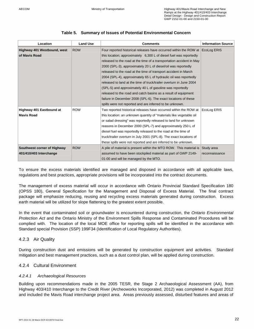
AECOM Ministry of Transportation Highway 401/Mavis Road Interchange and New Ramps at the Highway 401/410/403 Interchange Detail Design - Design and Construction Report GWP 2152-01-00 and 2150-01-00
RPT-2014 01 28 Mavis DCR 0213979 Final.Doc 22
Table 5. Summary of Issues of Potential Environmental Concern
Location Land Use Comments Information Source
Highway 401 Westbound, west of Mavis Road
ROW Four reported historical releases have occurred within the ROW at this location; approximately 6,300 L of diesel fuel was reportedly released to the road at the time of a transportation accident in May 2000 (SPL-3), approximately 20 L of diesel/oil was reportedly released to the road at the time of transport accident in March 2004 (SPL-4), approximately 65 L of hydraulic oil was reportedly released to land at the time of truck/trailer overturn in June 2004 (SPL-5) and approximately 40 L of gasoline was reportedly released to the road and catch basins as a result of equipment failure in December 2008 (SPL-6). The exact locations of these spills were not reported and are inferred to be unknown.
EcoLog ERIS
Highway 401 Eastbound at Mavis Road
ROW Two reported historical releases have occurred within the ROW at this location: an unknown quantity of “materials like vegetable oil or salad dressing” was reportedly released to land for unknown reasons in December 2000 (SPL-7) and approximately 250 L of diesel fuel was reportedly released to the road at the time of truck/trailer overturn in July 2001 (SPL-8). The exact locations of these spills were not reported and are inferred to be unknown.
EcoLog ERIS
Southwest corner of Highway 401/410/403 Interchange
ROW A pile of material is present within the MTO ROW. This material is assumed to have been stockpiled material as part of GWP 2149-01-00 and will be managed by the MTO.
Study area reconnaissance
To ensure the excess materials identified are managed and disposed in accordance with all applicable laws, regulations and best practices, appropriate provisions will be incorporated into the contract documents. The management of excess material will occur in accordance with Ontario Provincial Standard Specification 180 (OPSS 180), General Specification for the Management and Disposal of Excess Material. The final contract package will emphasize reducing, reusing and recycling excess materials generated during construction. Excess earth material will be utilized for slope flattening to the greatest extent possible. In the event that contaminated soil or groundwater is encountered during construction, the Ontario Environmental Protection Act and the Ontario Ministry of the Environment Spills Response and Contaminated Procedures will be complied with. The location of the local MOE office for reporting spills will be identified in the accordance with Standard special Provision (SSP) 199F34 (Identification of Local Regulatory Authorities).
4.2.3 Air Quality
During construction dust and emissions will be generated by construction equipment and activities. Standard mitigation and best management practices, such as a dust control plan, will be applied during construction.
4.2.4 Cultural Environment
4.2.4.1 Archaeological Resources
Building upon recommendations made in the 2005 TESR, the Stage 2 Archaeological Assessment (AA), from Highway 403/410 Interchange to the Credit River (Archeoworks Incorporated, 2012) was completed in August 2012 and included the Mavis Road interchange project area. Areas previously assessed, disturbed features and areas of
AECOM Ministry of Transportation Highway 401/Mavis Road Interchange and New Ramps at the Highway 401/410/403 Interchange Detail Design - Design and Construction Report GWP 2152-01-00 and 2150-01-00
RPT-2014 01 28 Mavis DCR 0213979 Final.Doc 23
low archaeological potential were not subjected to systematic survey. Despite careful scrutiny, no archaeological remains were encountered. The project area was cleared of further archaeological concern. The Stage 2 AA was filed with MTCS and a letter of compliance was received on March 5, 2013.
4.2.4.2 Built and Cultural Heritage Resources
Unterman McPhail Associates completed a Cultural Heritage Assessment of Cultural Heritage Landscapes and Cultural Heritage Resources for the entire project area in April 2013. No mitigation measures are recommended for Highway 401 corridor in the vicinity of the Mavis Road interchange as previous widening activities have altered the original design and thus, resulted in the paving of the grass median (Unterman McPhail Associates, 2013).
4.3 Construction Contract Provisions
The following subsections outline the environmental specifications that have been incorporated into the Contract Documents. As such, these specifications are to be followed by the Contractor in carrying out the work.
4.3.1 Ontario Provincial Standard Specifications (OPSS)
The following Environmental OPSSs apply to this Contract: • OPSS 100 – General Conditions of Contract:
• GC 3.03: Contractor shall alter method, equipment or work force at any time Contract Administrator considers Contractor’s’ actions to be damaging to the environment.
• GC 3.07.01: The presence of Species at Risk as defined under the federal Species at Risk Act, 2002 and/or the provincial Endangered Species Act, 2007 not otherwise identified in the Contract Documents,
• GC 3.07.05: Contractor shall suspend operations if items which may indicate an archaeological find are exposed.
• GC 3.07.06: If the Contractor encounters Species at Risk as defined in clause GC 3.07.01 not otherwise identified in the Contract Documents within the Contract limits that are likely to be impacted by the Contractor’s operations: − The Contractor shall immediately notify the Contract Administrator and suspend operations
within the area identified by the Contract Administrator. − Work shall remain suspended within that area until otherwise directed by the Contract
Administrator in writing, according to subsection GC 7.11, Suspension of Work. − Any delay in the completion date of the Contract that is caused by such a cessation of
construction operations shall be considered to be beyond the Contractor's control according to clause GC 3.07.01.
− Any increases in the cost of the work to be done that are caused by such a cessation of construction operations shall be considered as a Change in the Work according to clause GC 3.10.01.01.
− Any work directed or authorized in connection with the unexpected presence of Species at Risk shall be considered as Changes in the Work according to clause GC 3.10.01, Changes in the Work.
• GC 3.11.03.01.09: Contractor responsible for obtaining all regulatory approvals from any Change Proposal.
• GC 3.11.03.05: Contractor shall submit a traffic management plan that maintains the minimum standards for environmental protection where a change to construction staging is proposed.

AECOM Ministry of Transportation Highway 401/Mavis Road Interchange and New Ramps at the Highway 401/410/403 Interchange Detail Design - Design and Construction Report GWP 2152-01-00 and 2150-01-00
RPT-2014 01 28 Mavis DCR 0213979 Final.Doc 24
• GC 7.07.03: Contractor shall control dust such that it does not affect traffic, enter surface waters, or escape beyond the ROW to cause a nuisance to residents and businesses.
• GC 7.09.01: Contractor shall at all times provide pedestrian and vehicle access to properties adjoining the work.
• GC 7.10.01: Contractor shall obtain any permits, licenses and certificate required for performance of the work.
• GC 7.13.02: Contractors’s environmental incident management under legislation protecting the environment and natural resources shall include containment, notification to proper authority, cleanup in accoradance with the Contractor’s plan that demonstrates satisfactory management of environmental incidents.
• OPSS 180 – Specification for the Management of Excess Material • OPSS 206 – Construction Specification for Grading • OPSS 506 – Construction Specification for Dust Suppression • OPSS 801 – Construction Specification for the Protection of Trees • OPSS 802 – Construction Specification for Topsoil • OPSS 803 – Construction Specification for Sodding • OPSS 804 – Construction Specification for Seed and Cover • OPSS 805 – Construction Specification for Temporary Erosion and Sediment Control.
4.3.2 Standard Special Provisions (SSPs)
The following Environmental SSPs are included with this Contract: • 101F21 – Occupational Health and Safety Act Compliance – List of Designated Substances • 110F10 – Use of Air Cooled Iron Blast Furnace Slag as Granular Material • 199F31 – Environmental Exemptions and Permits • 199F33 – Construction Noise Constraints • 199F34 – Identification of Local Regulatory Authorities • 805F01 – Amendment to OPSS 805, Construction Specification for Temporary Erosion and Sediment Control
Measures
4.3.3 Non-Standard Special Provisions (NSSP)
The Contract includes the following Environmental NSSPs: • General Environmental Protection Requirements • Erosion and Sedimentation Control - General • Management of Excess Earth with Salt Impacts • Emergency Service Providers • Migratory Bird Protection • Prevention of Asian Long Horned Beetle Infestation • General Wildlife Protection • General Tree Protection • Management of Effluent from Concrete Cutting/Grinding • Spill Prevention and Response Contingency Plan • Equipment Refueling and Washing

AECOM Ministry of Transportation Highway 401/Mavis Road Interchange and New Ramps at the Highway 401/410/403 Interchange Detail Design - Design and Construction Report GWP 2152-01-00 and 2150-01-00
RPT-2014 01 28 Mavis DCR 0213979 Final.Doc 25
4.4 Summary of Environmental Protection / Mitigation Requirements during Construction
The following exhibit provides a summary of the key environmental concerns for the Mavis Road interchange.
Table 6. Summary of Environmental Protection / Mitigation Requirements during Construction
I.D.# Issues/Concerns Potential Effects Concerned Agencies I.D.# Mitigation/Protection/Monitoring
General Environmental Protection Requirements 1 General Environmental Protection MTO 1.1 • The general requirement to protect the natural environment from impacts and damage,
including physical damage, emissions, and local access; and • Control of materials, equipment, construction method, construction disturbance limits,
and work timing/staging duration, in order to achieve the foregoing.
Natural Environment Concerns and Commitments 2 Fisheries and Watercourse Impacts MNR 2.1 • No watercourse within Project Area
• No mitigation required.
3 Wildlife Impacts (low probability in the Project Area)
/MNR 3.1 • Temporary vegetation protection fencing installed at the edge of the clearing / grubbing limits.
• Requirement that construction equipment and vehicles give a right-of-way to wildlife, allowing wildlife to pass and proceed to a safe distance prior to construction equipment/vehicles commencing construction activities; and
• Requirement the work cease and Contract Administrator be notified In the event wildlife is injured during construction activities.
4 Bird Impacts (on or adjacent to structure) MNR 4.1 • Vegetation and site clearing will take place between September and March 31st and avoid the months of April until August, in accordance with the Migratory Birds Convention Act.
• A nesting survey will be completed for the existing Mavis Road bridge and in the southwest quadrant of the Highway 401/410/403 interchange prior to commencement of construction.
• Bird netting/screening will be placed under the structure in advance of construction to deter rock pigeons from nesting.
5 Potential to encounter Species at Risk during construction
MTO/MNR 5.1 • If Species at Risk is encountered a qualified biologist should be contacted in order to determine how to proceed without contravening the ESA (2007).
6 Vegetation impacts MNR 6.1 • Vegetation removal will be kept to a minimum and exposed soils will be re-vegetated with an approved MTO seed mix that suits the area soils, immediately following the completion of required work and the final grade has been established.
• Graded areas within the Mavis Road interchange area will be covered with topsoil, seed

AECOM Ministry of Transportation Highway 401/Mavis Road Interchange and New Ramps at the Highway 401/410/403 Interchange Detail Design - Design and Construction Report GWP 2152-01-00 and 2150-01-00
RPT-2014 01 28 Mavis DCR 0213979 Final.Doc 26
I.D.# Issues/Concerns Potential Effects Concerned Agencies I.D.# Mitigation/Protection/Monitoring
and mulch. • Graded areas within the Highway 401/410/403 interchange will be re-planted with
species represented by the vegetation communities that occur within the woodlot. Appropriate species will be discussed and confirmed with MNR and provided on the final landscape plan.
7 Erosion and sediment control MTO 7.1 • An erosion and sediment control plan for construction shall be developed and effectively implemented. It will include: • Limiting vegetation removal to only what is required for grading and ditching
operations; • Constructing embankment slopes at a maximum ratio of 2:1; and • Establishing cover as soon as possible after excavation.
• Sediment fences around construction activities.
Socio-Economic Environment Concerns and Commitments 8 Construction Noise MTO/MOE 8.1 • A noise by-law exemption is not required for night-time construction activities outside the
permitted hours for noise (as per confirmation with the City of Mississauga) • Affected residents (within 500m radius of construction) will be notified 3-4 weeks prior to
night-time activities.
8.2 • Idling of construction equipment will be kept to a minimum and maintained in good working order.
• Contract documents provided to the contractor will contain general noise control measures to mitigate the noise impact at noise sensitive areas including two standard clauses regarding equipment noise.
8.3 • Respond to construction noise complaints according to MTO/MOE “Noise Protocol”.
9 Dust Control during Construction MTO/MOE 9.1 • A dust control plan for construction shall be developed and effectively implemented.
10 Spill Prevention and Response MTO 10.1 • Contractor shall have a spill prevention and response contingency plan that addresses procedures for preventing and responding to spills, and the equipment (including a spill response kit) and resources that will be available.
10.2 • Refuelling precautions will be taken • Refueling will be conducted only in designated areas preferably situated on an
impermeable surface.
10.3 • Construction equipment required to be in good condition.
11 Management of Surplus Material and Debris
MTO 11.1 • Management materials will be dealt with in accordance with normal MTO practices (regulated by OPSS 180).
11.2 • Lead paint on guard rails will be managed in accordance with the Ontario Occupational Health and Safety Act (Reg. 843) and Ontario Environmental Protection Act (Reg. 347).

AECOM Ministry of Transportation Highway 401/Mavis Road Interchange and New Ramps at the Highway 401/410/403 Interchange Detail Design - Design and Construction Report GWP 2152-01-00 and 2150-01-00
RPT-2014 01 28 Mavis DCR 0213979 Final.Doc 27
I.D.# Issues/Concerns Potential Effects Concerned Agencies I.D.# Mitigation/Protection/Monitoring
12 Potential for Property Impacts MTO 12.1 • MTO will coordinate with individual owners (Infrastructure Ontario and the City of Mississauga) for property transfer/purchase in accordance with standard MTO procedures.
13 Potential for temporary or permanent change to emergency access
OPP/Peel Region 13.1 • MTO will notify OPP and emergency medical services of construction staging, start of construction etc. to minimize delay in emergency response times during and after construction.
14 Potential impacts to existing utilities Bell Canada Rogers Communications Enbridge Gas Enersource Hydro Mississauga
14.1 • Utility relocation will be coordinated prior to construction.
15 Traffic delays and disruption during construction
15.1 • Traffic along Mavis Road will be reduced to two lanes per direction during construction, however access to and from Highway 401 will be maintained at all times.
• Night-time lane closures may be required during the construction of the two ramps at the Highway 401/410/403 interchange.
Cultural Environment Concerns and Commitments 16 Response to archaeological finds during
construction MTCS 16.1 • A Stage 2 Archaeological Assessment recommended that no further archaeological
concern is warranted for lands with the project area. • If any archaeological and/or historical resources be discovered during construction, they
may be a new archaeological site and therefore subject to Section 48(1) of the Ontario Heritage Act. Construction must cease immediately and a licensed consultant archaeologist must be engaged to carry out archaeological fieldwork in compliance with Section 48(1) of the Ontario Heritage Act.
• Work in the area would not resume until cleared by the Ministry of Tourism, Culture and Sport.
17 Impact to cultural heritage landscape (Highway 401 Roadscape)
MTCS 17.1 • No mitigation required.

1. AECOM Ministry of Transportation Highway 401/Mavis Road Interchange and New Ramps at the Highway 401/410/403 Interchange Detail Design - Design and Construction Report GWP 2152-01-00 and 2150-01-00
RPT-2014 01 28 Mavis DCR 0213979 Final.Doc 28
5. Environmental Monitoring / Inspection Program for Project Implementation
5.1 Overview of Environmental Monitoring / Inspection Program for Project Implementation
Environmental monitoring / inspection is a component of the overall monitoring / inspection program for project implementation. The environmental monitoring / inspection for project implementation has the following components: • on site construction administrator to oversee the work • environmental monitoring plans • design package handover meeting • pre-construction notifications • pre-construction environmental monitoring / inspection • environmental monitoring during construction • post-construction environmental monitoring / inspection. As part of the Ministry of Transportation’s continuing commitment to environmental stewardship, comprehensive construction and post-construction monitoring programs will be instituted on this undertaking. The programs will assess the effectiveness of environmental mitigation and compensation measures, as well as the degree of compliance with environmental mitigation and protection measures committed to during the construction period.
5.2 Environmental Monitoring / Inspection During Construction
During construction, the Contractor and Contract Administrator will ensure that implementation of mitigating measures and key design features are consistent with contractual requirements and commitments to external stakeholders. This will be achieved through the establishment of an environmental inspection approach that includes the use of an Environmental Inspector operating under the direction of the Contract Administrator, in compliance with MTO’s Construction Administration and Inspection Task Manual (May, 2010) (CAIT Manual). The CAIT Manual task descriptions provide guidance to those involved in inspection on Ministry of Transportation construction contracts, to ensure that the quality and quantity of the work is in accordance with Ministry specifications, standards, drawings, policies and procedures. The project will be subject to periodic on-site environmental inspection to ensure that the execution of the environmental component of the work is occurring as planned and to deal with any environmental problems that may develop during construction. The periodic on-site inspection will be supplemented by the support of environmental specialists retained by the Contract Administrator, as required, to assure the proper implementation of site-specific mitigation or remediation measures.
5.3 Post-Construction Environmental Monitoring / Inspection
The purpose of the post-construction monitoring and environmental inspection program is to ensure, to the extent possible, that lands disturbed as a result of construction activities will be restored to their original use and condition as soon as possible after construction.
Appendix A - Consultation Notice of Commencement
Project Website
Public Information Centre
Select Correspondence
Meetings
Notice of Filing of the Design and Construction Report

Notice of Commencement

ONTARIO GOVERNMENT NOTICE NOTICE OF STUDY COMMENCEMENT
HIGHWAY 401 WIDENING
FROM HIGHWAY 403/410 INTERCHANGE TO THE CREDIT RIVER DETAIL DESIGN G.W.P. 2150-01-00
THE PROJECT
AECOM Canada Ltd. (AECOM) has been retained by the Ontario Ministry of Transportation (MTO) to undertake the Detail Design Project for the ultimate widening of Highway 401 from the Highway 403/410 interchange to the Credit River in the City of Mississauga, Regional Municipality of Peel, a distance of 7 km (see Key Map). The project will complete the expansion of Highway 401 from Highway 410/403 interchange to the Credit River, from its current 6 lanes to a 12-lane core/collector system including a High Occupancy Vehicle (HOV) lane in each direction.
Key Map
THE PROCESS
The project will follow the approved environmental planning process for Group ‘B’ projects under the Class Environmental Assessment for Provincial Transportation Facilities (2000). A Transportation and Environmental Study Report (TESR) was prepared in August 2005 and received environmental approval in July 2007. A review of this TESR will be conducted for this project. A Design and Construction Report (DCR) will be prepared to document environmental investigation, environmental impacts, proposed mitigation measures and commitments to future work. This document will be made available for public review upon completion of Detail Design. Project information will be posted and updated on the project website: www.401expansion-mississauga.ca A Public Information Centre (PIC) will be held for this project to present details of the proposed Highway 401 widening, construction staging, and mitigation measures to address potential environmental impacts. Notice of the PIC will be provided in local newspapers and on the project website. The PIC is anticipated to be held in the summer of 2012. COMMENTS
There is opportunity at any time of the project for interested persons to provide comments and input to the Project Team. Comments and information regarding this project are being collected to assist in meeting the requirements of the Environmental Assessment Act, in accordance with the Freedom of Information Act. This material will be maintained on file for use during the project and may be included in project documentation. With the exception of personal information, all comments will become part of the public record. To obtain additional information, provide comments, or to join our mailing list, please contact either one of the following Project Team members:
Miao Zhou, M.Eng. P.Eng. Senior Project Engineer Ontario Ministry of Transportation Central Region Building’ D’, 4th Floor 1201 Wilson Avenue Downsview, ON M3M 1J8 Phone: (416) 235-4277 Fax: (416) 235-3576 Email: [email protected]
Brian Ruck, P. Eng. C.V.S., Consultant Project Manager AECOM Canada Ltd. 300 Water Street Whitby, ON L1N 9J2 Toll Free: 1-800-668-1983 or Phone: (905) 668-4021 ext. 2250 Fax: (905) 665-4867 E-mail: [email protected]
This Notice first issued on: June 21, 2011

AVIS DU GOUVERNEMENT DE L'ONTARIO AVIS DE DÉBUT D'ÉTUDE
ÉLARGISSEMENT DE L'AUTOROUTE 401
ENTRE L'ÉCHANGEUR DE L'AUTOROUTE 403/410 ET CREDIT RIVER CONCEPTION DÉTAILLÉE G.W.P. 2150-01-00
LE PROJET
Le ministère des Transports de l'Ontario (MTO) a retenu les services d’AECOM Canada Ltd. pour entreprendre le projet de conception détaillée pour l'élargissement ultérieur de l 'autoroute 401 entre l'échangeur de l'autoroute 403/410 et la rivière Credit River dans la ville de Mississauga, Municipalité régionale de Peel, sur une distance de 7 km (voir la carte-index). Le projet complètera l'agrandissement de l 'autoroute 401 entre l'échangeur de l'autoroute 403/410 et la rivière Credit River, de 6 voies actuellement en une autoroute principale/collectrice de 12 voies comprenant une voie réservée aux véhicules multioccupants (VMO) dans chaque direction.
Carte index
PROCESSUS
Cette étude se déroulera conformément au pr ocessus approuvé de planification environnementale pour les projets du groupe B décrits dans l'Évaluation environnementale de portée générale pour les installations provinciales de transport (2000).
Un Rapport d’étude environnementale pour le transport (REET) a été rédigé en août 2005 et a obt enu l’approbation environnementale en juillet 2007. Ce REET sera réexaminé dans le cadre de ce projet. Un Rapport de conception et de construction (RCC) sera rédigé pour documenter l’étude sur l’environnement, les répercussions sur l’environnement, les mesures d'atténuation proposées ainsi que les engagements pour des travaux futurs. Une fois la conception détaillée achevée ce document sera rendu public pour un examen.
Les informations concernant le projet seront affichées et mises à j our sur le site Web du projet : www.401expansion-mississauga.ca
Un Centre d’information (CI) sera ouvert au public pour ce projet afin de présenter les détails concernant l’élargissement de l’autoroute 401, la planification de la construction, et les mesures d’atténuation pour traiter des répercussions potentielles sur l’environnement. Un avis concernant le CI sera publié dans les journaux locaux et sur le site Web du projet. Il est prévu que le CI sera tenu pendant l’été en 2012. COMMENTAIRES
Les personnes intéressées pourront à n’importe quel moment pendant le projet, faire des commentaires ou apporter leur contribution à l’équipe du projet. Les commentaires et les informations concernant ce projet sont recueillis afin d’aider à satisfaire les exigences de la Loi sur les évaluations environnementales, en conformité avec la Loi sur l’accès à l’information. Ces éléments seront conservés dans le dossier pour être utilisés pendant le projet et pourront être inclus dans la documentation du projet. À l’exception des informations personnelles, tous les commentaires feront partie des dossiers publics.
Pour obtenir de plus amples renseignements, faire des commentaires, ou vous inscrire sur notre liste d’abonnement, veuillez communiquer avec l’un des membres suivants de l’équipe du projet :
Miao Zhou, M.Eng. P.Eng. Ingénieur principal chargé de projet Ministère des Transports de l'Ontario Région du Centre Immeuble D, 4ème étage 1201 Wilson Avenue Downsview, ON M3M 1J8 Téléphone : 416 235-4277 Télécopieur : 416 235-3576 Courriel : [email protected]
Brian Ruck, P. Eng. C.V.S., Chargé de projet de l’expert-conseil AECOM Canada Ltd. 300 Water Street Whitby, ON L1N 9J2 Numéro sans frais : 1 800 668-1983 ou Téléphone : 905 668-4021, poste 2250 Télécopieur : 905 665-4867 Courriel : [email protected]
Cet avis a été publié pour la première fois le : 21 juin 2011

Affiliation Agency Sub-Agency Title Contact Names Greeting Street Address City Prov P.C. Phone No. Fax No. Email
NoC Electronic Notification Date
NoC Hard Copy Notification Date
Federal Canadian Environmental Assessment Agency Ontario Region CEAA Coordinator Mr. Jim Chan Mr. Chan 55 St. Clair Ave. E., 9th Flr Toronto ON M4T 1M2
[email protected] 6/21/2011 6/28/2011
Federal Canadian Environmental Assessment Agency Ontario Region Regional Director Ms. Louise Knox Ms. Knox 55 St. Clair Ave. E., 9th Flr Toronto ON M4T 1M2
[email protected] 6/21/2011 6/28/2011
Federal Fisheries and Oceans Canada Burlington Office Referral Coordinator Sir/Madam
304-3027 Harvester Rd, PO Box 85060 Burlington ON L7R 4K3
[email protected] 6/21/2011 6/28/2011
Federal Fisheries and Oceans Canada
Fish Habitat Management, Ontario-Great Lakes Area
Senior Habitat Biologist Ms. Sara Eddy Ms. Eddy 867 Lakeshore Rd. Burlington ON L7R 4A6
[email protected] 6/21/2011 6/28/2011
Federal Fisheries and Oceans Canada Inspection Officer 201 N. Front St, Suite 203 Sarnia ON N7T 8B1 6/21/2011 6/28/2011
Federal Environment Canada
Environmental Protection Operations Division - Ontario Region
Manager, Environmental Assessment Section Mr. Rob Dobos Mr. Dobos
867 Lakeshore Rd, P.O. Box 5050 Burlington ON L7R 4A6
[email protected] 6/21/2011 6/28/2011
Federal
Aboriginal Affairs and Northern Development Canada
Environmental Assessment Coordination Environmental Unit 25 St. Clair Ave E, 8th Flr Toronto ON M4T 1M2
[email protected] 6/21/2011 6/28/2011
Federal
Aboriginal Affairs and Northern Development Canada
Litigation Management and Resolution Branch
Team Leader, Ontario/Nunavut Litigation Team
Ms. Josee Beauregard Ms. Beauregard
10 Wellington St. Rm 1310 Gatineau QC K1A 0H4
[email protected] 6/21/2011 6/28/2011
Federal
Aboriginal Affairs and Northern Development Canada
Office of the Federal Interlocutor for Metis and Non-status Indians Senior Policy Analyst Mr. Jeffrey Betker Mr. Betker 66 Slater St., Rm 1218 Ottawa ON K1A 0H4
[email protected] 6/21/2011 6/28/2011
Federal Transport Canada Environmental Affairs Regional Manager Ms. Monique Mousseau Ms. Mousseau 4900 Yonge St., Suite 300 Toronto ON M2N 6A5
[email protected] 6/21/2011 6/28/2011
Federal Transport Canada Marine Safety Superintendent Mr. Barry Putt Mr. Putt 100 South Front Street Sarnia ON N7T 2M1 [email protected] 6/21/2011 6/28/2011
Federal Canadian Transportation Agency Secretariat Directorate Ms. Cathy Murphy Ms. Murphy 15 Eddy Street Gatineau QC K1A 0N9
[email protected] 6/21/2011 6/28/2011
Provincial Ministry of Aboriginal Affairs
Consultation Unit, Aboriginal Relations Manager
Ms. Heather Levecque Ms. Levecque 160 Bloor St. E., 9th Flr Toronto ON M7A 2E6
(416)325-4044
(416)326-1066
[email protected] 6/21/2011 6/28/2011
Provincial Ministry of Aboriginal Affairs Technical Team Lead Mr. David Pickles Mr. Pickles 160 Bloor St. E., 9th Flr Toronto ON M7A 2E6
(416)326-4757
[email protected] 6/21/2011 6/28/2011
Provincial Ministry of Aboriginal Affairs Mr. Martin Rukavina Mr. Rukavina 160 Bloor St. E., 9th Flr Toronto ON M7A 2E6
[email protected] 6/21/2011 6/28/2011
Provincial Ministry of Tourism and Culture Culture Services Unit
A/Heritage Planner, Central and Southeast Ms. Rosi Zirger Ms. Zirger 401 Bay St. 17th Floor Toronto ON M7A 0A7
(416)314-7159
(416)314-7175
[email protected] 6/21/2011 6/28/2011
Provincial Ministry of Environment Central Region, Halton-Peel District Office District Manager
Mr. Vincent Sferrazza Mr. Sferrazza
4145 North Service Rd, Suite 300 Burlington ON L7L 6A3
[email protected] 6/21/2011 6/28/2011
Provincial Ministry of Environment
Environmental Assessment and Approvals Branch Director
Ms. Agatha Garcia-Wright
Ms. Garcia-Wright 2 St. Clair Ave W, Flr 12A Toronto ON M4V 1L5
[email protected] 6/21/2011 6/28/2011
Provincial Ministry of Environment
Environmental Assessment and Approvals Branch
EA and Planning Coordinator Ms. Chunmei Liu Ms. Liu 5775 Yonge St, 9th Flr Toronto ON
[email protected] 6/21/2011 6/28/2011

Provincial Ministry of Municipal Affairs and Housing
Central Municipal Services Office
Manager Community Planning and Development Mr. Victor Doyle Mr. Doyle 777 Bay St., 2nd Flr Toronto ON M5G 2E5
(416)585-6109
(416)585-6882
[email protected] 6/21/2011 6/28/2011
Provincial Ministry of Natural Resources Aurora District Office District Planner Mr. Steve Strong Mr. Strong
50 Bloomington Rd W, RR#2 Aurora ON L4G 2G8
[email protected] 6/21/2011 6/28/2011
Provincial Credit Valley Conservation Authority
Manager, Planning Ecology Mr. Liam Murray Mr. Murray 1255 Old Derry Rd
Mississauga ON L5N 6R4
[email protected] 6/21/2011 6/28/2011
Provincial Toronto Region Conservation Authority
Planning and Development
Planner II, Environmental Assessment
Ms. Sharon Lingertat Ms. Lingertat 5 Shoreham Dr
Downsview ON M3N 1S4
[email protected] 6/21/2011 6/28/2011
Provincial Ministry of Agriculture, Food and Rural Affairs Central West-Ontario Rural Planner
Ms. Jackie Van de Valk Ms. Van De Valk
6484 Wellington Rd 7, Unit 10 Elora ON N0B 1S0
[email protected] 6/21/2011 6/28/2011
Provincial Ministry of Energy and Infrastructure
Ontario Realty Corporation, Professional Services
General Manager, Planning, Survey and Appraisal Mr. Anil Wijesooriya Mr. Wijesooriya
1 Dundas St. W. Suite 2000 Toronto ON M5G 2L5
[email protected] 6/21/2011 6/28/2011
Provincial Ministry of Energy and Infrastructure
Strategic Policy Branch, Conservation & Strategic Policy Division Sr. Policy Advisor
Mr. Hartley Springman Mr. Springman 880 Bay St., 6th Flr Toronto ON M7A 2C1
(416)327-7276
(416)327-7204
[email protected] 6/21/2011 6/28/2011
Provincial Ministry of Energy and Infrastructure
Ontario Growth Secretariat
Manager Growth Policy Mr. Jamie Austin Mr. Austin
777 Bay St., 4th Flr, Suite 425 Toronto ON M5G 2E5
(416)325-5794
(416)325-7403
[email protected] 6/21/2011 6/28/2011
Provincial Ontario Provincial Police
OPP Facilities Section, Accommodation Services Section Manager Ms. Sheryl Bennett Ms. Bennett 777 Memorial Avenue Orilla ON L3V 7V3
[email protected] 6/21/2011 6/28/2011
Provincial GO Transit and Metrolinx Transportation Planning & Development Manager Mr. Dan Francey Mr. Francey 20 Bay St, Suite 600 Toronto ON M5J 2W3
(416)869-3600
(416)869-1563
[email protected] 6/21/2011 6/28/2011
Political Mississauga-Streetsville MPP Mr. Bob Delaney Mr. Delaney 2000 Argentia Road, Plaza IV, Suite 220
Mississauga ON L5N 1W1
Political Mississauga-Brampton South MPP Ms. Amrit Mangat Ms. Mangat
7045 Edwards Boulevard, Suite 203
Mississauga ON L5S 1X2
Political Mississauga -Streetsville MP Ms. Eve Adams Ms. Adams House of Commons Ottawa ON K1A 0A4
Political Mississauga-Brampton South MP Mr. Brad Butt Mr. Butt
154 Queen Street South, Unit 104
Mississauga ON L5M 2P4

Affiliation Agency Sub-Agency Title Contact Names Greeting Street Address City Prov P.C.
Municipality Region of Peel Regional Clerk 10 Peel Centre Dr., Suite A, 5th Flr Brampton ON
L6T 4B9
Municipality Region of Peel Regional Chair Mr. Emil Kolb Mr. Kolb 10 Peel Centre Dr., Suite A, 5th Flr Brampton ON
L6T 4B9
Municipality Region of Peel Public Works Commissioner Mr. Dan Labrecque Mr. Labrecque
10 Peel Centre Dr., Suite A, 4th Flr Brampton ON
L6T 4B9
Municipality Region of Peel Transportation Division Director
Mr. Damian Albanese Mr. Albanese 9445 Airport Rd, 3rd Flr Brampton ON
L6S 4J3
Municipality Region of Peel
Strategist - Infrastructure Planning and Design
Mr. Gary Kocialek, P.Eng. Mr. Kocialek
10 Peel Centre Dr. 6th Flr Brampton ON
L6T 4B9
Municipality Region of Peel Transportation Division
Manager of Transportation Systems Planning Mr. Sabbir Saiyed Mr. Saiyed 9 Peel Centre Dr. 6th Flr Brampton ON
L6T 4B8
Municipality Region of Peel Planning Principal Planner Ms. Margie Chung Ms. Chung 10 Peel Centre Dr. 6th Flr Brampton ON
L6T 4B9
Municipality Region of Peel
Ambulance and Emergency Services Director Mr. Peter Dundas Mr. Dundas 5299 Maingate Dr Mississauga ON
L4W 1G6
Municipality Peel Region Police 12 Division A/Superintendent Mr. David Downer Mr. Downer 4600 Dixie Road Mississauga ON
L4W 2R1
Municipality City of Mississauga
Office of the City Clerk City Clerk Ms. Crystal Greer Ms. Greer
300 City Centre Dr, 3rd Flr Mississauga ON
L5B 3C1
Municipality City of Mississauga
Transportation Planning Manager Mr. Robert Sasaki Mr. Sasaki 3484 Sementyk Crt. Mississauga ON
L5C 4R1
Municipality City of Mississauga
Transportation and Works Department
Transportation Project Manager Mr. Abdul Shaikh Mr. Shaikh
201 City Centre Dr, Suite 800 Mississauga ON
L5B 2T4
Municipality City of Mississauga Ward 5 Councillor Ms. Eve Adams Ms. Adams 300 City Centre Dr. Mississauga ON
L5B 3C1
Municipality City of Mississauga
Fire and Emergency Services
Information Coordinator 15 Fairview Rd W Mississauga ON
L5H 1K7
Municipality City of Mississauga
Fire and Emergency Services Fire Chief
Mr. John A. McDougall
Mr. McDougall 15 Fairview Rd W Mississauga ON
L5B 1K7
Municipality City of Brampton Mayor Susan Fennell Mayor Fennell 2 Wellington St W Brampton ON L6Y 4R2
Municipality City of Brampton
Management and Administrative Services Commissioner Ms. Kathy Zammit Ms. Zammit 2 Wellington St W Brampton ON
L6Y 4R2
Municipality City of Brampton Works and Transportation Commissioner Mr. John Corbett Mr. Corbett 2 Wellington St W Brampton ON
L6Y 4R2
Municipality City of Brampton
Brampton Fire and Emergency Services Fire Chief
Mr. Andy MacDonald
Mr. MacDonald 8 Rutherford Rd S Brampton ON
L6W 3J1

Municipality City of Brampton City Clerk's Office City Clerk 2 Wellington St W Brampton ON L6Y 4R2
Other Peel District School Board
Planning and Accommodation Department
Intermediate Planning Officer Mr. Paul Mountford Mr. Mountford
HJA Brown Education Centre, 5650 Hurontario St Mississauga ON
L5R 1C6
Other
Dufferin-Peel Catholic District School Board
Planning Department
Manager of Planning Mr. Thane Munn Mr. Munn 40 Matheson Blvd W Mississauga ON
L5R 1C5
Other TransHelp Advisory Committee 3190 Mavis Road Mississauga ON
L5C 1T9
Other Mississauga Board of Trade Chair Mr. Ian MacFadden
Mr. MacFadden
701-77 City Centre Drive Mississauga ON
L5C 1T9
Utilities Bell Canada Mr. Rick Englehardt Mr. Englehardt 2 Fieldway Dr. 9th Flr Etobicoke ON
Utilities Enbridge Gas Distribution Inc. Special Projects
Planning and Design Analyst Mr. Martin Paquette Mr. Paquette
500 Consumers Rd, 4th Flr, Post D1 North York ON
Utilities Rogers Cable OPE-GTA West Planner Mr. Corry Baker Mr. Baker 3573 Wolfedale Rd Mississauga ON
Utilities Hydro One Telecom OSP Manager Mr. Ian Mitchell Mr. Mitchell 65 Kelfield St. Rexdale ON
Utilities Hydro One Networks Area Distribution
Engineering Technician Mr. B. Jamie Bignell Mr. Bignell 913 Crawford Dr. Peterborough ON
Utilities Trans Northern Pipelines Coordinator Mr. Satish Kumar Mr. Kumar 45 Vogell Rd., Suite 310 Richmond Hill ON
Utilities Peel Region PUCC/Permits
Information Services, Operations Support, Public Works Ms. Wendy Jawdek Ms. Jawdek
9445 Airport Road, 3rd Floor Brampton ON
Utilities Greater Toronto Airport Authority
Strategic Planning and Airport Development
Geomatics Planning Analyst Ms. Agnes Kotowicz Ms. Kotowicz
PO Box 6031, 3111 Convair Dr Toronto AMF ON
Utilities
Orangeville-Brampton Railway
Operations Manager Mr. Steve Gallagher Mr.Gallagher 75 1st St Orangeville ON

Affiliation Title Contact Names Greeting Street Address City Prov P.C. Union of Ontario Indians, Nipissing First Nation CEO
Mr. Alan Ozawanimke Mr. Ozawanimke PO Box 711 North Bay ON
P1B 8J8
Association of Iroquois and Allied Indians
Director of Intergovernmental Affairs
Ms. Adrianna Poulette Ms. Poulette 387 Princess Street London ON N6B
2A7
Coordinator for the Williams Treaties Barrister/Solicitor
Karry Sandy-McKenzie Ms. Sandy 8 Creswick Court Barrie ON
L4M 2J7
Mississauga of Scugog Island First Nation Chief
Tracy Gauthier / Rhonda Coppaway Chief Gauthier RR#5, 22521 Island Road Port Perry ON
L9L 1B6
Chippewas of Georgina Island First Nation Chief Donna Big Canoe Chief Big Canoe RR#2, PO Box N13 Sutton West ON
L0E 1R0
Chippewas of Mnjikaning First Nation Chief
Sharon Stinson Henry Chief Stinson Henry 5884 Rama Road, Suite 200 Rama ON
L0K 1T0
Hiawatha First Nation Chief Laurie Carr Chief Carr 123 Paudash St Hiawatha ON K0L 2G0
Hiawatha First Nation Councillor Lorne Paudash Mr. Paudash 123 Paudash St Hiawatha ON K0L 2G0
Beausoleil First Nation Chief Rodney Monague Jr. Chief Monague Jr. 1 Ogema St Christian Island ON L0K 1C0
Alderville First Nation Chief James Marsden Chief Marsden
Alderville Administrative Office, 11696 Second Line Rd., PO Box 46 Alderville ON
K0K 2X0
Curve Lake First Nation Chief Keith Knott Chief Knott 22 Winookeeda Rd Curve Lake ON K0L 1R0
Curve Lake First Nation Councillor Ted Coppaway Mr. Coppaway 22 Winookeeda Rd Curve Lake ON K0L 1R0
Mississaugas of the New Credit First Nations Chief Bryan Laforme Chief Laforme 2789 Mississauga Rd, RR#6 Hagersville ON
N0A 1H0
Mississauga of the New Credit First Nations Margaret Sault Ms. Sault 2789 Mississauga Rd, RR#6 Hagersville ON
N0A 1H0
Six Nations Haudensaunee Confederacy Council Chief
Allen McNaughton c/o Leroy Hill Chief McNaughton RR #2 Ohsweken ON
N0A 1M0
Six Nations of the Grand River Territory Chief William Montour Chief Montour
1695 Chiefswood Road, PO Box 5000 Ohsweken ON
N0A 1M0
Metis Consultation Unit Head Office, 500 Old St. Patrick St, Box 5000 Ohsweken ON
K1N 9G4
Credit River Metis Council c/o 1515 Matheson Blvd. E. #103 Mississauga ON
L4W 2P5

AECOM300 Water Street 905 668 9363 telWhitby, ON, Canada L1N 9J2 905 668 0221 faxwww.aecom.com
June 24, 2011
Contact NameContact TitleCompany NameCompany Address
Dear Contact Name:
Regarding: Notice of Study CommencementHighway 401 Widening – Highway 403/410 Interchange to the Credit RiverGroup Work Project (G.W.P.) 2150-01-00Detail Design
AECOM Canada Ltd. (AECOM) has been retained by the Ontario Ministry of Transportation (MTO) toundertake the Detail Design Project for the ultimate widening of Highway 401 from the Highway403/410 interchange to the Credit River in the City of Mississauga, Regional Municipality of Peel, adistance of 7 km. The project will complete the expansion of Highway 401 from Highway 410/403interchange to the Credit River, from its current 6 lanes to a 12-lane core/collector system including aHigh Occupancy Vehicle (HOV) lane in each direction. The proposed improvements include:
Widening of Highway 401 to a 12-lane core/collector system from west of Hurontario Street to theCredit River;
Construction of HOV lanes in both directions; Reconstruction or extension of the Mavis Road interchange; Removal of the 2nd Line West structure; Culvert extensions at Fletcher’s Creek; and Expansion of COMPASS system
The purpose of this letter is to inform you of the project and to solicit comments that should beaddressed throughout the detail design stage. To this end, your assistance in ensuring this letter iscirculated to the appropriate personnel within your organization or agency is greatly appreciated.
This project is subject to the Environmental Assessment Act and has followed the environmentalplanning process for Group “B” Projects as described in the Class Environmental Assessment forProvincial Transportation Facilities (2000), with public input throughout. A Consultation Plan hasbeen developed to ensure external agencies and the public have an opportunity to participate in theplanning and decision-making processes throughout the project. Please find enclosed a copy of theNotice of Study Commencement providing further details regarding the project.
We would appreciate receiving any information your agency may have which is relevant to thisproject. If your agency has any concerns and/or comments regarding this project and you wish toprovide input, please contact the undersigned using the Reply Form provided. Should the proposedproject have no affect on your agency’s program mandate and/or policies, please advise the

Page 2June 24, 2011
undersigned of this fact by returning the Reply Form provided. Your response is appreciated by July18, 2011 so that we can meet the study schedule, and ensure your issues/concerns are addressed ina timely manner.
If you require additional information or wish to discuss the project or the study process, pleasecontact either one of the following Project Team members listed in the enclosed Notice. Projectinformation will be posted and updated on the project website: www.401expansion-mississauga.ca.
Thank you for your assistance with this project.
Sincerely,AECOM Canada Ltd.
Brian Ruck, P.Eng.Consultant Project [email protected]
CL:moEncl.cc: Miao Zhou, P.Eng. – MTO Senior Project Engineer
Larry Sarris – MTO Environmental PlannerMirjana Osojnicki – AECOM Environmental Planner
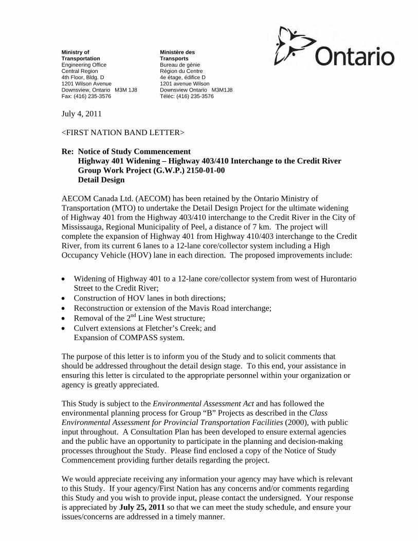
Ministry of Ministère des Transportation Transports Engineering Office Bureau de génie Central Region Région du Centre 4th Floor, Bldg. D 4e étage, édifice D 1201 Wilson Avenue 1201 avenue Wilson Downsview, Ontario M3M 1J8 Downsview Ontario M3M1J8 Fax: (416) 235-3576 Téléc: (416) 235-3576 July 4, 2011 <FIRST NATION BAND LETTER> Re: Notice of Study Commencement Highway 401 Widening – Highway 403/410 Interchange to the Credit River Group Work Project (G.W.P.) 2150-01-00 Detail Design AECOM Canada Ltd. (AECOM) has been retained by the Ontario Ministry of Transportation (MTO) to undertake the Detail Design Project for the ultimate widening of Highway 401 from the Highway 403/410 interchange to the Credit River in the City of Mississauga, Regional Municipality of Peel, a distance of 7 km. The project will complete the expansion of Highway 401 from Highway 410/403 interchange to the Credit River, from its current 6 lanes to a 12-lane core/collector system including a High Occupancy Vehicle (HOV) lane in each direction. The proposed improvements include:
• Widening of Highway 401 to a 12-lane core/collector system from west of Hurontario Street to the Credit River;
• Construction of HOV lanes in both directions; • Reconstruction or extension of the Mavis Road interchange; • Removal of the 2nd Line West structure; • Culvert extensions at Fletcher’s Creek; and
Expansion of COMPASS system.
The purpose of this letter is to inform you of the Study and to solicit comments that should be addressed throughout the detail design stage. To this end, your assistance in ensuring this letter is circulated to the appropriate personnel within your organization or agency is greatly appreciated. This Study is subject to the Environmental Assessment Act and has followed the environmental planning process for Group “B” Projects as described in the Class Environmental Assessment for Provincial Transportation Facilities (2000), with public input throughout. A Consultation Plan has been developed to ensure external agencies and the public have an opportunity to participate in the planning and decision-making processes throughout the Study. Please find enclosed a copy of the Notice of Study Commencement providing further details regarding the project. We would appreciate receiving any information your agency may have which is relevant to this Study. If your agency/First Nation has any concerns and/or comments regarding this Study and you wish to provide input, please contact the undersigned. Your response is appreciated by July 25, 2011 so that we can meet the study schedule, and ensure your issues/concerns are addressed in a timely manner.

If you require additional information or wish to discuss the project or the study process, please contact the undersigned. Study information will be posted and updated on the project website: www.401expansion-mississauga.ca. Thank-you for your assistance with this project. Sincerely, ORIGINAL SIGNED Miao Zhou, M. Eng., P. Eng. Senior Project Engineer Ministry of Transportation, Central Region Encl. Information will be collected in accordance with the Freedom of Information and Protection of Privacy Act. With the exception of personal information, all comments will become part of the public record.


Page 3June 24, 2011
REPLY FORM
PLEASE REPLY BY July 18, 2011
To: MIRJANA OSOJNICKI, AECOM Date:
Fax: (905) 238-0038 E-mail: [email protected]
Re: Notice of Study Commencement Highway 401 Widening, from Highway 403/410Interchange to the Credit River, City of Mississauga, Regional Municipality of Peel,7 km, GWP 2150-01-00
NAME:
Use my contact information as the key project contact for futurecorrespondence
TITLE:
MUNICIPALITY/AGENCY:
ADDRESS:
POSTAL CODE:
PHONE:
FAX:
E-MAIL:
Please indicate the appropriate response:My group/agency is interested in providing input regarding this Study. Pleaseleave me on the Study Mailing List.
My group/agency is not interested in providing input regarding this Study butwould like to be kept informed. Please leave me on the Study Mailing List.
Please remove my group/agency from Study Mailing List.
Area of interest or concern/preliminary comments:

Project Website

wrighta1
Stamp

Public Information Centre

BLEED
Ministry of transportationPN-5596-URS_ENGToronto Star 6C (6.267) x 145ag (set-size)Mississauga News 6C (6.191") x 150ag
notiCE of pUBLiC inforMation CEntrEHighway 401 Widening
from Highway 403/410 interchange to the Credit riverG.W.p.s 2150-01-00 and 2152-01-00
tHE proJECt
aECoM Canada Ltd. is undertaking the Detail Design on behalf of the Ontario Ministry of transportation (Mto) for the ultimate widening of Highway 401 from the Highway 403/410 interchange to the Credit River, Mississauga, a distance of 7 km (see key plan). This project involves:
Under G.W.p. 2150-01-00• Expansion of Highway 401 from its current
six lanes to a 12-lane core/collector system including High Occupancy Vehicle (HOV) lanes;
• Removal of the Second Line West structure over Highway 401 to accommodate the widening; and
• Construction of two ramps from Highway 401 eastbound to Highway 403 southbound and from Highway 403 northbound to Highway 401 westbound at the 401/410/403 interchange.
Under G.W.p. 2152-01-00• Extension of the Mavis Road bridge as an
advanced construction contract.
tHE proCEss
This project will follow the environmental planning process for Group ‘B’ undertakings as defined in the Class Environmental Assessment for Provincial Transportation Facilities (2000). A previous Transportation Environmental Study Report (TESR) was prepared in August 2005 and received environmental approval. Since that time, it has been determined that reconstruction of the Mavis Road bridge can be advanced by preparing the Detail Design separately and documenting this in its own Design and Construction Report (DCR).
A second DCR will subsequently be prepared to document the Detail Design for the remainder of the highway expansion work. A TESR Addendum will be prepared for the proposed extension of Belgrave Road to connect to Mavis Road. Details regarding the release of these documents will be provided in future notices.
Project information will be posted and updated on the project website: www.401expansion-mississauga.ca.
The City of Mississauga is considering a separate study for pedestrian/cycling options across Highway 401 at the location of the removed Second Line West structure. This study will be undertaken in accordance with the Municipal Class Environmental Assessment process.
pUBLiC inforMation CEntrE
The public is invited to attend a Public Information Centre (PIC) for this project. The purpose of the PIC is to present and receive input on the design details of the proposed Highway 401 improvements, including information on construction staging, potential environmental impacts and proposed mitigation measures. The PIC will be held on:
Date: Wednesday, november 13, 2013Location: Meadowvale Village Hall
6970 second Line West, Mississauga, ontime: 4:00 p.m. to 8:00 p.m.
This PIC will be an informal drop-in centre. Representatives from the MTO and the project’s consultant team will be available to answer questions, receive comments and discuss the next steps in this project. You are encouraged to attend the PIC and provide the Project Team with your views and comments so that they can be considered as the project progresses. For further information or if you wish to be added to the project mailing list, please contact:
Miao Zhou, p.Eng., M.Eng. Brian ruck, p.Eng., C.V.s.Project Engineer Consultant Project ManagerOntario Ministry of Transportation AECOM Canada Ltd.Central Region 300 Water Street1201 Wilson Avenue, Building D, 4th Floor Whitby, ON L1N 9J2Downsview, ON M3M 1J8 toll-free: 1-800-668-1983tel: 416-235-4277 tel: 905-668-4021 ext. 2250fax: 416-235-3576 fax: 905-665-4867e-mail: [email protected] e-mail: [email protected]
Comments and information regarding this project are being collected to assist in meeting the requirements of the Environmental Assessment Act, in accordance with the Freedom of Information Act. This material will be maintained on file for use during the project and may be included in project documentation. With the exception of personal information, all comments will become part of the public record.

BLEED
Ministry of transportationPN-5596_AEC_FREToronto L'Express 6C (6.25) x 160ag
aVis ConCErnant La sÉanCE D’inforMation pUBLiQUE
Élargissement de l'autoroute 401 à partir de l'échangeur entre les autoroutes 403 et
410 jusqu'à la rivière CreditG.W.p. 2150-01-00 et G.W.p. 2152-01-00
proJEt
aECoM Canada Ltd. entreprend une étude de conception détaillée pour le compte du ministère des transports de l'ontario (Mto) en vue du dernier élargissement de l'autoroute 401 à partir de l'échangeur entre les autoroutes 403 et 410 jusqu'à la rivière Credit à Mississauga sur une distance de 7 km (voir la carte-index). Le projet comprend ce qui suit :
aux termes de G.W.p. 2150-01-00 • Élargissement de l'autoroute 401 qui comporte
actuellement 6 voies afin d'y aménager un système de 12 voies principales et collectrices comprenant des voies réservées aux véhicules multioccupants (VMO);
• Enlèvement de la structure de Second Line West au-dessus de l'autoroute 401 afin de permettre l'élargissement;
• Construction de deux bretelles de l'autoroute 401 en direction est jusqu'à l'autoroute 403 en direction sud et de l'autoroute 403 en direction nord jusqu'à l'autoroute 401 en direction ouest à l'échangeur 401/410/403.
aux termes de G.W.p. 2152-01-00 • Prolongement du pont de Mavis Road à titre de contrat de construction devancée.
proCEssUs
Ce projet suit le processus de planification environnementale approuvé pour les projets du groupe B en vertu de l’Évaluation environnementale de portée générale pour les installations provinciales de transport (2000). Un rapport d’étude environnementale pour les transports (REET) a été préparé en août 2005 et a fait l'objet d'une approbation environnementale. Depuis, il a été déterminé que la reconstruction du pont de Mavis Road pouvait être devancée en préparant une étude de conception détaillée distincte et en documentant ce projet dans un rapport de conception-construction (RCC) s'y rattachant en propre.
Un deuxième RCC a par la suite été préparé pour documenter la conception détaillée du reste des travaux d'élargissement de l'autoroute. Un addenda au REET sera préparé pour le prolongement proposé du Belgrave Road pour le relier au Mavis Road. Les détails concernant la publication de ces documents seront fournis dans des avis futurs.
Des renseignements sur le projet seront fournis et mis à jour sur le site Web du projet : www.401expansion-mississauga.ca.
La Ville de Mississauga envisage de commander une étude distincte visant des options pour la circulation des piétons et des cyclistes au-dessus de l'autoroute 401 à l'endroit où se trouvait la structure enlevée à la Second Line West. Cette étude sera menée conformément au processus de l'évaluation environnementale municipale de portée générale.
sÉanCE D'inforMation pUBLiQUE
Le public est invité à participer à une séance d'information publique (SIP) pour ce projet. L'objectif de la SIP est de présenter les détails de la conception et de recueillir les commentaires relatifs aux améliorations proposées à l'autoroute 401, ce qui comprend des renseignements sur les étapes de la construction, les incidences environnementales potentielles ainsi que les mesures d'atténuation proposées. Date de la SIP :
Le mercredi 13 novembre 2013 Meadowvale Village Hall, 6970 second Line West, Mississauga, on
16 h – 20 h
Cette SIP sera une séance informelle à laquelle tous pourront se présenter à l'heure désirée. Des représentants du MTO et de l'équipe de l'expert-conseil du projet seront disponibles pour répondre aux questions, recevoir des commentaires et discuter des prochaines étapes du projet. Nous vous encourageons à y assister et à exprimer à l'équipe du projet vos opinions et commentaires pour qu'ils puissent être pris en considération au fur et à mesure de l'avancement du projet. Pour en savoir plus ou pour faire ajouter votre nom sur la liste d'envoi du projet, veuillez communiquer avec :
Miao Zhou, p.Eng., M.Eng. Brian ruck, p.Eng. C.V.s.,Ingénieur chargé de projet Chargé de projet de l’expert-conseilMinistère des Transports de l'Ontario AECOM Canada Ltd.Région du Centre 300, rue WaterImmeuble D, 4e étage, 1201, avenue Wilson Whitby, ON L1N 9J2Downsview, ON M3M 1J8 Sans frais : 1-800-668-1983 ouTéléphone : 416-235-4277 Téléphone : 905-668-4021, poste 2250Télécopieur : 416-235-3576 Télécopieur : 905-665-4867Courriel : [email protected] Courriel : [email protected]
Les commentaires et les renseignements concernant ce projet sont recueillis afin d'aider à satisfaire aux exigences de la Loi sur les évaluations environnementales et ils seront utilisés conformément à la Loi sur l’accès à l’information et la protection de la vie privée. Ces éléments seront conservés dans le dossier pour être utilisés pendant le projet et pourront être inclus dans la documentation du projet. À l’exception des renseignements personnels, tous les commentaires feront partie du domaine public.
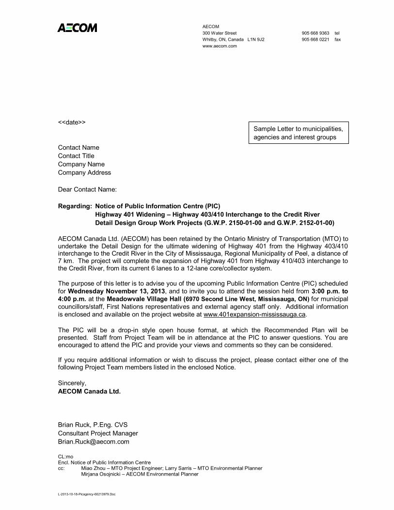
AECOM 300 Water Street 905 668 9363 tel Whitby, ON, Canada L1N 9J2 905 668 0221 fax www.aecom.com
L-2013-10-18-Picagency-60213979.Doc
<<date>> Contact Name Contact Title Company Name Company Address Dear Contact Name: Regarding: Notice of Public Information Centre (PIC) Highway 401 Widening – Highway 403/410 Interchange to the Credit River Detail Design Group Work Projects (G.W.P. 2150-01-00 and G.W.P. 2152-01-00) AECOM Canada Ltd. (AECOM) has been retained by the Ontario Ministry of Transportation (MTO) to undertake the Detail Design for the ultimate widening of Highway 401 from the Highway 403/410 interchange to the Credit River in the City of Mississauga, Regional Municipality of Peel, a distance of 7 km. The project will complete the expansion of Highway 401 from Highway 410/403 interchange to the Credit River, from its current 6 lanes to a 12-lane core/collector system. The purpose of this letter is to advise you of the upcoming Public Information Centre (PIC) scheduled for Wednesday November 13, 2013, and to invite you to attend the session held from 3:00 p.m. to 4:00 p.m. at the Meadowvale Village Hall (6970 Second Line West, Mississauga, ON) for municipal councillors/staff, First Nations representatives and external agency staff only. Additional information is enclosed and available on the project website at www.401expansion-mississauga.ca. The PIC will be a drop-in style open house format, at which the Recommended Plan will be presented. Staff from Project Team will be in attendance at the PIC to answer questions. You are encouraged to attend the PIC and provide your views and comments so they can be considered. If you require additional information or wish to discuss the project, please contact either one of the following Project Team members listed in the enclosed Notice. Sincerely, AECOM Canada Ltd. Brian Ruck, P.Eng. CVS Consultant Project Manager [email protected] CL:mo Encl. Notice of Public Information Centre cc: Miao Zhou – MTO Project Engineer; Larry Sarris – MTO Environmental Planner
Mirjana Osojnicki – AECOM Environmental Planner
Sample Letter to municipalities, agencies and interest groups

AECOM 300 Water Street 905 668 9363 tel Whitby, ON, Canada L1N 9J2 905 668 0221 fax www.aecom.com
L-2013-10-18-Picproperty Owners-60213979.Doc
<<date>> Contact Name Address Dear Contact Name: Regarding: Notice of Public Information Centre (PIC) Highway 401 Widening – Highway 403/410 Interchange to the Credit River Detail Design Group Work Projects (G.W.P. 2150-01-00 and G.W.P. 2152-01-00) AECOM Canada Ltd. (AECOM) has been retained by the Ontario Ministry of Transportation (MTO) to undertake the Detail Design for the ultimate widening of Highway 401 from the Highway 403/410 interchange to the Credit River in the City of Mississauga, Regional Municipality of Peel, a distance of 7 km. The project will complete the expansion of Highway 401 from Highway 410/403 interchange to the Credit River, from its current 6 lanes to a 12-lane core/collector system. The purpose of this letter is to advise you of the upcoming Public Information Centre (PIC) scheduled for Wednesday November 13, 2013 from 4:00 p.m. to 8:00 p.m. at the Meadowvale Village Hall (6970 Second Line West, Mississauga, ON), and to invite you to attend. Additional information is enclosed and available on the project website at www.401expansion-mississauga.ca. The PIC will be a drop-style open house format, at which the Recommended Plan will be presented. Staff from the Project Team will be in attendance at the PIC to answer questions. You are encouraged to attend the PIC and provide your views and comments so they can be considered. Sincerely, AECOM Canada Ltd. Brian Ruck, P.Eng. Consultant Project Manager [email protected] CL:mo Encl. Notice of Public Information Centre cc: Miao Zhou – MTO Project Engineer Larry Sarris – MTO Environmental Planner
Mirjana Osojnicki – AECOM Environmental Planner
Sample Letter to Impacted Property Owners

Ministry of Transportation Planning and Environmental Office Central Region 4th Floor, Bldg. ‘D’ 1201 Wilson Avenue Downsview, ON M3M 1J8 Tel.: 416-235-4277 Fax.: 416-235-3576
Ministère des Transports Bureau de la planification et de l’environnement Région du Centre 4e étage, édifice D 1201, avenue Wilson Downsview, ON M3M 1J8 Tél.: 416-235-4277 Téléc.: 416-235-3576
<<date>> Contact Name Contact Title Company Name Company Address Dear Contact Name: Regarding: Notice of Public Information Centre (PIC) Highway 401 Widening – Highway 403/410 Interchange to the Credit River Detail Design Group Work Projects (G.W.P. 2150-01-00 and G.W.P. 2152-01-00) AECOM Canada Ltd. (AECOM) has been retained by the Ontario Ministry of Transportation (MTO) to undertake the Detail Design for the ultimate widening of Highway 401 from the Highway 403/410 interchange to the Credit River in the City of Mississauga, Regional Municipality of Peel, a distance of 7 km. The project will complete the expansion of Highway 401 from Highway 410/403 interchange to the Credit River, from its current 6 lanes to a 12-lane core/collector system. The purpose of this letter is to advise you of the upcoming Public Information Centre (PIC) scheduled for Wednesday November 13, 2013, and to invite you to attend the session held from 3:00 p.m. to 4:00 p.m. at the Meadowvale Village Hall (6970 Second Line West, Mississauga, ON) for municipal councillors/staff, First Nations representatives and external agency staff only. Additional information is enclosed and available on the project website at www.401expansion-mississauga.ca. The environmental investigations for this assignment include:
Fish and Fish Habitat Existing Conditions and Impact Assessment Report. Terrestrial Ecosystems Report, including ecological land classification (ELC), botanical inventory,
migratory bird activity and wildlife activity and habitat. Groundwater Assessment. This project involves the identification of groundwater resources. A Stage 1/2 Archaeological Assessment following Ministry of Tourism and Culture guidelines for the
completion of archaeological assessments. A Built Heritage and Cultural Heritage Landscape Assessment within the Project Limits.
The PIC will be a drop-in style open house format, at which the Recommended Plan will be presented. Staff from MTO and their consultant, AECOM, will be in attendance at the PIC to answer questions. You are encouraged to attend the PIC and provide your views and comments so they can be considered.
Sample Letter to First Nations

If you have any questions about the project, please contact one of the individuals named in the enclosed Notice. Should you prefer to meet with Ministry staff to discuss the study, please contact the undersigned at 416-235-4277, or by email at: [email protected]. Sincerely, Miao Zhou, M. Eng., P. Eng. MTO Project Engineer Ministry of Transportation, Central Region Encl. Notice of Public Information Centre cc: Brian Ruck – AECOM Project Manager Leslie Currie – MTO Regional Archaeologist Larry Sarris – MTO Environmental Planner
Mirjana Osojnicki – AECOM Environmental Planner

Ministry of Transportation Planning and Environmental Office Central Region 4th Floor, Bldg. ‘D’ 1201 Wilson Avenue Downsview, ON M3M 1J8 Tel.: 416-235-4277 Fax.: 416-235-3576
Ministère des Transports Bureau de la planification et de l’environnement Région du Centre 4e étage, édifice D 1201, avenue Wilson Downsview, ON M3M 1J8 Tél.: 416-235-4277 Téléc.: 416-235-3576
DATE Contact Name Contact Title Company Name Company Address Dear Contact Name: Regarding: Notice of Public Information Centre (PIC) Highway 401 Widening – Highway 403/410 Interchange to the Credit River Detail Design Group Work Projects (G.W.P. 2150-01-00 and G.W.P. 2152-01-00) AECOM Canada Ltd. (AECOM) has been retained by the Ontario Ministry of Transportation (MTO) to undertake the Detail Design for the ultimate widening of Highway 401 from the Highway 403/410 interchange to the Credit River in the City of Mississauga, Regional Municipality of Peel, a distance of 7 km. The project will complete the expansion of Highway 401 from Highway 410/403 interchange to the Credit River, from its current 6 lanes to a 12-lane core/collector system. The purpose of this letter is to advise you of the upcoming Public Information Centre (PIC) scheduled for Wednesday November 13, 2013, and to invite you to attend the session held from 3:00 p.m. to 4:00 p.m. at the Meadowvale Village Hall (6970 Second Line West, Mississauga, ON) for municipal councillors/staff, First Nations representatives and external agency staff only. Additional information is enclosed and available on the project website at www.401expansion-mississauga.ca. The PIC will be a drop-in style open house format, at which the Recommended Plan will be presented. Staff from Project Team will be in attendance at the PIC to answer questions. You are encouraged to attend the PIC and provide your views and comments so they can be considered. If you require additional information or wish to discuss the project, please contact either one of the following Project Team members listed in the enclosed Notice. Sincerely, Miao Zhou, M.Eng. P.Eng. Project Engineer Ontario Ministry of Transportation CL:mo Encl. Notice of Public Information Centre cc: Brian Ruck - AECOM Project Manager Larry Sarris – MTO Environmental Planner
Mirjana Osojnicki – AECOM Environmental Planner
Sample Letter to Member of Provincial Parliament (MPP)

23/01/2014
1
Highway 401 WideningFrom Highway 403/410 Interchange to the Credit River
PUBLIC INFORMATION CENTRE for the
Highway 401 WideningFrom Highway 403/410 Interchange to the Credit River
Detail Design Project G.W.P. 2150-01-00 and G.W.P. 2152-01-00
Wednesday November 13, 20134:00 p.m. to 8:00 p.m.
PLEASE SIGN IN
Welcome to the
Highway 401 WideningFrom Highway 403/410 Interchange to the Credit River
Purpose of the Public Information CentreThe purpose of this Public Information Centre (PIC) is to seek input on the Detail Design for the recommended plan and answer questions about the project. :
Purpose of the Project• The purpose of the project is to carry out a Detail
Design and Class Environmental Assessment (EA) for the ultimate widening of Highway 401 from the Highway 403/410 interchange to the Credit River, a distance of 7 km.
• The project will complete the expansion of Highway 401 within the project limits from its current 6- lanes to a 12-lane core/collector system, as documented in the Transportation Environmental Study Report (TESR) for the Preliminary Design of Highway 401 From Highway 410/403 Interchange to East of the Credit River, August 2005.
• Upon completion, the project will be documented in Design and Construction Reports (DCRs) and will include mitigation measures and future commitments to address the identified environmental impacts.

23/01/2014
2
Highway 401 WideningFrom Highway 403/410 Interchange to the Credit River
Project Background• In 1982, the Ministry of Transportation completed a Preliminary Design study for Highway
401 from Renforth Drive to 2nd Line West (G.W.P. 127-66-64). This study identified the need for significant capacity improvements to accommodate growing travel demands, including the need for an express/collector system west of the Highway 410/403.
• In August 2005, the Ministry of Transportation completed a Preliminary Design study for improvements to Highway 401 from the Highway 410/403 interchange westerly to east of the Credit River (G.W.P. 2149-01-00 and 2150-01-00). This study was undertaken to review and update previous work and look for opportunities to integrate High Occupancy Vehicle (HOV) facilities within the corridor.
o The study included two (2) PICs held in June 2003 and June 2004.o The Transportation Environmental Study Report (TESR) was approved with Conditions by the
Minister of the Environment in 2007 following receipt of two (2) bump-up requests (Part II Orders).
• In June 2011, the Ministry of Transportation initiated the current Detail Design project (G.W.P. 2150-01-00).
Highway 401 WideningFrom Highway 403/410 Interchange to the Credit River
Design FeaturesThis project involves:Under G.W.P. 2150-01-00• Expansion of Highway 401 from its current 6-lanes to a 12-lane core/collector system including:
o Collector lanes consisting of three (3) general purpose lanes in each direction;o Core lanes consisting of two (2) general purpose lanes and one (1) High Occupancy
Vehicle (HOV) lane in each direction;o HOV lanes from west of Mavis Road to east of Highway 410 to be opened following
construction completion;o Removal of the 2nd Line West structure over Highway 401 to accommodate the highway
widening;o New ramps from Highway 401 eastbound to Highway 403 southbound and from Highway
403 northbound to Highway 401 westbound at the 401/410/403 interchange;o New structures carrying the proposed collector lanes over Fletcher's Creek;o Stormwater management strategy;o High mast illumination on Highway 401 throughout the project limits; ando Reconstruction of the existing highway pavement.
Under G.W.P. 2152-01-00• Extension of the Mavis Road bridge as an advanced construction contract to accommodate the
proposed additional collector lanes.

23/01/2014
3
Highway 401 WideningFrom Highway 403/410 Interchange to the Credit River
EA Process• This project is following the approved environmental planning process for Group ‘B’ projects, under the
Ministry’s Class Environmental Assessment (EA) for Provincial Transportation Facilities (2000), with the opportunity for public input throughout.
• Group ‘B’ Projects generally include major improvements to existing provincial transportation facilities. They do not require formal EA Act review and approval, provided the Class EA process is followed.
• There is an opportunity at any time during the Class EA Process for interested persons to provide comments and review outstanding issues.
• The project will proceed with documentation as follows:o Extension of the Mavis Road bridge will be documented in a Design and Construction Report
(DCR) for construction start in 2014; o The remainder of the highway expansion work will be documented in a separate DCR; ando An Addendum to the August 2005 TESR will be prepared to document the proposed extension of
Belgrave Road to connect to Mavis Road. Only the changes documented in the Addendum are eligible for a bump-up (request for a Part II Order by the Minister of the Environment).
• There is no bump up opportunity (request for Part II Order by the Minister of the Environment) for a DCR. • Details regarding the release of these documents will be provided in future notices.
Highway 401 WideningFrom Highway 403/410 Interchange to the Credit River
Existing Environmental ConditionsNatural Environment:
• The project area contains two watercourses, including: o Tributary of the Credit River – crosses Highway 401 approximately 0.7 km east of the Credit River. It
originates on the north side of the Highway to the west of Meadowvale Station Woods and discharges approximately 700 m downstream of the highway. This tributary is an intermittent stream with a coolwater thermal classification and is located within the Credit River Watershed.
o Fletcher's Creek – large meandering watercourse that flows through Meadowvale Station Woods and discharges to the Credit River approximately 1.5 km downstream of the highway. Fletcher's Creek is a permanent stream with coolwater thermal classification and is located within the Credit River Watershed.
• There is evidence of wildlife crossings through existing culverts at the Tributary of the Credit River and Fletcher's Creek.
• Species at Risk and/or habitat are present within the project area including the Jefferson Salamander (Ambystoma jeffersonianum) and Redside Dace (Clinostomus elongatus), as designated under the Endangered Species Act (2007).
• The Environmentally Sensitive Area (ESA) and Life Science Area of Natural and Scientific Interest (ANSI) named Meadowvale Station Woods, bisects Highway 401.
• There are no Provincially Significant Wetlands within the project limits, however there is an unevaluated wetland near the Highway 403/410 interchange.
• MOE Well Water Records indicate that there are fourteen (14) wells located in the project area, the majority are inactive, decommissioned, or demolished.

23/01/2014
4
Highway 401 WideningFrom Highway 403/410 Interchange to the Credit River
Existing Environmental Conditions
Fletcher's Creeknorth of Highway 401
Fletcher's Creek south of Highway 401
Highway 401 WideningFrom Highway 403/410 Interchange to the Credit River
Existing Environmental ConditionsSocio-Economic Conditions:
• There are three (3) planning districts: Meadowvale Village (Residential); East Credit (Residential); and Gateway (Employment) within the project area.
• The Highway 403/410 and Highway 401 interchange is located within the Parkway West Belt Plan Area (2008) under the Public Use Areas land use category.
• Land uses in the project area include commercial/industrial developments to the east of HurontarioStreet and residential lands from Mavis Road to 2nd Line West. Land uses west of 2nd Line West primarily consist of forested and agricultural land.
• The existing Highway 401 is intersected by the following north-south urban roads that provide access to local residents and businesses:
o 2nd Line Westo Mavis Roado McLaughlin Roado Hurontario Street (Highway 10)
Cultural Landscapes and Archaeology:
• There are eleven (11) cultural heritage landscapes (CHL) and built heritage resources (BHR) within or adjacent to the project area, including roadscapes, bridges, waterscapes and farm complexes.
• The project area has been cleared from archaeological potential following a Stage 2 archaeological assessment.

23/01/2014
5
Highway 401 WideningFrom Highway 403/410 Interchange to the Credit River
Noise Assessment
• A Noise Sensitive Area (NSA) is defined as a noise sensitive land use with an outdoor living area, including: single family houses (typically backyard); townhouses (typically backyard); multiple unit buildings, such as apartments with outdoor living areas for use by all occupants; hospitals and nursing homes, where there are outdoor living areas for patients.
• Highway noise levels take into consideration the vehicle type, road grade, distance from an NSA, type of ground between the road and the NSA and travel speeds.
• A noise analysis was carried out to assess the potential impacts of the proposed highway conditions. The analysis determined that no additional noise mitigation measures are warranted.
9
Highway 401 WideningFrom Highway 403/410 Interchange to the Credit River
New Highway 401 West to Highway 403 South Ramp and Highway 403 South to Highway 401 West Ramp
See Roll Plan for Greater Detail

23/01/2014
6
Highway 401 WideningFrom Highway 403/410 Interchange to the Credit River
Key Changes from the 2005 TESRKey changes include:• An eastbound transfer from collector to core has been added;• To address concerns with respect to wildlife crossings, the Fletcher’s Creek
crossing was enlarged and wildlife fencing will direct animals to safe crossings at the Credit River and Fletcher’s Creek;
• A Stormwater (SWM) management pond identified for the north side of Highway 401 at 2nd Line West has been removed from the design. The SWM strategy for the area draining to Fletcher’s Creek will include a series of small wetlands within the Mavis Road interchange. This will allow for additional vegetation restoration once 2nd Line West is closed;
• MTO’s Green Pavement Design Rating System ‘GreenPave’ was considered in the development and evaluation of pavement recommendations; and
• ‘Green Road’ design concepts were incorporated to mitigate environmental impacts (A copy of the Report is on the Reference Table).
Highway 401 WideningFrom Highway 403/410 Interchange to the Credit River
Fletcher's Creek Crossing• The August 2005 TESR recommended retaining the existing
twin cell culvert and constructing a third cell under the future core lanes to address hydraulic deficiencies. In addition, two (2) rigid frame structures were proposed to carry the future Highway 401 collector lanes over Fletcher's Creek.
• The project team has re-evaluated the crossing and determined that full replacement with two bridges is preferred:
o Provides enhancement to the SAR designated watercourse;
o Provides ultimate infrastructure upgrade within the Highway 401 core/collector expansion;
o Culvert inspection revealed that the existing structural culverts are weak and would require rehabilitation;
o Allows for additional room for construction access;o Will significantly reduce upstream flooding conditions; o Allows opportunity for increased light, air penetration
and a larger opening to make it more attractive to wildlife crossing the highway; and
o Reduces future maintenance and disruption of Highway 401 traffic.
• MTO has obtained MNR’s agreement in principle on the design concept including the span of the new bridges.
Existing twin cell culvert at Fletcher's Creek
Proposed replacement with two full span bridges

23/01/2014
7
Highway 401 WideningFrom Highway 403/410 Interchange to the Credit River
Conceptual Fletcher’s Creek Crossing
Conceptual view from south side of Highway 401
Conceptual bird’s eye view of 2 clear span bridges
Conceptual view from north side of Highway 401
Highway 401 WideningFrom Highway 403/410 Interchange to the Credit River
• High mast system will be implemented within the entire project corridor and will extend along Highway 401 from Mavis Road to the Credit River.
• High mast lighting at the Mavis Road interchange will be upgraded to meet current standards and to reduce the amount of light trepass onto private properties.
• Special measures will applied to control light and minimize light spillage into environmentally sensitive and residential areas:
o Environmentally Sensitive Area extends from 2nd Line West to the Credit River; and
o Residential zone covers the section of Highway 401 between Mavis Road and 2nd Line West.
• In some sections, high mast lighting will be supplemented by lower conventional lighting poles to minimize light spillage.
• High mast lighting poles will be located in the median for the main sections of the Highway 401 core/collector system and located strategically within the Mavis Road interchange to provide uniform coverage of Highway 401 and access ramps.
• Shielded high mast lighting fixtures have been selected to significantly reduce glare and create a well defined lighting corridor while controlling lighting levels beyond the MTO Right-of-Way.
Lighting System Improvements
High Mast Lighting Pole 25m to 45m high
Conventional Lighting Pole 6m to 15m high
Luminaire Ring with Raising / Lowering Device
Cobra Head Luminaire and Mounting Bracket
Shielded Luminaires

23/01/2014
8
Highway 401 WideningFrom Highway 403/410 Interchange to the Credit River
Existing and Proposed Illumination Plan
See Roll Plan for Greater Detail
Highway 401 WideningFrom Highway 403/410 Interchange to the Credit River
Construction Staging – Mavis Road• Extension of the Mavis Road bridge will be required in order to accommodate widening
of the highway.• It is expected that construction will take place over a 2-year period.• During construction of the interchange, two lanes of traffic will be maintained in both
directions at all times.
See Traffic Staging Drawings for More Detail

23/01/2014
9
Highway 401 WideningFrom Highway 403/410 Interchange to the Credit River
Proposed Construction Staging – Removal of 2nd Line West• Removal of the 2nd Line West structure will require
the temporary full closure of Highway 401 in the eastbound and westbound direction from Mavis Road to Mississauga Road.
• Closure will take place over the weekend for approximately a 12-18 hour period; typically starting 11pm on Saturday to 5pm on Sunday.
• A Communication Plan will be developed to include:o PVMS signs advising motorists in advance of and
during construction;o Notification to transit and emergency services;o Media notification; and o Signage along all detour routes.
• Detours will ensure that thru traffic avoids travel through residential neighbourhoods.
• Details are subject to approval by the City of Mississauga and the Regional Municipality of Peel.
• Detour routes include Mavis Road, Derry Road West, Britannia Road West, Queen Street North and Mississauga Road.
Highway 401 WideningFrom Highway 403/410 Interchange to the Credit River
Potential Environmental Impacts and MitigationPotential Issues/Effects MitigationNatural EnvironmentSoil Erosion and Sediment Control• Excavation and grading activities
associated with construction may result in erosion and generation of sediment carried into the watercourses within the project limits
• Sedimentation control measures consisting of the installation of silt fencing, as per Ontario Standard Drawings, will be installed prior to construction and any surface grading. Plans will be developed and reviewed by the CVC and MNR.
• Erosion and sediment control practices will focus on two separate targets: minimizing site erosion; and, keeping any eroded material on site. Best management practices for erosion and sediment control include:
• Silt fence barriers, erosion control blanket, and rock flow checks will be implemented during construction to prevent migration of sediment to the watercourses within the project area and all other natural features;
• Rip rap or other stabilizing systems will be installed at outlets or spillways; and• Stabilization and re-vegetation of all disturbed surfaces will be established as soon as possible with the most appropriate
treatments available.Watercourses and Fisheries• Potential for impacts to fish habitat in
Tributary to the Credit River and Fletcher's Creek
• Maintain fish habitat through structures with fisheries resources by providing natural substrate and channel form.• Apply timing constraints for construction.• Contract package to include appropriate timing restrictions and mitigation design (i.e. open bottom culvert, clear span bridge, where
possible).• Manage fisheries impacts and mitigation in accordance with the Federal Fisheries Act and the MTO/DFO/MNR Fisheries Protocol.• Reinstate and expand culvert inlet and outlet at Fletcher's Creek and enhance pools at inlet and outlet of culvert at tributary of the
Credit River.Wildlife• Potential for wildlife passage through
existing culverts at Tributary to the Credit River and Fletcher's Creek
• A wildlife crossing will be established at Fletcher's Creek that allows for increased light, air penetration and a larger opening to make it more attractive to wildlife crossing the highway and provides enhancement to the SAR designated watercourse.
• Fencing will be provided along Highway 401 within the Meadowvale Station Woods to encourage/direct wildlife to use the crossing.
Vegetation• Loss of vegetation due to
construction
• Develop an overall-benefit plan and contract documents to include operational constraints and special provisions with respect tovegetation removal.
Species At Risk• Loss of habitat for species at risk
due to construction
• A permit will be obtained under the Endangered Species Act for the area of the Meadowvale Station Woods and crossing of Fletcher’s Creek prior to construction for two species at risk.
• Tree and site clearing will take place between September and March 31st and avoid the months of April until August, in accordance with the Migratory Birds Convention Act.
Groundwater/Surface Water• Potential for increased pollutants to
enter receiving watercourses and groundwater recharge areas
• Drainage will be designed to manage stormwater quality and quantity, and will include a series of small wetlands within the Mavis Road interchange for the area draining to Fletcher's Creek.
• Obtain Permit to Take Water for dewatering activities exceeding 50,000L/day.• Re-fuelling during construction will occur in designated areas.
Management of Excess Material and Property Contamination
• Management of excess materials will be dealt with in accordance with normal MTO practices (regulated by OPSS 180). • Lead paint on guard rails will be managed in accordance with the Ontario Occupational Health and Safety Act (Reg. 843) and
Ontario Environmental Protection Act (Reg. 347).

23/01/2014
10
Highway 401 WideningFrom Highway 403/410 Interchange to the Credit River
Potential Environmental Impacts and MitigationPotential Issues/Effects MitigationSocio-Economic Environment
Noise• Highway operational noise• Potential noise increase during
construction activities
• A noise analysis was carried out to assess the potential impacts of the proposed highway conditions. The analysis determined that no additional noise mitigation measures are warranted.
• The Contractor will be required to maintain equipment in good operating condition to prevent unnecessary noise and restrict idling of equipment to the minimum necessary to perform the work.
• Complaints about noise will be investigated in accordance with the MTO/MOE Noise Protocol.• Adherence to the municipal noise by-law.
Archaeology• Potential impact to archaeological
resources
• A Stage 2 Archaeological Assessment recommended that no further archaeological concern is warranted for lands with the project area.
• If any archaeological and/or historical resources be discovered during construction, they may be a new archaeological site and therefore subject to Section 48(1) of the Ontario Heritage Act. Construction must cease immediately and a licensed consultant archaeologist must be engaged to carry out archaeological fieldwork in compliance with Section 48(1) of the Ontario Heritage Act. Work in the area would not resume until cleared by the Ministry of Tourism, Culture and Sport.
Property Impacts• Limited property requirements for
widening
• MTO will negotiate with individual owners for property purchase in accordance with standard MTO procedures.
Emergency Access• Temporary or permanent change to
access
• Notify OPP and emergency medical services of construction staging, start of construction, temporary closure of Highway 401 for the removal of the 2nd Line West structure, etc. to minimize delay in emergency response times during and after construction.
Air Quality (Dust) • Dust suppressants will be used during construction.• Construction equipment will be required to conform to emissions standards and the idling of equipment will be restricted to ensure
that air quality is not unduly impacted.Utilities• Potential impacts to existing utilities
• Utility relocations will be coordinated.
Traffic• Motorists may experience delays
and disruption during construction
• Collector lanes will be generally constructed first thereby minimizing traffic disruptions on Highway 401.• Closure of lanes only once additional capacity of the network has been provided.• Short-term closures will be limited to off-peak and/or nighttime hours.
Highway 401 WideningFrom Highway 403/410 Interchange to the Credit River
Proposed Belgrave Road Extension• At the request of the City of Mississauga, the Ministry of Transportation has investigated the need for a future extension of
Belgrave Road from the Highway 401 EB off ramp at Mavis Road easterly to the existing cul-de-sac west of Suffolk Court – a distance of approximately 200m.
• Three (3) alternatives were considered. They include:Alternative A – Mavis Road Underpass to Belgrave Road
• The full grade separated option would provide unimpeded unidirectional traffic flow onto Belgrave Road from the W-N/S ramp via a tunnel under the existing Mavis Road, similar to that currently under construction at Hurontario Street.
• Access from Highway 401 east would be split into two ramps when approaching Mavis Road. Ramp W-N/S would approach Mavis Road at-grade while a second Ramp W-E would tunnel under Mavis Road [and S-E Ramp] to connect to Belgrave Road.
Alternative B – At-Grade Intersection with Mavis Road Structure Over Realigned Ramp S-E• An at-grade connection would provide 2-way access to Belgrave Road from Mavis Road.
Some turning movements would be restricted at the intersection (i.e. Belgrave WB Left) to optimize traffic operations.
• A south to east at-grade ramp would be constructed under the Belgrave Road extension.• MTO would construct the S-E ramp on a lower profile and the City would build a bridge over
the ramp to connect Belgrave Road at a later date.
Alternative C – At Grade Full Intersection at Mavis Road Ramp S-E Relocated North of the Existing Intersection
• MTO Central Region has utilized this type of connection within Parclo-A type interchanges in some recent highway projects to maintain connections to existing connected roadways.
• Construction of a tighter Ramp S-E avoids the construction of a bridge structure.

23/01/2014
11
Highway 401 WideningFrom Highway 403/410 Interchange to the Credit River
Proposed Belgrave Road Extension
Proposed Belgrave Road ExtensionSUFFOLK COURT
• Alternative B is selected to be carried forward as the Recommended Plan. This alternative provides operational benefits including providing free flow of traffic and provision of a ‘right out’ access to northbound Mavis Road; allows for the protection of a future Belgrave extension within the current MTO contract; and, has minimal impact to existing environmental features.
• For this proposed design enhancement, MTO will prepare an Addendum to the August 2005 TESR, on behalf of the City of Mississauga. The TESR Addendum will document the proposed change to the 2005 TESR and consultation which has taken place. It will be available for a 30-day public review period. Only the changes identified in this presentation and documented in the Addendum will be eligible for a ‘bump up’ (request for a Part II Order by the Minister of the Environment).
• A Notice of TESR Addendum Filing will be posted in the Mississauga News, L’Express de Toronto, as well as the project website at www.401expansion-mississauga.ca.
• Timing for the construction of the Belgrave Road extension will be determined at a later date.
Copy of the Geometric Feasibility Design Report (August 2012) on the Reference Table
Highway 401 WideningFrom Highway 403/410 Interchange to the Credit River
Next StepsFollowing tonight’s information session we will:• Review and consider your comments and input;• Respond to your written questions;• Produce the following EA documentation:
o DCR to document the reconstruction of the Mavis Road interchange; o DCR to document the remainder of the highway expansion work, with the exception of the
proposed Belgrave Road extension; ando TESR Addendum to the 2005 TESR to document the proposed extension of Belgrave Road.
Details regarding the release of these documents and will be provided in future notices, as well as the project website at www.401expansion-mississauga.ca.
Once the Detail Design and contract package for the Mavis Road interchange and the remainder of the highway expansion is finalized, the project will proceed to construction.
The City of Mississauga is considering a separate study for pedestrian/cycling options across Highway 401 at the location of the removed 2nd Line West structure. This study will be undertaken in accordance with the Municipal Class EA process.

23/01/2014
12
Highway 401 WideningFrom Highway 403/410 Interchange to the Credit River
Remain Involved in the ProjectThank you for attending this PIC and participating in the Detail Design process. We encourage you to fill out the comment sheet provided and drop it off in the comment box. Alternatively, you can mail, fax, or email your comments by December 13, 2013 to either of the individuals listed below:
Miao Zhou, P.Eng. Project EngineerOntario Ministry of TransportationCentral RegionBuilding ‘D’, 4th Floor, 1201 Wilson AveDownsview, ON M3M 1J8Phone: (416) 235-4277Fax: (416) 235-3576Email: [email protected]
Brian Ruck, P. Eng. C.V.S.,Consultant Project ManagerAECOM Canada Ltd.300 Water StreetWhitby, ON L1N 9J2Toll Free: 1-800-668-1983 or Phone: (905) 668-4021 ext. 2250Fax: (905) 665-4867E-mail: [email protected]
All comments received will be reviewed and considered in the Detail Design process to implement the proposed improvements within the Highway 401 Project Limits. Public comments will be collected in accordance with the Freedom of Information and Protection of Privacy Act. With the exception of personal information, all comments will become part of the public record.

Fly Sheet Select Correspondence.Docx
Select Correspondence


1
Osojnicki, Mirjana
From: Zirger, Rosi (MTC) [[email protected]]Sent: August 3, 2011 4:04 PMTo: Osojnicki, MirjanaSubject: Highway 401 widening - Highway 403/410 Interchange to Credit River (MTO) - Detail Design
(GWP 2150-01-00)
Follow Up Flag: Follow upFlag Status: Flagged
Project: Highway 401 widening – Highway 403/410 Interchange to Credit River (MTO) - Detail Design (GWP 2150-01-00)Location: City of MississaugaMTC File: 21EA063
The Ministry of Tourism and Culture (MTC) received a Notice of Study Commencement for the project mentioned above.As part of the Class Environmental Assessment process, the MTC has an interest in the conservation of cultural heritageresources including:
archaeological resources, built heritage resources, and cultural heritage landscapes.
MTC would be interested in remaining on the circulation list and being informed of the project as it proceeds through theEA process. We ask that you update your contact list to remove the names of Karla Barboza and Mairflor Toneatto, andsend future notices to Rosi Zirger A/Heritage Planner at the address below.
Best regards,
Rosi ZirgerA/Heritage Planner | Central and SoutheastMinistry of Tourism and Culture | Culture Services UnitTel. 416.314.7159 | Fax [email protected]
Ministry of Tourism and CulturePrograms and Services BranchCulture Services Unit401 Bay Street, 17th FloorToronto, Ontario M7A 0A7


July 28th, 2011 Att: Miao Zhou, M.Eng. P.Eng. Re: Notice of Study Commencement Highway 401 Widening – Highway 403/410 Interchange to the Credit River Group Work Project (G.W.P.) 2150-01-00 Dear Miao, Thank you for your consultation request to Alderville First Nation regarding the Project for the Ultimate Widening of Highway 401 from the Highway 403/410 Interchange to the Credit River, which is being proposed within our Traditional and Treaty Territory. We appreciate the fact that the Ministry of Transportation, recognizes the importance of First Nations Consultation and that your office is conforming to the requirements within the Duty to Consult Process. As per the Alderville First Nation Consultation Protocol, your proposed project is deemed a level 3, having minimal potential to impact our First Nations’ rights, therefore, please keep Alderville apprised of any archaeological findings, burial sites or any environmental impacts, should any occur. Although we may not always have representation at all stakeholders meetings, it is our wish to be kept apprised throughout all phases of this project. I can be contacted at the mailing address above or electronically via email, at the email address below. In good faith and respect, Dave Simpson [email protected] Lands and Resources Communications Officer Tele: (905) 352-2662 Alderville First Nation Fax: (905) 352-3242
ALDERVILLE FIRST NATION P.O. Box 46
11696 Second Line Roseneath, Ontario K0K 2X0
Chief: James R. Marsden Councillor: Dave Mowat Councillor: Pam Crowe Councillor: Leonard Gray Councillor: Randall Smoke


Chief: James R. Marsden Councillor: Julie Bothwell Councillor: Jody Holmes Councillor: Dave Mowat Councillor: Angela Smoke
ALDERVILLE FIRST NATION 11696 Second Line
P.O. Box 46 Roseneath, Ontario K0K 2X0
Phone: (905) 352-2011 Fax: (905) 352-3242
November 5, 2013
Ministry of Transportation Planning and Environmental Office Central Region 4th Floor, Bldg. D 1201 Wilson Avenue Downsview, ON M3M 1J8
Att: Miao Zhou, M. Eng., P. Eng.
Re: Notice of Public Information Centre (PIC) Highway 401 Widening – Highway 403/410 Interchange to the Credit River Detail Design Group Work Projects (G.W.P. 2150-01-00 and G.W.P. 2152-01-00)
Dear Miao Zhou,
Thank you for your consultation request to Alderville First Nation regarding the widening of Highway 401 from the Highway 403/410 interchange to the Credit River in the City of Mississauga which is being proposed within our Traditional and Treaty Territory. We appreciate the fact that the Ministry of Transportation recognizes the importance of First Nations Consultation and that your office is conforming to the requirements within the Duty to Consult Process.
As per the Alderville First Nation Consultation Protocol, your proposed project is deemed a level 3, having minimal potential to impact our First Nations’ rights, therefore, please keep Alderville apprised of any archaeological findings, burial sites or any environmental impacts, should any occur. I can be contacted at the mailing address above or electronically via email, at the email address below.
In good faith and respect,
Dave Simpson [email protected] Lands and Resources Communications Officer Tele: (905) 352-2662 Alderville First Nation Fax: (905) 352-3242


Meetings

AECOM5080 Commerce Boulevard 905 238 0007 telMississauga, ON, Canada L4W 4P2 905 238 0038 faxwww.aecom.com
Minutes of Meeting
MIN City Of Mississauga 06172011 FINAL.Doc
Date of Meeting June 17, 2011 Start Time 9:00am Project Number 60213979
Project Name Highway 401 Widening from Highway 403/410 Interchange to the CreditRiver – Detail Design G.W.P. 2150-01-00
Location City of Mississauga –8th Floor, 201 City Centre Drive, Mississauga, ON L5B 2T4
Regarding Project Update and Opportunities for MTO/City Coordination
Attendees Miao Zhou, MTO Senior Project EngineerBrian Ruck, AECOM Project ManagerSteve Barrett, City of Mississauga, Manager - Transportation Asset Mgmt.Abdul Shaikh, City of Mississauga, Transportation Project EngineerFarhad Shahla, City of Mississauga, Transportation Project EngineerLarry Sarris, MTO Environmental PlannerMirjana Osojnicki, AECOM Environmental Planner
Distribution AttendeesAimee Rose Tupaz, Corridor Management Engineer, MTO
Minutes Prepared By M. Osojnicki
PLEASE NOTE: If this report does not agree with your records of the meeting, or if there are any omissions, please advise,otherwise we will assume the contents to be correct.
Schedule ActionAECOM advised that the Transportation Environmental Study Report (TESR)was filed in 2005 and Minister approved in 2007 after the resolution of two (2)bump-up requests.Project is currently in the Pre-Design phase, scheduled for completion by theend of 2011. Detail Design will commence in 2012 and the MTO is workingunder a tight timeline in order to achieve planned construction in 2013.Project includes:
o Mavis Road interchange improvementso Transfer lanes – best fit and alternativeso T-Ramp connection to facilitate HOV lanes and exit at McLaughlin
Roado 410/403/401 Rampso Removal of the 2nd Line West structure as per TESR approval
There may be opportunities for the City and MTO to work together and identifyissues at the beginning of the project to benefit both.

Page 2Minutes of Meeting
June 23, 2011-06-23
MIN City Of Mississauga 06172011 FINAL.Doc
City must decide in a relatively short period of time if it plans to pursue apedestrian bridge over Highway 401 to tie into the MTO project schedule andtake advantage of construction/staging opportunities, as there may beimplications for the current project schedule as well as EA approvals.
City
2nd Line West StructureCity is currently undertaking a Traffic Impact Study on Sombrero Way.It was noted that the 2nd Line West Structure is not currently being usedextensively from a traffic perspective and that the increased traffic on SombreroWay is independent of the 2nd Line West closure.There is interest from the local Councillor as well as ratepayers for the provisionof a pedestrian crossing over Highway 401.AECOM advised that the cost to construct a pedestrian crossing over theultimate 12-lane Highway 401 is in the range of $4-23 million. The least cost toconstruct would occur at the same time as the widening of Highway 401 to takeadvantage of staging opportunities; future retrofitting/staging is costly.Opportunity may exist to provide for a pedestrian/cycling crossing at Fletcher’sCreek and maintain wildlife connectivity between the north and south side ofHighway 401. There remain issues that require further study with this designconcept.The existing deer crossing to the west of Fletcher’s Creek was (likely) originallya cattle crossing; low occurrence of deer currently using the structure as theproperty on the north side of Highway 401 is fenced off. It may be used by otheranimals and is also a drainage feature.Fletcher’s Creek Crossing is still in relatively good condition however, it isnearing its life span. Replacement/rehabilitation opportunities are beingconsidered within the current project scope.City wants MTO to include the new pedestrian overpass in the 401 project; MTOexpressed concerns for possible impact to the schedule. Both partiesexpressed interest in working together.City will discuss options with Senior Staff on how it would like to proceed withrespect to 2nd Line West (i.e. pedestrian crossing or multi-use underpass atFletcher’s Creek) and advise the MTO within a week.
City
Mavis Road Interchange ImprovementsCity requested that the MTO ‘protect’ for a future direct connection to BelgraveRoad.City understands that this connection would not be built as part of the currentproject. The City would have to initiate a separate Municipal Class EA to allowthis road extension but requested that the MTO design not preclude these futureimprovements.AECOM advised that there may be issues with the on-ramp at Mavis Road toeastbound Highway 401, as well as property impacts on the south side of MavisRoad with this design concept.Additional studies would be required to evaluate the geometry for either anoverpass/underpass to provide the Belgrave access and MTO would require

Page 3Minutes of Meeting
June 23, 2011-06-23
MIN City Of Mississauga 06172011 FINAL.Doc
Senior Management approval.City will discuss options with Senior Staff on how it would like to proceed withthe potential Belgrave direct-access and advise the MTO within a week.City suggested an at-grade crossing. MTO mentioned that Belgrave Road fallswithin MTO’s CAH permit control. This is not a simple design exercise andMTO’s Corridor Office will need to get involved in this municipal initiative.
City
Highway 403/410 InterchangeAECOM is confirming the viability of the remnant ramps through modelling; theywere approved in the TESR (2005).City shows these ramps in its long-term transportation plans and stronglyrecommends their construction.City advised that the traffic modelling should account for the Light Rail Transit(LRT) initiative on Hurontario Street.
**Post meeting note: MTO confirmed that MTO’s EMME/2 2031 includes LRT on Hurontario Street.

AECOM5080 Commerce Boulevard 905 238 0007 telMississauga, ON, Canada L4W 4P2 905 238 0038 faxwww.aecom.com
Minutes of Meeting
MIN City Of Mississauga 08032011 FINAL.Doc
Date of Meeting August 3, 2011 Start Time 9:00am Project Number 60213979
Project Name Highway 401 Widening from Highway 403/410 Interchange to the CreditRiver – Detail Design G.W.P. 2150-01-00
Location City of Mississauga –8th Floor, 201 City Centre Drive, Mississauga, ON L5B 2T4
Regarding Project Update and Opportunities for MTO/City Coordination
Attendees Miao Zhou, MTO Senior Project EngineerBrian Ruck, AECOM Project ManagerSteve Barrett, City of Mississauga, Manager - Transportation Asset Mgmt.Abdul Shaikh, City of Mississauga, Transportation Project EngineerFarhad Shahla, City of Mississauga, Transportation Project EngineerAl Jeraj, City of Mississauga, City SurveyorJacquelyn Hayward Gulati, City of Mississauga, Manager Cycling OfficeBob Sasaki, City of Mississauga, Manager Transportation PlanningLarry Sarris, MTO Environmental PlannerClement Shim, MTO Senior Structural EngineerMirjana Osojnicki, AECOM Environmental Planner
Distribution AttendeesAimee Rose Tupaz, Corridor Management Engineer, MTORobert Fulton, Senior Surveyor, MTO
Minutes Prepared By M. Osojnicki
PLEASE NOTE: If this report does not agree with your records of the meeting, or if there are any omissions, please advise,otherwise we will assume the contents to be correct.
Purpose of Meeting Action Follow up to June 17, 2011 meeting and updates to:
o Potential for pedestrian overpass in vicinity of 2nd Line Westversus multi-use underpass at Fletcher’s Creek
o Closure of 2nd Line West structureo Mavis Road Interchange improvements - Belgrave Road
Environmental Assessment (EA) Perspective and Project SchedulePedestrian Access – Overpass vs.Underpass
AECOM advised that both an overpass and underpass are feasible from aconstructability point of view.
Scheduling is the key risk factor since construction for this project is planned for

Page 2Minutes of Meeting
August 3, 2011
MIN City Of Mississauga 08032011 FINAL.Doc
2013 and a pedestrian overpass would require either an EA Addendum to the2007 approved Transportation Environmental Study Report (TESR) (MTOwould assume proponency) or a separate Municipal Class EA (City wouldassume proponency).
There are also environmental constraints/risks associated with the overpasssince one of MOE’s Conditions of Approval rested with the closure of the 2nd
Line West structure and naturalization of the Meadowvale Station Woods area. It was also re-emphasized that a Stormwater Management Pond was proposed
in Preliminary Design to occur on the north side of Highway 401 immediatelyeast of the Meadowvale Station Woods area and that an overpass at thislocation would conflict with the capacity requirements of the pond.
There is awareness in the community for the closure of 2nd Line West structure. City is interested in providing cyclists/pedestrians with a crossing opportunity
across Highway 401 in this area.Fletcher’s Creek Culvert – Multi-Use Underpass
AECOM advised the existing Fletcher’s Creek twin cell culvert will be replacedas part of the EA with a bridge approximately 16.5m and will accommodate a4.5m path underneath (based on 2yr storm event for the path).
Cost-sharing would result in a difference of approximately $2 million. MTO provided examples and photos of similar structures at Highway 401/
Leslie where a walking/cycling trail besides the Don River exists, below theexisting 401 core/collector system.
May be an opportunity to construct the proposed clear span structure overFletcher’s Creek in two parts to provide additional natural lighting and aircirculation and reduce the tunnel effect, thus making it more attractive to wildlifeand increased safety for persons using the underpass. The location of thecore/collector transfer will determine if one or two bridges is feasible.
Meeting with MNR is taking place in August to present this idea. Manager of City’s Cycling Office (Ms. Jacquelyn Hayward Gulati) briefly joined
the meeting and provided support in principle for the underpass; it would likelybe used by recreational cyclists as opposed to commuter cyclists.
City would support a 2-bridge option from a safety perspective and will consultwith Commissioner and local Councillor.
AECOM/MTO to notify City which alternative is selected (1 or 2-bridge option)
City
AECOM/MTOPedestrian Overpass
Higher risk due to scheduling:o Provincial consultation moratorium will be in effect due to
November election.o Substantial cost increase if the City were to require EA approval
but constructed at a later date because of staging (i.e. City’srequest to construct piers is not preferred from a stagingperspective as it would be very costly to stage Highway 401 at alater time).
City to consult with Commissioner for decision in about a week. CityClosure of 2nd Line West
City advised that parts immediately north and south of Highway 401, Parts 1and 2 on Plan 43R-20987, were closed in July 1995 by By-law 215-95, but
Page 3Minutes of Meeting
August 3, 2011
MIN City Of Mississauga 08032011 FINAL.Doc
several months later, in October 1995, the same two parts were re-opened byBy-law 433-95; therefore they are still public highway.
A new by-law is required for the same closure – City is to initiate and theprocess takes approximately 6 months to complete.
Although the City noted that there is no traffic justification for maintaining the2nd Line West overpass, the Mississauga Official Plan does not indicatesupport for closure or opening of 2nd Line West.
Some ambiguity regarding which policy document supersedes:o By-law for closure (By-law 215-95)o By-law to re-open (By-law 433-95)o Approved TESR based on By-law 215-95
City to obtain legal opinion. However, the City noted that there was anagreement between the City of Mississauga and the Ministry (shared 1982document with MTO) and the closure of 2nd Line West was included in the2007 TESR.
The physical closure of 2nd Line West is required prior to constructioncommencement.
City will take this to the Commissioner and will let MTO know soon if the Citywill pass a new by-law to close 2nd Line West. This issue will be discussed atthe next liaison meeting, if not resolved before that.
City
City
City
Mavis Road Interchange Improvements – Potential Belgrave Road extension AECOM advised that (two) 2 options are being considered for the configuration
of the Mavis Road interchange; one (1) of the options would provide space andflexibility to allow for a future direct access to Belgrave Road.
AECOM to notify City with selection of preferred option. AECOM A grade-separated ramp would be required to facilitate the connection. Limited by property requirements identified in the TESR; if additional property
were required, then a TESR Addendum is needed. City to look at conceptual design and capital budget and update AECOM/MTO
on how it would like to proceed with potential direct access to Belgrave Road.City

AECOM5600 Cancross Court, Suite A 905.501.0641 telMississauga, ON, Canada L5R 3E9 905.501.0181 faxwww.aecom.com
Minutes of Meeting
MIN 60213979 City Of Mississauga 2012 03 07 FINAL.Doc
Date of Meeting March 7, 2012 Start Time 1:30pm Project Number 60213979
Project Name Highway 401 Widening from Highway 403/410 Interchange to the CreditRiver – Detail Design G.W.P. 2150-01-00
Location City of Mississauga –8th Floor, 201 City Centre Drive, Mississauga, ON L5B 2T4
Regarding Project Updates – Belgrave Road Extension/2nd Line West Options/MavisRoad Interchange Staging
Attendees Miao Zhou, MTO Senior Project EngineerBrian Ruck, AECOM Project ManagerJan Wieczorek, AECOM Highway DesignSteve Barrett, City of Mississauga, Manager - Transportation Asset Mgmt.Abdul Shaikh, City of Mississauga, Transportation Project EngineerFarhad Shahla, City of Mississauga, Transportation Project EngineerLarry Sarris, MTO Environmental PlannerCameron Bevers, MTO TrafficHossein Hosseini, MTO Project EngineerMirjana Osojnicki, AECOM Environmental Planner
Distribution Attendees
Minutes Prepared By M. Osojnicki
PLEASE NOTE: If this report does not agree with your records of the meeting, or if there are any omissions, please advise,otherwise we will assume the contents to be correct.
ActionPotential Belgrave Road Extension
At the City’s Request AECOM presented three (3) options for a connection toBelgrave Road from the new Mavis Road interchange:A. Tunnel Under Mavis Road and S-E Ramp
o Access off of Highway 401 east would be split into two approachingMavis Road. Ramp W-N/S would approach Mavis Road at-gradewhile a second ramp W-E would tunnel Mavis Road [and S-E Ramp]connect to Belgrave Road.
o Requires staging work under the MTO contract otherwise cost willbe higher.
o Significant grading and staging is involved in addition to detours onMavis Road.
B. At-Grade Intersection with Mavis Roado A south-east ramp would be constructed under the Belgrave Road
extension.o Provides natural gravity flow of water (drainage).

Page 2Minutes of Meeting
March 7, 2012
MIN 60213979 City Of Mississauga 2012 03 07 FINAL.Doc
o Provides free flow of traffic and provides a right turn north to MavisRoad.
o MTO would construct a south-east ramp on a lower profile and theCity would later build a bridge over the ramp to connect BelgraveRoad.
o Some additional property may be required however same propertyowner (Orlando) and not in excess of what was identified in theTransportation Environmental Study Report (TESR).
C. At-Grade with a Full Intersection at Mavis Roado Additional property would be required (more so than for Options A
or B).o Not preferred since this is a heavy traffic volume area.
Option B is preferred by both the MTO and City due to:o Operational benefits.o Provision of a ‘right-out’ northbound on Mavis.o City provides some investment with MTO current contract in order to
protect for future improvements.
**City may utilize these three (3) options in its evaluation of alternatives for itsMunicipal Class EA for a Belgrave Road extension.
AECOM to provide a memo to the City summarizing pros/cons of the aboveoptions as well as a cost estimate (including confirmation of any additionalproperty impacts).
AECOM
Staging for Mavis Road2nd Line West structure must be removed by the end of Stage 1 (i.e., 2014 at theearliest).Mavis Road structure must be extended before traffic can be shifted from core tocollector lanes. This structure was designed to accommodate an expansion.Mavis Road will be reduced to two (2) lanes in either direction during bridgeexpansion for one (1) construction year (i.e., May – November).City asked that the curb lane be left a little wider to accommodate truck traffic.AECOM advised this should not be a problem.
2nd Line WestAECOM presented several options for 2nd Line West once the existing structureis removed:Option A: Replace with a Vehicular Bridge and Two (2) Bike Lanes
o Bridge would have to be constructed higher to accommodatevehicles and bicycles.
o AECOM calculated cost of a new bridge to be approximately $3.6million dollars.
o Option to work with current MTO schedule (i.e., take advantage ofstaging opportunities).
o City would need to complete a Municipal Class EA.
Page 3Minutes of Meeting
March 7, 2012
MIN 60213979 City Of Mississauga 2012 03 07 FINAL.Doc
o Issue with the location of proposed stormwater management pond;technically feasible but would have to consider other locations andmethods for dealing with stormwater (i.e., possibly relocating thepond to southwest quadrant of Mavis Road interchange or otherlinear ponds along Highway 401).
o Other issues with conditions of EA approval to re-vegetate this area.Option B: Pedestrian Bridge
o Approximate cost: $1.2 million dollars for a steel box girder structureif constructed at the same time as Highway 401 expansion.
o Possibility to skew the alignment to allow for the construction of thestormwater management pond.
o Option to work with MTO schedule (i.e. staging as noted above).o City would need to complete a Municipal Class EA.o This option may provide better functionality than a trail under
proposed Fletcher’s Creek bridge(s) which has issues withheadroom, safety and MNR permitting.
City advised that a petition has been signed by 500 members of the local publicto re-investigate the option of replacing the existing structure with a newvehicular bridge. City has an obligation to investigate the request and respondto the public.
Next Steps:City will continue to investigate the underpass (trail) option and will continue itsattempts to consult with the MNR. To date, the MNR has only provided an‘Information Gathering Form’ as per its new guidelines which came into effectFebruary, 2012. No other communication has occurred from the City’s requestto the MNR to consider a trail using the existing proposed sizes of the Fletcher’sCreek Bridge(s) rather than lengthening the structures even further.City will look at costs presented by AECOM for the 2nd Line West crossing ofHighway 401 and will highlight areas of potential savings to senior management.City will make a formal request to the Ministry of Transportation to make adecision on the feasibility of constructing a new vehicular bridge crossing at 2nd
Line West.AECOM to prepare a memo/costs for the at-grade intersection for the BelgraveRoad extension.
City
City
City
AECOM

AECOM 300 Water Street 905 668 9363 tel Whitby, ON, Canada L1N 9J2 905 668 0221 fax www.aecom.com
Minutes of Meeting
MIN-Agencies-60213979-July 5-13 Final.Docx
Date of Meeting July 5, 2013 Start Time10:00AM Project Number 60213979
Project Name Highway 401 Widening from Highway 403/410 Interchange to the Credit River – Detail Design G.W.P 2150-01-00
Location AECOM – 5600A Cancross Court, Mississauga, ON, L5R 3E9
Attendees Miao Zhou Larry Sarris John Van Voorst Dorothy Moszynski Liam Marray Mark Heaton Melinda Thompson David Denyes Brian Ruck Renée Pettigrew Brian Richert
MTO – Project Manager MTO – Environmental MTO – Drainage and Hydrology (Telecon) MOE – Environmental Resource Planner CVC – Manager, Planning Ecology MNR – Area Biologist MNR – SAR Biologist MNR – Assistant SAR Biologist AECOM – Project Manager AECOM – Environmental Planner AECOM – Water Resources Engineer
Distribution Attendees and Project Team
Minutes Prepared By Renée Pettigrew
PLEASE NOTE: If this report does not agree with your records of the meeting, or if there are any omissions, please advise,
otherwise we will assume the contents to be correct.
1. Introductions/ Project Update Action
The Highway 401 widening design project has been completed to about 30% design and was then stopped due to provincial funding constraints.
While the overall project was suspended, the project team has continued
dialogue with regulatory agencies to advance stormwater management strategy and ESA permitting issues.
The project has now been restarted and is part of MTO’s 2013/14 capital budget.
Constrained with the duration required to secure an ESA permit around Meadowvale Station Woods (MSW), it is unlikely that the entire Project Limits will be ready to tender for construction in 2014. Thus, MTO is proceeding with an advance contract for the lengthening of the Mavis Road structure with construction to begin in 2014.
The advance contract may require a separate Design and Construction

Page 2 Minutes of Meeting – Agency Meeting
July 5, 2013
Report (DCR) and Public Information Centre (PIC) – details are still being worked out.
MTO will be proceeding with the remainder of the Highway 401 widening as early as 2015; depending on whether “constructor” issues can be adequately addressed between the advance and main contracts; otherwise construction would begin in 2016. The main contract may be a conventional design-bid-build or design-build.
A possible approach for applying ESA permit for Design-Build contract is to obtain agreement in principle, or district level approval, between MTO and MNR prior to the issuance of the EOI/RFP to DB bidders. This draft permit is required by December 2013 to tender the DB contract for 2015/2016 construction.
o During the Design Build process, MTO will continue facilitate the final permit being issued to the Owner.
The City noted an EA for the widening of McLaughlin Road south of
Britannia Road (south of Highway 401) is underway; timing of construction will need to be co-ordinated (presently anticipated in 2015).
2. Review of Previous Minutes (Feb. 20, 2013) Action
Stormwater Management SWM Report has been circulated digitally to all agencies.
B. Ruck noted that the revised drainage strategy no longer includes a pond
within the existing ROW of 2nd Line West Road as outlined in the TESR.
Although the TESR included the construction of the pond, the intent was that water quality objectives be achieved and the pond was identified to be the best solution to do so. Hence, the TESR commitment is not to build a pond, but rather to treat water.
Consequently, a revised drainage strategy was developed that provides
the required quality treatment without the need for any ponds. This new strategy employs treatment within the Mavis Road interchange and flat bottom swales discharging to Fletchers Creek.
CVC, MOE, and MNR are all in agreement with this revised strategy and further SWM solutions will still be subject to review and comment by MNR and CVC. Second Line West
Ownership was discussed and location of trail along the existing utility corridor.
Potential forest replacement of upland and wetland creation from the City
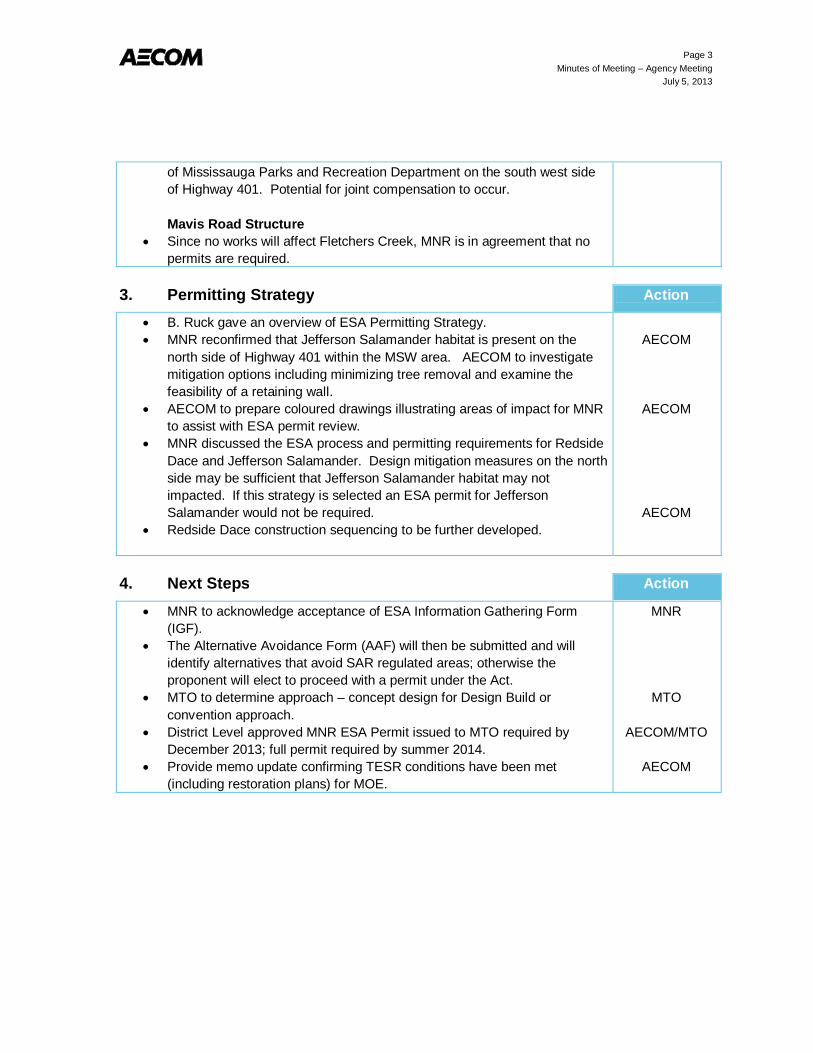
Page 3 Minutes of Meeting – Agency Meeting
July 5, 2013
of Mississauga Parks and Recreation Department on the south west side of Highway 401. Potential for joint compensation to occur. Mavis Road Structure
Since no works will affect Fletchers Creek, MNR is in agreement that no permits are required.
3. Permitting Strategy Action
B. Ruck gave an overview of ESA Permitting Strategy. MNR reconfirmed that Jefferson Salamander habitat is present on the
north side of Highway 401 within the MSW area. AECOM to investigate mitigation options including minimizing tree removal and examine the feasibility of a retaining wall.
AECOM to prepare coloured drawings illustrating areas of impact for MNR to assist with ESA permit review.
MNR discussed the ESA process and permitting requirements for Redside Dace and Jefferson Salamander. Design mitigation measures on the north side may be sufficient that Jefferson Salamander habitat may not impacted. If this strategy is selected an ESA permit for Jefferson Salamander would not be required.
Redside Dace construction sequencing to be further developed.
AECOM
AECOM
AECOM
4. Next Steps Action
MNR to acknowledge acceptance of ESA Information Gathering Form (IGF).
The Alternative Avoidance Form (AAF) will then be submitted and will identify alternatives that avoid SAR regulated areas; otherwise the proponent will elect to proceed with a permit under the Act.
MTO to determine approach – concept design for Design Build or convention approach.
District Level approved MNR ESA Permit issued to MTO required by December 2013; full permit required by summer 2014.
Provide memo update confirming TESR conditions have been met (including restoration plans) for MOE.
MNR
MTO
AECOM/MTO
AECOM
Notice of Filing of the Design and Construction Report

G.W.P. 2152-01-00 and 2150-01-00
NOTICE OF SUBMISSION DESIGN AND CONSTRUCTION REPORT
Highway 401/Mavis Road Interchange and New Ramps at the Highway 401/410/403 Interchange City of Mississauga, Regional Municipality of Peel
G.W.P. 2152-01-00 and 2150-01-00 THE PROJECT The Ministry of Transportation (MTO) has retained AECOM Canada Limited to carry out the Detail Design for the ultimate widening of Highway 401 from the Highway 403/410 interchange to the Credit River, City of Mississauga, Regional Municipality of Peel (see key plan). In order to accelerate the construction schedule, the Detail Design for the lengthening of the Mavis Road bridge over Highway 401 to accommodate future widening of Highway 401, and new ramps from Highway 401 eastbound to Highway 403 southbound and from Highway 403 northbound to Highway 401 westbound at the 401/410/403 interchange, has been completed. THE PROCESS The project was conducted in accordance with MTO’s Class Environmental Assessment for Provincial Transportation Facilities (as amended July 2000) as a Group ‘B’ undertaking, with public input throughout. A Transportation Environmental Study Report (TESR) documenting the Preliminary Design was prepared in August 2005 and received environmental approval. A Design and Construction Report (DCR) has been prepared to document the improvements for this portion of the project. A second DCR will subsequently be prepared to document the Detail Design for the remainder of the highway expansion work. The DCR provides a description of the recommended Detail Design, associated environmental impacts and proposed mitigation measures and the results of the consultation process to date. As part of the consultation process, the DCR has been submitted to the Ministry of the Environment, Central Region, 5775 Yonge Street, 8th Floor, Toronto, ON M2M 4J1 and placed in the Public Record for a formal review period of 30 calendar days between the dates of January 31, 2014 and March 3, 2014. The DCR is also available for the 30-day public review at the following locations:
Ministry of Transportation Central Region Planning and Environmental Office 1201 Wilson Ave., Bldg. D, 3rd Floor Downsview, ON M3M 1J8 Telephone: (416) 235.5412 Monday-Friday: 8:30am to 4:30pm Weekends: Closed
Region of Peel Clerk’s Office 10 Peel Centre Drive Brampton, ON L6T 4B9 Telephone: (905) 791.7800 Monday-Friday: 8:00am to 5:00pm Weekends: Closed
City of Mississauga Clerk’s Office 300 City Centre Drive Mississauga, ON L5B 3C1 Telephone: (905) 615.4311 Monday – Friday: 8:30am to 4:30pm Weekends: Closed
Courtneypark Branch Library 730 Courtneypark Drive West Mississauga, ON L5W 1L9 Telephone: (905) 615.4745 Monday - Friday: 8:00am to 9:00pm Saturday: 9:00 am to 5:00 pm Sunday: 1:00 pm to 5:00 pm
An electronic version of the DCR is also available on the project website for public viewing: www.401expansion-mississauga.ca. COMMENTS Interested persons are encouraged to review the document and provide comments by March 3, 2014, after which construction can proceed. Consistent with the MTO Class EA, there is no Part II Order (bump-up) opportunity. If you have any comments or questions regarding this project, please contact:
Miao Zhou, P.Eng.,M.Eng. Senior Project Engineer Ontario Ministry of Transportation Central Region Building ‘D’, 4th Floor, 1201 Wilson Ave Downsview, ON M3M 1J8 Phone: (416) 235-4277 Fax: (416) 235-3576 Email: [email protected]
OR
Brian Ruck, P. Eng. C.V.S., Consultant Project Manager AECOM Canada Ltd. 300 Water Street Whitby, ON L1N 9J2 Toll Free : 1-800-668-1983 or Phone: (905) 668-4021 extension 2250 Fax: (905) 665-4867 E-mail: [email protected]
Comments and information regarding this Project are being collected to assist the MTO in meeting the requirements of the Provincial Environmental Assessment Act. Information collected will be used in accordance with the Freedom of Information and Protection of Privacy Act. With the exception of personal information, all comments will become part of the public record.

G.W.P. 2152-01-00 et 2150-01-00
AVIS DE PRÉSENTATION RAPPORT DE CONCEPTION-CONSTRUCTION Échangeur de l’autoroute 401/Mavis Road et
nouvelles bretelles à l'échangeur des autoroutes 401/410/403 Ville de Mississauga, Municipalité régionale de Peel
G.W.P. 2152-01-00 et 2150-01-00 PROJET Le ministère des Transports (MTO) a retenu les services d'AECOM Canada Limited afin d’entreprendre la conception détaillée du dernier élargissement de l'autoroute 401 à partir de l'échangeur des autoroutes 403/410 jusqu'à la rivière Credit, Ville de Mississauga, Municipalité régionale de Peel (voir plan). Afin d'accélérer le calendrier de construction, on a complété l'étude détaillée pour le prolongement du pont de Mavis Road au-dessus de l'autoroute 401 pour permettre l'élargissement futur de l'autoroute 401 ainsi que la construction de nouvelles bretelles de l'autoroute 401 en direction est jusqu'à l'autoroute 403 en direction sud et de l'autoroute 403 en direction nord jusqu'à l'autoroute 401 en direction ouest à l'échangeur 401/410/403. PROCESSUS
Le projet a été mené conformément à l'Évaluation environnementale de portée générale pour les installations provinciales de transport (2000) du MTO en tant que projet de catégorie B et les observations du public ont été recueillies tout au long du processus. Un rapport d’étude environnementale pour les transports (REET) a été préparé en août 2005 et a fait l'objet d'une approbation environnementale. Un rapport de conception-construction (RCC) a été préparé afin de documenter les améliorations pour cette portion du projet. Un deuxième RCC sera préparé ultérieurement afin de documenter la conception détaillée pour le reste des travaux d'élargissement de l'autoroute. Le RCC décrit la conception détaillée recommandée, les répercussions environnementales associées, les mesures d'atténuation proposées ainsi que les résultats du processus de consultation obtenus à ce jour. Dans le cadre du processus de consultation, le RCC a été soumis au ministère de l'Environnement, Région du Centre, 5775, rue Yonge, 8e étage, Toronto, ON M2M 4J1, et versé dans un dossier public pendant une période d'examen officielle de 30 jours civils du 31 janvier 2014 au 3 mars 2014. Le RCC est également disponible pour un examen public pendant 30 jours aux endroits suivants :
Ministère des Transports Région du Centre Bureau de la planification et de l'environnement 1201, av. Wilson, édifice D, 3e étage Downsview ON M3M 1J8 Téléphone : 416 235-5412 Lundi-vendredi : 8 h 30 – 16 h 30 Fin de semaine : fermé
Région de Peel Bureau du greffier 10 Peel Centre Drive Brampton ON L6T 4B9 Téléphone : 905 791-7800 Lundi-vendredi : 8 h - 17 h Fin de semaine : fermé
Ville de Mississauga Bureau du greffier 300 City Centre Drive Mississauga ON L5B 3C1 Téléphone : 905 615-4311 Lundi-vendredi : 8 h 30 – 16 h 30 Fin de semaine : fermé
Bibliothèque Courtneypark 730 Courtneypark Drive West Mississauga ON L5W 1L9 Téléphone : 905 615-4745 Lundi-vendredi : 8 h – 21 h Samedi : 9 h – 17 h Dimanche : 13 h – 17 h
Une version électronique du RCC est également disponible pour consultation publique sur le site Web du projet : www.401expansion-mississauga.ca.
COMMENTAIRES Les personnes intéressées sont invitées à examiner le document et à faire part de leurs commentaires d'ici le 3 mars 2014; la construction pourra commencer par la suite. Conformément aux EA de catégorie du MTO, il n'y a pas de possibilité d'ordonnance de partie II (passage à une étape supérieure). Pour tout commentaire ou toute question sur le projet, communiquez avec :
Miao Zhou, ing., M.Ing. Ingénieure principale de projet Ministère des Transports de l'Ontario Région du Centre Immeuble D, 4e étage, 1201, av. Wilson Downsview ON M3M 1J8 Téléphone : 416 235-4277 Télécopieur : 416 235-3576 Courriel : [email protected]
OU
Brian Ruck, ing., C.V.S., Chargé de projet de l’expert-conseil AECOM Canada Ltd. 300, rue Water Whitby ON L1N 9J2 Sans frais : 1 800 668-1983 ou Téléphone : 905 668-4021, poste 2250 Fax: 905 665-4867 Courriel : [email protected]
Les commentaires et les renseignements concernant ce projet sont recueillis afin d'aider le MTO à satisfaire aux exigences de la Loi sur les évaluations environnementales et ils seront utilisés conformément à la Loi sur l’accès à l’information et la protection de la vie privée. À l’exception des renseignements personnels, tous les commentaires feront partie du domaine public.

AECOM 300 Water Street 905 668 9363 tel Whitby, ON, Canada L1N 9J2 905 668 0221 fax www.aecom.com
L-2014 01 14-Draftcompletionagency_Municipality_FN_Stakeholders-60213979_FINAL.Doc
January 28, 2014 Contact Name Contact Title Company Name Company Address Dear Contact Name: Regarding: Notice of Filing of Design and Construction Report (DCR)
Highway 401 Mavis Road Interchange and New Ramps at the Highway 401/410/403 Interchange – City of Mississauga, Regional Municipality of Peel Detail Design – G.W.P. 2152-01-00 and 2150-01-00
AECOM Canada Limited (AECOM) was retained by the Ontario Ministry of Transportation (MTO) to undertake the Detail Design for the ultimate widening of Highway 401 from the Highway 403/410 interchange to the Credit River in the City of Mississauga, Regional Municipality of Peel. In order to accelerate the construction schedule, the Detail Design for the lengthening of the Mavis Road bridge over Highway 401, as well as the Detail Design for new ramps from Highway 401 eastbound to Highway 403 southbound and from Highway 403 northbound to Highway 401 westbound at the 401/410/403 interchange, has been completed. A Design and Construction Report (DCR) has been prepared and placed on the public record for the 30-day public review period from Friday January 31, 2014 to Monday March 3, 2014 at the locations listed in the enclosed notice. The DCR is also available for download at www.401expansion-mississauga.ca. This project followed the process for Group ‘B’ projects in accordance with the approved MTO Class Environmental Assessment for Provincial Transportation Facilities (2000). Opportunities for public input included a Public Information Centre (PIC) designed to provide project-specific information to the public, as well as the above-mentioned website which provided background information and project updates. Should you have any questions or require additional information, please contact one of the project team members in the enclosed notice. Sincerely, AECOM Canada Ltd. Brian Ruck, P.Eng. Consultant Project Manager [email protected] CL:mo Encl. cc: Miao Zhou, P.Eng. – MTO Senior Project Engineer Larry Sarris – MTO Environmental Planner
Mirjana Osojnicki – AECOM Environmental Planner
Sample Letter to municipalities, agencies and interest groups

Ministry of Transportation Planning and Environmental Office Central Region 4th Floor, Bldg. ‘D’ 1201 Wilson Avenue Downsview, ON M3M 1J8 Tel.: 416-235-4277 Fax.: 416-235-3576
Ministère des Transports Bureau de la planification et de l’environnement Région du Centre 4e étage, édifice D 1201, avenue Wilson Downsview, ON M3M 1J8 Tél.: 416-235-4277 Téléc.: 416-235-3576
January 28, 2014 Dear: Regarding: Notice of Filing of Design and Construction Report (DCR) Highway 401 Mavis Road Interchange and New Ramps at the Highway 401/410/403
Interchange – City of Mississauga, Regional Municipality of Peel Detail Design – G.W.P. 2152-01-00 and 2150-01-00 AECOM Canada Limited (AECOM) was retained by the Ontario Ministry of Transportation (MTO) to undertake the Detail Design for the ultimate widening of Highway 401 from the Highway 403/410 interchange to the Credit River in the City of Mississauga, Regional Municipality of Peel. In order to accelerate the construction schedule, the Detail Design for the lengthening of the Mavis Road bridge over Highway 401, as well as the Detail Design for new ramps from Highway 401 eastbound to Highway 403 southbound and from Highway 403 northbound to Highway 401 westbound at the 401/410/403 interchange, has been completed. A Design and Construction Report (DCR) has been prepared and placed on the public record for the 30-day public review period from Friday January 31, 2014 to Monday March 3, 2014 at the locations listed in the enclosed notice. The DCR is also available for download at www.401expansion-mississauga.ca. This project followed the process for Group ‘B’ projects in accordance with the approved MTO Class Environmental Assessment for Provincial Transportation Facilities (2000). Opportunities for public input included a Public Information Centre (PIC) designed to provide project-specific information to the public, as well as the above-mentioned website which provided background information and project updates. Should you have any questions or require additional information, please contact one of the project team members in the enclosed notice. Yours truly, Ministry of Transportation Miao Zhou, M. Eng., P. Eng. Senior Project Engineer Encl. Notice of DCR Submission cc: Brian Ruck – AECOM Project Manager Larry Sarris – MTO Environmental Planner
Mirjana Osojnicki – AECOM Environmental Planner
Sample Letter to MP/MPP

Ministry of Transportation Planning and Environmental Office Central Region 4th Floor, Bldg. ‘D’ 1201 Wilson Avenue Downsview, ON M3M 1J8 Tel.: 416-235-4277 Fax.: 416-235-3576
Ministère des Transports Bureau de la planification et de l’environnement Région du Centre 4e étage, édifice D 1201, avenue Wilson Downsview, ON M3M 1J8 Tél.: 416-235-4277 Téléc.: 416-235-3576
January 28, 2014 Dear: Regarding: Notice of Filing of Design and Construction Report (DCR) Highway 401 Mavis Road Interchange and New Ramps at the Highway 401/410/403
Interchange – City of Mississauga, Regional Municipality of Peel Detail Design – G.W.P. 2152-01-00 and 2150-01-00 AECOM Canada Limited (AECOM) was retained by the Ontario Ministry of Transportation (MTO) to undertake the Detail Design for the ultimate widening of Highway 401 from the Highway 403/410 interchange to the Credit River in the City of Mississauga, Regional Municipality of Peel. In order to accelerate the construction schedule, the Detail Design for the lengthening of the Mavis Road bridge over Highway 401, as well as the Detail Design for new ramps from Highway 401 eastbound to Highway 403 southbound and from Highway 403 northbound to Highway 401 westbound at the 401/410/403 interchange, has been completed. A Design and Construction Report (DCR) has been prepared and placed on the public record for the 30-day public review period from Friday January 31, 2014 to Monday March 3, 2014 at the locations listed in the enclosed notice. The DCR is also available for download at www.401expansion-mississauga.ca. This project followed the process for Group ‘B’ projects in accordance with the approved MTO Class Environmental Assessment for Provincial Transportation Facilities (2000). Opportunities for public input included a Public Information Centre (PIC) designed to provide project-specific information to the public, as well as the above-mentioned website which provided background information and project updates. Should you have any questions or require additional information, please contact one of the project team members in the enclosed notice. If you have any questions about the project, please contact one of the individuals named in the enclosed Notice. Should you prefer to meet with Ministry staff to discuss the study, please contact the undersigned at 416-235-4277, or by email at: [email protected]. Yours truly, Ministry of Transportation Miao Zhou, M. Eng., P. Eng. Senior Project Engineer Encl. Notice of DCR Submission cc: Brian Ruck – AECOM Project Manager Robert Pearce – MTO Regional Archaeologist Larry Sarris – MTO Environmental Planner
Mirjana Osojnicki – AECOM Environmental Planner
Sample Letter to First Nations

Appendix B – Recommended Plan Drawings Mavis Road Interchange
New Ramps at the Highway 401/410/403 Interchange

Mavis Road Interchange


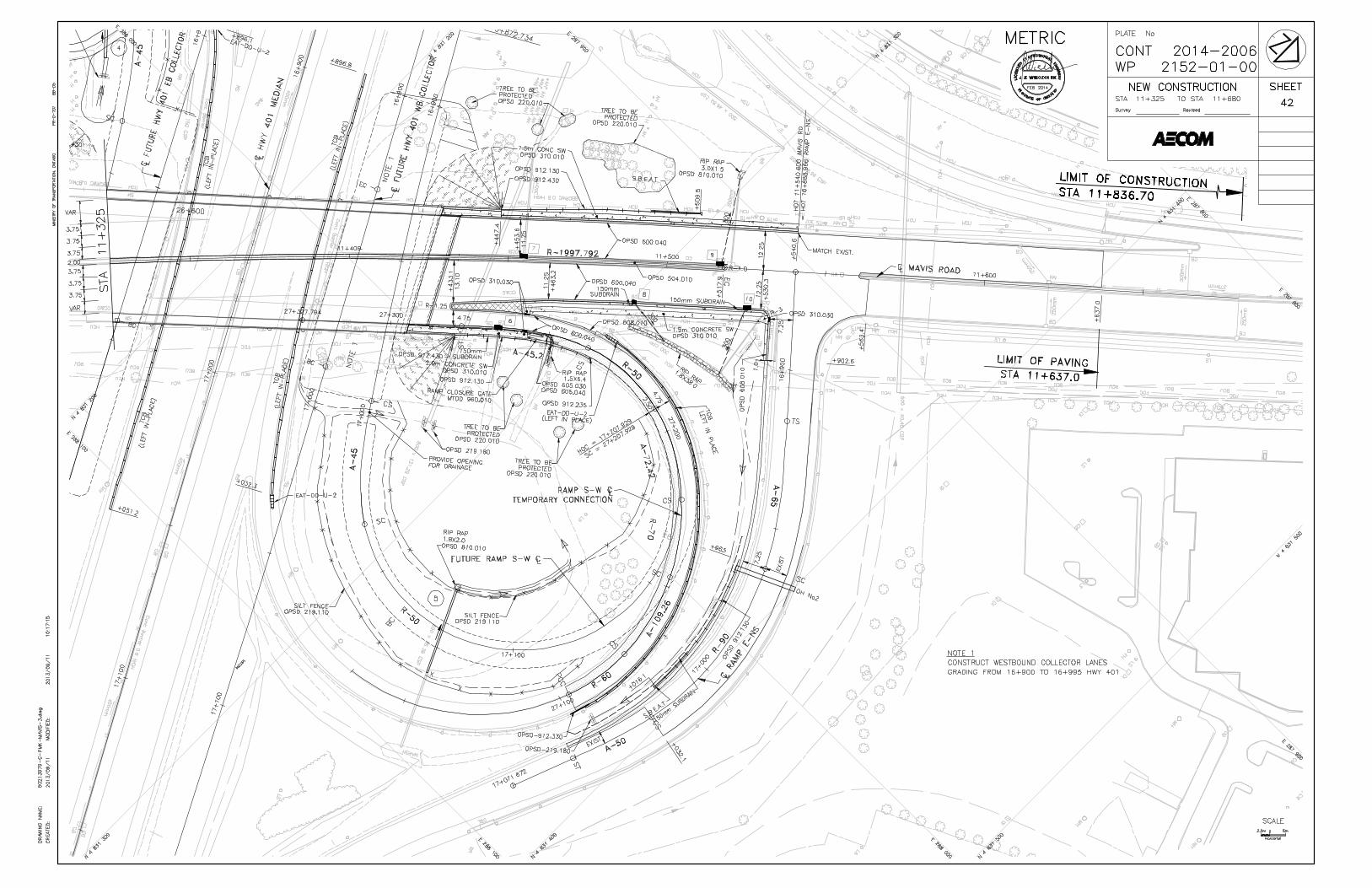


New Ramps at the Highway 401/410/403 Interchange

LIMIT OF CONSTRUCTIONSTA. 20+846.67
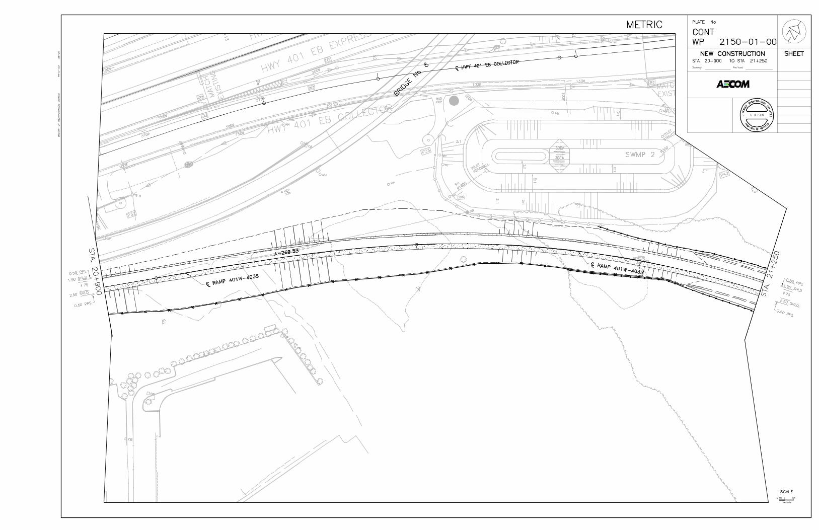
15


62

LIMIT OF CONSTRUCTIONSTA. 22+105.316

STA. 19+553

62


STA.
23+
100
LIM
IT O
F CO
NTR