MINING PLANMINING PLAN - Welcome to...
31
MINING PLAN MINING PLAN MINING PLAN MINING PLAN INCLUDING PROGRESSIVE MINE CLOSURE PLAN PROGRESSIVE MINE CLOSURE PLAN PROGRESSIVE MINE CLOSURE PLAN PROGRESSIVE MINE CLOSURE PLAN (Submitted under Rule 34 of Uttar Pradesh Minor Mineral Concession Rules 1963 and its amendment 2013) OF RIVER SAND/MORRUM MINE VILLAGE- PARECHHA, TEHSIL-MOTH, DISTRICT- JHANSI, UTTAR PRADESH Araji No. – 184/4, Total Allotted Area- 10.00 Acres (4.0469 Ha.) PERMIT PERIOD: 6 MONTH APPLICANT M/S ASHISH ENTERPRISES M/S ASHISH ENTERPRISES M/S ASHISH ENTERPRISES M/S ASHISH ENTERPRISES Address: Station Road, Parichha, Tehsil, District-Jhansi Prepared By ARUN KUMAR YADAV ARUN KUMAR YADAV ARUN KUMAR YADAV ARUN KUMAR YADAV RQP/AJM/242/2003/A, Validity upto 21 st May, 2023
Transcript of MINING PLANMINING PLAN - Welcome to...

MINING PLANMINING PLANMINING PLANMINING PLAN INCLUDING
PROGRESSIVE MINE CLOSURE PLANPROGRESSIVE MINE CLOSURE PLANPROGRESSIVE MINE CLOSURE PLANPROGRESSIVE MINE CLOSURE PLAN
(Submitted under Rule 34 of Uttar Pradesh Minor Mineral Concession Rules 1963
and its amendment 2013)
OF
RIVER SAND/MORRUM MINE
VILLAGE- PARECHHA, TEHSIL-MOTH, DISTRICT- JHANSI, UTTAR PRADESH
Araji No. – 184/4, Total Allotted Area- 10.00 Acres (4.0469 Ha.)
PERMIT PERIOD: 6 MONTH
APPLICANT
M/S ASHISH ENTERPRISES M/S ASHISH ENTERPRISES M/S ASHISH ENTERPRISES M/S ASHISH ENTERPRISES
Address: Station Road, Parichha, Tehsil, District-Jhansi
Prepared By
ARUN KUMAR YADAVARUN KUMAR YADAVARUN KUMAR YADAVARUN KUMAR YADAV
RQP/AJM/242/2003/A,
Validity upto 21st
May, 2023
INDEX
CHAPTER TITLE PAGE NO.
1. Introduction 1
2. Chapter – 1 : General Information 2-3
3. Chapter – 2 : Location 4
4. Chapter – 3 : Geology, Reserve and Replenishment Study 5-9
5. Chapter – 4 : Mining 10-11
6. Chapter – 5 : Blasting 12
7. Chapter – 6 : Mine Drainage 12
8. Chapter – 7 : Disposal of Waste 13
9. Chapter – 8 : Use of Mineral 13
10. Chapter – 9 : Mineral Beneficiation 13
11. Chapter – 10 : Surface Transport 13
12. Chapter – 11 : Site Services 14
13. Chapter – 12 : Employment Potential 14
14. Chapter – 13 : Environment Management Plan 15-18
15. Chapter – 14 : Any other Information 19
16. Progressive Mine Closure Plan 20-27

LIST OF ANNEXURES
S. No. Particulars Annexure No.
1 Authorization letter/Consent letter from
applicant
I
2 LOI II
3 RQP Certificate III
4 Power of Attorney & partnership deed, Registration of firm
IV
LIST OF PLATES
S. No. Particulars Plate Number
1 Location Plan 1
2 Key Plan 2
3 Google Map 3
4 Cadastral Map 4
5 Surface cum Surface Geological Plan & Sections
5
6 Year Wise Development Plan & Sections 6
7 Conceptual Plan 7

Overseas Min-tech Consultants
Page | 1
INTRODUCTION
Letter of Intent (LOI) for mining of minor mineral Sand/Morrum has been granted in Favor of M/S
Ashish Enterprises vide letter no.195/30MMC/E-NIVIDA/APPROVAL/2017-18 dated 19/05/2017
under U.P Minor Mineral Concession Rules 1963 by District Mining Officer, Jhansi (U.P) for the
period of 6 month The total area of mining is (10.00 Acres) 4.0469 Hectares approximately. The
Mining Short term permit is granted for a period of 6 month from the date of grant of permit Copy
enclosed as Annexure-II.
The proposed production capacity of Sand/Morrum is 40460cum. The short term permit area lies
on the river beds of Betwa River in Jhansi district, U.P. The proposed mining project land has been
allotted for mining of River Sand/Morrum throughout the riverbed of Beta River district Jhansi
(U.P).Sand/Morrums Grades as fine, medium and coarse with ranges 0.063 mm to 0.2 mm, 0.25
mm to 0.50 mm and 0.63 mm to 2.0 mm respectively.
In order to process further by the concern Department, an environment clearance from State
Expert Appraisal Committee is necessary. For the grant of environment clearance, preparation and
approval of Mining Plan for the said area is also one of the components. For this, the Company has
given the work of Preparation of Mining Plan to RQP- Arun Kumar Yadav, having RQP No.
RQP/AJM/242/2003/A, Validity 21st May, 2023.Consent is attached as Annexure-I.

Overseas Min-tech Consultants
Page | 2
CHAPTER- 1 1.1. GENERAL INFORMATION ABOUT APPLICANT
Name and address of Applicant:
M/S Ashish Enterprises
Address: Station Road, Paricha, Tehsil, District-Jhansi
1.2 STATUS OF THE APPLICANT:
Pvt. Ltd. Co.
Power of Attorney Holders (Annexure IV)
1. Shri Ramashanker Singh S/o Shri Shiv Charan Singh R/o Station road, Parichha, District-
Jhansi.
2. Shri Pramod Kumar S/o Shri Shiv Rameshwar Singh R/o Station road, Parichha, District-
Jhansi.
3. Shri Ashish Kumar S/o Shri Shiv Kailash Singh R/o Station road, Parichha, District- Jhansi.
1.3 MINERALS THAT THE APPLICANT INTENDS TO MINE
River Sand/Morrum (Minor Mineral)
1.4 NAME & ADDRESS & REGISTRATION NUMBER OF RECOGNISED PERSON, WHO HAS
PREPARED THE MINING PLAN: -
Arun Kumar Yadav,
RQP/AJM/242/2003/A,
Validity 21st May, 2023
501, Apex Tower, Tonk Road,
P.O. Jaipur-302015(Raj.)
E-mail- [email protected]
Website- www.overseasmintech.com
Telefax- 0141-2744509, M-+91-9460221084
1.5 NAME & ADDRESS OF PROSPECTING AGENCY
M/S Ashish Enterprises
1.6 DETAILS OF THE MINING SHORT TERM PERMIT AREA: -
(a) Allotted area of 4.0469 hectares marked on Toposheet No refers Plate No. 2.
(b) Name of the Mineral: - Sand/Morrum (Minor Mineral)
District- Jhansi
State- Uttar Pradesh
Area in hectare: - 4.0469ha.
Status of Land: - River bed (GM land)
Permit Period- 6 Months

Overseas Min-tech Consultants
Page | 3
DESCRIPTION OF GHATS PILLAR IN THE AREA: -
S.No. DISTRICT NAME OF RIVER
NAME OF THE GHAT/VILLAGE
COORDINATE AREA IN (Ha.) LATITUDE
(N) LONGITUDE
(E)
(BETWA RIVER)
1 JHANSI BETWA NADI
PARECHHA A 25044'40.32'' 7903'28.56'' 4.0469
B 25044'50.00'' 7903'33.00''
C 25044'48.08'' 7903'37.22''
D 25044'38.17'' 7903'32.72''
1.7 SHORT TERM PERMIT PERIOD: 6 Months.
1.8 INFRASTRUCTURE FACILITIES: -
1.8.1. Railway Station: - Considering the extent of river beds, Moth Railway Station is the nearest
rail head for approach and transportation of mineral which is about 11.25 km SW from the
center of proposed mine activities.
1.8.2. Nearest Airport: - Considering the extent of river beds, Rajmata Vijaya Raja Scindia Air
Terminal, Gwaliar Airport is the nearest airport 102.60Km from the applied area in NW
direction.
1.8.3. Nearest Highway: - Nearest highway are SH-42 at 17.15Km in SE direction of the applied
area, NH-25 at 7.18Km in WEW of the applied area.
1.8.4. Nearest Town/City: -.Nearest town is Jhansi which is 58.23km SW from the center of
proposed mine activity.
1.8.5. Availability of water: - Water for drinking purpose is brought from nearby village. The water
of Hand Pump located nearby the area is potable and being used by the villagers, habitants and
labors. Water required for dust suppression will also be supplied from the Hand Pump by water
tanker.
1.8.6. Electricity: - There is no electric line pass through the mine area.
1.8.7. Educational Facilities: - The school and College facilities are available in Moth and Jhansi.
1.8.8. Mode of transportation of Mineral: - The allotted area is situated at Parechha village
connected to tehsil Moth by SH-25. To reach at the allotted area, metalled road is there up to
the site .Mineral will be transported by truck/Dumper from the site to nearby Market.
1.8.9. River/ Canal: - Betwa Nadi
1.8.10. Other relevant information: - Banking and all other essential infrastructural facilities are
available at Jhansi district.

Overseas Min-tech Consultants
Page | 4
CHAPTER-2
2.0 LOCATION & GENERAL DESCRIPTION 2.1 LOCATION
A) DETAILS OF THE AREA
S. No. Particulars Description
1 Short term permit area 4.0469ha.
2 Village Parechha
3 Tehsil Moth 4 District & State Jhansi (U.P) 5 Name of River Betwa River 6 Araji No 184/4
7 Latitude 25°44'38.17'' N to 25°44'50.00'' N
8 Longitude 79°3'28.56'' E to 79°3'37.22'' E
2.2. GENERAL
S. No. Particulars Description
1 Mineral River Sand/Morrum
2 Period of Mining Letter of Intent (LOI) for
mining of minor mineral
Sand/Morrum has been
granted in favor of M/S
Ashish Enterprises under
U.P Minor Mineral
Concession Rules 1963 by
District Mining Officer,
Jhansi (U.P) for a period of
six month
3 Category of Land River bed (Non Forest Land)
4 Ownership of Land Private limited company
5 Approach Road NH-25
Location of Mine is shown in Plate No. 1. Google imagery showing in Plate No.3, 5 Km radius area
is shown in Plate No. 2. Surface Geological Plan of the area is shown in Plate No. 5.

Overseas Min-tech Consultants
Page | 5
CHAPTER-3
3.1 Physiography
The topography of the area is flat. The district Jhansi is located in the South western part of
the state .Jhansi district is gradually sloping in the north-easterly direction. The allotted area
extends between the north latitudes of 25°44'38.17'' N to 25°44'50.00'' N longitudes of 79°3'28.56'' E
to 79°3'37.22'' E falling in the Survey of India toposheet No’s. The area is chiefly drained by
the river Betwa and Minor River like Dhasan and Pahuj. The Betwa and Pahuj rivers are
tributaries of Betwa and Dhasan is tributary of Betwa. The major tributaries of Dhasan are the
Lakheri, Sukhnai, Kurera etc which are mainly ephemeral. All three main rivers are perennial.
The average annual rainfall is 850.1mm. The climate is sub-humid and it is characterized by a
hot dry summer and cold winter. About 91% of rainfall take 6 place from June to September.
During monsoon surplus water is available for charging to ground water. January is the coldest
month of the year when the mean daily maximum temperature is 24.10 C and the mean daily
minimum temperature is 9.20 C, May is the hottest month with mean daily maximum
temperature is 42.60 C and mean daily minimum temperature is 28.80 C. The mean monthly
maximum temperature is 32.60 C and mean minimum temperature is 19.20 C.
3.2 Geology
Probable Geological Succession of the study area.
Quaternary Alternate bed of sand and clay
with occasional beds of calcrete. -
------------------ Unconformity-----------------------
Upper Proterozoic Vindhyan Super Group
------------------ Unconformity-----------------------
Middle Protoerozoic Delhi Super Group
------------------- Unconformity-----------------------
Archean to Bundelkhand Granitoids
Lower Proterozoic
The northern part of the district is occupied by the alluvium of quarternary age. The
alluvium consisting of mainly fine to coarse sand, gravel, pebble, silt, clay and kankar attains a maximum thickness of about 60.00 meters. The alluvium together with the underlying
weathered zone of granite-gneissic basement form a more or less homogeneous aquifer
system. The northern aquifer system yields moderate quantities of ground water through dug
wells and tube wells. In southern parts of the district, the weathered zone of Bundelkhand
granite gneissic complex of Archean age and overlying residual soils largely forms the aquifer
system. The aquifer system exhibits heterogeneity to some extent due to impervious nature of
frequently occurring outcrops, hillocks and linear quartz reefs. This aquifer has an average thickness of about 20 to 40 meters and yield is limited to moderate through dug wells and tube
wells. Ground water occurs under water table conditions in plains. In the granitic terrain ground
water occurs in fractures and in fine interstices of the weathered rock material.
3.3 LOCAL GEOLOGY
Mining area is situated in the bank of Betwa River .No soil is present in the area. River
Sand/Morrum is spread all over the area.

Overseas Min-tech Consultants
Page | 6
3.3 DETAILS OF EXPLORATION
Mining of Sand/Morrum is being done since long time. No specific method of exploration is
required as the river borne sediments are deposited all along the river bed and are very well
exposed on the surface. Moreover, these sediments are accumulated /replenished every year
during rainy season by river waters to almost more than extracted level depending on the
intensity of rains on the upstream side. Adequate quantity of Sand/Morrum in mixed state
reserves is available to meet the market demand. There is no possibility of any other mineral
to be found in the area.
3.4 METHOD OF ESTIMATION OF RESERVES
This is the freshly allotted area for mining of river Sand/Morrum minor mineral. The area of
proposed mining for 6 Months is selected as per the provision made in the U.P Minor Mineral
Concession Rules, 1963 and its amendment 2013 under Rule 34 and guideline contained in the
river bed mining policy and land form studies. As per the LOI, the following special conditions
shall be applicable for excavation of minor mineral from river bed in order to ensure safety of
river beds, structure and the adjoining areas: -
� The maximum depth of Sand/Morrum quarrying in the river bed shall not exceed 3 (three)
meters measured from the un-mined bed level at any point of time or the water table
whichever is less.
� The quarrying of Sand/Morrum shall be prohibited within 300 m on both sides of any
railway bridge or any bridge falling under any National Highway/State Highway and shall be
prohibited 100 m of both sides of any other bridge.
� No quarrying shall be permitted within 50 (fifty) meters of any public place i.e. cremation
ghat or any religious place etc.
� No quarrying shall be permitted within 5 (five) meters from both banks of the river.
� The quarrying of Sand/Morrum shall be prohibited within 100 (one hundred) meters
upstream and downstream from any dam/weir or any other structure erected for irrigation
purpose.
� No quarrying shall be permitted within 46 (forty six) meters distance from Flood control
embankments. The quarrying shall be restricted up to a depth of 1.80m within 46 (forty
six) meters to 61(sixty one) meters distance from the said embankments and shall be
further restricted up to a depth of 2.40 meters within 61 (sixty one) meters to 91(ninety
one) meters distance from the above said embankments.
A. Details of UNFC classification
UNFC is a three digit code based system, the economic viability axis representing
the first digit, the feasibility axis the second digit and the geological axis the third
digit. Each digit provided Codes 1, 2 and 3 in decreasing order. The highest
category of resources under UNFC system has code (111) and for lowest category
the code is (334).
Code (111): This code is provided for the economically mineable part of the
measured mineral resources (proved category reserves).
Code (121): This code is provided for the economically mineable part of the
indicated mineral resources (probable category reserves).
Code (211): The part of the measured mineral resources (proved category),
which as per feasibility study has not found economically mineable.
The reserves blocked in 7.5 meters buffer zone and 50 meters from
permanent structure.

Overseas Min-tech Consultants
Page | 7
Code (222): The part of the indicated mineral resources (probable category),
which as per feasibility study has not found economically mineable.
The reserves blocked in 7.5 meters buffer zone and 50 meters from
permanent structure.
Code (333): Tonnage, Grade and mineral contents can be estimated with low
level of confidence and resources are also inferred from geological.
Geological Reserves
The total mineable reserves as estimated within the short term permit are 40460cum .The river
Sand/Morrum so extracted will be replenished every year after monsoon. The extractable reserves will
be realized after leaving out 25% as blocked area in order to protect the river banks. The mining will be
done only up to a depth of 3 m.

Overseas Min-tech Consultants
Page | 8
Sr.
No.
Name of
the Ghats/ Village
Name of
River
Coordinate
Short
term
permit area
In sqm
Total
Proved Geological
Reveres
TONNE= area*Depth
(UNFC code
111) (in cum)
Blocked area of
25%
blocked in River, banks,
railways,
Road / bridges
Short term
permit Boundary
etc.=
(in sqm)
Geological Reserves in
Blocked
Area(in cum) (UNFC
Code 211*222)
Mineable
Reserves 44.44% of
geological
reserve(in
cum)
Latitude
(N)
Longitude
(E)
(BETWA RIVER)
1.
ARAJI NO-
184/4
PARECHHA BETWA RIVER
25044'40.32'' 7903'28.56''
40469
121404
10117
30351 40460
25044'50.00'' 7903'33.00''
25044'48.08'' 7903'37.22''
25044'38.17'' 7903'32.72''

Overseas Min-tech Consultants
Page | 9
Total Mineable Reserves = (Proved) reserves
= 40460cum
The mineral reserves are computed as per UNFC. The reserves are as follows:
Reserves of Sand/Morrum
Total Mineral Resources (A+B) Code Reserves
A. Mineral Reserves
1. Proved Mineral Reserves
2. Probable Mineral Reserves
111
121 & 122
40460cum
Nil
B. Remaining Mineral
1. Feasibility Mineral Resources
2. Prefeasibility Mineral Resources
3. Measured Mineral Resources
4. Indicated Mineral Resources
5. Inferred Mineral Resources
6. Reconnaissance Mineral Resources
211
221 & 222
331
332
333
334
Nil
Nil
Nil
Nil
Nil
Nil
Details of UNFC classification
UNFC is a three digit code based system, the economic viability axis representing the first digit, the feasibility axis the second digit and the geological axis the third digit. Each digit provided.
Codes 1, 2 and 3 in decreasing order. The highest category of resources under UNFC system has code
(111) and for lowest category the code is (334).
Code (111): This code is provided for the economically mineable part of the measured mineral resources (proved category reserves).
Code (121): This code is provided for the economically mineable part of the indicated mineral
resources (probable category reserves).
Code (211): The part of the measured mineral resources (proved category), which as per feasibility study has not found economically mineable. The reserves blocked in 7.5 meters buffer
zone and 45 meters from permanent structure.
Code (222): The part of the indicated mineral resources (probable category), which as per feasibility study has not found economically mineable. The reserves blocked in 7.5 meters buffer
zone and 45 meters from permanent structure.
Code (333): Tonnage, Grade and mineral contents can be estimated with low level of confidence and resources are also inferred from geological.
Anticipated life of the mine
The area for Sand/Morrum (minor minerals) has been consented for a period of 6 Months from the date
of grant of permit. Accordingly, it is proposed to produce 40460 cum within 6 month permit period. So,
the anticipated life of mine will be 6 Months.

Overseas Min-tech Consultants
Page | 10
CHAPTER-4
METHOD OF MINING
4.0 Present Method of Mining: -
It is a case of freshly grant of short term permit. The mining is being done by manually (semi-
mechanized only in night) as per the provisions laid in the new Sand/Morrum policy. Mining is
carried out by the LOI holder with due permission from the department of Mines & Geology,
U.P.
It is proposed to produce 40460cum Sand/Morrum (minor minerals) within six months , for
this, following consideration taken for the proposed mine layout to be carried out
systematically & scientifically.
Mining activity will be carried out by open cast Semi-mechanized method.
� Lightweight excavators will be used for digging & loading of mineral in Dumpers & Trucks.
� No OB/ waste material will be produced.
� No drilling/ blasting is required as the material is loose in nature.
� Proper benching of 3.0 m height will be maintained.
� Roads will be properly made and sprayed by water for suppression of dust.
� Roads in the short term permit area for the movement of loaded trippers/ trucks will not
have slopes more than 1 in 20.
� Extraction activities will start in the blocks from the upstream side to downstream side.
This will not obstruct the movement of water, if any, during monsoon period in the river
course.
� Approach roads from the various blocks as already described earlier will be merging with
permanent tar roads on both sides of the river for transportation of the mineral to final
destinations.
4.1 Proposed Year wise development for Six Months: -
The river Sand/Morrum is exposed and does not have any over burden so no development work
will be required for the mining of river bed Sand/Morrum. Extraction of river Sand/Morrum will
be done by semi- mechanized means and transportation will be done by hired Dumpers &
Trucks. It is proposed to produce about 40460cum.
4.2 EXTENT OF MECHANIZATION
Presently, no mining is carried out in the allotted area, so there is no machinery deployed for
mining operations. To achieve the desired production, as proposed in six month permit period,
the following machinery is proposed to be deployed for Sand/Morrum mining. The Machinery to
be deployed and their Specifications are as follows - :
The Proposed Mining Machinery is as follows: -
S.No. Machine Make Capacity
1. JCB JCB 0.9 m3
3. Dumper/Trucks Ashok Leyland 20 Tonne
4. Tractor Trolley Mahindra/Sonalika 4 Tonne

Overseas Min-tech Consultants
Page | 11
4.3 Production for the six month: -
The production of Sand & Morrum will be 40460cum as given by the govt. in the auction.
Excavated area will be replenished naturally due to sediment inflow from the catchment area.
4.4 PROPOSED RATE OF PRODUCTION WHEN MINE IS FULLY DEVELOPED: -
The required rate of production is around of 40460cum Sand/Morrum minor minerals. The
required target is planned & will be achieved during six month permit period.
4.5 MINERAL RESERVE AND ANTICIPATED LIFE OF MINE: -
The area for Sand/Morrum (minor minerals) has been consented for a period of 6 Months from the date of auction .So, the anticipated life of mine will be 6 Months.
4.6 PROPOSED METHOD OF MINING: -
Opencast Working
Method for developing and working the deposits
The Mining will be carried out as per New Sand Policy by U.P Government. Only dry
Sand/Morrum will be transported. The river Sand/Morrum deposited as the river bed material
will be exploited in its natural form by semi- mechanized open cast method.
Method of mining
The area allotted is for a period of 6 Months in Betwa River. Alloted area consists of 4.0469 ha
area of Araji NO-184/4 in Parechha village. Mining will be done in leaving safety distance form
bank and stream for river bed blocks around the Applied Area. The river Sand/Morrum to be
won from River Ghat will be exploited and it will be simultaneously reclaimed by replenished
river Sand/Morrum brought out during monsoon period. The river Sand/Morrum mining will be
done by manually from morning to evening, after evening it will be/ can be used excavator
with proper lighting. The river Sand/Morrum will be excavated by light weight excavators/jcb
by formation of benches & it will be directly loaded into Dumpers & Trucks for dispatch to
consumers of Jhansi District. Water will be sprinkled in the area from where the Sand/Morrum
is to be removed before the starts and thereafter of exploitation, at regular intervals to keep
the dust suppressed at the source itself. There is no need for drilling & blasting as
Sand/Morrum is soft. Therefore, Environment and Ecology of the area remains undisturbed.
The max. depth of working shall not be more than 3m from the river bed Mining activities will
be carried out in a manner so that there is no obstruction to the flow of water, during rainy
season. Movement of trippers/ trucks after river Sand/Morrum loading will be towards both
sides through approach roads connecting to tar roads. No processing of river Sand/Morrum will
be done.
• Mining will be confined within central of the river. This will prevent collapse of bank and
erosion.
• Mining will be done leaving 25% of the total area as safety zone from the banks for bank
protection.
• Excavated area will be replenished naturally due to sediment inflow from the catchment
area.
• The maximum depth of Sand/Morrum quarrying in the river bed shall not exceed 3 (three)
meters measured from the un-mined bed level at any point of time or the water table
whichever is less.
Conceptual Mining Plan and life of Mine.
The conceptual Mining Plan has been prepared up to the mining contract of 6 Months. It is proposed to
work the deposit by formation of benches till the end of short term permit contract to exploit the
mineral to its fullest extent. The proposed planned production is 40460cum.
Overseas Min-tech Consultants
Page | 12
CHAPTER- 5
BLASTING
The river Sand/Morrum is a loose material so no blasting is required for its mining.
CHAPTER- 6
MINE DRAINAGE
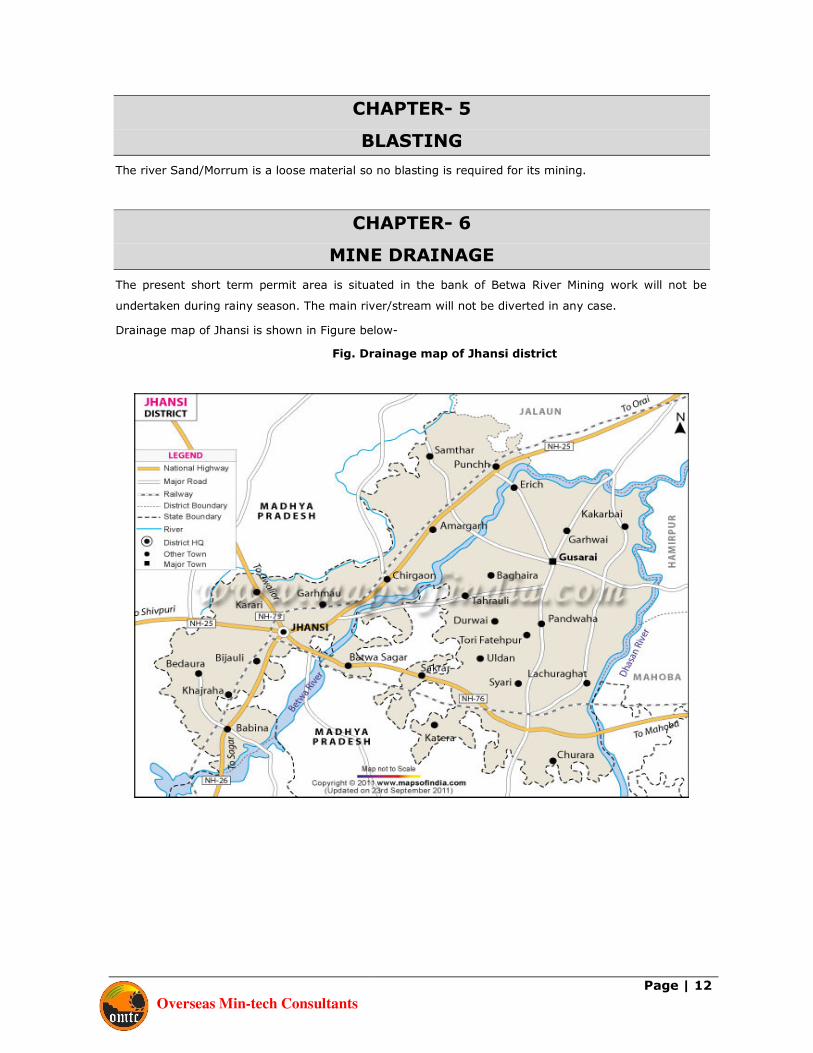
The present short term permit area is situated in the bank of Betwa River Mining work will not be
undertaken during rainy season. The main river/stream will not be diverted in any case.
Drainage map of Jhansi is shown in Figure below-
Fig. Drainage map of Jhansi district

Overseas Min-tech Consultants
Page | 13
CHAPTER – 7
STACKING OF MINERAL REJECTS & DISPOSAL OF WASTES
There is no waste or mineral rejects generation in the proposed mining of river Sand/Morrum so question
does not arise for the stacking of the same.
CHAPTER- 8
USE OF MINERAL
The mineral river Sand/Morrum is used for the following uses and it will be dispatched in its crude form.
There will be no beneficiation or treatment before its dispatch.
• Construction material for buildings,
• Raw material for construction of dams,
• Raw material for roads construction, paving, etc.
CHAPTER- 9
MINERAL BENEFICIATION
The river Sand/Morrum will be used as building construction material so no mineral beneficiation is
required.
CHAPTER- 10
SURFACE TRANSPORT
Mode of Transport of Mineral to the Dispatch Point: -
During the Mining Plan period, the mineral produced will be loaded into trucks/dumpers/Dumpers &
Trucks, for onward transport to the consumer as well as to the Market nearby the allotted area. The
mine is situated very close to the NH-25.

Overseas Min-tech Consultants
Page | 14
CHAPTER- 11
SITE SERVICES
Working Office: Temporary working office will be maintained at site. This will be a temporary
structure and can easily shifted one side to another side as & when required. Safe drinking water will
be kept in covered buckets / clay pitcher and will be provided to mine workers.
Rest Shelter: A temporary structure as a rest shelter to labours will be provided to the workers near
mine site. Primary Health/First Aid: First aid box with principal medicine will be kept at mine site to facilitate
the first aid treatment to the workers. Protective Measures: Shoes and helmet will be provided to all the workers during mining. Regular
sprinkling will be done to check the dust pollution. Ear Plug & dust mask will be provided to the workers
for their safety measures.
CHAPTER- 12
DETAILS OF EMPLOYMENT
Requirement of Technical and other supervisory staff will be as follows for the proposed systematic and
scientific mining: -
a. Mining Engineer - 1
b. H.E.M.M. Operators - 4
c. Supervisor - 2
d. Skilled Workers - 10
e. Semiskilled Workers - 20
Total - 37

Overseas Min-tech Consultants
Page | 15
CHAPTER- 13
ENVIRONMENT MANAGEMENT PLAN
13.1 BASE LINE INFORMATION
(i) EXISTING LAND USE PATTERN
The allotted short term permit area of mining is a river bed. There is no forest or
agriculture land in the allotted short term permit area. The entire allotted short term
permit lies within river beds of Betwa River and there will be no change in land use
after operation. The river Sand/Morrum will be replenished every year during the
monsoon season. The ultimate land use of the allotted short term permit area will not
change.
Summary Area (in Ha)
River bed 4.0469
(ii) WATER REGIME
Surface Water: Short term permit area is in the bank of Betwa River, which is a
perennial water body.
Ground Water: Water level in wells varies 5-15mbgl.
(iii) FLORA & FAUNA
Top soil layer is not present hence the area devoid of any kind of vegetation. Infect,
this is a river bank of river Betwa where mineral (river sand) is spread over the area.
Tree species like pipal, mango, Neem, Ber, Babool etc are common in nearby areas.
Shurbs like Kaner, Madar, Dhatura, Makoi, and Munj are a few common species.
Amphibians and reptiles are common in such type of habitat. Species of fishes like
Indian Rohu are also common in river water.
(iv) CLIMATIC CONDITION
Temperature: The climate is sub-humid and it is characterized by a hot dry summer
and cold winter. About 91% of rainfall takes place from June to September. During
monsoon surplus water is available for charging to ground water. January is the coldest
month of the year when the mean daily maximum temperature is 24.10 C and the
mean daily minimum temperature is 9.20 C, May is the hottest month with mean daily
maximum temperature is 42.60 C and mean daily minimum temperature is 28.80 C.
The mean monthly maximum temperature is 32.60 C and mean minimum temperature
is 19.20 C.
Rainfall: Average rain fall in the month of July August is around 850mm.
(v) SOCIAL ENVIRONMENT
Peoples, mainly in this area belong to Hindu community.
Overseas Min-tech Consultants
Page | 16
Occupation
The main occupation in the area is agricultural. Teaching, small business, mining is the
other main occupations in nearby villagers.
(vi) PUBLIC BUILDING, PLACES AND MONUMENTS
The allotted area is parts of river ghats having no infrastructures, except fair weathered
connecting road for local transportation.
13.2 ENVIRONMENT IMPACT ASSESSMENT STATEMENT
The Sand/Morrum mining activity will have minimum adverse impact on the environment;
rather it will have beneficial impact. The removal of the Sand/Morrum from the river bed will be
confined to the dry portion of the bed. However, the following areas are affected due to
Sand/Morrum mining:
i. Dust generation during handling and transportation.
ii. Noise pollution
iii. Impact on river water quality
iv. Impact on ground water
v. Impact on flora and fauna
Some of the beneficial effects from Sand/Morrum mining activity are:
i. Regular de-siltation of the river to avoid flooding
ii. Upgradation of socio-economic level of the area
iii. Vital support to construction activity
The baseline study of the various environmental parameters is being studied for one season
except monsoon.
The study area also witnesses huge transportation activities of minerals, men, material, etc.
The data obtained from the ambient air quality analysis carried out by our EIA/EMP consultant
indicates that for a number of occasions the level of air quality was higher than the permissible
limits which is quite obvious since the area has been declared critically polluted area.
The surface water quality data shows that all the parameters are within range except the
concentration of microbial organisms. Moreover the ground water analysis data was found
within permissible limits except the dissolved mineral concentration level.
As far as the noise level is concerned, it is only during the loading and transportation of the
mineral. Moreover, no populated area found within 500 meters from the edge of the river.
There is no rare species of flora or endangered fauna in the study area. There is no eco-
sensitive area, wildlife sanctuary and national parks in 10 kms radius of the proposed
Sand/Morrum short term permit.
13.3 ENVIRONMENTAL MANAGEMENT PLAN
Mining of river Sand/Morrum will be carried out as per the guidelines issued under U.P Mineral
Policy, and U.P Minor Mineral Concession Rules (amended thereof).This project is for
exploitation of river Sand/Morrum necessary as construction material. The area allotted along
the river will be used for its exploitation so that it will be used in construction of various kinds
of infrastructures, building bridges, road etc.
The project involves collection of river bed material. This will also help to prevent widening of
the riverbeds and to prevent flooding off and damage to the adjoining areas. This can only be
achieved by maintaining the existing course of the river. This is ensured through the following:

Overseas Min-tech Consultants
Page | 17
1. The maximum depth of Sand/Morrum quarrying in the river bed shall not exceed 3 (three)
meters measured from the un-mined bed level at any point of time or the water table
whichever is less.
2. The quarrying of Sand/Morrum shall be prohibited within 300 m on both sides of any
railway bridge or any bridge falling under any National Highway/State Highway and shall
be prohibited 100 m of both sides of any other bridge.
3. No quarrying shall be permitted within 50 (fifty) meters of any public place i.e. cremation
or any religious place etc.
4. No quarrying shall be permitted within 5 (five) meters from both banks of the river.
5. The quarrying of Sand/Morrum shall be prohibited within 100 (one hundred) meters
upstream and downstream from any dam/weir or any other structure erected for irrigation
purpose.
6. No quarrying shall be permitted within 46 (forty six) meters distance from Flood control
embankments. The quarrying shall be restricted up to a depth of 1.80m within 46 (forty
six) meters to 61(sixty one) meters distance from the said embankments and shall be
further restricted up to a depth of 2.40 meters within 61 (sixty one) meters to 91(ninety
one) meters distance from the above said embankments.
7. The irrigation outlet shall be maintained at the same level as that of the river bed and in
no case the river bed level shall be permitted to be below the irrigation outlet level.
8. No quarrying shall be permitted around the infiltration well / intake well up to a distance
of 5 meters.
9. The extraction of Sand/Morrum shall be permitted only after obtaining a ‘No Objection
Certificate’ from the Water Resources Department in the case of rivers where from
irrigation channels are out flowing.
10. No quarrying of Sand/Morrum shall be permitted in any private land owned by a person
other than the settlee unless the settlee obtains the consent of the concerned land owner/
raiyat.
11. No quarrying of Sand/Morrum shall be permitted in any area which the State Government
notifies as a restricted area.
12. Water spraying along the haul roads & transportation routes to prevent air pollution.
13. Maintain the health of the transportation roads.
14. Transportation by covered trucks.
15. Maintenance of trucks to prevent spillage and noise minimization.
16. Use of proper PPE’s for the workforce is ensured.
17. No withdrawal/ pumping of water from Sand/Morrum short term permit areas.
18. This project operation will provide livelihood to the poorest section of the society. It
provides employment to the people residing in vicinity directly or indirectly by the project.
Program of afforestation, for six month permit period indicating number of plants to
be afforested.
PROGRAMME FOR PLANTATION
Plantation will be carried out side the river bed, at approach road, transport road of mineral,
nearby school, Hospital, police station and the place for common utility to arrest the dust at
source. The total allotted area is 4.0469 hectare out of which 33% of the total area i.e.
1.33hectare has to be covered under plantation during the Permit period. Considering 20 trees
per hectare as a tree density, the applicant will plant minimum 27 saplings within 6 month
permit period. The rainfall in the area is also inadequate hence it is essential that the saplings

Overseas Min-tech Consultants
Page | 18
of plants should be of the variety which require minimum water and hence it is proposed to
plant 27 saplings of local variety within 6 month as recommended by the regional forest officer.
Place of proposed plantation: -
Plantation shall be done in the outside the river bed, at approach road, transport road of
mineral, nearby school, Hospital, police station and the place for common utility to arrest the
dust at source.
MEASURES FOR DUST SUPPRESSION
Control of Air Pollution Due To Dust, Exhaust Emissions or Fumes During Mining or
Processing Operations For Minor Mineral & Related Activities And Containing the
Same Within Permissible Limits Specified Under : -
1. Water spray will be done thrice in a day over the haul road & upto 2 km from the end
point of the mining short term permit during the working hour
2. Proper care & frequent maintenance of machines will be done.
3. At every work place where, the air borne dust generated, to be sampled and the
concentration of the respirable dust will be determined semesterly. If any
measurement at any workplace, source the concentration in access of 50% or 75% of
the available concentration of permissible limit. Measurements shall be carried on, at
intervals not exceeding 3 months or 1 month respectively.
4. Silencers will be fitted to the dumpers.
Measures to Control Impacts of Noise: -
1. All the machineries including transport vehicles will be properly maintained to minimize
generation of noise.
2. Noise source will be isolated.
3. Attenuation between source & receive points will be incased.
4. Noise will be kept as a prime consideration while purchasing the machines.
5. Dense plantation in mining area will also reduce propagation of noise outside the core
zone.
STABILISATION AND VEGETATION OF DUMPS
There will be no waste generation from the proposed mining of Sand/Morrum (minor minerals),
so stabilization of waste will not be required.
TREATMENT AND DISPOSAL OF WATER FROM MINE AND BENEFICIATION PLANT
The proposed mine workings will be above the ground water table thus no measures will be
required. There will be no treatment of mineral to produce effluent hence it will not require any
management.
MEASURES FOR MINIMISINGH ADVERSE EFFECTS ON WATER REGIME
No impact will take place due to proposed mining activities on water quality also neither the
mineral nor any toxic substance will be discharged to the ground water.
AFFORESTATION OF TAILING PONDS
As there is no beneficiation so tailing ponds are not proposed, hence afforestation of tailing ponds
will not be required.
PREPARATION OF DUMPING GROUND FOR STACKING TOXIC MINERAL SUBSTANCE
There will be no generation of toxic substances, due to the proposed mining. So, neither the
mineral nor any waste will require dumping ground for stacking the toxic mineral / substance.

Overseas Min-tech Consultants
Page | 19
CHAPTER-14
ANY OTHER INFORMATION
In preparation of this Mining plan Mrs. Prerna Chauhan Bisht Geologist has provided her assistance.
Place : Jaipur
Date :
(Arun Kumar Yadav)
RQP/ AJM/242/2003/A
RQP Validity 21st May, 2023

Overseas Min-tech Consultants
Page | 20
PROGRESSIVEPROGRESSIVEPROGRESSIVEPROGRESSIVE
MINEMINEMINEMINE
CLOSURE PLANCLOSURE PLANCLOSURE PLANCLOSURE PLAN

Overseas Min-tech Consultants
Page | 21
CHAPTER –1
1.0 INTRODUCTION: -
Letter of Intent (LOI) for mining of minor mineral Sand/Morrum has been granted in Favor of
M/S Ashish Enterprises under U.P Minor Mineral Concession Rules 1963 by District Mining
Officer, Jhansi (U.P) for the period of 6 month The total area of mining is (10.00 Acres) 4.0469
Hectares approximately. The Mining Short term permit is granted for a period of 6 month from
the date of grant of permit Copy enclosed as Annexure-II.
The proposed production capacity of Sand/Morrum is 40460cum. The short term permit area
lies on the river beds of Betwa River in Jhansi district, U.P. The proposed mining project land
has been allotted for mining of River Sand/Morrum throughout the riverbed of Betwa River
district Jhansi (U.P).Sand/Morrums Grades as fine, medium and coarse with ranges 0.063 mm
to 0.2 mm, 0.25 mm to 0.50 mm and 0.63 mm to 2.0 mm respectively.
In order to process further by the concern Department, an environment clearance from State
Expert Appraisal Committee is necessary. For the grant of environment clearance, preparation
and approval of Mining Plan for the said area is also one of the components. For this, the
Company has given the work of Preparation of Mining Plan to RQP- Arun Kumar Yadav, having
RQP No. RQP/AJM/242/2003/A, Validity 21st May, 2023.Consent is attached as Annexure-I.
1.1 Reasons for Closure : -
The area is freshly allotted area therefore closure of mine is not applicable at this stage.
1.2 Statutory obligations : -
The legal obligations, if any which the applicant is bound to implement like special conditions
imposed while execution of short term permit ,approval of Short term permit, directives issued by
the Indian Bureau of Mines, conditions imposed by the Ministry of Environment & Forests, State or
Central Pollution Control Board or by any other organization describing the nature of conditions and
compliance position there of:
The company will implement like special conditions imposed while execution of short term permit
approval of Short term permit, directives issued by the Central & State Government, conditions
imposed by the Ministry of Environment & Forests, State or Central Pollution Control Board or by
any other organization.
1.3 Closure plan preparation : -
M/S Ashish Enterprises
Address: Station Road, Paricha, Tehsil,District-Jhansi

Overseas Min-tech Consultants
Page | 22
1.4 Name & address and Registration Number of the Recognized person
Arun Kumar Yadav,
RQP/AJM/242/2003/A,
Validity 21st May, 2023
501, Apex Tower, Tonk Road,
P.O. Jaipur-302015(Raj.)
E-mail- [email protected]
Website- www.overseasmintech.com
Telefax- 0141-2744509, M-+91-9460221084
1.4 Executing Agency
M/S Ashish Enterprises
Address: Station Road, Paricha, Tehsil,District-Jhansi

Overseas Min-tech Consultants
Page | 23
CHAPTER –2
MINE DESCRIPTION
2.1 GEOLOGY
The Study area forms a part of Ganga baisn as Betwa is the largest tributary of river ganga The
soil is generally red and the terrain generally rocky in the District. The geological formations
met with in the area are the quartzites of Vindhyan System and Quaternary alluvium. The
quartzites are found in the central and the southern parts of the area, forming hills and
highlands. They strike NE-SW to ENE-WSW dipping at high angles towards north-west. Two
main sets of joints present in the quartzites are bedding joints and vertical dip joints. Alluvium
in the area is found in the extreme northern part and on either side of the river Betwa. It is
also found locally in scattered patches throughout the area. Alluvium of the area comprises
clay, silt, Sand/Morrum and occasionally, kankar.
The Sand/Morrumstone of this area is of upper part of Kaimur plateau. The geology of the area
belongs to Vindhayan Super Group. Geologicaly the area comprises of upper vindhyan
formations consisting of Sand/Morrumstone, quartzite and shale. Vindhyan formation is
overlain by quarternary alluvium, which was deposited on the eroded basement. Upper
vindhyayan formation represented by kaimur series are divided into two groups the upper and
lower. The lower kaimur consists of quartzite and silicified shales at the base followed by susnai
conglomerates. The top of lower kaimur is characterized by thick shales belonging to vijaigarh
shales. The upper kaimur are represented by brown to red , fine grained Sand/Morrum stone
followed by white chandraul quartzite.
Table 1.3 Probable Geological Succession of the study area.
Quaternary Alternate bed of sand and clay
with occasional beds of calcrete. -
------------------ Unconformity-----------------------
Upper Proterozoic Vindhyan Super Group
------------------ Unconformity-----------------------
Middle Protoerozoic Delhi Super Group
------------------- Unconformity-----------------------
Archean to Bundelkhand Granitoids
Lower Proterozoic
It appears from the above sequence that the area is underlain by the bundelkhand
Granitoids which forms the Basement complex. It appears that a very long period of erosion
preceded the deposition of the Delhi group of rocks on the eroded and upturned surface of the Bundelkhand Granitoids.
3.3 LOCAL GEOLOGY
Mining area is situated in the bank of Betwa River. No soil is present in the area. River
Sand/Morrum is spread all over the area.

Overseas Min-tech Consultants
Page | 24
2.2 Reserves
Reserves Sand/Morrum in cum
Proved reserves 40460
More details are given in chapter- 3 of Mining Plan.
2.3.1 Mining Method
Mining will be done by open cast manual (semi-mechanized method ) Heavy earth
moving machinery will be deployed. More details are given in chapter- 4 of Mining plan.
2.3.2 Mineral Beneficiation
The river Sand/Morrum will be used as building construction material so no mineral
beneficiation is required.
CHAPTER –3
REVIEW OF IMPLEMENTATION OF MINING PLAN INCLUDING PROGRESSIVE CLOSURE PLAN
UP TO THE FINAL CLOSURE OF MINE.
This is a freshly allotted area, so review of implementation of Mining Plan including Progressive Closure
Plan up to the final closure of mine is not applicable.
CHAPTER –4
CLOSURE PLAN
4.1 Mined out land
No proposal can be given for concurrent back-filling. Further, mined out reserve will be
Replenished by the river.
4.2 Water Quality Management
Mining activity (collecting sand) will be done in the bank of river Betwa. So, there shall be no impact on water quality.
4.3 Air Quality management
Describe the existing air quality status. The corrective measures to be taken for
prevention of pollution of air should be described:
Ambient air quality has been monitored by us and external agency. For baseline study, in each
season monitoring will be carried out on two days in a week with 24-hourly samples being
collected on each day in future as per the norms laid down by MoEF. Emission of dust due to
movement of vehicles and machineries will produce impact on air. As such there is no need for
prevention of pollution of Air quality except sprinkling of water on haul road etc. in dry season.
4.4 Waste management
Describe the type, quality and quantity of overburden, mineral reject etc. available and their
disposal practice. If no utilization of waste material is proposed, the manner in which the waste
material will be stabilized should be described. The protective measures to be taken for
prevention of siltation, erosion and dust generation from these waste materials should also be
described. If toxic and hazardous elements present in the waste material the protective
measures to be taken for prevention of their dispersal in the air environment, leaching in the
surface and ground water etc. should be described:

Overseas Min-tech Consultants
Page | 25
There is no generation of waste during mining operation, therefore, no provision of stock yard
is proposed. The entire mineral produced is useable.
4.5 Top Soil Management
There is no generation of topsoil.
4.6 Infrastructure
The existing infrastructural facilities available such as roads, aerial ropeways, conveyer belts,
railways, power lines, buildings & structures, water treatment plant, transport, water supply
sources in the area etc. and their future utilization should be evaluated on case-to-case basis.
If retained, the measures to be taken for their physical stability and maintenance should be
described. If decommissioning proposed, dismantling and disposal of building structures,
support facilities and other infrastructure like electric transmission line, water line, gas
pipeline, water works, sewer line, telephone cables, underground tanks, transportation
infrastructure like roads, rail, bridges, culverts etc, electrical equipments and infrastructures
like electrical cables, transformers to be described in connection with restoring land for further
use
4.7 Disposal of Mining Machinery
Mining is proposed for open cast sem i-mechanized mining. Details are given in Chapter 4 of
Mining plan.
4.8 Safety & Security
Explain the safety measures implemented to prevent access to surface openings; excavations
etc. and arrangements proposed during the mine abandonment plan and up to the site being
opened for general public should be described:
D.G.M.S. approved Safety shoes and helmets are being provided to the all workmen. During proposed plan period there is no proposal to close the mine.
Security guards are engaged for security.
4.9 Disaster Management and Risk Assessment
This should deal with action plan for high-risk accidents like landslides, subsidence flood,
inundation in underground mines, fire, seismic activities, tailing dam failure etc. and
emergency plan proposed for quick evacuation, ameliorative measures to be taken etc. The
capability of applicant to meet such eventualities and the assistance to be required from the
local authority should also be described:
High risk factors such as landslide, subsidence flood, fire, tailing dam failure etc. are not
encountered nor anticipated during proposed Six Months plan period. As such, emergency plan
for quick evacuation, protective measures are not proposed. Also, no local habitant exists as
the working area is far away from the locality.
4.10 Care and Maintenance during temporary discontinuance
For Short term permit period an emergency plan for the situation of temporary discontinuance
or incomplete programme due to court order or due to statutory requirements or any other
unforeseen circumstances, should include a plan indicating measures of care, maintenances,
and monitoring of status of unplanned discontinued mining operations expected to re-open in
near future. This should detail item wise status monitoring and maintenance with periodicity
and objective.
Due to unforeseen reason the mine will be a closed temporarily then proper care of workers
and staffs will be taken. Temporary discontinuance notice in the prescribed form will be sent to
the concerned authority of D.G.M.S., concerned State Government and concerned Labour
Department within the stipulated time.
Security guards to take care of the infrastructure shall be kept under the roll of the
management in case of any temporary discontinuation.

Overseas Min-tech Consultants
Page | 26
CHAPTER-5
ECONOMIC REPERCUSSIONS OF CLOSURE OF MINE AND
MANPOWER RETRENCHMENTS
Manpower retrenchment, compensation to be given, socio – economic repercussions and remedial
measures consequent to the closure of mines should be described, specifically stating the following.
At this stage there will be no manpower retrenchment etc. in the area, hence, no proposal for these
have been discussed.
CHAPTER –6
TIME SCHEDULING FOR ABANDONMENT
Not Applicable
CHAPTER –7
ABANDONMENT COST
Not Applicable
CHAPTER –8
FINANCIAL ASSURANCE
The financial assurance has been calculated on the basis of following parameters:
Area considered for Financial Assurance: 4.0469ha
The amount of Financial Assurance: Rs. 60703/-
According to rule 34(6) of amended rules of UP MMCR 1963, the minimum amount as a financial
assurance is Rs. 2 lakh.
Thus the applicant shall submit a financial assurance of Rs. 2.0 Lakh as applicable to the district officer
or the officer authorised by the State Government in this behalf.

Overseas Min-tech Consultants
Page | 27
CHAPTER –9
9.0 PLANS, SECTIONS
All relevant plans & sections have been enclosed.
1. Location Plan
2. Key Plan
3. Surface Cum Surface Geological Plan & Sections
4. Year Wise Development Plan & Sections
5. Conceptual Plan
Place : Jaipur
Date :
(Arun Kumar Yadav)
RQP/ AJM/242/2003/A
RQP Validity 21st May, 2023

Overseas Min-tech Consultants
Page | 28
Annexure-I
CONSENT LETTER FROM APPLICANT
An area of about (10.00 Acres) 4.0469 Hectares of Araji No.-184/4 has been granted for the extraction
of river sand in village Parechha, Tehsil-Moth & District-Jhansi, U.P. under U.P. minor mineral
concession rule 1963. The mine plan in respect of above area has been prepared by Arun Kumar
Yadav, having RQP No. RQP/AJM/242/2003/A, Validity 21st May, 2023
I request to make further correspondence regarding the modification in mining plan with the said
recognized person on his following address:
Arun Kumar Yadav,
RQP/AJM/242/2003/A,
Validity 21st May, 2023
501, Apex Tower, Tonk Road,
P.O. Jaipur-302015(Raj.)
E-mail- [email protected]
Website- www.overseasmintech.com
Telefax- 0141-2744509, M-+91-9460221084
I hereby undertake that all the information provided in Mining plan by the recognized person may be
deemed to have been made with my knowledge and consent and shall be acceptable to me and binding
on me in all respect. I have understood the content of this mine plan and agree to implement the
same.
Date : Place: M/S Ashish Enterprises
Applicant