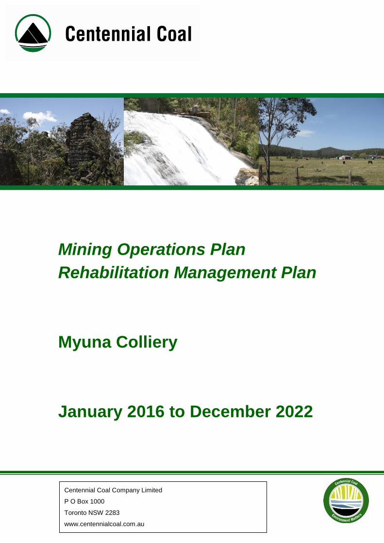
Mining Operations Plan Rehabilitation Management Plan ...
97
Centennial Coal Company Limited P O Box 1000 Toronto NSW 2283 www.centennialcoal.com.au Mining Operations Plan Rehabilitation Management Plan Myuna Colliery January 2016 to December 2022
Transcript of Mining Operations Plan Rehabilitation Management Plan ...
Centennial Coal Company Limited
P O Box 1000
Toronto NSW 2283
www.centennialcoal.com.au
Mining Operations Plan
Rehabilitation Management Plan
Myuna Colliery
January 2016 to December 2022
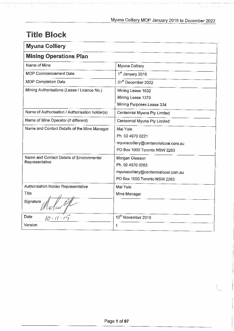
Myuna Colliery MOP January 2016 to December 2022
Page 2 of 97
Table of Contents
1 INTRODUCTION ................................................................................................................... 9
1.1 History of Operations .......................................................................................................... 9
1.2 Consents Leases and Licences .........................................................................................10
1.3 Land Ownership ................................................................................................................12
1.3.1 Land Use ......................................................................................................................12
1.3.2 Land Ownership ...........................................................................................................12
1.4 Stakeholder Consultation ..................................................................................................13
2 PROPOSED MINING ACTIVITIES .......................................................................................14
2.1 Project Description ............................................................................................................14
2.1.1 Mining Area ..................................................................................................................14
2.1.2 Mining Method ..............................................................................................................14
2.2 Asset Register ...................................................................................................................15
2.2.1 Infrastructure Area ........................................................................................................15
2.2.2 Stockpile Area ..............................................................................................................16
2.2.3 Down Cast Shaft Area ..................................................................................................16
2.2.4 Lower Field ...................................................................................................................16
2.2.5 Water Management Area ..............................................................................................16
2.2.6 Underground Mining Area .............................................................................................17
2.3 Activities over the MOP Term ............................................................................................17
2.3.1 Exploration ...................................................................................................................17
2.3.2 Construction .................................................................................................................17
2.3.3 Mining operations (including mining purposes) .............................................................17
2.3.4 Rock/overburden emplacement ....................................................................................19
2.3.5 Processing Residues and Tailings ................................................................................19
2.3.6 Waste Management .....................................................................................................19
2.3.7 Decommissioning and demolition activities ...................................................................20
2.3.8 Temporary Stabilisation ................................................................................................20
2.3.9 Progressive rehabilitation and completion ....................................................................20
2.3.10 Material Production Schedule .......................................................................................20
3 Environmental Issues Management ......................................................................................21
3.1 Environmental Risk Assessment .......................................................................................21
3.2 Environmental Risk Management ......................................................................................21
3.3 Specific Risks Relating to Rehabilitation ............................................................................22
3.3.1 Geology and Geochemistry ..........................................................................................22
3.3.2 Spontaneous Combustion ............................................................................................22
Myuna Colliery MOP January 2016 to December 2022
Page 3 of 97
3.3.3 Acid Mine Drainage ......................................................................................................23
3.3.4 Mine Subsidence ..........................................................................................................23
3.3.5 Erosion and Sediment Control ......................................................................................24
3.3.6 Soil Type and Suitability ...............................................................................................25
3.3.7 Flora .............................................................................................................................25
3.3.8 Fauna ...........................................................................................................................26
3.3.9 Overburden Characterisation ........................................................................................26
3.3.10 Slopes and Slope Management ....................................................................................26
3.3.11 Surface Water ..............................................................................................................26
3.3.12 Groundwater .................................................................................................................27
3.3.13 Contaminated Land ......................................................................................................27
3.3.14 Hazardous Materials .....................................................................................................28
3.3.15 Greenhouse Gases, Methane Drainage .......................................................................29
3.3.16 Air Quality .....................................................................................................................29
3.3.17 Noise ............................................................................................................................29
3.3.18 Blasting ........................................................................................................................30
3.3.19 Visual and Lighting .......................................................................................................30
3.3.20 Heritage ........................................................................................................................30
3.3.21 Bushfire ........................................................................................................................30
3.3.22 Drought ........................................................................................................................31
3.3.23 Settlement in Rehabilitation Areas ................................................................................31
3.3.24 Land Zoning .................................................................................................................31
4 Post Mining Land Use ...........................................................................................................34
4.1 Regulatory Requirements ..................................................................................................34
4.2 Post Mining Land Use Goal ...............................................................................................38
4.3 Rehabilitation Objectives ...................................................................................................38
5 Rehabilitation Planning and Management .............................................................................40
5.1 Domain Selection ..............................................................................................................40
5.1.1 Primary Domains ..........................................................................................................40
Domain 1 – Infrastructure Area .............................................................................................40
Domain 2 – Stockpile Area ....................................................................................................40
Domain 3 – Downcast Shaft Area .........................................................................................40
Domain 4 – Lower Field ........................................................................................................41
Domain 5 - Water Management Area ....................................................................................41
Domain 6 - Remnant Bushland Area .....................................................................................41
Domain 7 - Underground Mining Area ...................................................................................41
5.1.2 Secondary Domains .....................................................................................................41
Myuna Colliery MOP January 2016 to December 2022
Page 4 of 97
Domain A – Rehabilitation Area - Woodland .........................................................................41
Domain B – Rehabilitation Area - Forest ...............................................................................41
Domain C – Development Site ..............................................................................................41
Domain D – Lake Macquarie .................................................................................................41
Domain E – Shoreline and Land ...........................................................................................41
Domain F – Light Industrial ...................................................................................................41
5.2 Domain Rehabilitation Objectives .....................................................................................42
5.3 Rehabilitation Phases ........................................................................................................49
5.4 Closure Timeline ...............................................................................................................55
6 Performance Indicators, and Completion /Relinquishment Criteria ........................................58
7 Rehabilitation Implementation ...............................................................................................65
7.1 Status at MOP Commencement ........................................................................................65
7.2 Proposed Rehabilitation Activities during the Mop Term ....................................................65
7.2.1 Domain 1 Infrastructure Area ........................................................................................66
7.2.2 Domain 2 – Stockpile Area ...........................................................................................67
7.2.3 Domain 3 – Downcast Shaft Area .................................................................................69
7.2.4 Domain 4 – Lower Field ................................................................................................69
7.2.5 Domain 5 - Water Management Area ...........................................................................70
7.2.6 Domain 6 - Remnant Bushland Area ............................................................................71
7.2.7 Domain 7 - Underground Mining Area ..........................................................................71
7.3 Summary of Rehabilitation Areas During The MOP Term ..................................................73
7.4 Relinquishment Phase Achieved During MOP Period .......................................................74
8 Rehabilitation Monitoring and Research ................................................................................75
8.1 Rehabilitation Monitoring ...................................................................................................75
8.1.1 Monitoring of Native Vegetation ....................................................................................75
8.1.2 Active Mining Records ..................................................................................................76
8.1.3 Rehabilitation Methodology Records ............................................................................76
8.1.4 Rehabilitation Inspections .............................................................................................76
8.1.5 Rehabilitation Monitoring ..............................................................................................77
8.2 Research and Rehabilitation Trials and Use of Analogue Sites. ........................................79
9 Intervention and Adaptive Management ................................................................................80
9.1 Threats to Rehabilitation....................................................................................................80
9.1.1 Domain A Woodland .....................................................................................................80
9.1.2 Domain B Forest ..........................................................................................................80
9.1.3 Domain C Development Site ........................................................................................81
9.1.4 Domain D Lake Macquarie ...........................................................................................81
9.1.5 Domain E Land and Shoreline ......................................................................................82

Myuna Colliery MOP January 2016 to December 2022
Page 5 of 97
9.1.6 Domain F Light Industrial ..............................................................................................82
9.2 Trigger Action Response Plan ...........................................................................................83
10 Reporting ..........................................................................................................................86
11 Plans .................................................................................................................................87
12 Review and implementation of MOP .................................................................................88
12.1 Review ..............................................................................................................................88
12.2 Implementation ..................................................................................................................88
Appendices ..................................................................................................................................89
List of Tables TABLE 1 HISTORY OF MOP'S AT MYUNA COLLIERY ............................................................................................ 10
TABLE 2 SUMMARY OF MYUNA COLLIERY APPROVALS ........................................................................................ 10
TABLE 3 SUMMARY OF MYUNA COLLIERY MINING AUTHORISATIONS .................................................................... 11
TABLE 4 SUMMARY OF MYUNA COLLIERY LICENCES AND PERMITS ...................................................................... 11
TABLE 5 STAKEHOLDER CONSULTATION ............................................................................................................ 13
TABLE 6 PRIMARY DOMAINS IN MOP AREA ........................................................................................................ 15
TABLE 7: MYUNA WORKING PANELS .................................................................................................................. 18
TABLE 8: MYUNA MINING EQUIPMENT ................................................................................................................ 19
TABLE 9 MATERIAL PRODUCTION DURING MOP TERM ........................................................................................ 20
TABLE 10 REGULATORY REQUIREMENTS ........................................................................................................... 34
TABLE 11 REHABILITATION OBJECTIVES ............................................................................................................. 38
TABLE 12 PRIMARY (OPERATIONAL) AND SECONDARY DOMAINS ......................................................................... 40
TABLE 13 DOMAIN REHABILITATION OBJECTIVES ................................................................................................ 42
TABLE 14 REHABILITATION PHASES ................................................................................................................... 50
TABLE 15 SUMMARY OF REHABILITATION PHASES PROPOSED FOR COMPLETION AT THE END OF THE MOP. ......... 55
TABLE 16 INDICATIVE CLOSURE TIMELINE .......................................................................................................... 56
TABLE 17 REHABILITATION PHASE - PERFORMANCE CRITERIA, MEASURES AND INDICATORS ............................... 59
TABLE 18 DOMAIN REHABILITATION STATUS ...................................................................................................... 65
TABLE 19 PROPOSED REHABILITATION DURING THE MOP PERIOD ..................................................................... 72
TABLE 20 SUMMARY OF REHABILITATION AREAS DURING MOP PERIOD ............................................................. 73
TABLE 21 RISK CLASSIFICATION ........................................................................................................................ 83
TABLE 22 TRIGGER ACTION RESPONSE PLAN .................................................................................................... 84
TABLE 23 MYUNA MOP PLANS INDEX ................................................................................................................ 87
TABLE 24 MOP RESPONSIBILITIES .................................................................................................................... 88

Myuna Colliery MOP January 2016 to December 2022
Page 6 of 97
Summary of Tables, Figures and Plans.
Section of MOP Table Reference Plan Reference.
Source
Section 2.2 – Primary Domains in MOP Area Table 6 Plan 2 Spatial Data
Section 2.3 Myuna Working Panels Table 7 Plan 3A, 3B, 3C Spatial Data
Section 2.3 Myuna Mining Equipment Table 8 N/A Mine Planning Team
Section 2.3.10 – Material Production During MOP Term
Table 9 N/A Mine Planning Team
Section 3.1 – Regulatory Requirements Table 10 N/A Project Approval, Mining Leases
Section 3.3 – Rehabilitation Objectives Table 11 N/A Mine Planning Team
Section 4.1 – Coding for Primary and Secondary Domains
Table 12 Plan 2 Spatial Data
Section 4.2 - Domain Rehabilitation Objectives
Table 13 N/A Mine Planning Team
Section 4.3 – Rehabilitation Phases Table 14 N/A Mine Planning Team
Section 4.3 –Summary of Rehabilitation Phases Proposed for Completion at the End
of the MOP
Table 15 Plan 4 Spatial Data
Section 4.4 - Indicative Closure Timeline Table 16 N/A Mine Planning Team
Section 6 - Rehabilitation Phase - Performance Criteria, Measures And
Indicators
Table 17 N/A Mine Planning Team
Section 7.1 - Primary Domain Rehabilitation Status
Table 18 Plan 3A, 3B Spatial Data
Section 7.2 - Proposed Rehabilitation During The MOP Period
Table 19 N/A Mine Planning Team
Section 7.3 - Summary Of Rehabilitation Areas During MOP Period
Table 20 N/A Mine Planning Team
Section 9.2 – Trigger Action Response Plan Table 22 N/A Mine Planning Team
Section 11 Myuna MOP Plans Index Table 23 All Plans Spatial Data
Myuna Colliery MOP January 2016 to December 2022
Page 7 of 97
Document Control
Description
Project Name Mining Operations Plan
Date January 2016
Owners Environment & Community Officer: Morgan Gleeson
Client Mine Manager : Mal Yule
Document # 1
Approvals
ORIGINATORS Morgan Gleeson Environment & Community Co-ordinator
REVIEWED Morgan Gleeson
Pieter Van Rooyen
Mal Yule
Bernie Kirsch
Nerida Manley
Environment & Community Co-ordinator
Technical Services Manager
Mine Manager
Environmental Specialist – Rehabilitation
Environment & Community Co-ordinator
APPROVED Mal Yule Mine Manager
Revisions
Approved
Version # Date Description By Name
1 27/10/2015 Original draft Morgan Gleeson Mal Yule
Consultation
Version # Name Department Title Date of Issue
1 Sarah Jardine
DTIRIS - Department of Resources & Energy
Principal Environmental Officer
1 Gerard Martin Myuna Colliery CCC CCC Chairman 2/09/2015
1 John Shoebridge
Ray Robinson
Myuna Colliery CCC CCC Members 2/09/2015
1 Grant Alderson
Lake Macquarie City Council.
Strategic Land Use Planner, 29/07/2015
Distribution
This document has been distributed to:
Version # Name Department Title Date of Issue
1 Sarah Jardine
DTIRIS - Department of Resources & Energy
Principal Environmental Officer

Centennial Myuna MOP January 2016 to December 2022
Page 8 of 97
Abbreviations & Definitions
AEMR Annual Environment Management Report
CCC Community Consultative Committee
CCL Consolidated Coal Lease
CHP Coal Handling Plant
ECD Environment and Community Database
EL Exploration Licence
EMP Environment Management Plan
EMS Environment Management System
EPA Environmental Protection Authority
EPL Environment Protection Licence
EWP Environmental Work Procedure
DRE Division of Resources and Energy
DPE Department of Planning & Environment
HWLCZ High Water Level Control Zone
LMCC Lake Macquarie City Council
ML Mining Lease
MOP Mining Operations Plan
MPL Mining Purposes Lease
Mtpa Million tonnes per annum
NPWS National Parks and Wildlife Service
POEO Act Protection of the Environment Operations Act
PA Project Approval

Myuna Colliery MOP January 2016 to December 2022
Page 9 of 97
1 INTRODUCTION
1.1 History of Operations
Myuna Colliery is an underground coal mine owned and operated by Centennial Myuna Pty Limited. Myuna is located 25 km south west of Newcastle NSW in the Lake Macquarie and Wyong Local Government Areas.
Lake Macquarie City Council (LMCC) granted Development Consent SH110_148 (Appendix 1) for the development and operation of the Myuna and Cooranbong Collieries in 1977. The development Consent was granted pursuant to the provisions of the now repealed Local Government Act 1919. The Development Consent remains in force and authorises the extraction of coal within the Development Consent Mining Area.
The Development of Myuna Colliery began in 1979 and underground mining using bord and pillar mining methods commenced in 1982. Centennial Coal Company Ltd acquired Myuna Colliery in 2002, and has operated the mine since this time.
On 18 January 2012, the then Minister of Planning and Infrastructure granted Project Approval (PA) 10_0080 to Centennial Myuna. A modification to PA10_0080 was approved 1st February 2015 (Appendix 2).
PA 10_0080 (MOD1) authorises the continued mining in areas outside the existing Development Consent SH110_148 mining area and within the boundary of existing mining leases held by Centennial Myuna. PA 10_0080 authorises:
the use of bord and pillar methods in the Wallarah, Great Northern and Fassifern coal seams;
the continued use of ancillary infrastructure until 31st December 2032;
The extraction of not more than 3 million tonnes of ROM coal from the site in any calendar year.
This Mining Operations Plan (MOP) details the process for monitoring and managing progression towards successful rehabilitation outcomes for the period 1st January 2016 to 31st December 2022.
The MOP has been prepared in compliance with relevant legislation, approvals, and licences and in accordance with the NSW Trade and Investment ESG3 Mining Operations Plan Guidelines September 2013.
Myuna Colliery Mining Operations Plan 1999 covered the period from 1st July 1999 to 30th June 2006. The Wallarah seam and Fassifern North area was placed on care and maintenance during a period from 1998 – 1999. During the MOP period all operations were centralised into the Great Northern seam. As reserves were depleted during the latter half of 2005, operations were recommenced in the Fassifern South area. Transfer of ownership of associated leases from Powercoal to Centennial Coal occurred in August 2002.
Myuna Colliery MOP 2006 covered the period from 1st July 2006 to 30th June 2013. All mining activities in the Great Northern and Wallarah seams had ceased and the seams were placed on care and maintenance at the beginning of this MOP period. Coal production recommenced in the Great Northern in March 2007 and in the Wallarah in September 2007. Production continued in the three seams throughout the remainder of the MOP period. Myuna Colliery received Project Approval 10_0080

Centennial Myuna MOP January 2016 to December 2022
Page 10 of 97
in January 2012 for the areas outside of the Development Consent and within the lease boundaries.
Myuna Colliery MOP 2013 covered the period from 8th September to 30th June 2015. Production continued in the three seams throughout 2013 and into 2014. Mining activities had ceased in the Wallarah seam and was placed on care and maintenance in 2014. Production continued in the Great Northern and Fassifern seams for the remainder of the MOP period. An amendment to the Myuna Colliery MOP, requesting an extension to the term of the MOP, was approved until 31st December 2015 to allow a transition between the previous MOP guidelines and the new guidelines.
Table 1 History of MOP's At Myuna Colliery
Detail Granted Authority Status Expiry
Mining Operations Plan
MOP 1999 Myuna Colliery 01/07/1999 DRE S/S 30/06/2006
MOP 2006 Myuna Colliery 01/07/2006 DRE S/S 30/06/2013
MOP 2013 Myuna Colliery 08/10/2013 DRE S/S 30/06/2015
MOP 2013 Myuna Colliery Amendment A
10/06/2015 DRE Current 31/12/2015
Note: S/S – Superseded.
1.2 Consents Leases and Licences
The Colliery lease lies within the Parishes of Awaba, Coorumbung, Morisset and Wallarah in the County of Northumberland subsidence district and is located within the Shire of Lake Macquarie.
The Myuna Colliery Holding is covered by Mining Lease No 1632. Mining Lease No 1632 includes a surface land area of 33 hectares for mine infrastructure (Mining Purposes Lease No. 334). The total lease area is 7426.5 hectares.
Centennial Myuna had subleased part of Consolidated Coal Lease No 762 held by Centennial Mandalong Pty Limited. The sublease area was then transferred to Centennial Myuna Pty Limited as ML1632. Effectively ML1632 replaced Part CCL762. The lease areas are shown on the Myuna Colliery Holding Plan PC14.
Myuna Colliery is classed a Level 1 mine. PA 10_0080 was granted by the Minister for Planning on 18th January 2012 under Section 75J of Part 3A of the EP&A Act 1979.
This MOP is the first following the modification of PA 10_0080 on the 1st February 2015. The PA 10_0080 is provided in appendix 2.
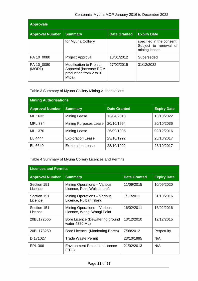
A summary of Myuna’s Approvals (Table 2), Mining Authorities (Table 3) and Licences (Table 4) is presented in the respective tables below.
Table 2 Summary of Myuna Colliery Approvals
Approvals
Approval Number Summary Date Granted Expiry Date
SH. 110/148 Development Consent 21/12/1977 No expiration date
Centennial Myuna MOP January 2016 to December 2022
Page 11 of 97
Approvals
Approval Number Summary Date Granted Expiry Date
for Myuna Colliery specified in the consent. Subject to renewal of mining leases
PA 10_0080 Project Approval 18/01/2012 Superseded
PA 10_0080 (MOD1)
Modification to Project Approval (increase ROM production from 2 to 3 Mtpa)
27/02/2015 31/12/2032
Table 3 Summary of Myuna Colliery Mining Authorisations
Mining Authorisations
Approval Number Summary Date Granted Expiry Date
ML 1632 Mining Lease 13/04/2013 13/10/2022
MPL 334 Mining Purposes Lease 20/10/1994 20/10/2036
ML 1370 Mining Lease 26/09/1995 02/12/2016
EL 4444 Exploration Lease 23/10/1992 23/10/2017
EL 6640 Exploration Lease 23/10/1992 23/10/2017
Table 4 Summary of Myuna Colliery Licences and Permits
Licences and Permits
Approval Number Summary Date Granted Expiry Date
Section 151 Licence
Mining Operations – Various Licence, Point Wolstoncroft
11/09/2015 10/09/2020
Section 151 Licence
Mining Operations – Various Licence, Pulbah Island
1/11/2011 31/10/2016
Section 151 Licence
Mining Operations – Various Licence, Wangi Wangi Point
16/02/2011 16/02/2016
20BL172565 Bore Licence (Dewatering ground water 4380 ML)
13/12/2010 12/12/2015
20BL173259 Bore Licence (Monitoring Bores) 7/08/2012 Perpetuity
D 171027 Trade Waste Permit 23/10/1995 N/A
EPL 366 Environment Protection Licence (EPL)
21/02/2013 N/A

Centennial Myuna MOP January 2016 to December 2022
Page 12 of 97
1.3 Land Ownership
1.3.1 Land Use
The Lake Macquarie Local Environmental Plan 2014 (LMLEP 2014) contains standards that apply to development in Lake Macquarie. It also establishes the types of development that may be permitted on a particular parcel of land with the permission of Council. Some changes were made as directed by the Department of Planning and Environment and Parliamentary Counsel.
The land on which Myuna Colliery is situated is classified by two different land zones under the LMLEP 2014:
SP1 Special Activities Mining applies to the Myuna Colliery Surface Facilities Area.
E2 Environmental Conservation applies to the natural bushland surrounding the surface facilities.
The zone SP1 Mining permits mining and mining associated activities. The zone E2 has a range of developments that are permitted with consent.
Myuna Colliery is surrounded by a mix of land uses and types, including mining, industrial, vegetated and residential land, and is in close proximity to Lake Macquarie.
Lake Macquarie itself is a significant recreation area within the LGA, with activities including recreational fishing, boating, water-skiing and bathing.
Point Wolstoncroft, Wangi Point, Pulbah Island and portions of the foreshore of Myuna Bay (refer to Plan 1C) are designated State Conservation Areas, within the MOP area which are managed by the National Parks and Wildlife Service (NPWS). The Lake Macquarie State Conservation Area includes some 16 kilometres of foreshore vegetated areas and open spaces in different sections around Lake Macquarie which provide important habitat for native flora and fauna species (NPWS, 2005).
The Pulbah Island Nature Reserve is an area of 68 ha located in Lake Macquarie. Nature reserves are areas of land in a predominantly untouched, natural condition which has high conservation value managed by the NPWS.
The MOP Area comprises portions of vegetated and built up areas, including the residential suburbs of Arcadia Vale, Morisset Peninsula, Wangi Wangi, Myuna Bay, Coal Point, Fishing Point and Rathmines. The built up areas of the MOP Area incorporate man-made surface features and infrastructure such as roads, bridges, sewer and water pumping stations, pipelines, fibre optic cables and electrical transmission lines. The Pacific Highway is the closest major transport route, located on the eastern side of Lake Macquarie, one kilometre east of the MOP Area.
There is coal extraction at a number of collieries underneath and surrounding Lake Macquarie including Chain Valley, Mandalong Mine, Mannering and Newstan. With the proximity of coal resources, power generation is also a significant industry in the Lake Macquarie Area, with Eraring Power Station located immediately to the west of the MOP Area and Vales Point Power Stations located to the south.
1.3.2 Land Ownership
The mining area is predominately positioned beneath Lake Macquarie, which is NSW Government Crown land. Freehold land is the other predominant land ownership with in the MOP area.

Centennial Myuna MOP January 2016 to December 2022
Page 13 of 97
Myuna Colliery is situated on, Lot 100 DP880089, land owned by Centennial Fassifern Pty Ltd, a sister company of Centennial Myuna.
The Enclosed Overland Conveyor, which is owned and operated by Eraring Energy is located to the south-west of the Surface Facilities Area. The Enclosed Overland Conveyor is situated on land owned by Eraring Energy, the State of NSW (Crown Land) and Centennial Fassifern Pty Ltd.
1.4 Stakeholder Consultation
Centennial Myuna has consulted with DRE prior to and during the preparation of this MOP. Consultation with other relevant authorities has occurred and is ongoing for all approval submissions and environmental assessments.
Table 5 Stakeholder Consultation
Stakeholder Date Issues
DRE 8th October 2014 Discussion with DRE Officer on development of proposed MOP.
9th October 2014 DRE representative provided material as guidance for the preparation of the MOP.
19th March 2015 Phone conversations with DRE representative to discuss classification of domains and plans.
LMCC 29th July 2015 Phone conversation with a Strategic Land Use Planner to discuss the Colliery site final land use.
LMCC 24th August 2015 Centennial Myuna request for comment on the final land use options being considered by Centennial Myuna for the Myuna Colliery site.
CCC 2nd September 2015 Presentation of MOP and proposed final land use.
LMCC 4th September 2015 LMCC provides comment on the proposed land use options.
DRE 9th October 2015 Phone conversations with DRE representative to discuss the requirements for Plan 1B, 1C and 2.

Centennial Myuna MOP January 2016 to December 2022
Page 14 of 97
2 PROPOSED MINING ACTIVITIES
2.1 Project Description
Myuna Colliery is an underground coal mine owned and operated by Centennial Myuna Pty Limited. Myuna is located 25 km south west of Newcastle NSW in the Lake Macquarie and Wyong Local Government Areas. Myuna Colliery’s Surface Facilities Area is on the western side of Lake Macquarie, at Wangi Wangi,
Myuna Colliery received Project Approval (10_0080) for the Extension of Mining on 18 January 2012. Approval for Modification to PA was received 1st February 2015. PA 10_0080(MOD1) extends mining and coal handling at Myuna Colliery within the Colliery Lease Area and proposes to:
Mine using bord and pillar mining methods in the Wallarah, Great Northern, and Fassifern seams in ML1632 and ML1370, to 2032;
Produce, handle and distribute to Eraring Power Station, up to 3 million tonnes per annum (Mtpa) using existing infrastructure;
Continue the use of ancillary infrastructure and service to 2032;
Upgrade the water management system; and
Rehabilitate the surface facilities within 5 years of completion of mining.
2.1.1 Mining Area
Underground coal miming has been conducted at Myuna Colliery since 1982. Coal has been recovered from three seams (Wallarah, Great Northern and Fassifern) within the Project Application area and Development Consent mining area. The majority of the mining has been conducted under Lake Macquarie.
2.1.2 Mining Method
The method of extraction for these areas is by conventional underground bord and pillar mining methods. The mining system includes:
• Multiple seam mining – first workings or non caving partial pillar extraction systems where multiple seams are to be mined; and
• Single seam mining – first workings, partial pillar extraction or wide panel full extraction.
Two subsidence zones have been established at Myuna Colliery in accordance with the PA10_0080.
• Zone A – long term stable mining systems generating up to 20 millimetres surface subsidence (i.e. no measurable or discernible surface impacts) on sensitive surface features including land and seagrass beds; and
• Zone B – Mining Systems generating up to 650 millimetres surface subsidence (under Lake Macquarie).
The subsidence zones are shown on Appendix 3 of the Project Approval.

Centennial Myuna MOP January 2016 to December 2022
Page 15 of 97
2.2 Asset Register
The Surface Facilities Area encompasses a footprint of approximately 89 hectares, of which 25.2 hectares includes the surface infrastructure. The remainder of the Surface Facilities Area is predominantly natural bushland vegetation, the Wangi Creek watercourse and existing cleared easement corridors. The area of the Primary Domains encompasses the Project Approval and Development Consent approved mining areas and the Myuna Colliery Surface Facilities. The domains within the MOP area and the size in hectares are provided in table 6 and are displayed in Plan 2, Mine Domains at Commencement of MOP Period 2015 – 2022. Table 6 Primary Domains in MOP Area
Code Primary Domains (Operational) Area (ha)
1 Infrastructure Area 14.7
2 Stockpile Area 5.3
3 Down Cast Shaft Area 9.6
4 Lower field 3.9
5 Water Management Area 1.1
6 Remnant Bushland 50.4
7 Underground Mining Area 910
2.2.1 Infrastructure Area
The Infrastructure Area contains the following surface infrastructure:
Mine Infrastructure: • Men and materials portal; • Conveyor drift portal; • Drive houses; • Up-cast ventilation shaft and fan-house; • Power Factor Correction Banks; • Diesel and Oil Tanks; and • Water storage tanks.
Coal Handling Plant: • Breaker and crusher groups, feeders and coal storage bins (ROM bin
and Final Product Bin); and • Surface conveyor systems.
Workshop and administration infrastructure: • Workshop, store and wash down facilities; • Material yard and equipment/oil and gas stores; • Materials reclaim area; • Administration offices and bath house; • Air compressors and associate infrastructure; • Service bay;
Centennial Myuna MOP January 2016 to December 2022
Page 16 of 97
• Hardstand areas, haul roads, car-parking areas and emergency heli-pad; and
• Fire station and associated fire fighting equipment.
Pollution control infrastructure: • Wash down bay oil/water separator; • Primary settlement tank (sump); • CHP Dust suppression system; • Sewerage treatment plant and associated infrastructure; and • Hydrocarbon recycling depot.
Other Infrastructure
Non-mine infrastructure, located at the Surface Facilities Area includes: • Enclosed Overland Conveyor (Eraring Energy owned); • Potable water supplies (Hunter Water Corporation) from Toronto and
Wangi Wangi reservoirs; • Overhead transmission lines (Energy Australia) (including 11kV and
33kV power supplies); • Energy Australia 33kV substation; • Telecommunications (Telstra) network cabling; and • Hunter Water sewage system (Hunter Water Corporation).
2.2.2 Stockpile Area
The Stockpile Area contains the following surface infrastructure:
Emergency coal stockpile pad;
Emergency coal stockpile sediment dam and pump-house;
Haul road; and
Dust suppression system.
2.2.3 Down Cast Shaft Area
The Down Cast Shaft Area contains the following surface infrastructure:
Downcast ventilation shaft;
Security fencing and gate;
Road ballast bore and dump; and
Concrete bore hole with associated infrastructure.
2.2.4 Lower Field
Mine related infrastructure within the lower field area consists of ground water monitoring wells.
2.2.5 Water Management Area
The Water Management Area contains the following surface infrastructure
3 Sediment ponds;
Dewatering pumps;
Aqua duct;
Sub surface stormwater drains; and
Bore hole.

Centennial Myuna MOP January 2016 to December 2022
Page 17 of 97
2.2.6 Underground Mining Area
Mine related surface infrastructure within underground mining area consists of subsidence monitoring point markers on the shoreline of Wangi Wangi, Morisset Peninsula, Point Wolstoncroft and Pulbah Island.
2.3 Activities over the MOP Term
2.3.1 Exploration
The majority of the Colliery reserves lie below Lake Macquarie. Exploration is not only required to define the coal resource, which includes the geometry, seam levels and geological structures, it also serves an important role in determining the solid rock head cover (solid rock mass between the lake bed and the working seams).
Exploration activities will be undertaken during the term of the MOP. The location and timing of the exploration activities is yet to be determined. The exploration activities during the MOP term may include:
Lake drilling – this is used to determine seam levels, geological structures, the solid rock head cover and coal qualities of the coal resource.
Seam-to-seam drilling – this is used to determine seam levels, geological structures and coal qualities of the coal resource.
In-seam drilling – may be carried out as required where no overlying workings exist to provide geological information for mine workings in the three seams.
2.3.2 Construction
There are no construction or demolition activities scheduled for the MOP term.
2.3.3 Mining operations (including mining purposes)
Myuna Colliery has extensive workings in the Wallarah, Great Northern and Fassifern seams and has been extracting coal for over 30 years. The area covered by the Colliery is located in the centre of the Newcastle coalfield, a geological sub-division of the North Eastern Sydney basin. The coal deposits of this area are contained within sedimentary rocks of the late Permian age Newcastle Measures. The coal seams typically extend deeper to the south, therefore a higher depth of cover is observed.
Myuna Colliery will mine coal in accordance with relevant approvals, licences and guidelines sought through various government authorities. Myuna Colliery will be operating in accordance with the Mining Authority titles ML1370, ML1632 and MPL 334 and exploration Leases EL4444 and EL6640. The Planning approval has been given under the Part 3A approval process.
Mine Design
The Project Approval constrains the mining activities at Myuna based on the maximum predicted mine subsidence over the PA area. Mine design criteria are used to manage the predicted subsidence in the design phase of the operation and the predictions are based on latest pillar design principles, local geological characteristics and results of existing subsidence monitoring data.
The subsidence conditions for the PA area are as follows:
Centennial Myuna MOP January 2016 to December 2022
Page 18 of 97
The proponent shall ensure that vertical subsidence within Zone A is limited to a maximum of 20mm and that extraction methods are first workings only;
The proponent shall ensure that vertical subsidence within Zone B is limited to 650mm and second workings are limited to partial pillar extraction within the Great Northern and Fassifern coal seams;
The Project Layout Plan (Appendix 3 of the PA) shows the area of Mining Zone A and Mining Zone B.
Mining Zone A encompasses all areas of land and shoreline (High Water Control Zone) within the PA area.
Mining Zone B encompasses the area from HWLCZ lake ward within the PA area.
The Centennial Myuna mining activities within the Development Consent area are constrained by the High Water Level Control Zone which encompasses all areas of shoreline, as per ML1632 condition 25, within the Development Consent area.
Proposed mining activities during the MOP period are concentrated in the Great Northern and Fassifern seams, but could include workings in the Wallarah seam.
It is proposed to continue the operational structure as reported within the business plan and schedules. As business requirements change within the Centennial group, the mine plan will also adapt to fulfil change management. The adopted mine layout and methods of mining at Myuna Colliery allows for mine design flexibility.
The mining methods will be Place Change Mining, second pass mining and secondary extraction.
Mining Sequence
Myuna Colliery will operate with up to 5 working panels in the proposed MOP term. The operating panels will be relocated into various areas and seams during the proposed MOP term. The number of working panels may change according to requirements and constraints within the business plan. The table below describes the working panels.
Mining will mostly take place in the South Western zone of the Fassifern seam (Plan 3B) and the North Zone and South Zone of the Great Northern Seam (Plan 3A). Unforeseen geological conditions, market requirements and coal quality issues may result in different zones to be mined (including the Wallarah Seam).
Table 7: Myuna Working Panels
Seam Number of working Panels
Proposed Commencement
Proposed Completion
Mining Method
Wallarah Up to 2 Jul-2015 continuing
First workings, Secondary extraction
Great Northern Up to 4 Jul-2015 continuing
First workings, Secondary extraction
Fassifern Up to 4 Jul-2015 continuing
First workings, Second pass and
Secondary extraction

Centennial Myuna MOP January 2016 to December 2022
Page 19 of 97
Mineral Processing
The handling is achieved through a series of conveyors and coal bins which stows, transport and transfer the coal from underground to the customer. Coal is only placed on the Emergency Coal Stockpile Pad in the event of breakdowns or servicing of the Overland Enclosed Conveyor.
The coal processing plant is a sizing plant, consisting of a primary and two secondary crushers. This system delivers a final product size of less than 35mm. The final product is delivered to Eraring Power Station via the Overland Enclosed Conveyor.
Management of coal fines and coal plant dust suppression systems are discussed in the Air Quality and Greenhouse Gas Management Plan.
Mining Equipment
Myuna Colliery operates a fleet of modern mining equipment enabling productive and efficient place change development and extraction methods. The following table outlines the current equipment in use at the mine (these numbers may vary during the Plan period due to operational requirements).
Table 8: Myuna Mining Equipment
Equipment Type Number
Continuous miners Joy 12 CM12 6
Roof bolters Joy Multi Bolters 8
Shuttle Cars Joy / Waracar 14
Breaker Feeder Ontrak – Stamler conversions 6
LHD
Eimco
Coaltram
3
6
Man transporters PJB 10
2.3.4 Rock/overburden emplacement
A negligible amount of waste rock from the CHP is managed by the waste management contractor. The waste is removed from site to a registered waste facility.
2.3.5 Processing Residues and Tailings
Myuna Colliery does not wash ROM coal and there is no coal reject material produced on site.
2.3.6 Waste Management
In 2011 Myuna Colliery moved to total waste management contract. This is to allow for the efficient management and reporting of waste, and also greater recycling through the sorting of waste brought to the surface from underground.
The recyclable material is separated out of the general waste into allocated bins for paper, steel and timber.

Centennial Myuna MOP January 2016 to December 2022
Page 20 of 97
Purpose built oil drainage bins are placed in the Oil Storage Shed and the wash down bay for the collection of waste oil. Waste oil is removed from site by the Waste Management Contractor as per the waste tracking guidelines.
Waste material from the Coal Handling Plant refuse bin is classified as general waste and transported to the appropriate waste facility by the waste contractor. There is no coal processing waste stored on site.
A Trade Waste Permit (permit number D-171027) issued by Hunter Water regulates the discharge of certain liquid wastes to Hunter Water’s sewerage system.
2.3.7 Decommissioning and demolition activities
There are no decommissioning or demolition activities scheduled for the term of the MOP.
2.3.8 Temporary Stabilisation
There are no temporary stabilisation works scheduled for the term of the MOP.
2.3.9 Progressive rehabilitation and completion
There are no rehabilitation activities scheduled for the term of the MOP.
2.3.10 Material Production Schedule
The proposed production schedule for Myuna Colliery over the period covered by this MOP is shown in Table 9. During 2015 Myuna Colliery obtained approval to increase its ROM coal production up to 3,000,000t per annum. Economic and market drivers may necessitate change to the proposed production schedule within the limits of the approval.
Table 9 Material Production during MOP Term
Material Stripped Topsoil
Rock/ Overburden Rock
ROM coal Coarse Reject
Product Coal
Unit M3 M
3 T T T
Year 1 2016 0 0 1,823,463 0 1,823,463
Year 2 2017 0 0 1,821,077 0 1,821,077
Year 3 2018 0 0 1,795,836 0 1,795,836
Year 4 2019 0 0 1,688,142 0 1,688,142
Year 5 2020 0 0 1,484,736 0 1,484,736
Year 6 2021 0 0 1,488,823 0 1,488,823
Year 7 2022 0 0 1,416,913 0 1,416,913
Centennial Myuna MOP January 2016 to December 2022
Page 21 of 97
3 Environmental Issues Management
3.1 Environmental Risk Assessment
The key risks associated with achieving the MOP rehabilitation outcomes at Centennial Myuna Colliery have been identified and assessed in accordance with Centennial Coal’s risk management processes, which follows the general principles outlined in ISO 31000:2009 Risk Management – Principles and Guidelines (Standards Australia). The method used for the risk assessment encompassed the following key steps:
1. Establish the context for the risk assessment process;
2. Identify risks and potential impact;
3. Analyse risks; and
4. Evaluate risks to determine the necessary controls for mitigation.
The Myuna Surface Rehabilitation Risk Assessment is provided in Appendix 3. The risk assessment document lists current or existing controls and recommended controls. The risk assessment is conducted under the framework of the Myuna Mine “WRAC” system- “Workplace Risk Assessment and Control”. Risks ranked between 1-6 are considered as unacceptable high risk. Risks ranked from 7-15 are considered moderate, and new controls should be considered. Risks ranked between 16-25 are considered acceptable / low level risks.
3.2 Environmental Risk Management
Centennial Myuna has an established Environmental Management System (EMS) that has been developed in accordance with the Centennial Coal Environmental Management System Framework (October 2011). The EMS, which has been developed to be generally consistent with the elements of ISO 14001, provides a framework to ensure the effective management of environmental issues and compliance with regulatory requirements for all activities and areas managed by Centennial Myuna. It also provides a means for continued improvement in environmental performance.
As part of this EMS, a comprehensive set of environmental management plans have been developed and implemented at Centennial Myuna in accordance with the relevant conditions of PA 10_0080, EPL 366 and the relevant mineral authorities. The implementation of these plans and the integration of Centennial Coal’s Environmental Management System Framework (October 2011) is a strong focus at Centennial Myuna and demonstrates environmental due diligence. These plans are reviewed and updated as necessary, to reflect operational changes and incorporate requirements, with actions from internal audits being carried out as required. The Environmental Management Plans that have developed as part of the requirements of the Project Approval and Development Consent for Myuna Colliery are listed in Appendix 6 of the MOP.
The environmental management plans are backed by an environmental monitoring network. Monitoring results are reported monthly on Centennial Myuna’s website and an on annual basis in the AEMR.
Centennial Myuna MOP January 2016 to December 2022
Page 22 of 97
3.3 Specific Risks Relating to Rehabilitation
3.3.1 Geology and Geochemistry
Surface soils in the Wangi area and proximate to the surface facilities are classified as part of the Awaba erosional landscape on the Lake Macquarie to Gosford 1:100,000 Map Sheet. The Awaba soil landscape is associated with the Munmorah Conglomerate Formation of the Narrabeen Group, and the Newcastle Coal Measures. The topography of this landscape typically comprises low hills with short side slopes and numerous closely spaced drainage lines. Rock outcrops are usually absent and lenses of mudstone and tuff may occur. This soil landscape generally has a high erosion hazard (Extension of Mining EA Feb 2011).
A comprehensive Rehabilitation Risk Assessment identified that a risk may result from the geology and geochemistry of the site caused by a less than adequate knowledge on inappropriately placed materials, less than adequate knowledge of material and its geochemistry or geological conditions.
It was identified that there is a risk to Centennial Myuna from the discharge of poor quality water from site caused by mine workings flooding and mine water passing through the different geological strata to the surface.
The Myuna Colliery workings are below the sea level elevation. The only potential areas of mine water seepage are the drifts, shafts and boreholes. All of the openings to the Myuna workings are located within the Myuna Colliery site.
The Myuna Colliery shafts and drifts will be filled and sealed in accordance with NSW DTI Resources and Energy (DRE) Mine Design Guideline (MDG) 6001 Guideline for the permanent filling and capping of surface entries to coal seams.
The Myuna Colliery boreholes will be filled and sealed in accordance with the NSW DRE Environmental Management Guideline for Industry EDG01 Borehole Sealing Requirements on Land, Coal Exploration.
Thirteen ground water monitoring wells have been established on the pit top, stockpile pad and lower field areas for the monitoring and assessment of ground water.
A Ground Water Monitoring Program will be implemented post mine closure where mine water seepage has been identified as an issue.
3.3.2 Spontaneous Combustion
Spontaneous Combustion tests have been carried out on the Wallarah, Great Northern and Fassifern Seam coal from Myuna Colliery by Simtars (Report OG420187F1).These tests have found, by R70 testing, that the Wallarah (1.470C/hr) and Fassifern Seams (1.150C/hr) are ranked as having a medium propensity to spontaneously combust, whereas the Great Northern Seam (2.000C/hr) has a high propensity to spontaneously combust. Additional samples from the seams being worked will be tested during the MOP period..
There have been no recorded spontaneous combustion events in more than 30 years of operation at Myuna Colliery in the Wallarah, Great Northern and Fassifern seams. There was a recent (2015) heating event within the Great Northern Seam and in 2011 a heating was recorded at a non-Centennial pit, in the Fassifern seam, prompting a review of the Spontaneous Combustion Hazard Management Plan. Neither of the heating events occurred at Myuna Colliery.
Coal is only placed on the Emergency Coal Stockpile Pad in the event of breakdowns or servicing of the Overland Enclosed Conveyor. The coal stockpile is reclaimed at

Centennial Myuna MOP January 2016 to December 2022
Page 23 of 97
the earliest opportunity. The Emergency Coal Stockpile Pad is maintained at minimum levels.
A comprehensive Rehabilitation Risk Assessment identified that a risk may result from the spontaneous combustion of the coal stockpile pad and the spontaneous combustion of the under ground workings.
At mine closure the Myuna Colliery workings will be sealed and allowed to flood with ground water. The flooding of the mine workings will reduce any risk of spontaneous combustion.
Spontaneous combustion was assessed to be a low risk with the current controls in place.
All coal will be removed from the stockpile pad and pit top areas, contoured and seeded with a suitable material as per the rehabilitation plan.
3.3.3 Acid Mine Drainage
The Acid Sulphate Soils Planning Maps established five classes of land based on the probability of acid sulphate soils being present, as stated in the Acid Sulphate Soils Assessment Guidelines (Ahern, Stone & Blunden 1998), with Acid Sulphate Soil Risk Class 1 having the highest possibility and Acid Sulphate Soil Risk Class 5 having the lowest probability.
Acid Sulphate Soils Risk Class 5 is defined as a possibility if works are carried out within 500 m of adjacent Acid Sulphate Soil Risk Class 1, 2, 3, or 4 which are likely to lower the water table below 1 m AHD on that adjacent land.
According to the Lake Macquarie City Council (LMCC) 2012 Acid Sulphate Soils Risk Maps (LMCC 2012a), the Myuna Colliery site has a Acid Sulphate Soils Risk Class 5.
Portions of the lease area do exist in areas of potential acid sulphate soils, however, there have been no acid mine drainage issues identified at Centennial Myuna, in particular with the surface operations undertaken since the commencement of operations.
A comprehensive Rehabilitation Risk Assessment identified that a risk may result from acid mine drainage caused by a less than adequate knowledge on inappropriately placed materials or less than adequate knowledge of material and its geochemistry.
There are no overburden or reject emplacements at Myuna Colliery. The Emergency Coal Stockpile Pad is maintained at minimum levels. Coal is only stored on the Emergency Stockpile Pad for short periods of time during Eraring Power Stations overland conveyor shutdown and maintenance periods. The coal from the Myuna Colliery workings has a low sulphur content.
Thirteen ground water monitoring wells have been established on the pit top, stockpile pad and lower field areas for the monitoring and assessment of the ground water. A Ground Water Monitoring Program will be implemented post mine closure where acid mine drainage has been identified as a issue.
3.3.4 Mine Subsidence
The term “subsidence” generally refers to the deformation of the ground mass surrounding a mine resulting from the mining activity. The term is a broad one and includes all mining-induced ground movements, including both vertical and horizontal displacement, tilt, strain and curvature (NSW DoP 2008).
Centennial Myuna MOP January 2016 to December 2022
Page 24 of 97
A comprehensive Rehabilitation Risk Assessment identified that a risk may result from subsidence outside of the design criteria as per the Project Approval caused by inadequate geotechnical design or less than adequate depth of cover.
Controls have been implemented to ensure that mining occurs according to the design dimensions. A mining panel inspection system has been implemented to monitor and report any deviation from the plan and the corrective action taken.
Mining Zone A is restricted to First Workings only which are designed to remain stable and non-subsiding.
Vertical subsidence with in Mining Zone B is limited to 650mm and second workings are limited to partial pillar extraction within the Great Northern and Fassifern coal seams. The whole of the Mining Zone B area lies beneath Lake Macquarie. Prior to any secondary workings being undertaken within the Mining Zone B an extraction plan must be developed and approved by the DPE. The Extraction Plan will incorporate a Benthic Communities Management Plan, Seagrass Management Plan and Subsidence Monitoring Program.
Centennial Myuna will not commence or undertake underground mining operations that will potentially lead to subsidence other than in accordance with a Subsidence Management Plan approved by the Director General (Resources and Energy) as per ML1632 condition 8.
A subsidence monitoring program has been implemented for the shore line of the State Conservation Areas (SCA)(Section 1.3.1), Wangi Wangi and Morisset Peninsula. The data collected over a period of 12 years shows there has been no mine induced subsidence associated with first workings.
Mine subsidence was assessed to be a low risk with the current controls in place.
3.3.5 Erosion and Sediment Control
The infrastructure within the Surface Facilities Area is located within a natural depression in the landscape. The majority of the infrastructure is situated on hardstand, and therefore has little exposure to erosion. The upper vegetated catchment within the Surface Facilities Area exhibits a significant degree of erosion and hence sedimentation downstream. Erosion tends to occur along access tracks, which are required for the management of bushfire risks, and in steeply sloping areas.
Soil erosion and sedimentation at the Myuna Colliery is currently managed in accordance with the approved Erosion and Sediment Control Plan (ESCP). The ESCP was developed to control and mitigate erosion and sediment impacts that may arise from Myuna Colliery operations. A summary of the measures to manage erosion and sediment control are:
Diverting surface water runoff around the site;
Capturing runoff from surface facilities / disturbed areas within a sediment dam for treatment;
Installing sediment fencing, hay bales or other suitable controls down slope of disturbed areas to inhibit sediment laden runoff;
Regular inspection and monitoring;
Promptly rehabilitating disturbed areas no longer required for ongoing operations.
Water management systems which transfer sediment laden water to the under ground reservoir for retention and filtration.

Centennial Myuna MOP January 2016 to December 2022
Page 25 of 97
Erosion and sediment management and related control structures are implemented in accordance with the specifications contained in Managing Urban Stormwater – Soils and Construction, Volume 1, 4th edition (Landcom 2004), and Volume 2E Mines and Quarries (DECC, 2008a).
The rehabilitation plan incorporates the EPA design guidelines for contours and erosion and sedimentation control.
A comprehensive Rehabilitation Risk Assessment identified that a risk may result from erosion and sedimentation of rehabilitated areas caused by a failure of sediment control systems or less than adequate water management system or poor design of rehabilitation areas.
Erosion and sediment control was assessed to be a low risk with the current controls in place.
3.3.6 Soil Type and Suitability
Surface soils in the Wangi area and proximate to the surface facilities are classified as part of the Awaba erosional landscape on the Lake Macquarie to Gosford 1:100,000 Map Sheet. The Awaba soil landscape is associated with the Munmorah Conglomerate Formation of the Narrabeen Group, and the Newcastle Coal Measures. The topography of this landscape typically comprises low hills with short side slopes and numerous closely spaced drainage lines. Rock outcrops are usually absent and lenses of mudstone and tuff may occur. This soil landscape generally has a high erosion hazard (Extension of Mining EA Feb 2011).
A comprehensive Rehabilitation Risk Assessment identified that a risk may result from a failure to achieve the rehabilitation outcome prescribed in the MOP caused by a lack of available topsoil material or a lack of knowledge of soil type or an inability to obtain suitable and adequate volumes of top soil.
In year 5 of the MOP term analogue sites will be established in the Down Cast Shaft Domain to determine the criteria for soil characteristics. Centennial Myuna will then undertake a review of the material balance to verify volumes of available suitable topsoils, subsoils and capping materials for rehabilitation. Following completion of the soil balance Centennial Myuna will review suitable soil substitutes such as recycled organics, mulch and mushroom composts, and identify locations for stockpiling. A Soil Procurement Plan will be developed for the procurement of the required volume of suitable materials over the period to mine closure.
The procurement of a suitable soil type for rehabilitation was assessed to be a low risk with the controls in place.
3.3.7 Flora
A comprehensive Rehabilitation Risk Assessment identified that a risk may result from a failure to achieve the rehabilitation outcome prescribed in the MOP caused by;
a failure to manage the EEC; or
a failure to manage unwanted fauna; or
inappropriate selection of local flora; or
From not considering the requirements in rehabilitation planning.
Biodiversity management is conducted in accordance with the Biodiversity Management Plan approved by the DPE.
The Weed Action Plan, produced annually, identifies the areas of high weed growth and provides a schedule of activities for weed control.
Centennial Myuna MOP January 2016 to December 2022
Page 26 of 97
The Terrestrial Flora and Fauna Impact Assessment (Feb 2011) identified EEC Swamp Sclerophyll Forest along Wangi creek and adjacent to the Colliery site. An annual monitoring program has been implemented and will be reported in the Annual Environmental Management Report.
Flora was assessed to be a low risk with the controls in place.
3.3.8 Fauna
A comprehensive Rehabilitation Risk Assessment identified that a risk may result from a failure to achieve the rehabilitation outcome prescribed in the MOP caused by a failure to manage feral fauna.
Centennial Myuna has implemented a pest control program which involves monthly servicing and inspections.
Failure to achieve rehabilitation due to fauna was assessed to be a low risk with the controls in place.
3.3.9 Overburden Characterisation
Overburden characterisation is not applicable to the Myuna Colliery site.
3.3.10 Slopes and Slope Management
A comprehensive Rehabilitation Risk Assessment identified that a risk may result from long term stability failure of batters and slopes.
Myuna Colliery has an Erosion and Sediment Control Plan approved by the DPE. Slopes and batters will be designed implemented in accordance with the specifications contained in Managing Urban Stormwater – Soils and Construction, Volume 1, 4th edition (Landcom 2004), and Volume 2E Mines and Quarries (DECC, 2008a).
The failure of slopes and batters was assessed to be a low risk with the controls in place.
3.3.11 Surface Water
Surface water is managed in accordance with the approved Water Management Plan (WMP). The WMP was prepared to satisfy conditions specified by the Project Approval 10_0080 for the extension to underground coal mining activities for Centennial Myuna.
A Water Monitoring Program is a component of the WMP and includes monitoring of Myuna Colliery mine water discharge and background monitoring of Wangi Creek and Lake Macquarie.
A comprehensive Rehabilitation Risk Assessment identified that a risk may result from a failure to achieve the rehabilitation outcome prescribed in the MOP caused by;
a failure to remove all contaminants from the area; or
Less than adequate water management system and/or design.
The mine water settlement ponds will be emptied, contaminants removed and the ponds filled with earth. The storm water drains will be retained for the surface water management of the site post mine closure.
The general principles, as outlined in the WMP for surface water management on site include:
Centennial Myuna MOP January 2016 to December 2022
Page 27 of 97
To prevent the degradation in quality of surface water in compliance with
appropriate ANZECC guidelines to protect water quality in creeks and
streams;
Conformance of all water extractions with licensing requirements;
Diversion of external catchment runoff through a series of clean water
diversions which direct the flow of surface water from clean catchments away
from dirty catchment areas;
Separation of clean and dirty water;
Dirty water capture, treat and release.
A failure to achieve rehabilitation outcomes due to surface water contamination or inadequate system management was assessed to be a low risk with the controls in place.
3.3.12 Groundwater
The Groundwater Monitoring Program (GWMP) and Ground Water Model has been developed by Centennial Myuna in accordance with Schedule 3 condition 26 of the Project Approval 10_0080 and approved by the DPE. The GWMP is a component of the Myuna Colliery WMP.
A comprehensive Rehabilitation Risk Assessment identified that a risk may result from a failure to achieve the rehabilitation outcome prescribed in the MOP caused by the mine filling with water due to mine closure and resulting in mine water seepage from an opening or through strata.
The mine workings are below sea level elevation. The only potential areas of mine water seepage are the drifts, shafts and boreholes. All of the openings to the mine are located within the surface facilities area and rise above the sea level elevation in a range of 10m to 30 m.
The Myuna Colliery shafts and drifts will be filled and sealed in accordance with NSW DRE MDG 6001 Guideline for the permanent filling and capping of surface entries to coal seams.
The Myuna Colliery boreholes will be filled and sealed in accordance with the NSW DRE EDG01 Borehole Sealing Requirements on Land, Coal Exploration.
A failure to achieve the rehabilitation outcome due to mine water seepage was assessed to be a moderate risk with the controls in place.
A ground water monitoring program will be implemented post mine closure.
3.3.13 Contaminated Land
A comprehensive Rehabilitation Risk Assessment identified that a risk may result from a failure to achieve the rehabilitation outcome prescribed in the MOP caused by;
contaminated land occurring on the site at closure; or
Less than adequate knowledge of contaminated land.
A Targeted Phase 2 Environmental Site Assessment (ESA) was conducted, by AECOM 2013, subsequent to the decommissioning by foam filling of the Underground Petroleum Storage Systems (UPSS) infrastructure. The objective of the Phase 2 ESA was to assess the presence of soil, sediment, surface water and ground water contamination in targeted areas which have been identified as areas of potential concern within the Site and to determine Centennial’s remedial obligations.

Centennial Myuna MOP January 2016 to December 2022
Page 28 of 97
The targeted Phase 2 ESA identified on-site Phase separated hydrocarbons, soil and ground water impact and off-site sediment and surface water impact related to historic and current Site mining operations, which under the Contaminated Land Management Amendment Act 2008 triggered the duty to report to the NSW EPA. Centennial Coal had reported Myuna Colliery to the EPA in a letter dated 2nd February 2012. The EPA responded to Centennial acknowledging receipt of the Duty to Report letter and Centennial’s commitment to staged investigation and remediation works at its mine sites.
The recommendations of the Phase 2 Assessment are:
o Recommended works to be conducted in the short term:
Undertake a comprehensive hydraulic investigation including but not limited to the assessment of the hydraulic gradient of the groundwater.
Delineate the extent of the PSH plume and petroleum hydrocarbon impacted groundwater, further down gradient of the decommissioned UST’s and towards Wangi Creek.
Document the nature and location of the identified PSH, TPH impacted soils and ground water across the site in Centennial’s Environmental Management Plan.
Undertake a Human Health and Ecological Risk Assessment.
o Recommended works to be conducted in the mid to long term:
Undertake an additional ground water monitoring event of the existing well network
Undertake additional sediment sampling and analysis along Wangi Creek, particularly but not limited to up gradient of the site nearer to SS01 sediment sampling location.
Characterise soils and ground water beneath the existing building footprints.
Contaminated land was assessed to be a significant risk with the controls in place.
Hydrocarbon contamination has been identified in Domain 1, Domain 2 and Domain 5. Further investigations will be undertaken within the MOP term to determine the extent of the contamination at the identified locations and the connectivity between the locations. Remediation options will be assessed based on the outcomes of the extent and connectivity investigation.
3.3.14 Hazardous Materials
Hazardous Materials Surveys and Registers were developed in 2012 for Centennial Myuna. The Register and Survey is available to all personnel on site. The objective of the survey was to determine, as far as practicable, the extent, type and condition of hazardous materials on surface areas, buildings and associated infrastructure at the site. The handling of hazardous materials is conducted in accordance with the Centennial Myuna Hazard Management Plan and Asbestos Management Plan.
A comprehensive Rehabilitation Risk Assessment identified that a risk may result from a failure to achieve the rehabilitation outcome prescribed in the MOP caused by hazardous materials and dangerous goods remaining on the site at mine closure.
Centennial Myuna MOP January 2016 to December 2022
Page 29 of 97
Hazardous materials and dangerous goods were assessed to be a low risk with the controls in place.
3.3.15 Greenhouse Gases, Methane Drainage
Greenhouse gas and methane drainage was managed as per the Air Quality and Greenhouse Gas Management Plan. Estimation of the GHG emissions associated with the Myuna Colliery was undertaken using the emission factors and methods outlined in the National Greenhouse and Energy Reporting (Measurement) Determination 2008.
A comprehensive Rehabilitation Risk Assessment identified that a risk may result from a failure to achieve the rehabilitation outcome prescribed in the MOP caused by;
Inadequate seal between workings and surface; or
Seam gas pressure higher than underground workings water pressure.
The mine closure will be conducted in accordance with the NSW DRE MDG 6001 Guideline for the permanent filling and capping of surface entries to coal seams.
Greenhouse gasses and methane drainage venting was assessed to be a low risk with the controls in place.
3.3.16 Air Quality
A comprehensive Rehabilitation Risk Assessment identified that a risk may result from increased air borne dust caused by;
rehabilitation / closure activities; or
Inability to rehabilitate disturbed areas.
Air Quality at the Centennial Myuna operation is managed in accordance with the DPE approved Air Quality and Greenhouse Gas Management Plan.
The objectives of the AQMP are to fulfil the requirements of Schedule 2, Conditions 16 and 17 of the Centennial Myuna Project Approval (PA 10_0080 MOD1) and any Environment Protection Licence requirements.
Controls have been put in place to control potential sources of air pollution.
The control measures outlined in the Management Plan include:
enclosed conveyors;
road sweeping of hardstand areas;
haul road sprinklers system;
speed limit of 20km on site;
Emergency stockpile pad is maintained at a minimum.
Air quality was assessed to be a low risk with the controls in place.
3.3.17 Noise
Noise Emissions from the Myuna Colliery operations is managed in accordance with the approved Noise Monitoring and Management Plan (NMMP). The NMMP outlines noise monitoring that is required to be undertaken to measure compliance with statutory requirements and applies to the surface operations at Myuna Colliery.
Noise emission risks were not applicable to the Myuna Colliery rehabilitation.
Centennial Myuna MOP January 2016 to December 2022
Page 30 of 97
3.3.18 Blasting
Blasting is not applicable to the Myuna Colliery rehabilitation.
3.3.19 Visual and Lighting
The Myuna site is bounded by native vegetation in all directions with the site entry from Old Wangi Road adjacent to Wangi Power Station to the east.
A comprehensive Rehabilitation Risk Assessment identified that a risk may result from a failure to achieve the rehabilitation outcome prescribed in the MOP caused by inadequate mine closure planning.
Visual and lighting was assessed to be a low risk with the controls in place.
3.3.20 Heritage
A comprehensive Rehabilitation Risk Assessment identified that a risk may result from a disturbance of an Aboriginal cultural heritage site caused by an unintended interaction with an unidentified heritage site.
The Centennial Coal Northern Region Aboriginal and Cultural Heritage Management Plan aims to provide a consistent approach to consultation between Centennial and the Aboriginal community as well as identify standard Aboriginal cultural heritage monitoring and management requirements. This Aboriginal Cultural Heritage Management Plan (ACHMP) should be used by Centennial personnel to ensure that the appropriate protocols are adopted for the identification, monitoring and management of Aboriginal material culture. The structure of the management plan has been designed as an over-arching document which must be followed in conjunction with specific development consent requirements for each operation within the Northern Holdings. The ACHMP is included in Appendix 6
There have been no Aboriginal Cultural Heritage sites identified within the Myuna Colliery site.
Disturbance of an Aboriginal cultural heritage site was assessed to be a low risk with the controls in place.
3.3.21 Bushfire
Bushfire risk for Centennial Myuna’s operations is managed in accordance with the Centennial Myuna Bush Fire Management Plan. The preventative management actions include the following:
Maintaining firebreaks surrounding Centennial Myuna operations;
Providing fire fighting equipment at Centennial Myuna operations;
Trained and competent personnel on-site who can conduct fire-fighting if
required;
Regular dialogue with the local Rural Fire Service (RFS) in relation to
Bushfire Management Practices;
Fuel loading assessment conducted by the RFS; and
Site hazard reduction burns conducted by the RFS.
A comprehensive Rehabilitation Risk Assessment identified that a risk may result from a failure to achieve the rehabilitation outcome prescribed in the MOP caused by;
Combustion of course and fine coal rejects in a bushfire; or
Loss of established rehabilitation due to bushfire; or
Centennial Myuna MOP January 2016 to December 2022
Page 31 of 97
Tree roots infiltrating capping.
The carbonaceous material in the land fill that forms the stockpile pad will be removed from the area and disposed underground. The area will be covered with greater than 100 mm of suitable material and seeded.
Bushfire was assessed to be a low risk with the controls in place.
3.3.22 Drought
A comprehensive Rehabilitation Risk Assessment identified that a risk may result from a failure to achieve the rehabilitation outcome prescribed in the MOP caused by drought conditions when completing final rehabilitation.
The mine water is not considered to be of suitable quality for the irrigation of the rehabilitated land due to the high electrical conductivity (Ec). The annual average Ec for the mine water discharge is 34,000 micro seimens per centimetre.
Irrigation would be conducted if required by water cart or an irrigation system connected to the potable line.
Drought was assessed to be a low risk with the controls in place.
3.3.23 Settlement in Rehabilitation Areas
A comprehensive Rehabilitation Risk Assessment identified that a risk may result from a failure to achieve the rehabilitation outcome prescribed in the MOP caused by;
Inadequate mine closure planning and design; or
Settlement of material after rehabilitation activity; or
Wrong selection of materials.
The filling, capping and sealing of the mine openings will be completed in accordance with the NSW DRE Mine Design Guideline (MDG) 6001 Guideline for the permanent filling and capping of surface entries to coal seams.
Settlement in rehabilitated areas was assessed to be a low risk with the controls in place.
3.3.24 Land Zoning
The Lake Macquarie Local Environmental Plan 2014 (LMLEP 2014) is the legal instrument that imposes local standards to control development, including the allocation of land use zones.
The Myuna Colliery site is situated on Lot 100 DP880089 Wangi Wangi. There are two LMLEP land use zone classifications covering the Lot. The surface infrastructure area which is central to the lot is zoned Special Activities Mining (SP1). The northern and southern sections of the lot are zoned Environmental Conservation (E2).
The lot is bounded by Wangi road, Summerhill drive and Donnelly road. The neighbouring properties which lie to the west of the site is zoned E2, to the north of the site is zoned SP2 Infrastructure and to the east of the site is zoned B4 Mixed Use and R3 Medium Density Residential.
The SP1 zone classification permits mining development and mining associated development. Following mine closure the land use zone SP1 Mining will no longer be relevant to the site and a Rezoning/ LEP Amendment Request will by required.
The proposed final land use of light industrial / mixed use would require the site to be rezoned Light Industrial (IN2) or Mixed Use (B4) under the LMLEP 2014. The
Centennial Myuna MOP January 2016 to December 2022
Page 32 of 97
neighbouring properties to the east of the site, Wangi Power station, have the land use zone classification Mixed Use B4 and Medium Density Residential R3.
The proposed final land use of light industrial / mixed use is compatible with the surrounding LMLEP 2014 land use zones.
There are two distinct sections within the area zoned E2 Environmental Conservation.
The northern section is predominantly undisturbed remnant bush land apart from easements for services and fire access trails. There is no rehabilitation required in this area.
The southern section contains undisturbed remnant bushland, the downcast shaft compound, the skulls bin and a cleared area historically used for horse paddocks. The infrastructure will be removed, the shafts sealed and capped and the area rehabilitated back to predevelopment natural bushland. The area is identified in plan 2 as Primary Domain 3 Down Cast Shaft and Secondary Domain B Forest.
The proposed final land use of predevelopment natural bushland for Domain 3 Down Cast Shaft Area and Domain 6 Remnant Bushland is compatible with the current LMCC land use zone classification E2. A request for rezoning of the section zoned E2 will not be required.
Consultation on the final land use options for the Myuna Colliery site was undertaken with LMCC. LMCC provided the following comments on the proposed land use options being considered by Centennial Myuna:
“The proposed rehabilitation of SP1 zoned land to a final land use compatible with light industry is generally consistent with the existing land use. The existing use is an industrial activity, and a future light industrial land use would allow the land to continue to be used for employment purposes. Given this, light industry is likely to be a suitable land use option.”
“The proposed rehabilitation of E2 zoned land to predevelopment natural bushland is consistent with the existing objectives of the zone, and no adverse land use planning implications have been identified with this land use option. Given this, rehabilitation of the land to predevelopment natural bushland is likely to be a suitable land use option.”
The LMCC Lifestyle 2030 Strategy (LS2030) provides the long-term direction for the overall development of the City and describes Council’s high level policies for managing private and public development in Lake Macquarie. LS2030 is the primary guiding document for the development of local plans, regulations and guidelines that control development of land.
The Strategic Plan Maps identify the preferred pattern of development for the City and form a graphic description of how LS2030’s aims and directions will be achieved. The Urban Change and Investigation Map shows the areas zoned for medium and higher density residential development, those areas identified by the council for investigation for possible rezoning for urban uses, and those areas identified as proposed employment land or proposed urban area in the Lower Hunter Regional Strategy. These areas are likely to be the focus for change and development under LS2030. The Area of the Myuna Colliery Site has been identified on the Urban Change and Urban Investigation Map as Core Commercial and Living Urban Area.
The proposed final land use of the light industrial / mixed use for the area currently zoned SP1 and predevelopment natural bushland for the area zoned E2 is compatible with the LMCC LS2030.
A comprehensive Rehabilitation Risk Assessment identified that a risk may result from a failure to achieve the rehabilitation outcome prescribed in the MOP caused by
Centennial Myuna MOP January 2016 to December 2022
Page 33 of 97
the prescribed rehabilitation outcome being inconsistent with the Local Government land zoning.
Land use zoning was assessed to be a moderate risk with the controls in place.
Further consultation will be undertaken with LMCC in regard to the future land use of Myuna Colliery prior to the mine closure.

Myuna Colliery MOP January 2016 to December 2022
Page 34 of 97
4 Post Mining Land Use 4.1 Regulatory Requirements
The regulatory requirements specific to post mining land use and rehabilitation outcomes at Myuna Colliery are summarised in Table 10.
Table 10 Regulatory Requirements
Subject Approval
Condition
Rehabilitation / Management Requirement Timing Location
Rehabilitation Objectives
10_0080 MOD1
Schedule 3 Condition 33
The Proponent shall rehabilitate the surface facilities to the satisfaction of the Executive Director Mineral Resources. This rehabilitation must be generally consistent with the proposed rehabilitation strategy described in the EA, and comply with the objectives in Table 7.
Surface Facilities – Safe, stable & non-polluting. Final Land use compatible with surrounding land uses.
Project surface infrastructure - To be decommissioned and removed, unless the Executive Director Mineral Resources agrees otherwise.
Portals and vent shafts - To be decommissioned and made safe and stable. Retain habitat for threatened species (e.g. bats), where practicable.
Community - Ensure public safety. Minimise the adverse socio-economic effects associated with mine closure.
Notes: These rehabilitation objectives apply to all subsidence impacts and environmental consequences caused by mining taking place after the date of this approval; and to all project surface infrastructure part of the project, whether constructed prior to or following the date of this approval.
Rehabilitation of subsidence impacts and environmental consequences cause by mining which took place prior to the date of this approval may be subjected to the requirements of other approvals (e.g. under a mining lease or a Subsidence Management Plan approval) or the Proponents commitments.
Mine Closure All Areas
Progressive Rehabilitation
10_0080 MOD1
Schedule 3 Condition 34
The proponent shall carry out the rehabilitation of the site progressively, that is, as soon as reasonably practicable following disturbance.
Ongoing throughout mine life.
All areas
Rehabilitation Management
10_0080 MOD1
Schedule 3
The Proponent shall prepare and implement a Rehabilitation Management Plan for the project to Current MOP All areas
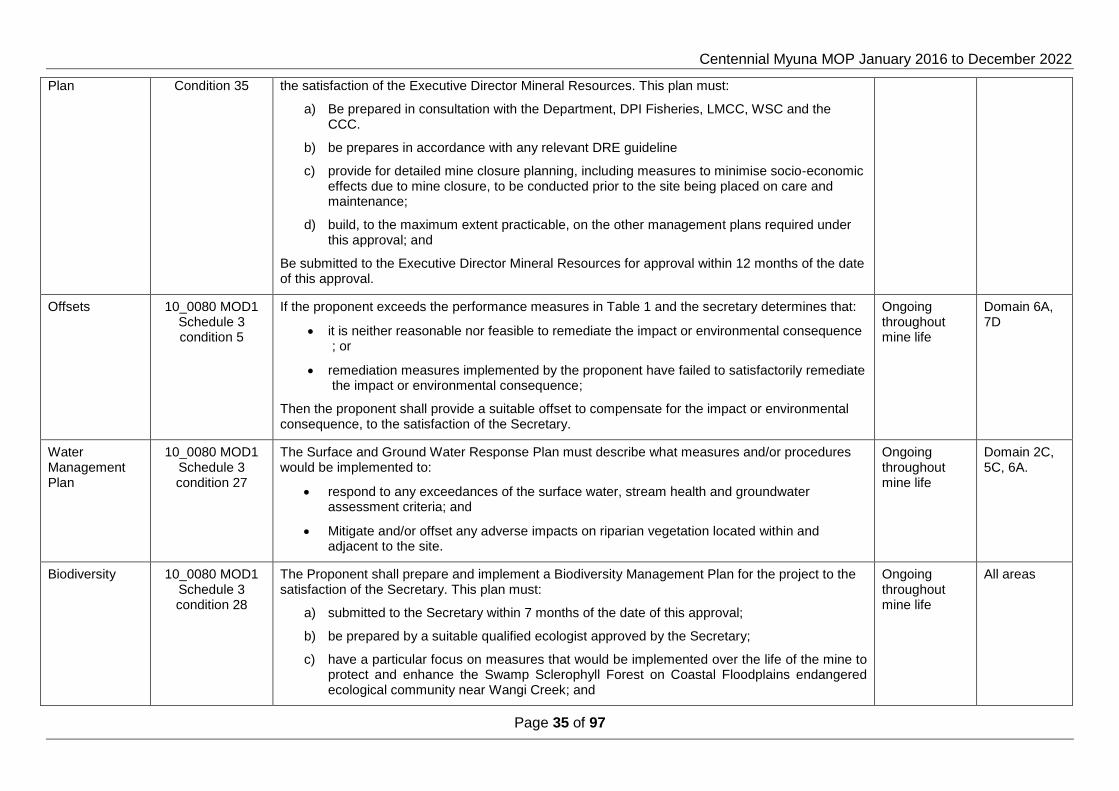
Centennial Myuna MOP January 2016 to December 2022
Page 35 of 97
Plan Condition 35 the satisfaction of the Executive Director Mineral Resources. This plan must:
a) Be prepared in consultation with the Department, DPI Fisheries, LMCC, WSC and the CCC.
b) be prepares in accordance with any relevant DRE guideline
c) provide for detailed mine closure planning, including measures to minimise socio-economic effects due to mine closure, to be conducted prior to the site being placed on care and maintenance;
d) build, to the maximum extent practicable, on the other management plans required under this approval; and
Be submitted to the Executive Director Mineral Resources for approval within 12 months of the date of this approval.
Offsets 10_0080 MOD1 Schedule 3 condition 5
If the proponent exceeds the performance measures in Table 1 and the secretary determines that:
it is neither reasonable nor feasible to remediate the impact or environmental consequence ; or
remediation measures implemented by the proponent have failed to satisfactorily remediate the impact or environmental consequence;
Then the proponent shall provide a suitable offset to compensate for the impact or environmental consequence, to the satisfaction of the Secretary.
Ongoing throughout mine life
Domain 6A, 7D
Water Management Plan
10_0080 MOD1 Schedule 3 condition 27
The Surface and Ground Water Response Plan must describe what measures and/or procedures would be implemented to:
respond to any exceedances of the surface water, stream health and groundwater assessment criteria; and
Mitigate and/or offset any adverse impacts on riparian vegetation located within and adjacent to the site.
Ongoing throughout mine life
Domain 2C, 5C, 6A.
Biodiversity 10_0080 MOD1 Schedule 3 condition 28
The Proponent shall prepare and implement a Biodiversity Management Plan for the project to the satisfaction of the Secretary. This plan must:
a) submitted to the Secretary within 7 months of the date of this approval;
b) be prepared by a suitable qualified ecologist approved by the Secretary;
c) have a particular focus on measures that would be implemented over the life of the mine to protect and enhance the Swamp Sclerophyll Forest on Coastal Floodplains endangered ecological community near Wangi Creek; and
Ongoing throughout mine life
All areas
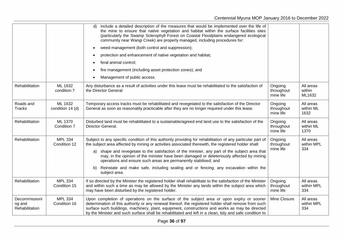
Centennial Myuna MOP January 2016 to December 2022
Page 36 of 97
d) include a detailed description of the measures that would be implemented over the life of the mine to ensure that native vegetation and habitat within the surface facilities sites (particularly the Swamp Sclerophyll Forest on Coastal Floodplains endangered ecological community near Wangi Creek) are properly managed, including procedures for:
weed management (both control and suppression);
protection and enhancement of native vegetation and habitat;
feral animal control;
fire management (including asset protection zones); and
Management of public access.
Rehabilitation ML 1632 condition 7
Any disturbance as a result of activities under this lease must be rehabilitated to the satisfaction of the Director General
Ongoing throughout mine life
All areas within ML1632
Roads and Tracks
ML 1632 condition 14 (d)
Temporary access tracks must be rehabilitated and revegetated to the satisfaction of the Director General as soon as reasonably practicable after they are no longer required under this lease.
Ongoing throughout mine life
All areas within ML 1632
Rehabilitation ML 1370 Condition 7
Disturbed land must be rehabilitated to a sustainable/agreed end land use to the satisfaction of the Director-General.
Ongoing throughout mine life
All areas within ML 1370
Rehabilitation MPL 334 Condition 12
Subject to any specific condition of this authority providing for rehabilitation of any particular part of the subject area affected by mining or activities associated therewith, the registered holder shall:
a) shape and revegetate to the satisfaction of the minister, any part of the subject area that may, in the opinion of the minister have been damaged or deleteriously affected by mining operations and ensure such areas are permanently stabilised; and
b) Reinstate and make safe, including sealing and or fencing, any excavation within the subject area.
Ongoing throughout mine life
All areas within MPL 334
Rehabilitation MPL 334 Condition 15
If so directed by the Minister the registered holder shall rehabilitate to the satisfaction of the Minister and within such a time as may be allowed by the Minister any lands within the subject area which may have been disturbed by the registered holder.
Ongoing throughout mine life
All areas within MPL 334
Decommissioning and Rehabilitation
MPL 334 Condition 16
Upon completion of operations on the surface of the subject area or upon expiry or sooner determination of this authority or any renewal thereof, the registered holder shall remove from such surface such buildings, machinery, plant, equipment, constructions and works as may be directed by the Minister and such surface shall be rehabilitated and left in a clean, tidy and safe condition to
Mine Closure All areas within MPL 334

Centennial Myuna MOP January 2016 to December 2022
Page 37 of 97
the satisfaction of the Minister.
Rehabilitation MPL 334 Condition 17
If so directed by the Minister the registered holder shall rehabilitate to the satisfaction of the Minister and within such time as may be allowed by the Minister any lands within the subject area which may have been disturbed by mining or prospecting operations whether such operations were or were not carried out by the registered holder.
Ongoing throughout mine life
All areas within MPL 334
Rehabilitation MPL 334 Condition 23
The registered holder shall plant such grasses, trees or shrubs or such other vegetation as may be required by the Minister and care for the same during the currency of this authority or any renewal thereof, to the satisfaction of the Minister.
Ongoing throughout mine life
All areas within MPL 334
Rehabilitation MPL 334 Condition 26
The registered holder shall cover with top dressing material, to the Minsters satisfaction, such parts of the subject area as may be stipulated by the Minister and shall plant and maintain, to the Ministers satisfaction, such grasses, trees or shrubs or such other vegetation as may be required by the minister.
Ongoing throughout mine life
All areas within MPL 334
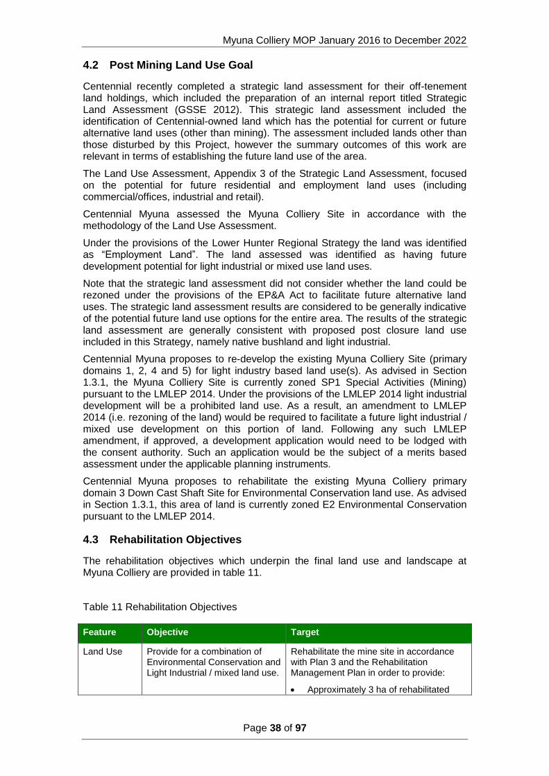
Myuna Colliery MOP January 2016 to December 2022
Page 38 of 97
4.2 Post Mining Land Use Goal
Centennial recently completed a strategic land assessment for their off-tenement land holdings, which included the preparation of an internal report titled Strategic Land Assessment (GSSE 2012). This strategic land assessment included the identification of Centennial-owned land which has the potential for current or future alternative land uses (other than mining). The assessment included lands other than those disturbed by this Project, however the summary outcomes of this work are relevant in terms of establishing the future land use of the area.
The Land Use Assessment, Appendix 3 of the Strategic Land Assessment, focused on the potential for future residential and employment land uses (including commercial/offices, industrial and retail).
Centennial Myuna assessed the Myuna Colliery Site in accordance with the methodology of the Land Use Assessment.
Under the provisions of the Lower Hunter Regional Strategy the land was identified as “Employment Land”. The land assessed was identified as having future development potential for light industrial or mixed use land uses.
Note that the strategic land assessment did not consider whether the land could be rezoned under the provisions of the EP&A Act to facilitate future alternative land uses. The strategic land assessment results are considered to be generally indicative of the potential future land use options for the entire area. The results of the strategic land assessment are generally consistent with proposed post closure land use included in this Strategy, namely native bushland and light industrial.
Centennial Myuna proposes to re-develop the existing Myuna Colliery Site (primary domains 1, 2, 4 and 5) for light industry based land use(s). As advised in Section 1.3.1, the Myuna Colliery Site is currently zoned SP1 Special Activities (Mining) pursuant to the LMLEP 2014. Under the provisions of the LMLEP 2014 light industrial development will be a prohibited land use. As a result, an amendment to LMLEP 2014 (i.e. rezoning of the land) would be required to facilitate a future light industrial / mixed use development on this portion of land. Following any such LMLEP amendment, if approved, a development application would need to be lodged with the consent authority. Such an application would be the subject of a merits based assessment under the applicable planning instruments.
Centennial Myuna proposes to rehabilitate the existing Myuna Colliery primary domain 3 Down Cast Shaft Site for Environmental Conservation land use. As advised in Section 1.3.1, this area of land is currently zoned E2 Environmental Conservation pursuant to the LMLEP 2014.
4.3 Rehabilitation Objectives
The rehabilitation objectives which underpin the final land use and landscape at Myuna Colliery are provided in table 11.
Table 11 Rehabilitation Objectives
Feature Objective Target
Land Use Provide for a combination of Environmental Conservation and Light Industrial / mixed land use.
Rehabilitate the mine site in accordance with Plan 3 and the Rehabilitation Management Plan in order to provide:
Approximately 3 ha of rehabilitated

Centennial Myuna MOP January 2016 to December 2022
Page 39 of 97
native forest.
Approximately 9.7 ha of rehabilitated land suitable for light industrial / mixed use development .
Retained hardstand and building infrastructure for light industrial /mixed use.
Landform Provide a geo-technically stable landform.
Geotechnical assessment based on site specific review and, if required, computer modelling determines that the retained slopes are not likely to actively erode or slip to an extent requiring further earthworks and profiling.
Provide a non polluting landform.
Water quality monitoring results show the land form is non-polluting within the meaning of Section 120 of the Protection of the Environment and Operations Act 1997. In particular downstream water quality monitoring will record total suspended solids <50mg/L or within 10% of upstream levels (which ever is greater).
Hazardous materials maintained in a safe condition or removed by a licenced contractor to a registered waste facility.
Ensure all portals and vent shafts are sealed safe and secure.
Shafts and drifts to be sealed to MDG 6001 guidelines. Boreholes to be sealed to EDG01 guidelines.
Biodiversity Revegetated areas provide a vegetation community with maintenance requirements no greater than adjoining vegetation not disturbed by mining activities.
Rehabilitation monitoring confirms that the established vegetation communities are self sustaining (refer to table 14 for detailed criteria).
Revegetated areas contain species consistent with surrounding vegetation communities.
Rehabilitation monitoring confirms that non-native and target species (weeds) represent less than 10% of projected foliage cover or equivalent to surrounding vegetation not disturbed by mining activities.
Maintain or improve the species diversity and habitat value of the areas within the Mining Lease that will not be disturbed by mining activities.
Manage the Mining Lease in accordance with the Biodiversity Management Plan.
Other Allow for the relinquishment of the Mining Lease and the return of the security lodged over the Mining Lease within a reasonable time frame after the end of mine life.
12 years after end of mine life.
Community Ensure public safety. Public access restricted

Centennial Myuna MOP January 2016 to December 2022
Page 40 of 97
5 Rehabilitation Planning and Management
5.1 Domain Selection
A domain is a land management unit within ML1632 and MPL334. For the purposes of this MOP, the domain comprises primary and secondary domains as follows:
1. Primary or operational domains - categorised on the basis of mine related activities occurring within each domain.
2. Secondary or post mining land use domains – categorised on the basis of similar post mining land use objectives and rehabilitation outcomes.
Table 12 Primary (Operational) and Secondary Domains
Code Primary Domains (Operational)
Code
Secondary Domains (Post Mining Land Use)
1 Infrastructure Area A Rehabilitation Area - Woodland
2 Stockpile Area B Rehabilitation Area - Forest
3 Down Cast Shaft Area C Development Site
4 Lower Field D Lake Macquarie
5 Water Management Area E Land and Shoreline
6 Remnant Bushland Area F Light Industrial
7 Underground Mining Area
5.1.1 Primary Domains
Plan 2 presents the location of the primary domains and the following subsections provide a description of each.
Domain 1 – Infrastructure Area
Domain 1 is the area of the Myuna Colliery surface facilities which includes the administration block, bathhouse, workshop, CHP, fan house, hardstand, drifts, storm water drains, all access roads and the haul road.
Domain 2 – Stockpile Area
Domain 2 is the emergency stockpile area and incorporates the emergency stockpile pad, the stockpile dam, LDP A and an area of land fill to the north west of the stock pile pad bounded by the former rail way easement and Wangi Creek.
Domain 3 – Downcast Shaft Area
Domain 3 is the down cast shaft area which incorporates the down cast shaft compound, the road ballast compound and borehole and a cleared paddock historically used for stock agistment. The Down Cast Shaft Area contains remnant stands of Coastal Foothills Spotted Gum Iron bark Forest and Coastal Plains Smooth Barked Apple Woodland.

Centennial Myuna MOP January 2016 to December 2022
Page 41 of 97
Domain 4 – Lower Field
Domain 4 is the area to the north east of the surface facilities and incorporates the area bounded by the mine water discharge channel, the former Wangi power station and Old Wangi road.
Domain 5 - Water Management Area
Domain 5 incorporates the CHP dam, mine water settlement pond 2 and 3, LDP B, borehole and the mine water discharge channel.
Domain 6 - Remnant Bushland Area
Domain 6 incorporates the remnant natural bushland containing Coastal Plains Smooth Barked Apple Woodland, Coastal Plains Scribbly Gum Woodland, Riparian Melaleuca Swamp Woodland and Coastal Foothills Spotted Gum Iron Bark Forest within lot 100 DP880089 and to the north, west and south of the surface facilities.
Domain 7 - Underground Mining Area
Domain 7 incorporates the area of ML1632 excluding Lot 100 DP880089.
5.1.2 Secondary Domains
Domain A – Rehabilitation Area - Woodland
Domain A incorporates the area of Coastal Plains Smooth Barked Apple Woodland, Coastal Plains Scribbly Gum Woodland, Riparian Melaleuca Swamp Woodland and Coastal Foothills Spotted Gum Iron Bark Forest within lot 100 DP880089 and to the north, west and south of the surface facilities.
Domain B – Rehabilitation Area - Forest
Domain B incorporates the area of Coastal Foothills Spotted Gum Iron bark Forest and Coastal Plains Smooth Barked Apple Woodland within lot100 DP880089 and to the south east of the surface facilities.
Domain C – Development Site
Domain C incorporates the emergency stockpile area, the lower field area and the mine water discharge channel.
Domain D – Lake Macquarie
Domain D incorporates the area of Lake Macquarie within ML1632.
Domain E – Shoreline and Land
Domain E incorporates the area of land within ML1632 and excluding lot 100 DP880089.
Domain F – Light Industrial
Domain F is the area of Myuna Colliery surface facilities and incorporates the administration block, bathhouse, workshop, hardstand, car park, storm water drains, landscaped lawns, all access roads and the haul road.

Myuna Colliery MOP January 2016 to December 2022
Page 42 of 97
5.2 Domain Rehabilitation Objectives
TABLE 13 DOMAIN REHABILITATION OBJECTIVES
Domain 1 Infrastructure Area
Rehabilitation Objective Indicator Criteria
Optimisation of land use potential Selected structures and services to be maintained for occupation
Building and services safety assessment
Domain safe and free from hazards
Hazardous materials removed from infrastructure to be demolished.
All hazardous and/or contaminated materials will be identified and removed or appropriately remediated in-situ
Services not required for final land use disconnected. Services will be progressively decommissioned and rehabilitated when no longer required
Infrastructure not required for final land use removed. Infrastructure, fixed plant will be progressively decommissioned and rehabilitated when no longer required
Public Safety
Underground openings sealed to prevent access. Capped and sealed to NSW DRE guideline MDG 6001.
High Wall Stabilisation Structural Assessment.
Site secured to restrict unauthorised access Security fencing
Non-Polluting
On site remediation of contaminated soil. Removal of UG tank (including pipes, bunds, etc.)
Ground & Surface water assessment criteria ANZECC (2000) Marine Water trigger levels.
Soil Assessment Criteria NSW DEC (2006) SIL 4, CRC CARE HSL – D, NSW EPA (1994) TPH BTEX.
Remove carbonaceous material (spillage or otherwise) from footprint of the CHPP, ROM & conveyors, sumps, stormwater drains and workshops.
Site Inspection

Centennial Myuna MOP January 2016 to December 2022
Page 43 of 97
Water quality pH Range between 6.5 – 8.5
Water quality Total Suspended Solids < 50 mg/L
Water quality Oil and Grease <10 mg/L
Land Form Stability Stability All disturbed areas stabilised, Paved or grassed.
Surface water drainage Stormwater drainage system
Domain 2 Stockpile Area
Rehabilitation Objective Indicator Criteria
Landform established to development site standards suitable for a light industrial / mixed land use.
Remove land fill from the stock pile pad. Land fill removed.
Complete removal of infrastructure. Infrastructure removed.
Public Safety Site secured to restrict unauthorised access Security fencing
Non-Polluting
On site remediation of contaminated soil.
Ground & Surface water assessment criteria ANZECC (2000) Marine Water trigger levels.
Soil Assessment Criteria NSW DEC (2006) SIL 4, CRC CARE HSL – D, NSW EPA (1994) TPH BTEX.
Remove carbonaceous material (spillage or otherwise) from footprint of the stockpile pad.
Site inspection
pH Range between 6.5 – 8.5
Total Suspended Solids < 50 mg/L
Oil and Grease <10 mg/L
Land Form Stability
Slope gradient <10°
Erosion Control
Erosion control structures installed in accordance with ESCP.
Longitudinal grade of contour drain 1 %

Centennial Myuna MOP January 2016 to December 2022
Page 44 of 97
Growth medium Top soil or suitable growth medium depth >100 mm
Establishment of suitable ground cover for a development site.
Establishment of ground cover over disturbed areas >70%.
Grazing by native and domestic fauna not adversely impacting on ground cover development.
Feral and Animal control programs .
Weeds are not competing or impacting on rehabilitated area. < 20% of total ground cover
Maintain established ground cover
Weeds are appropriately controlled and not impacting on rehabilitation.
<20% of total ground cover
Vegetation is self sustaining Regrowth evident.
Ground cover >70%
Domain 3 Down Cast Shaft Area
Rehabilitation Objective Indicator Criteria
Remove all infrastructure
Services isolated and terminated. Services disconnected from site.
Infrastructure removed Complete removal of infrastructure
Mine Ventilation shaft sealed and capped. Shaft filling capping and sealing to NSW DRE MDG 6001.
Mine boreholes sealed and capped Borehole capping/sealing to DRE EDG01.
Remove ballast and road base material (spillage or otherwise) from footprint of the road base dump.
Complete removal of ballast and road base.
Public Safety Site secured to restrict unauthorised access Security fencing
Land Form Stability
Slope gradient <14°
Erosion Control
Erosion control structures installed in accordance with ESCP.
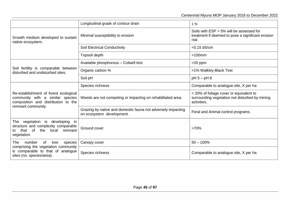
Centennial Myuna MOP January 2016 to December 2022
Page 45 of 97
Longitudinal grade of contour drain 1 %
Growth medium developed to sustain native ecosystem.
Minimal susceptibility to erosion Soils with ESP > 5% will be assessed for treatment if deemed to pose a significant erosion risk
Soil Electrical Conductivity <0.15 dS/cm
Topsoil depth >100mm
Soil fertility is comparable between disturbed and undisturbed sites.
Available phosphorous – Colwell test >20 ppm
Organic carbon % >1% Walkley-Black Test
Soil pH pH 5 – pH 8
Re-establishment of forest ecological community with a similar species composition and distribution to the remnant community.
Species richness Comparable to analogue site, X per ha
Weeds are not competing or impacting on rehabilitated area. < 20% of foliage cover or equivalent to surrounding vegetation not disturbed by mining activities.
Grazing by native and domestic fauna not adversely impacting on ecosystem development.
Feral and Animal control programs.
The vegetation is developing in structure and complexity comparable to that of the local remnant vegetation.
Ground cover >70%
The number of tree species comprising the vegetation community is comparable to that of analogue sites (no. species/area).
Canopy cover 50 – 100%
Species richness Comparable to analogue site, X per ha

Centennial Myuna MOP January 2016 to December 2022
Page 46 of 97
Domain 4 Lower Field
Rehabilitation Objective Indicator Criteria
Non-Polluting
On site remediation of contaminated soil.
Ground & Surface water assessment criteria ANZECC (2000) Marine Water trigger levels.
Soil Assessment Criteria NSW DEC (2006) SIL 4, CRC CARE HSL – D, NSW EPA (1994) TPH BTEX.
Remove carbonaceous material (spillage or otherwise). Site inspection
Public Safety Site secured to restrict unauthorised access Security fencing
Maintain established ground cover
Weeds are appropriately controlled and not impacting on rehabilitation. <20% of total ground cover
Vegetation is self sustaining Regrowth evident
Ground cover >70%
Domain 5 Water Management Area
Rehabilitation Objective Indicator Criteria
Structural integrity of retained structures
Selected structures and services to be maintained for use Structural safety assessment.
Removal of infrastructure and services Mine water settlement ponds removed
Sediment dams and associated water management structures will remain in place until the catchment is rehabilitated and discharge water quality is similar to comparable undisturbed landforms.
Removal of services Services isolated and removed

Centennial Myuna MOP January 2016 to December 2022
Page 47 of 97
Public Safety
Underground openings sealed to prevent access. Capped and sealed to NSW DRE MDG 6001 .
Site secured to restrict unauthorised access Security fencing
Non-Polluting
Assess the area of the ponds for contaminated soils.
Ground & Surface water assessment criteria ANZECC (2000) Marine Water trigger levels.
Soil Assessment Criteria NSW DEC (2006) SIL 4, CRC CARE HSL – D, NSW EPA (1994) TPH BTEX.
Remove carbonaceous material (spillage or otherwise) from footprint of the CHP dam and settlement ponds.
Site Inspection
Water quality pH Range between 6.5 – 8.5
Water quality Total Suspended Solids < 50 mg/L
Water quality Oil and Grease <10 mg/L
Establish connection of storm water drainage system.
Sub surface installation of storm water drain. Complete connection of sub surface system to Wangi Creek.
Domain 6 Remnant Bushland Area
Rehabilitation Objective Indicator Criteria
Maximise preservation of remnant swamp Sclerophyll forest on Coastal Floodplains Endangered Ecological Community.
Annual monitoring of groundwater dependent ecosystem No mine related change to flora or the ground water dependent ecosystem.
Monitoring of contamination to ground & surface water, sediments and soils.
Ground & Surface water assessment criteria ANZECC (2000) Marine Water trigger levels.
Soil Assessment Criteria NSW DEC (2006) SIL 4, CRC CARE HSL – D, NSW EPA (1994) TPH BTEX.

Centennial Myuna MOP January 2016 to December 2022
Page 48 of 97
Maintain asset protection zone. Maintenance of Asset Protection Zone. Bushfire safe standard APZ
Maintain compliance with the Noxious Weeds Act 1993.
Removal from site of declared noxious weeds propagules and biomass
Noxious weeds controlled as per noxious weeds act
Public safety Site secured to restrict unauthorised access Visual inspection of security fencing.
Domain 7 Underground Mining Area
Rehabilitation Objective Indicator Criteria
Rehabilitate and or offset mine induced subsidence impacts
Subsidence monitoring
Mine induced Subsidence in Zone A > 20mm
Mine induced subsidence in zone B contributes to impact on Benthic organisms
Mine induced subsidence in Zone A and or Zone B contributes to impact on Seagrass.

Myuna Colliery MOP January 2016 to December 2022
Page 49 of 97
5.3 Rehabilitation Phases
The phases in the rehabilitation process commence after completion of active mining. The rehabilitation phases progress through logical steps ending where the land is able to meet its nominated end land use in a sustainable way and can be relinquished.
The rehabilitation hierarchy used in this MOP follows the guidance provided Explanatory Note 2(h) of ESG3, which references six separate phases as follows.
Phase 1 Decommissioning
Decommissioning will include the cessation of infrastructure usage, disconnection of services, its demolition and removal from the mine site. The removal of hazardous materials will be undertaken during this phase. No decommissioning activities are planned during the term of this MOP.
Phase 2 Landform Establishment / Hazards and Safety
The Landform establishment phase involves the earthworks required to construct and/or profile all or part of each domain to the approved final landform. The constructed land form should be suitable for the proposed final land use and blend as far as practicable with the adjacent topography. This stage would also include the construction of any drainage structures needed for the area.
Landform establishment is not applicable to the Industrial Park Area. Phase 2 for the Industrial Park Area will be Hazards and Safety and will consist of remediation of contaminated soils, Safety assessment of services and structures.
Phase 3 Growth Medium Development
The growth medium development phase involves the placement of weathered overburden, subsoil and available top soil on the final landform and preparation of the surface for revegetation. Soil preparation may include fertiliser or ameliorant application and ripping or scarifying the surface. Non persistent cover crops will be used to stabilise the soil surface.
Phase 4 Ecosystem and Land Use Establishment / Surface plus Services Installation
The ecosystem and land use establishment phase involves the establishment and maintenance of vegetation on the completed land form. On completion of ecosystem and land use establishment for a final land use of native vegetation on the constructed land form, the non persistent cover crop will have been replaced by a native ground cover (grasses). Revegetation will then comprise planting of native tree and shrub tube stock.
Ecosystem and Landform Establishment is not applicable to the Industrial Park Area. Phase 4 for the Industrial Park Area will be Surface Plus Services Installation.
Phase 5 Ecosystem and Land Use Sustainability / Maintaining Structures
The ecosystem and land use sustainability phase occurs once monitoring illustrates the achievement of relevant performance indicators with respect to ecosystem development. Areas of the land form may remain within this phase for extended periods while progress is made towards achieving completion criteria.
Ecosystem and Land Use Sustainability is not applicable to the Industrial Park Area. Phase 5 for the Industrial Park Area is Maintaining Structures.
Phase 6 Land Relinquishment

Centennial Myuna MOP January 2016 to December 2022
Page 50 of 97
On achievement of the nominated closure criteria for ML1632 and MPL334 the land will be relinquished and the rehabilitation security held by DRE released in full for that component of the final land form.
Table 14 Rehabilitation Phases
Phase No
Rehabilitation Phase Industrial Park Phase
1 Decommissioning
Infrastructure removed, soil contamination remediated, electricity decommissioned, shafts and drifts sealed.
Decommissioning
Removal of hazardous materials, Infrastructure removed, shafts and drifts sealed.
2 Landform Establishment
Slope, drainage, morphology, substrate material characterisation, density, aspect.
Hazards and Safety
Soil contamination remediated, Ensure safety of services and structures, hazards assessment.,
3 Growth Medium Development
Physical, chemical and biological characteristics.
4 Ecosystem and Land Use Establishment
Species selection, species presence, and germination rate.
Surface plus Services Installation
Drainage, asphalt, turf.
5 Ecosystem and Land Use Sustainability
Floristics and structure, recruitment and recovery, fauna presence, growth, ecosystem resilience.
Maintaining Structures
Maintenance of buildings and services.
6 Land Relinquishment
Demonstrated success of rehabilitation process.
5.3.1 Domain 1 Infrastructure Area
The infrastructure area will be rehabilitated to achieve a final land use goal of light industrial or mixed use as defined by the LMLEP 2014. The rehabilitation phases will not commence until the end of mine life. Centennial Myuna has Project Approval to carry out mining operations on the site until 31st December 2032. There are no rehabilitation phases proposed to be commenced within the term of the MOP.
The following rehabilitation phases will be implemented for the infrastructure area to be rehabilitated to an industrial park with the nominated retained infrastructure:
Decommissioning
Centennial Myuna MOP January 2016 to December 2022
Page 51 of 97
o Remove hazardous materials (asbestos) from Infrastructure.
o Remove infrastructure identified for demolition.
o Seal mine entries.
Hazards and safety
o Hazards assessment.
o On site remediation of contaminated soil.
o Removal of UG tank (including pipes, bunds, etc.)
o Ensure safety of services and structures.
Surface plus services installation
o Re-establish Old Wangi Road and haul road.
o Asphalt unsealed areas of hardstand.
Maintaining Structures
o Office building
o Workshop
o Stores
Relinquishment
5.3.2 Domain 2 Stockpile Area
The stockpile area will be rehabilitated to achieve a final land use goal of approximately 5.3 ha of land suitable for light industrial or mixed use development in accordance with the LMLEP 2014. The rehabilitation phases will not commence until the end of mine life. Centennial Myuna has Project Approval to carry out mining operations on the site until 31st December 2032. There are no rehabilitation phases proposed to be commenced within the term of the MOP.
The following rehabilitation phases will be implemented for the stockpile area to be rehabilitated to a development site suitable for light industrial / mixed use:
Landform establishment
o Establish erosion and sedimentation controls;
o Remove land fill (stockpile pad);
o Removal of infrastructure
o Manage contamination (soil).
o Contour to natural surrounding;
o Establish drainage lines.
Growth media development
o Soil assessment
o Compacted surfaces deep ripped along contours;
o Establish soil / growing medium suitable for the establishment of ground cover;
Ecosystem and land use establishment
o Establishment of initial cover crop over disturbed areas;

Centennial Myuna MOP January 2016 to December 2022
Page 52 of 97
o Establishment of grass cover over disturbed areas;
o Pest animal and weed species management and control;
o Monitor vegetation growth;
Ecosystem and land use sustainability
o Weed and pest maintenance;
o Vegetation self sustaining;
o Monitor vegetation.
Relinquishment
5.3.3 Domain 3 Downcast Shaft Area
The Downcast Shaft Area will be rehabilitated to achieve a final land use goal of approximately 3 hectares of rehabilitated native forest. The rehabilitation phases will not commence until the end of mine life. Centennial Myuna has Project Approval to carry out mining operations on the site until 31st December 2032. There are no rehabilitation phases proposed to be commenced within the term of the MOP.
The following rehabilitation phases will be implemented for the Downcast Shaft Area to be rehabilitated to native forest:
Decommissioning
o Remnant vegetation areas protected from disturbance;
o Removal of infrastructure;
o Seal mine shafts and bores;
o Removal of ballast.
Landform establishment
o Contour to natural surrounding;
o Landform similar to pre-disturbance landform;
o Establish drainage lines.
Growth media development
o Soil assessment (key soil characteristics in the range of pre-disturbance soil characteristics);
o Establish erosion and sedimentation controls;
o Compacted surfaces deep ripped along contours;
o Establish soil / growing medium suitable for the establishment of native species;
Ecosystem and land use establishment
o Establishment of initial cover crop over disturbed areas;
o Revegetated native species diversity consistent with the relevant mapped ecological community;
o Pest animal and weed species management and control;
o Revegetation monitoring and maintenance.
Ecosystem and land use sustainability
Centennial Myuna MOP January 2016 to December 2022
Page 53 of 97
o Revegetated native species diversity consistent with the relevant mapped ecological community;
o Weed and pest maintenance;
o Vegetation self sustaining;
o Vegetation monitoring.
Relinquishment
5.3.4 Domain 4 Lower Field
The Lower Field Area will be rehabilitated to achieve a final land use goal of a approximately 3.9 ha of land suitable for light industrial or mixed use development in accordance with the LMLEP 2014. The rehabilitation phases will not commence until the end of mine life. Centennial Myuna has Project Approval to carry out mining operations on the site until 31st December 2032. There are no rehabilitation phases proposed to be commenced within the term of the MOP.
The following rehabilitation phases will be implemented for the Lower Field Area to be rehabilitated to a development site suitable for light industrial / mixed use:
Decommissioning
o Manage contamination (soil).
Ecosystem and land use sustainability
o Weed and pest maintenance;
o Vegetation self sustaining;
o Monitor vegetation.
Relinquishment
5.3.5 Domain 5 Water Management Area
The Water Management Area will be rehabilitated to achieve a final land use goal of light industrial or mixed use in accordance with the LMLEP 2014. The rehabilitation phases will not commence until the end of mine life. Centennial Myuna has Project Approval to carry out mining operations on the site until 31st December 2032. There are no rehabilitation phases proposed to be commenced within the term of the MOP.
The following rehabilitation phases will be implemented for the Water Management Area to be rehabilitated to an industrial park with the nominated retained infrastructure:
Decommissioning
o Dewater mine water settlement ponds;
o Removal of identified infrastructure and services;
o Seal bore holes;
Hazards and safety
o Manage contamination (soil)
o Hazards assessment;
o Ensure safety of structures.
Surface plus services installation

Centennial Myuna MOP January 2016 to December 2022
Page 54 of 97
o Sub surface installation (storm water drains)
Relinquishment
5.3.6 Domain 6 Remnant Bushland Area
The Remnant Bushland Area is the undisturbed natural bushland which provides a buffer from the mine site to the surrounding residences. The remnant bushland area is undisturbed from mining activities however there are fire access trails and service easements which run through the bushland. An Endangered Ecological Community (EEC) identified as Swamp Sclerophyll Forest on Coastal Floodplains is located near Wangi Creek within the bushland area. The management of the EEC will continue for the life of the mine as per condition 28 of the Project Approval.
The following rehabilitation phases will be implemented for the Remnant Bushland Area to be maintained as native woodland:
Ecosystem and land use sustainability
o Weed and pest management;
o Protect and enhance native vegetation and habitat;
o Fire management (maintenance of asset protection zones);
o Management of public access.
Relinquishment
5.3.7 Domain 7 Underground Mining Area
The Underground Mining Area incorporates the whole of PA10_0080 and Development Consent approved mining areas with the exception of lot 100 DP880089. The mining related surface activities within this area are restricted to subsidence monitoring and exploration activities. All surface impacts resulting from mine related exploration activities will be rehabilitated in accordance with the conditions of Exploration Lease 4444, Exploration Lease 6640 and this Mining Operations Plan.

Centennial Myuna MOP January 2016 to December 2022
Page 55 of 97
Table 15 Summary of Rehabilitation Phases Proposed for Completion at the end of
the MOP.
Domain
Rehabilitation
Phase Infr
astr
uctu
re
Are
a (
1,
F)
Sto
ck
pil
e A
rea
(2, C
)
Do
wn
cas
t S
haft
Are
a (
3,
B)
Lo
we
r F
ield
(4, C
)
Wa
ter
Ma
na
ge
me
nt
Are
a (
5,
F)
Re
mn
an
t
Bu
sh
lan
d a
rea
(6, A
)
Un
de
rgro
un
d
Min
ing
Are
a
(7, D
& E
)
Phase 1
Decommissioning X NA X X X NA NA
Phase 2
Land form Establishment (Hazards & Safety)
X X X NA X NA NA
Phase 3
Growth Medium Development
NA X X NA NA NA NA
Phase 4
Ecosystem and Land Use Establishment (Surface & Services Installation)
X X X NA X NA NA
Phase 5
Ecosystem and Land Use Sustainability (Maintaining Structures)
X X X X X X NA
Phase 6
Land Relinquishment
X X X X X X NA
Note: = rehabilitation phase completed at the end of the MOP term.
X = rehabilitation phase not completed at the end of the MOP term.
NA = rehabilitation phase not applicable to domain.
5.4 Closure Timeline
Table 16 below provides an indicative closure timeline based on Centennial Myuna not receiving approval to continue operations beyond the current approval date of 31st December 2032.

Myuna Colliery MOP January 2016 to December 2022
Page 56 of 97
TABLE 16 Indicative Closure Timeline
YEAR FROM CLOSURE
-3 -2 -1 1 2 3 4 5 6 7 8 9 10 11 12
Closure Planning 2029
Stakeholder Engagement Regarding Closure
Agreed Final Detailed Closure Strategy
Develop Demolition Plan
Rehabilitation Phases
1 Decommissioning
2
Landform Establishment
Hazards and Safety
3 Growth Media Development
4
Ecosystem and Landuse Establishment
Surface plus Services Installation
5
Ecosystem and Landuse Sustainability
Maintaining Structures
6 Relinquished Lands
Post Closure Activities
Maintenance of Rehabilitated Areas
Monitoring and Inspections
Centennial Myuna MOP January 2016 to December 2022
Page 57 of 97

Myuna Colliery MOP January 2016 to December 2022
Page 58 of 97
6 Performance Indicators, and Completion
/Relinquishment Criteria
The post mining land use goal at Myuna Colliery is to implement successful design and rehabilitation of landforms to ensure structural stability, revegetation success and containment of wastes; and to ensure rehabilitation and revegetation is self sustaining and follows the principles of sustainable development. The objective of rehabilitation activities will be to:
Restore 71 % of land disturbed by mining activities to pre-developed natural bushland;
Restore 11 % of the land disturbed by mining activities to land suitable for light industrial or mixed use development; and
Retain 18 % of land disturbed by mining activities for a light industrial park.
The performance measures developed for each Domain will be used to quantify the initial and long-term success of the rehabilitation programs.
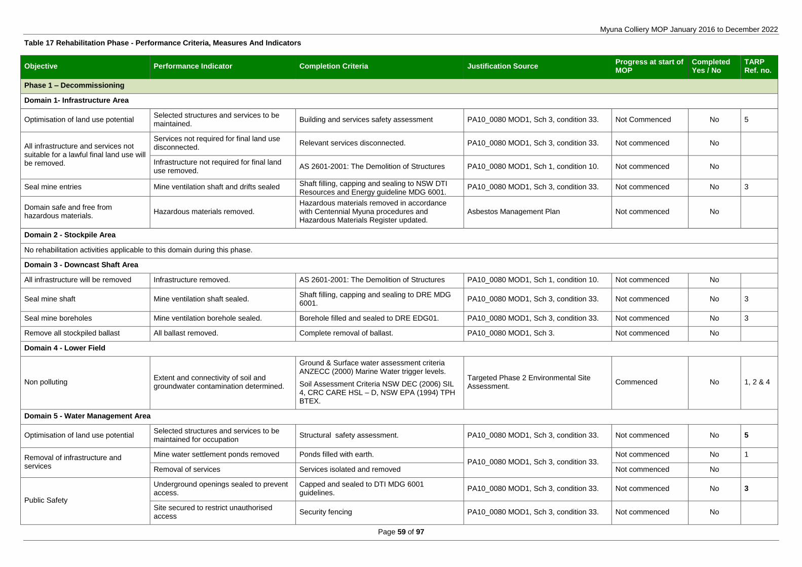
Myuna Colliery MOP January 2016 to December 2022
Page 59 of 97
Table 17 Rehabilitation Phase - Performance Criteria, Measures And Indicators
Objective Performance Indicator Completion Criteria Justification Source Progress at start of MOP
Completed Yes / No
TARP Ref. no.
Phase 1 – Decommissioning
Domain 1- Infrastructure Area
Optimisation of land use potential Selected structures and services to be maintained.
Building and services safety assessment PA10_0080 MOD1, Sch 3, condition 33. Not Commenced No 5
All infrastructure and services not suitable for a lawful final land use will be removed.
Services not required for final land use disconnected.
Relevant services disconnected. PA10_0080 MOD1, Sch 3, condition 33. Not commenced No
Infrastructure not required for final land use removed.
AS 2601-2001: The Demolition of Structures PA10_0080 MOD1, Sch 1, condition 10. Not commenced No
Seal mine entries Mine ventilation shaft and drifts sealed Shaft filling, capping and sealing to NSW DTI Resources and Energy guideline MDG 6001.
PA10_0080 MOD1, Sch 3, condition 33. Not commenced No 3
Domain safe and free from hazardous materials.
Hazardous materials removed. Hazardous materials removed in accordance with Centennial Myuna procedures and Hazardous Materials Register updated.
Asbestos Management Plan Not commenced No
Domain 2 - Stockpile Area
No rehabilitation activities applicable to this domain during this phase.
Domain 3 - Downcast Shaft Area
All infrastructure will be removed Infrastructure removed. AS 2601-2001: The Demolition of Structures PA10_0080 MOD1, Sch 1, condition 10. Not commenced No
Seal mine shaft Mine ventilation shaft sealed. Shaft filling, capping and sealing to DRE MDG 6001.
PA10_0080 MOD1, Sch 3, condition 33. Not commenced No 3
Seal mine boreholes Mine ventilation borehole sealed. Borehole filled and sealed to DRE EDG01. PA10_0080 MOD1, Sch 3, condition 33. Not commenced No 3
Remove all stockpiled ballast All ballast removed. Complete removal of ballast. PA10_0080 MOD1, Sch 3. Not commenced No
Domain 4 - Lower Field
Non polluting Extent and connectivity of soil and groundwater contamination determined.
Ground & Surface water assessment criteria ANZECC (2000) Marine Water trigger levels.
Soil Assessment Criteria NSW DEC (2006) SIL 4, CRC CARE HSL – D, NSW EPA (1994) TPH BTEX.
Targeted Phase 2 Environmental Site Assessment.
Commenced No 1, 2 & 4
Domain 5 - Water Management Area
Optimisation of land use potential Selected structures and services to be maintained for occupation
Structural safety assessment. PA10_0080 MOD1, Sch 3, condition 33. Not commenced No 5
Removal of infrastructure and services
Mine water settlement ponds removed Ponds filled with earth. PA10_0080 MOD1, Sch 3, condition 33.
Not commenced No 1
Removal of services Services isolated and removed Not commenced No
Public Safety
Underground openings sealed to prevent access.
Capped and sealed to DTI MDG 6001 guidelines.
PA10_0080 MOD1, Sch 3, condition 33. Not commenced No 3
Site secured to restrict unauthorised access
Security fencing PA10_0080 MOD1, Sch 3, condition 33. Not commenced No

Centennial Myuna MOP January 2016 to December 2022
Page 60 of 97
Objective Performance Indicator Completion Criteria Justification Source Progress at start of MOP
Completed Yes / No
TARP Ref. no.
Non-Polluting
Assess the area of the ponds for contaminated soils.
Ground & Surface water assessment criteria ANZECC (2000) Marine Water trigger levels.
Soil Assessment Criteria NSW DEC (2006) SIL 4, CRC CARE HSL – D, NSW EPA (1994) TPH BTEX.
Targeted Phase 2 Environmental Site Assessment.
Not commenced No 1
Remove carbonaceous material (spillage or otherwise) from footprint of the CHP dam and settlement ponds.
Site inspection PA10_0080 MOD1, Sch 3, condition 33. Not commenced No
Domain 6 – Remnant Bushland
No rehabilitation activities applicable to this domain during this phase.
Domain 7 - Underground Mining Area
No rehabilitation activities applicable to this domain during this phase.
Phase 2 – Landform Establishment (Hazards and Safety)
Domain 1- Infrastructure Area
Ensure safety of services and structures
A building and services safety assessment completed by a suitable qualified person.
Building and services safety assessment
PA10_0080 MOD1, Sch 3, condition 33.
Not commenced No
Hazardous materials do not pose a risk to health or safety.
Hazards Materials Survey and Register audit. Not commenced No
Non polluting
Soil and Groundwater contamination remediated.
Ground & Surface water assessment criteria ANZECC (2000) Marine Water trigger levels.
Soil Assessment Criteria NSW DEC (2006) SIL 4, CRC CARE HSL – D, NSW EPA (1994) TPH BTEX.
Targeted Phase 2 Environmental Site Assessment.
Commenced No 1, 2 & 4
Remove underground tanks, pipes. Contaminated land assessment, SIL 4 Targeted Phase 2 Environmental Site Assessment.
Not commenced No 1
Domain 2 - Stockpile Area
Landform established to development site standards suitable for a light industrial / mixed land use.
Remove land fill from the stock pile pad. Land fill removed. PA10_0080 MOD1, Sch 3, condition 33. Not commenced No 1
Soil and Groundwater contamination remediated.
Ground & Surface water assessment criteria ANZECC (2000) Marine Water trigger levels.
Soil Assessment Criteria NSW DEC (2006) SIL 4, CRC CARE HSL – D, NSW EPA (1994) TPH BTEX.
Targeted Phase 2 Environmental Site Assessment.
Not Commenced No 1 & 4
Infrastructure removed. Site inspection, complete removal of infrastructure.
PA10_0080 MOD1, Sch 3, condition 33. Not Commenced No
Landform stability
Stability Geo-technical assessment of contoured landform.
From Managing Urban Stormwater: Soils and Construction
Not commenced No
Slope gradient <100 From Managing Urban Stormwater: Soils and Construction
Not commenced No
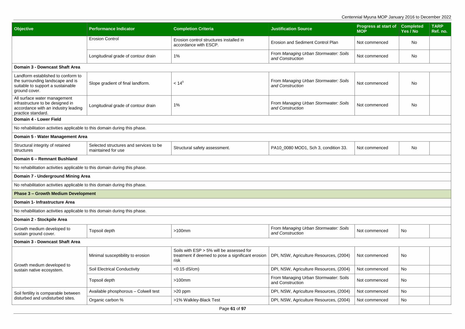
Centennial Myuna MOP January 2016 to December 2022
Page 61 of 97
Objective Performance Indicator Completion Criteria Justification Source Progress at start of MOP
Completed Yes / No
TARP Ref. no.
Erosion Control
Erosion control structures installed in accordance with ESCP.
Erosion and Sediment Control Plan Not commenced No
Longitudinal grade of contour drain 1% From Managing Urban Stormwater: Soils and Construction
Not commenced No
Domain 3 - Downcast Shaft Area
Landform established to conform to the surrounding landscape and is suitable to support a sustainable ground cover.
Slope gradient of final landform. < 140 From Managing Urban Stormwater: Soils and Construction
Not commenced No
All surface water management infrastructure to be designed in accordance with an industry leading practice standard.
Longitudinal grade of contour drain 1% From Managing Urban Stormwater: Soils and Construction
Not commenced No
Domain 4 - Lower Field
No rehabilitation activities applicable to this domain during this phase.
Domain 5 - Water Management Area
Structural integrity of retained structures
Selected structures and services to be maintained for use
Structural safety assessment. PA10_0080 MOD1, Sch 3, condition 33. Not commenced No
Domain 6 – Remnant Bushland
No rehabilitation activities applicable to this domain during this phase.
Domain 7 - Underground Mining Area
No rehabilitation activities applicable to this domain during this phase.
Phase 3 – Growth Medium Development
Domain 1- Infrastructure Area
No rehabilitation activities applicable to this domain during this phase.
Domain 2 - Stockpile Area
Growth medium developed to sustain ground cover.
Topsoil depth >100mm From Managing Urban Stormwater: Soils and Construction
Not commenced No
Domain 3 - Downcast Shaft Area
Growth medium developed to sustain native ecosystem.
Minimal susceptibility to erosion Soils with ESP > 5% will be assessed for treatment if deemed to pose a significant erosion risk
DPI, NSW, Agriculture Resources, (2004) Not commenced No
Soil Electrical Conductivity <0.15 dS/cm) DPI, NSW, Agriculture Resources, (2004) Not commenced No
Topsoil depth >100mm From Managing Urban Stormwater: Soils and Construction
Not commenced No
Soil fertility is comparable between disturbed and undisturbed sites.
Available phosphorous – Colwell test >20 ppm DPI, NSW, Agriculture Resources, (2004) Not commenced No
Organic carbon % >1% Walkley-Black Test DPI, NSW, Agriculture Resources, (2004) Not commenced No

Centennial Myuna MOP January 2016 to December 2022
Page 62 of 97
Objective Performance Indicator Completion Criteria Justification Source Progress at start of MOP
Completed Yes / No
TARP Ref. no.
Soil pH pH 5 – pH 8 DPI, NSW Agriculture, Understanding Soil pH (June 2000).
Not commenced No
Soil Electrical Conductivity < 0.15 dS/m DPI, NSW, Agriculture Resources, (2004) Not commenced No
Domain 4 - Lower Field
No rehabilitation activities applicable to this domain during this phase.
Domain 5 - Water Management Area
No rehabilitation activities applicable to this domain during this phase.
Domain 6 – Remnant Bushland
No rehabilitation activities applicable to this domain during this phase.
Domain 7 - Underground Mining Area
No rehabilitation activities applicable to this domain during this phase.
Phase 4 – Ecosystem and Land Use Establishment (Surface and Service Installation)
Domain 1- Infrastructure Area
Sealed hardstand area Unsealed areas of the hardstand (egg. removed cement footings) area to be sealed with asphalt.
Completely sealed hardstand area. PA10_0080 MOD1, Sch 3, condition 33. Not commenced No
Re-establish Old Wangi Road Seal and mark the Old Wangi Road. Old Wangi Road constructed to RMS guidelines. PA10_0080 MOD1, Sch 3, condition 33. Not commenced No
Domain 2 - Stockpile Area
Establishment of a suitable ground cover for a development site
Establishment of grass cover over disturbed areas.
>70% From Managing Urban Stormwater: Soils and Construction
Not commenced No
Grazing by native and domestic fauna not adversely impacting on ground cover development.
Feral and Animal control programs implemented and reported in the AEMR
Biodiversity Management Plan Not commenced No
Weeds are not competing or impacting on rehabilitated area.
< 20% of foliage cover or equivalent to surrounding vegetation not disturbed by mining activities.
Analogue site Not commenced No
Domain 3 - Downcast Shaft Area
Re-establishment of forest ecological community with a similar species composition and distribution to the remnant community.
Species richness X per ha Analogue site Not commenced No
Weeds are not competing or impacting on rehabilitated area.
<20% of foliage cover or equivalent to surrounding vegetation not disturbed by mining activities.
Analogue site Not commenced No
Grazing by native and domestic fauna not adversely impacting on ecosystem development.
Feral and Animal control program Biodiversity Management Plan Not commenced No
Domain 4 - Lower Field
No rehabilitation activities applicable to this domain during this phase.

Centennial Myuna MOP January 2016 to December 2022
Page 63 of 97
Objective Performance Indicator Completion Criteria Justification Source Progress at start of MOP
Completed Yes / No
TARP Ref. no.
Domain 5 - Water Management Area
Establish connection of storm water drainage system.
Sub surface installation of storm water drain.
Complete connection of sub surface system to Wangi Creek.
PA10_0080 MOD1, Sch 3, condition 33. Not Commenced No
Domain 6 – Remnant Bushland
No rehabilitation activities applicable to this domain during this phase.
Domain 7 - Underground Mining Area
No rehabilitation activities applicable to this domain during this phase.
Phase 5 – Ecosystem and Land Use Sustainability (Maintaining Structures)
Domain 1- Infrastructure Area
Maintenance of buildings and services.
Buildings and services ready for immediate occupation.
Buildings and services safety assessment PA10_0080 MOD1, Sch 3, condition 33. Ongoing PA requirement
No
Non polluting.
Water quality pH Range between 6.5 – 8.5 EPL 366 Ongoing EPL requirement
No 1
Water quality Total Suspended Solids < 50 mg/L EPL 366 Ongoing EPL requirement
No 1
Water quality Oil and Grease <10 mg/L EPL 366 Ongoing EPL requirement
No 1
Domain 2 - Stockpile Area
Maintain established ground cover
Weeds are appropriately controlled and not impacting on rehabilitation.
<20% of total ground cover PA10_0080 MOD1, Sch 3, condition 28. Not commenced No
Vegetation is self sustaining Regrowth evident PA10_0080 MOD1, Sch 3, condition 28. Not commenced No
Ground cover >70% From Managing Urban Stormwater: Soils and Construction
Not commenced No
Domain 3 - Downcast Shaft Area
The vegetation is developing in structure and complexity comparable to that of the local remnant vegetation
Ground cover >70% Analogue site Not commenced No
The number of tree species comprising the vegetation community is comparable to that of analogue sites (no. species/area).
Canopy cover 50 – 100% Analogue site Not commenced No
Species richness X per ha Analogue site Not commenced No
Domain 4 - Lower Field
Maintain established ground cover
Weeds are appropriately controlled and not impacting on rehabilitation.
<20% of total ground cover PA10_0080 MOD1, Sch 3, condition 28. Not commenced No
Vegetation is self sustaining Regrowth evident PA10_0080 MOD1, Sch 3, condition 28. Not commenced No
Ground cover >70% PA10_0080 MOD1, Sch 3, condition 28. Not commenced No

Centennial Myuna MOP January 2016 to December 2022
Page 64 of 97
Objective Performance Indicator Completion Criteria Justification Source Progress at start of MOP
Completed Yes / No
TARP Ref. no.
Domain 5 - Water Management Area
Non polluting
Water quality pH Range between 6.5 – 8.5 EPL 366 Ongoing EPL requirement
No 1
Water quality Total Suspended Solids <50 mg/L EPL 366 Ongoing EPL requirement
No 1
Water quality Oil and Grease <10 mg/L EPL 366 Ongoing EPL requirement
No 1
Domain 6 – Remnant Bushland
Maximise preservation of remnant swamp Sclerophyll forest on Coastal Floodplains Endangered Ecological Community.
Annual monitoring of groundwater dependent ecosystem
No mine related change to flora or the ground water dependent ecosystem.
Biodiversity Management Plan Commenced PA 10_0080 requirement.
No
Ground water monitoring
Ground & Surface water assessment criteria ANZECC (2000) Marine Water trigger levels.
Soil Assessment Criteria NSW DEC (2006) SIL 4, CRC CARE HSL – D, NSW EPA (1994) TPH BTEX.
Sediment Assessment Criteria ANZECC (2000) ISQG, NSW EPA (1994) TPH.
Targeted Phase 2 Environmental Site Assessment.
Commenced No 1
Maintain asset protection zone. Maintenance of Asset Protection Zone. Bushfire safe standard APZ (not less than 20m) Biodiversity Management Plan Commenced No
Maintain compliance with the Noxious Weeds Act 1993.
Removal from site of declared noxious weeds propagules and biomass
Noxious weeds controlled as per noxious weeds act
Biodiversity Management Plan Commenced No
Domain 7 - Underground Mining Area
Rehabilitate and or offset mine induced subsidence impacts
Subsidence monitoring
Mine induced Subsidence in Zone A < 20mm PA10_0080 MOD1, Sch 3, condition 1. Commenced No
Mine induced subsidence in zone B contributes to minor environmental consequences on Benthic communities.
PA10_0080 MOD1, Sch 3, condition 4. Not Commenced No
Mine induced subsidence in Zone A and or Zone B contributes to negligible impact on Seagrass beds.
PA10_0080 MOD1, Sch 3, condition 4. Not Commenced No
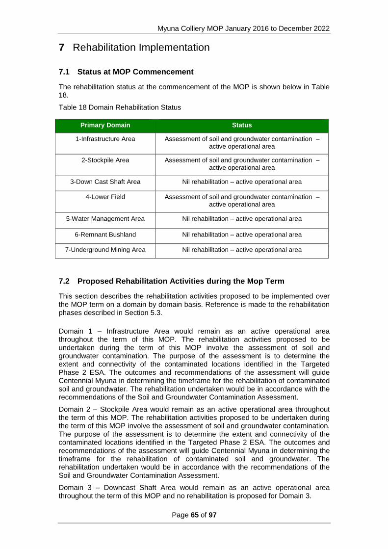
Myuna Colliery MOP January 2016 to December 2022
Page 65 of 97
7 Rehabilitation Implementation
7.1 Status at MOP Commencement
The rehabilitation status at the commencement of the MOP is shown below in Table 18.
Table 18 Domain Rehabilitation Status
Primary Domain Status
1-Infrastructure Area Assessment of soil and groundwater contamination – active operational area
2-Stockpile Area Assessment of soil and groundwater contamination – active operational area
3-Down Cast Shaft Area Nil rehabilitation – active operational area
4-Lower Field Assessment of soil and groundwater contamination – active operational area
5-Water Management Area Nil rehabilitation – active operational area
6-Remnant Bushland Nil rehabilitation – active operational area
7-Underground Mining Area Nil rehabilitation – active operational area
7.2 Proposed Rehabilitation Activities during the Mop Term
This section describes the rehabilitation activities proposed to be implemented over the MOP term on a domain by domain basis. Reference is made to the rehabilitation phases described in Section 5.3.
Domain 1 – Infrastructure Area would remain as an active operational area throughout the term of this MOP. The rehabilitation activities proposed to be undertaken during the term of this MOP involve the assessment of soil and groundwater contamination. The purpose of the assessment is to determine the extent and connectivity of the contaminated locations identified in the Targeted Phase 2 ESA. The outcomes and recommendations of the assessment will guide Centennial Myuna in determining the timeframe for the rehabilitation of contaminated soil and groundwater. The rehabilitation undertaken would be in accordance with the recommendations of the Soil and Groundwater Contamination Assessment.
Domain 2 – Stockpile Area would remain as an active operational area throughout the term of this MOP. The rehabilitation activities proposed to be undertaken during the term of this MOP involve the assessment of soil and groundwater contamination. The purpose of the assessment is to determine the extent and connectivity of the contaminated locations identified in the Targeted Phase 2 ESA. The outcomes and recommendations of the assessment will guide Centennial Myuna in determining the timeframe for the rehabilitation of contaminated soil and groundwater. The rehabilitation undertaken would be in accordance with the recommendations of the Soil and Groundwater Contamination Assessment.
Domain 3 – Downcast Shaft Area would remain as an active operational area throughout the term of this MOP and no rehabilitation is proposed for Domain 3.

Centennial Myuna MOP January 2016 to December 2022
Page 66 of 97
Domain 4 – Lower Field Area would remain as an active operational area throughout the term of this MOP. The rehabilitation activities proposed to be undertaken during the term of this MOP involve the assessment of soil and groundwater contamination. The purpose of the assessment is to determine the extent and connectivity of the contaminated locations identified in the Targeted Phase 2 ESA. The outcomes and recommendations of the assessment will guide Centennial Myuna in determining the timeframe for the rehabilitation of contaminated soil and groundwater. The rehabilitation undertaken would be in accordance with the recommendations of the Soil and Groundwater Contamination Assessment.
Domain 5 – Water Management Area would remain as an active operational area throughout the term of this MOP and no rehabilitation is proposed for Domain 5.
Domain 6 – Remnant Bushland Area provides a buffer zone between Myuna Colliery and the surrounding residential areas. The Remnant Bushland Area is intersected by services easements and fire access trails. Land Management practices including weed and pest management will be ongoing throughout the term of this MOP. No rehabilitation is proposed for Domain 6 within the MOP term.
Domain 7 - The Underground Mining Area incorporates the whole of the PA10_0080 and Development Consent approved mining area with the exception of lot 100 DP880089. Subsidence monitoring will be ongoing throughout the term of this MOP. Exploration activities may be undertaken within Domain 7 during the term of this MOP however location and timing of exploration activities has not yet been determined. All surface impacts resulting from mine related exploration activities will be rehabilitated in accordance with the conditions of the relevant Exploration Lease (Exploration Lease 4444, Exploration Lease 6640) and this Mining Operations Plan. Domain 7 will remain active at the end of this MOP term.
7.2.1 Domain 1 Infrastructure Area
Rehabilitation activities required to meet the final land use of an Industrial Park would commence at the end of mine life.
Decommissioning
The Myuna Colliery Hazardous Material Survey Register (2012) identifies the extent, type and condition of hazardous materials on surface areas, buildings and associated infrastructure. The hazardous materials identified are asbestos containing material (ACM), synthetic mineral fibre (SMF), polychlorinated biphenyls (PCB) and lead based paint.
The Hazardous Materials Survey Register will be provided to a licenced contractor prior to the commencement of decommissioning. The hazardous materials will be disposed at a licensed waste facility.
Demolition of the buildings and structures can commence following the completion of the hazardous material removal. Infrastructures to be retained for future land uses include the Administration block, Store, Workshop and sewerage treatment system. The existing established landform, including roads, kerb and guttering, stormwater drains, hardstand and lawns will be retained.
The sealing of the mine entries will commence following the completion of the stowing of material in the underground void. The land fill and inert material from the Stockpile Area and Downcast Shaft Area will be stowed in the underground workings.
The mine ventilation shaft and drifts will be sealed and capped in accordance with the NSW DTI Resources and Energy guideline MDG 6001.
Hazards and safety
Contaminated soils will be remediated and/or disposed of at a licenced waste facility.

Centennial Myuna MOP January 2016 to December 2022
Page 67 of 97
A review of the Hazardous Materials Assessment Report will be conducted following the completion of the decommissioning phase on the retained buildings to assess the safety of remaining services and structures. The buildings will be made safe from hazardous materials as per the Asbestos Management Plan. Where the hazardous material presents an unacceptable risk the hazardous material will be removed.
Surface plus services installation
Openings in the hardstand surface resulting from the removal of the infrastructure and footings would be sealed with asphalt or seeded and grassed to prevent erosion and degradation of the surface.
The old Wangi Road and Haul road will be assessed and upgraded to the appropriate standard.
Change from Previous MOP
Under the previous MOP the infrastructure area was to be rehabilitated to the pre-existing environment. This involved the complete removal of infrastructure and the re-establishment of natural bushland. The previous proposal was considered to be not consistent with the LMCC 2030 Vision, The Hunter Regional Strategy or the Centennial Coal Strategic Land Assessment.
7.2.2 Domain 2 – Stockpile Area
Rehabilitation activities required to meet the final land use of a Development Site would commence at the end of mine life. The rehabilitation activities include;
Landform establishment
The Emergency Coal Stock Pile Pad was formed by the compaction of land fill to form a flat surface for coal handling. Knowledge of the materials and method used to form the stock pile pad is limited due to the pad being formed prior to the acquisition of Myuna Colliery by Centennial Myuna Pty Ltd.
The measures to be implemented for the protection of Wangi Creek from sedimentation include establishment of sediment and erosion controls, daily monitoring and the establishment of a water management system. The Stockpile pad dam infrastructure would be utilised for water management during the land form establishment. Surface run off will be collected in an established dam on the Stockpile Area and pumped to the CHP dam. The infrastructure would be decommissioned and removed following the completion of the land form establishment.
The clean land fill that formed the stockpile pad would be removed and stowed underground. The land fill will be removed to establish the pre-existing land form and to remove any contaminants that may be present within the land fill.
A phase 2 site assessment identified contaminated soils in the northern section land fill of the Stock Pile Area. Monitoring for contaminants will be conducted during the removal of the land fill. Contaminated soils will be assessed and either transported to a licenced waste facility or remediated onsite.
Growth media development
Material and soil characterisation will be undertaken at an appropriate scale across the site. Representative samples will be taken to characterise the nature of the soil material (e.g. sodicity, acid-generating potential, etc.) to determine the potential limitations to rehabilitation and sustainable plant growth. The results will be used to determine specific ameliorant techniques that may be applied to the soil material in order for rehabilitation to be sustainable. The results from material and soil testing

Centennial Myuna MOP January 2016 to December 2022
Page 68 of 97
will determine if any ameliorates are required to be added to spoil material and topsoil to achieve sustainable rehabilitation.
Some ameliorates may need to be added to rehabilitated areas, with these possibly including gypsum, lime, fertiliser and bio solids. The use of soil ameliorants is designed to prevent surface crusting, increase moisture and organic content, and buffer surface temperatures to improve germination.
Elements such as drainage paths, contour drains, ridgelines, and emplacement areas will be shaped, as much as practical, to undulating profiles in keeping with natural landforms of the surrounding environment. Contour and catch drains are designed to collect surface runoff from revegetation or disturbed areas. Sedimentation dams are incorporated into the final landform to collect runoff from rehabilitated areas and the dam capacities are designed to allow time for suspended sediment to settle out.
Key erosion and sediment controls are outlined in the Erosion and Sediment Control Plan which forms part of the Water Management Plan. Erosion and sediment controls will need to be completed in accordance with key guidelines including DECC (2008) Managing Urban Stormwater: Soils and Construction Volume 2E - Mines and Quarries.
In summary Myuna Colliery utilise some of the following erosion and sediment controls to minimise erosion from rehabilitation:
o Sediment dams;
o Drainage lines to manage clean and dirty water runoff; and
o Erosion controls such as sediment fencing, straw bales.
Ecosystem and land use establishment
Following the establishment of sediment and erosion control measures a topsoil will be spread to a nominal minimum depth range of 0.1 metre to 0.3 metre on all areas to be rehabilitated. All topsoiled areas will be lightly contour-ripped.
All revegetation operations will be undertaken immediately after ripping using a quick growing cover crop and grasses.
Rehabilitation maintenance is to be completed in accordance with the Myuna Colliery Biodiversity Management Plan. Key rehabilitation maintenance requirements include:
Weed and feral animal control of rehabilitation;
Erosion control works;
Re-seeding/planting of rehabilitation areas that may have failed;
Maintenance fertilising; and
Repair of fence lines, access tracks and other general related land management activities.
The monitoring of vegetation growth is to be completed in accordance with the Myuna Colliery Biodiversity Management Plan.
Ecosystem and land use sustainability
Rehabilitation monitoring will continue to be used during the MOP period to assess rehabilitation progress and success. In order to demonstrate rehabilitation success or succession toward rehabilitation success, specific indicators will be expected to equal or exceed values obtained from the reference site under the same set of conditions or demonstrate a positive trend towards target values.
Change from Previous MOP

Centennial Myuna MOP January 2016 to December 2022
Page 69 of 97
Under the previous MOP the Stock pile area was to be rehabilitated to the pre-existing environment. This involved the complete removal of infrastructure, stockpile pad and the re-establishment of natural bushland. The previous proposal was considered to be not consistent with the LMCC 2030 Vision, The Hunter Regional Strategy or the Centennial Coal Strategic Land Assessment.
7.2.3 Domain 3 – Downcast Shaft Area
Rehabilitation activities required to meet the final land use of rehabilitated Native Forest would commence at the end of mine life. The rehabilitation activities include;
Decommissioning
The areas of remnant vegetation surrounding the infrastructure will be cordoned off to protect against disturbance
Decommissioning of the Down Cast Shaft structure will commence following the completion of stowing materials in the underground void. All infrastructure and ballast material will be removed from the Down Cast Shaft site. The shaft and bores holes will be sealed to the NSW DTI Resources and Energy guideline MDG 6001.
Landform establishment
Land form establishment will be undertaken at the Down Cast Shaft compound, an area of approximately 4000 square metres, and will be re-established to the pre-disturbance land form. The final landform will be structurally stable, with acceptable slopes and unimpeded drainage lines.
Growth media development
Growth media development will be conducted as described in section 7.2.2. for the establishment of native forest species.
Ecosystem and land use establishment
An initial cover crop will be established over the disturbed area. Revegetated native species diversity will be consistent with the mapped ecological community.
All revegetation operations will be undertaken immediately after ripping using a quick growing cover crop.
Rehabilitation maintenance monitoring is to be completed in accordance with the Myuna Colliery Biodiversity Management Plan.
Ecosystem and land use sustainability
Rehabilitation monitoring will continue to be used during the MOP period to assess rehabilitation progress and success.
Change from Previous MOP
There are no changes to the proposed final land use from the previous MOP.
7.2.4 Domain 4 – Lower Field
Rehabilitation activities required to meet the final land use of a Development Site suitable for light industrial development would commence at the end of mine life. The rehabilitation activities include;
Decommissioning

Centennial Myuna MOP January 2016 to December 2022
Page 70 of 97
The lower field is a relatively flat area of approximately 4.1ha with established native fauna and open grass field. The area was established prior to the acquisition of Myuna Colliery by Centennial Myuna Pty Ltd. Decommissioning of the area involves the management of soil contamination, the removal of monitoring wells and monitoring point.
A phase 2 site assessment identified contaminated soils. Monitoring for contaminants will be conducted during the rehabilitation of the site. Contaminated soils will be remediated and/or disposed of at a licenced waste facility. The area will be remediated to the standard required for a light industrial / mixed use development site.
Ecosystem and land use sustainability
Rehabilitation monitoring will continue to be used during the MOP period to assess rehabilitation progress and success. In order to demonstrate rehabilitation success or succession toward rehabilitation success, specific indicators will be expected to equal or exceed values obtained from the reference site under the same set of conditions or demonstrate a positive trend towards target values.
Change from Previous MOP
Under the previous MOP the Lower Field Area was to be rehabilitated to the pre-existing environment. This involved the removal of Monitoring points and wells and the re-establishment of natural bushland. The previous proposal was considered to be not consistent with the LMCC 2030 Vision, The Hunter Regional Strategy or the Centennial Coal Strategic Land Assessment.
7.2.5 Domain 5 - Water Management Area
Rehabilitation activities required to meet the final land use of an Industrial Park would commence at the end of mine life. The rehabilitation activities include;
Decommissioning
Decommissioning of the water management system will commence following the completion of land form establishment of the Stockpile Area and decommissioning of the Infrastructure Area.
Decommissioning of the water management system involves the removal of mine water settlement ponds, CHP dam, CHP dam sump, associated infrastructure and services and the sealing of the bore hole. The infrastructure to be retained includes the sub surface drain from the settlement pond to LDP B and the aqua duct and subsurface drain from LDP B to Wangi Creek. The LDP B real time monitoring system will be utilised to monitor water quality from the site for the duration of the site rehabilitation.
All sediments and contaminants will be removed from the settlement ponds. The ponds will be filled with earth and covered with turf.
Hazards and safety
A Structural Safety Assessment will be conducted on the water management structures to assess public safety and structural integrity.
Surface plus services installation
Subsurface drains will be laid to connect the storm water drainage system with the discharge channel.
Change from Previous MOP
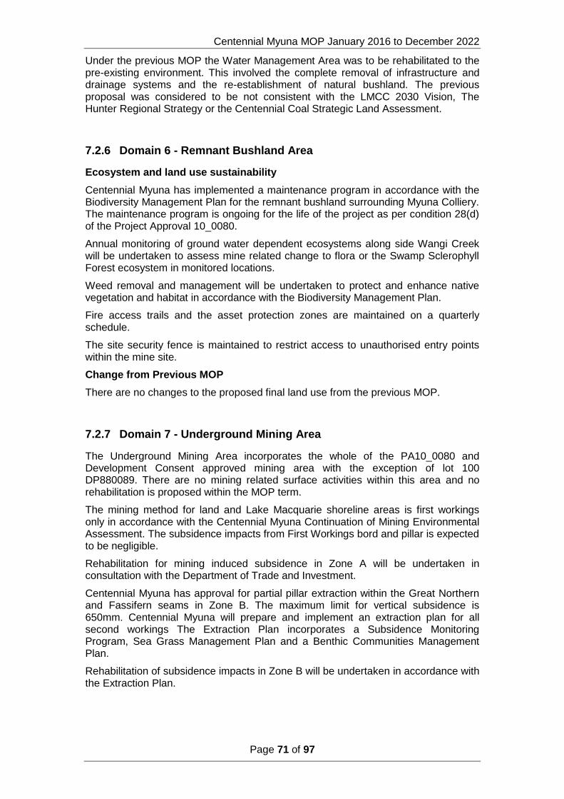
Centennial Myuna MOP January 2016 to December 2022
Page 71 of 97
Under the previous MOP the Water Management Area was to be rehabilitated to the pre-existing environment. This involved the complete removal of infrastructure and drainage systems and the re-establishment of natural bushland. The previous proposal was considered to be not consistent with the LMCC 2030 Vision, The Hunter Regional Strategy or the Centennial Coal Strategic Land Assessment.
7.2.6 Domain 6 - Remnant Bushland Area
Ecosystem and land use sustainability
Centennial Myuna has implemented a maintenance program in accordance with the Biodiversity Management Plan for the remnant bushland surrounding Myuna Colliery. The maintenance program is ongoing for the life of the project as per condition 28(d) of the Project Approval 10_0080.
Annual monitoring of ground water dependent ecosystems along side Wangi Creek will be undertaken to assess mine related change to flora or the Swamp Sclerophyll Forest ecosystem in monitored locations.
Weed removal and management will be undertaken to protect and enhance native vegetation and habitat in accordance with the Biodiversity Management Plan.
Fire access trails and the asset protection zones are maintained on a quarterly schedule.
The site security fence is maintained to restrict access to unauthorised entry points within the mine site.
Change from Previous MOP
There are no changes to the proposed final land use from the previous MOP.
7.2.7 Domain 7 - Underground Mining Area
The Underground Mining Area incorporates the whole of the PA10_0080 and Development Consent approved mining area with the exception of lot 100 DP880089. There are no mining related surface activities within this area and no rehabilitation is proposed within the MOP term.
The mining method for land and Lake Macquarie shoreline areas is first workings only in accordance with the Centennial Myuna Continuation of Mining Environmental Assessment. The subsidence impacts from First Workings bord and pillar is expected to be negligible.
Rehabilitation for mining induced subsidence in Zone A will be undertaken in consultation with the Department of Trade and Investment.
Centennial Myuna has approval for partial pillar extraction within the Great Northern and Fassifern seams in Zone B. The maximum limit for vertical subsidence is 650mm. Centennial Myuna will prepare and implement an extraction plan for all second workings The Extraction Plan incorporates a Subsidence Monitoring Program, Sea Grass Management Plan and a Benthic Communities Management Plan.
Rehabilitation of subsidence impacts in Zone B will be undertaken in accordance with the Extraction Plan.
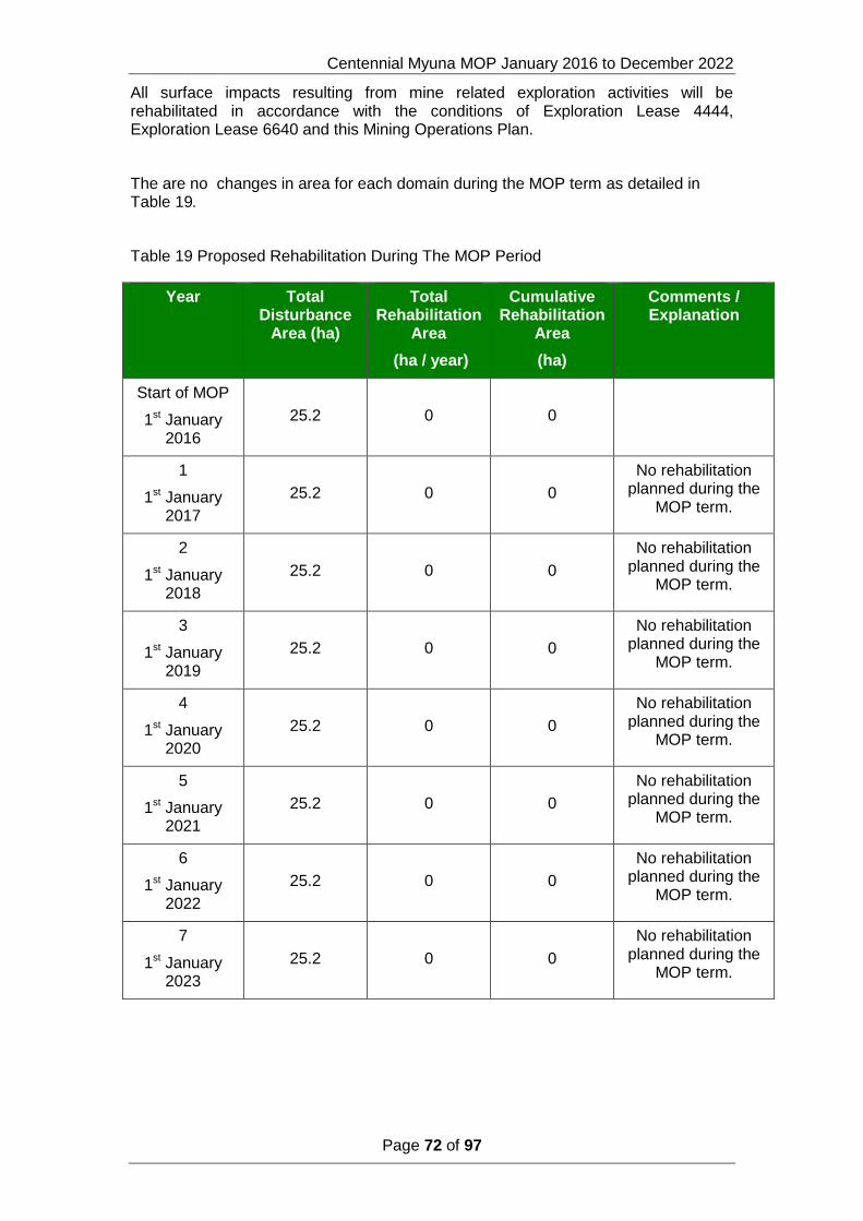
Centennial Myuna MOP January 2016 to December 2022
Page 72 of 97
All surface impacts resulting from mine related exploration activities will be rehabilitated in accordance with the conditions of Exploration Lease 4444, Exploration Lease 6640 and this Mining Operations Plan.
The are no changes in area for each domain during the MOP term as detailed in Table 19.
Table 19 Proposed Rehabilitation During The MOP Period
Year Total Disturbance
Area (ha)
Total Rehabilitation
Area
(ha / year)
Cumulative Rehabilitation
Area
(ha)
Comments / Explanation
Start of MOP
1st January 2016
25.2 0 0
1
1st January 2017
25.2 0 0
No rehabilitation planned during the
MOP term.
2
1st January 2018
25.2 0 0
No rehabilitation planned during the
MOP term.
3
1st January 2019
25.2 0 0
No rehabilitation planned during the
MOP term.
4
1st January 2020
25.2 0 0
No rehabilitation planned during the
MOP term.
5
1st January 2021
25.2 0 0
No rehabilitation planned during the
MOP term.
6
1st January 2022
25.2 0 0
No rehabilitation planned during the
MOP term.
7
1st January 2023
25.2 0 0
No rehabilitation planned during the
MOP term.
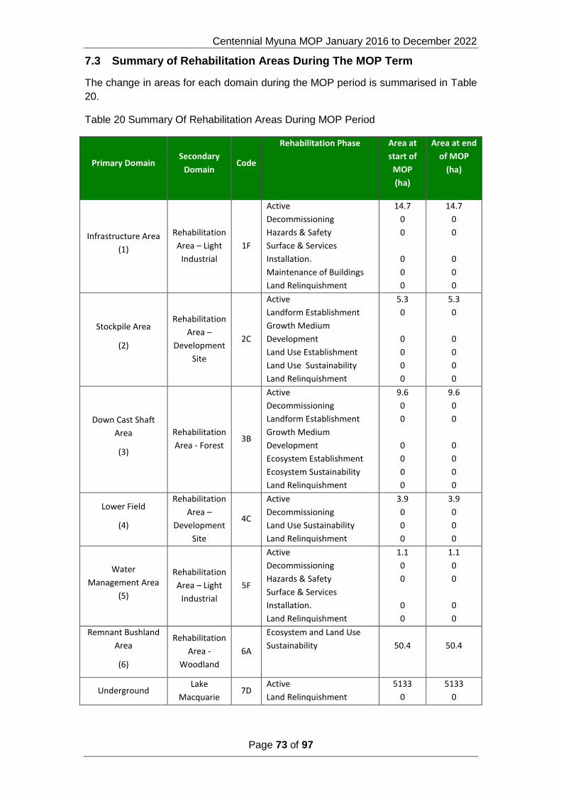
Centennial Myuna MOP January 2016 to December 2022
Page 73 of 97
7.3 Summary of Rehabilitation Areas During The MOP Term
The change in areas for each domain during the MOP period is summarised in Table
20.
Table 20 Summary Of Rehabilitation Areas During MOP Period
Primary Domain Secondary
Domain Code
Rehabilitation Phase Area at
start of
MOP
(ha)
Area at end
of MOP
(ha)
Infrastructure Area
(1)
Rehabilitation
Area – Light
Industrial
1F
Active
Decommissioning
Hazards & Safety
Surface & Services
Installation.
Maintenance of Buildings
Land Relinquishment
14.7
0
0
0
0
0
14.7
0
0
0
0
0
Stockpile Area
(2)
Rehabilitation
Area –
Development
Site
2C
Active
Landform Establishment
Growth Medium
Development
Land Use Establishment
Land Use Sustainability
Land Relinquishment
5.3
0
0
0
0
0
5.3
0
0
0
0
0
Down Cast Shaft
Area
(3)
Rehabilitation
Area - Forest 3B
Active
Decommissioning
Landform Establishment
Growth Medium
Development
Ecosystem Establishment
Ecosystem Sustainability
Land Relinquishment
9.6
0
0
0
0
0
0
9.6
0
0
0
0
0
0
Lower Field
(4)
Rehabilitation
Area –
Development
Site
4C
Active
Decommissioning
Land Use Sustainability
Land Relinquishment
3.9
0
0
0
3.9
0
0
0
Water
Management Area
(5)
Rehabilitation
Area – Light
Industrial
5F
Active
Decommissioning
Hazards & Safety
Surface & Services
Installation.
Land Relinquishment
1.1
0
0
0
0
1.1
0
0
0
0
Remnant Bushland
Area
(6)
Rehabilitation
Area -
Woodland
6A
Ecosystem and Land Use
Sustainability
50.4
50.4
Underground Lake
Macquarie 7D
Active
Land Relinquishment
5133
0
5133
0

Centennial Myuna MOP January 2016 to December 2022
Page 74 of 97
Primary Domain Secondary
Domain Code
Rehabilitation Phase Area at
start of
MOP
(ha)
Area at end
of MOP
(ha)
Mining Area
(7)
Shoreline and
Land 7E
Active
Relinquished Lands
2337
0
2337
0
7.4 Relinquishment Phase Achieved During MOP Period
No lands will be relinquished from the Mining Leases during the MOP period.

Centennial Myuna MOP January 2016 to December 2022
Page 75 of 97
8 Rehabilitation Monitoring and Research
8.1 Rehabilitation Monitoring
Rehabilitation Monitoring
Myuna will undertake a rehabilitation monitoring program that will:
Provide the scientific basis for defining:
o Rehabilitation Objectives; and
o Completion Criteria.
Facilitate continuous improvement in rehabilitation practices through appropriate monitoring and remedial action; and
Assess the long term stability and functioning of rehabilitation areas that will facilitate progressive rehabilitation certification and eventual lease relinquishment following mine closure.
The objective of the rehabilitation monitoring program is to:
Assess the long term stability and functioning of re-established ecosystems on mine affected land when compared to adjacent analogue sites;
Assess rehabilitation performance against the closure criteria; and
Facilitate continuous improvement in rehabilitation practices.
To complement the annual inspections, A rehabilitation monitoring program will be undertaken. The objective of this monitoring program is to evaluate the progress of rehabilitation towards fulfilling long term land use objectives. The monitoring program will also include non-mined areas and rehabilitated areas for reference (analogue) sites. The monitoring results will provide the basis to measure the success of the rehabilitation against the closure criteria. Information from this monitoring program will also be used to refine closure criteria as required.
Broadly, the long term rehabilitation monitoring program will include vegetation monitoring, habitat assessment and fauna monitoring. Whilst the program will be designed to be comparable between monitoring periods, the program will also be flexible to enable the incorporation of a range of industry accepted techniques that will enable sites to be tracked against meeting the closure criteria.
8.1.1 Monitoring of Native Vegetation
A standard monitoring plot design approach that is consistent with the Bio Banking Assessment Methodology 2014 (NSW Office of Environment and Heritage, 2014) which provides a robust and repeatable approach to monitoring of native vegetation in both rehabilitation areas and reference sites will be utilised. The approach aligns with the NSW government’s preferred methodology. The design includes a 20m x 50m base plot incorporating a 20m x 20m nested subplot, 50 metre centres transect and a photo point. Each plot is positioned at a standardised bearing (north/south and east/west, with the longer side ideally running across the slope to pick up erosion issues north/south) and the location marked from the north-east corner with a handheld GPS.

Centennial Myuna MOP January 2016 to December 2022
Page 76 of 97
Plot/transect sites are selected by considering a range of attributes that are considered to influence or determine the type of vegetation communities present. In post mining environments this includes topography, spoil/soil type and aspect. Monitoring of the full range of ecological attributes/floristic aspects of native vegetation rehabilitation commences when the vegetation has reached a level of maturity (i.e. between years 5 to 10). It is recommended that once monitoring commences plot/transect monitoring be undertaken at yearly intervals. Annual monitoring in years 1 - 3 following seeding is undertaken to focus on the initial emergence and establishment of seedlings, including the range and density of key community species that have established. Early signs of erosion can be captured along transects at this time. It is also important during this phase to examine the sites for the presence of weedy species that may hinder further development of the site.
8.1.2 Active Mining Records
During active mining operations, Myuna will maintain active records as to activities and processes that may impact upon the rehabilitation and closure of the site. These records will provide the basis for developing rehabilitation strategies and interpretation of later rehabilitation monitoring outcomes. The types of records to be maintained include, but are not necessarily limited to the following:
Details on each batch of the VENM and ENM used in the rehabilitation of the Down Cast Shaft and Stockpile areas
Where used, a register of topsoil and or soil substitute stockpiles (e.g. bio solids), which includes information such as the date in which they were formed and maintenance works undertaken (e.g. weed control, planting with native legumes to maintain microbes etc.);
Environmental incident records.
8.1.3 Rehabilitation Methodology Records
Myuna will also record the details of each rehabilitation campaign so that they are available for later interpretation of rehabilitation monitoring results with the aim of continually improving rehabilitation standards. Amongst the key monitoring parameters to be included in the program relate to the following:
Landform design details;
Drainage design details;
Substrate characterisation;
Site preparation techniques (e.g. topsoil and source, time of sowing, soil ameliorants used etc.);
Revegetation methodologies (e.g. rate and type of fertiliser, cover crop and rate, seed viability including watering and weed management);
Photographic records; and
Initial follow-up care and maintenance works (including watering and weed management).
8.1.4 Rehabilitation Inspections
Following the completion of each rehabilitation campaign, an initial establishment inspection will be conducted within 6 months to determine whether issues have occurred or are emerging, which have the potential to delay revegetation establishment. Such issues may include erosion that has occurred due to storm events, failure of drainage structures and a lack of germination or establishment of ground cover etc. The objective of this process will be to identify potential issues early in order to minimise the extent of areas affected as well as develop mitigation

Centennial Myuna MOP January 2016 to December 2022
Page 77 of 97
strategies in a timely and cost effective manner As a minimum, annual inspections of rehabilitated areas will be undertaken over the life of the Project to assess soil conditions and erosion, drainage and sediment control structures, runoff water quality, revegetation germination rates, plant health and weed infestation. Outcomes of the annual rehabilitation inspection will be recorded and any required management actions that are identified as part of the inspection implemented as soon as practical as part of the rehabilitation care and maintenance program. Where necessary, rehabilitation procedures will be amended accordingly with the aim of continually improving rehabilitation standards.
8.1.5 Rehabilitation Monitoring
Flora Monitoring
Flora monitoring is conducted annually to assess development of regenerating Open Woodland and rehabilitation areas. Analogue sites are used as control sites for comparison with rehabilitation areas. Information obtained from this monitoring is used to guide and continuously improve rehabilitation efforts at the mine.
Fauna Monitoring
Fauna monitoring is conducted to assess the impacts of mining on local fauna populations, including birds, reptiles, mammals and frogs. Monitoring is also undertaken in rehabilitation to look at colonisation rates of native species in these areas. Monitoring techniques include trapping, spotlighting, echolocation call analysis (for woodland bat species) and inspection of artificial roost sites.
Habitat Analysis
The list below includes the information that is collected with consideration of the habitat analysis techniques:
Physical features including:
o Topographic position;
o Slope;
o Aspect;
o Structure;
o Patch size;
o Patch shape;
o Width if linear;
o Connectivity;
Linear Type;
o Geology;
o The soil chemical and physical properties;
o Soil colour and texture; and
o Surface water bodies within 100 m.
o Plant diversity and health including:
o Exposed soil;
o Lichen;

Centennial Myuna MOP January 2016 to December 2022
Page 78 of 97
o Litter;
o Herbs/ forbs;
o Grasses;
o Grassland condition;
o Grassland height;
o Grassland species diversity;
o Dieback;
o Mistletoe;
o Litter tree base;
o DBH ranges and percentage cover;
o Shrub species;
o Shrub layer species diversity;
o Canopy species;
o Canopy layer species diversity;
o Canopy layer structural diversity;
o Patch health;
o Canopy description;
o Understory description; and
o Tree species percentage (%) of cover.
Habitat value including:
o Rock on rock;
o Overhangs/caves;
o Mistletoe;
o Terrestrial and Arboreal termite mounds;
o Hollow; structure, size classes, number, status and relative abundance;
o Number of habitat trees;
o Scratches on smooth tree trunks; and
o Loose tree bark.
Level of disturbance including:
o Fire;
o Number of cut stumps;
o Presence of grazing and, if so, by what animal species;
o Presence of erosion and, if so, what type;
o Dumping;
o Weed cover abundance; and

Centennial Myuna MOP January 2016 to December 2022
Page 79 of 97
o Dominant weed species.
8.2 Research and Rehabilitation Trials and Use of Analogue Sites.
There are no research projects currently undertaken or planned to be undertaken during the term of the MOP.
There are no rehabilitation trials undertaken or proposed to be undertaken in the term of the MOP.

Centennial Myuna MOP January 2016 to December 2022
Page 80 of 97
9 Intervention and Adaptive Management
9.1 Threats to Rehabilitation
The hazards which could impact on achieving the rehabilitation objectives for each domain are discussed below.
9.1.1 Domain A Woodland
The rehabilitation objectives for Domain A Woodland are:
Maximise preservation of remnant Swamp Sclerophyll Forest on Coastal Floodplains Endangered Ecological Community;
Maintain asset protection zone;
Maintain compliance with the Noxious Weeds Act 1993; and
Public safety.
The primary activities involved in the rehabilitation of the secondary Domain Woodland are the ongoing scheduled maintenance for weed and pest control and maintenance of the asset protection zone. The scheduled maintenance is to be ongoing over the life of the mine. A failure to undertake the scheduled maintenance could result in weed and pest infestation within the woodland domain and impact on achieving the rehabilitation objectives.
The rehabilitation of the neighbouring domain Development Site could impact on the Woodland domain if contaminants and sediments are not adequately controlled. Contamination and sedimentation of Wangi Creek could result in a non compliance with the Project Approval condition to protect and enhance the EEC on Wangi Creek which could impact on the woodland domain achieving the rehabilitation objective.
9.1.2 Domain B Forest
The rehabilitation objectives for Domain B Forest are:
Remove all infrastructure;
Public Safety;
Landform Stability;
Growth Medium developed to sustain native ecosystem;
Soil fertility is comparable between disturbed and undisturbed sites;
Re-establishment of forest ecological community with a similar species composition and distribution to the remnant community;
The vegetation is developing in structure and complexity comparable to that of the local remnant vegetation; and
The number of tree species comprising the vegetation community is comparable to that of analogue sites (no. species/area).
The rehabilitation of the domain Forest will involve the removal of the down cast shaft and sealing and capping of mine openings to departmental guidelines. A failure to seal and cap the mine openings to the Departmental guidelines could lead to slumping, sinkholes and mine water seepage.
Centennial Myuna MOP January 2016 to December 2022
Page 81 of 97
Landform establishment will be undertaken at the down cast shaft compound. The compound area was created by cutting into the hillside. Land fill will be used to reshape the hillside to pre-existing environment. The established land form could be impacted by slumping and or erosion.
The ballast compound will be cleared of all foreign material by use of front end loader and truck. The ballast compound and access road will be deep ripped and capped with top soil. The disturbed areas and the grassed fields will be seeded with an endemic species mix consistent with the analogue site. Hazards which could impact on achieving the rehabilitation objectives include erosion of top soil, insufficient depth of topsoil, inadequate species mix compared with analogue site and poor growth of seedlings and propagules.
9.1.3 Domain C Development Site
The rehabilitation objectives for Domain C Development Site are:
Landform established to development site standards suitable for a light industrial / mixed land use;
Public Safety;
Non-Polluting;
Land Form Stability;
Growth medium;
Establishment of suitable ground cover for a development site;
Maintain established ground cover; and
Structural integrity of retained structures.
The secondary domain C Development Site incorporates the primary domains Stockpile Area, Lower Field and the Water Management Area.
There is an assumption by Centennial Myuna that the Local Government Regional Strategies will remain consistent in the approach of land use zone allocation. There is the potential for Local Government Regional Strategies to change which could result in the final land use plan being inconsistent with the LMLEP Land Use Zone. The approval of the Rezoning LEP Amendment Request is a potential hazard to achieving the rehabilitation objectives.
The rehabilitation of the Stockpile Area involves the removal of the landfill used to create the stockpile pad down to the pre-existing rock base.
The contaminants identified in the stockpile pad were present within the landfill material. The removal of the landfill material will assist in the removal of the contaminants. The removal process presents the potential for sediments and contaminants to be dispersed into Wangi Creek particularly during periods of high rainfall.
There is a further hazard in that there is limited knowledge as to what materials were present in the landfill material used for the stockpile pad and the lower field.
Potential hazards which could impact on achieving the rehabilitation objectives include erosion of top soil, insufficient depth of topsoil, and poor development of ground cover.
9.1.4 Domain D Lake Macquarie
The rehabilitation objectives for Domain D Lake Macquarie are:

Centennial Myuna MOP January 2016 to December 2022
Page 82 of 97
Rehabilitate and or offset mine induced subsidence impacts.
The Lake Macquarie domain encompasses the area identified as Zone B within the Project Approval. Vertical subsidence is limited to 650mm and second workings are limited to partial pillar extraction within the Great Northern and Fassifern seams.
An Extraction Plan which takes into account the information presented in the EA for mining within Zone B will be developed prior to secondary extraction. The Extraction Plan will meet the relevant statutory requirements. The Extraction Plan will consider ways to rehabilitate potential predicted and unpredicted subsidence impacts, including methodologies and response times, and will identify the need for further research required to address any uncertainties or information gaps.
9.1.5 Domain E Land and Shoreline
The rehabilitation objectives for Domain E Shoreline and Land Area are:
Rehabilitate and or offset mine induced subsidence impacts.
The shoreline and land domain encompasses the area identified as Zone A within the Project Approval. The extraction methods within Zone A are restricted to first workings only. Vertical subsidence is to be limited to a maximum of 20mm.
A geo-technically engineered mine design was predicted to provide long term stable mining systems generating no noticeable surface impacts on sensitive surface features including land and sea grass beds.
Mine induced surface subsidence is a hazard which could impact on achieving the rehabilitation objectives.
Rehabilitation of mine induced subsidence impacts would be conducted in consultation with the Department of Trade and Investment and the Department of Planning and Environment.
9.1.6 Domain F Light Industrial
The rehabilitation objectives for Domain F Light Industrial are:
Optimisation of land use potential;
Domain safe and free from hazards;
Public Safety;
Non-Polluting;
Land Form Stability
There is an assumption by Centennial Myuna that the Local Government Regional Strategies will remain consistent in the approach of land use zone allocation. There is the potential for Local Government Regional Strategies to change which could result in the final land use plan being inconsistent with the LMLEP Land Use Zone. The approval of the Rezoning LEP Amendment Request is a potential hazard that could impact on achieving the rehabilitation objectives.
The Myuna Colliery Hazardous Material Survey Register (2012) identifies the extent, type and condition of hazardous materials on surface areas, buildings and associated infrastructure. The hazardous materials identified are asbestos containing material (ACM), synthetic mineral fibre (SMF), polychlorinated biphenyls (PCB) and lead based paint. The non identification of hazardous materials onsite could impact on achieving the rehabilitation objectives for Domain F.

Centennial Myuna MOP January 2016 to December 2022
Page 83 of 97
9.2 Trigger Action Response Plan
The 2015 Myuna Surface Rehabilitation Risk Assessment (Appendix 3) identified risks which may impact on achieving the rehabilitation objectives for the site. The management of these risks during the MOP term are outlined in Section 3 and where required, where risks were determined to be unacceptable, risks classified as moderate or above, a Trigger Action Response Plan has been developed for the management of these risks and is presented in table 22
TABLE 21 RISK CLASSIFICATION
Risk Classification Domain
Soil/hydrocarbon contamination significant C & F
Groundwater seepage moderate B, C & F
Acid mine drainage moderate C
Land Use zoning moderate C & F

Myuna Colliery MOP January 2016 to December 2022
Page 84 of 97
TABLE 22 TRIGGER ACTION RESPONSE PLAN
TARP Ref No.
Risk Trigger Response Action Proposed Mitigation Measure
Monitoring Notification
1
Failure to address
contamination.
Contamination Assessment
identifies contaminated
land exceeding acceptable
levels present within mine
site.
Verification monitoring
undertaken to confirm
contamination has been
removed.
Recommendations of
contamination assessment
implemented.
Ground & Surface water assessment criteria ANZECC (2000) Marine Water trigger levels.
Soil Assessment Criteria NSW DEC (2006) SIL 4, CRC CARE HSL – D, NSW EPA (1994) TPH BTEX.
Sediment Assessment Criteria ANZECC (2000)
ISQG, NSW EPA (1994) TPH.
Notify EPA of Contamination Assessment and
remediation action plan
Data obtained from
compliance monitoring
program indicates
exceedance of EPL
Requirements.
Report non compliance to
EPA.
Repeat analysis to verify
result.
Conduct site investigation
to determine source.
Remove/prevent source
from water course.
Undertake mitigation
measures as proposed in the
WMP.
Monitoring of water quality at discharge point in
accordance with EPL366.
Surface water monitoring at upstream and downstream
location.
Notify relevant Government Agencies in accordance
with Pollution Incident Response Plan if there is
environmental harm, or the potential to cause
environmental harm.
Data obtained from
monitoring program
indicates presence of
contaminants in ground
water.
Repeat analysis to verify
result.
Conduct Soil
Contamination Assessment
Recommendations of
contamination assessment
implemented.
Ground & Surface water assessment criteria ANZECC (2000) Marine Water trigger levels.
Soil Assessment Criteria NSW DEC (2006) SIL 4, CRC CARE HSL – D, NSW EPA (1994) TPH BTEX.
Sediment Assessment Criteria ANZECC (2000)
ISQG, NSW EPA (1994) TPH.
Notify EPA of Contamination Assessment and
remediation action plan
2
Mine water
seepage through
different geological
strata.
Ground water quality
monitoring indicates levels
greater than background
levels.
Visual inspections identify
saturated soils and
stressed vegetation.
Repeat analysis to verify
result.
Investigation and
assessment of cause.
Recommendations of
assessment implemented.
Rehabilitation of area
Ground & Surface water assessment criteria ANZECC (2000) Marine Water trigger levels.
Soil Assessment Criteria NSW DEC (2006) SIL 4, CRC CARE HSL – D, NSW EPA (1994) TPH BTEX.
Sediment Assessment Criteria ANZECC (2000)
ISQG, NSW EPA (1994) TPH.
Notify relevant Government Agencies in accordance
with Pollution Incident Response Plan if there is
environmental harm, or the potential to cause
environmental harm.
3 Mine water
seepage
Ground water quality
monitoring indicates
parameters greater than
background levels.
Visual inspections identify
saturated soils and
stressed vegetation.
Repeat analysis to verify
result.
Recommendations of
assessment implemented.
Rehabilitation of area
Ground & Surface water assessment criteria ANZECC (2000) Marine Water trigger levels.
Soil Assessment Criteria NSW DEC (2006) SIL 4, CRC CARE HSL – D, NSW EPA (1994) TPH BTEX.
Sediment Assessment Criteria ANZECC (2000)
ISQG, NSW EPA (1994) TPH.
Notify relevant Government Agencies in accordance
with Pollution Incident Response Plan if there is
environmental harm, or the potential to cause
environmental harm.
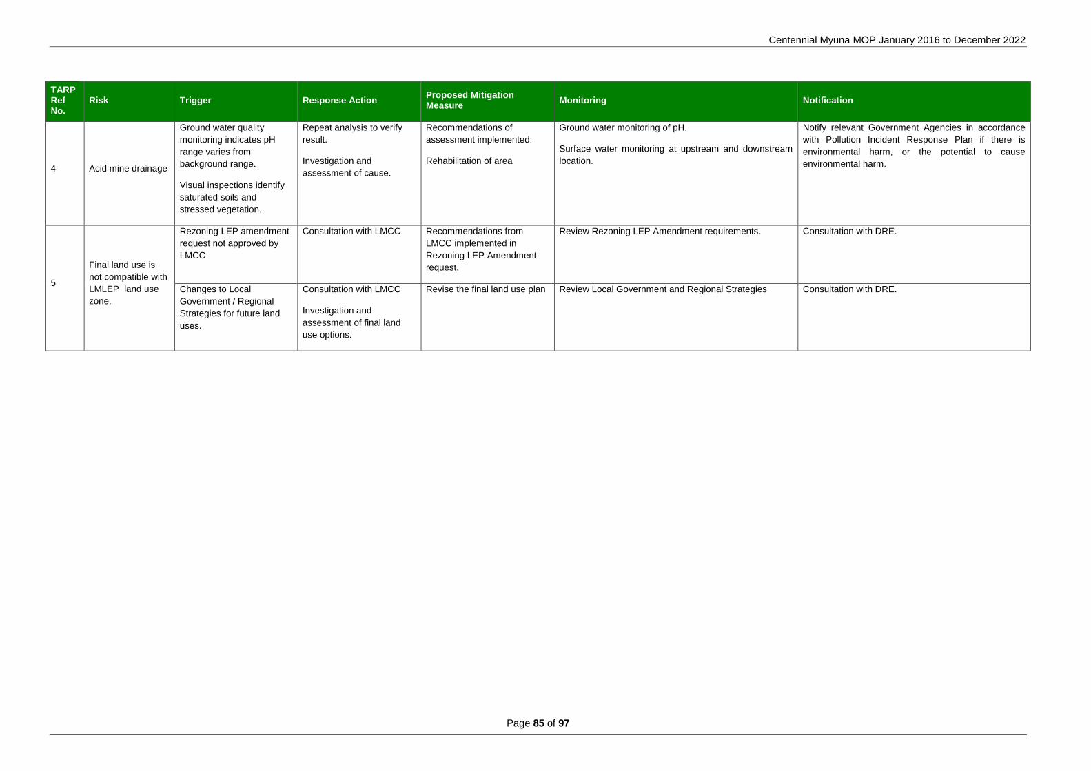
Centennial Myuna MOP January 2016 to December 2022
Page 85 of 97
TARP Ref No.
Risk Trigger Response Action Proposed Mitigation Measure
Monitoring Notification
4 Acid mine drainage
Ground water quality
monitoring indicates pH
range varies from
background range.
Visual inspections identify
saturated soils and
stressed vegetation.
Repeat analysis to verify
result.
Investigation and
assessment of cause.
Recommendations of
assessment implemented.
Rehabilitation of area
Ground water monitoring of pH.
Surface water monitoring at upstream and downstream
location.
Notify relevant Government Agencies in accordance
with Pollution Incident Response Plan if there is
environmental harm, or the potential to cause
environmental harm.
5
Final land use is
not compatible with
LMLEP land use
zone.
Rezoning LEP amendment
request not approved by
LMCC
Consultation with LMCC Recommendations from
LMCC implemented in
Rezoning LEP Amendment
request.
Review Rezoning LEP Amendment requirements. Consultation with DRE.
Changes to Local
Government / Regional
Strategies for future land
uses.
Consultation with LMCC
Investigation and
assessment of final land
use options.
Revise the final land use plan Review Local Government and Regional Strategies Consultation with DRE.
Myuna Colliery MOP January 2016 to December 2022
Page 86 of 97
10 Reporting
Centennial Myuna will prepare an Annual Environmental Management Report (AEMR) as part of the DRE’s Mining, Rehabilitation and Environmental Management Process framework. This report will provide an annual summary of rehabilitation of disturbed lands, rehabilitation monitoring and rehabilitation research trials.
Centennial Myuna will also include in the AEMR the following information;
A description of any rehabilitation works that were completed during the previous calendar year, and
the works that are proposed to be carried out in the coming calendar year;
Results of rehabilitation monitoring and analysis of results against the performance measures specified for each Domain in this MOP document;
A description of any discrepancies between the predicted and actual rehabilitation results;
A report where the rehabilitation TARP has been triggered and the mitigation measures that were implemented; and
A report on any non-compliances or incidents relevant to rehabilitation.
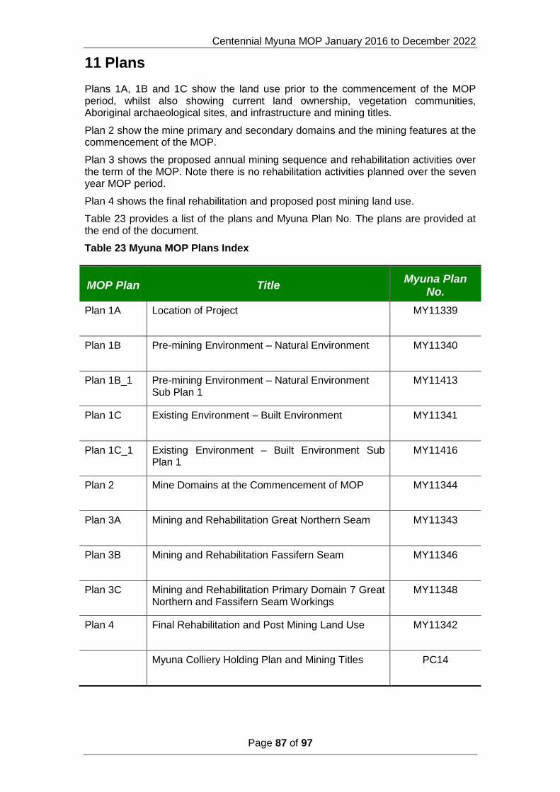
Centennial Myuna MOP January 2016 to December 2022
Page 87 of 97
11 Plans
Plans 1A, 1B and 1C show the land use prior to the commencement of the MOP period, whilst also showing current land ownership, vegetation communities, Aboriginal archaeological sites, and infrastructure and mining titles.
Plan 2 show the mine primary and secondary domains and the mining features at the commencement of the MOP.
Plan 3 shows the proposed annual mining sequence and rehabilitation activities over the term of the MOP. Note there is no rehabilitation activities planned over the seven year MOP period.
Plan 4 shows the final rehabilitation and proposed post mining land use.
Table 23 provides a list of the plans and Myuna Plan No. The plans are provided at the end of the document.
Table 23 Myuna MOP Plans Index
MOP Plan Title Myuna Plan
No.
Plan 1A Location of Project MY11339
Plan 1B Pre-mining Environment – Natural Environment MY11340
Plan 1B_1 Pre-mining Environment – Natural Environment Sub Plan 1
MY11413
Plan 1C Existing Environment – Built Environment MY11341
Plan 1C_1 Existing Environment – Built Environment Sub Plan 1
MY11416
Plan 2 Mine Domains at the Commencement of MOP MY11344
Plan 3A Mining and Rehabilitation Great Northern Seam MY11343
Plan 3B Mining and Rehabilitation Fassifern Seam MY11346
Plan 3C Mining and Rehabilitation Primary Domain 7 Great Northern and Fassifern Seam Workings
MY11348
Plan 4 Final Rehabilitation and Post Mining Land Use MY11342
Myuna Colliery Holding Plan and Mining Titles PC14
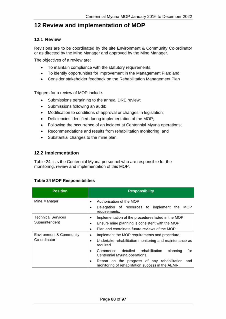
Centennial Myuna MOP January 2016 to December 2022
Page 88 of 97
12 Review and implementation of MOP
12.1 Review
Revisions are to be coordinated by the site Environment & Community Co-ordinator or as directed by the Mine Manager and approved by the Mine Manager.
The objectives of a review are:
To maintain compliance with the statutory requirements,
To identify opportunities for improvement in the Management Plan; and
Consider stakeholder feedback on the Rehabilitation Management Plan
Triggers for a review of MOP include:
Submissions pertaining to the annual DRE review;
Submissions following an audit;
Modification to conditions of approval or changes in legislation;
Deficiencies identified during implementation of the MOP;
Following the occurrence of an incident at Centennial Myuna operations;
Recommendations and results from rehabilitation monitoring; and
Substantial changes to the mine plan.
12.2 Implementation
Table 24 lists the Centennial Myuna personnel who are responsible for the monitoring, review and implementation of this MOP.
Table 24 MOP Responsibilities
Position Responsibility
Mine Manager Authorisation of the MOP
Delegation of resources to implement the MOP requirements.
Technical Services
Superintendent
Implementation of the procedures listed in the MOP.
Ensure mine planning is consistent with the MOP.
Plan and coordinate future reviews of the MOP.
Environment & Community
Co-ordinator
Implement the MOP requirements and procedure
Undertake rehabilitation monitoring and maintenance as required.
Commence detailed rehabilitation planning for Centennial Myuna operations.
Report on the progress of any rehabilitation and monitoring of rehabilitation success in the AEMR.
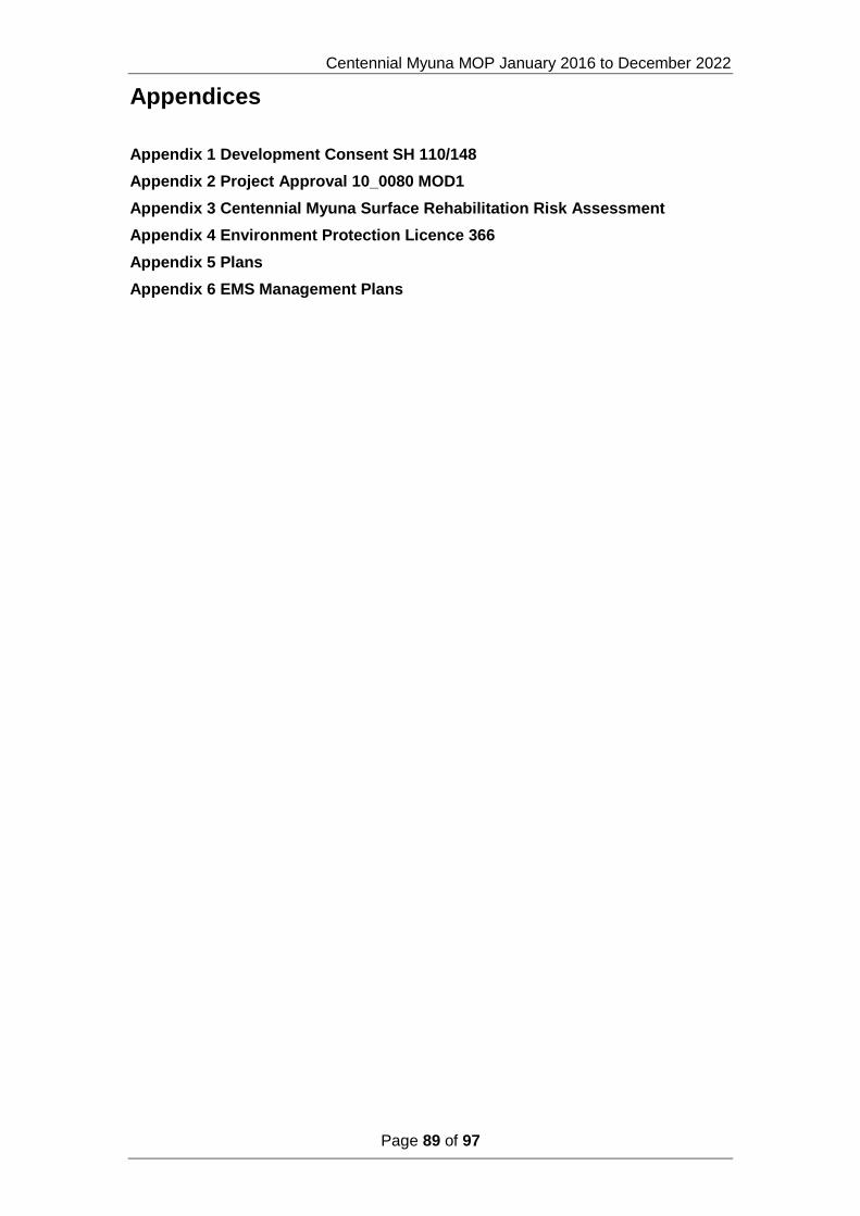
Centennial Myuna MOP January 2016 to December 2022
Page 89 of 97
Appendices
Appendix 1 Development Consent SH 110/148
Appendix 2 Project Approval 10_0080 MOD1
Appendix 3 Centennial Myuna Surface Rehabilitation Risk Assessment
Appendix 4 Environment Protection Licence 366
Appendix 5 Plans
Appendix 6 EMS Management Plans

Centennial Myuna MOP January 2016 to December 2022
Page 90 of 97
Appendix 1 Development Consent SH 110/148
Centennial Myuna MOP January 2016 to December 2022
Page 91 of 97
Appendix 2 Project Approval 10_0080 MOD1
Centennial Myuna MOP January 2016 to December 2022
Page 92 of 97
Appendix 3 Myuna Annual Environmental risk Assessment

Centennial Myuna MOP January 2016 to December 2022
Page 93 of 97
Appendix 4 Environment Protection Licence 366

Centennial Myuna MOP January 2016 to December 2022
Page 94 of 97
Appendix 5 Plans
Centennial Myuna MOP January 2016 to December 2022
Page 95 of 97
Appendix 6 EMS Management Plans
Water Management Plan
Air Quality and Greenhouse Gas Management Plan
Noise Management Plan
Pollution Incident Response Plan
Non Indigenous Cultural Heritage Management Plan
Biodiversity Management Plan

Centennial Coal Company Limited
P O Box 1000
Toronto NSW 2283
www.centennialcoal.com.au