Mineral Resources of the Steep Creek Wilderness Study Area ...
34
Mineral Resources of the Steep Creek Wilderness Study Area, Garfield County, Utah, and the Escalante Canyons Tract V, Kane County, Utah U.S. GEOLOGICAL SURVEY BULLETIN 1747-B *r / * r T-=~f. ^ *» J tf f * T' r : «* .&&* , A" ' . -/" **v-.-. UTAH
Transcript of Mineral Resources of the Steep Creek Wilderness Study Area ...
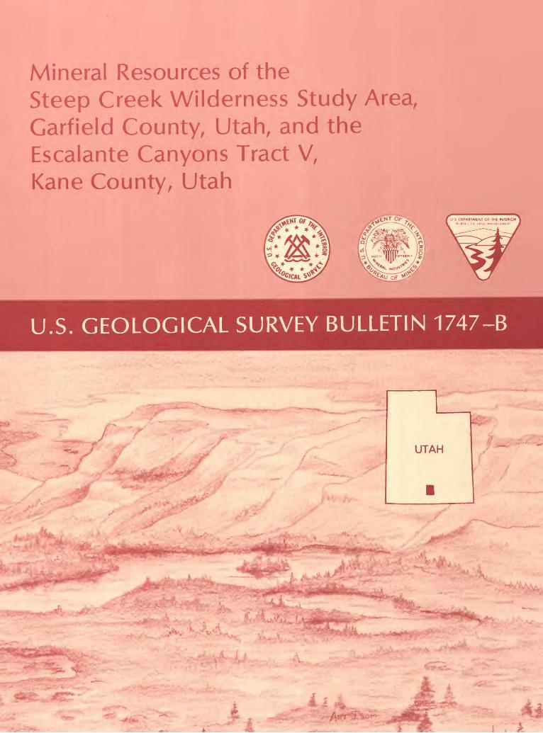
Mineral Resources of theSteep Creek Wilderness Study Area,Garfield County, Utah, and theEscalante Canyons Tract V,Kane County, Utah
U.S. GEOLOGICAL SURVEY BULLETIN 1747-B
*r
/ *
rT-=~f. ^
*» J tf
f *
T'
r
: «* .&&*, A" ' .
-/"**v-.-.
UTAH


Chapter B
Mineral Resources of theSteep Creek Wilderness Study Area,Garfield County, Utah, and theEscalante Canyons Tract V,Kane County, Utah
By SUSAN BARTSCH-WINKLER, RICHARD J. GOLDFARB, JOHN W. CADY, and JOSEPH S. DUVAL U.S. Geological Survey
RICHARD F. KNESS and PATRICIA A. CORBETTA U.S. Bureau of Mines
KENNETH L COOK University of Utah
U.S. GEOLOGICAL SURVEY BULLETIN 1 747

DEPARTMENT OF THE INTERIOR
DONALD PAUL MODEL, Secretary
U. S. GEOLOGICAL SURVEY
Dallas L Peck, Director
Any use of trade names in this report is for descriptive purposes only and does not imply endorsement by the U.S. Geological Survey or the U.S. Bureau of Mines.
UNITED STATES GOVERNMENT PRINTING OFFICE: 1988
For sale by theBooks and Open-File Reports SectionU.S. Geological SurveyFederal CenterBox 25425Denver, CO 80225
Library of Congress Cataloging-in-Publication Data
Mineral resources of the Steep Creek wilderness study area, Garfield County, Utah, and the Escalante Canyons Tract V, Kane County, Utah.
(Mineral resources of wilderness study areas Escalante Canyon region, Utah ; ch. B) (U.S. Geological Survey bulletin ; 1747)
Bibliography: p.Supt. of Docs, no.: I 19.3:1747-81. Mines and mineral resources Utah Steep Creek Wilderness. 2. Mines
and mineral resources Utah Escalante Canyon (Kane County) 3. Steep Creek Wilderness (Utah) I. Barsch-Winkler, S. II. Series. III. Series: U.S. Geological Survey bulletin ; 1747.QE75.B9 no. 1747-B 557.3 s [553'.09792'52] 88-600426 [TN24.U8]
STUDIES RELATED TO WILDERNESS
Bureau of Land Management Wilderness Study Areas
The Federal Land Policy and Management Act (Public Law 94-579, October 21, 1976) requires the U.S. Geological Survey and the U.S. Bureau of Mines to conduct mineral surveys on certain areas to determine the mineral values, if any, that may be present. Results must be made available to the public and be submitted to the President and the Congress. This report presents the results of a mineral survey of the Steep Creek Wilderness Study Area (UT-040-061), Garfield County, Utah, and the Escalante Canyons Tract V (UT-040-077), Kane County, Utah.

CONTENTSAbstract Bl Summary Bl Introduction B5
Investigations by the U.S. Bureau of Mines B5 Investigations by the U.S. Geological Survey B5
Appraisal of identified resources B6 Mining and leasing activity B6 Energy resources B6 Bentonite B7 Sandstone B7 Petrified wood B7 Uranium B7 Gypsum B9 Conclusions B9
Assessment of potential for undiscovered resources B9 Geologic setting and description of rock units B9 Geochemistry Bll
Methods Bll Results of analyses Bll
Geophysics Bll Methods Bll Aeroradiometric survey Bll Gravity and aeromagnetic survey B12
Mineral and energy resources B16 Uranium B16Metals other than uranium B17 Oil and gas B17 Carbon dioxide B17 Gypsum B18 Bentonite B18 Geothermal sources B18
References cited B19 Appendix B21
PLATE
[Plate is in pocket]
1. Map showing mineral resource potential and generalized geology of the Steep Creek Wilderness Study Area, Garfield County, Utah, and the Escalante Canyons Tract V, Kane County, Utah
Contents
FIGURES
1-5. Maps showing:1. Approximate boundary and mineral resource potential of the Steep
Creek Wilderness Study Area, Garfield County, Utah, and the Escalante Canyons Tract V, Kane County, Utah B2
2. Sample localities, mining claims, oil and gas leases and leaseapplications, and generalized structural geology of the Steep Creek Wilderness Study Area B4
3. Sample localities, mining claims, oil and gas leases and lease applications, and generalized structural geology of the Escalante Canyons Tract V B8
4. Complete Bouguer gravity anomalies of an area that includes the Steep Creek Wilderness Study Area and the Escalante Canyons Tract V B13
5. Total-intensity aeromagnetic data for an area that includes the Steep Creek Wilderness Study Area and the Escalante Canyons Tract V B14
VI Contents

MINERAL RESOURCES OF WILDERNESS STUDY AREAS-ESCALANTE CANYON REGION, UTAH
Mineral Resources of the Steep Creek Wilderness Study Area, Garfield County, Utah, and the Escalante Canyons Tract V, Kane County, Utah
By Susan Bartsch-Winkler, Richard J. Goldfarb, John W. Cady, and Joseph S. Duval U.S. Geological Survey
Richard F. Kness and Patricia A. Corbetta U.S. Bureau of Mines
Kenneth L Cook University of Utah
ABSTRACT
The Steep Creek Wilderness Study Area (UT-040-061) and the Escalante Canyons Tract V (UT-040-077) are located in south-central Utah in Garfield and Kane Counties, respectively, west of Capitol Reef National Park. Inferred subeconomic resources of bentonite are present in the Steep Creek Wilderness Study Area; inferred subeconomic resources of decorative and dimension stone are present in both study areas. Petrified wood is present in the Steep Creek Wilderness Study Area, but does not constitute a resource. The mineral resource potential for undiscovered bentonite, oil, gas, and carbon dioxide is moderate in both study areas, and the mineral resource potential for undis covered uranium is moderate in the northeastern part of the Steep Creek Wilderness Study Area and unknown in the western part of the Steep Creek Wilderness Study Area and in the Escalante Canyons Tract V. In both areas, the mineral resource potential for undiscovered iron, cobalt, nickel, copper, lead, molybdenum, tin, cadmium, strontium, and vanadium is low, as is the potential for geothermal energy. Low potential for undiscovered gypsum resources exists in the Escalante Canyons Tract V, and no potential for undiscovered gypsum resources exists in the Steep Creek Wilderness Study Area.
SUMMARY
In November 1987, the U.S. Geological Survey (USGS) and the U.S. Bureau of Mines (USBM), at the request of the U.S. Bureau of Land Management, studied the identified
Manuscript approved for publication September 6, 1988.
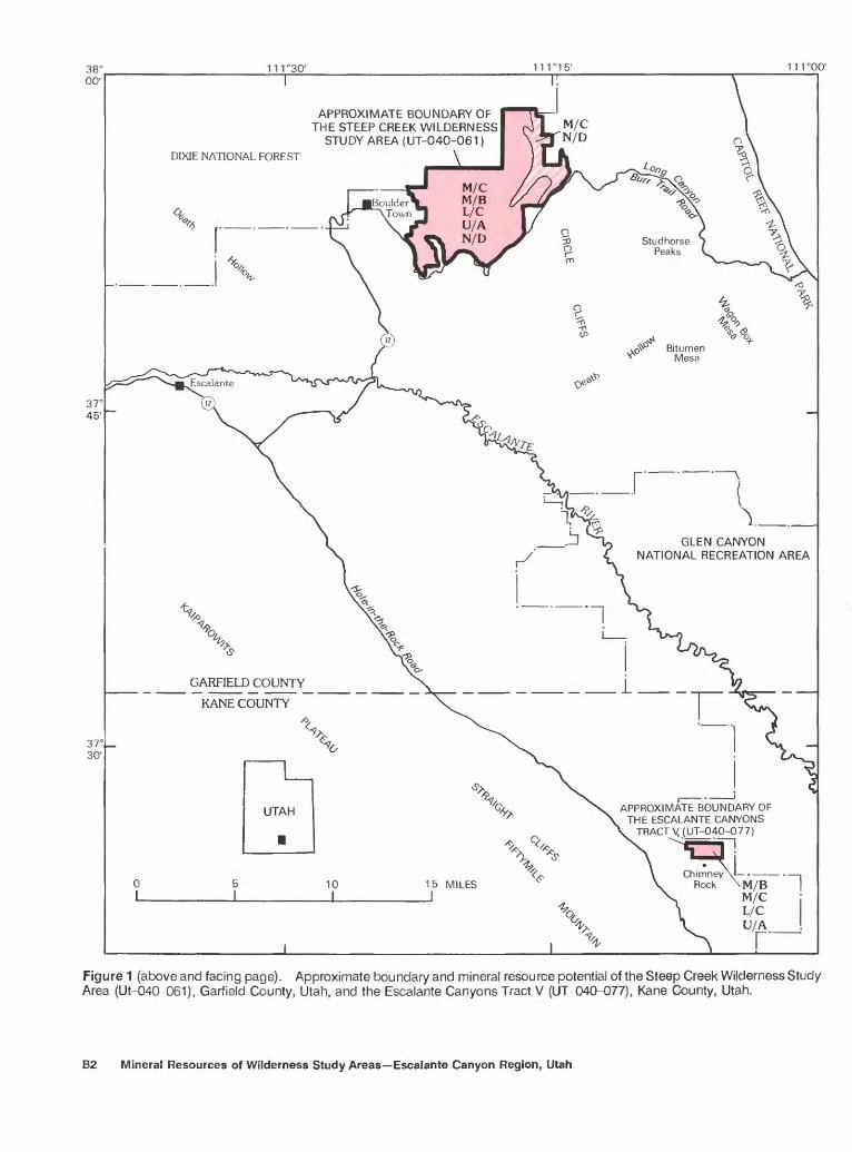
resources (known) and the mineral resource potential (undiscovered) of 20,806 acres of the Steep Creek Wilder ness Study Area, Garfield County, Utah, and the 760-acre Escalante Canyons Tract V, Kane County, Utah (fig. 1). In this report, each of the wilderness study areas is called the "wilderness study area(s)" or simply the "study area(s)." The study areas are in an arid region of south-central Utah, north and west of the Glen Canyon National Recreation Area and south and east of Dixie National Forest (fig. 1). Paved access to the areas is via Utah Highway 12 through Escalante and Boulder Town, the two population centers of the region. Steep Creek Wilderness Study Area is located 2 mi (miles) east of Boulder Town and about 8 mi west of Capitol Reef National Park. Access to the Escalante Canyons Tract V is via the unpaved road that follows the Mormon pioneer route from Escalante to Hole-in-the-Rock about 10 mi southeast of the area of figure 1; the study area lies about 10 mi east of the Straight Cliffs (locally called Fiftymile Mountain). The study areas are within the Colorado Plateau province of south- central Utan (Thornbury, 1965).
The study areas are in a region of broad folds that formed in Mesozoic rock sequences. The Steep Creek Wilderness Study Area lies west of the Circle Cliffs upwarp and is within the Henry Mountains mining district (Johnson, 1961); the Escalante Canyons Tract V is located in a plateau region south and west of the Circle Cliffs upwarp and east of the coal basin on the Kaiparowits Plateau. The study areas contain exposed, gently dipping to flat-lying, Triassic through Jurassic (see geologic time chart in Appendix) sedimentary rocks that are minimally offset by normal faults in the Steep Creek Wilderness Study Area, but that are undisturbed in the Escalante Canyons Tract V. Throughout the region, these rock units have been folded into gentle structures that have
Steep Creek Wilderness Study Area and Escalante Canyons Tract V B1
38 C 00'
37° 45'
37 C 30'
111 °30' 111 °00'
DIXIE NATIONAL FOREST
APPROXIMATE BOUNDARY OFTHE STEEP CREEK WILDERNESS |
STUDY AREA (UT-040-061)
\
M/C M/B L/CU/A N/D
GLEN CANYON NATIONAL RECREATION AREA
GARFIELD COUNTY
KANE COUNTY
APPROXIMATE BOUNDARY OFTHE ESCALANTE CANYONS
TRACT V (UT-040-077)
Figure 1 (above and facing page). Approximate boundary and mineral resource potential of the Steep Creek Wilderness Study Area (Ut-040-061), Garfield County, Utah, and the Escalante Canyons Tract V (UT-040-077), Kane County, Utah.
B2 Mineral Resources of Wilderness Study Areas Escalante Canyon Region, Utah

generally northerly and northwesterly directed axes (Doel- ling, 1975; Sargent and Hansen, 1982). The sedimentary rock units are of dominantly marine shelf and continental origin and are covered, in places, by younger, thin, talus, terrace, and pediment deposits. Exposed bedrock units include, from oldest to youngest, the Lower and Middle(?) Triassic Moenkopi Formation and Upper Triassic Chinle Formation, Upper Triassic Wingate Sandstone, and Upper Triassic(?) Kayenta Formation; the Triassic(?) and Juras- sic(?) Navajo Sandstone; and the Middle Jurassic Carmel Formation and Entrada Sandstone.
Large inferred subeconomic resources of bentonite exist in the lower part (the Monitor Butte and Petrified Forest Members) of the Chinle Formation within the Steep Creek Wilderness Study Area but are without special or unique properties; higher quality resources are present outside the study area. Mesozoic sandstone beds inside and outside both study areas are suitable for decorative and dimension stone and are classified as a large inferred subeconomic resource. Petrified wood, suitable for gem and decorative material, is abundant both inside and outside the north eastern part of the Steep Creek study area where the lower part of the Chinle is exposed, but does not constitute a resource.
No mining has occurred in the study areas, but uranium has been prospected for and mined within 1.5 mi of the
EXPLANATIONGeologic terrane having moderate mineral resource poten
tial for uranium with certainty level C Applies only to the northeastern part of the Steep Creek Wilderness Study Area
Geologic terrane having moderate energy resource poten tial for oil, gas, and carbon dioxide with certainty level B and thin bentonite beds dispersed throughout the lower most Chinle Formation on the surface and in the subsur face with certainty level C Applies to both the Steep Creek Wilderness Study Area and to the Escalante Canyons Tract V
Geologic terrane having low mineral resource potential for iron, cobalt, nickel, copper, lead, molybdenum, tin, cad mium, strontium, vanadium, and geothermal energy with certainty level C Applies to both study areas
Geologic terrane having low mineral resource potential for gypsum with certainty level C Applies only to the Escalante Canyons Tract V
Concealed geologic terrane having unknown mineral resource potential for uranium with certainty level A Applies to the western, central, and southeastern part of the Steep Creek Wilderness Study Area and to the entire Escalante Canyons Tract V
Geologic terrane having no resource potential for gypsum, with certainty level D Applies only to Steep Creek Wilderness Study Area
Level of certainty:Available geologic information is not adequate for deter
mination of the level of mineral resource potential Data indicate geologic environment and suggest the level
of mineral resource potential Data indicate geologic environment and give a good
indication of the level of mineral resource potential Data clearly define geologic environment and level of
resource potentialUnpaved road
N/D
A
B
C
D
Steep Creek Wilderness Study Area boundary. No uranium resources were identified in either of the study areas.
As part of this study, stream-sediment and rock samples from the study areas were collected for analysis. The only consistent multielement anomalies within the study areas occurred within drainages in the Circle Cliffs area near the northeastern part of the Steep Creek Wilderness Study Area. Anomalous concentrations of iron, copper, thorium, lead, vanadium, and uranium characterize the stream-sediment samples in the northeastern part of the Steep Creek Wilderness Study Area; these concentrations probably represent uranium occurrences located outside the study area in the headwaters of the washes. Rock samples collected outside the northeastern part of the Steep Creek Wilderness Study Area in the Horsehead group of prospects (fig. 2) indicate that anomalous amounts of silver, cobalt, copper, molybdenum, nickel, lead, selenium, vanadium, and zinc occur in association with the uranium-bearing minerals. Concentrations decrease with distance away from the Circle Cliffs. Samples from the remaining parts of the Steep Creek Wilderness Study Area contained background concen trations for all analyzed elements.
Geophysical information shows that the study areas are located on opposite sides of roughly congruent, ring- shaped belts of gravity and magnetic highs that are interpreted to indicate a zone of subsurface plutons, either in the Precambrian basement or intruding the Phanerozoic (post-Precambrian) sedimentary section.
Permian and Lower Triassic carbonate reservoir and source rocks that contain hydrocarbon resources elsewhere are present beneath the study areas. However, no drilling or oil and gas exploration has been conducted, and no oil and gas resources were identified. Because the study areas are underlain by known oil-bearing geologic units and there are structural similarities to the nearby Upper Valley field, about 10 mi southwest of Escalante on the western edge of the Kaiparowits Plateau, a moderate resource potential with certainty level B is assigned for oil, gas, and carbon dioxide resources in both study areas.
Uranium occurs elsewhere in the lowermost part of the Chinle Formation, which is present at depths exceeding 1,000 ft (feet) beneath the western part of the Steep Creek Wilderness Study Area and beneath the Escalante Canyons Tract V. In these areas the mineral resource potential for uranium is rated as unknown with certainty level A. The base of the Chinle Formation is exposed in the northeastern part of the Steep Creek Wilderness Study Area that lies adjacent to the Circle Cliffs uranium deposits. Because of this proximity, the mineral resource potential for uranium in the northeastern part of the Steep Creek Wilderness Study Area is rated as moderate with certainty level C.
Geologic units that might contain gypsum deposits crop out along the southwest corner of the Escalante Canyons Tract V, but no gypsum is exposed. The potentially gypsiferous geologic unit has been eroded away from the Steep Creek Wilderness Study Area. A low mineral resource potential with a certainty level C is assigned for gypsum in the Escalante Canyons Tract V. There is no mineral resource potential for gypsum in the Steep Creek Wilderness Study Area with certainty level D. Thin beds of bentonite are
Steep Creek Wilderness Study Area and Escalante Canyons Tract V B3

38° 00'
37' 52' 30"
111"22'30"
I
11 T15'
I
FORMER APPROXIMATE BOUNDARYOF THE STEEP CREEK
WILDERNESS STUDY AREA
R. 4 E. R. 5 E.4 MILES J
R6 E.
EXPLANATION
Former approximate boundary of the Steep Creek Wilderness Study Area
Oil and gas leases
Oil and gas lease offerings
Unpatented mining claims
Anticline Showing trace of axial plane and direction of plunge
-^ Prospect
Figure 2. Map showing sample localities, mining claims, oil and gas leases and lease applications, and generalized structural geology of the Steep Creek Wilderness Study Area (UT-040-061), Garfield County, Utah.
dispersed throughout the lowermost Chinle Formation on the surface and in the subsurface in both study areas. The mineral resource potential for thin beds of bentonite on the surface and in the subsurface is rated as moderate with certainty level C.
Geophysical evidence suggests the possibility for plu- tons at depth adjacent to both study areas, although the plutons would be too old to be a source of heat necessary to produce geothermal resources. There are no volcanic rocks in the vicinity of the study areas. No thermal springs were
B4 Mineral Resources of Wilderness Study Areas Escalante Canyon Region, Utah

observed in either study area. Therefore, the possibility for geothermal energy in both areas is rated as low with a certainty level of C.
Although the statistical geochemical data indicate that iron, cobalt, nickel, copper, lead, molybdenum, tin, cad mium, strontium, and vanadium are present as anomalous trace elements, no metallic mineral deposits occur in the study areas, and both areas are assigned a low mineral resource potential for these metals with certainty level C.
INTRODUCTION
This report presents an evaluation of the mineral endowment (identified resources and mineral resource potential) of the Steep Creek Wilderness Study Area and the Escalante Canyons Tract V and is the product of studies by the USBM and the USGS. Identified resources are classified according to the system of the U.S. Bureau of Mines and U.S. Geological Survey (1980), which is shown in the Appendix of this report. Identified resources are studied by the USBM. Mineral resource potential is the likelihood of occurrence of undiscovered metals and nonmetals, industrial rocks and minerals, and of undiscovered energy sources (geother mal, coal, oil, and gas). Undiscovered resources are studied by the USGS.
The study areas consist of rugged mesa and canyon topography dissected by rivers that flow south and southeast from the highlands of the Henry Mountains (about 45 mi east of Boulder Town), Boulder Mountain (about 15 mi north of Boulder Town), and the Straight Cliffs (Davidson, 1967) (fig. 1). Deeply incised canyons are cut by tributaries of the Escalante River. The region lies within the western part of the Canyonlands section of the Colorado Plateau physiographic province (Thorn- bury, 1965) and within the Escalante Bench and Canyon- lands physiographic province of Doelling (1975, fig. 3). The Steep Creek Wilderness Study Area is 2 mi east of Boulder Town and west of Circle Cliffs and Capitol Reef National Park. The approximate southern boundary of the Steep Creek Wilderness Study Area is the unpaved road (the Burr Trail) extending from Boulder Town through Long Canyon. The major ephemeral drainages in the study area are The Gulch, Steep Creek, and Cottonwood and Hot Canyons (pi. 1). The Escalante Canyons Tract V is a 760-acre proposed addition to the adjacent Glen Canyon National Recreation Area. The area is about 10 mi east of the Straight Cliffs (locally called Fiftymile Mountain); Chimney Rock, a prominent landmark, is near the southern boundary of the area, and Coyote Gulch crosses the northeastern boundary. Foot
. access to each area is gained by use of stock trails.
Investigations by the U.S. Bureau of Mines
In April 1986, the USBM conducted a mineral investigation of 18,350 acres of the total 21,896 acres of the Steep Creek Wilderness Study Area deemed preliminarily suitable by the BLM for inclusion in the National Wilderness Preservation System (Kness, 1987). In addition, USBM geologists conducted a field examination of the Escalante Canyons Tract V. Four- wheel-drive vehicles were driven along outlying unpaved roads and foot traverses were undertaken through both study areas. In the Steep Creek Wilderness Study Area, rock and stream-sediment samples were collected to identify and classify possible identified resources (Kness, 1987, table 6). The samples were analyzed by Bondar Clegg Inc., Lakewood, Colo., by one of the following methods: inductively coupled plasma (ICP), fire assay/ atomic absorption, gravimetric, or X-ray fluorescence. Analytical detection limits and methods are presented in Kness (1987, table 7). The bentonitic mudstone sample (Kness, 1987, table 2, no. 96) was tested for apparent viscosity and water loss by the BLM, Worland, Wyo. In the Escalante Canyons Tract V, two rock-chip samples of the Navajo Sandstone were collected for whole-rock analyses by inductively coupled plasma-atomic emission spectrometry.
A detailed literature search was made for geologic and mining information pertinent to the study area, and BLM records were examined for mining claims and oil and gas leases. National Uranium Resource Evaluation (NURE) reports, published by the U.S. Department of Energy, were reviewed for locations of uranium occur rences and radiometric anomalies. Nine days were spent on the field study, which included an examination of mines and prospects near the Steep Creek Wilderness Study Area and the Escalante Canyons Tract V. Sample results and additional information are available from the USBM, Intermountain Field Operations Center, Building 20, Denver Federal Center, Denver, Colo.
Investigations by the U.S. Geological Survey
During 1986, personnel from the U.S. Geological Survey conducted independent field investigations using four-wheel-drive vehicles for access to the area. Foot traverses were undertaken to accomplish most of the field work. Geologic information, which includes new geophysical and geochemical data and all available and previously published geologic reports and maps as of June 1987, was compiled at 1:50,000 scale.
Steep Creek Wilderness Study Area and Escalante Canyons Tract V B5
The geologic information provided in this report was compiled from cited sources and field-checked by Susan Bartsch-Winkler in August 1986. Stream- sediment and bedrock samples for geochemical analysis were collected by Richard J. Goldfarb during July and August 1986, and interpretations of laboratory data were made by him. Geophysical information was provided by John W. Cady, who conducted a gravity survey during May 1986, and who interpreted the aeromagnetic and gravity data; and by Joseph S. Duval, who interpreted the aeroradiometric data. Additional gravity data were provided by Professor K.L. Cook and students at the University of Utah, Salt Lake City.
APPRAISAL OF IDENTIFIED RESOURCES
By Richard F. Kness and Patricia A. Corbetta U.S. Bureau of Mines
Mining and Leasing Activity
No mining has occurred in the Steep Creek Wilderness Study Area, but uranium has been pros pected for and mined within 1.5 mi of the boundary of the study area. No mineralized areas were identified and no prospects were found inside the study area during the USBM field investigation. However, several old four- wheel-drive roads inside the eastern boundary are probably the result of prospecting during the early 1950's uranium "boom." Unpatented uranium mining claims covering the Centipede, Bart, Midas, and Horsehead prospects extend inside the northeastern boundary of the Steep Creek Wilderness Study Area (fig. 2). Another block of unpatented uranium mining claims near the Blue Goose prospect are 0.5 mi southeast of the boundary (fig. 2).
The Steep Creek Wilderness Study Area is about 1.5 mi west of the Circle Cliffs uranium area and within the Henry Mountains uranium mining district (Johnson, 1961; Doelling, 1967). Uranium occurrences in the Circle Cliffs are small and irregularly distributed along paleochannels in sedimentary rocks. Uranium oxide content ranges from 0.05 to 0.20 percent; copper content ranges from 0.50 to 3.00 percent. Copper-bearing minerals may or may not occur with uranium minerals (Doelling, 1975). Fossil logs in the basal part of the Chinle Formation contain carnotite, a uranium-oxide mineral. Most of the mineralized logs have been found on the west side of the Circle Cliffs, but not in sufficient quantity to define a resource (Davidson, 1967, p. 68).
Uranium workings were driven into the lowermost part of the Chinle Formation within 1.5 mi of the northeastern Steep Creek Wilderness Study Area boundary (at the Centipede mine and other prospects). Most prospects are small, and most underground workings are 100 ft long or less. The Centipede mine is the largest mine to the northeast of the study area and has about 2,000 ft of underground workings. The mine has been worked intermittently since the 1950's, but no production records were found. Total production from the nearby Horsehead mine is less than 20,000 Ibs (pounds) of uranium oxide (Hackman and Wyant, 1973). More than 75 percent of the production in the Circle Cliffs area has been from the Rainy Day mine, about 15 mi southeast of the study area, but the total amount of uranium oxide produced was less than 20,000 Ibs (David- son, 1959; 1967; Hackman and Wyant, 1973). At the Rainy Day mine, uranium is localized in siltstone and mudstone of the uppermost part of the Moenkopi Formation. The ore body is pod-shaped, 1,800 ft long, and 1-1/2 x 4 ft in cross section; ore grade averaged 0.3 percent uranium oxide and 0.15 percent vanadium oxide (Davidson, 1959; Doelling, 1967).
Uranium occurrences were not found in the Esca lante Canyons Tract V. The Chinle Formation, the only rock unit underlying the study area and known to contain significant uranium deposits on the Colorado Plateau, lies at depths of greater than 1,000 ft. The nearest uranium occurrences are to the northeast in the Circle Cliffs area.
Energy Resources
Oil, gas, and oil-impregnated sandstone occur near the Steep Creek Wilderness Study Area. No drilling or other oil and gas exploration is known to have occurred in the study area, but two dry oil and gas holes were drilled on the Circle Cliffs anticlinal axis near Wagon Box Mesa about 10 mi southeast of the study area boundary (Kness, 1987, fig. 1). One well was drilled to a depth of 3,212 ft to the Mississippian Redwall Limestone. The other penetrated 5,628 ft of strata and bottomed in Cambrian rocks (Davidson, 1967). As of October 1986, 7,000 acres in the Steep Creek Wilderness Study Area were leased for oil and gas, and an additional 7,000 acres are oil and gas lease offerings (fig. 2) (Kness, 1987, pi. 1).
The Circle Cliffs oil-impregnated sandstone deposit is 6-8 mi southeast of the study area boundary near Bitumen Mesa, Studhorse Peaks, and Wagon Box Mesa (fig. 1). The deposit is an inspissated oil field (heavy oil) formed in a stratigraphic and structural trap in the Moenkopi Formation. Source rocks are the Lower Permian Kaibab Limestone and beds in the Moenkopi Formation. The deposit is on the east and west flanks of
B6 Mineral Resources of Wilderness Study Areas Escalante Canyon Region, Utah

the Circle Cliffs anticlinal axis, but is absent from the anticlinal axis itself. The west-flank oil-impregnated sandstone section is as much as 310 ft thick, covers 6.6 square miles and contains about 447 million barrels of oil. Minor oil occurrences are present in the Chinle Formation near the east and west flank deposits (Cam pbell and Ritzma, 1979; Ritzma, 1980).
No oil and gas leases or lease applications cover the Escalante Canyons Tract V (fig. 3). Leases to the north west are along the Collet anticline and Harris Wash syncline. Drill holes along and east of the Collet anticline and along the Willow Tank anticline were dry and abandoned, but penetrated the Timpoweap Member of the Moenkopi Formation and the Kaibab Limestone, productive horizons in the Upper Valley field (Doelling, 1975, p. 91).
Bentonite
Bentonite, a clay composed mainly of montmoril- lonite in the smectite clay mineral group, has major uses in drilling mud, taconite (iron ore) pelletizing, and foundry-sand binder (Patterson and Murray, 1983). Physical properties, primarily yield and water-loss, determine the particular commercial use of bentonite. Yield (barrels per ton) is an index to mud building properties; water-loss is a measure of the relative amount of water lost to permeable formations and of the amount of mud sheath deposited on the permeable walls of a drill hole. High-grade bentonite yielding 80 barrels per ton or higher and less than 1.04 in.3 (cubic inches) (17 mL (milliliters)) water-loss meets most industrial speci fications (Regis, 1978).
The Chinle Formation that crops out inside the Steep Creek Wilderness Study Area near the eastern boundary contains bentonitic mudstone beds. In the Circle Cliffs area, the bentonitic part of the Chinle Formation includes the 100- to 200-ft-thick Monitor Butte Member and the 150- to 350-ft-thick Petrified Forest Member in the lower part of the formation (Davidson, 1967). A bentonitic mudstone sample was taken from the Petrified Forest Member in the Steep Creek Wilderness Study Area (Kness, 1987, pi. 1, no. 96). Water-loss was 3.05 in.3 (50 mL) and apparent viscosity equaled one, corresponding to less than 30 barrels per ton yield (Kness, 1987, table 2). These data show that although the bentonitic mudstone is low grade, it would be suitable for use as animal feed binder, gray iron foundry-sand binder, and pet absorbent, as there are no yield or water-loss specifications for these uses (Regis, 1978).
Large inferred subeconomic bentonite resources, suitable for animal feed binder, gray iron foundry, and pet absorbent, are present in the basal part of the Chinle
Formation inside the Steep Creek Wilderness Study Area. No markets have been identified and higher quality resources are present outside the study area.
Sandstone
The Wingate and Navajo Sandstones are exposed within both study areas. These sandstone beds were evaluated for use as industrial special-purpose sands, such as foundry and glass sands. Foundry-sand speci fications require greater than 98 percent silica (Wilburg, 1983), and glass sand specifications require greater than 98.5 percent silica and less than 0.25 percent iron oxide (Mills, 1983). Analytical data (Corbetta, 1986; Kness, 1987) for samples from both study areas show that the Wingate Sandstone is low in silica, making it unsuitable for foundry sands and the manufacture of glass. Samples of Navajo Sandstone from the Escalante Canyons Tract V were collected for whole-rock analysis and show that although the sandstone contains 94-97 percent silica, it is substandard for glass production because the iron-oxide content exceeds the industrial standards of 0.06 percent. It is suitable as a foundry, fracturing, and filtering sand and for use as an abrasive (Bates, 1960, p. 99-103).
The sandstone units are suitable for colored decora tive sands, picture rock, and dimension stone. Large inferred subeconomic sandstone resources suitable for decorative uses are present inside both study areas. The sandstone is unlikely to be developed because similar and more accessible sandstone deposits throughout the Colo rado Plateau are nearer to possible markets.
Petrified Wood
Petrified wood, suitable for gem and decorative material, is abundant in the lower part of the Chinle Formation inside the eastern boundary of the Steep Creek Wilderness Study Area; a broken, 20-ft-long silicified tree log was observed. The wood is dark reddish-brown, silicified, and has visible annular rings. Large petrified wood resources, however, are present outside the study area boundary. Petrified wood occur rences within the study area do not constitute a resource.
Uranium
The Steep Creek Wilderness Study Area is about 1.5 mi west of the Circle Cliffs uranium area. Uranium was mined at the Centipede mine outside the north eastern study area boundary (fig. 2). Mine workings follow a northwest-trending paleochannel for about
Steep Creek Wilderness Study Area and Escalante Canyons Tract V B7

111°22'30" 111°07'30"
GARFIELD COUNTY
KANE COUNTY
APPROXIMATE BOUNDARY OFTHE ESCALANTE CANYONS
_______TRACT V \
T. 38 S.
T. 39 S.
R. 5 E.
I____I
R. 6 E.
I
R. 7 E.5 MILES
I I
UTAH
EXPLANATION Study area boundary
Oil and gas leases (BLM, 6/86)
Oil and gas lease applications (BLM, 6/86)
Unpatented mining claims
Sample locality Showing sample number
Syncline Showing plunge direction
Anticline Showing plunge direction
Figure 3. Map showing sample localities, mining claims, oil and gas leases and lease applications, and generalized structural geology of the Escalante Canyons Tract V, Kane County, Utah.
B8 Mineral Resources of Wilderness Study Areas Escalante Canyon Region, Utah

1,050 ft along a scour-and-fill Moenkopi-Chinle contact (Kness, 1987). According to Davidson (1967), the channel is 200-400 ft wide and 25-40 ft deep in some places; the main channel is about 100 ft wide at the mine. Filled paleochannels and tributaries, present in the Centipede mine and nearby prospects, trend toward and could extend beneath the study area. Uranium resources, however, were not identified in the study area.
In the Centipede mine and nearby prospects, an altered, 6- to 42-in.-thick gray mudstone in the basal part of the Chinle Formation and at the Moenkopi Formation contact with the Chinle Formation contains uranium minerals. The gray mudstone contrasts sharply with the underlying, reddish-brown, unaltered Moenkopi Forma tion. Uraninite is the principal uranium-bearing mineral. Chalcanthite, coquimbite(?), gypsum, hematite, mala chite, and pyrite were also present as gangue minerals. The common spatial association of hematite with sulfide minerals indicates a reduction-oxidation control on ore deposition (Nash and others, 1981). Carbonaceous material is present as fragments, streaks, and pods, and is, in places, stained by iron oxides.
Resource estimates were made using the weighted average of sample concentrations taken from the Centi pede mine. Because the mineralized body is elongate (a paleochannel), resources have been conservatively esti mated to extend 5 ft into both ribs. A tonnage factor of 14 ft3 (cubic feet) per short ton was used. Inferred resources, based on 75 sample sites that have an average mineralized thickness of 1.48 ft and a strike length of 1,550 ft, are approximately 1,600 short tons at average grades of 0.153 percent uranium, 0.439 percent copper, 0.009 percent lead, 0.062 percent vanadium, and 0.076 percent zinc.
Pathfinder elements associated with sandstone- type uranium deposits, such as those in the Circle Cliffs uranium area, are copper, molydenum, selenium, and vanadium (Levinson, 1980; Nash and others, 1981). Pathfinders may be closely associated with, and may assist in finding, mineral occurrences or undiscovered deposits. Anomalous concentrations of these pathfinder elements as well as of lead, silver, and zinc were present in many of the 76 mudstone and sandstone samples collected at the Centipede mine. Analytical data and description of samples from this mine are presented in Kness (1987, table 3) and show that uranium and associated minerals within the Centipede mine are erratically distributed vertically and horizontally.
Gypsum
About 15 mi northwest of the Escalante Canyons Tract V, a 125-ft-thick section of the upper and middle parts of the Carmel Formation contains alternating beds
of gypsum and siltstone (Doelling, 1975, p. 148). The lower part of the Carmel crops out along the western and southern boundaries of the Escalante Canyons Tract V, but gypsum was not exposed.
Conclusions
Large inferred subeconomic resources of bentonite occur within the Steep Creek Wilderness Study area; however, these resources are without special or unique properties. They may be suitable for animal feed binder, iron foundry-sand binder, and pet absorbent. No markets have been identified and higher quality resources are present elsewhere. Sandstone suitable for decorative purposes is present inside both study areas and is classi fied as an inferred subeconomic resource. Petrified wood is abundant in and near the Steep Creek Wilderness Study Area where the lower part of the Chinle Formation is exposed; however, these occurrences are not classified as resources because they are suitable only for gem or decorative material.
Exposed Mesozoic formations within the study areas lack identified metallic minerals. Analytical data do not show uranium or consistent pathfinder element con centrations that may indicate uranium or other metallic minerals at or near the surface. Uranium minerals are present in the lowermost Chinle Formation outside the study areas.
ASSESSMENT OF POTENTIAL FOR UNDISCOVERED RESOURCES
By Susan Bartsch-Winkler,Richard J. Goldfarb, John W. Cady andJoseph S. DuvalU.S. Geological Survey
Kenneth L. Cook University of Utah
Geologic Setting and Description of Rock Units
The western flank of the Circle Cliffs uplift located east and northeast of the study areas (Circle Cliffs, fig. 1) extends southwesterly into the Escalante River region with little disruption (Doelling, 1975). The northwest- plunging Circle Cliffs anticline, which is near the crest of the Circle Cliffs upwarp, dips less than about 6 degrees west but contains many high-angle normal faults whose
Steep Creek Wilderness Study Area and Escalante Canyons Tract V B9
displacement is less than 50 ft. The region is one of gently dipping, north-trending anticlines and synclines. The south-plunging Harris Wash syncline (pi. 1) lies west of the Steep Creek Wilderness Study Area and west of the Escalante Canyons Tract V (Sargent and Hansen, 1982).
The sedimentary sequence exposed and in the subsurface in and near the study areas (pi. 1) includes Mesozoic rocks of the Lower and Middle(?) Triassic Moenkopi Formation and Upper Triassic Chinle Forma tion, Upper Triassic Wingate Sandstone and Upper Triassic(?) Kayenta Formation, the Triassic(?) and Jurassic(?) Navajo Sandstone, and Middle Jurassic rocks including the Carmel Formation and Entrada Sandstone (Davidson, 1967; Sargent and Hansen, 1982) (pi. 1). As determined by exploratory drilling in the vicinity of the study areas, the subsurface sequence includes the Lower and Upper Mississippian Redwall Limestone, the Lower Pennsylvanian Molas and Middle and Upper Pennsyl- vanian Hermosa Formations, the Lower Permian Cutler and Toroweap Formations and the Kaibab Limestone. The Triassic Moenkopi and Chinle Formations crop out in the eastern part of the Steep Creek Wilderness Study Area but are buried in the western part of the study area (Lidke and Sargent, 1983). The exposed sedimentary sequence contains unconformities between the Chinle and Moenkopi Formations, the Wingate Sandstone and the Chinle Formation, and the Navajo Sandstone and the Carmel Formation (Hackman and Wyant, 1973; Sargent and Hansen, 1982).
The Lower and Middle(?) Triassic Moenkopi Formation, about 500-700 ft thick, is a sandstone, silt- stone, and mudstone unit that contains minor amounts of limestone, conglomerate, dolomite, and gypsum that probably represent shallow marine and intertidal deposi- tional environments. The upper part of the Moenkopi is incised (by as much as 200 vertical feet) by stream paleochannels that contain strata of the lower part of the Chinle Formation; these paleochannels may be deposi- tional sites for uranium and associated minerals. In places, the Moenkopi is saturated with heavy oil and asphalt that may be remnants of former oil pools hosted in the rock. Gypsum occurrences are few.
The Upper Triassic Chinle Formation ranges from 0 to 450 ft thick and contains varying amounts of sandstone, mudstone, claystone, siltstone, limestone, grit stone, and conglomerate. The unit thickens to the west and south from the two study areas, but various members comprise the basal strata at different localities. The lower part of the Chinle Formation contains uranium-, vanadium-, and copper-bearing sandstone, siltstone, and mudstone (in some places bentonitic), and silicified and coalified wood and plant debris at the bottom and sides of some paleochannels.
The Upper Triassic Wingate Sandstone is homo geneous, reddish brown, cliff forming, and commonly stained deep purple or black by desert varnish and pock-marked by erosion of noncemented sand. The unit was derived by eolian deposition. Total thickness is 200-400 ft.
The Upper Triassic(?) Kayenta Formation is fine- to coarse-grained sandstone interbedded with minor silt- stone, shale, and conglomerate. The unit is thin to thickly bedded, lenticular, and partly crossbedded. Both calcite and silica cement are present in the sandstones. The Kayenta Formation is distinguished from the Wingate and Navajo Sandstones by its grayish-brown color and its common occurrence as a ledge-former. The Kayenta was deposited by a fluvial system and is about 200 ft thick.
The Triassic(?) and Jurassic(?) Navajo Sandstone is very fine to medium grained, white to buff, and is strikingly crossbedded and massive. The unit is domi- nantly a wind-blown deposit, but rare thin interbeds of shaley, dolomitic, and limy beds originated in a lake; no interbeds are thicker than 10 ft and most are less than 3 ft thick. The unit also contains iron and manganese nodules. The Navajo is characterized by an "elephant- hide" pattern, due to erosion along strong joints, and forms sheer cliffs and domes. The sandstone formation generally lacks vegetation and forms many long, narrow box canyons. The unit thickens to the west, where, at Escalante, it is as much as 1,400 ft thick. It is an excellent aquifer.
The Middle Jurassic Carmel Formation makes a red or brown cap on the Navajo Sandstone. The Carmel is a ledge-forming unit, commonly mottled and streaked, composed of sandstone, siltstone, mudstone, limestone, and gypsum. Mudstone and siltstone are variegated in shades of red, orange, gray, white, brown, and light tan. Limestone beds are more common in the lower parts of the formation. Gypsum is found in nonresistant, con torted and broken thick beds, veinlets, fracture fillings, and nodules, and as cement. The Carmel Formation was deposited in a desert lake or marginal marine environ ment and is about 200 ft thick.
The Middle Jurassic Entrada Sandstone is com posed of unfossiliferous sandstone, siltstone, and mud- stone, and is variegated in tints of red, orange, brown, gray, and white. In areas of nonresistant beds, slopes on the Entrada are earthy and typically covered with sandy soil and vegetation; in places of resistant sandstone, slickrock areas and "elephant-hide" cliffs form which are grooved on the bedding planes; "goblins," "stone- babies," posts, turrets, and isolated buttes are typical. The sandstone is of continental or marine origin and is as much as 900 ft thick in the region.
B10 Mineral Resources of Wilderness Study Areas Escalante Canyon Region, Utah

Geochemistry
Methods
The geochemical survey of the Steep Creek Wilderness Study Area consisted of the collection and analysis of 37 stream-sediment, 32 heavy-mineral con centrate, and 7 rock samples in and adjacent to the study area. Each sample was semiquantitatively analyzed for 31 elements using an optical emission spectrograph accord ing to the method outlined by Grimes and Marranzino (1968). In addition, sediment and selected rock samples were analyzed for uranium (U) and thorium (Th) by delayed neutron activation, and selected rock samples were analyzed for gold (Au) by atomic absorption spectrometry. A complete tabulation of the data and detailed discussion of the sampling and analytical methods are given in Hopkins and others (1987).
Results of Analyses
Small uranium mines and prospects adjacent to the northeastern part of the Steep Creek Wilderness Study Area define the only known mineral occurrences in this part of the Colorado Plateau. Five samples of shale, sandstone, and petrified wood from the Horsehead group of uranium prospects near the northeast corner of the Steep Creek Wilderness Study Area (fig. 2) contain as much as 5 ppm (parts per million) silver (Ag), 200 ppm cobalt (Co), 5,000 ppm copper (Cu), 70 ppm molyb denum (Mo), 200 ppm nickel (Ni), 700 ppm lead (Pb), 150 ppm vanadium (V), and 2,000 ppm zinc (Zn). Results of these analyses indicate that the concentrations are associated with the U-bearing minerals. Kness (1987) also showed that anomalous Ag, Cu, Mo, Pb, V, and Zn, as well as selenium (Se), were associated with the U-rich ore samples from the Circle Cliffs area.
The geochemical evaluation is based largely upon the distribution of selected elements in the stream- sediment samples and in the nonmagnetic fraction of the heavy-mineral concentrates. The only consistent multi element anomalies within the sampled area are within drainages in the Circle Cliffs area both inside and outside the Steep Creek Wilderness Study Area boundary. Anomalous concentrations of 2 percent iron (Fe), 10 ppm Co, 70 ppm Cu, 20 ppm Ni, 30 ppm Pb, 70 ppm V, and 27 ppm U characterize a sediment sample and 1.5 percent Fe, 2 ppm beryllium (Be), 70 ppm cadmium (Cd), 50 ppm Co, 3,000 ppm Cu, 15 ppm Mo, 150 ppm Ni, 3,000 ppm Pb, 70 ppm tin (Sn), 10,000 ppm strontium (Sr), and 7,000 ppm Zn characterize a concentrate collected a few hundred yards downstream from the Horsehead prospect. Farther from the localities known to be mineralized, only the stream-sediment samples contained concentrations above background levels for many elements.
All three sediment samples collected from washes along the east side of the Circle Cliffs to the northeast of the study area boundary are anomalous in Cu, Fe, Pb, Th, U, and V. These sediment samples are derived from the Moenkopi and Chinle Formations, and the anomalous element suite represents contributions of material from the uranium within these lower parts of the sedimentary section. Within the Steep Creek Wilderness Study Area, stream-sediment samples from The Gulch above its junction with Egg Canyon, within Egg Canyon, and within Long Canyon, commonly have weaker anoma lous concentrations for many of the same elements. These anomalies probably represent the uranium occur rences in the headwaters of these washes within the Circle Cliffs.
A sample collected in Water Canyon above the junction with The Gulch contained anomalous concen trations of Cu, Th, and U slightly higher than back ground. These enrichments probably represent contri butions from within the Chinle Formation that crops out along the lower reaches of Water Canyon near the sampled site.
Eight additional panned-concentrate and 17 stream-sediment samples were taken from drainages in and near the Steep Creek Wilderness Study Area (Kness, 1987, pi. 1). Selenium and silver concentrations were below detection limits. Panned-concentrate samples taken from in and near the eastern part of the study area showed low uranium concentrations, and several samples showed high vanadium concentrations (Kness, 1987, table 6). Because vanadium is highly mobile in the secondary environment (Levinson, 1980), the vanadium could be derived from the tuffaceous beds in the Chinle Formation, which crops out in and near the eastern study area boundary. The amount and distribution of vana dium, therefore, was determined not to be indicative of the presence of unknown minerals in the study area.
Geophysics
Methods
Reconnaissance geophysical data typically are not used to detect mineral deposits, but such information aids in providing a three-dimensional geologic frame work that serves to guide exploration. Geophysical data obtained for the Steep Creek Wilderness Study Area and the Escalante Canyons Tract V includes reconnaissance aeroradiometric, aeromagnetic, and regional gravity surveys.
Aeroradiometric Survey
Aerial gamma-ray spectroscopy is utilized to determine the near-surface concentrations of potassium (in percent) and uranium and thorium (in parts per million); because uranium and thorium measurements
Steep Creek Wilderness Study Area and Escalante Canyons Tract V B11
utilize radioactive daughter nuclei that are chemically distinct from the parent nuclei, the uranium and thorium data are described as equivalent concentrations. For a typical aerial survey, each measurement represents aver age concentrations for a surface area on the order of 646,000 ft2 (square feet) to an average depth of about 1 ft. From 1975 to 1983, the U.S. Department of Energy contracted for aerial gamma-ray surveys that covered most of the United States, including Utah, at flight-line spacings of 1A mi, 1 mi, 2 mi, and 3 mi (3 mi is the most common spacing used in Utah). Because of the wide flight-line spacing, the survey is only suitable for pro ducing a regional-scale map. As part of the state mapping project of Utah, data were compiled and processed to produce a series of 1:1,000,000 maps, including the composite-color maps described by Duval (1983). These maps were examined to estimate the concentrations of potassium, thorium, and uranium, for each wilderness study area. The definition of an anomaly requires that the element concentration, as well as its ratios to the other two elements, all be high values within the context of the map. For the Steep Creek Wilderness Study Area and the Escalante Canyons Tract V, the overall radioactivity is low. Concentrations are 1.2-2.0 and 0.5-1.0 percent potassium, respectively; 0.5-2.5 and 0.1-0.5 ppm equiva lent uranium, respectively; and 1-4 and 1-2 ppm equivalent thorium, respectively. There are no gamma- ray anomalies within or adjacent to the study areas.
Gravity and Aeromagnetic Survey
Figures 4 and 5 are gravity and aeromagnetic maps of an area that includes both the Steep Creek Wilderness Study Area and the Escalante Canyons Tract V. Neither the gravity nor the aeromagnetic surveys were designed specifically for either mineral resource or hydrocarbon investigations, although the results are useful for evalu ating such possibilities. Evaluations were based upon a comparison of the geologic map of Hackman and Wyant (1973) with unpublished, l:250,000-scale gravity and magnetic maps. Figures 4 and 5 represent only a small part of these maps.
Figure 4 is a complete Bouguer gravity anomaly map showing stations (triangles) from the digital data set compiled for the Bouguer gravity anomaly map of Utah and stations (squares) obtained specifically for this study (McCafferty and Cady, 1987). A Bouguer anomaly map was prepared using the standard regional Bouguer reduction density of 2.67 g/cm3 (gram per cubic cen timeter). This map showed southeast-trending gravity lows correlative with the high topography of Fiftymile Mountain, 10-15 mi southwest of the Escalante Canyons Tract V. This inverse correlation of Bouguer anomalies with topography indicates that the actual density of the near-surface rocks is less than the reduction density. A
series of maps was prepared using reduction densities of less than 2.67 g/cm3 . The correlation of Bouguer gravity anomalies with local topography was nearly eliminated using a reduction density of 2.30 g/cm3 , the density used in creating figure 4.
Figure 5 is a map showing total-intensity aeromag netic data obtained from a digital tape (National Ura nium Resource Evaluation, 1980) and recontoured. Data for the aeromagnetic map were collected along east-west flight lines spaced 3 mi apart and at 400 ft (nominal) above the ground. Short-wavelength information, origi nally available from closely spaced gravity stations or along magnetic flight lines, was lost in the gridding and contouring process and small features cannot be resolved.
Magnetic profiles (National Uranium Resource Evaluation, 1983) were inspected for short-wavelength anomalies indicating near-surface magnetic rocks. Near- surface magnetic rocks do not appear to be present in the study areas, although short-wavelength magnetic anom alies caused by clinker occur in the Kaiparowits coal field in the southwest part of the map area shown on figure 4 (Bartsch-Winkler and others, 1988).
The major gravity anomaly shown on figure 4 and the large magnetic anomaly on figure 5 have long wavelengths that can be explained by sources 1-2 mi or more deep. Determining what causes the anomalies is difficult, but they may be due to relief of ancient metaig- neous rocks that underlie sedimentary strata, variations in composition of these ancient rocks, or intrusive rocks of younger age that cut the ancient metaigneous basal sequence and (or) the overlying sedimentary section. In the large area east of long 111°, Case and Joesting (1972) concluded that most gravity and magnetic anomalies are caused by sources within the Precambrian metaigneous basement. They argued that gravity anomalies over younger laccoliths of the central Colorado Plateau yield small, poorly defined positive gravity anomalies of about 5 mGal (milligal) amplitude, much smaller than the anomalies attributed to the ancient basement sources. However, my interpretation of regional gravity data indicates that short-wavelength gravity highs over younger laccoliths in the Henry Mountains east of the area shown on figures 4 and 5 are superimposed upon regional gravity highs that together have an amplitude of 15 mGal (at a reduction density of 2.67 g/cm3 , and
Figure 4 (facing page). Complete Bouguer gravity anomaly map of an area that includes the Steep Creek Wilderness Study Area and the Escalante Canyons Tract V. Bouguer reduction density 2.30 g/cm3 . WPM, Waterpocket monocline; CCA, Circle Cliffs anticline; HMSB, Henry Mountains structural basin. GH, gravity high; GL, gravity low. Open triangles, stations from digital data set compiled for Bouguer gravity anomaly map of Utah; open squares, stations obtained for present study (McCafferty and Cady, 1987).
B12 Mineral Resources of Wilderness Study Areas Escalante Canyon Region, Utah

111 °00'
^ APPROXIMATE LOCATION OF I THE STEEP CREEK WILDERNESS
STUDY AREA BOUNDARY
APPROXIMATE LOCATION THE ESCALANTE CANYONS
TRACT V BOUNDARY
Steep Creek Wilderness Study Area and Escalante Canyons Tract V B13

11 1 °00'
\u\\\ \ "--' iAPPROXIMATE LOCATION OF
THE STEEP CREEK WILDERNESSSTUDY AREA BOUNDARY
APPROXIMATE LOCATION OF THE ESCALANTE CANYONS
TRACTV BOUNDARY
B14 Mineral Resources of Wilderness Study Areas Escalante Canyon Region, Utah

greater amplitude at the locally inappropriate reduction density of 2.30 g/cm3) an amplitude comparable to that of gravity highs shown on figure 4. Magnetic highs over the Henry Mountains east of figure 5 have higher ampli tudes than magnetic highs shown on figure 5; however, the higher amplitude highs to the east could result in highs comparable to those shown on figure 5 if the sources were deeply buried. A detailed investigation of the cause of the anomalies on figures 4 and 5 is beyond the scope of this paper, and the widely spaced aeromag- netic data are not amenable to detailed analysis. How ever, there is sufficient doubt about the cause of the anomalies to suggest buried laccoliths as a second hypothesis in addition to that of basement sources.
Twenty miles west of the area shown on figures 4 and 5, magnetic and gravity anomalies clearly reflect basement relief along linear geologic structures such as the Kaibab monocline. In most of the map area, however, linear geophysical anomalies are subdued and there is little expression of mapped geologic structures on the geophysical maps. An exception is the northern part of the Waterpocket monocline (WPM, fig. 4), which coincides with linear gravity and magnetic gradients.
About 25 mi east of the Steep Creek Wilderness Study Area, magnetic and gravity highs are related to Tertiary intrusive rocks of the Henry Mountains. A belt of gravity highs extends southwest from the Henry Mountains towards the eastern part of the area shown on figure 4, although the belt is partly interrupted by the Waterpocket monocline. A belt of magnetic highs extends southwest from the Henry Mountains, but it passes south of the area shown on figure 5.
Within the areas of figures 4 and 5, there is little correlation between magnetic anomalies and surface geology, and an imperfect correlation between gravity and magnetic anomalies. Where magnetic and gravity highs correlate, the source is interpreted to be both dense and magnetic that is, igneous rocks that are denser than adjacent rocks, either in the Precambrian basement or the overlying Phanerozoic sedimentary section. Offsets between approximately correlative gravity and magnetic highs are probably explained by differences in the mathe matics of magnetic and gravity fields, lack of closely spaced magnetic and gravity observations, and com plexities in the geology not included in the simple igneous-intrusion model.
Figure 5 (facing page). Total field aeromagnetic map flown 400 ft (nominal) above ground along east-west flight lines spaced 3 miles apart across an area that includes the Steep Creek Wilderness Study Area and the Escalante Canyons Tract V. Magnetic declination approximately 15 degrees east. WPM, Waterpocket monocline; CCA, Circle Cliffs anticline; HMSB, Henry Mountains structural basin. MH, magnetic high; ML, magnetic low.
GH1-GY4 and MH1-MH4 are gravity and magnetic highs, respectively, caused by the same feature; GL1-GL3 and ML1-ML3 are gravity and magnetic lows, respectively, caused by the same feature. GHa-GHc and MHa-MHg are highs possibly caused by the same feature. GLa and MLa-MLg are lows not caused by the same features.
Gravity highs GH1-GH4 and GHa-GHc encircle gravity low GL1. Of these gravity highs, only high GHc correlates with a mapped geologic feature the Circle Cliffs anticline (CCA, figs. 4,5). Northeast of gravity high GHc, gravity low GL2 is over a syncline (the Henry Mountains structural basin HMSB). Between the high and the low is a gravity gradient associated with the Waterpocket monocline (WPM). Although gravity high GHc coincides with the topographic uplift west of Circle Cliffs, the gravity high is not caused by an inappropriate choice of Bouguer reduction density, for it is present for Bouguer reduction densities ranging from 2.30 to 2.67 g/cm3 . Gravity high GHc, as well as the other gravity highs shown on figure 5, is probably caused in part by higher average densities in the older Permian through Lower Jurassic section (limestone, shale, and sandstone) west of the Waterpocket monocline. A younger sequence of Upper Jurassic through Upper Cretaceous sandstone and shale that has lower average densities occurs east of the Waterpocket monocline in the northeastern part of the area shown on figures 4 and 5.
The circular configuration of gravity highs GH1-GH4 and GHa-GHc and of gravity low GL1 cannot be explained by structures in the sedimentary section, because the structural contour map of Hackman and Wyant (1973) shows no evidence for circular struc tures. The magnetic highs on figure 5 form a circular belt that coincides roughly with the circular belt of gravity highs on figure 4. Although the correlation of magnetic and gravity highs is imperfect, they are probably all caused by fairly dense magnetic rocks, probably plutons, either in the basement or intruding the sedimentary section. The plutons could be granitic, yet have a density higher than adjacent sedimentary rocks. Gravity low GL1 and magnetic low ML1 coincide and indicate an area in the center of the ring belt in which subsurface plutons appear to be lacking. Although gravity low GLa and magnetic low MLd do not exactly coincide, together they also indicate a region lacking subsurface plutons.
The approximate depth to the top of the inferred plutons is equal to the width of the zone of steepest gradients bounding the magnetic highs, or about 1-2 mi. Gravity high GH1 is wider than magnetic high MH1. A second magnetic high (MH1') coincides with the southern part of GH1, and magnetic low MLc separates MH1 and MH1'. This pattern of magnetic highs and lows may be caused by a multiphase pluton that has a non-
Steep Creek Wilderness Study Area and Escalante Canyons Tract V B15

magnetic center and magnetic rim. Magnetic highs MHa-MHg coincide with the belt of gravity highs that runs from GH3 through GHa-GHc to GH1, although individual magnetic and gravity anomalies fail to cor relate, probably because of variations in the magnetic properties of the inferred plutons.
Gravity highs GHc and GH1 end at the Water- pocket monocline, suggesting a relationship between the monocline and the inferred plutons. However, magnetic high MHg crosses the monocline. The relationship between the Waterpocket monocline and the buried sources of the geophysical anomalies remains largely an unsolved problem. Possibly the uplift west of the Water- pocket monocline was caused in part by the Tertiary(?) intrusions inferred from the gravity and magnetic highs.
In conclusion, the encircling belt of gravity and magnetic highs shown on figures 4 and 5 is interpreted to be caused by a ring-shaped subsurface plutonic complex. The Steep Creek Wilderness Study Area overlies the northern part of the inferred complex, and the Escalante Canyons Tract V overlies the southern part of the inferred complex. The inferred plutons are denser than the rocks that they intrude, either Phanerozoic sedi mentary rocks or the underlying Precambrian basement. The plutons are generally magnetic, but nonmagnetic phases are present. The plutons may be analogous to exposed plutons in the Henry Mountains that cause magnetic and gravity highs.
Mineral and Energy Resources
Uranium
Sandstone-hosted uranium deposits are found in sandstones that typically are flat-bedded feldspathic or tuffaceous and of Devonian or younger age in a stable platform or foreland interior basin setting (Turner- Pet erson and Hodges, 1986). According to Turner- Peterson and Hodges (1986), the microcrystalline uranium oxides and silicate ores form during post- depositional alteration of fine- to medium-grained permeable sandstone beds within shale and mudstone sequences, and are later redistributed by ground water; some uranium oxides are concentrated at an oxida tion/reduction boundary. Further, the interbedded mud- stone or shale provides the source for ore-related fluids; carbonaceous material typically reacts with these fluids to precipitate the uranium. Fluvial channels, braided stream deposits, continental-basin margins, and stable coastal plains are the most characteristic settings for uranium deposits. In some tabular uranium-bearing sandstone sequences, humic-acid mineralizing fluids leach iron from detrital magnetite and ilmenite and leave relict titanium minerals (Turner-Peterson and Hodges,
1986). According to Wood and Grundy (1956), uranium deposits in the Chinle Formation are usually found in (1) bottoms and sides of fluvial channels; (2) poorly sorted, argillaceous, arkosic sandstone or conglomerate inter- bedded with mudstone and clay lenses; (3) irregular channels with steep, narrow cross sections; (4) carbon aceous material and clay lenses; (5) a thickened bleached zone in the underlying Moenkopi; and (6) when the following combinations of metals are nearby copper sulfides, sulfates, and carbonates; iron sulfides, sulfates, and hydrous oxides; and cobalt arsenate.
Uranium, a commodity produced within the Colo rado Plateau, is found in the Upper Triassic Chinle Formation and the Upper Jurassic Morrison Formation of northern New Mexico, southwestern Colorado, and southeastern Utah (Doelling, 1975; U.S. Department of Energy, 1979). The Morrison Formation has been eroded from the study areas, but the Chinle Formation is exposed in the eastern part of the Steep Creek Wilderness Study Area and occurs at depth in the western part of the Steep Creek Wilderness Study Area and beneath the Escalante Canyons Tract V.
According to Dubyk and Young (1978), the favorability for uranium and its recovery in the nearby Kaiparowits Plateau region is low. Their conclusion is partly based on the following data: (1) only 3 of 34 test hole logs showed gamma-ray anaomlies (greater than two times background); (2) the absence of carbonaceous matter that is associated with uranium mineralization; and (3) the great depth to the Chinle Formation.
The Steep Creek Wilderness Study Area lies within the Henry Mountains mining district where uranium- oxide minerals occur in fossilized logs in the lower part of the Chinle Formation. No uranium has been mined from within the Steep Creek Wilderness Study Area itself, but unpatented uranium claims extend inside the north eastern boundary where the lowermost Chinle Forma tion is most exposed. In the northeastern part of the Steep Creek Wilderness Study Area, near the Circle Cliffs uranium deposits, the mineral resource potential for uranium is moderate with a certainty level C. In the southeastern part of the Steep Creek Wilderness Study Area, any uranium present would probably be within the lowermost Chinle at less than 1,000 ft depth; near the western boundary of the study area, any uranium present would probably be at a depth of 1,700 ft (Oakes and others, 1981). Because pertinent information is lacking in these two places in the study area, the mineral resource potential for uranium is unknown with certainty level A.
No uranium was found in the Escalante Canyons Tract V. The Chinle Formation, the only rock unit underlying the study area known to contain significant concentrations of uranium elsewhere, lies at depths in excess of 1,000 ft. The mineral resource potential for
B16 Mineral Resources of Wilderness Study Areas Escalante Canyon Region, Utah
uranium in concealed rocks of the Chinle Formation of the Escalante Canyons Tract V is unknown with certainty level A.
Metals Other Than Uranium
Neither the Steep Creek Wilderness Study area nor the Escalante Canyons Tract V contains any known mineralized areas. Statistical geochemical data indicate anomalous concentrations of iron, cobalt, nickel, copper, lead, molybdenum, tin, cadmium, strontium, and vana dium in stream-sediment and concentrate samples collected from drainages in the Steep Creek Wilderness Study Area near Circle Cliffs. Farther from known mineralized areas, only the stream-sediment samples contained concentrations higher than background levels. These anomalies probably reflect uranium derived from deposits from Circle Cliffs outside the Steep Creek Wilderness Study Area. The Steep Creek Wilderness Study Area and the Escalante Canyons Tract V have a low mineral resource potential for iron, cobalt, nickel, copper, lead, molybdenum, tin, cadmium, strontium, and vanadium with certainty level C.
Oil and Gas
The most favorable formations targeted for oil and gas exploration in south-central Utah are the Honaker Trail Formation and the Paradox Formation (Pennsyl- vanian) (Oakes and others, 1981), the Redwall Lime stone (Mississippian) (Kunkel, 1965; Oakes and others, 1981), the Cedar Mesa Sandstone Member of the Cutler Formation (Lower Permian), the Kaibab Limestone (Lower Permian) (Kunkel, 1965; Oakes and others, 1981), and the upper part of the Moenkopi Formation (Triassic) (Doelling, 1975, p. 91-96; Oakes and others, 1981). According to Lidke and Sargent (1983), the Mississippian through Triassic section is present beneath the Steep Creek Wilderness Study Area and the Escal ante Canyons Tract V.
Oil and gas resources in Utah have been appraised by Molenaar and Sandberg (1983), who designated the Steep Creek Wilderness Study Area and Escalante Canyons Tract V as having moderate potential. In the nearby Upper Valley field, about 10 mi southwest of Escalante on the western edge of the Kaiparowits Plateau (fig. 1), production is primarily from the Kaibab Limestone (Campbell, 1969; Molenaar and Sandberg, 1983). The oil and gas occur in a southeasterly plunging anticline in which a hydrodynamic gradient has produced an inclined oil-water contact (Sharp, 1978; Molenaar and Sandberg, 1983). At one tract on the west flank of the Upper Valley structural anticline in the Upper Valley field, 21 million barrels of oil have been produced (Sharp, 1976). Some exploration has taken place on
similar structural anticlines in south-central Utah, including those near Steep Creek Wilderness Study Area and Escalante Canyons Tract V since production began from the Upper Valley field, but no commercial oil and gas has been found.
No drilling or other oil and gas exploration has occurred within the Steep Creek Wilderness Study Area, but as many as eight exploratory oil and gas wells have been drilled in the vicinity, each testing parts of the large anticlines that surround the study area to the east, west, and north. These wells bottomed in lower Paleozoic rock sequences (Oakes and others, 1981). Oil shows were reported from parts of the Pennsylvanian and Permian sections (Oakes and others, 1981) and in the Lower Permian Cedar Mesa Sandstone and White Rim Sandstone Members near Wagon Box Mesa (Kness, this report). Structural and stratigraphic traps may be present at depth. The distribution of oil-impregnated sandstone deposits southeast of the study area may represent a southward-directed hydrodynamic drive that displaced oil to the south (Oakes and others, 1981). If this apparent hydrodynamic fluid-pressure gradient has not displaced the hydrocarbons away from the Steep Creek Wilderness Study Area, oil and gas resources may be present. As of October 1986, 7,000 acres have been leased for oil and gas in the Steep Creek Wilderness Study Area, and an additional 7,000 acres are oil and gas lease offerings (fig. 2).
No oil and gas leases or lease applications cover the Escalante Canyons Tract V. The nearest leases are near the southern boundary of the study area and extend southward into what is known as Cat Pasture. Leases to the northwest are along the Collet anticline and Harris Wash syncline (fig. 3). Drill holes into the Collet anticline and the Willow Tank anticline were dry and abandoned, but penetrated the Timpoweap Member of the Moen kopi Formation and the Kaibab Limestone, which are the productive horizons in the Upper Valley field (Doelling, 1975, p. 91). Based on the stratigraphic and structural similarities between the two study areas and the Upper Valley field, Molenaar and Sandberg (1983, p. K-ll) assigned a moderate petroleum potential to the Esca lante Canyons Tract V.
Oil and gas resources in the Steep Creek Wilder ness Study Area and the Escalante Canyons Tract V are assigned a moderate energy resource potential with a certainty level B.
Carbon Dioxide
Carbon dioxide is important in oil-recovery enhancement techniques, such as those being used in West Texas fields. Because carbon dioxide is miscible with oil, it acts as a solvent and displaces enough water to mobilize oil in water-invaded reservoirs that would
Steep Creek Wilderness Study Area and Escalante Canyons Tract V B17

otherwise be unrecoverable. The largest carbon-dioxide gas reservoirs in the region are the McElmo dome and Doe Canyon fields near the Four Corners area of Colo rado and about 100 mi southeast of the two study areas. The source rock is the Leadville Limestone of Early Mississippian age. Carbon-dioxide gas was created in this carbonate reservoir when the water-filled formation was altered by high pressure and temperature during deep- seated volcanism.
In the early 1960's, during exploration for oil and gas in the Death Hollow area about 8 mi northeast of Escalante (fig. 1), a carbon-dioxide reservoir was dis covered in rocks beneath the Escalante anticline (Oil and Gas Journal, 1984), a structure similar to those near the Steep Creek Wilderness Study Area and the Escalante Canyons Tract V. The anticline is overlain on its north half by igneous volcanic rocks (Oil and Gas Journal, 1984). Drilling confirmed a field of high-purity carbon dioxide in the Upper Triassic Chinle Formation and the Lower Permian Kaibab Limestone, Cedar Mesa Sand stone Member, and Toroweap Formation sedimentary rocks (Tooker and others, 1984). Mid-Continent Oil and Gas Reserves Inc. confirmed a carbon-dioxide gas reservoir that had a gauged open-flow of 124,347,000 ft3 (cubic feet) daily at one well; the gas occurs in an interval from 1,354 to 3,443 ft depth (The Denver Post, Nov. 20, 1983). This deposit is estimated to contain several trillion cubic feet of gas (Leed Petroleum Corporation, written commun., 1984).
Geophysical evidence suggests possible plutonic activity of unknown age at depth in the vicinity of the study areas (Cady, this report). If the plutonic activity took place at a propitious time interval, the heat and pressure generated by such activity might enable carbon dioxide gas to generate in the overlying carbonate rocks. There are no volcanic rocks in the vicinity of the study areas such as those overlying the Escalante anticline that might produce the necessary heat and pressure to form carbon-dioxide gas in the underlying limestone strata. Although recent drilling has shown no evidence of carbon-dioxide gas in the study areas, because the Esca lante anticline is similar to other structures in the study areas and because of its proximity to the study areas, the energy resource potential for carbon-dioxide gas in the Steep Creek Wilderness Study Area and the Escalante Canyons Tract V is rated as moderate with a certainty levelB.
Gypsum
Gypsum commonly precipitates in inland sabkha (salt flat) and desert lakes in basins where rainfall is limited and evaporation is rapid (Reineck and Singh, 1975). Gypsum typically occurs in evaporite deposits or in extensive beds interstratified with limestone, shale, and clay.
Near the Escalante Canyons Tract V, a 125-ft-thick section of the upper and middle parts of the Carmel Formation contains alternating beds of gypsum and siltstone (Doelling, 1975, p. 148). The lower part of the Carmel crops out along the southwestern corner of the Escalante Canyons Tract V, but gypsum is not exposed. The Carmel Formation has been eroded from the Steep Creek Wilderness Study Area. Therefore, there is low mineral resource potential with certainty level C for gypsum in the Escalante Canyons Tract V, and there is no resource potential for gypsum in the Steep Creek Wilderness Study Area with certainty level D.
Bentonite
Bentonite is a term applied to various colloidal or plastic clays; their colloidal and plastic properties make bentonite clays useful. The clays can take up water or organic liquids between their structural layers and can exchange cations readily. Dispersed bentonite is thixo- tropic (colloidal). Bentonite is especially useful to the oil industry in drilling operations; it is also useful in making ceramics, paper, rubber, paints, and moulding sands (Deer and others, 1966).
Bentonite is formed by in-place alteration of volcanic matter; the deposits containing bentonite maybe either marine or nonmarine. Beds of bentonite are typically less than 1 ft thick; rarely they are as thick as 50 ft. Usually several tens of thin bentonitic beds might occur in a formation separated by clastic or tuffaceous units (Blatt and others, 1972). The chemical composition of bentonite is complex and variable, although calcic montmorillonite (with magnesium in small amounts) is the most common bentonite clay in the western Untied States and Canada (Blatt and others, 1972; Dana, 1963).
Bentonite is a constituent of mudstone in the lower part of the Chinle Formation that crops out in the northeastern part of the Steep Creek Wilderness Study Area and that occurs in the subsurface in the rest of the Steep Creek Wilderness Study Area and in the Escalante Canyons Tract V. Bentonite beds are typically less than a few inches thick and bentonite is dispersed in mudstone throughout the lower part of the Chinle. The mineral resource potential for thin, dispersed bentonite beds in the lower part of the Chinle Formation on the surface and in the subsurface in both study areas is rated as moderate with a certainty level C.
Geothermal Sources
Geothermal sources are lacking within the Colo rado Plateau except along the edges where volcanic rocks are found. No thermal springs were observed in either of the study areas. Igneous rocks that crop out on the Colorado Plateau are generally between 17 and 65 m.y.
B18 Mineral Resources of Wilderness Study Areas Escalante Canyon Region, Utah

old (Luedke and Smith, 1978); according to some investigators, these rocks are too old to be a viable source of heat necessary to produce geothermal activity. In addition, stream incision has lowered the ground-water table in the study areas. However, given the possibility of plutonic activity at depth and the excellent water reser voir rocks present, such occurrences cannot be ruled out. Therefore, the Steep Creek Wilderness Study Area and the Escalante Canyons Tract V have low potential for geothermal sources with a certainty level of C.
REFERENCES CITED
Bartsch-Winkler, Susan, Barton, H.N., Cady, J.W., and Martin, C.M., 1988, Mineral resources of the Fifty Mile Mountain Wilderness Study Area, Kane County, Utah: U.S. Geological Survey Bulletin 1447-A, 20 p.
Bates, R.L., 1960, Geology of the industrial rocks and minerals: New York, Dover Publications, Inc., 459 p.
Blatt, Harvey, Middleton, Gerard, and Murray, Raymond, 1972, Origin of sedimentary rocks: Englewood Cliffs, New Jersey, Prentice-Hall, Inc., 634 p.
Campbell, J.A., 1969, The Upper Valley oil field, Garfield County, Utah, in Four Corners Geological Society Guidebook, Fifth field conference on geology and natural history of the Grand Canyon region: p. 195-200.
Campbell, J.A., and Ritzma, H.R., 1979, Geology and petroleum resources of the major oil-impregnated sandstone deposits of Utah: Utah Geological and Mineralogical Survey Special Studies 50, 24 p.
Case, J.E., and Joesting, H.R., 1972, Regional geophysical investigations in the central Colorado Plateau: U.S. Geological Survey Professional Paper 736, 31 p.
Corbetta, P.A., 1986, Mineral investigation of a part of the Scorpion Wilderness Study Area (UT-040-082), Garfield County, Utah, and North Escalante Canyon (V) Instant Study Area, Kane County, Utah: U.S. Bureau of Mines Open File Report MLA 59-86.
Dana, E.S., 1963, A textbook of mineralogy, revised and enlarged by W.E. Ford, 4th edition: New York, John Wiley and Sons, Inc., 851 p.
Davidson, E.S.,1959, Geology of the Rainy Day uranium mine, Garfield County, Utah: Economic Geology, v. 54, no. 3, p. 436-^48.
____ 1967, Geology of the Circle Cliffs area, Garfield andKane Counties, Utah: U.S. Geological Survey Bulletin1229, 140 p., 3 pi., scale 1:48,000.
Deer, W.A., Howie, R.A., and Zussman, J., An introduction tothe rock-forming minerals: New York, John Wiley andSons, Inc., 528 p.
Doelling, H.H., 1967, Uranium deposits of Garfield County,Utah: Utah Geological and Mineralogical Survey SpecialStudies 22, 113 p.
____1975, Geology and mineral resources of GarfieldCounty, Utah: Utah Geological and MineralogicalSurvey Bulletin 107, 175 p.
Dubyk, W.S., and Young, Patty, 1978, Preliminary evaluation of the uranium favorability in the Kaiparowits Plateau region, Garfield and Kane Counties, Utah: U.S. Department of Energy Report GJBX-64(78), 26 p.
Duval, J.S., 1983, Composite color images of aerial gamma-ray spectrometric data: Geophysics, v. 48, p. 722-735.
Grimes, D.J., and Marranzino, A.P., 1968, Direct-current arc and alternating-current spark emission spectrographic field methods for the semiquantitative analysis of geologic materials: U.S. Geological Survey Circular 591, 6 p.
Hackman, R.J., and Wyant, D.G., 1973, Geology, structure, and uranium deposits of the Escalante quadrangle, Utah and Arizona: U.S. Geological Survey Miscellaneous Geologic Investigations Series Map 1-744, scale 1:250,000.
Hopkins, R.T., Goldfarb, R.J., Rose, S.D., and Vaughn, R.B., 1987, Analytical results and sample locality map of stream-sediment, heavy-mineral-concentrate, and rock samples from the Steep Creek Wilderness Study Area, Garfield County, Utah: U.S. Geological Survey Open- File Report 88-208, 16 p.
Johnson, H.S., 1961, Uranium resources of the Green River and Henry Mountains districts A regional synthesis, in Contributions to the geology of uranium, 1958: U.S. Geological Survey Bulletin 1087-C, p. 59-104.
Kness, R.F., 1987, Mineral investigation of a part of the Steep Creek Wilderness Study Area (UT-040-061), Garfield County, Utah: U.S. Bureau of Mines Mineral Land Assessment Report MLA 21-87, 36 p.
Kunkel, R.P., 1965, History of exploration for oil and natural gas in the Kaiparowits region, Utah, in Geology and resources of southcentral Utah Resources for power: Utah Geological Society Guidebook 19, p. 93-111.
Levinson, A.A., 1980, Introduction to exploration geochemis try: Wilmette, 111., Applied Publishing, 924 p.
Lidke, D J., and Sargent, K.A., 1983, Geologic cross sections of the Kaiparowits coal-basin area, Utah: U.S. Geolog ical Survey Miscellaneous Investigations Series Map I-1033-J, scale 1:125,000.
Luedke, R.G., and Smith, R.C., 1978, Map showing distribution, composition, and age of late Cenozoic volcanic centers in Colorado, Utah, and southwestern Wyoming: U.S. Geological Survey Miscellaneous Investigations Series Map I-1091-B, scale 1:1,000,000.
McCafferty, A.E., and Cady, J.W., 1987, Gravity survey data of seven wilderness study areas in southwest Utah, Kane and Garfield Counties, Utah: U.S. Geological Survey Open-File Report 87-200, 9 p.
McKelvey, V.E., 1972, Mineral resource estimates and public policy: American Scientist, v. 60, p. 32-40.
Mills, H.N., 1983, Glass raw materials, in Lefond, SJ., ed., Industrial minerals and rocks (5th ed.): New York, American Institute of Mining, Metallurgical, and Petroleum Engineers, v. 1, p. 339-347.
Molenaar, C.M., and Sandberg, C.A., 1983, Petroleum potential of wilderness lands in Utah, in Miller, B.M., ed., Petroleum potential of wilderness lands in the western United States: U.S. Geological Survey Circular 902, p. K1-K14.
Steep Creek Wilderness Study Area and Escalante Canyons Tract V B19

Nash, J.T., Granger, H.C., and Adams, S.S., 1981, Geology and concepts of genesis of important types of uranium deposits: Economic Geology, 75th Anniversary Volume, p. 63-116.
National Uranium Resources Evaluation, 1980, Aerial radio- metric and magnetic survey, Escalante national topographic map, Arizona/Utah: Geo-Life, Inc., 183 p., 106 fiches, PR-80-13, 2/6/80.
____1983, Residual intensity magnetic anomaly profile map, Escalante national topographic map, Arizona/Utah: U.S. Department of Energy Open-File Map GJM-416.
Oakes, Ed, Wedow, Helmuth, Poling, Robert, and Voelker, Al, 1981, Energy-resource evaluation of wilderness study areas administered by the Bureau of Land Management Cedar City District, Utah: Prepared for U.S. Department of Energy, Leasing Policy Develop ment Office, Oak Ridge, Tenn., 317 p.
Oil and Gas Journal, 1984, Utah CO2 reservoir scheduled for delineation: Oil and Gas Journal, April 23, 1984, p. 53.
Patterson, S.H., and Murray, H.H., 1983, Clays, in Lefond, S.J., ed., Industrial mineral and rocks (5th ed.): New York, American Institute of Mining, Metallurgical, and Petroleum Engineers, v. 1, p. 585-651.
Regis, A.J., 1978, Correlation between physical properties and exchangeable chemistry of bentonites from the western United States: U.S. Bureau of Land Management Technical Note 313, 56 p.
Reineck, H.-E., and Singh, I.E., 1975, Depositional sedimentary environments: New York, Springer-Verlag, 439 p.
Ritzma, H.R., 1980, Oil-impregnated sandstone deposits, Circle Cliffs uplift, Utah, in Henry Mountains Sym posium: Utah Geological Association Publication 8, p. 343-351.
Sargent, K.A., and Hansen, D.E., 1982, compilers, Bedrock geologic map of the Kaiparowits coal-basin area, Utah: U.S. Geological Survey Miscellaneous Investigations Series Map I-1033-I, scale 1:125,000.
Sharp, G.C., 1976, Reservoir variations of Upper Valley field: Rocky Mountain Association of Geologist Cordilleran-Hingeline Guidebook, p. 325-344.
____1978, Upper Valley, in Oil and gas fields of the Four Corners area: Four Corners Geological Society, v. 2, p. 709-711.
Thornbury, W.D., 1965, Regional geomorphology of the United States: New York, John Wiley, 609 p.
Tooker, E.W., Wong, George, and Morris, H.T., 1984, The status of mineral and energy resource evaluations of wilderness and roadless areas, Utah: U.S. Geological Survey Open-File Report 84-221, 6 p.
Turner-Peterson, C.E., and Hodges, C.A., 1986, Descriptive model of sandstone U, in Cox, D.P., and Singer, D.A., eds., Mineral deposit models: U.S. Geological Survey Bulletin 1693, p. 209-210.
U.S. Bureau of Mines and U.S. Geological Survey, 1980, Principles of a resource/reserve classification for min erals: U.S. Geological Survey Circular 831, 5 p.
U.S. Department of Energy, 1979, National uranium resource evaluation, interim report: U.S. Department of Energy Report GJO-111 (79), 137 p.
Wilburg, H.E., 1983, Foundry sand, in Lefond, S.J., ed., Industrial minerals and rocks (5th ed.): New York, American Institute of Mining, Metallurigical, and Petroleum Engineers, v. 1, p. 271-278.
Wood, H.B., and Grundy, W.D., 1956, Techniques and guides in exploration for uranium in Shinarump channels on the Colorado Plateau, in Page, L.R., Stocking, H.E., and Smith, H.B., eds., Geology of uranium and thorium, International Conference, 1955: U.S. Geological Survey Professional Paper 300, p. 651-657.
B20 Mineral Resources of Wilderness Study Areas Escalante Canyon Region, Utah

APPENDIX

DEFINITION OF LEVELS OF MINERAL RESOURCE POTENTIAL AND CERTAINTY OF ASSESSMENT
Definitions of Mineral Resource Potential
LOW mineral resource potential is assigned to areas where geologic, geochemical, and geophysical charac teristics define a geologic environment in which the existence of resources is unlikely. This broad category embraces areas with dispersed but insignificantly mineralized rock as well as areas with few or no indications of having been mineralized.
MODERATE mineral resource potential is assigned to areas where geologic, geochemical, and geophysical characteristics indicate a geologic environment favorable for resource occurrence, where interpretations of data indicate a reasonable likelihood of resource accumulation, and (or) where an application of mineral-deposit models indicates favorable ground for the specified type(s) of deposits.
HIGH mineral resource potential is assigned to areas where geologic, geochemical, and geophysical charac teristics indicate a geologic environment favorable for resource occurrence, where interpretations of data indicate a high degree of likelihood for resource accumulation, where data support mineral-deposit models indicating presence of resources, and where evidence indicates that mineral concentration has taken place. Assignment of high resource potential to an area requires some positive knowledge that mineral-forming processes have been active in at least part of the area.
UNKNOWN mineral resource potential is assigned to areas where information is inadequate to assign low, moderate, or high levels of resource potential.
NO mineral resource potential is a category reserved for a specific type of resource in a well-defined area.
Levels of Certainty
U/A
UNKNOWN
POTENTIAL
H/B
HIGH POTENTIAL
M/B
MODERATE POTENTIAL
L/B
LOW
POTENTIAL
H/C
HIGH POTENTIAL
M/C
MODERATE POTENTIAL
L/C
LOW
POTENTIAL
H/D
HIGH POTENTIAL
M/D
MODERATE POTENTIAL
L/D
LOW POTENTIAL
N/D
NO POTENTIAL
*O (X
CJoc O
LL O
LU
B C
LEVEL OF CERTAINTY
A. Available information is not adequate for determination of the level of mineral resource potential.B. Available information suggests the level of mineral resource potential.C. Available information gives a good indication of the level of mineral resource potential.D. Available information clearly defines the level of mineral resource potential.
Abstracted with minor modifications from:
Taylor, R. B., and Steven, T. A., 1983, Definition of mineral resource potential: Economic Geology,v. 78, no. 6, p. 1268-1270.
Taylor, R. B., Stoneman, R. J., and Marsh, S. P., 1984, An assessment of the mineral resource potentialof the San Isabel National Forest, south-central Colorado: U.S. Geological Survey Bulletin 1638, p.40^12.
Goudarzi, G. H., compiler, 1984, Guide to preparation of mineral survey reports on public lands: U.S.Geological Survey Open-File Report 84-0787, p. 7, 8.

RESOURCE/RESERVE CLASSIFICATION
ECONOMIC
MARGINALLY ECONOMIC
SUB- ECONOMIC
IDENTIFIED RESOURCES
Demonstrated
Measured Indicated
1 Reserves
11
Marginal Reserves
Demonstrated Subeconomic Resources
Inferred
Inferred Reserves
Inferred Marginal Reserves
Inferred Subeconomic
Resources
UNDISCOVERED RESOURCES
Probability Range (or)
Hypothetical i Speculative
I
1
1
+
Major elements of mineral resource classification, excluding reserve base and inferred reserve base. Modified from McKelvey, 1972, Mineral resource estimates and public policy: American Scientist, v.60, p.32-40, and U.S. Bureau of Mines and U.S. Geological Survey, 1980, Principles of a resource/reserve classification for minerals: U.S. Geological Survey Circular 831, p.5.

GEOLOGIC TIME CHART Terms and boundary ages used in this report
EON
Phanerozoic
Proterozoic
Archean
pre- Ar<
ERA
Cenozoic
Mesozoic
Paleozoic
Late Proterozoic
Middle Proterozoic
Early Proterozoic
Late Archean
Middle Archean
Early Archean
:hean z
PERIOD
Quaternary
Tertiary
Neogene
Subperiod
Paleogene
Subperiod
Cretaceous
Jurassic
Triassic
Permian
Carboniferous Periods
Pennsylvanian
Mississippian
Devonian
Silurian
Ordovician
Cambrian
3800? -
EPOCH
Holocene
Pleistocene
Pliocene
Miocene
Oligocene
Eocene
Paleocene
Late Early
Late Middle Early
Late Middle Early
LateEarly
Late Middle Early
Late Early
Late Middle Early
Late Middle Early
Late Middle Early
Late Middle Early
-
BOUNDARY AGE IN
MILLION YEARS
-0.010
- 1.7
- 5
ta
GR
- 96
1 *3o
-A/ 240
- 290
-'v 330
- 360
- 410
- 500
- ~ 570'
- 900
- 1600
- 2500
- 3000
- 3400
'Rocks older than 570 m.y. also called Precambrian, a time term without specific rank.
1 Informal time term without specific rank.
U.S. GOVERNMENT PRINTING OFFICE: 1989 673-047/86,029 REGION NO. 8