Mineral Reconnaissance Programme Report · 2010. 5. 18. · M. J. Gallagher, BSc, PhD and R. T....
86
-‘WV Natural Environment Research Councii \ -= Institute of Geological Sciences Mineral Reconnaissance Programme Report A report prepared for the Department of Industry
Transcript of Mineral Reconnaissance Programme Report · 2010. 5. 18. · M. J. Gallagher, BSc, PhD and R. T....
-‘WV
Natural Environment Research Councii
\ -= Institute of Geological Sciences
Mineral Reconnaissance Programme Report
A report prepared for the Department of Industry

No. 3 Molybdenite mineralisation in Precambrian rocks near
Lairg, Scotland

This report relates to work carried out by the Institute of Geological Sciences on behalf of the Department of Industry. The information contained herein must not be published without reference to the Director, Institute of Geological Sciences.
S. H. U. Bowie Programme Manager Institute of Geological Sciences 64-78 Gray’s Inn Road London WClX 8NG
I I e I - I I -- R I e - - I ! I I - I R I I I
Natural Environment Research Council
Institute of Geological Sciences
Mineral Reconnaissance Programme Report No. 3
Molybdenite mineralisation in
Precambrian rocks, near Lairg, Scotland
M. J. Gallagher, BSc, PhD and R. T. Smith, BSc, DipGeochem
with contributions by J. D. Peacock, BSc, PhD and L. Haynes, BSc, PhD
A report prepared for the Department of Industry
London: 1975
The Institute of Geological Sciences If-as formed by the incorporation of the Geological Survey of Great Britain and the nluseum of Practical Geology 1%.itil Overseas Geological Surveys and is a constituent body of the Katural Environment Research Council
0 NERC copyright 1976
I It is recommended that reference to this report be made in the following form:
GALLAGHER, &‘I. J. and SIWTH, R. T. 1976. Molybdenite mineralisation
I
in Precambrian rocks, near Lairg, Scotland. Aliner. Reconnaissance Programme Rep. Inst. Geol. Sci. , So. 3, 78pp.
I IGS 1787 35 N/76
I Printed in England by the Institute of Geological Sciences

CONTENTS
SUMMARY
INTRODUCTION
GENERAL GEOLOGY
GEOCHEMICAL ANOMALIES
MINERALISATION
C ONC L US1 OIL’S
ACKNOWLEDGEMENTS
REFERENCES
APPENDIX 1: Geochemical Analyses
APPENDIX 2: Borehole Records
ILLUSTRATIONS
Fig. 1.
Fig. 2.
Fig. 3.
Table 1.
Table 2.
Revised geology of the area west of Lairg principal exposures of mineralisation and shallow boreholes
showing sites of 9
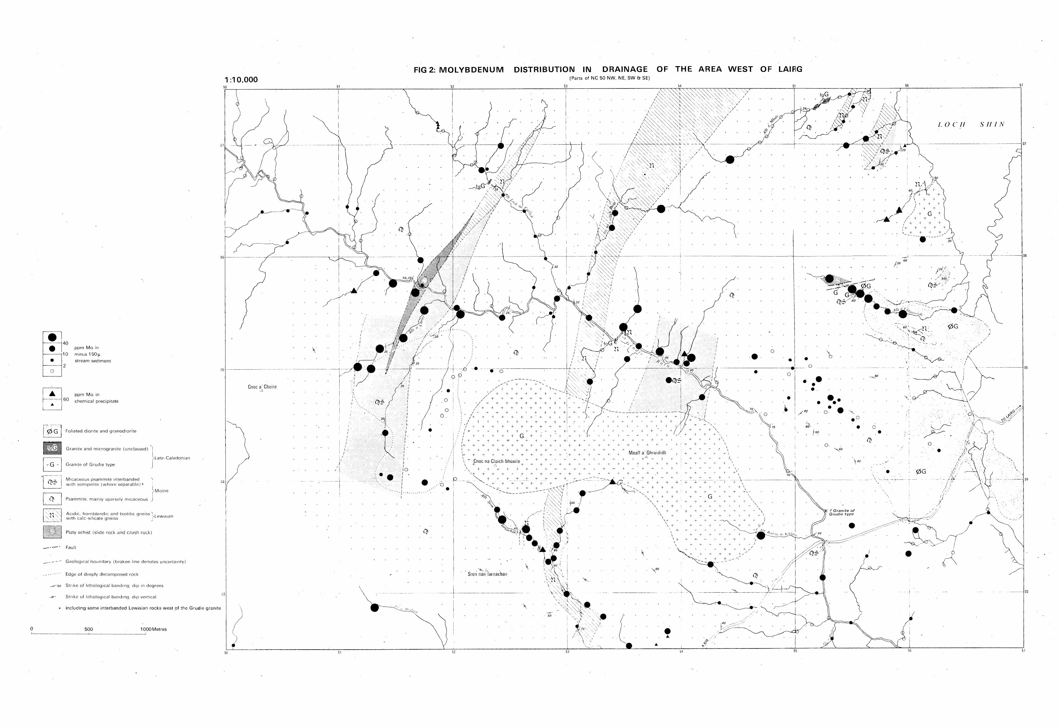
Molybdenum distribution in drainage in the area west of Lairg
Molybdenum content of channel samples from mineralised schists exposed in the stream banks of upper AR a’Chlaonaidh I553 6581, west of Lairg
TABLES
Concentrations of some metals in major rock-types of the Lairg area
Concentrations of some metals in drill core samples of Precambrian rocks and Caledonian granite from shallow boreholes near Lairg, Sutherland
iii
Page
1
1
1
3
5
10
:1
11
12
29
In envelope
In envelope
6

Moiybdenite mineralisation in Precambrian rocks,
near Lairg, Scotland
M. J. Gallagher, BSc, and R. T. BSc,
Summary
Low grade molybdenite mineralisation is intermittently exposed in Moinian and Lewisian rocks intruded by Caledonian granites to the west of Lairg in Sutherland, Scotland. Molybdenite occurs predominantly with pyrite in thin post-foliation quartz veins and as coat- ings to joints and foliation planes in the schists and gneisses. Chalcopyrite, fluorite and bismuth minerals sometimes occur as accessories. Galena, baryte and sphalerite are also present in narrow brecciated zones and small veins. Sampling of sparse rock exposures and of cores from a series of shallow boreholes drilled through peat and glacial deposits shows the molybdenum and copper concentrations to average less than 100 ppm. The regional distribution of mineralisation appears to be related to the presence of small late-Caledonian granites containing traces of molybdenite, but the local controls are mainly structural and include zones of thrusting associated with the Moine- Lewisian boundary.
Introduction
Earlier investigations in the Lairg area of Scotland indicated the presence of small amounts of molybdenite in two Caledonian granites and some enrichment of MO in later galena-fluorite veins (Gallagher, 1970; Gallagher and others, 1971; >Iichie and others, 1973). Molybdenum anomalies were subse- quently identified from the geochemical map of the region (Plant and others, 1972), in streams draining the Precambrian metamorphic rocks intruded by these granites. In this region, recognition of significant XI0 anomalies is enhanced by the low geochemical relief of this metal, values of 6 ppm 110 and above being rare except in some localised areas of Lewisian gneiss, Caledonian granite and Devonian (Old Red Sandstone) sediments. The present investigation comprised revision geological
maPP ing (J. D. P. ), drainage and soil sampling,
the examination of outcrops and boulders for mineralisation, shallow drilling for overburden and bedrock samples, petrographical and mineralogical studies (L. H. ), geochemical analysis of more than 1000 samples, and geophysical surveys in and around the area depicted in Figs. 1 and 2. Full details of the geochemistry, mineralogy and petrographical characteristics of the surface and borehole rock samples are listed in Appendices 1 and 2 respectively. These investigations formed part of the Mineral Reconnaissance Programme being undertaken in several areas of the UK on behalf of the Department of Industry. The investigations so far completed have established that molybdenite mineralisation occurs intermittently in the Precambrian metamorphic rocks over a wide zone roughly defined by the molybdenite -bearing granites, namely the small granite referred to here as the Shin mass in the north-east and the Grudie boss in the south-west. Further mineralogical, isotopic and geochemical studies of the new mineralisation will be reported later.
General Geology
The Lairg area is situated centrally in the belt of Moine metamorphic rocks extending from the Great Glen to the north coast of Scotland. The metamorphic rocks give rise to undulating moorlands which reach a height of about 400 m but fall away rapidly to the valleys occupied by Loch Shin and by the major east and south-east draining rivers. Since the publication of the Geological Survey One-Inch Lairg (102) Sheet and the accompanying memoir (Read and others, 1926) there has been no general re-examination of the ground. However t certain hornblendic rocks have been further investigated (Winchester and Lambert, 1970) and work has been carried out on the metamorphic and structual history of the region as a whole (Soper and Brown, 1971).
The area, over most of which rock exposure is poor, is underlain by metamorphic
1

-
-
-
-
-
-
L
-
-
-
-
rocks of the Moine assemblage together with subsidiary sheets of Lewisian gneisses (in part hornblendic rocks of Durcha T,ype (Read and others, 1926)). Between Lairg and the lower Grudie Burn there are a number of major and minor intrusions of late Caledonian pink granite (including the Grudie granite) and earlier foliated granodiorite allied to the Rogart granodiorite (Soper, 1963) to the east. Scyelite, appinite, and microgranite form a number of small bosses and sills and there are intercalations of hornblende -schist (Read and others, 1926).
The Moine strata comprise for the most part sparsely micaceous psammites. Thick bands composed mainly of micaceous psammite with subsidiary semipelitel are also present, but are difficult or impossible to map because I of poor exposure. An additional complication is the presence within the broad band of micaceous psammite west of the Grudie granite (Fig. 1) of numerous sheets of fine grained Lewisian acid gneiss. These may be inter- banded on a very fine scale with Moinian rocks, bands being of the order of centimetres rather than metres, and compositionally they differ from the Moinian rocks in containing slightly more biotite and occasional hornblende and epidote -rich partings. Moinian, micaceous and sparsely micaceous psammites are locally pebbly with clasts of quartz and feldspar; cross-bedding is retained in a few places. Calc-silicate ribs are rare. Laminae of heavy minerals (mainly hematite and magnetite) are present at some localities in siliceous psammite Segregation of, or introduction of, quartz and feldspar to form augen and lit-par-lit gneisses is sometimes seen in more micaceous rocks and bands of red feldspar were noted in pink sparsely rnicaceous psammite in boreholes 14 and 15 west of the head of the Alit a’chlaonaidh.
The Lewisian rocks are mainly quartzo- feldspathic, biotitic, and hornblendic gneisses and schists with subsidiary talc-silicate gneisses and marble (the Shinness Limestone (Read and others, 1926; Winchester and Lambert, 1970)). In the Grudie Burn north- east of the Grudie granite and in cores from boreholes west of the granite, they are intimately intercalated with stripes and bands of siliceous granulite and semipelite of Moine aspect. The contacts of some of the Lewisian
sheets are marked by platy muscovitic schists and gneisses. In such rocks there is an unusually well marked platy foliation and they contain a much higher proportion of muscovite than is normal in either the Moine or Lewisian. They are thought to be ‘slide rocks’ which were reconsituted from other rock types during the movements which led to the intercalation of Lewisian and Moine (Peacock, 1975).
The Moine rocks with the subsidiary sheets of Lewisian are disposed as a complex dome, the longer axis of which is parallel to but several kilometres west of Loch Shin. In the Loch Shin area there is a structural succession in which massive psammites retaining eastward-facing cross-bedding are interbedded with Lewisian sheets and slide .rocks and with thinly bedded strata with numerous ‘stacked’ tight minor folds charac - terised by axial-plane schistosity and a strong east or south-east plunging lineation. This type of succession can be traced from Loch Shin southwards and westwards of the area in Fig. 1 to the River Cassley. The minor folds, which can be correlated with the ‘F2’ folds of the area, are poorly developed in the slide rocks, and it is not clear whether or not they fold the foliation, including the platiness. Late, open to very tight brittle folds account for major swings of strike in the area south and east of the Grudie granite.
‘.
The igneous rocks within the area of the map comprise granite of Grudie type, a foliated granodiorite referred to here as the Claonel mass, and minor intrusions of granitic rocks. Pink granite of Grudie type forms two discrete cross -cutting bodies, the Grudie granite proper and the smaller Shin granite. In addition, veins of microgranite and felsite in the Alit alchlaonaidh section resemble the two larger bodies both mineralogically and texturally. The granite is strictly an adamellite with sparse biotite, and plagioclase in excess of orthoclase. Some of the quartz characteristically occurs as blebs. The Claonel granodiorite is grey in hand specimen, and differs from the Grudie type in that it contains altered biotite and hornblende each forming about 10 per cent by volume, and is commonly foliated. It is seen to be intrusive and the foliation is parallel to that in the country rock. In the Grudie Burn (594 053) 2
- ’ The mica content of various rock types is 2 Xational Grid References in this Report fall
very approximately as follows: pelite 400/o, within the 100 km grid square NC unless semipelite 20-40%, psammite 20% otherwise stated.
2
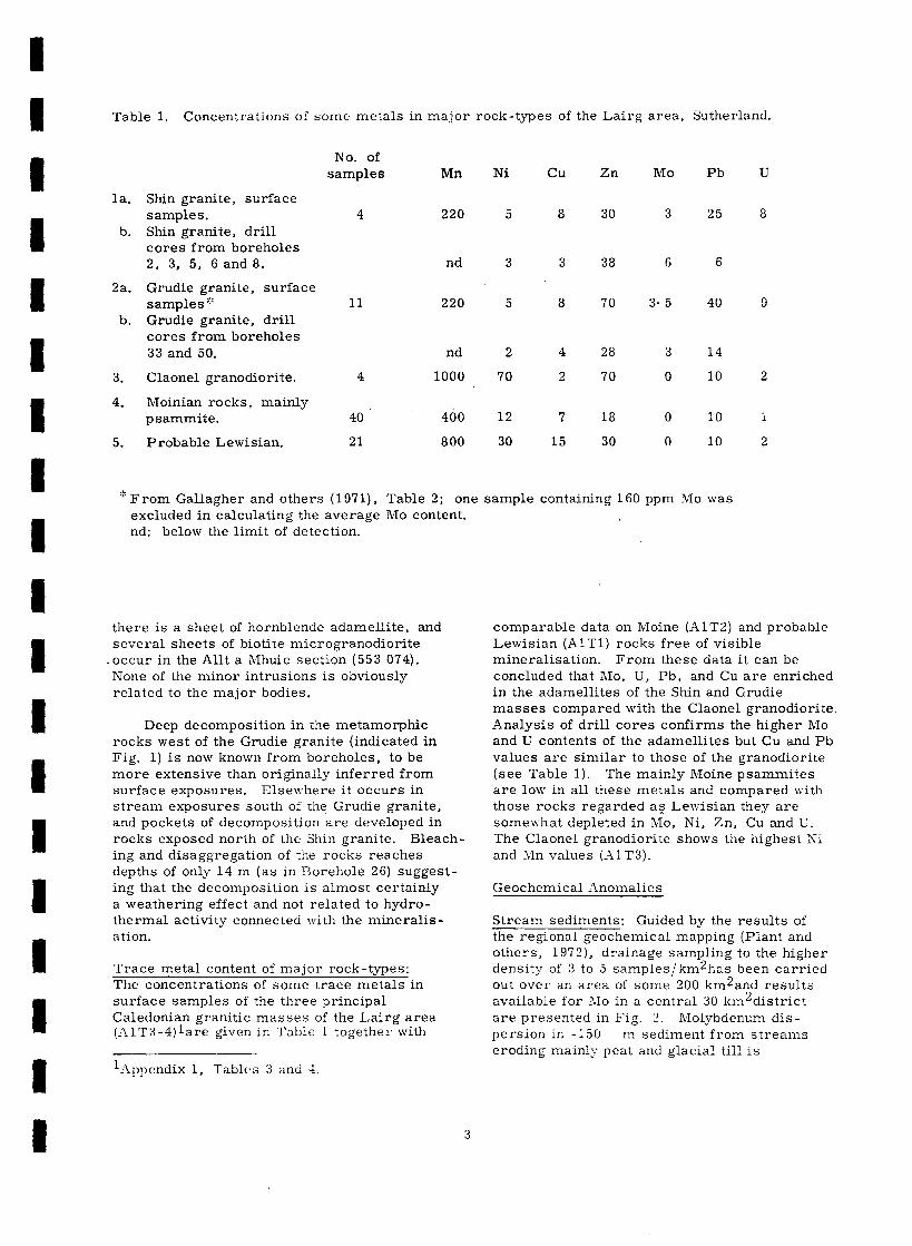
Table 1. Concentrations of some metals in major rock-types of the Lairg area, Sutherland.
la.
b.
2a.
b.
3.
4.
5.
Shin granite, surface samples. Shin granite, drill cores from boreholes 2, 3, 5, 6 and 8.
Grudie granite, surface samples a% Grudie granite, drill cores from boreholes 33 and 50.
Claonel granodiorite.
Moinian rocks, mainly psammite.
Probable Lewisian.
No. of samples
4
Mn
220
nd
11 220
nd
4 1000
. 40 400
21 800
Ni cu Zn MO Pb
5
3
5
2
70
12
30
8 30 3 25
3 38 6 6
8 70
4
2
7
15
28
70
18
30
3* 5
3
0
0
0
40
14
10
10
10
“‘:From Gallagher and others (19’71), Table 2; one sample containing 160 ppm MO was excluded in calculating the average MO content. , nd: below the limit of detection.
there is a sheet of hornblende adamellite, and several sheets of biotite microgranodiorite occur in the Allt a Mhuic section (553 074). None of the minor intrusions is obviously related to the major bodies.
Deep decomposition in the metamorphic rocks west of the Grudie granite (indicated in Fig. 1) is now known from boreholes, to be more extensive than originally inferred from surface exposures. Elsewhere it occurs in stream exposures south of the Grudie granite, and pockets of decomposition are developed in rocks exposed north of the Shin granite. Bleach ing and disaggregation of the rocks reaches depths of only 14 m (as in Borehole 26) suggest- ing that the decomposition is almost certainly a weathering effect and not related to hydro- thermal activity connected with the mineralis- a tion.
Trace metal content of maior rock-Woes: The concentrations of some trace metals in surface samples of the three principal Caledonian granitic masses of the Lairg area (XlT3-4)lare given in Table 1 togethel* with
‘klppendix 1, Tables 3 and 4,
comparable data on Moine (AlT2) and probable Lewisian (AlTl) rocks free of visible mineralisation. From these data it can be concluded that MO, U, Pb, and Cu are enriched in the adamellites of the Shin and Grudie masses compared with the Claonel granodiorite. Analysis of drill cores confirms the higher MO and U contents of the adamellites but Cu and Pb values are similar to those of the granodiorite (see Table 1). The mainly Moine psammites are low in all these metals and compared with those rocks regarded as Lewisian they are somewhat depleted in RIO, Ni, Zn, Cu and U. The Claonel granodiorite shows the highest Xi and Mn values (_11T3).
Geochemical -Anomalies
Stream sediments: Guided by the results of the regional geochemical mapping (Plant and others, 1972), drainage sampling to the higher density of 3 to 5 samples/km2has been carried out over an area of some 200 km2and results available for 110 in a central 30 km’district are presented in Fig. 2. Molybdenum dis - persion in -150 m sediment from streams eroding mainly peat and glacial till is

especially pronounced in districts of poor relief, for example, in the area underlain by super- ficially decomposed metamorphic rocks to the north-west of the Grudie granite where the alluvial sediments are typically fine grained and organic -rich. Comparison of Figs. 1 and 2 shows that almost all MO anomalies in stream sediments are traceable to mineralised bedrock sources either in outcrop or borehole. Further work is in progress to determine the source of MO (and Cu) anomalies developed in stream courses running southwards to the Grudie Burn in the district of the Grudie granite. The anomalous value shown in the extreme south- west of Fig. 2 has been traced to minor molybdenite mineralisation in schists.
Some limonitic precipitates developed on small spring sites were sampled to provide supplementary geochemical coverage but MO was enriched only in districts where molybdenite mineralisation was known to occur. Experi- mentation with a water-suspended ‘fines’ fraction of alluvial sediment, comprising organic matter plus silt and clay-grade material, demonstrated improved contrast for Cu as well as MO compared with normal stream sediment samples (Leake and Smith, in press). But, this method of sampling did not lead to the detection of new MO anomalies. In all sample types the correlation between &IO and other metals is low, with the exception of Mn which is significantly correlated at the 95 per cent confidence level. Molybdenum anomalies attributable to discrete mineralisation however, are not obscured by such co-precipitation of MO with either Mn or Fe in the stream sediment samples.
Widespread Ba anomalies were also detected in the area and traced to baryte mineralisation principally in the form of veins and breccias with minor amounts of galena. Analysis of panned concentrates is a particularly effective means of locating mineralisation of this type (Leake and Smith, in press). Ba, Cu and Pb are also anomalous in streams north of the Shin granite where fracture-bound polymetallic mineralisation is located (Fig. 1).
Glacial deposits: The till deposits of the Lairg area usually consist of angular fragments up to boulder size set in a matrix of sand and clay. They appear to be lodgement or melt-out tills in which material related closely to the local bedrock is concentrated towards the profile base. The middle and upper parts of the till are rich in farther-travelled clasts, and debris derived by solifluction from nearby solid exposures sometimes occurs in the uppermost
parts of the profiles. Small morainic deposits occurring on the southern extrapolation of the galena-fluorite veins exposed at the ~0~1th -eas:
edge of the Grudie granite contain metal concentrations, notably Pb, which is enriched in the lower horizons of overburden profiles 1. 5 to 2. 5 m thick (AlT5). Analysis of 50 channel samples from 80 m of trenched moraine yielded averages of 12 ppm Cu, 125 ppm Zn, 30 ppm MO, 400 ppm Pb, and 2 ppm U (AlT6-7).
Because of the variation in the depth and nature of overburden in the area, and the general lack of rock exposures, shallow drill holes were used to establish geochemical profiles through the peat and till deposits, in order to determine the role of both mechanical and hydromorphic factors in metal transport through overburden. The mean overburden thickness was 4. 3 m (range 1 to 15 m) with till as the main component.
After initial difficulties in recovering the sand and clay fractions of till (in boreholes l-10, Table 2) satisfactory recovery was achieved in almost all later boreholes using a specially modified rotary drilling technique. Preliminary geochemical analysis of till cores from localities now known to be underlain by mineralised schists and gneisses suggest that MO is concentrated in the finer fractions of basal till. Further studies are in hand however, to identify the optimum sampling horizons and the particle size fractions best suited for chemical analysis. Results from this orientation study in the Lairg area should provide a basis for applying this type of sampling to comparable glaciated areas of Britain.
Soils: The enrichment of MO, Pb, U and other metals in peat and organic-rich soils has al- ready been noted from the south-east margin of the Grudie granite (Gallagher and others, 1971). There is also a striking accumulation of MO in the surficial waterlogged organic debris of a small basin peat bog west of the Grudie granite (515 045). Anomalies of up to 300 ppm MO occurring in organic samples from shallow drainage channels at the margins of the basin can be related to heavy precipitation of iron-hydroxide. In contrast, MO seldom exceeds 20 ppm in the more freely drained peats from the hill slopes west of the bog where molybdenite mineralisation is known to occur. However, values can increase to 50 to 100 ppm 110 in the podsolic soils (pIi 5. 0 to 6. 0) beneath the hill peats (pII 3. 3 to 4. 5).
4

Molybdenite mineralisation in stream exposures of the upper Alit a’Chlaonaidh has been traced for a short distance south-westwards by sampling of surficial peat and, more satis- factorily, the clay-rich B-horizon podsolic soils which are geochemically less susceptible to variable drainage and topographic conditions. The thickness of peat cover can, however, preclude sampling of this soil horizon by manual auger. Recently, soil sampling in the area has been effected successfully with a mechanical auger.
Mineralisation
Molybdenite has been recognised in sparse rock outcrops, transported boulders, and cores from shallow boreholes, in a zone up to 3 km in width extending for some 6 km south-westwards from lower Loch Shin. Several othe’r ore minerals are also present in small amounts khalcopyrite, galena, fluorite and baryte), while traces of bismuth minerals, sphalerite and scheelite also occur. In the Precambrian schists and gneisses molybdenite is mainly found with major pyrite, in post-foliation quartz veinlets and as coatings to foliation planes and joints. Chalcopyrite, fluorite, bismuth minerals and scheelite are accessories. Molybdenite in the Shin and Grudie granites is developed with pyrite and fluorite either in quartz veinlets or as scattered grains. Chalcopyrite and galena occur locally in small veins and breccia zones in the metamorphic rocks with fluorite or baryte, and are associated with the only significant development of sphalerite in the area, in a quartz vein cutting the Shm granite.
Galena has previously been described from quartz -hematite -baryte -fluorite veins cutting the Grudie granite and adjacent Moinian rocks (Gallagher, 1970); it also occurs with baryte in fault fillings (520 002). The traces of Sn, W and Bi accompanying minor 310 enrichments in the Grudie galena veins (AlT4) were also noted in solme of the new occurences of molybdenite and other sulphides. Among these, members of the bismuthinite [Bi2S3] - aikinite [ 2PbS,Cu2 S, Bi2S3 1 series have been identified from the shin granite as well as from quartz veins and joint coatings in the metamorphic rocks (C. M. Rice, personal communication). The rare mineral betechtinite [ Pb2 (Cu, Fe) 21S15 ] is associated with the Grudie galena veins.
bedrock intersections in most of the 52 shallow boreholes drilled for overburden sampling (see Fig. 1 and the 52 tables forming Appendix
2). Molybdenite is present in cores from 21 of the 46 holes that penetrated bedrock, the most notable concentrations occurring in two districts: west of the head of Allt a’chlaonaidh (550 058); and north-west of the Grudie granite (512 045). Both have an elevation of around 260 m OD. From borehole and outcrop evidence it is estimated that molybdenite mineralisation could extend over at least 500 by 400 m in the first district and in the second over a minimum of 800 by 600 m.
Mineralised schists were intersected in five boreholes (Nos. 13-17) near Allt a’chlaonaidh, while 9 of the 19 boreholes drilled to bedrock in the schists and gneisses of the west Grudie district proved molybdenite (Nos. 26, 29, 38, 41-43, 46-48).
Descriptions of the principal mineral localities follow.
Loch Shin: In the, north-east of the map area (Fig. 1) there are numerous small mineral occurrences of which the most conspicuous lies in the Shin granite near the edge of Loch Shin (563 066). Fine grained sulphides (pyrite, sphalerite, chalcopyrite, covellite and galena (Rice and Cope, 1973)) occur in a zone of grey quartz veining trending 150” , 1.8 m wide over 12.5 m of exposed strike. Specimens of the sulphide assemblage grade 0.57 per cent Cu, 3.05 per cent Zn and 0.05 per cent Pb (CBR 319) and are enriched in Bi (4200 ppm) Ag and Cd but contain only 3 ppm MO. Traces of U (3 ppm) and Hg (60 ppb) are also present. Barren quartz veining extends into the hanging-wall (south-west) and the adjacent granite is locally enriched in molybdenite. A comparison can be drawn between the pol ymetallic mineralisation associated with the Shin granite and that developed at Alice Arm, B. C. , where bismuth minerals occur with sphalerite and galena in late fractures post-dating the main phase of molybdenite mineralisation (Woodcock and others, 1966). Although molybdenite pyrite and fluorite are scattered throughout the Shin granite, only a few ppm MO are shown by analysis of small rock samples (Table 1 and AlT3) and drill cores (borehole nos. 2-3, 5-6, 8-9 in Table 2; A2T2-3, 5-6, 8-9). The
Drilling results: Some evidence of the lithology same minerals occur with chalcopyrite and and mineralisation of the concealed rocks in a galena in the central zone of some 7 km2 between lower Loch
surrounding schists and gneisses coating joint and foliation planes and in thin
Shin and the area to the south and west of the Grudie granite, has been ohtamed from short
quartz veins (as in boreholes 7 and l9j, The relatively high 110 content (60 ppm) shown by

Location of channt t- 98 + sample with MO
content in ppm
?I
72 Lithological banding,
dip in degrees
Moorland
t I I I 1
0 1 2 3 4 metres
Fig. 3. Molybdenum content of channel samples from mineralised schists exposed in the stream banks of upper Allt a’chlaonaidh (553 658), west of Lairg c
-
-.
-
-
-
-
-
-
-
-
a small bedrock sample from borehole 4 (A2T4) is contained in a rock similar to the platy schists of upper Alit a’chlaonaidh described below. High Ni, Cu and Zn values shown against Borehole 9 are concentrated in a calcareous schist (thought to be Lewisian) in psammites beneath what appears to be a shallow-dipping south-east contact to the Shin granite. Biotite gneiss intersected by Borehole ‘7 (A2T7) is also enriched in these metals.
North of the Shin granite chalcopyrite, galena and fluorite are present in small quartz- baryte breccia veins in Moine schists and brecciated Lewisian gneisses (AlT8; CBR 344, 345, 330). These exposures are in approximate alignment with the polymetallic quartz vein in the Shin granite. Near the north-eastern edge of the map area a narrow quartz-pyrite- molybdenite vein in gneiss is enriched in Cu and Bi. Further north, several mineralised boulders have been found which are regarded as Lewisian calcereous rocks displaying mineral assemblages representative of several metamorphic grades. In a banded quartz- tremolite-diopside rock containing 0. 2 per cent Cu, the diopside is unaltered despite the presence of abundant granular pyrite and minor chalcopyrite, indicating that this sulphide mineralisation was contemporaneous with high- grade metamorphism (AlT8: CBR 3100). Although only traces of MO are associated with the sulphides, it may be significant in consider- ing possible loci of metal enrichment that molybdenite is known from the Shinness marble (Gallagher and others, 1971), now regarded as Lewisian (Winchester and Lambert, 1970), on the east side of Loch Shin.
Claonel: The principal exposure of molybdenite mineralisation in the area is in platy schists located at the head of Allt a’chlaonaidh (Fig. 1). The molybdenite occurs with titaniferous magnetite and hematite in quartz-pyrite veinlets 1 to 5 cm in thickness generally trending east- north-east closely parallel to, or occasionally crosscutting, the pronounced platy foliation in the schists which are regarded as slide rocks probably related to a Moinian-Lewisian boundary
Mineralogically the rocks are semipelitic and psammitic schists in which plagioclase is at least as abundant as quartz, potassium- feldspar is rare and garnet pseudomorphs may be present (Haynes, 1974a). Locally, particu - larly in the vicinity of larger quartz veins, the rock is granitised and gneissose texture is sometimes developed. The quartz veins them- selves are often brecciated, and contain rare granitic or pegmatitic inclusions as n-el.l as
abundant pyrite and molybdenite, the latter usually confined to vein margins. Along quartz-vein boundaries a zone of orthoclase- quartz may be developed, passing outwards into zones where sericite (after plagioclase) has been upgraded to muscovite and eventually into unaltered rock over a distance of only a few centimetres from the vein. The relatively unaltered rock contains a low grade assemblage of quartz, sericitised plagioclase and chlorite occasionally intergrown with muscovite and hematite. Green biotite is sometimes present and chlorite-s upgraded to biotite in areas where fresh muscovite porphyroblasts have grown from sericite.
Textural evidence suggests that the introduction of high temperature quartz - sulphide veins is accompanied by granitisation in the immediately adjacent schists resulting i in quartz-feldspar ‘lits’, that is, overgrowths of ,
microcline on plagioclase, and the formation of zones of intimately intergrown quartz and potassium-feldspar. New growth of muscovite and biotite occurs locally in the immediately adjacent schists but only one or two centimetres away the schists have suffered low grade retrogressive metamorphism causing sericitisation of plagioclase and regression of garnet and biotite to chlorite and iron oxide. Occasionally, even the chlorite and sericite is partially replaced by carbonate. Late carbonate -hematite-sericite -quartz veinlets with littleor no sulphides are sometimes present.
The quartz veins being mainly concordant with the platy foliation, have clearly been introduced along well defined structural lines. The MO contents of channel samples taken from an excavated exposure on the banks of the stream is shown in Fig. 3. These average 110 ppm MO over 15.7 m on the east bank and 200 ppm MO over 12.0 m on the west bank (Al Tl 0). Molybdenite -bearing quartz veins are sporadically exposed in schists to the south- east of this location for some 60 m across the strike and there are minor molybdenite-pyrite showings in psammites cut by the stream before it enters the Claonel granodiorite. Except in a 15 cm thick gouge developed on a small fault where Pb and Cu are enriched (AlT9; CBR 544), the only other valuable metals associated with the molybdenite mineralisation are Bi and W which reach maximum values of 75 ppm and 100 ppm respectively in a rock locally containing 1 per cent MO. Anomalous W values also occur in quartz -hematite breccias sporadically exposed in psammitic schists and granite cut by the upper course of

Alit a’chlaonaidh and shois-n as a fault line on galena in a narrow vein with smithsonite and
the One-Inch Lairg (102) Sheet. purple fluorite (AlT12; CBR 396).
A line of shallow boreholes (Nos. 13 to 20; A2T13-2O), drilled westwards of the head of Allt a’ Chlaonaidh, intersected weak molybdenite- pyrite mineralisation in psammite and micaceous psammiie affected by fracturing, quartz veining and granite veining. The rocks in these bore- holes show many textural features similar to those from the Alit a’Chlaonaidh section, although the rocks are generally more psammitic and less platy (Haynes, 1974b). Quartz vein boundaries are characterised by the development of quartz -potassium feldspar zones and microcline overgrowths on plagioclase in granitised psammite, while a few centimetres away plagioclase is heavily sericitised, chlorite replaced by carbonate and iron oxide, and cross- cutting carbonate -quartz -pyrite -rutile veinlets are present. Minor amounts of a yellowish- coloured secondary molybdenum compound absorbed on clay coating joint surfaces were noted in core from Borehole 17.
Mineralisation associated with the Claonel granodiorite appears to be limited to small chalcopyrite occurrences at its contact. Recent drilling on induced polarisation anomalies detected by colleagues in the Applied Geophysics Unit has located only traces of galena, chalcopyrite and molybdenite occurring with pyrite at or near the north-west contact of the mass.
Grudie Burn: North-westerly trending quartz- hematite breccias are exposed at several localities in an area of Moine schists between Allt a’chlaonaidh and Grudie Burn (AlTll; CBR 630 for example). The fault marked on the One-Inch Lairg (102) Sheet running east- south-east from the A839 road (south of the map area in Fig. 1) to the River Shin is also accompanied by quartz -hematite veining and irregular baryte veinlets up to 50 cm in thick- ness (AlTll; CBR 108). This surface mineralisation does not include galena in contrast to the north-north-westerly trending quartz -hematite-baryte veining at the south- east margin of the Grudie granite which carries galena and fluorite (Al T4). Here the Moine rocks are somewhat brecciated psammites, locally recrystallised and granite-veined near the granite contact. The new mapping of stream exposures in lower Grudie Burn shows that galena-chalcopyrite -fluorite mineralisation at the A839 road bridge (Gallagher, 1970) occurs in chlorite-rich schist (AlT12; CRR 590). A boulder of semipelitic schist, found near the north-east edge of the Gr~~die <r‘ani:e, contains
Boreholes drilled across the valley of Grudie Burn intersected mainly barren psammite and micaceous psammite (Nos. 21, 22, 24, 25) and granitised schist (27) near the northern contact of the Grudie granite, but small enrichments of Pb and Zn were observed in psammite in Borehole 23 and high &IO, Pb and Cu values in the basal till at Borehole 24 (A2T24). Traces of joint-surface molybdenite are present in Lewisian rocks north of the granite (533 061).
West Grudie: In the metamorphic rocks north- west of the Grudie granite mclybdenite is developed in two stream exposures forming the only significant outcrops in an area of some 2 km2. Near the head of the ‘Moly’ burn (514 044) molybdenite occurs with pyrite and traces of chalcopyrite, fluorite, a bismuth mineral and scheelite on joint surfaces and in quartz veins within micaceous psammite and interbanded Lewisian rocks (Al T13). Analyses show ranges of 30 to 360 ppm RIO and 20 to 90 ppm Cuin small selected samples (AlT14). A relatively deep borehole drilled a short distance to the north (No. 26; A2T26) intersected mainly Lewisian gneisses with intermittent molybdenite -chalcopyrite mineralisation occuring chiefly in quartz veins. Averages of 37 ppm MO and 58 ppm Cu were obtained on some 30 m of core (30 samples). The second stream exposure of note is in the middle reaches of Allt a’choire (515 052) where molybdenite occurs with pyrite in bands of quartz-feldspar and quartz in micaceous psammite and semipelite (Al T13). Analysis of two small samples yielded 14 and 53 ppm MO (AlT14) while from an adjacent shallow borehole some 3 m of core averaged 74 ppm MO and 60 ppm Cu (Borehole 48, Table 2; A2T48). Numerous mineralised boulders occur in the headwaters of both burns.
Of 7 boreholes drilled to bedrock within 0. 5 km of the north-western edge of the Grudie granite (Nos. 28, 29, 32, 34 - 37) only two proved moiybdenite, whereas mineralisation was detected in 8 of 11 successful holes (Nos. 26, 38, 40 - 48) drilled at distances of 0. 5 to 1. 25 km from the granite contact (see relevant tables in Appendix 2). The first group of holes intersected predominantly Moine psammites but in the second group micaceous psammite, psammite and a variety of rocks regarded as Lewisian are present (Haynes, 1974a; 1974b). As in the Alit a’chlaonaidh section, .quartz veins are
8

Table 2. Concentrations of some metals in drill core samples of Precambrian rocks and Caledonian granite from shallow boreholes near Lairg, Sutherland.
Borehole Overburden Bedrock Main Weighted Borehole intersection bedrock average No.
wm
Overburden Bedrock
thickness intersection m m
Ni Cu Zn MO Pb
Main Weighted
bedrock average
type(s) ppm
Ni Cu Zn izlo Pb u
27 ll.G6 10.91 6 8 29 2 31 5.9
6 nd 40 4 nd 6.5 28 11.20
5 nd 40 8 nd 13.0 29 2.54
35 150 70 GO 10 4.8 30 10.92
0. 35
8. 69
granitoid psammite,
schist
micaceous psammite
micaceous psammite
7 psammitt
nd 520 4 10 8.0
12 54 19 25 5 1.4
4 4 35 6 5 11.0 31 15.50 _ ? psamrnitc
nd nd 38 8 6 8.5 32 7.22 1.63 psammite
62 58 80 16 nd 3.1 33 1. 10 800 Grudic granite
nd nd 50 2 20 5.5 34 2.22 2. 50 psammite
159 42 58 2 11 2.8 35 4.75 2. 81 ’ psammite
- -_ - _ 5 8 10 1 nd 2.3
2 326 4 15 7.5
5 6 7 3 nd 0.8 8 13 30 1 nd 2. 1
15 29 40 32 5 2.3 36 4.41 3.04 psammit e 4 16 28 7 2.3
7 15 37 2 nd 3.8 37 2.61 3. 89
38 4.03 3. 87
12 7 22 27 8 1.7 39 4.51
13 18 28 30 15 2.1 40 2.75
28 51 52 23 13 2.5 41 5.20
2. 79
3. 87
psammite
psammite,
? Lewisian
? peammite
psammite
psammite
54 330 48 11 14 3.4
19 19 31 17 7 1.8
_ __ G 14 24
5 64 26
6
9
_ _ 9 1.0
14 1.7
35 9 66 75 30 3.6 42 1.89 3. 81 psamniite 11 23 25 18 nd 1.9
nd 10 10 46 10 1.1 43 5.90 3. 18 probable Lewisian 10 47 10 29 nd 1.2
3 8 IS 2 10 1.4 44 2.96 1.88 micaceous psammite 8 21 nd 24 nd 1.3
nd 5 10 1 10 1.1 4s 4.32 6. 35 micaccous pammite 27 27 29 7 4 1.6
nd 5 10 2 10 1.4 46 4.80 2. 86 Lewisian 28 22 32 18 nd 1.7
S 10 24 6 10 1.6 47 1.46 4. 14 Lewisian 32 30 32 12 5 1.3
10 25 20 2 10 3.0 48 2.51 2.97 Lewisian 9 60 20 74 nd 1.3
10 5 200 4 110 1.7 49 5. 2 1 2.67 semipelite psammite 10 15 30 3 10 0.8
10 933 4 13 2.3 SO 1.25 3. 24 Grudic granite 3 634 2 10 5. 1
_ -- - 18 58 27 37 3 1.4
51 1.90 0.23
52 2.81 4. 78
semipelite
psammite and platy
schist
- __ _ _ _ 16 10 46 18 6 1.0
No. thickness m m
8. 84
2 2.30 2.95
3.25 0.25
7.40 0.22
6
8
3.50 11.41
4.07 2.84
4.72 1.20
2.28 1.56
3.80 4.30
o. 83 2.13
11
iti 12
3.20
3.90
3.40
13 2. 16 5. 14
1-I 2.08 2.67
15 4.65 7.71
10 1.28 4.19
17 1. G5 5.35
18 2.51 1.96
l!’ 1. .17 2. 50
1.65 1.02
21 0.90 2.07
22 2.20 1.66
23 2.30 0.86
24 4.30 2.21
25 10.40
26 2.23 29.92
type b)
? Shin granite
Shin granite
Shin granite
* rnic ‘xc cous L ~xsarnnlitc
Shin grdnite
Shin granite
Lewisinn
Shin granite
Shin granite , psammite 8
Lewisian micaceous
psammite micaceous
psammrte ? psammite
psammitc
psammitc
psammite and
scmipelite micaceous
psammitc psammitc
psammit e
iiricaccous
psammite micaccous
psammite psammite,
semipelibe micaceous
psammite psammite
micaceous
psammite ? psammite
Lewisian
‘) Psanimitr, micaceous ps;tm
nd: below limit of detection. ‘3l.C varieties Moinian asscmblagc.

accompanied by local granitisation and the growth of microcline and muscovite. From this distribution of molybdenum it might be inferred that the relatively micaceous Moine rocks and closely associated Lewisian rocks are the more favourable hosts of molybdenite mineralisation. Although molybdenite is apparently absent from boreholes intersecting granite at the west and south-west contacts of the Grudie granite (Nos. 33 and 50), it does occur with fluorite in quartz veins in platy schists and psammite near the south-west contact (Borehole 52; A2T52).
In stream exposures of Allt Sron_nan Iarnachan south-west of the Grudie granite, traces of molybdenite occur with bismuthinite (Rice and Cope, 197 3) and chalcopyrite in a quartz (quartz-feldspar) vein 2 to 3 cm thick (Al T15: CBR 054) running parallel to the foliation of the enclosing gneisses (529 034). Fluorite and carbonate are associated minerals and a similar mineral assemblage is developed in the vein wall-rock where garnet pseudomorphs and rutile are present (CBR 055). Copper and bismuth minerals (CBR 034) were also observed in quartz -feldspar veins in platy schists nearby (527 034).
Conclusions
Although the MO and Cu grades obtained from exposures and shallow boreholes are well below the level for economic exploitation, the broad area over which molybdenite has been recorded would seem to justify further investigations in the Lairg area. The regional distribution of molybdenite mineralisation appears to be related to two small late- Cale- donian granites which are themselves weakly enriched in molybdenite. Only traces of mineralisation have so far been detected in a foliated Caledonian granodiorite mass.
The mineralisation so far.observed is best developed in the more micaceous rock types of the Moinian, in platy schists and in the newly recognised Lewisian acid gneisses, particularly near the head of Allt a’chlaonaidh and in an area about 1 km north-west of the Grudie granite. Platy schists are not present at all the areas of molybdenite mineralisation, but petrographic features consistent with those described from the Allt a’chlaonaidh exposures, where molybdenite mineralisation is associated with high temperature quartz veining, are present in all the principal molybdenite localities. It is concluded on this evidence that there is a structural control to the mineralisation related to the prosimity of ‘slide rocks’ and Lewisian thru:;r .-:iices. The
high temperature quartz veins containing the molybdenite are assumed to have been developed by magmatic processes associated with the emplacement of the molybdenite-bear- ing Shin and Grudie granites. These granites are regarded as high level intrusions and are petrologically similar to molybdenum-bearing granites at Wolfram Camp, North Queensland (Plimer, 1974). Mineralisation in the Elizabeth Creek Granite at Wolfram Camp is associated with quartz-rich pipes and greisens and is thought to have resulted from resurgent boiling of the magma’s aqueous phase on intrusion to higher levels in the crust. Plimer concludes that zoning around silica-rich pipes ‘is probably a result of an increase away from the pipes of the pH of initially weakly acidic solutions which have altered the original Elizabeth Creek Granite to a muscovite-rich greisen (+ kaolinite) close to the pipes and further away have sericitised it’ (p. 104). Whilst a zonal pattern is not developed in the Shin area, there is evidence that the quartz veining has been produced by similar processes although the silica-rich solutions have entered pre-existing channel ways in the country rocks rather than in the granites themselves.
The paucity of exposure that results from the widespread’ glacial and peat deposits precludes the establishment of relationships between mineralisation and structure. However, the pattern drilling through over- burden into bedrock has established the presence of two areas that seem to merit further investigation. These are west of the head of Allt a’chlaonaidh and north-west of the Grudie granite. To assist any follow-up that may be deemed worth while, some tentative conclusions relating to the mineral- isation are given below.
1. MO, Cu (Bi) mineralisation is spatially related to the Shin and Grudie granites and formed during or soon after granite emplace- ment. It appears likely that both the granites and mineralisation are genetically related to a deeper parent magmatic body,
2. Cu, Pb (Zn) mineralisation is probably of later origin although still occurring in close proximity to the granites.
3. Baryte and galena in post-granite veins probably belong to a final phase of mineralis- ation.
4. Chalcopyrite-pyrite in high-grade meta- morphic Lewisian rocks is regarded as a very early mineralisation, which may provicie
10
-
some clue to the origins of the later ore- forming fluids.
5. The most favourable target areas would seem to be where ‘slide rocks’ and Lewisian thrust slices occur in proximity to the granites.
Acknowledgments
-
-
Thanks are due to the Forestry-Commission and other land owners in the area for their co- operation in facilitating this investigation. The analytical and mineralogical data presented were provided by the Analytical and Ceramics Unit and the Mineralogy Unit respectively. The work was carried out under the general management of Dr S. H. U. Bowie on behalf of the Department of industry.
,- References
-
GALLAGHER, M. J. 197 0. Galena -fluorite mineralisation near Lairg, Sutherland. Trans. Instn. Min. Metall. , B, Vol. 79, pp. B182-184.
-
MICHIE, U. McL. M., SMITH, R. T. and HAYNES, L. 1971. New evidence of uranium and other mineralisation in Scotland. Trans. In&n. Min. Metall. , B, Vol. 80, pp. B150-173.
-
HAYNES, L. 1974a. The petrology and mineralogy of some rocks from the Loch Shin area. Mineralogy Unit Rep. Inst. Geol. Sci. No. 140, 9 pp. [ Unpubl].
.
1974b. Notes on the petrography of selected samples of diamond cut cores from the Loch Shin area. Mineralogy Unit Rep. Inst. Geol. Sci. No. 141, 9 pp. [Unpubl].
-
-
LEAKE, R. C. and SMITH R. T. 1975. A comparison of stream-sediment sampling methods in parts of Great Britain. Pp. 579- 594 in Geochemical Exploration, 1974, Proc. 5th Int. Geochem. Expl. Symp. , Vancouver 1974. Edited by I. L. Elliot and W. K. Fletcher. (Elsevier Developments in Economic Geology No. 1, Assoc. Explor-
- ation Geochemists Spec. Publ. No. 2. )
-
-
-
PLIMER, 1. R. 1974. Pipe -like molybdeni ie - wolframite-bismuth deposits of Wolfram Camp, North Queensland, Australia. Miner. Denosita (Berlin), Vol. 9, pp. 95-104.
READ, H. H., PHEMISTER, J. and ROSS, G. 1926. The geology of Strath Oykell and Lower Loch Shin. Mem. Geol. Surv. Scotland, 222 pp.
RICE, C. M. and COPE, M. J. 1973. The ore mineralogy of some rocks from the Loch Shin area. Mineralogy Unit Rep. Inst. Geol. Sci. , No. 125, 7 pp. [Unpubl. 3.
SOPER, N. J. 1963. The structure of the Rogart igneus complex, Sutherland, Scotland. Q. J. Geol. Sot. London, Vol. 119, pp. 445- 478.
BROWN, P.E. 1971. Relation- ship between metamorphism and migmatization in the northern part of the Moine Nappe. Scott. J. Geol. , Vol. 7, pp. 305-325.
WINCHESTER, J. A., and LAMBERT, R. St. J. 1970. Geochemical distinctions between the Lewisian of Cassley, Durcha and Loch Shin, Sutherland, and the surroundimz Moines. Proc. Geol. Assoc. , Vol. 81, pp. 27&302.
WOODCOCK, J. R., BRADSHAW, B.A. and NEY, C. S. 1966. Molybdenum deposits at Alice Arm, B.‘C. Pp. 335-339 in Tectonic -- History and Mineral-Deposits of the Western Cordillera, (CIM Spec. Vol. 81.
MICHIE, U. McL. M., GALLAGHER, M. J. and SIMPSON, A. 1973. Detection of concealed mineralisation in northern Scotland. Pp. 115- 130 in Geochemical Exploration 1972, Proc. 4th Int. Geochem. Expl. Symp. , Ed. by M. J. Jones. (London: Institution of Mining and Metallurgy).
PEACOCK, J. D. 1975. Slide rocks in the Moine of the Loch Shin area, northern Scotland. Bull. Inst. Geol. Sci. , so. 49, pp. 23-30
PLANT, J. and OTIIERS. 1972. Geochemical map of northern Scotland overla_vs to quarter-
inch geological sheets 6 and 0 (part). Inst. Geol. Sci. Open File Rep.

Appendix 1: Geochemical Analvses -----L-,
Methods of Analysis: The analyses presented in the tables forming Appendix 1 and Appendix 2 were obtained by atomic absorption spectrophotometry (Ni, Cu, Zn, Pb); optical emission spectro- scopy (Be, B, Mn, Fe203, Co, Ni, Sn, Bi); streamlined wet chemistry method (MO, W, As) and delayed neutron activation analysis (U). In general, the analyses made by optical emission spectroscopy are regarded only as semiquantitative. Some comparative analyses are shown in Table 4. Values are given
Table 1: Concentrations of
Sample No. Grid PPm (CBR) Ref. Be B Mn
295 519 144 0 0 2400 555 550 092 2 0 2400 556 550 092 0 0 180 558 550 091 0 32 420 559 548 090 0 0 2400 585 552 089 2 0 320
575 556 0’75 0 0 560
339 557 075 0 10 100 338 557 075 0 10 320 337 557 075 0 0 180 574 557 075 0 0 130 570 553 074 4 0 180
571 552 073 3 0 320 240 534 066 0 0 420 238 534 062 2 0 560 237 533 061 013 320
236 532 059 13 0 560
541 558 055 2 0 1000
540 558 055 3 10 1800 539 560 054 2 10 1300
174 541 996>: 0 10 560
Averages+ 1 5 806 3.3
:F This grid reference falls
+
in ppm unless otherwise stated.
some metals in probable Lewisian rocks of the Lairg area, Sutherland
% . wm Fe203 Co Ni Cu Zn MO Sn Pb Bi U Other Comments
13.0 7.5 0.0 4.2
10.0 10.0
1.8
56 56 40 30 0 1 10 60.3 - hornblende -schist 42 32 20 10 0 3 10 6 1.0 - amphibolite
3 6 10 10 0 0 10 6 20 - acid gneiss s 6 30 40 0 2 0 30.3 - biotite -gneiss
56 75 20 10 0 3 0 60.1 - hornblende-schist 32 100 180 60 0 2 10 6 10 - biotite -gneiss
boulder 8 13 10 20 0 0 10 0 1.3 1.10JK20 psammitic
gneiss 0.0 2 13 5 0 1 0 0 40.3 - 1 1.8 3 10 0 10 0 1 10 06.7 - 1 0.0 3 10 0 0 0 0 0 6 0.5 . - 1 0.0 6 6 5 0 0 0 10 30.4 - ) 1.3 6 3 5 30 0 1 10 2. 1.6 3,350/oK20
1.8 1.3 1.3 0.0
2.4
5.6
1 4 2 15 40 0 0 10 2 2.1 3.55%K2C 13 32 0 20 1 1 20 3 0.8 -
8 24 0 10 0 2 20 2 0.4 4 10 0 10 0 1 10 2 0.2
OAg, OW OAg, OW
24 42 10 30 0 2 90 4 3.0 OAg, 5W
32 75 45 130 0 3 10 03.1 -
7.. 5 4.2
2.4
56 130 40 140 0 2 20 2 1.7 - 18 18 20 60 0 1 20 2 2.5 O&, OW
3. ?$oK@ 13 10 0 20 0 10 10 3 2.5 OAg
18 29 15 30 0.1 2 10 3 2.1
acid gneisses
pyrite -quartz veins granitic aspect biotite gneiss hornblende gneiss tremolite calcsilicate tremolite -quartz gneiss hornblende-gneiss with pyrite- bearing feldspar veins baryte and calcite hornblende -gneiss biotite-schist
in the 100 km square NH
Excluding Sample No. CBR 585
12
hornblende-gneiss

Table 2. Concentrations of some metals in Moine psammites of the Lairg district, Sutherland
Sample No. Grid (CBR) Ref.
PPm % PPm Be B Mn Fe203 Co Ni Cu Zn MO Sn Pb Bi U Other Comments
376 492 099 2 0 320 1.3 6 13 0 10 0 1 0 21.1 560 520 105 2 13 1000 1.0 6 8 010 0 4 10 2 0.8 375 533 107 0 24 100 1.8 6 10 15 10 0 0 0 60.7
605 523 103 0 13 320 1.8 3 4 510 0 0 10 0 0.8 576 527 102 0 10 180 1.0 6- 8 0 10 0 0 10 0 0.9 380 501 083 0 0 75 0.0 3 610 0 0 2 0 00.6 379 504 083 0 13 320 1.3 4 10 5 10 0 1 0 20.6 378 505 083 0 13.1000 1.3 610 0 0 0 0 10 2 0.5 377 506 083 0 10 420 1.0 4 10 5 10 0 3 10 2 0.7 235 519 079 0 10 130 0.0 4 6 20 10‘ 1 ‘1 10 2 0.9
190 483 068 113 560 4.2 10 18 5 40 1 18 10 3 1.7 078 587 076 0 0 560 1.3 13 18 0 20 0 2 20 3 0.6 568 553 074 4 0 130 1.0 4 2 540 0 0 10 2 1.8 567 554 074 0 10 320 1.8 4 8 510 0 0 10 3 0.7
266 559 058 514 555 057 513 555 057 543 555 057 508 555 057 450 553 050 631 550 049 643 554 047 636 550 046 562 547 046 564 551 045 456 550 040 561 553 035 239 523 067 228 529 060 230 530 057 394 544 042 393 550 035 140 523 032 057 532 029 162 542 992::' 552 581 .982::
563 539 051 167 539 003
551 580 002 553 580 975::
0 10 320 1.3 4 10 0 10 1 2 10 8 0.7 0 10 42 1.8 18 13 10 10 1 1 10 10 1.9 0 10 1300 1.8 24 10 20 10 1 0 10 13 2.9 0 0 320 3.2 13 42 5 20 0 6 0 0 0.8 0 10 420 2.4 24 13 10 20 1 6 20 6 1.3 0 0 56 10.0 6 13 5 10 0 8 10 3 1.6 0 13 420 4.2 8 32 5 20 0 2 40 2 1.3 0 32 42 1.0 10 13 10 10 0 2 0 8 0.8 2 24 560 2.4 13 18 5 10 0 2 10 2 1.2 0 18 750 2.4 8 10 5 20 0 3 0 20.6 0 13 180 3.2 10 8 510 1 3 20 4 1.3 6 13 420 3.2 8 13 15 30 0 3 10 0 2.4 2 13 320 1.3 8 8 10 20 0 3 10 2 1.1 0 0 320 1.0 2 3 030 0 1 10 3 1.2 0 10 130 0.0 2 4 0 0 0 1 10 3 0.5 0 0 240 1.3 4 21540 0 3 10 6 1.8 0 0 180 1.0 4 8 510 0 2 10 6 0.6 2 10 750 s.4 8 13 0 20 1 2 0 22.1 0 0 750 1.0 410 0 0 0 3 0 00.4 0 0 420 2.4 10 10 0 10 0 3 10 2 1.5 0 0 420 1.0 6 81040 0 3 30 3 2.1 0 10 240 2.4 13 18 0 30 0 2 0 00.9
8 10 1300 5.6 24 24 10 80 0 4 10 3 4.2 2 10 420 3.2 13 42 40 50 0 2 30 4 1.9
Averages
0 10 750 3.2 4130001 0 0 1.1 4 0 1300 7.5 42 180 45 90 0 2 10 2 0.6
19 412 2.1 8 12 7 18 0.2 2 10 3 1.2
:: Falls in the 100 km square NH
i3
OAg OW 3.45%K20 4.60%K20
,
3.65%K20
OAg ow ” OAg OW OAg OW
OAg OW
PSAMMITES
brecciated baryte
with
baryte veinlets
traces of sulphide
pyrite on joint surfaces sheared with hematite pyrite -quartz veins muscovitic
calcite minor
veinlets pyrite
(? ) Lewisian psammite
hematite laminae
hematite veinlets
hematite veinlets traces of pyrite
cut by calcite granitic aspect; traces of pyrite
granitic veins
biotitic OTHER ROCKS Semipelitic schist Semipelitic schist, traces of sulphide talc-silicate band biotite-hornblende schist dyke, 2 m wide

Table 3. Concentrations of some metals in granitic rocks of the Lairg area, Sutherland
Sample Grid
Ref. Be B Mn l?e203 Co Ni Cu Zn MO Sn Pb Bi U Other
SHIN GRANITE 2003 563 067 - - - -
320 561 066 6 10 420 1.3 8 8 60 110 0 20 10 19 -
549 562 065 8 0 240 1.8
2010 560 065 - - - -
2012 560 065 - - - -
325 563 064 6 0 130 1.8
324 564 062 8 10 320 1.8
550 562 062 4 10 180 1.3
CLAONEL GRANODIORITE 278 560 055 3 0 1300 7.5 391 563 055 4 0 1300 4..2 440 559 039 3 0 1000 4.2
542 559 056 2 10 560 4.2 OTHER 557 550 092 6 0 420 3.2
_ _ _ _ _ - - - 36 -
6’10 io 30 0 3 20 0 11 4.3%K 0 Ohs, 0 &
_ - lo lo 3 - 20 - - OAg,OAu 5W, 4ppbHg
_ - 15 20 0 - 20 - - OAg, OAu 5W, 5ppbHg
2 4 5 30 10 1 10 13 5.5
2 3 5 40 1 1 10 4 8.0
1 3 10 30 0 2 60 24 6.2
32 100 0 70 1 1 10 0 1.3 13 56 0 70 0 3 10 3 2.7 13 56 5 70 0 4 10 3 1.2
18 56 5 60 0 2 10 0 2.4
18 75 20 50 0 2 10 6 4.9 micromonzonite
- 1 -1 e
- 1
Comments
molybdenite -rich altered granite weakly brecciated uraniferous band in Moinian with pyrite, fluorite and carbonate in veinlets pyrite present
structureless granitic rock with molybdenite - coated surfaces and with K-spar overgrowths on plagioclase, carbonate common (boulder) quartz -rich granite with molybdenite - coated surfaces (boulder) disseminated pyrite and molybdenite molybdenite in coarser patches disseminated minor pyrite, chalcopyrite and fluorite;aikinite on joint surface
a foliated granodiorite composed of altered plagioclase -amphibole - quartz assemblages
Table 4. Minor element composition of the Grudie granite and attendant vein mineralisation, Lairg area, Sutherland.
SAMPLE cu Zn MO 4s sl Location
b NCR or local grid (ft)
12 8OE 760N
5 87OW 2210N
7 820W 3020N
4 - 960W 2990N
No. (UL/FN) Ti v Cr Mn Co Ni a b a b Ga Ge As Sr a b a b a b Ba
GRANITE (11)
401 850
1165 600
1535 l&IO
1551 1300
lG56 600
1657 500
1665 1300
1666 850
1667,O 600
1668 1300
1669 1600
13 2 160 85 10 5 7.5 - 25 85 600 0 300 10 7 - x - x
20 2 130 20 - 1310 - 60 30 500 X 85 8 x - x - x
20 6 200 SO 5 3015 - 4040 500 x1003x-x-x
30 4 85 30 - 10 75 50 35 40 500 0 130 200 160 - x - x
16 8 200 85 10 20 10 - 80 40 600 x130 - x - x - x
132 400 60 - 85 - 90 40 600 x1604 x - x - x
138 400 60 - 13 10 - 70 40 600 0160 - 3 - x - x
138 400 60 - 45 - 60 30 500 0300- 4-x-x
102 60 40 - 4 5 - 60 40 600 x 300 - x - x - x
16 4 85 60 - 10 10 - 20 40 600 0400- 6-x-x
20 6 300 60 10 10 10 - 90 40 600 x400- x-x-x
3000
600
500
850
400
600
1300
1300
2000
2000
a
0 60 30 - 11
X 20 30 - 5
X 20 - 9
4 8s 45 - 4
x 300 100 - 14
X 85 40 - 24
4 85 SO - 6
4 60 30 - 5
X 85 30 - 6
4 60 20 - 4
x 100 60 - 11
14 230E 745N
24 270E 935N
6. S 720W 28SON
4.6 NC 535 040
5.2 NC 526 040
3.9 NC 523 040 11 NC 525 045
X
X
X
X
X
X
X
X
X
X
X
X
X
X
X
X
X
X
X
X
X
X
X
X
NC 5522 0335
14OE 730N 185E 917N 185E 917N 185E 917N 185E 917N 700W 2860N 700W 1860N 700W 2860N 700W 286ON
140E 730N 140E 730N 300E 84SN 300E 84SN 300E 84SN 294E 802N 294E 802N 294E 802N 230E 745N 230E 745N 230E 745N 340E 745N NC 5522 0335 NC 5465 0345
~Scl-lIsr (1)
1664 2000 130 850 1600 40 300 4 5 100 200 13 300 x so0 - X X X 2000 X 2
GRANITE AND VEIN MINERALISATION (9) 403 300 105 300 300 8 5 S 16S4,O 130 16 4 160 100 20 S 5 1654,~ 130 20 3 400 85 13 10 5 16S5,O 200 10 2 85 50 ‘5 2 5 1655, D 300 400 2 200 SO - 85 S 1659,O 200 200 2 400 40 - 300120 1659,D 160 10 4 130 60 5 3 3s 1660 20 10 2 50 45 - 4 5 1662 600 300 8 130 10 - 16 15
- so 8 1000 x600 5 X
- 50 20 1000 x 100 16 x 200 80 13 1300 x13060 x
- 50 8 600 x3000 16 x 600 40 5 600 x8502 x 600 220 8 1300 x1000- 7
- 270 4 850 x500030 x - 80 - 1000 x 160 - X
200 80 20 850 x60005 x
- x - x 300 X 20 30 - 1
3000 X400 250 - 3 3000 x 850 360 - 6
1% X4OW 1300 - 2 1% x 300 1000 - 3 1% - 1300 200 St2 1% x 80 80 5 2
8500 x SO 20 - 1
1% x 300 80 - 4
- x - x - x - x
0.2x - x 8 x 13 x 8 5523 4 4 x - x - x - x
0.8 x 8 x
MOINLAN ROCKSAND VEIN MINERALISATION (12 + [2])
404,o 60 40 3 130 100 - 13050 - 140 2 1300
404,D 130 60 2 850 85 5 5025 - 50 2 850
405,o 850 13 30 130 30 20 16 10 - 80 10 800
4OS,D 3ooO 20 20 400 160 16 13 5 200 70 10 850
407 600 40 30 5000 40 8 20 10 - 120 10 500
408 50 502 100 50 - 1315 SO 40 - 600
1651,O 600 30 10 100 50 - 8 5 60 100 8 600
1651,D 100 50 2 85 160 - 2 5 50 50 3 600
1652,O 300 160 5 1300 20 - 68 55 - 150 2 850
1652,D 300 160 4 600 40 - 50 33 100 180 4 600
1653 400 102 160 60 - 4025 - 60 30 400
1658 300 10 8 160 ‘85 - 45 85 80 4 1000
[1663] 5000 130 3000 3000 60 300 1300530 500 280 30 850
[G8.02.01] x x x 850 x x 5 5 600160 x x
0 300 2 93.014 5 5
x200013 x 6 x 5 x
X 4020 x-x-x
X 4030 x-x5x
X 40 8 x‘0.S x - x
x 600 - x-x-x
X 3010 x - x - x
X 50 2 x - x’ - x
X 50 10 x 13 x 13 x 0402 5 13 10 ‘6 5
X 85 2 x - x - x x 850 10 xl.6 x - x x100- x5x-x
x x 26 3 x x x x
X 1% 2.3% 13Ot 1
X 1% 600 100 1
X 85 30 - 2
X 30 30 - lx
x 400 120 - 1
X 30 30 - 1
x 140 140 - 1
X 20 50 - 1 X 1% 7800 - 4
12 1% 1.8% Sck 2 x 1600 640 - 15 x 1300 130 - 1 x 6000 6100 - S
x 850 550 x 1
1600
1% 600 850
I Analytical Method
OES: Optical emission spectroscopy
AAS: ktomic absor*ion spectrophotomelxy
swc: Stream-lined wet chemical methods
DNA: Delayed neutron activation analysis
- Not detected
+ OES Bi analysis confirmed by SWC
x No analysis
Metal Ti V Cr Mn Co Cu(a) Zn(a) Ga Ge 9 Ma(a) Ag(a) Sri(a) Ba B(a) Bi
CG) zn@) n@) As MO(b) Ag(b) Sri(b) W
U(a) - U(b) is a duplicate analysis of same sub-sample

Table 5. Distribution of some metals through overburden adjacent to Crudie galena mineralisation in the western section of Trench 4, Lairg area, Sutherland.
Distance from western end of trench, m
1. 52 3. 05
PPm cu
10 5 5 5
10 10 5 25
10 10 5
PP~ Mo
13 13 0 15 0 4 0 2
2 20 11
PP” u
4 2 1 2 2 3 3 5
5 7 5
4. 57
5 5 5
10
10
10 12 2 4
8
2 2 2 4
5
6. 10 7. 62 , 1. 52 3. 05 4. 57 6. 10 7. 62
wm Zn
10 5 5 5
10 5
.5 5
10 10
10
50 50 50 50 50 50 90 160
50 90 50
50 50 50
120
50 50 50 30
60
50 50 50 50 80 50 60
ppm Pb ’
10 11 10
6 10 4
80 70 0 . 30
50 50 80 130
120 360 170
20 30 50
330
280
70 30 30 70
260 210
30 20 70
100
190
2 1 2 3
5
Depth, cm 0 0
-15 -30 -46 -71 -79 -112
-185 -155 -165
-234 -221
0 -38 -84
-119 -157
221 ”
0 -25 -53 -89
-112 -165 -203
-3: -71
-112 -152
-191

Table 6. Concentrations of some metals in channel samples from Trench 4 adjacent to Grudie galena mineralisation, I.airg area, Sutherland,
Distance from western end of trench, m
Depth cm CU Zn
PPm MO Pb U
1.52 234 7 77 5 124 3.05 221 10 74 8 98 4.57 221 . 7 65 8 155 6.10 203 7 58 9 133 7.62 191 8 48 3 84 9.14 168 5 80 4 120
10.67 175 5 50 5 50 12.19 130 5 50 5 50 13.72 91 5 70 2 320 15.24 71 20 80 * 0 1210 16.76 61 10 70 2. 660 18.29 46 5 50 2 70 19.81 69 5 70 0 350 21.34 102 5 60 0 130 22.86 122 5 110 0 70 24.38 114 5 120 0 170 25.90 137 10 80 0 150 27.43 137 10 150 0 240 28.96 183 20 110 0 130 30.48 152 25 160 0 130 32.00 221 10 90 1 120 33.52 252 10 160 0 240 35.05 244 30 120 0 450 36.57 251 5 110 0 170 38.10 234 10 160 0 120 39.62 229 10 110 0 340 41.15 193 10 220 0 220 42.67 183 5 300 2 630 44.20 198 10 290 5 340 45.72 191 10 200 1 220 47.24 183 20 150 0 1660 48.76 213 40 860 110 6810 50.29 221 10 270 2 330 51.81 198 10 290 0 380 53.34 152 10 180 2 220
Averages (35 channels) 11 147 5 477 2.2
through overburden
3.5 3.8 3.2 3 .‘i 2.7 2.8 2.2 2.3 2.8 3.6 4.7 2.3 2.1 1.4 1.6 1.7 1.8 1.7 1.7 1.9 1.5 1.5 1.4 1.6 1.3 1.8 1.7 2.0 2.7 2.1 2.1 2.3 2.3 1.5 1.8

Table 7. Concentrations of some metals in channel samples from trenches 5 and 6 through overburden adjacent to Grudie galena mineralisation, Lairg area, Sutherland.
Distance from western end of
trench, m
TRENCH 5
Depth cm
4.57 6.10
7.62 9.14
10.67 12.19
o-191 5 60 0 100 1.7 o-119 10 110 0 100 1.5
-142 5 70 0 30 1.5 -206 10 50 0 110 2.1
Av. 9 87 0 95 1.7 O-208 5 60 4 100 1.7 O-36 5 50 2 100 1.1
-56 15 280 10 2200 2.2 -127 10 70 0 140 1.7 -150 10 70 4 90 1.7 -196 10 60 0 70 2.7 -229 15 70 0 50 2.8
Av. 10 83 2 2.82 2.0 O-213 10 70 0 90 1.8 O-30 10 70 13 350 1.7
-107 10 110 0 160 1.2 -140 20 70 2 . 100 1.8 -213 10 60 4 70 1.9 -329 5 40 4 50 1.8
Av. 11 78 4 99 1.6
Averages (6 channels) 8 73 2 128 1.8
TRENCH 6
1.52 3.05 4.57 6.10 7.62 9.14
10.67 12.19 13.72
61-76 45-61 84-91 61-76
O-84 o-15
15-46 46-76 Av.
IT
110 300 520 210 900 800
50 8 80 50 3 70 30 15 80 40 12 130 70 10 190 70 5 410 60 9 240 50 30 430 80 3 350 30 9 50
74 142 291
18
Ag 1 2 1 1 0
. 0 1 0 0 1 1 0
1

1 1
Table 8. Geochemistry and mineralogy of mineralised rocks exposed near lower Loch Shin, Lairg, Sutherland
Sample Grid No. CBR Ref.
3133 505 143
522 122
508 143
550 092 552 088
557 074
318
557 074 $55 072
555 072
558 069
560 067
561 066
561 066
2000 561 060 2011 560 065
Cu Zn MO
5 10 2
2050 10 4
4850 60 8
640 20 25
320 10 450
25 40 1 2500 70 40
2500 10 1
20 40
5 20
15 0 20 30
8
15
100 22
wm Ore Bi Pb U Other minerals
o- -
lo- - chalcopyrite
_’ 30- -
sulphur lo- -
5600 50 - 4200 ppm molybdenite Bi (repeat anal. )
3 20 3.2 - 240 720 1.3 - chalcopyrite
galena 240 40 0.7 - chalcopyrite
chalcopyrite galena
20- -
chalcopyri te
‘6 20 6.1 3.7% galena,
K2° molybdenite
OPPm AS. W
_ lo.- - molybdenite 0 - 9 PPm molybdenite
Ag, Au; 10 PPm W, 2 ppb 1%
1
Comments
Disseminated pyrite in probable Lewisian talc -silicate boulder, Granular with pyrite in boulder of diopside - tremolite - quartz rock (Lewisian). 20-30% pyrite (altering to goethite) in boulder of brecciated rock rich in phlogopitic biotite (after ?tremolite) the pyrite is presumably cupriferous as only a trace of chalcopyrite is present. In quartz band with pyrrhotite in Lewisian hornblende rock. Magnesian schist with abundant amphibole and traces of chalcopyrite and pyrite (Lewisian). With pyrite in 30 cm wide quartz vein in Lewisian gneiss.
Lewisian gneiss adjacent to CBR 341. With bornite and possible molybdenite in quartz -carbonate matrix of beccia vein trending 030” in Lewisian gneiss. With pyrite and fluorite in quartz matrix of brecciated Lewisian gneiss. In quartz -baryte-fluorite breccia veins trending 150° in micaceous psammite. Disseminated euhedral pyrite in brecciated psammite boulder. *With pyrite and fluorite at edge of 3 cm quartz vein adjacent to CBR 318, 2002. Lewisian gneiss with disseminated pyrite and galena plus molybdenite on joint; at northern edge of Shin granite.
With pyrite on joints. Boulder of granitised psammite containing pyrite and early carbonate veinlets; molybdenite and fluorite occur on joints.
?‘ablc 9
Sample NO.
(CBR)
a 97
2 86
2 ii’ 3 553 058 30 30 0 9400 100 50 75 4.8
2 87 553 058 20 10 0 30 0 30 8 5.0 288 553 058 20 30 0 200 20 10 8 I.4 515 554 057 25 40 - 5 - 10 8 6.5
281
449 559 047 20 0 - 4 - 280 18 0.8 445 560 0471.3%30 0 0 0 10 8 I.4
612
Geochemistry and mineralogy of mineralised metamorphic and granitic rocks exposed in the Allt a’ Chlaonaidh stream section and adjacent Claoncl district, Lairg area, Sutherland.
Grid Cu Zn As lJ
Pm Ref 0 W Pb Bi
556 059 10 0 0 80 0 10 4
553 058 5 40 0 200 25 10 8
554 057 840 50 0 0 0182042 554 057 - - - - - _ -
555 057 10 30 0 1 275 0 2
555 056 10 10 0 60 0 20 0
558 055 20 10 - 150 - 10 3
565 041 - - - - _ _ _
U
0.5
3.2
Other
0 ppm Au, 6 PPb IIg
0 ppm Au, 66 PPb Hg
I.3 1. 9”/“K2 0
I.2
5.9
0.4
0. 25%K20
0 ppm Au, 12 ppb IIg 2. 5%K2()
2. 0%K2G
Ore minerals
? molybdenite
molybdenite
molybdeni te
molybdenite molybdeni te
molybdenite
molybdenite
molybdeni te
? galena chalcopyrite
chalcopyrite (minor)
Comments
Psammite boulder veined by quartz, pyrite and hematite, 300 m NE of 286. Platy muscovite schist cut by sub-parallel pyrite-molybdenite veins mainly 1 to 5 cm thick trending 070” -080” (see text).
With pyrite in quartz. Veins, iron-stained. Psammitic hornfels containing andalusite with quartz-hematite veinlets and pyrite on joint surfaces Fault gouge 15 cm thick on vertical fault face. In quartz veins trending 090” in micaceous psammite. Brecciated psammite with a quartz-hematite matrix; hematite unusually thick. Granitic rock with a small cluster of moly- bdenite grains.
Psamnnte boulder cut by molybdenite-pyrite bearing quartz veins.
’
Psamrnite with disseminated pyrite. With pyrite and fluorite in a band in foliated and rather fractured and altered quartz- feldspar rock with ophitic texture. Disseminated in granitic band in psammite boulder.
Table 10. Molybdenum content of channel samples from the molybdenite occurrence in upper Allt 8’ Chlaonaidh, Lairg area, Sutherland.
EAST WALL. LENGTH OF ppm MO’: WEST WALL. LENGTH OF ppm MO CHANNEL CHANNEL CHANNEL CHANNEL SAMPLE No. (CBR) m SAMPLE No.(CBR) m
2013 2.0 2014 2.0 2015 2.0 2016 2.0 2017 2.0 2018 2.0 2019 1.0 2020 1.5 2021 1.2
88 2022 2.0 48 98 2023 2.0 125
225 2024 2.0 305 100 2025 2.0 83
70 i 2026 2.0 425 93 2027 2.0 195
160 35 98‘
Totals and averages 15.7 109 12.0
, +Means of analysis on four sub-samples per channel sample.
196
Table 11. Concentration of some metals associated with hematite-quartz-baryte veining in Maine psammites, Raemore and Achany districts, Lairg area, Sutherland.
Sample No. (CBR)
RAEMORE
620
Grid Ref. Cu
549 052 5
630 551 049 5
629 551 049 5
626 552 049 5
441 558 042 10
442 558 042 5
ACHANY
478
479
480
553 015 0
554 014 25
554 014 10
180 568 005 30
181 570 003 10
Zn
0
10
10
20
10
10
0
0
0
0
150
PPm MO
1
0
0
1
0
0
0
0
0
1
0
Pb Bi U Other Comments
10
li,
10
10
10
10
10
10
30
10
20
4 2.3 250 ppm W 0 ppm As 1.7%K 0
2
2 0.6 -
_ 0.4
1.5
0.7
0.6 4
Hematite -ilmenite intergrowths in goethite! limonite with quartz in stockwork in boulders of brecciated psammite. Quartz -hematite veins trending 150” in psammite. Quartz-hematite veins in psammi te. Quartz-hematite veins trending 125O in psammite. Quartz breccia with quartz vugs and minor hematite veinlets up to lcm thick.
4
10
6
0.4 Oppm As, W
10
3
0.4 Oppm As, W
0.5 10 ppm As, 0 W ppm
0.7 OppmAs,W 0. 23%K20
3.8 5.10%K20
Banded psammite adjacent to 479-480 Brecciated psammite with baryte and hematite. Brecciated psammite with hematite veinlets trending 155O. Baryte vein 50 cm thick trending 100 O with hematite and trace pyrite in brecciated psammite. Baryte vein 7 cm thick trending 080‘in decomposed fine grained mafic rock with minor pyrite.
Table 12. Geochemistry and mineralogy of mineralisation in metamorphic and granitic rocks exposed in the valley of Grudie Burn, Lairg area, Sutherland.
Sample Grid ‘No. (CBR) Ref. Cu Zn
064
272
396
397
p3 c3
395
259
590
307
554
541 051 - -
538 051 10 10
541 047 20 300
548 040 - -
551 035 5 10
553 034 GO 200
569 021 310 20
570 021 5 20
As MO
0
,O
1
15
0
l
0
5
PPm W
0
Pb Bi U Other Ore minerals
0 56 0.2
130 6 3.7
iron-rich
5.5% K20 galena
10 6 molybdenite
2330 32 4.4 galena, chalcopyrite
20
0
0 0.9 chalcopyrite
8 1.5
Comments
Semipelite boulder with pyrite and probable hematite on joint surface. Disseminated sulphide on joint surface of psammite boulder. Purple fluorite with minor galena and smithsonite in thin vein in boulder of semipelite or altered Lewisian rock. Boulder of pink shattered recrystal- lised psammite with quartz veins and chlorite veins, the latter con- taining ovoid masses of a yellow mixed -layer clay mineral. Brecciated psammite with quartz - calcite -chlorite matrix and minor pyrite. Boulder of Grudie granite with molybdenite and pyrite both in quartz veinlet and disseminated . chlorite schist (2% in chlorite) with ore minerals in band 20 cm in width and trending 040” parallel to folia- tion; fluorite and pyrite present (Gallagher, 1970). Chlorite and iron oxide after amphibole; Lewisian intermediate gneiss. With pyrite in quartz -feldspar vein 3 cm wide trending 090” in psammite Micaceous psammite adjacent to CBR 307.
Table 13. Geochemistry and mineralogy of mineralisation in metamorphic rocks exposed west of the Grudie granite, Lairg area, Sutherland.
Sample Grid ?cTo. (CBR) Ref.
261 514 052
2 62 514 052
252 514 052 358 511 050
256 513 050
260 515 048
: 142 514 044
145 514 044
146
144
143
,
514 044
514 044
514 044
CU
50
PPm Zn As MO
30 0 30
W Pb Bi U Other Ore minerals
0 0 4 1.7 3. 2%K20 molybdenite
15
15
40 0 35
20 0 400
0 10 61.4 - molybdenite ) )
0’ 10 - 1.5’ - molybdenite ) 9 - molybdenite
80 20 0 700 0 10 13 2.7 2.3%K20 molybdeni te
molybdeni te
35 20- 1
25 20 0 150
0 10 0 1.5 0 PPm Ag
5 40 6 1.0 0 ppm Ag molybdenite 0 ppm Au 3 PPb Hg 2.8%K20
molybdeni,te
10
40
200 5 5 20 3 1.8 0 ppm Ag molybdenite
30 0 80 15 -10 3 1.8 0 ppm Ag molybdenite
Comments ALLT A’ CHOIRE SECTION With pyrite in quartz-feldspar vein 5 cm thick trending 180” (dip 30” E) in rnicaceous psammite.
With pyrite in thin quartz band in Lewisian acid gneiss.
With pyrite on joint surface oblique to second surface with pyrite only; boulder With pyrite at edge of quartz vein in micaceous psammite boulder.
‘MOLY’ BURNL SECTION Disseminated with pyrite through quartz vein; boulder. Micaceous psammite strike 015’ (dip 40” E) adjacent to CBR 145. In quartz veins with fluorite and on chlorite coated surfaces; minor pyrite; Lewisian acid gneiss. Biotite altered to chlorite on joint surface; pyrite present; from boulders adjacent to CBR 145; Lewisian acid gneiss with disseminated pyrite and chalcopyrite in , rock (boulder); Lewisian intermediate gneiss (altered). With pyrite, scheelite and unknown Cu-Pb- sulphide phases on joint surface (boulder). Biotite altered to chlorite and feldspar to sericite.
On joint surface; pyrite present; from boulders adjacent to CUR 145; Lewisian acid gneiss. With quartz and pyrite on joint surfaces; traces of disseminated pyrite ;curu chalcopyrite in rock (boulder); Lewisian intermediate gneiss (altered).
Table 14. Molybdenum and copper contents of small bulk samples of mineralised Moinian rocks from two localities north west of the Grudie granite, Lairg area, Sutherland.
Sample Nos. (CBR) MO
mean range
PPm
c CU C
mean range
% PPm or IO
Holy Burn exposure (5140 0440)
876, 885, 890, 899 32.5 15-60 62 22.5 20-50 12 877, 893, 895, 896 77.5- 60-100 22 45 40-50 9 878, 884, 887, 909 290 '230-350 17 51 50-55 4 879, 886, 897, 903 362 250-400 20 86 80-90 5 882, 891, 904, 905 262 100-350 41 47 40-50 9
Allt a'Choire exposure (5140 519). ’ ’
880, 889, 898, 902 14 10-20 29 16 15-20 15
881, 888, 894, 900 53 40-60 12 23 20-25 18
25

Table 14. Molybdenum and copper contents of small bulk samples of mineralised Moinian rocks from two localities north westofthe Grudie granite, Lairg area, Sutherland.
Sample Nos. (CBR) MO C cu C
meanrange mean range
PPm % PPm or IO
Moly Burn exposure (5140 0440)
876, 885, 890, 899 32.5 877, 893, 895, 896 77.5 878, 884, 887, 909 290 879, 886, 897, 903 362 882, 891, 904, 905 262
Allt a'Choire exposure (5140 519) .
15-60 62 22.5 20-50 12
60-100 22 45 40-50 9
230-350 17 51 50-55 4
250-400 20 86 80-90 5
100-350 41 47 40-50 9
880, 889, 898, 902 14 10-20 29 16 15-20 15 881, 888, 894, 900 53 40-60 12 23 20-25 18
25

Table 15. Geochemistry and mineralogy of polymetallic mineralisation in the metamorphic rocks south of the Grudie granite, Lairg area, Sutherland.
. .
Sample Grid No. (CBR) Ref.
035 528 933 5 054 529 034 425
055
056 529 034 268 543 032 052 543 031
043
528 037
529 036
527 035
527 035
526 035
527 034
529 034
541 024
15 30
0
cu
35
10
155
Zn A.8
40 0
30 -
20 3
20 -
20 - 70 3
170 3
10 - 80 -
50 3
PPm MO
0
0
5
0
0 3
15
0 5
0
W
0
0
20
5
5 20
30
.
0
0
Pb
20
Bi U
3 1.3
20 0 1.5
30
20
10
3
3.2
1.3
40 56 50 180
1. 6 2.1
40 6 3.8
20 3 90 2
30 2
8.4 3.5
2.8
Other
0 PPm Ag 5.2%K20
0 PPm Ag
0 PPm Ag 2.80JoK20 0 PPm Ag, Au; 4 ppb Hg: 2.6O/oK20 0 PPm Ag
Ore minerals
molybdenite
aikinite, trace chalcopyrite
0 ppm Ag Au bismuthinite 0 ppb Hg chalcopyrite
molybdenite 1 PPm Ag molybdeni te ,
, trace bismuthinite, chalcopyrite
9 PPm Ag
9 PP” Ag Pyrite-bearing orthoclase-quartz 3.8%K 0
2 carbonate veins in psammite,
Comments
Banded gneiss boul&r with pyrite in quartz -perthite veins. Microcl-inu plagioclasu and biotite occur in Lewisian gneiss. Biotite -psammite boulder with pyrite in quartz -feldspar veins, altered Lewisian acid gneiss. Pyrite on joints and in quartz- felspar veins. Psammite boulder with joint surface molybdenite and pyrite -quartz vein. Psammite boulder with common pyrite disseminated and on joints. Micaceous ? Lewisian gneiss with pyrite and hematite. With pyrite and fluorite in quartz- orthoclase (perthitic) veins in platy schist.
? Lewisian rock. Granite vein 2 to 3 m thick trending 120”‘( dip 15” S) with fluorite, carbonate and pyrite. In formerly garnetiferous ? Lewisian rock with pyrite and rutile aggregates at margin of vein CBR 054, fluorite and carbonate present. ?Lewisian rock adjacent to CBR 054. Boulder of quartz -feldspar-hematite. Pyrite-bearing boulder of Lewisian biotite gneiss.

i
Tabk16. Supplementary semi-quantitative analyses ufmineralisedrocks listed in Tables 8-15. -
Mn
J
Sample Table PP No.(CBR) No. Be 3
k
Fe203 CO
PPm Mi Sn
-
342 341 344 F- 345 318
8 2 10 1800 0 10 320 0 10 1000 0 10 750 0 10 320
4.2 5.6 2.4 2.4 2.4
10. 42 18 24 8
10 32 56 24 13
-.. 297 286
/ 289 287
- 288 515 544 512 509 281 449 445
9 0 4 3 2 2 2 2 0 2 0 0 2
10 100 10 1000 0 320 10 240 10 320 10 1300 10 240 13 180 10 130 10 320 0 24 0 180
0.0 4;2 4.2 4.2 . 4.2 1.8 2.4 24.0 0.0 0.0 1.0 4.2
3 56 24 32 56 32 32 1 4 8 8 8
620 630
I_ 629 626 441 442
- 478 479 480 180 - 181
11 0 0 0 0 0 0 0 0 0 0 0
0 32 18 420 0 130 18 240 18 42 32 100 18 24 10 42 13 32 0 26 0 1300
24.0 2.4 0.0 7.5 4.2 2.4 1.3 0.0 2.4 1.8 4.2
0 13 0 8 3 6 4 3 2 1
42
8 56 32 24 32 13 32 0 8 13 10 24
,
.1 18 2 10 13 18 13 10
- 10
0 2 2 2 1 1 1
130 1 0 3 2
13 2 0 6 0 0 4 2 2
75 4
272 396 259 590 307
-_ 554
12. 0 3 4 2 0 0
32 100 0 750 0 240 0 3200 10 320 10 240
24.0 5.6 0.0 18.0 1.8 3.2
42 13 3 75 13 8
a 2 42 6 2 3
420 0 13 1 180 3
261 262 c- 252 256 142
- 145 144 143
- 033 049 040 034 - 035 054 055
I. ,
13 0 0 8 2 1 '1 0 2
10 10 10 10 10 10 10 10
0 0 0 0 0 0 0
1800 1000 750 750 420 180 ‘320 750
4.2 4.2 1.8 1.8 2.4 1.3 2.4 4.2
10 13 10 8 13 10 8 13
32 56 24 24 32 10 10 24
15 2 2 6 3 0 4 4
420 560 560 240 240 ?3QO 3200
4.2 2.4 4.2 3.2 1.8 7.5 I ::,cI
6 10 13 10 8 75 56
10 3 13 3 18 8 18 4 13 0 100 18
100 32
2';
I Sample ‘f-sI>le No.(CBR) No. Be
056 10 268 0
‘;pm % B Mn Fe de
PPm
2 3 CO Ni Sn -‘-
0 75 0.0 3 6 3 . 0 240 0.0 0 10 0
043 4 0 1000 4.2 13 13 3
Note: All analyses by optical emission spectroscopy.
I
Appendix 2 : Borehole Records Table 1. BII No, SPDl Location: 200 m W of Loch Shin uphill of Sallachy Road XGR 5620 0620 Collar elevation 126 m, vertical hole
Uepth Thickness 111 m
I’;~.ble 2. tJlI No. SPD2 l,-ucation: 300 m W of Loch Shin, NC’;R 5610 0620 Collar elevation
Depth Thickness 1’) m
0.00 0.20 0.20 0.60 0.40 0.76 0.16
1.26 0.50 2.30 1.04
Core description
TIlJL Boulders and
pebbles. l’ine grained granite boulders. Sludge sample.
2.51 2.90 5.25
0.21 0.39 2.35
Total bedrock intersection
2.95
100 m uphill of Sallachy road 148 m, vertical hole
Core description
SOIL
*o - organic litter. U - orange brown sandy clay. U/C - coarse granitic sand TILL T1- leached sandy till with granitic pebbles r 1 I2 - leached sandy till with minor clay, overlying boulders.
GRANITE: ? bedrock or large 5 0 40 4
granite boulders. 10 10 40 2 Fine grained granite with quartz veins. 5 0 40 4
Ni CU Zn PPm MO Pb co U
5 0 10 6 0 10 5 20 7 0
5 0 40 9 0 25 125 70 12 10
Ni cu Zn
I
PPm MO Pb
0 5 10 8 ’ 20 10 30 2 15 15 40 0
35 20
.
25 60 2 35 50 8
20 20 10
20 30
0 20
0
6 average ppm of bedrock
1 40 4 2
-. ._t .
5
co
0 5 5
20 15
Sample No. CBD
1.6 1001 2.4 1002 4.5 1003 4.8 1004
U Sample No. CBD
1.9 1.8 2.6
2.2 3.0
1005 1006 1007
1008 It309
6.7 1010 6.0 1011 6.6 1012
6.5

Appendix 2 : Borehole Records Table 3. BH No. SPD3 Location: 400 m W of Loch Shin, 200 m uphill of Sallachy Road NGR 5600 0620 Collar elevation 162 ti, vertical hole
Depth Thickness 111 m
Core description
. 0.14 SUIL
A0 - dry organic horizon. 0.32
0.48
0.77 1.20
1.53
3.25
3.50 0.25
Ni cu Zn
0 0.18
0.16
0.29 0.43
0.33
1.72
Al - dark brown organic, with decomposed 5 rock fragments
B - detrital quartz with a little clay and rock 5 fragments.
TILL
Tl - compact orange sandy till 10
T2 - leached sandy till with small rock 15 fragments
T2 - very leached sandy till with rock 10 fragments
T2 - cored boulders and pebbles, increasingly 5 granitic with depth. Molybdenite in small quartz vein in fine grained granite.
GRANITE Fine grained granite with disseminated pyrite
and fluorite. 5 0
.
.
5 10
15
15 25
30.
10
10 10
10
20 20
40
.O
40
PPm MO
3 10
8
5 10
12 .
, 0
8
Pb co u
10 10
20
20 20
30
0
0
0 2.1 0 1.8
5 2.7
5 2.7 6 1.2
10 2.4
1.0
13
__
Sample No. CBD
1013 1014
1015
1016 1017
1018 I
1019 I
1020
: .
. ’
cu Zn PPm
MO Pb Co U Sampie No. CBD
0 10 5 10
3 .lO 20 10 5
10 10 10 20 5
2.9 2.4
2.4
1021 1022
1023
15 30 8 20 5 1024
15 .20 0 0
220 150
2.3
1.7 1.4
1025 1026
10
150 70 60 10 4.8 1030
Appendix 2 : Borehole Records Table 4 BEI No. SPD4 Location: 500 m W of Loch Shin, 300 m uphill of Sallachy Road NCR 5590 0620 Collar elevation 178 m, vertical hole
Depth Thickness m m
Core description Ni
0.00 SOIL 0.18 0.18 0.47 0.29
0.5f.i 0.09
A0 - black, dry peat with detritalquartz grains
Bl - fine sandy soil with limonitic patches, 0 moderate clay
B2 - fine sandy, gleyed and more decomposed. 5
TILL , ‘R - orange-brown sandy till with numerous 10
rock fragments.
Tl - brown sandy till with small rock fragments 10
Tl - cored psammite boulders 5 Tl - joint face baryte in two small psammite
fragments. Tl - pink psammi te boulder with thin quartz 5
coating Tl - cored psammite and granite boulders.
0.76 0.20
0.91 0.15 3..58 2.67 3.70 0.12
3.78 0.08
6.48 W C’L
6.56
2.70 molybdenite on joint in granite.
Tl - cored psammite boulder with pyrite and 0.08
7.40 0.84 calcite on joint and disseminated pyrite-flourite
T1 - boulder fragments of psammite, semi- pelite and granitic Moinian
7.62 0.22 MICACEOUS PSAMMITE Quartz-plagioclase-muscovite rock with minor 35
microcline and carbonate replacing ferro- magnesian minerals. A quartz vein containing’ large euhedral’pyrites is bordered by a musco- vite-rich pe,litic selvage. Also pyrite- chalcopyrite-fluorite-calcite on joints.

1 1
Appendix 2 : Borehole Records Table 5 BH No. SPD5 Location: Drift cutting beside Sallachy Road, 200 m W of Loch Shin NGR 5612 0649 Collar elevation 129 m, vertical hole
Depth Thickness r-0 m
Core description
0.00
0.10 0.10 0.55 0.45
I.. 10 0.55
2.10 1. 00 3.20 1.10
0. T6 0.76 2.40 1.64
3 l 3 0 0.90 4.65 1.35
5.05 0.40 5.45 0.40 5.85 0.40
molybdeni te vein 6.25 0.40 Fine grained granite with 2 cm wide quartz vein 5’ 0 .80 20
6.65 0.40
7.05 0.40
7.45 0.40 7.85 0.40 8.25 0.40
8.65 0.40
9.05 0.40 9.45 0.40 9.85 0.40
Ni cu Zn
. SOIL (from road cutting) A,/Al - organic, with clay-sand. 0 B - sandy limonite staining on Moine fragments 55
TILL Leached sandy till with Moine, granite and
amphibolite pebbles. Leached*sandy till with decomposing
granite pebbles
100
35 30
GRANITE (collared in bedrock) Weathered fine grained granite. 5 Weathered and broken fine grained granite with 5
pyrite and fluorite on joints also traces of disseminated fluorite, pyrite, chalcopyrite and molybdeni te,
Broken and weathered fine grained granite with 5 minor sulphide, calcite, fluorite and clay on 5 joints
Massive fine grained granite 5 5
Fine grained granite with thin quartz- 5
with pyrite, molybdeni te Broken granite with disseminated molybdenite; , 5
pyrite and fluorite on joints Finer grained granite; pyrite, molybdenite and 5
fluoritt! on joints.
0 50 20
5 30 4
Fine grained and fresher granite with a little 0 pyrite and fluorite on joints. 5
Fine grained granite; 5 cm wide quartz vein 5 with pyrite
5 5 5
40 0 20 2 30 1
Granite with 2 cm vein of quartz-pyrite-trace 5 10 30 1 molybdeni te
Fine grained granite with a little disseminated 0 pyrite and fluorite 5
( 11 11 11 1 5
PPm MO
0 20
3 10 6 30
55
35 35
70 4
60 6 50 9
0 2
30
30
0 0
60
0 3
*
5 20 0
0 20 1 20 50 2
0 40 25
5 30 1 25 30 0
5 30 2
1
Pb
60
60 60
0 0
0 0
0 0 0
30
10
0
10 0
10
10
10 10 10
1 - \ ,
co
2:
20
10 10
U No. CBD
2.6 1031 2.4 1032
2.3
6.2 7.9
9.7 11
7.0 15
1; 11
. 14 1
10
13
Sample
1033
1034 1035
1036 1037
1038 1039
1040 1041 1042
1043
1044
1740
1741 1742 1743
1744
1745 1746 1747

Table 5: continued
Depth Thickness m m
IO.25 0.40
IO.65 0,40
J 1.. 0 5 0.40
11.45 0.40
Total bedrock intersection
11.45
Core description
Broken fine grained fluorite on joints
Ni
granite, rich pyrite and 0
Pyritiferous patches in locally reddened granite: 5 pale yellow mineral on some joint surfaces.
Biotite-rich segregation following near vertical 0 joint
Local enrichment of quartz-feldspar: rare molybdenite grains; pyrite in a veinlet.
5
4
CU
5
5
5
5
4
Zn
30
PPm MO
6
Pb
10
co
w w
40 0 10
30 45 10
average ppm of bedrock 35 6 5
! ,
.
.
11
Sample No. CBD
1748
1749
1750
1751

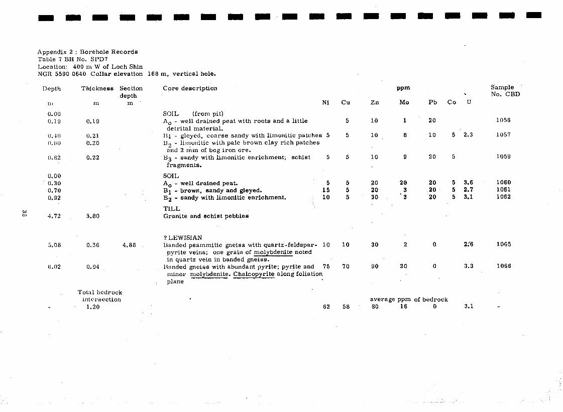
Appendix 2 : Borehole Records Table 7 BH No. SPD7 Location: 400 m W of Loch Shin NGR 5590 0640 Collar elevation 168 m, vertical hole.
Depth Thickness Set tion Core description
m m
0.00 0.19 0.19
O.~lO 0.21 0.60 0.20
I). 82 0.22
0.00 SOIL 0.30 A0 - well drained peat. 0.70 Bl - brown, sandy and gleyed. 0.92 B2 - sandy with limonitic enrichment.
K 4.72 3.80
5.08 0.36
6.02 0.94
depth m
SOIL (from pit)
A0 - well drained peat with roots and a little detrital material.
Bl - gleyed, coarse sandy with limonitic patches 5
B2 - limonitic with pale brown clay rich patches and 2 rim of bog iron ore.
B3 - sandy with limonitic enrichment; schist 5 fragments.
5 15 10
TILL Granite and schist pebbles
4.88 ? LEWISIAN Banded psammitic gneiss with quartz-feldspar- 10
pyrite veins; one grain of molybdenite noted in quartz vein in banded gneiss.
13nndcd gnciss with abundant pyrite; pyrite and 75 minor molybdenite. Chalcopyrite along foliation plane
.
Total bedrock intersection
1.20
.
62
cu Zn
10
10
PPm
MO
5
5
1
8
5
5 5 5
10
70
10
ZO 20 30
30
90
9
20 3
‘3
2
20
average ppm 58 80 16
Pb
20
10
20
20 20 20
0
0
.
co u
Sample No. CBD
1056
5 ‘2.3 1057
5 1059
5 3.6 1060 5 2.7 1061 5 3.1 1062
2:6 1065
3.3 1066
of bedrock 0 3.1
-.
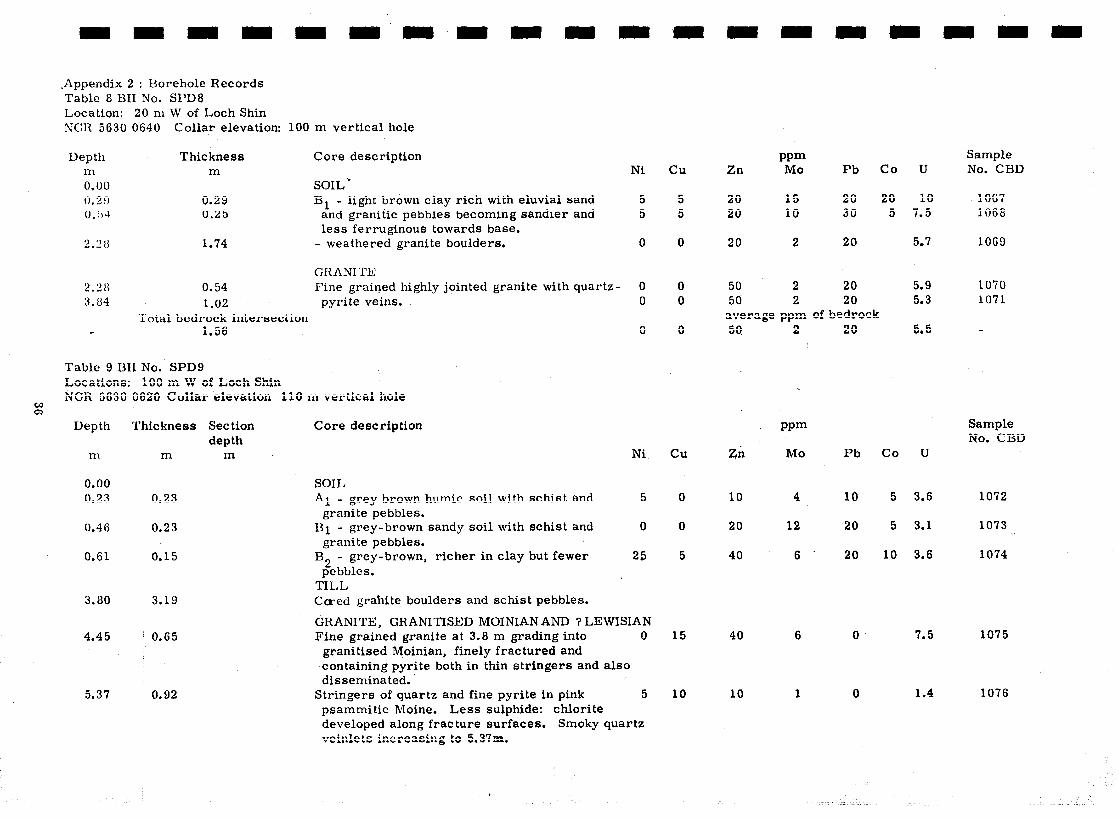
*Appendix 2 : Borehole Records Table 8 BII No. SPD8 Location: 20 m W of Loch Shin ru’GT1 5630 0640 Collar elevation: 100 m vertical hole
Depth 111 0.00 0.29 0,Tr-i
2.28
Thickness m
0.29 0.25
1.74
Core description
SOIL‘, light brown clay rich with eluvial sand B1 -
and granitic pebbles becoming sandier and less ferruginous towards base.
- wea thered granite boulders.
GRRNITl: 0.54 Fine grained highly jointed granite with quartz 1.02 pyrite veins.
Total bedrock intersection 1.56
Table 9 ISIf No. SPD9 Locations: 100 m W of Loch Shin NCR 5630 0620 Colla’r elevation 110 m vertical hole
Depth Thickness Set tion Core description depth
111 m m Ni
0.00 0.23
0.46
0.61
3.80
4.45
5.37
0.23
0.23
0.15
3.19
0.65
.0.92
5
0
25
SOIL
Al - grey brown humic soil with schist and granite pebbles.
Bl - grey-brown sandy soil with schist and granite pebbles.
B2 - grey-brown, richer in clay but fewer
pebbles. TILL Ca-ed granite boulders and schist pebbles.
GRANITE, GRANITISED MOINIANAND ? LEWISIAN Fine grained granite at 3.8 m grading into 0
granitised Moinian, finely fractured and containing pyrite both in thin stringers and also disseminated.
Stringers of quartz and fine pyrite in pink 5 psammitic Moine. Less sulphide: chlorite developed along fracture surfaces. Smoky quartz veinle ts increasing to 5.37m.
Ni
5 5
0
cu
5 5
0
0 0
0
cu
0
0
5
15
10
Zn
20 20
20
50 59
PPm MO
15 10
2
2 2
Pb Co U
20 20 10 30
20
20 20
average ppm of bedrock
zn
10
20
40
40
10
.
2 I
L
PPm
MO
4
12
6
6
1
20
5.9 5.3
5.5
Pb co u
10
20
20
0
0
5 3.6
5 3.1
10 3.6
7.5
1.4
5 7.5
5.7
Sample No. CBD
1067 1068
1069
1070 1071
Sample No. CBD
1072
1073
1074
1075
1076
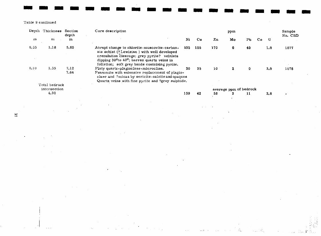
Table 9 continued
Depth Thickness Section depth
rn m m
6.55 1.18 5.60
8.10 1.55 7.12 7.64
‘Iota1 bedrock intersection
4.30
Core description
Abrupt change to chlorite-muscovite-carbon- ate schist (? Lewisian ) with well developed crenulation tcleavage; grey pyrite? veinlets dipping 30°to 40 O; barren quartz veins in foliation; soft grey bands containing pyrite.
Ylaty quartz-plagioclase-microcline. _
Ni Cu
535 105
30 25 10 2 0 3.0 1078 Ysarnmite with extensive replacement of plagio-
clase and ?micas by sericite-calcite and opaques Quartz veins with fine pyrite and ?grey sulphide.
159 42
Zn
170
PPm
MO
0
Pb
40
co u
Sample No. CBD
1.0 1077
average ppm of bedrock 58 2 11
I 2.8 -
. .
; .
r
‘_ . . ,_- k !

Appendix 2 : Borehole Records Table 10 BH No. SPD 10 Location: 300 m W of Loch Shin NCR 5600 0640 Collar elevation 163 m, vertical hole
Pb co u Sample No. CBD
15 3.7 1080 5 3.8 1081 5 5.4 1082
10 8.2 1083
3.2 1084
30 4.8 1085 30 5.6 1086
2.2 1087
1.6 1088
3.3 1089
average ppm of bedrock 40 32 5 2.3
Depth Thickness m m
Core description Ni cu Zn
PPm MO
4 4 3 4
0
13 15
8;
9
5
15 35 15 30 10 25 10 30
4.11 1.78 Boulder fine grained granite with minor pyrite 0
10 65
5
180 210
20 40
15 25
5 15
15 29
30 30 40 50
10
159 190
40
50
30
20 20 40 40
0
40 40
0
20
0
0.00 1.00 1.40 1.82 2 . 3 3
SOIL
*1 - grey-brown sandy-clay
Hl - grey brown with some schist fragments Bl +C - lighter brown with coarse schist
1.00 0.40 0.42 0.51 fragments
TII,L
and thin quartz veins. Drill sludge; granite and 4.62 0.51
6.83 2.21 psammite rock
fragments.
MOINIAN 7.82 0.99 Micaceous psammite with pyrite along
foliation, and in fractures where molybdenite may be associated.
8.36 0.54 Schist with quartz-feldspar pyrite veins
and quartz-
8.96 0.60 Schist with some pyrite and a concordant calcite vein; foliation dips 550.
Total bedrock intersection
2.13
i i :
_ f

Appendix 2: Uorehole Records Table 11 HH No. SPDll Location: 190 m W of Loch Shin . NCR 5610 0660 Collar elevation 109.5 m, vertical hole
Depth Thickness m m
Core description
0.00 0.38 0.61 1.52
3.00
0.38 0.23 0.91
1.48
SOIL Ao/Al - organic and sandy clay 80 Bl - brown sandy-clay soil. 35 H2 - light brown sandy clay 25
TILL Cored schist boulders (not sampled) and sludge. 35
MOINIAN 5.25
6.40
2.25
1.15 Total bedrock
intersection 3.40
Feldspathised semipelite grading to sparsely micaceous psammite, . l 3 molybdenite associated with pyrite in a biotitic band.
Schist with concordant granitic bands (60 cm).
Table 12 HH No. SPD12 Location: ,290 m W of Loch Shin; 40 m W of Sallachy Road NCR 5600 bGG0 Collar elevation 131.8 m, vertical hole.
,
0.00 1.06
2.17 3.17 3.90
I Thickness Core description .
111
1.06
1.11 1.00 0.73
TILL
Tl - greyish brown till with large Moinian rock fragments.
T2 - orange brown till with caved material
T2 - orange brown till becoming grey/brown
T2 - grey/brown till mixed with some sludge
10
7
Ni
‘20
30 30 20
cu
15 50 20
120
15
15
cu
10
40 50 45
Zn PPm MO
40 10 80 2 30 2
60 6
50 f .
Pb
20 20 10
10
co
10 15 10
10
0
average ppm of bedrock 37 ’ 2 0
Zn PPm
MO Pb co U
20 6 10 10 2.2 1096
20 8 20 25 3.8 1097 40 8 20 10 6.0 1098 60 14 20 55 4.7 1099
U Sample No. CBD
2.9 1090 2.0 1091 2.6 1092
2.2 1093
4.1 1095
3.8 ‘_
S#mple Np. CUD

Appendix 2 : tiorehole Records Table 13 BH No. SPD13 Location: 250 m NNW of head of Allt a’chlaonaidh, Claonel district NGR 5500 0610 Collar elevation 278 m, vertical hole
Depth
I-n
0.00 0.16 0.28
2.52 0.:36 3.43 O.!)l
3.79 5.95
6.20 li. 21
6.96
7.30
/
Thickness Section Core description
1.
0.16 0.12
0.70 0.40 0.78
depth m
SOIL
Ni
- poorly decomposed peat and litter. &B - organic-rich soil with mineral matter.
TILL
Tl - clay and sand cementing fragments and 20 pebbles of Moinian. 25
20
MOINIRN
2.90
3.07
4.57
Psammitic schist with quartz-feldspar veins 20 Psammite composed of quartz sericitised 5
piagioclase, microcline and lesser muscovite, magnetite and pyrite.
Bi-Pb sulphide probably of the aikinite group partly replaced by covellite in quartz vein; molybdenite in quartz veinlet.
Concordant quartz-feldspar veins in psammite. 30 Psammite composed of quartz, plagioclase, 10
K-spar, muscovite and lesser magnetite and chlorite; K-spar and quartz inter-grown; trace of chalcopvrite; two generations of quartz
6.82
veins. .
Psammite with quartz-K-spar veins, both concordant and somewhat cross-cutting. .
Psammite with quartz veins and segregations; composed of quartz, sericitised plagioclase, fresh microciine and muscovite; molybdenite in cross-Gutting quartz veinlets.
Psammite with cross-cutting quartz-pyrite and feldspar veinlets.
10 15 20 .
15
12
cu
0
0
10 25 20
5 15
5 5
5 10
5
10
7
Zn
10 10
30 50 40
20 * 10
.
50 . 20
20 30 20
30
PPm MO
1 0
4 22 15
0 23
i
.
5 6
0 5
220
6
Pb
10 10
40 60 40
0 0
10 10
10 10 10
10
co
5 10 15
1.8 1.6
2.2 2.2 2.4
average ppm of bedrock 22 27 8
Sample No. CBD
1100 1101
1102 1103 1104
1105 1106
1107 1108
1109 1110 1111
1112

Appendix 2 : Borehole Records Table 14 Bfl No. SPDl4 Location: $00 m NW of head of Allt a’chlaonaidh, Claonel NC;li 5500 4600 Collar elevation 270 m, vertical hole.
Depth 1 Thickness
m
0.00 0.21 0. 59
1.07 1.Ei5 2.08
3.38
3.86 rp 4.75 w
j I m
t 0.21 0.30
0.48 0.444 0. 53
1.30
0.48 0.89
/ Total bedrock intersection
2.67
Set tion Core description depth
m
SOIL A - peat with rootlets
District
Ni cu Zn
A,/Al - peat with sand and rock fragments.
TILL Tl - fine, leached, sandy till with angular rock 15
fragments. 15 T2 - clay rich till with decayed rock fragments 10
and pebbles at base.
MOINPAN
4.26
Weathered psammite or micaceous psammite 15 with quartz-pyrite veinlets.
Psammite with minor pyrite and carbonate 15 Psammite composed of quartz, plagioclase, 10
K-spar, muscovite (in partings) and chlorite; cross-cutting quartz-carbonate-pyrite veinlets contain molybdenite and hematite; alteration along joints.
13 18
5 10
10 40 55
10
15 30
20 20
70 20 70
30
40 20
PPm MO
130 25
8 9
20
9
70’ 30
Pb
40 30
10 20 30
10
0 30
U
10 7.3 1114 10 5.9 1115
5 5.9 1116
1.9 1117
2.5 1118 2.1 1119
Sample No. CBI)
1113 1132
average ppm of bedrock 28 30 15 2.1

Appendix 2 : Horehole Records Table 15 BH No. SPD15 Location: 100 m WNW of head of Allt a’chlaonaidh, Claonel district. SGIi. 5500 6590 Collar elevation 266 m, vertical hole.
Sample Thickness Set tion depth
m m
Core description Ni cu Zn
Depth PPm MO
5 20 12
0 20 5 15 30 15 35 50 25 50 70 35 70 80 20
45 30 110 80
120:
?5
25 100
30 20 20
8
15 10 15
6 7
12
Pb co U No. CBD
30
20 40 40 40 30
20 10
10
20 20 10
In
0.00
0.30
SOIL
A0 - peat with much undecomposed vegetation TILL
Tl - grey sandy till with schist fragments, probably leached. 25
T2 - compact sandy till with schist fragments. 30 reddenep in places. 45
T3 - compact stony till with red and green 50 patches.
MOINIAN Micaceous psammite with cross-cutting quartz
pyrite veinle ta trace molybdeni te. 30 Pink psammite composed of quartz. plagioclase, 40
K-spar and minor green biotite, pyrite and chalcopyrite; concordant quartz-pyrite- molybdenite and cross-cutting carbonate- pyrite-hematite rutile veinlets; abrupt changes in dip of foliation (204 to 45” ).
2.4
2.9 15 3.0 25 3.8 30 5.1 40 3.9
1120
1121 1122 1123 1124 1125
1.7 1126 2.0 1127
3.0
4.3 3.0 2.1
1128
1129 1130, 1131
average ppm of bedrock 52 23 13 2.5
0.20
0.40 0.95 1.00
1.00
1.10
5.26 0.61
7.95 & h3
2.69 6.55
Psammite with hematite veinlets (vertical), calcite.
Common on joint, some disseminated pyrite
55
15
0.94
9.45 I 0.56 10.7 5 1.30 12.36 1.61 12.35
and molybdenite in quartz veinlets foliation. 10 Handed semipelitic schist composed of quartz, 10
sericitised plagioclase, microcline, muscovite . (in foliae) and biotite (or chlorite) replaced by carbonate and iron oxides; veinlets of hematite and of K-spar with minor carbonate and sulphide. Total bedrock
intersection 7.71 28 51

Appendix 2 : Uorehole Records Table 16 BH No. SPD16 Location: 100 m WSW of head of Allt NGlt 5500 9580 Collar elevation 269
Depth Thickness m m
0.00 0.70
1.28 0.58
2.00
3.37
4.45
& 5.47 w
0.70
0.72
1.37
I 1.17
0.93
I Total bedrock intersection
4.19
a’chlaonaidh, Claonel district m, vertical hole.
Core description Ni
SOIL
A0 - fairly well decomposed peat.
TILL T1 - grey sandy till with decomposed schist
fragments. 30
M0INIAN Weathered micaceous psammite, foliation dips 35
SO” to 60”. Micaceous psammi te showing minor folding;
limonitic and trace of molybdenite. Micaceous and chloritic psammite with two
generations of quartz veinlets, one with minor pyrite.
30
40
Micaceous and chloritic psammite with drusy 35 quartz veinlets and minor disseminated pyrite.
35
cu
0
15
10
10
10
5
9
Zn PPm MO Pb cu u
30 4 20
60 60 70 20 3.7
70
60
70
90
85
60 3.7 1135
20 3.4 1136
30 3.9 1137 100 t
, ;7 20 3.6 1138
Sample No. CBD
1133
1134
average ppm of bedrock 66 75 30 3.6

Appendix 2 : Borehole Records Table 17 BH No. SPD17 Location: 200 m SSW of head of Allt a’chlaonaidh, Claonel district NGR 5500 0570 Collar elevation 273 m, vertical hole.
Depth T hit kness Set tion C’ore description
2.;&5 2.65
3.40
& 3.77
4.30
m
0.33
0. 50
0.32 0.50
O.%O
0.20
0.75 0.37
0.53
0.80 0.70 1.20
depth m
SOIL
A0 - partly decomposed brownish-black peat with rootlets
A0 - black peat. TILL .
Tl - grey grading into brown sandy till with numerous subangular schist fragments
15 10
MOINIAN
2.60
3.50
Weathered psammite with trace of molybdenite. 0 Vein quartz with subhedral pyrite, also contain- 0
ing leucoxene and sericitised feldspar. Fractured silicious psammite, somewhat altered. 0 Quartz-sericite-muscovite psammite with some 0
quartz veins and molybdenum- bearing yellowish- brown clay on one joint surface; foliation dips at 70”.
Psammite with quartz veins containing traces of 0 molybdeni te
Psammite with quartz-pyrite-molybdenite veins 0 Psnmmite with quartz veins; brown staining 0
on slickenside and joint surface contains MO. 0
0
cu
5
55
25 35
10 15
15 10
10
10 10
5
10
Zn
40
10
30 50
16. 0
10’ 10
30
10 10 16
wm MO
15
4
60 150
I 17
130 ~
23 27
16
40 130 40
Pb co u
40
20
30 30
10 0
10 10
10
10 10 10
15 2.5 1141 10 2.8 1142
0.8 0.7
1.1 1.7
1.2
0.8 1148, 1.0 1149 . 1.2 1150
average ppm of bedrock 10 46 10 1.1
Sample No. CBD
1139
1140
1143 1144
1145 1146
1147
.

Appendis 2 : Borehole Records Table 18 Z3II No. SPD18 Location: 280 rn SSW of head of Allt a’chlaonaidh Claonel district. NCR 5500 0560 Collar elevation 276 m, vertical hole.
Depth Thickness Core description m m Ni cu
0.00 0.55 1.25
1.92
2.51
0.55 0.70
0.67
0.59
SOIL A0 - brown peat with rootlets. Ao - chocolate-brown fairly well decomposed peat TILL Tl - greyish brown sandy till with schist 20
fragments. Tl - till with large psammite boulder. 20
.
MOINIAN 3.55 0.04 Sparsely micaceous psammite, foliation dips 50~ 5 4.47 0.92 minor quartz veins and sulphide. ‘. ’ 0
Total bedrock intersection
1.96 3
Table 10 BH No. $PD19 Location: 360 m S of head of Allt a’chlaonaidh, Claonel district NGR 5590 0550 Collar elevation 279 m,. vertical hole.
Depth Thickness ’ Core description In m Ni
I
0.00 0.80
1.47
0.80
0.67
SOIL
A0 - peat with rootlets.
TILL Tl - silt-sized till with schist fragments, more 5
. sandy at base.
2.13
2.64 4.05
0.66
0.51 1.41
Total bedrock intersection
2.58
MOINIAN Fresh micaceous psammite with hematite 0
stringers. Buff-coloured psammite with some cross-cutting 0
quartz veins and hematite stringers; foliation 0 dips 304
0
Pb U
20 0
10.
10
PPm Zn MO
20 2 10 2
50 5
45 5
20 2 10 3
10 20
20
20
10 10
co
10
15
3.4
3.5
10 5
1.4 1155 1.5 1156
average ppm of bedrock 8 15 2 10 1.4
cu
0
5.
5
5 5
5
Zn
I
PPm MO Pb
10
40
10
10 10
2 0
3 20
co
10
U
2.5 1158
1 10
1 10 2 10
average ppm of bedrock 10 1 10
1.7
1.0 0.9
1.1
Sample No. CBD
1151 1152
1153
1154
Sample No. CBD
1157
1159
1160 1162

Appendix 2 : Borehole Records Table 20 BH No. SPDBO Location: 460 m S of head of Allt a’chlaonaidh Claonel district NGR 5500 0540 Collar elevation 284 m, vertical hole.
Depth m
0.00 1.30
Thickness m
1.30
1.65 0.35
2.67 1.02
Table 21 BH No. SPD21 Location: NGR 5350
% Depth
m
650 m N of Grudie Burn, 200 m E of Allt na Caillich Beag 0600 Collar elevation 236 m, vertical hole.
Thickness Core description m
0.00 0.28
0.83
0.97
2.07
2.97
0.28
0.55
0.07
1.17
0.90
Core description
SOIL
A0 - dark brown well decomposed peat with rootlets.
TILL
Tl - orange brown sandy till with schist fragments; bottom 10 cm clay-rich and leached.
MO1 NL%N Micaceous psammite. 0
Ni
SOIL
A0 - dark brown peat with roots passing into
black peat. TILL
Tl - 8 cm white sand with pebbles of quartz and 10 psammite; brown sandy clay and green compact ’ sandy till angular psammite fragments.
Total bedrock intersection 2.07
. MOINIAN Sparsely micaceous psammitic schist with ’
regular banding dipping at 20”. Semipelite, no evidence of mineralisation.
5
5
5
cu
0
5
cu
5
10
10
10
10
Zn
10
PPm MO
0
Pb
10
‘10 2 10
.
I .
* PPm MO Zn
10
10
6
5
Pb
30
20
20 5 10
30 8 10 average ppm of bedrock
24 6 10
co u Sample No. CBD
1163
1.4 1165
co u Sample No. CBD
1166
5 1.7 1167
1.3
2.0
1.6
1168
1169
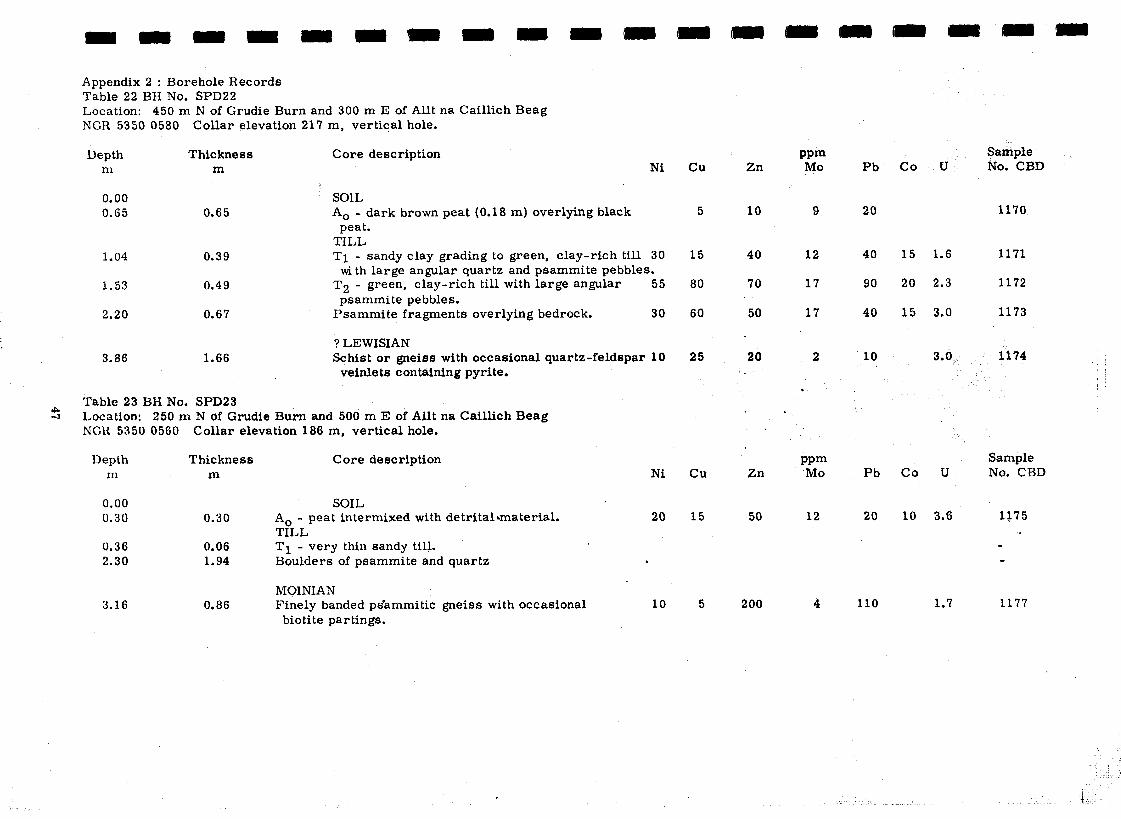
Appendix 2 : Bor*ehole Records Table 22 BH No. SPD22 Location: 450 m N of Grudie Burn and 300 m E of AU na Caillich Beag NGR 5350 0580 Collar elevation 217 m, vertical hole.
Depth Thickness m m
Core description Ni
0.00 0.65
1.04
1.53
2.20
0.65
0.39
0.49
0.67
SOIL
A0 - dark brown peat (0.18 m) overlying black peat.
TILL Tl - sandy clay grading to green, clay-rich till 30
with large angular quartz and psammite pebbles.
T2 - green, clay-rich till with large angular 55 psammite pebbles.
Psammite fragments overlying bedrock. 30
3.86 1.66 ? LEWISIAN Schist or gneiss with occasional quartz-feldspar 10
veinlets containing pyrite.
Table 23 BH No. SPD23 Location: 250 m N of Grudie Burn and 500 m E of Alit na Caillich Beag NCR 5350 0560 Collar elevation 186 m, vertical hole.
Depth Thickness m m
0.00 0.30 0.30
0.36 0.06 2.30 1.94
3.16 0.86
Core description Ni
detritalamaterial. SOIL
A0 - peat intermixed with
TILL
Tl - very thin sandy till. Boulders of psammite and quartz
20.
.
MOINIAN Finely banded ps’ammitic gneiss with occasional
biotite partings. 10
cu Zn PPm MO Pb co u
Sample No. CBD
5 10 9 20 1170
15 40 12 40 15 1.6 1171
80 70 17 90 20 2.3 1172
60 50 17 40 15 3.0 1173
25 20 2 ,
l
10 3.0 1174
cu
15
5
Zn PPm MO Pb co u
Sample No. CBD
50
200
12
4
20
110
10 3.6 1175 .
1.7 1177

Appendix 2 : Borehole Records Table 24 BH No: SPD24 L,ocation: 400 m S of Grudie Burn; N of Meallla Ghruididh NGR 5350 0490 Collar elevation 188 m, vertical hole.
Depth Thickness m m
0.00 1.07 1.27
1.70
1.89
2.64 0.75 3.25 0.61 3.87 0.62 4.12 0.25
?G 4.25 0.13
4.30 0.05
4.91 0.61 6.51 1.60
1.07 0.20
0.43
0.19
Total bedrock intersection
2.21
! Core description Ni cu Zn
SOIL
A0 - very wet dark brown peat.
A0 - dark brown wet peat with roots, poorly decomposed
TILL, Tl- fine grey till with many angular semipelite 60
fragments. T2- red-brown oxidised till, fine grained with 50
rock fragments T2- cored fragments of semipelite T2- sandy brown till with many angular 30
T2’ rock fragments 40 T3 - deeply weathered semipelite boulder?
with quartz veins 300
T3- light brown sandy-clay with rock fragments 60 T3- contaminated with drill bit.
MOINIAN . Psammite with sparse pyrite; a few quartz veins 10
parallel to foliation contain pyrite, also iron rich bands. . 10.
-10
25 40
40
60
.70
100
35 .50 40 110
45 4.70
60 160
5
10
9
40
30
average ppm of bedrock 33 4 13
PPm MO
20
5
4
a ‘40
200
35
2
5
Pb co
40
40
20
20 400
470
190
20
10
30 4.8 1179
30 3.5 1180
20 3.6 1183 1 80 8.4 1182
40 20.3 11&s
130 5.9 1184 /
Sample u No. CBD
1178
2.1 1185
2.3 1186
2.3 -
f

Appendix 2 : Borehole Record Table 25. BH No. SPD 25 Location: 550 m S of Grudie Burn, : N of Meall’a Ghruididh NGR 5350 0475 Collar elevation 208 m vertical hole
Depth n1
0.00 0.33 1.03
1 ‘,7 1.4.d
1.58 0.36 B2 - grey clay rich with caved materials.
2.51 4
2.87
3.24 4.22 5.00 5.W 5.70 5.80 6. %O 6.60 7.02
‘7.50
7.70 8.00
9.00
9.57 10.07 10.37
Thickness Core, description
0.36
0.37 0.98 0.78 0.60 0.10 0.10 0.40 0.40 0.42
0.48
0.20 0.30
1.00 0.57 0.50 0.30
___ .
m
0.33 0.70 0.19
0.93
SOIL A, - dark brown poorly decomposed peat.
A0 - black, well decomposed peat.
Hl - brown-grey sandy find-grained soil with rock fragments.
TILL
Tl - cored semi-polite. boulders; sparse pyrite along foliation (70 ).
T2 - fine grained grey-green sandy till with rock fragments.
T2 - coarse grained sandy till .
T2 - washed sand and Moinian rock fragments T3 - grey sandy till with some caved material.
T3 - grey-brown sandy clay with small fragments of psammite and granitised schist.
T3 - green-grey till angular granite and micaceous psnmmite fragments.
’ T3 - orange-brown clay-sand with many feldspar grains
T3 - grey-brown till with psammite fragments T3 - grey-broyn sandy clay with scarce rock
fragments 1 ) 1
Grey sandy clay
)
Ni cu Zn
15
10 30 5 10
25 50
.
30 30 20 20 15 15 20 15 45 20 25 85 30 85 25 60 10 30 25 15
60 50, 30 30 20
130 70 60 50 40
25 . 40
25 20 25 30
49 5c)
45 45 40 15
90 110
60 50
100 99 80 50
PPm MO
4 5 0
I
0, .O 1 1 0 0 3 0 0 3
1
0 1
3 3 3 3
Pb co U
30 20 10
10 10 10 20 20
400 30 40 10 20
20
10 10
10 30 20 20
10 2.5
1.7
10 B.0 10 3.5 10 3.2 5 3.0
15 6.1 10 3.7 10 2.9 10 4.1 I.0 4.5 10 4.2
16
10 20
T5 is0 10 10
5.6 1201
4.3 4.0
5.1 4.4 7.4 4.0
Sample No. CBD
Xl87 1188 1189
1193
1390 , 1191 1192 1194 1195 1196 1197 1198 1199 1200
1202 1203
1204 1205 1206 1207
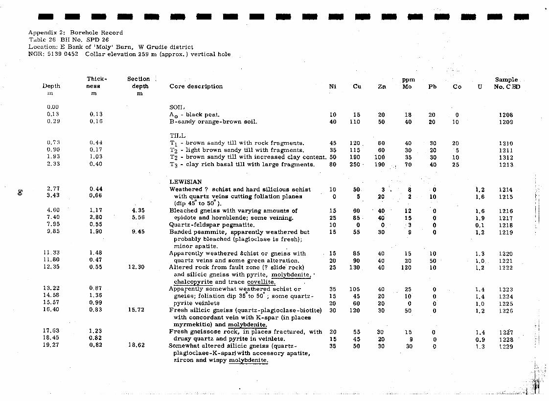
.
Appendix 2: Borehole Record Table 26 BH No. SPD 26 Location: E Bank of ‘Moly Burn, W Grudie district NGR: 5139 0452 Collar elevation 259 m (approx. ) vertical hole
Depth 111
0.00
0.13 0.29
0.73
0.90
1.93 2.33
2.77 0.44 3.43 0.66
4.60 1.17 7.40 2.80 7.95 0.55 9.85 1.90
11.33 1.48 11.80 0.47 12.35 0.55
13.22 0.87 14.58 1.36 15.57 0.99 16.40 0.83
17.63 1.23 18.45 0.82 19.27 0.82
Thick- Section / ness depth
m m
0.13 0.16
0.44 0.17 1.03 0.40
4.35 5.56
9.45
12.30
15.72
18.62
Core description Ni Cli
SOIL
A0 - black peat. B-sandy orange-brown soil.
10 40
15 110
TILL
Tl - .brown sandy till with rock fragments. 45
T2 - light brown sandy till with fragments. 35 T2 - brown sandy till with increased clay content. 50
T3 - clay rich basal till with large fragments. 80
LEWISIAN Weathered ? schist and hard silicious schist
with quartz veins cutting foliation planes (dip 45* to 50* ).
Bleached gneiss with varying amounts of epidote and hornblende; some veining.
Quartz-feldspar pegmatite. Banded psammite, apparently weathered but
probably bleached (plagioclase is fresh); minor apatite.
Apparently weathered Schist or gneiss with quartz veins and some green alteration.
Altered rock from fault zone (? slide’ rock) and silicic gneiss with pyrite, molybdenite, l
chalcopyrite and trace covellite. Apparently somewhat w%atherfd schist or
gneiss; foliation dip 35 to 50 ; some quartz- pyrite veirilets
Fresh silicic gneiss (quartz-plagioclase-biotite) with concordant vein with K-spar (in places myrmekitic) and molybdenite.
Fresh gneissose rock, in places fractured, with drusy quartz and pyrite in veinlets.
Somewhat altered silicic gneiss (quartz- plagioclase-K-spar) with accessory apatite, zircon and wispy molybdenite.
120. 115 190 250 .
10 0
50 5
15 60 25 85. 10 0 15 55
15 85 20 90 25 130
35 15 20 30
20 15 35
105 45 60
120
55 45 50
Zn
20 50
80 60
100 190
20
40 4d
0 30
40
t:
40 20 20 30
30 20 30
PPm MO
18 40
40 30 35
( 70
3. 8 2
12 15
3 9
15 20
120
25 10 0
50
15 9
30
Pb vco U
20 20
30 20 30 40
0 10
0
: 0
10 50 10
0 0 0 0
0 0 0
0 1208 10 1209
20 1210 5 1211
10 1312 25 1213
192 1214 ‘s 1,6 1215 , 1
1.6 1.9 O,l 1.2
1.3 1.0 1.2
1.4 1.4 1.0 1.2
1.4 0.0 1.3
Sample NO.CBD
1216 1217 I 1218 i
i 1219 i
1220 1221 1222
1223 1224 1225 1226
1227 1
1228 ;.j 1220

Table 26 cont.
I.3ep th J-n
20.20
21.71
29.00 0.40 28.65
2 9.30
3o.oC.l 31.10 3 2. 2 5
Thick- Section ness depth
m m
0.93
1.51
0.79 1.19 0.75 0.77 1.09 1.35 0.95
0.30 0.70 1.10 1.15
Total bedrock intersection
29.92
20.10
21.54
31.13
Core description Ni cu Zn
Altered intermediate gneiss (quartz-plagioclase- 25 chlorite) with chalcopyrite invertical fractures.
Intermediate gneiss with epidote, hornblende 15 and lesser sphene, apatite and allanite.
Chloritic and biotitic schist or gneiss 30 wi tll cross-cutting clu~rtz-pyi’ito-Inolybdcnitc 20 vcinlcts and K-spar veinlets; foliation dips 28” . 20
V amiably chloriticj biotitic and laminated schist gnciss with cross-cutting K-spar and quartz- pyrite veinle ts.
More psammitic, cut by numerous feldspar- quartz veinlets with pyrite and fine grained molybdenite.
Gneiss (quartz-plagioclase-muscovite-biotite) tending to exhibit augen texture with pyrite, chalcopyrite and sphalerite; molybdenite in cross-cutting quartz vein.
Gneiss with quartz -pyrite veins containing molybdenite and chalcopyrite; epidote on joint surfaces; foliation dips 35’
k’ine grained gneiss with sericite and poikilitic biotite (? replacing staurolite or kyanite).
30 35 15 10
40 50 95 50
100 15 50
15 75
20 80 15 40 25 85 20 20
18 average ppm of bedrock
58 27 37 3
PPm MO
110 60 10
45 30
20 30 30 30 30 30 20
20
30 30 40 30
40
25 90
150 10 24 10
120 I
650
250 22
100 8
Pb
0
0
0 0 0 0
10 10 10
10
20 10 10 20
co tJ
1.1
1. 3
1.2 1.0 1 . 3 1.3 1.2 3.1 1.4
1.4
1.6 1.5 2.0 1.6
1.4
Sample No. CBD
1230
1231
1232 I 2 33 1234 1235 1236 1237 1238
1239
1240 1241 1242 1243

-1 I -1 ,--‘I ,--1 ( ._) I-_ ._‘~
L _)
--7 1 -7 ’ -1 /
4 ppendix 2 Borehole Records Table 27. BII No. SPD 27 Location: 700 m S of Grudie Burn N of Meal1 a’Ghruididh NGR 5350 0460 Collar elevation 231 m, vertical hole.
Depth m
Thickness m
0.00 0.15 0.35 0.57
0.15 0.20 0.22
0.90 0.33 1.22 0.32 1.71 0.49 2.14 0.43 2.51 0.37 2.92 0.41 3.48 0.56
isi 4.07 0.59 4.75 0.68 5.64 0.89 (j.18 0.54 Ei.89 0.71 7. (il 0.72 ii. 111 0.57 a. fi 9 0.51
15.32 16.77 17.76 19.50 20.36 22.57
0.51 0.48 0.75 0.55 0.68
3.G6 1.45 0.99 1.74 0.86 2.21
Core description !
SOIL A0 - thin peat with roots.
B1 - brown clay with fine sand.
B2 - orange and sandy with occasiotil Moinian fragments.
TILL
Tl - light brown sandy till with occasional Moinian fragments.
T2 - very light brown sandy till with small rock fragments. T2 - grey, clay-sand with rounded
psammitic pebbles. T2 - grey till with common quartz fragments
and rounded semipelite fragments. T2 - grey, clay-sand with Moinian fragments of various sizes. T3 - grey, clay-sand with small fragments of feldspar and granite. T3 - grey, clay-rich with increasing feldspar fragments.
T3 - brown till, with numerous feldspar fragments. T:j - red-brown clay rich due to weathered feldspar and muscovite.
yellow-brown clay sand no rock fragments.
T3 - clay-rich, pale grey-brown with coarse fragments of weathered feldspar and bands of muscovite.
T3 - clay-rich, light brown with bands of feldspar and biotite sand
T3 - sandy clay with very weathered biotite rich pebbles’ T3 - clay-sand, rich in biotite and weathered feldspar fragments l
T3 - sandy clay with fewer rock fragments but a few large . quartz grains. *
MOINIAN Highly altered psammite with quartz veins containing iron oxides RIicaceous to sparsely micaceoug psammite.
(1 II 11 11
Granitised schist containing pink feldspar, quartz and biotite. Pink granitised schist; heavily fractured with black staining on
surfaces; occasional quartz phenocrysts. Totrrl bedrock intersection
10.91
- -7 i----l I-- 7
Ni CU PPm
Zn MO Pb
0 0 0
x 0
10 2 10 7 10 0
20 0
10
0 0’ 10 b 10 0 0 10 b 10 0 6. 10 0 10
10 10 20 0 10 5 16 30 !nd 0 5 5 20 0 10 5 5 10 l 0 10 5 5 10 nd 10 5 10. 10 nd 10
15 40 60 3 30 30 20 80 2 10 15 25 60 3 10 10 1s 60 3 10 15 15 75 2 20 25 15 80 2 10
15 20 10 20 20
5 5
10 10
5
60 70 3 10 10 18 1262 26 80 3 20 20 17 1263 lb 40 1 10 10 18 1264 25 80 0 10 15 37 1265 10 70 8 10 15 35 1266
5 20 2 10 6.0 1267 10 30 1 10 5.5 1268
5 30 2 10 5.6 1269 15 50 1 60 7.1 1270
5 20 10 120 3.6 1271 sample missing
co
0 0
5 0 0 0 5 0 0 0 5
30
U
2.0 2.0
1.9 1.8 1.5 2.9 3.5 3.7 3.3 2.6 2.5 9.7
16 16 16 16 15 15 . 15 18 20 18
6 8 ;j;erage2ppm $ bedrock
5.9
Sample No. CBD
1244 1245 1246
1247 1248 1249 1250 1251 1252 1253 1254
.1255 1256 1257 1258 1259 1260 1261
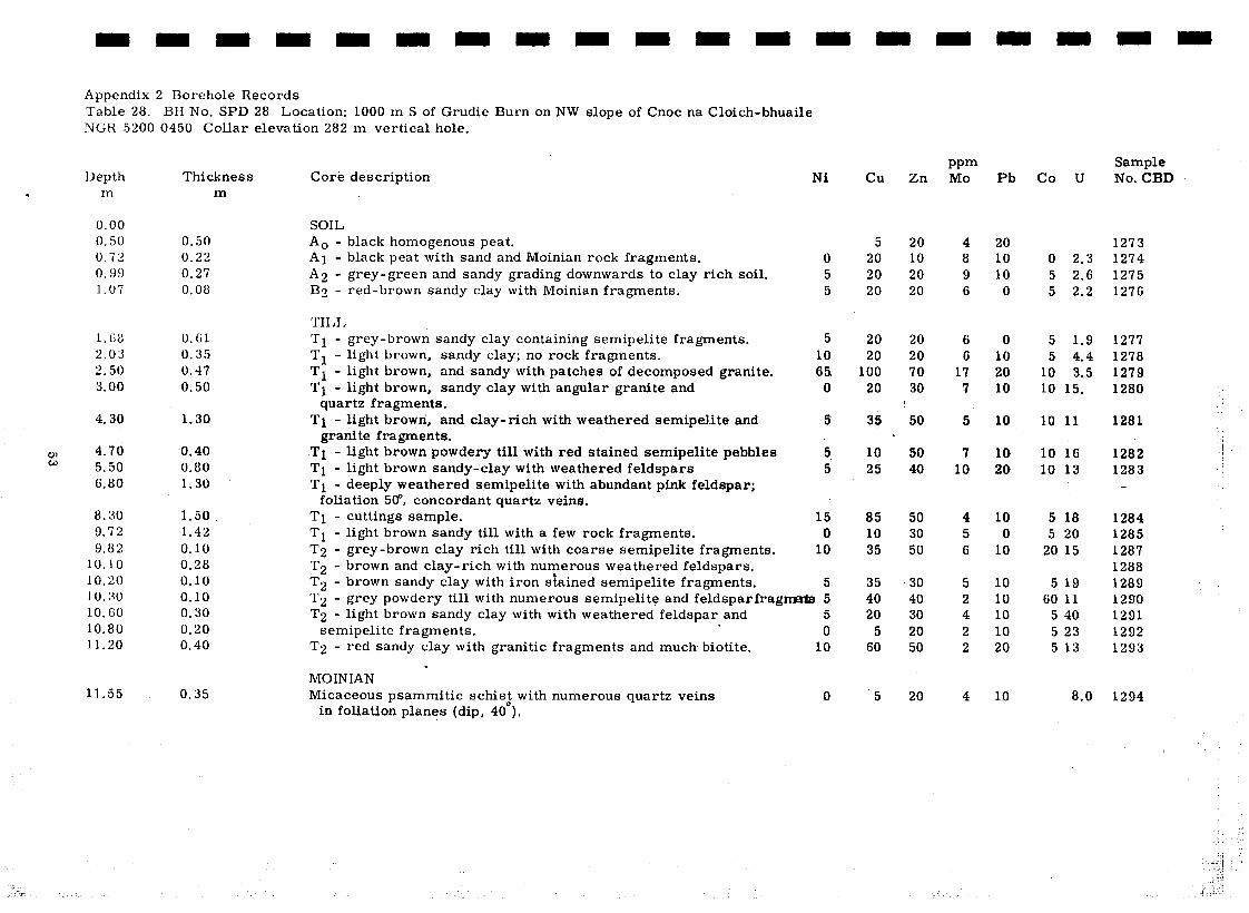
Appendix 2 Borehole Records Table 28. BII No. SPD 28 Location: 1000 m S of Grudie Burn on NW slope of Cnoc na Cloich-bhuaile NGR 5200 0450 Collar elevation 282 m vertical hole.
. Depth Thickness
m m
0.00
0.50 0.72
0.99
1.07
l.G8
2.03
3.50 3.00
4.30
w 4.70 0.40 w 5.50 0.80
6.80 1.30
8.30 9.72 9.82
10.10 1 0 ? 0 lo:;0 10.60 10.80 11.20
11.55
0.50 0.22 0.27 0.08
0.61
0.35 0.47 0.50
1.30
Tl - light brown powdery till with red stained semipelite pebbles
Tl - light brown sandy-clay with weathered feldspars
Tl - deeply weathered semipelite with abundant pink feldspar; foliation 5(P, concordant quartz veins,
1.50. Tl - cuttings sample. 1.42 Tl - light brown sandy till with a few rock fragments. 0.10 T2 - grey-brown clay rich till with coarse semipelite fragments. 0.28 T2 - brown and clay-rich with numerous weathered feldspars. 0.10 T2 - brown sandy clay with iron stained semipelite fragments.
Core description Ni
SOIL
A0 - black homogenous peat. Al - black peat with sand and Moinian rock fragments.
A2 - grey-green and sandy grading downwards to clay rich soil. B2 - red-brown sandy clay with Moinian fragments.
TILL
Tl - grey-brown sandy clay containing semipelite fragments.
Tl - light brown, sandy clay; no rock fragments.
Tl - light brown, and sandy with patches of decomposed granite.
Tl - light brown, sandy clay with angular granite and quartz fragments.
Tl - light brown, and clay-rich with weathered semipelite and granite fragments.
0 5 5
5 10 65.
0
5
5. 5
15 0
10
5 0.10 0.30 0.20 0.40
0.35
T2 - grey powdery till with numerous semipelite and feldsparfragn 5
T2 - light brown sandy clay with with weathered feldspar and 5 semipelite fragments.
. 0
T2 - red sandy clay with granitic fragments and much biotite. 10 9
MOINIAN Micaceous psammitic schis; with numerous quartz veins 0
in foliation planes (dip, 40 ).
__
cu
5 20 20 20
20 20
100 20
35
Zn
20 10 20 20
20 20 70 30
I
50 .a
10 50 25 40
7 10
85 50 . 4 10 30 5 35 50 6
35 * 30 40 40 20 30
5 20 60 50
5 20
PPm MO
4 8 9 6
6 6
17 7
5
Pb co u
20 10 10 0
0 10 20 10
10
10 20
10 0
10
10 10 10 10 20
10
0 2.3 5 2.6 5 2.2
5 1.9 1277 5 4.4 1278
10 3.5 1279 10 15. 1280
10 11 1281
10 16 1282 i
10 13 1283 I
5 18 5 20
20 15
5 19 60 11
5 40 5 23 5 13
8.0
Sample No. CBD
1273 1274 1275 1276
1284 1285 1287 1288 1289 1290 1291 1292 1293
1294

Appendix 2: 13orehole Records Table 29. BH No. SPD 29 I,ocation: W Grudie district; 200 m E of Moly Burn outcrop NGH: 5160 0450 Collar elevation 2’71 m, vertical hole
Depth Thickness 111 m
Core description Ni cu ZC
0.00 1.36 0.58
1.05
0.36 0.22
0.47
SOIL
A0 - black moderately decomposed peat
*1 - very dark brown clay-sand soil with semipelite fragments
B2 - light brown soil with angular semipelite or micaceous psammite fragments
0
0
10 10
10
15
10
10 10 10
10
30 15
10
10 15
12
10 30 1 5 10 5
25 20 6
1.47 0.42 1.99 0.52
2.21 0.22
2.54 0.33
TILL
Tl - brown, medium grained sandy till
Tl - brown, sandy till with abundant schist fragments
T2 - greyish-green fine-grained sandy till with schist fragments
T2 - very fine grained sandy till, light brown with schist fragments becoming larger with depth
MOINIAN 3.30 0.76 Micaceous psammite with narrow bands of
granitic material; foliation 48. 4.00 0.70 Well foliated micaceous psammite with 4.80 0.80 muscovite, deeply weathered 5.67 0.87 Micaceous psammite containin; granitic
veins with pyrite-molybdenite 6. 60 0.93 Less micaceous with quartz-feldspar veinlets
containing pyrite-molybdenite; cross cutting veinlets of molybdenite, and abundant hematite
7.19 0.59 Weathered ticaceous psammite with large barren quartz vein
8.00 0.81 Disseminated hematite in fresher micaceous psammite
9.06 1.06 Quartz -feldspar veins with pyrite -molybdenite- chalcopyrite
10.11 1.05 Variably weathered micaceous psammite 11.23 1.12 Rock more fractured and minerals leached
Total bedrock intersection 8.69
i
95 65
25
90
60
55 70 70
65
50 40
40
70 30
60 40
40
PPm MO
15 12
7
40 15
20 40
20 40 20 30 10 1
10 35
30 40 20 10
20 40
20 20 20 12
Pb
60 10
10
30 20
! 10
‘ 10
10
10 10 10
10
0 0
0
0 0
average ppm of bedrock 54 19 25 5
CO
0
0
5 5
5
5
U
1.5
6.9
2.7 2.8
11
2.7
1.4
1.5 1.1 1.2
1.0
1.5 1.2
1.5
1.8 1.4
1.4
Sample No. CBD
1295 1296
1297
1298 1299
1302
1303 1304 1305
1306
1307 1308 II
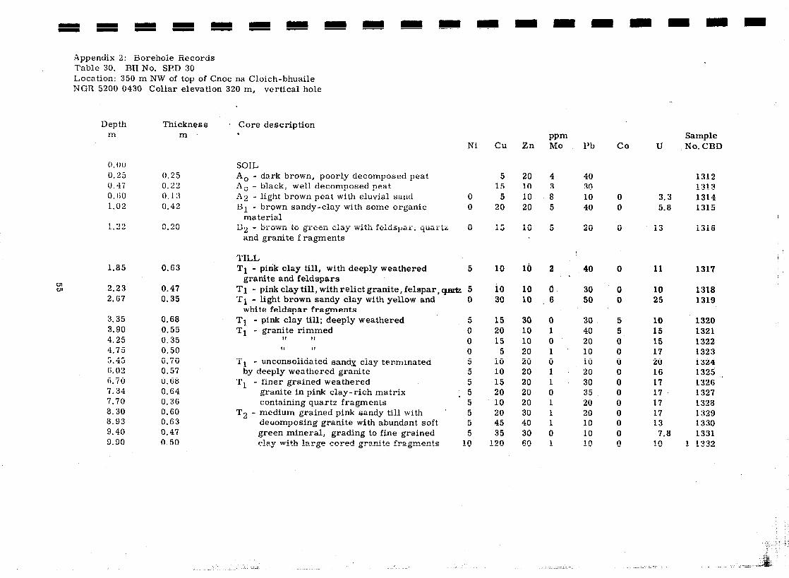
Appendix 2: Borehole Records Table 30. BH No. SPD 30 LAocation: 350 m NW of top of Cnoc na Cloich-bhuaile NCR 5200 0430 Collar elevation 320 m, vertical hole
Depth Thickness 1 Core description m m 6 4
co Sample No. CBD
PPm MO Ni cu Zn Pb U
0. 0 0
0.25 0.47 0. (;o 1.02
SOIL
A0 - dark brown, poorly decomposed peat
A0 - black, well decomposed peat
*2 - light brown peat with eluvial sand 0
B1 - brown sandy-clay with some organic 0 material
B2 - brown to green clay with feldspar: quartz 0 and granite fragments
0.25 0.22 0.13 0.42
5 15
5 20
20 10 10 20
40 30 10 40
1312 1313 1314 1315
0 3.3 0 5.8
1.22 0.20 15 10 5 20 0 13 1316
8
40 TILL
Tl - pink clay till, with deeply weathered 5 granite and feldspars
Tl - pink clay till, with relict granite, felspar, w 5
Tl - light brown sandy clay with yellow and 0 white feldspar fragments
Tl - pink clay till; deeply weathered 5
Tl - granite rimmed 0 II II 0 II If 0
Tl - unconsolidated sandx clay terminated 5 by deeply weathered granite 5
Tl - finer grained weathered 5 granite in pink clay-rich matrix . 5 containing quartz fragments 5
T2 - medium grained pink sandy till with ’ 5 deoomposing granite with abundant soft 5 green mineral, grading to fine grained 5 clay with large cored granite fragments 10
1.85 0.63 lb 10 2 0 11 1317
cn w 2.23
2.67 0.47 0.35
10 10 0 30 0 10 1318 30 10 6 50 0 25 1319
3.35 0.68 3.90 0.55 4.25 0.35 4.75 0.50 5.45 0.70 6.02 0.57 6.70 0.68 7.34 0.64 7.70 0.36 8.30 0.60 8.93 0.63 9.40 0.47 9.90 0.50
15 30 0 30 5 10 1320 20 10 1 40 5 15 1321 15 10 0 20 0 15 1322
5 20 1 10 0 17 1323 10 20 0 10 0 20 1324 10 20 1 20 0 16 1325 * 15 20 1 30 0 17 1326 20 20 0 35 0 17 1327 10 20 1 20 0 17 1328 20 30 1 20 0 17 1329 45 40 1 10 0 13 1330 35 30 0 10 0 7.8 1331
120 60 1 10 0 10 1 1332

Appendix 2: Borehole Records Table 31. BII No. SPD 31 Location: 650 m NW of top of Cnoc na Cloich-bhuaile; 400 m E of Moly Burn outcrop NGR 5180 0450 Collar elevation 271 m, vertical hole.
Depth Thickness m m
0.00 0.48 1.33 1.85
2.38 2.68 3.30 4.19 4.88
10.62 CJJ Q, 13.27
14.00
15.25 1.25 15.50 0.25
4.00 4.88 6.86 7.50 8.23
9.23 10.49 11.90 12.45 13.27 15.50
0.48 0.85 0.52
0.53 0.30 0.62 0.89 0.69 5.74 2.65 0.73
Core description
SOIL
A0 - moderately decomposed dark brown peat A, - black peat; less root material
A0 - black, very well decomposed peat
TILL
Tl - large semipelite pebbles in grey sandy till
Tl - light grey sandy till with pebbles of angular semipelite and quartz
Tl - cored pebbles and boulders of semipelite with a little disseminated pyrite, quartz -feldspar rich and pink psammite; no fines recovered
11 I(
Tl - wet, limonitic stony till containing granitised Moine schist
T2 - limonitic clay rich till
T2 - sandy till probably caved material
DRILL CUTTINGS SAMPLES T1 - washed sand with dominant feldspar and
biotite grains . clay-sand Tl - , *
I1 - T2 -
T2 - sandy till very rich in muscovite
T2 - T2 - T2 -
T2 -
coarser grained sand containing more feldspar red-brown sand with limonitic staining and abundant
feldapar
and biotite limonitic micaceous sandy till limonitic feldspar rich sandy-clay till light brown mica-rich sandy till limonitic, muscovite-feldspar rich sandy till
Ni Cu Zn
10 30 4 30 1333 5 10 0 10 1334
20 20 6 10 1335
10 10
40 40 30 * 30
45
50 65 100 30 65 ’ 70
10 20 20 70 75 50
5 15 10 30 65 40 60 105 80
60 120 100 50 70 40
105 150 130 50 95 110 60 140 110 65 135 80
PPm MO Pb co U
Sample No, CBD
3 4
20 20
5 5
3
1.0 1336 2.4 1337 2.2 1338 0.9 1339 ‘1.0 1340 2.4 1341
.
17 40 15 6.4 1342
17 30’ 20 9.1 1343 18 50 40 2.6 1344
3 0 0 2.0 1345 4 10 35 2.9 1346 1 10 0 2. 3 1347
15 10 10 6.1 1348 23 60 10 7.9 1349
7 10 25 3.1 1350 10 10 15 3.2 1351 25 20 45 4.2 1352 25 90 20 9.8 1353 20 40 15 6.3 1354
9 30 10 4.1 1355
. i

cn -J
Appendix 2: Borehole Records Table 32. BH No. SPD 32 Location: 400 m W of Cnoc na Cloich-bhuaile, W Grudie district NGR 5200 0410 Collar elevation 312 m vertical hole.
Depth Thickness m m
0.00 0.37
0.48
0.60
0.85 1.25
1.85 2.35 3.20 4.00
4.70
5.20 5.30
5.90
G. GG 0.76
7.22 0.56
8.30 1.08
8.85 0.55
0.37
0.11
0.12
0.25 0.40
0.60 0.50 0.85 0.80
0.70
0.50 0.10
0.60
Total bedrock intersection
1.63
Core description Ni Cu Zn
SOIL
AO - dark brown moderately decomposed peat with
eluvial sand.
Al - abundant organic material with eluvial iron stained quartz.
Bl - red-brown limonitic sandy soil.
TILL
Tl - light brown fine grained sandy till.
Tl - light brown sandy till with fragments of feldspathic schist.
Tl - pink sandy till with feldspathic quartz veined schist; more clay-rich at base.
Tl - buff sandy till.
Tl - light brown clay till containing weathered psammite fragments.
Tl - light brown clay with hematised clay patches and more rock fragments.
Tl - brown clay, containing many psammitic fragments.
T1 - fragments of well jointed granite with disseminated hematite.
T2 - clay-rich brown till with fragments of semipelite (granite veined) and granite with black . precipitate on joints
* T2 - clay-rich brown till with weathered and stained mica schist fragments.
T2 - clay-rich brown till with quartz and mica-schist fragments containing quartz-feldspar-hematite veins.
MOINIAN Psammitic schist with quartz-hematite and feldspar
veinlets. Vertical contact between psammite and a pink granitised
schist containing feldspar-quartz-weathered. biotite.
f
5
5
5
10 15
10 5 5
15
10
10 10
25
40
30
5
5
5
5 10
10 10
15 . 20
10 * 20 25 50
15 I’ 30 35 30 25 6 20 15 4Q
35 * 40
20 30 20 30
30 80
25 110
50 90
10 10
5 10
PPm MO
5 7
s!
‘5 3 4
4
5 3
9
8
6
0
2
Pb co U
20
20
10
20 30
20 10 20 10
20
20 70
20
20
20
0
0
0 2.3
0 3.5
0 10
5 5 5
10
10
5 10
20
4.2 7.2
5.1 3.6 5.5 5.6
7.6
4.6 7.1
8.6
25
25
9.5
6.3
1.9
3.2
average ppm of bedrock 8 10 1 0 2.3
Sample No. CBD
1356
1357
1358
1359 1360
1361 1362 1363 1364
1365
1366 1367
1368
1369
1370
1371 ’
1372
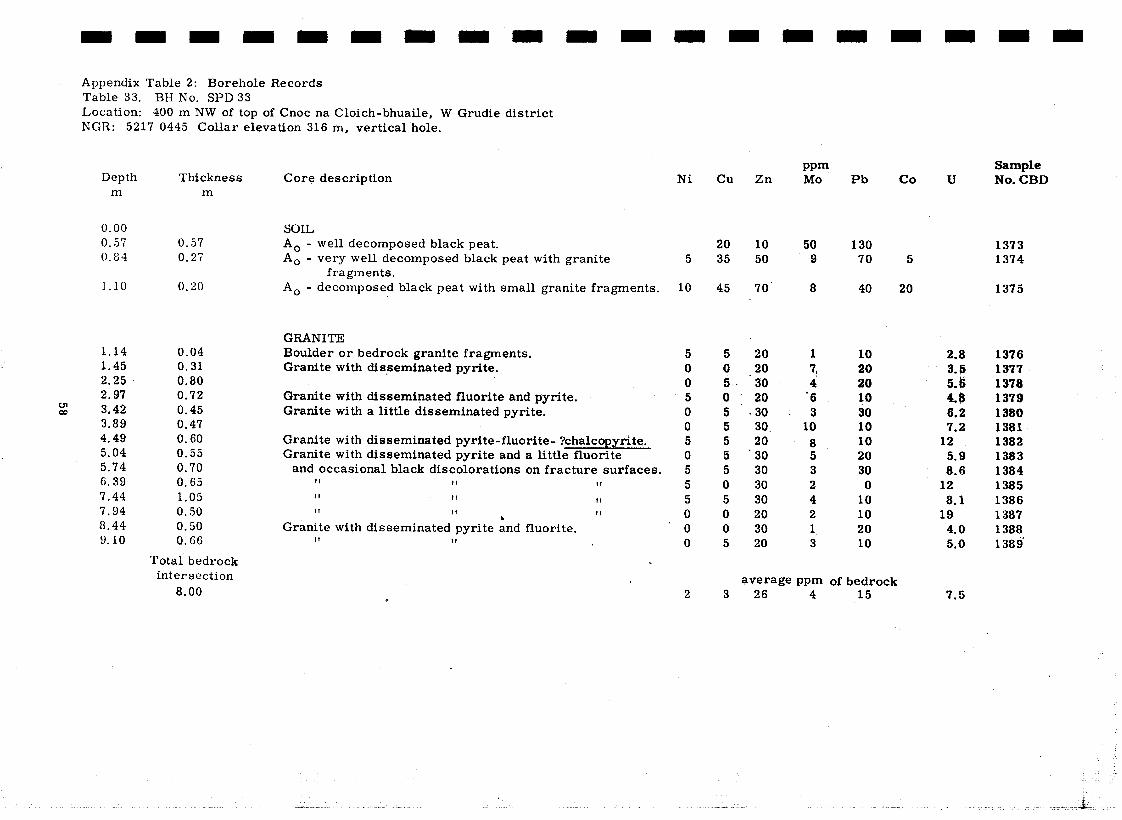
Appendix Table 2: Borehole Records Table 33. BH No. SPD 33 Location: 400 m NW of top of Cnoc na Cloich-bhuaile, W Grudie district NGR: 5217 0445 Collar elevation 316 m, vertical hole.
Depth Thickness m m
0.00 0.57 0.84
1.10
1.14 0.04 1.45 0.31 2.25 0.80 2.97 0.72
: 3.42 0.45 3.89 0.47 4.49 0.60 5.04 0.55 5.74 0.70 6.39 0.65 7.44 1.05 7.94 0.50 a.44 0.50 9.10 0. ($6
0.57 0.27
0.20
Total bedrock intersection
8.00
Core description Ni
SOIL
A0 - well decomposed black peat.
A0 - very well decomposed black peat with granite fragments.
A0 - decomposed black peat with small granite fragments.
GRANITE Boulder or bedrock granite fragments. Granite with disseminated pyrite.
Granite with disseminated fluorite and pyrite. Granite with a little disseminated pyrite.
Granite with disseminated pyrite-fluorite- ?chalcopyrite. a little fluorite Granite with disseminated pyrite and
and occasional black discolorations II II
on fracture surfaces, II
II II
II II
Granite with disseminated pyrite ind II 11
II
II
fluorite.
5
10
5 0 0 5 0 0 5 0 5 5 5 0 0 0
2
cu
20 35
45
5 0 5 0 5 5 5 5 5 0 5 0 0 5
Zn
10 50
70’
29 * 2o 30 20
- 30 30. 20 30 30 30 30 20 30 20
PPm MO
50 9
8
1
?! 4 l 6 3
10
a 5 3 2 4 2
1, 3
Pb
130 70
40
10 20 20 10 30 10 10 20 30 0
10 10 20 10
average ppm of bedrock 3 26 4 15
U
2.8 3.5
5:; 6.2 7.2
12 5.9 8.6
12 8.1
19 4.0 5.0
7.5
Sample No. CBD
1373 1374
1375
1376 1371 1378 1.379 1380 1381 1382 1383 1384 1385 1386 1387 1388 1385

Sample
Appendix Table 2: Borehole Records Table 34 BH No. SPD 34 Location: 200 m SW of Cnoc na Cloich-bhuaile, W Grudie district NGR: 5220 0400 Collar elevation 328 m, vertical hole.
Core d$scription I Depth Thickness
In m Ni Zn
PPm MO Pb
0.14 0.16 0.08
SOIL
A0 - dark brown peat grading downwards to black peat.
A0 - black, well decomposed peat with eluvial sand.
Bl - brown sandy soil.
37 10 25
0.36
0.90 0.16
0.49
z 1.85 0.46 2.22 0.37
TILL
T1 - yellow -grey, clay-sand till with hematite in psammitic fragments.
Tl - pale yellow sandy till with psammite and semipelite fragments.
Tl - grey, clay-sand till with granite and psammite fragments.
Tl - grey, clay-sand with psammite containing quartz-feldspar veins; also granite fragments.
0 0 0
10
5
5
5 5 ?
5
5 5
. 5
cu
10 5
15
20
10
35
35 30
15
5 0
20 10 20
30
20
‘30
*30 30
10
10 0
15
6
6! .
il 6
MOINIAN 2.88 0.66 Pink granitised schist with quartz-feldspar and
hematite in veins. Fractured granitised schist with secondary green
mineral on fracture surfaces.
6
1.03 0.81
‘I‘otal bedrock intersection
2.50
2
1,
20 10 20
10
10
10
20 20
0
0 0
.
.
average ppm of bedrock 6 7 3 0
co
5 0 0
5
5
5
5 15
_
U No. CBD
5.0 1390 4.8 1391 4.0 1392
5.0
4.4
4.b
4.4 4.1
1393
1394
1395
1396 1397
1.0
0.8 0.5
1398
1399 1460
0.8
0.00 0.14 0. :10 0. :s8
0.74
1.39
3.91 4.72

Ni cu Zn PPm MO Pb co tJ
Sample. No. CRD
10 50 4 40 1401
5 10 0 10 1402 5 10 0 10 1403 5 .lO 3 10 1404
25 20 5 20 2.7 1406
40 50 45
20 15 5
15 15
56 40 40 .
4 3 ‘4
20 10 ld
4.2
3.0
1407 1408 1409
60 . 3 10 3.4 1410 ‘10 1 0 1.1 1411 10 1 0 0.8 1412 40 1 0 2.0 1413 30 0, 0 2.6 1414
average ppm of bedrock 15 30 1 2 ;2.1
Appendix Table 35. Location:
Table 2: Borehole Records BH No. SPD 35 400 m SW of Cnoc na Cloich-bhuaile, W Grudie district
NGH: 5200 0390 Collar elevation 320 m vertical hole.
Thickness m
t Core description
SOIL
Depth m
0.00 0.11 0.11
AO - moderately well decomposed peat with much
root material.
AO - darker, moderately well decomposed peat. 0.57 0.46
0.99 0.42 1 . 46 0.47 2.00 0.54 2.56 0.56
Bl - psammite boulders followed by light brown sandy soil with psammite pebbles (angular). 15
TILL
Tl - grey sandy,till with weathered Moinian pebbles. 20
Tl - grey-brown clay-sand till with large angular pebbles. 20
T2 - clay-sand till with orange patches. 20
3.88 1.32 4.66 0.78 4.76 0.10
MOINIAN Fine grained psammite containing quartz-feldspar veins. ’ 10 Quartzose psammite with granitic veins. 5 6 cm quartz vein with adjacent pink feldspar enrichment 5 Fractured and deeply weathered psammite. 10 Psammite containing some quartz -feldspar veins. 10
.
5.32 6.04 6.37 6.86 7.57
0.56 0.72 0.33 0.49 0.71
Total bedrock intersection
2.81 8
.
.^ ; .” ._ - .- _ - . _- :3--r. . ..L. .
m m m m m m m I m m m m m I *m m
PPm MO Pb Co U
Sample No. CBD
20 1415 10 1416
0 10 20 10 20 15 20 10 10 10 20 10
4.6 1417 3.4 1418 5.7 1419 4.3 1420 4.2 1421 5.4 1422
8 . 6
4 10 15 20 5
5.5 1423 4.5 1424 2.4 1425
7 0 1.7 1426 12 20 2.9 1427
4’ 0 2.4 1428
2 10 1.8 1430
average ppm of bedrock 16 28 6 7 2.3
Appendix 2: Borehole Records Table 36. BH No. SPD 36 Location: 400 m SE of head of ‘Moly’ Burn, W. Grudie district NGR: 5180 0400 Collar elevation about 298 m vertical hole.
I
Core description . . Depth Thickness Section
m m depth
m
Ni cu Zn
5 5
10 0
10 10 15
5 5 5
0 0 0
5 5 5
0
4
30 30 70
100 30 40
0 .50 80
. *ii 40
60 40 25
15 20 10
20
‘40 40 * a40
10 30 50
10
0.00 0.26 0.36
SOIL
A0 - brown peat with rootlets.
A0 - black decomposed peat.
TILL
0.26
0.10
0.82 1.24 1.71 2.14 2.68 3.29
Q) )-r 3.70 3.98 4.41
0.46 0.42 0.47 0.43 0.54 0.61
0.41 0.28 0.43
Tl - boulder of micaceous schist with minor pyrite.
Tl - brown clay-rich sand with limonitic bands and numerous schist fragments.
T2 - more sandy yellowish-brown till with small fragments of vein quartz and granitic material.
T3 - clay-rich till with limonitic patches and fragment s of quartz and psammite.
T4 - buff sandy till with black iron-rich patches and many psammite fragments.
T5 - basal clay-rich brown till (poor recovery).
MOINIAN Weathered and broken psammite with small quartz
veins containing hematite and traces of possible molybdenite: foliation dips 30’ - ’
Psammite composed:of quartz, microcline and sericitised plagioclase (mica absent) with small quartz segregations: hematite fairly common (contains ’ traces of copper and bismuth). .
a
4.86 0.45 5.60 0.74 6.61 1.01 6.86 0.25
0.59 7.30
Total bedrock intersection
3.04 -
7.45

Appendix 2: Borehole Records Table 3’7 BH No. SPD 37 Location: 250 m SSE of head of ‘Moly’ Burn, W. Grudie district NGR.: 5160 0400 Collar elevation about 285 m vertical hole,
Depth Thickness m m
0.00 0.09 1.08
1.22 1. 87 2.00 2.40 2.57
i 2.61
Q) N
3.38 4.19 5.00 5.. 7 2 6.50
0.09 0.99
> 0.14 0.65 0.13
; 0.40 / 0.17
0.04 & i
:, 0.77 , 0.81 0.81
.r 0.72 0.78
Section depth
m
Core description !
SOIL
A0 - organic litter.
A0 - dark brown to black fairly well decomposed
peat with wood fragments.
TILL * Schist boulder.
Tl - sandy till (low clay content) with rounded schist pebbles,; locally ferruginous.
*2 - sandy till, more ferruginous. T3 - basal till with fragments of schist.
MOINIAN Weathered psammite.
5.75
Rather weatheredoand fractured psammite; foliation dips 38.
Weathered ferruginous schist. Pink psammite composed of quartz, microcline
and sericitised plagioclase; a green clay mineral occurs in fractures with qhartz; quartz veinlets.
‘I’otal bedrock intersection
3.89
. average ppm of bedrock 54 330 48 11 14 3.4
. _. .* _. -. __ .- - _ _ _ . . . JL
Ni Cu Zn
10 10
0 40 10 150 10 140 15 215 ,
40 10
0 60 40
5(! 10 260 ,*40
5 110 30
5 50 _h 10’ ‘4 5 65 . 0 6 5 60 0 4
270 1440 240 40 5 140 10 3
PPm- MO
3 110
3 8
23 25 33 a5
Pb CO
40 20
0 20 20 20 20 16
0 20 20 20 10
5 0 0
10 5
G Sample No. CBD
1431 1432
1.0 1433 7.9 1434 7.3 1435 7.7 1436
11 1437 i.4 1438
1.8 1439 1.7 1440 1.5 1441
10.9 1442 1.8 1443
Appendix 2: Borehole Records Table 38. BH No. SPD 38 Location: 200 m S of head of ‘Molyl Burn, W. Grudie district NGR 5140 0400 Collar elevation about 286 m vertical hole.
PPm MO
2
15
100 12 !8
20 I.7
. 10
Ni Cy isn
5
5
TILL ’
Tl - dark brown till with pebbles and fragments. 25 45
Tl - cuttings of micaceous schist (poor recovery). 5 40 T2 - greenish-grey sandy clay. 10 40’
(partly washed) with schist fragment. 30 75 30 125 .
T3 - basal greenish-grey sandy clay with angular 30 95 schist and quartz fragments.
10
10
50 20 20 40 $0 30
Sample No. CBD Thickness Section Core descriotion Pb
40
40
20 0
10 10 10 10
10 d 0
10 10
0
co u Depth m m
0.00 0.48
1.00
0.48
0.52
1.95 2.45 3.16 3.42 3.60
EJ 4.03
0.95 0.50 0.71 0.26 0.18 0.43
4.43 0.40 4.75 0.32 5.13 0.38 6.24 .11 6.79 0.55
7.90 1.11
depth m
*
SOIL
A0 - dark brown peat with roots, moderately
decomposed.
A0 - very dark brown well decomposed peat.
1444
1445
15 9.1 5 11 5
9 .3
5 .4 15 $5 20 3.1
1446 1447 1448 1449 1450 1451
22 8
18 2
45
10
? LEWISIAN
2.7 1.5 1.9 1.7 1.8
50 20 30 30 30
30
1452 1453 1454 1455 1456 6.39
Very weathered schist at bedrock surface 30 210 . becoming fresher in depth; some 15 40 fracturing and dispersed 15 130 goethite. 15 100
Psammite comprising quartz, plagioclase, K-spar 35 140 biotite, minor pyrite andbilmenite and muscovite . replacing sericitised plagioclase; molybdenite in concordant quartz vein; pyrite, ilmenite and trace of covellite present; foliation dip 35”: the fresh brown biotite suggests Lewisian affinities. s . Fractured ‘psammite 15 100 . 1.5 1457
Total bedrock intersection
3.87 average ppm of bedrock
31 17 7 1.8 19 115
Appendix 2: Borehole Records Table 39. BH No. SPD 39 Location: 300 m SW of head of ‘Moly’ Burn, W Grudie district NGR: 5120 0400 Collar elevation 305m (approx.) vertical hole.
Depth Thickness m m
Core description Ni cu
0.00 0.18 0.28
1.00 0.72 1.10 0.10 1.87 0.77 2.74 0.87 3.40 0.66 4.51 1.11
0.18 0.10
SOIL
A0 - dark brown decomposed peat with rootlets
Al - sandy soil with organic matter 5
TILL q
Tl - micaceous schist pebbles. Sandy clay with angular fragments
(partly washed). Fragments of schist boulders with
traces of pyrite (Poor recovery) (Bedrock not intersected)
10 15 15
5 10 15
.
.
5 10
10 65 10 15 15 1s
PPm Zn MO
20 4 20 4
10 3 50 7
- 30 20 : 2o 3
* 30 2
Pb
30 10
0 10
0 0 0 0
CO
5
5 5 5
10 10
5
U
1.9
1.1 2.6
::“o
Sample No. CBD
1458 1459
1460 1461 1462 1463 1464 1465
Appendix 2: ’ Borehole Records Table 40. BH No, SPD 40 Location: 400 m WSW of head waters of ‘Moly’ Burn; W Grudie district NGR: 5100 0415 Collar elevation 328 m vertical hole.
Depth Thickness rn m
Section depth
m
Core description
.
Ni PPm
Cu Zn MO
0.08 0.30
SOIL
A0 - vegetation and minor humus.
A0 - brown to black moderately decomposed wet peat.
15 30 10 56 10 6
0.24 A, - black, decomposed peat lying above boulders 15 40 15
1.27 0.65 TILL
.Tl - cored psammite boulders with K-spar veinlets containing pyrite
T2 - very coarse sandy till.’
10 30 4
0.08 0.54 0.59
5
10 15 *20 3 15 20 ‘1
125 -100 + 9
10 -10 3
10 20 6
25 20 5
10 30 7
Sample No. CSD Pb
50 40
20
*o
0 0
20
0
0
0
20
0.00 0.08 0.38
0.62
1466 1467
1468
1.35 1.89 2.48
cr, CJl
2.75
1469
1470 1471 1472
average ppm of bedrock 14 24’ 6 9
0.27
T2 - cored pink psammite boulders with minor pyrite. 5
. T2 - coarse sandy leached till with angular psammite 20 pebbles.
T2 - cored psammite pebbles. 5
MOINIAN 0.80
0.74
5.54 1.25 4.32
Sheared and banded psammite; pink feldspar in bands 5 along foliation planes and in cross-cutting veinlets calcite and drusy quartz on vertical joints; pyrite 10 associated with quartz veins and with muscovite- chlorite foliae.
Strongly banded pink and grey psammite consisting 5 of quartz-microcline-muscovite-(plagioclase)- (green biotite); cross-cutting feldspar veinlets with minor p*yrite and calcite.
Total bedrock intersection
2.79 6
1473
3.55
4.29
1474
1475
1476
Appendix 2: Borehole Records Table 41. BH No. SPD 41 Location: 400 m W of ‘Moly’ Burn headwaters, W Grudie district NGR: 5100 0430 Collar elevation 320 m vertical hole.
Depth Thickness Section Core description m m
0.00 0.69 1.15 1.42 1.73 2.05
depth : m
SOIL
2.41 0.36 2.67 0.26 4.66 1.99 5.20 0.54
z 5.98
7.06 1.08
8.21
9.07
0.69 A0
- poorly decomposed, dark brown wet peat. 0.46 A0 - moderately decomposed, dark brown peat. 0.27 A0 - dry black well decomposed peat lying above soil. 0.31 0.32
Agl - brown sandy soil with a few psammite pebbles. - dark *brown sandy soil.
TILL
Tl - grey-green sandy-clay with Moinian pebbles cored boulders of semipelite and psammite; disseminated pyrite in most fragments.
0.68 5.80 MOINIAN Quartz-muscovite rock with quartz veins
containing fine grained molybdenite; disseminated pyrite and chalcopyrite. _ __ __ *
1.15
0.86
6.20
7.85
Sparsely micaceous psammite with pink veins; quartz 5 microcline -plagioclase- (biotite) with interstitial carbonate; quartz veinlets contain minor molybdenite; pyriteds disseminated.
Numerous cross-cutting pink veinlets containing ’ 5 pyrite-molybdenite-chalcopyrite on joint surface, also disseminated pyrite; vein at 7.85 m contains. quartz-sericitised feldspar-carbonate-pyrite- ilmenite -hematite-molybdenite -chalcopyrite - * covellite:
Numerous cross-cutting feldspar-pyrite veinlets and minor molybdenite in concordant quartz veinlets.
.
Ni
10 20
35 10
5
5
Total bedrock intersection
3.77 5
PPm Sample cu Zn MO Pb ‘Co ‘U No. CBi3
5 10 0 20 5 10 1 10
10 10 4 10 15 20 7 10 0 2.7 25 .30 5 20 5 2.7
35 * 59 3 20 5 2.6 10 28 2 10 1.6
I
‘
1477 1478 1479 1480 1481
1482 i t: 1483
‘; i
60 60. 7 30 1.1
75 30 8 20 2.0
1484
1485
65 20 0, 10 1.6 1486
55 0 22 0 1.9 1487
average ppm of bedrock 64 26 9 14 1.7

Appendix 2: Borehole Records Table 42. BH No. SPD 42 Location: 400 m W of ‘Moly’ Burn, W Grudie District NGR: 5100 0450 Collar elevation 290 m, vertical hole.
Depth m
0.00 0.34 0.38 0.52 0.74
1.89 1.15
3.69 0.82
4.19 0.50 4.84 0.65 5.44 0.60 5.70 0.26
Thickness m
0.34 0.04 0.14 0.22
0.32 0.66
Total bedrock intersection
3.81
Section depth
m
I
Core description
SOIL
AO - dark brown peat with roots.
A0 - medium brown, well decomposed, gleyed peat.
A0 - black, well decomposed peat.
Al - dark.grey sandy soil.
TILL
Tl - grey-green clay-sand till containing rounded and subangular Moinian pebbles.
MOINIAN ’ 3 boulders of psammite.
5.65
Siliceous psammite with quartz-feldspar veins containing much pyrite and minor chalcopyrite.
Molybdenite on some fracture surfaces; pyrite in quartz-feldspar veinlets which cross cut thicker concordant quartz veins.
Pyrite-chalcopyrite in quartz-feldspar veins in a more feldspathic schist.
11 11
Quartz-plagioclase-K-sparzcarbonate psammite with discordant carbonate veins containing minor baryte and surrounded by reddened altered area.
.
Ni cu Zn
15
15
10 5
10
15 15 15 10
11
5 5
10 20
20 10 10 40’
40 .46
40 35
35
30
.30
10’
25 20 0 30
15 30 25 30
average ppm of bedrock 23 25 18 0
PPm MO
20 30
150 40
9
I
l 2 6
9
4 0 3
70
Pb
40 10 20 20
20
0 0
0
0 0 0 0
U Sample No. CBD
1488 1489 1490 1499
1491 !
2.3 2.3
1.9
1492 1493
1494
1.8 1495 1.5 1496 1.8 1497 2.0 1498
1.9
Appendix 2: Borehole Records Table 43. BH No. SPD 43 Location: 400 m W of headwaters of ‘Moly’ Burn; W Crudie.district NGR: 5120 0450. Collar elevation 28.0 m (approx. ), vertical hole.
Depth Thickness Section . $ ore description m m
0.00 0.19 0.26 0.42
0.50 0.63 0.82 1.15 3.35
Z 5.41 5.79 5.90
6.56 0.77
8.28 1.72
0.19 0.07 0.16
SOIL
Ar\ - black peat with rootlets. A” B0
- black peat with some eluvial sand. - light brown soil with rounded pebbles.
0.08 0.13 0.1: 0.33 2.20 2.06 0.38
9.08 0.80 Gneiss with tendency to show augen texture; l)p\;! 10 80
Total bedrock intersection
3.18
TILL ’
T1 - clay rich till with rounded pebbles.
T1 - boulder.
Tl - brown clay-rich sandy till with fragments. T? 2 - grey till with pebbles and fragments. T? 2 - pebbles and boulders of metamorphic
and granitic rocks (poor core recovery). T? 3 - greenish-grey clay-rich sand with pebbles. T? 3 - boulder.
LEWISIAN
8.0
Fresh schist or gneiss with some later feldspar veinlets and minor calcite.
Intermediate or silicic gneiss composed of quartz plagioclase, K-spar, musfovite, chlorite (after amphibole) and accessory apatite, epidote, zircon and sulphide including traces of molybdenite in late veinlets; quartz-carbonate veinlets also . present.
small molybdenite veinlet at 8.50 m.
Ni
15 10 20 20 10
5
10
10
10
cu
5 5 0
15 30 35 30 10 10
35
35
Zn
20 10 30.
4q . 10 50 40
’ 10 10
.
10
10
10
PPm MO Pb co u
0 20 6 20 5 20
0 30 1 0 1 30 O! 20 3 0
‘6 0
10
3
100
16 0.9 1510
0 1.3 1511
0
average ppm of bedrock 47 10 29 4
2.0
5 2.2 1503 1.5 1504
5 2.8 1505 5 2.8 1506
2.7 1507 1.5 1508 2.8 1509
1.2
1.2
Sample No. CBD
1500 1501 1502
1512
Appendix 2 : Borehole Records Table 44. BH No. SPD 44 Location: about 400 m W of headwaters of ‘Moly W Grudie district NGR: 5100 0470. Collar elevation 273 m (approx. ), vertical hole.
Depth Thickness m m
0.00 0.25 0.50 0.98 1.28
1.73 0.45 20 40 2.15
Tl - greyish-green clay-rich sandy 0.42 till with weathered fragments of 20 40
2.96 0.81 micaceous schist or gneiss. 40 70
Q, w 3.56
4.29 4.84
Core description
0.25 0.25 0.48 0.30
SOIL
An - organic litter.
Az - dark brown peat with much undecomposed matter.
AO - black ‘welI decomposed peat.
0.60 Little weathered micaceous psammite with thick 10 20 0 ‘14 0.73 barren quartz veins, some hematite and 5 20 0’ ,8 0.55 oxidised pyrite; no molybdenite observed. 10 25 lo 55
TILL
MOINIAN
Total bedrock intersection
1.88 .
.
.
Ni Cu
0 0 5
15
PPm Zn / MO
30 5 10. 6 0 2
‘10 24
-60 30 50 50! 70 30
.
Pb co u
20 10 40 30
30 20 20
0 0 0
10 5.9 10 4.1 10 4.1
1.2 1520 1.5 1521 1.1 1522
average ppm of bedrock 8 21 3 24 0
.
1.3
Sample No. CBD
1513 1514 1515 1516 I i
1517 1513 . 1519
I,
. .

Appendix 2 : Borehole Records Table 45. BH No. SPD 45 Location: west bank of head waters of Allt a’choire, W Grudie district NGR 5120 0490. Collar elevation about 253 m, vertical hole.
Depth Thickness m m
0.00 0.18 0.42 0. G7
. . 1.39 2.26
2.57 2.74 3.39 3.91
2: 4.32
5.18 6.10 7.75 8.60 9.20
.1::::
1
‘Core description
0.18 0.24 0.25 0.72 0.87
SOIL
Al - a dark brown well decomposed peat
becoming wetter towards base. II II 11 II II 11
0,31 0.17 6.56 0.61 . 0.41
TILL cored boulder.
Tl - Tl - greyish-green sandy clay with subangular
pebbles of psammitic schist ’ Ti - weathered micaceous schist (? bedrock)
fragments in a sandy matrix.
0.86 0.92 1.65 0.85 0.60 0.71 0.76
rota1 bedrock intersect ion
MOINIAN Weathered micaceous psammite with concordant
quartz-feldspar veins and cross-cutting quartz-veinlets; some oxidised pyrite
II II 11 II
Fresh psammite with minoi pyrite; some quartz and feldspar veinlets.
6.35 .
-.
.
.
Ni cu Zn PPm MO
5 30 0 0 5 10
25 16 15 . 10
2 4 6
30 100
.
20 25 30 225 40 65 * 60 22 70 145 100 22 65 170 *120 1 20
35 25 * 30 8 25 30 30 7 25 35 30 11 30 15 30 3 25 25 30 9 25 25 20 5 25 25 30 3
27 average ppm of bedrock 27 29 7 4
Pb co u
10 0 0
10 10
10 10 10 20
0 0
10 0 0
10 0
10 2.5 1528 15 3.7 1529 20 4.7 1530 25 5.3 1531
2.1 1532 1.6 1533 1.6 1534 1.5 1535 1.6 1536 1.5 1537 1.3 1538
1.6
Sample No, CBD
1523 1524 1525 1526 1527

Appendix 2: Borehole Records Table 46. BH No. SPD 46 Location: 200 m W of head of Alit a’choire, W Grudie district NCR: 5100 0490 Collar elevation 858 m (approx. ), vertical hole.
Depth Thickness m m
0.00 0.42 0.96 1.47 2.10
2. 55
2.97
3.30 3.57
-J c1 3.97 4.56
4.80
5.34 6.03
6.63
7.66
0.54 0.69
0.60
1.03
Total bedrock
Section depth
m
Core description Ni’ cu Zn PPm MO Pb co U
SOIL 0.42
AO - dark brown well decomposed peat with roots. 5 10 10 60
0.54 A0 - black decomposed peat. 10 10 30 10 0.51 A0 - Few roots. 15 10 50 10 0.63 - black, decomposed wet peat (poor recovery). 85 60 200 50
0.45
0.42
0.33 0.27 0.40 0.59
0.24
TILL
Tl -
T2 -
T2 - T2 - T2 - T3 -
T3 -
boulder of probable micaceous psammite with quartz-feldspar-pyrite veinlets.
greenish-grey sandy clay with subangular fragments of micaceous schist.
micaceous psammite boulder. sandy clay with some fragments. greenish-grey sandy till. alternating clay-rich and sandy bands
with altered biotite in the sand. basal sandy clay (contaminated).
10
20
15
60 60
70
10
50
. 20
60
15 20
80 ‘79 35 60
40 70
!l
10
l 6
9 6
9
LE WISIAN
6.26 Strongly weathered biotite-&rich schist or gneiss. Micaceous schist or gneiss with numerous
concordant quartz veins. Somewhat weathered gneiss composed of quartz,
K-spar, plagioclase (partly overgrown by K-spar)
25 25
30
10 40 10 30
40 30
3 1
70
chlorite (partly after amphibole) epidote and biotite; concordant quartz-pyrite-molybdenite veinlets; some feldspar veinlets and trace of galena.
Gneiss 30 25 30 8
10
40
10
30 20
10
0 0
10
0
intersection 2.86 28
. . .
average ppm of bedrock 22 32 18 2
_ __: i..
5
5
30 20
25
Sample No. CBD
.’
1539 / 1540 1541 1542
1.1 1543
1344
1.2 1545 1546 1547 1548
1549
1.5 1.1
1.9
1550 1551
1552
1.6 1553
1.7

Appendix 2 : Borehole Records Table 47. BH No. SPD 47 Location: 100 m W of headwaters of Allt a’choire, W Grudie district NGR: 5120 0510 Collar elevation 245 m (approx. ), vertical hole.
Depth Thickness
m
0.00 0.21 0.44
0.91 1.40
1.64 0.24 2.16 0.52 2.60 0.44 3.24 0.64
3.96 0.72
4.76 0.80 5.54 0.78
m
0.21 0.23
0.47 0.49
Total bedrock intersection
4.14
Section Depth
m
Core description
SOIL A - dark brown peat. A; - organic-rich soil.
TILL
T1 - leached buff-coloured sandy clay with boulders of micaceous schist.
LEWISIAH
2.95
5.40
Gneiss or schist with feldspar-pyrite veinlets, foliation dips ZO’, concordant quartz veins cut by fractures with pyrite.
Banded gneiss (quartz, plagioclase, biotite, chlorite epidote) with some epidote rimming large allanites; minor pyrite and ilmenite, trace chalcopyrite.
Gneiss with pyrite and molybdenite in concordant quartz veins.
Less micaceous gneiss. Banded gneiss similar to thit at 2.95 m but
plagioclass less sericitised; pyrite and - molybdenite in concordant quartz veinlet.
.
Ni cu Zn PPm MO
10 15 15
40 20
30 12
10 50 .40 70 30 65 60 60
25 35 30 25 30 5 35 25
‘30 30 *30 30
40
30 30
lo! i
. 0 5
40
,25 35
40 28
10 25
8 35,
32 average ppm of bedrock
30 32 12 5
Pb co u
50 0
40 50
40 10
0 0
10
0 0
0 2.7
10 2.6 15 2.5
1.d 1.5 1.2 1.3
1.3
1.2 1.2
Sample No. CBD
1554 1555
1556 1557
1558 1559 1560 1561
1562
1563 156%.
1.3 -
. -_--i
Appendix 2: Borehole Records Table 48. BH No. SPD 48 Location: 300 m NW of head of All a’choire, W. Grudie district NGR: 5100 0510 Collar elevation 259 m (approx. ), vertical hole.
Depth Thickness Section Core description
m
0.00 0.14 0. 25 0.58
1.34
1.76 1.96 2.34
-J 2.51 cu
3.15 0.64
3.80 0.65 4.62 0.82
5.48 0.86 5.13
m
0.14 0.11 0.33
0.76
0.42 0.20 0.38 0.17
Depth m ,
SOIL
A0 - black moderately decomposed peat with grass.
A0 - black decomposed peat.
Al - dark brown sand-humus mixture with boulders of schist or gneiss containing pyrite.
2.84
TILL T
1 - leached pale grey sandy till with rock fragments. T2 - grey sandy clay with some limonitic patches
and angular fragments. .
T3 - basal till consisting of grey sandy clay with limonitic patches.
. Ni
LE WISIAN Psammite composed of quartz, microcline and
lesser plagioclase and chlorite; cut by quartz -pyrite -molybdenite -chalcopyrite veinlets.
More weathered with some quartz-pyrite veinlets. Psammitic gneiss with weak augen texture composed
of quartz, plagioclase, biotite, chlorite, minor epidote and hematite- ilmenite intergrowths; chlorite -coated and slickensided surface cutting quartz -molybdenite veinlet. .
Fine grained silicic gneiss composed of quartz microcline plagioclase, muscovite, biotite, minor epidoti and hematite-ilmenite intergrowth; molybdenite and chalcopyrite occur at edge of quartz vein which has a feldspathic selvage.
5
20 15 20 20 20
5
10 10
Total bedrock intersection
2.97 9
cu
0 5
10
Zn
20 10 10
45 30 * 40 30
40’ 30 40 * 30 45 40
.
100 20
35 20 45 20
PPm MO
9 2
30
30 30 30 !30 40
150
60
Pb
20 20 20
20 20 20 20 20
0
0 0
average ppm of bedrock
60 20 74’ 0
U
1.3
1.3 1.4
1.3
Sample No. CBD
1565 1566 1567
1568 1569 1570 1571 1572
1573
1574 1575
1576

Appendix 2 : Borehole Records Table 49. BH No. SPD 49’ Location: 700 m SE of Cnoc na Cloich-bhuaile NGR: 5300 0370 Collar elevation 286 m, vertical hole.
PPm MO
18 40 20 22
4 6
5!
‘6
3
Sample No. CBD
Core description Ni
Depth Thickness m m cu
5 20 10 35
35 50 50
Zn
10 30 20
,50
*40 10 40
120 .
30
Pb co u
40 10 30 10
0 0 0
30
10
5 8.8
16 2.8 1581 lb 2.9 1582 lb 4.4 1583
20 2.8 1584
0.8
0.00 0.30 1.30 1.80 2.40
SOIL A
A:
- dark brown dry peat. - dark brown wet peat.
A0 - dark brown-black, .rvery wet peat.
Al - grey, clay rich soil with schist pebbles. 45
1577 1578 1579 1580
0.30 1.00 0.50 0.60
TILL
Tl - grey clay sand with angular schist pebbles. 45 15
T2 - grey-green clay rich till with angular schist pebbles.
25
3.15 0.75 4.08 0.93 4.70 0.62
5.21
2
5.71 6.86
0.51
0.50 1.15
1.02
T2 - green clay-sand till with anglular schist pebbles. 50 100
MOINIAN Quartz -biotite-( chlorite) schist with minor K-spar 10 15
along foliation planes associated with secondary hematite.
Psammite with quartz-feldspar bands along foliation planes.
.
1585 1586
1587 7.88
.
.
1- _

Appendix 2: Borehole Records Table 50. BH No. SPD 50 Location 600 m ESE of Cnoc na Cloich-bhuaile NG16 5300 0410 Collar elevation 326 m, vertical hole
J)ep th Thickness Core description m m
0. 00 SOIL 0. ‘3 5 0.35 0. 60 0.25 0.7 0 0.1 C)
0.97 a. 27 1.25 0.28
2.13 0.88
3.10 0.97 4.49 1.39
Total bedrock intersection
3.24
A0 - black, poorly decomposed dry peat. *,I* - black peat with some detrital minerals. B - light brown gleyed sandy soil; numerous angular
granitic fragments.
TILL Tl - light grey sandy till containing numerous
granitic fragments.
GRANITE Granite containing quartz phenocrysts and minor pyrite,
both disseminated and in quartz veins. Granite containing quartz -pyrite-magnetite veins; traces of fluorite associated with pyrite.
Ni Cu Zn
5
5
15 5
3
5 ‘30 5 10
5 10
10 .30 10 30
5 30
5 .30 10 40
Fvm MO Pb
5 40 2 0
2 0
7 10 6 10
/
,4 10
1 10 3 10
average ppm of bedrock 6 34 2 10
co
5
5
0 0
U,
2.2
2.7
5.0 6.5
7.1
7.9 1.9
5.1
Sample No.CBD
1588 1589
1590
1591 1592
1593
1594 1595

Appendix 2: Borehole Records Table? 51 Location 800 m SSE of Cnoc na Cloich-bhuaile NCR 5280 0340 Collar elevation 255 m vertical hole.
Depth Thickness Core description m m
0.00 SOIL 0.35 6. 3 5
A0 - dark brown dry peat. lJ.65 0.30 A0 - dark brown wet peat.
Ni
1.05 0.40 Al - clay-sand soil with schist fragments 5
TILL I .oo 0.85 Tl - grey clay-sand till with schist fragments. 50
? MOINIAN 2.13 0,23 Micaceous psammite with very weathered green banding
(possible bou1de.r).
cu
5 20 10
35
Zn MO Pb
10 10 10
50
3 12 12
12
I
r
10 30 0
10
co
5
20
U
3.0
6.2
Sample No.CBD
1596 1597 1598

-1 -1
0~00000
Appendix 2: Borehole Records Table 52. BII No. SPD 52 Location: 650 m SE of Cnoc na Cloich-bhuaile NGR: 5300 0390 Collar elevation 305, vertical hole.
Depth thickness m m
0.00 0.24 0.58 0.90 1.21
1.71
2.57
2.81
‘3.45 0.64
4.23 0.78
4.56 0.33
5.45 0.89
6.71 1.26
7.59 0.88
0.24 0.34 0. 32 0.31
0.50
0.86
0.24
Total bedrock intersection
4.78
Section depth
m
Core description
5.2
0 _ m 0 0
Ni cu Zn
SOIL
A0 - vegetation and a little dark brown peat.
A0 - black, moist moderately decomposed peat.
A0 - very moist, well decomposed peat.
Al - grey clay soil with peat and a few semipelite pebbles.
20
TILL
Tl - drier grey clay rich till with angular semipelite pebbles containing pyrite and fine grained molybdenite ( ?)
T2 - wet grey clay till with angular semipelite fragments
T2 - veined with quartz -feldspar.
15
10
10
MOINIAN Granitised micaceous schist with quartz and feldspar 10
molybdenite-pyrite. Sheared schist containing large quartz phenocrysts;
fluorite and molybdenite in calcite vei .n’. Schist enriched in silica; more intense calcite *
veining, also molybdenite in concordant quartz veins; Psammite composed of quartz-microcline (biotitej and K-spar-sericite-carbonate layers.
Sili$eous schist with calcite veining; foliation 35 dip.
Much quartz and K-spar introduction; foliation locally destroyed in probable melt zone.
30
35
10
10
15
16
PPm MO Pb U
Sample No. CBD
10 30 15 80 1601 5 10 40 50 1602
15 20 35 10 1603 40 60 40 20 1604
25 70
40
20
40
70
50
30
40
50
3 1605
20
15
5
10
75
5
5
5
,
6 1606
9 1607
2 0.7
2.0
1608
50 1609
7
16
30
20
10
10
10
20
0
0
5
1.0
1 . 3
1610
1611
4 1612
8
0.6
0.7 1613
average ppm of bedrock 10 46 18 6 1.0