Milpitas Transit Area Specific Plan - Chapter 3 - Land Use ...
42
3 Milpitas Transit Area Plan: Land Use, Circulation, and Parks is chapter of the Specific Plan sets out the types and locations of land use, streets, and open space within the Transit Area—the backbone of the new high density walkable communities that will develop there over the next 20 years. e Plan is organized around policies—which are fundamental guiding princi- pals with which public agencies, private developers and property owners must comply. Policies are numbered sequentially through the chapter. Chapter 3 contains the policies for the entire Transit Area, viewed as a single entity. e Plan further splits to smaller neighborhood units, known as subdis- tricts, which each have their own policies and standards for street and building layout, landscaping, and land use—these details are in Chapter 4. Detailed requirements for street sections, site planning, and buildings are in Chapter 5, and policies on public facilities and implementation plans are in Chapters 6 and 7.
Transcript of Milpitas Transit Area Specific Plan - Chapter 3 - Land Use ...

3 Milpitas Transit Area Plan: Land Use, Circulation, and Parks
This chapter of the Specific Plan sets out the types and locations of land use, streets, and open space within the Transit Area—the backbone of the new high density walkable communities that will develop there over the next 20 years. The Plan is organized around policies—which are fundamental guiding princi-pals with which public agencies, private developers and property owners must comply. Policies are numbered sequentially through the chapter.
Chapter 3 contains the policies for the entire Transit Area, viewed as a single entity. The Plan further splits to smaller neighborhood units, known as subdis-tricts, which each have their own policies and standards for street and building layout, landscaping, and land use—these details are in Chapter 4. Detailed requirements for street sections, site planning, and buildings are in Chapter 5, and policies on public facilities and implementation plans are in Chapters 6 and 7.

MiLPiTAs TrAnsiT AreA sPeCifiC PLAn
3-2
3.1 PLAn frAMework And gUiding PrinCiPLes
The Specific Plan sets the framework for land use, streets, and open space. The Plan Map, provided in Figure 3-1, is the governing master plan for land use, permitted densities/intensities, street grid, park and open space location, and pedestrian connections. The policies and standards in this and other chapters clarify and provide further details to the concept laid out in the Plan Map. Chapter 4 describes policies specific to each of the six subdistricts within the Transit Area.
The principles for land use, streets, and open space are described in this section. These principles shall be used to guide the preparation of development applica-tions and to guide the consideration by the City of any proposed revisions to the Specific Plan in the future.
LAnd Use
Land Use
The land use principles for the Milpitas Transit Area are as follows:
Develop the Transit Area with high intensity land uses that can •take advantage of the major public investment in transit. Most of the Transit Area is within a 1/3 mile radius of a transit station, equiv-alent to a 7 minute walk; and over half of the Transit Area is within a 1/3 mile radius of the future BART/light rail/bus station.
Locate the highest densities on the properties closest to the future •BART station/existing Montague light rail station. This locates the greatest concentration of residents and employees within easy walking distance of transit.
Maintain commercial uses at and around the Great Mall• .
Locate a mix of uses, including hotel, residential, and office, along •Montague Expressway and Great Mall Parkway. With the wide landscape buffer and trees along these arterials, the properties can be attractive and livable for both residents and employees.
Locate residential neighborhoods at the interior of the subdistricts• . This locates residences away from high traffic streets and creates neighborhoods that enjoy a quiet environment with low speed traffic.

Chapter 3 Milpitas Transit Area Plan: Land Use, Circulation, and Parks
3-3
Locate parks within each subdistrict to be easily accessible for resi-•dents. Parks are the most critical element to ensure that high density residential neighborhoods are livable and attractive.
Provide opportunities for hotels in locations where they can be suc-•cessful. Based on economic research, these locations are expected to be those along major arterials for access and visibility; in close prox-imity to shopping, entertainment, and dining; and with good access to BART and light rail.
Retain light industrial/R&D uses located opposite similar uses in •San Jose. Locating similar land uses across the street from one an-other creates a distinctive and unified character, and thus enhances land values for the properties in the area. Locating residential across from light industrial is not desirable because a residential neighbor-hood character is not created, and there may be conflicts between the operations of industrial users and residents’ desire for a quiet residen-tial atmosphere.

MiLPiTAs TrAnsiT AreA sPeCifiC PLAn
3-4
Figure 3-1
Transit Area Plan
General Commercial
Retail Transit OrientedCommunity and Regional Retail; Hotels, Office. Maximum FAR of 2.5.
Boulevard Very High Density Mixed UsePermitted uses include Residential, Office, Commercial and Medical uses up to 1.5 maximumgross FAR, an FAR of 2.5 may be permitted on individual sites. 4-12 stories (20 storieswith CUP). Residential use shall have 41un/ac minimum average gross density; 60 un/acmaximum average gross density.
Residential - Retail High Density Mixed UseResidential, office, and/or hotel uses above ground floor retail and restaurants, 200 sq. ftof retail or restaurant use required for every residential unit. Residential density: 31du/acminimum average gross density; 50 un/ac maximum average gross density. 4-12 stories.(20 stories with CUP) Maximum FAR of 1.5; up to 2.5 FAR may be permitted on individualsites.
Very High Density Transit Oriented Residential41 un/ac minimum average gross density; 60 un/ac maximum average gross density;4-6 stories; (12 stories on arterials, 20 stories with CUP) gross densities of individualprojects may be <41 or >60, provided that area development complies with average grossdensity; small local-serving retail, office, and live/work permitted at ground floor.
High Density Transit Oriented Residential21 un/ac minimum average gross density; 40 un/ac maximum average gross density;3-5 stories; gross densities of individual projects may be <21 or >40, providedthat area development complies with average gross density; residential uses only.
Transit FacilitiesUnderlying zoning to be Boulevard Very High Density Mixed Use if transit facilitiesare not built on this site.
Industrial Park
Parks/Plazas/Community Facilities
Linear Park and Trails
Landscaped Front Yards and Buffers
Neighborhood Retail Locations5000 sq. ft. of local serving retail required onthe ground floor.
Density BonusIncreased density permitted on sites closest to BART and light rail.See table for detail about TOD Overlay District and TOD DensityBonus allowed with a CUP.
Potential Hotel Sites
Potential Grocery Store Site
Proposed BART Line
VTA Light Rail Transit
Union Pacific Railroad and Railroad Spur
Potential Future Train Turn-aroundand/or Relocated Spur Track
Study Area
Pedestrian Connection
Pedestrian Bridge
Legend
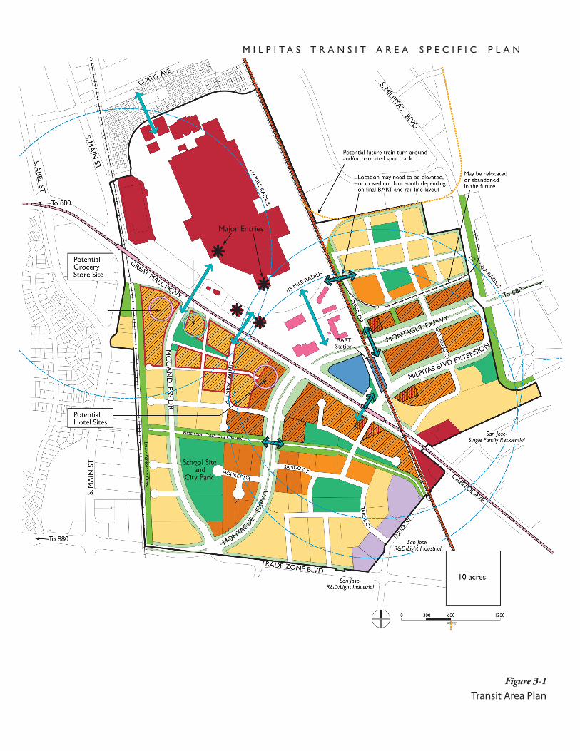
Figure 3-1
Transit Area Plan
May be relocatedor abandonedin the future
Location may need to be elevated,or moved north or south, dependingon final BART and rail line layout
Potential future train turn-aroundand/or relocated spur track
MONTAGUE EXPWY
CAPITOL AVE
S. MILPITAS BLVD
MONTA
GUEEX
PWY
TRADE ZONE BLVD
MC
CA
ND
LESSD
R
S. M
AIN
ST
S. MA
IN ST
GREAT MALL PKWY
PIPER DR
SANGO CT
TARO
BC
T
CURTIS AVE
HOURET DR
GLA
DD
ING
CT
S. ABEL ST
CEN
TR
EPO
INT
D
R
To 680
To 880
To 880
MILPITAS BLVD EXTENSION
LUN
DY ST
Penetencia Creek East ChannelLower Penetencia Creek
1/3MILE RAD
IUS
1/3MILE RADIUS
1/3M
ILERA
DIU
S
0 600 1200300
FEET
Transit Area Plan
General Commercial
Retail Transit OrientedCommunity and Regional Retail; Hotels, Office. Maximum FAR of 2.5.
Boulevard Very High Density Mixed UsePermitted uses include Residential, Office, Commercial and Medical uses up to 1.5 maximumgross FAR, an FAR of 2.5 may be permitted on individual sites. 4-12 stories (20 storieswith CUP). Residential use shall have 41un/ac minimum average gross density; 60 un/acmaximum average gross density.
Residential - Retail High Density Mixed UseResidential, office, and/or hotel uses above ground floor retail and restaurants, 200 sq. ftof retail or restaurant use required for every residential unit. Residential density: 31du/acminimum average gross density; 50 un/ac maximum average gross density. 4-12 stories.(20 stories with CUP) Maximum FAR of 1.5; up to 2.5 FAR may be permitted on individualsites.
Very High Density Transit Oriented Residential41 un/ac minimum average gross density; 60 un/ac maximum average gross density;4-6 stories; (12 stories on arterials, 20 stories with CUP) gross densities of individualprojects may be <41 or >60, provided that area development complies with average grossdensity; small local-serving retail, office, and live/work permitted at ground floor.
High Density Transit Oriented Residential21 un/ac minimum average gross density; 40 un/ac maximum average gross density;3-5 stories; gross densities of individual projects may be <21 or >40, providedthat area development complies with average gross density; residential uses only.
Transit FacilitiesUnderlying zoning to be Boulevard Very High Density Mixed Use if transit facilitiesare not built on this site.
Industrial Park
Parks/Plazas/Community Facilities
Linear Park and Trails
Landscaped Front Yards and Buffers
Potential Hotel Sites
Potential Grocery Store Site
Proposed BART Line
VTA Light Rail Transit
Union Pacific Railroad and Railroad Spur
Potential Future Train Turn-aroundand/or Relocated Spur Track
Study Area
Pedestrian Connection
Pedestrian Bridge
10 acres
M I L P I T A S T R A N S I T A R E A S P E C I F I C P L A N
Neighborhood Retail Locations5000 sq. ft. of local serving retail required onthe ground floor.
Density BonusIncreased density permitted on sites closest to BART and light rail.See table for detail about TOD Overlay District and TOD DensityBonus allowed with a CUP.
Capitol AveUrban Interchange
San Jose-Single Family Residential
San Jose-R&D/Light Industrial
San Jose-R&D/Light Industrial
BARTStation
PotentialHotel Sites
PotentialGroceryStore Site
School Siteand City Park
Major Entries

MiLPiTAs TrAnsiT AreA sPeCifiC PLAn
3-6
sTreeTs
The Specific Plan lays out policies for both existing and new streets within the Transit Area, regulating their location and type. The Plan pays particular atten-tion to pedestrian and bicycle circulation options within the Transit Area and connections to the citywide trail system. The circulation plan is based on the following principles.
street Layout
Maintain Montague Expressway and Great Mall Parkway/Capitol •Avenue as regional arterials.
Build a Milpitas Boulevard Extension• . This will relieve the Montague/Great Mall Parkway intersection and provide access to the BART station, parking, and drop-off.
Create a new network of internal local streets• . Create two to three-acre blocks in order to create a residential neighborhood scale, with direct and easy pedestrian connections and better emergency vehicle access to buildings.
Prevent cut-through traffic in neighborhoods.• Residential districts will have narrower roadways, parking generally on one side of the street, and indirect routes rather than direct links between arterials that could be used to avoid major intersections.
Minimize cul-de-sacs.• In a transit-oriented development area, cul-de-sacs are not appropriate because they disrupt connectivity for walkers and bicyclists. Where cul-de-sacs are shown, create pedestrian and bicycle connections.
Locate new streets along property lines• to the maximum extent prac-tical and consistent with plan goals. This is so that land and costs of new streets can be shared among property owners.
Pedestrian Connections
The Plan aims to create attractive, inviting, and safe pedestrian connections for residents, workers, and visitors to key destinations. The major destinations for walking within the Transit Area are anticipated to be transit stations, parks, and shopping at both the Great Mall and local neighborhood-serving retail sites. The idea is to minimize unnecessary automobile use and promote an ac-tive and interesting community. The Plan specifies two types of major pedes-trian connection improvements:
Pedestrian Connections• at grade that need to be improved, to make a safer more attractive crossing on a heavy traffic streets, to cross the BART line, or to improve streets that currently do not have sidewalks.
Pedestrian Bridges• that are needed to cross Montague Expressway or to connect the LRT and the BART Station.
Chapter 3 Milpitas Transit Area Plan: Land Use, Circulation, and Parks
3-7
Pedestrian routes
Key pedestrian routes within the Transit Area that must be established and maintained are:
Residents to retail and restaurants. • Residents in each subdistrict should be able to easily walk to neighborhood-serving retail or restaurants within their subdistrict, without having to cross major roadways. Residents that live along McCandless Drive and Centre Point Drive need an inviting route to retail and restaurants along Great Mall Parkway and to the Great Mall. It is important to improve the safety and attractiveness of pedestrian crossings on Great Mall Parkway.
Piper/Montague residents to the Great Mall and to BART.• This re-quires a crossing over the BART tracks to access the Great Mall; and an overhead or underground crossing of Montague Expressway.
BART and Montague light rail station to the Great Mall, hotels, •and Heald Business College. This requires crossing Montague Expressway.
BART and Montague• light rail station to jobs. Most jobs will be lo-cated on properties along Montague Expressway, at the Great Mall, and along Great Mall Parkway.
Residential neighborhoods to BART and light rail stations. • This will require crossing Montague Expressway, Great Mall Parkway/Capitol Avenue, and/or Milpitas Boulevard Extension.
Connections between residential neighborhoods to the east and •west of Montague Expressway. This requires crossing Montague Expressway; a pedestrian bridge over the roadway is called for in the Plan.
Hotel visitors to the Great Mall and BART/light rail.•
Residents to neighborhood-serving retail•
oPen sPACe-PArks And TrAiLs
The Specific Plan has located and sized parks to comply with the goals listed in Chapter 1, including creating a mix of larger and smaller parks that achieves ready access within each subdistrict. It attempts to spread the impact for pro-viding park land among property owners, as best as possible. The Plan requires public park space to serve the Transit Area’s residents, workers, and visitors based on the acreage requirements established in the Midtown Specific Plan.
MiLPiTAs TrAnsiT AreA sPeCifiC PLAn
3-8
Park Locations and size
The locations and size of the public parks, plazas, and community facilities are shown on the Transit Area Plan Map (Figure 3-1). The principles for park location and size are as follows:
Locate parks in a central area of each subdistrict that is within walk-•ing distance of all residents in that area;
Locate parks away from major thoroughfares;•
Distribute parks in order to maximize their accessibility. Create •multiple smaller parks rather than a single large park, placing them within walking distance of housing, locating at least one park in each subdistrict, and having street access on at least three sides;
Locate parks adjacent to higher density residential development, pro-•viding a visual and activity amenity for housing, as well as the secu-rity of a constant presence;
Locate parks adjacent to Penitencia Creek and Berryessa Creek to im-•prove the appearance of these channels and to serve as trailheads for bicycle and pedestrian paths;
Size parks to match the acreage requirements of the Transit Area’s fu-•ture expected population;
Size parks to match the different parks needs identified for both the •Transit Area and the city as a whole; and
Locate parks to span multiple properties to the maximum extent •practical so that all land owners share in the obligations for park land dedication.
Types of Parks and recreation facilities
A variety of park types will be needed to meet the needs of Transit Area residents, as well as workers and visitors. The types of parks to be provided shall include:
Passive recreation parks near housing that provide a visual amenity as •well as place to walk dogs, take children to play, etc.;
Parks with sports fields;•
An urban plaza with landscaping, paving, benches and trees;•
A community center where City recreation programs and classes can •be offered;
Staging areas along the trail network where people can access the trail •system; and
Parks along creeks where people can enjoy passive recreation in a •creek setting.

Chapter 3 Milpitas Transit Area Plan: Land Use, Circulation, and Parks
3-9
Parks Acreage
The Midtown Milpitas Plan calls for new residential development to pro-vide a minimum of 3.5 acres of open space per thousand residents, with 2.0 acres per thousand residents to be public park land. This standard is a reduction from the City’s usual park and open space standard, acknowl-edging the denser nature of the Midtown area.
Trails
The Specific Plan also includes trails that link into the citywide trail sys-tem. The City’s General Plan, in Guiding Principal 4.a-G-2, promotes trail development, starting as follows:
“Develop a diversified trail system along streamsides and other pub-lic rights of way to provide recreational opportunities and link facili-ties.”
In addition the Midtown Specific Plan, in Policy 4.13, calls for an in-terconnected system of sidewalks and paths provide safe and convenient access between transit stations and destinations within the Midtown area, saying that:
“As new development occurs around the [transit] stations, linkages through new development between the trail and stations should be made to provide an attractive bicycle and pedestrian entry.”
This Specific Plan builds on these policies to ensure that pedestrian access is pervasive, with multiple links to the trail system and bridges to provide safe crossings over regional arterial roads.
Landscape Areas fronting streets
Landscaping within the street right of way and in front yards abutting streets is key to creating a pedestrian character for the area and to develop-ing distinctive residential neighborhoods and employment districts that are livable and attractive. The Plan incorporates the following key land-scape components:
Maintain trees on McCandless Drive.• The trees are incredibly healthy, mature, evenly spaced and beautiful, with a lush dense canopy. These create a unique and beautiful setting for a high density residential neighborhood.
Create a 45 foot deep continuous landscape setback from the fu-•ture curb to buildings on Montague Expressway, and landscape the medians. This will create a distinctive and attractive character for the Transit Area as a whole, and will buffer the residents and workers from the heavy traffic volumes and noise along Montague Expressway.
Existing creek channels provide opportunities to create a continuous citywide Trail System.
Existing trees on McCandless Drive can create a unique and beautiful setting for a high density residential neighborhood.
Create a continuous deep landscape setback on Montague Expressway, and landscape the medians.

MiLPiTAs TrAnsiT AreA sPeCifiC PLAn
3-10
Create landscape setbacks along Great Mall Parkway, Capitol •Avenue, and Milpitas Boulevard. These are needed to buffer uses from heavy traffic.
Create a landscape buffer along Piper Drive• . This is needed to buf-fer residential development from the BART line and heavy rail trains.
3.2 LAnd Use
Individual land use designations are established in order to achieve an overall mix and intensity of land uses that achieves the Plan’s primary objectives: sup-port public investment in the BART extension; create a walkable community with jobs, stores, and recreation options near residences; avoid a negative impact on the City’s revenues; and meet market demand for new development over the next 20 years. Existing uses have a right to remain. Land use requirements only apply to changes of use and new development.
LAnd Use CLAssifiCATions
The Plan designates six new land use categories, two of which are mixed-use, two residential, and two commercial. These categories are similar to many ex-isting land use designations used by the City, but these new ones allow and at times require higher densities. In addition, the Plan (Figure 3-1) applies a den-sity bonus to allow greater density for the properties closest to the BART sta-tion. Some existing land uses are maintained with their current designations.
The new land use classifications follow and their basic development regulations (density, height, uses) are shown in Table 3-1. Densities for residential develop-ment are expressed in units per gross acre (see definitions later in this chapter). Densities for non-residential development are expressed in terms of floor area ratio (FAR).
On all sites throughout the Transit Area, densities can be averaged over an in-dividual project which covers multiple parcels. Densities may also be averaged over separate projects, if so requested by developers and approved by the Plan-ning Department, provided that legal instruments are recorded for individual parcels to ensure that the minimum and maximum densities established by the Plan are met.
Boulevard Very High density Mixed Use
This classification is intended to provide high-density housing, retail, and em-ployment along Montague Expressway with a landscaped boulevard character. Projects may include a wholly residential or non-residential concept or a project that integrates residential and non-residential uses vertically or horizontally.
Chapter 3 Milpitas Transit Area Plan: Land Use, Circulation, and Parks
3-11
Permitted uses include residential, office, commercial, and medical uses. Sites developed with a mix of uses, or non-residential uses, must adhere to the FAR maximum which ranges from 1.5 to 2.25. Residential projects shall have a min-imum average gross density of 41 units per acre and can be built up to between 60 to 90 units per acre.
An FAR of 2.5 may be permitted on individual sites with approval of a condi-tional use permit by the Planning Commission. Special criteria would need to be met, including the following: (1) the proposed uses include a hotel or office uses that create substantial new jobs, and do not include residential uses; (2) the design of the project is of extremely high quality and is compatible with the scale of surrounding buildings; (3) there are no adverse traffic impacts beyond those studied in the Transit Area Plan EIR or the project will be required to mitigate such impacts individually; and (4) buildings do not shade public parks or plazas more than 30% between 10 AM and 3 PM as measured on March 15.
residential - retail High density Mixed Use
This district is intended to be a true mixed use area with retail, restaurants, and services on the ground floor, and residential or office uses on floors above. The residential density is a minimum average gross density of 31 units per acre and a maximum of between 40 to 60 units per gross acre. In addition, 200 square feet of retail or restaurant space is required per unit, using the minimum den-sity (i.e. the requirement is based on the number of units required to meet the minimum density). Sites may be developed for office and hotel uses without residential development, although ground floor retail or restaurant square foot-age will still be required. For nonresidential projects, the maximum FAR ranges from 1.5 to 2.25. However there is no FAR limit for hotels. An FAR of 2.5 may be permitted on individual sites with approval of a conditional use permit by the Planning Commission.
Very High density Transit-oriented residential
Intended to create residential districts near BART and light rail stations, this designation requires housing to be built at an average density of at least 41 units per gross acre, up to a maximum of between 60 and 90 units per gross acre. Small local-serving commercial uses are permitted at the ground floor level, including retail, restaurants, and personal services uses.
High density Transit-oriented residential
A classification similar to the Midtown Plan’s “Multifamily Very High Den-sity” designation, these properties are intended for medium-density residential neighborhoods further from BART, at the interior of subdistrict neighbor-hoods. A minimum average gross density of 21 units per acre is required, up to a maximum of 40 units per acre. Residential and related uses are allowed, but not commercial uses.

MiLPiTAs TrAnsiT AreA sPeCifiC PLAn
3-12
retail Transit-oriented
This designation provides for retail, hotel, and office uses located immediately south of the Great Mall. Although active uses already exist in this area, infill or redevelopment would be permitted at up to a maximum gross FAR of 2.5.
density Bonus
A TOD density bonus is applied to sites closest to BART and light rail, which allows up to a 25 percent increase in maximum allowable density for sites clos-est to BART and light rail. This is implemented by a TOD Overlay zone which allows the additional density by right. The minimum density of the underlying zoning district does not change.
An additional density bonus of up to 25 percent of the maximum allowable density may be allowed on these sites with the approval of a conditional use permit. Criteria for the approval of a conditional use permit are as follows:
The project provides public benefits, which include but are not limited to: •public improvements to create comfortable, attractive, and direct walking routes from the building entrances to the nearest transit station; mid-rise or high-rise buildings along the arterials that enhance the visibility and identity of the Transit Area; and public open space which exceeds mini-mum requirements; and
The development project sites are located within the density bonus area as •shown on Figure 3-1 of the Transit Area Plan, which defines areas within reasonable walking distance of the BART and/or light rail transit stations; and
The development projects are consistent with the policies of the Transit •Area Specific Plan, and any exceptions requested meet the required find-ings under Chapter 57; and
The additional density allowed will require additional CEQA review to •ensure that the increase will not result in impacts beyond those identified in the Transit Area Plan EIR.
Active ground floor Commercial Uses required
In each subdistrict of the Transit Area, it is important to include some ground floor retail, restaurant, and other commercial uses that provide services to the residents and workers in the area. The requirements for Active Ground Floor Commercial Uses aims to ensure that commercial uses are available within walking distance, thereby reducing the need to drive. Also, a mix of uses will increase vitality and safety as more people walk and are outside during a broad-er extent of the day. A minimum of 5,000 square feet of commercial uses is required at the ground floor of building(s) built on the property. Permitted uses include retail, restaurants, and personal service uses such as copy shops, hair salons, etc.

Chapter 3 Milpitas Transit Area Plan: Land Use, Circulation, and Parks
3-13
other uses
Transit Facilities. The BART Station and its accompanying parking garage.
Industrial Park. Light industrial or research and development uses, located along Lundy Street on the southern edge of the Transit Area.
General Commercial. Retail and commercial uses for regional and local cus-tomers.
Parks/Plazas/Community Facilities. Public open space developed for pas-sive and active recreation, or civic uses such as schools or community meeting space.
Linear Park. Public space along Penitencia Creek and railroads that can con-tain bike and pedestrian trails.
Landscaped Front Yards/Buffers. Required green space along major streets.
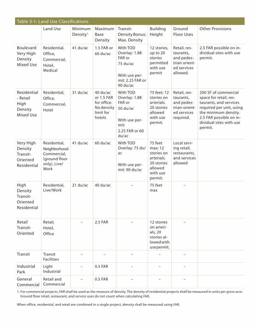
Table 3-1: Land Use ClassificationsLand Use Minimum
density1.
Maximum Base density
Transit-density Bonus: Max. density
Building Height
ground floor Uses
other Provisions
Boulevard Very High density Mixed Use
residential,office,Commercial,Hotel, Medical
41 du/ac 1.5 fAr or60 du/ac
with Tod overlay: 1.88 fAr or75 du/ac
with use per-mit: 2.25 fAr or 90 du/ac
12 stories, up to 20 stories permitted with use permit
retail, res-taurants, and pedes-trian orient-ed services allowed.
2.5 fAr possible on in-dividual sites with use permit.
residential - retail High density Mixed Use
residential,office,Commercial,Hotel
31 du/ac 40 du/ac or 1.5 fAr for office. no density limit for hotels
with Tod overlay: 1.88 fAr or 50 du/ac
with use per-mit: 2.25 fAr or 60 du/ac
75 feet; 12 stories on arterials. 20 stories allowed with use permit.
retail, res-taurants, and pedes-trian-orient-ed services required.
200 sf of commercial space for retail, res-taurants, and services required per unit, using the minimum density. 2.5 fAr possible on in-dividual sites with use permit.
Very High density Transit-oriented residential
residential,neighborhood Commercial, (ground floor only), Live/work
41 du/ac 60 du/ac with Tod overlay: 75 du/ac
with use per-mit: 90 du/ac
75 feet max; 12 stories on arterials. 20 stories allowed with use permit.
Local serv-ing retail, restaurants, and services allowed
High density Transit-oriented residential
residential, Live/work
21 du/ac 40 du/ac – 75 feet max
–
retail Transit-oriented
retail,Hotel,office
– 2.5 fAr – 12 stories on arteri-als, 20 stories al-lowed with use permit.
–
Transit Transit facilities
– – – – –
industrial Park
Light industrial
– 0.5 fAr – – –
general Commercial
retail and Commercial
– 0.5 fAr – – –
1. for commercial projects, fAr shall be used as the measure of density. The density of residential projects shall be measured in units per gross acre. ground floor retail, restaurant, and service uses do not count when calculating fAr.
when office, residential, and retail are combined in a single project, density shall be measured using fAr.
Chapter 3 Milpitas Transit Area Plan: Land Use, Circulation, and Parks
3-15
exisTing LAnd Uses
Existing land uses are permitted to remain in place and continue operations. Existing buildings or land uses which become nonconforming as a result of the new zoning and land use classifications are governed by the provisions in the Zoning Code regarding nonconforming buildings and uses. Certain limits are established for repairs, additions, restoration, expansion, and occupancy after an extended vacancy.
residenTiAL deVeLoPMenT
development Targets
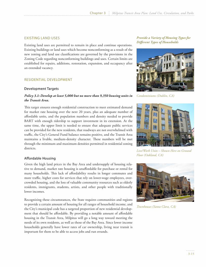
Policy 3.1: Develop at least 5,000 but no more than 9,350 housing units in the Transit Area.
This target ensures enough residential construction to meet estimated demand for market rate housing over the next 20 years, plus an adequate number of affordable units, and the population numbers and density needed to provide BART with enough ridership to support investment in its extension. At the same time, the upper limit is needed to ensure that adequate public services can be provided for the new residents, that roadways are not overwhelmed with traffic, the City’s General Fund balance remains positive, and the Transit Area maintains a livable, medium-density character. These numbers will be met through the minimum and maximum densities permitted in residential zoning districts.
Affordable Housing
Given the high land prices in the Bay Area and undersupply of housing rela-tive to demand, market rate housing is unaffordable for purchase or rental for many households. This lack of affordability results in longer commutes and more traffic, higher costs for services that rely on lower-wage employees, over-crowded housing, and the loss of valuable community resources such as elderly residents, immigrants, students, artists, and other people with traditionally lower incomes.
Recognizing these circumstances, the State requires communities and regions to provide a certain amount of housing for all ranges of household income, and the City’s municipal code has a targeted proportion of new residential develop-ment that should be affordable. By providing a notable amount of affordable housing in the Transit Area, Milpitas will go a long way toward meeting the needs of its own residents, as well as those of the Bay Area. Since lower income households generally have lower rates of car ownership, living near transit is important for them to be able to access jobs and run errands.
Condominiums (Dublin, CA)
Provide a Variety of Housing Types for Different Types of Households
Live/Work Units – Shown Here on Ground Floor (Oakland, CA)
Townhouses (Santa Clara, CA)

MiLPiTAs TrAnsiT AreA sPeCifiC PLAn
3-16
The City’s Municipal Code, XI-10-8.10, states that “Affordable housing units should be provided in all new housing projects. While twenty percent (20%) is the minimum goal, affordable unit requirements will be determined on a project by project basis, taking into consideration the size and location of the project, the type of housing unit, proximity to transit and the mix of affordable units in the vicinity.”
Policy 3.2: Affordable housing units should be provided with new housing developments. Determine affordable unit requirements on a project-by-project basis, considering the size of the project, the location of the site, and the mix of affordable units in the Midtown Area. Allow housing develop-ments of 12 units or less to pay a fee in lieu of providing affordable units.
Policy 3.3: Affordable housing should be integrated into all residential projects.
However, projects can be reviewed by the City on a case-by-case as established in the Municipal Code.
Variety of Housing Types
Policy 3.4: Provide a variety of housing types for different types of house-holds, different income levels, different age groups, and different life-styles.
Overall, the Transit Area should function as a home for households below, at, and above median income, and as a place where singles, families, children, and seniors can all live. These residents will be looking for many different types of housing, with variations in unit size, degree of privacy, distance from ground, materials, amount of parking, image, and cost. This policy will require housing units to be built in a variety of sizes and configurations. It applies areawide and not to any individual project, but developers should take existing residential uses into account and complement them in terms of unit size and type. The City will consider this policy when reviewing proposals for approval.
Policy 3.5: In order to encourage larger housing units that can accommo-date larger households, units with four or more bedrooms can count as 1.5 units when calculating minimum densities within the Transit Area. Using this calculation is optional and up to the private developer.
For example, 10 units with four bedrooms apiece could count as 15 units when calculating a project’s density (10 x 1.5). However, a project does not need to use this bonus and can still apply normal density calculations to their project. A unit with more than four bedrooms does not accrue any additional bonus.

Chapter 3 Milpitas Transit Area Plan: Land Use, Circulation, and Parks
3-17
Policy 3.6: Encourage creativity in high-density residential design. Allow housing types, such as live/work lofts, that are not currently developed in the city.
This guideline also exists in the Midtown Plan as Policy 3.8, and the Transit Area Plan strongly supports its supports it’s enforcement by the City.
Calculation of Minimum and Maximum density
Policy 3.7: Maintain the City’s policy of calculating residential density by dwelling units per gross acre, and floor area ratio (FAR) by gross floor area divided by gross site area. However, do not count land required to be dedi-cated for regional roadways as part of the total site area.
The City calculates residential density and floor area ratio (FAR) of land use by using gross acreage. Section XI-10-2.41-1.1 of the Municipal Code defines gross acreage as:
“The total area within the boundaries of a legal lot or parcel, including any area proposed to be dedicated or reserved for public right-of-way. Adjacent lands already dedicated for public right-of-way, including public roadways, easements or other areas, shall not be included as part of the gross acreage.”
The implication for the Transit Area is that properties that have new roadways, parks, or other public facilities designated on part of their land must include that acreage when calculating the resulting density or FAR of their proposed project. For example, a five (5) acre parcel of land is designated High Density Transit Oriented Residential with a minimum residential density of 21 units per acre and a maximum of 40 units per acre, but has one (1) acre designated as new roads and parkland. The number of allowed housing units is based on the original parcel size of 5 acres. As a result, between 105 and 200 housing units need to be built on the remaining 4 acres of land.
Three regional roadways that traverse the Transit Area will be widened (Mon-tague Expressway and Capitol Avenue) or extended (Milpitas Boulevard), re-quiring land dedication. It is not appropriate to count this land area as part of a development site, because the roadways serve the region rather than the adjoining property.
Developers should consult the zoning map for the Transit Area, in Chapter 5, to see the underlying density designation for all properties. This will allow calcula-tion of the gross density for private land designated for new roads, parks, and other public facilities on the Land Use Map.
Policy 3.8: Allow contiguous developments to build at higher or lower resi-dential densities, so long as their average density falls between the desig-nated minimum and maximum.

MiLPiTAs TrAnsiT AreA sPeCifiC PLAn
3-18
The Plan encourages individual property owners and developers to work to-gether on projects, and supports the calculation of density across multiple pro-posals. However, City approval of a higher or lower density is binding on all of the property involved. To ensure that areawide densities do not end up above or below the minimum and maximum densities, density averaging across multiple parcels will be enforced by conditions of approval recorded on the property title, simultaneous approval of projects, merging parcels, and/or deed restrictions.
Policy 3.9: Maintain the Midtown Plan’s gross floor area policy, which ex-cludes all areas of a building devoted to parking from FAR calculations.
This is in contrast to policy in the rest of the city, which excludes structured parking from FAR calculation only if it is located wholly underground.
3.3 CirCULATion
With its transformation from a low density industrial area to an urban resi-dential and mixed-use district, the Transit Area will need an enhanced cir-culation network that accommodates the new land uses, smaller block sizes, pedestrian-oriented streets, and higher density development types. Streets will follow a hierarchy to ensure that regional traffic can reach destinations within and beyond the Transit Area, and at the same time residential areas will be safe and reasonably quiet places. With an emphasis on walkability and bicycling, connections will be multi-modal in their perspective. The future street system is shown in Figure 3-2.
AUTo CirCULATion And sTreeT CLAssifiCATions
The Transit Area is intended to be a series of walkable neighborhoods, as well as a major destination for workers and shoppers. While many trips to and from the Transit Area will be made by BART, VTA light rail, and bus, regional express-ways will also move many people. In addition, the area is already crossed by several major thoroughfares which Milpitas residents and workers use to access destinations throughout the South Bay.
To successfully balance these different transportation objectives this Specific Plan recognizes three street classifications within the Transit Area: arterials, minor collectors, and local streets. These are shown in Figure 3-2, along with existing and proposed traffic signals. Detailed street sections and design re-quirements are provided in Chapter 5, and shall govern the design of streets within the Transit Area.

Chapter 3 Milpitas Transit Area Plan: Land Use, Circulation, and Parks
3-19
Arterials
Arterials are major connectors intended to move large amounts of traffic be-tween regional destinations. The Transit Area contains three arterials and the Plan provides an extension for one of them. The arterials are:
Montague Expressway—Connection to I-880, I-680, and Silicon Valley;•
Great Mall Parkway—Connection to I-880 and San Jose;•
Milpitas Boulevard—Connection to the northern areas of Milpitas; and•
Milpitas Boulevard Extension—Connection between Milpitas Boulevard •and the future BART station; also intended to help relieve congestion at the Montague/Great Mall intersection.
Per County policy for regional traffic circulation, traffic lights should not be added on Montague Expressway or Great Mall Parkway. New access points may need to be achieved via a separated deceleration lane, as is recommended on Montague Expressway along the new BART Station frontage. Pedestrian and bicycle crossings should be above grade at key crossing locations shown in the Plan Map. In addition, given the high speeds and volumes of traffic on arterials, land uses along them should have large landscaped setbacks.
In the future, the County plans to widen Montague Expressway to eight lanes between US 101 and just east of I-680, although the City is already widening the section between Great Mall Parkway and Milpitas Boulevard. The City cur-rently collects Traffic Impact Fees for the Montague Expressway Improvement Project on a peak hour trip basis, via the Milpitas Business Park Traffic Miti-gation Fee Ordinance and through CEQA using a fair-share contribution for projects east of Interstate 880. As funds are collected, the City and the County coordinate to implement projects along Montague Expressway. Collected fees can be combined with other regional funding sources to implement large-scale projects.
Minor Collectors
Minor collectors serve as significant conduits for interior neighborhood traffic to access arterials, and vice versa. They are not intended to support regional or pass-through traffic, but they typically carry traffic volumes that warrant a traf-fic light at their intersections with arterials. New development along a minor collector is required to have a landscaped front yard or buffer, and bike lanes are an important feature.
The minor collector streets are:
Milpitas Boulevard Extension—Connection between Milpitas Boulevard •and the future BART station; also intended to help relieve congestion at the Montague/Great Mall intersection.

MONTAGUE EXPWY
CAPITOL AVE
S. MILPITAS BLVD
MONTA
GUEEX
PWY
TRADE ZONE BLVD
MC
CA
ND
LESSD
R
S. M
AIN
ST
S. MA
IN ST
GREAT MALL PKWY PIPER D
R
SANGO CT
TARO
BC
T
CURTIS AVE
HOURET DR
GLA
DD
ING
CT
S. ABEL ST
CEN
TR
EPO
INT
DR
To 680
To 880
To 880
MILPITAS BLVD EXTENSION
LUN
DY ST
Penetencia Creek East ChannelLower Penetencia Creek
Figure 3-2
Street System
0 600 1200300
FEET
10 acres
Arterial
Collector
Local Pedestrian Retail Street
New Local Street
Existing Local Streets to Remainin Current Configuration
Private Street
Existing Traffic Signals
New Traffic Signals
Figure 3-2
street system

Chapter 3 Milpitas Transit Area Plan: Land Use, Circulation, and Parks
3-21
McCandless Drive•
Trade Zone Boulevard•
Piper Drive (along the BART station)•
Local streets
Most of the roadways within the Transit Area are considered local streets. Some of these are extensions of existing cul-de-sacs and some are new roads. Local streets are intended to provide low-speed access between housing and more ma-jor street types and will be multi-modal, with an emphasis on comfort, safety, and amenities for pedestrians.
Policies
Policy 3.10: Maintain Montague Expressway and Great Mall Parkway/Capitol Avenue as regional arterials. Impediments to through traffic flow along arterial roadways will be minimized. Signalized intersections and at-grade crossings will be kept to a minimum, and retail and parking access will be off of the main travel lanes.
No new traffic signals are planned on Montague Expressway, and only one •new traffic signal will be built along Great Mall Parkway, at the Milpitas Boulevard extension intersection.
The ground floor, street-facing retail along the south side of Great Mall •Parkway between McCandless Drive and Centre Point Drive will be ac-cessed via a frontage road containing a travel lane and a parking lane.
Access to the BART station for cars and buses will be from a new accelera-•tion and deceleration lane.
While crosswalks will be marked across arterials, the Plan calls for pe-•destrian and bike bridges to be built over Capitol Avenue and Montague Expressway to maximize safety and traffic flow.
The number of curb cuts along each block of an arterial will be limited in •number, and only permitted to right in and right out access to gain entry to parking lots, parking structures, or alleyways. More details are provided in Chapter 5.
Policy 3.11: Build a Milpitas Boulevard Extension.
This will relieve the Montague/Great Mall Parkway intersection and provide access to the BART station, parking, and drop-off.
Policy 3.12: Preserve adequate right-of-way along Capitol Avenue, Great Mall Parkway, and Montague Expressway to accommodate future regional roadway improvements.
Montague Expressway-Limit new curb-cuts on this regional arterial.

MiLPiTAs TrAnsiT AreA sPeCifiC PLAn
3-22
Final dimensions of right-of-way acquisition are not yet known. The detailed street sections in Chapter 5 include notes about right-of-way acquisition, to the extent that information is currently available.
Policy 3.13: Prevent cut-through traffic in neighborhoods.
Residential districts will have narrower roadways, parking along the street, and indirect routes rather than direct links between arterials that could be used to avoid major intersections.
Policy 3.14: Minimize cul-de-sacs.
Cul-de-sacs disrupt connectivity, particularly for walkers and bicyclists, and overload cut-through roadways.
Policy 3.15: Review individual development applications to ensure that adequate street right-of-way, bicycle facilities, pedestrian facilities and landscaping are provided and are consistent with the Transit Area Plan circulation policies and street design standards in Chapter 5.
Policy 3.16: Establish and implement a travel demand management (TDM) program in order to encourage alternate modes of travel and thereby reduce automobile trips. Establish a funding mechanism to pay for the costs of the program, including the cost of a transportation coordinator to administer the program. The program would include a ride-matching program, coor-dination with regional ride-sharing organizations, and provision of tran-sit information; and could also include sale of discounted transit passes and provision of shuttle service to major destinations.
sTreeT LoCATions And ConneCTions
The new street system will consist of public roadways which must connect to adjacent properties, as illustrated in Figure 3-2. The street layout has been care-fully crafted to establish connections between properties, parks, transit, and other subareas, and to create pedestrian-oriented districts with direct pedes-trian routes. Small block sizes and ample connections give pedestrians direct and easy access routes to transit, retail, jobs, and other residents.
The streets have also been laid out to minimize through traffic in neighbor-hoods, while still allowing access for residents to surrounding destinations. Cul-de-sacs limit connectivity, especially within a dense and walkable environ-ment, resulting in less accessibility and more driving. Consequently, the Transit Area will have cul-de-sacs only at the existing location off Houret Drive, where streets end at Lower Penetencia Creek, and at train tracks in Piper/Montague. Existing cul-de-sacs like those at Sango Court and Tarob Court can remain until properties abutting the cul-de-sac are redeveloped.

Chapter 3 Milpitas Transit Area Plan: Land Use, Circulation, and Parks
3-23
Streets are intentionally located alongside parks so that there is a separation be-tween park activities and adjoining residences. This will help reduce noise and security issues for residents that live adjacent to parks, and will provide parking for park visitors.
Finally, as best as possible, roadways are sited to run along property lines, with the right of way dedication and responsibility for constructing them falling evenly on each land owner.
Policy 3.17: New streets shall be located as generally shown on the Street System Map, Figure 3-2.
New local streets may shift location to take into account more detailed survey information, to better align them evenly along property boundaries, or to facili-tate a better, more efficient development project. Standards for maximum block size and block frontage established in Chapter 5 must still be met.
Policy 3.18:New development must dedicate land for new public streets and pay for their construction.
When a parcel is redeveloped under this Specific Plan, all necessary right-of-way must be dedicated for new public streets and the streets constructed follow-ing the street designs and streetscape standards laid out in Chapter 5 and any unique details established in the subdistrict policies, Chapter 4.
Policy 3.19: In future decisions regarding street layout, street design, and allocation of public right-of-way, balance the needs of cars with those of pedestrians, bicyclists, and transit.
Changes to the circulation system must continue the Transit Area’s emphasis on balancing auto traffic with bike and pedestrian connectivity.
Policy 3.20: Allow exceptions to citywide Level of Service policy under cer-tain conditions.
For all streets not part of the County’s Congestion Management Program, the City maintains a Level of Service (LOS) of D for vehicular circulation. How-ever, the City may allow the LOS to exceed these standards under one or more of the following circumstances:
Existing or projected congestion is primarily the result of traffic passing •through Milpitas and generated by development located outside the com-munity;

MiLPiTAs TrAnsiT AreA sPeCifiC PLAn
3-24
Mitigation of such existing or projected congestion requires regional or •multi-jurisdiction measures, and is not the sole responsibility of the pro-posed development and/or of the City; and
Constraints on development as would be required to achieve or maintain •these standards in Milpitas would adversely impede achievement of this Plan’s goals and policies.
Mitigation of such existing or projected vehicular congestion would nega-•tively affect transit, bicycle or pedestrian circulation, or would conflict with Transit Area Specific Plan goals for these alternative modes of circula-tion, for example by increasing crossing distances, increasing pedestrian safety risk, or restricting bicycle or transit access.
Traffic congestion is a result of an effort to promote transit ridership and/•or access, including the development of dense residential housing or em-ployment near transit or circulation changes to enhance access to Light Rail and BART.
A demonstrated significant increase in transit ridership, carpooling, bicy-•cling, and/or walking is achieved.
On a temporary basis when the improvements necessary to preserve the •LOS standard are in the process of construction or have been designed and funded but not yet constructed.
PedesTriAn And BiCyCLe CirCULATion
The Transit Area is intended to be a community where walking and biking are dominant transportation modes for short internal trips, because they are fun, safe, pleasant, and convenient. Pedestrian and bike connections should be as direct as possible and will be accomplished through a pervasive and consistent network of sidewalks, bike lanes, and crosswalks, which will include pedestrian bridges over Great Mall Parkway, Capitol Avenue, and Montague Expressway. The use of pedestrian bridges will also permit greater traffic volumes and speeds on regional arterials.
This Specific Plan also requires new development to support alternatives to sin-gle-passenger driving, particularly for commuting. These alternatives include walking and biking, but also car pooling, shuttles to transit stations, and even telecommuting. The Plan expects employers to actively encourage these options through company policies as well as investing in infrastructure, such as secure bike parking.

Chapter 3 Milpitas Transit Area Plan: Land Use, Circulation, and Parks
3-25
Policy 3.21: Provide continuous pedestrian sidewalks and safe bike travel routes throughout the entire Transit Area and within development proj-ects.
New development shall install sidewalks per the street design standards in Chapter 5. The City and/or private property owner shall install sidewalks in areas where they currently do not exist, and where new development is not an-ticipated during the Plan timeframe. City staff will review individual develop-ment applications to ensure that adequate pedestrian facilities are provided and are consistent with the Transit Area Plan’s pedestrian improvements.
Policy 3.22: Private development shall provide direct walking and biking routes to schools and major destinations, such as parks and shopping, through their property.
Policy 3.23: Encourage children to walk or bike to school by expanding existing safe walking and bicycling routes to schools into the Transit Area.
Policy 3.24: Design local streets for slow speeds (25 – 35 miles per hour) to improve pedestrian safety and comfort.
Policy 3.25: Improve pedestrian crossings at major intersections on Great Mall Parkway, as shown in Figure 3-3 and Figure 3-4.
These intersections are extremely wide and thus discouraging for pedestrians. These crosswalks should be designed to be highly visible and to provide safe spots for pedestrian as they cross the street.
Add date palms to punctuate the major intersection and give a spot of ref-•uge for pedestrians.
Add pedestrian-scale street lights to demarcate pedestrian islands and •crosswalks.
Use ornamental paving to differentiate crosswalks from adjacent paving •material.
Policy 3.26: Construct pedestrian/bicycle bridges over Montague Expressway to allow safe crossings of this regional roadway with heavy traffic volumes: (1) near Piper Drive, to connect the Light Rail station, BART station, and development sites on the south side with the Great Mall and the neighborhoods north of Montague Expressway; and (2) near the Penitencia Creek East channel to connect schools and neighborhoods north and south of Montague Expressway.
The locations and designs of the bridges should be incorporated into the final designs for the BART alignment and the widening of Montague Expressway. Construction of the bridges should occur concurrently with these projects.
Provide continuous [edestrian sidewalks along public streets (Santa Clara, CA)
Provide landscaped planter strips with streets trees
Encourage children to walk or bike to school by developing safe routes protected from auto-mobile traffic

MiLPiTAs TrAnsiT AreA sPeCifiC PLAn
3-26
Figure 3-3
great Mall Parkway at Montague expressway

Chapter 3 Milpitas Transit Area Plan: Land Use, Circulation, and Parks
3-27
Figure 3-4
great Mall Parkway at south
Main street

MiLPiTAs TrAnsiT AreA sPeCifiC PLAn
3-28
SANGO CT
TARO
BC
T
CEN
TR
EPO
INT
DR
MONTAGUE EXPWY
CAPITOL AVE
S. MILPITAS BLVD
TRADE ZONE BLVD
S. M
AIN
ST
S. MA
IN ST
GREAT MALL PKWY
PIPER DR
CURTIS AVE
HOURET DR
GLA
DD
ING
CT
S. ABEL ST
To 680
To 880
To 880
MILPITAS BLVD EXTENSION
LUN
DY ST
Penetencia Creek East Channel
Lower Penetencia Creek
MONTA
GUEEX
PWY
MC
CA
ND
LESSD
R
Berryessa Creek
0 600 1200300
FEET
Figure 3-7
Bicycle Circulation Improvements
Pedestrian/Bike Trails
Existing Class II Bike Lane
Proposed Class II Bike Lane
Existing Class III Bike Route
Proposed Class III Bike Route
Proposed Pedestrian/Bike Bridge
Proposed BART Line
VTA Light Rail Transit
Union Pacific Railroad and Railroad Spur
Study Area
10 acres
M I L P I T A S T R A N S I T A R E A S P E C I F I C P L A N
BARTStation
Add striping todelineate bike lanes
Upgrade from bike routeto Class III bike lanes
Figure 3-5
Bicycle Circulation improvements
note: Montague expressway Bike routes to be upgraded to Class ii Bike Lanes as part of any Montague widening project.

Chapter 3 Milpitas Transit Area Plan: Land Use, Circulation, and Parks
3-29
Policy 3.27: Every resident of the Transit Area shall be able to safely walk and bike to the BART and VTA light rail stations. As projects are con-structed, make sure that all the routes described below are continuous and designed to be attractive and safe for pedestrians.
The Plan aims to create attractive, inviting, and safe pedestrian connections for residents, workers, and visitors to key destinations. The major destinations for walking within the Transit Area are anticipated to be transit stations, parks, and shopping. The idea is to minimize unnecessary automobile use and pro-mote a fun and interesting community. Pedestrian bridges will be constructed to permit direct pedestrian access between subareas without having to cross arterial roads at grade; this will also permit great or traffic volumes and speeds on regional roads.
Policy 3.28: Provide continuous bicycle circulation through the project site and to adjacent areas by closing existing gaps in bicycle lanes and bicycle routes, per Figure 3-5.
Gaps exist on Capitol Avenue between Montague Expressway and Trimble Road, and on Trade Zone Boulevard between Montague Expressway and Lun-dy Place. Capitol Avenue only needs to be re-striped to add a bike lane. Trade Zone Boulevard generally contains sufficient width to accommodate two travel lanes and bike lanes in each direction; however, the westbound lanes on Trade Zone jog south slightly, so right-of-way acquisition will likely be required to push the curb further north to maintain a consistent section and to add bike lanes. Bike routes should be upgraded to bike lanes as part of any Montague widening project.
Policy 3.29: A Class III bicycle route shall be created on the internal road-ways (from the Milpitas Boulevard Extension/Capitol Avenue intersec-tion to Tarob Court) to provide a continuous bicycle connection between Milpitas Boulevard and the existing bicycle lanes on Lundy Street, as in-dicated on Figure 3-5.
Policy 3.30: Maintain pedestrian and biking facilities.
Pedestrian facilities and amenities shall be routinely maintained as funding and priorities allow. The highest priority shall be given to facilities that are used to provide access to transit, public facilities, senior facilities, and schools.
Policy 3.31: Require provision of bicycle and pedestrian facilities such as weather protected bicycle parking, direct and safe access for pedestrians and bicyclists to adjacent bicycle routes and transit stations, showers and lockers for employees at the worksite, secure short-term parking for bicy-cles, etc.
Construct a pedestrian bicycle bridge over Montague Expressway (Berkeley, CA)
Construct a pedestrian bridge to connect light rail and BART, using the same design features as exist at the VTA light rail stations on Great Mall Parkway.

MiLPiTAs TrAnsiT AreA sPeCifiC PLAn
3-30
TrAnsiT
Policy 3.32: Coordinate with VTA to provide sufficient amenities (such as transit shelters) at all transit stops within the Transit Area.
Policy 3.33: Require new development within the Transit Area to facilitate the use of alternative modes of transportation through programs such as carpool parking, the VTA’s EcoPass Program, shuttles to transit stations and lunchtime destinations, assistance to regional and local ridesharing organizations, alternative work schedules, telecommuting, etc. Establish a Transportation Demand Management (TDM) program for this purpose, as described in Policy 3.16.
Policy 3.34: Encourage preferential parking measures for carpool and van-pool vehicles, guaranteed ride home services and other incentives to em-ployees choosing transportation modes other than driving. Provide prefer-ential parking for low-emission vehicles.
rAiL Lines And rAiL Crossings
Policy 3.35: Any development projects, parks, or pedestrian trails built ad-jacent to a rail line shall build continuous fencing or solid walls to ensure that there will be no pedestrian access to the line. Fencing shall be designed to be vandal-resistant in order to deter trespassing.
Policy 3.36: The City will maintain and enhance public safety by requiring uniform safety standards for all at-grade rail crossings.
Policy 3.37: Consult with the Union Pacific Railroad and the Public Utilities Commission prior to any improvements to segments of Milpitas Boulevard, Capitol Avenue, and Montague Expressway that include at-grade rail crossings, to determine if improvements to existing at-grade highway-rail crossings are warranted.
Provide attractive transit shelters (Mountain View, CA)

Chapter 3 Milpitas Transit Area Plan: Land Use, Circulation, and Parks
3-31
3.4 PArks, PUBLiC sPACes, And TrAiLs
The Midtown Specific Plan project established open space requirements for the majority of the Transit Area. This Plan accepts those policies and provides ad-ditional details and guidelines. Ultimate decisions about park facilities and park programming will be determined by the City’s Recreation Services Depart-ment, which will work with the Planning Department to determine the profile and needs of nearby park patrons.
PArk ACreAge And LoCATion
The Midtown Specific Plan envisioned three types of open space within its boundaries: Public Parks, Common Open Space, and Private Open Space. Parks are required at a ratio of 3.5 acres per 1,000 people, with at least 2.0 of those acres publicly accessible. This Public Park land requirement must be satis-fied by either dedication of land to the City for public parks and open space, or payment of an in-lieu fee (City of Milpitas Zoning Ordinance, XI-10-8.07). The Midtown Plan defines Public Parks as community open space that is pub-licly accessible and programmed for public use.
Private developers provide Common Open Space and Private Open Space for the recreational purposes of residents within the private developments. Types of common and private open space include courtyards, recreation centers, balco-nies, porches, roof decks, and other open space areas when properly developed for work, play, or outdoor living area (City of Milpitas, Zoning Ordinance, XI-10-38.07).
The Specific Plan applies this park and open space standard from the Midtown Milpitas Plan to the entire Transit Area. This has several implications:
The parks standard applies to residential development in the Piper/•Montague subdistrict, which is outside of the Midtown Plan area.
The amount of parkland in the Transit Area is treated as an overall total, •with the amount of acreage based on buildout projections of the future population in 20 years time. As a result, not all residential projects will provide public parkland on site, but all will contribute toward land pur-chase and park construction.
Some subdistricts have more parkland per person than others. This results •from the creation of a large park in the McCandless/Centre Point subdis-trict that can accommodate community facilities.
As shown on Figure 3-6, the Plan includes one or two public parks in each subdistrict, approximating the mandated minimum open space acreage per 1,000 residents for the projected population within the subdistrict, which is shown in Table 3-2. Additional park acreage would need to be provided by wide landscape buffer acres that include trails (20 percent counts towards park requirements, or other additional park land, to meet the full 36 acres of park-land required).
MiLPiTAs TrAnsiT AreA sPeCifiC PLAn
3-32
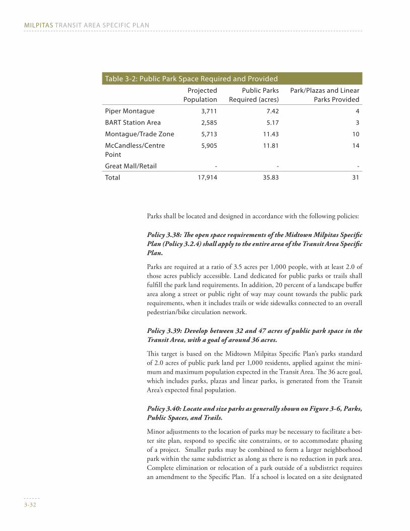
Table 3-2: Public Park space required and ProvidedProjected
PopulationPublic Parks
required (acres)Park/Plazas and Linear
Parks Provided
Piper Montague 3,711 7.42 4
BArT station Area 2,585 5.17 3
Montague/Trade Zone 5,713 11.43 10
McCandless/Centre Point
5,905 11.81 14
great Mall/retail - - -
Total 17,914 35.83 31
Parks shall be located and designed in accordance with the following policies:
Policy 3.38: The open space requirements of the Midtown Milpitas Specific Plan (Policy 3.2.4) shall apply to the entire area of the Transit Area Specific Plan.
Parks are required at a ratio of 3.5 acres per 1,000 people, with at least 2.0 of those acres publicly accessible. Land dedicated for public parks or trails shall fulfill the park land requirements. In addition, 20 percent of a landscape buffer area along a street or public right of way may count towards the public park requirements, when it includes trails or wide sidewalks connected to an overall pedestrian/bike circulation network.
Policy 3.39: Develop between 32 and 47 acres of public park space in the Transit Area, with a goal of around 36 acres.
This target is based on the Midtown Milpitas Specific Plan’s parks standard of 2.0 acres of public park land per 1,000 residents, applied against the mini-mum and maximum population expected in the Transit Area. The 36 acre goal, which includes parks, plazas and linear parks, is generated from the Transit Area’s expected final population.
Policy 3.40: Locate and size parks as generally shown on Figure 3-6, Parks, Public Spaces, and Trails.
Minor adjustments to the location of parks may be necessary to facilitate a bet-ter site plan, respond to specific site constraints, or to accommodate phasing of a project. Smaller parks may be combined to form a larger neighborhood park within the same subdistrict as along as there is no reduction in park area. Complete elimination or relocation of a park outside of a subdistrict requires an amendment to the Specific Plan. If a school is located on a site designated

Chapter 3 Milpitas Transit Area Plan: Land Use, Circulation, and Parks
3-33
as a park, it may be counted as a park if a joint use agreement is established to allow public use of open space and buildings for recreation purposes after school hours and on weekends. If not such joint use agreement is established, an alternate park site shall be designated.
Policy 3.41: Park land dedication and in-lieu fees required of new develop-ment.
Park land shall be dedicated as part of the approval of any new development, if a park site is designated on the property as shown in Figure 3-6. Land dedication is required for Parks/Plazas/Community Facilities and Linear Parks and Trails in the locations and amounts generally shown on Figure 3-6.
Dedication of the land shown on Figure 3-6 cannot be substituted by in-lieu fees. If a development’s parkland obligation as determined by City ordinances is not satisfied by the required land dedication, it must pay an in-lieu fee which shall be spent to acquire and develop other parks within the Transit Area. If a development provides more than its fair share of park land, it will be compen-sated by the City at fair market value, using in-lieu fees paid by new develop-ment and other available sources.
Policy 3.42: If a public utility easement (such as the one existing between Capitol Avenue and Penitencia Creek East Channel) is developed as a pub-licly-accessible pathway or linear park that connects two public streets, it can be counted toward a development’s park dedication requirement.
Policy 3.43: New development must pay for the construction of public parks and streets surrounding the parks (or half-streets if bordering an adjacent development site).
In addition to dedicating or contributing toward the land for new public parks, projects under this Specific Plan must also pay for the improvement of the parks with appropriate landscaping and recreation facilities. Covering this cost can be handled by paying a fee to the City or by direct development of parkland, or both. The cost and/or actions expected of projects will be determined by the City.
Policy 3.44: The design of new public parks must be approved by the City.
This Specific Plan includes policies on parks programming in Chapters 3 & 4. If a developer plans to construct the public park(s) designated for their property, while adhering to this Plan’s policies, the developer may either execute a park plan provided by the City or submit plans for new public parks on their prop-erty to the City. The plans will be subject to review by the Parks, Recreation and Cultural Resources Commission and approval by the City Council.

Figure 3-6
Public Parks, spaces, and Trails
Urban residential park -trees, paths, benches andmaybe a tot lot. Passiverecreation
BART Station Plaza -benches, trees, foodkiosks, public art, etc.
Trailhead parks withbenches, parking, andpicnic tables. Gatheringspace.
Sports fields, such asbasketball and soccer
Sports fields and passiverecreation or schoolplaygrounds
Urban plaza -benches, trees,food kiosks,public art, etc.
MONTAGUE EXPWY
CAPITOL AVE
S. MILPITAS BLVD
TRADE ZONE BLVD
S. M
AIN
ST
S. MA
IN ST
GREAT MALL PKWY
PIPER DR
CURTIS AVE
HOURET DR
GLA
DD
ING
CT
S. ABEL ST
To 680
To 880
To 880
MILPITAS BLVD EXTENSION
LUN
DY ST
Penetencia Creek East Channel
Lower Penetencia Creek
MONTA
GUEEX
PWY
MC
CA
ND
LESSD
R
Berryessa Creek
CEN
TR
EPO
INT
DR
SANGO CT
TARO
BC
T
0 600 1200300
FEET
Parks/Plazas/Community Facilities
Linear Park and Trails
Landscaped Front Yards and Buffers
Proposed BART Line
VTA Light Rail Transit
Union Pacific Railroad and Railroad Spur
Pedestrian Bridge
Transit Area Walking/Jogging Loop
Pedestrian/Bike Trails
Study Area
10 acres
M I L P I T A S T R A N S I T A R E A S P E C I F I C P L A N
BARTStation
School Siteand City Park
1.59ac
1.69 ac
1.66ac
2.51 ac
5.1ac
3.59 ac
3.35 ac
.86ac
Chapter 3 Milpitas Transit Area Plan: Land Use, Circulation, and Parks
3-35
Policy 3.45: Private development within the Transit Area must meet the private open space requirements on a project-by-project basis.
Private open space areas can be shared among separate phases of larger devel-opments as long as each phase provides the minimum amount of private open space for units within that phase..
PUBLiC PArk design
Public Parks in the Transit Area Specific Plan have three main forms:
Parks/Plazas, intended to be more urban in form, are the focus of new de-•velopment in each subdistrict by providing a physical center to the neigh-borhoods. Typically, hardscaping distinguishes plazas from parks, which are vegetated.
Linear Parks and trails occur along rail and water rights-of-way to connect •and unify the subdistricts with bike and pedestrian trails.
Landscape Buffers provide a separation between heavy traffic streets and •the high density office and residential uses facing those streets. They also enhance the image of the Transit Area.
Parks/Plazas
Figure 3-6 highlights the proposed parks, shows what type of park each should be and the major landscape buffer areas, and includes the trail locations.
Policy 3.46: Parks in the Piper Montague subdistrict shall be small urban neighborhood parks with passive recreation facilities that include tot lots, barbeques, and opportunities for dog-walking.
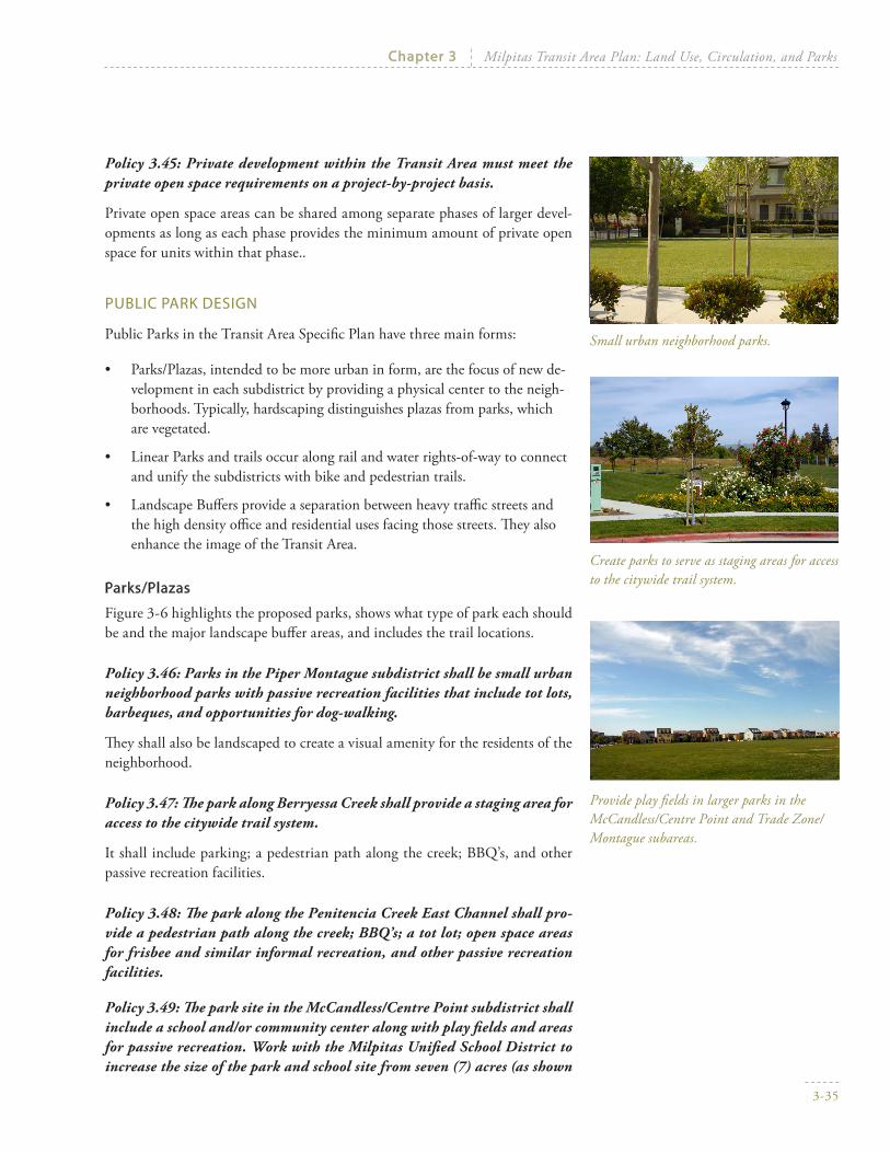
They shall also be landscaped to create a visual amenity for the residents of the neighborhood.
Policy 3.47: The park along Berryessa Creek shall provide a staging area for access to the citywide trail system.
It shall include parking; a pedestrian path along the creek; BBQ’s, and other passive recreation facilities.
Policy 3.48: The park along the Penitencia Creek East Channel shall pro-vide a pedestrian path along the creek; BBQ’s; a tot lot; open space areas for frisbee and similar informal recreation, and other passive recreation facilities.
Policy 3.49: The park site in the McCandless/Centre Point subdistrict shall include a school and/or community center along with play fields and areas for passive recreation. Work with the Milpitas Unified School District to increase the size of the park and school site from seven (7) acres (as shown
Small urban neighborhood parks.
Create parks to serve as staging areas for access to the citywide trail system.
Provide play fields in larger parks in the McCandless/Centre Point and Trade Zone/Montague subareas.

MiLPiTAs TrAnsiT AreA sPeCifiC PLAn
3-36
in Figures 3-1 and 3-6) to ten (10) acres. The additional three acres and the facilities to be included on those three acres are to be funded by SB 50 fees, school district grants, possible level two fees, as well as Midtown Specific Plan development fees. Negotiate a Memorandum of Understanding and subsequently a Joint Use Agreement between the City of Milpitas and the Milpitas Unified School District to allow for joint use of recreational facili-ties within the park and school site.
A school should be built on the park site in the McCandless/Centrepoint Area, with recreation facilities that can be jointly used by the City and the School District. The play fields could serve the school on weekdays and be open to the community as a park on evenings and weekends. The school building could also function as a community center on evenings and weekends.
If a public school is built in the planning area, shared indoor and outdoor recre-ation areas—available to the City’s Recreation Services Department for events and/or general public use outside of school hours—will be counted toward the planning area’s open space requirement.
Policy 3.50: The park in the center of the Trade Zone/Montague subdis-trict shall provide sports fields for soccer, baseball, basketball, and/or other sports that have a high demand in Milpitas.
There shall be ample perimeter landscaping to create an attractive setting for the surrounding housing; and a tot lot shall be included. A community center could also be included. Sports fields should serve both children and adult sports leagues.
Policy 3.51: Parks will have public streets abutting at least three sides.
Parks shall be surrounded by streets on three sides in order to: provide parking for the park on the street; enhance security of the park by having residents over-look the park and police vehicles able to drive by; and provide noise and visual separation for residents and offices from the activities in the park. If approved by the City, a park can also have public streets on two sides and a public right-of-way, such as a trail, or a railroad right-of-way along the third side.
Policy 3.52: Provide a plaza or other type of public space in the Mixed Use District at Great Mall Parkway/McCandless/Centre Point.
Amenities shall include landscaping, trees, lighting, waste receptacles, shade, benches or ledges for people to sit, and amenities such as fountains or public art. Wide sidewalks shall be provided along the edge for outdoor cafes.
Policy 3.53: Create an attractive and comfortable plaza at the future BART Station that provides a place for BART, light rail, and bus patrons waiting for a ride.
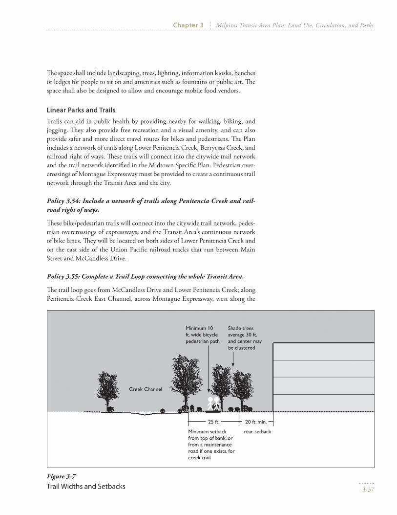
Chapter 3 Milpitas Transit Area Plan: Land Use, Circulation, and Parks
3-37
The space shall include landscaping, trees, lighting, information kiosks, benches or ledges for people to sit on and amenities such as fountains or public art. The space shall also be designed to allow and encourage mobile food vendors.
Linear Parks and Trails
Trails can aid in public health by providing nearby for walking, biking, and jogging. They also provide free recreation and a visual amenity, and can also provide safer and more direct travel routes for bikes and pedestrians. The Plan includes a network of trails along Lower Penitencia Creek, Berryessa Creek, and railroad right of ways. These trails will connect into the citywide trail network and the trail network identified in the Midtown Specific Plan. Pedestrian over-crossings of Montague Expressway must be provided to create a continuous trail network through the Transit Area and the city.
Policy 3.54: Include a network of trails along Penitencia Creek and rail-road right of ways.
These bike/pedestrian trails will connect into the citywide trail network, pedes-trian overcrossings of expressways, and the Transit Area’s continuous network of bike lanes. They will be located on both sides of Lower Penitencia Creek and on the east side of the Union Pacific railroad tracks that run between Main Street and McCandless Drive.
Policy 3.55: Complete a Trail Loop connecting the whole Transit Area.
The trail loop goes from McCandless Drive and Lower Penitencia Creek; along Penitencia Creek East Channel, across Montague Expressway, west along the
Figure 3-7
Trail widths and setbacks
Creek Channel
Minimum 10 ft. wide bicycle pedestrian path
Minimum setback from top of bank, or from a maintenance road if one exists, for creek trail
rear setback
Shade trees average 30 ft. and center may be clustered
20 ft. min.25 ft.

MiLPiTAs TrAnsiT AreA sPeCifiC PLAn
3-38
creek channel, then northeast across Capitol Avenue, then across Montague Expressway, along Piper Drive, and across the Great Mall back to Centre Point and McCandless. It is shown on Figure 3-6.
The Trail Loop provides a clear and easy way for people to access the BART and LRT station, move between different subareas of the Transit Area, and offers a roughly 1.5 to 2 mile jogging and walking and biking path for recreational use.
Policy 3.56: Connections shall be created across Montague Expressway with overhead bridges or undercrossings to create a continuous trail network; allow pedestrians and bicyclists to cross safely; and connect neighborhoods, schools, and parks.
One connection will be where the Penitencia Creek East Channel crosses Mon-tague, via ramps in the creek channel area or on adjacent park land, and another will be at Piper Drive, connected to the BART station, with elevators at both ends.
Policy 3.57: All properties along the trail network will need to set aside land for the trails. This land will count towards the required public park land dedication requirement. Refer to Figure 3-7 for required dimensions. If trail easements already exist or are acquired within the rail line or flood control right of ways, these easements may be used in lieu of land on devel-opment sites.
Landscaping
Policy 3.58: Preserve and protect trees on McCandless Drive.
The trees are incredibly healthy, mature, evenly spaced and beautiful, with a lush dense canopy. These create a unique and beautiful setting for a high density residential neighborhood.
Policy 3.59: Create a 45 foot deep continuous landscaped setback on Montague Expressway.
New development along Montague Expressway must include a vegetated or landscaped buffer of at least 45 feet in depth measured from curb to building face. This setback must be calculated based on the future width of Montague Expressway, which may be expanded to eight lanes. The setback will include a pedestrian walkway in the middle (i.e. not immediately along Montague Ex-pressway) flanked by trees and benches.
The setback is intended to create a distinctive and attractive character for the Transit Area as a whole, and will buffer the residents and workers from the heavy traffic volumes and noise along Montague Expressway. It will also con-nect residents and workers in buildings along Montague Expressway and in surrounding areas to the BART and LRT stations, and to the trails network.

Chapter 3 Milpitas Transit Area Plan: Land Use, Circulation, and Parks
3-39
Policy 3.60: Create landscaped setbacks along Great Mall Parkway, Capitol Avenue, Milpitas Boulevard and Trade Zone Boulevard to buffer uses from heavy traffic.
Policy 3.61: Create a landscaped buffer along Piper Drive to shield resi-dences from the BART line and heavy rail trains.
3.5 ProjeCTed AMoUnT of deVeLoPMenT
The Specific Plan sets a maximum as well as a minimum development density for all of the parcels within the Transit Area that are designated for redevelop-ment. The range of possible development under these rules is referred to as “buildout.” The Plan will result in the creation of new housing and commercial space, largely replacing light industrial uses, which will create a net increase in population and jobs.
LAnd Use, HoUsing, And PoPULATion growTH
Table 3-3 shows the acreage of land uses on the Plan Map (Figure 3-1). These are gross acreages, so new streets, rights of way, parks, and other public uses are included within the numbers below. Existing streets, however, are not included in these acreages.
Table 3-3: Land Use Acreage at BuildoutAcres % of Total
High density Transit-oriented residential 80.8 23.4%
Boulevard Very High density Mixed Use 55.0 15.9%
Very High density Transit-oriented residential 47.8 13.8%
residential – retail High density Mixed Use 20.0 5.8%
Hotel 5.0 1.4%
Transit facilities 4.9 1.4%
neighborhood retail 4.5 1.3%
existing Uses to remain 127.9 37.0%
High density Transit-oriented residential 13.1 3.8%
industrial 8.9 2.6%
retail 105.9 30.7%
Total 344.9

MiLPiTAs TrAnsiT AreA sPeCifiC PLAn
3-40
The Transit Area Specific Plan buildout would likely result in the development of between 6,440 and 9,350 residential units, all of which will be in multi-fam-ily structures. This range is the result of applying the maximum and minimum density requirements for each land use against the total acreages of those uses. It assumes that 90 percent of the available development sites would actually be redeveloped. It also estimates that 60 percent of development in the Boule-vard Very High Density Mixed Use designation will be devoted to residential uses, and that all properties designated for residential uses will redevelop. These numbers include both market-rate housing and the 20 percent affordable units called for by the City’s General Plan policies.
Assuming an average household size of 2.52 people—the figure stipulated in the City’s Subdivision Ordinance for calculating public facilities provision—this would mean an increase in population of 16,230 to 23,580 residents. House-hold size could be as low as 2.0 people per unit, which would mean an increase of 12,880 to 18,700 residents.
Calculations that rely on population figures, such as amount of park space to be developed in the Transit Area, have assumed that 90 percent of the midpoint of these ranges will be built. Consequently, transportation, public facilities, and utilities have been planned assuming 7,109 new housing units and 17,915 new residents in the Transit Area. Approximately 470 housing units with around 1,200 residents already exist within the Plan area.
CoMMerCiAL sPACe And eMPLoyMenT
Non-residential development in the Plan area is expected to include office, re-tail, and hotel uses. These uses are concentrated along Montague Expressway and Great Mall Parkway.
The range of new commercial building space is based on the minimum and maximum commercial intensities allowed, with the assumptions that 35 per-cent of development in the Boulevard Very High Density Mixed Use desig-nation will be devoted to office uses and 5 percent to retail uses. Given this approach, the Transit Area Specific Plan would likely result in the following amounts of new commercial development:
Office use: 840,000 to 1,370,000 square feet•
Retail use: 280,000 to 355,000 square feet•
Hotels: 350 to 430 rooms (equivalent to 175,000 to 215,000 square feet)•
Some minor existing retail uses are expected to be redeveloped. While no light industrial or R&D uses will be added, some existing ones in the southeastern part of the transit area are slated to remain. Overall, almost 3 million square feet of light industrial uses will be removed and redeveloped.

Chapter 3 Milpitas Transit Area Plan: Land Use, Circulation, and Parks
3-41
Public facilities and utilities have been planned assuming that 90 percent of the midpoint of these ranges will be built. Those estimates are 994,000 s.f. of office uses, 287,000 s.f. of retail uses, and 350 hotel rooms (175,000 s.f.).
Table 3-4 summarizes the new development resulting from the Specific Plan.
Table 3-4: Projected new development in the Transit Areaexisting new
developmentTotal
development: new + remaining
dwelling Unit Projections* 468
Minimum 6,440 6,908
Maximum 9,358 9,826
infrastructure Planning Assumption 7,109 7,577
Population Projections 1,179
Minimum 16,229 17,408
Maximum 23,582 24,762
infrastructure Planning Assumption 17,915 19,094
Total office Area (square feet) 52,780
Minimum 838,429 891,209
Maximum 1,370,111 1,422,891
infrastructure Planning Assumption 993,843 1,046,623
Total retail Area (square feet) 1,972,457
Minimum 280,894 2,237,317
Maximum 357,050 2,313,473
infrastructure Planning Assumption 287,075 2,243,498
Total Hotel Area (square feet) 177,289
Minimum 175,000 352,289
Maximum 215,000 392,289
infrastructure Planning Assumption 175,500(350 rooms)
352,789
Total industrial Area (square feet) 3,129,166 (2,986,000) 143,143
* These projections reflect the buildout analyzed in the Plan’s environmental impact report, based on the Preferred Plan of May 2006. Adjustments made to land use designations since then means that the minimum residential development may be as much as 1,000 units less than shown. However, the eir analysis remains valid, because CeQA requires an analysis of the reasonable worst case scenario.

MiLPiTAs TrAnsiT AreA sPeCifiC PLAn
3-42
jobs
The new commercial space is expected to generate between 3,730 and 5,670 jobs. This is a gross estimate of new jobs, and does not reflect the number of jobs lost by demolition of existing buildings for new development. The current number of existing jobs is hard to estimate due to high vacancy rates currently in the Transit Area. However, based on a simple ratio of jobs per acre of existing industrial uses, roughly 3,040 jobs would be displaced. As a result, the Specific Plan is projected to cause a net increase of around 730 to 2,670 jobs.
The development estimates used for infrastructure planning would result in roughly 4,230 gross new jobs, or 1,230 net new jobs.
Job numbers were calculated as follows:
Retail employment is calculated as one job for every 350 gross square feet •of floor area of retail and pedestrian-oriented service uses. The exception is employment of the existing retail uses in the Great Mall/Retail subdistrict, which is estimated as one employee for every 400 gross square feet.
Office employment is calculated as one job per 260 net square feet of floor •area, which is estimated as 86 percent of gross square footage, minus an assumed seven percent vacancy rate. This results in an applied ratio of one office employee per 325 gross square feet.
Hotel employees are estimated at one per hotel room, with one hotel room •per 500 square feet of hotel floor area.
The number of industrial and R&D employees as of the year 2000 is es-•timated by a ratio of 30 jobs per acre of land, due to high R&D/dot com employment rates at the time. For the future, industrial/R&D employ-ment is estimated at 15 jobs per industrial acre. Consequently, the Transit Area is estimated to have had around 6,340 industrial/R&D jobs in the year 2000, while the redevelopment of 200 acres of industrial/R&D land is expected to remove around 3,040 jobs.