Mill Farm, Nortongrey-lit-suffolkarchaeology.s3.amazonaws.com/2012_054.pdf · Introduction and...
82
Mill Farm, Norton NRN 024 Archaeological Evaluation and Monitoring Report SCCAS Report No. 2012/054 Client: Wentworth Country Properties Ltd. Author: Rob Brooks October/2012 © Suffolk County Council Archaeological Service
Transcript of Mill Farm, Nortongrey-lit-suffolkarchaeology.s3.amazonaws.com/2012_054.pdf · Introduction and...

Mill Farm, Norton NRN 024
Archaeological Evaluation and Monitoring Report
SCCAS Report No. 2012/054
Client: Wentworth Country Properties Ltd. Author: Rob Brooks
October/2012
© Suffolk County Council Archaeological Service


Mill Farm, Norton NRN 024
Archaeological Evaluation and Monitoring Report
SCCAS Report No. 2012/054
Author: Rob Brooks
Contributions By: Duncan Stirk, Andy Fawcett and Val Fryer
Illustrator: Gemma Adams
Editor: Richenda Goffin
Report Date: October/2012


HER Information
Site Code: NRN 024 Site Name: Mill Farm Report Number 2012/054 Planning Application No: Mid Suffolk 2323/09 Date of Fieldwork: 25th May, 2011 – 20th April, 2012 Grid Reference: TL 9599 6573 Oasis Reference: suffolkc1-129213 Curatorial Officer: Dr Jess Tipper Project Officer: Rob Brooks Client/Funding Body: Wentworth Country Properties Ltd Client Reference: N/A
Digital report submitted to Archaeological Data Service:
http://ads.ahds.ac.uk/catalogue/library/greylit
Disclaimer Any opinions expressed in this report about the need for further archaeological work are those of the Field
Projects Team alone. Ultimately the need for further work will be determined by the Local Planning
Authority and its Archaeological Advisors when a planning application is registered. Suffolk County
Council’s archaeological contracting services cannot accept responsibility for inconvenience caused to
the clients should the Planning Authority take a different view to that expressed in the report.
Prepared By: Rob Brooks
Date: 23/10/2012
Approved By: Jo Caruth
Position: Senior Project Officer
Date: 23/10/2012
Signed:


Contents
Summary
Drawing Conventions
1. Introduction 1
2. Geology and topography 1
3. Archaeology and historical background 2
4. Methodology 7
4.1 Evaluation methodology 7
4.2 Monitoring methodology 7
4.3 Recording methodology 8
5. Results 9
5.1 Introduction 9
5.2 Medieval or early post-medieval features 9
5.3 Post-medieval archaeology 10
Building features 12
5.4 Undated features 15
6. Finds and environmental evidence 20
6.1 Introduction 20
6.2 The Pottery 20
Introduction 20
Methodology 20
Medieval 21
Post-medieval 21
6.3 Ceramic building material (CBM) 21
Introduction 21
Methodology 21
Roof tile 22

Late Brick 22
Floor brick 22
6.4 Fired clay 23
6.5 Mortar 23
6.6 Worked flint 23
6.7 Burnt flint/stone 23
6.8 Millstone 24
6.9 Glass 24
6.10 Iron objects 24
6.11 Coal 24
6.12 Faunal remains 24
6.13 Plant macrofossils and other remains 25
Introduction and method statement 25
Results 25
Conclusions and recommendations for further work 26
7. Discussion 27
8. Conclusions and recommendations for further work 28
9. Archive deposition 29
10. Acknowledgements 29
11. Bibliography 30
List of Figures
Figure 1. Location of the site, with Historic Environment Record entries as mentioned in the text 3
Figure 2. 1884 Ordnance Survey map with site outline (red) 4
Figure 3. 1904 Ordnance Survey map with site outline (red) 5
Figure 4. Trench plan showing house plots, evaluation trenches and features 6
Figure 5. House plot 1 plan and sections 16
Figure 6. House plot 2 plan and sections 17

Figure 7. House plot 3 plan showing post-medieval pit and undated post holes 18
Figure 8. Millstone 0417 plan and profile 19
List of Tables
Table 1. Finds quantities 20
Table 2. CBM form quantities 22
List of Plates
Plate 1. Pit 0306 and ditch 0309, 1m scale, facing west 10
Plate 2. Millstone 0417, 2x1m scale 12
Plate 3. Section 1, 1m and 0.5m scale, facing north 14
Plate 4. Postholes 0107 (left) and 0109, 0.5m scale, facing south 15
List of Appendices
Appendix 1. Brief and specification for evaluation
Appendix 2. Brief and specification for monitoring
Appendix 3. Context List Appendix 4. OASIS form
Appendix 5. Bulk finds catalogue
Appendix 6. Pottery catalogue
Appendix 7. CBM catalogue
Appendix 8. Plant macrofossils and other remains catalogue

Summary An evaluation and monitoring were carried out at Mill Farm, The Street, Norton, in
Suffolk. The works revealed evidence of medieval/post-medieval ditches, as well as
several post-medieval pits, postholes, floor layers, walls and foundation slots. Further
undated postholes were also excavated. The majority of the later structural features
related to a complex of farm buildings that had been on the site, whilst the pits are likely
to be from slightly earlier farmyard activity. Finds recovered from the works included
medieval pottery, as well as post-medieval pottery, brick, tile, animal bone, glass, a nail
and coal. Undated fired clay was also recovered, as were a piece of later prehistoric
worked flint and several heated stone fragments. Environmental samples from the site
indicated that light industrial processes had been carried out in the area at some point
and that there had been waterlogging or flooding too. An unstratified millstone was
present on the site. Its date is uncertain, but it is thought to relate to the site’s name.
Some areas of the site had been slightly truncated by the laying of a post-medieval
layer of aggregate across the area, which caused further damage to the underlying
layers when it was machined off. However, apart from this the archaeological features
were well preserved.

Plans
S.14
Limit of Excavation
Features
Break of Slope
Features - Conjectured
Natural Features
Sondages/Machine Strip
Intrusion/Truncation
Illustrated Section
Limit of Excavation
Cut
Cut - Conjectured
Deposit Horizon
Deposit Horizon - Conjectured
Intrusion/Truncation
Top Surface
Top of Natural
Break in Section
Sections
18.45m OD
0007
0008
0008
Cut Number
Cut Number
Deposit Number
Ordnance Datum
Archaeological Features
Modern Cut
Drawing Conventions

1. Introduction
An archaeological evaluation and monitoring were carried out before and during works
to build three houses on land to the rear of Mill Farm, The Street, Norton, in Suffolk (Fig.
1). The work was carried out to two Brief and Specification documents issued by Dr
Jess Tipper (from Suffolk County Council Archaeological Service Conservation Team –
Appendices 1 and 2), to fulfil a condition on planning application Mid Suffolk 2323/09.
The works were funded by the developer, Wentworth Country Properties Ltd and
involved the initial excavation of three evaluation trenches across the site (13th – 15th
April, 2011). A series of archaeological deposits were uncovered, so that monitoring of
the excavation of footing trenches for the houses was required (25th May, 2011 – 20th
April, 2012).
2. Geology and topography
The site is located at Mill Farm, on the southern side of The Street, near the centre of
Norton. The plot is aligned north-south and lies on the slope from the 50m contour to
the east and the 45m contour to the west. Ground levels were recorded as 46.8m above
the Ordnance Datum near the front of the site and 47.8m by the rear house plot.
The geology of the area consists of patchy superficial deposits of Lowestoft Formation
Diamicton, made up of chalky till with outwash sands, gravels, silts and clays, overlying
bedrock formations of Lewes Nodular Chalk Formation, Seaford Chalk Formation,
Newhaven Chalk Formation and Culver Chalk Formation (BGS, 2012). On site, the
geology consisted of mid-dark orange gravelly-sand, or as orange silty or sandy-clay.
1

3. Archaeology and historical background
The locality has a very high concentration of medieval landscape features, including
numerous moated sites, ancient woodland, track-ways and extensive areas known to
represent former greens. A particularly large green, called Button Hoo, Button Haugh, or
Boten Haugh Green is thought to extend from Great Ashfield and Elmswell up to the
Norton Little Green to the east (Atfield, 2007). The site itself lies in an area of
archaeological importance, close to the medieval settlement core of the village. Several
instances of archaeological sites close to the site are recorded in the Suffolk Historic
Environment Record (HER). These include medieval remains such as St Andrew’s
Church and a pottery and metalwork scatter to the north (NRN 007 and NRN 009, Fig.
1). A medieval moated site at Norton Hall is located to the south-east (NRN 003).
Other nearby HER entries to the west of the site include the remains of a Neolithic
axehead (NRN 019), a possible Roman road (NRN 008), a Bronze Age spearhead
fragment (NRN 006) and an undated ring ditch (NRN 015). North of the site a Roman
pottery scatter, with coins and other metalwork is recorded (NRN 009), whilst a coin
scatter was found to the east of the development area (NRN Misc). A 16th century
farmhouse, with a 17th century cartshed and granary (NRN 026), and a post-medieval
farm complex (NRN 020), stand 1km to the east.
The Tithe map and apportionments for the site list the development area as meadow,
owned by Spencerley Martin and occupied by Jonathan Balls. The field to the south was
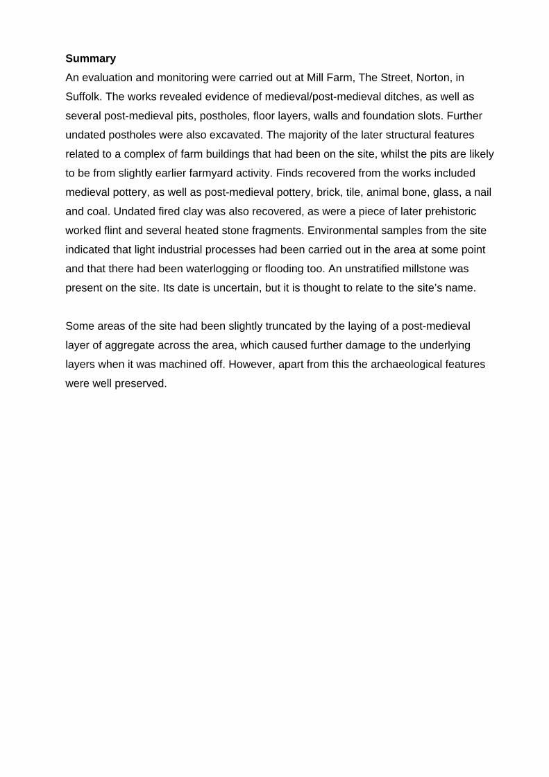
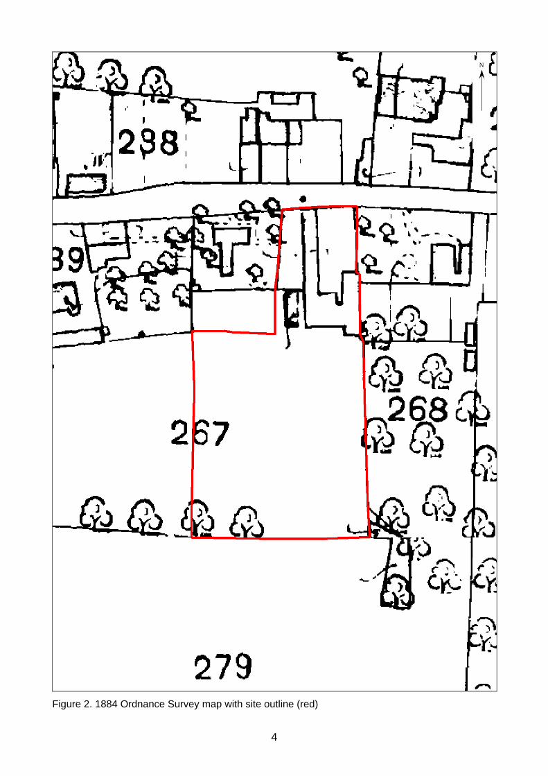
also a meadow, whilst that to the east was orchard. The 1884 and 1904 Ordnance
Survey (OS) maps indicate the extensive range of farm buildings that occupied the site
prior to its redevelopment (Figs. 2 and 3). There are no references on any of these
historical maps, or within the apportionment listings that refer to the site as Mill Farm. It
is unclear when or why this name was given to the site, though it obviously suggests
that a mill was present at some point. Sale particulars from 1950 list the property as Mill
Farm and show an identical layout to the 1904 OS map, whilst a document from 1597
records a ‘Millhouse’ in Norton, although it was unclear where this was located (Bury
Records Office, references HE 503/6/87 and 553/107-108, respectively).
2

264800
595000
NRN 019
595000
595200
595400
595600
595800
596000
596200
596400
596600
596800
597000
266800
266600
266400
266200
266000
265800
265600
265400
265200
265000
3
264800
A 1088
The Street
A 1088
Site
TL
BBN
0 800m
NRN 007
NRN 008
NRN 006
NRN 015NRN 019
NRN Misc
NRN 009
NRN 003
NRN 026
NRN 020
B
0 2 km
A
A
Norfolk
SUFFOLK
Essex
0 25 km
© Crown Copyright. All rights reserved. Suffolk County Council Licence No. 100023395 2012
Figure 1. Location of site, with Historic Environment Record entries as mentioned in the text.
N
Figure 2. 1884 Ordnance Survey map with site outline (red)
4
N
Figure 3. 1904 Ordnance Survey map with site outline (red)
5

Tr.1
Tr.2
Tr.3
N
0 10m
Plan Scale 1:250
House plot 1
House plot 2
House plot 3
© Crown Copyright. All rights reserved. Suffolk County Council Licence No. 100023395 2012
Figure 4. Trench plan showing house plots, evaluation trenches and features
6
UndatedPost-medieval features
Later farm building features (post-med.)Medieval / early post-medieval features
Earlier farm building features (post-med.)

4. Methodology
4.1 Evaluation methodology
Duncan Stirk
Trial trenching was carried out by Duncan Stirk (SCCAS Field Team) from the 13th -
15th April 2011. Three trenches were excavated using a mechanical excavator fitted
with a 1.6m wide toothless bucket. All mechanical excavation was carried out under
close archaeological supervision until the top of the first undisturbed archaeological
deposit or natural subsoil was revealed. The trenching took place after the demolition of
the former farm buildings that had been on the site, as well as a site strip across the
footprints of the new houses. The site strip did not uncover the archaeological levels.
The overall site measures approximately 2275sqm, within which the house plots
measured 515sqm. The trenches were positioned to sample the house plots and
covered 57.5sqm, or 11% of the total area to be developed. The trench layout was
designed to sample the areas to be damaged by the development. Contexts recorded
within this phase of work were numbered from 0100 for Trench 1, from 0200 for Trench
2 and 0300 for Trench 3. Certain features within Trench 2 were not excavated on the
basis that they would not be damaged by the later groundworks due to their positions
and depths.
4.2 Monitoring methodology
Excavation of the foundation trenches for the houses was carried out by a machine
equipped with a toothed bucket. The trench works were monitored constantly for House
Plots 1 and 2 (Fig. 4). These areas were thought to have the greater potential for
revealing archaeological deposits. However, the presence of a make up-layer of rubble
(in the place of topsoil) made it difficult to recognise features. This was because the
excavation of the rubble tended to partially abrade cut features, leaving them difficult to
distinguish until they could be seen in section. Dry soil conditions also made it harder to
see archaeological deposits. Contexts recorded within this phase of work were
numbered from 0400. On its western side, House Plot 3 had variable trenching depths.
Many of these trenches were only dug to 0.5m below ground level, whilst three trench
pads were excavated to 1.9-2m deep (Fig. 7).
7
4.3 Recording methodology
When the evaluation and foundation trenches were excavated, soil profiles were
cleaned and then recorded on SCCAS pro forma trench record sheets, including
descriptions and measurements. Features were cleaned and excavated by hand.
Environmental bulk samples were taken from two datable and sealed features. Features
were recorded using a single continuous numbering system (Appendix 3), on pro forma
context sheets. Sections and plans were drawn of individual features at varying scales
between 1:10-1:50. Colour digital photographs (300 x 300 dpi and 314 x 314 dpi
resolution) were taken of the features, as well as of soil profiles and the site as a whole.
The site was hand planned at 1:50 using points located using a GPS working within
tolerances of <0.05m. These points were also used to obtain levels for the site.
Site data has been input onto the MS Access database and recorded using the County
HER code NRN 024. An OASIS form has been completed for the project (reference no.
suffolkc1-129213) which is included as Appendix 4, and a digital copy of the report
submitted for inclusion on the Archaeology Data Service database (http://ads.ahds.ac.
uk/catalogue/library/greylit). The site archive is kept in the main store of Suffolk County
Council Archaeological Service at Bury St Edmunds under HER code NRN 024.
8
5. Results
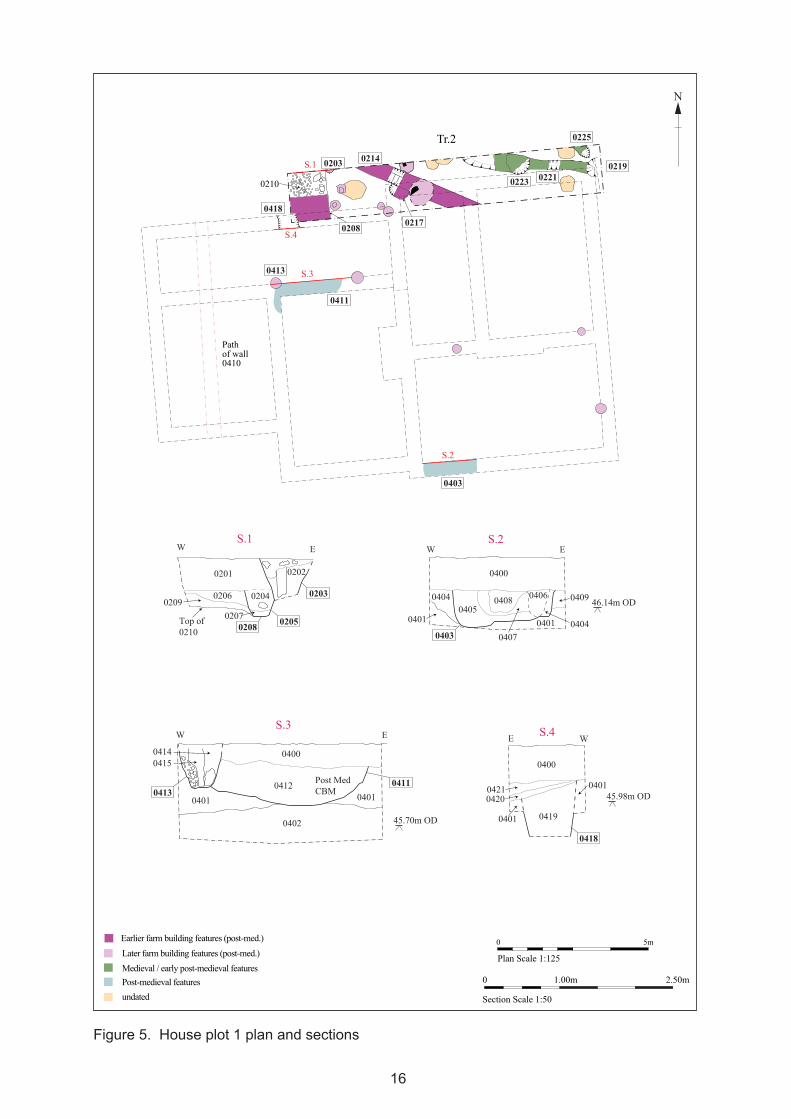
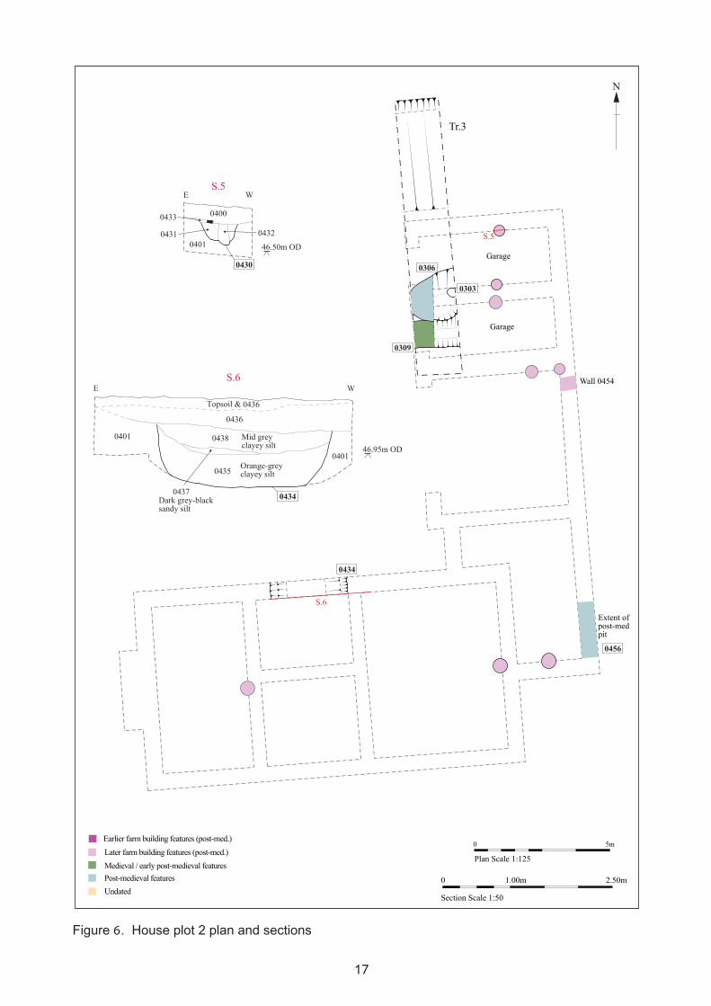
5.1 Introduction
Figs. 4-8
Across much of the area of Houses 1 and 2 there was no topsoil present, with this layer
and any subsoil/B-horizon having been replaced with 0.26-0.5m of make-up/
consolidation layer 0400 (Figs. 5 and 6). This layer was associated with the farm
buildings that had stood on the site and is also recorded as 0201 and 0301. It
immediately overlaid the natural geology of coarse orange sand and silt, 0401.
However, within the south-west limits of House 2, none of layer 0400 was recorded and
there was up to 0.06m-0.75m of topsoil present. This layer overlaid a mid grey silty-
sand with frequent ceramic building material (CBM) and mortar inclusions that was
heavily disturbed. Within the trenches for House 3 a less disturbed profile survived,
consisting of 0.5-6m of topsoil, overlying 0.2-3m of mid orangish-grey sandy-silt subsoil.
This in turn overlaid the geology of mottled grey and orange sandy-clay, recorded as
0453.
5.2 Medieval or early post-medieval features
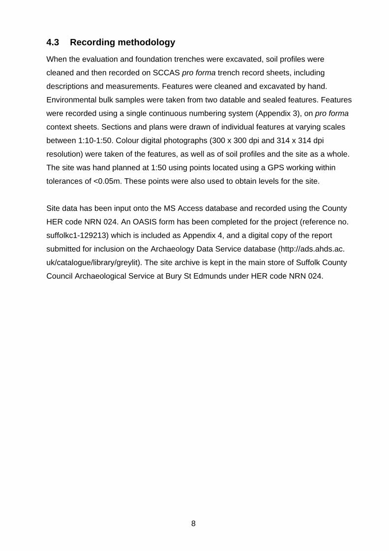
Ditch 0309
In the area of House 2, ditch 0309 was excavated in evaluation Trench 3 (Fig. 6 and Pl.
1). It was aligned east-west and was cut by pit 0306. It sides sloped at 40-50° and were
straight-irregular. The base of the ditch was flat. It contained two fills, 0307 and 0308,
which were light-mid grey silty-sands. Fill 0308 produced three sherds of slightly
abraded medieval pottery. The feature is possibly medieval, indicated by its alignment
with the road to the north, the pottery within it, and because of its stratigraphic position
underlying pit 0309 and the former buildings on the site. However, it may well have
continued in use into the post-medieval period.
Ditch 0221 and pit 0223
A small east-west aligned ditch was recorded as 0221 in House 1 (Fig. 5). It had 45°
straight sides and a flat base and was filled with 0220; a light grey silty-sand fill, with
9
mottled orange and brown patches. It ran parallel to The Street and may well represent
a ditch flanking the road. The ditch was cut by pit/posthole 0219 and pit 0223. The latter
was a small, round pit, with variable sides and a slightly concave base. Its single fill
0222, which was mid greenish-grey sandy-silt with charcoal flecks, produced one piece
of abraded 12th-14th century pot.
Plate 1. Pit 0306 and ditch 0309, 1m scale, facing west
5.3 Post-medieval archaeology
Pits 0306, 0403, 0411, 0434, 0455 and 0456
Six large pits were recorded across all three house plots, as cuts 0306, 0403, 0411,
0434, 0455 and 0456 (Pl. 1). These were roughly circular to oval in plan, and were up to
2.58m long x up to >1.8m wide x up to 0.94m deep. With the exception of pit 0306,
which appeared to have been heavily truncated by layer 0301, the cuts had steep to
near vertical sides, which curved at the base. The cuts had either concave or somewhat
uneven bases. Only pit 0411 contained a single fill, 0412, which was a very dark
brownish-grey clayey-silty-sand, producing post-medieval ceramic building material
(CBM), animal bone and coke. The remaining pits had between two and four fills, which
were a mixture of orange-grey clayey-silt and sand, and mid-dark grey/black sandy-silt.
10

Fill 0304 from pit 0306 was more distinctive however. Although it is post-medieval, when
sampled it produced redeposited glumed wheat, which could be indicative of a possible
Saxon origin. The sample also contained ferrous fragments, which may be the result of
light industrial processes, which required the wheat processing waste for kindling/fuel.
Each of the pits produced either 16th-18th century/post-medieval pottery or post-
medieval CBM, excluding pit 0434, which produced one fired clay fragment. Pit 0306
also produced five small sherds of abraded medieval pottery. Each one of the pits was
overlaid by the site make-up/consolidation layers, with pit 0434 being overlaid with a
particularly substantial deposit of consolidating rubble, 0436. A possible but poorly
defined posthole cutting into the top fill of pit 0403 was recorded as 0406.
Pit/posthole 0219 and ditch/posthole 0225
In the north-east corner of House 1 two post-medieval cuts were recorded as
pit/posthole 0219 and ditch/posthole 0225. Cut 0219 appeared to be round in plan, with
its full extent going beyond the end of the trench and it truncated linear feature 0221.
The sides of the cut sloped at 40-45° and were convex-irregular, with a concave base.
The yellow-brown and grey-brown sandy-silt fill 0218 produced an iron nail and post-
medieval CBM. Immediately north-west of this cut was pit/posthole 0225, which was
circular in plan, with 80-85° straight sides, and a flat base. Greyish-brown sandy-silt fill
0224 produced post-medieval CBM.
Millstone 0417
A large, unstratified millstone was present on the site (Pl. 2). This was circular in plan,
with a flat top and straight sides. One edge of the stone was damaged and it had a
square timber slot in the centre (Fig. 8). It was 0.33m tall and had a slight chamfer on
the edge between the top and sides, which were dressed with an engraved 10mm x
10mm grid pattern. Its diameter was between 1.32m and 1.34m. It is unclear whether it
had been used, but it was made from basalt. It may have been imported from Scotland,
but is almost certainly German: ‘These lava stones were known as Cullin or Blue stones, obtained from blue or purple
basalt quarried in the Eifel mountains south of Cologne and shipped down the Rhine
from Andernacht and through Cologne (hence the name Cullin). Their use was fairly
widespread until the C17, when French stones from the Paris basin became more
11

common … They continued to be used for querns and hand driven mills (e.g. for grinding
malt) into C19’ (Barnard, 2012).
Plate 2. Millstone 0417, 2x1m scale
Building features
Several features are thought to have been associated with various incarnations of the
farm buildings that previously stood on the site. These include the remnants of two
walls, two foundation slots, nineteen postholes, a drain and several floor surfaces or
screeds, which are detailed below.
Drain 0212, trench 0214 and posthole 0217
Running north-west to south-east in Trench 2/House 1 was a drain trench cut, 0214, at
the bottom of which was brick drain 0212 (Fig. 5). An 18th-19th century brick was
retrieved from the drain. The trench was c.0.55m wide x 0.6m deep. A possibly oval
posthole was cut by trench 0214. This was aligned north-west to south-east and had
steep, concave sides and a slightly concave base. No finds were recovered from its mid
12

grey silty-sandy-clay fills. The feature could not be traced throughout the foundation
trenching.
Foundation cuts 0205/0208 and 0418, and layers 0206/0421, 0209/0420 and 0210
All of the features in this sequence were recorded in the overlapping areas of House 1
and Trench 2 (Fig. 5 and Pl. 3). The earliest cut was foundation slot 0418, containing fill
0419 that produced post-medieval CBM. It had 80° straight sides, but it was not
possible to fully excavate the feature. It was 0.7m wide x >0.72m deep and was filled
with dark grey clay and mortar remnants, indicating that its original fill had been robbed-
out. A sample from the fill indicated that the site had at one time been water-logged, as
indicated by the high density of de-watered plant macrofossils.
Foundation trench 0418 was overlaid by two layers, which corresponded with two layers
within evaluation Trench 2. These were recorded as 0209/0420 and 0206/0421, and
were mid-dark grey compacted clay layers. Both contexts 0209 and 0420 produced
post-medieval CBM. These layers appear to have been clay surfaces, either used as
floors or as the base for another surface that was no longer present.
A layer of mid grey and orange clay, pebbles and CBM fragments was recorded under
layer 0209/0420. This was 0.14m thick and was a floor surface or a screed for a
surface.
Cutting through the top of uppermost layer 0206/0421 was a later foundation slot, 0208.
It also had 80° straight sides and a flat base, and was 0.34m wide x 0.15m deep. The
fill, a mottled grey and orange sandy-clay, produced fired clay, late 12th-14th century
pottery and post-medieval/18th-19th century CBM.
13

Plate 3. Section 1, 1m and 0.5m scale, facing north
Late post-medieval postholes and clay layer 0433
Nineteen late post-medieval postholes were located throughout the area of Houses 1
and 2 (Figs. 5 and 6). A number of these were individually recorded, as cuts 0203,
0303, 0413 and 0430. These invariably had 70-80° straight-slightly concave sides and
flat-irregular bases. All of the cuts were circular and they varied in size slightly, ranging
from 0.52-0.7m across x 0.33-0.6m deep. Each of these postholes cut the consolidation/
make-up layer that ran across much of the former area of the farm buildings, and many
of them still contained rotten wooden posts. The fills consisted of tightly packed greyish-
brown or brownish-yellow clay, although in cut 0430 the fill was greyish-brown chalky-
sand. None of the posthole fills produced finds. Immediately overlying posthole cut 0430
in House 2 was a possible clay floor surface, recorded as 0433. This consisted of yellow
chalky-clay with occasional charcoal flecks and was at most 0.05m thick. It contained a
fragment of post-medieval brick. This layer is interpreted as either the surviving remnant
of a floor surface that had slumped into the top of the cut, or a consolidation/post-
packing deposit.
Walls 0410 and 0454
A north to south aligned brick, flint and lime mortar wall was recorded as 0410 in House
1 and east-west wall 0454 of the same construction was located in House 2. An
example of a brick from wall 0410 was dated as 18th-19th century. These were the
foundations of walls from the recently demolished farm buildings on the site.
14
5.4 Undated features
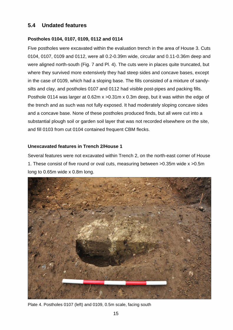
Postholes 0104, 0107, 0109, 0112 and 0114
Five postholes were excavated within the evaluation trench in the area of House 3. Cuts
0104, 0107, 0109 and 0112, were all 0.2-0.39m wide, circular and 0.11-0.36m deep and
were aligned north-south (Fig. 7 and Pl. 4). The cuts were in places quite truncated, but
where they survived more extensively they had steep sides and concave bases, except
in the case of 0109, which had a sloping base. The fills consisted of a mixture of sandy-
silts and clay, and postholes 0107 and 0112 had visible post-pipes and packing fills.
Posthole 0114 was larger at 0.62m x >0.31m x 0.3m deep, but it was within the edge of
the trench and as such was not fully exposed. It had moderately sloping concave sides
and a concave base. None of these postholes produced finds, but all were cut into a
substantial plough soil or garden soil layer that was not recorded elsewhere on the site,
and fill 0103 from cut 0104 contained frequent CBM flecks.
Unexcavated features in Trench 2/House 1
Several features were not excavated within Trench 2, on the north-east corner of House
1. These consist of five round or oval cuts, measuring between >0.35m wide x >0.5m
long to 0.65m wide x 0.8m long.
Plate 4. Postholes 0107 (left) and 0109, 0.5m scale, facing south
15
W E
W E E WS.3 S.4
0408
0401
0407
0409
04040401
04040405
0400
0403
040646.14m OD
45.98m OD
0419
0401
0400
0421
0418
0401
0420
S.2
04150414
04010413
0400
0412
0402
0411
Section Scale 1:50
0 2.50m1.00m
0401
45.70m OD
W ES.1
0201
02060209
0208 0205
0204
0207
0202
0203
Top of0210
Post MedCBM
undatedPost-medieval features
Later farm building features (post-med.) Medieval / early post-medieval features
Earlier farm building features (post-med.)
Pathof wall0410
0418
0413
0411
0203
0223
0219
0225
0221
0214
Tr.2
S.4
S.3
S.2
02170208
S.1
0210
0 5m
Plan Scale 1:125
Figure 5. House plot 1 plan and sections
16
N
0403
E W
E W
S.5
S.6
04000433
0401
0430
46.50m OD
0435
0401
0401
0436
0436
0438
04340437
0431 0432
46.95m OD
Topsoil &
Mid grey clayey silt
Orange-greyclayey silt
Dark grey-blacksandy silt
Section Scale 1:50
0 2.50m1.00m
0434
S.6
S.5
Garage
Garage
0306
Tr.3
0456
0303
0309
Extent ofpost-medpit
Wall 0454
0 5m
Plan Scale 1:125
Figure 6. House plot 2 plan and sections
17
N
UndatedPost-medieval features
Later farm building features (post-med.)Medieval / early post-medieval features
Earlier farm building features (post-med.)

Tr.1
0112
0114
0102
0104
01070109Trenchpad 2
Trenchpad 1
Trenchpad 3
Nat.
Extent ofpost-medpit
0.5m deep
Nat.
Post-medieval feature
0455
0 5m
Plan Scale 1:125
Figure 7. House plot 3 plan showing post-medieval pit and undated post holes
18
N

0 1.00m
Plan and Section Scale 1:20
Chamfered edge
Broken
edge
Pitted surface
not patterned
Millstone 0417
Figure 8. Millstone 0417 plan and profile
19
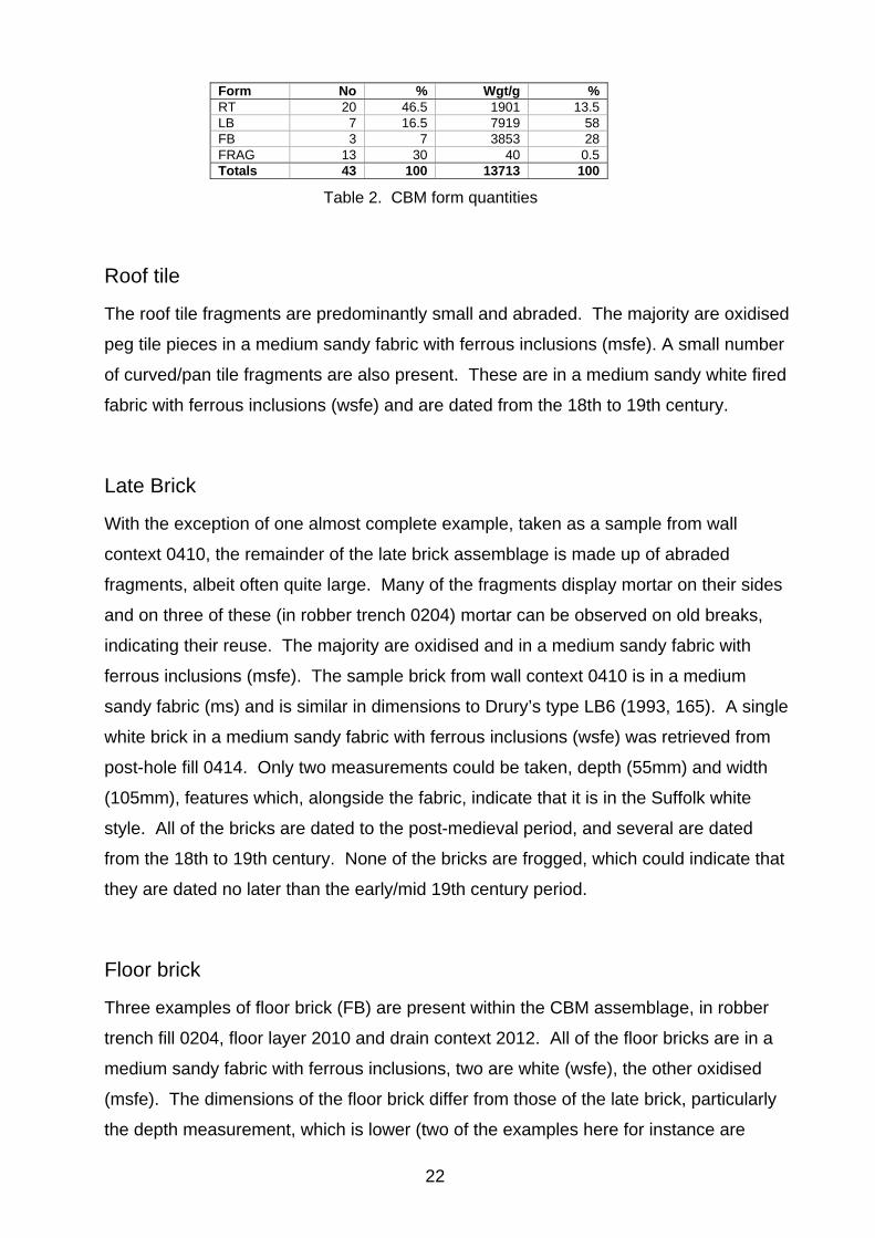
6. Finds and environmental evidence
Andy Fawcett
6.1 Introduction
Table 1 shows the quantities of finds collected from both the archaeological evaluation
and monitoring. Finds were retrieved from twenty-two contexts in three trenches as well
as from a small number of features near to the trenches during the evaluation stage. A
small quantity of finds was retrieved through the sampling strategy. Where these have
contributed additional information to the overall analysis and interpretation of the main
bulk finds assemblage, they have also been included in Table 1. A full breakdown by
context of the bulk finds can be seen in Appendix 5.
Find type No Wt/g Pottery 15 263 CBM 43 13713 Fired clay 15 63 Mortar 4 8 Worked flint 1 3 Burnt flint/stone 39 477 Quern stone 1 429 Glass 2 43 Iron objects 2 190 Coal 1 8 Animal bone 1 9 Total 124 15206
Table 1. Finds quantities
6.2 The Pottery
Introduction
A total of fifteen sherds of pottery weighing 263g was recorded from the evaluation and
monitoring. The greater part of the assemblage is dated to the medieval period and a
small number of sherds are of a post-medieval date. A complete contextual breakdown
of the pottery can be seen in Appendix 6.
Methodology
All of the pottery has been examined at x20 vision and allocated to fabric groups.
Codes have been assigned to these groups using the Suffolk fabric series (SCCAS). All
of the pottery has been recorded by sherd count and weight.
20

Medieval
Thirteen body sherds with a weight of 108g are dated to this period. The condition of
the sherds may be described as between abraded and slightly abraded. They are all
small and thinly spread across the seven contexts in which they occur. Medieval sherds
are present in all three trenches on the site however most (nine) are located within the
area of House Plot 2 (Tr.3). The majority of medieval sherds are also accompanied by
finds of a later date, principally post-medieval ceramic building materials.
The entire assemblage is made up of Medieval coarsewares (MCW), dated from the
late 12th to 14th century. The fabrics are all reduced and composed of ill sorted quartz,
some of which occasionally contain small amounts of black iron ore or grog.
Post-medieval
Two sherds of post-medieval pottery were recorded (155g), one in floor layer 0209
(Tr.3) and the other in pit fill 0405 (near Tr.3). Both are body sherds of Glazed red
earthenware (GRE) and are dated from the 16th to 18th century.
6.3 Ceramic building material (CBM)
Introduction
Forty-three fragments of CBM with a weight of 13713g were recorded in thirteen
contexts. The entire assemblage is dated to the post-medieval period and a full
breakdown by context can be seen in Appendix 7.
Methodology
All of the CBM has been rapidly scanned at x20 vision and divided into fabric groups.
Codes have been assigned to these groups using the Suffolk fabric series (SCCAS). All
of the CBM has been recorded by fragment number and weight. The assemblage is
composed of four different categories of CBM, roof tile (RT), late brick (LB), floor brick
(FB) and miscellaneous fragments (FRAG) and a basic breakdown of these can be
seen in Table 2.
21
Form No % Wgt/g % RT 20 46.5 1901 13.5 LB 7 16.5 7919 58 FB 3 7 3853 28 FRAG 13 30 40 0.5 Totals 43 100 13713 100
Table 2. CBM form quantities
Roof tile
The roof tile fragments are predominantly small and abraded. The majority are oxidised
peg tile pieces in a medium sandy fabric with ferrous inclusions (msfe). A small number
of curved/pan tile fragments are also present. These are in a medium sandy white fired
fabric with ferrous inclusions (wsfe) and are dated from the 18th to 19th century.
Late Brick
With the exception of one almost complete example, taken as a sample from wall
context 0410, the remainder of the late brick assemblage is made up of abraded
fragments, albeit often quite large. Many of the fragments display mortar on their sides
and on three of these (in robber trench 0204) mortar can be observed on old breaks,
indicating their reuse. The majority are oxidised and in a medium sandy fabric with
ferrous inclusions (msfe). The sample brick from wall context 0410 is in a medium
sandy fabric (ms) and is similar in dimensions to Drury’s type LB6 (1993, 165). A single
white brick in a medium sandy fabric with ferrous inclusions (wsfe) was retrieved from
post-hole fill 0414. Only two measurements could be taken, depth (55mm) and width
(105mm), features which, alongside the fabric, indicate that it is in the Suffolk white
style. All of the bricks are dated to the post-medieval period, and several are dated
from the 18th to 19th century. None of the bricks are frogged, which could indicate that
they are dated no later than the early/mid 19th century period.
Floor brick
Three examples of floor brick (FB) are present within the CBM assemblage, in robber
trench fill 0204, floor layer 2010 and drain context 2012. All of the floor bricks are in a
medium sandy fabric with ferrous inclusions, two are white (wsfe), the other oxidised
(msfe). The dimensions of the floor brick differ from those of the late brick, particularly
the depth measurement, which is lower (two of the examples here for instance are
22

33mm). The floor bricks are post-medieval and within this period the two white fired
examples are dated from the 18th to 19th century.
6.4 Fired clay
A small quantity of fired clay was recorded in four contexts, layers 0102, 0207 and pit
fills 0304, 0437. A full breakdown by context forms part of the site archive. The pieces
are all small, mostly abraded and the majority are in a medium sandy fabric with calcite
(msc). Two joining fragments in layer 0207 are reduced/burnt and display a flat
irregular surface. The pieces in contexts 0102 and 0304 are accompanied by medieval
pottery.
6.5 Mortar
Two small and abraded fragments of lime based mortar were retrieved from building slot
fill 0419. The only other find type within the fill is post-medieval CBM.
6.6 Worked flint
Identified by Colin Pendleton
A single unpatinated squat flake with a retouched notch was recovered from post-hole
fill 0113 (Tr.1). The flint is dated to the later prehistoric period. No other finds were
recorded in the context.
6.7 Burnt flint/stone
The entire burnt flint/stone collection was recovered via the sampling strategy from
possible fire pit 0304 in Trench 3 (39 fragments @ 477g). The burnt flint/stone is of a
variable size and its colour ranges from white/grey to red/orange. The pit fill also
contains medieval pottery but interestingly too, charred cereal waste and tiny ferrous
fragments which were identified during the examination of the samples (Fryer, below).
23

6.8 Millstone
A single fragment of millstone 0417 was retained for analysis. The piece is shattered
and no dimensional measurements are possible. A very small area of one surface
remains, the patterning of which indicates that it was from the side of the millstone (Fig.
8). The fragment is basalt, possibly imported into East Anglia from Scotland, but
probably from Germany. It is either medieval or post-medieval.
6.9 Glass
Robber trench 0204 and floor layer 0209, both contained single degraded fragments of
post-medieval bottle glass. Each fill also contains CBM and in the case of 0209, pottery
that was also dated to the post-medieval period.
6.10 Iron objects
Six fragments of an iron nail (127g) were retrieved from post-hole fill 0218 which also
contains pieces of post-medieval CBM.
The remains of a late post-medieval/modern padlock were recovered from post-hole
0302. The lock is heavy and exhibits few corrosion products.
6.11 Coal
A single worn coal fragment was recorded in pit fill 0412 which also contains a small
quantity of post-medieval CBM.
6.12 Faunal remains
A single broken pig tooth was noted in pit fill 0412 (9g).
24

6.13 Plant macrofossils and other remains
Val Fryer
Introduction and method statement
Evaluation and monitoring works at Norton recorded a small number of features
including a fire pit 0306 and a possible foundation slot 0418 which, at the time of
excavation, were thought to be of a possible medieval date. Samples for the evaluation
of the content and preservation of the plant macrofossil assemblages were taken from
pit fill 0304 and building slot fill 0419.
The samples were bulk floated by SCCAS and the flots were collected in a 300 micron
mesh sieve. The dried flots were scanned under a binocular microscope at
magnifications up to x 16 and the plant macrofossils and other remains noted are listed
in Appendix 8. Nomenclature within Appendix 8 follows Stace (1997). Both charred
and de-watered plant remains were recorded, with the latter being denoted within the
table by a lower case ‘w’ suffix. Modern fibrous roots were also recorded.
Results
The flot from pit fill 0304 (Sample 1) was relatively large (circa 0.4 litres in volume), and
although largely composed of charcoal/charred wood fragments, cereal grains, chaff
and weed seeds were also recorded. Preservation of these remains was mostly good,
although some grains were puffed and distorted, probably as a result of combustion at a
high temperature. The assemblage from Sample 2 contained both charred and de-
watered macrofossils, with the latter being moderately well preserved, although some
distortion had occurred, probably as a result of the compaction of the soil deposits.
Barley (Hordeum sp.) and wheat (Triticum sp.) grains were recorded along with oat
(Avena sp.) awn fragments. Chaff elements were rare, but a small number of spelt
wheat (T. spelta) glume bases were noted along with two possible emmer (T. dicoccum)
glume bases, barley/rye (Hordeum/Secale cereale) type rachis nodes and a single
bread wheat (T. aestivum/compactum) type node. The seeds were all of common
segetal and ruderal weeds including brome (Bromus sp.), fat hen type
(Chenopodiaceae), black bindweed (Fallopia convolvulus), persicaria (Persicaria
maculosa/lapathifolia), buttercup (Ranunculus acris/repens/bulbosus), dock (Rumex
25

sp.) and stinging nettles (Urtica dioica). A single, fragmentary sainfoin (Onobrychis
viciifolia) seed was noted within the assemblage from Sample 2. Occasional sedge
(Carex sp.) and spike-rush (Eleocharis sp.) nutlets were also recorded along with seeds
of blinks (Montia fontana), with all being indicative of a damp grassland habitat. Seeds
of celery-leaved crowfoot (Ranunculus sceleratus) were particularly abundant within
Sample 2, almost certainly indicating that building slot 0418 had, at some point, been
muddy and water-filled. Charcoal/charred wood fragments were abundant, but other
remains, including indeterminate culm nodes, occurred very infrequently. Other
remains were also scarce, although the non-floating residue from Sample 1 did contain
a moderate to high density of ferrous fragments.
Conclusions and recommendations for further work
In summary, it would appear most likely that some or all of the remains within Sample 1
are derived from charred cereal processing waste. Such material was often used as
kindling/fuel for a range of light industrial processes and given the occurrence of the
ferrous fragments this is perhaps of relevance in this instance. It should also be noted
that this assemblage is atypical of material of medieval date because of the presence of
wheat glume bases. The growing and usage of glumed wheats had almost certainly
ceased in the eastern region by the end of the Saxon period, and although the current
examples may be residual from earlier activity on the site, their presence is enigmatic.
Charred cereal processing waste may also be present within Sample 2, although at a
far lower density. However, this assemblage is of note because of the high density of
de-watered plant macrofossils, which appear to indicate that at some point, parts of the
site were probably flooded and overgrown with weeds and colonising shrubs.
Although both of the current assemblages do contain a sufficient density of material for
quantification (i.e. 100+ specimens), further analysis is not recommended until the
features from which the samples were taken can be securely dated. However, in the
meantime, if further interventions are planned within the immediate area, it is strongly
recommended that additional plant macrofossil samples of approximately 20 – 30 litres
in volume are taken from all well-sealed contexts recorded during excavation.
As a result of the query about the date of these assemblages, a selection of grains was
removed during sorting to be submitted for AMS dating if required.
26

7. Discussion
Rob Brooks and Andy Fawcett
Across the site a number of features survived in the evaluation and the monitoring that
relates to its 19th century to 20th century use for farm buildings. This includes two walls
of flint, brick and mortar construction, a drain, a number of postholes, several floor
layers and screeds, and two foundation slots. These seem to indicate various stages of
alterations and possible repairs to these buildings and may tie into the changes
recorded on the 1884 and 1904 Ordnance Survey maps, which show the construction of
new structures and the demolition of others (Figs. 2 and 3). The postholes and surviving
walls would appear to be the most recent of the features associated with these
buildings, with the earlier structures being characterised by robbed-out foundation slots
and floor surfaces/screeds. However post-medieval activity pre-dating the farm
buildings also existed, mainly in the form of several large refuse pits, which presumably
show an earlier phase of activity in association with the farm.
There was also limited evidence for late medieval/early post-medieval activity on the
site. This included very small quantities of abraded medieval pottery and two ditches,
the latter of which possibly flanked The Street to the north, or were field boundaries. Of
particular interest is possible fire pit 0306. This contained one slightly abraded sherd of
medieval pottery, as well as further smaller and abraded sherds retrieved from the
sampling process. Also present within the fill is burnt flint/stone (as well as worked flint)
and analysis of the macrosfossils indicates that the charred materials from the fill, as
well as ferrous fragments, point towards some form of light industrial process. However,
it is thought that this is probably a post-medieval feature containing redeposited
material, due to its stratigraphy, the abraded finds it produced and the large number of
similar post-medieval features on the site, but it does suggest earlier activity in the area.
This absence of earlier contexts occurs across the site, despite its position close to the
centre of the village, the church and the frontage of The Street. The finds assemblage
does contain earlier material, but most of this is probably redeposited, even from the
post-medieval period. The earliest finds are the redeposited glumed wheat and
medieval pottery, although the latter comprise small body sherds (mostly abraded)
which occur in very small numbers across contexts. Nevertheless, they again
demonstrate some form of activity dated to this period, in or around the current area of
the groundworks. The condition of the pottery is in contrast to the larger fragments of
27

post-medieval CBM which often accompany them, although this material also suffers
from abrasion. A very small quantity of post-medieval pottery is also present, dated from
the 16th to 18th century, and analysis of the CBM, and in particular the late bricks,
indicates that none are dated past the mid 19th century. Apart from the iron padlock
recorded in post-hole 0302, none of the finds appear to be dated to the later post-
medieval or modern period.
The undated features within Trench 1/House Plot 3 are of interest as they do not
correspond to any of the features on the early Ordnance Survey maps. This would
suggest that they are earlier than 1884 and are part of an as yet unexplained phase of
the site’s history. However they do cut the deep plough soil/garden soil layer in this
trench, which may suggest a relatively late date. As such they may correspond with the
post-medieval pit phase. Their alignment, running parallel with the existing property
boundary to the west, would suggest that they marked a boundary, although they could
equally have been part of a building. The position of the mill, from which the site gets its
name, was not established from these groundworks or from a brief study of the
available historic references or maps. However, the millstone recovered is likely to have
been associated with this structure.
8. Conclusions and recommendations for further work
The evaluation and monitoring of the site have revealed the presence of mainly post-
medieval features on the site, associated with the farm and potentially with the former
mill that may have occupied the area. However, there is limited evidence for earlier
activity as well, with abraded medieval pottery. Of particular note is the presence of
Saxon crop residues and possible industrial remains. If further work is to take place
within the area it is recommended that an archaeological strategy is put in place in order
to further explain the nature of these earlier deposits.
28
9. Archive deposition
Paper and photographic archive: SCCAS Bury St Edmunds
Digital archive: SCCAS R:\Environmental Protection\Conservation\Archaeology\
Archive\Norton\NRN 024 Mill Farm
Digital photographic archive: SCCAS R:\Environmental Protection\Conservation\
Archaeology\Catalogues\Photos\HPA-HPZ\HPD 1-77
Finds and environmental archive: SCCAS Bury St Edmunds. Store Location: J/115/3
10. Acknowledgements
The evaluation was carried out and directed by Duncan Stirk, while the monitoring was
carried out and directed by Rob Brooks.
Project management was undertaken by Jo Caruth who also provided advice during the
production of the report.
Post-excavation management was provided by Richenda Goffin. Finds processing and
analysis was undertaken by Jonathan Van Jennians. The specialist finds report was
produced by Andy Fawcett and additional specialist advice was provided by Val Fryer.
The report illustrations were created by Gemma Adams and the report was edited by Jo
Caruth and Richenda Goffin.
29
11. Bibliography
Anderson, S, 2005, ‘Ceramic building material’ in Duffy, J. The Angel Hotel, Bury St Edmunds (BSE 231); A report on the archaeological investigation, SCCAS Report No 2005/173 Atfield, R., 2007, Archaeological Evaluation Report, Three Bridges, Norton Little Green, SCCAS Report No. 2007/067, Ipswich: SCCAS Barnard, M., 2012, Email advice obtained from Mark Barnard, Historic Buildings Officer for Suffolk County Council BGS, 2012, Information obtained from http://www.bgs.ac.uk/products/digital maps/ data_625k.html and reproduced with the permission of the British Geological Survey ©NERC. All rights Reserved Drury, P. J., 1993, ‘The ceramic building materials’ in Margeson, S. Norwich Households; Medieval and post-medieval finds from Norwich Survey excavations 1971-78, East Anglian Report No 58 Stace, C., 1997, New Flora of the British Isles. 2nd edition. Cambridge University Press
30


2
Suffolk County Council (9-10 The Churchyard, Shire Hall, Bury St Edmunds IP33 2AR; telephone/fax: 01284 352443) for approval. The work must not commence until this office has approved both the archaeological contractor as suitable to undertake the work, and the WSI as satisfactory. The WSI will provide the basis for measurable standards and will be used to satisfy the requirements of the planning condition.
1.10 Neither this specification nor the WSI, however, is a sufficient basis for the discharge of the
planning condition relating to archaeological investigation. Only the full implementation of the scheme, both completion of fieldwork and reporting based on the approved WSI, will enable SCCAS/CT to advise Mid Suffolk District Council that the condition has been adequately fulfilled and can be discharged.
1.11 Before any archaeological site work can commence it is the responsibility of the developer to
provide the archaeological contractor with either the contaminated land report for the site or a written statement that there is no contamination. The developer should be aware that investigative sampling to test for contamination is likely to have an impact on any archaeological deposit which exists; proposals for sampling should be discussed with the Conservation Team of the Archaeological Service of SCC (SCCAS/CT) before execution.
1.12 The responsibility for identifying any constraints on field-work, e.g. Scheduled Monument
status, Listed Building status, public utilities or other services, tree preservation orders, SSSIs, wildlife sites &c., ecological considerations rests with the commissioning body and its archaeological contractor. The existence and content of the archaeological brief does not over-ride such constraints or imply that the target area is freely available.
1.13 Any changes to the specifications that the project archaeologist may wish to make after
approval by this office should be communicated directly to SCCAS/CT and the client for approval.
2. Brief for the Archaeological Evaluation 2.1 Establish whether any archaeological deposit exists in the area, with particular regard to any
which are of sufficient importance to merit preservation in situ. 2.2 Identify the date, approximate form and purpose of any archaeological deposit within the
application area, together with its likely extent, localised depth and quality of preservation. 2.3 Evaluate the likely impact of past land uses, and the possible presence of masking
colluvial/alluvial deposits. 2.4 Establish the potential for the survival of environmental evidence. 2.5 Provide sufficient information to construct an archaeological conservation strategy, dealing
with preservation, the recording of archaeological deposits, working practices, timetables and orders of cost.
2.6 This project will be carried through in a manner broadly consistent with English Heritage's
Management of Archaeological Projects, 1991 (MAP2), all stages will follow a process of assessment and justification before proceeding to the next phase of the project. Field evaluation is to be followed by the preparation of a full archive, and an assessment of potential. Any further excavation required as mitigation is to be followed by the preparation of a full archive, and an assessment of potential, analysis and final report preparation may follow. Each stage will be the subject of a further brief and updated project design; this document covers only the evaluation stage.
3
2.7 The developer or his archaeologist will give SCCAS/CT (address as above) five working days notice of the commencement of ground works on the site, in order that the work of the archaeological contractor may be monitored.
2.8 If the approved evaluation design is not carried through in its entirety (particularly in the
instance of trenching being incomplete) the evaluation report may be rejected. Alternatively the presence of an archaeological deposit may be presumed, and untested areas included on this basis when defining the final mitigation strategy.
2.9 An outline specification, which defines certain minimum criteria, is set out below. 3. Specification: Trenched Evaluation 3.1 Trial trenches are to be excavated to cover 5% by area, which is 100.00m
2. These shall be
positioned to sample all parts of the development site. Linear trenches are thought to be the most appropriate sampling method in a systematic grid array. Trenches are to be a minimum of 1.80m wide unless special circumstances can be demonstrated; this will result in a minimum of 56.00m of trenching at 1.80m in width.
3.2 If excavation is mechanised a toothless ‘ditching bucket’ 1.80m wide must be used. A scale
plan showing the proposed locations of the trial trenches should be included in the WSI and the detailed trench design must be approved by SCCAS/CT before field work begins.
3.3 The topsoil may be mechanically removed using an appropriate machine with a back-acting
arm and fitted with a toothless bucket, down to the interface layer between topsoil and subsoil or other visible archaeological surface. All machine excavation is to be under the direct control and supervision of an archaeologist. The topsoil should be examined for archaeological material.
3.4 The top of the first archaeological deposit may be cleared by machine, but must then be
cleaned off by hand. There is a presumption that excavation of all archaeological deposits will be done by hand unless it can be shown there will not be a loss of evidence by using a machine. The decision as to the proper method of excavation will be made by the senior project archaeologist with regard to the nature of the deposit.
3.5 In all evaluation excavation there is a presumption of the need to cause the minimum
disturbance to the site consistent with adequate evaluation; that significant archaeological features, e.g. solid or bonded structural remains, building slots or post-holes, should be preserved intact even if fills are sampled. For guidance: For linear features, 1.00m wide slots (min.) should be excavated across their width;
For discrete features, such as pits, 50% of their fills should be sampled (in some instances 100% may be requested).
3.6 There must be sufficient excavation to give clear evidence for the period, depth and nature of
any archaeological deposit. The depth and nature of colluvial or other masking deposits must be established across the site.
3.7 Archaeological contexts should, where possible, be sampled for palaeoenvironmental
remains. Best practice should allow for sampling of interpretable and datable archaeological deposits and provision should be made for this. The contractor shall show what provision has been made for environmental assessment of the site and must provide details of the sampling strategies for retrieving artefacts, biological remains (for palaeoenvironmental and palaeoeconomic investigations), and samples of sediments and/or soils (for micromorphological and other pedological/sedimentological analyses. Advice on the appropriateness of the proposed strategies will be sought from Helen Chappell, English

4
Heritage Regional Adviser for Archaeological Science (East of England). A guide to sampling archaeological deposits (Murphy, P.L. and Wiltshire, P.E.J., 1994, A guide to sampling archaeological deposits for environmental analysis) is available for viewing from SCCAS.
3.8 Any natural subsoil surface revealed should be hand cleaned and examined for archaeological
deposits and artefacts. Sample excavation of any archaeological features revealed may be necessary in order to gauge their date and character.
3.9 Metal detector searches must take place at all stages of the excavation by an experienced
metal detector user. 3.10 All finds will be collected and processed (unless variations in this principle are agreed
SCCAS/CT during the course of the evaluation). 3.11 Human remains must be left in situ except in those cases where damage or desecration are to
be expected, or in the event that analysis of the remains is shown to be a requirement of satisfactory evaluation of the site. However, the excavator should be aware of, and comply with, the provisions of Section 25 of the Burial Act 1857.
3.12 Plans of any archaeological features on the site are to be drawn at 1:20 or 1:50, depending on
the complexity of the data to be recorded. Sections should be drawn at 1:10 or 1:20 again depending on the complexity to be recorded. All levels should relate to Ordnance Datum. Any variations from this must be agreed with SCCAS/CT.
3.13 A photographic record of the work is to be made, consisting of both monochrome photographs
and colour transparencies and/or high resolution digital images. 3.14 Topsoil, subsoil and archaeological deposit to be kept separate during excavation to allow
sequential backfilling of excavations. 3.15 Trenches should not be backfilled without the approval of SCCAS/CT. Suitable arrangements
should be made with the client to ensure trenches are appropriately backfilled, compacted and consolidated in order to prevent subsequent subsidence.
4. General Management 4.1 A timetable for all stages of the project must be agreed before the first stage of work
commences, including monitoring by SCCAS/CT. The archaeological contractor will give not less than five days written notice of the commencement of the work so that arrangements for monitoring the project can be made.
4.2 The composition of the archaeology contractor staff must be detailed and agreed by this
office, including any subcontractors/specialists. For the site director and other staff likely to have a major responsibility for the post-excavation processing of this evaluation there must also be a statement of their responsibilities or a CV for post-excavation work on other archaeological sites and publication record. Ceramic specialists, in particular, must have relevant experience from this region, including knowledge of local ceramic sequences.
4.3 It is the archaeological contractor’s responsibility to ensure that adequate resources are
available to fulfill the Brief. 4.4 A detailed risk assessment must be provided for this particular site. 4.5 No initial survey to detect public utility or other services has taken place. The responsibility for
this rests with the archaeological contractor.
5
4.6 The Institute for Archaeologists’ Standard and Guidance for archaeological field evaluation (revised 2001) should be used for additional guidance in the execution of the project and in drawing up the report.
5. Report Requirements 5.1 An archive of all records and finds must be prepared consistent with the principles of English
Heritage's Management of Archaeological Projects, 1991 (particularly Appendix 3.1 and Appendix 4.1).
5.2 The report should reflect the aims of the WSI. 5.3 The objective account of the archaeological evidence must be clearly distinguished from its
archaeological interpretation. 5.4 An opinion as to the necessity for further evaluation and its scope may be given. No further
site work should be embarked upon until the primary fieldwork results are assessed and the need for further work is established.
5.5 Reports on specific areas of specialist study must include sufficient detail to permit
assessment of potential for analysis, including tabulation of data by context, and must include non-technical summaries.
5.6 The Report must include a discussion and an assessment of the archaeological evidence,
including an assessment of palaeoenvironmental remains recovered from palaeosols and cut features. Its conclusions must include a clear statement of the archaeological potential of the site, and the significance of that potential in the context of the Regional Research Framework (East Anglian Archaeology, Occasional Papers 3 & 8, 1997 and 2000).
5.7 The results of the surveys should be related to the relevant known archaeological information
held in the County Historic Environment Record (HER). 5.8 A copy of the Specification should be included as an appendix to the report. 5.9 The project manager must consult the County HER Officer (Dr Colin Pendleton) to obtain a
HER number for the work. This number will be unique for each project or site and must be clearly marked on any documentation relating to the work.
5.10 Finds must be appropriately conserved and stored in accordance with UK Institute of
Conservators Guidelines. 5.11 Every effort must be made to get the agreement of the landowner/developer to the deposition
of the full site archive, and transfer of title, with the intended archive depository before the fieldwork commences. If this is not achievable for all or parts of the finds archive then provision must be made for additional recording (e.g. photography, illustration, scientific analysis) as appropriate.
5.12 The project manager should consult the intended archive depository before the archive is
prepared regarding the specific requirements for the archive deposition and curation, and regarding any specific cost implications of deposition. The intended depository should be stated in the WSI, for approval. The intended depository must be prepared to accept the entire archive resulting from the project (both finds and written archive) in order to create a complete record of the project.
5.13 If the County Store is the intended location of the archive, the project manager should consult
the SCCAS Archive Guidelines 2010 and also the County Historic Environment Record Officer regarding the requirements for the deposition of the archive (conservation, ordering, organisation, labelling, marking and storage) of excavated material and the archive. A clear

6
statement of the form, intended content, and standards of the archive is to be submitted for approval as an essential requirement of the WSI.
5.14 The WSI should state proposals for the deposition of the digital archive relating to this project
with the Archaeology Data Service (ADS), and allowance should be made for costs incurred to ensure the proper deposition (http://ads.ahds.ac.uk/project/policy.html) with ADS or another appropriate archive depository.
5.15 Where positive conclusions are drawn from a project (whether it be evaluation or excavation)
a summary report, in the established format, suitable for inclusion in the annual ‘Archaeology in Suffolk’ section of the Proceedings of the Suffolk Institute for Archaeology, must be prepared. It should be included in the project report, or submitted to SCCAS/CT, by the end of the calendar year in which the evaluation work takes place, whichever is the sooner.
5.16 An unbound hardcopy of the evaluation report, clearly marked DRAFT, must be presented to
SCCAS/CT for approval within six months of the completion of fieldwork unless other arrangements are negotiated with the project sponsor and SCCAS/CT.
Following acceptance, two hard copies of the report should be submitted to SCCAS/CT
together with a digital .pdf version. 5.17 Where appropriate, a digital vector trench plan should be included with the report, which must
be compatible with MapInfo GIS software, for integration in the County HER. AutoCAD files should be also exported and saved into a format that can be can be imported into MapInfo (for example, as a Drawing Interchange File or .dxf) or already transferred to .TAB files.
5.18 At the start of work (immediately before fieldwork commences) an OASIS online record
http://ads.ahds.ac.uk/project/oasis/ must be initiated and key fields completed on Details, Location and Creators forms.
5.19 All parts of the OASIS online form must be completed for submission to the County HER, and
a copy should be included with the draft report for approval (see para. 5.16). This should include an uploaded .pdf version of the entire report (a paper copy should also be included with the archive).

7
Specification by: Dr Jess Tipper Suffolk County Council Archaeological Service Conservation Team 9-10 The Churchyard, Shire Hall Bury St Edmunds Suffolk IP33 2AR Tel: 01284 352197 Email: [email protected] Date: 12 October 2010 Reference: /MillFarm_Norton2010
This brief and specification remains valid for six months from the above date. If work is not carried out in full within that time this document will lapse; the authority should be notified and a revised brief and specification may be issued.
If the work defined by this brief forms a part of a programme of archaeological work required by a Planning Condition, the results must be considered by the Conservation Team of the Archaeological Service of Suffolk County Council, who have the responsibility for advising the appropriate Planning Authority.


2
1.5 Following approval of the WSI, our office will advise the Local Planning Authority that an acceptable scheme of work is in place, and therefore we (will) have no objection to the work commencing. Neither this specification nor the WSI, however, is a sufficient basis for the discharge of the planning condition relating to archaeological investigation (assuming planning permission is granted). Only the full implementation of the scheme, both completion of fieldwork and reporting based on the approved WSI, will enable SCCAS/CT to advise Mid Suffolk District Council that the condition has been adequately fulfilled and can be discharged; only the Local Planning Authority can effect discharge of the condition.
1.6 Before commencing work the project manager must carry out a risk assessment and
liase with the site owner, client and the Conservation Team of SCCAS (SCCAS/CT) in ensuring that all potential risks are minimised.
1.7 All arrangements for the excavation of the site, the timing of the work, access to the
site, the definition of the precise area of landholding and area for proposed development are to be defined and negotiated by the archaeological contractor with the commissioning body.
1.8 The responsibility for identifying any constraints on field-work (e.g. Scheduled
Monument status, Listed Building status, public utilities or other services, tree preservation orders, SSSIs, wildlife sites &c., ecological considerations rests with the commissioning body and its archaeological contractor. The existence and content of the archaeological brief does not over-ride such constraints or imply that the target area is freely available.
1.9 Detailed standards, information and advice to supplement this brief are to be found in
Standards for Field Archaeology in the East of England, East Anglian Archaeology Occasional Papers 14, 2003.
1.10 The Institute for Archaeologists’ Standard and Guidance for an archaeological watching
brief (revised 2001) should be used for additional guidance in the execution of the project and in drawing up the report.
2. Brief for Archaeological Recording 2.1 To provide a record of archaeological deposits which are damaged or removed by any
development [including services and landscaping] permitted by the current planning consent.
2.2 Any ground works, and also the upcast soil, are to be closely monitored during and after
stripping in order to ensure no damage occurs any heritage assets. Adequate time is to be allowed for archaeological recording of archaeological deposits during excavation, and of soil sections following excavation.
3. Arrangements for Monitoring
3.1 To carry out the monitoring work the developer will appoint an archaeologist (the archaeological contractor) who must be approved by SCCAS/CT.
3.2 The developer or his contracted archaeologist will give SCCAS/CT five working days
notice of the commencement of ground works on the site, in order that the work of the archaeological contractor may be monitored. The method and form of development will also be monitored to ensure that it conforms to previously agreed locations and techniques upon which this brief is based.
3.3 Allowance must be made to cover archaeological costs incurred in monitoring the
development works by the contract archaeologist. The size of the contingency should

3
be estimated by the approved archaeological contractor, based upon the outline works in this Brief and Specification and the building contractor’s programme of works and time-table.
3.4 If unexpected remains are encountered SCCAS/CT must be informed immediately.
Amendments to this specification may be made to ensure adequate provision for archaeological recording.
4. Specification 4.1 The developer shall afford access at all reasonable times to SCCAS/CT and the
contracted archaeologist to allow archaeological monitoring of building and engineering operations which disturb the ground.
4.2 Opportunity must be given to the contracted archaeologist to hand excavate any
discrete archaeological features which appear during earth moving operations, retrieve finds and make measured records as necessary. Where it is necessary to see archaeological detail one of the soil faces is to be trowelled clean.
4.3 All archaeological features exposed must be planned at a scale of 1:20 of 1:50 on a
plan showing the proposed layout of the development, depending on the complexity of the data to be recorded. Sections should be drawn at 1:10 or 1:20 again depending on the complexity to be recorded.
4.4 A photographic record of the work is to be made of any archaeological features,
consisting of both monochrome photographs and colour transparencies/high resolution digital images.
4.5 All contexts must be numbered and finds recorded by context. All levels should relate to
Ordnance Datum. 4.6 Archaeological contexts should, where possible, be sampled for palaeo-environmental
remains. Best practice should allow for sampling of interpretable and datable archaeological deposits and provision should be made for this. Advice on the appropriateness of the proposed strategies will be sought from Helen Chappell, English Heritage Regional Adviser for Archaeological Science (East of England). A guide to sampling archaeological deposits (Murphy, P.L. and Wiltshire, P.E.J., 1994, A guide to sampling archaeological deposits for environmental analysis) is available for viewing from SCCAS.
4.7 All finds will be collected and processed (unless variations in this principle are agreed
with SCCAS/CT during the course of the monitoring). 4.8 The data recording methods and conventions used must be consistent with, and
approved by, the County Historic Environment Record. 5. Report Requirements 5.1 An archive of all records and finds is to be prepared consistent with the principles of
Management of Archaeological Projects (MAP2), particularly Appendix 3.This must be deposited with the County Historic Environment Record within three months of the completion of work. It will then become publicly accessible. It must be adequate to perform the function of a final archive for deposition in the County Historic Environment Record (The County Store) or museum in Suffolk.
5.2 The project manager must consult the County Historic Environment Record Officer to
obtain an event number for the work. This number will be unique for each project or site and must be clearly marked on any documentation relating to the work.

4
5.3 Finds must be appropriately conserved and stored in accordance with UK Institute of
Conservators Guidelines. 5.4 Every effort must be made to get the agreement of the landowner/developer to the
deposition of the full site archive, and transfer of title, with the intended archive depository before the fieldwork commences. If this is not achievable for all or parts of the finds archive then provision must be made for additional recording (e.g. photography, illustration, scientific analysis) as appropriate.
5.5 The project manager should consult the intended archive depository before the archive
is prepared regarding the specific requirements for the archive deposition and curation, and regarding any specific cost implications of deposition. The intended depository should be stated in the WSI, for approval. The intended depository must be prepared to accept the entire archive resulting from the project (both finds and written archive) in order to create a complete record of the project.
5.6 If the County Store is not the intended depository, the project manager should ensure
that a duplicate copy of the written archive is deposited with the County HER. 5.7 If the County Store is the intended location of the archive, the project manager should
consult the SCCAS Archive Guidelines 2010 and also the County Historic Environment Record Officer regarding the requirements for the deposition of the archive (conservation, ordering, organisation, labelling, marking and storage) of excavated material and the archive. A clear statement of the form, intended content, and standards of the archive is to be submitted for approval as an essential requirement of the WSI.
5.8 The WSI should state proposals for the deposition of the digital archive relating to this
project with the Archaeology Data Service (ADS), and allowance should be made for costs incurred to ensure proper deposition (http://ads.ahds.ac.uk/project/policy.html).
5.9 A report on the fieldwork and archive, consistent with the principles of MAP2,
particularly Appendix 4, must be provided. The report must summarise the methodology employed, the stratigraphic sequence, and give a period by period description of the contexts recorded, and an inventory of finds. The objective account of the archaeological evidence must be clearly distinguished from its interpretation. The Report must include a discussion and an assessment of the archaeological evidence, including palaeoenvironmental remains recovered from palaeosols and cut features. Its conclusions must include a clear statement of the archaeological value of the results, and their significance in the context of the Regional Research Framework (East Anglian Archaeology, Occasional Papers 3 & 8, 1997 and 2000).
5.10 An unbound hardcopy of the report, clearly marked DRAFT, must be presented to
SCCAS/CT for approval within six months of the completion of fieldwork unless other arrangements are negotiated with the project sponsor and SCCAS/CT.
5.11 Following acceptance, a single copy of the report should be submitted to SCCAS/CT. A
single hard copy should be presented to the County Historic Environment Record as well as a digital copy of the approved report.
5.12 A summary report, in the established format, suitable for inclusion in the annual
‘Archaeology in Suffolk’ section of the Proceedings of the Suffolk Institute of Archaeology, must be prepared and included in the project report.
5.13 Where appropriate, a digital vector trench plan should be included with the report, which
must be compatible with MapInfo GIS software, for integration in the County Historic Environment Record. AutoCAD files should be also exported and saved into a format that can be can be imported into MapInfo (for example, as a Drawing Interchange File or .dxf) or already transferred to .TAB files.

5
5.14 At the start of work (immediately before fieldwork commences) an OASIS online record http://ads.ahds.ac.uk/project/oasis/ must be initiated and key fields completed on Details, Location and Creators forms.
5.15 All parts of the OASIS online form must be completed for submission to County Historic
Environment Record. This should include an uploaded .pdf version of the entire report. A paper copy should also be included with the report and also with the site archive.
Specification by: Dr Jess Tipper Suffolk County Council Archaeological Service Conservation Team 9–10 The Churchyard, Shire Hall Bury St Edmunds Suffolk IP33 2AR Tel. : 01284 741225 E-mail: [email protected] Date: 4 May 2011 Reference: /MillFarm_Norton2011
This brief and specification remains valid for six months from the above date. If work is not carried out in full within that time this document will lapse; the authority should be notified and a revised brief and specification may be issued.
If the work defined by this brief forms a part of a programme of archaeological work required by a Planning Condition, the results must be considered by the Conservation Team of the Archaeological Service of Suffolk County Council, who have the responsibility for advising the appropriate Planning Authority.


Appendix 3. Context listContext No Feature No Feature TypeGrid Sq. Description Length Width Depth Phase SpotdateGroup NoSmall Finds Cuts Cut by Over Under Finds Sample
0100 Unstratified finds retrieved from Trench 1.Finds Unstratified
No No
0101 Very dark grey sandy-silt. Friable compaction. Frequent small stones. Moderate quantities of charcoal flecks and small charcoal pieces. Diffuse horizon clarity with the contexts it overlays.
Topsoil- probably the remnants of a garden soil.
0.4Topsoil Layer 0103, 0110, 0105, 0108, 0113
No No
0102 Mid greyish-brown sandy-silt. Firm compaction. Frequent small stones and occasional flecks of charcoal.
Subsoil or buried ploughsoil? Deep homogenous deposit containing one fragment of abraded medieval pot.
0.65Soil Layer 0104 0104, 0107, 0112, 0114
Yes No
0103 Mixed very pale yellow sandy-clay and mid greyish-brown sandy-silt. Firm compaction. Frequent small pink daub lumps, or degraded CBM. Frequent chalk and charcoal flecks. Moderate quantities of small stones. Sharp horizon clarity at base. Primary/only fill.Fill of posthole. No visible post-pipe.
0.29 0.28 0.11Posthole Fill 0104 0101 No No0104
0104 Circular in plan. Sharp break of slope at surface, moderately sloping concave sides, with moderately curving break of slope to base. Concave base. Cuts deposit 0102.Cut of posthole.
0.29 0.28 0.11Posthole Cut 0102 0102 0103 No No0104
0105 Mid greyish-brown clayey-sandy-silt. Firm compaction. Occasional flecks of chalk and small stones. Sharp horizon clarity with 0106.Post-pipe fill in posthole 0107. Rectangular post.
c.0.2 0.12 0.23Posthole Fill 0106 0101 No No0107
0106 Mixed very pale orangish-brown sandy-clay and very pale green and mid greyish-brown clayey-sandy-silt. Plastic compaction. Frequent flecks and small chalk pieces. Occasional small stones. Sharp horizon clarity with natural. Primary fill.Clay packing fill in posthole 0107. Derived from natural.
0.31 0.25 0.24Posthole Fill 0109 0107 0105, 0109
No No0107
0107 Oval in plan. Sharp break of slope at top of cut. Vertical, straight sides, with moderately curving break of slope to base. Concave base. Cuts 0102, cut by 0109.Cut of post hole. Similar to others in trench and site as a whole.
c.0.2 0.22 0.24Posthole Cut 0102 0106 No No0107
0108 Very pale greenish-grey sandy-clay. Plastic compaction. Moderate flecks of chalk. Occasional small stones. Sharp horizon clarity. Primary fill.Only fill of posthole 0109. No visible post-pipe.
0.3 0.26 0.17Posthole Fill 0109 0101 No No0109
0109 Oval in plan. Sharp break of slope at surface, with steep to vertical concave sides and a moderately curving break of slope to the abse. Concave base.Cut of posthole.
0.3 0.26 0.17Posthole Cut 0106 0106 0108 No No0109

Context No Feature No Feature TypeGrid Sq. Description Length Width Depth Phase SpotdateGroup NoSmall Finds Cuts Cut by Over Under Finds Sample
0110 Mid greyish-brown clayey-sandy-silt. Firm compaction. Moderate quantities of chalk. Occasional small stones. Sharp horizon clarity. Secondary fill of posthole.Post-pipe fill in posthole 0112. Shows rectangular post setting.
0.2 0.11 0.22Posthole Fill 0111 0101 No No0112
0111 Mottled very pale greenish-grey sandy-clay and mid greyish-brown clayey-sandy-silt. Firm and plastic compaction. Frequent chalk flecks. Occasional small stones. Sharp horizon clarity. Primary fill of posthole.Packing fill in posthole 0112.
0.39 0.38 0.36Posthole Fill 0112 0110 No No0112
0112 Nearly circular cut in plan. Sharp break of slope at top, steep straight sides, with sharply curving break of slope to base. Flat base.Cut of posthole.
0.39 0.38 0.36Posthole Cut 0102 0111 No No0112
0113 Dark brownish-grey sandy-silt. Friable compaction. Moderate small stones. Occasional flecks of chalk. Moderately sharp horizon clarity.Fill of small pit or posthole, or plant hole.
0.62 >0.31 0.3Posthole Fill 0114 0101 Yes No0114
0114 Semi-circular in plan. Sharp break of slope at top of feature. Moderately sloping concave sides. Moderately curving break of slope to base. Concave base.Cut of small pit or posthole, or plant hole.
0.62 >0.31 0.3Posthole Cut 0102 0113 No No0114
0200 Unstratified finds from Trench 2.Finds Unstratified
No No
0201 Orange-brown hardcore rubble and hoggin.
Make-up layer for floors of recently demolished barn.
0.44Construction Layer
0204 0203 No No
0202 Mid brown clayey-sandy-silt. Firm compaction. Inclusions of cobbles and mortar and rotted timber.Fill of large post-medieval/modern posthole 0203. Post still in-situ.
0.7 >0.56Posthole Fill 0203 No No0203
0203 Circular in plan. Sharp break of slope at top. Steep convex sides. Base not seen.Cut of modern posthole.
0.7 >0.56Posthole Cut 0201 0202 No No0203
0204 Mixed orangish-brown sandy-clay and mid greenish-grey clayey-silt. Firm compaction. Occasional small cobbles.Back fill of robber trench over wall 0208.
>1.6 0.38 0.26Robber trench Fill
0205 0201 Yes No0205
0205 Linear feature aligned N-S. Sharp break of slope at top of feature. Steep straight sides. Sharp break of slope at base of feature. Flat base.Robbing of wall in 0208.
>1.6 0.38 0.26Robber trench Cut
0206 0206 0204 No No0205
0206 Mixed mid grey and light yellowish-grey sandy-clayey-silt. Firm compaction.Possible floor layer abutting wall for 0207.
>1.6 >0.87 0.2Floor Layer 0205 0207 0205 No No

Context No Feature No Feature TypeGrid Sq. Description Length Width Depth Phase SpotdateGroup NoSmall Finds Cuts Cut by Over Under Finds Sample
0207 Mixed light-mid grey sandy-clay. Firm compaction. Frequent small and medium cobbles & lime mortar. Frequent charcoal flecks.Remnants of a robbed out wall foundation. Seems to cut floor layers that are associated with the former wall, but this may be a quirk of the construction process. Presumably the floors were built to abut the wall.
>1.6 0.34 0.15Wall Layer 0208 0206 Yes No0208
0208 Linear cut, aligned N-S. Sharp break of slope at surface. Steep, concave sides. Sharp break of slope to base. Flat base.Cut for foundation 0207. Seems to cut floor layers that are associated with the former wall, but this may be a quirk of the construction process rather than evidence of multiple building phases. Presumably the floors were built to abut the wall.
>1.6 0.34 0.15Wall Cut 0209 0207 No No0208
0209 Mid-dark grey sandy-clay. Firm and plastic compaction. Frequent charcoal flecks.Possible clay floor in building abutting wall 0207.
>1.6 >0.76 0.18Floor Layer 0210 0208 Yes No0209
0210 Mid grey and orange clay, pebbles and CBM fragments. Firm and plastic compaction.Floor in building.
>1.6 >0.8 0.14Floor Layer 0209 Yes No0210
0211 Mixed mid grey and light orangish-brown sandy-clay. Plastic compaction. Frequent chalk flecks and small-medium stones. Occasional CBM. Sharp horizon clarity. Top fill.Back fill over brick drain 0212.
0.52 0.68Drain Fill 0212 No No0214
0212 Brick drain cut/construction within base of 0214.
Brick drain. 0214 was a construction trench for 0212.
Drain Other 0211, 0213
Yes No0212
0213 Very dark greyish-brown silt. Soft compaction. Sharp horizon clarity. Wet.Wet fill of drain - probably cess.
0.14 0.14Drain Fill 0212 No No0212
0214 Linear in plan, aligned NW-SE. Steep sides with rapidly curving break of slope to base. Irregular base with drain 0212 set within it.Construction trench for drain 0212.
Construction Trench
0216 0216 No No0214
0215 Mixed light grey and light orangish-brown clayey-sand. Firm compaction. Occasional chalk flecks. Moderate quantities of small CBM fragments and flecks. Moderate horizon clarity.Post-pipe fill in posthole.
0.24 0.17Posthole Fill 0216 No No0217
0216 Mid grey sandy-silt. Firm compaction. Frequent small stones. Occasional chalk flecks. Sharp horizon clarity.Packing fill of posthole.
0.59 0.33 0.26Posthole Fill 0214 0217 0215, 0214
No No0217
0217 Oval in plan? Aligned NW-SE. Near vertical sides, with curving break of slope to base. Concave base.Posthole cut.
0.59 0.33 0.26Posthole Cut 0216 No No0217

Context No Feature No Feature TypeGrid Sq. Description Length Width Depth Phase SpotdateGroup NoSmall Finds Cuts Cut by Over Under Finds Sample
0218 Mottled mid greyish-brown and light yellowish-brown sandy-silt and sand. Firm compaction. Frequent small stones and occasional charcoal flecks. Clear horizon clarity.Fill of possible posthole or pit.
>0.34 0.65 0.25Posthole Fill 0219 Yes No0219
0219 Round cut in plan? Full extent goes beyond end of trench. 40-45° convex/irregular sides, with curving break of slope to base. Concave base.Possible posthole or pit.
>0.34 0.65 0.25Posthole Cut 0218 No No0219
0220 Light grey mottle orange and brown silty-sand. Firm compaction. Moderate levels of small pebbles.Fill of a NW-SE aligned gully- probably a truncated ditch.
>0.57 0.09Gully Fill 0223 0221 0223 No No0221
0221 Linear, aligned W-E. 45° straight stide with sharply curving break of slope to base. Flat base.Gully- probably a truncated ditch.
>0.57 0.09Gully Cut 0220 No No0221
0222 Mid greenish-grey sandy-silt. Firm compaction. Frequent small stones. Occasional charcoal flecks. Clear horizon clarity.Fill of small pit 0223.
Pit Fill 0223 Yes No0223
0223 Round in plan. NE side = 80° straight, rapidly curving break of slope to base. SW side = 45° straight, gradually curving break of slope to base. Base straight/slightly convex, sloping down to NE.Small pit that cuts gully 0221.
0.7? 0.7? ?Pit Cut 0220 0220 0222 No No0223
0224 Mid greyish-brown sandy-silt. Firm compaction. Frequent small and medium stones. Occasional charcoal flecks.Fill of probable posthole. No obvious post-pipe.
>0.61 0.37 0.28Posthole Fill 0225 Yes No0225
0225 Oval(?) in plan, aligned NW-SE. 80-85° straight sides, with rapidly curving break of slope to base. Flat base.Posthole cut.
>0.61 0.37 0.28Posthole Cut 0224 No No0225
0300 Unstratified finds retrieved from Trench 3.Finds Unstratified
No No
0301 Mixed orange and brown sandy gravel banded with light grey clay and crushed mortar. Depth varies from 0.2m at the south end of the trench to 0.65m at the north end.Make-up layer for latest buildings on the site. Functioned to also level out site, which slopes away to the north.
0.65Construction Layer
0302 No No
0302 Mixed light yellowish-brown silty-clay and black ash. Firm compaction. Clear horizon clarity.Fill of modern posthole cutting pit 0307. Contained a padlock.
Posthole Fill 0303 0301 Yes No0303
0303 Cricular(?) in plan- runs under baulk. Steep, straight sides. Base not uncovered.Modern posthole cutting pit 0307.
Posthole Cut 0304 0302 No No0303
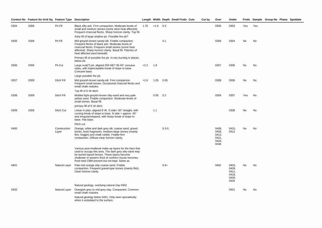
Context No Feature No Feature TypeGrid Sq. Description Length Width Depth Phase SpotdateGroup NoSmall Finds Cuts Cut by Over Under Finds Sample
0304 Black silty-ash. Firm compaction. Moderate levels of small and medium stones (some were heat affected). Frequent charcoal flecks. Sharp horizon clarity. Top fill.Ashy fill of large shallow pit. Possible fire pit?
1.76 >1.6 0.3Pit Fill 0305 0303 Yes Yes0306
0305 Mid greyish-brown sandy-silt. Friable compaction. Frequent flecks of black ash. Moderate levels of charcoal flecks. Frequent small stones (some heat affected). Sharp horizon clarity. Basal fill. Patches of heat affected sand beneath.Primary fill of possible fire pit. In-situ burning in places below pit.
0.1Pit Fill 0306 0304 No No0306
0306 Large oval(?) pit, aligned SW-NE? 35-45° concave sides, with imperceptible break of slope to base. Concave base.Large possible fire pit.
>2.2 1.8Pit Cut 0307 0305 No No0306
0307 Mid greyish-brown sandy-silt. Firm compaction. Frequent small stones. Occasional charcoal flecks and small chalk nodules.Top fill of E-W ditch.
>1.6 1.05 0.65Ditch Fill 0308 0306 No No0309
0308 Mottled light greyish-brown silty-sand and very pale yellow sand. Friable compaction. Moderate levels of small stones. Basal fill.primary fill of E-W ditch.
0.55 0.2Ditch Fill 0309 0307 Yes No0309
0309 Linear in plan, aligned E-W. S side= 50° straight, with curving break of slope to base. N side = approx. 40° and irregular/stepped, with sharp break of slope to base. Flat base.Ditch cut.
1.1Ditch Cut 0308 No No0309
0400 Orange, white and dark grey silt, coarse sand, gravel, bricks, brick fragments, medium-large stones (mainly flint, hoggin) and chalk rubble. Friable-firm compaction. Diffuse-clear horizon clarity.
Various post-medieval make-up layers for the barn that used to occupy this area. The dark grey silty-sand may be buried topsoil lenses. These layers become shallower in western third of northern house trenches. Post-med CBM present but not kept. Same as
0.3-0.Construction Layer
0408, 0406, 0412, 0421, 0433, 0436
0410, 0413
No No
0401 Pale-mid orange silty-coarse sand. Friable compaction. Frequent gravel-type stones (mainly flint). Clear horizon clarity.
Natural geology, overlying natural clay 0402.
0.6+Natural Layer 0402 0403, 0409, 0411, 0418, 0430, 0434
No No
0402 Orangish-grey to mid grey clay. Compacted. Common small chalk nodules.Natural geology below 0401. Only seen sporadically when it undulated to the surface.
Natural Layer 0401 No No

Context No Feature No Feature TypeGrid Sq. Description Length Width Depth Phase SpotdateGroup NoSmall Finds Cuts Cut by Over Under Finds Sample
0403 Unknown shape in plan. W side = 45°, irregular slope, with gradual break of slope to base. E side = sharp break of slope at surface. 80° straight slope, with rapidly curving break of slope to base. Irregular base which steps down at W end.Post-medieval pit containing decaying wood and glazed pot sherd. Probable refuse pit, hence deposit of wood and clay.
>1.65 >0.45 0.48Pit Cut 0409 0401, 0409
0404 No No0403
0404 Mid orangish-brown sand. Friable compaction. Common gravel-type stones. Diffuse horizon clarity. Basal fill.Basal fill of 0403.
0.4Pit Fill 0403 0405 No No0403
0405 Dark greyish-brown sandy-clay. Firm compaction. Occasional gravel-type stones. Clear horizon clarity.Pit fill. Contained large glazed pot sherd.
0.47Pit Fill 0404 0407 Yes No0403
0406 Dark brown decayed wood. Friable-firm compaction. Clear horizon clarity. Contemporary with 0407.Wooden post. Dug in through top of pit, but then cut itself by make up layer 0400. Could be contemporary with 0408.
0.3 0.36Wooden post Other
0408 0400 No No0406
0407 Orangish-grey clay. Compacted fill. Clear horizon clarity.Pit fill.
0.34Pit Fill 0405 0408 No No0403
0408 Greenish-grey clay. Compacted fill. Occasional small flints. Clear horizon clarity.Pit fill.
0.32Pit Fill 0407 0400, 0406
No No0403
0409 Mid orangish-brown silty-sand. Friable compaction. Common small-medium rounded flints. Clear horizon clarity.Sporadically recorded subsoil (B horizon).
Subsoil Layer 0403 0401 0403 No No
0410 Linear wall, aligned N-S. Vertical but irregular sides. Flat/slightly irregular base. Cuts 0400.Foundation of wall for barn that was only recently demolished. Made of irregular bricks and flint construction. Bricks are post-medieval (one kept).
0.35- 0.6Wall Other 0400 Yes No0410
0411 Unknown shape in plan - sub-circular? E side = 45°, concave slope. Gradually curving break of slope to base. W side = cut by 0413. Base is almost flat/slightly concave. Cut by 0413, under 0400.Post-medieval pit.
2.2 >1 0.55Pit Cut 0401 0412 No No0411
0412 Very dark brownish-grey clayey-silty-sand. Firm compaction. Common small-medium rounded flints. Clear horizon clarity. Basal/only fill.Post-medieval pit fill with CBM, animal bone and coke.
2.2 >1 0.55Pit Fill 0411 0400 Yes No0411
0413 Circular? 70-80° slightly concave sides. Abrupt break of slope at base at top of feature, with sharply curving break of slope to the base. Flat/slightly irregular base. Cuts 0400.Modern posthole cutting post-medieval make-up layers 0400 and still with decaying wood visible. Several other similar postholes of this age on site, which are only recorded in plan. Possibly associated with former barn.
0.58 0.6Posthole Cut 0400 0414 No No0413

Context No Feature No Feature TypeGrid Sq. Description Length Width Depth Phase SpotdateGroup NoSmall Finds Cuts Cut by Over Under Finds Sample
0414 Mid greyish-brown chalky-sand. Friable-firm compaction. One large brick fragments and one patch of dense compacted chalk packing. Clear horizon clarity.Post-medieval posthole fill. Chalk and CBM were used for post-packing.
0.58 0.6Posthole Fill 0413 0415 Yes No0413
0415 Dark brown decayed wood. Friable compaction. Friable compaction. Clear horizon clarity. Top fill/stake from posthole. Only partially surviving because of machining.Decaying stake from posthole.
0.2 0.55Posthole Fill 0414 No No0413
0416 Dark greyish-brown clay, silt and sand topsoil. Friable-firm compaction. Occasional small stones. Clear horizon clarity.Topsoil. Only present in west of trenches, outside of footprint of former barn. Not well sorted, so obviously vey modern. Uncertain relationship to 0410.
0.4-0.Topsoil Layer No No
0417 Mill stone. Circular in plan, with flat top and straight sides. One edge damaged. Square timber slot in centre. C.45° chamfer on edge between top and sides. 0.33m tall. Sides were textured with an engraved 10mm x 10mm grid pattern.Mill stone from former mill that stood on the site. Found near SW corner of the site, where locals apparently thought the mill used to be. Stone has been built into the front garden wall of the development.
1.34 1.32 0.33Mill stone Other
Yes No0417
0418 Linear feature, aligned N-S. 85° slightly concave sides. No fully excavated. Under/cut by layer 0420.Building foundation slot, hence depth, shape in section and presence of mortar lenses. However, it was probably robbed-out hence lack of building material. Not fully excavated due to limited space in trench and heavy compaction of 0419.
>0.5 0.7 >0.72Building slot Cut
0401 0419 No No0418
0419 Dark grey clay. Compacted material. Frequent charcoal flecks. 2-3 lenses of pale chalky material thought to be mortar remnants. Diffuse-clear horizon clarity with 0401 at the sides of the cut. Only recorded fill (cut not fully excavated).Back fill of robbed-out building slot. Consists of redeposited natural, occupation material and possible mortar from former structure.
>0.5 0.7 >0.72Building slot Fill
0418 0420 Yes Yes0418
0420 Mid-dark grey sandy-clay. Compacted material. Occasional charcoal flecks. Diffuse-clear lower horizon clarity. Same as layer 0209 from evaluation works.Thought to be the same layer as 0209 from the evaluation phase. Does not appear to be a floor surface, but may be associated with building demolition, particularly the robbing out of slot 0418.
0.08Demolition Layer
0419 0421 Yes No0420
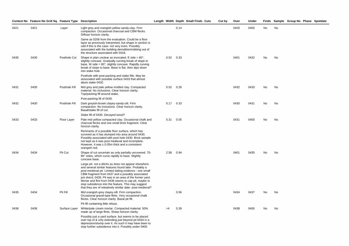
Context No Feature No Feature TypeGrid Sq. Description Length Width Depth Phase SpotdateGroup NoSmall Finds Cuts Cut by Over Under Finds Sample
0421 Light grey and orangish-yellow sandy-clay. Firm compaction. Occasional charcoal and CBM flecks. Diffuse horizon clarity.Same as 0206 from the evaluation. Could be a floor layer as previously interpreted, but shape in section is odd if this is the case- not very even. Possibly associated with the building demolition/robbing out of the structure associated with 0418.
0.14 Layer 0420 0400 No No0421
0430 Shape in plan unclear as truncated. E side = 60°, slightly concave. Gradually curving break of slope to base. W side = 80°, slightly concave. Rapidly curving break of slope to base. Base is flat, then dips down into stake hole.Posthole with post-packing and stake fills. May be associated with possible surface 0433 that almost abuts stake 0432.
0.52 0.33Posthole Cut 0401 0432 No No0430
0431 Mid grey and pale yellow mottled clay. Compacted material. No inclusions. Clear horizon clarity. Top/packing fill around stake.Post-packing fill of 0430.
0.52 0.26Posthole Fill 0432 0433 No No0430
0432 Dark greyish-brown clayey-sandy-silt. Firm compaction. No inclusions. Clear horizon clarity. Basal/stake fill of cut.Stake fill of 0430. Decayed wood?
0.17 0.33Posthole Fill 0430 0431 No No0430
0433 Pale-mid yellow compacted clay. Occasional chalk and charcoal flecks and one small brick fragment. Clear horizon clarity.Remnants of a possible floor surface, which has survived as it has slumped into area around 0430. Possibly associated with post hole 0430. Brick sample not kept as it was post medieval and incomplete. However, it was c.0.05m thick and a consistent orangish-red.
0.31 0.05Floor Layer 0431 0400 No No0433
0434 Shape of cut uncertain as only partially uncovered. 70-80° sides, which curve rapidly to base. Slightly concave base.Large pit- not a ditchs as does not appear elsewhere and several similar features found later. Probably a post-medieval pit. Limited dating evidence - one small CBM fragment from 0437 and a possibly associated pot sherd, 0439. Pit was in an area of the former yard. Mortar and flint from 0436 seems to cap pit, maybe to stop subsidence into the feature. This may suggest that they are of releatively similar date- post-medieval?
2.58 0.94Pit Cut 0401 0435 No No0434
0435 Mid orangish-grey clayey-silt. Firm compaction. Occasional gravel-type flints. Very occasional chalk flecks. Clear horizon clarity. Basal pit fill.Pit fill containing little refuse.
0.56Pit Fill 0434 0437 No No0434
0436 White/pale cream mortar. Compacted material. 50% made up of large flints. Sharp horizon clarity.Possibly just a yard surface, but seems to be placed over top of & only extending just beyond pit 0434 in a depression/slump over it. As such it may have been to stop further subsidence into it. Possibly under 0400.
>4 0.39Surface Layer 0438 0400 No No0436

Context No Feature No Feature TypeGrid Sq. Description Length Width Depth Phase SpotdateGroup NoSmall Finds Cuts Cut by Over Under Finds Sample
0437 Dark grey/black sandy-silt. Firm compaction. Occasional CBM, chalk and charcoal flecks. Clear horizon clarity. Middle fill of pit.Dump of hearth and general waste.
0.1Pit Fill 0435 0438 Yes No0434
0438 Mid grey clayey-silt. Firm compaction. Occasional gravel-type flints and chalk flecks. Diffuse-clear horizon clarity. Top pit fill.
0.34Pit Fill 0437 0436 No No0434
0439 One unstratified pot sherd. Found in base of trench next to section of pit 0434, so may be associated.
Unstratified Finds
Yes No
0450 Large pit, shape in plan unclear. 90° sides, curving to 45°, curving to slightly concave base. Cuts through the topsoil in this area.Large pit. Post-medieval of the same phase as the other pits on site. Similar in size, form and dark fill to other pits. Cuts through the topsoil indicating that it is quite recent and that the soil profile is not as disturbed in this part of the site as elsewhere. This would suggest that this house plot/area was less intensively used.
2.3 0.8Pit Cut 0451 No No0450
0451 Dark grey sandy-clayey-silt topsoil.
Topsoil A horizon. Less disturbed than topsoil elsewhere on site. Cut by pit 0450. Lack of hoggin layers, postholes and lower density of pits, and the presence of this topsoil indicates that this area was less disturbed than house plots 1 and 2.
0.5-6Topsoil Layer 0452 0450 No No
0452 Mid orangish-grey sandy-silt. Firm compaction. Occasional angular-rounded stones.Subsoil B horizon- mainly naturally derived but some leaching from 0451.
0.2-0.Subsoil Layer 0453 0451 No No
0453 Mottled orange and grey (mainly orange) sandy-clay. Firm compaction. Common small-medium mixed flints.Superficial geology of Lowestoft Formation - Diamicton material.
>1.1Subsoil Layer 0452 No No
0454 Linear wall, aligned E-W. Vertical but irregular sides. Flat/slightly irregular base.Foundation of wall for barn that was only recently demolished. Made of irregular bricks and flint construction. Bricks are post-medieval.
0.4Wall Other No No
0455 Post-medieval pit cut. Steep sided, with a fairly flat base. Not fully recorded.Post-medieval refuse pit. Part of a series of such pits found across the site.
Pit Cut No No0455
0456 Post-medieval pit cut. Steep sided, with a fairly flat base. Not fully recorded.Post-medieval refuse pit. Part of a series of such pits found across the site.
Pit Cut No No0456


Appendix 4. OASIS form
OASIS ID: suffolkc1-129213
Project details
Project name NRN 024 Mill Farm Evaluation and Monitoring, Norton
Short description of the project
An evaluation and monitoring were carried out at Mill Farm, The Street, Norton, in Suffolk. These works revealed evidence of medieval/post-medieval ditches, as well as several post-medieval pits, postholes, floor layers, walls and foundation slots. Further undated postholes were also excavated. The majority of the later structural features related to a complex of farm buildings that had been on the site, whilst the pits probably related to slightly earlier farmyard activity. Finds included medieval pottery, as well as post-medieval pottery, brick, tile, animal bone, glass, a nail and coal. Undated fired clay was also recovered, as were a piece of later prehistoric worked flint and several heated stone fragments. Environmental samples from the site indicated that light industrial processes had been carried out in the area at some point and that there had been waterlogging or flooding too. Some areas of the site had been slightly truncated by the laying of a post-medieval layer of aggregate across the site, which caused further damage to the underlying layers when it was machined off. However apart from this, archaeological features were well preserved.
Project dates Start: 25-05-2011 End: 20-04-2012
Previous/future work
No / No
Any associated project reference codes
NRN 024 - HER event no.
Any associated project reference codes
NRN 024 - Sitecode
Any associated project reference codes
Mid Suffolk 2323/09 - Planning Application No.
Any associated project reference codes
2012/054 - Contracting Unit No.
Type of project Recording project
Site status Area of Archaeological Importance (AAI)
Current Land use
Other 13 - Waste ground
Current Land use
Other 3 - Built over
Monument type DITCH Medieval
Monument type DITCH Post Medieval
Monument type PIT Post Medieval
Monument type FLOOR Post Medieval
Monument type FOUNDATION Post Medieval
Monument type POSTHOLE Post Medieval
Monument type PIT Uncertain

Monument type POSTHOLE Uncertain
Significant Finds POT Medieval
Significant Finds POT Post Medieval
Significant Finds LITHIC IMPLEMENT Late Prehistoric
Significant Finds BRICK Post Medieval
Significant Finds TILE Post Medieval
Significant Finds FIRED CLAY Uncertain
Significant Finds MORTAR Post Medieval
Investigation type
'''Test-Pit Survey''','''Watching Brief'''
Prompt Direction from Local Planning Authority - PPS
Project location
Country England
Site location SUFFOLK MID SUFFOLK NORTON NRN 024 Mill Farm Evaluation and Monitoring, Norton
Postcode IP31 3NA
Study area 4182.00 Square metres
Site coordinates TL 9599 6573 52 0 52 15 15 N 000 52 18 E Point
Project creators
Name of Organisation
Suffolk County Council Archaeological Service
Project brief originator
Local Authority Archaeologist and/or Planning Authority/advisory body
Project design originator
Jess Tipper
Project director/manager
Jo Caruth
Project supervisor
Rob Brooks
Type of sponsor/funding body
Developer
Name of sponsor/funding body
Wentworth Country Properties Ltd
Project archives
Physical Archive recipient
Suffolk County Council Archaeological Service
Physical Archive ID
J/115/3
Physical Contents
''Animal Bones'',''Ceramics'',''Environmental'',''Glass'',''Industrial'',''Metal'',''Worked stone/lithics''
Digital Archive recipient
Suffolk County Council Archaeological Service
Digital Archive ID
NRN 024
Digital Contents ''Animal

Bones'',''Ceramics'',''Environmental'',''Glass'',''Industrial'',''Metal'',''Stratigraphic'',''Survey'',''Worked stone/lithics'',''other''
Digital Media available
''Database'',''Images raster / digital photography'',''Spreadsheets'',''Survey'',''Text''
Paper Archive recipient
Suffolk County Council Archaeological Service
Paper Archive ID NRN 024
Paper Contents ''Animal Bones'',''Ceramics'',''Environmental'',''Glass'',''Industrial'',''Metal'',''Worked stone/lithics'',''other''
Paper Media available
''Context sheet'',''Correspondence'',''Notebook - Excavation',' Research',' General Notes'',''Plan'',''Report'',''Section'',''Survey '',''Unpublished Text''
Project bibliography 1
Publication type
Grey literature (unpublished document/manuscript)
Title Mill Farm, Norton, NRN 024, Archaeological Evaluation and Monitoring Report
Author(s)/Editor(s)
Brooks, R.
Other bibliographic details
SCCAS Report No. 2012/054
Date 2012
Issuer or publisher
SCCAS
Place of issue or publication
Bury St Edmunds
Description A4, comb-bound, white card cover, in colour, with 8 appendices, also available as a pdf
Entered by Rob Brooks ([email protected])
Entered on 11 July 2012
OASIS: Please e-mail English Heritage for OASIS help and advice © ADS 1996-2012 Created by Jo Gilham and Jen Mitcham, email Last modified Wednesday 9 May 2012 Cite only: http://www.oasis.ac.uk/form/print.cfm?ID=130063 for this page


Appendix 5. Bulk finds catalogueContext
No Wt No Wt No Wt No Wt No Wt No Wt No Wt No Wt No Wt No Wt No Wt No Wt No Wt No No WtNotePottery CBM
Plaster/Mortar
FiredClay
Clay Pipe
IronNails Slag
Post-Med GlassBottle Window
FlintWorked Burnt Ston
BonAnimal Human Shell
1 2 0 0 4 8 8 1 0 0 0 0 0 0 0 0 0 0 0 0 0 0 0 0 0 0 0 0 0 MortarCeramic Periods Med Overall Date L12th-14th C
0102
0 0 0 0 0 0 0 0 0 0 0 0 0 0 0 0 0 0 1 3 0 0 0 0 0 0 0 0 0Ceramic Periods Overall Date
0113
1 10 7 2922 0 0 0 0 0 0 0 0 0 0 1 21 0 0 0 0 0 0 0 0 0 0 0 0 0Ceramic Periods Med Overall Date L12th-14th C
0204
0 0 0 0 0 0 3 20 0 0 0 0 0 0 0 0 0 0 0 0 0 0 0 0 0 0 0 0 0Ceramic Periods Overall Date
0207
2 17 4 276 0 0 0 0 0 0 0 0 0 0 1 22 0 0 0 0 0 0 0 0 0 0 0 0 0Ceramic Periods Med Pmed Overall Date L12th-14th C/16th-18th C
0209
0 0 3 1637 0 0 0 0 0 0 0 0 0 0 0 0 0 0 0 0 0 0 0 0 0 0 0 0 0Ceramic Periods Overall Date
0210
0 0 1 2963 0 0 0 0 0 0 0 0 0 0 0 0 0 0 0 0 0 0 0 0 0 0 0 0 0Ceramic Periods Overall Date
0212
0 0 6 127 0 0 0 0 0 0 1 11 0 0 0 0 0 0 0 0 0 0 0 0 0 0 0 0 0Ceramic Periods Overall Date
0218
1 2 0 0 0 0 0 0 0 0 0 0 0 0 0 0 0 0 0 0 0 0 0 0 0 0 0 0 0Ceramic Periods ?Med Overall Date ?L12th-14th C
0222
0 0 3 8 0 0 0 0 0 0 0 0 0 0 0 0 0 0 0 0 0 0 0 0 0 0 0 0 0Ceramic Periods Overall Date
0224
0 0 1 926 0 0 0 0 0 0 0 0 0 0 0 0 0 0 0 0 0 0 0 0 0 0 0 0 0Ceramic Periods Overall Date
0302
4 5 0 0 0 0 0 0 0 0 0 0 0 0 0 0 0 0 0 0 39 477 0 0 0 0 0 0 0Ceramic Periods Med Overall Date
0304
1 57 2 303 0 0 3 41 0 0 0 0 0 0 0 0 0 0 0 0 0 0 0 0 0 0 0 0 0Ceramic Periods Med Overall Date 12th-14th C
0304
3 11 0 0 0 0 0 0 0 0 0 0 0 0 0 0 0 0 0 0 0 0 0 0 0 0 0 0 0Ceramic Periods Med Overall Date L12th-14th C
0308
1 151 0 0 0 0 0 0 0 0 0 0 0 0 0 0 0 0 0 0 0 0 0 0 0 0 0 0 0Ceramic Periods Pmed Overall Date 16th-18th C
0405
0 0 1 2906 0 0 0 0 0 0 0 0 0 0 0 0 0 0 0 0 0 0 0 0 0 0 0 0 0Ceramic Periods Overall Date
0410
0 0 3 47 0 0 0 0 0 0 0 0 0 0 0 0 0 0 0 0 0 0 0 0 1 9 0 0 0Ceramic Periods Overall Date
0412
0 0 1 1505 0 0 0 0 0 0 0 0 0 0 0 0 0 0 0 0 0 0 0 0 0 0 0 0 0Ceramic Periods Overall Date
0414
0 0 0 0 0 0 0 0 0 0 0 0 0 0 0 0 0 0 0 0 1 429 0 0 0 0 0 0 0Ceramic Periods Overall Date
0417
0 0 9 29 0 0 0 0 0 0 0 0 0 0 0 0 0 0 0 0 0 0 0 0 0 0 0 0 0Ceramic Periods Overall Date
0419
0 0 2 64 0 0 0 0 0 0 0 0 0 0 0 0 0 0 0 0 0 0 0 0 0 0 0 0 0Ceramic Periods Overall Date
0420
0 0 0 0 0 0 1 1 0 0 0 0 0 0 0 0 0 0 0 0 0 0 0 0 0 0 0 0 0Ceramic Periods Overall Date
0437
1 8 0 0 0 0 0 0 0 0 0 0 0 0 0 0 0 0 0 0 0 0 0 0 0 0 0 0 0Ceramic Periods Med Overall Date L12th-14th C
0439


Appendix 6. Pottery catalogue
Ctxt Fabric Form Dec No Wgt/g State Comments Context date
0102 MCW Body 1 2 Abr Reduced surface with ill sorted quartz L12th-14th C
0204 MCW Body 1 10 Sli Reduced with ill sorted quartz L12th-14th C
0209 MCW Body 1 13 Sli Reduced with ill sorted quartz and black iron ore. Part of a sagging base.
L12th-14th C/16th-18th C
0209 GRE Body Brown glaze 1 4 Abr
0222 ?MCW Body 1 2 Abr Reduced with ill sorted quartz L12th-14th C
0304 MCW Body 5 62 Abr-sli Partially reduced with ill sorted quartz and grog. One large sherd the others shattered fragments retrieved from sampling
12th-14th C
0308 MCW Body 3 11 Sli Reduced with ill sorted quartz L12th-14th C
0405 GRE Body Brown glaze 1 151 Sli 16th-18th C
0439 MCW Body 1 8 Sli Reduced with ill sorted quartz L12th-14th C


Appendix 7. CBM Catalogue
Ctxt Fabric Form No Wgt/g Height/mm Length Width Re-use Abr Mortar Notes Date
0204 Msfe RT 2 132 14 Sli On lower surface
Oxidised. Post-medieval
0204 Wsfe FB 1 295 33 Abr White 18th-19th C
0204 Msfe LB 1 562 Abr On all surfaces Oxidised. No measurable sides, mortar on breaks
Post-medieval
0204 Ms LB 1 1137 60 110 Abr On most surfaces
Oxidised. LB3+ - mortar on old shattered area
Post-medieval
0204 Msfe LB 1 793 Abr On all sides Oxidised. No measurable sides, mortar on all breaks
?Post-medieval
0204 Ms FRAG 1 3 Abr Oxidised Post-medieval
0209 Msfe LB 1 193 55 Abr Oxidised Post-medieval
0209 Msfe RT 3 83 13 Abr Oxidised Post-medieval
0210 Msfe LB 1 823 c55 Abr Oxidised with red iron ore Post-medieval

Ctxt Fabric Form No Wgt/g Height/mm Length Width Re-use Abr Mortar Notes Date
0210 Msfe RT 1 219 14 Abr Oxidised, some of the red iron ore looks like clay pellets
Post-medieval
0210 Msfe FB 1 595 33-35 110 Abr Oxidised Post-medieval
0212 Wsfe FB 1 2963 45 250 150 Sli White with red iron ore, a whole example
18th-19th C
0218 Msfe RT 6 127 14 Abr-sli On lower surface
Oxidised, one with sparse flint too
Post-medieval
0224 Msfe FRAG 3 8 Abr Oxidised, looks like roof tile
Post-medieval
0302 Wsfe RT 1 926 24 Abr White with common red iron ore, pan/curved tile fragment
18th-19th C
0304 Wsfe ?RT 2 303 23 Abr White with common red iron ore, pan/curved tile fragment
18th-19th C
0410 Ms?+ LB 1 2906 65 c 220 110 Sli On four sides Oxidised slightly burnt, not frogged like LB6
18th-19th C
0412 Msfe RT 3 47 13 Abr On three sides Oxidised Post-medieval
0414 Wsfe LB 1 1505 55 105 Abr White, no frog 18th-19th C
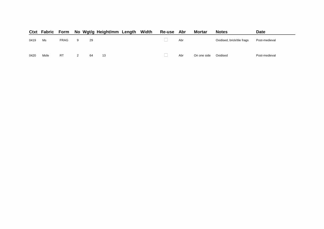
Ctxt Fabric Form No Wgt/g Height/mm Length Width Re-use Abr Mortar Notes Date
0419 Ms FRAG 9 29 Abr Oxidised, brick/tile frags Post-medieval
0420 Msfe RT 2 64 13 Abr On one side Oxidised Post-medieval


Appendix 8. Plant macrofossils and other remains catalogue
Sample No. 1 2 Context No. 0304 0419 Cut No. 0306 0418 Cereals Avena sp. (awn frags.) x
Hordeum sp. (grains) xx x
(rachis nodes) x
H. vulgare L. (asymetrical lateral grains) xcf
Hordeum/Secale cereale type (rachis nodes) x xw
Triticum sp. (grains) x x
T. aestivum/compactum type (rachis node) x
T. dicoccum Schubl (glume base) xcf
T. spelta L. (glume bases) x
Cereal indet. (grains) xx x
Herbs
Anthemis cotula L. x
Atriplex sp. x xw
Bromus sp. xx
Carduus sp. xw
Chenopodium album L. x
Chenopodiaceae indet. xx xw
Fabaceae indet. x
Fallopia convolvulus (L.)A.Love x
Lamium sp. xw
Lapsana communis L. xw
Onobrychis viciifolia Scop. xw
Persicaria maculosa/lapathifolia x xw
Polygonum aviculare L. xw
Prunella vulgaris L. xw
Ranunculus acris/repens/bulbosus xw
Rumex sp. x xxw
Sonchus asper (L.)Hill xw
Urtica dioica L. xxxw
U. urens L. xw
Wetland plants
Carex sp. x xw
Eleocharis sp. xw
Montia fontana L. x
Ranunculus sceleratus L. xxxxw
Tree/shrub macrofossils
Rubus idaeus L. xcfw
R. sect. glandulosus Wimmer & Grab xw
Sambucus nigra L. xw

Other plant macrofossils
Charcoal <2mm xxxx xxx
Charcoal >2mm xxxx xxx
Charcoal.5mm xxx
Charcoal.10mm xx
Charred root/stem x
Waterlogged root/stem xxxx
Indet.bud xw
Indet.culm nodes x xw
Indet.seeds x
Indet.thorn (Prunus type) xw
Other remains
Black porous 'cokey' material x
Black tarry material x
Burnt stone x
Ferrous fragments xxxx
Small coal frags. x
Vitreous material x
Waterlogged arthropod remains x
Sample volume (litres) 15 30 Volume of flot (litres) 0.4 <0.1 % flot sorted 25% 100%
Key to table x = 1 – 10 specimens xx = 11 – 50 specimens xxx = 51 – 100 specimens xxxx = 100+ specimens cf = compare w = de-watered


Archaeological services Field Projects Team Delivering a full range of archaeological services
• Desk-based assessments and advice
• Site investigation
• Outreach and educational resources
• Historic Building Recording
• Environmental processing
• Finds analysis and photography
• Graphics design and illustration
Contact:
Rhodri Gardner Tel: 01473 581743 Fax: 01473 288221 [email protected] www.suffolk.gov.uk/Environment/Archaeology/