Middle West Canada Creek Watershed - dec.ny.gov · H-240-180- P799-14-P807 to P810 Lake Tamarack,...
22
Middle West Canada Creek Watershed (0202000405) Water Index Number Waterbody Segment Category H-240-180 (portion 3) West Canada Creek, Middle, Main Stem (1203-0024) Impaired Seg H-240-180 (portion 4)/P799 Hinckley Reservoir (1203-0022) MinorImpacts H-240-180 (portion 5) West Canada Creek, Upp, and minor trib (1203-0008) Impaired Seg H-240-180- 55 Mill Creek, Upper, and tribs (1203-0034) NoKnownImpct H-240-180- 59 Cincinnati Creek, Lower, and tribs (1203-0010) MinorImpacts H-240-180- 59 Steuben Creek and tribs (1203-0013) MinorImpacts H-240-180- 59- 2 Cincinnati Creek, Upper, and minor tribs (1203-0035) MinorImpacts H-240-180- 59- 2-2 Cady Brook and tribs (1203-0036) UnAssessed H-240-180- P799- 1 thru 21 Minor Tribs to Hinckley Reservoir (1203-0037) NoKnownImpct H-240-180- P799- 5-P803a Lake Gay (1203-0038) UnAssessed H-240-180- P799-11-808a Finches Pond (1203-0039) UnAssessed H-240-180- P799-14-P807 to P810 Lake Tamarack, Tom Kettle and Curtis Lks (1203-0040) UnAssessed H-240-180- P799-19 Black Creek, Lower, and minor tribs (1203-0041) NoKnownImpct H-240-180- P799-19 Black Creek, Upper, and tribs (1203-0072) UnAssessed H-240-180- P799-19- 4 Ash Creek and tribs (1203-0042) UnAssessed (con’t)
Transcript of Middle West Canada Creek Watershed - dec.ny.gov · H-240-180- P799-14-P807 to P810 Lake Tamarack,...

Middle West Canada Creek Watershed (0202000405)
Water Index Number Waterbody Segment Category H-240-180 (portion 3) West Canada Creek, Middle, Main Stem (1203-0024) Impaired Seg H-240-180 (portion 4)/P799 Hinckley Reservoir (1203-0022) MinorImpacts H-240-180 (portion 5) West Canada Creek, Upp, and minor trib (1203-0008) Impaired Seg H-240-180- 55 Mill Creek, Upper, and tribs (1203-0034) NoKnownImpct H-240-180- 59 Cincinnati Creek, Lower, and tribs (1203-0010) MinorImpacts H-240-180- 59 Steuben Creek and tribs (1203-0013) MinorImpacts H-240-180- 59- 2 Cincinnati Creek, Upper, and minor tribs (1203-0035) MinorImpacts H-240-180- 59- 2-2 Cady Brook and tribs (1203-0036) UnAssessed H-240-180- P799- 1 thru 21 Minor Tribs to Hinckley Reservoir (1203-0037) NoKnownImpct H-240-180- P799- 5-P803a Lake Gay (1203-0038) UnAssessed H-240-180- P799-11-808a Finches Pond (1203-0039) UnAssessed H-240-180- P799-14-P807 to P810 Lake Tamarack, Tom Kettle and Curtis Lks (1203-0040) UnAssessed H-240-180- P799-19 Black Creek, Lower, and minor tribs (1203-0041) NoKnownImpct H-240-180- P799-19 Black Creek, Upper, and tribs (1203-0072) UnAssessed H-240-180- P799-19- 4 Ash Creek and tribs (1203-0042) UnAssessed (con’t)
Middle West Canada Creek Watershed (con’t) (0202000405)
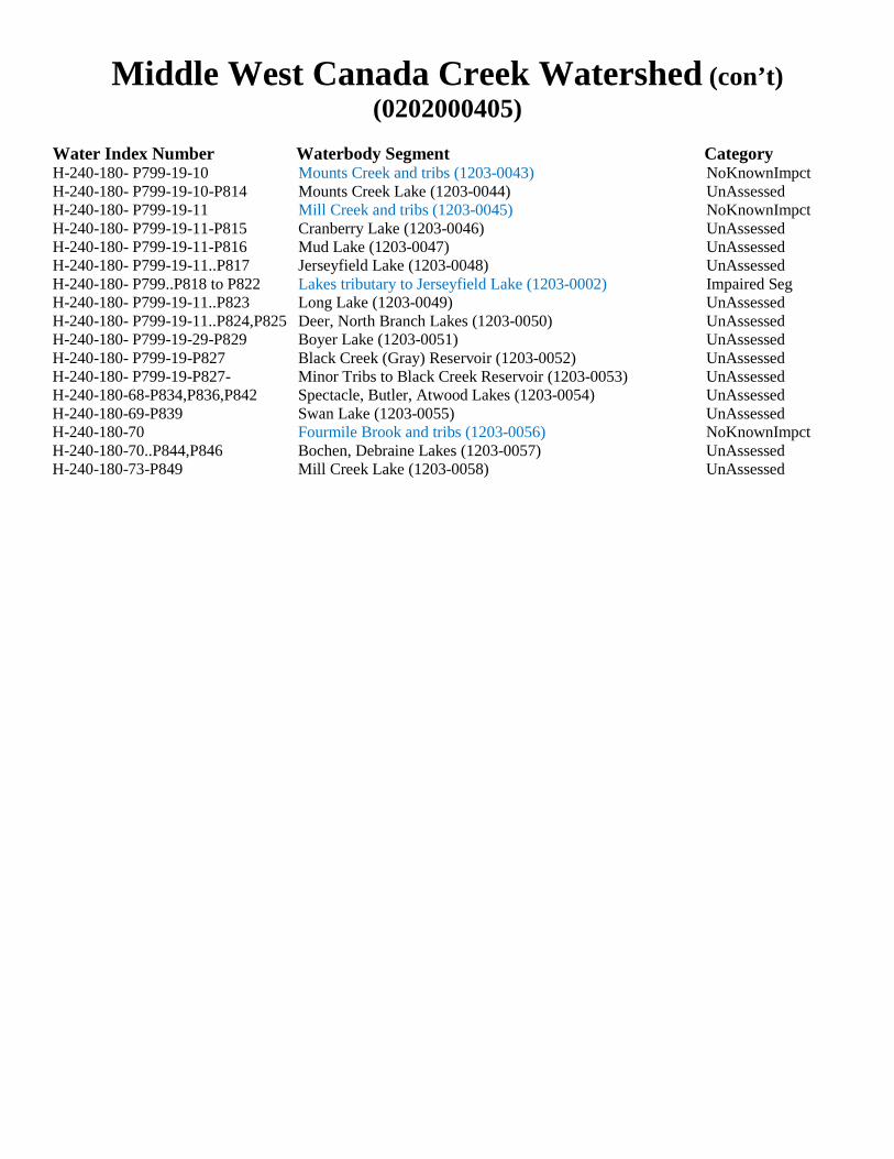
Water Index Number Waterbody Segment Category H-240-180- P799-19-10 Mounts Creek and tribs (1203-0043) NoKnownImpct H-240-180- P799-19-10-P814 Mounts Creek Lake (1203-0044) UnAssessed H-240-180- P799-19-11 Mill Creek and tribs (1203-0045) NoKnownImpct H-240-180- P799-19-11-P815 Cranberry Lake (1203-0046) UnAssessed H-240-180- P799-19-11-P816 Mud Lake (1203-0047) UnAssessed H-240-180- P799-19-11..P817 Jerseyfield Lake (1203-0048) UnAssessed H-240-180- P799..P818 to P822 Lakes tributary to Jerseyfield Lake (1203-0002) Impaired Seg H-240-180- P799-19-11..P823 Long Lake (1203-0049) UnAssessed H-240-180- P799-19-11..P824,P825 Deer, North Branch Lakes (1203-0050) UnAssessed H-240-180- P799-19-29-P829 Boyer Lake (1203-0051) UnAssessed H-240-180- P799-19-P827 Black Creek (Gray) Reservoir (1203-0052) UnAssessed H-240-180- P799-19-P827- Minor Tribs to Black Creek Reservoir (1203-0053) UnAssessed H-240-180-68-P834,P836,P842 Spectacle, Butler, Atwood Lakes (1203-0054) UnAssessed H-240-180-69-P839 Swan Lake (1203-0055) UnAssessed H-240-180-70 Fourmile Brook and tribs (1203-0056) NoKnownImpct H-240-180-70..P844,P846 Bochen, Debraine Lakes (1203-0057) UnAssessed H-240-180-73-P849 Mill Creek Lake (1203-0058) UnAssessed
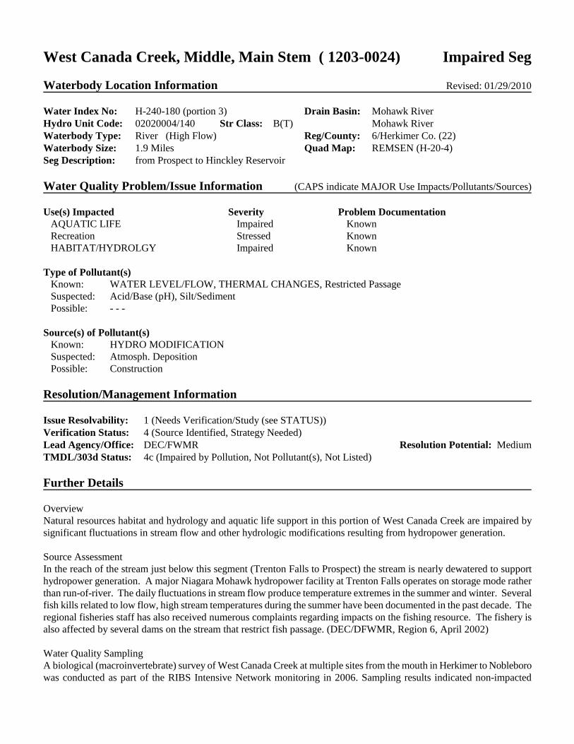
West Canada Creek, Middle, Main Stem ( 1203-0024) Impaired Seg Waterbody Location Information Revised: 01/29/2010 Water Index No: H-240-180 (portion 3) Drain Basin: Mohawk River Hydro Unit Code: 02020004/140 Str Class: B(T) Mohawk River Waterbody Type: River (High Flow) Reg/County: 6/Herkimer Co. (22) Waterbody Size: 1.9 Miles Quad Map: REMSEN (H-20-4) Seg Description: from Prospect to Hinckley Reservoir Water Quality Problem/Issue Information (CAPS indicate MAJOR Use Impacts/Pollutants/Sources) Use(s) Impacted Severity Problem Documentation
AQUATIC LIFE Impaired Known Recreation Stressed Known HABITAT/HYDROLGY Impaired Known Type of Pollutant(s)
Known: WATER LEVEL/FLOW, THERMAL CHANGES, Restricted Passage Suspected: Acid/Base (pH), Silt/Sediment Possible: - - -
Source(s) of Pollutant(s) Known: HYDRO MODIFICATION Suspected: Atmosph. Deposition Possible: Construction
Resolution/Management Information Issue Resolvability: 1 (Needs Verification/Study (see STATUS)) Verification Status: 4 (Source Identified, Strategy Needed) Lead Agency/Office: DEC/FWMR Resolution Potential: Medium TMDL/303d Status: 4c (Impaired by Pollution, Not Pollutant(s), Not Listed) Further Details Overview Natural resources habitat and hydrology and aquatic life support in this portion of West Canada Creek are impaired by significant fluctuations in stream flow and other hydrologic modifications resulting from hydropower generation. Source Assessment In the reach of the stream just below this segment (Trenton Falls to Prospect) the stream is nearly dewatered to support hydropower generation. A major Niagara Mohawk hydropower facility at Trenton Falls operates on storage mode rather than run-of-river. The daily fluctuations in stream flow produce temperature extremes in the summer and winter. Several fish kills related to low flow, high stream temperatures during the summer have been documented in the past decade. The regional fisheries staff has also received numerous complaints regarding impacts on the fishing resource. The fishery is also affected by several dams on the stream that restrict fish passage. (DEC/DFWMR, Region 6, April 2002) Water Quality Sampling A biological (macroinvertebrate) survey of West Canada Creek at multiple sites from the mouth in Herkimer to Nobleboro was conducted as part of the RIBS Intensive Network monitoring in 2006. Sampling results indicated non-impacted

conditions at all except the most upstream site in Nobleboro. Within this segment, this survey included sites just below the reach in Trenton Falls (at Trenton Falls Road) which was assessed as having non-impacted water quality. Such samples are dominated by clean-water species and are most similar to a natural community with minimal human impacts. Some additional species, including sensitive non-native species, and additional biomass may be present; the samples reveal no, or only incidental, anomalies. Aquatic life community is fully supported. (DEC/DOW, BWAM/SBU, January 2010) The 2006 results are consistent with biological assessments of West Canada Creek conducted in Trenton Falls in 2000 and 2001. All sampling results indicated non-impacted water quality conditions. The Trenton Falls samples were field-assessed. (DEC/DOW, BWAR/SBU, July 2002) Previous Assessment Local concerns regarding mining activities have been investigated by DEC Mineral Resources staff. There were only two mines identified in the segment watershed and these were found to pose no concern or impacts to the creek. (DEC/DMR, Region 6, October 2002) Segment Description This segment includes the portion of the stream from the Niagara Mohawk Dam near Prospect to Hinckley Dam at the mouth of the reservoir in Hinckley. The waters of this portion of the stream are Class B(T).
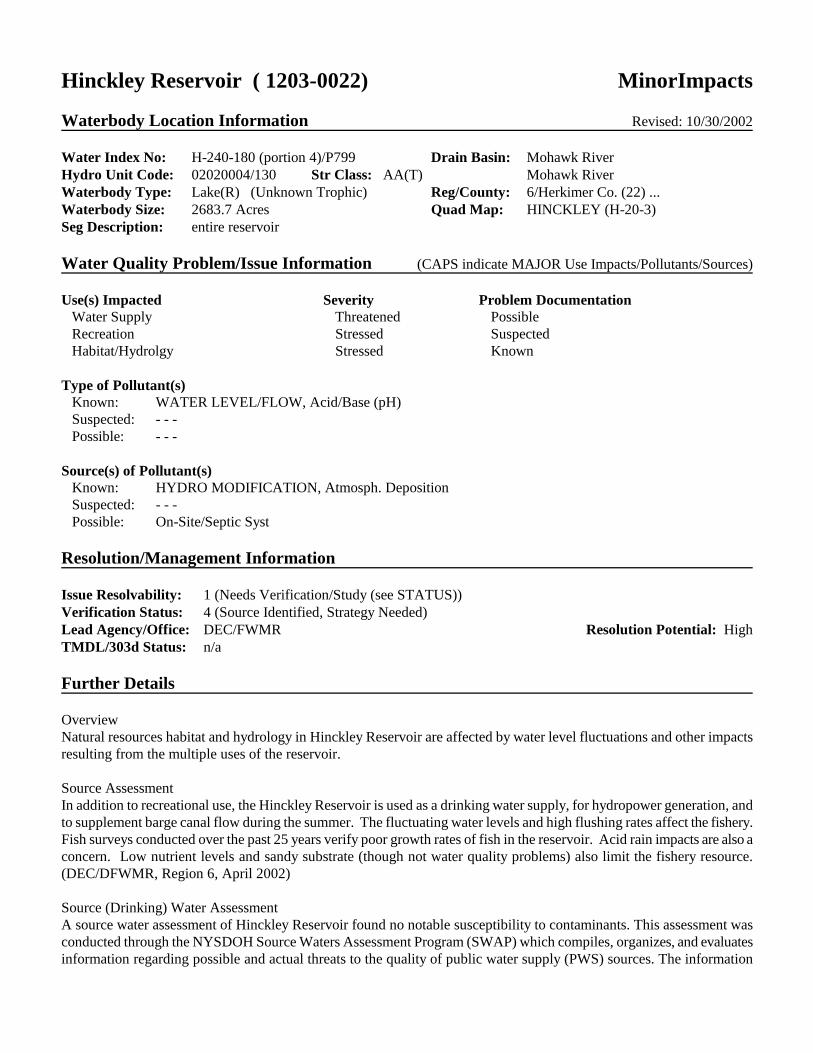
Hinckley Reservoir ( 1203-0022) MinorImpacts Waterbody Location Information Revised: 10/30/2002 Water Index No: H-240-180 (portion 4)/P799 Drain Basin: Mohawk River Hydro Unit Code: 02020004/130 Str Class: AA(T) Mohawk River Waterbody Type: Lake(R) (Unknown Trophic) Reg/County: 6/Herkimer Co. (22) ... Waterbody Size: 2683.7 Acres Quad Map: HINCKLEY (H-20-3) Seg Description: entire reservoir Water Quality Problem/Issue Information (CAPS indicate MAJOR Use Impacts/Pollutants/Sources) Use(s) Impacted Severity Problem Documentation
Water Supply Threatened Possible Recreation Stressed Suspected Habitat/Hydrolgy Stressed Known Type of Pollutant(s)
Known: WATER LEVEL/FLOW, Acid/Base (pH) Suspected: - - - Possible: - - -
Source(s) of Pollutant(s) Known: HYDRO MODIFICATION, Atmosph. Deposition Suspected: - - - Possible: On-Site/Septic Syst
Resolution/Management Information Issue Resolvability: 1 (Needs Verification/Study (see STATUS)) Verification Status: 4 (Source Identified, Strategy Needed) Lead Agency/Office: DEC/FWMR Resolution Potential: High TMDL/303d Status: n/a Further Details Overview Natural resources habitat and hydrology in Hinckley Reservoir are affected by water level fluctuations and other impacts resulting from the multiple uses of the reservoir. Source Assessment In addition to recreational use, the Hinckley Reservoir is used as a drinking water supply, for hydropower generation, and to supplement barge canal flow during the summer. The fluctuating water levels and high flushing rates affect the fishery. Fish surveys conducted over the past 25 years verify poor growth rates of fish in the reservoir. Acid rain impacts are also a concern. Low nutrient levels and sandy substrate (though not water quality problems) also limit the fishery resource. (DEC/DFWMR, Region 6, April 2002) Source (Drinking) Water Assessment A source water assessment of Hinckley Reservoir found no notable susceptibility to contaminants. This assessment was conducted through the NYSDOH Source Waters Assessment Program (SWAP) which compiles, organizes, and evaluates information regarding possible and actual threats to the quality of public water supply (PWS) sources. The information

contained in SWAP assessment reports assists in the oversight and protection of public water systems. It is important to note that SWAP reports estimate the potential for untreated drinking water sources to be impacted by contamination and do not address the quality of treated finished potable tap water. This water supply source provides water to... (NYSDOH, Source Water Assessment Program, 2005) Hinckley Reservoir has been designated a Class AA water, suitable for use as a drinking water supply. The Class AA designation means the waters require minimal additional treatment (including disinfection) to remove only naturally occurring impurities in order to be considered safe and satisfactory for drinking water use. As a result of this designation, the stream is considered a highly valued resource and may be subject to special protections from possible threats to water quality. The reservoir is used as drinking water supply for a large population in and around the City of Utica (more than 125,000) Water Quality Management The Upper Mohawk Valley Region Water Board (UMVRWB) completed a comprehensive watershed assessment USEPA grant in 2001. This grant included significant watershed activities related to changing biological, chemical and physical conditions monitoring in the reservoir and eight tributaries. Additional work conducted by UMVRWB includes a detailed septic survey to identify failing on-site septic systems and the dissemination of survey results to surrounding municipalities, power generating facilities and the general public. Continued monthly monitoring of various sites within the watershed, coupled with an aggressive stakeholder cooperation/networking initiative has elevated public participation in maintaining the overall health of the reservoir. (Herkimer County WQCC and UMVRWB, March 2002) Segment Description This segment includes the entire reservoir from the Hinckley Dam at the mouth of the reservoir in Hinckley to McIntosh/Harvey Bridge. The waters of the reservoir are Class AA(T).

West Canada Creek, Upp, and minor trib ( 1203-0008) Impaired Seg Waterbody Location Information Revised: 01/29/2010 Water Index No: H-240-180 (portion 5) Drain Basin: Mohawk River Hydro Unit Code: 02020004/120 Str Class: A(T) Mohawk River Waterbody Type: River (Low Flow) Reg/County: 6/Herkimer Co. (22) Waterbody Size: 43.8 Miles Quad Map: OHIO (H-21-0) Seg Description: stream and selected tribs, Hinckley Res to Nobleboro Water Quality Problem/Issue Information (CAPS indicate MAJOR Use Impacts/Pollutants/Sources) Use(s) Impacted Severity Problem Documentation
AQUATIC LIFE Precluded Known Type of Pollutant(s)
Known: ACID/BASE (PH) Suspected: - - - Possible: - - -
Source(s) of Pollutant(s) Known: ATMOSPH. DEPOSITION Suspected: - - - Possible: - - -
Resolution/Management Information Issue Resolvability: 1 (Needs Verification/Study (see STATUS)) Verification Status: 4 (Source Identified, Strategy Needed) Lead Agency/Office: ext/EPA Resolution Potential: Low TMDL/303d Status: 2a (Multiple Segment/Categorical Water, Atmosph Dep) Further Details Overview Aquatic life in this portion of West Canada Creek is thought to be impaired due to low pH from atmospheric deposition (acid rain). Water Quality Sampling Previous fishery surveys indicate that low pH due to atmospheric deposition (acid rain) is significantly limiting the fishery in portions of Upper West Canada Creek. These waters are subject of episodic acidification: short-term yet significant decreases in acid neutralizing capacity (ANC) that may occur during high streamflow/runoff events (i.e., spring runoff, snowmelt). Although these events are periodic, bioassays and other fishery studies show that the impact on the fishery can be significant and long-lasting. (DEC/DFWMR, Region 6, 2000) A biological (macroinvertebrate) survey of West Canada Creek at multiple sites from the mouth in Herkimer to Nobleboro was conducted as part of the RIBS Intensive Network monitoring in 2006. Sampling results indicated non-impacted conditions at all except the most upstream site in Nobleboro, where indices slipped into the range of slightly impacted. Within this segment, this survey included sites in McIntosh Bridge (at Harvey Road) and Nobleboro (at Route 8). The downstream site in McIntosh Bridge was assessed as having non-impacted water quality. Such samples are dominated by clean-water species and are most similar to a natural community with minimal human impacts. Some additional species,
including sensitive non-native species, and additional biomass may be present; the samples reveal no, or only incidental, anomalies. The Nobleboro site was found to be just into the range of slightly impacted, due to nutrient enrichment. This was attributed to elevated nitrate levels from atmospheric deposition which causes increased algal growth in the stream. (DEC/DOW, BWAM/SBU, January 2010) This stream is included in a network of water quality sampling sites monitored by the Herkimer County Water Quality Coordinating Committee. (Herkimer County WQCC, 2000). Water Quality Management Efforts are underway on a national level to address problems caused by acid rain by reducing pollutant emissions, as required by the Clean Air Act. New York State (and other northeastern states) have taken legal action against USEPA to accelerate implementation of controls. Monitoring of these waters will continue, in order to assess changes in water quality resulting from implementation of the Clean Air Act. However, these changes are expected to occur only slowly over time. Section 303d Listing This portion of West Canada Creek is included on the NYS 2008 Section 303(d) List of Impaired Waters. The lake is included on Part 2a of the List as an Atmospheric Deposition (Acid Rain) Water. Segment Description This segment includes the portion of the stream and selected/smaller tribs from McIntosh/Harvey Bridge to the Nobleboro Dam in Nobleboro. The waters of this portion of the stream are Class A(T). Tribs to this reach/segment, including Mad Tom Brook (-66) and Mill Creek (-73), are Class A,A(T). Fourmile Brook (-70) is listed separately.

Mill Creek, Upper, and tribs ( 1203-0034) NoKnownImpct Waterbody Location Information Revised: 08/19/2002 Water Index No: H-240-180- 55 Drain Basin: Mohawk River Hydro Unit Code: 02020004/140 Str Class: AA(T) Mohawk River Waterbody Type: River (Low Flow) Reg/County: 6/Herkimer Co. (22) Waterbody Size: 8.2 Miles Quad Map: HINCKLEY (H-20-3) Seg Description: stream and tribs, above Herkimer water supply dam Water Quality Problem/Issue Information (CAPS indicate MAJOR Use Impacts/Pollutants/Sources) Use(s) Impacted Severity Problem Documentation
NO USE IMPAIRMNT Type of Pollutant(s)
Known: - - - Suspected: - - - Possible: - - -
Source(s) of Pollutant(s) Known: - - - Suspected: - - - Possible: - - -
Resolution/Management Information Issue Resolvability: 8 (No Known Use Impairment) Verification Status: (Not Applicable for Selected RESOLVABILITY) Lead Agency/Office: n/a Resolution Potential: n/a TMDL/303d Status: n/a Further Details Water Quality Sampling A biological (macroinvertebrate) assessment of Mill Creek at the mouth in Gravesville was conducted in 2000. Field sampling results indicated non-impacted water quality conditions. The sample satisfied field screening criteria and was returned to the stream. Though this sampling point is below the described segment, it is considered representative of water quality in the upper reach. (DEC/DOW, BWAR/SBU, July 2002) Segment Description This segment includes the portion of the stream above the Herkimer water supply dam, and the upper reach of Taylor Brook, above a point 0.5 miles above the mouth. The waters of these portions of the stream, and their tribs, are Class AA.
Cincinnati Creek, Lower, and tribs ( 1203-0010) MinorImpacts Waterbody Location Information Revised: 04/02/2010 Water Index No: H-240-180- 59 Drain Basin: Mohawk River Hydro Unit Code: 02020004/140 Str Class: C(T) Mohawk River Waterbody Type: River (Low Flow) Reg/County: 6/Oneida Co. (33) Waterbody Size: 7.8 Miles Quad Map: SOUTH TRENTON (I-20-1) Seg Description: stream and tribs, from mouth to Barneveld Water Quality Problem/Issue Information (CAPS indicate MAJOR Use Impacts/Pollutants/Sources) Use(s) Impacted Severity Problem Documentation
Recreation Stressed Known Type of Pollutant(s)
Known: NUTRIENTS (phosphorus), PATHOGENS Suspected: Silt/Sediment Possible: - - -
Source(s) of Pollutant(s) Known: - - - Suspected: AGRICULTURE, ON-SITE/SEPTIC SYST (Barneveld) Possible: Urban/Storm Runoff
Resolution/Management Information Issue Resolvability: 1 (Needs Verification/Study (see STATUS)) Verification Status: 4 (Source Identified, Strategy Needed) Lead Agency/Office: DOW/Reg6 Resolution Potential: Medium TMDL/303d Status: n/a Further Details Overview Recreational uses (fishing, swimming) in Cincinnati Creek are known to experience impacts due to nutrient enrichment and pathogens attributed primarily to nonpoint sources within the watershed. Urban runoff in the small population centers, some agricultural activity and failing/inadequate on-site septic systems (in Barneveld) are suspected sources of pollutants to the stream. Water Quality Sampling NYSDEC Rotating Integrated Basin Studies (RIBS) Intensive Network monitoring of Cincinnati Creek at the head of this reach in Barneveld, Herkimer County, (at Park Street) was conducted in 2006. Intensive Network sampling typically includes macroinvertebrate community analysis, water column chemistry, toxicity testing, sediment assessment and macroinvertebrate tissue analysis. Biological (macroinvertebrate) sampling indicated non-impacted conditions. Such samples are dominated by clean-water species and are most similar to a natural community with minimal human impacts. Some additional species, including sensitive non-native species, and additional biomass may be present; the samples reveal no, or only incidental, anomalies. Water column chemistry indicates pathogens (coliform) to be present at levels that constitute parameters of concern. Toxicity testing using water from this location detected no significant mortality or reproductive effects on the test organism. Sediment screening for acute toxicity indicated no sediment toxicity. A biological assessment of Cincinnati Creek was also conducted in Mapledale (at Route 28) as part of the RIBS biological

screening effort in 2005. Sampling results indicated non-impacted conditions. Such samples are dominated by clean-water species and are most similar to a natural community with minimal human impacts. Some additional species, including sensitive non-native species, and additional biomass may be present; the samples reveal no, or only incidental, anomalies. Aquatic life community is fully supported. (DEC/DOW, BWAM/SBU, January 2010) Based on the consensus of these established assessment methods, overall water quality at this site is mostly satisfactory, although pathogen levels and sources should continue to be monitored. Aquatic life is fully supported, in spite of some nutrient enrichment in the stream. (DEC/DOW, BWAM/RIBS, January 2010) RIBS Intensive Network monitoring of Cincinnati Creek in Barneveld (at Park Street) was also conducted in 2001. A biological (macroinvertebrate) survey of Cincinnati Creek at multiple sites from Mapledale to Remsen was conducted in 2000 as part of the RIBS effort. The Prospect site (just above this reach) was assessed as slightly impacted by nonpoint enrichment, and the Mapledale site was assessed as non-impacted, although some enrichment was still evident. Both sites had ample mayflies, stoneflies, and caddisflies. Sampling in 2001 at Barneveld (at the head of this reach) resulted in an assessment of slight impact, also due to nutrient enrichment. The results of water column sampling showed elevated fecal coliform levels, but no other significant parameters of concern in the water column. Sediment analysis revealed no organic compounds or metals to be present at or above levels of concern and no acute or chronic toxicity was indicated based on 3 tests. No organic compounds or metals were found in invertebrate tissues above levels of concern. (DEC/DOW, BWAR/RIBS, April 2003) Segment Description This segment includes the portion of the stream and all tribs from the mouth to Steuben Creek near Barneveld. The waters of this portion of the stream are Class C(T). Tribs to this reach/segment, including the portion of the feeder canal east of Route 12 are Class C,C(T).
Steuben Creek and tribs ( 1203-0013) MinorImpacts Waterbody Location Information Revised: 02/10/2010 Water Index No: H-240-180- 59 Drain Basin: Mohawk River Hydro Unit Code: 02020004/140 Str Class: C Mohawk River Waterbody Type: River (Low Flow) Reg/County: 6/Oneida Co. (33) Waterbody Size: 44.7 Miles Quad Map: REMSEN (H-20-4) Seg Description: entire stream and tribs Water Quality Problem/Issue Information (CAPS indicate MAJOR Use Impacts/Pollutants/Sources) Use(s) Impacted Severity Problem Documentation
Aquatic Life Stressed Known HABITAT/HYDROLGY Impaired Known Type of Pollutant(s)
Known: SILT/SEDIMENT, THERMAL CHANGES, Nutrients Suspected: - - - Possible: - - -
Source(s) of Pollutant(s) Known: AGRICULTURE, STREAMBANK EROSION Suspected: - - - Possible: - - -
Resolution/Management Information Issue Resolvability: 1 (Needs Verification/Study (see STATUS)) Verification Status: 4 (Source Identified, Strategy Needed) Lead Agency/Office: DEC/FWMR Resolution Potential: Medium TMDL/303d Status: 4c (Impaired by Pollution, Not Pollutant(s), Not Listed) Further Details Overview Natural resources habitat and hydrology in Steuben Creek are impaired by siltation, excessive sediment loadings and thermal stresses to the stream. Agricultural activities have resulted in modification of the stream habitat. Aquatic life is also considered to experience minor impacts from nutrient enrichment related to the agricultural sources. Source Assessment Poor agricultural (grazing) practices have resulted in the loss of riparian buffers. Open banks with little or no canopy cover cause high temperatures, reducing the potential for cold water fisheries. Fishery surveys over the past decade reveal a poor fish community structure, particularly the absence of salmonids. The natural condition and habitat of this stream would appear to support a cold water fishery if not for high temperatures. (DEC/DFWMR, Region 6, April 2002) Water Quality Sampling A biological (macroinvertebrate) assessment of Steuben Creek in Barnveld (at McDonald Road) was conducted as part of the RIBS biological screening effort in 2005. Sampling results indicated slightly impacted conditions. In such samples some replacement of sensitive ubiquitous species by more tolerant species occurs, although the sample also includes a balanced distribution of all expected species. Aquatic life is considered to be fully supported in the stream, however the

community composition and nutrient biotic evaluation suggest conditions and levels of enrichment are sufficient to cause some stress to aquatic life. Impact source determination found the fauna to be most similar to communities influenced by nonpoint sources of nutrient enrichment. These results are consistent with sampling conducted at this site in 2000. (DEC/DOW, BWAM/SBU, January 2010) Segment Description This segment includes the entire stream (above the Cincinnati Creek confluence) and all tribs. The waters of the stream are Class C,C(T). Tribs to this reach/segment, including Shepards Brook (-6), are Class C,C(T),C(TS).

Cincinnati Creek, Upper, and minor tribs ( 1203-0035) MinorImpacts Waterbody Location Information Revised: 04/02/2010 Water Index No: H-240-180- 59- 2 Drain Basin: Mohawk River Hydro Unit Code: 02020004/140 Str Class: C Mohawk River Waterbody Type: River (Low Flow) Reg/County: 6/Oneida Co. (33) Waterbody Size: 44.4 Miles Quad Map: REMSEN (H-20-4) Seg Description: stream and selected tribs, above Barneveld Water Quality Problem/Issue Information (CAPS indicate MAJOR Use Impacts/Pollutants/Sources) Use(s) Impacted Severity Problem Documentation
Recreation Stressed Known Type of Pollutant(s)
Known: PATHOGENS Suspected: NUTRIENTS, Silt/Sediment Possible: - - -
Source(s) of Pollutant(s) Known: - - - Suspected: AGRICULTURE, ON-SITE/SEPTIC SYST, Urban/Storm Runoff Possible: - - -
Resolution/Management Information Issue Resolvability: 1 (Needs Verification/Study (see STATUS)) Verification Status: 4 (Source Identified, Strategy Needed) Lead Agency/Office: DOW/Reg6 Resolution Potential: Medium TMDL/303d Status: n/a Further Details Overview Recreational uses (fishing, swimming) in this portion of Cincinnati Creek are known to experience impacts due to nutrient enrichment and pathogens attributed primarily to nonpoint sources within the watershed. Urban runoff in the small population centers, some agricultural activity and failing/inadequate on-site septic systems (in Barneveld) are suspected sources of pollutants to the stream. Water Quality Sampling NYSDEC Rotating Integrated Basin Studies (RIBS) Intensive Network monitoring of Cincinnati Creek at the base of this reach in Barneveld, Herkimer County, (at Park Street) was conducted in 2006. Intensive Network sampling typically includes macroinvertebrate community analysis, water column chemistry, toxicity testing, sediment assessment and macroinvertebrate tissue analysis. Biological (macroinvertebrate) sampling indicated non-impacted conditions. Such samples are dominated by clean-water species and are most similar to a natural community with minimal human impacts. Some additional species, including sensitive non-native species, and additional biomass may be present; the samples reveal no, or only incidental, anomalies. Water column chemistry indicates pathogens (coliform) to be present at levels that constitute parameters of concern. Toxicity testing using water from this location detected no significant mortality or reproductive effects on the test organism. Sediment screening for acute toxicity indicated no sediment toxicity. Based on the consensus of these established assessment methods, overall water quality at this site is mostly satisfactory, although
pathogen levels and sources should continue to be monitored. Aquatic life is fully supported, in spite of some nutrient enrichment in the stream. (DEC/DOW, BWAM/RIBS, January 2010) RIBS Intensive Network monitoring of Cincinnati Creek in Barneveld (at Park Street) was also conducted in 2001. A biological (macroinvertebrate) survey of Cincinnati Creek at multiple sites from Mapledale to Remsen was conducted in 2000 as part of the RIBS effort. The Prospect site (just above this reach) was assessed as slightly impacted by nonpoint enrichment, and the Mapledale site was assessed as non-impacted, although some enrichment was still evident. Both sites had ample mayflies, stoneflies, and caddisflies. Sampling in 2001 at Barneveld (at the head of this reach) resulted in an assessment of slight impact, also due to nutrient enrichment. The results of water column sampling showed elevated fecal coliform levels, but no other significant parameters of concern in the water column. Sediment analysis revealed no organic compounds or metals to be present at or above levels of concern and no acute or chronic toxicity was indicated based on 3 tests. No organic compounds or metals were found in invertebrate tissues above levels of concern. (DEC/DOW, BWAR/RIBS, April 2003) Previous Assessment Previously cited raw sewage discharges from individual household systems and failed septic systems in Remsen have been addressed by the construction of a new WWTP. (DEC/DOW, Region 6, April 2002). Segment Description This segment includes the portion of the stream and selected/smaller tribs above the confluence with Steuben Creek in Barneveld. The waters of the stream are Class C,C(T),C(TS). Tribs to this reach/segment, including Mud Brook (-4), are also Class C,C(T),C(TS). Cady Brook (-2-2) is listed separately.

Minor Tribs to Hinckley Reservoir ( 1203-0037) NoKnownImpct Waterbody Location Information Revised: 02/09/2010 Water Index No: H-240-180- P799- 1 thru 21 Drain Basin: Mohawk River Hydro Unit Code: 02020004/130 Str Class: A,AA Mohawk River Waterbody Type: River (Low Flow) Reg/County: 6/Herkimer Co. (22) Waterbody Size: 19.4 Miles Quad Map: HINCKLEY (H-20-3) Seg Description: total length of selected tribs to reservoir Water Quality Problem/Issue Information (CAPS indicate MAJOR Use Impacts/Pollutants/Sources) Use(s) Impacted Severity Problem Documentation
NO USE IMPAIRMNT Type of Pollutant(s)
Known: - - - Suspected: - - - Possible: - - -
Source(s) of Pollutant(s) Known: - - - Suspected: - - - Possible: - - -
Resolution/Management Information Issue Resolvability: 8 (No Known Use Impairment) Verification Status: (Not Applicable for Selected RESOLVABILITY) Lead Agency/Office: n/a Resolution Potential: n/a TMDL/303d Status: n/a Further Details Water Quality Sampling A biological (macroinvertebrate) assessment of Kreskern Brook in Northwood (at Pardee Road Spur) was conducted as part of the RIBS biological screening effort in 2005. Sampling results indicated slightly impacted conditions. In such samples the community is slightly altered from natural conditions. Some sensitive species are not present and a the overall abundance of macroinvertebrates is lower. However, the effects on the fauna are relatively insignificant and water quality is considered to be good. The nutrient biotic index and impact source determination indicate low enrichment in the stream and fauna that is most similar to communities influenced by impoundment effects. Aquatic life support is considered to be fully supported in the stream, and there are no other apparent water quality impacts to designated uses. Though Kreskern Brook is just one of several streams that make up this waterbody segment, it is considered representative of water quality in the segment as a whole. This segment is listed as being evaluated rather than monitored. (DEC/DOW, BWAM/SBU, January 2009) Segment Description This segment includes the total length of selected/smaller tribs to Hinckley Reservoir. Tribs within this segment, including Meadow Creek (-1), Kreskern Brook (-5), Concklin Brook (-11) and Taynter Brook (-20) are primarily Class A,AA, A(T),AA(T). Upper West Canada Creek and Black Creek (-19) are listed separately.

Black Creek, Lower, and minor tribs ( 1203-0041) NoKnownImpct Waterbody Location Information Revised: 08/06/2002 Water Index No: H-240-180- P799-19 Drain Basin: Mohawk River Hydro Unit Code: 02020004/130 Str Class: A,AA Mohawk River Waterbody Type: River (Low Flow) Reg/County: 6/Herkimer Co. (22) Waterbody Size: 38.7 Miles Quad Map: HINCKLEY (H-20-3) Seg Description: stream and minor tribs, from mouth to Black Creek Res. Water Quality Problem/Issue Information (CAPS indicate MAJOR Use Impacts/Pollutants/Sources) Use(s) Impacted Severity Problem Documentation
NO USE IMPAIRMNT Type of Pollutant(s)
Known: - - - Suspected: - - - Possible: - - -
Source(s) of Pollutant(s) Known: - - - Suspected: - - - Possible: - - -
Resolution/Management Information Issue Resolvability: 8 (No Known Use Impairment) Verification Status: (Not Applicable for Selected RESOLVABILITY) Lead Agency/Office: n/a Resolution Potential: n/a TMDL/303d Status: n/a Further Details Water Quality Sampling A biological (macroinvertebrate) assessment of Black Creek near the mouth in Pardeeville Corners was conducted in 2000. Field sampling results indicated non-impacted water quality conditions. The sample satisfied field screening criteria and was returned to the stream. (DEC/DOW, BWAR/SBU, July 2002) Segment Description This segment includes the portion of the stream and selected/smaller tribs from the mouth at Hinckley Reservoir to Black Creek Reservoir (P827). The waters of this portion of the stream are Class A,AA. Tribs to this reach/segment, including Ash Brook (-1), Wilt Brook (-2a), Fox Brook (-6) and Paul Brook (-7), are Class A,A(T). Ash Brook (-4), Mounts Creek (-10) and Mill Creek (-11) are listed separately.
Mounts Creek and tribs ( 1203-0043) NoKnownImpct Waterbody Location Information Revised: 02/04/2010 Water Index No: H-240-180- P799-19-10 Drain Basin: Mohawk River Hydro Unit Code: 02020004/130 Str Class: A(T) Mohawk River Waterbody Type: River (Low Flow) Reg/County: 6/Herkimer Co. (22) Waterbody Size: 28.9 Miles Quad Map: OHIO (H-21-0) Seg Description: entire stream and tribs Water Quality Problem/Issue Information (CAPS indicate MAJOR Use Impacts/Pollutants/Sources) Use(s) Impacted Severity Problem Documentation
NO USE IMPAIRMNT Type of Pollutant(s)
Known: - - - Suspected: - - - Possible: - - -
Source(s) of Pollutant(s) Known: - - - Suspected: - - - Possible: - - -
Resolution/Management Information Issue Resolvability: 8 (No Known Use Impairment) Verification Status: (Not Applicable for Selected RESOLVABILITY) Lead Agency/Office: n/a Resolution Potential: n/a TMDL/303d Status: n/a Further Details Water Quality Sampling A biological (macroinvertebrate) assessment of Mounts Creek above Gray (at Route 4) was conducted as part of the RIBS biological screening effort in 2005. Sampling results indicated slightly impacted conditions. In such samples the community is slightly altered from natural conditions. Some sensitive species are not present and a the overall abundance of macroinvertebrates is lower. However, the effects on the fauna are relatively insignificant and water quality is considered to be good. The nutrient biotic index and impact source determination indicate low enrichment in the stream and fauna that is most similar to natural communities. Aquatic life support is considered to be fully supported in the stream, and there are no other apparent water quality impacts to designated uses. (DEC/DOW, BWAM/SBU, January 2010) Segment Description This segment includes the entire stream and all tribs. The waters of the stream are Class A,A(T). Tribs to this reach/segment, including Little York Stream (-1), are also Class A,A(T).
Mill Creek and tribs ( 1203-0045) NoKnownImpct Waterbody Location Information Revised: 02/10/2010 Water Index No: H-240-180- P799-19-11 Drain Basin: Mohawk River Hydro Unit Code: 02020004/130 Str Class: A(T) Mohawk River Waterbody Type: River (Low Flow) Reg/County: 6/Herkimer Co. (22) Waterbody Size: 64.4 Miles Quad Map: OHIO (H-21-0) Seg Description: entire stream and tribs Water Quality Problem/Issue Information (CAPS indicate MAJOR Use Impacts/Pollutants/Sources) Use(s) Impacted Severity Problem Documentation
NO USE IMPAIRMNT Type of Pollutant(s)
Known: - - - Suspected: - - - Possible: - - -
Source(s) of Pollutant(s) Known: - - - Suspected: - - - Possible: - - -
Resolution/Management Information Issue Resolvability: 8 (No Known Use Impairment) Verification Status: (Not Applicable for Selected RESOLVABILITY) Lead Agency/Office: n/a Resolution Potential: n/a TMDL/303d Status: n/a Further Details Water Quality Sampling Biological (macroinvertebrate) assessments of Mill Creek and North Branch Mill Creek in Gray/Ohio (at Tea Cup Road) were conducted as part of the RIBS biological screening effort in 2005. Sampling results indicated slightly impacted conditions. In such samples the community is slightly altered from natural conditions. Some sensitive species are not present and a the overall abundance of macroinvertebrates is lower. However, the effects on the fauna are relatively insignificant and water quality is considered to be good. The nutrient biotic index and impact source determination indicate low enrichment in the stream and fauna that is most similar to natural communities. These are headwater sites and the slight impacts noted are likely in part due to headwater conditions that are known to skew biological sampling results. In either case, aquatic life support is considered to be fully supported in the stream, and there are no other apparent water quality impacts to designated uses. (DEC/DOW, BWAM/SBU, January 2010) Segment Description This segment includes the entire stream and all tribs. The waters of the stream are Class A,A(T),A(TS). Tribs to this reach/segment, including Upper Mill or North Branch and South Branch (-3) are Class A,A(T), with upper reaches designated Class C,C(T).

Lakes tributary to Jerseyfield Lake ( 1203-0002) Impaired Seg Waterbody Location Information Revised: 12/29/2010 Water Index No: H-240-180- P799-19-11..P818 to P822 Drain Basin: Mohawk River Hydro Unit Code: 02020004/130 Str Class: C Mohawk River Waterbody Type: Lake (Unknown Trophic) Reg/County: 6/Herkimer Co. (22) Waterbody Size: 83.2 Acres Quad Map: OHIO (H-21-0) Seg Description: total area of all lakes Water Quality Problem/Issue Information (CAPS indicate MAJOR Use Impacts/Pollutants/Sources) Use(s) Impacted Severity Problem Documentation
AQUATIC LIFE Precluded Known Type of Pollutant(s)
Known: ACID/BASE (PH) Suspected: - - - Possible: - - -
Source(s) of Pollutant(s) Known: ATMOSPH. DEPOSITION Suspected: - - - Possible: - - -
Resolution/Management Information Issue Resolvability: 1 (Needs Verification/Study (see STATUS)) Verification Status: 4 (Source Identified, Strategy Needed) Lead Agency/Office: ext/EPA Resolution Potential: Low TMDL/303d Status: 2a (Multiple Segment/Categorical Water, Atmosph Dep) Further Details Overview Aquatic life support in these lakes is known to be impaired by low pH, a result of atmospheric deposition (acid rain). Water Quality Sampling Historical surveys of these lakes indicate that low pH due to atmospheric deposition (acid rain) is limiting the fishery. Monitoring of Diamond Lake by DFW in 1975 revealed a pH <5.0. More recent surveys in 1987 found pH to be very low (less than 5.0) in Cold Spring Lake (P819) and unnamed trib (P820). (DEC/DFWMR, Region 5, August 2002) Water Quality Management Efforts are underway on a national level to address problems caused by acid rain by reducing pollutant emissions, as required by the Clean Air Act. New York State (and other northeastern states) have taken legal action against USEPA to accelerate implementation of controls. Monitoring of these waters will continue, in order to assess changes in water quality resulting from implementation of the Clean Air Act. However, these changes are expected to occur only slowly over time. Section 303(d) Listing The waters of this segment are included on the 2008 NYS Section 303(d) List of Impaired/TMDL Waters. This segment is included on the NYS 2008 Section 303(d) List of Impaired Waters. The segment is included on Part 2a of the List as an

Atmospheric Deposition (Acid Rain) Water. Segment Description This segment includes Potter Pond (P818), Cold Spring Lake (P819), Unnamed (P820), Big Metcalf Lake (P821), Diamond Lake (P822).

Fourmile Brook and tribs ( 1203-0056) NoKnownImpct Waterbody Location Information Revised: 08/08/2002 Water Index No: H-240-180-70 Drain Basin: Mohawk River Hydro Unit Code: 02020004/120 Str Class: A(T) Mohawk River Waterbody Type: River (Low Flow) Reg/County: 6/Herkimer Co. (22) Waterbody Size: 42.4 Miles Quad Map: OHIO (H-21-0) Seg Description: entire stream and tribs Water Quality Problem/Issue Information (CAPS indicate MAJOR Use Impacts/Pollutants/Sources) Use(s) Impacted Severity Problem Documentation
NO USE IMPAIRMNT Type of Pollutant(s)
Known: - - - Suspected: - - - Possible: - - -
Source(s) of Pollutant(s) Known: - - - Suspected: - - - Possible: - - -
Resolution/Management Information Issue Resolvability: 8 (No Known Use Impairment) Verification Status: (Not Applicable for Selected RESOLVABILITY) Lead Agency/Office: n/a Resolution Potential: n/a TMDL/303d Status: n/a Further Details Water Quality Sampling A biological (macroinvertebrate) assessment of Fourmile Creek near the mouth at Wilmurt Corners (at Attwood Lake Road) was conducted in 2000. Field sampling results indicated non-impacted water quality conditions. The sample satisfied field screening criteria and was returned to the stream. (DEC/DOW, BWAR/SBU, July 2002) Segment Description This segment includes the entire stream and all tribs. The waters of the stream are Class A(T). Tribs to this reach/segment, including Jones Creek (-1), Twomile Brook (-2a), Wilder Brook (-6b), Hurrell Brook (-7), Long Vly Brook (-7a) and Hurricane Brook (-11), are Class A,A(T),C(T) and other portions in the forest preserve.


![[XLS] · Web view180 180 151 126 76 30 30 27 25 16 90 60 30 30 22 280 205 198 165 95 180 180 132 121 20 146 146 124 94 122 90 90 83 69 0 240 180 169 128 13 240 240 234 234 1 346 317](https://static.fdocuments.us/doc/165x107/5aaf82a17f8b9aa8438d65bc/xls-view180-180-151-126-76-30-30-27-25-16-90-60-30-30-22-280-205-198-165-95-180.jpg)


![Ratchet Hubs [180, 240, 350, 540] Technical Manual](https://static.fdocuments.us/doc/165x107/624c9e82ecbdbe4e0067c28e/ratchet-hubs-180-240-350-540-technical-manual.jpg)
