Mid-City/Exposition Light Rail Transit · PDF fileMid-City/Exposition Light Rail Transit...
106
Mid-City/Exposition Light Rail Transit Project Final Supplemental Environmental Assessment and Section 4(f) Evaluation for the Improvements at Farmdale Avenue and Exposition Boulevard Federal Transit Administration (Lead Agency) Los Angeles Metropolitan Office 888 South Figueroa Street, Suite 1850 Los Angeles, CA 90017 Exposition Construction Authority (Project Sponsor) 707 Wilshire Boulevard, 34 th Floor Los Angeles, CA 90017 October 2010
-
Upload
truongkien -
Category
Documents
-
view
220 -
download
0
Transcript of Mid-City/Exposition Light Rail Transit · PDF fileMid-City/Exposition Light Rail Transit...

Mid-City/Exposition Light Rail Transit Project
Final Supplemental Environmental Assessment and Section 4(f) Evaluation for the
Improvements at Farmdale Avenue and Exposition Boulevard
Federal Transit Administration (Lead Agency)
Los Angeles Metropolitan Office 888 South Figueroa Street, Suite 1850
Los Angeles, CA 90017
Exposition Construction Authority (Project Sponsor)
707 Wilshire Boulevard, 34th Floor Los Angeles, CA 90017
October 2010


Mid-City/Exposition Light Rail Transit Project i October 2010 Final Supplemental Environmental Assessment and Section 4(f) Evaluation for the Improvements at Farmdale Avenue and Exposition Boulevard ICF J&S 0019.08
Contents
Summary of Findings .............................................................................. 1 Section 1 Purpose, Need, and Description of the Proposed Action .. 1
Currently Proposed Action ............................................................. 4 Purpose and Scope of an Environmental Assessment .................. 4 Project Description ......................................................................... 5 Project Location and Setting .......................................................... 8
Section 2 Public Outreach Process .................................................... 12 Section 3 Environmental Impacts ....................................................... 14
Land Acquisitions and Displacements ......................................... 14 Land Use and Zoning .................................................................. 15 Air Quality .................................................................................... 19 Noise and Vibration ..................................................................... 20 Water Quality ............................................................................... 24 Geology, Soils, and Seismicity .................................................... 26 Hazards and Hazardous Materials .............................................. 27 Traffic and Parking ....................................................................... 29 Historic Properties and Parklands ............................................... 32 Construction ................................................................................. 36 Aesthetics .................................................................................... 37 Community Disruption (including Environmental Justice) ............ 40 Utilities and Emergency Services ................................................ 42 Safety and Security ...................................................................... 43 Secondary Development ............................................................. 45 Consistency with Local Plans ...................................................... 46 Cumulative Impacts ..................................................................... 47 Other Impacts Found to Be Less than Significant ....................... 54 Summary of Impacts and Mitigation Measures ............................ 59
Section 4 List of Agencies and Persons Consulted .......................... 61 Section 5 Distribution List ................................................................... 62 Section 6 List of Preparers .................................................................. 66
ICF Jones & Stokes ..................................................................... 66 ATS Consulting ............................................................................ 67 Fehr & Peers/Kaku Associates .................................................... 67
Section 7 ............................................................................................... 68 References .................................................................................. 68 Personal Communication ............................................................. 69
Section 8 Responses to Comments .................................................... 70

Mid-City/Exposition Light Rail Transit Project iii October 2010 Final Supplemental Environmental Assessment and Section 4(f) Evaluation for the Improvements at Farmdale Avenue and Exposition Boulevard ICF J&S 0019.08
Acronyms and Abbreviations APN assessor’s parcel number
AQMP Air Quality Management Plan
ATCS Adaptive Traffic Control System
ATSAC Automated Traffic Surveillance and Control
BMPs best management practices
BRT bus rapid transit
CAAQS California ambient air quality standards
CCTV closed-circuit television
CEQ Council on Environmental Quality
CEQA California Environmental Quality Act
CFR Code of Federal Regulations
CMA Critical Movement Analysis
CNDDB California Natural Diversity Database
CPUC California Public Utilities Commission
CRHR California Register of Historical Resources
draft EIS/EIR draft environmental impact statement/draft environmental impact report
DTSC California Department of Toxic Substance Control
EA environmental assessment
ECU Exposition Community United
EIR environmental impact report
EIS environmental impact statement
EMFs electromagnetic fields
ESA Environmental Site Assessment
Expo Exposition Construction Authority
Expo LRT Mid-City/Exposition Light Rail Transit
FEIS/EIR final environmental impact statement/environmental impact report
FONSI finding of no significant impact
FTA Federal Transit Administration
ISA Initial Site Assessment
LADOT Los Angeles Department of Transportation
LAUSD Los Angeles Unified School District
LOS level of service
LRT light rail transit
LRV light rail vehicle

Mid-City/Exposition Light Rail Transit Project ii October 2010 Final Supplemental Environmental Assessment and Section 4(f) Evaluation for the Improvements at Farmdale Avenue and Exposition Boulevard ICF J&S 0019.08
Appendices Appendix A Historical Resources Technical Memorandum Appendix B Section 4(f)/Section 6(f) Evaluation Appendix C Visual Impact Assessment Appendix D Community Impact Assessment Appendix E Noise and Vibration Impact Memorandum Appendix F Air Quality Technical Study Appendix G Traffic and Parking Assessment Memorandum Appendix H Documented Communication and Public Notice Material for
Public Meetings Appendix I Notice of Availability and Proof of Publication Appendix J Transcript of Comments and Comment Letters Received Appendix K Settlement Agreement Appendix L 2006 LADOT Pedestrian and Traffic Counts Appendix M Metro’s Grade Separation Policy and Evaluation Study
Tables Table 1 Related Projects ............................................................................................... 49 Table 2 Summary of Impacts, Mitigation Measures, and Implementation for the
Proposed Action ...................................................................................................... 59 Table 3 List of Commenters on the Draft EA ................................................................. 70 Figures Figure 1a Proposed LRT Passenger Station Plan with At-grade Crossing –
Eastbound Platform, West of Farmdale Avenue ............................................ 5 Figure 1b Proposed LRT Passenger Station Plan with At-grade Crossing –
Westbound Platform, East of Farmdale Avenue ............................................ 5 Figure 2a LRT Passenger Station with At-grade Crossing and LAUSD Staff Parking
Area, Northeast View ..................................................................................... 7 Figure 2b LRT Passenger Station Plan with At-grade Crossing, LAUSD Staff Parking
Area, and Dorsey High School in Background, Southwest View ................... 7 Figure 3 Regional Location .......................................................................................... 9 Figure 4 Project Vicinity ............................................................................................. 10 Figure 5 Land Acquisition and Displacements under the Proposed Action ............... 16 Figure 6 Land Use Map .............................................................................................. 18 Exhibits Exhibit 1 Light Rail Grade Crossing Review Process .............................. follows page 86 Exhibit 2 Initial Screening Results ............................................................... follows page 86

Mid-City/Exposition Light Rail Transit Project iv October 2010 Final Supplemental Environmental Assessment and Section 4(f) Evaluation for the Improvements at Farmdale Avenue and Exposition Boulevard ICF J&S 0019.08
Metro Los Angeles County Metropolitan Transportation Authority
MIS Major Investment Study
NEPA National Environmental Policy Act
NHPA National Historic Preservation Act
NOA Notice of Availability
NPDES National Pollutant Discharge Elimination System
NRHP National Register of Historic Places
PM2.5 particulate matter less than 2.5 microns in size
PM10 particulate matter less than 10 microns in size
ROW right-of-way
RTP Regional Transportation Plan
SCAG Southern California Association of Governments
SCAQMD South Coast Air Quality Management District
SEA Sensitive Ecological Area
SHPO State Historic Preservation Officer
TPSS traction power substation
UST underground storage tanks
V/C volume to capacity

Mid-City/Exposition Light Rail Transit Project 1 October 2010 Final Supplemental Environmental Assessment and Section 4(f) Evaluation for the Improvements at Farmdale Avenue and Exposition Boulevard ICF J&S 0019.08
Final Supplemental Environmental Assessment and Section 4(f) Evaluation for the Improvements at Farmdale Avenue and
Exposition Boulevard
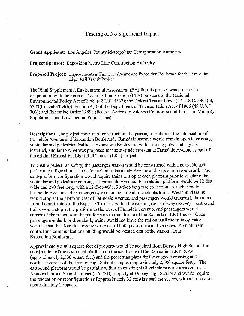
Summary of Findings This final supplemental environmental assessment (EA) has been prepared pursuant to the National Environmental Policy Act (NEPA) of 1969, as amended; 42 United States Code (USC) 4332(2); the regulations of the Council on Environmental Quality (CEQ); 40 Code of Federal Regulations (CFR) 1500–1508; and Department of Transportation (DOT) regulation 23 CFR Part 771 and 49 CFR Part 622. This EA for the Mid-City/Exposition Light Rail Transit (Expo LRT) project analyzes the proposed action for the Farmdale Avenue crossing on the Expo LRT line and compares its findings with the analysis in the previously certified final environmental impact statement/environmental impact report (FEIS/EIR) for the project. The EA finds that the proposed action would not result in any substantial adverse social, economic, or environmental impacts that cannot be mitigated. Mitigation measures have been proposed to ensure that no significant impacts result.
Section 1 Purpose, Need, and Description of the Proposed Action
In 1998, the Regional Council of the Southern California Association of Governments (SCAG) adopted a Regional Transportation Plan (RTP) to establish goals, objectives, and policies for the region’s transportation system and an implementation plan for transportation investment over the next 20 years. The RTP includes performance indicators with specific objectives against which transportation investments can be measured. The performance indicators point toward worsening travel conditions in the westside area of the City of Los Angeles by 2020, an area that will

Mid-City/Exposition Light Rail Transit Project 2 October 2010 Final Supplemental Environmental Assessment and Section 4(f) Evaluation for the Improvements at Farmdale Avenue and Exposition Boulevard ICF J&S 0019.08
not be able to meet regional objectives for mobility, accessibility, reliability, or safety without the implementation of additional transportation improvements.
Given the RTP forecasts and the data provided in the Major Investment Study (MIS) for the Mid-City/Westside Study Area, several themes emerged regarding the need for transportation improvements in the study area. These themes are listed below.
The need for transit improvements has been established in previous studies.
The “centers concept” land use policy is transit based.
The study area contains a major concentration of activity centers and destinations.
There is an existing concentration of transit-supporting land uses.
The high study area population and employment densities support transit.
Local redevelopment plans depend heavily on transit improvements.
There is a history of transit usage in the study area.
There is a significant transit-dependent population in the study area.
The study area is expected to continue to capture a large share of regional population and employment growth.
Continued growth in the business services sector (including entertainment and media-related businesses) underlies the future development potential in the study area.
Travel demand justifies transit services.
Peak-hour congestion on study area roadways underlies the need for transit improvements.
Existing and future traffic and street conditions justify transit improvements.
Local policies are oriented toward demand management and transit solutions rather than physical roadway improvements.
After review of the aforementioned themes as well as public review of the alternatives contained in the Mid-City/Westside Transit Corridor Draft Environmental Impact Statement/Environmental Impact Report (Draft EIS/EIR) in June 2001, the Los Angeles County Metropolitan Transportation Authority (Metro) Board of Directors adopted a Locally Preferred Alternative (Draft EIS/EIR Alternative 3a), which included a bus rapid transit (BRT) project on Wilshire Boulevard and a light rail transit (LRT) project along the Exposition Boulevard right-of-way (ROW) from downtown Los Angeles to Culver City. The FEIS/EIR was certified by Metro in 2005. The FEIS/EIR was completed by issuance of the Record of Decision from the Federal Transit Administration (FTA) in

Mid-City/Exposition Light Rail Transit Project 3 October 2010 Final Supplemental Environmental Assessment and Section 4(f) Evaluation for the Improvements at Farmdale Avenue and Exposition Boulevard ICF J&S 0019.08
February 2006. The FEIS/EIR was used as California Environmental Quality Act (CEQA) documentation by the California Public Utilities Commission (CPUC) in its December 2007 decision approving all but two of the at-grade crossings (at Farmdale Avenue and at Harvard Boulevard) for the Exposition Construction Authority’s (Expo’s) LRT project.
Since that time, members of the public have voiced safety concerns about the previously proposed Farmdale Avenue at-grade LRT crossing. Of particular concern to the Los Angeles Unified School District (LAUSD) and local residents is the proximity of Dorsey High School, with a population of more than 2,000 students, to the at-grade crossing. Other issues include potential visual impacts, reduced vehicular access, and noise.
In compliance with DOT regulation 23 CFR Part 771.130, this final supplemental EA is being prepared for submission to FTA in response to the February 25, 2009, CPUC decision regarding the LRT crossing at Farmdale Avenue.
In that decision, CPUC denied Expo’s application for an at-grade crossing at Farmdale Avenue, and in response to subsequent discussions between Expo and the LAUSD. After considering various options, the CPUC found that a pedestrian overcrossing and the closure of Farmdale Avenue at Exposition Boulevard was a practicable alternative to the at-grade crossing as then proposed. Accordingly, the CPUC left the proceeding open to allow Expo to file an amended application or new application.
Subsequent to the CPUC decision, Expo filed an amended application with the CPUC, suggesting several possible options for the crossing at Farmdale Avenue, including a pedestrian overcrossing, a stop-and-proceed requirement for all trains, construction of an LRT station at the intersection of Farmdale Avenue and Exposition Boulevard, and an interim stop-and-proceed requirement with later construction of an LRT station. The CPUC held a prehearing conference on the amended application on September 30, 2009, and at the direction of the Administrative Law Judge, the parties initiated a discussion of issues in hopes of more expeditiously resolving the proceeding. These discussions indicated that the construction of an LRT station at the intersection of Farmdale Avenue and Exposition Boulevard, with a stop-and-proceed requirement in place during any operation of trains prior to completing such construction, would provide a basis for more expeditious resolution of this proceeding.

Mid-City/Exposition Light Rail Transit Project 4 October 2010 Final Supplemental Environmental Assessment and Section 4(f) Evaluation for the Improvements at Farmdale Avenue and Exposition Boulevard ICF J&S 0019.08
Currently Proposed Action The Farmdale Avenue crossing is the final crossing to be considered by the CPUC for the Expo LRT line, and is the subject of an amended application filed with the CPUC on July 29, 2009. All other crossings requiring CPUC approval have been approved, and much of the Expo LRT line is currently under construction.
The currently proposed action is Expo’s original plan for an at-grade crossing. However, the differences between the original plan, and the proposed action specifically include the following items:
1. The construction of an LRT passenger station at Farmdale Avenue, and the subsequent acquisition of approximately 5,000 square feet of property on the northeastern edge of Dorsey High School, All LRT vehicles would come to a full stop on approach to the Farmdale Avenue crossing at the “near-side” station platforms east and west of Farmdale Avenue.
2. The acquisition of a 10,963-square-foot property located on the northeast corner of the intersection of Exposition Boulevard and Farmdale Avenue. On this site, the existing Expo Inn, a residency motel located at 4523 West Exposition Boulevard, would be demolished. A new 26-space paved parking lot would be constructed at this location to compensate for the lost parking spaces from the existing Dorsey High School staff parking lot.
Purpose and Scope of an Environmental Assessment
According to the Council on Environmental Quality (CEQ) NEPA regulations, an EA is a concise public document that is prepared by a federal lead agency when a proposed action is not covered by a categorical exclusion or otherwise exempt from NEPA. Federal agencies use an EA to determine whether a proposed action has the potential to cause significant environmental effects. In accordance with FTA guidelines, the scope of an EA is designed to determine which aspects of a proposed action have the potential to result in environmental impacts; identify measures to mitigate adverse environmental impacts; identify alternatives, including those that are environmentally preferable; and identify other environmental review and consultation requirements that should be prepared concurrently with the EA. The purpose of the EA is to determine if the proposed action would result in substantial adverse social, economic, or environmental impacts that would require the preparation of an environmental impact statement (EIS) or allow FTA to determine that the proposed action would not have a significant environmental impact and issue a finding of no significant impact (FONSI).

Mid-City/Exposition Light Rail Transit Project 5 October 2010 Final Supplemental Environmental Assessment and Section 4(f) Evaluation for the Improvements at Farmdale Avenue and Exposition Boulevard ICF J&S 0019.08
Project Description The proposed action would involve the construction of a passenger station at the intersection of Farmdale Avenue and Exposition Boulevard (see Figures 1a and 1b). Farmdale Avenue would remain open to crossing vehicular and pedestrian traffic at Exposition Boulevard, with crossing gates and signals, similar to what was originally proposed for the at-grade crossing at Farmdale Avenue as part of the original Expo LRT project.
Figure 1a: Proposed LRT Passenger Station Plan with At-grade Crossing – Eastbound Platform, West of Farmdale Avenue Source: Expo Construction Authority 2009.
Figure 1b: Proposed LRT Passenger Station Plan with At-grade Crossing – Westbound Platform, East of Farmdale Avenue Source: Expo Construction Authority 2009.

Mid-City/Exposition Light Rail Transit Project 6 October 2010 Final Supplemental Environmental Assessment and Section 4(f) Evaluation for the Improvements at Farmdale Avenue and Exposition Boulevard ICF J&S 0019.08
To ensure pedestrian safety, the passenger station would be constructed with a near-side split-platform configuration at the intersection of Farmdale Avenue and Exposition Boulevard. The split-platform configuration would require trains to stop at each platform prior to reaching the vehicular and pedestrian crossings at Farmdale Avenue. Each station platform would be 12 feet wide and 270 feet long, with a 12-foot-wide, 20-foot-long fare collection area adjacent to Farmdale Avenue and an emergency exit on the far end of each platform. Westbound Expo trains would stop at the platform east of Farmdale Avenue, and passengers would ingress/egress trains from the north side of the Expo LRT tracks, within the existing ROW. Eastbound Expo trains would stop at the platform to the west of Farmdale Avenue, and passengers would ingress/egress trains from the platform on the south side of the Expo LRT tracks. Once passengers embark or disembark, trains would not leave the station until the train operator verifies that the at-grade crossing is clear of both pedestrians and vehicles. A small train control and communications building would be located east of the station along Exposition Boulevard.
Approximately 5,000 square feet of property would be acquired from Dorsey High School for construction of the eastbound platform on the south side of the Expo LRT ROW (approximately 2,500 square feet) and the pedestrian plaza for the at-grade crossing at the northeast corner of the Dorsey High School campus (approximately 2,500 square feet). The eastbound platform would be partially within an existing staff vehicle parking area on LAUSD property at Dorsey High School and would require the relocation or reconfiguration of approximately 32 existing parking spaces, with a net loss of approximately 19 spaces. A 10,963-square-foot property on the northeast corner of the intersection of Exposition Boulevard and Farmdale Avenue would be acquired, and all structures would be demolished, including the Expo Inn, a residency motel located at 4523 West Exposition Boulevard. To compensate for the loss of parking spaces within the existing Dorsey High School staff parking lot for the construction of the proposed eastbound Expo LRT station platform, a new 26-space paved parking lot would be constructed on this acquired property.
To the west of Farmdale Avenue, construction of the eastbound platform would require existing Los Angeles Department of Water and Power (LADWP) overhead utility lines to be relocated underground along the ROW as well as the relocation of an electrical transformer at the northeast corner of Dorsey High School. Overhead catenary power lines would be constructed along the Expo LRT alignment, including at this station, to provide electrical power to the Expo LRT trains.
The at-grade crossing would also include realignment of the existing Dorsey High School driveway at the northeast corner of the school property to accommodate the pedestrian plaza for the at-grade pedestrian crossing. Pedestrians would be directed across the crossing when it is safe. The other side of the crossing, on the north side of Exposition

Mid-City/Exposition Light Rail Transit Project 7 October 2010 Final Supplemental Environmental Assessment and Section 4(f) Evaluation for the Improvements at Farmdale Avenue and Exposition Boulevard ICF J&S 0019.08
Boulevard, would include a smaller pedestrian plaza, including swing gates, pedestrian gates, and traffic signals to control pedestrian and vehicle traffic.
Figures 2a and 2b, below, illustrate the proposed station and the proposed parking lot in relation to Dorsey High School.
Figure 2a. LRT Passenger Station with At-grade Crossing and LAUSD Staff Parking Area, Northeast View Source: Expo Construction Authority 2009.
Figure 2b. LRT Passenger Station Plan with At-grade Crossing, LAUSD Staff Parking Area, and Dorsey High School in Background, Southwest View Source: Expo Construction Authority 2009.
Expo estimates that final design and construction of the station will require between 12 and 15 months. With a system opening currently contemplated for the summer of 2011, Expo may decide to use an interim stop-and-proceed procedure until the station is completed.

Mid-City/Exposition Light Rail Transit Project 8 October 2010 Final Supplemental Environmental Assessment and Section 4(f) Evaluation for the Improvements at Farmdale Avenue and Exposition Boulevard ICF J&S 0019.08
During the initial interim phase, operating the at-grade crossing with a stop-and-proceed operation variation would not result in any physical modifications to the Farmdale Avenue crossing beyond those already evaluated in the FEIS/EIR and thus would not result in any environmental changes or new potentially significant environmental impacts beyond those evaluated in the FEIS/EIR.
Previously Considered Options The following options were previously considered and evaluated but are no longer being proposed as a result of the CPUC decision dated February 25, 2009, and subsequent discussions among the parties conducted at the suggestion of the Administrative Law Judge to this proceeding to identify an option that could provide a basis for a more expeditious resolution to this proceeding. Accordingly, these options are not evaluated in this study.
At-grade Expo LRT crossing at Farmdale Avenue.
Stop and proceed for Expo LRT trains at the at-grade crossing at Farmdale Avenue.
Pedestrian overcrossing and closure of Farmdale Avenue at Exposition Boulevard.
Pedestrian overcrossing, with Farmdale Avenue remaining open at Exposition Boulevard.
Train overcrossing at Farmdale Avenue.
Train undercrossing at Farmdale Avenue.
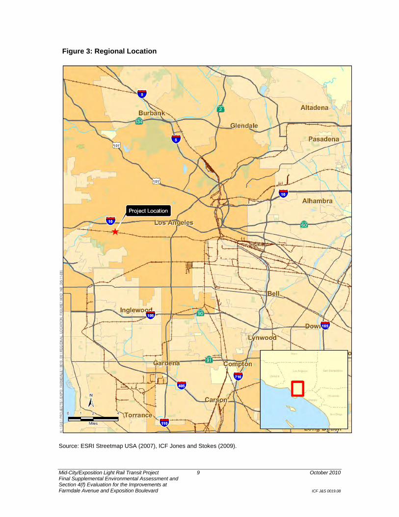
Project Location and Setting The project site is located in the mid-western portion of the City of Los Angeles, approximately 7 miles southwest of downtown Los Angeles, within the West Adams-Baldwin Hills-Leimert Community Plan area (see Figures 3 and 4). The specific location of the project site is the intersection of Farmdale Avenue and Exposition Boulevard. Regional access to the project site is provided from Interstate 10 (Santa Monica Freeway), which is approximately 0.75 mile to the north.
General Plan Designation and Zoning As designated by the City of Los Angeles General Plan, the project site falls within the West Adams area,1 which is included in the West Adams-Baldwin Hills-Leimert Community Plan.
1 City of Los Angeles. West Adams-Baldwin Hills-Leimert Community Plan. Available: <http://www.lacity.org/PLN>.
Mid-City/Exposition Light Rail Transit Project 9 October 2010 Final Supplemental Environmental Assessment and Section 4(f) Evaluation for the Improvements at Farmdale Avenue and Exposition Boulevard ICF J&S 0019.08
Figure 3: Regional Location
Source: ESRI Streetmap USA (2007), ICF Jones and Stokes (2009).

Mid-City/Exposition Light Rail Transit Project 10 October 2010 Final Supplemental Environmental Assessment and Section 4(f) Evaluation for the Improvements at Farmdale Avenue and Exposition Boulevard ICF J&S 0019.08
Figure 4: Project Vicinity
Source: ESRI Streetmap USA (2007), ICF Jones and Stokes (2009).

Mid-City/Exposition Light Rail Transit Project 11 October 2010 Final Supplemental Environmental Assessment and Section 4(f) Evaluation for the Improvements at Farmdale Avenue and Exposition Boulevard ICF J&S 0019.08
According to the City of Los Angeles Department of City Planning, Dorsey High School, located southwest of the project site, is zoned PF-1 (Public Facilities). The Rancho Cienega Sports Complex, located adjacent to and west of Dorsey High School, is also zoned PF-1. To the southeast, the area is designated Medium-Density Residential and zoned R3-1 (Residential). The northern side of Exposition Boulevard, near the project site, is designated General Commercial and zoned C1.5-VL (Commercial).
Surrounding Land Uses Land uses in the vicinity include public facilities (Dorsey High School and the Rancho Cienega Sports Complex), single-story medium-density residential areas to the east and southeast, and commercial areas to the north. Dorsey High School is southwest of the intersection of Farmdale Avenue and Exposition Boulevard; it continues to the west along the southern side of Exposition Boulevard. Northwest of the intersection, along the northern side of Exposition Boulevard, are contiguous blocks of single-story light industrial buildings. On the northwest corner of the intersection, part of an approximately 2,500-square-foot parcel owned by Metro is the proposed site for Expo LRT project traction power substation (TPSS) No. 6. East of Farmdale Avenue, along the northern side of Exposition Boulevard, the primary land use is single-family residential; to the south are mixed single-family and multi-family residences. Motel uses and associated surface parking are also located in the area. Specifically, the Expo Inn is located at the northeast corner of the intersection at 4523 West Exposition Boulevard.

Mid-City/Exposition Light Rail Transit Project 12 October 2010 Final Supplemental Environmental Assessment and Section 4(f) Evaluation for the Improvements at Farmdale Avenue and Exposition Boulevard ICF J&S 0019.08
Section 2 Public Outreach Process The FEIS/EIR documents the Mid-City/Westside Transit Corridor Public Involvement Program, which progressed over the course of three phases. This program included an MIS, completed in March 2000; a scoping process and review of the Draft EIS/EIR, completed in June 2001; and the lead agency’s response to comments and release of the final environmental impact report (EIR) in 2005. A Record of Decision was issued by FTA in February 2006, including a description of environmental impacts and proposed mitigation measures.
Subsequent to the Record of Decision, public meetings and presentations have occurred in the mid-corridor section of the Expo LRT project. This included a presentation during the design phase (Dorsey High School, November 16, 2006) and project status update meetings (Dorsey High School, March 21 and June 20, 2006).
Due to the controversy and special concerns regarding the intersection of the Expo LRT at Farmdale Avenue and Exposition Boulevard, extensive public outreach efforts have taken place in the community surrounding the project site. The following list provides the locations and dates of the public outreach activities that were conducted in connection with the current environmental analysis.
Design presentation and project update meeting, held at Dorsey High School auditorium, November 16, 2006;
Project status update/open house, held at Dorsey High School cafeteria, June 20, 2007;
Project status update/open house, held at Dorsey High School cafeteria, March 21, 2007;
CPUC’s first prehearing conference regarding protests, held at Exposition Park, April 5, 2007;
CPUC’s workshop to address the protests, held at the State Office Building, July 18, 2007;
CPUC’s second prehearing conference regarding protests, held at Culver City Hall, July 19, 2007;
CPUC’s mediation with Exposition Community United (ECU) to address the protests, held at the State Office Building, August 14, 2007;
CPUC’s pubic meeting regarding the Farmdale Avenue crossing, held at Dorsey High Auditorium, November 5, 2007;
Presentation to review the grade crossing alternatives for Farmdale Avenue, held at West Angeles Church of God in Christ, January 8, 2008;

Mid-City/Exposition Light Rail Transit Project 13 October 2010 Final Supplemental Environmental Assessment and Section 4(f) Evaluation for the Improvements at Farmdale Avenue and Exposition Boulevard ICF J&S 0019.08
CPUC’s prehearing conference regarding the Farmdale Avenue and Harvard Boulevard crossings, held at the State Office Building, March 12, 2008;
Project status update/open house, held at Holman United Methodist Church, April 1, 2008;
Project status update/open house, held at Holman United Methodist Church, July 23, 2008;
Project status update/open house, held at Holman United Methodist Church, October 22, 2008; and
Project status update/open house, held at Holman United Methodist Church, January 22, 2009.
A public meeting/hearing was held on June 1, 2010, for the draft supplemental EA. Please see Section 5, Distribution List, for additional details on the NOA’s distribution.

Mid-City/Exposition Light Rail Transit Project 14 October 2010 Final Supplemental Environmental Assessment and Section 4(f) Evaluation for the Improvements at Farmdale Avenue and Exposition Boulevard ICF J&S 0019.08
Section 3 Environmental Impacts The following sections of this analysis evaluate whether the proposed action would have new or substantially more severe significant environmental impacts compared to the impacts evaluated in the previously certified FEIS/EIR for the Expo LRT project. In each of the following sections, this analysis first summarizes the conclusions in the previously certified FEIS/EIR, then evaluates whether the proposed action would have new or more severe adverse environmental effects (compared to the Expo LRT project) for the resource category in question.
Land Acquisitions and Displacements
Summary of Conclusions in the Previously Certified Expo LRT Project FEIS/EIR
The FEIS/EIR identified a total of 89 properties along the Expo LRT project corridor where either full or partial acquisition would be required to construct the Expo LRT project. In addition, the FEIS/EIR identified a need for acquisition of the parcel on the northwest corner of the intersection of Farmdale Avenue and Exposition Boulevard (assessor’s parcel number [APN] 5046-010-035) to allow construction of a TPSS. According to the FEIS/EIR, a partial take of this property (3,683 square feet) would be required, which would reduce the automobile storage and parking area of the business. However, the business would not be displaced.
Mitigation measures for land acquisition impacts were specified by Metro to compensate those who were displaced or whose property was acquired as a result of the Expo LRT project, including relocation assistance and compensation per the Uniform Relocation Assistance and Real Property Acquisition Policies Act and the California Relocation Act. However, despite the planned implementation of mitigation measures, full or partial acquisition of property and related displacement would be considered a significant impact.
Unavoidable adverse effects related to land acquisition would occur as a result of the Expo LRT project.

Mid-City/Exposition Light Rail Transit Project 15 October 2010 Final Supplemental Environmental Assessment and Section 4(f) Evaluation for the Improvements at Farmdale Avenue and Exposition Boulevard ICF J&S 0019.08
Proposed Action: Construction of an LRT Station at the Intersection of Farmdale Avenue and Exposition Boulevard
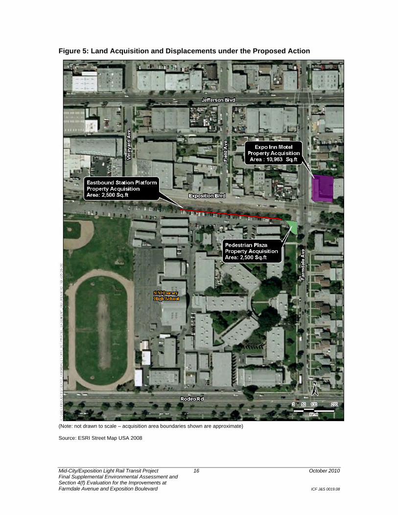
Approximately 5,000 square feet of property would be acquired from Dorsey High School for the proposed eastbound platform on the south side of the of Expo LRT tracks and the construction of a pedestrian plaza for the at-grade crossing. Acquisition of this property would require relocation or reconfiguration of approximately 32 Dorsey High School parking spaces. Figures 2a and 2b, included in the project description above, show the boundaries of the project site and the properties, including parking spaces that would be acquired under the proposed action. Figure 5, below, shows the specific acquisitions that will be required for the proposed station and parking lot.
The proposed action would also require the acquisition of the 10,963-square-foot property on the northeast corner of the intersection of Exposition Boulevard and Farmdale Avenue. The existing Expo Inn would be demolished prior to the construction of a new 26-space paved parking lot, which would be used by Dorsey High School staff.
As described in the FEIS/EIR, mitigation for the acquisition of the Expo Inn property would include relocation assistance and compensation per the Uniform Relocation Assistance and Real Property Acquisition Policies Act, pursuant to 49 CFR Part 24, and the California Relocation Act. Displacements were considered substantial adverse effects in the FEIS/EIR. However, the addition of one property to the list of 89 affected properties and the parking spaces would not constitute a substantial adverse effect under NEPA.
No new or more severe adverse effects are expected to occur as a result of modifying the Expo LRT project with an LRT passenger station at Farmdale Avenue.
Land Use and Zoning Summary of Conclusions in the Previously Certified Expo LRT Project FEIS/EIR
The Expo LRT project would not physically divide an established community because it would allow pedestrians and vehicles to cross the alignment at designated intersections. While some streets would be closed, which would prevent motorists and pedestrians from crossing the ROW at those locations, other north–south streets would remain open as designated ROW crossings. Furthermore, the Expo LRT project would be constructed predominantly within an existing Metro-owned ROW, which, historically, has been used by passenger and freight trains.
Mid-City/Exposition Light Rail Transit Project 16 October 2010 Final Supplemental Environmental Assessment and Section 4(f) Evaluation for the Improvements at Farmdale Avenue and Exposition Boulevard ICF J&S 0019.08
Figure 5: Land Acquisition and Displacements under the Proposed Action
(Note: not drawn to scale – acquisition area boundaries shown are approximate) Source: ESRI Street Map USA 2008

Mid-City/Exposition Light Rail Transit Project 17 October 2010 Final Supplemental Environmental Assessment and Section 4(f) Evaluation for the Improvements at Farmdale Avenue and Exposition Boulevard ICF J&S 0019.08
The FEIS/EIR did not identify any zoning or land use conflicts that would result from construction of the mid-corridor section of the Expo LRT project.
No substantial adverse effect would occur as a result of the Expo LRT project.
Proposed Action: Construction of an LRT Station at the Intersection of Farmdale Avenue and Exposition Boulevard
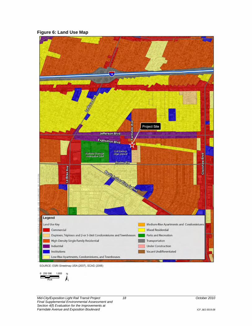
Information and conclusions presented in the FEIS/EIR remain unchanged in light of the proposed action. Construction of the proposed LRT station and parking lot on the northeast corner of the intersection of Exposition Boulevard and Farmdale Avenue would be consistent with local land use plans and policies; it would not introduce new or incompatible land uses to the area (see Figure 6, Land Use Map). Under the proposed action, Farmdale Avenue would remain open to crossing vehicular and pedestrian traffic at Exposition Boulevard, with crossing gates and signals to control movement. This would be similar to what was originally proposed for the at-grade crossing at Farmdale Avenue under the original Expo LRT project.
The acquisition of the property located at the northeast corner of Exposition Boulevard and Farmdale Avenue and demolition of the Expo Inn at the northeast corner of the intersection of Exposition Boulevard and Farmdale Avenue would not result in an obstruction or physical division within the community. The construction and operation of an LAUSD staff parking lot would be an acceptable use for a commercially zoned property.2 Therefore, implementation of the proposed action would not physically divide an established community.
The West Adams-Baldwin Hills-Leimert Community Plan Freeways, Highways, and Street Element recognizes the goal of providing a circulation system that supports approved and planned land uses while maintaining a desired LOS at all intersections (Goal 7). The proposed action would not substantially affect existing traffic conditions and, therefore, would not have a substantial adverse effect.
No new or more severe adverse effects are expected to occur as a result of modifying the Expo LRT project with an LRT passenger station at Farmdale Avenue.
2 City of Los Angeles General Plan, Sections 12.13.5 A9, 12.21 A4.
Mid-City/Exposition Light Rail Transit Project 18 October 2010 Final Supplemental Environmental Assessment and Section 4(f) Evaluation for the Improvements at Farmdale Avenue and Exposition Boulevard ICF J&S 0019.08
Figure 6: Land Use Map

Mid-City/Exposition Light Rail Transit Project 19 October 2010 Final Supplemental Environmental Assessment and Section 4(f) Evaluation for the Improvements at Farmdale Avenue and Exposition Boulevard ICF J&S 0019.08
Air Quality
Summary of Conclusions in the Previously Certified Expo LRT Project FEIS/EIR
According to the FEIS/EIR (Section 4.5.4), operation of the Expo LRT project would not incrementally increase pollution emissions and exceed South Coast Air Quality Management District (SCAQMD) standards or California ambient air quality standards (CAAQS). No adverse effect is anticipated from operation of the Expo LRT system.
The FEIS/EIR identified the Los Angeles County portion of the South Coast Air Basin as a nonattainment area for ozone, carbon monoxide (CO), and suspended particulate matter. While operation of the Expo LRT project is expected to have a beneficial impact by decreasing overall vehicle miles traveled in the region, construction of the Expo LRT system would result in significant, unavoidable impacts due to emissions of particulate matter less than 10 microns in size (PM10) from grading and excavation activities. These emissions would substantially exceed the criteria established by SCAQMD as part of its Air Quality Management Plan (AQMP).
Severe, unavoidable adverse effects due to construction-period PM10 emissions were identified for the Expo LRT project.
Proposed Action: Construction of an LRT Station at the Intersection of Farmdale Avenue and Exposition Boulevard
According to the Air Quality Technical Study prepared in January 2010,3 the proposed action would result in emissions below the threshold of significance under the AQMP for this region (ICF Jones & Stokes 2010d [see Appendix F]).
Construction activities proposed under the proposed action would result in short-term GHG emissions. With respect to long-term project operations, there would be no new trip generation or increases in energy consumption that would result in GHG emissions. As demonstrated in the Air Quality Technical Study (see Appendix F), the proposed action would not conflict with the state’s goals of reducing GHG emissions to 1990 levels by 2020 relative to construction emissions.
The proposed Expo LRT project would reduce GHG emissions and assist the state in meeting its GHG reduction goals by providing mass transit as an alternative to automobile travel. As such, potential impacts resulting
3 ICF Jones & Stokes 2010a (see Appendix F).

Mid-City/Exposition Light Rail Transit Project 20 October 2010 Final Supplemental Environmental Assessment and Section 4(f) Evaluation for the Improvements at Farmdale Avenue and Exposition Boulevard ICF J&S 0019.08
from GHG emissions would be less than significant. Nonetheless, mitigation measures AIR-1 through AIR-5, included below, are prescribed to ensure that temporary GHG emissions during construction are minimized to the extent feasible. AIR-1 Utilize recycled, low-carbon, and otherwise climate-friendly
building materials such as salvaged and recycled-content materials for building, hard surfaces, and non-plant landscaping materials.
AIR-2 Minimize, reuse, and recycle construction-related waste.
AIR-3 Minimize grading, earthmoving, and other energy-intensive construction practices.
AIR-4 Landscape to preserve natural vegetation and maintain watershed integrity.
AIR-5 Utilize alternative fuels in construction equipment (e.g., biodiesel, electricity, ethanol, hydrogen, methanol, natural gas, propane, and/or LNG/LPG) and require construction equipment to utilize the best available technology to reduce emissions.
No new or more severe adverse effects are expected to occur as a result of modifying the Expo LRT project with an LRT passenger station at Farmdale Avenue.
Noise and Vibration
Summary of Conclusions in the Previously Certified Expo LRT Project FEIS/EIR
The FEIS/EIR identified severe noise impacts, as defined by FTA, that would exceed the CEQA threshold for significance (see Table 4.6-3, FEIS/EIR). In accordance with CEQA guidelines, a significant noise impact must be either mitigated or identified as an impact for which it is likely that no, or only partial, abatement measures are available because of specific economic, social, environmental, legal, or technological conditions that make complete mitigation of the noise impact unfeasible.
As identified in the FEIS/EIR, baseline noise measurements taken in July 2000 at a location near the intersection of Farmdale Avenue and Exposition Boulevard (3500 Muirfield Road) were within the typical limits for urban residential neighborhoods.
Noise impacts from audible warnings would occur at six grade crossings, including the at-grade crossing at Farmdale Avenue. Noise impacts resulting from train operations could be fully mitigated by installing

Mid-City/Exposition Light Rail Transit Project 21 October 2010 Final Supplemental Environmental Assessment and Section 4(f) Evaluation for the Improvements at Farmdale Avenue and Exposition Boulevard ICF J&S 0019.08
adequate sound insulation in affected buildings, constructing soundwalls, or implementing other mitigation measures, as specified in the FEIS/EIR. Mitigation measures would reduce light rail vehicle (LRV) noise and track crossover noise impacts to a less-than-significant level. Relevant measures include those listed below.
FEIS/EIR NV1 To achieve Federal Transit Administration noise standards for residential uses adjacent to the Exposition ROW, soundwalls shall be constructed approximately 8 feet from the near-track centerline. They shall be constructed at the following locations and according to the specified height: • Between Van Ness Avenue and Arlington Avenue,
on the south side of the ROW, at a height of 8 feet;
• Between 2nd Avenue and 7th Avenue, on the south side of the ROW, at a height of 8 feet;
• Between 7th Avenue and 9th Avenue, on the south side of the ROW, at a height of 8 feet;
• Between Somerset Drive and Buckingham Road, on the south side of the ROW, at a height of 6 feet;
• Between Buckingham Road and Farmdale Avenue, on the south side of the ROW, at a height of 6 feet;
• Between La Brea Avenue and 600 feet east of Hauser Boulevard, on the south side of the ROW, at a height of 6 feet for the at-grade soundwall and 4 feet for the wall along the elevated structure; and
• Between Fay Avenue and Wesley Street, on the north side of the ROW, at a height of 6 feet.
All of the soundwalls shall incorporate landscape screening or public art features to enhance their appearance and reduce visual intrusion. Specific heights and lengths may be modified slightly as the design process progresses but shall comply with all federal and state noise regulations.
FEIS/EIR NV2 In addition to the soundwalls required by mitigation measure NV1, a combination of the following source, path, and receiver options shall be employed to augment noise reductions from Expo LRT operations where necessary and comply with federal and state noise regulations. These methods shall be employed where soundwalls alone would not fully attenuate LRT noise levels to federal and state noise standards. The following methods shall be employed:

Mid-City/Exposition Light Rail Transit Project 22 October 2010 Final Supplemental Environmental Assessment and Section 4(f) Evaluation for the Improvements at Farmdale Avenue and Exposition Boulevard ICF J&S 0019.08
• sound absorption treatment,
• sound insulation,
• relocation of turnouts (switches) to minimize proximity to residences or other sensitive receptors,
• spring-rail frogs where turnouts cannot be relocated to avoid residences or sensitive receptors, and
• increased wheel and rail maintenance (only when all other methods fail because it is a reoccurring operational expense).
FEIS/EIR NV3 In addition to the soundwalls required by mitigation measure NV1, the following options to control noise from audible warnings at grade crossings shall be employed at the following locations along the ROW:
• Arlington Avenue: Crossing bell noise shall be reduced to 64 dBA at 50 feet, and the same sound barrier prescribed in NV1 shall be constructed;
• 7th Avenue: Crossing bell noise shall be reduced to 64 dBA at 50 feet, the sound barrier prescribed in NV1 shall be constructed, the noise walls shall extend south for approximately 50 to 100 feet on both the east and the west side of 7th Avenue at a height of 8 feet, or if extending the noise walls is infeasible, then sound insulation at affected residences shall be put in place;
• 9th Avenue: Crossing bell noise shall be reduced to 64 dBA at 50 feet, and the same sound barrier prescribed in NV1 shall be constructed;
• Buckingham Road: Crossing bell noise shall be reduced to 64 dBA at 50 feet, the sound barrier prescribed in NV1 shall be constructed, and sound insulation at affected residences near Buckingham Road shall be put in place; and
• Farmdale Avenue: Crossing bell noise shall be reduced to 64 dBA at 50 feet, the sound barrier prescribed in NV1 shall be constructed, and sound insulation at affected residences near Farmdale Avenue shall be put in place.

Mid-City/Exposition Light Rail Transit Project 23 October 2010 Final Supplemental Environmental Assessment and Section 4(f) Evaluation for the Improvements at Farmdale Avenue and Exposition Boulevard ICF J&S 0019.08
FEIS/EIR NV7 Methods to mitigate vibration impacts may include the following:
• ballast mats,
• resilient fasteners,
• resiliently supported ties,
• tire shred or recycled rubber chip underlay,
• floating slabs, and
• relocation of crossovers or special trackwork.
FEIS/EIR C1 Metro shall coordinate with the Los Angeles Department of Transportation (LADOT) and the Culver City Public Works Department to designate and identify haul routes for trucks and establish hours of operation during final design. These routes shall be situated to minimize noise, vibration, and other possible impacts.
FEIS/EIR C21 Construction sites shall be laid out in a manner so that the noisiest activities are as far as possible from noise-sensitive receptors.
Consistent and perceptible ground-borne vibration is currently not a normal phenomenon for people in this area because there are no rail operations along the Exposition ROW. Vibration impacts were not fully accounted for in the FEIS/EIR due to a lack of specific information regarding the engineering plan, but mitigation measures included in the FEIS/EIR specify performance standards that would reduce vibration impacts at all affected residential locations to a level below the FTA vibration criterion. As discussed in the March 2009 Noise and Vibration Study (see Appendix E), the 2004 FEIS/EIR vibration assessment was based on vibration testing of the prototype Gold Line vehicle. Subsequent testing after the Gold Line became operational validated the FEIS/EIR procedures. The FEIS/EIR concluded that there would be no vibration impacts associated with the previously proposed at-grade crossing.
After mitigation, no residual adverse effects related to noise or vibration would occur as a result of the Expo LRT project.
Proposed Action: Construction of an LRT Station at the Intersection of Farmdale Avenue and Exposition Boulevard
According to the Noise and Vibration Impact Memorandum (ATS Consulting, 2010), noise impacts associated with construction of an LRT station at the intersection of Farmdale Avenue and Exposition Boulevard would be similar to those described in the FEIS/EIR and similar to those
Mid-City/Exposition Light Rail Transit Project 24 October 2010 Final Supplemental Environmental Assessment and Section 4(f) Evaluation for the Improvements at Farmdale Avenue and Exposition Boulevard ICF J&S 0019.08
of the previously proposed at-grade crossing. The only difference is a small decrease in noise levels due to slower train speeds as the LRT vehicles approach the station. The decrease would not be enough to change the noise impact at any of the clusters of sensitive receptors. As compared to the impacts described in the FEIS/EIR, no change would occur relative to the noise impact at any of the clusters of sensitive receptors, including the residence directly to the north of the Expo Inn, after demolition of the motel. As described in the FEIS/EIR, the installation of soundwalls to the east of Farmdale Avenue, along the south side of the ROW, would reduce noise impacts caused by passing trains to less-than-significant levels. All other appropriate mitigation measures identified in the FEIS/EIR, as described above, would be implemented. No additional mitigation would be required.
No new or more severe adverse effects related to noise and vibration would occur as a result of modifying the Expo LRT project with an LRT passenger station at Farmdale Avenue.
Water Quality
Summary of Conclusions in the Previously Certified Expo LRT Project FEIS/EIR
As discussed in Section 4.9.2 of the FEIS/EIR, it was determined that the Expo LRT project would not result in any adverse effects on water resources. The Expo LRT project would be subject to existing National Pollutant Discharge Elimination System (NPDES) permit requirements to regulate impacts from runoff on water quality. The Expo LRT project would not result in a substantial increase in runoff. In reconfiguring the ROW, a drainage plan would be implemented to direct stormwater and runoff to existing storm drains. The existing storm drains would be able to accommodate the increased flow. In addition, mitigation measures specified in the FEIS/EIR would ensure that permeable surfaces would be included in all new parking areas. No adverse effects are anticipated from project-related runoff.
Mitigation measures specified in the FEIS/EIR would ensure that no impacts would result from the limited potential for flooding during 100-year storm events. The development of the ROW for the Expo LRT project would result in the removal of existing landscaping and a small reduction in the amount of permeable surfaces along the alignment. An integral element of the Expo LRT project, however, would be its landscape features, which would replace a portion of the removed landscaping and re-create a pervious surface. Overall, a limited amount of surface area would be paved but not enough to result in a significant effect on regional groundwater recharge. Project construction activities would occur within an existing ROW, which is located in an established residential and
Mid-City/Exposition Light Rail Transit Project 25 October 2010 Final Supplemental Environmental Assessment and Section 4(f) Evaluation for the Improvements at Farmdale Avenue and Exposition Boulevard ICF J&S 0019.08
industrial area, and would not alter local drainage patterns. No impact on groundwater resources are anticipated. Construction of the Expo LRT project would include the best management practices (BMPs) required by the regional water quality control board to minimize erosion of exposed soils by water and resultant sediment loading in the storm drain system and downstream water bodies.
The Expo LRT project would require the use of a small amount of water during construction for dust control and mixing concrete off site. However, it would not permanently increase water usage, except for the negligible amount necessary for landscaping. Water is expected to be drawn from municipal sources rather than groundwater. The proposed improvements would create relatively few new impermeable surface areas; therefore, the proposed action would not significantly affect local groundwater recharge.
After mitigation, no adverse effects would occur as a result of the Expo LRT project.
Proposed Action: Construction of an LRT Station at the Intersection of Farmdale Avenue and Exposition Boulevard
Information and conclusions presented in the FEIS/EIR remain unchanged in light of the proposed action. Approximately 5,000 square feet of property from Dorsey High School would be acquired for the proposed eastbound platform and a pedestrian plaza. A limited amount of additional surface area would be paved but not enough to result in a significant effect on local or regional groundwater recharge. Construction and operation of the proposed action would not alter the existing drainage pattern of the site and surrounding area in a manner that would result in substantial erosion. The property located on the northeastern corner of the intersection Exposition Boulevard and Farmdale Avenue would be acquired under the proposed action. The existing Expo Inn would be demolished prior to the construction of a paved parking lot. The site is currently paved, and therefore the parking lot would not significantly increase paved surface areas, or otherwise affect local or regional groundwater recharge or alter the existing drainage pattern.
Implementation of the proposed action would result in limited grading and a slight increase in impermeable surface area. Therefore, runoff volumes, flows, and velocities would be slightly altered. However, surface runoff would be directed into existing drainage systems. Also, landscaping would be an integral element of the proposed station and would assist in reducing the amount of stormwater runoff because of the addition of more permeable surfaces.
No new or more severe adverse effects are expected to occur as a result of modifying the Expo LRT project with an LRT passenger station at Farmdale Avenue.
Mid-City/Exposition Light Rail Transit Project 26 October 2010 Final Supplemental Environmental Assessment and Section 4(f) Evaluation for the Improvements at Farmdale Avenue and Exposition Boulevard ICF J&S 0019.08
Geology, Soils, and Seismicity
Summary of Conclusions in the Previously Certified Expo LRT Project FEIS/EIR
According to the FEIS/EIR, the California Department of Conservation (Division of Mines and Geology) reports that the Newport-Inglewood Fault Zone overlaps the Expo LRT project area, including the intersection of Farmdale Avenue and Exposition Boulevard. This zone is located southeast of the intersection of La Cienega and Washington Boulevards and crosses the Expo LRT project ROW at National Boulevard and Fay Street in Culver City. The fault is characterized as a right-lateral local reverse slip, which is associated with fault steps, with a fault slip rate of 0.6 millimeter per year. The probable magnitude of a seismic event would range from 6.7 to 7.4 on the Richter scale. The other adjacent fault system in the local area is the Hollywood-Santa Monica Fault Zone, with runs approximately 15 miles in an east–west orientation, approximately 3 miles north of the Expo LRT project area. Due to the intense seismic environment of Southern California, there is always the potential for blind thrust faults, or otherwise unmapped faults that do not have a surface trace, to be present. Furthermore, two-thirds of the overall project area, including the intersection of Farmdale Avenue and Exposition Boulevard, is within an area that is potentially subject to liquefaction due to the predominant soil types and high water table. Additionally, starting slightly west of the University of Southern California, the dominant soil type exhibits moderate shrink-swell behavior. However, the FEIS/EIR concluded that, after mitigation, the Expo LRT project would not result in increased exposure to risks associated with faults, nor would it exacerbate pre-existing seismic conditions.
Grade separations included in the planned design for the Expo LRT project and considered in the FEIS/EIR, such as elevated structures, would be vulnerable to damage during an earthquake. The Expo LRT project would be required to comply with the seismic safety requirements in the Uniform Building Code and the California Department of Conservation’s Geologic Survey Special Publication 117 (Guidelines for Evaluating and Mitigating Seismic Hazards in California [1997]), which provide guidance for evaluating and mitigating geological hazards, including earthquakes, liquefaction, and soil expansion/contraction.
After mitigation, no adverse effects related to faults, liquefaction, or soil expansion/contraction would occur as a result of the Expo LRT project.

Mid-City/Exposition Light Rail Transit Project 27 October 2010 Final Supplemental Environmental Assessment and Section 4(f) Evaluation for the Improvements at Farmdale Avenue and Exposition Boulevard ICF J&S 0019.08
Proposed Action: Construction of an LRT Station at the Intersection of Farmdale Avenue and Exposition Boulevard
The proposed action would involve the construction of an LRT station at the intersection of Farmdale Avenue and Exposition Boulevard. Since the proposed action would consist of low-lying, ground-supported concrete station platforms and would not involve elevated or substantial load-bearing structures, no new adverse effects related to geology, soils, or seismicity would result. Although a small equipment control building would be constructed to the east of the LRT passenger station, it would not be publicly accessible; it would be accessible to Metro personnel only. The station platforms and control building included under the proposed action would be constructed according to current engineering and safety standards and would comply with all other standards established for the rest of the Expo LRT project. The proposed action would include the construction of a paved parking lot at the northeastern corner of the intersection of Farmdale Avenue and Exposition Boulevard. No new adverse impacts on geology and soils would occur. Furthermore, the mitigation measures described in the FEIS/EIR would be implemented for the proposed action as well.
No new or more severe adverse effects are expected to occur as a result of modifying the Expo LRT project with an LRT passenger station at Farmdale Avenue.
Hazards and Hazardous Materials
Summary of Conclusions in the Previously Certified Expo LRT Project FEIS/EIR
The potential for encountering contaminated soil during the grading and excavation phase of the Expo LRT project would be the primary concern related to exposure to hazardous materials. As discussed in the FEIS/EIR (Section 4.8.2.1), construction work for the Expo LRT project would be contained generally within the upper 5 feet of soil, thereby limiting the possibility of unearthing contaminated soil. Sites identified in the Phase I Initial Site Assessment (ISA) as possibly contaminated are listed in the FEIS/EIR (Section 4.8.1). The mitigation measures provided in the FEIS/EIR (Section 4.8.3) provide the appropriate methods for safely approaching potentially hazardous situations, thereby eliminating a potentially adverse effect. There are numerous schools within 0.25 mile of the Expo LRT project alignment, including Dorsey High School. However, potential exposure to hazards or contaminated materials would be limited to the confines of the ROW. As specified in the FEIS/EIR, the mitigation measures provide proper disposal methods for contaminated substances, which would ensure the safety of students at nearby schools.

Mid-City/Exposition Light Rail Transit Project 28 October 2010 Final Supplemental Environmental Assessment and Section 4(f) Evaluation for the Improvements at Farmdale Avenue and Exposition Boulevard ICF J&S 0019.08
The ISA identified three potential areas of concern within the ROW. First, in the easternmost portion of the ROW, there are existing service stations with underground storage tanks (USTs), or database records indicating former service stations with USTs, on the corners where Figueroa Avenue, Vermont Avenue, and Western Avenue intersect with the Expo LRT project ROW. Second, from Gramercy Place to La Brea Avenue, small soil stockpiles with concrete and asphalt debris were observed as well as an oily stain with a chemical odor in the central portion of the ROW, near the southwest corner of the intersection of Exposition Boulevard and 11th Avenue. Third, an existing auto maintenance shop located between La Brea Avenue and La Cienega Avenue, north of the Expo LRT project ROW, appears as though it may have been a former UST site that was not listed in the 1992 database.
Operation of the Expo LRT project would not result in exposure to hazardous materials. In addition, as discussed in Section 4.8.2.2 of the FEIS/EIR, the level of risk related to exposure to electromagnetic fields (EMFs) emanating from the electrified catenary power supply wires for the LRT system is considered low. No impacts related to hazardous substances would result from operation of the Expo LRT project.
After mitigation, no adverse effects due to hazards or hazardous materials would occur as a result of the Expo LRT project.
Proposed Action: Construction of an LRT Station at the Intersection of Farmdale Avenue and Exposition Boulevard
Because no substantial excavation would take place under the proposed action, no impacts due to soil-borne hazardous materials would be expected. None of the three potential areas of concern identified in the FEIS/EIR is within the proposed action’s construction limits.
The area at Dorsey High School with potential contamination would not be affected by construction of the proposed LRT passenger station. Therefore, no increased risk of exposure to hazardous materials or chemicals would occur.
As discussed above, the site, at the intersection of Farmdale Avenue and Exposition Boulevard, is not located within an airport land use plan or within 2 miles of an existing public airport. Therefore, no safety hazards specific to the proposed action are anticipated.
Prior to acquisition of the Expo Inn property, a Phase I ESA would be carried out by a qualified hazardous materials specialist. The motel was constructed in the early 1980s, and therefore, the presence of lead-based paints is unlikely. In the event that any hazardous materials are identified at the motel property, demolition of the existing buildings and

Mid-City/Exposition Light Rail Transit Project 29 October 2010 Final Supplemental Environmental Assessment and Section 4(f) Evaluation for the Improvements at Farmdale Avenue and Exposition Boulevard ICF J&S 0019.08
construction of the new parking lot will comply with all applicable regulations, and all relevant mitigation measures identified in the FEIS/EIR will be implemented.
As discussed above, during construction, all applicable mitigation measures specified in the FEIS/EIR would be implemented to reduce any potential adverse effects related to hazards and hazardous materials to less-than-significant levels.
No new or more severe adverse effects would occur as a result of modifying the Expo LRT project with an LRT passenger station at Farmdale Avenue.
Traffic and Parking
Summary of Conclusions in the Previously Certified Expo LRT Project FEIS/EIR
Completion and operation of the Expo LRT system would reduce vehicle traffic in the communities surrounding the Expo LRT alignment. However, specific impacts would occur due to construction activities, closed intersections, and at-grade crossing delays. According to the FEIS/EIR (Section 3.2.6), all significant impacts resulting from construction of the Expo LRT system would be mitigated to less-than-significant levels. The mitigation measures include those listed below.
FEIS/EIR C6 Prior to construction, Metro public affairs and construction staff shall contact and interview individual businesses to understand how they carry out their work. Metro shall use this information to develop worksite traffic control plans, identify alternative access routes, and make efforts during construction to maintain business activities.
FEIS/EIR C7 Unless required by worksite traffic control plans, construction activities shall be sequenced to minimize the temporary removal of multiple blocks of on-street parking at one time; this would make various on-street parking spaces available in an area under construction for a period of time.
FEIS/EIR C8 Metro shall provide affected communities and businesses with the telephone numbers of the public affairs officers who will be responsible for responding to questions about construction activities.

Mid-City/Exposition Light Rail Transit Project 30 October 2010 Final Supplemental Environmental Assessment and Section 4(f) Evaluation for the Improvements at Farmdale Avenue and Exposition Boulevard ICF J&S 0019.08
FEIS/EIR C9 Metro shall notify property owners, residents, and businesses of major construction activities (e.g., utility relocation/disruption and the rerouting of delivery trucks).
FEIS/EIR C10 Metro shall coordinate with local businesses and residents to provide advanced notification of traffic detours and delays and potential utility disruptions associated with construction.
FEIS/EIR C11 Temporary special signage shall be used to inform customers that merchants and other businesses directly affected by construction are open. The signage shall include special closure information in advance of any temporary closure. Signage shall also provide special access directions, if warranted.
According to Section 3.3.4 of the FEIS/EIR, parking would be eliminated in downtown Los Angeles along Hill Street as part of the Expo LRT project; this would be an unavoidable significant impact. However, the loss of parking elsewhere in downtown Los Angeles, as well as in the mid-corridor and the west-end project segments would result in less-than-significant impacts after mitigation. The FEIS/EIR did not identify specific parking impacts near the intersection of Farmdale Avenue and Exposition Boulevard as a result of the Expo LRT project. Nevertheless, the following relevant mitigation measures were identified in the FEIS/EIR:
FEIS/EIR P1 The following mitigation measures shall be implemented in the areas adjacent to the LRT station where no station parking facility is provided and local jurisdictions determine that spillover parking is causing significant impact. Some contribution of the following four basic control approaches shall be implemented to reduce impacts of Metro patron parking in neighborhoods:
• Prohibit on-street parking,
• Implement time-limited parking,
• Implement resident permit parking, and
• Require non-resident permits for registered carpoolers who work in the zone.
An unavoidable significant and substantial adverse impact would result due to the Expo LRT project due to parking impacts in downtown Los Angeles. However, no adverse effects were identified in the vicinity of the intersection of Farmdale Avenue and Exposition Boulevard.

Mid-City/Exposition Light Rail Transit Project 31 October 2010 Final Supplemental Environmental Assessment and Section 4(f) Evaluation for the Improvements at Farmdale Avenue and Exposition Boulevard ICF J&S 0019.08
Proposed Action: Construction of an LRT Station at the Intersection of Farmdale Avenue and Exposition Boulevard The proposed action involves the construction of an LRT passenger station at the intersection of Farmdale Avenue and Exposition Boulevard, including an at-grade pedestrian and vehicle crossing. According to the December 2010 Traffic and Parking Assessment Memo prepared by Fehr and Peers,4 it is assumed that that a new traffic signal would be installed at the intersection of Farmdale Avenue and Exposition Boulevard that, together with the crossing barriers and audible warning signals, would control the flow of vehicular traffic across the Expo LRT alignment. The following four nearby intersections were analyzed as part of the January 2010 traffic assessment and found to have an LOS of A under existing conditions:
Farmdale Avenue and Jefferson Boulevard,
Farmdale Avenue and Exposition Boulevard,
Farmdale Avenue and Exposition Boulevard South, and
Farmdale Avenue and Rodeo Road.
January 2010 Traffic and Parking Assessment Memo found that the project (with the addition of the Farmdale station) would result in 10 additional PM peak-hour trips in 2020. For the 2010 opening year, it is expected that fewer than 10 additional PM peak-hour trips would result.
The existing year (2008) LOS at all four intersections was LOS A. The addition of 10 additional trips would not adversely affect the level of service at the four study intersections. Acceptable levels of service (LOS B or better) would be maintained in 2010 and 2020.
The existing unrestricted parking and available capacity are likely to encourage park-and-ride activity within walking distance (0.25 mile) of the station. In the initial planning and environmental clearance for Phase I of the Expo LRT project, a parking facility was indicated at the La Brea station; however, the unavailability of a suitable site led to the La Brea station’s park-and-ride demand being split between the adjacent La Cienega and Crenshaw stations. Accordingly, the potential exists for patrons to park in neighborhoods within a 0.25-mile walk of the proposed Farmdale station. If this potential problem materializes, a parking mitigation measure as described above (FEIS/EIR P1) would be applicable. The January 2010 Traffic and Parking Assessment Memo recommended that if a parking related hardship occurs for the affected residents, a residential parking permit district could be implemented subject to approval by the affected community.
4 Fehr and Peers. 2010. Traffic and Parking Assessment for Exposition Boulevard at Farmdale Avenue Station, Exposition Light Rail Transit Project. August 7. Los Angeles, CA (see Appendix G2).

Mid-City/Exposition Light Rail Transit Project 32 October 2010 Final Supplemental Environmental Assessment and Section 4(f) Evaluation for the Improvements at Farmdale Avenue and Exposition Boulevard ICF J&S 0019.08
The proposed action would include the acquisition and demolition of the Expo Inn property at the northeastern corner of the intersection of Exposition Boulevard and Farmdale Avenue. A new school staff parking lot would be constructed, replacing parking displaced by the construction of the eastbound LRT station platform and providing approximately 26 supplemental parking spaces as well. Therefore, no adverse impacts related to parking would occur.
LADOT’s Traffic Study Policies and Procedures requires a traffic study to be completed if a project adds 43 or more PM peak-hour trips. The forecast of 10 vehicular trips falls below this threshold. As discussed in the January 2010 traffic study, the effect of less than 10 additional “kiss-and-ride” trips during the AM and PM peak hour would be minimal. Therefore, the proposed action would not result in a significant adverse traffic impact.
No new or more severe adverse effects would occur as a result of modifying the Expo LRT project with an LRT passenger station at Farmdale Avenue.
Historic Properties and Parklands
Section 106 Summary of Conclusions in the Previously Certified Expo LRT Project FEIS/EIR As discussed in the FEIS/EIR (Section 4.13.2.3), the State Historic Preservation Officer (SHPO) determined that the changes proposed for the Expo LRT project would have no significant effect on the alignment or Expo LRT ROW eligibility under National Register of Historic Places (NRHP) Criterion A. The removal of existing tracks, ties, and railroad equipment would not result in a significant impact on historic resources.
The FEIS/EIR also included a detailed description of adjacent historic properties, including Dorsey High School. It was determined that a nearby LRT alignment would not result in any specific impacts on the historic value of Dorsey High School.
On December 8, 2004, Jones & Stokes submitted a Section 106 criteria of adverse effect memorandum regarding the Expo LRT project to the SHPO (see Appendix G, FEIS/EIR). The Section 106 memorandum found that the Dorsey High School complex was eligible for the NRHP under Criterion C at the local level of significance because of the Streamline Moderne style of the one- and two-story complex, which was built between 1936 and 1937 and designed by the Los Angeles architectural firm of Gogerty and Norenberg. The SHPO concurred with

Mid-City/Exposition Light Rail Transit Project 33 October 2010 Final Supplemental Environmental Assessment and Section 4(f) Evaluation for the Improvements at Farmdale Avenue and Exposition Boulevard ICF J&S 0019.08
the findings of the letter, determining that the complex was eligible for the NRHP under Criterion C. The formal determination of Dorsey High School’s NRHP eligibility automatically listed the complex in the California Register of Historical Resources (CRHR).
The FEIS/EIR identified potentially unavoidable adverse effects on historic resources within the overall Expo LRT project corridor (see Section 4.13, pages 20–21). However, implementation and enforcement of mitigation measures, as specified in the FEIS/EIR, would reduce all potential impacts on cultural resources to less-than-significant levels. No mitigation measures were previously identified relative to the project site at Farmdale Avenue and Exposition Boulevard.
After mitigation, no adverse effect is anticipated for the Expo LRT project.
Proposed Action: Construction of an LRT Station at the Intersection of Farmdale Avenue and Exposition Boulevard ICF Jones and Stokes prepared an Historic Resources Study in March of 2010. Under the proposed action, the north side of Dorsey High School would terminate at a realigned driveway and the eastbound split-platform LRT passenger station, with Farmdale Avenue remaining open to crossing vehicular and pedestrian traffic. The realignment of the driveway and eastbound LRT passenger station would require the acquisition of approximately 5,000 square feet of property from Dorsey High School.
The north elevation of Dorsey High School, along Exposition Boulevard, is not and has never been the principal view of the school. The most prominent buildings, which contribute to the property’s significance, face east along Farmdale Avenue. These buildings compose the school’s primary façade. The north end of the campus includes only one of the property’s 12 contributing buildings; this support building is located well south of Exposition Boulevard. The support building faces south, toward the interior of the campus; its rear elevation faces Exposition Boulevard. Today, even this view is obscured because of the presence of an original staff parking lot, smaller ancillary structures, and mature landscaping.
Historically, existing important views of the school in its historic setting have always been available from three areas: 1) along Farmdale Avenue; 2) in the southern and southeastern portions of the campus along Rodeo Road, an area that is anchored by the striking auditorium (a contributing building); and 3) along Exposition Boulevard (traveling west) at the intersection of Farmdale Avenue. Because no soundwalls would extend across Farmdale Avenue under the proposed action, the existing open thoroughfares at the intersection of Farmdale Avenue and Exposition

Mid-City/Exposition Light Rail Transit Project 34 October 2010 Final Supplemental Environmental Assessment and Section 4(f) Evaluation for the Improvements at Farmdale Avenue and Exposition Boulevard ICF J&S 0019.08
Boulevard would be retained. There would be no visual interruption of the school’s historic visual connection to the surrounding community and urban fabric, which, in turn, help to establish the property’s setting, feeling, and association.
The existing overhead electrical lines near the proposed eastbound LRT station platform at the northern edge of the Dorsey High School campus would be placed underground. This change would not contribute to potential adverse changes but, rather, may serve to enhance views of the school in its original setting. Under the proposed action, the Expo Inn, located on the northeastern corner of the intersection of Farmdale Avenue and Exposition Boulevard, would be demolished prior to the construction of paved parking. The Expo Inn was constructed in 1981 and is not considered a historic property.
Although two mature redwood trees and two mature street trees (which would be replaced by a driveway realignment on the northeast side of the campus) would be removed, their removal would not affect the integrity of the historic resource. Nonetheless, to ensure that such impacts do not contribute cumulatively to significant impacts, the following mitigation measure would be recommended:
H-4 Two mature redwood trees near the northeast corner of Dorsey High School shall be assessed for viability and removed and placed under the care of a licensed arborist during construction. Replanting or replacement of these mature trees shall be considered on the Dorsey High School property or at a nearby suitable location. Consistent with City of Los Angeles policy, any removed street trees shall be replaced in the local vicinity at a 2:1 ratio. All replanting or replacement of trees shall be performed in accordance with the Landscape Element of the Mid-City/Exposition Transit Parkway Plan, as described in the FEIS/EIR.
Before and after mitigation, no new or more severe adverse effects would occur as a result of modifying the Expo LRT project with an LRT passenger station at Farmdale Avenue.
Section 4(f) Summary of Conclusions in the Previously Certified Expo LRT Project FEIS/EIR As discussed in Sections 4.14 and 4.17 of the FEIS/EIR, 41 community facilities and park areas would benefit from improved access to transit. The FEIS/EIR did not identify a use of any Section 4(f)5 properties.
No adverse effect would occur from the Expo LRT project. 5 Section 4(f) resources include publicly owned public park and recreation areas, publicly owned wildlife and waterfowl refuges, and historic sites.
Mid-City/Exposition Light Rail Transit Project 35 October 2010 Final Supplemental Environmental Assessment and Section 4(f) Evaluation for the Improvements at Farmdale Avenue and Exposition Boulevard ICF J&S 0019.08
Proposed Action: Construction of an LRT Station at the Intersection of Farmdale Avenue and Exposition Boulevard As discussed in the January 2010 Section 4(f) Evaluation, the proposed action would result in a permanent take of 5,000 square feet of Dorsey High School’s paved entrance area at the northeastern corner of the school property. Given the minor acquisition of land (roughly 0.58 percent of the total school property) and the fact that the proposed action would not affect the historic integrity of the resource such that the resource would no longer be eligible for the NRHP (pending SHPO concurrence), the transportation use of the 4(f) property would have a de minimis impact.
Approximately 10,963 square feet would be acquired from the property at the northeastern corner of the intersection of Farmdale Avenue and Exposition Boulevard, including the Expo Inn. However, this is not an historic building or property, and no recreational or parkland resources would be affected by this acquisition. An LAUSD staff parking lot would be constructed on this acquired property, in order to compensate for displaced parking as a result of the station platform at the northern edge of Dorsey High School.
FTA will consider the view of any consulting parties participating in the Section 106 consultation in making a de minimis impact finding pursuant to Section 6009. Expo has held numerous meetings with LAUSD and Dorsey staff to jointly develop the station alternative and to identify measures to minimize harm to the Section 4(f) property. Appendix H (Documented Communications and Public Notice Material for Public Meetings) includes a November 24, 2009 email from LAUSD’s lead counsel to the CPUC’s Administrative Law Judge that confirms LAUSD’s support for the station alternative and their commitment to work with Expo during design development. Appendix H also includes the joint Expo and LAUSD public notices and attendance sheet for the Settlement Conference held on January 29, 2010.
The following measures to minimize harm have been included to ensure that the historic integrity of the resource is maintained:
P-2 The public and Dorsey High School staff and students shall be notified of any nearby road closures during construction through on-site notices, direct mailings, and postings on Expo’s web site.
P-3 Safe pedestrian and vehicular access to Dorsey High School shall be provided during construction.
Under the proposed action, there would be no Section 4(f) use of the Rancho Cienega Sports Complex.
No adverse effect would result from modifying the Expo LRT project with an LRT passenger station at Farmdale Avenue.

Mid-City/Exposition Light Rail Transit Project 36 October 2010 Final Supplemental Environmental Assessment and Section 4(f) Evaluation for the Improvements at Farmdale Avenue and Exposition Boulevard ICF J&S 0019.08
Construction
Summary of Conclusions in the Previously Certified Expo LRT Project FEIS/EIR
As discussed in Section 4.15 of the FEIS/EIR, construction of the proposed Expo LRT project would employ conventional construction techniques and equipment that is used throughout the Southern California region. All work would conform to industry specifications and standards. The equipment that would be used would include rail-mounted equipment, graders, dozers, cranes, cement-mixers, flat bed trucks, and dump trucks to haul dirt and spoil materials.
Typical construction activity impacts would include loud noise and vibration from heavy equipment, traffic disruptions due to road and/or building demolition and the movement of equipment and materials, changes in visibility due to large cranes and work vehicles, localized temporary air pollution from vehicle exhaust and dust from demolition and construction activities, and risks to public safety due to the presence of heavy equipment.
Although construction activities would be located within an existing street and railroad ROW, construction activities would be incompatible with nearby residential uses due to increased traffic congestion, air pollution, noise and vibration, and decreased visual quality and safety. Further details regarding potential construction impacts are available in Section 4.15 of the FEIS/EIR.
The use of shields and construction barriers was proposed to address some airborne noise and public safety concerns. Traffic detours and truck routes would be required during construction. To minimize traffic disruptions and mitigate potential traffic impacts, traffic management and control measures would be implemented. Dust and air pollution would be unavoidable temporary impacts during construction. All construction work would comply with the mitigation measures identified in the FEIS/EIR.
Although all feasible mitigation measures will be implemented, adverse effects related to air pollution and traffic congestion is anticipated for the Expo LRT project during construction.
Proposed Action: Construction of an LRT Station at the Intersection of Farmdale Avenue and Exposition Boulevard
Construction activities associated with the proposed action would be similar to construction activities for the rest of the Expo LRT project. In addition, as previously stated, the proposed action would include the

Mid-City/Exposition Light Rail Transit Project 37 October 2010 Final Supplemental Environmental Assessment and Section 4(f) Evaluation for the Improvements at Farmdale Avenue and Exposition Boulevard ICF J&S 0019.08
demolition of the existing Expo Inn prior to the construction of a paved parking lot. Mitigation measures would be implemented, as described in the FEIS/EIR. Mitigation measures P-2 and P-3, as described above, would be implemented to ensure that both the general public and students at nearby Dorsey High School are made aware of the construction activities and that safe access is provided for students at all times during construction.
If the station construction cannot be completed prior to the opening of the system, Expo will coordinate construction activities with Metro to minimize any disruption to operations. If after issuance of a FONSI, it is apparent the construction of the station will extend beyond the system opening date, Expo will focus on constructing those elements of the station that may have the most impact to the LRT operations at the outset of construction. Construction hours and operational mitigations will be closely coordinated with Metro.
With mitigation described in the FEIS/EIR, no new or more severe adverse effects related to construction would result from modifying the Expo LRT project with an LRT passenger station at Farmdale Avenue.
Aesthetics
Summary of Conclusions in the Previously Certified Expo LRT Project FEIS/EIR
The FEIS/EIR found that the Expo LRT project would result in no adverse effect on visual resources due to the landscaping and design elements already included in the project design as well as the inclusion of public art elements and the implementation of mitigation measures specified in the FEIS/EIR, Section 4.4, pages 47–49. These measures include those listed below.
FEIS/EIR V1 Wherever feasible (as determined by a qualified arborist), specimen trees within the existing median shall be relocated and incorporated into the landscape plan or placed along adjacent sidewalks, where space permits, as part of the implementation of the guidelines for the Landscape Element of the Mid-City/Exposition Transit Parkway Plan. The landscape guidelines shall be prepared before the construction phase of the project.
FEIS/EIR V3 All lighting at the parking facilities and station locations shall use best available technology to reduce spillover on adjacent land uses. In addition, all lighting at parking facilities and station locations shall be directed away from adjacent residences; landscaping, fences, or other

Mid-City/Exposition Light Rail Transit Project 38 October 2010 Final Supplemental Environmental Assessment and Section 4(f) Evaluation for the Improvements at Farmdale Avenue and Exposition Boulevard ICF J&S 0019.08
measures shall be included to shield adjacent residences from light and glare produced by light standards and vehicle headlights as part of the design development and implementation of the integrated corridor feature sub-element.
FEIS/EIR V4 All walls, structures, and fences shall be properly screened or incorporate design features to improve their appearance and reduce visual intrusion. Feature improvements, at minimum, would include a choice of materials, lead artist design input, and placement as part of the implementation of all sub-elements of landscaping, art, and other transit parkway improvements.
FEIS/EIR V7 To reduce impacts in the mid-corridor segment, landscaping, trees and public art, and other elements of the Mid-City/Exposition Transit Parkway Plan included in the median ROW shall be designed with lead artist and community input. Landscaping shall be provided, where feasible, to shield the LRT alignment against privacy impacts in residential areas.
FEIS/EIR V8 To reduce impacts, noise walls and landscape screening shall be designed with community and lead artist input. Landscaping, where feasible, shall shield the LRT alignment against privacy impacts in residential areas.
FEIS/EIR V24 Metro shall conduct an urban design study with the City of Los Angeles before final design to develop design guidelines for tree location and replacement. Community input shall be included as part of the study.
FEIS/EIR C13 All construction lighting shall be hooded and shielded to minimize spillover and glare. Alternately, screening can be used to shield construction lighting.
FEIS/EIR C14 Lighting shall be directed toward the interior of the construction staging area and shielded so as to avoid or minimize impacts. Lighting techniques are to be approved by Metro.
After mitigation, no adverse effects were identified for the Expo LRT project.
Mid-City/Exposition Light Rail Transit Project 39 October 2010 Final Supplemental Environmental Assessment and Section 4(f) Evaluation for the Improvements at Farmdale Avenue and Exposition Boulevard ICF J&S 0019.08
Proposed Action: Construction of an LRT Station at the Intersection of Farmdale Avenue and Exposition Boulevard As discussed in the Visual Impact Assessment Memorandum (ICF Jones & Stokes 2010c [see Appendix D]), the proposed action would include the construction of an LRT station at the intersection of Farmdale Avenue and Exposition Boulevard. As described above, and in Section 4.4 of the FEIS/EIR, views across Exposition Boulevard are generally of low quality. The view of the skyline is also of low quality, without significant or memorable landmarks or vistas. Facing south, views of Dorsey High School are currently obstructed by a large coniferous tree. Views of the Hollywood Hills from the south side of Exposition Boulevard, facing north, would still be visible in the background. However, these views are of minor visual importance because of their low to moderate quality. Demolition of the existing Expo Inn and the subsequent construction of a paved parking lot at this location may improve views of the surrounding area and skyline.
The FEIS/EIR found that the Expo LRT project, including the various proposed LRT passenger station platforms, would result in a less-than-significant impact on visual resources due to the landscaping and design elements already included in the project design, the inclusion of public art elements, and implementation of other mitigation measures, as specified in the FEIS/EIR, Section 4.4, pages 47–49.
Two mature redwood trees at the northeastern corner of Dorsey High School would be removed to allow for realignment of the staff parking area, which would be necessary to accommodate the proposed station platform within the Exposition Boulevard ROW as well as the pedestrian plaza as part of the at-grade crossing. These trees are not protected by local ordinance. Two trees along Farmdale Avenue on the eastern edge of Dorsey High School would also be removed, neither of which are protected. Since only four trees would be affected, the loss of these trees is not considered significant. Nonetheless, the following mitigation measure shall be implemented:
H-4 Two mature redwood trees near the northeast corner of Dorsey High School shall be assessed for viability and removed and placed under the care of a licensed arborist during construction. Replanting or replacement of these mature trees shall be considered on the Dorsey High School property or at a nearby suitable location. Consistent with City of Los Angeles policy, any removed street trees shall be replaced in the local vicinity at a 2:1 ratio. All replanting or replacement of trees shall be performed in accordance with the Landscape Element of the Mid-City/Exposition Transit Parkway Plan, as described in the FEIS/EIR.
Before and after mitigation, no new or more adverse effects would occur as a result of modifying the Expo LRT project with an LRT passenger station at Farmdale Avenue.

Mid-City/Exposition Light Rail Transit Project 40 October 2010 Final Supplemental Environmental Assessment and Section 4(f) Evaluation for the Improvements at Farmdale Avenue and Exposition Boulevard ICF J&S 0019.08
Community Disruption (including Environmental Justice)
Environmental Justice Implications—Executive Order 12898, Federal Actions to Address Environmental Justice in Minority and Low-Income Populations, signed on February 11, 1994, directs federal agencies to take the appropriate and necessary steps to identify and address disproportionately high and adverse human health or environmental effects of federal projects and programs on minority and low-income populations to the greatest extent practicable and permitted by law. A determination of whether or not the effects of the proposed action are disproportionately high and adverse depends on:
Whether the effects of the project are predominately borne by a minority or low-income population, and
Whether the effects of the project are appreciably more severe or greater in magnitude on minority or low-income populations compared to the effects on non-minority or non-low-income populations (see the Federal Highway Administration’s Western Resource Center Interim Guidance – Addressing Environmental Justice in the EA/EIS [1999]).
Summary of Conclusions in the Previously Certified Expo LRT Project FEIS/EIR
Environmental justice was addressed as part of the FEIS/EIR. No adverse effects were identified for the Expo LRT project. According to the FEIS/EIR (Section 4.3.2.2), an extension of the Expo LRT system would be an improvement over the existing public transportation system that serves the areas affected by the Expo LRT project. Residents in the study area are characterized by higher-than-normal transit dependency and lower-than-normal automobile ownership (see Section 1.0, pages 1–11, of the FEIS/EIR). Therefore, the extension of a light rail system to this area would be beneficial for the Expo LRT project study area population. Low-income residents would benefit from increased access to mass transit and, subsequently, increased access to employment opportunities and regional centers. Nuisance impacts associated with mass-transit (noise, aesthetics, etc.) were addressed in the FEIS/EIR, along with the applicable mitigation measures. As discussed in the FEIS/EIR, the impacts of the Expo LRT project, which are related to aesthetics, traffic, noise, and pedestrian safety, would be concentrated within the local communities along the Expo LRT alignment. However, the introduction of an LRT system would result in a beneficial overall effect related to transportation availability for the affected communities. There is no evidence of a disproportionate adverse impact on local minority or low-income populations under any of the

Mid-City/Exposition Light Rail Transit Project 41 October 2010 Final Supplemental Environmental Assessment and Section 4(f) Evaluation for the Improvements at Farmdale Avenue and Exposition Boulevard ICF J&S 0019.08
other environmental categories reviewed in this document. Furthermore, with sensitive design and proper landscaping, which would reduce train noise and ensure pedestrian safety, the Expo LRT project could also be made more visually appealing.
The FEIS/EIR identified the need for the acquisition of the parcel on the northwest corner of the intersection of Farmdale Avenue and Exposition Boulevard (APN 5046-010-035) to construct a TPSS. The parcel is already owned by Metro. According to the FEIS/EIR, a partial take (3,683 square feet) of this property would be required, which would reduce the automobile storage and parking area for the business. However, the business would not be displaced. Mitigation measures were specified by Metro in the FEIS/EIR for land acquisition impacts, including relocation assistance and compensation per the Uniform Relocation Assistance and Real Property Acquisition Policies Act and the California Relocation Act to compensate those who are displaced or whose property is acquired as a result of the Expo LRT project.
After mitigation, as specified in the FEIS/EIR, significant impacts related to acquisitions and relocations along the Expo LRT project alignment would be reduced to less-than-significant levels. Any proposed mitigation measures are expected to offer equal efficacy for all groups. No adverse effects related to environmental justice were identified for the Expo LRT project.
Proposed Action: Construction of an LRT Station at the Intersection of Farmdale Avenue and Exposition Boulevard
As discussed in the Community Impact Assessment (ICF Jones & Stokes 2010d), as many as 32 parking spaces may be reconfigured or displaced at Dorsey High School because the land may be required for the eastbound station platform. Given that transit opportunities would increase in the area, it is reasonable to assume that some of the faculty and staff may choose to use the LRT line. Nonetheless, as previously described, the Expo Inn would be acquired and demolished, and a new 26-space paved parking lot would be constructed to compensate for the lost parking spaces in the Dorsey High School staff parking lot.
According to the FEIS/EIR and the Community Impact Assessment, the community surrounding the project site is inhabited by persons identified as both minority and low income. Generally, the extension of the Expo LRT system to this area would be beneficial for the study area population due to increased transit access. The effects of the proposed action would not be appreciably more severe or greater in magnitude on minority or low-income populations compared to the effects on non-minority or non-low-income populations. All mitigation measures identified in the FEIS/EIR related to mass-transit nuisance impacts would be implemented

Mid-City/Exposition Light Rail Transit Project 42 October 2010 Final Supplemental Environmental Assessment and Section 4(f) Evaluation for the Improvements at Farmdale Avenue and Exposition Boulevard ICF J&S 0019.08
and would be expected to offer equal efficacy for all groups. Specifically, the proposed action would have a beneficial impact on the nearby community by improving access to public transit with the construction of an LRT passenger station. In addition to the LRT line, feeder bus service would be initiated along Exposition Boulevard North.
No new or more severe significant impacts under CEQA and no new or more severe adverse substantial effects under NEPA would occur as a result of modifying the Expo LRT project with an LRT passenger station at Farmdale Avenue.
Utilities and Emergency Services
Summary of Conclusions in the Previously Certified Expo LRT Project FEIS/EIR
Utilities could be affected by construction activities due to the need to relocate, modify, or protect in place all utilities and underground structures, which could conflict with excavation for street-level trackwork and bridge and station structures. Most of this work would be completed before other construction work begins. Temporary service interruptions during the construction period (for several hours) could be experienced while utilities are being relocated or rerouted. However, these impacts would not result in substantial adverse effects.
The FEIS/EIR established that the Expo LRT project would not affect emergency response times for fire personnel or access to their stations. As described in Section 3.2 of the FEIS/EIR, the Expo LRT project would not result in any significant traffic impacts. Therefore, response times for emergency service providers would remain unaffected. Most improvements would be constructed entirely within the existing ROW and would not result in impacts on existing police or fire services. As stated in the FEIS/EIR, during construction, alternate emergency access routes in the project area would be established, in cooperation with the Los Angeles Police Department and Los Angeles Fire Department, to ensure an adequate response. In addition, a traffic management plan would be implemented to minimize impacts. Construction and operational impacts are expected to be less than significant.
No adverse effects would occur as a result of the Expo LRT project.
Proposed Action: Construction of an LRT Station at the Intersection of Farmdale Avenue and Exposition Boulevard
Utilities may be affected by construction activities associated with the proposed action, which could result in some ground disturbance during construction of the proposed LRT station. However, major excavation is

Mid-City/Exposition Light Rail Transit Project 43 October 2010 Final Supplemental Environmental Assessment and Section 4(f) Evaluation for the Improvements at Farmdale Avenue and Exposition Boulevard ICF J&S 0019.08
not expected, and existing underground storm drains and sewers have already been identified and would be avoided. All previously specified construction-period mitigation measures in the FEIS/EIR would be implemented, as appropriate; therefore, no substantial adverse effects would occur.
Construction activities associated with the proposed LRT station and demolition activities associated with the existing Expo Inn would result in the generation of some construction/demolition-related solid waste material. However, it would not be a substantial amount. In addition, the material would be disposed of the same way that other waste generated by Expo LRT construction activities is disposed of. During operation of the station, trash receptacles would be provided by Expo maintenance staff, which would be emptied on a regular basis. However, this would not generate a substantial amount of solid waste.
No new or more severe adverse effects would occur as a result of modifying the Expo LRT project with an LRT passenger station at Farmdale Avenue.
Safety and Security
Summary of Conclusions in the Previously Certified Expo LRT Project FEIS/EIR
According to Section 4.12, Safety and Security, of the FEIS/EIR, the Expo LRT project would not result in significant unavoidable impacts related to security, crime, or vehicular and pedestrian safety. To the extent that implementation of the regional transportation improvements contemplated in SCAG’s 2004 RTP could result in increased growth and development, crime may also be expected to grow incrementally at the current ratio of crimes to population. There is nothing inherent in transportation improvements that would be reasonably anticipated to result in significant cumulative safety and security impacts. In fact, implementation of the Expo LRT project and other RTP projects may have a beneficial cumulative effect in this area due to the safety and security elements (i.e., personnel, technology, and physical improvements) associated with these projects.
The FEIS/EIR (Section 4.12.2.3) found that the Expo LRT project would pass through low-density residential areas as well as industrial and commercial areas and that many segments of the project are part of a former ROW. Adjacent land uses would be somewhat removed from the ROW, creating an “isolated environment.” These conditions, combined with the fact that traffic and pedestrian volumes are relatively low and the existing crime rate is somewhat higher than that of the City of Los Angeles as a whole, raise security concerns for both station areas and the proposed parking facilities.

Mid-City/Exposition Light Rail Transit Project 44 October 2010 Final Supplemental Environmental Assessment and Section 4(f) Evaluation for the Improvements at Farmdale Avenue and Exposition Boulevard ICF J&S 0019.08
Mitigation is necessary to address security concerns along the alignment, including the measures listed below.
FEIS/EIR SS2 All stations and parking facilities shall be equipped with monitoring equipment and/or be monitored by Metro security personnel on a regular basis.
FEIS/EIR SS3 Metro shall implement a security plan for LRT operations. The plan shall include both in-car and station surveillance by Metro security personnel or security personnel of local jurisdictions.
FEIS/EIR SS4 All stations shall be lit to standards that avoid shadows, and all pedestrian pathways leading to/from stations and parking facilities shall be well illuminated.
FEIS/EIR SS5 Metro shall coordinate and consult with the Los Angeles Police Department, the Los Angeles County Sheriff’s Department, and the Culver City Police Department to develop safety and security plans for the alignment, parking facilities, and station areas.
FEIS/EIR SS6 The station design shall not include design elements that obstruct visibility or observation or provide discrete locations favorable to crime; pedestrian access at stations shall be at ground level, with clear sight lines.
FEIS/EIR SS7 Metro shall monitor pedestrian crossing activity at all locations with adjacent schools and implement appropriate measures to ensure pedestrian crossing safety.
The measures being contemplated at the Farmdale pedestrian crossing to ensure pedestrian safety include the possibility of posting crossing guards during the peak pedestrian periods for the first few months of revenue operations, establishing an LAUSD police command center within the off-site parking area and the posting of additional LAUSD police and sheriffs at the crossing during peak pedestrian periods. These additional measures are to be coordinated with LAUSD and Metro.
After mitigation, no adverse effects related to safety and security were identified for the Expo LRT project.

Mid-City/Exposition Light Rail Transit Project 45 October 2010 Final Supplemental Environmental Assessment and Section 4(f) Evaluation for the Improvements at Farmdale Avenue and Exposition Boulevard ICF J&S 0019.08
Proposed Action: Construction of an LRT Station at the Intersection of Farmdale Avenue and Exposition Boulevard
Motorist and pedestrian safety at the Farmdale Avenue and Exposition Boulevard at-grade crossing would be ensured by slow speeds and a stop-and-proceed movement for trains. The near-side stop for the LRT trains would ensure that train operators would be able to monitor the intersection prior to proceeding across Farmdale Avenue. The crossing barriers would prevent motorists and pedestrians from crossing when trains are present at the intersection. Therefore, the risk of collision would be very low.
According to the Los Angeles Police Department,6 the Southwest Area police jurisdiction, which includes the West Adams Community Area and the project site (adjacent to Dorsey High School), had a combined violent and property crime rate of 108.1 per 10,000 people during the first four months of 2008. This is 34 percent higher than the total for the City of Los Angeles, which had a combined violent and property crime rate of 70.9 per 10,000 people during the same time period.
Due to the relatively high incidence of crime in the local community, security at the proposed station could be an issue. However, security measures would be implemented as proposed in the FEIS/EIR for Expo LRT stations, described above.
The proposed station would be similar to all other platform stations constructed along the Expo LRT alignment and would not create any new or more severe security or safety risks beyond what was already described in the FEIS/EIR. Therefore, no new or more severe significant impacts would result related to security.
No new or more severe adverse effects under NEPA on motorist and pedestrian safety and security would occur as a result of modifying the Expo LRT project with an LRT passenger station at Farmdale Avenue.
Secondary Development
Summary of Conclusions in the Previously Certified Expo LRT Project FEIS/EIR
According to Section 4.17 of the Final EIS/EIR for the Expo LRT project, secondary development may result from certain projects that occur in isolated, undeveloped, or underdeveloped areas, thereby
6 COMPSTAT Citywide Profile and Southwest Area Profile, Los Angeles Police Department, accessed April 3, 2008. Available: <http://www.lapdonline.org/crime_maps_and_compstat>.

Mid-City/Exposition Light Rail Transit Project 46 October 2010 Final Supplemental Environmental Assessment and Section 4(f) Evaluation for the Improvements at Farmdale Avenue and Exposition Boulevard ICF J&S 0019.08
necessitating the extension of major infrastructure (e.g., sewer and water facilities, roadways, etc.), or projects that encourage “premature” or unplanned growth (i.e., “leap-frog” development). The proposed Expo LRT project is designed to meet the existing and future transit needs of the surrounding area. The Expo LRT project would be located within a densely developed urban setting. It would not extend into previously undeveloped areas or induce changes in such areas. The Expo LRT project would not result in the need to extend major infrastructure or government services beyond the levels that are already planned.
No impacts were identified for the Expo LRT project relative to Secondary Development.
Proposed Action: Construction of an LRT Station at the Intersection of Farmdale Avenue and Exposition Boulevard
The proposed action would include the development of an LRT station at the intersection of Farmdale Avenue and Exposition Boulevard, an area that is densely developed. However, the proposed action would not include any elements that would result in additional growth or new secondary development. The proposed parking lot would be for the use of LAUSD staff only, and replaces the parking spaces lost at the northern edge of Dorsey High School, due to construction of the eastbound LRT station platform. It would not increase or attract new traffic or development in the area. Any new development that occurs subsequent to the proposed action is unlikely to be related to the proposed LRT station. Rather, it would be the result of ongoing infill development in the surrounding community.
No new or more severe adverse effects related to secondary development would occur from modifying the Expo LRT project with an LRT passenger station at Farmdale Avenue.
Consistency with Local Plans
Summary of Conclusions in the Previously Certified Expo LRT Project FEIS/EIR
In the West Adams-Baldwin Hills-Leimert Community Plan, the need for a public transit system that is capable of adequately serving the community and the region is acknowledged. The Expo LRT project fulfills that need. The FEIS/EIR did not identify any conflicts with local plans that would occur by constructing an at-grade crossing at Farmdale Avenue.
No impacts related to consistency with local plans were identified for the Expo LRT project.

Mid-City/Exposition Light Rail Transit Project 47 October 2010 Final Supplemental Environmental Assessment and Section 4(f) Evaluation for the Improvements at Farmdale Avenue and Exposition Boulevard ICF J&S 0019.08
Proposed Action: Construction of an LRT Station at the Intersection of Farmdale Avenue and Exposition Boulevard
The West Adams-Baldwin Hills-Leimert Community Plan Freeways, Highways, and Street Element recognizes the goal of providing a circulation system that supports existing approved and planned land uses while maintaining a desired LOS at all intersections. the proposed action would include the construction of an LRT station at the intersection of Farmdale Avenue and Exposition Boulevard.
The Public Transportation Element recognizes the need to “develop a public transit system that improves mobility and accessibility with convenient alternatives to automobile travel.” The construction of the LRT station would not conflict with the goals of the West Adams-Baldwin Hills-Leimert Community Plan and in fact would facilitate the use of public transportation for students, staff, and the surrounding community near Dorsey High School. No substantial adverse conflicts with local plans are anticipated.
The proposed action would include the displacement of one business (the Expo Inn) at the northeastern corner of Farmdale Avenue and Exposition Boulevard for the construction of a staff parking lot for Dorsey High School. However the construction and operation of an LAUSD staff parking lot would be an acceptable use for a commercially zoned property.7 Furthermore, displacement of a single business (Expo Inn) on commercially zoned property would not result in a significant impact.
No new or more severe adverse effects would occur as a result of modifying the Expo LRT project with an LRT passenger station at Farmdale Avenue.
Cumulative Impacts Analysis of the cumulative effects incorporates suggestions found in the CEQ handbook entitled Considering Cumulative Effects under the National Environmental Policy Act (Council on Environmental Quality 1997) which is intended to be an informational document rather than formal agency guidance.
In accordance with the CEQ discussion of cumulative effects, the following principles can be applied to the assessment of the cumulative effects of the proposed action:
7 City of Los Angeles, Municipal Code, Ch.1, Art. 2, Secs. 12.13.5 A9, 12.21 A4. Amended June 16, 1969.

Mid-City/Exposition Light Rail Transit Project 48 October 2010 Final Supplemental Environmental Assessment and Section 4(f) Evaluation for the Improvements at Farmdale Avenue and Exposition Boulevard ICF J&S 0019.08
Cumulative effects are caused by the aggregate effects of past, present, and reasonably foreseeable actions. These include the effects (past, present, and future) of the proposed action on a given resource and the effects (past, present, and future), if any, caused by all related actions that affect the same resource;
When related actions are likely to affect a resource that is also affected by the option, it does not matter who (public or private entity) has taken the related action(s);
The scope of cumulative effects analyses can usually be limited to reasonable geographic boundaries and time periods. These boundaries should extend only so far as the point at which a resource is no longer substantially affected or where the effects are so speculative as to no longer be truly meaningful; and
Cumulative effects can include the effects (past, present, and future) on a given resource caused by similar types of actions (e.g., air emissions from several individual highway projects) and/or the effects (past, present, and future) on a given resource caused by different types of actions (e.g., air emissions from a highway project, a solid waste incinerator, or a mining facility).
The analysis that follows considers the potential cumulative effects, if any, that would result from construction and operation of the proposed action combined with construction and operation of related projects.
Summary of Conclusions in the Previously Certified Expo LRT Project FEIS/EIR
Specific projects that would contribute to cumulative impacts were not identified in the FEIS/EIR. However, cumulative impacts were generally identified for each of the environmental issues (Section 4.17-2). No cumulative effects were identified related to land use, hazards and hazardous materials, biological resources, or construction impacts. Beneficial cumulative effects were identified related to traffic, air quality, water resources, energy resources, safety and security, and overall parklands and community facilities. Adverse cumulative effects were identified related to parking, land acquisition, environmental justice, cultural resources, and certain parklands and community facilities along the Expo LRT project corridor. Mitigation measures were identified (see FEIS/EIR, Section 4.17.1) that would reduce the impacts of these cumulative effects to less-than-significant levels. The FEIS/EIR also identified adverse cumulative effects related to aesthetics, noise and vibration, geology, soils and seismicity but noted that these effects were within the scope of the predicted impacts previously identified in the 2004 SCAG RTP.

Mid-City/Exposition Light Rail Transit Project 49 October 2010 Final Supplemental Environmental Assessment and Section 4(f) Evaluation for the Improvements at Farmdale Avenue and Exposition Boulevard ICF J&S 0019.08
Proposed Action: Construction of an LRT Station at the Intersection of Farmdale Avenue and Exposition Boulevard
Table 1 provides a list of proposed, planned, and recently approved projects (since 2006) within the immediate vicinity of the project site. Eight related projects were identified within a 1-mile radius. Most of these projects are small residential and commercial projects. However, the Crenshaw-Prairie Transit Corridor is a major project that will be constructed along Crenshaw Boulevard, approximately 0.33 mile east of the site.
Table 1: Related Projects
No Location Project Description
1 3789 S. Crenshaw Boulevard Drive-through restaurant
2 4529 W. Don Ricardo Drive, 90008
Eighteen new condominiums
3 4044 W. Martin Luther King Jr. Boulevard, 90008
Car wash
4 2946 S. Harcourt Avenue, 90016 Demolition of a single-family development and the construction of 10 small-lot residential condominium units
5 4505 W. 29th Street, 90016 Six new condominiums (6 small lots)
6 2343 S. West View Street, 90016 Single-family development
7 3015 S. West View Street, 90016 Funding of 64-unit affordable housing development
8 5244 W. Adams Boulevard, 90016 A three-story building that measures 15,000 square feet (2.0 floor area ratio, which exceeds the 1.5 permitted); 25 parking spaces in lieu of the 30 required.
9 Crenshaw-Prairie Transit Corridor (north–south along Crenshaw Boulevard)
A light rail line that would connect with existing lines, such as the Metro Green Line or the Expo LRT project. Construction date is unknown, but may begin as early as 2011. Operation is scheduled to begin by 2025.
Source: City of Los Angeles, 2009; ICF Jones and Stokes, 2009.
The proposed action would not result in individual or project-level significant impacts in any of the resource areas studied. However, with consideration of nearby, related projects listed in Table 1, above, the proposed action may contribute to cumulatively considerable impacts in the following areas: aesthetics, air quality, cultural resources, construction, geology, soils and seismicity, hazards and hazardous materials, hydrology and water quality, noise and vibration, traffic and transportation, and utilities. However, for each of these environmental areas, mitigation measures would reduce the potential for significant impact to less-than-significant levels.

Mid-City/Exposition Light Rail Transit Project 50 October 2010 Final Supplemental Environmental Assessment and Section 4(f) Evaluation for the Improvements at Farmdale Avenue and Exposition Boulevard ICF J&S 0019.08
The discussion below focuses on the project-related effects that could contribute to cumulative impacts resulting from related projects and cumulative growth and development. The proposed action would have effects in the following areas, which may contribute to cumulatively considerable impacts:
Air Quality;
Noise and Vibration;
Water Quality;
Geology, Soils, and Seismicity;
Hazards and Hazardous Materials;
Traffic and Parking;
Historic Properties and Parklands;
Construction;
Aesthetics; and
Utilities and Emergency Services;
Avoidance, minimization, or mitigation measures have been identified for each of the impacts. The discussion for each of these impact areas follows below.
Air Quality: SCAQMD’s approach for assessing cumulative impacts is based on the AQMP forecasts of attainment of ambient air quality standards in accordance with the requirements of the Federal and State Clean Air Acts. As discussed in Section 2.3 above, the proposed action would be consistent with the AQMP, which is intended to bring the Basin into attainment for all criteria pollutants.
Although the FEIS/EIR identified significant, unavoidable impacts due to construction-period PM10 emissions for the entire Expo LRT project, the mass regional emissions calculated for the proposed action (Forecast of Regional Construction Emissions and Forecast of Regional Operational Emissions) are less than the applicable SCAQMD daily significance thresholds that are designed to assist the region in attaining the applicable state and national ambient air quality standards. As such, cumulative impacts for the construction and operation of the proposed action would be less than considerable.
With regard to climate change and GHG emissions, the amounts of construction- and operations-period GHG emissions that would result from development of the proposed action are negligible. The amount of emissions generated by the proposed action, without considering other cumulative global emissions, would be insufficient to cause climate change. The overall Expo LRT project is consistent with the state’s goals of reducing GHG emissions to 1990 levels by 2020. As such, as part of

Mid-City/Exposition Light Rail Transit Project 51 October 2010 Final Supplemental Environmental Assessment and Section 4(f) Evaluation for the Improvements at Farmdale Avenue and Exposition Boulevard ICF J&S 0019.08
the larger Expo LRT project, the contribution of the proposed action to climate change/worldwide GHG emissions would be less than considerable.
No new or more severe cumulatively considerable adverse impacts related to air quality would result from modifying the Expo LRT project with a pedestrian overcrossing at Farmdale Avenue.
Noise and Vibration: No traffic diversions would occur as a result of the proposed action, and the decreased operational speeds of the LRT trains near the station would effectively reduce noise from the LRT system near the intersection of Farmdale Avenue and Exposition Boulevard. Therefore, the proposed action would not substantially contribute to noise impacts or adversely affect other identified projects in the surrounding area.
No new or more severe cumulatively considerable adverse noise impacts would result from modifying the Expo LRT project with an LRT passenger station at Farmdale Avenue.
Water Quality: The proposed action would require the use of a small amount of water during construction for dust control and off-site mixing of concrete; however this would be temporary. However, implementation of the proposed action would not permanently increase water usage, other than landscaping along the Expo LRT alignment, which was already discussed in the FEIS/EIR. The proposed improvements would create relatively small amounts of new impermeable surface areas; therefore, the action would not substantially affect local groundwater recharge. Water run-off would not be substantial, and no other related projects in the surrounding area would be affected, or contribute to the local hydrology or water quality. Therefore, no cumulatively considerable adverse effects would be expected to result from the proposed action.
No new or more severe cumulatively considerable adverse effects related to water quality would result from modifying the Expo LRT project with an LRT passenger station at Farmdale Avenue.
Geology, Soils, and Seismicity: The proposed action would be constructed according to current engineering and safety standards and would comply with all other standards established for the rest of the Expo LRT project. Furthermore, mitigation measures would consist of those described in the FEIS/EIR. The project area is within a known seismically active area and would be subject to the similar types of geological and seismic conditions as other nearby projects. The proposed action would not contribute to or increase the associated risk of these projects and, therefore, would not contribute to cumulatively considerable adverse effects.

Mid-City/Exposition Light Rail Transit Project 52 October 2010 Final Supplemental Environmental Assessment and Section 4(f) Evaluation for the Improvements at Farmdale Avenue and Exposition Boulevard ICF J&S 0019.08
No new or more severe cumulatively considerable adverse impacts related to geology, soils, or seismicity would result from modifying the Expo LRT project with an LRT passenger station at Farmdale Avenue.
Hazards and Hazardous Materials: While Dorsey High School is located in the immediate vicinity of the intersection of Farmdale Avenue and Exposition Boulevard, during construction, all applicable mitigation measures specified in the FEIS/EIR would be implemented to reduce any potential impacts related to hazardous materials to less-than-significant levels. Other adjacent projects would not affect the project area and would not result in any other new source or risk of exposure to hazardous materials. Due to the low likelihood of exposure to hazardous materials, as well as the mitigation measures included as part of implementation of the proposed action, no cumulatively considerable adverse effects or significant impacts would be expected to result from the proposed action.
No new or more severe cumulatively considerable adverse impacts related to hazards or hazardous materials would result from the proposed action.
Traffic and Parking: While the proposed action would not generate a substantial number of new motor vehicle trips, future increases in traffic due to the other adjacent projects may contribute to traffic in the general vicinity of the intersection of Farmdale Avenue and Exposition Boulevard, which may exacerbate the traffic conditions resulting from the proposed action. However, the increased availability of public transportation as a result of the completion of the Expo LRT system is expected to have cumulative beneficial effects that would counteract small any potential cumulative increases in local traffic.
As discussed above, a maximum of 32 parking spaces may be reconfigured or displaced at Dorsey High School due to land required to build the eastbound station platform. After reconfiguration of the parking lot, only approximately 19 spaces are expected to be lost. As previously described, under the proposed action, a new 26-space paved parking lot would be constructed at this location to compensate for the lost parking spaces in the existing Dorsey High School staff parking lot.
Future related projects would be unlikely to have a substantial adverse effect on parking in the immediate vicinity of the action, due to the relatively low utilization of parking in the neighborhood, and due to the fact that a majority of the related projects listed in Table 1 are located at least 0.5 mile from the project site. Furthermore, given that transit opportunities would increase in the area, it is reasonable to assume that some of the faculty and staff may choose to use the LRT line and therefore, the reduced number of parking spaces would be adequate for the school’s needs.

Mid-City/Exposition Light Rail Transit Project 53 October 2010 Final Supplemental Environmental Assessment and Section 4(f) Evaluation for the Improvements at Farmdale Avenue and Exposition Boulevard ICF J&S 0019.08
No new or more severe cumulatively considerable adverse traffic impacts would result from modifying the Expo LRT project with an LRT passenger station at Farmdale Avenue.
Historic Properties and Parklands: The proposed action would not result in a significant impact on the historic integrity of the Dorsey High School complex. Compliance with the mitigation measure listed in the FEIS/EIR would ensure that no significant impacts occur related to archaeological or paleontological resources. The proposed action would not combine with other projects to have an impact on other surrounding cultural resources and, therefore, would not have a cumulatively considerable adverse effect.
No new or more severe cumulatively considerable adverse impacts related to historic properties or parklands would result from modifying the Expo LRT project with an LRT passenger station at Farmdale Avenue.
Construction: While the FEIS/EIR identified unavoidable construction-related air quality and traffic impacts, the proposed action would not create any new types of construction-related impacts. It would employ the same mitigation measures as described in the FEIS/EIR. Additionally, it is not expected that construction of the proposed action would affect other projects in the surrounding area. As a result, no new cumulatively considerable adverse effects would result.
No new or more severe cumulatively considerable adverse impacts related to construction activities would result from modifying the Expo LRT project with an LRT passenger station at Farmdale Avenue.
Aesthetics: The proposed action would involve the construction of a split-platform LRT passenger station at the intersection of Farmdale Avenue. The passenger station platforms would introduce new 15-foot vertical canopy structures, as well as a small control equipment building to the east of the station; however, these elements would be similar in design to other stations along the Expo LRT alignment, and would not be visually obtrusive or substantially out of character with the visual surroundings of the neighborhood. The removal of two mature redwood trees and two street trees at the northeastern corner of Dorsey High School would have the potential to change the visual character of the immediate area surrounding the intersection of Farmdale Avenue and Exposition Boulevard. However, the implementation of all appropriate mitigation measures specified in the FEIS/EIR, as discussed above, and mitigation measure H-4 (assessment, replanting or replacement of the mature redwood and street trees), would ensure that the proposed action would not adversely affect the visual surroundings, and therefore would not have cumulatively considerable adverse effects.

Mid-City/Exposition Light Rail Transit Project 54 October 2010 Final Supplemental Environmental Assessment and Section 4(f) Evaluation for the Improvements at Farmdale Avenue and Exposition Boulevard ICF J&S 0019.08
With adequate mitigation, no new or more severe cumulatively considerable adverse aesthetic impacts would result from implementation of modifying the Expo LRT project with an LRT passenger station at Farmdale Avenue.
Utilities and Emergency Services: Construction of the proposed action would require the use of water; however, the demand would not be substantial and would be temporary, occurring only during the construction phase of the action. Similarly, construction activities may require the disposal of solid waste (concrete, building material waste); however this would not be a substantial amount, and would be accommodated at existing nearby waste disposal sites. Operation of the proposed action would require no water, other than what is used for landscaping along the Expo LRT alignment, as already discussed in the FEIS/EIR, and minimal solid waste disposal, primarily consisting of period emptying of trash receptacles at the station. Lighting of the station would require some electricity, however, this would not be expected to be significant. Therefore, the proposed action would not be expected to substantially contribute to a cumulatively considerable adverse effect related to utilities and service systems.
No new or more severe cumulatively considerable adverse effects would occur as a result of modifying the Expo LRT project with an LRT passenger station at Farmdale Avenue.
Other Impacts Found to Be Less than Significant
Wetlands Summary of Conclusions in the Previously Certified Expo LRT Project FEIS/EIR As stated in the FEIS/EIR (Section 4.10.4), the Expo LRT project would be contained largely within existing city streets and a former railroad ROW, which is now owned by Metro. The Expo LRT project would not affect any wetlands, the nearest of which is the Ballona Wetland, located approximately 4.5 miles west of the Expo LRT project.
No adverse effects related to wetlands would occur as a result of the Expo LRT project.
Proposed Action: Construction of an LRT Station at the Intersection of Farmdale Avenue and Exposition Boulevard The FEIS/EIR did not identify any wetlands on or in the vicinity of the proposed action, which is located at the intersection of Farmdale Avenue and Exposition Boulevard.

Mid-City/Exposition Light Rail Transit Project 55 October 2010 Final Supplemental Environmental Assessment and Section 4(f) Evaluation for the Improvements at Farmdale Avenue and Exposition Boulevard ICF J&S 0019.08
No new or more severe adverse effects are expected to occur as a result of modifying the Expo LRT project with an LRT passenger station at Farmdale Avenue.
Flooding Summary of Conclusions in the Previously Certified Expo LRT Project FEIS/EIR According to the analysis contained in the FEIS/EIR, the Expo LRT project would not lie within a floodplain. Mitigation measures specified in the FEIS/EIR would ensure that no impacts would result from the limited potential for flooding during 100-year storm events.
No adverse effects due to flooding would occur as a result of the Expo LRT project.
Proposed Action: Construction of an LRT Station at the Intersection of Farmdale Avenue and Exposition Boulevard The intersection of Farmdale Avenue at Exposition Boulevard is not located within a 100-year flood zone and, therefore, would experience no impact from a 100-year storm event.8
No new or more severe adverse effects are expected to occur as a result of modifying the Expo LRT project with an LRT passenger station at Farmdale Avenue.
Navigable Waterways and Coastal Zones Summary of Conclusions in the Previously Certified Expo LRT Project FEIS/EIR The project site is not located on or reasonably close to a navigable waterway or coastal zone.
No adverse effects due to flooding would occur as a result of the Expo LRT project.
8 Federal Emergency Management Agency. 2008. Flood Insurance Rate Map, Map Number 06037C1615F. Effective Date: September 26, 2008.

Mid-City/Exposition Light Rail Transit Project 56 October 2010 Final Supplemental Environmental Assessment and Section 4(f) Evaluation for the Improvements at Farmdale Avenue and Exposition Boulevard ICF J&S 0019.08
Proposed Action: Construction of an LRT Station at the Intersection of Farmdale Avenue and Exposition Boulevard The project site is not located on or reasonably close to a navigable waterway or coastal zone. The project area is located approximately 7.6 miles from the Pacific Ocean. There are no major water bodies in the immediate vicinity.
No new or more severe adverse effects are expected to occur as a result of modifying the Expo LRT project with an LRT passenger station at Farmdale Avenue.
Ecologically Sensitive Areas Summary of Conclusions in the Previously Certified Expo LRT Project FEIS/EIR As stated in the FEIS/EIR (Section 4.10.4), the Expo LRT project would be contained largely within existing city streets and a former railroad ROW, which is now owned by Metro. It would not affect wildlife corridors, nor would it interfere with a Habitat Conservation Plan. The area surrounding the Expo LRT project ROW is highly urbanized. A search of the California Natural Diversity Database (CNDDB) found eight species on the federal or state lists of species of concern, threatened species, or endangered species. Although these species may have been observed in the Expo LRT project study area, the ROW and surrounding area generally do not have habitat that is suitable for these species. There is very little undisturbed natural land left; most of the project area is built up or paved. What green space remains is a patchwork of landscaping, with shrubbery, palm trees, and grassy parks that are too fractured from one another and devoid of overall floral diversity to function as livable environments for most species. As stated in the FEIS/EIR, the Expo LRT project would not affect any wetlands, the nearest of which is the Ballona Wetland, located approximately 4.5 miles west of the Expo LRT project. One Sensitive Ecological Area (SEA) occurs along the alignment near Baldwin Hills Recreation Park, but the Expo LRT project would not affect the park or the SEA. According to the FEIS/EIR, there would be no adverse effect on biological resources.
No adverse effects were identified pertaining to the Expo LRT project.
Proposed Action: Construction of an LRT Station at the Intersection of Farmdale Avenue and Exposition Boulevard The project site is highly urbanized and built up; therefore, it has no potential for any natural habitat. The proposed action is located within the area analyzed previously in the FEIS/EIR; it was found not to contain any ecologically sensitive areas. As such, no new impacts are expected.

Mid-City/Exposition Light Rail Transit Project 57 October 2010 Final Supplemental Environmental Assessment and Section 4(f) Evaluation for the Improvements at Farmdale Avenue and Exposition Boulevard ICF J&S 0019.08
No new or more severe adverse effects are expected to occur under implementation of modifying the Expo LRT project with an LRT passenger station at Farmdale Avenue.
Endangered Species Summary of Conclusions in the Previously Certified Expo LRT Project FEIS/EIR The area surrounding the Expo LRT project ROW is highly urbanized. A CNDDB search found eight species on the federal or state lists of species of concern, threatened species, or endangered species. Although these species may have been observed in the Expo LRT project study area, the ROW and surrounding area generally do not have habitat that is suitable for these species.
No adverse effects were identified for the Expo LRT project.
Proposed Action: Construction of an LRT Station at the Intersection of Farmdale Avenue and Exposition Boulevard The project site is highly urbanized and built up; therefore, it has no potential for any natural habitat. No endangered species were identified in the vicinity of the site in the FEIS/EIR.
No new or more severe adverse effects are expected to occur as a result of modifying the Expo LRT project with an LRT passenger station at Farmdale Avenue.
Farmlands Summary of Conclusions in the Previously Certified Expo LRT Project FEIS/EIR The FEIS/EIR did not identify any agricultural resources in the vicinity of the Expo LRT project. The project site is not located on or near agricultural land. The Expo LRT project corridor does not lie within an area that supports agricultural use and is not known to include any Prime Farmland, Unique Farmland, or Farmland of Statewide Importance.9 The Expo LRT project corridor and its surrounding areas fall under the “Areas Not Mapped” category, which includes areas that are known to be generally urban.
No adverse effects were identified for the Expo LRT project.
9 California Department of Conservation. 2002. Farmland Mapping and Monitoring Program. Division of Land Resource Protection, GIS data.

Mid-City/Exposition Light Rail Transit Project 59 October 2010 Final Supplemental Environmental Assessment and Section 4(f) Evaluation for the Improvements at Farmdale Avenue and Exposition Boulevard ICF J&S 0019.08
Proposed Action: Construction of an LRT Station at the Intersection of Farmdale Avenue and Exposition Boulevard
Below is a summary of impacts for which mitigation measures are proposed under the proposed action. All other resource areas have no new or more severe adverse effects compared to those presented in the FEIS/EIR. All feasible, prudent, and reasonable actions have been taken to avoid or minimize significant impacts.
Table 2: Summary of Impacts, Mitigation Measures, and Implementation for the Proposed Action
Impact
Significance of Impact before Mitigation Mitigation Measures
Significance of Impact after Mitigation
Historic Resources: The removal of up to four mature trees at the northeastern corner of the Dorsey High School property would not affect the integrity of the historic resource. Nonetheless, to ensure that these tree removals do not cumulatively contribute to impacts, mitigation is recommended.
Not Adverse Mitigation measure H-4 will be implemented.
Not Adverse. No new or more severe adverse effects would occur.
Air Quality: Construction activities proposed under the proposed action would result in short-term GHG emissions. With respect to long-term project operations, there would be no new trip generation or increases in energy consumption that would result in GHG emissions. The proposed action would not conflict with the state’s goals of reducing GHG emissions to 1990 levels by 2020 relative to construction emissions. As such, potential impacts resulting from GHG emissions would be less than significant. Nonetheless, mitigation measures AIR-1 through AIR-5, included below, are prescribed to ensure that impacts remain less than significant.
Not Adverse Mitigation measure Air-1 through Air-5 will be implemented.
Not Adverse. No new or more severe adverse effects would occur.
Parks: A permanent take of 5,000 square feet of Dorsey High School’s paved entrance at the northeastern corner of the school property would occur. The proposed action would not affect the historic integrity of the resource such that the resource would no longer be eligible for the
Not Adverse Mitigation measure P2 and P3 will be implemented.
Not Adverse. No new or more severe adverse effects would occur.

Mid-City/Exposition Light Rail Transit Project 58 October 2010 Final Supplemental Environmental Assessment and Section 4(f) Evaluation for the Improvements at Farmdale Avenue and Exposition Boulevard ICF J&S 0019.08
Proposed Action: Construction of an LRT Station at the Intersection of Farmdale Avenue and Exposition Boulevard As discussed above, neither the Expo LRT project nor the proposed action would be located in an area that supports agricultural use. The proposed action would not include any area that is known to be Prime Farmland, Unique Farmland, or Farmland of Statewide Importance.
No new or more severe adverse effect would occur as a result of modifying the Expo LRT project with an LRT passenger station at Farmdale Avenue.
Energy Requirements and the Potential for Conservation
Summary of Conclusions in the Previously Certified Expo LRT Project FEIS/EIR The FEIS/EIR did not identify any adverse effects related to energy requirements and conservation. The Expo LRT project is expected to have beneficial impacts from a potential reduction in energy usage for transportation.
No adverse effects related to energy or conservation would occur as a result of the Expo LRT project.
Proposed Action: Construction of an LRT Station at the Intersection of Farmdale Avenue and Exposition Boulevard Construction and operation of the proposed action would not result in any substantial additional energy consumption. The primary demand for electricity related to the proposed station would be nighttime outdoor lighting. High-efficiency lighting for the station, and the parking lot would be used under the proposed action. Therefore, the proposed action would not have a substantial adverse effect on energy consumption or conservation efforts.
No new or more severe adverse effects would occur as a result of modifying the Expo LRT project with an LRT passenger station at Farmdale Avenue.
Summary of Impacts and Mitigation Measures The following section summarizes the impacts for which mitigation measures are proposed, for the proposed action.
Mid-City/Exposition Light Rail Transit Project 60 October 2010 Final Supplemental Environmental Assessment and Section 4(f) Evaluation for the Improvements at Farmdale Avenue and Exposition Boulevard ICF J&S 0019.08
Impact
Significance of Impact before Mitigation Mitigation Measures
Significance of Impact after Mitigation
NRHP (pending SHPO concurrence), the transportation use of the 4(f) property would have a de minimis impact. Approximately 10,963 square feet would be acquired from the property at the intersection of Farmdale Avenue and Exposition Boulevard. No recreational or parkland resources would be affected by this acquisition.

Mid-City/Exposition Light Rail Transit Project 61 October 2010 Final Supplemental Environmental Assessment and Section 4(f) Evaluation for the Improvements at Farmdale Avenue and Exposition Boulevard ICF J&S 0019.08
Section 4 List of Agencies and Persons Consulted City of Los Angeles Department of Parks and Recreation.
Dorsey High School (Los Angeles Unified School District).
California Office of Historic Preservation (letter to Mr. Wayne Donaldson, February 2009).
Bjorklund, Vance. Sergeant. Los Angeles Police Department. March 18, 2008—email correspondence with Chris Burner of Expo.
Quintanar, John. Battalion Chief. Los Angeles Fire Department. December 19, 2007—email correspondence with Chris Burner of Expo.
City of Los Angeles Department of Transportation.

Mid-City/Exposition Light Rail Transit Project 62 October 2010 Final Supplemental Environmental Assessment and Section 4(f) Evaluation for the Improvements at Farmdale Avenue and Exposition Boulevard ICF J&S 0019.08
Section 5 Distribution List The NOA for the draft EA was published in local area newspapers (see Appendix I for a copy of the NOA and proof of publication). The NOA provided the following:
a brief description of the project, locations where the EA was available for review, dates for the 30-day period during which comments could be
submitted, information regarding how and where comments could be submitted,
and the date, time, and location of the public meeting.
In addition to the publication of the NOA in area newspapers, notifications were mailed to occupants within 0.25 mile of the project site who are most likely to be affected by the proposed action. Additionally, copies of the NOA were emailed to all stakeholders in the Expo database, including residents; federal, state, and local agencies; elected officials; and community organizations (a distribution list is provided at the end of this section). All notices stated where copies of the EA can be reviewed and the date, time, and location of the public meeting.
Copies of the draft EA were made available for public review at the following locations:
Baldwin Hills Library, 2906 S. La Brea Avenue, Los Angeles, CA; Jefferson Library, 2211 West Jefferson Boulevard, Los Angeles, CA;
and Exposition Construction Authority, 707 Wilshire Boulevard, 34th
Floor, Los Angeles, CA.
Following the close of the comment period, Expo and FTA reviewed and considered the comments submitted. Responses to comments submitted at the public meeting and during the public review period are included in Section 8 of this final EA.
An electronic copy of the draft EA was posted on Expo’s web site. Copies of the NOA for the draft EA were mailed to the agencies and individuals listed below.
Federal Agencies Advisory Council on Historic Preservation
Department of Health and Human Services
Department of Housing and Urban Development

Mid-City/Exposition Light Rail Transit Project 63 October 2010 Final Supplemental Environmental Assessment and Section 4(f) Evaluation for the Improvements at Farmdale Avenue and Exposition Boulevard ICF J&S 0019.08
Department of the Interior, Office of Environmental Affairs
Federal Railroad Administration
Federal Transit Administration
U.S. Department of Transportation, Environmental Division
U.S. Environmental Protection Agency
U.S. Fish and Wildlife Service
State Agencies California Department of Housing and Community Development
California Public Utilities Commission
California Transportation Commission
Native American Heritage Commission
Office of Historic Preservation, California Park and Recreation Department
Regional Water Quality Control Board
State Clearinghouse, Office of Planning and Research
Regional Agencies Metropolitan Water District of Southern California
South Coast Air Quality Management District
Los Angeles Unified School District (Local District 7)
City of Los Angeles Elected Officials
Antonio Villaraigosa, Mayor of the City of Los Angeles
Carmen A. Trutanich, City Attorney for the City of Los Angeles
Herb J. Wesson Jr., Council Member, 10th District
City Staff
Department of Transportation, General Manager
City Departments
Building and Safety Department
Bureau of Engineering
Bureau of Sanitation, Wastewater Treatment Management

Mid-City/Exposition Light Rail Transit Project 64 October 2010 Final Supplemental Environmental Assessment and Section 4(f) Evaluation for the Improvements at Farmdale Avenue and Exposition Boulevard ICF J&S 0019.08
City Clerk
Community Development Department
Community Redevelopment Agency
Department of Recreation and Parks
Department of Transportation
Department of Water and Power
Department of Environmental Affairs
Fire Department
Office of Historic Resources, City of Los Angeles
Planning Department
Police Department
California State Assembly Karen Bass, Assembly Member, 48th District
California State Senate Curren Price, Senator, 26th District
U.S. House of Representatives Diane E. Watson, Congresswoman, 33rd District
U.S. Senate Barbara Boxer, Senator
Diane Feinstein, Senator
Community and Civic Organizations Arlington Heights Neighborhood Association
Baldwin Neighborhood Homeowners Association
Baldwin Village Gardens Homeowners Association
Baldwin Vista Homeowners Association
Brookside Homeowners Association
Cameo Woods Homeowners Association
Cherrywood/Leimert Park Block Club
Chesapeake Apartments
Crenshaw Chamber of Commerce
Crenshaw Manor Neighborhood Watch

Mid-City/Exposition Light Rail Transit Project 65 October 2010 Final Supplemental Environmental Assessment and Section 4(f) Evaluation for the Improvements at Farmdale Avenue and Exposition Boulevard ICF J&S 0019.08
Crenshaw Neighbors
Expo Place Block Club
Friends 4 Expo Transit
Greater Los Angeles African American Chamber of Commerce
Korean American Chamber of Commerce
Los Angeles Area Chamber of Commerce
Los Angeles Business Council
Los Angeles Conservancy
Los Angeles County Bicycle Coalition
Mid-City Chamber of Commerce
Neighbors for Smart Rail
North Area Neighborhood Development Council
Rails to Trails Conservancy
Tom Bradley Magnet School Collaborative
Transit Coalition
United Community Associations, Inc.
United Homeowner's Association
United Neighborhood's Neighborhood Council
United Teachers of Los Angeles
Village Green Homes Homeowners Association
West Adams Neighborhood Council
West Area Neighborhood Development Council
West Los Angeles Chamber of Commerce
The NOA for this final EA will be published in local newspapers. The NOA will also be sent to affected units of the federal, state, and local government as well as the State Clearinghouse in compliance with Executive Order 12372. As provided under NEPA, there will be no public hearing on the final EA.

Mid-City/Exposition Light Rail Transit Project 66 October 2010 Final Supplemental Environmental Assessment and Section 4(f) Evaluation for the Improvements at Farmdale Avenue and Exposition Boulevard ICF J&S 0019.08
Section 6 List of Preparers ICF Jones & Stokes
Gabriel Olson, Environmental Planner M.Sc., Environmental Policy and Management, University of Utrecht, Netherlands; B.A., Anthropology, University of California, Berkeley. Five years of experience in geographic information systems and preparing CEQA/NEPA environmental documents.
Tamseel Mir, Environmental Planner M. A., Urban Planning, University of California, Los Angeles; B.A., Environmental Analysis and Design, University of California, Irvine. Seven years of experience preparing CEQA environmental documents.
Shilpa Trisal, AICP, Project Manager M.A., Community Planning, University of Cincinnati; B.A. Planning, School of Planning and Architecture, India. Five years of land use, community, and environmental planning experience.
Lee Lisecki, Project Director M.A., Graduate School of Engineering, Transportation Planning, Cornell University. Twenty-five years of experience in preparing and managing CEQA and NEPA environmental documents.
Victor Ortiz, Environmental Planner/Air Quality Specialist B.S., Earth and Environmental Sciences, University of California, Irvine. Three years of experience with air quality assessment, modeling, and documentation.
Rick Starzak, Senior Architectural Historian M.A. Architecture, University of California Los Angeles. Thirty years of experience in historic preservation and architectural history.
Barbara Lamprecht, Senior Architectural Historian M. Arch., California State Polytechnic University, Pomona; B.A., History and German, Bucknell University, Lewisburg, Pennsylvania. Twenty years of experience in architectural history.

Mid-City/Exposition Light Rail Transit Project 67 October 2010 Final Supplemental Environmental Assessment and Section 4(f) Evaluation for the Improvements at Farmdale Avenue and Exposition Boulevard ICF J&S 0019.08
ATS Consulting Zack Dennis, ATS Consulting. Noise Analysis.
Hugh Saurenman, ATS Consulting. Noise Analysis.
Fehr & Peers/Kaku Associates John Stutsman, Fehr & Peers/Kaku Associates. Traffic Analysis.

Mid-City/Exposition Light Rail Transit Project 68 October 2010 Final Supplemental Environmental Assessment and Section 4(f) Evaluation for the Improvements at Farmdale Avenue and Exposition Boulevard ICF J&S 0019.08
Section 7 References
ATS Consulting. 2010. Assessment of Potential Noise and Vibration Impacts, Farmdale Crossing Design Alternatives for Exposition Corridor Light Rail Project. March.
California Department of Conservation. 1997. Guidelines for Evaluating and Mitigating Seismic Hazards in California. Geologic Survey Special Publication 117.
———. 2002. Farmland Mapping and Monitoring Program. Division of Land Resource Protection. Sacramento, CA.
City of Los Angeles. 2001. West Adams-Baldwin Hills-Leimert Community Plan. Available: < http://www.lacity.org/PLN >.
City of Los Angeles. 1969. Municipal Code. Chapter 1, Article 2, Sections 12.13.5 A9, 12.21 A4. Amended June 16, 1969. Available: <http://www.amlegal.com/nxt/ gateway.dll?f=templates&fn=default.htm&vid=amlegal:lapz_ca>
Council on Environmental Quality. 1997. Considering Cumulative Effects under the National Environmental Policy Act. January.
Federal Emergency Management Agency. 2008. Flood Insurance Rate Map. Map number 06037C1615F. Effective date: September 26, 2008.
Federal Highway Administration. 1999. Addressing Environmental Justice in the EA/EIS. Western Resource Center Interim Guidance.
Fehr & Peers. 2010. Traffic and Parking Assessment Memorandum for the Exposition Light Rail Transit Project Farmdale Station. January.
ICF Jones & Stokes. 2010a. Air Quality Assessment Memorandum for the Farmdale Avenue Crossing. January.
———. 2010b. Section 4(f) Evaluation. March.
———. 2010c. Visual Impact Assessment Memorandum for the Farmdale Avenue Crossing. January.
———. 2010d. Community Impact Assessment for the Farmdale Avenue Crossing. January.
———. 2010e. Historical Resources Technical Report for the Improvements at Farmdale Avenue and Exposition Boulevard. March.
Los Angeles Department of Transportation. 1999. Traffic Study Policies and Procedures.

Mid-City/Exposition Light Rail Transit Project 69 October 2010 Final Supplemental Environmental Assessment and Section 4(f) Evaluation for the Improvements at Farmdale Avenue and Exposition Boulevard ICF J&S 0019.08
Los Angeles Police Department. n.d. COMPSTAT: Citywide Profile and Southwest Area Profile. Available: <http://www.lapdonline.org/ crime_maps_and_compstat>. Accessed: April 3, 2008.
Southern California Association of Governments. 1998. Regional Transportation Plan.
———. 2004. Regional Transportation Plan.
U.S. Department of Transportation. n.d. Urban Mass Transportation Administration Circular 5620.1. Federal Transit Administration.
Personal Communication Bjorklund, Vance. Sergeant. Los Angeles Police Department. March 18, 2008—
email correspondence with Chris Burner of Expo.
Quintanar, John. Battalion Chief. Los Angeles Fire Department. December 19, 2007—email correspondence with Chris Burner of Expo.

Mid-City/Exposition Light Rail Transit Project 70 October 2010 Final Supplemental Environmental Assessment and Section 4(f) Evaluation for the Improvements at Farmdale Avenue and Exposition Boulevard ICF J&S 0019.08
Section 8 Responses to Comments A total of 89 individuals provided comments and/or letters during the public review period for the draft EA. A public meeting was held on June 1, 2010, at 6:00 p.m. before the Public Utilities Commission at Dorsey High School, during which 86 individuals provided oral comments (see transcript of oral testimony in Appendix J). Additionally, three individuals provided written comments (see copies of comment letters in Appendix J). As described in Table 3, below, the commenters raised concerns regarding potential adverse effects of the proposed action on Dorsey High School and the surrounding neighborhood, including those related to student safety, noise, grade separation, and environmental justice. Many of the same concerns were raised repeatedly by the individual commenters; therefore, rather than addressing each commenter individually, responses are provided by topic area to avoid redundancy.
Table 3: List of Commenters on the Draft EA
Commenter Affiliation, if any Main Environmental Concerns Raised Response
COMMENTS RECEIVED AT THE PUBLIC HEARING (TRANSCRIPT PROVIDED AS APPENDIX J)
Damien Goodman United Community Association
Safety of students; relevance and benefits of the station to the community; environmental justice; supports grade separation
Please see Response A on page 76; please see Response D on page 89; please see Response C on page 85.
Lester Hollins Retired Metro rail operator
Safety of students; supports grade separation
Please see Response A on page 76; please see Response C on page 85.
Steve Bagby President, Dorsey High Alumni Association
Safety of students; supports grade separation
Please see Response A on page 76; please see Response C on page 85.
Jerard Wright Supports the station Comment noted.
Jolaine Hackless Safety of students; supports grade separation
Please see Response A on page 76; please see Response C on page 85.
Willie King Safety of students; jobs or benefits for the community; supports grade separation
Please see Response A on page 76; please see Response C on page 85; please see Response D on page 89.
Ms. Culbert Safety of students; supports grade separation
Please see Response A on page 76; please see Response C on page 85.

Mid-City/Exposition Light Rail Transit Project 71 October 2010 Final Supplemental Environmental Assessment and Section 4(f) Evaluation for the Improvements at Farmdale Avenue and Exposition Boulevard ICF J&S 0019.08
Commenter Affiliation, if any Main Environmental Concerns Raised Response
Jesse Mathus Vice president, Baldwin Hills Village Garden Homeowners Association; member of Fix Expo and UCA
Safety of students; supports grade separation
Please see Response A on page 76; please see Response C on page 85.
Donald Singleton Teacher at Dorsey High School
Safety of students Please see Response A on page 76.
Romona Tolliver Safety of students; supports grade separation
Please see Response A on page 76; please see Response C on page 85.
Vivian Blaylock Retired school nurse Safety of students; supports an underground train alignment
Please see Response A on page 76; also Response C on page 85.
Sarah Hays Supports the station Comment noted.
Steven Rose President, Culver City Chamber of Commerce; former mayor of Culver City
Supports the station Comment noted.
Marguerite Poindexter LaMotte
Member of LAUSD Safety of students Please see Response A on page 76.
Michale Jones
Resident; CEO of Crenshaw Chamber of Commerce
Supports the station
Comment noted.
Ron Taylor Supports the light rail line Comment noted.
Frank Elmore
Neither in support or opposed to the station
Comment noted.
Marlene Carter
Teacher at Dorsey High School
Safety of students Please see Response A on page 76.
Noah Lippenklein
Teacher at Dorsey High School
Safety of students; supports a belowground or aboveground alignment
Please see Response A on page 76; also Response C on page 85.
David Richardson
President of Motivated Men at Dorsey High School
Safety of students; supports grade separation
Please see Response A on page 76; please see Response C on page 85.
Barry Johnson Concerns regarding existing traffic violations that affect kids’ safety
Please see Response A on page 76.
Presly Burroughs Supports the station Comment noted.
Taylor Mayfield
Safety of students; opposed to the station; supports grade separation
Please see Response A on page 76; please see Response C on page 85.
Latanya Jones Supports the light rail Comment noted.

Mid-City/Exposition Light Rail Transit Project 72 October 2010 Final Supplemental Environmental Assessment and Section 4(f) Evaluation for the Improvements at Farmdale Avenue and Exposition Boulevard ICF J&S 0019.08
Commenter Affiliation, if any Main Environmental Concerns Raised Response
Moses Calhoun
LAUSD employee and member of LA House of Representatives
Safety of students; supports grade separation; concerns regarding the effects of train noise on learning, especially for students with learning disabilities
Please see Response A on page 76; also Response B on page 84, Response C on page 85, and Response D on page 89.
Opel Young Chair, Baldwin Hills/ Crenshaw Homeowners Coalition
Supports an underground alignment
Please see Response C on page 85.
Hattie Babb
Chair, West Adams Neighborhood Council
Supports grade separation
Please see Response C on page 85.
Ernesto Pantaja
Laborers Local 300
Supports the station
Comment noted.
Jevante Davis Captain, varsity wrestling team
Supports grade separation Please see Response C on page 85.
Darrell Clarke
Co-chair, Friends for Expo Transit
Supports the station and Expo LRT
Comment noted.
Karen Leonard Supports the station Comment noted.
Alex Kasper Supports the station Comment noted.
Alan Fisher Supports the station Comment noted.
Virginia Clarke Supports the station Comment noted.
John Mackel Supports the station Comment noted.
Charles Walker Supports grade separation Please see Response C on page 85.
Ernest Roberts Executive director, Playa Vista Job Opportunities and Business Services
Supports Expo LRT Comment noted.
Ken Ruben Supports the station Comment noted.
Nelle Ivory Safety of students; supports an underground alignment; closure of streets
Please see Response A on page 76; also Response C on page 85.
Emily Cobar
Senior class vice president at Dorsey; Eagle Club member
Safety of students; supports grade separation
Please see Response A on page 76; also Response C on page 85.
Julia Maher Supports the station Comment noted.
Charlotte Furth Supports the station Comment noted.
Lizet Lopez Dorsey student Safety of students; supports grade separation
Please see Response A on page 76 and Response C on page 85.
Pam Emerson Supports the station Comment noted.

Mid-City/Exposition Light Rail Transit Project 73 October 2010 Final Supplemental Environmental Assessment and Section 4(f) Evaluation for the Improvements at Farmdale Avenue and Exposition Boulevard ICF J&S 0019.08
Commenter Affiliation, if any Main Environmental Concerns Raised Response
Clint Simmons Supports grade separation Please see Response C on page 85.
Mr. Kane Supports the Expo LRT Comment noted.
Darren Starks Board member, Baldwin Hills Homeowners Association
Safety of students; supports an underground alignment
Please see Response A on page 76; also Response C on page 85.
Marta Zaradoza Co-chair, Culver City Neighborhood Alliance
Safety of students: supports grade separation
Please see Response A on page 76.
Katherine Warren Supports the station Comment noted.
Ms. Harris Supports the station and Expo LRT
Comment noted.
Timothy Harris Supports the station and Expo LRT
Comment noted.
Bobby Evans No environmental concerns raised
Comment noted.
Horace Hill Supports the station Comment noted.
Irvin Davidson
Supports putting the train in a trench between Crenshaw and Farmdale
Please see Response C on page 85.
Barbara Greaves Safety of students: supports grade separation
Please see Response A on page 76; also Response C on page 85.
Unidentified speaker Former Dorsey High student
Safety of students Please see Response A on page 76.
Drew Furedi Supports the station Comment noted.
Jacquelyn Smith Conkleton
Safety of students, especially those with special needs
Please see Response A on page 76.
Connie Johnston Safety of students; traffic gridlock
Please see Response A on page 76.
Michelle Pulley Supports the station Comment noted.
Ryan Stern Supports the station and Expo LRT
Comment noted.
Gloria Banks Supports grade separation; prefers aboveground alignment
Please see Response C on page 85.
Colleen Mason Heller Neighbors for Smart Rail
Supports grade separation; public safety
Please see Response A on page 76; also Response C on page 85.
Mr. Bara Supports the station. Non-environmental concern raised about acquisition of the motel property by eminent domain
Please see Response E on page 90.
Ms. Jackson Supports an underground alignment
Please see Response C on page 85.

Mid-City/Exposition Light Rail Transit Project 74 October 2010 Final Supplemental Environmental Assessment and Section 4(f) Evaluation for the Improvements at Farmdale Avenue and Exposition Boulevard ICF J&S 0019.08
Commenter Affiliation, if any Main Environmental Concerns Raised Response
Jolle Blanks Safety of students Please see Response A on page 76.
Eric Sievering No environmental concerns raised
Comment noted.
Tiffany Wallace Safety of students; opposes the Expo LRT
Please see Response A on page 76.
Mr. Jolles Safety of students; supports grade separation
Please see Response A on page 76; also Response C on page 85.
Gerald Pass Supports the station Comment noted.
R.W. Akile Public safety and potential for accidents: supports grade separation
Please see Response A on page 76; also Response C on page 85.
Rashad Rucker Supports grade separation Please see Response C on page 85.
Dave Frevele Supports an underground alignment
Please see Response C on page 85.
Ms. Ansley Opposed to the station Please see Response C on page 85.
Mr. Jones Supports grade separation Please see Response C on page 85.
Mr. Walker Supports the station Comment noted.
Mr. Levey Supports the station Comment noted.
Karen Banks Supports grade separation Please see Response C on page 85.
Ivan Gamble Supports an underground alignment
Please see Response C on page 85.
Mary Rose Supports grade separation; safety of students
Please see Response A on page 76; also Response C on page 85.
Ms. America Washington
Supports grade separation Please see Response C on page 85.
Mary Christian Safety of students Please see Response A on page 76.
Gary Gless President, Citizens Coalition for a Safe Community
Supports grade separation Please see Response C on page 85.
Jeana Fields Supports grade separation Please see Response C on page 85.
Eva Marie Alt Supports grade separation Please see Response C on page 85.
Ms. Joyce Supports grade separation Please see Response C on page 85.

Mid-City/Exposition Light Rail Transit Project 75 October 2010 Final Supplemental Environmental Assessment and Section 4(f) Evaluation for the Improvements at Farmdale Avenue and Exposition Boulevard ICF J&S 0019.08
Commenter Affiliation, if any Main Environmental Concerns Raised Response
COMMENT LETTERS RECEIVED DURING THE PUBLIC REVIEW PERIOD (PROVIDED IN APPENDIX J)
Jonathan D. Melvin Supports the station and an above-grade alignment
Please see Response C on page 85.
Jerold Steiner Consider closing Farmdale Avenue; supports light rail
Please see Response C on page 85; also see Response E on page 90.
Barbara Broide Supports the station Please see Response C on page 85.
As stated in the draft EA, effects of the proposed Farmdale Avenue station were compared with effects previously analyzed in the certified FEIS/EIR for the Expo LRT project to determine whether the proposed action would result in any new or more severe substantial adverse environmental impacts. The draft EA concluded that all such impacts would be mitigated to less-than-significant levels. Likewise, comments received on the draft EA do not demonstrate that any new or more severe substantial adverse impacts would result from the proposed action. Unless otherwise specified, all references to page numbers below pertain to the draft EA.
On July 29, 2010, the CPUC approved a settlement agreement among Expo, LAUSD, and Metro that provides for an LRT station at Farmdale Avenue, adjacent to Dorsey High School (see copy of settlement agreement in Appendix K). This CPUC action also allows for the construction of at-grade vehicular and pedestrian crossings, with extensive safety procedures and mechanisms.

Mid-City/Exposition Light Rail Transit Project 76 October 2010 Final Supplemental Environmental Assessment and Section 4(f) Evaluation for the Improvements at Farmdale Avenue and Exposition Boulevard ICF J&S 0019.08
Response A: Safety of Students The commenters had a number of concerns related to the safety of students. These involve 1) the adequacy of crossing gates; 2) the safety of the pedestrian plazas, including concerns related to gang violence; 3) assurance that train speeds and stopping distances will be safe, will not be increased at a later date, and that dangerous conditions will not occur, even at lower speeds; 4) accessibility at the new gym, at parking lots, and at drop-off and pick-up areas for children; and 5) potential accidents and conductor error, including assurances that safety issues at the Blue Line will not occur on the Expo LRT system. These issues are addressed below.
Adequacy of Crossing Gates Commenters expressed concern regarding the adequacy of crossing gates to protect students from oncoming train traffic and eliminate safety hazards.
The crossing gates and warning devices proposed for the Farmdale Avenue station and crossing are similar to what was proposed for the at-grade crossing at Farmdale Avenue as part of the original Expo LRT project (p. 5) and reflect the latest state-of-the-art grade crossing protection equipment mandated by the CPUC general orders. Farmdale Avenue would remain open to crossing vehicular and pedestrian traffic at Exposition Boulevard, with crossing gates and signals provided for security. No significant adverse impacts were found in the original Expo LRT project, and no significant adverse impacts are found as a result of the proposed Farmdale Avenue station. To specifically ensure pedestrian safety at schools located adjacent to the Expo LRT route, mitigation measure FEIS/EIR SS7 was included in the FEIS/EIR, requiring Metro to “monitor pedestrian crossing activity at all locations with adjacent schools and implement appropriate measures to ensure pedestrian crossing safety.” With this mitigation applied, no adverse effects related to safety and security were identified in the FEIS/EIR (p. 43).
In addition, as part of the settlement agreement among MTA, LAUSD, and Expo, MTA will operate its Ambassador program at the Farmdale Avenue station for 1 year. The Ambassador program will provide retired bus and train operators to educate the public about safe practices around light rail tracks and identify unsafe behavior as well as report any such behavior to the program manager. As provided in the settlement agreement, Ambassador program representatives will be present during the peak school transit times of 7:30 a.m. to 9:30 a.m. and 2:30 p.m. to 4:00 p.m. Also, Dorsey High School has an on-site LAUSD police presence that monitors students when they arrive and leave school. Off-site LAUSD patrol officers also monitor the school at these times.

Mid-City/Exposition Light Rail Transit Project 77 October 2010 Final Supplemental Environmental Assessment and Section 4(f) Evaluation for the Improvements at Farmdale Avenue and Exposition Boulevard ICF J&S 0019.08
In its existing condition, the intersection of Farmdale Avenue/Exposition Boulevard is stop-sign controlled. The proposed project would install new traffic signals at the intersection of Exposition Boulevard and Farmdale Avenue and the intersection of Exposition Boulevard South and Farmdale Avenue as well as at the Dorsey High School driveway. These new traffic signals would be connected to the City’s Automated Traffic Control and Surveillance System (ATSAC), which is monitored and remotely controlled by LADOT. This would be a significant improvement for the area because it would allow the intersection to be viewed in LADOT’s control center. Also, the newly signalized intersection would be equipped with countdown and audible pedestrian crossing devices that would help pedestrians to cross safely at each leg of the intersection.
The train crossing operation would be separated from the vehicular crossing operation by the use of the latest state-of-the-art four-quadrant gates. Pedestrian traffic would also be separated by both pedestrian gates and emergency swing gates. In addition to the standard pedestrian signals that are common to all signalized intersections, this crossing would have “train coming” LED devices to warn pedestrians when the trains are approaching the intersection. Also, additional lighting would be provided at the newly signalized Farmdale Avenue intersection and at both station platforms. This would improve the level of lighting in the area and increase pedestrian and vehicular safety and security.
As described in the draft EA, the proposed station would be similar to all other platform stations constructed along the Expo LRT alignment and would not create any new or more severe security or safety risks. The crossing barriers would prevent motorists and pedestrians from crossing when trains are present at the crossing. Pedestrian safety at the Farmdale Avenue crossing would be ensured by slow speeds and a stop-and-proceed movement for trains because the trains must stop at the platforms on either side of the crossing. The near-side stop for the LRT trains would ensure that train operators would be able to monitor the intersection prior to proceeding across Farmdale Avenue. As with all other platforms along the alignment, the risk of collision would be very low (p. 44). The draft EA concludes that no new or more severe adverse effects on pedestrian safety and security would occur as a result of modifying the Expo LRT project with an LRT passenger station at Farmdale Avenue (p. 44).
Comments received regarding crossing gates do not include evidence that any new or more severe substantial adverse impacts would result from the proposed action. Therefore, this issue was adequately addressed in the original FEIS/EIR and subsequent draft EA.
Safety at Pedestrian Plazas A number of commenters voiced concerns regarding the location and design of the pedestrian plazas, including the potential for the plazas to constrict the movement of pedestrians while waiting in the plazas.

Mid-City/Exposition Light Rail Transit Project 78 October 2010 Final Supplemental Environmental Assessment and Section 4(f) Evaluation for the Improvements at Farmdale Avenue and Exposition Boulevard ICF J&S 0019.08
Specific concerns raised by speakers include the proximity of the plazas to the tracks and the possibility of leaving those standing in the plaza areas vulnerable in case of a train accident. Also, concerns were raised regarding the plaza design and whether it failed to account for the number of students waiting in the plaza areas accurately. In addition, there was concern that potential confinement in plaza areas could expose students who are waiting for the trains to gang violence.
As described in the draft EA, the Farmdale Avenue crossing would include realignment of the existing Dorsey High School driveway at the northeast corner of the school property (at the southwest corner of the Farmdale Avenue grade crossing) to accommodate the pedestrian plaza for the at-grade pedestrian crossing. Gates, warning lights, and other safety devices would ensure that pedestrians would be directed across the crossing only when it is safe. The northwest side of the crossing would include a smaller pedestrian plaza as well as swing gates, pedestrian gates, and traffic signals to control pedestrian and vehicle traffic (pp. 6–7). This area was created to provide a safe place for students to wait for the pedestrian signal to cross Exposition Boulevard. In the existing condition, the intersection is stop-sign controlled only; therefore, this will add an additional safety element to this crossing. Incorporation of pedestrian signals and demarcation of the crosswalk would provide increased pedestrian safety while crossing the street.
The draft EA recognized that, because of the relatively high incidence of crime in the local community, security at the proposed station could be an issue (p. 43). However, security measures described in the FEIS/EIR would be implemented to reduce security risks. These include the following:
FEIS/EIR SS2 All stations and parking facilities shall be equipped with monitoring equipment and/or be monitored by Metro security personnel on a regular basis;
FEIS/EIR SS3 Metro shall implement a security plan for LRT operations. The plan shall include both in-car and station surveillance by Metro security personnel or security personnel;
FEIS/EIR SS4 All stations shall be lit to standards that avoid shadows, and all pedestrian pathways leading to/from stations and parking facilities shall be well illuminated;
FEIS/EIR SS5 Metro shall coordinate and consult with the Los Angeles Police Department, the Los Angeles County Sheriff’s Department, and the Culver City Police Department to develop safety and security plans for the alignment, parking facilities, and station areas; and

Mid-City/Exposition Light Rail Transit Project 79 October 2010 Final Supplemental Environmental Assessment and Section 4(f) Evaluation for the Improvements at Farmdale Avenue and Exposition Boulevard ICF J&S 0019.08
FEIS/EIR SS6 The station design shall not include design elements that obstruct visibility or observation or provide discrete locations favorable to crime; pedestrian access at stations shall be at ground level, with clear sight lines.
As explained in the draft EA, the proposed station would be similar to all other platform stations constructed along the Expo LRT alignment and would not create any new or more severe security or safety risks beyond what was already described in the FEIS/EIR. Therefore, no new or more severe significant impacts would result related to security (p. 44).
The settlement agreement among Expo, LAUSD, and MTA specifically states that all trains will come to a full stop under Automatic Train Protection (ATP) at the near-side station platform prior to reaching the Farmdale intersection. The light rail vehicle will not leave the platform area until the operator verifies that the crossing is clear of all vehicular and pedestrian traffic.
The ATP would be part of the system that would control all Expo light rail vehicles so that the speed of the light rail vehicle would not exceed 15 mph when the front cab of the train is within the Farmdale Avenue/ Exposition Boulevard intersection. Furthermore, the ATP would automatically apply the vehicles brakes anytime an operator exceeds the speed limit.
Expo pedestrian counts and video surveillance of existing conditions at the Farmdale Avenue crossing showed that the period with the greatest amount of pedestrian activity was the 15-minute period at the end of the day when school was let out. Expo performed an extensive modeling analysis to ensure that the size of the plaza would provide adequate queuing capacity and be able to accommodate the number of students anticipated to be crossing the tracks during this 15-minute time period. Under existing conditions, students meander in all directions at the crossing and intersection. The proposed Farmdale Avenue grade crossing would provide pedestrian plazas and clearly marked crossings with defined pedestrian paths that would be protected by traffic signals and crossing gates. This would provide an improved level of safety at the Farmdale Avenue intersection.
The settlement agreement among LAUSD, Expo, and MTA requires all trains to stop at the station platforms and then proceed through the crossing no faster than 15 mph once the train operator verifies that the crossing is clear of both pedestrians and vehicles. This additional safety measure virtually eliminates any likelihood that a train would collide with either a pedestrian or a vehicle.
In addition to surveillance of the area by Metro security personnel, LAUSD typically stations school police at crossings when students are arriving at or departing from Dorsey High School in an effort to protect them from gang violence and other sources of criminal activity. The

Mid-City/Exposition Light Rail Transit Project 80 October 2010 Final Supplemental Environmental Assessment and Section 4(f) Evaluation for the Improvements at Farmdale Avenue and Exposition Boulevard ICF J&S 0019.08
LAUSD police presence would be further bolstered by the newly proposed security building, which would be part of the proposed parking area at the northeast corner of Exposition Boulevard and Farmdale Avenue. As stated in the settlement agreement, Expo will pursue its best efforts to acquire the real property known as 4523 Exposition Boulevard, which is located at the northeast corner of the intersection of Farmdale Avenue and Exposition Boulevard and presently occupied by an operating motel. Upon acquiring that property, Expo would demolish the existing structure or structures on the property and construct a surface parking lot secured by a protective fence, electronic gates with card-key entry, a 10- by 36-foot modular building for use by LAUSD security personnel and other law enforcement agencies, and closed-circuit television (CCTV) cameras, in accordance with plans to be developed in cooperation with LAUSD.
For the reasons stated above, comments received regarding the safety and security aspects of the station design as well as the location do not provide evidence that any new or more severe substantial adverse impacts would result from the proposed action. Therefore, this issue was adequately addressed in the original FEIS/EIR and subsequent draft EA.
Train Speeds and Stopping Distance Several commenters expressed concern regarding train speed and stopping distance, stating that accidents can still occur, even at low speeds. Several requested assurances that the train speed would not increase once operations have started.
The CPUC order requires that the train come to a complete stop at the station platform prior to crossing the intersection at a maximum speed of 15 mph. The Farmdale Avenue station was specifically designed to address this issue; the station platforms would be located as close as possible to the intersection to provide train operators an unobstructed view of the entire intersection prior to being allowed to proceed (speed controlled) through the intersection. See response below, “Potential for Accidents,” for more information on accident prevention.
Comments received regarding train speeds and stopping distance do not include evidence that any new or more severe substantial adverse impacts would result from the proposed action. Therefore, this issue was adequately addressed in the original FEIS/EIR and subsequent draft EA.
Accessibility Issues Commenters expressed concerns regarding accessibility issues at Dorsey High School, including a proposed gym that would be located at the north end of the campus, because of longer walking distances and

Mid-City/Exposition Light Rail Transit Project 81 October 2010 Final Supplemental Environmental Assessment and Section 4(f) Evaluation for the Improvements at Farmdale Avenue and Exposition Boulevard ICF J&S 0019.08
possible delays posed by the proposed action. The reason for these concerns is that the eastbound LRT platform would be built partially within an existing staff vehicle parking area at the north end of the campus and would require the relocation or reconfiguration of approximately 32 existing parking spaces, with a net loss of approximately 19 spaces. To compensate for the loss of parking spaces, a new 26-space paved parking lot would be constructed on the 10,963-square-foot property to be acquired on the northeast corner of the intersection of Exposition Boulevard and Farmdale Avenue, which is located across from both the proposed LRT station and the school. Delays may occur for those who wish to cross the street when a train is stopped at the station.
Mere inconvenience due to longer walking distances or waiting time is not an environmental issue. These comments do not raise any specific environmental concerns regarding safety and security. Furthermore, all elements (street and station) would be fully ADA compliant to ensure access to the campus for those who are disabled. No information is presented regarding accessibility issues to indicate a new or more severe substantial adverse impact would result from the proposed action. Therefore, this issue was adequately addressed in the original FEIS/EIR and subsequent draft EA.
Potential for Accidents Many commenters mentioned concerns regarding accidents that have occurred along the Blue Line and whether similar accidents may occur along the Expo LRT. One commenter mentioned a concern regarding conductor error and the potential for accidents.
As stated above in the Train Speeds and Stopping Distance section, because there would be a station at the nearside location, the trains would come to a complete stop before entering the intersection. The train operator would be on high alert and have clear visibility of the intersection to mitigate the potential for accidents. Furthermore, all at-grade crossings would be required to operate in conformance with Metro Design Criteria and CPUC general orders and include signals and pedestrian and vehicle barriers to reduce the potential for right-of way accidents to occur. Specific safety measures would include audible and visual emergency warning systems. Each at-grade crossing would have automated state-of-the-art crossing controls and features, including the following:
Audible sounds to inform pedestrians and vehicles of approaching LRVs,
Flashing lights to inform pedestrians and motorists of approaching LRVs,
Vehicle approach gates,

Mid-City/Exposition Light Rail Transit Project 82 October 2010 Final Supplemental Environmental Assessment and Section 4(f) Evaluation for the Improvements at Farmdale Avenue and Exposition Boulevard ICF J&S 0019.08
Vehicle departure gates (to prevent vehicles from going around approach gates),
Pedestrian approach gates,
Pedestrian emergency exit swing gates,
Emergency battery backup power,
Activated electronic “no turn” symbol signs to prohibit attempted turns onto parallel streets and/or U-turns,
Activated electronic “train coming” symbol signs,
Pedestrian countdown signals to inform pedestrians of the time remaining to cross the intersection safely,
ADA-compliant features for pedestrians, and
Queue-cutter and/or sign features to prevent vehicles from stopping on tracks.
These safety features and requirements have been developed over a period of years from lessons learned on other light rail systems. After they are applied, pedestrian and vehicular safety at grade crossings are greatly improved.
To supplement the state-of-the-art grade-crossing protection equipment, safety would be further enhanced at the crossing through the inclusion of near-side station platforms and a 15 mph speed restriction through the intersection. The settlement agreement approved by the CPUC specifically states that all trains will come to a full stop under ATP at the near-side station platform prior to reaching the Farmdale Avenue intersection and then proceed once the LRT operator verifies that the at-grade crossings are clear. The ATP shall be set and maintained so that the speed of the light rail vehicle on the Expo line never exceeds 15 miles per hour when the cab of the vehicle is within either Farmdale Avenue crosswalk. Furthermore, the ATP will automatically apply the vehicle’s brakes anytime an operator exceeds the speed limit. The inclusion of these operational requirements would enhance safety at the crossing and virtually eliminate the potential for operator error.
For the reasons stated above, comments received regarding potential accidents and conductor error do not include evidence that any new or more severe substantial adverse impacts would result from the proposed action. Therefore, this issue was adequately addressed in the original FEIS/EIR and subsequent draft EA.

Mid-City/Exposition Light Rail Transit Project 83 October 2010 Final Supplemental Environmental Assessment and Section 4(f) Evaluation for the Improvements at Farmdale Avenue and Exposition Boulevard ICF J&S 0019.08
Additional Information Regarding Safety and Security
Existing regulations pertaining to avoiding or reducing potential safety impacts govern LRT design and operation. These regulations will ensure that the safety and security concerns raised in the comments will be adequately addressed. Among these regulations are those contained in the Metro Design Criteria, Metro Operating Rules, CPUC general orders, Expo Safety Certification Program Plan Guidelines, Expo Systems Safety Program Plan Guidelines, and American Public Transit Association (APTA) Manual for the Development of Rail Transit System Safety Program Plans. Below is a summary of some of the programs and procedures related to safety.
Safety Pedestrian safety is a major consideration for all of Metro’s transit corridors that involve at-grade crossings. These safety considerations address regular pedestrian traffic and especially pedestrian traffic related to schools in the vicinity of LRT lines and stations. Many protections exist to reduce potential safety risks, including educational programs, design safety features, operational safety requirements, and system safety requirements.
Educational Programs Metro’s Rail Safety Education Program is designed to educate the public, especially schoolchildren, about the transit system, safety within its proximity, and access the facilities. Also, Metro’s Rail Safety Orientation Program offers guided tours for students and site-specific presentations in a classroom setting, using photos and videos of LRT crossings.
Design Safety Features A number of operational safeguards are incorporated into the design of transit corridors to ensure the safety of residential and school communities in proximity to LRT operations, including physical barriers such as gates, fences, and walls to prevent accidents between pedestrians/cyclists and LRTs. Title 9 of GO 143-B and the Metro Design Criteria describe the conditions under which curbs, fences, and barriers would be required along sections of the Expo project. When LRTs operate in roadways, they can be operated more safely than cars because they are subject to operating rules and special train signals that regulate train movement. Several features have been introduced to address safety concerns and evaluate the effectiveness of the methods that have been designed to discourage illegal encroachment onto at-grade LRT crossings by both motorists and pedestrians/cyclists. They include features such as pedestrian swing gates, “look both ways” signage, automatic gates for pedestrians, automated photo enforcement, and four-quadrant gates.

Mid-City/Exposition Light Rail Transit Project 84 October 2010 Final Supplemental Environmental Assessment and Section 4(f) Evaluation for the Improvements at Farmdale Avenue and Exposition Boulevard ICF J&S 0019.08
Operational Safety Requirements Metro operates all transit-related vehicles according to the guidelines established by the CPUC. The CPUC sets requirements for vehicle and pedestrian crossing gates, which discourage pedestrians and motorists from crossing tracks when an LRT is approaching. Other general safety regulations established by the CPUC for LRTs pertain to audible warning devices and rear-view mirrors. The CPUC also regulates LRT braking, lighting, and operating speeds, as adopted in GO 143-B, the Safety Rules and Regulations Governing Light Rail Transit in California.
System Safety Requirements Expo is required to develop plans that address system safety protocols in compliance with its Safety Certification Program Plan Guidelines and Systems Safety Program Plan Guidelines. The Safety Certification Program Plan (SCPP) was developed to ensure that extensions and/or new projects are reviewed for compliance with all applicable safety requirements and readiness to enter into revenue service.
Security Features that would be included for passenger security are CCTV cameras, emergency call boxes, fully lighted rail stations and pedestrian plazas, and new street lighting. Metro security personnel provide law enforcement across the entire Metro transit system. Deputies, both uniformed and undercover, are on duty 24 hours a day to monitor Metro facilities. In addition to Metro security personnel, LAUSD has police officers monitoring student activity in and around Dorsey High School.
Response B: Noise Concerns regarding the effect of train noise on students at Dorsey High School were raised by commenters, including whether the noise levels would affect learning or activities at the new gym.
The noise analysis was based on projected peak-hour volumes for vehicular traffic, with LRT frequency based on 5-minute headways (projected peak-hour service) and 10-minute headways (projected midday service). As determined in the original FEIS/EIR, the closest classroom is 62 feet away from the nearest tracks. The maximum hourly sound level at this distance would be 58 dBA (see p. 3.9-19 of the draft EIS/EIR), which is well below the impact threshold of 61 dBA.
LAUSD has issued standards regarding classroom noise (LAUSD School Design Guide, January 2007) that target 45 dBA as the maximum allowable interior noise level from interior HVAC or exterior traffic noise. The FEIS/EIR predicted an hourly noise level of 58 dBA due to the trains. Most building structures provide noise

Mid-City/Exposition Light Rail Transit Project 85 October 2010 Final Supplemental Environmental Assessment and Section 4(f) Evaluation for the Improvements at Farmdale Avenue and Exposition Boulevard ICF J&S 0019.08
attenuation of at least 20 dBA. Consequently, noise from the trains would not cause interior classroom noise levels to exceed the allowable LAUSD standards.
The FEIS/EIR concluded that, after mitigation, no residual adverse effects related to noise or vibration would occur as a result of the Expo LRT project. Mitigation measures to reduce noise at Dorsey High School include crossing bell noise reduction, sound barriers, and sound insulation at Farmdale Avenue (Mitigation Measure FEIS/EIR NV3).
The draft EA concludes that no new or more severe adverse effects related to noise and vibration would occur as a result of modifying the Expo LRT project with an LRT passenger station at Farmdale Avenue (p. 22).
Comments received regarding noise do not demonstrate that any new or more severe substantial adverse impacts would result from the proposed action. Therefore, this issue was adequately addressed in the original FEIS/EIR and subsequent draft EA.
Response C: Grade Separation Metro’s adopted Grade Crossing Policy, as well as traffic and environmental analysis, indicates that grade separation at the Farmdale Avenue location is not warranted. The Grade Crossing Policy discusses several issues that must be considered when determining whether a crossing can be built safely at-grade; these include traffic, safety, and engineering issues. The policy focuses on traffic issues and analyzes each proposed grade crossing with respect to headways, vehicular traffic projections, and other factors, such as excess delays and queue lengths that cannot be mitigated, to determine which grade crossings warrant separation. The location of a school in proximity to an LRT track would affect the decision regarding whether to provide grade separation only as it relates to these factors. Originally, grade separation was not suggested or proposed at Farmdale Avenue because Metro’s grade-separation guidelines were not met. Safety issues are addressed at each crossing, regardless of grade separation.
The Expo Authority followed the procedures prescribed in Metro’s Grade Crossing Policy in its evaluation of all LRT grade crossings. The Metro Grade Crossing Policy is not intended to circumvent the evaluation of alternatives nor the identification of impacts and mitigations; rather, it was developed to ensure that a wide range of safety and environmental factors are considered in the identification of project alternatives, including potential at-grade solutions or recommended grade separations, before the specific environmental effects are identified and environmental mitigations established. The policy is intended to ensure that “best practices” are incorporated when developing the proposed configuration of project alternatives for subsequent

Mid-City/Exposition Light Rail Transit Project 86 October 2010 Final Supplemental Environmental Assessment and Section 4(f) Evaluation for the Improvements at Farmdale Avenue and Exposition Boulevard ICF J&S 0019.08
environmental analysis. At the same time, it is intended to be used as a screening tool that is part of a structured decision-making process by the agencies that are ultimately involved with regulatory approval and operational maintenance for the crossing in the early stages of the environmental process rather than after the project has been cleared environmentally.
The Grade Crossing Policy was developed during the Expo Phase I project in 2003 and adopted by the Metro Board of Directors on December 4, 2003. It has been applied to the Expo Phase I project as well as the Metro Gold Line Foothill Extension project. The policy is documented in detail in the “MTA Grade Crossing Policy for Light Rail Transit,” revised policy approved by MTA board, December 4, 2003, and can also be found on Metro’s web site, www.metro.net. The Grade Crossing Policy has also been reviewed by and has overall support from LADOT. It evaluates grade-crossing impacts with CPUC standards in mind. The technical basis of the policy has roots in nationally and internationally accepted engineering practices and follows general guidelines recommended by the Institute of Transportation Engineers (ITE).
The structured decision process for rail crossings involves a multi-step procedure that considers location, design, operation, safety, and other factors. The decision is specific to each crossing location based on the unique characteristics of the site and the surrounding neighborhood affected by the operational characteristics and factors of the LRT project. Specifically, the Grade Crossing Policy includes up to three sequential phases of review and three corresponding Milestones before arriving at the “final decision” on a rail crossing. The Milestone 1 (initial screening) effort is usually accomplished during a preliminary planning feasibility study, while Milestone 2 (detailed analysis) and Milestone 3 (verification) efforts are usually accomplished during the draft and final environmental review phases. Please see Exhibit 1 for a graphic representing the Light Rail Grade Crossing Review Process as per the Grade Crossing Policy.
An evaluation of the Mid-City/Exposition LRT Project conducted in 2003 (Evaluation of Exposition Light Rail Transit Project with the Proposed MTA Grade Crossing Policy, November 2003, provided as Appendix M in this document) involved 50 intersections where LRT crossings would be located along the proposed alignment. The initial screening determined that most intersections along the Locally Preferred Alternative would operate feasibly with at-grade crossings, with the exception of the crossings at Venice and La Cienega Boulevards, which would require grade separation. In fact, Farmdale Avenue was noted to be least likely to be considered for grade separation according to the policy. The report noted that the at-grade operation of the Farmdale Avenue intersection would be acceptable; however, a safety review identified the need for further study of pedestrian activity levels at the crossing and incorporation of appropriate safety provisions.
Please see Exhibit 2 for results of this initial screening.

Exposition LRT Grade Crossing Recommendations Executive Summary
PROJECTDEVELOPMENTPHASE
Exhibit 1 - Light Rail Grade Crossing Review Process
PRELIMINARY PLANNINGFEASIBILITY STUDY
PRELIMINARY ENGINEERING/ENVIRONMENTA FINAL
CLEARANCE ENGINEERING
. Project Description
. Roadway Volumes
.Traln Frequencies
. Initial Assessment
. At Grade OperationShould Be Feasible
. Possible At GradeOperation
. Grade SeparationUsually Requir.,d
, See Initial Screening Chart
. Site Conditions
. Concept Designs. At Grade
. Grade Separatud
. Traffic ControlOptions
. Rail OperationsOptions
. PE Level Design
. Refined Volume Data
. Additional SafetyInformation
:...,.. ,"""-
See Detailed Analysis Flowchart
. Institutional &
Policy Level
Considerations
. California Public
Utilities CommissionGrade CrossingApplications
. PreliminaryDisposition
. AI Grade OperationShould Be FaM,ibla
. Grade Sap""""'"Usually Required
. OperationalImpacts
. Safety Impacts
~=
Milestone
Grade Crossing Policy for Light Rail Transit
. Final TechnicalRecomendation. At Grade
. Trade.OffsCosUOperationslRidership
. Grade Separation
Page B-


Mid-City/Exposition Light Rail Transit Project 87 October 2010 Final Supplemental Environmental Assessment and Section 4(f) Evaluation for the Improvements at Farmdale Avenue and Exposition Boulevard ICF J&S 0019.08
According to the evaluation report, the reasons for recommending Venice Boulevard and La Cienega Boulevard for grade separation are as follows:
Venice Boulevard (Culver City): The conflict volume is more than 1,600 vehicles per hour per lane, making this location the most congested point along the corridor. Because the intersection was already operating at LOS F without an LRT phase under existing conditions, there was no available capacity to accommodate an LRT phase. Inclusion of an LRT phase would exacerbate the traffic congestion.
La Cienega Boulevard (Los Angeles): This location had the highest level of conflicting traffic with the LRT trackway, and the roadway is highly congested, In accordance with the policy, because proposed operation at this location would be greater than 35 mph, the recommendation was to proceed with design development of a grade separation.
A detailed analysis of specific crossings or segments that contain crossings requiring additional analysis was also prepared for the same section. As a result of the detailed analysis, which included evaluation of traffic operations, crossing safety, and rail operation checks, it was determined that one location originally in the “gray area,” La Brea Avenue in the City of Los Angeles, would also require grade separation. Also, the detailed analysis noted that at-grade operations up to Venice/Robertson Station, as an interim western terminus, would be feasible. Furthermore, should the LRT alignment be extended west across Venice Boulevard in the future, grade separation would be necessary. Because of the proximity of Venice Boulevard to Washington and National Boulevards, it was noted as likely that the LRT alignment would be grade separated at these locations if the alignment is extended farther west of Venice/Robertson Station.
Options to construct a train overcrossing or a train undercrossing at Farmdale Avenue were previously considered by CPUC but were eliminated from further discussion as a result of the CPUC decision (D.09-02-031) dated February 25, 2009.
In its decision, the CPUC explored four options for grade separating Farmdale Avenue: 1) pedestrian bridge with Farmdale Avenue open to traffic; 2) train undercrossing; 3) train flyover, and 4) pedestrian bridge with Farmdale Avenue closed to traffic. Only Option 4 was found to be a practicable alternative to the at-grade crossing at Farmdale Avenue that was proposed in the FEIS/EIR.
In rejecting the train undercrossing option, the CPUC found that constructing the rail line below ground level (tunnel or trench) is not practicable for reasons related to engineering, cost, and time (project delay). The CPUC found that a below-ground rail line in this area would need to be 3,200 feet long and include special engineering and construction because of two large storm drains that cross under and run adjacent to the rail right-of-way. The CPUC also found the additional cost of such a project, $100 million, to be prohibitive, not only when

Mid-City/Exposition Light Rail Transit Project 88 October 2010 Final Supplemental Environmental Assessment and Section 4(f) Evaluation for the Improvements at Farmdale Avenue and Exposition Boulevard ICF J&S 0019.08
compared with the cost of an at-grade crossing but also when compared with the “pedestrian bridge with Farmdale Avenue closed” option or the train flyover (D.09-02-031, at 27).
In rejecting the train flyover option, the CPUC found that raising the tracks above the roadway would require an aerial structure that would be approximately 1,500 feet long and 20 feet high. With soundwalls and the necessary overhead catenary structure, the overall height would be 40 to 45 feet. The CPUC cited Expo’s visual impacts study, which concluded that permanent adverse unmitigable impacts would result with the flyover. Also, Dorsey High School is a historical resource under CEQA and listed in the California Register of Historical Resources. Expo historical resources study determined that the flyover would obstruct the views to Dorsey and [diminish] the integrity of its location, resulting in an additional permanent, adverse unmitigable impact. The study also determined that the other design options for Farmdale Avenue would not cause the significant impacts of this type (Id. at 28). The CPUC noted that the additional cost of a train flyover, $28 million, would be prohibitive when compared with the additional cost of the “pedestrian bridge with Farmdale Avenue closed” option (Option 4), $9 million, because “both of these options would provide the same level of safety and complete separation with respect to the interface of the trains with vehicles and pedestrians (Id).”
To summarize the environmental effects of the two rejected options described above, the environmental analysis prepared prior to the CPUC decision (CEQA Analysis of Grade-Crossing Options at the Intersection of Farmdale Avenue and Exposition Boulevard, August 2008, p. 8) found that both options would result in new or more severe environmental impacts when compared with the at-grade crossing analyzed in the FEIS/EIR. Air quality would be significantly affected during construction of the train undercrossing option because of the unavoidable release of substantial amounts of particulate matter. The flyover option would have significant impacts on aesthetics and cultural resources, as described by the CPUC, above, and would also result in a significant air quality impact during construction because of the unavoidable release of substantial amounts of particulate matter. Therefore, not only are these options impracticable, but they are also environmentally inferior to the at-grade crossing analyzed in the FEIS/EIR.
Subsequent to the CPUC decision, Expo filed an amended application with the CPUC, suggesting several possible options for the crossing at Farmdale Avenue, including the pedestrian overcrossing option described above and the construction of an LRT station. The CPUC held a prehearing conference on the amended application on September 30, 2009. It was at this time that construction of the LRT station was the option chosen for further evaluation.

Mid-City/Exposition Light Rail Transit Project 89 October 2010 Final Supplemental Environmental Assessment and Section 4(f) Evaluation for the Improvements at Farmdale Avenue and Exposition Boulevard ICF J&S 0019.08
The draft EA found that the proposed at-grade station would be similar to all other platform stations constructed along the Expo LRT alignment and would not result in any substantial adverse social, economic, or environmental impacts beyond what was already described in the FEIS/EIR.
Comments received regarding the at-grade placement of the LRT route and station at Farmdale Avenue do not include evidence that any new or more severe substantial adverse impacts would result from the proposed action. Therefore, this issue was adequately addressed in the original FEIS/EIR and subsequent draft EA.
Response D: Environmental Justice Comments raised concerns regarding environmental justice and potentially unequal treatment of the Farmdale Avenue community in comparison with communities located elsewhere along the LRT route. For example, commenters sought justification for why the alignment is grade separated at USC and in Culver City.
Environmental justice was addressed as part of the FEIS/EIR, and no adverse effects were identified for the Expo LRT project. As discussed in the FEIS/EIR, the impacts of the Expo LRT project, which are related to aesthetics, traffic, noise, and pedestrian safety, would be concentrated within the local communities along the Expo LRT alignment. However, the introduction of an LRT system would result in a beneficial overall effect related to transportation availability for the affected communities. No evidence of a disproportionate adverse impact on local minority or low-income populations under any of the other environmental categories reviewed in the FEIS/EIR was found (p. 40).
As described in the draft EA, effects of the proposed action would not be appreciably more severe or greater in magnitude on minority or low-income populations compared with the effects on non-minority or non-low-income populations. All mitigation measures identified in the FEIS/EIR related to mass-transit nuisance impacts would be implemented and expected to offer equal efficacy for all groups. Specifically, the proposed action would have a beneficial impact on the nearby community by improving access to public transit with the construction of an LRT passenger station. Therefore, the proposed action would not create any new or more severe adverse effects beyond what was already described in the FEIS/EIR (p. 41).
Comments received regarding environmental justice do not include evidence that any new or more severe substantial adverse impacts would result from the proposed action. Therefore, this issue was adequately addressed in the original FEIS/EIR and subsequent draft EA.
Mid-City/Exposition Light Rail Transit Project 90 October 2010 Final Supplemental Environmental Assessment and Section 4(f) Evaluation for the Improvements at Farmdale Avenue and Exposition Boulevard ICF J&S 0019.08
Response E: Miscellaneous Comments Several commenters raised non-specific concerns regarding the efficacy of the proposed location for an LRT station. Although no specific environmental issues were raised, a commenter suggested that the EA does not provide adequate data to support its conclusions. This commenter specifically requested information regarding the number of students, teachers, and staff at Dorsey High School; data regarding how students travel to the school currently; and vehicle traffic counts on surrounding streets. The commenter suggested that the opinions of parents whose children attend Dorsey should be obtained and the surrounding community should be surveyed to see how many would ride the train or use the station.
Data on student enrollment and staffing at Dorsey High School is available on the California Department of Education’s web site: http://www.cde.ca.gov/ds/.
A Fehr & Peers study conducted in 200810 includes field observations and LADOT pedestrian and traffic count data to estimate the typical number of students traveling to and from school on any given day and their mode of transportation. According to the field observations from February 2008, approximately 150 to 160 pedestrians use the Farmdale Avenue sidewalks when walking to or from the south side of the school property (Farmdale Avenue toward Rodeo Road) during the morning or afternoon peak hour.
According to LADOT’s count data from a typical school day in January 2006 (see Appendix L), 873 to 1,020 pedestrians crossed the Farmdale Avenue and Exposition Boulevard intersection between 7 and 10 a.m. and between 3 and 6 p.m., respectively. These are primarily pedestrians walking to or from the north side of the school property as well as a combination of pedestrians walking from the neighborhoods, a drop-off location on Farmdale Avenue north of Exposition Boulevard or on Exposition Boulevard North or South, or transit lines on Jefferson Boulevard.
According to field observations on February 20, 2008, approximately eight school buses dropped off 110 to 120 students in front of Dorsey High School during the morning peak hour, and about the same number of buses returned to pick up a similar number of students during the afternoon peak hour. LADOT’s count data for Farmdale Avenue from January 29, 2006 (see Appendix L), indicates that a combined total of six bicyclists traveled on Farmdale Avenue between 7 and 10 a.m. and between 3 and 6 p.m. Only a nominal number of students were observed using bicycles on Farmdale Avenue to travel to or from Dorsey High School. No surveys have been conducted regarding the number students driving private vehicles and parking near Dorsey High School.
10 Fehr & Peers. 2008. Traffic Study for the Exposition Light Rail Transit Farmdale Avenue Crossing. August.

Mid-City/Exposition Light Rail Transit Project 91 October 2010 Final Supplemental Environmental Assessment and Section 4(f) Evaluation for the Improvements at Farmdale Avenue and Exposition Boulevard ICF J&S 0019.08
Traffic counts were also conducted on Farmdale Avenue between Jefferson Boulevard and Rodeo Drive for three continuous days, from February 11 to February 13, 2008. The average results of the 3-day count data are documented in the Traffic Study for the Improvements at Farmdale Avenue and Exposition Boulevard (Fehr & Peers, September 2009). While no surveys have been conducted regarding likely use of the Farmdale Avenue station by nearby residents, ridership estimates were prepared by AECOM to show the effect of adding this station.11
As stated above, comments do not raise any specific environmental concerns regarding this data. No information is presented regarding station location to indicate a new or more severe substantial adverse impacts would result from the proposed action. Therefore, this issue was adequately addressed in the original FEIS/EIR and subsequent draft EA.
An additional concern was raised regarding the eminent domain process as it may apply to the hotel property located adjacent to the proposed LRT station. The commenter does not raise a specific environmental concern but suggests that the process would be unfair if the hotel were to be taken to provide parking for the station. However, the Fifth Amendment to the Constitution requires the government to provide “just compensation” when private property is taken for public use. Should the eminent domain process be invoked against a property owner, just compensation would be awarded in full compliance with the Constitution, the Uniform Relocation Assistance and Real Property Acquisition Policies Act, and the California Relocation Act.
11 AECOM. 2009. Mid-City/Exposition Corridor Project, Phase I Ridership Forecasts with Farmdale Station. August 11 (see Appendix G).