Metro Map - Official Washington Nationals...
1
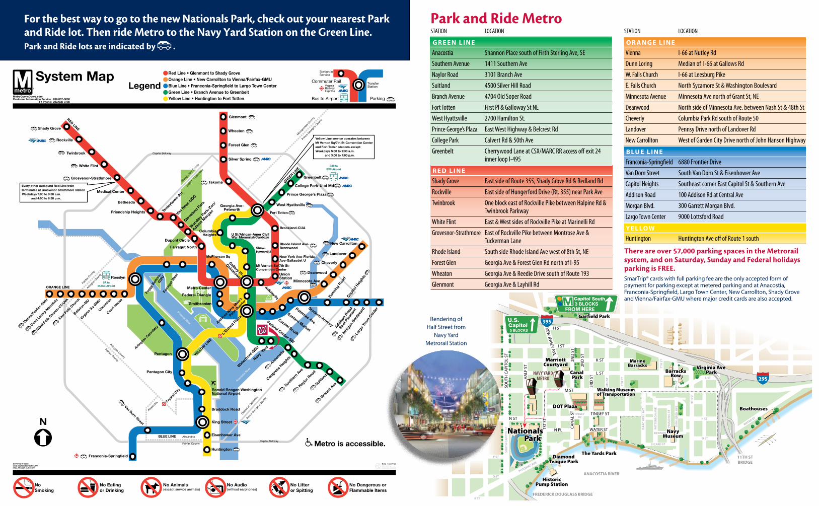
STATION LOCATION GREEN LINE Anacostia Shannon Place south of Firth Sterling Ave, SE Southern Avenue 1411 Southern Ave Naylor Road 3101 Branch Ave Suitland 4500 Silver Hill Road Branch Avenue 4704 Old Soper Road Fort Totten First Pl & Galloway St NE West Hyattsville 2700 Hamilton St. Prince George’s Plaza East West Highway & Belcrest Rd College Park Calvert Rd & 50th Ave Greenbelt Cherrywood Lane at CSX/MARC RR access off exit 24 inner loop I-495 RED LINE Shady Grove East side of Route 355, Shady Grove Rd & Redland Rd Rockville East side of Hungerford Drive (Rt. 355) near Park Ave Twinbrook One block east of Rockville Pike between Halpine Rd & Twinbrook Parkway White Flint East & West sides of Rockville Pike at Marinelli Rd Grovesnor-Strathmore East of Rockville Pike between Montrose Ave & Tuckerman Lane Rhode Island South side Rhode Island Ave west of 8th St, NE Forest Glen Georgia Ave & Forest Glen Rd north of I-95 Wheaton Georgia Ave & Reedie Drive south of Route 193 Glenmont Georgia Ave & Layhill Rd STATION LOCATION ORANGE LINE Vienna I-66 at Nutley Rd Dunn Loring Median of I-66 at Gallows Rd W. Falls Church I-66 at Leesburg Pike E. Falls Church North Sycamore St & Washington Boulevard Minnesota Avenue Minnesota Ave north of Grant St, NE Deanwood North side of Minnesota Ave. between Nash St & 48th St Cheverly Columbia Park Rd south of Route 50 Landover Pennsy Drive north of Landover Rd New Carrollton West of Garden City Drive north of John Hanson Highway BLUE LINE Franconia-Springfield 6880 Frontier Drive Van Dorn Street South Van Dorn St & Eisenhower Ave Capitol Heights Southeast corner East Capitol St & Southern Ave Addison Road 100 Addison Rd at Central Ave Morgan Blvd. 300 Garrett Morgan Blvd. Largo Town Center 9000 Lottsford Road YELLOW Huntington Huntington Ave off of Route 1 south NEW JERSEY AVE TINGEY CANAL ST SOUTH CAPITOL ST POTOMAC AVE Q ST P ST R ST ISAAC HULL AVE PATTERSON AVE DAHLGREN AVE PAULDING ST 2ND ST 4TH ST 5TH ST 7TH ST 8TH ST 9TH ST N ST O ST KENNON ST SICARD ST WATER ST L ST K ST H ST TINGEY ST FR EDERICK DOUGLASS BRIDGE 11TH ST BRIDGE SOUTH CAPITOL ST N a t i o n a l s a r k Nationals ark D O T P l a z a DOT Plaza C a n a l P a r k Canal Park N a v y M u s e u m Navy Museum V i r g i n i a A v e P a r k Virginia Ave Park T h e Y a r d s P a r k The Yards Park S H i s t o r i c P u m p S t a t i o n Historic Pump Station B a r r a c k s R o w Barracks Row W a l k i n g M u s e u m o f T r a n s p o r t a t i o n Walking Museum of Transportation A NAVY YARD METRO B o a t h o u s e s Boathouses D i a m o n d T e a g u e P a r k Diamond Teague Park M a r r i o t t C o u r t y a r d Marriott Courtyard M a r i n e B a r r a c k s Marine Barracks G a r f i e l d P a r k Garfield Park I ST 2ND ST L ST 3RD ST M ST HALF ST 1ST ST N ST N PL SQ WATER ST P P Park and Ride Metro Rendering of Half Street from Navy Yard Metrorail Station For the best way to go to the new Nationals Park, check out your nearest Park and Ride lot. Then ride Metro to the Navy Yard Station on the Green Line. Park and Ride lots are indicated by . There are over 57,000 parking spaces in the Metrorail system, and on Saturday, Sunday and Federal holidays parking is FREE. SmarTrip® cards with full parking fee are the only accepted form of payment for parking except at metered parking and at Anacostia, Franconia-Springfield, Largo Town Center, New Carrollton, Shady Grove and Vienna/Fairfax-GMU where major credit cards are also accepted.
Transcript of Metro Map - Official Washington Nationals...
Station Location
G R E E N L I N E anacostia Shannon Place south of Firth Sterling ave, SE
Southern avenue 1411 Southern ave
naylor Road 3101 Branch ave
Suitland 4500 Silver Hill Road
Branch avenue 4704 old Soper Road
Fort totten First Pl & Galloway St nE
West Hyattsville 2700 Hamilton St.
Prince George’s Plaza East West Highway & Belcrest Rd
college Park calvert Rd & 50th ave
Greenbelt cherrywood Lane at cSX/MaRc RR access off exit 24 inner loop i-495
R E d L I N E
Shady Grove East side of Route 355, Shady Grove Rd & Redland Rd
Rockville East side of Hungerford Drive (Rt. 355) near Park ave
twinbrook one block east of Rockville Pike between Halpine Rd & twinbrook Parkway
White Flint East & West sides of Rockville Pike at Marinelli Rd
Grovesnor-Strathmore East of Rockville Pike between Montrose ave & tuckerman Lane
Rhode island South side Rhode island ave west of 8th St, nE
Forest Glen Georgia ave & Forest Glen Rd north of i-95
Wheaton Georgia ave & Reedie Drive south of Route 193
Glenmont Georgia ave & Layhill Rd
Station Location
O R a N G E L I N E
Vienna i-66 at nutley Rd
Dunn Loring Median of i-66 at Gallows Rd
W. Falls church i-66 at Leesburg Pike
E. Falls church north Sycamore St & Washington Boulevard
Minnesota avenue Minnesota ave north of Grant St, nE
Deanwood north side of Minnesota ave. between nash St & 48th St
cheverly columbia Park Rd south of Route 50
Landover Pennsy Drive north of Landover Rd
new carrollton West of Garden city Drive north of John Hanson Highway
B Lu E L I N E
Franconia-Springfield 6880 Frontier Drive
Van Dorn Street South Van Dorn St & Eisenhower ave
capitol Heights Southeast corner East capitol St & Southern ave
addison Road 100 addison Rd at central ave
Morgan Blvd. 300 Garrett Morgan Blvd.
Largo town center 9000 Lottsford Road
Y E L LO W
Huntington Huntington ave off of Route 1 south
NEW
JERSEY AVE
TINGEY
CA
NA
L ST
SOU
TH C
AP
ITO
L ST
POTOMAC AVE
Q ST
P ST
R ST
S ST
T ST
ISA
AC
HU
LL A
VE
PATT
ERSO
N A
VE
DA
HLG
REN
AV
E
PAU
LDIN
G S
T
2ND
ST
4TH
ST
5TH
ST
7TH
ST
8TH
ST
9TH
ST
N ST
O ST
KENNON ST
SICARD ST
WATER ST
L ST
K ST
H ST
1ST
ST
HA
LF S
T
V ST
TINGEY ST
FREDERICK DOUGLASS BRIDGE
11TH STBRIDGE
SOU
TH C
API
TOL
ST
2ND
ST
Nationalsark
Nationalsark
DOT PlazaDOT Plaza
Canal Park
Canal Park
NavyMuseum
NavyMuseum
Virginia Ave Park
Virginia Ave Park
The Yards ParkThe Yards Park
S
HistoricPump Station
HistoricPump Station
BarracksRow
BarracksRow
Walking Museumof TransportationWalking Museumof Transportation
A
NAVY YARD
METRO
BoathousesBoathouses
DiamondTeague Park
DiamondTeague Park
CoasdGuard HQ
Coast Guard HQ
MarriottCourtyard
MarriottCourtyard
MarineBarracksMarine
Barracks
Garfield ParkGarfield Park
I ST
2ND
ST
L ST
3RD
ST
M ST
HA
LF S
T
1ST
ST
N ST
N PL
SQ
WATER ST
PP
Park and Ride Metro
Rendering of Half Street from
Navy Yard Metrorail Station
For the best way to go to the new Nationals Park, check out your nearest Park and Ride lot. Then ride Metro to the Navy Yard Station on the Green Line. Park and Ride lots are indicated by .
There are over 57,000 parking spaces in the Metrorail system, and on saturday, sunday and Federal holidays parking is Free.SmarTrip® cards with full parking fee are the only accepted form of payment for parking except at metered parking and at Anacostia, Franconia-Springfield, Largo Town Center, New Carrollton, Shady Grove and Vienna/Fairfax-GMU where major credit cards are also accepted.