METAL ACCUMULATION IN SURFACE SEDIMENT OF THE …cinarem.ismm.edu.cu/ponencias/PROTAMBI17/Yosbanis...
16
METAL ACCUMULATION IN SURFACE SEDIMENT OF THE URBAN AND INDUSTRIAL COASTAL AREA OF THE MUNICIPALITY OF MOA (CUBA): DISTRIBUTION AND POLLUTION ASSESSMENT. Yosbanis Cervantes-Guerra. Mining and Metallurgist Institute of Moa “Dr. Antonio Núñez Jiménez”, Cuba, [email protected]. Allan Pierra-Conde. University of Computer Science, Cuba. [email protected] Alina Rodríguez-Infante. Mining and Metallurgist Institute of Moa “Dr. Antonio Núñez Jiménez”, Cuba. [email protected]. Yuri Almaguer-Carmenates. Autonomous University of Coahuila, Mexico. [email protected] Hans Jürgen-Gursky. Technical University of Clausthal, Germany. [email protected]. Jo Van-Caneghem. Catholic University of Leuven, Belgium. [email protected]. Carlo Vandecasteele. Catholic. University of Leuven, Belgium. [email protected]. Abstract The investigation is to evaluate the accumulation of ten elements (Al, Cr, Fe, Mn, Ni, Co, As, Cu, Pb and Zn) in surface sediments from the urban and industrial coastal area of Moa. Human activity has influenced the region, which has been developing in one of the most important mining regions of Cuba since the middle of the past century. Two methods were used to assess the contamination of the sediments: the estimation of metal enrichment by calculating the index of geo-accumulation (Igeo) and the interpretation of the data obtained based on quality criteria. The overall range of concentrations is 15.7 - 83.5 mg g -1 for aluminum, 1.4 - 17.9 mg g -1 for chromium, 22.8 - 379.5
Transcript of METAL ACCUMULATION IN SURFACE SEDIMENT OF THE …cinarem.ismm.edu.cu/ponencias/PROTAMBI17/Yosbanis...
METAL ACCUMULATION IN SURFACE SEDIMENT OF THE URBAN AND
INDUSTRIAL COASTAL AREA OF THE MUNICIPALITY OF MOA (CUBA):
DISTRIBUTION AND POLLUTION ASSESSMENT.
Yosbanis Cervantes-Guerra. Mining and Metallurgist Institute of Moa “Dr.
Antonio Núñez Jiménez”, Cuba, [email protected].
Allan Pierra-Conde. University of Computer Science, Cuba.
Alina Rodríguez-Infante. Mining and Metallurgist Institute of Moa “Dr. Antonio
Núñez Jiménez”, Cuba. [email protected].
Yuri Almaguer-Carmenates. Autonomous University of Coahuila, Mexico.
Hans Jürgen-Gursky. Technical University of Clausthal, Germany.
Jo Van-Caneghem. Catholic University of Leuven, Belgium.
Carlo Vandecasteele. Catholic. University of Leuven, Belgium.
Abstract
The investigation is to evaluate the accumulation of ten elements (Al, Cr, Fe,
Mn, Ni, Co, As, Cu, Pb and Zn) in surface sediments from the urban and
industrial coastal area of Moa. Human activity has influenced the region, which
has been developing in one of the most important mining regions of Cuba since
the middle of the past century. Two methods were used to assess the
contamination of the sediments: the estimation of metal enrichment by
calculating the index of geo-accumulation (Igeo) and the interpretation of the
data obtained based on quality criteria. The overall range of concentrations is
15.7 - 83.5 mg g-1 for aluminum, 1.4 - 17.9 mg g-1 for chromium, 22.8 - 379.5
mg g-1 for iron, 1.5 - 56.2 mg g-1 for manganese, 0.9 - 6.2 mg g-1 for nickel, 56 -
1094 μg g-1 for cobalt, 6 - 126 μg g-1 for arsenic, 17 to 146 μg g-1 for copper, 6 -
66 μg g-1 for lead, and 64 - 576 μg g-1 for zinc. The results obtained from the
studied coastal zone show a high level of pollution in surface sediments. The
spatial distribution of the elements varied according to the analyzed elements:
Al, Cr, Fe and Ni showed high levels of concentration throughout the studied
zone; Mn, Co, Cu, As and Zn are in a higher proportion in Moa Bay Cay. In the
case of As and Pb, higher concentrations were located at the deltas of Moa and
Cayo Guam rivers and also in some areas in the west of the bay.
Key words: Moa Bay Cay; geoaccumulation index; contamination in marine
sediments; mining impacts; geoenvironmental study.
1. INTRODUCTION
Studies about toxic elements in surface sediments are considered to be
relevant for geochemical investigations on seacoasts as these elements may
dissolve and be incorporated in the ecosystem, turning them into environmental
risk areas (Zhu et al. 2012; Herrera et al. 2013; Gupta et al. 2014; Gang et al.
2016).
The mobility of metals is generally considered very low: they accumulate on the
first centimeters of the sediment and only very small quantities reach the
subsurface. Therefore, a high concentration on the surface horizon is a good
diagnostic criterion for anthropogenic pollution. The coastline of the Moa Bay
Cay located to the northeast of the province of Holguín, Cuba has suffered a
great deterioration due to mining and metallurgical activities (Cervantes et al.
2011).
The municipality of Moa is the most important mining town of Cuba, with an
average production of more than 60 thousand tons of nickel and cobalt on a
yearly basis (National Bureau of Statistics and Information – ONEI – (2014)).
Moa with a population of 75 101 inhabitants (ONEI 2014) has two mine -
metallurgical plants in operation, one port and an airport.
The main impacts produced by mining operations in Moa are the disappearance
of extensive areas of forests, the construction of geological exploration trails
and of mining roads, and the formation of large deposits of industrial tailings.
This has led to increased erosion of the land surface resulting from more than
106 m3/year of sediments being carried by surface streams and deposited in
the Moa Bay Cay (Fernández 2009).
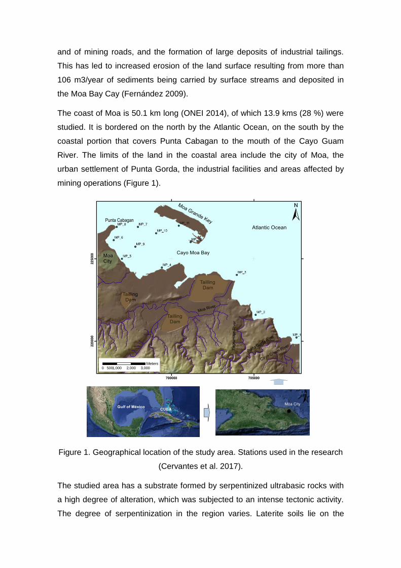
The coast of Moa is 50.1 km long (ONEI 2014), of which 13.9 kms (28 %) were
studied. It is bordered on the north by the Atlantic Ocean, on the south by the
coastal portion that covers Punta Cabagan to the mouth of the Cayo Guam
River. The limits of the land in the coastal area include the city of Moa, the
urban settlement of Punta Gorda, the industrial facilities and areas affected by
mining operations (Figure 1).
0 1,000 2,000 3,000500Meters
Figure 1. Geographical location of the study area. Stations used in the research
(Cervantes et al. 2017).
The studied area has a substrate formed by serpentinized ultrabasic rocks with
a high degree of alteration, which was subjected to an intense tectonic activity.
The degree of serpentinization in the region varies. Laterite soils lie on the
serpentinized substrate, spatially located along the coast or near. Cr, Fe, Mn,
Ni, Co, Cu, and Zn occur in various proportions in different profiles of the laterite
soils.
At the bottom of the bay, friable quaternary clastic sediments and terrigenous
biodentritical prevail. The lithology is represented by four horizons (from the
bottom up): calcareous grit, carbonated sandy silt, carbonated silt and
terrigenous silt (Menéndez 2001).
The stream pattern in the Moa Bay Cay is ruled by the effect of tides, showing a
net water movement in the western direction during high tides and less intense
in the east direction during low tides (Menéndez 2001).
This implies that most waste and movement sediments carried over by the
Cayo Guam, Punta Gorda, Yagrumaje and Moa rivers reach the bay and are
being deposited along the coast.
2. MATERIALS ANDY METHODS
For geoaccumulation analysis, sediment samples were taken in three periods
from 2009 through 2011. Twelve sampling locations were selected. These were
sampled on a yearly basis for three consecutive years. Ten elements (Al, Cr,
Fe, Mn, Ni, Co, As, Cu, Pb, and Zn) were determined. The average value will be
used for subsequent calcullations.
Samples were collected by scuba diving. A collector tube inserted into the mud
allowed 50 cm of sediment to be extracted. All samples were stored in a plastic
bag of about one kilogram capacity.
The evaluated area was divided into two areas of work:
Deltaic zone: In this zone, the mouth of Moa, Yagrumaje, and Cayo
Guam rivers were monitored. These are the main ways through which
pollutants get into the marine area; therefore, the pollution of the area is
caused by sediments recently accumulated in the delta. MP 1, MP 2 and
MP 3 stations were located in the deltaic zone (Figure 1).
Industrial and urban, coastal zone: This includes the lagoon of the Moa
Bay Cay that is bordered on the south by the coastline of Moa city and
on the north by the southern coast of the Moa Grande Cay. It extends
from Punta Cabagan in the west to Moa River in the east. Stations MP 5,
MP 6, MP 7, MP 8 MP 9 MP 10, MP 11 and MP 12 where located in Moa
Bay Cay (Figure 1).
The samples were dried at 60 °C for 24 hours and later sieved. The fraction ˂
63 microns were extracted for analysis. A portion of dry sediment (0.5 g) was
digested with the following mix of Suprapur® quality acid: 5 ml of HNO3
(concentrated), 10 ml of HF (concentrated) and 7 ml of HClO4 (concentrated)
and evaporated to dryness. The residue was dissolved in 10 ml of HCl
(concentrated) tranferred to a Teflon flask and adjusted to 25 ml with pure
deionized water of 18.2 MΩcm-1. Determinations were carried out by using a
Varian Vista MPX Axial ICP - AES spectrometer.
The accuracy of the analytical procedure used was checked by repeatedly
analyzing reference samples (IAEA-365), and comparing the obtained values
with the expected values. The quality control samples represented 10% of the
total analytical load. Precision was over 50% and the results for the references
samples were between 93 % and 105 % compared to the certified value.
The index value of geoaccumulation defined by Müller (1969) was used for
assessing the contamination caused by sediments. This index has been used in
several investigations and is proven to be a useful pollution geoindicator (Amat
et al. 2002; ONG et al. 2013), (See Supporting Information SI.I).
The limits proposed by Long et al. (1995) were used (See Supporting
Information SI.II) in order to interpret the information based on ecotoxicological
criteria.
3. RESULTS AND DISCUSSIN
3.1. Sediment characterization
The color of the sediment obtained in the studied coastal area ranged between
black and brown-red. The sediments most affected by suspended materials
penetrating into the marine environment through Yagrumaje and Cayo Guam
rivers are reddish, which is caused by laterite sediments.
However, sediments obtained from the delta of Moa River (MP 3) have a black
coloration very similar to the tailings deposited near the mouth of the Moa Rive.
This waste is carried over to the coast due to erosion during periods of heavy
rains. Granulometry, in most stations, shows the presence of clay or a mixture
of clay with different types of sand (Table 1).
Table 1. Characteristics of surface sediments.
Sample Color (visual) Granulometric features (visual)
MP 1 Black-gray with red streaks Fine sand
MP 2 Brown with black streaks Clay
MP 3 Black Clay-fine sand
MP 4 Brown - black Sand-clay
MP 5 Brown - black Clay-sand
MP 6 Brown-black Clay
MP 7 Brown-black Clay
MP 8 Brown-black Clay
MP 9 Brown - black Clay-fine sand
MP 10 Gray-black Clay-fine sand
MP 11 Gray-black Clay-sand
MP 12 Gray Clay-sand
Factor analysis showed that the elements determined are in three groups: there
is a high correlation between, Al, Cr, Ni and Fe (first group); a second group
shows a high correlation between Mn, Co, Cu and Zn, and finally, a third group
is formed by As and Pb (See Supporting Information SI.III).
3.2. Distribution of the elements studied
Aluminum
The area with the highest concentrations of Al covers the coastline from the
west of Moa (MP 5) to the mouth of Cayo Guam River (MP 1) (Figure 2). At the
MP 5 and MP 2 stations, concentrations above 80 mg g-1 were recorded. MP 5
is located in one of the areas receiving the largest quantities of sediments from
the emerged areas and is situated on the southern shore of the Moa Bay Cay.
Removal of silty sediments is high in this area, mainly caused by shallowness
and the impact of climatic factors as well as dredging activity on the bay.
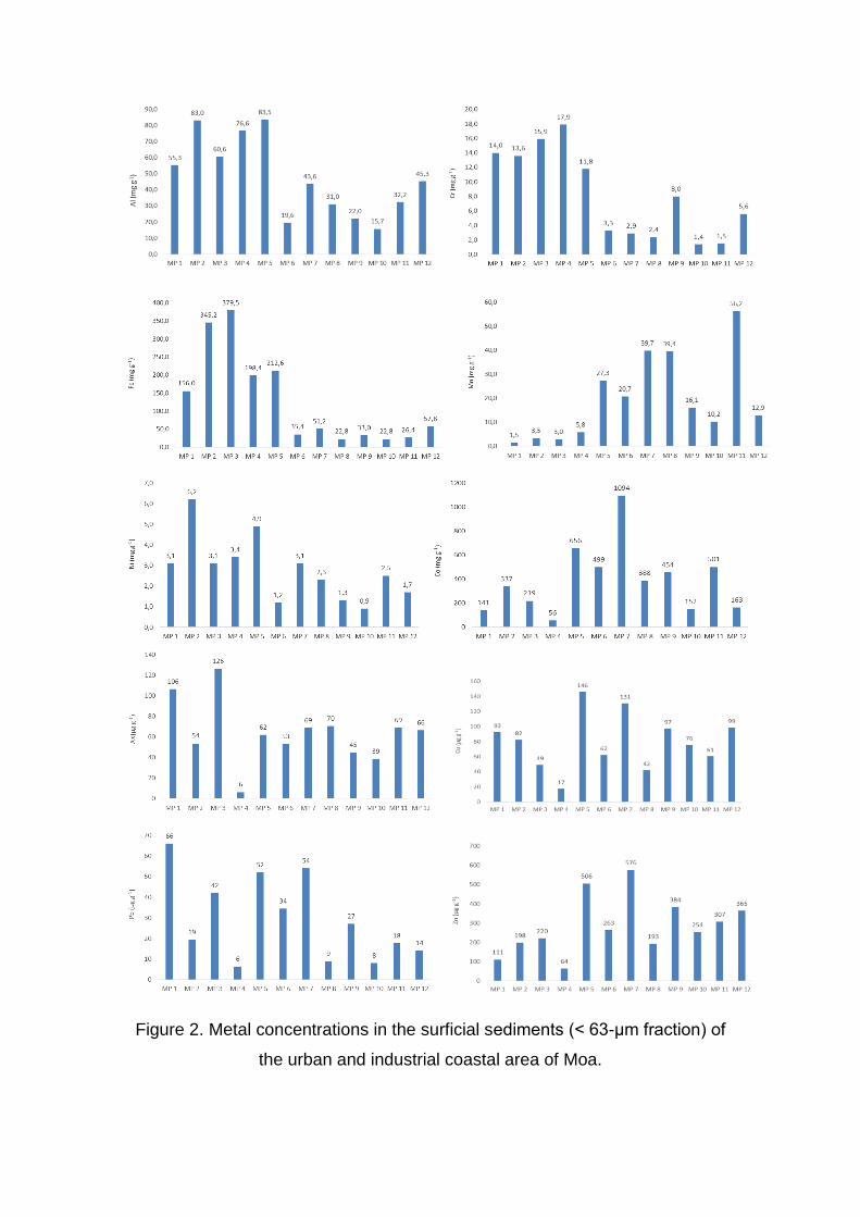
Figure 2. Metal concentrations in the surficial sediments (˂ 63-μm fraction) of
the urban and industrial coastal area of Moa.
The delta of Yagrumaje River (MP 2) is an area where large volumes of eroded
laterite sediments coming from various affected areas by the mining activity
converge. Another reason explaining a high concentration of Al in this location
is erosion of soil profiles in the presence of medium and low grade bauxite in
the northernmost section of the river (Bergues 2006). MP 3 and MP 4 are also
close to the dumping area of liquid wastes coming from the industry with
contents of Al between 4 000 and 5 000 mg /l (Cueto et al. 2003).
Chromium
Two zones that show differences in the chromium accumulation can be
distinguished. The highest concentrations of Cr (11.8 to 17.9 mg g-1) are found
in the coastal area from Moa city (MP 5) to the mouth of the river Cayo Guam
(MP 1) and lower concentrations (1.4 to 5.6 mg g-1) are found to the west of
Moa Bay Cay.
Chromium is a common element in the soils of the region; and the industrial
wastes are another source of Cr going to the coast.
Iron
The studied region is one of the largest iron reserves around the world. Fe is
concentrated in the tailings discharged by the existing mining industries which
are stored behind dams located along the coast, for future use. In general, the
concentration values are high. The concentrations of Fe exceed 150 mg g-1 in
five stations. Maximum concentration values were found in MP 3 (379.5 mg g-1)
and MP 2 (345.2 mg g-1) stations, located in the deltas of Moa and Yagrumaje
rivers.
Lower contents were found to the northwest of the area, where the mayority of
the monitored stations are located, except for MP 5 (212.6 mg g-1) and MP 4
(198.4 mg g-1). In the remaining stations, concentrations were all below 150 mg
g-1 (Figure 2).
Manganese
Manganese is a metal associated to laterite soils and it is essentially found as
oxides (MnO). In soil profiles, manganese oxides are phase mineral carriers of
cobalt and nickel (Rojas 2012). The highest concentration values were found in
the industrial and urban coastal areas. The highest value is found in MP 11
(56.2 mg g-1). High concentration values of Mn are also found in MP 7 (39.7 mg
g-1) and MP 8 (39.4 mg g-1). This is because the area of the lagoon is a basin
receiving sediments, which carries Mn from the areas affected by erosion.
Nickel
Nickel is an essential element exploited by mining companies in the region. Its
content in the ore ranges from 0.5 mg g-1 and 30 mg g-1 and the average in the
surface sediments from the seabed is 2.8 mg g-1 (Figure 2). Maximum levels
were found in MP 2 station (6.2 mg g-1) and MP 5 (4.9 mg g-1). Minimum
contents were found in the lagoon, specifically in MP 10, MP 6 and MP 9
stations with values lower than 2 mg g-1.
The elements of Al, Cr, Fe and Ni show a similar accumulation pattern. Higher
values are found in the deltaic zone (MP 1, MP 2 and MP 3) as well as in MP 4
and MP 5 stations located in the coastal zone. This behavior is due to these
elements entering the coast by the Moa, Yagrumaje and Cayo Guam rivers and
due to the ocean. Currents are carried over to the lagoon.
Cobalt
Cobalt is an element under exploitation by the local mining industry. Co occurs
in laterite soils in smaller quantities than Ni. Its concentration in laterite profiles
of the region ranges from 0.3 mg g-1 to 17.1 mg g-1. In urban and industrial
coastal areas of Moa, the highest concentrations were found to the west of the
lagoon. The highest values were found in MP 7 station with 1094 μg g-1. Other
significant values exceeding 500 μg g-1 were found in MP 5 and MP 11 stations.
The lowest concentrations were found in stations MP 1, MP 4, MP 10 and MP
12 (Figure 2).
Arsenic
Arsenic is an element that has never been reported to be found in surface
sediments on the coast of Moa. The concentrations found here range from 6 to
126 μg g-1 (Figure 2). The highest concentrations were found at the mouths of
the Moa River (MP 3) with 126 μg g-1 and Cayo Guam River (MP 1) with 106 μg
g-1; on the coastline of Moa the highest value was found in MP 8 and MP 11.
The concentration decreases to the northwest of the lagoon.
Arsenic is an element dissociated from the local geology, which indicates that it
reaches the bay because of human activity.
Copper
The concentration of Cu ranges from 17 to 146 μg g-1, with an average value of
79 μg g-1. The maximum values are distributed in the lagoon. The best
examples are found in MP 5 (146 μg g-1) and MP 7 (130 μg g-1), and the highest
values in the delta zone were associated with MP 1 (92 μg g-1) and MP 2 (82 μg
g-1). As copper is not a common metal occurring in the laterite crust, its origin is
presumed to be urban and mining – metallurgical activities in the coastline zone
(Figure 2).
Lead
The concentration of lead ranges from 6 to 66 μg g-1. The highest
concentrations are found in the mouth of Cayo Guam River (MP 1) and in the
western portion of the Moa Bay Cay in MP 7 and MP 5 stations. Minimum
values (below 10 μg g-1) were found in MP 4, MP 10 and MP 8 (Figure 2). There
is no report of Pb being found in laterites so it is assumed that its origin is
associated with the industrial and urban activity.
Zinc
Laterite soils contain large amounts of iron oxides, which are known to have
strong zinc-binding capacity (Mandal et al. 1992). In surface marine sediments,
the concentration ranges from 64 to 576 μg g-1, with an average value of 286 μg
g-1 (Figure 2). The highest concentrations were found in the western portion of
the Moa Bay Cay (MP 5, MP 7 and MP 9) and south of Moa Grande Cay in MP
12.
The accumulation of Zn, Cu and Co shows a pattern: the highest values are
located in Moa Bay Cay specifically in MP 5 and MP 7 stations. The highest
disposals of terrigenous sediments in this zone and the influence of dumping
urban and industrial wastes on the coast is the major cause of this behavior.
Average, standard deviations and ranges for all samples analyzed are in the
supporting information (See Supporting Information SI. IV).
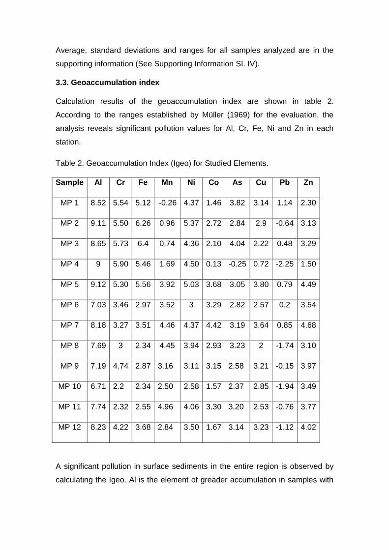
3.3. Geoaccumulation index
Calculation results of the geoaccumulation index are shown in table 2.
According to the ranges established by Müller (1969) for the evaluation, the
analysis reveals significant pollution values for Al, Cr, Fe, Ni and Zn in each
station.
Table 2. Geoaccumulation Index (Igeo) for Studied Elements.
Sample Al Cr Fe Mn Ni Co As Cu Pb Zn
MP 1 8.52 5.54 5.12 -0.26 4.37 1.46 3.82 3.14 1.14 2.30
MP 2 9.11 5.50 6.26 0.96 5.37 2.72 2.84 2.9 -0.64 3.13
MP 3 8.65 5.73 6.4 0.74 4.36 2.10 4.04 2.22 0.48 3.29
MP 4 9 5.90 5.46 1.69 4.50 0.13 -0.25 0.72 -2.25 1.50
MP 5 9.12 5.30 5.56 3.92 5.03 3.68 3.05 3.80 0.79 4.49
MP 6 7.03 3.46 2.97 3.52 3 3.29 2.82 2.57 0.2 3.54
MP 7 8.18 3.27 3.51 4.46 4.37 4.42 3.19 3.64 0.85 4.68
MP 8 7.69 3 2.34 4.45 3.94 2.93 3.23 2 -1.74 3.10
MP 9 7.19 4.74 2.87 3.16 3.11 3.15 2.58 3.21 -0.15 3.97
MP 10 6.71 2.2 2.34 2.50 2.58 1.57 2.37 2.85 -1.94 3.49
MP 11 7.74 2.32 2.55 4.96 4.06 3.30 3.20 2.53 -0.76 3.77
MP 12 8.23 4.22 3.68 2.84 3.50 1.67 3.14 3.23 -1.12 4.02
A significant pollution in surface sediments in the entire region is observed by
calculating the Igeo. Al is the element of greader accumulation in samples with
a maximum Igeo value of 9.12 (MP 5) and a minimum value of 6.71 (MP 10).
Cr, Fe and Ni are also metals with a high geoaccumulation.
In general, the most contaminated samples were found in MP 5, MP 7, MP 2
and MP 3, indicating a significant level of pollution throughout the analyzed
coastal sector.
The Mn geoaccumulation was not significant in the delta zone; however, the
values increase within the lagoon and reach a maximun value in the MP 11
station. Co, As and Cu are observed as recurrent contaminants in all stations,
except in MP 4.
Of all analyzed elements, Pb had the lowest geoaccumulation because only a
low degree of contamination was observed in MP 1. Negative Igeo values for
Mn, As and Pb in some stations indicate that the sediments are not
contaminated by these metals.
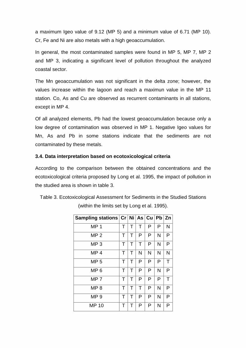
3.4. Data interpretation based on ecotoxicological criteria
According to the comparison between the obtained concentrations and the
ecotoxicological criteria proposed by Long et al. 1995, the impact of pollution in
the studied area is shown in table 3.
Table 3. Ecotoxicological Assessment for Sediments in the Studied Stations
(within the limits set by Long et al. 1995).
Sampling stations Cr Ni As Cu Pb Zn
MP 1 T T T P P N
MP 2 T T P P N P
MP 3 T T T P N P
MP 4 T T N N N N
MP 5 T T P P P T
MP 6 T T P P N P
MP 7 T T P P P T
MP 8 T T T P N P
MP 9 T T P P N P
MP 10 T T P P N P
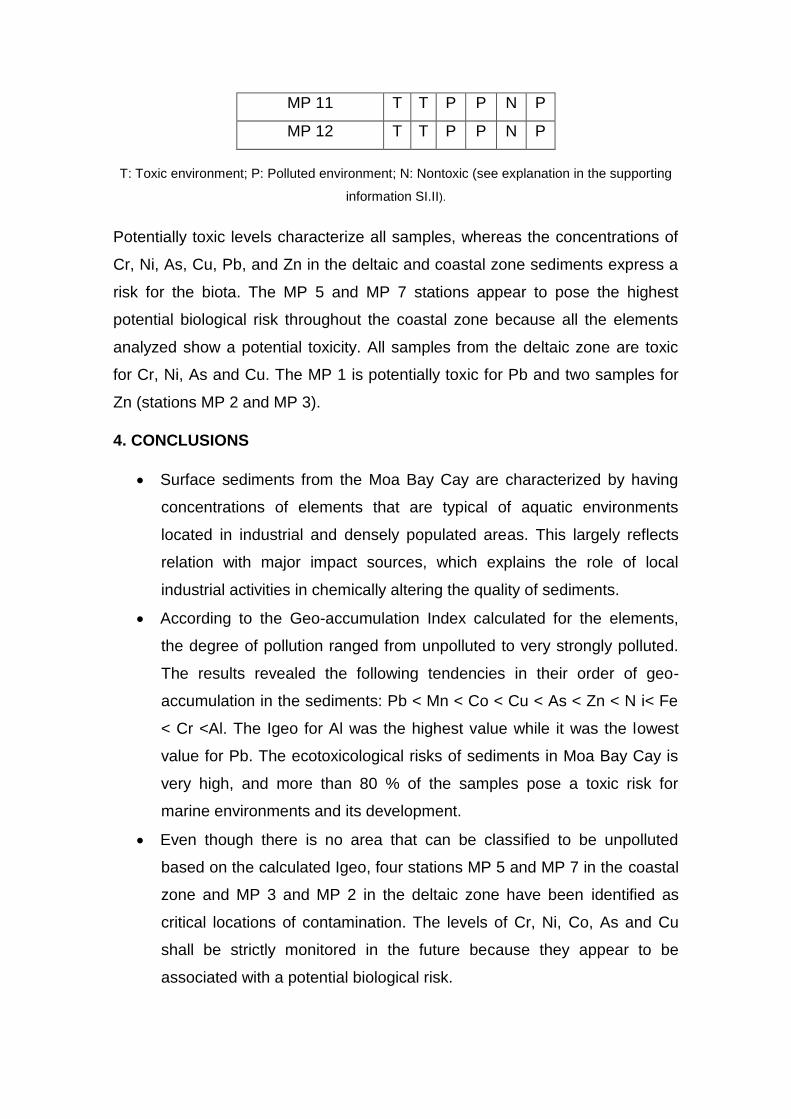
MP 11 T T P P N P
MP 12 T T P P N P
T: Toxic environment; P: Polluted environment; N: Nontoxic (see explanation in the supporting
information SI.II).
Potentially toxic levels characterize all samples, whereas the concentrations of
Cr, Ni, As, Cu, Pb, and Zn in the deltaic and coastal zone sediments express a
risk for the biota. The MP 5 and MP 7 stations appear to pose the highest
potential biological risk throughout the coastal zone because all the elements
analyzed show a potential toxicity. All samples from the deltaic zone are toxic
for Cr, Ni, As and Cu. The MP 1 is potentially toxic for Pb and two samples for
Zn (stations MP 2 and MP 3).
4. CONCLUSIONS
Surface sediments from the Moa Bay Cay are characterized by having
concentrations of elements that are typical of aquatic environments
located in industrial and densely populated areas. This largely reflects
relation with major impact sources, which explains the role of local
industrial activities in chemically altering the quality of sediments.
According to the Geo-accumulation Index calculated for the elements,
the degree of pollution ranged from unpolluted to very strongly polluted.
The results revealed the following tendencies in their order of geo-
accumulation in the sediments: Pb < Mn < Co < Cu < As < Zn < N i< Fe
< Cr <Al. The Igeo for Al was the highest value while it was the lowest
value for Pb. The ecotoxicological risks of sediments in Moa Bay Cay is
very high, and more than 80 % of the samples pose a toxic risk for
marine environments and its development.
Even though there is no area that can be classified to be unpolluted
based on the calculated Igeo, four stations MP 5 and MP 7 in the coastal
zone and MP 3 and MP 2 in the deltaic zone have been identified as
critical locations of contamination. The levels of Cr, Ni, Co, As and Cu
shall be strictly monitored in the future because they appear to be
associated with a potential biological risk.
This research clearly highlights the pressing need to make great efforts
to control industrial disposals in the coastal area. It also indicates that
immediate measures are to be taken to minimize contamination and to
prevent future pollution issues.
The investigation results have been considered in the definition of a
specific set of geoindicators for assessing and monitoring the condition of
the coastal environment and can be of great help for developing an
Integrated Coastal Zone Management.
5. References
Amat, D., Pierra, A., Casals, I., Vázquez, D. (2002) - Estudio de la
contaminación por metales pesados en sedimentos y ostiones de la bahía
de Manzanillo, Cuba. Journal of the Mexican Chemical Society (ISSN 1665
– 9686), 46 (4): 357-361. México. Available on-line at:
www.redalyc.org/pdf/475/47546411.pdf
Bergues, P. (2006) - Presencia de perfiles lateríticos con intercalaciones
atípicas y bauxitas en el sector septentrional del río Yagrumaje, Moa.
Minería y Geología (ISSN 0258 5979), 22 (1): 1 - 8, Moa, Cuba. Available
on-line at http://revista.ismm.edu.cu/index.php/revistamg/article/view/120
Cervantes, Y.; Almaguer, Y.; Pierra, A.; Orozco, G.; Gursky, H. (2011) -
Metales traza en sedimentos de la bahía de Cayo Moa (Cuba): evaluación
preliminar de la contaminación. Minería y Geología (ISSN 1993 8012) 27
(4): 1-19, Moa, Cuba. Available on-line at
http://revista.ismm.edu.cu/index.php/revistamg/article/download/282/pdf
CESIGMA. (1997) - Report on complete oceanographic study of the reef
lagoon of Cayo Moa Bay. Prepared by CESIGMA – División América and
GENECAR S.A., Report, 105p., Moa, Cuba. Unpublished.
Cueto, F.; Rondón, E.; Fuentes, R. (2003). Efluente líquido (wl) de la
tecnología de lixiviación ácida: alternativas de tratamiento. Geología y
Minería (ISSN 0258 5979) 3-4: 79 – 84, Moa, Cuba. Available on-line at
http://revista.ismm.edu.cu/index.php/revistamg/article/view/250
Fernández, Z. (2009) - Plan de MIZC para minimizar el azolvamiento en la
bahía de Cayo Moa. 106p., Master Thesis, Universidad de Oriente. Santiago
de Cuba, Cuba. Unpublished.
Gang, X.; Jian, L.; Shaofeng, P.; Gang, H.; Xianghuai, K. (2016) - Sources
and geochemical background of potentially toxic metals in surface
sediments from the Zhejiang coastal mud area of the East China Sea.
Journal of Geochemical Exploration, 168: 26 -35. DOI:
10.1016/j.gexplo.2016.06.003168
Gupta, S.; Jena, V.; Matic, N.; Kapralova, V. & Solanki, J. 2014: Assessment
of geo-accumulation index of heavy metal and source of contamination by
multivariate factor analysis. International Journal of Hazardous Materials,
2(2): 18-22.
Herrera, J; Rodríguez, J; Coto, J; Salgado, V & Borbón, H. 2013: Evaluación
de metales pesados en los sedimentos superficiales del río Pirro.
Tecnología en Marcha, 26 (1): 27-36.
Long, E.; Macdonald, D.; Smith, S.; Calder, F. (1995) - Incidence of adverse
biological effects within ranges of chemical concentrations in marine and
estuarine sediments. Environmental Management, 19 (1): 81-97. DOI:
10.1007/BF02472006.
Mandal, B.; Chatterjee, J.; Hazra, G.; Mandal, L. (1992). - Effect of
preflooding on transformation of applied zinc and its uptake by rice in lateritic
soils. Soil Science (ISSN: 0038-075X), 153(3): 250-257. Available on-line at
http://journals.lww.com/soilsci/Fulltext/1992/03000/EFFECT_OF_PREFLOO
DING_ON_TRANSFORMATION_OF_APPLIED.9.aspx
Menéndez, M. (2001) - Explotación racional del yacimiento de Cienos
Carbonatados en la Bahía de Cayo Moa. Master Thesis, 78p., Instituto
Superior Minero Metalúrgico de Moa, Moa, Cuba. Unpublished.
Müller, G. (1969) - Index of geoaccumulation in sediments of the Rhine
River. Geology Journal, 2(3): 108 – 118.
ONEI. (2014) - Anuario estadístico de Moa 2013. Report, Moa, Cuba.
Unpublished.
ONG, M.; Menier, D.; Shazili, N. & Kamaruzzaman, B. 2013: Geochemical
Characteristics of Heavy Metals Concentration in Sediments of Quiberon
Bay Waters, South Brittany, France. Oriental Journal of Chemistry, 29(1):
39-45.
Rodríguez, A. (1998) - Estudio morfotectónico de Moa y áreas adyacentes
para la evaluación de riesgos de génesis tectónica. 112p., Doctoral Thesis,
Instituto Superior Minero Metalúrgico de Moa, Cuba. Unpublished.
Rojas, A.; Romulo, S.; Orozco, G. (2012) - Identificación mineralógica de los
óxidos de manganeso del yacimiento laterítico Punta Gorda, Moa, Cuba.
Minería y Geología (ISSN: 0258-8959): 28(1): 1-26, Moa, Cuba. Available
on-line at http://www.redalyc.org/articulo.oa?id=223523810001
ZHU, H.; Zeng, G.; Jiang, M.; Liang, J.; Zhang, C.; Yin, J.; Huang, H.; Liu, Z.
& Jiang, H. 2012: Ecological risk assessment of heavy metals in sediments
of Xiawan Port based on modified potential ecological risk index. Trans.
Nonferrous Met. Soc. China 22: 1470-1477.