MESSAGE FROM THE EXECUTIVE DIRECTOR AND PRESIDENT … · MESSAGE FROM THE EXECUTIVE DIRECTOR AND...
13
Transcript of MESSAGE FROM THE EXECUTIVE DIRECTOR AND PRESIDENT … · MESSAGE FROM THE EXECUTIVE DIRECTOR AND...


MESSAGE FROM THE EXECUTIVE DIRECTOR AND PRESIDENT
The grounding of the T/V Seabulk Pride in
2006 set the tone for our focus in
2007 — navigational safety in Cook Inlet.
We began this year with great excitement
when Tesoro Alaska went beyond regulatory
requirements and announced their decision
to station an assist tug in Nikiski. Later in
the year Tesoro again went beyond
expectations by keeping the tug stationed
year-round and revealing the construction
of a new tug solely dedicated and specifically
designed to work in Cook Inlet.
A tug in Cook Inlet, however, does not
mean that our mission is accomplished.
There is much more work to be done. The
Council sponsored “Cook Inlet Navigational
Safety Forum” echoed the consensus of years
past when the participants strongly voiced the
need for a comprehensive risk assessment for
Cook Inlet. We must see that this assessment
is completed, but we will not do it alone.
Cook Inlet RCAC accomplishes the work
that Congress has mandated through
cooperation. It is in this spirit of cooperation
that we work with the citizens of Cook Inlet
as well as industry and government agencies
to keep Cook Inlet safe and free of oil
pollution. The following pages illustrate how
important those partnerships are to improve
prevention and response practices and to
guide our environmental monitoring projects
throughout the region.
Working together, we all succeed.
Michael Munger, Executive Director
Douglas Jones, President
MISS ION STATEMENT
Cook Inlet RCAC’s mission is to represent the citizens of Cook Inlet in promoting environmentally safe marine transportation and oil facility operations in Cook Inlet.
Our mission reflects the mandates spelled out by Congress when it passed the Oil Pollution Act of 1990, thereby creating two citizen oversight councils — one for Cook Inlet and one for Prince William Sound. Congress established these councils to ensure that citizens, oil industry, and government agencies would work together to prevent oil spills in Alaska’s waters.
Since then, Cook Inlet RCAC has been a strong voice for citizens from coastal communities in an area stretching from Anchorage to Kodiak who are working to keep Cook Inlet free from oil pollution.
TABLE OF CONTENTS
Message from President & Executive Director 1Response Tug Arrives 2-3Contingency Plan Review 4Ice Forecasting Network 5 Aquatic Non-Indigenous Species 6 NPDES Permit 7Saltmarsh Mapping 8-9 Kodiak ShoreZone 10-12Additional Projects 13Geographic Response Strategies 14-15Committee & Community Awareness Program 16-17Groups Represented by CIRCAC 18-19Board of Directors & Staff 20-21

RESPONSE TUG ARRIVES
SPOTLIGHT
The Council commended Captain Tim Plummer, president of Tesoro Maritime, for taking the initiative to bring an assist tug to Cook Inlet. “Tesoro should be applauded for their commitment to navigational safety by bringing this tug into Cook Inlet,” said Executive Director Michael Munger. “It’s a rare but welcomed occurrence for a corporation go above and beyond regulatory compliance.”
Captain Plummer
For many Cook Inlet citizens, the 2006
grounding of the T/V Seabulk Pride
underscored the need for improved safety
measures for tankers docking in Nikiski. This
prompted the Cook Inlet RCAC to pass a
resolution restating their 1996 position that
the U.S. Coast Guard should require that an
assist tug be stationed in Nikiski, to be paid
for by Inlet shippers and producers.
Although the Coast Guard did not establish
such a rule, Cook Inlet RCAC Executive
Director Michael Munger persistently urged
area producers to bring a tug to Cook
Inlet and these efforts were rewarded in
January 2007 when Tesoro Alaska stationed
the M/V Protector, a 5500 horsepower
tractor tug, at the Nikiski dock. This event
was one of the most important maritime
safety achievements in Cook Inlet since the
inception of the RCAC.
Although the Protector was originally slated
to leave Cook Inlet when the winter ice
retreated, Tesoro decided to station the tug
in Nikiski throughout the year and to bear
the total vessel costs.
The tug serves as an added precaution
to winter-time berthing and un-berthing
operations of crude oil tankers and provides
critical prevention and response capabilities
for the Cook Inlet region.
V IGILANT CONSTRUCTION
In September, Tesoro Alaska went one step
further than stationing the assist tug Protector
in Nikiski when they contracted with Crow-
ley Maritime Corporation for the construc-
tion of a new tractor tug. The 6700 horse-
power M/V Vigilant will replace the 5500
horsepower Protector and will be operated by
Crowley’s marine services division.
The vessel is in the final stages of fabrication
at Nichols Brothers Boat Builders in Wash-
ington and is slated to arrive in Cook Inlet in
2008. With steel plate ice belting above and
below the water line, under-deck heaters,
and immersion heaters for ballast tanks, the
Vigilant will be even better equipped than the
Protector to operate in the harsh ice-laden
winter waters of Cook Inlet. In addition, the
Vigilant’s twin “Z-Drive” system will be much
better suited for Cook Inlet than the Protec-
tor’s Voith-Schneider propulsion system. Tugs
with “Z-Drive” propulsion systems have ef-
fectively operated in icy Scandinavian waters
and in the extreme ice and tide conditions at
the Port of Anchorage.
2

Cook Inlet RCAC is mandated by OPA 90 to
review contingency plans — the action plans
that responsible parties use to address oil
spills — for the regulated crude oil industry in
Cook Inlet. Cook Inlet RCAC represents the
public’s interest and works with state agencies
and industry during plan reviews to reinforce
their importance in protecting Cook Inlet.
Thorough reviews of these plans are essential
to a healthy Cook Inlet since the State of Alaska
lengthened the effective period for contingency
planning from three years to five years. In 2007,
Cook Inlet RCAC commented on the following
local area contingency plans:
Forest Oil Corporation
Pioneer Natural Resources
Cook Inlet Pipeline Company
Tesoro Alaska Company
Cook Inlet RCAC also reviewed the Petro
Marine Services (Homer Bulk Plant)
contingency plan which, unlike the plans of the
facilities listed above, is a non-crude facility
plan. Using funds from an Alaska Legislative
Grant, we review plans of this nature one
or two times a year to increase prevention
awareness at non-crude facilities and maintain
coordination with the government agencies
responsible for regulating these facilities.
CONTINGENCY PLAN REVIEW
COOK INLET RCAC HISTORY
Cook Inlet RCAC opened its firstoffice in a little house on the bluffin Old Town Kenai on December6, 1990. Marathon Oil Companyprovided the initial start-up fundsfor the Council and these funds wenttoward office furnishings and salariesfor Frank Mullin, Interim ExecutiveDirector, and Karen (Williams) Delaney who is still employed by the Council as Assistant Executive Director.
In 2007, a National Oceanic and
Atmospheric Administration (NOAA) ice
forecaster requested Cook Inlet RCAC’s
assistance in obtaining better field ice
observations. Cook Inlet RCAC worked
with personnel from production platforms,
shoreside facilities, supply and response
vessels, and charter air services to assemble
a network of ice observers located
throughout Cook Inlet.
The network provided two daily reports
describing ice cover and make-up, ice-pan
dimensions and thickness, and digital pho-
tographs — greatly enhancing Cook Inlet
ice forecasts and analyses. The potential to
blend technology with the newly established
personal observations led to plans for a net-
work of digital video cameras to be deployed
throughout upper Cook Inlet in 2008.
The images captured by the cameras, in
conjunction with field observations and
satellite radar imagery, will allow NOAA
ice forecasters to produce more accurate
ice advisories and analyses, which has
implications for winter navigation and
marine operations in Cook Inlet. NOAA ice
advisories and analyses will soon provide
commercial mariners, vessel managers,
port managers, tug and barge operators, oil
spill responders, and researchers with live
images and detailed information for use in
making decisions concerning safety, oil spill
response, and scheduling. Additionally, the
archived video images will be available for
future ice studies.
ICE FORECASTING NETWORK
4

BALLAST WATER
Ballast water is the water carried in tanks on ships to provide stability.
Ballast water is typically loaded onto a ship from coastal waters and may contain many living organisms, especially planktonic plants and animals.
The discharge of ballast water to coastal waters risks introducing these organisms where they can negatively impact native species and habitats.
To reduce these risks, the U.S. Coast Guard established a program of mandatory ballast exchange for ships entering U.S. coastal waters from outside of the Exclusive Economic Zone.
By exchanging coastal water for oceanic water, the number of organisms that would arrive at the receiving port is minimized.
AQUATIC NON-INDIGENOUS SPECIES
Cook Inlet RCAC partnered with the U.S. Fish
and Wildlife Service to evaluate risks of non-
indigenous species (NIS) introductions to Cook
Inlet via ballast tank discharges from ships.
Two active projects are underway —
(1) examining the potential transfer of NIS
organisms in the ballast tanks of ships
conducting Trans-Pacific voyages to Cook
Inlet and (2) compiling a catalog of sources
and discharge locations of ballast water for all
ships entering Cook Inlet. The ballast water
catalog project is developing statistics for the
number and volume of discharges into Cook
Inlet by vessel type, port facility, ballast water
source, and ballast management practices.
Through a contract to the Smithsonian
Environmental Research Center (SERC), we
are quantifying and describing the zooplankton
communities in ballast water of LNG ships
arriving in Nikiski from Tokyo, Japan. The ballast
water tanks were sampled throughout the year.
Additional sampling, during voyages from Japan,
measured the effects of the oceanic transit on
the survival of NIS in the ballast tanks.
Thanks to ConocoPhillips, Marathon Oil and
the captains and crews of the LNG Tankers
Polar Eagle and Arctic Sun for facilitating this
research with access to their docks and ships.
•
•
•
•
•
A copepod, Acartia omorii, found in ballast tank sample from Japan. Photo courtesy of Smithsonian Environmental Research Center.
6
Cook Inlet RCAC sharply criticized the EPA
in 2007 for inadequately addressing public
comments regarding the new National
Pollution Discharge Elimination System
(NPDES) Permit for discharges into Cook
Inlet from platforms and onshore facilities.
This permit proposed standards allowing an
increase in potential pollutant load
from area oil facilities and replaces one
that went into effect in 1999. The new
permit went into effect in July 2007.
Several environmental, Alaska Native and
commercial fishing organizations brought
suit against the EPA regarding the permit but
a court decision has not been made.
Cook Inlet RCAC first reviewed the draft
permit in spring of 2006 and submitted 25
pages of detailed comments. That May, Cook
Inlet RCAC passed a resolution opposing
the permit as written, supporting the goal of
zero discharge.
Unfortunately, the final permit did not
adequately address a number of significant
public comments. Cook Inlet RCAC also
identified important changes between the
draft and final permit that were not subject
to public review.
As required by the permit, industry has
proposed an environmental monitoring
program that will take effect in 2008. Cook
Inlet RCAC will be involved in the review
process of this program and will work
toward coordinating our sampling efforts
with those required by EPA.
NATIONAL POLLUTION DISCHARGE EL IMINATION SYSTEM PERMIT

6
SALT MARSH MAPPING
Salt marsh habitat dominates in many
coastal areas of Cook Inlet, particularly on
the west side. This habitat can be especially
sensitive to spilled oil since plant roots and
sediments can retain oil and cleansing by
tides is minimal. Clean-up options are limited
by logistics and response actions can cause
more damage to the habitat than leaving the
oil in place.
Cook Inlet RCAC is providing detailed
habitat maps for major Cook Inlet salt
marshes — areas for which we have little
current baseline information. In 2007,
through a contract with Kachemak Bay
Research Reserve, we produced detailed
habitat maps for Chickaloon, Trading, and
Redoubt bays using data collected in 2006.
In September 2007, biologists spent ten
days working from the Homer-based R/V
Columbia mapping and sampling salt marsh
plant associations in Iniskin, Iliamna, Oil, and
Chinitna Bays.
8
MAPPING
Detailed maps of salt marsh plant communities are being produced for Cook Inlet like the one shown in the above thumbnail for Chickaloon Bay. The lowest tidal areas of these salt marshes are mud flats composed of fine silts and clays. Mudflats can provide rich feeding areas for birds, marine invertebrates, and fish.
Different plant communities dominate in lower elevation floods on each tide, compared with areas higher up in the intertidal zone. Thus, plants with the highest salt tolerances are found in the low marsh, and those with lower tolerances to salt are found in high marsh. Tidal creeks interweave across the marshes and mud flats, further influencing the distribution of the various plants within the larger salt marsh. These tidal creeks fill with seawater during high tides and drain during low tides.
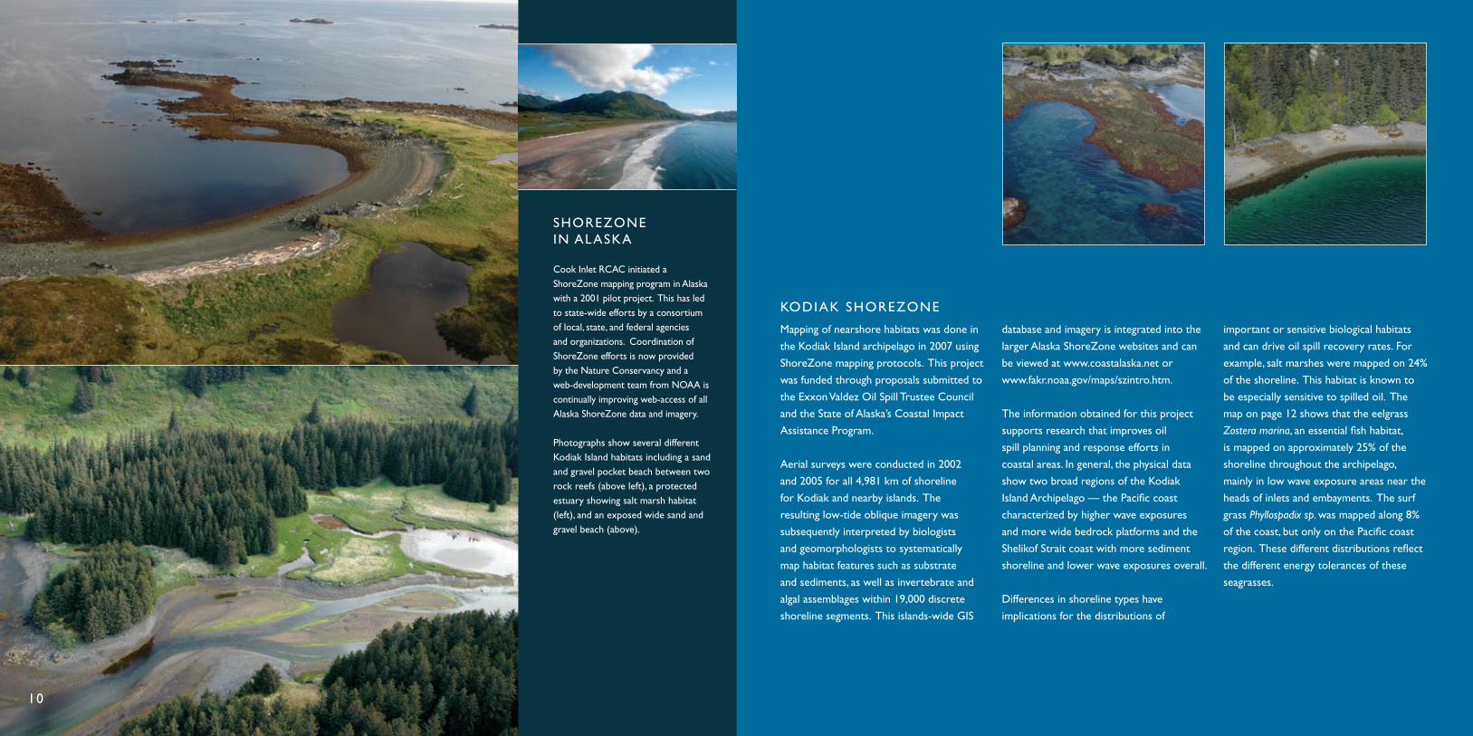
SHOREZONE IN ALASKA
Cook Inlet RCAC initiated a ShoreZone mapping program in Alaska with a 2001 pilot project. This has led to state-wide efforts by a consortium of local, state, and federal agencies and organizations. Coordination of ShoreZone efforts is now provided by the Nature Conservancy and a web-development team from NOAA is continually improving web-access of all Alaska ShoreZone data and imagery.
Photographs show several different Kodiak Island habitats including a sand and gravel pocket beach between two rock reefs (above left), a protected estuary showing salt marsh habitat (left), and an exposed wide sand and gravel beach (above).
KODIAK SHOREZONE
Mapping of nearshore habitats was done in
the Kodiak Island archipelago in 2007 using
ShoreZone mapping protocols. This project
was funded through proposals submitted to
the Exxon Valdez Oil Spill Trustee Council
and the State of Alaska’s Coastal Impact
Assistance Program.
Aerial surveys were conducted in 2002
and 2005 for all 4,981 km of shoreline
for Kodiak and nearby islands. The
resulting low-tide oblique imagery was
subsequently interpreted by biologists
and geomorphologists to systematically
map habitat features such as substrate
and sediments, as well as invertebrate and
algal assemblages within 19,000 discrete
shoreline segments. This islands-wide GIS
database and imagery is integrated into the
larger Alaska ShoreZone websites and can
be viewed at www.coastalaska.net or
www.fakr.noaa.gov/maps/szintro.htm.
The information obtained for this project
supports research that improves oil
spill planning and response efforts in
coastal areas. In general, the physical data
show two broad regions of the Kodiak
Island Archipelago — the Pacific coast
characterized by higher wave exposures
and more wide bedrock platforms and the
Shelikof Strait coast with more sediment
shoreline and lower wave exposures overall.
Differences in shoreline types have
implications for the distributions of
important or sensitive biological habitats
and can drive oil spill recovery rates. For
example, salt marshes were mapped on 24%
of the shoreline. This habitat is known to
be especially sensitive to spilled oil. The
map on page 12 shows that the eelgrass
Zostera marina, an essential fish habitat,
is mapped on approximately 25% of the
shoreline throughout the archipelago,
mainly in low wave exposure areas near the
heads of inlets and embayments. The surf
grass Phyllospadix sp. was mapped along 8%
of the coast, but only on the Pacific coast
region. These different distributions reflect
the different energy tolerances of these
seagrasses.
10

6
KODIAK ISLAND
Old Harbor
Akhiok
AFOGNAK ISLAND
Kodiak
BIOBANDS MAPPED IN SHOREZONE UNITS*
*present as either “patchy” or “continuous” within unit
Both Eelgrass and SurfgrassEelgrass Surfgrass
12
COOK INLET RCAC RESEARCH PARTNERS
Cook Inlet RCAC is coordinating sampling
programs with NOAA’s National Status
and Trends program as they assess habitat
conditions that influence biodiversity
and distribution of soft bottom benthic
invertebrate communities in Kachemak Bay.
In 2007, we participated during a research
cruise to coordinate our sampling methods.
We provided field support to scientists from
NOAA’s Auke Bay Laboratory during their
2007 Gulf of Alaska forage fish habitat study.
ShoreZone imagery and data were used to
identify locations for the fish capture surveys.
These data will improve our knowledge of
specific habitats that can be impacted by oil
spills that reach shore.
We continue to sponsor the website www.
seaweedsofalaska.com developed by Mandy
Lindenberg. The website provides photos
and information about seaweed species
identified during our shoreline surveys.
The site is expanding to include seaweeds
collected throughout Alaska by partnering
organizations.
Cook Inlet RCAC worked with scientists from
NOAA’s Office of Restoration and Response
on a study evaluating effects of oil and specific
clean-up methods on intertidal clams. One
aspect of the study is to evaluate the influence
of beach armoring on clam habitat and
populations. This information will translate
well to Cook Inlet RCAC concerns since
armored beaches are common in Cook Inlet.
With our partners at the Kachemak Bay
Research Reserve and the University of
Alaska Fairbanks, we submitted the report
“Seasonality of Boundary Conditions for
Cook Inlet, Alaska.” This study investigated
mechanisms that influence volume and
property fluxes at the inflow and outflow
boundaries to Cook Inlet and how they
change seasonally. This type of information
is necessary to develop and improve ocean
circulation models and oil spill trajectories in
Cook Inlet.
Cook Inlet RCAC was asked to lead the
Cook Inlet component of the Alaska Ocean
Observing System (AOOS). When fully
developed, AOOS will provide public access
to both real-time information and long-term
trends about Alaska’s ocean conditions and
marine life. We will coordinate these efforts
with a larger Gulf of Alaska observing system
and have submitted proposals to obtain
funding for deploying observation platforms
and developing atmospheric and oceanic
predictive models.

HARBOR SPECIF IC GRS
WHAT IS GRS?
Geographic Response Strategies (GRS) are oil spill response plans tailored to protect a specific sensitive area from impacts following a spill. These map-based response plans show responders where sensitive areas are located and where to place spill protection resources.
GRS sites are selected by a workgroup often comprised of scientists, government representatives and area stakeholders. The workgroup bases each selection on three criteria: environmental sensitivity, risk of impact from an oil spill, and feasibility of protecting the site. Once GRS site selection is finalized, the workgroup develops the appropriate strategy to protect the location. Each strategy is ground tested by deploying spill response equipment and personnel as though an actual spill has occurred. The test serves as a means to evaluate the strategy and allows for proper adjustment to be made prior to an event.
KODIAK GRS WORKGROUP
The Harbor Specific GRS is a component
of the Clean Harbors and Marinas Initiative,
an Alaska Department of Environmental
Conservation (ADEC) and Environmental
Protection Agency initiative. GRSs are being
developed for harbors and small boat marinas
within the Kenai Peninsula Borough.
This year, Cook Inlet RCAC worked with
the ADEC to form a workgroup to identify
and prioritize specific harbors and to create
operational GRS plans. By utilizing the
templates of the GRS and the Clean Harbors
and Marinas Initiative, this program will
facilitate pollution response within harbor
areas.The program will enable responders,
users, managers, and regulators to clean up
the harbor areas efficiently and will aid in the
prevention of future incidents.
When established, this program will provide
cleaner harbor environments and will
provide a template for other small harbors
and marinas around the state or nationwide.
The Kodiak GRS Workgroup met in 2007
to select specific areas for the remaining
two Kodiak Zones — Eastern and Southern.
For each zone, 20 sites were selected using
the same criteria as the sites selected
for the previous three zones. The criteria
included environmental sensitivity, exposure
to risk of being oiled, and ability to succeed
in protecting the area.
The map on the adjacent page shows the
Eastern Zone and the Southern Zone where
the GRS is final and has been adopted into
the contingency plan (green) or where the
GRS is still in draft form and will be reviewed
by the workgroup (red). To complete the
project, site surveys are slated for the
summer of 2008.
14
KODIAK ISLAND
Chiniak
Ugak Bay
SitkalidakIsland
Sitkinak Strait
Alita
k Ba
y
Olga Bay
Old Harbor
Uyak Bay
Akhiok
SitkinakIsland
Tugidak Island
ISLAND
Ugak Bay
SitkalidakIsland
Sitkinak Strait
Alita
k Ba
y
BayOlga BayBay
Old Harbor
Akhiok
akSitkinakakIslandI lI l
TugidakIslandandand
Old H
Sout
hern
Zon
e
Raspberry IslandKupreanof Strait
Afognak IslandMarmotIsland
Spruce IslandWhale Island
Chiniak
k gnak Islandk IMarmotMarmMarmIslandslasla
Spruce IslandWhale IslandWhale IWhale IW
gnak
East
ern
Zon
e
1817
16
82
81
84
85
86
87
83
15
19
20
21
3
2
1
4
5
88
69
7970 80
78
72
71
76
7374
75
77
9
8
6
7
SemidiIslands Chirikof
Island
Southern Zone Southern Zone
KODIAK ISLAND GRS Eastern and Southern Zones
KEY
In Dra f t Adopted

COMMITTEE & COMMUNITY AWARENESS PROGRAM
To increase their understanding of current
topics in 2007, committee and staff members
attended the 30th Arctic Marine Oil Spill
Program Technical Seminar, the Marine
Habitat and Technology Workshop for Alaska,
and the Alaska Invasive Species Conference.
Additionally, Chevron hosted a tour of their
facilities at Trading Bay and the Platform Bruce
in an effort to educate the Council on the oil
separation procedures and safety protocols
employed by Chevron during production.
Attendance at workshops and seminars
coupled with personal tours of local
production facilities, provides the Council with
education that vastly improves the group’s
decision-making on oil industry issues.
Effective communications with our
stakeholders is central to our program.
By utilizing various print, digital, and radio
resources to deliver information, Cook Inlet
RCAC strives to improve our communication
with constituents and industry representatives.
One such example of improved
communication is the evolution of our
newsletter, Council Briefs. In 2007, Cook Inlet
RCAC redesigned the newsletter as an online
interactive version that provides the reader
with links to relevant sections of our website
or to other websites. This format will enable
us to efficiently provide our subscribers with
more detailed information to augment stories.
Conferences and forums play an important
role in conveying the value of the RCAC
model to others. In 2007, Cook Inlet RCAC
representatives participated in local events
like the Alaska Forum for the Environment
and large regional proceedings such as the
Clean Pacific Conference and Exhibition in
Seattle, Washington.
Cook Inlet RCAC also hosted a two-day
Navigational Safety Forum in Anchorage
in February 2007 where major industry,
regulatory, municipal, and environmental
stakeholders from across the region met
to identify risks and discuss potential
safeguards for the Inlet.
The objective of the event was to develop
recommendations to improve navigational
safety through regulations, interventions, or
additional research and study.
A major point of discussion at the 2007
forum focused on our renewed request for a
comprehensive navigational risk assessment
in Cook Inlet to identify deficiencies and to
help implement measures that make vessel
traffic safer. Attendees and members of the
panel alike supported the risk assessment
and called on the State of Alaska and the
U.S. Coast Guard to fund the endeavor, an
essential first step to accomplish the study.
These conferences and forums provide a
venue for Cook Inlet RCAC to reach both
broad audiences and issue-specific assemblies.
The intimate settings of community visits,
an integral component of the Community
Awareness Program, and round out our
Committee & Community Awareness
Program affording us the opportunity to speak
with smaller audiences — not only about our
work, but also specific issues that directly
affect their communities.
16
COOK INLET RCAC HISTORY
In 1998, the 20th Alaska State Legislature honored the Councilfor the outstanding environmentalaccomplishments of its volunteermembers and staff since its inceptionseven years prior.
The Legislature commended Cook Inlet RCAC’s Alaskan volunteer spirit and dedication to its mission of being responsible and cooperative leaders in environmental monitoring of Cook Inlet . They stated that Cook Inlet RCAC’s reviews of oil spill prevention and response plans for crude oil tankers and onshore and offshore facilities and terminals operating within Cook Inlet were remarkable accomplishments.

The organization of the Cook Inlet Regional
Citizens Advisory Council is outlined in
the Oil Pollution Act of 1990 (OPA 90).
The thirteen-member Board of Directors
represents various municipalities, cities,
boroughs, and special interest groups to
ensure board representation of all citizens
within the Cook Inlet region. The Act also
calls for the inclusion of non-voting Ex-Officio
members, representing various state and
federal agencies.
BOARD OF DIRECTORS SEATSMunicipality of Anchorage
City of Homer
City of Kenai
City of Kodiak
City of Seldovia
Kenai Peninsula Borough
Kodiak Island Borough
Alaska Native Groups
Aquaculture Associations
Environmental Interest Groups
Commercial Fishing Groups
Recreational Groups
State Chamber of Commerce
EX-OFFICIO MEMBERSCAPTAIN MARK DEVRIES
United States Coast Guard
CARY LEHNHAUSEN
United States Forest Service
JOE DYGAS
Bureau of Land Management
JOHN WHITNEY
National Oceanic and Atmospheric
Administration
MATT CARR
Environmental Protection Agency
RICHARD T. PRENTKI
Minerals Management Service
PATRICIA WINN
Division of Homeland Security and Emergency
Management
BETTY SCHORR
Alaska Department of Environmental
Conservation
TOM BUCCERI
Alaska Department of Natural Resources
GROUPS REPRESENTED BY COOK INLET RCACOPA 90 requires that the Council establish
committees to accomplish its mandates. To
that end, Council directors and public members
comprise the Environmental Monitoring
Committee (EMC), the Prevention, Response,
Operations and Safety Committee (PROPS), and
the Protocol Committee to assist the Council in
meeting its obligations.
PROTOCOL COMMITTEE
COUNCIL MEMBERS
John Douglas, Chair
Vern McCorkle
Doug Jones
Grace Merkes
Rob Lindsey
Trenten Dodson
PREVENTION, RESPONSE, OPERATIONS, AND SAFETY COMMITTEE
COUNCIL MEMBERS
Rob Lindsey, Chair
Bob Shavelson
Carla Stanley
Doug Jones
Grace Merkes
Mary Jacobs
PUBLIC MEMBERS
Barry Eldridge
Bill Osborn
Bob Flint
Deric Marcorelle
Jerry Brookman
Lois Epstein
Philip Cutler
Ted Moore
CHARTER FUNDING COMPANIESConocoPhillips
Cook Inlet Pipeline Company
Forest Oil
Marathon Oil Company
Chevron/Unocal
XTO Energy
Tesoro/Kenai Pipeline
ENVIRONMENTAL MONITORING COMMITTEE
COUNCIL MEMBERS
Molly McCammon, Chair
Carla Stanley
Vern McCorkle
Gary Fandrei
Bob Shavelson
Doug Jones
PUBLIC MEMBERS
Craig Valentine
Marilyn Sigman
Woody Koning
Steve Hackett
Steve Hunt
Elizabeth Chilton
Glen Glenzer
18
COOK INLET RCAC HISTORY
In 1991, the Council received their first certification as the official Regional Citizens Advisory Council for Cook Inlet. The certification was presented to then President, James E. Carter, Sr. by then Senator Frank Murkowski.
Pictured left to right: Don Gilman, Kenai Peninsula Borough Mayor; Bill Stillings, CISPRI General Manager; Senator Murkowski; John Beitia, Unocal; Joe Sautner, ADEC; James E. Carter.

BOARD MEMBERS
DOUG JONESRecreational Interest Groups – President
BOB SHAVELSONEnvironmental Interest Groups – Vice President
JOHN DOUGLASCity of Kenai – Treasurer/Secretary
ROB LINDSEYCity of Kodiak
MOLLY MCCAMMON Municipality of Anchorage
MAVIS OWENSCity of Seldovia
JAMES SHOWALTER Alaska Native Organizations
GRACE MERKES Kenai Peninsula Borough
TRENTEN DODSON Commercial Fishing
CARLA STANLEY City of Homer
MARY JACOBSKodiak Island Borough
VERN MCCORKLE State Chamber of Commerce
STAFF
MICHAEL MUNGERExecutive Director
KAREN DELANEYAssistant Executive Director
SUSAN SAUPEDirector of Science and Research
STEVEN CATALANODirector of Operations
MARGARET FRENCHAdministrative Assistant
MARITTA NEWGREN Accounting/Grants Manager
20
GARY FANDREIAquaculture Associations

COOK INLET REGIONAL CITIZENS ADVISORY COUNCIL
910 Highland Ave. Kenai, AK 99611
Telephone: 907-283-7222Fax: 907-283-6102
www.circac.org