Mercury Levels in - Tennessee · Mercury Levels in Tennessee Fish ... the commissioner, post or...
51
Mercury Levels in Tennessee Fish May, 2007 Prepared by: Gregory M. Denton Tennessee Department of Environment and Conservation Division of Water Pollution Control 7 th Floor, L & C Annex 401 Church Street Nashville, Tennessee 37243
Transcript of Mercury Levels in - Tennessee · Mercury Levels in Tennessee Fish ... the commissioner, post or...

Mercury Levels in Tennessee Fish
May, 2007
Prepared by:
Gregory M. Denton
Tennessee Department of Environment and Conservation Division of Water Pollution Control
7th Floor, L & C Annex 401 Church Street
Nashville, Tennessee 37243


TABLE OF CONTENTS
I. Acknowledgements 1
II. Introduction 2
III. Tennessee Waters Where Mercury Trigger Points Are Exceeded By Average Fish Tissue Concentrations 9
IV. Miscellaneous Sampling Stations Where Mercury Trigger Points Are Exceeded By Average Fish Tissue Concentrations 35
V. Literature Cited 38
APPENDIX A: April TDEC Press Release Announcing New Mercury Advisories 39
APPENDIX B: Current Fish Tissue Advisories in Tennessee 42


TABLES
Page
1. Weighted Average Mercury Levels in East Fork Poplar Creek 9
2. Weighted Average Mercury Levels in North Fork Holston River 11
3. Weighted Average Mercury Levels at Holston River Mile 91.0 11
4. Weighted Average Mercury Levels at Holston River Mile 96.0 12
5. Weighted Average Mercury Levels at Holston River Mile 107.0 12
6. Weighted Average Mercury Levels at Holston River Mile 109.9 12
7. Weighted Average Mercury Levels at Holston River Mile 118.0 13
8. Weighted Average Mercury Levels at Holston River Mile 121.0 13
9. Weighted Average Mercury Levels at Holston River Mile 135.0 13
10. Weighted Average Mercury Levels at Holston River Mile 141.0 14
11. Weighted Average Mercury Levels in Norris Reservoir at the Dam Forebay 15
12. Weighted Average Mercury Levels in Norris Reservoir at Mile 113.5 16
13. Weighted Average Mercury Levels in Norris Reservoir at Mile 125.0 16
14. Weighted Average Mercury Levels in Watauga Lake at the Dam 17
15. Weighted Average Mercury Levels in Watauga Lake at Mile 45.5 17
16. Weighted Average Mercury Levels in the Hiwassee River at Mile 7.4 18
17. Weighted Average Mercury Levels in the Hiwassee River at Mile 12.0 19
18. Weighted Average Mercury Levels in the Hiwassee River at Mile 15.4 19
19. Weighted Average Mercury Levels in the Hiwassee River at Mile 18.6 19
20. Weighted Average Mercury Levels in the Hiwassee River at Mile 37.0 20
21. Weighted Average Mercury Levels in South Holston Lake at the Dam 21
22. Weighted Average Mercury Levels in South Holston Lake at the Stateline 21

23. Weighted Average Mercury Levels in the Emory River at Mile 7.0 22
24. Weighted Average Mercury Levels in the Emory River, Mile 14.5 – 22.0 22
25. Weighted Average Mercury Levels in the French Broad River at Rankin Bridge 24
26. Weighted Average Mercury Levels in the French Broad River at mile 77.5 24
27. Weighted Average Mercury Levels in the Mississippi River at Mile 710.7 26
28. Weighted Average Mercury Levels in the Mississippi River at Mile 724.6 26
29. Weighted Average Mercury Levels in the Mississippi River at McKellar Lake 26
30. Weighted Average Mercury Levels in the Mississippi River at Mile 735.0 27
31. Weighted Average Mercury Levels in the Mississippi River at Mile 754.0 27
32. Weighted Average Mercury Levels in the Mississippi River at Mile 786.0 28
33. Weighted Average Mercury Levels in the Mississippi River at Mile 817.8 28
34. Weighted Average Mercury Levels in the Mississippi River at Mile 773.5 29
35. Weighted Average Mercury Levels in the Wolf River at Mile 1.5 30
36. Weighted Average Mercury Levels in the Wolf River at Mile 9.3 31
37. Weighted Average Mercury Levels in the Loosahatchie River at Mile 1.5 31
38. Weighted Average Mercury Levels in the Loosahatchie River at Mile 5.0 32
39. Weighted Average Mercury Levels in the Loosahatchie River at Mile 17.0 32
40. Weighted Average Mercury Levels in Tellico Lake at the Dam 33
41. Weighted Average Mercury Levels in Tellico Lake at Mile 15.0 33
42. Weighted Average Mercury Levels in Buffalo River at Mile 17.7 34
43. Weighted Average Mercury Levels in Buffalo River at Mile 73.1 34
44. Miscellaneous Stations Where Mercury Samples Have Been Elevated 35

I. Acknowledgements
Fish sample collection assistance was provided to the Tennessee Department of Environment and Conservation (TDEC) by the Aquatic Biology Section within the Department of Health’s Environmental Laboratory and the Tennessee Wildlife Resources Agency. Samples were analyzed by the Environmental Laboratory. TDEC’s Debbie Arnwine, Linda Cartwright, and Rebecca James developed and managed the fish tissue database.
Agencies that provided additional fish tissue data for this project include the Environmental Protection Agency, Tennessee Valley Authority, the U. S. Geological Survey, the U. S. Army Corps of Engineers, Oak Ridge National Laboratory, the Olin Corporation, and the Tennessee Wildlife Resources Agency. Additionally, the states of Mississippi, Virginia, and North Carolina provided data for shared waterbodies.
The department is indebted to these organizations for their assistance in this project.
The Pigeon River in Tennessee was previously posted due to the accumulation of dioxin in fish flesh. However, the posting was lifted in 2002 following the
documentation of lower levels. (Photo by Greg Denton)
1

II. Introduction
Statutory Authority
The Department of Environment and Conservation is identified by the Tennessee Water Quality Control Act as having the primary statutory responsibility to ensure that the quality of our lakes, streams, rivers, wetlands, and reservoirs support the public’s reasonable uses of them. In order to establish a foundation for accomplishing this responsibility, the act establishes a partnership between the Tennessee Water Quality Control Board and the department for goal setting activities which include (1) the identification of designated uses for each waterbody, (2) promulgation of protection criteria specific to each use, and (3) creation of an antidegradation policy. The department then has the primary responsibility to monitor the quality of waters statewide to determine the extent goals have been met and to report to the public the results of these assessment activities.
Particular attention is given in the act to the commissioner’s responsibility to investigate and take action upon evidence of direct human health threats. Section 69‐3‐107(15) states that the commissioner should:
Inspect waters of the state where good cause is shown that the public health is threatened by pollutants in the waters, and, upon verification by the commissioner, post or cause to be posted such signs as required to give notice to the public of the potential or actual dangers of specific uses of such waters or restrictions of uses of such waters;
Types of Stream Postings
There are two primary justifications for a stream posting. The first is when bacteria or other pathogens pose a direct threat to humans who may come in contact with contaminated waters. The second is when toxic or carcinogenic materials accumulate in fish flesh to the extent that human consumption poses an unreasonable threat.
Stream postings, where justified, are communicated to the public in multiple ways:
• Signs warning the public concerning the nature of the threat, plus the activities that should be avoided, are posted at obvious access points,
• Press releases are issued and information is included in departmental publications such as the 305(b) Report,
2

• A list of current postings is maintained on the department’s webpage,
• Information concerning advisories is directly provided to fishermen by the Tennessee Wildlife Resources Agency.
• Public meetings are held as requested.
Fish consumption advisories have been caused by multiple bioaccumulative pollutants in Tennessee. Some of the major causes are organic contaminants such as PCBs, chlordane, and dioxin, plus the highly toxic metal mercury. A list of the current fishing advisories in Tennessee is in Appendix B.
Fishing advisories are intended to provide information to the public – TDEC has no authority to control or restrict fishing. Only the Tennessee Wildlife Resources Agency is given that authority by statute and may close fisheries to commercial or recreational harvesting. (Catch and release poses no threat to human health where fishing advisories have been issued.)
Mercury Effects, Exposure Pathways, and Sources
Mercury is a metal with a well‐documented link to environmental harm and human health impacts. Ingested mercury is readily carried throughout the body by the bloodstream and easily migrates through the placenta to the developing fetus. The consumption of contaminated fish is considered to be the major pathway of exposure for most people.
Mercury has been distributed globally and because many populations have been exposed to mercury in various amounts, human health effects studies have been undertaken in multiple locations. High dosage exposure to mercury occurred in Japan and Iraq. Observed effects included death, mental retardation, cerebral palsy, deafness, blindness, and severe motor impairment.
Three large epidemiological studies were recently completed which investigated effects from lower‐level mercury exposures in children. In the Seychelles Islands, no statistically significant differences were documented. However, in the Faroe Islands, diminished memory, attention, and language skills were noted in children exposed to higher mercury levels. In New Zealand, exposed children also exhibited neurological deficiencies in tests. According to EPA, effects were noted in some of the studies at levels “within the range of some U. S. population exposures” (EPA, 2001).
3

Additionally, mercury studies have been undertaken in the Amazon, Ecuador, French Guiana, Madeira, Mancora, Peru, northern Quebec, and Germany. Effects were noted in all but one of these investigations.
There are natural sources of mercury such as volcanoes, geysers, weathering of rocks, and forest fires. However, there are significant anthropogenic sources of mercury such as historic industrial uses, waste incineration, and the burning of coal.
Water Quality Criterion for Methylmercury
Under the Federal Clean Water Act, EPA is given responsibility for investigating the human health and ecological effects of water pollutants and developing guidance which the states reply upon in setting water quality criteria. EPA is required to develop national criteria for the pollutants specifically identified in Section 304(a). Mercury is one of these “priority pollutants.”
Prior to 2001, EPA’s national mercury criterion for public health protection was based on its concentration in water. The problem with this approach is that mercury is very difficult to detect in water using the equipment commonly available to laboratories. Failure to detect mercury in water does not ensure that it is not causing a problem in a stream or lake.
Since the primary human health exposure pathway for mercury is fish consumption, in 2001, EPA published a new national criterion based on tissue concentrations. In this document, EPA established a fish flesh criterion of 0.3 parts per million of methylmercury, mercury’s most toxic form. EPA was joined in this position by the Food and Drug Administration.
The 2001 EPA criterion has the additional benefit that mercury is easier to detect in fish flesh due to the bioconcentration that naturally occurs in aquatic food chains. However, collection, processing, and analysis of fish samples are more expensive than water samples. Additionally, the development of permit limits for dischargers is complicated if the water quality standard is not based on a water concentration.
EPA recommended that states adopt the new mercury criterion, but allowed them the flexibility to wait until an implementation procedure was developed. By the time the draft implementation procedure was released in 2006, Tennessee was approaching the end of its triennial review of water quality standards. The department decided to not complicate the review by attempting to adopt a new mercury criterion after rulemaking had already begun. However, the department did revise the regulation under the recreational use to allow the commissioner to base fishing advisory decisions on the new national criterion (Tennessee Department of Environment and Conservation, 2006).
4
Changes to the regulation have not yet been finalized as of April, 2007 and EPA approval must be obtained. The new language of 1200‐4‐3‐.03(m) states:
Based on the rationale used by FDA or EPA for their levels, the Commissioner may issue precautionary advisories at levels appropriate to protect sensitive populations.
Tennessee’s Fish Tissue Advisory Procedure
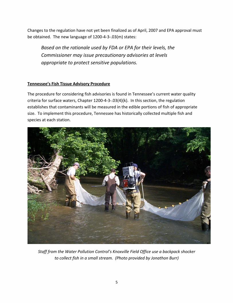
The procedure for considering fish advisories is found in Tennessee’s current water quality criteria for surface waters, Chapter 1200‐4‐3‐.03(4)(k). In this section, the regulation establishes that contaminants will be measured in the edible portions of fish of appropriate size. To implement this procedure, Tennessee has historically collected multiple fish and species at each station.
Staff from the Water Pollution Control’s Knoxville Field Office use a backpack shocker to collect fish in a small stream. (Photo provided by Jonathon Burr)
5

Because it is not possible to sample every species found in a waterbody, representative species are targeted from three groups: gamefish, catfish, and rough fish. Commonly‐selected gamefish are largemouth or smallmouth bass. Channel catfish is the preferred catfish species and carp or buffalo are the rough fish targeted.
If these species are not available, others are substituted. Fish are normally captured by electroshocking or nets. Fish too small to likely be kept by anglers are not included in samples. Similarly–sized fish of the same species are often composited. Catfish samples are filleted without the skin included. Gamefish and rough fish are scaled with the skin included.
Because mercury tends to accumulate in muscle tissue rather than in fat, as is the case with organic compounds such as PCBs, they tend to accumulate in greater concentrations in the more muscular gamefish rather than the fattier rough fish or catfish. For the same reason, some of the conventional wisdom concerning ways to reduce the contaminant levels in fish by broiling the catch or by removing as much fat as possible, are not effective with mercury.
TVA personnel use a specially outfitted boat to electroshock fish for analysis. (Photograph provided by TVA.)
6

Because mercury was not considered a carcinogen, the department previously issued “precautionary” fish advisories at half the Food and Drug Administration Action Level for fish sold in interstate commerce. This policy resulted in a trigger point of 0.5 ppm. However, we make note of the fact that the Food and Drug Administration and EPA now agree that 0.3 ppm is the appropriately protective level for mercury in locally‐consumed freshwater fish.
The department considers the evidence compelling that fish tissue methylmercury levels over 0.3 parts per million have a potentially detrimental effect on the health of Tennesseans, particularly children.
The department will use this level as a trigger point for consideration of fishing advisories for Tennessee waters. The type of advisory considered appropriate when methylmercury levels are over 0.3 ppm, but not above 1.0 ppm, will be the “precautionary advisory” which advises pregnant or nursing mothers, plus children, to avoid any consumption of fish. All other persons will be advised to limit fish consumption to one or two meals per month.
If 1.0 ppm is exceeded, all persons will be advised to avoid consumption in any amount.
Advisory Levels for Mercury in Tennessee
Precautionary Advisory 0.3 ppm average concentration
Children, pregnant women, or nursing mothers should not eat these fish in any amount. Persons with a previous occupational exposure to the chemical of concern should also not eat these fish. All other persons should
limit consumption of these fish to one or two meals per month.
Do Not Consume Advisory 1.0 ppm average concentration
No persons should eat these fish in any amount.
7
The April, 2007 Mercury Advisory
Prior to 2007, Tennessee had two mercury advisories in effect. The first is on East Fork Poplar Creek near Oak Ridge. The other is North Fork Holston River. At these sites, historical industrial discharges are the known source of the mercury.
On April 26, 2007, the department issued revised and new advisories based on the new 0.3 trigger point. At several waterbodies with existing “do not consume” advisories for either chlordane or PCBs, the justification for the advisory was modified to include mercury. These waterbodies were the Mississippi River, McKellar Lake, Wolf River, and Loosahatchie River in West Tennessee, plus Tellico Reservoir in East Tennessee.
At seven additional waterbodies (or waterbody segments), new advisories were issued for mercury: Buffalo River, Emory River, Holston River, Hiwassee River, Norris Reservoir, South Holston Reservoir, and Watauga Reservoir.
At a few additional sites, mercury levels were over 0.3 in a species, but an advisory was not issued. The reason was that either few data were available or the data were not recent. In these cases, the waterbodies were put on a 2007 study list.
Section III contains more specific information about mercury levels in the various streams, rivers and lakes in Tennessee.
Important Note:
TDEC is aware that much of the fish tissue data collected in the 1970s and 1980s are not represented in the following analyses. Many of these records, including those of TDEC, only exist as paper copies or entries in logbooks. We have not attempted to transfer these historic results into our database and acknowledge that we have only considered mercury concentrations for the last fifteen or twenty years. Additionally, no conclusions about
mercury trends should be inferred from our analysis.
8
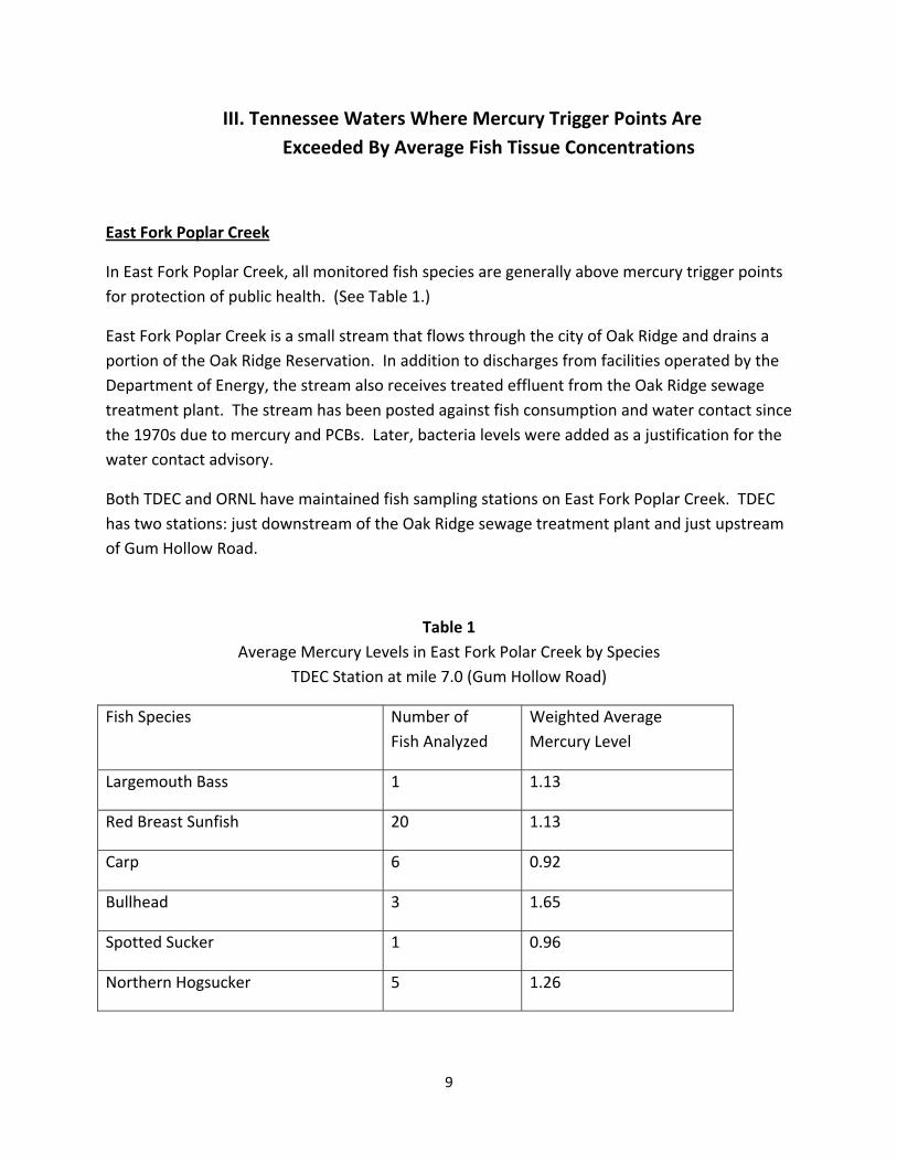
III. Tennessee Waters Where Mercury Trigger Points Are Exceeded By Average Fish Tissue Concentrations
East Fork Poplar Creek
In East Fork Poplar Creek, all monitored fish species are generally above mercury trigger points for protection of public health. (See Table 1.)
East Fork Poplar Creek is a small stream that flows through the city of Oak Ridge and drains a portion of the Oak Ridge Reservation. In addition to discharges from facilities operated by the Department of Energy, the stream also receives treated effluent from the Oak Ridge sewage treatment plant. The stream has been posted against fish consumption and water contact since the 1970s due to mercury and PCBs. Later, bacteria levels were added as a justification for the water contact advisory.
Both TDEC and ORNL have maintained fish sampling stations on East Fork Poplar Creek. TDEC has two stations: just downstream of the Oak Ridge sewage treatment plant and just upstream of Gum Hollow Road.
Table 1 Average Mercury Levels in East Fork Polar Creek by Species
TDEC Station at mile 7.0 (Gum Hollow Road)
Fish Species Number of Fish Analyzed
Weighted Average Mercury Level
Largemouth Bass 1 1.13
Red Breast Sunfish 20 1.13
Carp 6 0.92
Bullhead 3 1.65
Spotted Sucker 1 0.96
Northern Hogsucker 5 1.26
9

North Fork Holston River
Like East Fork Poplar Creek, monitored fish species in the North Fork Holston are generally above mercury trigger points for protection of public health. (See Table 2.) TDEC, TVA and the Olin Corporation have monitored fish tissue in the river.
North Fork Holston River originates in Virginia and flows in a southwesterly direction until it confluences with the South Fork Holston near Kingsport. Only about eight miles of the river are within Tennessee.
The stream has been posted against fish consumption since the 1970s due to mercury. The known source of the mercury in the North Fork is historical industrial activities in Saltville, Virginia. It is likely that contamination in the North Fork has contributed to mercury concentrations in the mainstem Holston River.
In spite of the mercury contamination, the North Fork Holston is an ecologically significant resource. It provides habitat for several species with special state and federal status and is designated as Critical Habitat by the U. S. Fish and Wildlife Service. Additionally, the North Fork is identified as a Tier II high quality stream under TDEC’s antidegradation policy (TDEC, 2006).
Both TDEC and TVA have maintained a historical fish sampling station on the North Fork at State Route 346 at Cloud’s Ford. The data from both agencies are combined in the table below.
Table 2 Average Mercury Levels in North Fork Holston River by Species
TDEC and TVA Station at mile 4.6 (SR 346, Cloud Ford)
Fish Species Number of Fish Analyzed
Weighted Average Mercury Level
Smallmouth Bass 20 1.31
Redbreast Sunfish 3 0.44
Northern Hogsucker 5 0.55
Channel Catfish 25 0.72
Golden Redhorse 3 0.67
Rock Bass 5 0.76
10

Upper Holston River
Fish in the upper Holston River (from approximately mile 91 to the confluence between the North and South Forks below Kingsport) are generally above mercury trigger points for protection of public health. (See Tables 3‐10.) This area includes a portion of upper Cherokee Reservoir.
TDEC, TVA and the Olin Corporation have monitored fish tissue in this portion of the river.
There is little doubt that some of the mercury in the Holston River originates in Virginia and is carried into Tennessee by way of the North Fork. However, South Fork Holston River fish contain mercury as well.
TDEC’s historical fish sampling stations in the upper Holston are at Goshen Valley Road near Church Hill and downstream of the Holston Army Ordinance facility. TVA’s stations are at mile 91, 109.9, and 118.
In 2005, Olin tested fish downstream of Stock Creek, at mile 107 (John Sevier Detention Pond), mile 110 (u/s John Sevier Detention Pond), mile 121 (Phipps Bend), and mile 141 (Holston Army Ordinance).
Due to mercury levels in multiple species of fish, the Holston River was included in the April, 2007 advisory. (See Appendix A for a copy of the press release.)
Table 3 Average Mercury Levels in Holston River by Species TVA Station at mile 91.0 (near Galbraith Springs)
Fish Species Number of Fish Analyzed Weighted Average Mercury Level
Largemouth Bass 6 0.24
Channel Catfish 15 0.36
11
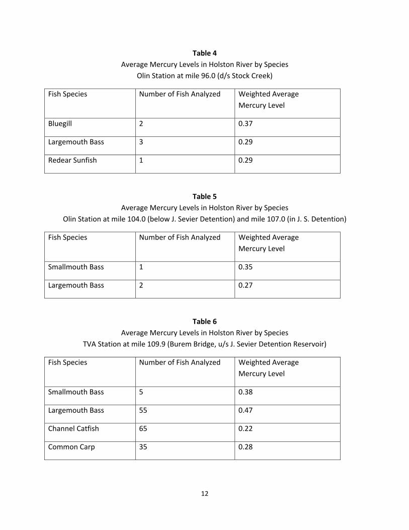
Table 4 Average Mercury Levels in Holston River by Species
Olin Station at mile 96.0 (d/s Stock Creek)
Fish Species Number of Fish Analyzed Weighted Average Mercury Level
Bluegill 2 0.37
Largemouth Bass 3 0.29
Redear Sunfish 1 0.29
Table 5 Average Mercury Levels in Holston River by Species
Olin Station at mile 104.0 (below J. Sevier Detention) and mile 107.0 (in J. S. Detention)
Fish Species Number of Fish Analyzed Weighted Average Mercury Level
Smallmouth Bass 1 0.35
Largemouth Bass 2 0.27
Table 6 Average Mercury Levels in Holston River by Species
TVA Station at mile 109.9 (Burem Bridge, u/s J. Sevier Detention Reservoir)
Fish Species Number of Fish Analyzed Weighted Average Mercury Level
Smallmouth Bass 5 0.38
Largemouth Bass 55 0.47
Channel Catfish 65 0.22
Common Carp 35 0.28
12

Table 7 Average Mercury Levels in Holston River by Species
TVA Station at mile 118.0 (u/s Cox Island near Surgoinsville)
Fish Species Number of Fish Analyzed Weighted Average Mercury Level
Smallmouth Bass 5 0.40
Largemouth Bass 5 0.36
Channel Catfish 10 0.21
Table 8 Average Mercury Levels in Holston River by Species
Olin Station at mile 121.0 (Phipps Bend)
Fish Species Number of Fish Analyzed Weighted Average Mercury Level
Smallmouth Bass 3 0.35
Table 9 Average Mercury Levels in Holston River by Species TDEC Station at mile 135.0 (Goshen Valley Road)
Fish Species Number of Fish Analyzed Weighted Average Mercury Level
Smallmouth Bass 14 0.49
Common Carp 15 0.32
Channel Catfish 1 0.32
Redhorse 2 0.29
Golden Redhorse 7 0.20
Black Redhorse 5 0.23
13

Table 10 Average Mercury Levels in Holston River by Species
Olin Station at mile 141.0 (Holston Army Ammunition Plant)
Fish Species Number of Fish Analyzed Weighted Average Mercury Level
Smallmouth Bass 4 0.37
14

Norris Reservoir
Norris Reservoir is an impoundment of the Clinch and Powell rivers in Campbell and Union counties. The Clinch and Powell originate in southwestern Virginia and flow into Tennessee. Both rivers are very important ecologically and are designated critical habitat by the U.S. Fish and Wildlife Service. Additionally, both streams are identified as Tier II High Quality Streams under Tennessee’s Antidegradation Policy.
Norris Lake has traditionally been considered to contain good water quality. However, elevated mercury levels have been documented in gamefish in parts of the lake.
TVA has performed most of the sampling, although the Oak Ridge National Laboratory and EPA have also analyzed fish from Norris. Norris Reservoir data are presented in Tables 11, 12, and 13. Gamefish are generally above 0.3 ppm of mercury at stations located on the Clinch River portion of the reservoir.
TVA’s fish sampling station within Norris are at Clinch River mile 80.0, mile 125, mile 172, and mile 180, plus mile 30 on the Powell River arm of the reservoir.
Due to mercury levels in largemouth bass, the Clinch River portion of the reservoir was included in the April, 2007 advisory. (See Appendix A for a copy of the press release.) The Powell River embayment was not included in the advisory due to generally lower levels of mercury. It is not well‐understood why mercury levels differ in the two branches of the lakes, as they have similar watersheds.
Table 11 Average Mercury Levels in Norris Reservoir
TVA and ORNL Station at the dam forebay, mile 80.0
Fish Species Number of Fish Analyzed
Weighted Average Mercury Level
Largemouth Bass 22 0.37
Channel Catfish 34 0.24
Striped Bass 1 0.32
15
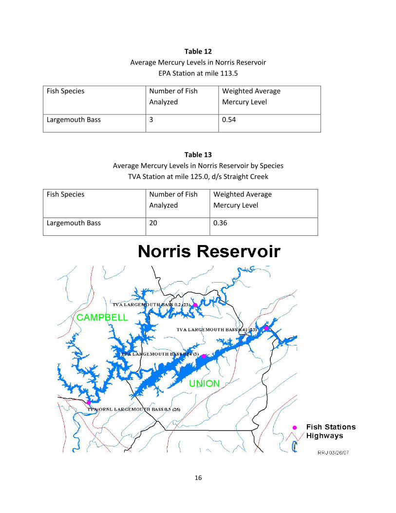
Table 12 Average Mercury Levels in Norris Reservoir
EPA Station at mile 113.5
Fish Species Number of Fish Analyzed
Weighted Average Mercury Level
Largemouth Bass 3 0.54
Table 13 Average Mercury Levels in Norris Reservoir by Species
TVA Station at mile 125.0, d/s Straight Creek
Fish Species Number of Fish Analyzed
Weighted Average Mercury Level
Largemouth Bass 20 0.36
16

Watauga Reservoir
Watauga Reservoir is an impoundment of the Watauga River above Elizabethton in Carter County. The reservoir is circled by mountains on all sides and the Appalachian Trail crosses the river at the dam. While some of the shoreline is developed, much is in the Cherokee National Forest.
Like Norris Reservoir, gamefish species in Watauga Reservoir are above mercury trigger points for protection of public health. (See Table 14 and 15.) Most of the fish tissue monitoring in the Watauga Reservoir has been performed by TVA.
Due to mercury levels in largemouth bass and channel catfish, Watauga Reservoir was included in the April, 2007 advisory. (See Appendix A for a copy of the press release.)
Table 14 Average Mercury Levels in Watauga Lake TVA Station at Watauga Dam, mile 36.6
Fish Species Number of Fish Analyzed
Weighted Average Mercury Level
Largemouth Bass 19 0.50
Channel Catfish 20 0.45
Table 15 Average Mercury Levels in Watauga Lake
TVA Station near Roan Creek Embayment, mile 45.5
Fish Species Number of Fish Analyzed
Weighted Average Mercury Level
Largemouth Bass 15 0.59
Channel Catfish 20 0.36
17

Hiwassee River
The Hiwassee River begins in the Blue Ridge Mountains of North Georgia as the Hiawassee River. The river is impounded by the Apalachia Dam just upstream of the Tennessee/North Carolina stateline. The upper portion of the river in Tennessee is impacted by a several mile flow diversion from the dam down to the powerhouse.
Both upstream and downstream of the powerhouse, the Hiwassee is considered a high quality water under the antidegradation policy due to the presence of endangered mussel species. Additionally, it is an important recreational resource for fishing and boating.
TDEC, TVA, and Bowaters have analyzed fish from multiple stations on the Hiwassee. However, Bowaters did not analyze for mercury. Mercury levels in largemouth bass are highest at the station near Interstate 75. The Hiwassee River fish tissue data are presented in Tables 16 – 20.
North Carolina has not issued any mercury advisories on their portion of the Hiwassee, however, Georgia has issued an advisory for spotted bass on their portion of Chatuge Lake, which is shared with North Carolina.
Due to mercury levels in largemouth bass, a section of the Hiwassee River was included in the April, 2007 advisory. (See Appendix A for a copy of the press release.)
Table 16 Average Mercury Levels on the Hiwassee River
TDEC Station at Highway 58, mile 7.4
Fish Species Number of Fish Analyzed
Weighted Average Mercury Level
Largemouth Bass 40 0.26
Blue Catfish 2 0.31
Carp 6 0.15
Channel Catfish 14 0.08
Smallmouth Buffalo 10 0.07
Spotted Sucker 5 0.04
Walleye 1 0.39
18
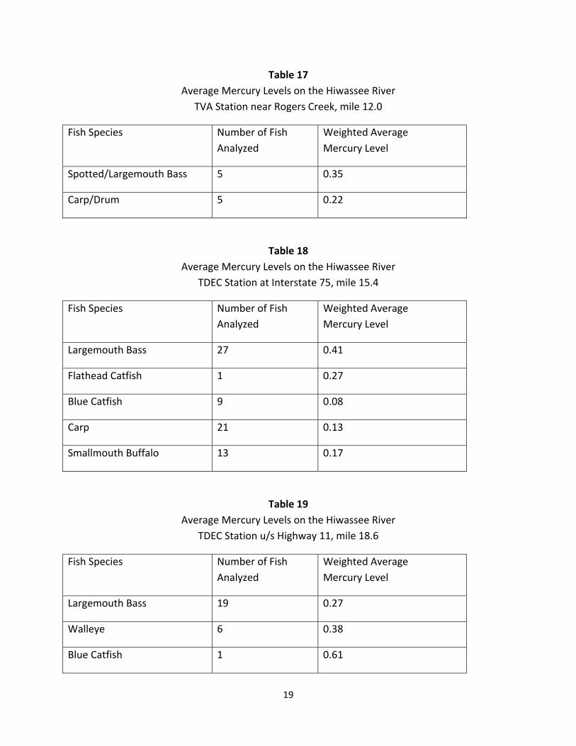
Table 17 Average Mercury Levels on the Hiwassee River
TVA Station near Rogers Creek, mile 12.0
Fish Species Number of Fish Analyzed
Weighted Average Mercury Level
Spotted/Largemouth Bass 5 0.35
Carp/Drum 5 0.22
Table 18 Average Mercury Levels on the Hiwassee River
TDEC Station at Interstate 75, mile 15.4
Fish Species Number of Fish Analyzed
Weighted Average Mercury Level
Largemouth Bass 27 0.41
Flathead Catfish 1 0.27
Blue Catfish 9 0.08
Carp 21 0.13
Smallmouth Buffalo 13 0.17
Table 19 Average Mercury Levels on the Hiwassee River
TDEC Station u/s Highway 11, mile 18.6
Fish Species Number of Fish Analyzed
Weighted Average Mercury Level
Largemouth Bass 19 0.27
Walleye 6 0.38
Blue Catfish 1 0.61
19

Table 19 (cont) Average Mercury Levels on the Hiwassee River
TDEC Station u/s Highway 11, mile 18.6
Fish Species Number of Fish Analyzed
Weighted Average Mercury Level
Flathead Catfish 1 0.55
Channel Catfish 18 0.15
Table 20 Average Mercury Levels on the Hiwassee River TVA Station at Patty Station Road, mile 37.0
Fish Species Number of Fish Analyzed
Weighted Average Mercury Level
Largemouth Bass 22 0.29
Spotted Bass 12 0.28
20

South Holston Lake
South Holston Lake is an impoundment of the South Fork Holston River near mile 50.0 in Sullivan County. A portion of the lake is in Washington County, Virginia. Much of the land adjacent to the lake is in the Cherokee and Jefferson National Forests.
Water quality in South Fork Holston Lake has traditionally been considered excellent. However, mercury is elevated at both of TVA’s stations on the lake. TVA’s data are presented in Table 21 and 22. Virginia maintains a sampling station in the upper portion of the reservoir and mercury levels are lower there.
Due to mercury levels in largemouth bass, a section of the South Holston Lake was included in the April, 2007 advisory. (See Appendix A for a copy of the press release.)
Table 21 Average Mercury Levels in South Holston Lake
TVA Station at the Dam, mile 50.0
Fish Species Number of Fish Analyzed
Weighted Average Mercury Level
Largemouth Bass 20 0.37
Channel Catfish 15 0.34
Table 22 Average Mercury Levels in South Holston Lake TVA Station at the TN/VA Stateline, mile 62.7
Fish Species Number of Fish Analyzed
Weighted Average Mercury Level
Largemouth Bass 15 0.30
Channel Catfish 15 0.24
21

Emory River
TVA has two stations in the Emory River, one upstream and one downstream of Harriman. Mercury levels appear elevated, particularly upstream of Harriman. The lower station is in the Emory River embayment of Watts Barr Reservoir, while the upper station is in the more riverine section. The lower station has not been sampled since the 1980s.
TVA’s data are in Table 23 and 24. Due to mercury levels documented at the upper station, a portion of the Emory River was included in the April, 2007 advisory. (See Appendix A for the press release.)
Table 23 Average Mercury Levels in the Emory River
1980s TVA Station just u/s the Little Emory River embayment, mile 7.0
Fish Species Number of Fish Analyzed
Weighted Average Mercury Level
Largemouth Bass 10 0.23
Channel Catfish 10 0.26
Carp 10 0.22
Table 24 Average Mercury Levels in the Emory River TVA Station u/s Harriman, mile 14.5 – 22.0
Fish Species Number of Fish Analyzed
Weighted Average Mercury Level
Largemouth Bass 25 0.44
Channel Catfish 35 0.32
Smallmouth Bass 5 0.63
Carp 5 0.30
22

French Broad River
The French Broad River originates in North Carolina and flows past Ashville on its way to Tennessee. After it enters Tennessee, it flows through the Cherokee National Forest until it reaches Douglas Reservoir near the Rankin Bridge. Because there is a wide variation in pool levels in Douglas, the river at Rankin Bridge can either be impounded or riverine.
From Douglas Reservoir upstream to the North Carolina stateline, the French Broad has been designated as a State Scenic River. It is also considered to be a high quality stream under Tennessee’s antidegradation policy.
23

TDEC has a fish monitoring station at Rankin Bridge. TVA has a station further upstream at Highway 321 near Newport. At both stations in Tennessee, mercury levels appear elevated in gamefish (see Table 25 and 26). However, there are very few recent samples in the last ten years from the Rankin Bridge station.
Table 25 Average Mercury Levels in the French Broad River
TDEC Station at Rankin Bridge, mile 71.4
Fish Species Number of Fish Analyzed
Weighted Average Mercury Level
Largemouth Bass 20 0.36
Blue Catfish 2 0.40
Channel Catfish 15 0.16
Carpsucker 3 0.43
Carp 13 0.13
Table 26 Average Mercury Levels in the French Broad River
TVA Station at Highway 321, mile 77.5
Fish Species Number of Fish Analyzed
Weighted Average Mercury Level
Largemouth/Spotted Bass 20 0.32
Smallmouth Bass 11 0.32
24

Mississippi River
The Mississippi River generally forms the western border of Tennessee and is shared with Arkansas, Missouri, Kentucky, and Mississippi.
TDEC has sampled fish at seven different stations along the Mississippi River: at the Memphis South Sewage Treatment Plant, in McKellar Lake(a side channel to the river used as a harbor and industrial area near Memphis), near the I‐40 bridge, at Meeman‐Shelby State Park, near Osceola, near Blytheville, and near Tiptonville. (TWRA assisted with the collection of fish at these stations in 2005 and 2006.) Additionally, the state of Mississippi maintains a fish tissue station near the stateline at mile 710.7.
At almost all of these stations, mercury levels in gamefish are elevated. These data are in Table 27 – 34. Based on these data, the existing “do not consume” advisory for all fish in the Shelby County portion of the Mississippi River and McKellar Lake was modified to include mercury as a concern. The press release for the April 2007 mercury advisory appears in Appendix A.
25

Table 27 Average Mercury Levels in the Mississippi River
State of Mississippi Station at Stateline, mile 710.7
Fish Species Number of Fish Analyzed
Weighted Average Mercury Level
White Bass 14 0.44
Blue Catfish 24 0.34
Channel Catfish 7 0.21
Table 28 Average Mercury Levels in the Mississippi River TDEC Station at Memphis South Plant, mile 724.6
Fish Species Number of Fish Analyzed
Weighted Average Mercury Level
Striped Bass 5 0.39
Flathead Catfish 3 0.24
Blue Catfish 6 0.10
Largemouth Bass 1 0.24
Carp 7 0.08
Table 29 Average Mercury Levels in the Mississippi River
TDEC Station at McKellar Lake
Fish Species Number of Fish Analyzed
Weighted Average Mercury Level
Largemouth Bass 6 0.33
Channel Catfish 7 0.10
26
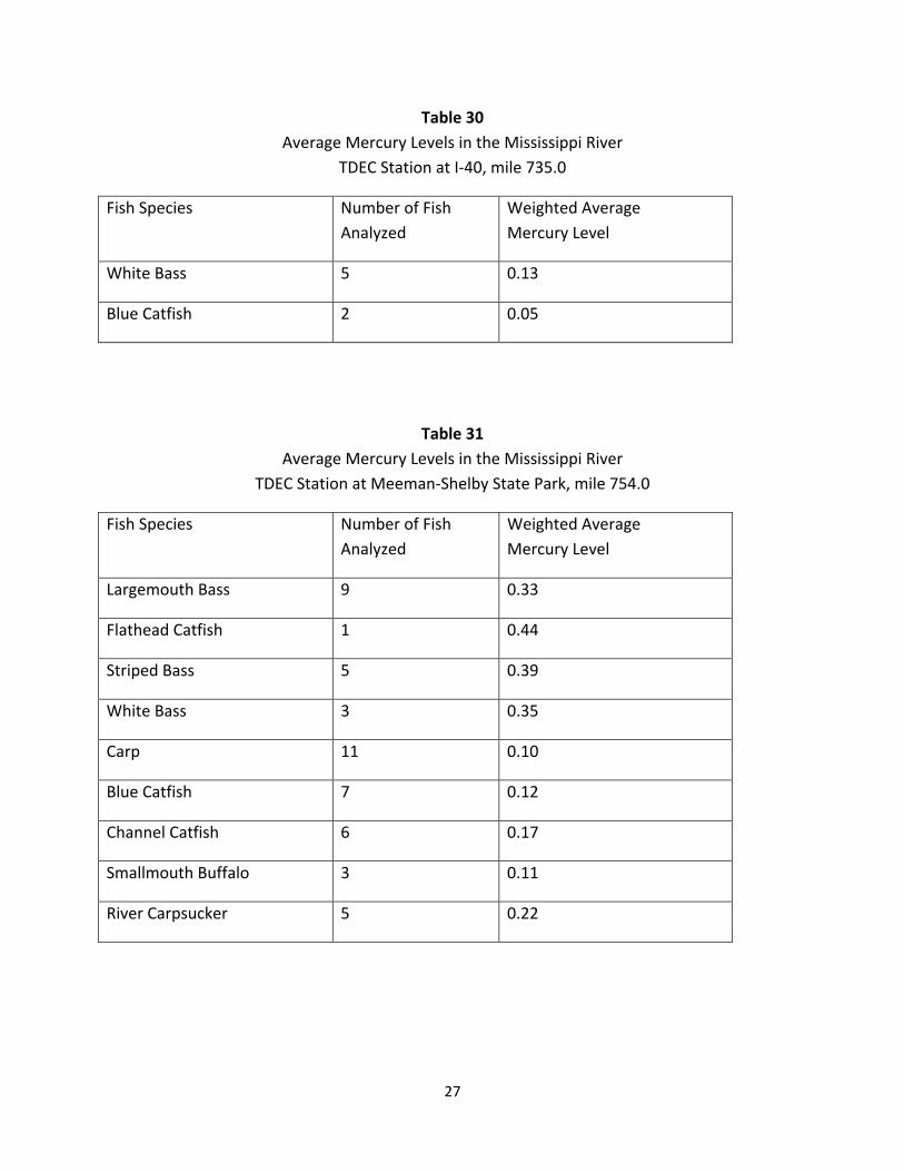
Table 30 Average Mercury Levels in the Mississippi River
TDEC Station at I‐40, mile 735.0
Fish Species Number of Fish Analyzed
Weighted Average Mercury Level
White Bass 5 0.13
Blue Catfish 2 0.05
Table 31 Average Mercury Levels in the Mississippi River
TDEC Station at Meeman‐Shelby State Park, mile 754.0
Fish Species Number of Fish Analyzed
Weighted Average Mercury Level
Largemouth Bass 9 0.33
Flathead Catfish 1 0.44
Striped Bass 5 0.39
White Bass 3 0.35
Carp 11 0.10
Blue Catfish 7 0.12
Channel Catfish 6 0.17
Smallmouth Buffalo 3 0.11
River Carpsucker 5 0.22
27

Table 32 Average Mercury Levels in the Mississippi River
TDEC Station at Osceola, mile 786.0
Fish Species Number of Fish Analyzed
Weighted Average Mercury Level
Largemouth Bass/White bass 9 0.34
Blue Catfish 9 0.12
Striped Bass 1 0.37
Carp 12 0.09
Channel Catfish 11 0.13
Smallmouth Buffalo 10 0.08
Table 33 Average Mercury Levels in the Mississippi River
TDEC Station at Blytheville, mile 817.8
Fish Species Number of Fish Analyzed
Weighted Average Mercury Level
Largemouth Bass 1 0.46
Flathead Catfish 1 0.54
Striped Bass 5 0.42
White Bass 10 0.38
Blue Catfish 6 0.18
Carp 15 0.16
Channel Catfish 15 0.09
River Carpsucker 5 0.20
Smallmouth Buffalo 10 0.20
28

Table 34 Average Mercury Levels in the Mississippi River
TDEC Station at Tiptonville, mile 873.5
Fish Species Number of Fish Analyzed
Weighted Average Mercury Level
Largemouth Bass 1 0.55
Striped Bass 5 0.32
White Bass 8 0.26
Channel Catfish 19 0.10
Blue Catfish 9 0.07
Carp 20 0.10
29
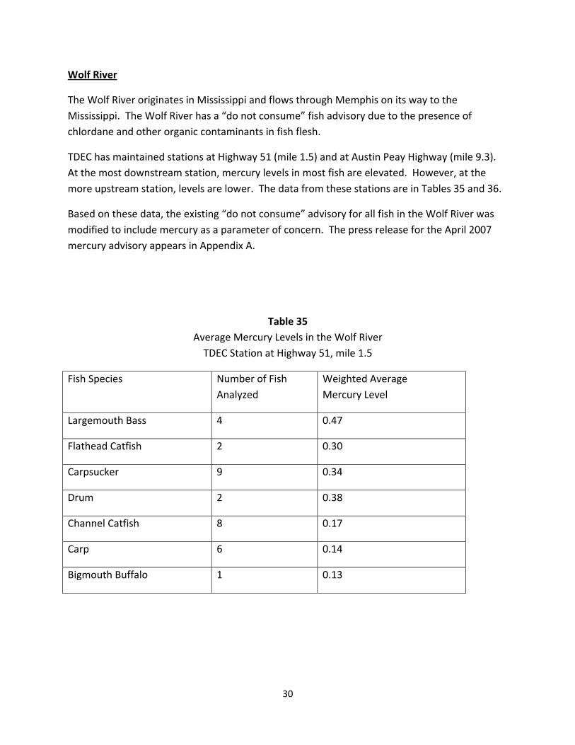
Wolf River
The Wolf River originates in Mississippi and flows through Memphis on its way to the Mississippi. The Wolf River has a “do not consume” fish advisory due to the presence of chlordane and other organic contaminants in fish flesh.
TDEC has maintained stations at Highway 51 (mile 1.5) and at Austin Peay Highway (mile 9.3). At the most downstream station, mercury levels in most fish are elevated. However, at the more upstream station, levels are lower. The data from these stations are in Tables 35 and 36.
Based on these data, the existing “do not consume” advisory for all fish in the Wolf River was modified to include mercury as a parameter of concern. The press release for the April 2007 mercury advisory appears in Appendix A.
Table 35 Average Mercury Levels in the Wolf River TDEC Station at Highway 51, mile 1.5
Fish Species Number of Fish Analyzed
Weighted Average Mercury Level
Largemouth Bass 4 0.47
Flathead Catfish 2 0.30
Carpsucker 9 0.34
Drum 2 0.38
Channel Catfish 8 0.17
Carp 6 0.14
Bigmouth Buffalo 1 0.13
30
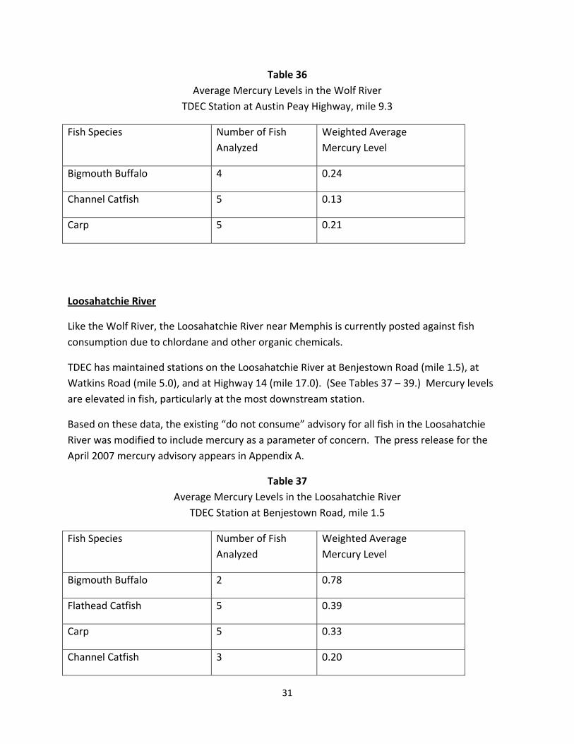
Table 36 Average Mercury Levels in the Wolf River
TDEC Station at Austin Peay Highway, mile 9.3
Fish Species Number of Fish Analyzed
Weighted Average Mercury Level
Bigmouth Buffalo 4 0.24
Channel Catfish 5 0.13
Carp 5 0.21
Loosahatchie River
Like the Wolf River, the Loosahatchie River near Memphis is currently posted against fish consumption due to chlordane and other organic chemicals.
TDEC has maintained stations on the Loosahatchie River at Benjestown Road (mile 1.5), at Watkins Road (mile 5.0), and at Highway 14 (mile 17.0). (See Tables 37 – 39.) Mercury levels are elevated in fish, particularly at the most downstream station.
Based on these data, the existing “do not consume” advisory for all fish in the Loosahatchie River was modified to include mercury as a parameter of concern. The press release for the April 2007 mercury advisory appears in Appendix A.
Table 37 Average Mercury Levels in the Loosahatchie River
TDEC Station at Benjestown Road, mile 1.5
Fish Species Number of Fish Analyzed
Weighted Average Mercury Level
Bigmouth Buffalo 2 0.78
Flathead Catfish 5 0.39
Carp 5 0.33
Channel Catfish 3 0.20
31
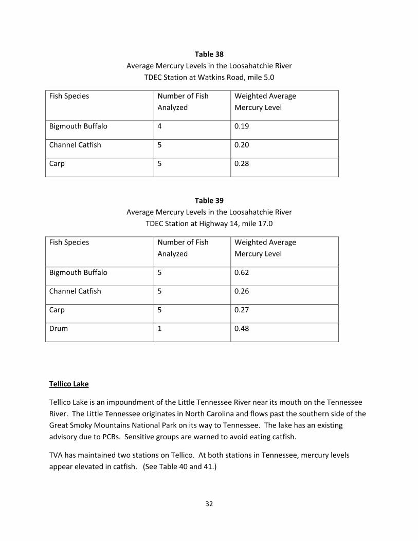
Table 38 Average Mercury Levels in the Loosahatchie River
TDEC Station at Watkins Road, mile 5.0
Fish Species Number of Fish Analyzed
Weighted Average Mercury Level
Bigmouth Buffalo 4 0.19
Channel Catfish 5 0.20
Carp 5 0.28
Table 39 Average Mercury Levels in the Loosahatchie River
TDEC Station at Highway 14, mile 17.0
Fish Species Number of Fish Analyzed
Weighted Average Mercury Level
Bigmouth Buffalo 5 0.62
Channel Catfish 5 0.26
Carp 5 0.27
Drum 1 0.48
Tellico Lake
Tellico Lake is an impoundment of the Little Tennessee River near its mouth on the Tennessee River. The Little Tennessee originates in North Carolina and flows past the southern side of the Great Smoky Mountains National Park on its way to Tennessee. The lake has an existing advisory due to PCBs. Sensitive groups are warned to avoid eating catfish.
TVA has maintained two stations on Tellico. At both stations in Tennessee, mercury levels appear elevated in catfish. (See Table 40 and 41.)
32

Based on these data, the existing “do not consume” advisory for catfish in Tellico Reservoir was modified to include mercury as a parameter of concern. The press release for the April 2007 mercury advisory appears in Appendix A.
Table 40 Average Mercury Levels in Tellico Lake
TVA Station at Dam, mile 1.0
Fish Species Number of Fish Analyzed
Weighted Average Mercury Level
Channel Catfish 40 0.40
Table 41 Average Mercury Levels in Tellico Lake TVA Station u/s Baker Creek, mile 15.0
Fish Species Number of Fish Analyzed
Weighted Average Mercury Level
Channel Catfish 40 0.30
Largemouth Bass 6 0.24
Buffalo River
The Buffalo River is a State Scenic River and a very valuable recreational resource. It is a popular stream for canoeist and fishermen. There are few cities and industries in its watershed and the river has traditionally been considered to be unimpacted by pollution.
TVA has a fish tissue station on the Buffalo near Lobelville. Additionally, USGS collected and analyzed fish near Flatwoods.
33

At the more downstream station, mercury levels are elevated (see Tables 42 and 43). Based on these data, a portion of the Buffalo River was included in the April, 2007 mercury advisory. Appendix A contains the text of the mercury advisory press release.
Table 42 Average Mercury Levels in Buffalo River TVA Station at Old Highway 13, mile 17.7
Fish Species Number of Fish Analyzed
Weighted Average Mercury Level
Smallmouth Bass 20 0.54
Table 43 Average Mercury Levels in Buffalo River
USGS Station Highway 13 near Flatwoods, mile 73.1
Fish Species Number of Fish Analyzed
Weighted Average Mercury Level
Largemouth Bass 3 0.28
34

IV. Miscellaneous Sampling Stations Where Mercury Trigger Points Are Exceeded By Average Fish Tissue Concentrations
Additional stations where limited fish tissue data appear elevated are listed in Table 44.
TABLE 44 Miscellaneous Stations Where Mercury Samples Have Been Elevated
Waterbody
Station Location
Fish Species
Number of Fish Analyzed
Weighted Average Mercury Level
Duck River USGS Gaging Station near Tumbling Creek, mile 26.0.
Largemouth Bass 11 0.38
Spotted Bass 20 0.28
Elk River d/s Richland Creek, mile 41.5
Largemouth/Spotted Bass
30 0.36
Tennessee River, Fort Loudoun Reservoir*
D/S confluence of Holston and French Broad rivers.
Channel Catfish 30 0.33
Largemouth Bass 20 0.33
* Fort Loudoun Reservoir already has an advisory in place for channel catfish and largemouth bass. See Appendix B for additional information.
35
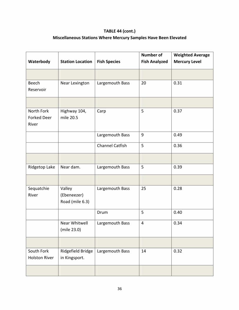
TABLE 44 (cont.) Miscellaneous Stations Where Mercury Samples Have Been Elevated
Waterbody
Station Location
Fish Species
Number of Fish Analyzed
Weighted Average Mercury Level
Beech Reservoir
Near Lexington Largemouth Bass 20 0.31
North Fork Forked Deer River
Highway 104, mile 20.5
Carp 5 0.37
Largemouth Bass 9 0.49
Channel Catfish 5 0.36
Ridgetop Lake Near dam. Largemouth Bass 5 0.39
Sequatchie River
Valley (Ebeneezer) Road (mile 6.3)
Largemouth Bass 25 0.28
Drum 5 0.40
Near Whitwell (mile 23.0)
Largemouth Bass 4 0.34
South Fork Holston River
Ridgefield Bridge in Kingsport.
Largemouth Bass 14 0.32
36
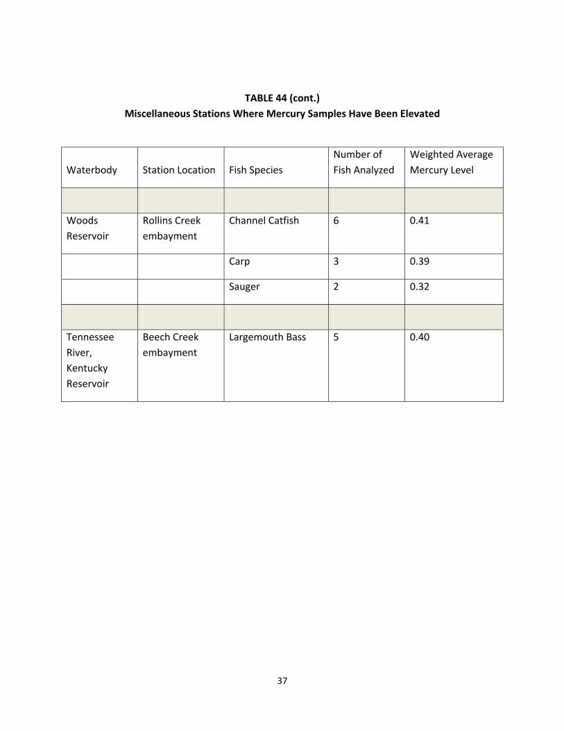
TABLE 44 (cont.) Miscellaneous Stations Where Mercury Samples Have Been Elevated
Waterbody
Station Location
Fish Species
Number of Fish Analyzed
Weighted Average Mercury Level
Woods Reservoir
Rollins Creek embayment
Channel Catfish 6 0.41
Carp 3 0.39
Sauger 2 0.32
Tennessee River, Kentucky Reservoir
Beech Creek embayment
Largemouth Bass 5 0.40
37

IV. Literature Cited
Freeman, C. S. and G. M. Denton, G.M., 2001. The Results of Fish Tissue Monitoring in Tennessee: 1992 ‐ 1997. Tennessee Department of Environment and Conservation, Division of Water Pollution Control. Nashville, TN.
Tennessee Department of Environment and Conservation, 2006. Rulemaking Hearing Rules of the Water Quality Control Board. Tennessee Department of Environment and Conservation, Water Quality Control Board. Nashville, TN.
______. 2006. Known High Quality Streams in Tennessee. Tennessee Department of Environment and Conservation, Division of Water Pollution Control. Nashville, TN.
______. 2004. General Water Quality Criteria for Surface Waters. Tennessee Department of Environment and Conservation, Water Quality Control Board. Nashville, TN.
U. S. Environmental Protection Agency, 2001. Water Quality Criterion for Protection of Human Health: Methylmercury. U. S. Environmental Protection Agency, Office of Science and Technology. Washington, DC. EPA‐823‐R‐01‐001.
38

APPENDIX A
April, 2007, Advisory Press Release FOR RELEASE: CONTACT: DANA COLEMAN APRIL 26, 2007 (615) 253-1916
UPDATED FISH CONSUMPTION ADVISORIES ISSUED FOR TENNESSEE ADVISORIES REFLECT NEW, MORE CONSERVATIVE WATER QUALITY CRITERION FOR MERCURY IN FISH
Nashville, Tenn. – The Department of Environment and Conservation has announced several additions to Tennessee’s list of precautionary fish consumption advisories as a result of the trigger point for issuing a mercury advisory being lowered to 0.3 parts per million (ppm). “Recent studies indicate that mercury has potential neurological effects on children at lower levels than previously thought,” said Paul Davis, director of the Division of Water Pollution Control. “Because of this new research and based on EPA’s new water quality criterion, the mercury advisory trigger point is being lowered to a more conservative level.” State law requires the department to inform the public and post warnings where contaminants in fish pose a possible threat to people who might catch and eat them. “Eating fish with elevated levels of mercury is a risk Tennesseans can avoid,” said Deputy Commissioner for Environment Paul Sloan. “Fishing advisories give fishermen and their families the information they need to make informed decisions about limiting their intake or avoiding fish from specific stream segments or bodies of water.” Unlike “do not consume” advisories that warn the general population to avoid eating fish from a particular body of water altogether, precautionary fish consumption advisories are directed at sensitive populations such as children, pregnant women, nursing mothers and those who eat fish frequently from the same body of water. Three existing advisories in Shelby, Loudon and Monroe Counties were modified to include mercury and seven new precautionary advisories for mercury were issued today. Two existing “do not consume” mercury advisories for the North Fork Holston River and East Fork Poplar Creek were not altered. “It’s important to understand that the risk associated with these advisories pertains specifically to the consumption of fish,” said Davis. “Swimming and wading in these waters or catching and releasing fish are activities that do not expose the public to an increased risk from mercury. In addition, people should be mindful that fish are a generally healthy source of high-quality protein and other essential nutrients, low in saturated fat and contain omega-3 fatty acids. While contaminated fish should be avoided, fish remain an important component of a healthy diet.” According to EPA, mercury is a naturally occurring element that can be found throughout the environment. Forest fires and human activities, such as burning coal, some industrial processes and waste incineration, have caused the amount of mercury in parts of the environment to increase. The primary way people in the U.S. are exposed to mercury is by eating fish containing methylmercury, a toxic form of mercury that accumulates easily in organisms.
39
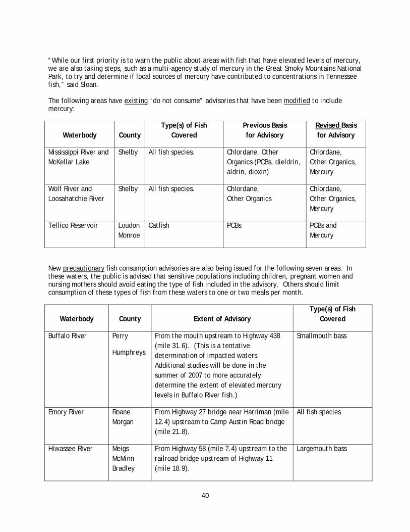
“While our first priority is to warn the public about areas with fish that have elevated levels of mercury, we are also taking steps, such as a multi-agency study of mercury in the Great Smoky Mountains National Park, to try and determine if local sources of mercury have contributed to concentrations in Tennessee fish,” said Sloan. The following areas have existing “do not consume” advisories that have been modified to include mercury:
Waterbody
County
Type(s) of Fish Covered
Previous Basis for Advisory
Revised Basis for Advisory
Mississippi River and McKellar Lake
Shelby All fish species. Chlordane, Other Organics (PCBs, dieldrin, aldrin, dioxin)
Chlordane, Other Organics, Mercury
Wolf River and Loosahatchie River
Shelby All fish species. Chlordane, Other Organics
Chlordane, Other Organics, Mercury
Tellico Reservoir Loudon Monroe
Catfish PCBs PCBs and Mercury
New precautionary fish consumption advisories are also being issued for the following seven areas. In these waters, the public is advised that sensitive populations including children, pregnant women and nursing mothers should avoid eating the type of fish included in the advisory. Others should limit consumption of these types of fish from these waters to one or two meals per month.
Waterbody
County
Extent of Advisory
Type(s) of Fish Covered
Buffalo River Perry
Humphreys
From the mouth upstream to Highway 438 (mile 31.6). (This is a tentative determination of impacted waters. Additional studies will be done in the summer of 2007 to more accurately determine the extent of elevated mercury levels in Buffalo River fish.)
Smallmouth bass
Emory River Roane Morgan
From Highway 27 bridge near Harriman (mile 12.4) upstream to Camp Austin Road bridge (mile 21.8).
All fish species
Hiwassee River Meigs McMinn Bradley
From Highway 58 (mile 7.4) upstream to the railroad bridge upstream of Highway 11 (mile 18.9).
Largemouth bass
40

Waterbody
County
Extent of Advisory
Type(s) of Fish Covered
Norris Reservoir Campbell Anderson Union
Claiborne
Grainger
Clinch River portion of the reservoir. (Powell River embayment is not included in advisory and neither is the free-flowing portion of the Clinch above the impounded part of Norris Reservoir.)
Largemouth bass
Holston River Hawkins Sullivan
From the mouth of Poor Valley Creek (River Mile 89) upstream to the confluence to the North and South Fork of the Holston near Kingsport.
All fish species
South Holston Lake
Sullivan Tennessee portion. (The upper part of the lake is Virginia. The state line is at approximately river mile 62.9)
Largemouth bass
Watauga Reservoir Carter Johnson
Entire lake. Largemouth bass and channel catfish
Where new advisories have been issued, the department will immediately begin the process of putting up signs at primary public access points. The Department of Environment and Conservation and the Tennessee Wildlife Resources Agency also plan to work in partnership on the collection and analysis of additional fish tissue samples this summer.
For a complete listing of Tennessee’s current fishing advisories plus additional information about the advisory issuance process, visit: www.tdec.net/wpc/publications/advisories.pdf.
An EPA publication called “What You Need to Know About Mercury in Fish and Shellfish” is available in several languages at www.epa.gov/waterscience/fish.
###
41

APPENDIX B: Fish Tissue Advisories in Tennessee (April 2007. This list is subject to revision.
For additional information: http://www.tdec.net/wpc/publications/advisories.pdf)
West Tennessee
Waterbody County Portion HUC Code Pollutant Comments
Loosahatchie River Shelby Mile 0.0 – 20.9 08010209 Chlordane, Dioxins Do not eat the fish.
McKellar Lake Shelby Entirety (13 miles) 08010100 Chlordane, Dioxins Do not eat the fish.
Mississippi River Shelby Mississippi Stateline to just downstream of Meeman‐Shelby State Park (31 miles)
08010100 Chlordane, Dioxins Do not eat the fish. Commercial fishing prohibited by TWRA.
Nonconnah Creek Shelby Mile 0.0 to 1.8 08010201 Chlordane, Dioxins Do not eat the fish. Advisory ends at Horn Lake Road bridge.
Wolf River Shelby Mile 0.0 – 18.9 08010210 Chlordane, Dioxins Do not eat the fish.
Middle Tennessee Waterbody County Portion HUC Code Pollutant Comments
Woods Reservoir Franklin Entirety (3,908 acres) 06030003 PCBs Catfish should not be eaten.
(Table continued on next page)
42

Fish Tissue Advisories in Tennessee (continued from previous page)
East Tennessee
Waterbody County Portion HUC Code Pollutant Comments
Boone Reservoir Sullivan, Washington
Entirety (4,400 acres)
06010102 PCBs, chlordane Precautionary advisory for carp and catfish. *
Chattanooga Creek Hamilton Mouth to Georgia Stateline (11.9 miles)
06020001 PCBs, chlordane Fish should not be eaten. Also, avoid contact with water.
East Fork of Poplar Creek including Poplar Creek embayment
Anderson, Roane
Mile 0.0 – 15.0 06010207 Mercury, PCBs Fish should not be eaten. Also, avoid contact with water.
Fort Loudoun Reservoir Loudon,
Knox, Blount
Entirety (14,600 acres)
06010201 PCBs Commercial fishing for catfish prohibited by TWRA. No catfish or largemouth bass over two pounds should be eaten. Do not eat largemouth bass from the Little River embayment.
Melton Hill Reservoir Knox, Anderson
Entirety (5,690 acres)
06010207 PCBs Catfish should not be eaten.
(Table continued on next page.)
43

Fish Tissue Advisories in Tennessee
(continued from previous page)
East Tennessee
Waterbody County Portion HUC Code Pollutant Comments
Nickajack Reservoir Hamilton, Marion
Entirety (10,370 acres)
06020001 PCBs Precautionary advisory for catfish. *
North Fork Holston River
Sullivan, Hawkins
Mile 0.0 ‐ 6.2 (6.2 miles)
06010101 Mercury Do not eat the fish. Advisory goes to TN/VA line.
Tellico Reservoir Loudon Entirety (16,500 acres)
06010204 PCBs Catfish should not be eaten.
Watts Bar Reservoir Roane, Meigs, Rhea, Loudon
Tennessee River portion (38,000 acres)
06010201 PCBs Catfish, striped bass, & hybrid (striped bass‐white bass) should not be eaten. Precautionary advisory* for white bass, sauger, carp, smallmouth buffalo and largemouth bass.
Watts Bar Reservoir Roane, Anderson
Clinch River arm (1,000 acres)
06010201 PCBs Striped bass should not be eaten. Precautionary advisory for catfish and sauger. *
*Precautionary Advisory - Children, pregnant women, and nursing mothers should not consume the fish species named. All other persons should limit consumption of the named species to one meal per month.
44