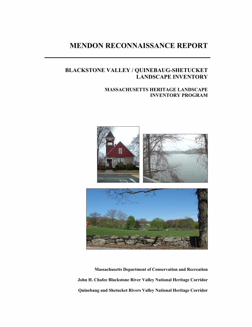
MENDON RECONNAISSANCE REPORT
41
MENDON RECONNAISSANCE REPORT BLACKSTONE VALLEY / QUINEBAUG-SHETUCKET LANDSCAPE INVENTORY MASSACHUSETTS HERITAGE LANDSCAPE INVENTORY PROGRAM Massachusetts Department of Conservation and Recreation John H. Chafee Blackstone River Valley National Heritage Corridor Quinebaug and Shetucket Rivers Valley National Heritage Corridor
Transcript of MENDON RECONNAISSANCE REPORT
MENDON RECONNAISSANCE REPORT
BLACKSTONE VALLEY / QUINEBAUG-SHETUCKETLANDSCAPE INVENTORY
MASSACHUSETTS HERITAGE LANDSCAPEINVENTORY PROGRAM
Massachusetts Department of Conservation and Recreation
John H. Chafee Blackstone River Valley National Heritage Corridor
Quinebaug and Shetucket Rivers Valley National Heritage Corridor

PROJECT TEAM
Massachusetts Department of Conservation and RecreationJessica Rowcroft, Preservation PlannerDivision of Planning and Engineering
John H. Chafee Blackstone River Valley National Heritage Corridor CommissionJoanna Doherty, Community Planner
Project ConsultantsElizabeth Vizza, Elizabeth Vizza ConsultingElecta Kane Tritsch, Oakfield ResearchDaniel Wells, Hyla Ecological Services Inc.
Local Project CoordinatorAnne Mazar
Local Heritage Landscape ParticipantsJane BigdaSharon CutlerBerneta D’VriesSusan DarnellPeter DentonJane EllisDick GradyShirley MalloyFrancine MathiesonAnne MazarSusan OberArlene ReedJoe RobertoShirley SmithJohn TrainorLinda VarneyRick Victor
June 2007
Cover Photographs: Taft Public LibraryLake NipmucVincent Farm

CONTENTS
Introduction ........................................................................................................................1
Part I: Mendon’s Heritage Landscapes
Mendon’s Landscape Through Time..........................................................................2
Community-Wide Heritage Landscape Issues ...........................................................3
Mendon Priority Landscapes.......................................................................................4Mendon CenterFarms
VanderSluis FarmTwin Elm Farm
Lake Nipmuc and Wildlife CorridorScenic Vistas
Part II: Building a Heritage Landscape Toolkit
Eight Toolkit Basics ..................................................................................................13
Mendon’s Toolkit: Current Status and Future Additions.........................................14
Conclusion and Implementation .........................................................................................21
Appendix A: Mendon Heritage Landscapes ............................................................................ i
Appendix B: Guide to Preservation and Planning Tools for Heritage .................................. viLandscapes

INTRODUCTION
The 22 Massachusetts communities within the John H. Chafee Blackstone River ValleyNational Heritage Corridor (BRV) and the Quinebaug-Shetucket Rivers Valley NationalHeritage Corridor (Q-S) are linked by a common heritage of agriculture and industrypowered by the rivers and streams that dominate the landscape of south centralMassachusetts. River Corridor towns extend from Mendon on the east to Brimfield on thewest. While they range in size from the city of Worcester to the compact town ofHopedale, each is equally shaped by the interaction of nature and culture over time.
Heritage landscapes are special places created by human interaction with the naturalenvironment that help define the character of a community and reflect its past. They aredynamic and evolving; they reflect the history of a community and provide a sense ofplace; they show the natural ecology that influenced land use patterns; and they oftenhave scenic qualities. This wealth of landscapes is central to each community’s character,yet heritage landscapes are vulnerable and ever changing. For this reason it is importantto take the first step toward their preservation by identifying those landscapes that areparticularly valued by the community – a favorite local farm, a distinctive neighborhoodor mill village, a unique natural feature or an important river corridor.
To this end, the Massachusetts Department of Conservation and Recreation (DCR) andthe two National Heritage Corridors (BRV and Q-S) have collaborated to bring theHeritage Landscape Inventory program to communities in south central Massachusetts.The goals of the program are to help communities identify a wide range of landscaperesources, particularly those that are significant and unprotected, and to providecommunities with strategies for preserving heritage landscapes.
The methodology for the Heritage Landscape Inventory program was developed in a pilotproject conducted in southeast Massachusetts and refined in Essex County. It is outlinedin the DCR publication Reading the Land, which has provided guidance for the programsince its inception. In summary, each participating community appoints a Local ProjectCoordinator (LPC) to assist the DCR-BRV/Q-S consulting team. The LPC organizes aheritage landscape identification meeting during which residents and town officialsidentify and prioritize the landscapes that embody the community’s character and itshistory. This meeting is followed by a fieldwork session including the consulting teamand the LPC, accompanied by interested community members. This group visits thepriority landscapes identified in the meeting and gathers information about thecommunity.
The final product for each community is this Reconnaissance Report. It outlines thecommunity’s landscape history; discusses broader land planning issues identified by thecommunity; describes the priority heritage landscapes and issues associated with them;and concludes with preservation recommendations. Two appendices include a list of allof the heritage landscapes identified at the community meeting and a reference listing ofland protection tools and procedures.

PART I
MENDON’S HERITAGE LANDSCAPES

Heritage Landscape Inventory Mendon Reconnaissance Report2
MENDON’S LANDSCAPE THROUGH TIME
Mendon, a rural town situated on rolling hills that rise to 500’ above sea level, isbordered by Hopedale, Bellingham, Blackstone, Millville, Uxbridge and Upton, and isthe “mother town” of all of them. The town center is located on a central plateau west ofthe Mill River, which flows north to south on a low, level floodplain, draining into theBlackstone River. Lake Nipmuc, Mendon’s one sizeable water body, lies in thesouthwest. Mendon’s soil is glacial till, much of it best suited for orchards, pastures andwoodland. The richest agricultural land lies on the central plateau, and along the MillRiver’s floodplain. In the pre-contact period, this area was used for seasonal hunting,fishing and agriculture.
In 1667 Mendon, originally Quinshapage Plantation, was established as a town; its initialgrant (1659) was eight miles square but its boundaries retracted over the next twocenturies as neighboring towns were set off. In the 18th and 19th centuries, Mendon wasa dispersed agricultural community, its farms lying primarily to the north of the centrallylocated meetinghouse. Two important roads were established during the Federal Period(1775-1830): the north-south post road from Worcester to Providence (now NorthAvenue/Main Street/Providence Street), and a turnpike running from Connecticut toBoston (now Route 16, or Milford Street/Hastings Street/Uxbridge Road).
Much of Mendon’s subsequent history was determined by its water resources and theconsequent locus of industrial development. Despite its name, the Mill River’s width andslowness could not provide the water-power for major industry. Instead, the realindustrial development took place on the powerful Blackstone River in the southern partof the original town. A large cotton spinning mill and village were built there in 1800. By1828 the Blackstone Canal, running beside the river, provided cheap and efficienttransportation, further encouraging growth of the mill villages. Meanwhile, the chiefeconomic focus of the center of Mendon continued to be farming, with associated cottageindustries such as shoes and straw goods.
When Mendon’s industrialized south parish separated as the town of Blackstone in 1845,the population of Mendon dropped from over 3,500 to 1,300. Railroads followedindustry, and the 19th century rail lines bypassed Mendon in favor of her industrialneighbors. Without the textile mills, Mendon’s industry consisted of small-scale woodand leather manufacturing. More important to the town, economically, were its forestproducts and an important shift to dairy farming. Milk, firewood, and building timberwere all in high demand in the mill towns surrounding agrarian Mendon.
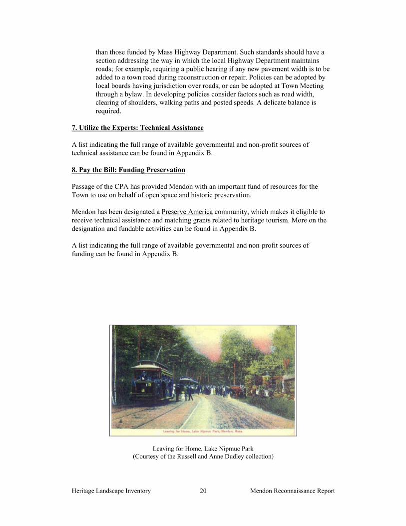
During the Late Industrial Period (1870-1915) trolley service linked Uxbridge toHopedale and Milford, running through the center of Mendon. Recreational cottagesbegan to be built around Lake Nipmuc, and in 1882 Lake Nipmuc Park, a lake shorerecreational area, was established by the trolley company. Streetcars were introduced in1901, bringing thousands of visitors to the park, with its ballroom, dining room andbeach, and providing new jobs for the town. By the time the streetcars were discontinuedin 1928, the main local roads had been improved for automotive traffic, making Mendonattractive to an increasing number of commuters from neighboring towns. From that timeto the present, Mendon has continued to be a residential and farming community. Muchof its landscape is characterized by hillside orchards, pastures and hayfields for dairycattle, and an overlay of residential neighborhoods.

Heritage Landscape Inventory Mendon Reconnaissance Report3
COMMUNITY-WIDE HERITAGE LANDSCAPE ISSUES
Concern for heritage landscapes is not new to Mendon. The town’s Growth ManagementStrategy, prepared in 1996, clearly expressed the community’s priorities to protect thetown’s rural character, open land particularly its farms, and views. These themes havebeen reiterated with every subsequent planning study.
Mendon's Heritage Landscape Identification meeting, attended by interested residentsincluding many representing town boards and local non-profit organizations, washeld on February 5, 2007. During the meeting, residents compiled a lengthy list ofthe town's heritage landscapes, which is included as Appendix A of this report. As thecomprehensive list was being created, attendees were asked to articulate the value ofeach landscape and identify issues relating to its preservation.
Residents emphasized broad issues related to heritage landscapes and communitycharacter. These issues are town-wide concerns that are linked to a range or category ofheritage landscapes, not just to a single place. In Mendon, four issues stand out.
Farmland PreservationMendon’s agricultural landscape is the most significant defining feature of the town. Itsrural character has also made it a desirable place to live, and the town has experiencedintense development pressures. Mass Audubon’s 2003 report, Losing Ground: At WhatCost identified Mendon as one of the top ten Sprawl Hot Spots in the state. Many farmshave never been placed in Chapter 61A; others have been removed from Chapter 61A.Some are deteriorating, and in shaky financial circumstances.
While Chapter 61A is a good incentive for owners of agricultural land, it does notprovide a permanent level of protection. Multiple approaches to farmland preservationneed to be called upon. Part II of this report lays out several mechanisms that addressagricultural preservation in particular.
Open Space CorridorsMendon has large tracts of open space that contribute positive scenic and environmentalbenefits to the town. The town recognizes that contiguous open space is more valuable aswildlife habitat than isolated parcels, and there are opportunities to strengthen greenwaycorridors in town. It is important that the town’s goal to identify the most critical areasfor protection be promoted to the public in order that this window of opportunity not belost.
Traffic PressuresMendon experiences significant regional traffic pressures. Approximately 85% of theregional traffic from Route 495 passes through Mendon, and it has had a major negativeimpact on the experience and safety of the town center. The state has expressed interest inwidening Hartford Avenue East from Route 140 to its intersection with Providence Road,which could exacerbate the traffic problem in Mendon Center and impact the experienceof the road itself as well as heritage landscapes along its route. Town boards should referto DCR’s publication Terra Firma 3: Identifying and Protecting Historic Roads, forsupport relative to protecting roads from inappropriate treatment, particularly p. 6, Lackof Awareness and Understanding.

Heritage Landscape Inventory Mendon Reconnaissance Report4
Historic House Preservation
Mendon Center has a wealth of significant historic structures. With an acceleratedhousing market and a number of key parcels in the town center up for sale or land lease,some important houses have unfortunately been victims of demolition just this summer.Documentation of the remaining significant historic structures in the Center is critical,followed by promotion of preservation strategies. Part II of this report lays out severalmechanisms that are very effective in addressing this issue, the most effective of which isestablishment of a Local Historic District.
PRIORITY HERITAGE LANDSCAPES
Based on information gathered at the community meeting, attendees identified a group ofpriority landscapes for the consulting team to focus on, through field survey,documentation and planning assessment. Each of the priority landscapes is highly valuedand contributes to community character. None of them has any permanent form ofprotection.
Mendon’s priority landscapes range from the heart of the town to an undeveloped openspace corridor of extraordinary wildlife significance. Farms and scenic vistas are strikingexpressions of the agricultural heritage that exists to this day.
The landscapes which were given priority status by Mendon’s community meetingrepresent a range of scales and types of resources. Each landscape is also representativeof other, similar properties in the town, and each demonstrates the multiple layers ofsignificance that are common to most heritage landscapes.
Natural and cultural features, individual and civic histories, combine to present propertyowners and concerned citizens with a complex combination of present-day issues andopportunities. The descriptions and recommendations that follow are intended to be firststeps and constructive examples for what needs to be an ongoing process: to identifywhat is valued and irreplaceable in the community, and develop strategies that willpreserve and enhance Mendon’s landscape heritage.
Mendon Center
Description: Mendon Center encompasses a remarkable mix of the village and ruralcharacteristics of the town, with the municipal and business heart of Mendon in closeproximity to expansive farm fields and scenic views. The center is one of the best-preserved Federal/Greek Revival hilltop village centers in the state, and was designated aNational Register Historic District in 2003. The compact center, formed by the triangle ofMaple, Hastings and Main Street, is dense with monuments and buildings, includingTown Hall. The majority of the center’s structures are residential, built between the mid-18th century and the mid-20th century. The Second Unitarian Church on Maple Street isalso a strong physical presence in the Center. Federal Period dwellings are generally largescale and reflect the prosperity and prominence of Mendon Center during the early 19th
century. The original meetinghouse and town common were located at the southwesterlycorner of the intersection of Main and Hastings Streets, now memorialized as Founders’Park.

Heritage Landscape Inventory Mendon Reconnaissance Report5
Just beyond the civic core, farms and open space parcels make a significant contributionto the landscape of the Center. The most prominent open spaces in the district are theVincent Farm and the abutting Cox property—which together total over 200 acres ofopen space—and the 78-acre town-owned property at the northwest edge of the Center.The majority of the Vincent property is within "core habitat" on the MassachusettsNatural Heritage and Endangered Species Program BioMap. There are also threecemeteries in Mendon Center, with Old Cemetery at Main, Providence and GeorgeStreets forming a highly visible historic landmark at the village’s southern gateway. Theconsolidated, rural setting of the village is dramatically evident when approaching fromthe east, north and south, particularly from the area on the plateau west of the Centerwhich has been heavily developed.
Background: At the end of the 18th century, Mendon was settled into a pattern of farmsradiating in all directions from the town center focused on the meetinghouse, and todaythe irregular street plan reflects this. The significance of this district was established inthe early decades of the 19th century, a period of growth and prosperity for the town andthe region, and the Center reached virtually its present dimensions and density by about1840. The break-off of the town of Blackstone and, by the last half of the 19th century, theend of boot and shoe making in Mendon is reflected by the near absence of buildingsconstructed in the Center between 1860 and 1900. This economic downturn, however,allowed Mendon to continue as a viable rural town. The early 20th century interest inMendon as a rural retreat had a modest physical impact on Mendon Center, withresidences and summer cottages, but mid-century saw greater development in the Centeras the town became a bedroom community.
Recommendations were made in the 1996 Growth Management Strategy report forimprovements in Mendon Center to address zoning issues, pedestrian safety andenvironment, parking needs, and traffic speeds. Some but not all of these have beenimplemented.
This August, the Silas Dudley House (1840) and the Simeon Doggett House (1820) weredemolished. Rumors are that the structures will be replaced by a CVS. In response to this,a grass roots group of concerned citizens formed Preservation Mendon, an organizationwhose mission is to protect the special nature of the town while also nurturingdevelopment.

Heritage Landscape Inventory Mendon Reconnaissance Report6
Issues:
Tear-Down and Replacement of Historic Buildings: This is a serious issue forMendon. The Silas Dudley House and the Simeon Doggett House were twosignificant and contributing buildings of the Center. Other important properties areup for sale or land lease, including the historic Dr. Metcalf house (1831), and the Tafthouse (1835). The Comstock House (1850) is also at risk of being torn down. Themajority of structures in the Center are residential and privately owned, and the riskof their loss is therefore high. Further demolitions will cause the serious erosion ofthe features that define the Center’s character.
Traffic Impacts: High traffic volumes and the threat of road widening negativelyimpact the center.
Risk of Loss of Agricultural Land: Several important farm parcels in Mendon Centerare not permanently protected, and therefore at risk.
Founders Park Character: This important site appears like a leftover abandonedspace, with trees haphazardly placed, a boulder plaque as well as a sign on a post, andan incompatible billboard-like sign. It should be improved to play a more positiverole in Mendon Center.
Recommendations:
Implement a Demolition Delay Bylaw, described in Part II, to provide a waiting andnegotiating period that can help to prevent the further loss of historic structures.
Revisit the proposal for a Local Historic District for Mendon Center. Initiate a town-wide discussion about the importance of protecting the essential features of theCenter, and about how LHDs can support private property values while preservingcommunity character. Part II describes the benefits of local historic districts.
Publicize the history and significance of the Center’s historic structures, includingarticles and letters in the Town Crier, Journeys, and Milford News. It is critical toeducate citizens about these important resources, to build a base of support for theirprotection.
Build on successes, such as the purchase of the 78 acres in northwest Mendon Center,to develop creative responses to properties for sale that may mean loss of historicstructures.
Implement recommendations in the 1996 Growth Management Strategy that have notyet been pursued, which details a village development strategy in the Mendon GiftBarn area, a Village Capital Improvements investment program, and streetscapeimprovements for Mendon Center.
Work with farm owners to encourage them to consider stronger forms of protectionfor their properties, including Agricultural Preservation Restrictions andConservation Restrictions.
Review DCR’s publication Terra Firma #3 to learn about state-wide historic roadissues and strategies for dealing with them.
Plans for design improvements to Founders’ Park are underway. Improvements mayinclude the removal of selected trees, planting new trees, installing a path and re-locating the plaque boulder to a new location on the site. Strong consideration shouldbe given to redesigning and/or finding a new location for the large, town events sign,which detracts from the park’s character. In addition, care should be taken to ensurethat work at the park does not affect any archaeological remains; it may be advisableto complete in-depth research into the history of the site and an assessment of itsarchaeological potential prior to undertaking the planned improvements. Knowledge

Heritage Landscape Inventory Mendon Reconnaissance Report7
gained from such research could affect the placement of new trees and path(s), andcould be incorporated into interpretive signage for the site.
Farms
The history of farming in Mendon is long, and widespread, and the town still showsevidence of that legacy in the number, size and beauty of its farms. Two farms wereselected as priority landscapes because of their scale, visual qualities, and environmentalvalues. Issues related to these farms are common to other farms in Mendon, and therecommendations are likewise applicable to agricultural landscapes throughout town
VanderSluis FarmDescription: VanderSluis Farm is a 101-acre farm on North Avenue north of MendonCenter. The farmhouse sits close to the road, facing south and forming an L-shapedbarnyard with the farm’s large main barn. There is a large Norway spruce in the frontyard, and there are several outbuildings nearby. Stone walls and white fences mark theboundaries of fields. Of the total acreage, the eastern portion of the property is currentlyactively used for agriculture, with 30 tillable acres and 20 in pasture, while the rest iswoodland composed primarily of mixed oak/hickory forest.
The property abuts several hundred more acres of undeveloped land, creating almost 500acres of contiguous open space which includes the town-owned Fino property in MendonCenter. The farm is completely within designated “core habitat” on the MassachusettsNatural Heritage and Endangered Program BioMap. VanderSluis Farm is a contributingproperty within the North Avenue Rural National Register Historic District, whichincludes portions of North Avenue, Trask Road, and Hopedale Street.
The owners have created a sanctuary for abandoned farm animals, and they provideeducation about the farm industry. Sanctuary animals include horses, cows, llamas, pigs,chickens, and goats.

Heritage Landscape Inventory Mendon Reconnaissance Report8
An ecological assessment of the VanderSluis property was conducted in 2006 byMetacomet Land Trust. The land was determined to have exceptional conservation value,with great habitat diversity relative to the size of the property. The conclusion was thatprotectable parcels of similar size and equivalent conservation value are uncommon inthe region and likely to become more so in the future.
Background: VanderSluis Farm has a legacy of active agricultural use as evidenced byextensive stone walls, old farm roads and a small farm pond impoundment. An 18th orearly 19th century Cape-style residence, likely the originally farmhouse, stands directlyacross the road. By the mid-19th century all of the upland acreage had probably beenconverted to agricultural use. Agricultural abandonment of the forested land appears tohave occurred piecemeal, over a long period of time. At one time it belonged to the Taftfamily, and it has been in the current owner’s family for several generations. The currentowner’s father worked the property as a dairy farm, milking 50-60 cows, processing themilk on site and delivering it throughout the town. The dairy operation was continued bythe family for a number of years, but stopped in 1993. They are currently applying fornonprofit 501(c)3 status for the sanctuary.
Twin Elm FarmDescription: Twin Elm Farm is a 691-acre farm on Bates Street. The property abutsseveral hundred more acres of undeveloped land, creating over 1000 acres of contiguousopen space. The land is also almost completely within "core habitat" on theMassachusetts Natural Heritage and Endangered Species Program BioMap. There aretwo major zones of farm buildings. The farmhouse sits off Hartford Avenue East near acluster of barns and corrals for the registered polled Herefords that the farm raises, aswell as horses and donkeys. The barns appear to be in excellent condition. The Twin ElmFarm property is an expansive site. It comprises three of the four corners of the nearbyBates/Bellingham Road intersection, and strongly defines the identity of this area.
Another cluster of outbuildings, including a large-scale former chicken coop now used asstorage for hay, is located on Providence Street. Rolling fields with stone walls, post-and-wire fencing, and a farm pond combine with the outbuildings to create a beautifulagricultural landscape, one of the views also identified in the Scenic Vistas priority

Heritage Landscape Inventory Mendon Reconnaissance Report9
landscape, below. The old town pound sits at the Providence Street edge of the farm, witha wooden sign that says it was built in 1670.
Issues
Lack of Permanent Protection: Like many farms in Mendon, neither of these twofarms are permanently protected. The VanderSluis’ considered an AgriculturalPreservation Restriction (APR) several years ago, but the state did not think it was agood candidate for the program because of concern that there would not be a farmerwho could work the farm when the owners died. The Metacomet Land Trust isexploring various foundation grants for a Conservation Restriction (CR), which theowners would welcome.
Scale of Property and Development Threat: The east side of Mendon has the good,sandy soil that supports farming as well as development. The sheer scale of TwinElm Farm, combined with its contiguous open spaces, poses a major threat to thetown if it were to be developed.
Recommendations:
Share the findings of this project with the property owners. They should know thatthese heritage landscapes are valued and appreciated by Mendon’s residents.
Continue efforts to obtain a CR for the VanderSluis property Work with the owners of Twin Elm Farm to explore protection options, including
placing a APR or a CR on the property Document the farm properties according to MHC standards, completing and
submitting Area forms with the local historical commission and MHC Form a local Agricultural Commission to help advocate for measures that will
support the viability of farming in Mendon. Establish an Open Space or Cluster Zoning Bylaw, which allows greater
development density in an effort to permanently protect open space, if farmlandbecomes subject to development.
Lake Nipmuc and Wildlife Corridor
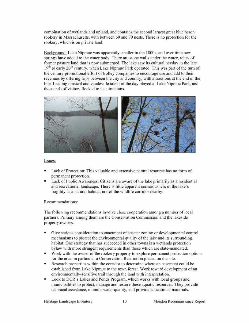
Description: Lake Nipmuc (also known as Nipmuc Pond, and historically spelledNipmuck) is Mendon’s one major water body and a Commonwealth Great Pond. Locatedin the central western area of town west of Mendon Center on Route 16, it is spring fed,with the outflow into Meadow Brook. The town owns the island in the lake and one areaof town beach along the lake’s eastern shore, accessed off Taft Avenue. The rest of theshorefront is private land, with houses and some restaurants on the northwest, northeast,and southeast lake edges. Most of the houses are converted summer cottages built duringthe trolley era when Lake Nipmuc Park operated. The Park was located on Nipmuc Driveat the northwestern edge of the lake. Various minimal stonework remains at the site. Thenearby Myriad Ballroom is adapted from the original ballroom of the Park.
The 85-acre lake serves as the largest source of water for local fire protection, sinceMendon does not have town water. There is a 500-acre contiguous open space wildlifecorridor stretching south from the southern shore of the lake, including the Mendon TownForest, to the Millville line. Approximately 100 acres of the land is under Chapter 61Aand 61B, and the town owns approximately 135 acres of the corridor. The land is a
Heritage Landscape Inventory Mendon Reconnaissance Report10
combination of wetlands and upland, and contains the second largest great blue heronrookery in Massachusetts, with between 60 and 70 nests. There is no protection for therookery, which is on private land.
Background: Lake Nipmuc was apparently smaller in the 1800s, and over time newsprings have added to the water body. There are stone walls under the water, relics offormer pasture land that is now submerged. The lake saw its cultural heyday in the late19th to early 20th century, when Lake Nipmuc Park operated. This was part of the turn ofthe century promotional effort of trolley companies to encourage use and add to theirrevenues by offering trips between the city and country, with attractions at the end of theline. Leading musical and vaudeville talent of the day played at Lake Nipmuc Park, andthousands of visitors flocked to its attractions.
Issues:
Lack of Protection: This valuable and extensive natural resource has no form ofpermanent protection.
Lack of Public Awareness: Citizens are aware of the lake primarily as a residentialand recreational landscape. There is little apparent consciousness of the lake’sfragility as a natural habitat, nor of the wildlife corridor nearby.
Recommendations:
The following recommendations involve close cooperation among a number of localpartners. Primary among them are the Conservation Commission and the lakesideproperty owners.
Give serious consideration to enactment of stricter zoning or developmental controlmechanisms to protect the environmental quality of the lake and its surroundinghabitat. One strategy that has succeeded in other towns is a wetlands protectionbylaw with more stringent requirements than those which are state-mandated.
Work with the owner of the rookery property to explore permanent protection optionsfor the area, in particular a Conservation Restriction placed on the site.
Research properties within the corridor to determine where an easement could beestablished from Lake Nipmuc to the town forest. Work toward development of anenvironmentally-sensitive trail through the land with interpretation.
Look to DCR’s Lakes and Ponds Program, which works with local groups andmunicipalities to protect, manage and restore these aquatic resources. They providetechnical assistance, monitor water quality, and provide educational materials.
Heritage Landscape Inventory Mendon Reconnaissance Report11
Scenic Vistas
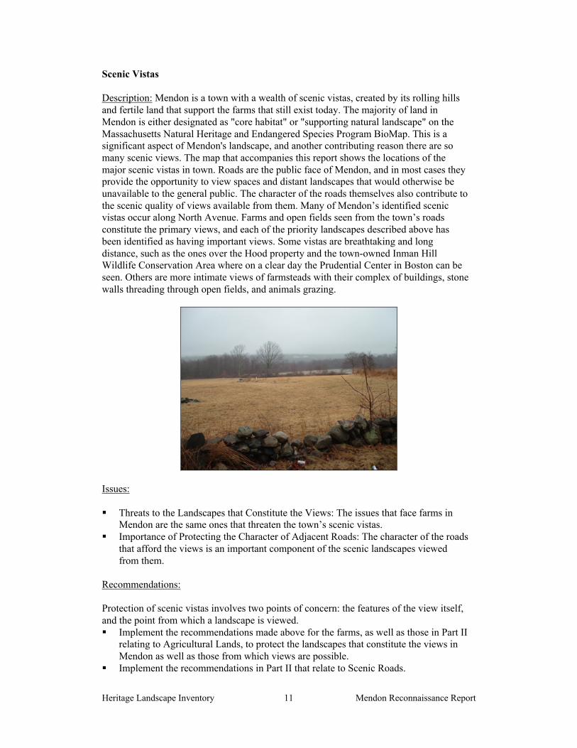
Description: Mendon is a town with a wealth of scenic vistas, created by its rolling hillsand fertile land that support the farms that still exist today. The majority of land inMendon is either designated as "core habitat" or "supporting natural landscape" on theMassachusetts Natural Heritage and Endangered Species Program BioMap. This is asignificant aspect of Mendon's landscape, and another contributing reason there are somany scenic views. The map that accompanies this report shows the locations of themajor scenic vistas in town. Roads are the public face of Mendon, and in most cases theyprovide the opportunity to view spaces and distant landscapes that would otherwise beunavailable to the general public. The character of the roads themselves also contribute tothe scenic quality of views available from them. Many of Mendon’s identified scenicvistas occur along North Avenue. Farms and open fields seen from the town’s roadsconstitute the primary views, and each of the priority landscapes described above hasbeen identified as having important views. Some vistas are breathtaking and longdistance, such as the ones over the Hood property and the town-owned Inman HillWildlife Conservation Area where on a clear day the Prudential Center in Boston can beseen. Others are more intimate views of farmsteads with their complex of buildings, stonewalls threading through open fields, and animals grazing.
Issues:
Threats to the Landscapes that Constitute the Views: The issues that face farms inMendon are the same ones that threaten the town’s scenic vistas.
Importance of Protecting the Character of Adjacent Roads: The character of the roadsthat afford the views is an important component of the scenic landscapes viewedfrom them.
Recommendations:
Protection of scenic vistas involves two points of concern: the features of the view itself,and the point from which a landscape is viewed. Implement the recommendations made above for the farms, as well as those in Part II
relating to Agricultural Lands, to protect the landscapes that constitute the views inMendon as well as those from which views are possible.
Implement the recommendations in Part II that relate to Scenic Roads.

Heritage Landscape Inventory Mendon Reconnaissance Report12
PART II
BUILDING A HERITAGE LANDSCAPE TOOLKIT
Heritage Landscape Inventory Mendon Reconnaissance Report13
EIGHT TOOLKIT BASICS
As our communities undergo rapid land use changes, heritage landscapes are particularlythreatened because they are often taken for granted. There is a broad variety of resourcesthat communities can call upon to protect these irreplaceable resources. Below is achecklist of the basics. Each is discussed in the sections that follow and in Appendix B.
1. Know the resources: InventoryWe cannot advocate for something until we clearly identify it – in this case, the physicalcharacteristics and historical development of the town’s historic and archaeologicalresources. The necessary first step is to record information about the resources at theMassachusetts Historical Commission.
2. Gain recognition for their significance: National Register ListingThe National Register of Historic Places is the nation’s official list of cultural resourcesworthy of preservation. Listing brings a number of benefits including recognition,consideration when federally-or state-funded projects may impact the resource, eligibilityfor tax credits, and qualification for certain grant programs.
3. Engage the public: Outreach, Education and InterpretationIn order to create a community of advocates, we need to raise public awareness andbroaden the base of support. This includes developing opportunities to learn about andcelebrate the places and history of the town, as well as to care for them.
4. Think in context: Comprehensive and Open Space PlanningIt is important that Open Space Plans and Comprehensive or Master Plans addressheritage landscapes as vital features of the community, contributing not only to uniquesense of place but also to environmental, recreational and economic health.
5. Develop partnerships: The Power of CollaborationProtecting community character, respecting history, and promoting smart growth areinterrelated concerns that impact heritage landscapes and require collaboration across abroad spectrum of the community. This includes communication among town boards anddepartments, as well as public-private partnerships.
6. Defend the resources: Zoning, Bylaw and Ordinance MechanismsEffective and innovative preservation tools exist in the legal and regulatory realm. Theserange from a wide array of zoning, bylaw and ordinance mechanisms, to incentiveprograms and owner-generated restrictions on land use.
7. Utilize the experts: Technical AssistanceRegulations and creative solutions for heritage landscapes are constantly changing andemerging. Public and private agencies offer technical assistance with the many issues tobe addressed, including DCR, MHC, the Heritage Corridor and the Central MassachusettsRegional Planning Commission.
8. Pay the bill: Funding PreservationFunding rarely comes from a single source, more often depending on collaborativeunderwriting by private, municipal, and regional sources. Each town also has a variety offunding sources that are locally based and sometimes site-specific.

Heritage Landscape Inventory Mendon Reconnaissance Report14
MENDON’S TOOLKIT – Current Status and Future Additions
What follows is a review of the tools that Mendon already has in place, as well as a lookat a number of additional tools. The tools already in place for Mendon provide a goodfoundation for heritage landscape preservation, but their efficacy as protection for thetown’s natural and cultural resources can be significantly improved by strengtheningexisting measures and putting others in place. Appendix B includes extended descriptionsof preservation measures; the specific applications of those tools to Mendon’s resourcesare described below. The appendix also contains a full description of additional avenuesand creative approaches that Mendon might consider in developing a multi-prongedstrategy for preservation.
A tool that has been proven to be one of the single most valuable resources in protectingheritage landscapes has been the Community Preservation Act (CPA). Mendon has beenan excellent model for how a town’s resources can be brought to bear on heritagelandscape preservation through the program, in particular its purchase of the 78-acre Finoproperty. The resources made possible by the CPA should be kept in mind whenconsidering the recommendations for priority landscapes as well as the generalrecommendations below.
These tools should be considered in combination with those recommendations made inPart I for Mendon’s priority landscapes.
1. Know the resources: Inventory
Current: According to the Massachusetts Historical Commission, the town’sinventory includes documentation for 295 buildings, structures and sites.
Additions: The inventory process completed in 2002 for Mendon provides a goodbasis for protection of the town’s historic resources. However, there are other sitesthat should be documented, most importantly some of the priority landscapes andother key farms that have not yet been thoroughly inventoried.
It is recommended that a similar, archaeological survey be completed for thecommunity. Known and potential precontact Native American and historicarchaeological sites should be documented in the field for evidence of their culturalassociation and/or integrity. Funding assistance for this effort would also be availablefrom the MHC Survey and Planning grants, as well as CPA funding.
2. Gain recognition for their significance: State and National Register Listing
Current: There are two National Register Historic Districts in town. The MendonCenter Historic District includes 224 contributing and 47 non-contributing features,while the North Avenue Rural Historic District includes 62 contributing and 9 non-contributing features. All are automatically listed in the State Register of HistoricPlaces. In addition, the Nathan Aldrich House and Resthaven Chapel wasindividually listed on the National Register in 2006.
There are no local historic districts and no Preservation Restrictions on properties inMendon.

Heritage Landscape Inventory Mendon Reconnaissance Report15
Additions: It is recommended that the Mendon Historical Commission pursueadditional National Register designations with the MHC and consider prioritizationof sites and areas for additional listing. Local Historic District designation forMendon Center should be pursued.
3. Engage the public: Outreach, Education and Interpretation
Current: Mendon’s sixth grade students follow a curriculum that teaches them aboutthe history of Mendon and Upton. A field trip is incorporated into the program, and awalking tour was prepared by sixth graders including historical research, writing oftext and drawing illustrations.
The town has a historic plaque program marking historic homes; markers have beenplaced identifying the location of early churches and cemeteries, and a plaque tellsthe history of Founders Park.
The Blackstone River Valley National Heritage Corridor has published an excellentwalking tour guide to Mendon Center that describes the history and significance of anumber of sites, as well as providing brief historical background to the town as awhole.
The Boy Scouts have camped on the town-owned Kelly Farm, and worked with aforester to blaze the borders of the property and perform selective cutting of trees tocreate nesting sites.
Trolley tours of the town are also conducted, which are very popular.
Additions: One of the most important resources that the newly formed organizationPreservation Mendon can provide to the town is that of outreach and education. It isvital for citizens to be informed of the richness of Mendon’s heritage landscapes andtheir contribution to the health and identity of the town. The group has discussed arange of activities, including trolley tours, walking tours, a fall Blackstone Valleyweekend, and historic reenactment. They also realize that education about zoningmechanisms is equally vital, and should be made available to community members.
More opportunities to reach out to young people should be explored through thepossible expansion of curricula to other grades and opportunities for supervised workon town properties. These are very effective ways to keep the values and needs ofheritage landscapes in the public consciousness for young and old alike.
Preservation Mass, as the statewide preservation advocacy organization, is a sourceof support for advocacy. They have a program that annually identifies and publicizesthe 10 Most Endangered historic resources in the Commonwealth, which is a goodway to advocate for resources that are imminently threatened.
4. Think in context: Comprehensive and Open Space Planning
Current: The Mendon Growth Management Strategy, 1996. This reportemphasized the importance of every one of Mendon’s priority landscapes, statingthat: “a critical aspect of Mendon’s historic and present character is faming and

Heritage Landscape Inventory Mendon Reconnaissance Report16
farmland. The fields, meadows and structures used in farming all help to define theTown’s rural character”. Of Lake Nipmuc, it stated, “Nipmuc Pond[sic] is a resourcefor the entire town and this body of water helps to define the entire Town’scharacter”. It also identified hill tops and views of farms and fields as favoredlandscapes among community members.
The Growth Strategy outlined creative steps that could be taken to protect Mendon’sspecial character, several of which have been implemented, such as the Rate ofDevelopment Bylaw.
Current: Community Development Plan, 2004. Like the Growth ManagementStrategy, this report also underscored the importance of measures to protect thecharacter of the town and guide sustainable growth. Objectives of the plan that relateto heritage landscape preservation include: determine where land preservation shouldbe targeted, considering scenic and environmental values; determine the needs ofarea farmers to help them sustain the agricultural use of their land; and plan growth topreserve town’s rural character and country atmosphere.
Current: Open Space and Recreation Plan, 2006. This plan includes a goodhistorical summary of the town, and a good identification of important scenicqualities. Wildlife habitat and conservation issues are identified.
VanderSluis and Twin Elm Farms, Lake Nipmuc wildlife corridor, and the northeastportion of Mendon Center were all identified in the plan as areas of high priority forprotection. The land is all identified as either core habitat or supporting naturallandscape.
In 2003, the Land Use Committee worked with MassGIS to update mapping data onMendon to identify owners of environmentally sensitive land and help target landprotection priorities. This will be a valuable resource as the town works to beproactive in its protection strategies.
Additional Planning: Mendon’s Growth Management Strategy document should berevisited to determine what additional strategies can be pursued. The goals laid out inboth the Community Development Plan and Open Space Plan that relate to heritagelandscape preservation should continue to be pursued, through the collaborativeefforts of the many town boards that have an interest in these issues.
A critical next step with open space planning is to discuss the issues of wildlifehabitat, conservation, and the historical values of the town’s heritage landscapes as acomplex of interdependent characteristics.
Mendon should hire a town planner. There have been plans developed over the yearsby volunteer boards and committees, which is very positive. The Town, however,would be well served by a paid professional who is focused on the important tasks ofmoving planning initiatives forward, acting as a liaison between town boards, andimplementing the recommendations of this report. Given the threats to MendonCenter, this is a particularly critical time for Mendon to have this kind of support.Towns that cannot afford the services of a full-time planner have benefited fromsharing a planner with an adjacent town,

Heritage Landscape Inventory Mendon Reconnaissance Report17
It is vital that there be strong links between community economic development, openspace, and recreation agendas in order to successfully address Mendon’senvironmental and development challenges. There should be regular joint meetingsof the town boards involved with land-based and cultural resource issues. Thisscheduled interaction will help to maintain communication, coordinate planningpriorities, and advance programs that support and promote community character andheritage landscapes.
5. Develop Partnerships: the Power of Collaboration
Current Status: In 2001 the town purchased land from three separate owners,helping to complete an 800-acre tract of contiguous, protected open space thatstraddles the Mendon–Blackstone town line. This was done in collaboration with theMassachusetts Department of Fisheries and Wildlife, Metacomet Land Trust,Mendon Land Use Committee, other town boards and a private donor.
Additional Efforts: Existing partnerships in town should be sustained, which haveserved Mendon well in the past.
Some of the recommendations in this report, such as reconsideration of a localhistoric district, will require the understanding and cooperation of multiple interestsand boards. The accomplishments of 2001 should be used as a model.
6. Defend the Resources: Zoning, Bylaw and Ordinance Mechanisms
Current Mechanisms
Rate of Development Bylaw: Mendon passed this time-limited bylaw in 2001 andagain in 2006, which allowed only 39 new building permits for residential units to beissued each year through 2006, in order for town to promote orderly growth.
Affordable Housing Overlay District: This district was approved in an area of thesoutheastern part of Mendon, which affects open space by helping to relieve thepressure of 40B comprehensive permits on the Town’s resources.
Additional Mechanisms
Three strategies have consistently proven effective as basic preservation tools incommunities throughout Massachusetts.
Demolition Delay Bylaws provide a time period in which towns can explorealternatives to demolition of historic structures. The Mendon Historical Commissionshould work with MHC staff to develop a bylaw that would best suit Mendon’sneeds. They should also work with other town groups to publicize the advantages of ademolition delay bylaw to the community. The most valuable aspect of this bylaw isthat it creates space within which to have a conversation about how private andpublic needs can both be met in the service of preservation. Many towns have foundthat a delay of one year is the most effective time frame within which to negotiatealternatives to demolition. A majority of the bylaws apply to all structures built over50 years ago, in accordance with federal standards.

Heritage Landscape Inventory Mendon Reconnaissance Report18
Neighborhood Architectural Conservation Districts (NACD), further explained inAppendix B, are local initiatives that recognize special areas within a communitywhere the distinctive characteristics of buildings and places are preserved andprotected. The Mendon Historic Commission should work with the MHC staff todetermine how an NACD can help to maintain the character of areas which havechanged through time, but which retain a valued neighborhood “feel” that may bethreatened by incompatible development.
Local Historic Districts (LHD), further explained in Appendix B, are also localinitiatives and the strongest form of protection to preserve special areas withdistinctive buildings and places. Mendon voters have voted against a proposed localhistoric district for Mendon center twice, fearing infringement on private propertyrights. Unfortunately, National Register listing provides only minimal protection forhistoric landscapes and structures. It should be made clear to voters that localdesignation can be tailored to specific community needs, often protecting privateinvestment by enhancing property values.
Additional mechanisms specific to Mendon’s landscapes
The following recommendations focus on two important types of resources thatMendon has, and measures that should be considered to strengthen their protection.
Agricultural Lands
Preservation of agricultural landscapes means preservation of the farming activities;otherwise, it simply is the preservation of land as open space. There are instances inwhich changing technology sometimes requires modifications to existing farmstructures, or the addition of new ones. It is important to know what the features of anagricultural setting are and which features the community treasures in order to makea case for preservation of these settings.
Appendix B has a full list of regulatory tools that should be considered to protectagricultural land; the following highlights important measures to meet the needs ofagricultural protection in Mendon.
1. Create an Agricultural Commission, a standing committee of town governmentcreated through vote at Town Meeting. This Commission would represent thefarming community, promote agricultural-based economic opportunities, andwork to protect and sustain agricultural businesses and farmland.
2. Prioritize parcels under Chapter 61A for future acquisition. Should the landownerchoose to sell land recently withdrawn from Ch 61, the town has only 120 days toact on its right of first refusal. The need to pay fair market value creates somechallenges for the town to effectively act on this right, although the CPAprovides some readily-available funding.
3. Strengthen public-private partnerships to preserve farmland through purchase ofAPRs or CRs.
4. Develop partnerships to raise funds (including partnerships with MetacometLand Trust) to purchase development rights on farms or to assist a farmer in therestoration of historic farm buildings for which the owner would be required todonate a preservation restriction (PR).

Heritage Landscape Inventory Mendon Reconnaissance Report19
5. Make information about the Massachusetts Department of AgriculturalResources programs available to farmers, including the Farm ViabilityEnhancement Program (technical assistance, funding) and the AgriculturalEnvironmental Enhancement Program (supports best management practices foragricultural operations to mitigate impacts on natural resources).
6. Adopt Open Space Zoning (also known as Cluster Zoning), which serves the dualpurpose of allowing landowners to develop their property while protectingsubstantive parcels of open space.
7. Document farms that are considered critical to the character of Mendon’scommunity using MHC survey forms.
8. Adopt a right-to-farm bylaw which allows farmers to carry on farming activitiesthat may be considered a nuisance to neighbors. Refer to Smart Growth Toolkitat: http://www.mass.gov/envir/smart_growth_toolkit/bylaws/Right-to-Farm-Bylaw.pdf
9. Explore Community Supported Agriculture (CSA), a partnership between a farmand a community of supporters. Community members cover a farm’s yearlyoperating budget by purchasing a share of the season’s harvest. This relationshipguarantees farmers a reliable market, while assuring the members high qualityproduce, often below retail prices.
Scenic Roads
Scenic roads and the views afforded from them are an integral part of the historicfabric of the community. They are highly valued by Mendon residents and visitorsalike and were listed as a heritage landscape theme during the public meeting. Roadsmust also accommodate modern transportation needs and decisions regardingroadways are often made with travel and safety requirements as the onlyconsiderations. Mendon has adopted the Scenic Roads Act (MGL Chapter 40-15C)and has designated 15 roads for which there would be review and approval for theremoval of trees and stone walls within the right-of-way.
In addition to roadway issues, much of what we value about scenic roads – the stonewalls, views across open fields and the many scenic historic buildings – is not withinthe public right-of-way. The preservation and protection of scenic roads thereforerequires more than one approach.
1. Complete an inventory with descriptions and photo documentation of each of theroads in Mendon considered scenic, including the character-defining features thatshould be retained.
2. Post attractive road signs that identify the designated scenic roads in town.3. Coordinate monitoring and roadwork procedures between Highway Department
and Planning Board or Historical Commission.4. Consider a Scenic Overlay District which may provide a no-disturb buffer on
private property bordering on scenic roads or adopt flexible zoning standards toprotect certain views. Such bylaws would apply to the landscapes bordering statenumbered roadways, which are not protected under the scenic roads designation,as well as to landscapes bordering town roads.
5. Develop policies and implementation standards for road maintenance andreconstruction which address the scenic and historic characteristics while alsoaddressing safety. This is an important public process in which the communitymay have to accept responsibility for certain costs to implement standards higher
Heritage Landscape Inventory Mendon Reconnaissance Report20
than those funded by Mass Highway Department. Such standards should have asection addressing the way in which the local Highway Department maintainsroads; for example, requiring a public hearing if any new pavement width is to beadded to a town road during reconstruction or repair. Policies can be adopted bylocal boards having jurisdiction over roads, or can be adopted at Town Meetingthrough a bylaw. In developing policies consider factors such as road width,clearing of shoulders, walking paths and posted speeds. A delicate balance isrequired.
7. Utilize the Experts: Technical Assistance
A list indicating the full range of available governmental and non-profit sources oftechnical assistance can be found in Appendix B.
8. Pay the Bill: Funding Preservation
Passage of the CPA has provided Mendon with an important fund of resources for theTown to use on behalf of open space and historic preservation.
Mendon has been designated a Preserve America community, which makes it eligible toreceive technical assistance and matching grants related to heritage tourism. More on thedesignation and fundable activities can be found in Appendix B.
A list indicating the full range of available governmental and non-profit sources offunding can be found in Appendix B.
Leaving for Home, Lake Nipmuc Park(Courtesy of the Russell and Anne Dudley collection)

Heritage Landscape Inventory Mendon Reconnaissance Report21
CONCLUSION AND IMPLEMENTATION
Mendon’s residents have a strong sense of place, defined by the town’s varied naturalfeatures and the historic land use patterns that grew out of them. The town has alreadybegun to document and evaluate its most significant buildings and natural areas. It mustnow also look beyond these traditional resources to the landscapes, streetscapes, ruralroads, neighborhoods and other natural and cultural assets that define the community’scharacter. Like most municipalities, Mendon is facing multiple pressures for change thatwill have permanent impact on land-based uses and natural resources, especially itsremaining farming areas. Special places within the community that were once taken forgranted are now more vulnerable than ever to change.
The Mendon Reconnaissance Report is a critical tool in starting to identify the rich anddiverse heritage landscapes in Mendon and in developing creative preservation strategiesand partnerships. Mendon will have to determine the best ways and sequence in which toimplement the recommendations discussed above. The town would do well to form aHeritage Landscape Committee, as described in DCR’s publication, Reading the Land.
Landscapes identified in this report, especially the priority landscapes, will benefit fromfurther documentation in accordance with MHC guidelines. The documentation in turnwill provide an information base for the local publicity needed to build consensus andgather public support for landscape preservation. Implementing many of therecommendations in this report will require a concerted effort by and partnerships amongmunicipal boards and agencies, local non-profit organizations, and regional and stateagencies and commissions.
There are no quick fixes for the challenges of managing growth and funding preservation.Many of the recommended tasks and approaches will require cooperation andcoordination among a number of municipal, regional and state partners to be successful.They will require time and a good dose of patience, as volunteer schedules, legislativeprocedures, and funding cycles try to mesh.
Circulating this Reconnaissance Report is an essential first step. The recommendationsshould be presented to the Board of Selectmen, who represented Mendon in itsapplication to the Heritage Landscape Inventory program. Copies of the report should beavailable on the town’s web site and distributed to town departments and boards,particularly Mendon 's Historical Commission, Planning Board, and ConservationCommission and will also be useful for the Mendon Historical Society, neighborhoodassociations, local land trusts, and other preservation organizations. Finally, a referencecopy belongs in the town library. All of these circulation efforts will broaden citizenawareness, and result in increased interest and support for Mendon's heritage landscapes.
Finally, the project team suggests that the following recommendations be the topfour priorities for Mendon as the town works to protect the character of itscommunity:
1. Passage of a Demolition Delay Bylaw2. Reconsideration of Local Historic District designation for Mendon Center3. Passage of an Open Space Subdivision (Cluster) Bylaw4. Hiring of a town planner, or sharing one with another community

Heritage Landscape Inventory Mendon Reconnaissance Reporti
APPENDIX A
MENDON HERITAGE LANDSCAPES
This list was generated by local participants at the Heritage Landscape Identification meeting held inMendon on February 5, 2007 and follow-up fieldwork on April 2, 2007. There are undoubtedly otherheritage landscapes that were not identified at the HLI meeting noted above. The chart has twocolumns, the name and location of the resource are in the first; notes about the resource are in the second.Landscapes are grouped by land use category. Abbreviations used are listed below.
APR = Agricultural Preservation Restriction CR = Conservation RestrictionLHD = Local Historic District NR = National RegisterPR = Preservation Restriction Bold = Priority Landscape
Summary of Priority Landscapes
Mendon CenterFarms: VanderSluis Farm, Twin Elm FarmLake Nipmuc & Wildlife CorridorScenic Vistas
Agriculture
Van derSluis Farm(Maple Farm)
101-acre farm in the North Avenue Rural NR District; abuts severalhundred more acres of undeveloped land; sanctuary for abandonedfarm animals, ecologically rich property; also a high prioritylandscape
Twin Elm Farm 691-acre farm on Bates Street; animals include registered polledHerefords; land abuts several hundred more acres of undevelopedland; scenic vistas; also a high priority landscape
Vincent Farm see Mendon Center NR Historic District; also scenic vistaProperty abuts other open space, making over 200 acres of contiguousopen space.
Pearson Farm(Quisset Farm)
abuts state land
Hawkes Farm North AvenueDenton FarmFormer Poor Farm Remodeled house, barn foundation, other outbuilding foundations,
stone walls
Archaeology
Powder Magazine131 Providence Rd.MillBellingham St.
foundation of mill remains, with indication of where water wheel waslocated

Heritage Landscape Inventory Mendon Reconnaissance Reportii
stone foundation of oldgrist mill
remnants of Albees Grist Mill at Mill River on Hartford Ave. East.
Blacksmith Shop on C. Allaire’s land; foundation is built into hillsideMassacre site early settlement with mill; burned 1675; historic marker there now;
exact location disputed
Burial Grounds and Cemeteries
theme: cemeteries Swandale Cem., Revolutionary War Cem., Pine Hill Cem., George St.Cem., Quaker Cem., Gaskill Cem., Bicknell Cem., Taft/LamontheCem., Locust Hill Cem., Wood Cem., Daniels Cem. Union FreemanCem., Cook Cem., Mowry Cem., Thornton St. Cem., Old Cem.,Quaker Cem.
Civic / Institutional
First ParishUnitarian Church
within Mendon Center NR Historic District, also a high prioritylandscape
Town Pounds- Providence Rd.- Hartford Ave. West
stone enclosures; one on Providence Rd. adjacent to Twin Elm Farm(see above)
Commercial / Industrial
Mendon Drive-In Still active; one of only four active drive-ins in the stateAmmidon Tavern Within the Mendon Center NR Historic District, also a high priority
landscapeMendon Gift Barn Within the Mendon Center NR Historic District, also a high priority
landscapeGeorge’s Surf & Turf Drive-thru restaurant
Miscellaneous
theme: scenic vistas-view from Rte 16,Hopedale line- view from North Ave.-view from Varneyproperty-view to Vincent Farmfrom Providence Rd. orGeorge St.
See map for locations of scenic vistas; most are of agriculturallandscapes
Open Space /Recreation/Parks
Southwick Zoo land in family since 17th centuryzoo established mid-20th c.
Founders Park Within the Mendon Center NR Historic District, also a high prioritylandscape; site of first meetinghouse
Tower Hill also precontact archaeological; see also Tower Road

Heritage Landscape Inventory Mendon Reconnaissance Reportiii
Lake Nipmuc &Wildlife Corridor
town beach = only public access to lakeuninterrupted open space from town forest to lake serves as wildlifecorridor and include Great Blue Heron rookery; privately owned.Also listed under scenic vistas.By lake, privately owned Phipps property near Myriad Ballroom(adapted from original ballroom of the Park)
Fino Property / TaftOrchards
Within the Mendon Center NR Historic District, also a high prioritylandscape
Inman Hill WildlifeCons. Area
Former Kelly Farm/Wood property/Paddock propertyalso includes the MA Division of Fisheries and Wildlife Quisset Hillopen space
Town ForestMill RiverTrolley Park at LakeNipmuc
ballroom survives; summer cottages converted to year-round usenearby
Residential
Metcalf House in Mendon Center HD.Home of Revolutionary War widow, Mrs. Prince. Purchased by Dr.John Metcalf in 1832, who lived there until his death in 1892.Prominent physician, town clerk, town treasurer, state senator, andtown historian.
Taft House Within the Mendon Center NR Historic District, also a high prioritylandscape
Labastie House Thornton Streettheme: stone houses Resthaven (finishing school for girls); Ouillette’s Farm; Old Metcalf
House; on Providence Road and George Street
Transportation
Scenic Roads Asylum St., Bates St. (from Bellingham St. to the Bellingham townline), Blackstone St. (from Lovell St. to the Blackstone town line),Inman Hill Rd., Park St., Pleasant St., Southwick St., Thornton St.,Gaskill St. (terminating at George St. and Providence St.), George St.(terminating at the Hopedale town line and Providence St.), NorthAve. (beginning and including the road adjacent tot he powertransmssion lines – USGS Blackstone, MA, RI quadrant – andterminating at the Upton town line), Miscoe Rd. (terminating at NorthAve. to the end of the public right of way), Quisset Rd. (terminatingat Providencce St. to the end of the public right of way), Thayer St.(terminating at Bates St. to the end of the public right of way), TraskRd. (terminating at Hopedale St. to the end of the public right of way)
Tower Road discontinued; now hiking trail; leads to fire tower; in town forestOld Post RoadTrolley Railbed
Village

Heritage Landscape Inventory Mendon Reconnaissance Reportiv
Mendon CenterHistoric District
NRHD 2003; commercial and civic core of Mendon see prioritylandscape description for specifics

Heritage Landscape Inventory Mendon Reconnaissance Reportv
APPENDIX B
GUIDE TO PRESERVATION AND PLANNING TOOLS FOR HERITAGE LANDSCAPES
Preservation planning is a four-step process: identification, evaluation, education and protection.Within the realm of protection, there is a vast array of tools that communities can call upon and that aremost effective when used in combination with one another. Stewardship of these resources involveseducation and community support, planning with a clear set of goals, and regulatory mechanisms.
Three useful documents to consult when planning preservation strategies are:
Department of Conservation and Recreation, Reading the Land
Massachusetts Historical Commission, Survey Manual
Massachusetts Historical Commission, Preservation through Bylaws and Ordinances
The following eight sections – based on the Toolkit Basics – detail the resources and strategies availablefor heritage landscape preservation—from documentation and evaluation, to public education, toregulating activities and finding the revenue necessary to fund the effort.
1. KNOW THE RESOURCES: INVENTORY
The vital first step in developing preservation strategies for heritage landscapes is to record informationabout the resources on MHC inventory forms. One cannot advocate for something unless one knowsprecisely what it is – the physical characteristics and the historical development.
Survey methodology has advanced since the early work of the 1980s. If a community had survey workdone during that time period, it is time for an inventory update, looking at resources in a morecomprehensive and connected way than may have been done at that time. Even if survey work is morerecent, there may be a need to document more resources throughout the community.
Using the Massachusetts Historical Commission survey methodology:
a. Compile a list of resources that are under-represented or not thoroughly researched, beginningwith heritage landscapes.
b. Document unprotected resources first, beginning with the most threatened resources.
c. Make sure to document secondary features on rural and residential properties, such asoutbuildings, stone walls and landscape elements.
d. Record a wide range of historic resources including landscape features and industrial resources.
e. Conduct a community-wide archaeological reconnaissance survey to identify patterns ofprehistoric and historic occupation and to identify known and probable locations ofarchaeological resources associated with these patterns. Known and potential precontact andhistoric archaeological sites should be professionally field-checked to evaluate culturalassociations and integrity. A professional archaeologist is one who meets the professional

Heritage Landscape Inventory Mendon Reconnaissance Reportvi
qualifications (950 CMR 70.01) outlined in the State Archaeologist Permit Regulations (950CMR 70.00).
NOTE: The Inventory of Archaeological Assets of the Commonwealth contains sensitive informationabout archaeological sites. The inventory is confidential; it is not a public record (G.L. c. 9, ss. 26A(1)). Care should be taken to keep archaeological site information in a secure location with restrictedaccess. Refer to the MHC article "Community-Wide Archaeological Surveys" which appeared inPreservation Advocate, Fall 2005, and which can be found at the following MHC link:http://www.sec.state.ma.us/mhc/mhcpdf/pafall05.pdf.
2. GAIN RECOGNITION FOR THEIR SIGNIFICANCE: NATIONAL REGISTER LISTING
Survey work includes evaluation of whether resources meet the qualifications for National Registerlisting. This will provide new information about the eligibility of properties. Using the informationgenerated in the survey work and the accompanying National Register evaluations, expand your town’sNational Register program.
Develop a National Register listing plan, taking into consideration a property’s or area’s integrityand vulnerability. Properties in need of recognition in order to advance preservation strategiesshould be given priority.
3. ENGAGE THE PUBLIC: OUTREACH, EDUCATION AND INTERPRETATION
The best stewards and advocates for heritage landscape protection are members of the community. Thereare many ways to communicate the importance of these special places to the public, and to connect theirpreservation with the shared values and goals that community members have already expressed in variousplanning documents and forums.
Think creatively about how to educate the community about the values and threats to heritage landscapes,and how each town resident benefits from these special places. Use a combination of strategies to get theword out about heritage landscapes and preservation of community character, including:
Festivals and Tours – Tours are a great way to draw attention to the history around us, and toengage more people in caring for it. Consider hosting a Heritage Celebration Day including toursand family-friendly activities, or plan a celebration around a particular place or area on ameaningful date. Make sure events are well publicized.
Signage and Banners – Signs are a very effective way to announce special historic sites anddistricts. Banners can also bring attention to the significance of an area and make a celebratorystatement about its contribution to the town.
Written Materials – Clear, concise and engaging written material with engaging illustrations is areliable way to relay information about community character and heritage landscapes. Make useof fact sheets and flyers to get the word out on particular issues such as a town ordinance thatprotects heritage landscapes, a threat that needs to be addressed, or an upcoming event.
School Curricula – Start teaching at a young age. Children are very receptive to engagingstories, and there are no better stories to excite childrens’ imaginations and build pride of placethan stories of their town’s past and present. Teachers have an opportunity to connect history

Heritage Landscape Inventory Mendon Reconnaissance Reportvii
with environmental issues through classroom study, hands-on history projects, and fieldexploration of a town’s heritage landscapes. Subsequently, students have an opportunity to teachtheir parents that preservation is everybody’s business.
Lectures and Workshops – Use these forums to raise awareness, educate at a deeper level aboutthe community’s history and its resources, and broaden the base of interest.
Website – Keep Historical Commission and local historical organizations’ entries on the town’swebsite current, and include information about issues, proposals for preservation strategies, andupcoming events.
Press Releases – Use all avenues including press releases to keep the public informed when ameeting or event is about to occur. Work with local reporters to develop special interest articlesthat highlight landscape resources.
Remember that bringing an issue or a heritage landscape to people’s attention once will have only short-term effect. Outreach, education and interpretation must be ongoing concerns that involve preservationand conservation interests, teachers and community organizations in repeated projects to attract andengage the general public.
4. THINK IN CONTEXT: COMPREHENSIVE AND OPEN SPACE PLANNING
Communities use a variety of planning exercises and documents to define their goals and vision of thefuture, address community-wide issues, and recommend measures to respond to them. There are statemandates for towns to prepare Comprehensive or Master Plans and Open Space and Recreation Plans.
Comprehensive or Master Plans provide an important frame of reference for land use decisions,and incorporate all of a community’s issues including economic development, housing andtransportation into an integrated plan. Heritage landscapes need to be seen through the lenses ofcommunity character, historic preservation, environmental health, and economic viability andgrowth. Their future and the values they contribute should be addressed within these multipleperspectives, not solely as historical assets of the community.
Like Comprehensive Plans, Open Space Plans look holistically at the community—its history,demographics and growth patterns, and current conditions—to make recommendations thatprotect open space and natural resources for ecological health and public benefits. The HeritageLandscape Inventory Program provides a framework for looking at these important resources, andthis new understanding should be incorporated into Open Space Plans.
5. DEVELOP PARTNERSHIPS: THE POWER OF COLLABORATION
Because heritage landscapes encompass such a broad range of resources and issues—from preservation oftown centers, scenic roads and river corridors to promotion of smart growth and economic development –stewardship of these resources involves many interests in a community. It is essential that there be goodcommunication between the many departments and committees that address issues related to heritagelandscapes. Collaboration between public and private partners is also an essential element in a successfulpreservation strategy. National Heritage Corridor personnel are helpful guides to partnershipopportunities for projects you may have in mind.

Heritage Landscape Inventory Mendon Reconnaissance Reportviii
Broaden the base. Preservation, particularly preservation of landscapes, is not just for theHistorical Commission. It is important that the cause not be marginalized by those who viewpreservation as opposed to progress, or to personal interests. A look at DCR’s Reading the Landshows the range of organizations and viewpoints that value heritage landscapes.
Nurture public-private partnerships. Friends groups, neighborhood associations, and local landtrusts all have important roles to play to spread the word, and to expand the capacity of the publicsector to care for heritage landscapes.
Take advantage of forums created to share issues and ideas. For instance, the MassachusettsDepartment of Agricultural Resources offers a “cluster” format for monthly discussion andinformation exchange meetings among area farmers.
Share resources across communities. Towns that lack funding for a town planner position, forinstance, have found that “sharing” a planner with another community can be quite effective.
6. DEFEND THE RESOURCES; LAWS, BYLAWS AND REGULATIONS
A wide range of laws, bylaws and regulations is available to protect heritage landscapes. Following arebrief descriptions of some of the most widely used and/or most effective of these tools, arrangedalphabetically.
Adaptive Reuse Overlay DistrictAn Adaptive Reuse Overlay District is superimposed on one or more established zoning districts in orderto permit incentive-based reuses of existing built properties. These districts can be created to allow for theadaptive reuse of properties of a certain kind, or within a specified area within a community. As anoverlay zone, all regulations pertaining to the underlying zone apply, except to the extent that the overlayzone modifies or provides for alternatives to the underlying requirements.
Agricultural Preservation Restrictions (APR)This program, managed by the Department of Agricultural Resources, offers to pay farmers the differencebetween the "fair market value" and the "agricultural value" of farmland located on prime agriculturalsoils, in exchange for a permanent deed restriction which precludes any use of the property that will havea negative impact on its agricultural viability. This program is different from the Chapter 61 program,which provides tax incentives for short term restrictions.
Community Preservation ActThe Community Preservation Act is statewide enabling legislation that allows communities to assemblefunds for historic preservation, open space protection and affordable housing through a local property taxsurcharge (up to 3%, with some allowable exemptions) and state matching funds. These funds can supporta wide variety of activities, including inventory and documentation of historic resources, restoration andacquisition.
Conservation Restrictions (CR)A permanent deed restriction between a landowner and a holder - usually a public agency or a privateland trust; whereby the grantor agrees to limit the use of his/her property for the purpose of protectingcertain conservation values in exchange for tax benefits. EOEEA’s Division of Conservation Servicesprovides assistance to landowners, municipalities, and land trusts regarding conservation restrictions andhas produced The Massachusetts Conservation Restriction Handbook as a guide to drafting conservationrestrictions.

Heritage Landscape Inventory Mendon Reconnaissance Reportix
Corridor Protection Overlay DistrictA Corridor Protection Overlay District is intended to promote appropriate development within a givencorridor, serving to protect natural (and sometimes cultural) resources. As an overlay zone, all regulationspertaining to the underlying zone apply, except to the extent that the overlay zone modifies or providesfor alternatives to the underlying requirements. The Corridor Protection Overlay District can be usedcooperatively by adjoining communities to help maintain continuous protection across town lines.
Demolition Delay BylawWith a Demolition Delay Bylaw, requests for a permit to demolish a historic building must first bereviewed and approved by the local historical commission. Demolition Delay Bylaws are either list-based(applying only to a specific list of buildings that have been previously identified), age based (applying toall buildings that are older than a certain age – typically 50 years), or categorical (applying only toresources that meet a specific criteria, such as having been documented on Massachusetts HistoricalCommission forms). If the historical commission does not approve of the demolition and deems astructure significant, it can impose a delay period, during which time the property owner is encouraged toexplore alternatives to demolition. Delay periods of 6 months are common, although communities areincreasingly adopting delay periods of up to one year.
Design ReviewDesign Review is a non-regulatory process that is undertaken by a town appointed Design Review Board.The board reviews the design of new construction and additions – typically those taking place in alreadybuilt-up areas. Recommendations are made to the planning board to help preserve appropriate buildingpatterns and architectural styles, with the goal of maintaining the overall character of a given area.Design Review Boards often limit their review to exterior architectural features, site design and signage.
Downtown Revitalization ZoningDowntown Revitalization Zoning seeks to encourage businesses to locate in downtowns. Zoning of thisnature is typically written to be attractive to businesses of a certain kind that would work well within thegiven infrastructure and transportation needs, but can also incorporate some of the same elements asVillage Center Zoning (see below), such as encouraging mixed use development at a pedestrian-friendlyscale, with minimal setbacks and offsite parking.
Flexible Development ZoningFlexible Development Zoning allows for greater flexibility and creativity when subdividing land, toconform and work with the natural and cultural resources of a site and minimize alteration or damage tothese resources, rather than follow standard requirements of subdivision regulations. While this does notprevent land from being subdivided, it does allow for the protection of some features, serves to preservesome undeveloped land, and promotes better overall site planning.
Local Historic Districts (LHD)LHDs recognize special areas within a community where the distinctive characteristics of buildings andtheir settings are preserved. They offer the strongest form of protection available for historic resources.LHDs are administered by a Local Historic District Commission (distinct from the community’s LocalHistorical Commission), which reviews proposed exterior changes to buildings within the district. Thekinds of changes that are reviewed vary according to the terms of the local bylaw.
Neighborhood Architectural Conservation Districts (NCD)Neighborhood Architectural Conservation Districts (sometimes known as Neighborhood ConservationDistricts) are local initiatives that recognize special areas within a community where the distinctivecharacteristics of the neighborhood are important. They are less restrictive than Local Historic Districts in
Heritage Landscape Inventory Mendon Reconnaissance Reportx
that they focus on a few key architectural elements and massing, scale, and setback in an effort toembrace overall neighborhood character. As in Local Historic Districts, changes are reviewed by aNeighborhood Architectural Conservation District Commission.
Open Space ZoningOpen Space Zoning – also known as Cluster Development Bylaw, Open Space Communities Zoning,Open Space Development Overlay District, Open Space Preservation Subdivision, or Open SpaceResidential Development – allows greater density than would otherwise be permitted on a parcel, in aneffort to preserve open space. Typically, construction is limited to half of the parcel, while the remainingland is permanently protected under a conservation restriction.
Rate of Development BylawA town may slow the rate of its growth within reasonable time limits to allow the community to engage inplanning and preparation for growth. This measure must be used for the purpose of conducting studiesand planning for rational development, and not for restraining the rate of growth for a period of unlimitedduration.
Right to Farm BylawA Right to Farm Bylaw asserts the rights of farmers to pursue agricultural activities, provides communitysupport for farming activities and requires dispute resolution so that abutters cannot make nuisanceclaims. Agricultural landscapes are widely considered to be significant heritage landscapes for whichthere is constant concern of potential development. This bylaw serves to help active farmers remain justthat - active.
Scenic Overlay District ZoningScenic Overlay District Zoning protects scenic vistas by providing for a no-disturb buffer on privatelands, thereby helping to maintain specific viewpoints. This type of zoning is more far-reaching than aScenic Roads Bylaw (see below) and may be applied to numbered routes.
Scenic Roads BylawThe Scenic Roads Bylaw requires that a public hearing be held prior to the removal of any trees or stonewalls that fall within the public right of way on a designated scenic road. Depending on how it is written,the bylaw may apply to a predetermined list of roads or encompass all roads in a community (other thannumbered routes). The bylaw applies whenever there is any public or private impact to trees or stonewalls within the right of way, including activities such as road widening, utility company work or creatingprivate driveways.
Scenic Vista Protection BylawScenic Vista Protection Bylaws require additional design criteria for any proposals for new constructionin areas that are determined by the town to be a scenic vista. Vistas may encompass natural, cultural andhistoric features.
Shade Tree ActThe Shade Tree Act is a part of MGL Chapter 87, which defines all trees within the public way as publicshade trees. The municipal Tree Warden is responsible for the care, maintenance and protection of allpublic shade trees (except those along state highways). Trimming or removal of any public shade treesgreater than 1.5” in diameter requires a public hearing. Chapter 87 applies to all communities; however,some communities have adopted their own Shade Tree Act Bylaws that provide stricter regulations thanthose mandated in Chapter 87.

Heritage Landscape Inventory Mendon Reconnaissance Reportxi
Site Plan ReviewSite Plan Review provides the planning board (and other boards and committees, depending how thebylaw is written) with an opportunity to consider a variety of community concerns – such as impacts tovehicular circulation, scenic vistas, topography and natural resources – during the permit process. Boardsmay comment on site plans and request changes to the design. Site Plan Review is typically limited tolarge scale projects and tied to the special permit process.
Smart Growth Zoning – Chapter 40RSmart Growth Zoning (Chapter 40R) provides financial rewards to communities that adopt specialoverlay zoning districts allowing as-of-right high density residential development in areas near transitstations, areas of concentrated development, or areas that are suitable for residential or mixed usedevelopment. Such zoning can help direct compact growth to areas that are already developed – such ashistoric village centers – thereby discouraging growth in less suitable areas.
Transfer of Development Rights (TDR)TDR is a regulatory technique that allows a landowner to separate building or development rights fromthe property and sell them, receiving compensation for preserving land and allowing for the developmentto occur in areas selected for higher density projects. In essence, development rights are "transferred"from one district (the "sending district") to another (the "receiving district"). As a result, developmentdensities are shifted within the community to achieve both open space preservation and economic goalswithout changing overall development potential.
Village Center ZoningThe goal of Village Center Zoning is to meet the needs of a small-scale, mixed-use, pedestrian-friendlyarea by encouraging compact development. New construction is required to be built at a scale that iscompatible with the neighborhood and to have a reduced (or no) setback from the street. Parking may bedirected to discourage large lots in front of buildings. Village Center Zoning shares many similaritieswith Traditional Neighborhood Development, and the terms are sometimes used interchangeably.
Wetlands Protection Act and BylawsThe Wetlands Protection Act (MGL Chapter 131, Section 40) protects wetlands by requiring a carefulreview by local conservation commissions of proposed work that may alter wetlands. The law alsoprotects floodplains, riverfront areas, land under water bodies, waterways, salt ponds, fish runs and theocean. Communities may also adopt their own Wetlands Protection Bylaw, providing stricter regulationsthan those mandated in Chapter 131.
7. UTILIZE THE EXPERTS: TECHNICAL ASSISTANCE
Beyond DCR and the Heritage Corridor, technical assistance is available from many governmental andnon-profit sources, most often free of charge to municipalities and non-profit organizations.
American Farmland Trust: Clearinghouse of information supporting farmland protection andstewardship.
Central Massachusetts Regional Planning Commission: The regional planning agency chargedwith assisting communities with local planning efforts in this region.
Citizen Planner Training Collaborative: Provides local planning and zoning officials with trainingopportunities and online information; they also hold an annual conference to support land useplanning.

Heritage Landscape Inventory Mendon Reconnaissance Reportxii
Green Valley Institute: Provides technical assistance about land use planning to communitieswithin the Quinebaug-Shetucket Heritage Corridor. Web site and publications containinformation of use to communities throughout the region.
Massachusetts Historical Commission: Provides technical assistance as well as grants tomunicipalities and nonprofits for preservation planning and restoration projects.
New England Small Farm Institute: A non-profit dedicated to providing technical assistance,information and training to farmers.
The Trustees of Reservations: Offers conservation and landscape protection workshops,publications and connections through the Putnam Conservation Institute. The Trustees alsomanages a unique Conservation Buyer Program that links interested sellers with conservation-minded buyers and assists with establishing permanent property protection mechanisms.
Massachusetts Department of Agricultural Resources is the state agency dedicated to supportingthe agricultural activities in the state through special initiatives, programs and technicalassistance.
The Trust for Public Land is a national non-profit that assists municipalities with landconservation efforts.
University of Massachusetts Extension DCR’s Lakes and Ponds Program works with local groups and municipalities to protect,
manage and restore these valuable aquatic resources. They provide technical assistance tocommunities and citizen groups, help to monitor water quality at various public beaches to ensurepublic safety, and provide educational materials to the public about a range of lake issues.
Massachusetts Agricultural Commissions has recently launched a new website that includeshelpful information both for communities with Agricultural Commissions and for those learningmore about forming one.
UMASS extension (NREC) – Natural Resources and Environmental Conservation) can provideassistance on issues related to land and water resource protection, smart growth/sustainabilitymeasures and forestry and farming management,
8. PAY THE BILL: FUNDING PRESERVATION
Funding for preservation projects is an important aspect of implementing strategies to protect heritagelandscapes. There are local, state, regional, national and non-profit funding programs and resources thatcan assist communities in preservation and land conservation-related issues. The availability of suchassistance varies from year to year and private property is not always eligible for funding. Examplesinclude:
Local Funding Assistance
Towns that have adopted the Community Preservation Act (CPA) find it to be an excellentfunding source for many heritage landscape projects. While tricky to pass in lean economictimes, the number and types of projects that are benefiting across the Commonwealth makes theCPA worthy of consideration. Such projects include MHC inventory, National Registernominations, cemetery preservation, open space acquisition and preservation and restoration ofpublic buildings. The CPA (M.G.L. Chapter 44B) establishes a mechanism by which cities andtowns can develop a fund dedicated to historic preservation, open space and affordable housing.Local funds are collected through a 0.5% to 3% surcharge on each annual real estate tax bill. Atthe state level, the Commonwealth has established a dedicated fund which is used to match themunicipality’s collections under the CPA. The amount of the surcharge is determined by ballotvote at a local election.

Heritage Landscape Inventory Mendon Reconnaissance Reportxiii
Adoption of the Community Preservation Act, by a majority vote on a ballot question, fosterspartnerships among historic preservationists, conservationists and affordable housing advocates.At least 10% of the funds must be used to preserve historic resources; at least 10% must be usedto protect open space; and at least 10% must be used to advance affordable housing. Theremaining 70% must be used for one of these three uses as well as recreational needs and can bedistributed in varying proportions depending upon the projects that the city or town believes areappropriate and beneficial to the municipality. Additional information about the CPA can befound at www.communitypreservation.org.
Municipalities can establish land acquisition funds, increasing their revenue from sources suchas an annual fixed line item in the municipal budget; income from forestry, farming and leasingof town-owned land; gifts and bequests; grants and foundation funding; and passage of the CPA,detailed above.
State Funding Assistance
Funding for a variety of preservation projects, primarily for municipalities and non-profit, isavailable through the Massachusetts Historical Commission (MHC), the EOEEA Division ofConservation Services (DCS), the Department of Conservation and Recreation (DCR) and otherstate agencies. Further information on these programs is available on the agency websites.
MHC Survey and Planning Grants support survey, National Register and a wide variety ofpreservation planning projects.
The Massachusetts Preservation Projects Fund (MPPF), administered through the MHC,funds restoration and rehabilitation projects.
Towns that have a local historic district bylaw may apply for Certified Local Government(CLG) status which is granted by the National Park Service (NPS) through the MHC. Atleast 10% of the MHC's yearly federal funding allocation is distributed to CLG communitiesthrough Survey and Planning matching grants. To become a CLG, the town completes anapplication; after being accepted as a CLG, it files a report yearly on the status ofapplications, meetings, and decisions; in return the town may apply for the matching grantfunding that the MHC awards competitively to CLGs annually. Presently 18 cities and townsin Massachusetts are CLGs. NOTE: CLG status is dependent in part on a municipalityhaving at least one Local Historical District as evidence of the community’s commitment tohistoric preservation.
Open Space Plans, with a requirement of updating the plan every five years, make a communityeligible for Executive Office of Energy and Environmental Affairs (EOEEA) grants andtechnical assistance programs through the Department of Conservation Services.
The Massachusetts Self-Help Program of DCS assists local conservation commissions inacquiring land for the purposes of natural and cultural resource protection and passiveoutdoor recreation.
The Massachusetts Urban Self-Help Program, another DCS initiative, is geared towardassisting towns and cities in acquiring and developing land for park and outdoor recreationpurposes.

Heritage Landscape Inventory Mendon Reconnaissance Reportxiv
DCS Conservation Partnership Grants assist non-profits in acquiring interests in land forconservation or recreation, and have also been used in the past to help protect activeagricultural lands.
The Federal Land and Water Conservation Fund, distributed through the DCS, cansupport heritage landscape protection by providing up to 50% of the total project cost for theacquisition or renovation of park, recreation or conservation areas. Municipalities, specialdistricts and state agencies are eligible to apply.
The Department of Conservation and Recreation (DCR) administers a variety of grantprograms that can help with heritage landscape preservation:
Urban and Community Forestry grants fund projects which will result in sustainedimprovements in local capacity for excellent urban and community forestry management.
The Recreational Trails Grant Program provides funding on a reimbursement basis for avariety of recreational trail protection, construction, and stewardship projects.
The Department of Agricultural Resources Farm Viability Enhancement Program workswith farmers to develop sound business plans and funding assistance to implement them.
Regional and Non-Profit Funding Assistance
The John H. Chafee Blackstone River Valley National Heritage Corridor Commission’sHeritage Partnership Program supports projects in corridor towns that further the Corridorgoals of historic preservation, community revitalization, ecological restoration, land useplanning, riverway development and educating people about the Valley’s heritage.Communities and organizations located within the Corridor are eligible to receive funding,subject to availability.
Quinebaug and Shetucket Rivers National Heritage Corridor provides mini-grants tomember towns, supporting preservation of heritage landscapes including projects involvingsustainable agriculture, river clean-ups, open space planning and natural resourceconservation.
The Greater Worcester Community Foundation provides grants to non-profitorganizations for community enhancements.
The Trust for Public Land (TPL) is a national, nonprofit, land conservation organizationthat conserves land for people to enjoy as parks, community gardens, historic sites, rurallands and other natural places. TPL helps communities identify and prioritize lands to beprotected; secure financing for conservation; and structure, negotiate and complete landtransactions. TPL’s New England Office recently launched the Worcester CountyConservation Initiative, to accelerate the pace of land conservation in central Massachusettsby helping communities plan and finance conservation projects.
The National Trust for Historic Preservation offers a variety of financial assistanceprograms. Based on the availability of funding, the National Trust awards more than $2million in grants and loans each year for preservation projects nationwide.

Heritage Landscape Inventory Mendon Reconnaissance Reportxv
The Central Massachusetts Regional Planning Commission (CMRPC) does notadminister grants, but can work with communities to write grants or help them find funding.
Federal Funding Assistance
The Farmland and Ranchland Protection Program of the U.S. Department of Agriculturehas protected 85 farms to date in Massachusetts on 6,335 acres with matching funds. Eligibleorganizations are federally recognized Indian tribes, states, local government, and non-governmental organizations. They are required to provide 50-50 matching funds for purchaseof conservation easements in land with prime, productive soils that are subject to a pendingoffer, for the purpose of limiting conversion to non-agricultural uses of the land.
All of the communities within the Blackstone Heritage Corridor have been designatedPreserve America communities, making them eligible to receive technical assistance andmatching grants related to heritage tourism. Eligible grant activities include research,documentation (e.g., historic resource surveys and National Register nominations),interpretation and education (e.g., signage, exhibits and itineraries), planning, marketing andtraining. (Communities within the Quinebaug and Shetucket Rivers Valley National HeritageCorridor may want to pursue Preserve America designation in order to take advantage ofthese funding opportunities.)
The National Park Service’s Rivers & Trails Program provides technical assistance tocommunity groups and government agencies so they can conserve rivers, preserve openspace, and develop trails and greenways. The program does not offer grants, but can providestaff to help identify needs, assist partners in navigating the planning process, and help withorganizational development and capacity building. The program can serve as a catalyst forsuccessful trail development and conservation efforts.

Nipmuck Pond
Hopedale Pond
Lake Hiawatha
Taft Pond
Fish Pond
Spindleville PondNorthbridge Street Pond
!(16
!(85
UV140
UV109
MILL
VILL
E RO
ADPROVIDENCE ROAD
WEST STREET
NORTH AVENUE
BLAC
KSTO
NE ST
REET
SOUTH MAIN STREET
UXBRIDGE ROAD
BATE
S ST
REET
PARK
STR
EET
PLAIN
STRE
ET
MENDON STREET
CAPE ROAD
GREE
N ST
REET
MILL STREET
CENTRAL STREET
MOWRY STREET
HARTFORD AVENUE EAST
DUTCHER STREET
NORTHBRIDGE ROAD
FREEDOM STREET
BELLINGHAM STREET
COLONIAL DRIVE
MILFORD ROAD
ASYL
UM S
TREE
T
EAST MAIN STREET
VINCENT ROAD
HIGHLAND STREET
FISHER STREET
WESTCOTT ROAD
CONGRESS STREET
QUIS
SET R
OAD
DEPO
T STR
EET
HARTFORD AVENUE WEST
WATER STREET
MELLEN STREET
GEORGE STREET
THAYER ROAD
JONES ROAD
TAFT STREET
WASHINGTON STREET
GROVE STREET
ADIN STREET
ELM STREET
PLEASANT STREET
WEST HILL ROAD
BELL
INGHA
M RO
AD
SUMNER STREET
MISCOE ROAD
BEAV
ER ST
REET
HIGH STREET
CHESTNUT STR
EET
ASHKINS DRIVE
CHESTNUT HILL ROAD
HARDING STREET
STEEL ROAD
PROSPECT STREET
TAFT AVENUE
LOVELL STREET
FRUIT STREET
CADMAN ROAD
NECK HILL ROAD WEST
HOPEDALE STREET
MOORE ROAD
BICKNELL DRIVEHAMMOND ROAD
GRANT STREET
WOOD DRIVE
ROCK MEADOW ROAD
HAYW
ARD
STRE
ET
BEN'S
WAY
WEST FOUNTAIN STREET
TAMMIE ROAD
SOUTHWICK STREET
FOREST PARK DRIVE
MAIN STREET
TALB
OT FA
RM R
OAD
SOUTH CENTRAL STREET
KELLY ROAD
PURCHASE STREET
IRENE
COUR
T
BIRCH STREET
CEMETERY STREETNATIONAL STREET
DANE PARK
IADOROLA AVENUEWH
ITE R
OAD
DUMP
ROAD
UNIO
N ST
REET
DUDLEY ROAD
PUDDINGSTONE LANE
BUTLER ROAD
MADDEN AVENUE
CRESTVIEW DRIVE
FOREST STREET
BRACCI LANE
HANCOCK STREET
EMMONS STREET
CUNN
IFF AV
ENUE
RUSS
EN R
OAD
INMAN STREET
WINTER STREET
DANIELS ROAD
KING PHILIP PATH
FITZGERALD DRIVE
GASKILL STREET
MARY DRIVE
TILLOTSON ROAD
PARK
ER R
OAD
SPRUCE STREET
LAWRENCE STREET
PINE STREET
CAROL LANE
POND
STR
EET
MEADE STREET
MELLON STREET
PURDUE DRIVE
VINE STREET
HOWAR
D STR
EET
TERESA DRIVE
REAGAN ROAD
NORTHROP STREET
LAKE SHORE DRIVE
LUNDVALL ROAD
BAY ROAD
CHRISTINA ROADCONGRESS TERRACE
ALLAN ROAD
EDWARD ROAD
SOUTH BOW STREET
EAST STREET EXTENSION
WEST
ERN
AVEN
UE
FRANKLIN STREET
METCALF AVENUE
POWE
RS R
OAD
FAIRVIEW ROAD
BOX POND DRIVE
BALLOU ROAD
HILL STREET
OAK VIEW LANE
LENA LANE
EAGLE ROCK DRIVE
THE DRIFTWAY
LEONARD STREET
SANDRA CIRCLE
TAYLOR STREET
GIBBON AVENUE FAYETTE STREET
CHARLESGATE ROAD
HOPE STREETPEACE STREET
DIANA CIRCLE
LORI LANE
ANTHONY ROAD
DOMINICK STREET
BROAD STREET
VILLA DRIVE
NIPMUC DRIVE
CRANBERRY COURT
MALQUINN DRIVE
FRANK DRIVE
ESTY
ROAD
LEONE LANE
ROGERS STREET
WESTERN AVENUE
ELM STREET
MENDON STREET
HILL STREET
BLAC
KSTO
NE ST
REET
ASYLUM STREET
UNION STREET
BLACKSTONE STREET
MENDON STREET
GROV
E ST
REET
UNION STREET
CHESTNUT STREET
HOWARD STREET
MENDON
MILFORD
HOPEDALE
UPTON
BLACKSTONEMILLVILLE
BELLINGHAM
UXBRIDGE
MENDONHERITAGE LANDSCAPE INVENTORY
0 10.5 Miles
¯Priority LandscapeLinear Priority LandscapeMajor RoadRoad
# State Register of Historic PlacesState Register of Historic DistrictsConservation RestrictionCommonwealth of Massachusetts LandsNon-ProfitFederalMunicipal
*
3
4
2
1
*
*
1. Mendon Center2. VanderSluis Farm3. Twin Elm Farm4. Lake Nipmuc and Wildlife Corridor Scenic Vistas
P r i o r i t y L a n d s c a p e s
*
*
*
*
*
*
*
Map Created By:Hyla Ecological Services, Inc.
(978) 371-1222www.hyla-ecological.com
* NOTE RE BOUNDARIES: Priority Landscape outlinesare not legal parcel boundaries; they indicate local
focus of concern. All other GIS data were obtained fromMassGIS and may not include 2007 updates.