Memphis Urban · Memphis International Airport was the busiest airport by cargo in the world for...
253
Transcript of Memphis Urban · Memphis International Airport was the busiest airport by cargo in the world for...

This document is available in accessible formats (such as foreign language versions or large-print and gray-scale versions, among others) when requested ten (10) calendar days in advance.
This document was prepared and published by the Memphis Urban Area Metropolitan Planning Organization (MPO) and is prepared in cooperation with and financial assistance from the following public entities: the Federal
Transit Administration (FTA), the Federal Highway Administration (FHWA), the Tennessee Department of Transportation (TDOT), the Mississippi Department of Transportation (MDOT), as well as the City of Memphis,
Shelby County, Tennessee, and DeSoto County, Mississippi. This financial assistance notwithstanding, the contents of this document do not necessarily reflect the official view or policies of the funding agencies.
It is the policy of the Memphis Urban Area Metropolitan Planning Organization (MPO) not to exclude, deny, or discriminate on the basis of race, color, national origin, immigration status, sex, gender, gender identity and
expression, sexual orientation, age, religion, veteran status, disability, or any other characteristic protected under applicable federal or state law in its hiring or employment practices, or in its admission to, access to, or operations
of its programs, services, or activities. For any and all inquiries regarding the application of this accessibility statement and related policies, please contact Alvan-Bidal Sanchez, at 901-636-7156 or

Memphis Urban Area
Regional ITS Architecture and Deployment Plan
Draft Report
A Memphis Urban Area Metropolitan Planning Organization Project
Prepared by:
October 2018
118082000
TABLE OF CONTENTS
October 2018 Memphis Urban Area Draft Report i Regional ITS Architecture
1.0 Introduction .................................................................................................................... 1
1.1 Project Overview ......................................................................................................... 1
1.2 Memphis Urban Area .................................................................................................. 3
1.3 Document Overview ...................................................................................................11
2.0 Regional ITS Architecture Update Process .................................................................13
2.1 Stakeholder Workshop ...............................................................................................13
2.2 Regional ITS Architecture Software ...........................................................................14
3.0 Regional ITS Needs .......................................................................................................17
4.0 Regional ITS Inventory ..................................................................................................21
4.1 Stakeholders ..............................................................................................................21
4.2 ITS Elements .............................................................................................................24
5.0 Regional ITS Architecture .............................................................................................52
5.1 ITS Service Packages ................................................................................................54
5.2 Architecture Interfaces ...............................................................................................73
5.3 Functional Requirements ...........................................................................................76
5.4 Standards ..................................................................................................................77
5.5 Operational Concepts ................................................................................................81
5.6 Phases of Implementation ........................................................................................ 100
6.0 Regional ITS Deployment Plan ................................................................................... 105
6.1 Deployment Plan Project Development Process ...................................................... 105
6.2 Existing Local ITS Deployments ............................................................................... 106
6.3 TDOT ITS Project Recommendations ...................................................................... 109
6.4 ITS Project Recommendations ................................................................................ 113
6.5 Regional ITS Deployments ...................................................................................... 115
7.0 Use and Maintenance Plan ......................................................................................... 132
7.1 Incorporation into the Regional Planning Process .................................................... 132
7.2 Systems Engineering Analysis ................................................................................. 133
7.3 Process for Determining ITS Architecture Conformity .............................................. 137
7.4 Regional ITS Architecture Maintenance Process ..................................................... 139
7.5 Procedure for Submitting ITS Architecture Changes Between Major Updates ......... 140

TABLE OF CONTENTS
October 2018 Memphis Urban Area Draft Report ii Regional ITS Architecture
Appendix A – Service Package Definitions
Appendix B – Element Functions
Appendix C – Stakeholder Invitation Database
Appendix D – Agreements
Appendix E – Architecture Maintenance Documentation Form
TABLE OF CONTENTS
October 2018 Memphis Urban Area Draft Report iii Regional ITS Architecture
List of Figures
Figure 1 – Memphis MPO Boundaries ..................................................................................... 4
Figure 2 – Regional ITS Architecture and Deployment Plan Development Process ................13
Figure 3 – Example ITS Service Package Diagram: TM01 – Infrastructure-Based Traffic Surveillance (City of Memphis) ...............................................................................59
Figure 4 – Memphis Urban Area Regional System Interconnect Diagram ...............................74
Figure 5 – Example Context Diagram: City of Memphis Field Sensors ...................................75
Figure 6 – Project Development and Selection Process........................................................ 106
Figure 7 – Systems Engineering Analysis Project Flow Chart ............................................... 134
Figure 8 – Systems Engineering Vee Diagram ..................................................................... 136
TABLE OF CONTENTS
October 2018 Memphis Urban Area Draft Report iv Regional ITS Architecture
List of Tables
Table 1 – Memphis Urban Area Stakeholder Agencies and Contacts ...................................... 8
Table 2 – RAD-IT and SET-IT Report and Diagrams ..............................................................16
Table 3 – Summary of Memphis Urban Area Regional ITS Needs ..........................................19
Table 4 – Memphis Urban Area Stakeholder Descriptions ......................................................22
Table 5 – Memphis Urban Area Inventory of ITS Elements .....................................................25
Table 6 – Memphis Urban Area Regional ITS Architecture Service Areas ..............................53
Table 7 – Memphis Urban Area ITS Service Package Prioritization by Functional Area .........56
Table 8 – Regional Service Packages with Corresponding Agency ........................................60
Table 9 – Memphis Regional ITS Needs and Corresponding Service Packages ....................72
Table 10 – Memphis Urban Area Regional ITS Standards ......................................................78
Table 11 – Memphis Urban Area Stakeholder Roles and Responsibilities ..............................82
Table 12 – Memphis Urban Area Existing and Potential ITS Agreements ............................. 102
Table 13 – Memphis Urban Area Regional Existing ITS Deployments .................................. 108
Table 14 – TDOT Region 4 Three-Year Strategic Deployment Plan (2017) .......................... 110
Table 15 – Routes Identified for Real-time System Management Information ....................... 114
Table 16 – Regional ITS Architecture and Deployment Plan Maintenance Summary ........... 139

LIST OF ACRONYMS
October 2018 Memphis Urban Area Draft Report v Regional ITS Architecture
AASHTO American Association of State Highway and Transportation Officials
AD Archived Data
AHTD Arkansas State Highway and Transportation Department
AMBER America’s Missing: Broadcast Emergency Response
APTA American Public Transportation Association
APTS Advanced Public Transportation System
ARC-IT Architecture Reference for Cooperative and Intelligent Transportation
ARDOT Arkansas Department of Transportation
ASTM American Society for Testing and Materials
ATIS Advanced Traveler Information System
ATMS Advanced Traffic Management System
AVL Automated Vehicle Location
CCTV Closed Circuit Television
CVISN Commercial Vehicle Information Systems and Networks
CVO Commercial Vehicle Operations
DARTS Delta Area Rural Transit System
DMS Dynamic Message Sign
DSRC Dedicated Short Range Communication
EM Emergency Management
EMA Emergency Management Agency
EMS Emergency Medical Services
EOC Emergency Operations Center
FHWA Federal Highway Administration
FTA Federal Transit Administration
HAR Highway Advisory Radio
HAZMAT Hazardous Materials
HOT High Occupancy Toll
HOV High Occupancy Vehicle
HRA Human Resource Agency
IEEE Institute of Electrical and Electronics Engineers
ITE Institute of Transportation Engineers
ITS Intelligent Transportation System
IVR Interactive Voice Response
LRTP Long-Range Transportation Plan
LIST OF ACRONYMS
October 2018 Memphis Urban Area Draft Report vi Regional ITS Architecture
MATA Memphis Area Transit Authority
MC Maintenance and Construction
MDOT Mississippi Department of Transportation
MEMA Mississippi Emergency Management Agency
MOU Memorandum of Understanding
MPO Metropolitan Planning Organization
NEMA National Electrical Manufacturers Association
NOAA National Oceanic and Atmospheric Administration
NTCIP National Transportation Communications for ITS Protocol
PSAP Public Safety Answering Point
RAD-IT Regional Architecture Development for Intelligent Transportation
RPO Regional Planning Organization
RTMS Remote Traffic Microwave Sensor
RWIS Road Weather Information System
SAE Society of Automotive Engineers
SAFETEA-LU Safe, Accountable, Flexible and Efficient Transportation Equity Act – A Legacy for Users
SET-IT Systems Engineering Tool for Intelligent Transportation
SDO Standards Development Organization
SWIFT Statewide Information For Travelers
TDOT Tennessee Department of Transportation
TEA-21 Transportation Equity Act for the 21st Century
TEMA Tennessee Emergency Management Agency
TIP Transportation Improvement Program
THP Tennessee Highway Patrol
TITAN Tennessee Integrated Traffic Analysis Network
TMC Transportation Management Center (or Traffic Management Center)
TOC Traffic Operations Center
TraCS Traffic and Criminal Software
USDOT United States Department of Transportation
VIVDS Video Image Vehicle Detection Systems
WAVE Wireless Access in Vehicular Environments
October 2018 Memphis Urban Area Draft Report 1 Regional ITS Architecture
1.0 Introduction
1.1 Project Overview
The Memphis Urban Area Regional Intelligent Transportation System (ITS) Architecture was first developed in 2002. The Regional ITS Architecture provides a framework for implementing ITS projects, encourages interoperability and resource sharing among agencies, identifies applicable standards to apply to projects, and allows for cohesive long-range planning among regional stakeholders. ITS architectures allow stakeholders to plan for what they want their system to look like in the long-term and then break out the system into smaller pieces that can be implemented as funding permits.
The Regional ITS Architecture is a living document that should be periodically updated in order to accurately reflect the ITS needs, plans, and visions within a region as ITS infrastructure and processes are implemented and improved. In October 2014, the Memphis Metropolitan Planning Organization (MPO), in coordination with the Tennessee Department of Transportation (TDOT), updated the Memphis Urban Area Regional ITS Architecture. The maintenance plan that was developed in the 2014 Memphis Urban Area Regional ITS Architecture and Deployment Plan set a goal to update the plan every four years. In order to meet that goal, the Memphis MPO completed an update in 2018 while developing the Livability 2050 Regional Transportation Plan (RTP), which updated and replaced the existing 2040 Long-Range Transportation Plan (LRTP).
The Regional ITS Architecture consists of several key components:
• ITS Needs – The needs describe the transportation related needs in the Region that could possibly be addressed by ITS.
• ITS Inventory – The inventory describes all of the ITS related elements that either exist or are planned for the Region.
• ITS Service Packages – The ITS service packages describe the services that stakeholders in the region want ITS to provide. ITS service package diagrams have been developed to illustrate how each service will be deployed and operated by each agency in the Region that expressed interest in a particular service. In previous versions of the Memphis Urban Area Regional ITS Architecture, ITS service packages were referred to as ITS market packages. The name change has been made to be consistent with the terminology that is now used in Version 8.1 of the National ITS Architecture. Previous versions of the Memphis Urban Area Regional ITS Architecture refer to 97 service packages. This update considers all 139 service packages currently provided in Version 8.1 of the National ITS Architecture.
• ITS Deployment Plan – The Deployment Plan documents planned and potential ITS projects that could be implemented in the region to provide the ITS services that stakeholders identified as important to the Region. The primary focus of the ITS Deployment Plan are regional projects that could include multiple stakeholders and address regional transportation needs.
• Use and Maintenance Plan – The use and maintenance plan describes how to use the Regional ITS Architecture for ITS planning and design efforts, such as the
October 2018 Memphis Urban Area Draft Report 2 Regional ITS Architecture
development of a Systems Engineering Analysis. It also describes how the Regional ITS Architecture should be maintained in the future.
A regional ITS architecture is necessary to satisfy the ITS conformity requirements first established in the Transportation Equity Act for the 21st Century (TEA-21) highway bill and continued in the Safe, Accountable, Flexible, Efficient Transportation Equity Act: A Legacy for Users (SAFETEA-LU) bill passed in 2005 and the Moving Ahead for Progress in the 21st Century (MAP-21) bill passed in 2012. In response to Section 5206(e) of TEA-21, the Federal Highway Administration (FHWA) issued a final rule and the Federal Transit Administration (FTA) issued a final policy that required regions implementing any ITS project to have an ITS architecture in place by April 2005. After this date, any ITS projects must show conformance with their regional ITS architecture in order to be eligible for funding from FHWA or FTA. In order to show this conformance, it is important that any region deploying ITS have an updated regional ITS architecture in place.
In December 2015 the federal government implemented the Fixing America’s Surface Transportation (FAST) Act, to provide long-term funding for surface transportation investments. With an emphasis on safety, the FAST Act authorizes $305 billion from 2016 to 2020, helping to streamline the project process and apply federal dollars to transportation projects, including highway, public transportation, rail, and freight initiatives. Current programs supported by the FAST Act include the Congestion Mitigation and Air Quality Improvement Program, the Highway Safety Improvement Program, and the Surface Transportation Block Grant Program.
The Memphis Urban Area Regional ITS Architecture update included the same geographic area and agencies that are included as part of the Memphis MPO. In addition, the TDOT SmartWay ITS deployments on I-40 and I-55 in Crittenden County, Arkansas are also considered part of the Memphis Urban Area Regional ITS Architecture. These deployments, which were installed under a memorandum of understanding (MOU) between TDOT and the Arkansas Department of Transportation (ARDOT), formerly the Arkansas State Highway and Transportation Department (AHTD), include closed circuit television (CCTV) cameras, dynamic message signs (DMS), and highway advisory radio (HAR). These devices were deployed and are operated by TDOT to monitor freeways and provide traveler information to travelers approaching the Mississippi River bridges.
The stakeholders developed the Regional ITS Architecture based on a vision of how they wanted to implement and operate ITS through the year 2050 in the Memphis Urban Area. The 2050 vision corresponds to the Memphis Urban Area Regional Transportation Plan, known as Livability 2050, which also uses the 2050 horizon year. Livability 2050 is centered around the following five planning themes: Connections and Choices, Economic Vitality, Safety and Security, Sustainable Growth, and System Preservation. Livability 2050 and this Regional ITS Architecture both help to identify projects for the 2020-2023 Transportation Improvement Program (TIP), a four-year, fiscally constrained program that prioritizes short-range transportation spending for the Memphis MPO Region.
The Memphis Urban Area Regional ITS Architecture was developed with significant input from local, state, and federal officials. A stakeholder workshop was held with all stakeholders, and individual interviews were conducted with many of the stakeholders outside the workshop to solicit input and ensure that the plans reflected the unique needs of the Region. Copies of the draft reports were provided to all stakeholders. The Regional ITS Architecture and Deployment Plan developed reflects an accurate snapshot of existing ITS deployments and future ITS plans in the Region. Needs and priorities of the Region will change over time, and in order to remain effective, this plan should be periodically reviewed and updated.
October 2018 Memphis Urban Area Draft Report 3 Regional ITS Architecture
1.2 Memphis Urban Area
1.2.1 Geographic Boundaries
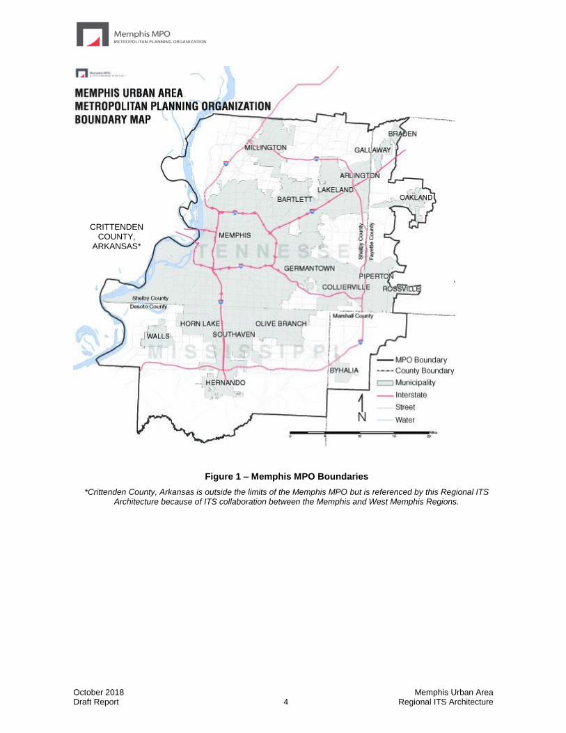
The Memphis MPO Region is comprised of Shelby County in Tennessee, DeSoto County in Mississippi, the western portion of Fayette County in Tennessee, and a northwest portion of Marshall County in Mississippi. These boundaries correspond with the boundaries of the Memphis MPO, which are shown in Figure 1. Also considered within the Memphis MPO Region are TDOT’s SmartWay ITS deployments along I-40 and I-55 in Crittenden County, Arkansas. Although this system is outside the Memphis MPO boundaries, it is operated by the TDOT SmartWay Transportation Management Center (TMC) in Memphis.
When developing the stakeholder group, the project team coordinated with the Memphis MPO to invite the appropriate city, county, regional, state and federal agencies. Stakeholders included both local representatives as well as representatives from TDOT headquarters in Nashville, ARDOT in Little Rock, Mississippi Department of Transportation (MDOT) in Jackson, and FHWA from the Tennessee Division Office in Nashville and Arkansas Division Office in Little Rock.
October 2018 Memphis Urban Area Draft Report 4 Regional ITS Architecture
Figure 1 – Memphis MPO Boundaries
*Crittenden County, Arkansas is outside the limits of the Memphis MPO but is referenced by this Regional ITS Architecture because of ITS collaboration between the Memphis and West Memphis Regions.
CRITTENDEN COUNTY,
ARKANSAS*
October 2018 Memphis Urban Area Draft Report 5 Regional ITS Architecture
1.2.2 Transportation Infrastructure
The transportation infrastructure in the Memphis MPO Region is diverse and robust, consisting of all forms of transportation. The primary access controlled facilities include I-40, I-55, I-240, Tennessee State Route (SR) 385, Mississippi SR 304 (also cosigned as I-69), and Sam Cooper Boulevard. I-40 runs from North Carolina to California, and I-55 runs from New Orleans to Chicago. An outer loop, I-269, is being completed in DeSoto and Marshall Counties. The other federal highways that serve the Memphis Urban Area include US 51, US 61, US 64, US 70, US 72, US 78, and US 79.
The Memphis Urban Area is also one of the few regions to be served by five Class 1 railroads. Burlington Northern Santa Fe, Union Pacific, Norfolk Southern Railroad and CNIC all have major intermodal facilities in the Memphis Urban Area. Only the CSX does not have an intermodal facility in Memphis. The security of the existing railroad bridges across the Mississippi River is a major issue since any disruption of the rail service through Memphis would have impacts over most of the continental United States.
Located on the banks of the Mississippi River, Memphis also has a robust water port. The port facility serves numerous businesses and industries and is home to the Memphis District U.S. Corps of Engineers. The Memphis port handles the fifth largest amount of cargo of all of the inland water ports in the United States.
One of the key elements for transportation and the economics of the Memphis Urban Area is the Memphis International Airport. The world hub for FedEx Express flights, the Memphis International Airport is the second busiest airport by cargo traffic in the world. Before 2010 the Memphis International Airport was the busiest airport by cargo in the world for nearly 20 years.
With all of these freight elements being part of the Memphis infrastructure, it follows that truck traffic is a significant element of the road system. Past studies have revealed that truck volumes on I-40 and I-55 are near 40 percent, with some sections of road experiencing truck volumes well in excess of 50 percent. Many of the truck origins and destinations are in the southern part of Memphis or northern DeSoto County in Mississippi. This puts most of the pressure for moving freight on the southern portion of I-240 and on I-55.
Fixed route and paratransit services are provided in Shelby County by the Memphis Area Transit Authority (MATA). Demand response service in the Memphis MPO Region is provided by several different agencies depending on the county. Within Tennessee, the Delta Human Resource Agency (HRA) provides service in Fayette County and non-urbanized areas of Shelby County. In Mississippi, the Delta Area Rural Transit System (DARTS) provides service in Desoto County. Commuter rail or light rail services are not provided at this time. However, MATA has three fixed guideway trolley lines that total 10 route miles.
Within the Memphis Urban Area there have been several ITS initiatives and deployments throughout the Region. These programs have come from multiple agencies and cover multiple transportation modes as well. Some of the larger ITS initiatives and deployments that are existing or underway in the Memphis Urban Area are listed below.
• TDOT SmartWay Program – This freeway management program is continuing expand coverage in the Memphis Urban Area and includes CCTV cameras, DMS including full colors DMS to support dynamic lane contorl, vehicle detectors, and HAR in Tennessee and Arkansas. The communications for the system are handled through a fiber optic backbone with a wireless connection to the elements in Arkansas. The system is managed from the TDOT Region 4 SmartWay TMC located near the I-40/I-240/Sam Cooper Boulevard interchange in east Memphis, and there is a microwave

October 2018 Memphis Urban Area Draft Report 6 Regional ITS Architecture
communications link to a workstation in the Region 4 office in Jackson, Tennessee. TDOT is designing the expansion of the system to include I-269.
• TDOT HELP – The TDOT HELP program has been in operation in the Memphis Urban Area since July 1999. The HELP program trucks patrol I-40, I-55, I-240, Sam Cooper Boulevard, and portions of SR-385, assisting motorists with flat tire changes, fuel, and minor vehicle repairs. The HELP program also provides assistance to the local police and State Highway Patrol with the management of incidents by providing traffic control and advance warning to motorists.
• 511 Traveler Information Number – TDOT currently operates a statewide traveler information number that provides real-time traveler information throughout the state. Information is put into 511 through the TDOT Statewide Information for Travelers (SWIFT) system (formally known as TDOT SmartWay Information System [TSIS]) which is updated by the TDOT SmartWay TMC operators and the Tennessee Highway Patrol (THP) dispatchers. 511 information can also be accessed through the TDOT SmartWay website (http://www.tdot.state.tn.us/tdotsmartway/) which includes a subscription for Rich Site Summary (RSS) feeds, TDOT SmartWay App, and several social media sites such as Twitter and Facebook.
• City of Memphis Traffic Operations Center – The City of Memphis has an existing signal system that supports real time monitoring and control of traffic signals, and from the TOC and the Signal Maintenance facility, the City has the capability to implement traffic signal timing plans, monitor traffic conditions and the operations of the signals, and to monitor the status of equipment. The City of Memphis also provides signal maintenance to all traffic signals within Shelby County. Memphis has installed 30 CCTV cameras and plans for more as funding becomes available.
• Shelby County Congestion Management Program (CMP) - The CMP is a county-wide effort that includes the City of Bartlett, City of Germantown, City Lakeland, City of Memphis, City of Millington, Town of Arlington, Town of Collierville, and unincorporated areas of Shelby County. This initiative has included the installation of new traffic signals in addition to upgrading, replacing, retiming, and connecting various traffic signals and signal components throughout the county. ITS elements that have been installed include video detection, fiber optic cable, and emergency vehicle preemption.
• City of Bartlett Signal System – The City of Bartlett presently has a signal system that provides the ability to monitor traffic operations and change signal timing plans for a few signals within the City. Future plans include providing real time monitoring capabilities, CCTV cameras, and expanding the system which will allow it to be connected with the City of Memphis system as part of the CMP.
• City of Germantown Signal System – The City of Germantown TOC is connected to most of the intersections across the city. The TOC will allow the traffic operations to be monitored and signal timing plans to be added or changed. Memphis and Germantown currently have memorandum of understanding in place, which was signed in 2012, to coordinate the operation and maintenance of traffic signals and ITS systems. Additionally, both TMCs agreed to provide mutual assistance and serve as backup coverage for traffic signal and ITS operations.
• MATA ITS – MATA has developed an extensive ITS program that includes automated vehicle location (AVL) on fixed-route buses and trolleys and paratransit vehicles, automated passenger counting that can distinguish a person from an inanimate object, onboard security cameras, transit signal priority for certain routes, and automated

October 2018 Memphis Urban Area Draft Report 7 Regional ITS Architecture
transit fleet maintenance monitoring. Additionally, MATA provides riders with next bus arrival DMS at all trolley stations and real-time bus location information on the MATA website and on the TransLoc app.
• MDOT Congestion Mitigation and Air Quality (CMAQ) Initiative and Other Deployments – MDOT is in the process of determining how best to allocate Federal CMAQ funds throughout DeSoto County including the City of Hernando, City of Horn Lake, City of Olive Branch, and City of Southaven. Potential projects include ITS deployments along major corridors such as Goodman Road (SR302) and various signal improvements including signal timing. These ITS deployments would complement MDOT’s existing ITS infrastructure that includes CCTV cameras, DMS, and field sensors. Additionally, the MDOT traffic website and MDOT traffic app provide drivers with live streaming video, traffic alerts, and construction information.
• City of Millington, Town of Collierville - These suburban Memphis cities have TOC’s that are connected to the majority of the traffic signals in their community. The TOC’s allow traffic operations to be monitored, and signal timing plans to be added or changed. A comprehensive Memorandum of Understanding is being reviewed by Memphis, Germantown, Collierville, Bartlett, Shelby County, and Millington that will replace the current agreement between Memphis and Germantown, and will provide coordination of the operation and maintenance of traffic signals and ITS elements.
1.2.3 Project Participants
Due to the fact that ITS often transcends traditional transportation infrastructure, it is important to involve a wide range of local, state, and federal stakeholders in the ITS architecture development and visioning process. Input from these stakeholders is a critical part of defining the interfaces, integration needs, and overall vision for ITS in a region. In the Memphis MPO Region, stakeholders that participated included not just representatives from transportation and public transit agencies, but also stakeholders that represented public safety, health, and aviation.
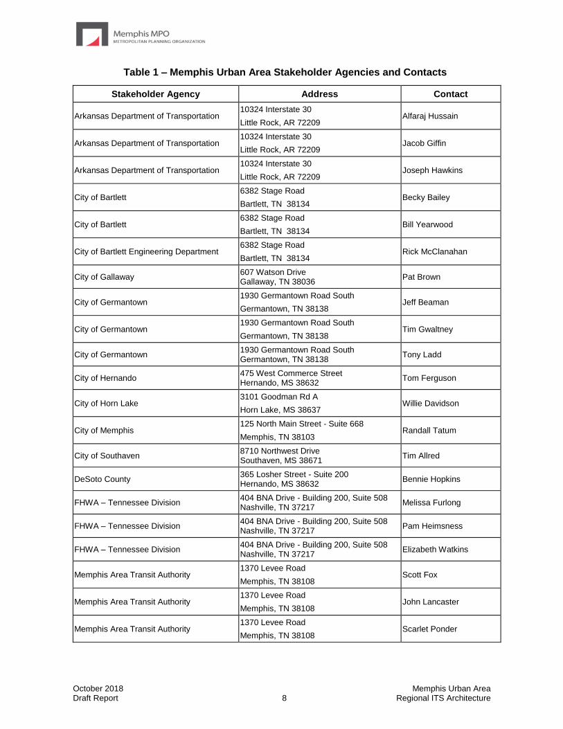
Table 1 contains a listing of stakeholders in the Memphis Urban Area who participated in the project workshop or provided input to the study team as to the needs and issues that should be considered as part of the Regional ITS Architecture. Other stakeholders that were invited to participate but were not able to attend were provided notified when reports were available for review on the project website to encourage their participation as much as possible. A complete listing of stakeholders invited to participate in the project is included in the stakeholder database in Appendix C.
October 2018 Memphis Urban Area Draft Report 8 Regional ITS Architecture
Table 1 – Memphis Urban Area Stakeholder Agencies and Contacts
Stakeholder Agency Address Contact
Arkansas Department of Transportation 10324 Interstate 30
Little Rock, AR 72209 Alfaraj Hussain
Arkansas Department of Transportation 10324 Interstate 30
Little Rock, AR 72209 Jacob Giffin
Arkansas Department of Transportation 10324 Interstate 30
Little Rock, AR 72209 Joseph Hawkins
City of Bartlett 6382 Stage Road
Bartlett, TN 38134 Becky Bailey
City of Bartlett 6382 Stage Road
Bartlett, TN 38134 Bill Yearwood
City of Bartlett Engineering Department 6382 Stage Road
Bartlett, TN 38134 Rick McClanahan
City of Gallaway 607 Watson Drive Gallaway, TN 38036
Pat Brown
City of Germantown 1930 Germantown Road South
Germantown, TN 38138 Jeff Beaman
City of Germantown 1930 Germantown Road South
Germantown, TN 38138 Tim Gwaltney
City of Germantown 1930 Germantown Road South Germantown, TN 38138
Tony Ladd
City of Hernando 475 West Commerce Street Hernando, MS 38632
Tom Ferguson
City of Horn Lake 3101 Goodman Rd A
Horn Lake, MS 38637 Willie Davidson
City of Memphis 125 North Main Street - Suite 668
Memphis, TN 38103 Randall Tatum
City of Southaven 8710 Northwest Drive Southaven, MS 38671
Tim Allred
DeSoto County 365 Losher Street - Suite 200 Hernando, MS 38632
Bennie Hopkins
FHWA – Tennessee Division 404 BNA Drive - Building 200, Suite 508 Nashville, TN 37217
Melissa Furlong
FHWA – Tennessee Division 404 BNA Drive - Building 200, Suite 508 Nashville, TN 37217
Pam Heimsness
FHWA – Tennessee Division 404 BNA Drive - Building 200, Suite 508 Nashville, TN 37217
Elizabeth Watkins
Memphis Area Transit Authority 1370 Levee Road
Memphis, TN 38108 Scott Fox
Memphis Area Transit Authority 1370 Levee Road
Memphis, TN 38108 John Lancaster
Memphis Area Transit Authority 1370 Levee Road
Memphis, TN 38108 Scarlet Ponder
October 2018 Memphis Urban Area Draft Report 9 Regional ITS Architecture
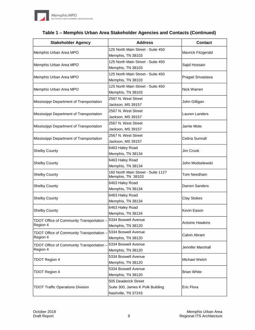
Table 1 – Memphis Urban Area Stakeholder Agencies and Contacts (Continued)
Stakeholder Agency Address Contact
Memphis Urban Area MPO 125 North Main Street - Suite 450
Memphis, TN 38103 Mavrick Fitzgerald
Memphis Urban Area MPO 125 North Main Street - Suite 450
Memphis, TN 38103 Sajid Hossain
Memphis Urban Area MPO 125 North Main Street - Suite 450
Memphis, TN 38103 Pragati Srivastava
Memphis Urban Area MPO 125 North Main Street - Suite 450
Memphis, TN 38103 Nick Warren
Mississippi Department of Transportation 2567 N. West Street
Jackson, MS 39157 John Gilligan
Mississippi Department of Transportation 2567 N. West Street
Jackson, MS 39157 Lauren Landers
Mississippi Department of Transportation 2567 N. West Street
Jackson, MS 39157 Jamie Mote
Mississippi Department of Transportation 2567 N. West Street
Jackson, MS 39157 Celina Sumrall
Shelby County 6463 Haley Road
Memphis, TN 38134 Jim Crook
Shelby County 6463 Haley Road
Memphis, TN 38134 John Modselewski
Shelby County 160 North Main Street - Suite 1127 Memphis, TN 38103
Tom Needham
Shelby County 6463 Haley Road
Memphis, TN 38134 Darren Sanders
Shelby County 6463 Haley Road
Memphis, TN 38134 Clay Stokes
Shelby County 6463 Haley Road
Memphis, TN 38134 Kevin Eason
TDOT Office of Community Transportation – Region 4
5334 Boswell Avenue
Memphis, TN 38120 Antoine Hawkins
TDOT Office of Community Transportation – Region 4
5334 Boswell Avenue
Memphis, TN 38120 Calvin Abram
TDOT Office of Community Transportation – Region 4
5334 Boswell Avenue
Memphis, TN 38120 Jennifer Marshall
TDOT Region 4 5334 Boswell Avenue
Memphis, TN 38120 Michael Welch
TDOT Region 4 5334 Boswell Avenue
Memphis, TN 38120 Brian White
TDOT Traffic Operations Division
505 Deaderick Street
Suite 300, James K Polk Building
Nashville, TN 37243
Eric Flora

October 2018 Memphis Urban Area Draft Report 10 Regional ITS Architecture
Table 1 – Memphis Urban Area Stakeholder Agencies and Contacts (Continued)
Stakeholder Agency Address Contact
TDOT Traffic Operations Division
505 Deaderick Street
Suite 300, James K Polk Building
Nashville, TN 37243
Khuzaima Mahdi
TDOT Traffic Operations Division
505 Deaderick Street
Suite 300, James K Polk Building
Nashville, TN 37243
Asem Halim
Town of Arlington 11475 Memphis Arlington Road
Arlington, TN 38002 Steve Hill
Town of Collierville 500 Poplar View Parkway
Collierville, TN 38017 Frank McPhail
West Memphis MPO 796 W. Broadway
West Memphis, AR 72301 Bobby Williams
West Memphis MPO 796 W. Broadway
West Memphis, AR 72301 Eddie Brawley
West Tennessee RPO 8289 Cordova Road – Suite 103
Cordova, TN 38016 Jasmine Champion

October 2018 Memphis Urban Area Draft Report 11 Regional ITS Architecture
1.3 Document Overview
The Memphis Urban Area Regional ITS Architecture report is organized into seven key sections:
Section 1 – Introduction
This section provides an overview of the Memphis Urban Area Regional ITS Architecture, including a description of the Region and list of participating stakeholders.
Section 2 – Regional ITS Architecture Development Process
This section provides an overview of the key steps involved in developing the ITS architecture for the Memphis MPO Region as well as an overview of the Turbo Architecture database and reports.
Section 3 – Regional Needs
This section contains a summary of regional needs for the Memphis MPO Region that are related to ITS.
Section 4 – Regional ITS Inventory
This section provides a description of the stakeholders and ITS elements in the Region. Elements are grouped based on the owner, such as the City of Memphis or MATA, and their current status is listed as either existing or planned.
Section 5 – Regional ITS Architecture
This section describes how the National ITS Architecture was customized to meet the ITS needs, plans, and visions for the Memphis MPO Region. The ITS service packages that are included in this section and interconnects are presented, including the “sausage diagram” showing the relationships of the key subsystems and elements in the Region. Functional requirements and standards that apply to the Region, as indicated by the Regional ITS Architecture, are also presented. Operational concepts identifying stakeholder roles and responsibilities have been prepared and potential agreements to support the sharing of data and resources have been identified.
Section 6 – Regional ITS Deployment Plan
This section describes the ITS projects that regional stakeholders expressed a need to deploy in order to deliver the ITS services identified in the regional ITS architecture. Focus is primarily on regional projects that involve multiple stakeholders.
Section 7 – Use and Maintenance of the Regional ITS Architecture
This section describes how the Regional ITS Architecture can be used to show architectural conformance of ITS projects in the planning or design phase. A process for maintaining the Regional ITS Architecture and submitting requested changes to the Regional ITS Architecture is also presented.

October 2018 Memphis Urban Area Draft Report 12 Regional ITS Architecture
The Memphis Urban Area Regional ITS Architecture also contains five appendices:
• Appendix A – Service Package Definitions
• Appendix B – Element Functions
• Appendix C – Stakeholder Invitation Database
• Appendix D – Agreements
• Appendix E – Architecture Maintenance Documentation Form
A corresponding website was also developed for the Memphis Urban Area Regional ITS Architecture which contains electronic versions of all documents, meeting minutes, and an interactive version of the architecture database known as RAD-IT (Regional Architecture Development for Intelligent Transportation). The website is located at the following address: www.memphismpo.org/plans/safety-mobility/its.
October 2018 Memphis Urban Area Draft Report 13 Regional ITS Architecture
2.0 Regional ITS Architecture
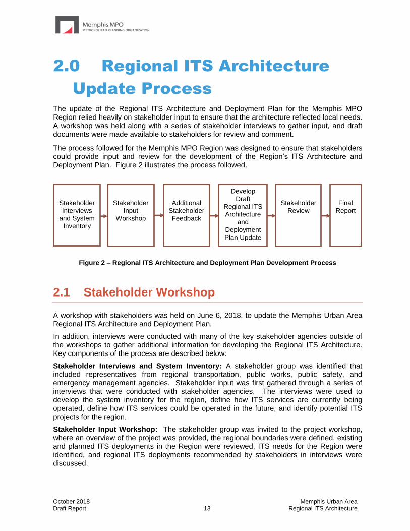
Update Process The update of the Regional ITS Architecture and Deployment Plan for the Memphis MPO Region relied heavily on stakeholder input to ensure that the architecture reflected local needs. A workshop was held along with a series of stakeholder interviews to gather input, and draft documents were made available to stakeholders for review and comment.
The process followed for the Memphis MPO Region was designed to ensure that stakeholders could provide input and review for the development of the Region’s ITS Architecture and Deployment Plan. Figure 2 illustrates the process followed.
Figure 2 – Regional ITS Architecture and Deployment Plan Development Process
2.1 Stakeholder Workshop
A workshop with stakeholders was held on June 6, 2018, to update the Memphis Urban Area Regional ITS Architecture and Deployment Plan.
In addition, interviews were conducted with many of the key stakeholder agencies outside of the workshops to gather additional information for developing the Regional ITS Architecture. Key components of the process are described below:
Stakeholder Interviews and System Inventory: A stakeholder group was identified that included representatives from regional transportation, public works, public safety, and emergency management agencies. Stakeholder input was first gathered through a series of interviews that were conducted with stakeholder agencies. The interviews were used to develop the system inventory for the region, define how ITS services are currently being operated, define how ITS services could be operated in the future, and identify potential ITS projects for the region.
Stakeholder Input Workshop: The stakeholder group was invited to the project workshop, where an overview of the project was provided, the regional boundaries were defined, existing and planned ITS deployments in the Region were reviewed, ITS needs for the Region were identified, and regional ITS deployments recommended by stakeholders in interviews were discussed.
Final Report
Develop Draft
Regional ITS Architecture
and Deployment Plan Update
Stakeholder Review
Stakeholder Input
Workshop
Stakeholder Interviews
and System Inventory
Additional Stakeholder Feedback

October 2018 Memphis Urban Area Draft Report 14 Regional ITS Architecture
Additional Stakeholder Feedback: Additional follow-up calls and emails with stakeholders occurred following the workshop to clarify workshop feedback, and obtain updated regional agreements.
Develop Draft Regional ITS Architecture and Deployment Plan Update: Following the stakeholder input through interviews and the workshop, a draft report was developed which identifies the roles and responsibilities of participating agencies and stakeholders in the operation and implementation of the ITS system, identifies projects for deployment, and establishes a maintenance plan. Additionally, a website was created to allow stakeholders access to an interactive version of the ITS architecture and documents such as reports, meeting minutes, presentations, and the RAD-IT architecture database.
Stakeholder Review: The Draft Regional ITS Architecture document was distributed to the stakeholder group for review. Stakeholders provided comments via email, and the project team revised the document accordingly, in coordination with the Memphis MPO.
Final Report: The final Regional ITS Architecture and Deployment Plan was developed, which included an executive summary, project report, RAD-IT architecture database, and project website with an interactive version of the Regional ITS Architecture.
2.2 Regional ITS Architecture Software
The Regional Architecture Development for Intelligent Transportation (RAD-IT) Version 8.1 was used to develop the Memphis Urban Area Regional ITS Architecture. RAD-IT, which had formerly been referred to as Turbo Architecture, is a software application that was developed by the United States Department of Transportation (USDOT) to be used as a tool for documenting and maintaining ITS architectures. Version 8.1 of RAD-IT was released in April 2018 and was developed to support Version 8.1 of the Architecture Reference for Cooperative and Intelligent Transportation (ARC-IT), the National ITS Architecture framework. RAD-IT can be used to develop service package diagrams for the Regional ITS Architecture. Use of RAD-IT software in development of the regional ITS architectures is recommended by both FHWA and FTA. The related Systems Engineering Tool for Intelligent Transportation (SET-IT) Version 8.1 is recommended by FHWA for systems engineering analysis at the project level.
In the Memphis MPO Region, the RAD-IT architecture database for the Regional ITS Architecture was based on the ITS service packages, which are provided in the online interactive RAD-IT database at www.memphismpo.org/plans/safety-mobility/its. The ITS service packages provide a graphical representation of the services that stakeholders in the Region would like ITS to provide. In each service package, the elements, such as a TMC or a CCTV camera, and the data that is shared between them are shown. RAD-IT allows the Region to document all of the elements and data flows that exist or are planned in the Region. SET-IT allows the user to quickly access any standards that are associated with the data flows as well as generate reports and diagrams to assist in reviewing the data. Some examples of the useful reports and diagrams that may be generated using RAD-IT and SET-IT software are included in Table 2.

October 2018 Memphis Urban Area Draft Report 15 Regional ITS Architecture
RAD-IT saves data in Microsoft Access compatible data files. RAD-IT files can be accessed using Microsoft Access, although use of Access will not provide nearly the same amount of capabilities as accessing the files using the RAD-IT software. With the release of Version 4.1 of Turbo Architecture (the software package that preceded RAD-IT and SET-IT), the USDOT began offering the Turbo Architecture software free of charge and provided a link for downloading the software on the National ITS Architecture website. RAD-IT and SET-IT were also offered free of charge and were available for download from the ARC-IT website. At the time this report was written, that site was located at www.arc-it.net. Version 8.1 was the most recent version available.

October 2018 Memphis Urban Area Draft Report 16 Regional ITS Architecture
Table 2 – RAD-IT and SET-IT Report and Diagrams
Report or Diagram Name Functions
RAD-IT Software
Stakeholder Summary Provides a description of the stakeholder and the associated elements for each stakeholder in the Regional ITS Architecture.
Inventory Summary Provides a description and status for each element in the Regional ITS Architecture.
Service Packages Summary Identifies each of the service packages selected for the Region and the elements associated with each service package.
Interconnect Report Identifies for each element all of the other elements that are connected and the status of each connection.
Standards Activities Report Identifies relevant standards associated with each of the data flows used in the Regional ITS Architecture.
Subsystem Diagram Identifies the subsystems from the National ITS Architecture that are included in the Regional ITS Architecture.
Interconnect Diagrams
Identifies for each element all of the other elements that are connected and the status of each connection. The Interconnect Diagrams can be customized to show all elements in the Regional ITS Architecture or a single element can be selected so that only the connections it has with other elements are shown. Interconnect Diagrams can also be viewed by individual service packages to view all of the elements and connections in each service package.
Context Diagrams
Context Diagrams show all of the data flows coming to and from a center (such as a Traffic Management Center), physical object, functional object, or a terminator (such as a vehicle). (Context diagrams can also be exported from SET-IT.)
Flow Diagrams Flow Diagrams are similar to Interconnect Diagrams; however, the actual data flows that are part of each connection between elements are also shown.
Service Package Diagrams Service Package Diagrams show the elements and flows associated with a service package that has been developed for a selected stakeholder.
Website RAD-IT generates a customized regional architecture website with a hyperlinked database of stakeholders, ITS elements, data standards, and other elements of the architecture for reference.
SET-IT Software
Enterprise Diagrams Enterprise Diagrams show functional relationships between users of the transportation system.
Summary Physical Diagrams Summary Physical Diagrams show data connections between centers (such as a Traffic Management Center), terminators (such as a TMC operator), and physical objects (such as a vehicle).
Context Diagrams
Context Diagrams show all of the data flows coming to and from a center (such as a Traffic Management Center), physical object, functional object, or a terminator (such as a vehicle). (Context diagrams can also be exported from RAD-IT.)
Communications Diagrams Communications Diagrams are a graphical representation of data standards that apply to a given data flow.
Concept of Operations SET-IT creates a Concept of Operations document by populating a standardized outline with SET-IT data. The document template is customizable.

October 2018 Memphis Urban Area Draft Report 17 Regional ITS Architecture
3.0 Regional ITS Needs Regional needs that could be addressed by ITS were identified by stakeholders in interviews conducted in March 2018 and the Memphis Urban Area Regional ITS Architecture workshop held in June 2018. In addition, the Memphis Urban Area Regional Transportation Plan (RTP): Livability 2040 was reviewed to determine other regional needs that could possibly be addressed in some way through ITS. The Memphis MPO is currently updating their RTP, and the new plan will be referred to as the Livability 2050 Regional Transportation Plan.
Within Livability 2050 there are nine goals that were defined for the plan, each with a corresponding set of objectives. These goals and objectives were approved by the Memphis MPO Policy Board in February 2018. Two of the goals had objectives that could be met in part through the use of ITS. These goals and their objectives are summarized below.
Livability 2050 RTP Goal – Increase the safety and security of the transportation system for all users.
Goal objectives include:
• Support projects that address an existing, identified safety or security need
• Support project, programs and policies that advance safe and secure travel over the plan horizon
• Continue coordination with TDOT and MDOT to meet federal safety performance targets
ITS systems offer a number of ways to improve the overall safety of the transportation system. ITS can improve the ability of an agency to detect an incident, improve coordination with public safety agencies for response, and be used to provide advanced warning of incidents to motorists. Through the HELP service patrol program TDOT is able to assist disabled motorists and move them out of travel lanes or off of shoulders quicker, which increases the safety of both the disabled motorists and reduces a potential roadside hazard for other drivers. During evacuations ITS can be used to monitor evacuation routes and provide information to travelers on which routes to use. Use of ITS to detect severe weather and provide advanced warning of railroad crossings are other examples of how ITS can increase safety. ITS can also be used in transit to provide alarms on buses and surveillance capabilities both on buses and at transit stops.4
Livability 2050 RTP Goal – Reduce travel delay for people and goods.
Goal objectives include:
• Address critical highway bottlenecks as a priority
• Focus capacity investment on corridor connections to regional employment centers
• Improve system operations through technology applications
Incidents are one of the primary causes of congestion. Through ITS, transportation agencies are better able to manage incidents which can result in quicker clearance time and less people caught in congestion due to advanced notification. Improved traffic signal coordination, both within cities and at jurisdictional boundaries, can also reduce congestion and lead to improvements in air quality. ITS can also be used to provide advanced traveler information to
October 2018 Memphis Urban Area Draft Report 18 Regional ITS Architecture
help travelers make decisions on the best modes and travel routes to use to avoid congested areas if possible.
The needs identified through the Regional ITS Architecture development process as well as the Livability 2050 RTP provided guidance for determining which ITS service packages should be included in the Regional ITS Architecture. Stakeholders identified a number of ITS needs for the Memphis Urban Area, with the majority of the needs focused on the following four areas:
• Traffic Management;
• Traveler Information;
• Data Management; and
• Public Safety.
In Section 5.1.4 a list of regional needs is presented along with the ITS service packages that have been recommended for the Region to consider implementing or expanding (if the service package currently exists.) A summary of these needs is presented in Table 3.
October 2018 Memphis Urban Area Draft Report 19 Regional ITS Architecture
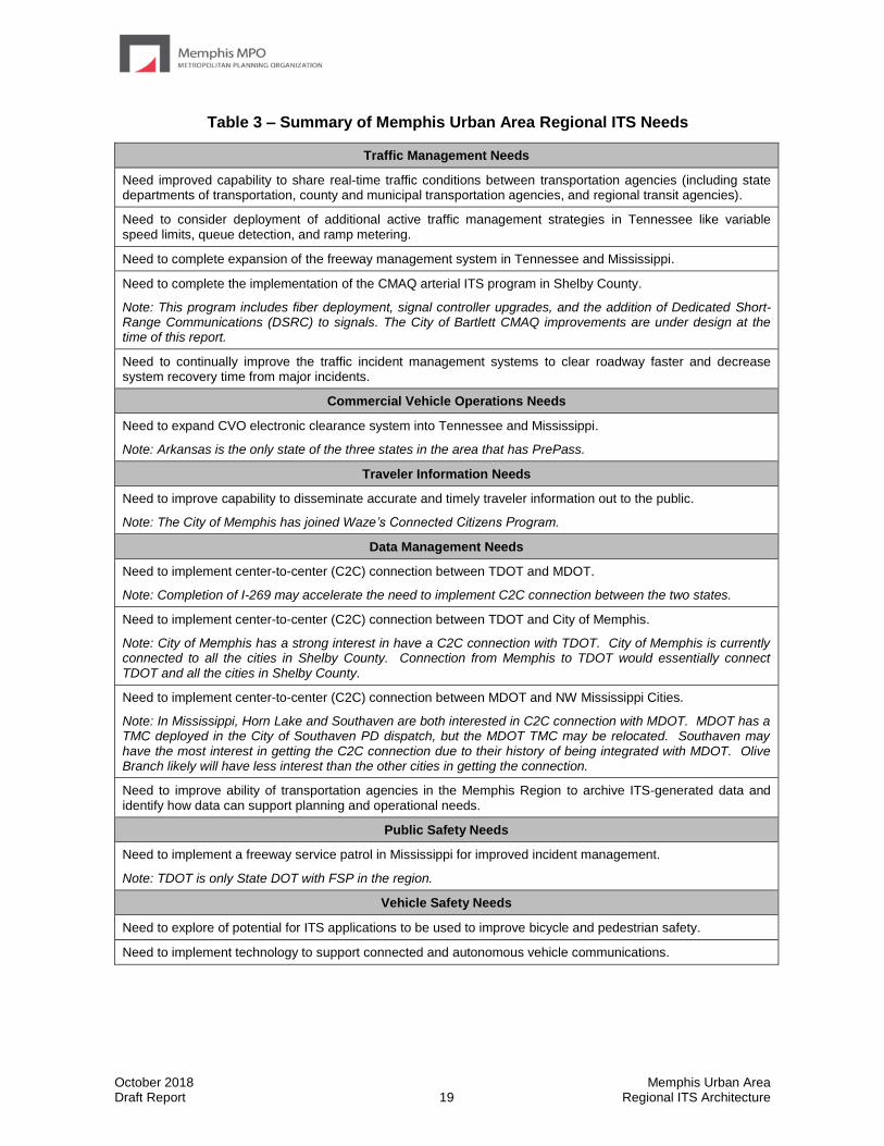
Table 3 – Summary of Memphis Urban Area Regional ITS Needs
Traffic Management Needs
Need improved capability to share real-time traffic conditions between transportation agencies (including state departments of transportation, county and municipal transportation agencies, and regional transit agencies).
Need to consider deployment of additional active traffic management strategies in Tennessee like variable speed limits, queue detection, and ramp metering.
Need to complete expansion of the freeway management system in Tennessee and Mississippi.
Need to complete the implementation of the CMAQ arterial ITS program in Shelby County.
Note: This program includes fiber deployment, signal controller upgrades, and the addition of Dedicated Short-Range Communications (DSRC) to signals. The City of Bartlett CMAQ improvements are under design at the time of this report.
Need to continually improve the traffic incident management systems to clear roadway faster and decrease system recovery time from major incidents.
Commercial Vehicle Operations Needs
Need to expand CVO electronic clearance system into Tennessee and Mississippi.
Note: Arkansas is the only state of the three states in the area that has PrePass.
Traveler Information Needs
Need to improve capability to disseminate accurate and timely traveler information out to the public.
Note: The City of Memphis has joined Waze’s Connected Citizens Program.
Data Management Needs
Need to implement center-to-center (C2C) connection between TDOT and MDOT.
Note: Completion of I-269 may accelerate the need to implement C2C connection between the two states.
Need to implement center-to-center (C2C) connection between TDOT and City of Memphis.
Note: City of Memphis has a strong interest in have a C2C connection with TDOT. City of Memphis is currently connected to all the cities in Shelby County. Connection from Memphis to TDOT would essentially connect TDOT and all the cities in Shelby County.
Need to implement center-to-center (C2C) connection between MDOT and NW Mississippi Cities.
Note: In Mississippi, Horn Lake and Southaven are both interested in C2C connection with MDOT. MDOT has a TMC deployed in the City of Southaven PD dispatch, but the MDOT TMC may be relocated. Southaven may have the most interest in getting the C2C connection due to their history of being integrated with MDOT. Olive Branch likely will have less interest than the other cities in getting the connection.
Need to improve ability of transportation agencies in the Memphis Region to archive ITS-generated data and identify how data can support planning and operational needs.
Public Safety Needs
Need to implement a freeway service patrol in Mississippi for improved incident management.
Note: TDOT is only State DOT with FSP in the region.
Vehicle Safety Needs
Need to explore of potential for ITS applications to be used to improve bicycle and pedestrian safety.
Need to implement technology to support connected and autonomous vehicle communications.
October 2018 Memphis Urban Area Draft Report 20 Regional ITS Architecture
Stakeholder interviews included discussions regarding the Real-time System Management Information Program, which is required under Part 511 of Title 23 Code of Federal Regulations. This rule requires that metropolitan areas with populations exceeding one million collect and make accessible real-time traffic information that includes roadway blockages, construction activities, roadway weather observations, and travel times along interstate highways and other routes of significance. States in coordination with local and regional agencies must determine which routes to designate as routes of significance. A list of non-interstate roadways in which stakeholders expressed a desire to collect real-time traffic information within the Memphis MPO Area and Crittenden County, Arkansas is presented in Section 6.4. These routes could be considered for designation as routes of significance in the future; however, a more comprehensive regional collaborative effort would be required to make those designations.
October 2018 Memphis Urban Area Draft Report 21 Regional ITS Architecture
4.0 Regional ITS Inventory The inventory and needs documented at the Kick-Off Workshop in addition to the individual interviews are the starting point for developing an ITS architecture for the Region. These ITS systems and components are used to customize the National ITS Architecture and create the Regional ITS Architecture for the Memphis MPO Region.
When developing customized elements for the 2010 and 2014 update, the Memphis stakeholder group agreed to create individual traffic, maintenance, and emergency management elements for the City of Bartlett, City of Germantown, City of Horn Lake, City of Millington, City of Olive Branch, City of Southaven, and Town of Collierville. While the Mississippi Bureau of Investigation was the only stakeholder added to the architecture with the 2018 update, new elements such as Connected Vehicle Roadside Equipment and Road Weather Information Systems have been added to existing stakeholders. The other smaller communities in the Region were documented as part of the municipal elements. This documentation allows the communities to be included in the Regional ITS Architecture, and therefore eligible to use federal funds for future ITS deployments, even if there are no specific plans for ITS implementation at this time.
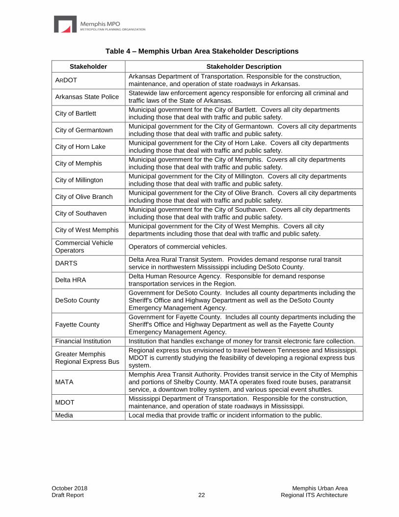
4.1 Stakeholders
Each element included in the Memphis Urban Area Regional ITS Architecture is associated with a stakeholder agency. A listing of stakeholders as identified in the Memphis Urban Area Regional ITS Architecture can be found in Table 4 along with a description of the stakeholder. Rather than individually documenting each of the smaller municipalities in the Region, a single stakeholder, which represents the cities and towns not specifically called out in the architecture, was created for municipal agencies.
October 2018 Memphis Urban Area Draft Report 22 Regional ITS Architecture
Table 4 – Memphis Urban Area Stakeholder Descriptions
Stakeholder Stakeholder Description
ARDOT Arkansas Department of Transportation. Responsible for the construction, maintenance, and operation of state roadways in Arkansas.
Arkansas State Police Statewide law enforcement agency responsible for enforcing all criminal and traffic laws of the State of Arkansas.
City of Bartlett Municipal government for the City of Bartlett. Covers all city departments including those that deal with traffic and public safety.
City of Germantown Municipal government for the City of Germantown. Covers all city departments including those that deal with traffic and public safety.
City of Horn Lake Municipal government for the City of Horn Lake. Covers all city departments including those that deal with traffic and public safety.
City of Memphis Municipal government for the City of Memphis. Covers all city departments including those that deal with traffic and public safety.
City of Millington Municipal government for the City of Millington. Covers all city departments including those that deal with traffic and public safety.
City of Olive Branch Municipal government for the City of Olive Branch. Covers all city departments including those that deal with traffic and public safety.
City of Southaven Municipal government for the City of Southaven. Covers all city departments including those that deal with traffic and public safety.
City of West Memphis Municipal government for the City of West Memphis. Covers all city departments including those that deal with traffic and public safety.
Commercial Vehicle Operators
Operators of commercial vehicles.
DARTS Delta Area Rural Transit System. Provides demand response rural transit service in northwestern Mississippi including DeSoto County.
Delta HRA Delta Human Resource Agency. Responsible for demand response transportation services in the Region.
DeSoto County Government for DeSoto County. Includes all county departments including the Sheriff's Office and Highway Department as well as the DeSoto County Emergency Management Agency.
Fayette County Government for Fayette County. Includes all county departments including the Sheriff's Office and Highway Department as well as the Fayette County Emergency Management Agency.
Financial Institution Institution that handles exchange of money for transit electronic fare collection.
Greater Memphis Regional Express Bus
Regional express bus envisioned to travel between Tennessee and Mississippi. MDOT is currently studying the feasibility of developing a regional express bus system.
MATA Memphis Area Transit Authority. Provides transit service in the City of Memphis and portions of Shelby County. MATA operates fixed route buses, paratransit service, a downtown trolley system, and various special event shuttles.
MDOT Mississippi Department of Transportation. Responsible for the construction, maintenance, and operation of state roadways in Mississippi.
Media Local media that provide traffic or incident information to the public.

October 2018 Memphis Urban Area Draft Report 23 Regional ITS Architecture
Table 4 – Memphis Urban Area Stakeholder Descriptions (Continued)
Stakeholder Stakeholder Description
MEMA Mississippi Emergency Management Agency. Responsible for emergency operations during a disaster or large scale incident.
Memphis and Shelby County Health Department
Health Department for Memphis and Shelby County. Responsible for providing a variety of environmental and personal health services.
Memphis Urban Area MPO Metropolitan Planning Organization for Memphis and Shelby County.
Mississippi Highway Patrol
Agency responsible for the enforcement of traffic safety laws on state and federal highways.
MS Municipal and County Emergency Management Stakeholder Group
Stakeholder group made up of Emergency Management Agencies in Mississippi including the following: City of Horn Lake, City of Olive Branch, City of Southaven, DeSoto County and Municipal/County Government.
MS Municipal and County Traffic Management Stakeholder Group
Stakeholder group made up of Traffic Management Agencies in Mississippi including the following: City of Horn Lake, City of Olive Branch, City of Southaven, and Municipal/County Government.
Municipal/County Government
Government for various municipalities and counties within the Region that are not specifically called out. Covers all departments including those that deal with traffic and public safety.
NOAA National Oceanic and Atmospheric Administration. Responsible for gathering weather information and issuing severe weather warnings.
Other Agencies Stakeholder group made up of a wide variety of agencies. The associated elements are groups of agencies or providers that do not have a primary stakeholder agency.
Private Information Provider
Private sector business responsible for the gathering and distribution of traveler information. This service is typically provided on a subscription basis.
Private Service Provider Private business providing transportation related services.
Rail Operators Companies that operate rail systems including the dispatch and control of trains and the maintenance and operations of railroad tracks.
Shelby County Government for Shelby County. Includes all county departments including the Sheriff's Office and Highway Department as well as the Shelby County Emergency Management Agency.
Shelby County Emergency Management Stakeholder Group
Stakeholder group made up of Emergency Management Agencies in Shelby County including the following: City of Memphis, City of Bartlett, Town of Collierville, City of Germantown, Shelby County, and Municipal/County Government.
Shelby County Traffic Management Stakeholder Group
Stakeholder group made up of Traffic Management Agencies in Shelby County including the following: City of Memphis, City of Bartlett, Town of Collierville, City of Germantown, City of Millington, Shelby County, and Municipal/County Government.
Southwest HRA Southwest Human Resource Agency. Responsible for demand response transportation services in several counties adjacent to the Memphis MPO Region.
System Users All of the users of the transportation system.
TDOT Tennessee Department of Transportation. Responsible for the construction, maintenance, and operation of state roadways in Tennessee.
October 2018 Memphis Urban Area Draft Report 24 Regional ITS Architecture
Table 4 – Memphis Urban Area Stakeholder Descriptions (Continued)
Stakeholder Stakeholder Description
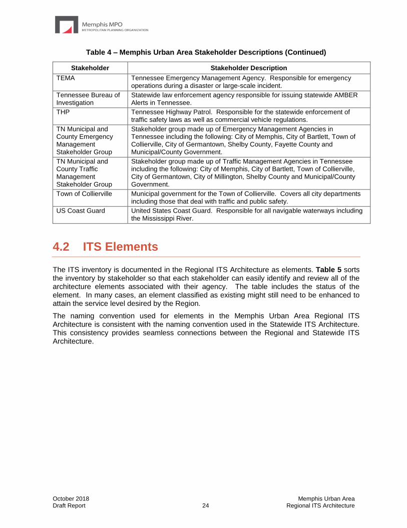
TEMA Tennessee Emergency Management Agency. Responsible for emergency operations during a disaster or large-scale incident.
Tennessee Bureau of Investigation
Statewide law enforcement agency responsible for issuing statewide AMBER Alerts in Tennessee.
THP Tennessee Highway Patrol. Responsible for the statewide enforcement of traffic safety laws as well as commercial vehicle regulations.
TN Municipal and County Emergency Management Stakeholder Group
Stakeholder group made up of Emergency Management Agencies in Tennessee including the following: City of Memphis, City of Bartlett, Town of Collierville, City of Germantown, Shelby County, Fayette County and Municipal/County Government.
TN Municipal and County Traffic Management Stakeholder Group
Stakeholder group made up of Traffic Management Agencies in Tennessee including the following: City of Memphis, City of Bartlett, Town of Collierville, City of Germantown, City of Millington, Shelby County and Municipal/County Government.
Town of Collierville Municipal government for the Town of Collierville. Covers all city departments including those that deal with traffic and public safety.
US Coast Guard United States Coast Guard. Responsible for all navigable waterways including the Mississippi River.
4.2 ITS Elements
The ITS inventory is documented in the Regional ITS Architecture as elements. Table 5 sorts the inventory by stakeholder so that each stakeholder can easily identify and review all of the architecture elements associated with their agency. The table includes the status of the element. In many cases, an element classified as existing might still need to be enhanced to attain the service level desired by the Region.
The naming convention used for elements in the Memphis Urban Area Regional ITS Architecture is consistent with the naming convention used in the Statewide ITS Architecture. This consistency provides seamless connections between the Regional and Statewide ITS Architecture.
October 2018 Memphis Urban Area Draft Report 25 Regional ITS Architecture
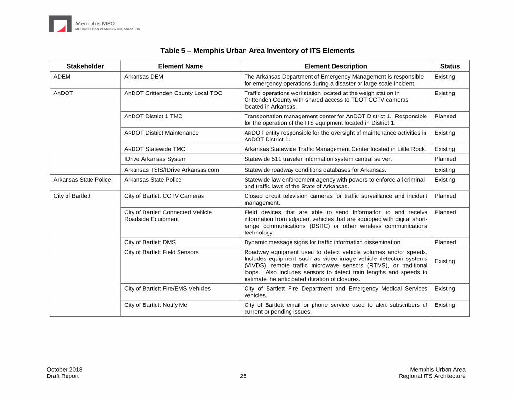
Table 5 – Memphis Urban Area Inventory of ITS Elements
Stakeholder Element Name Element Description Status
ADEM Arkansas DEM The Arkansas Department of Emergency Management is responsible for emergency operations during a disaster or large scale incident.
Existing
ARDOT ARDOT Crittenden County Local TOC Traffic operations workstation located at the weigh station in Crittenden County with shared access to TDOT CCTV cameras located in Arkansas.
Existing
ARDOT District 1 TMC Transportation management center for ARDOT District 1. Responsible for the operation of the ITS equipment located in District 1.
Planned
ARDOT District Maintenance ARDOT entity responsible for the oversight of maintenance activities in ARDOT District 1.
Existing
ARDOT Statewide TMC Arkansas Statewide Traffic Management Center located in Little Rock. Existing
IDrive Arkansas System Statewide 511 traveler information system central server. Planned
Arkansas TSIS/IDrive Arkansas.com Statewide roadway conditions databases for Arkansas. Existing
Arkansas State Police Arkansas State Police Statewide law enforcement agency with powers to enforce all criminal and traffic laws of the State of Arkansas.
Existing
City of Bartlett City of Bartlett CCTV Cameras Closed circuit television cameras for traffic surveillance and incident management.
Planned
City of Bartlett Connected Vehicle Roadside Equipment
Field devices that are able to send information to and receive information from adjacent vehicles that are equipped with digital short-range communications (DSRC) or other wireless communications technology.
Planned
City of Bartlett DMS Dynamic message signs for traffic information dissemination. Planned
City of Bartlett Field Sensors Roadway equipment used to detect vehicle volumes and/or speeds. Includes equipment such as video image vehicle detection systems (VIVDS), remote traffic microwave sensors (RTMS), or traditional loops. Also includes sensors to detect train lengths and speeds to estimate the anticipated duration of closures.
Existing
City of Bartlett Fire/EMS Vehicles City of Bartlett Fire Department and Emergency Medical Services vehicles.
Existing
City of Bartlett Notify Me City of Bartlett email or phone service used to alert subscribers of current or pending issues.
Existing
October 2018 Memphis Urban Area Draft Report 26 Regional ITS Architecture
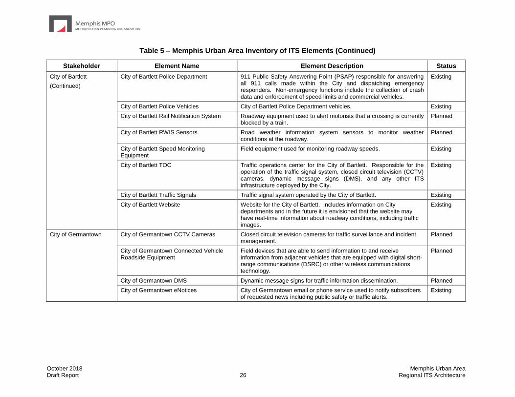
Table 5 – Memphis Urban Area Inventory of ITS Elements (Continued)
Stakeholder Element Name Element Description Status
City of Bartlett
(Continued)
City of Bartlett Police Department 911 Public Safety Answering Point (PSAP) responsible for answering all 911 calls made within the City and dispatching emergency responders. Non-emergency functions include the collection of crash data and enforcement of speed limits and commercial vehicles.
Existing
City of Bartlett Police Vehicles City of Bartlett Police Department vehicles. Existing
City of Bartlett Rail Notification System Roadway equipment used to alert motorists that a crossing is currently blocked by a train.
Planned
City of Bartlett RWIS Sensors Road weather information system sensors to monitor weather conditions at the roadway.
Planned
City of Bartlett Speed Monitoring Equipment
Field equipment used for monitoring roadway speeds. Existing
City of Bartlett TOC Traffic operations center for the City of Bartlett. Responsible for the operation of the traffic signal system, closed circuit television (CCTV) cameras, dynamic message signs (DMS), and any other ITS infrastructure deployed by the City.
Existing
City of Bartlett Traffic Signals Traffic signal system operated by the City of Bartlett. Existing
City of Bartlett Website Website for the City of Bartlett. Includes information on City departments and in the future it is envisioned that the website may have real-time information about roadway conditions, including traffic images.
Existing
City of Germantown City of Germantown CCTV Cameras Closed circuit television cameras for traffic surveillance and incident management.
Planned
City of Germantown Connected Vehicle Roadside Equipment
Field devices that are able to send information to and receive information from adjacent vehicles that are equipped with digital short-range communications (DSRC) or other wireless communications technology.
Planned
City of Germantown DMS Dynamic message signs for traffic information dissemination. Planned
City of Germantown eNotices City of Germantown email or phone service used to notify subscribers of requested news including public safety or traffic alerts.
Existing
October 2018 Memphis Urban Area Draft Report 27 Regional ITS Architecture
Table 5 – Memphis Urban Area Inventory of ITS Elements (Continued)
Stakeholder Element Name Element Description Status
City of Germantown
(Continued)
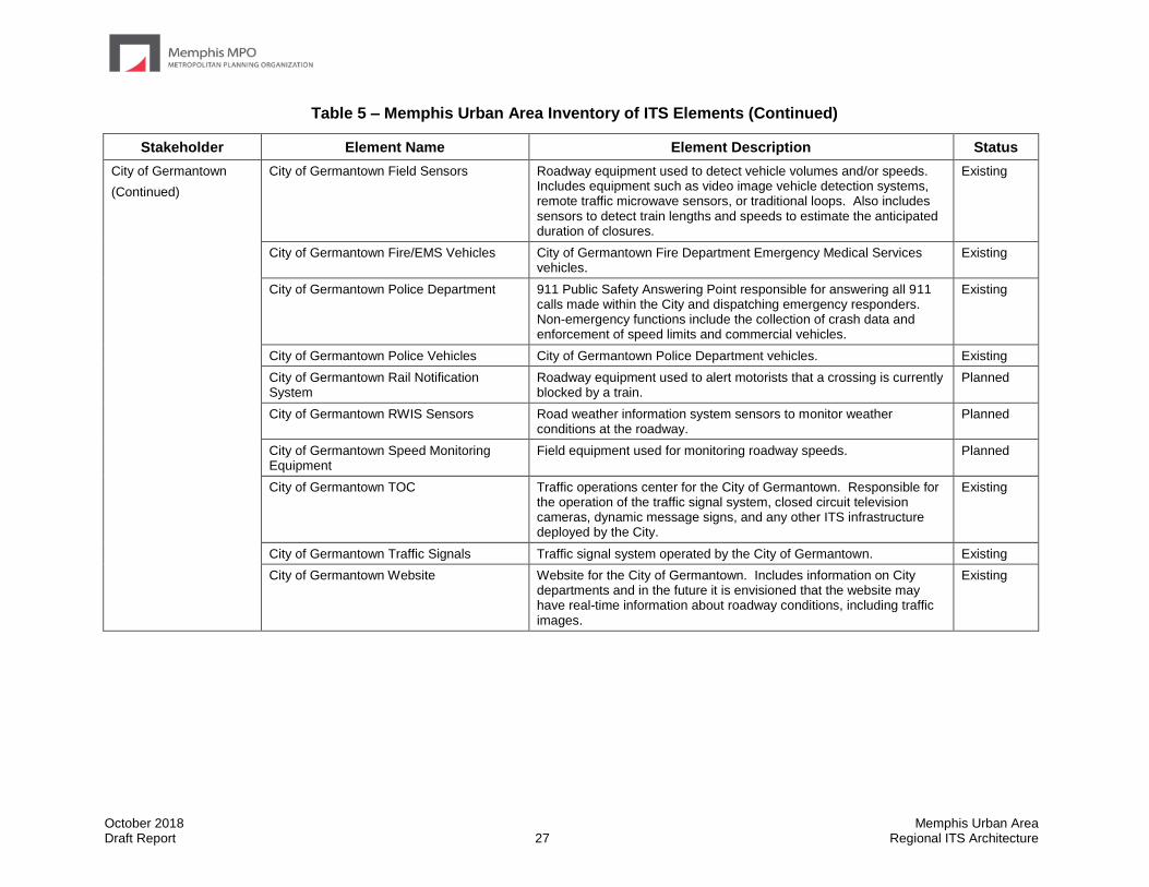
City of Germantown Field Sensors Roadway equipment used to detect vehicle volumes and/or speeds. Includes equipment such as video image vehicle detection systems, remote traffic microwave sensors, or traditional loops. Also includes sensors to detect train lengths and speeds to estimate the anticipated duration of closures.
Existing
City of Germantown Fire/EMS Vehicles City of Germantown Fire Department Emergency Medical Services vehicles.
Existing
City of Germantown Police Department 911 Public Safety Answering Point responsible for answering all 911 calls made within the City and dispatching emergency responders. Non-emergency functions include the collection of crash data and enforcement of speed limits and commercial vehicles.
Existing
City of Germantown Police Vehicles City of Germantown Police Department vehicles. Existing
City of Germantown Rail Notification System
Roadway equipment used to alert motorists that a crossing is currently blocked by a train.
Planned
City of Germantown RWIS Sensors Road weather information system sensors to monitor weather conditions at the roadway.
Planned
City of Germantown Speed Monitoring Equipment
Field equipment used for monitoring roadway speeds. Planned
City of Germantown TOC Traffic operations center for the City of Germantown. Responsible for the operation of the traffic signal system, closed circuit television cameras, dynamic message signs, and any other ITS infrastructure deployed by the City.
Existing
City of Germantown Traffic Signals Traffic signal system operated by the City of Germantown. Existing
City of Germantown Website Website for the City of Germantown. Includes information on City departments and in the future it is envisioned that the website may have real-time information about roadway conditions, including traffic images.
Existing

October 2018 Memphis Urban Area Draft Report 28 Regional ITS Architecture
Table 5 – Memphis Urban Area Inventory of ITS Elements (Continued)
Stakeholder Element Name Element Description Status
City of Horn Lake City of Horn Lake 911 Dispatch Responsible for emergency call-taking and dispatch for the City of Horn Lake.
Existing
City of Horn Lake CCTV Cameras Closed circuit television cameras for traffic surveillance and incident management.
Planned
City of Horn Lake Connected Vehicle Roadside Equipment
Field devices that are able to send information to and receive information from adjacent vehicles that are equipped with digital short-range communications (DSRC) or other wireless communications technology.
Planned
City of Horn Lake Fire/EMS Vehicles City of Horn Lake Fire Department and Emergency Medical Services vehicles.
Existing
City of Horn Lake Field Sensors Roadway equipment used to detect vehicle volumes and/or speeds. Includes equipment such as video image vehicle detection systems, remote traffic microwave sensors, or traditional loops. Also includes sensors to detect train lengths and speeds to estimate the anticipated duration of closures.
Planned
City of Horn Lake Police Vehicles City of Horn Lake Police Department vehicles. Existing
City of Horn Lake Rail Notification System Roadway equipment used to alert motorists that a crossing is currently blocked by a train.
Planned
City of Horn Lake RWIS Sensors Road weather information system sensors to monitor weather conditions at the roadway.
Planned
City of Horn Lake Speed Monitoring Equipment
Field equipment used for monitoring roadway speeds. Planned
City of Horn Lake TOC Traffic operations center for the City of Horn Lake. Responsible for the operation of the traffic signal system.
Planned
City of Horn Lake Traffic Signals Traffic signal system operated by the City of Horn Lake. Existing
City of Horn Lake Website Website for the City of Horn Lake. Includes information on City departments and in the future it is envisioned that the website may have real-time information about roadway conditions, including traffic images.
Existing
October 2018 Memphis Urban Area Draft Report 29 Regional ITS Architecture
Table 5 – Memphis Urban Area Inventory of ITS Elements (Continued)
Stakeholder Element Name Element Description Status
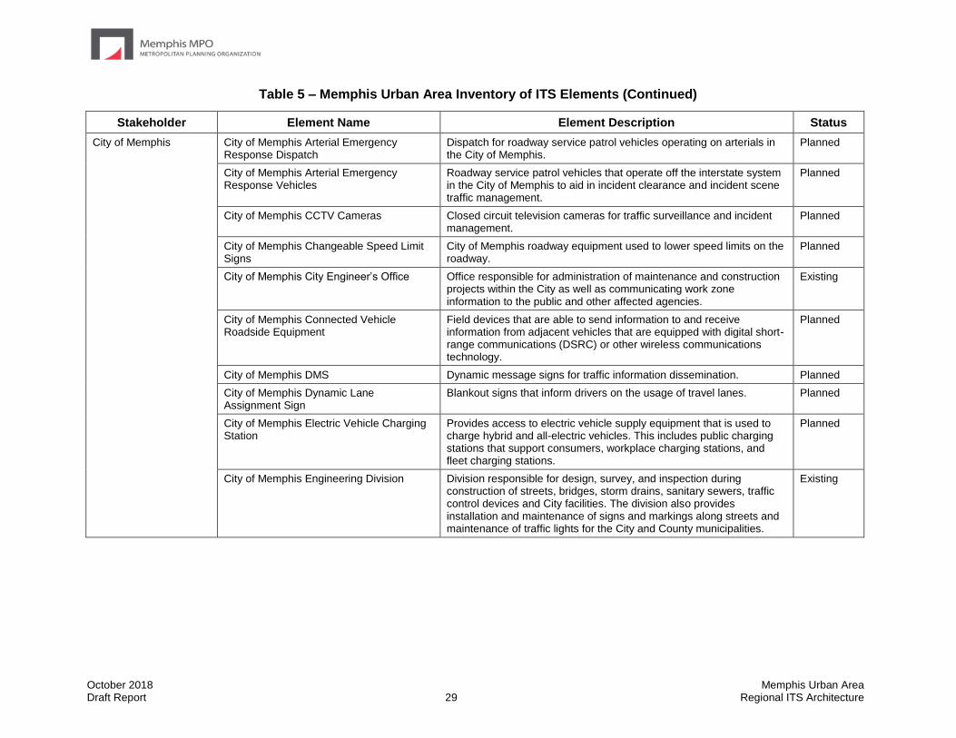
City of Memphis City of Memphis Arterial Emergency Response Dispatch
Dispatch for roadway service patrol vehicles operating on arterials in the City of Memphis.
Planned
City of Memphis Arterial Emergency Response Vehicles
Roadway service patrol vehicles that operate off the interstate system in the City of Memphis to aid in incident clearance and incident scene traffic management.
Planned
City of Memphis CCTV Cameras Closed circuit television cameras for traffic surveillance and incident management.
Planned
City of Memphis Changeable Speed Limit Signs
City of Memphis roadway equipment used to lower speed limits on the roadway.
Planned
City of Memphis City Engineer’s Office Office responsible for administration of maintenance and construction projects within the City as well as communicating work zone information to the public and other affected agencies.
Existing
City of Memphis Connected Vehicle Roadside Equipment
Field devices that are able to send information to and receive information from adjacent vehicles that are equipped with digital short-range communications (DSRC) or other wireless communications technology.
Planned
City of Memphis DMS Dynamic message signs for traffic information dissemination. Planned
City of Memphis Dynamic Lane Assignment Sign
Blankout signs that inform drivers on the usage of travel lanes. Planned
City of Memphis Electric Vehicle Charging Station
Provides access to electric vehicle supply equipment that is used to charge hybrid and all-electric vehicles. This includes public charging stations that support consumers, workplace charging stations, and fleet charging stations.
Planned
City of Memphis Engineering Division Division responsible for design, survey, and inspection during construction of streets, bridges, storm drains, sanitary sewers, traffic control devices and City facilities. The division also provides installation and maintenance of signs and markings along streets and maintenance of traffic lights for the City and County municipalities.
Existing

October 2018 Memphis Urban Area Draft Report 30 Regional ITS Architecture
Table 5 – Memphis Urban Area Inventory of ITS Elements (Continued)
Stakeholder Element Name Element Description Status
City of Memphis
(Continued)
City of Memphis Field Sensors Roadway equipment used to detect vehicle volumes and/or speeds. Includes equipment such as video image vehicle detection systems, remote traffic microwave sensors, or traditional loops. Also includes sensors to detect train lengths and speeds to estimate the anticipated duration of closures.
Existing
City of Memphis Fire/EMS Vehicles City of Memphis Fire Department and Emergency Medical Services vehicles.
Existing
City of Memphis Parking Management System
Parking management system to provide real-time parking availability information to drivers in coordination with private parking facilities and transit and traffic management.
Planned
City of Memphis Pedestrian Hybrid Beacons
A beacon that grants right of way to crossing pedestrians at a marked crosswalk.
Existing
City of Memphis Police Department 911 Public Safety Answering Point responsible for answering all 911 calls made within the City and dispatching emergency responders. Non-emergency functions include the collection of crash data and enforcement of speed limits and commercial vehicles.
Existing
City of Memphis Police Portable DMS Portable dynamic message signs owned and operated by the City of Memphis Police for the distribution of work zone information. In the future the Public Works and Engineering Divisions would like to be able to place messages on the signs as well.
Existing
City of Memphis Police Vehicles City of Memphis Police Department vehicles. Existing
City of Memphis Public Works Division Division responsible for the operation and maintenance of the City's infrastructure which includes streets, sanitary sewers, storm drains, bridges and flood control.
Existing
City of Memphis Rail Notification System Roadway equipment used to alert motorists that a crossing is currently blocked by a train.
Existing

October 2018 Memphis Urban Area Draft Report 31 Regional ITS Architecture
Table 5 – Memphis Urban Area Inventory of ITS Elements (Continued)
Stakeholder Element Name Element Description Status
City of Memphis
(Continued)
City of Memphis RWIS Sensors Road weather information system sensors to monitor weather conditions at the roadway.
Planned
City of Memphis Service Vehicles City of Memphis vehicles used by the Public Works Division and Engineering Division to support maintenance, construction, and operation of the City's transportation infrastructure.
Existing
City of Memphis Speed Monitoring Equipment
Field equipment used for monitoring roadway speeds. Existing
City of Memphis TOC Traffic operations center for the City of Memphis. Responsible for the operation of the traffic signal system, closed circuit television cameras, dynamic message signs, and any other ITS infrastructure deployed by the City.
Existing
City of Memphis Traffic Signals Traffic signal system operated by the City of Memphis. Existing
City of Memphis Variable LED Streetlights Streetlights that control lighting for transportation facilities and infrastructure.
Planned
City of Memphis Website Website for the City of Memphis. Includes information on City departments and in the future it is envisioned that the website may have real-time information about roadway conditions, including traffic images.
Existing
City of Millington City of Millington CCTV Cameras Closed circuit television cameras for traffic surveillance and incident management.
Planned
City of Millington Connected Vehicle Roadside Equipment
Field devices that are able to send information to and receive information from adjacent vehicles that are equipped with digital short-range communications (DSRC) or other wireless communications technology.
Planned
City of Millington DMS Dynamic message signs for traffic information dissemination.
Planned
City of Millington Field Sensors Roadway equipment used to detect vehicle volumes and/or speeds. Includes equipment such as video image vehicle detection systems, remote traffic microwave sensors, or traditional loops. Also includes sensors to detect train lengths and speeds to estimate the anticipated duration of closures.
Existing
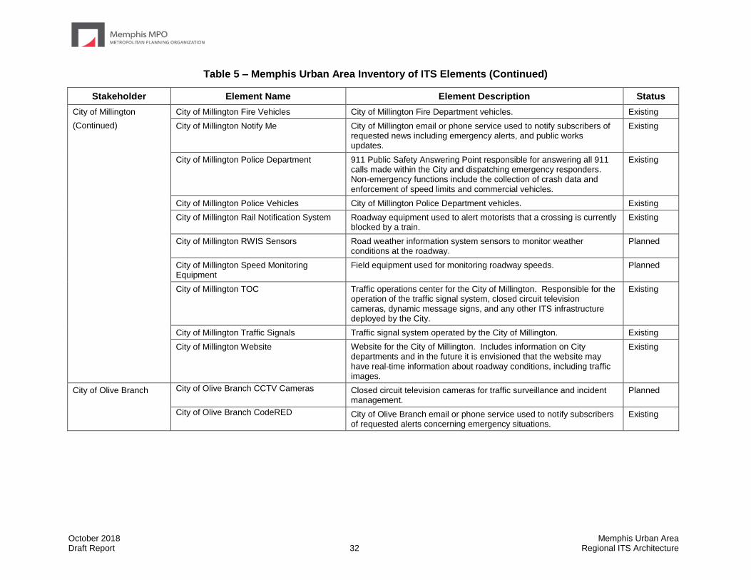
October 2018 Memphis Urban Area Draft Report 32 Regional ITS Architecture
Table 5 – Memphis Urban Area Inventory of ITS Elements (Continued)
Stakeholder Element Name Element Description Status
City of Millington
(Continued)
City of Millington Fire Vehicles City of Millington Fire Department vehicles. Existing
City of Millington Notify Me City of Millington email or phone service used to notify subscribers of requested news including emergency alerts, and public works updates.
Existing
City of Millington Police Department 911 Public Safety Answering Point responsible for answering all 911 calls made within the City and dispatching emergency responders. Non-emergency functions include the collection of crash data and enforcement of speed limits and commercial vehicles.
Existing
City of Millington Police Vehicles City of Millington Police Department vehicles. Existing
City of Millington Rail Notification System Roadway equipment used to alert motorists that a crossing is currently blocked by a train.
Existing
City of Millington RWIS Sensors Road weather information system sensors to monitor weather conditions at the roadway.
Planned
City of Millington Speed Monitoring Equipment
Field equipment used for monitoring roadway speeds. Planned
City of Millington TOC Traffic operations center for the City of Millington. Responsible for the operation of the traffic signal system, closed circuit television cameras, dynamic message signs, and any other ITS infrastructure deployed by the City.
Existing
City of Millington Traffic Signals Traffic signal system operated by the City of Millington. Existing
City of Millington Website Website for the City of Millington. Includes information on City departments and in the future it is envisioned that the website may have real-time information about roadway conditions, including traffic images.
Existing
City of Olive Branch City of Olive Branch CCTV Cameras Closed circuit television cameras for traffic surveillance and incident management.
Planned
City of Olive Branch CodeRED City of Olive Branch email or phone service used to notify subscribers of requested alerts concerning emergency situations.
Existing

October 2018 Memphis Urban Area Draft Report 33 Regional ITS Architecture
Table 5 – Memphis Urban Area Inventory of ITS Elements (Continued)
Stakeholder Element Name Element Description Status
City of Olive Branch
(Continued)
City of Olive Branch Connected Vehicle Roadside Equipment
Field devices that are able to send information to and receive information from adjacent vehicles that are equipped with digital short-range communications (DSRC) or other wireless communications technology.
Planned
City of Olive Branch DMS Dynamic message signs for traffic information dissemination. Planned
City of Olive Branch Emergency Communications Center
911 Public Safety Answering Point responsible for answering all 911 calls made within the City and dispatching emergency responders. Non-emergency functions include the collection of crash data and enforcement of speed limits and commercial vehicles.
Existing
City of Olive Branch Field Sensors Roadway equipment used to detect vehicle volumes and/or speeds. Includes equipment such as video image vehicle detection systems, remote traffic microwave sensors, or traditional loops.
Existing
City of Olive Branch Fire/EMS Vehicles City of Olive Branch Fire Department and Emergency Medical Services vehicles.
Existing
City of Olive Branch Police Vehicles City of Olive Branch Police Department vehicles. Existing
City of Olive Branch Rail Notification System
Roadway equipment used to alert motorists that a crossing is currently blocked by a train.
Existing
City of Olive Branch RWIS Sensors Road weather information system sensors to monitor weather conditions at the roadway.
Planned
City of Olive Branch Speed Monitoring Equipment
Field equipment used for monitoring roadway speeds. Planned
City of Olive Branch TOC Traffic operations center for the City of Olive Branch. Responsible for the operation of the traffic signal system, closed circuit television cameras, dynamic message signs, and any other ITS infrastructure deployed by the City.
Existing
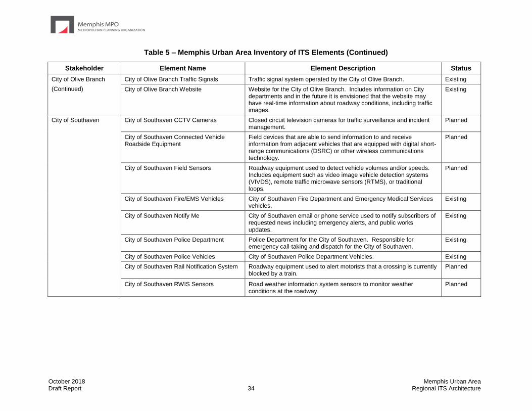
October 2018 Memphis Urban Area Draft Report 34 Regional ITS Architecture
Table 5 – Memphis Urban Area Inventory of ITS Elements (Continued)
Stakeholder Element Name Element Description Status
City of Olive Branch
(Continued)
City of Olive Branch Traffic Signals Traffic signal system operated by the City of Olive Branch. Existing
City of Olive Branch Website Website for the City of Olive Branch. Includes information on City departments and in the future it is envisioned that the website may have real-time information about roadway conditions, including traffic images.
Existing
City of Southaven City of Southaven CCTV Cameras Closed circuit television cameras for traffic surveillance and incident management.
Planned
City of Southaven Connected Vehicle Roadside Equipment
Field devices that are able to send information to and receive information from adjacent vehicles that are equipped with digital short-range communications (DSRC) or other wireless communications technology.
Planned
City of Southaven Field Sensors Roadway equipment used to detect vehicle volumes and/or speeds. Includes equipment such as video image vehicle detection systems (VIVDS), remote traffic microwave sensors (RTMS), or traditional loops.
Planned
City of Southaven Fire/EMS Vehicles City of Southaven Fire Department and Emergency Medical Services vehicles.
Existing
City of Southaven Notify Me City of Southaven email or phone service used to notify subscribers of requested news including emergency alerts, and public works updates.
Existing
City of Southaven Police Department Police Department for the City of Southaven. Responsible for emergency call-taking and dispatch for the City of Southaven.
Existing
City of Southaven Police Vehicles City of Southaven Police Department Vehicles. Existing
City of Southaven Rail Notification System Roadway equipment used to alert motorists that a crossing is currently blocked by a train.
Planned
City of Southaven RWIS Sensors Road weather information system sensors to monitor weather conditions at the roadway.
Planned

October 2018 Memphis Urban Area Draft Report 35 Regional ITS Architecture
Table 5 – Memphis Urban Area Inventory of ITS Elements (Continued)
Stakeholder Element Name Element Description Status
City of Southaven
(Continued)
City of Southaven Speed Monitoring Equipment
Field equipment used for monitoring roadway speeds. Planned
CIty of Southaven TOC Traffic operations center for the City of Southaven. Responsible for the operation of the traffic signal system, closed circuit television (CCTV) cameras, dynamic message signs (DMS), and any other ITS infrastructure deployed by the City.
Planned
City of Southaven Traffic Signals Traffic signal system operated by the City of Southaven. Existing
City of Southaven Website Website for the City of Southaven. Includes information on City departments and in the future it is envisioned that the website may have real-time information about roadway conditions, including traffic images.
Planned
City of West Memphis City of West Memphis Police Department Police Department for the City of West Memphis. Existing
City of West Memphis TOC Traffic operations center for the City of West Memphis. Responsible for the operation of the traffic signal system and any other ITS infrastructure deployed by the City.
Planned
West Memphis MPO Data Archive Archive of regional transportation data used in planning. Planned
Commercial Vehicle Operators
Commercial Vehicles Privately owned commercial vehicles traveling within the Region. Existing
Private Fleet Management Systems Fleet and freight management for private carriers. Existing
Rail Freight Rail cars traveling within the Region. Existing
DARTS DARTS Data Archive Delta Area Rural Transit System transit ridership statistics used by the National Transit Database, FTA, and MDOT.
Planned
DARTS Demand Response Vehicles Delta Area Rural Transit System demand response vehicle fleet. Existing
DARTS Dispatch Center Delta Area Rural Transit System dispatch center responsible for the tracking, scheduling, and dispatching of DARTS demand response services.
Existing
DARTS Website Delta Area Rural Transit System website. Includes information on services and in the future it is envisioned that the website will have real-time information about regional transit services and the ability to make trip requests online.
Existing
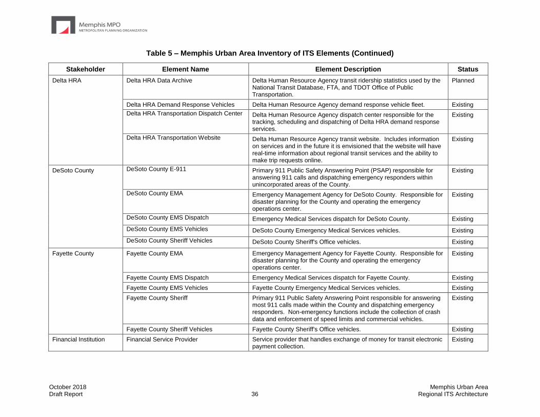
October 2018 Memphis Urban Area Draft Report 36 Regional ITS Architecture
Table 5 – Memphis Urban Area Inventory of ITS Elements (Continued)
Stakeholder Element Name Element Description Status
Delta HRA Delta HRA Data Archive Delta Human Resource Agency transit ridership statistics used by the National Transit Database, FTA, and TDOT Office of Public Transportation.
Planned
Delta HRA Demand Response Vehicles Delta Human Resource Agency demand response vehicle fleet. Existing
Delta HRA Transportation Dispatch Center Delta Human Resource Agency dispatch center responsible for the tracking, scheduling and dispatching of Delta HRA demand response services.
Existing
Delta HRA Transportation Website Delta Human Resource Agency transit website. Includes information on services and in the future it is envisioned that the website will have real-time information about regional transit services and the ability to make trip requests online.
Existing
DeSoto County DeSoto County E-911 Primary 911 Public Safety Answering Point (PSAP) responsible for answering 911 calls and dispatching emergency responders within unincorporated areas of the County.
Existing
DeSoto County EMA Emergency Management Agency for DeSoto County. Responsible for disaster planning for the County and operating the emergency operations center.
Existing
DeSoto County EMS Dispatch Emergency Medical Services dispatch for DeSoto County. Existing
DeSoto County EMS Vehicles DeSoto County Emergency Medical Services vehicles. Existing
DeSoto County Sheriff Vehicles DeSoto County Sheriff's Office vehicles. Existing
Fayette County Fayette County EMA Emergency Management Agency for Fayette County. Responsible for disaster planning for the County and operating the emergency operations center.
Existing
Fayette County EMS Dispatch Emergency Medical Services dispatch for Fayette County. Existing
Fayette County EMS Vehicles Fayette County Emergency Medical Services vehicles. Existing
Fayette County Sheriff Primary 911 Public Safety Answering Point responsible for answering most 911 calls made within the County and dispatching emergency responders. Non-emergency functions include the collection of crash data and enforcement of speed limits and commercial vehicles.
Existing
Fayette County Sheriff Vehicles Fayette County Sheriff's Office vehicles. Existing
Financial Institution Financial Service Provider Service provider that handles exchange of money for transit electronic payment collection.
Existing
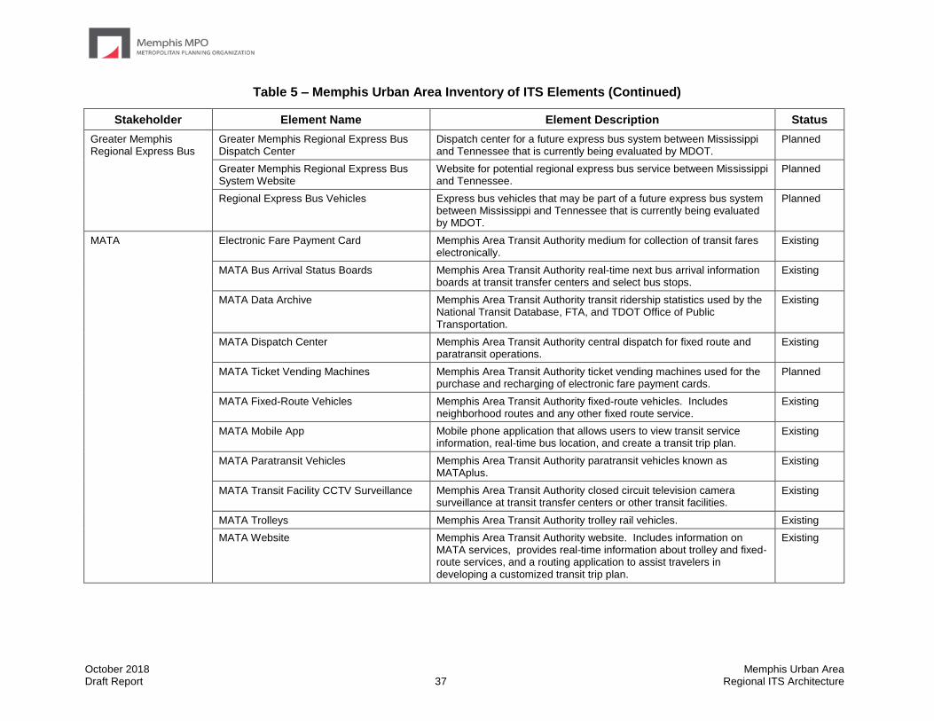
October 2018 Memphis Urban Area Draft Report 37 Regional ITS Architecture
Table 5 – Memphis Urban Area Inventory of ITS Elements (Continued)
Stakeholder Element Name Element Description Status
Greater Memphis Regional Express Bus
Greater Memphis Regional Express Bus Dispatch Center
Dispatch center for a future express bus system between Mississippi and Tennessee that is currently being evaluated by MDOT.
Planned
Greater Memphis Regional Express Bus System Website
Website for potential regional express bus service between Mississippi and Tennessee.
Planned
Regional Express Bus Vehicles Express bus vehicles that may be part of a future express bus system between Mississippi and Tennessee that is currently being evaluated by MDOT.
Planned
MATA Electronic Fare Payment Card Memphis Area Transit Authority medium for collection of transit fares electronically.
Existing
MATA Bus Arrival Status Boards Memphis Area Transit Authority real-time next bus arrival information boards at transit transfer centers and select bus stops.
Existing
MATA Data Archive Memphis Area Transit Authority transit ridership statistics used by the National Transit Database, FTA, and TDOT Office of Public Transportation.
Existing
MATA Dispatch Center Memphis Area Transit Authority central dispatch for fixed route and paratransit operations.
Existing
MATA Ticket Vending Machines Memphis Area Transit Authority ticket vending machines used for the purchase and recharging of electronic fare payment cards.
Planned
MATA Fixed-Route Vehicles Memphis Area Transit Authority fixed-route vehicles. Includes neighborhood routes and any other fixed route service.
Existing
MATA Mobile App Mobile phone application that allows users to view transit service information, real-time bus location, and create a transit trip plan.
Existing
MATA Paratransit Vehicles Memphis Area Transit Authority paratransit vehicles known as MATAplus.
Existing
MATA Transit Facility CCTV Surveillance Memphis Area Transit Authority closed circuit television camera surveillance at transit transfer centers or other transit facilities.
Existing
MATA Trolleys Memphis Area Transit Authority trolley rail vehicles. Existing
MATA Website Memphis Area Transit Authority website. Includes information on MATA services, provides real-time information about trolley and fixed-route services, and a routing application to assist travelers in developing a customized transit trip plan.
Existing

October 2018 Memphis Urban Area Draft Report 38 Regional ITS Architecture
Table 5 – Memphis Urban Area Inventory of ITS Elements (Continued)
Stakeholder Element Name Element Description Status
MDOT
MDOT CCTV Cameras Closed circuit television cameras for traffic surveillance and incident management.
Existing
MDOT Changeable Speed Limit Signs MDOT roadway equipment used to lower speed limits on the roadway Planned
MDOT Connected Vehicle Roadside Equipment
Field devices that are able to send information to and receive information from adjacent vehicles that are equipped with digital short-range communications (DSRC) or other wireless communications technology.
Planned
MDOT Data Archive Archive of transportation data used in planning. Existing
MDOT District 2 Engineer’s Office District 2 Engineer's Office is responsible for administration of maintenance and construction projects within the District as well as communicating work zone information to the public through the Public Information Office.
Existing
MDOT District 2 Maintenance Office that handles most of the routine roadway maintenance and responds to incidents when services are requested by local emergency management.
Existing
MDOT DMS Dynamic message signs for traffic information dissemination. Existing
MDOT Dynamic Lane Assignment Signs Blankout signs that inform drivers on the usage of travel lanes. Planned
MDOT Emergency Services Coordinator Coordinator responsible for managing the MDOT response in a large scale incident or disaster in which the Mississippi Emergency Management Agency activates the state emergency operations center.
Existing
MDOT Field Sensors Roadway equipment used to detect vehicle volumes and/or speeds. Includes equipment such as video image vehicle detection systems, remote traffic microwave sensors, or traditional loops.
Existing
MDOT HAR Highway advisory radio for traffic information dissemination. Planned
MDOT Infrastructure Monitoring Equipment Equipment that monitors the condition of pavement, bridges, tunnels, associated hardware, and other transportation-related infrastructure using both fixed and vehicle-based sensors and cameras. Sensors collect information such as vibration, stress, temperature, and continuity.
Planned
MDOT Lane Control DMS Dynamic message sign with the ability to display full-color traffic information messages and dynamic lane management.
Planned
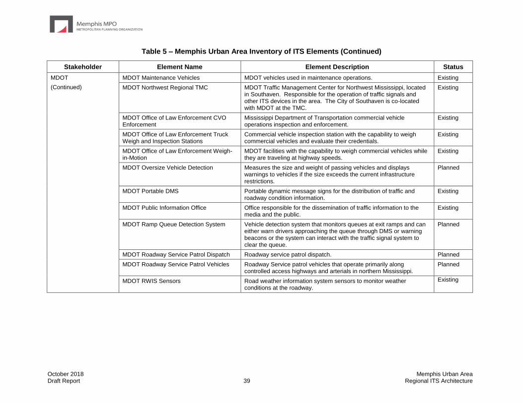
October 2018 Memphis Urban Area Draft Report 39 Regional ITS Architecture
Table 5 – Memphis Urban Area Inventory of ITS Elements (Continued)
Stakeholder Element Name Element Description Status
MDOT
(Continued)
MDOT Maintenance Vehicles MDOT vehicles used in maintenance operations. Existing
MDOT Northwest Regional TMC MDOT Traffic Management Center for Northwest Mississippi, located in Southaven. Responsible for the operation of traffic signals and other ITS devices in the area. The City of Southaven is co-located with MDOT at the TMC.
Existing
MDOT Office of Law Enforcement CVO Enforcement
Mississippi Department of Transportation commercial vehicle operations inspection and enforcement.
Existing
MDOT Office of Law Enforcement Truck Weigh and Inspection Stations
Commercial vehicle inspection station with the capability to weigh commercial vehicles and evaluate their credentials.
Existing
MDOT Office of Law Enforcement Weigh-in-Motion
MDOT facilities with the capability to weigh commercial vehicles while they are traveling at highway speeds.
Existing
MDOT Oversize Vehicle Detection Measures the size and weight of passing vehicles and displays warnings to vehicles if the size exceeds the current infrastructure restrictions.
Planned
MDOT Portable DMS Portable dynamic message signs for the distribution of traffic and roadway condition information.
Existing
MDOT Public Information Office Office responsible for the dissemination of traffic information to the media and the public.
Existing
MDOT Ramp Queue Detection System Vehicle detection system that monitors queues at exit ramps and can either warn drivers approaching the queue through DMS or warning beacons or the system can interact with the traffic signal system to clear the queue.
Planned
MDOT Roadway Service Patrol Dispatch Roadway service patrol dispatch. Planned
MDOT Roadway Service Patrol Vehicles Roadway Service patrol vehicles that operate primarily along controlled access highways and arterials in northern Mississippi.
Planned
MDOT RWIS Sensors Road weather information system sensors to monitor weather conditions at the roadway.
Existing

October 2018 Memphis Urban Area Draft Report 40 Regional ITS Architecture
Table 5 – Memphis Urban Area Inventory of ITS Elements (Continued)
Stakeholder Element Name Element Description Status
MDOT
(Continued)
MDOT Smart Work Zone Equipment Portable ITS equipment that can be used in work zones to more efficiently manage traffic and provide traveler information. Includes portable closed circuit television cameras, vehicle detection, and dynamic message signs.
Existing
MDOT Speed Monitoring Equipment Field equipment used for monitoring roadway speeds. Planned
MDOT Traffic Signals Traffic signal system operated by the Mississippi DOT. Existing
MDOTtraffic Information center that monitors road network conditions including incident and construction information and camera views.
Planned
MDOTtraffic App Mobile phone application that provides real-time traffic alert information and streaming video from traffic cameras.
Existing
MDOTtraffic Website Website providing road network conditions including incident and construction information and camera views.
Existing
Mississippi 511 IVR Mississippi 511 Interactive Voice Response. The IVR accepts callers' requests and provides responses to specific traveler information needs. This is the customer interface component of the 511 phone system.
Existing
Mississippi 511 System Statewide 511 traveler information system central server Existing
Mississippi Statewide TMC Mississippi Statewide Traffic Management Center in Jackson, MS. Existing
Other MDOT District Construction and Maintenance Offices
Additional MDOT district construction and maintenance offices excluding those in District 2
Existing
Media Local Print and Broadcast Media Local media outlets including television stations, newspapers, radio stations and their associated websites.
Existing
MEMA Mississippi EMA The Mississippi Emergency Management Agency manages emergency operations during a disaster or large scale incident.
Existing
Memphis and Shelby County Health Department
Memphis and Shelby County Health Department Emissions Sensors
Air quality sensors that monitor ozone and particulate matter levels. Existing
Memphis and Shelby County Health Department Pollution Control
Responsible for administering local air pollution control laws and monitoring air quality in Shelby County.
Existing
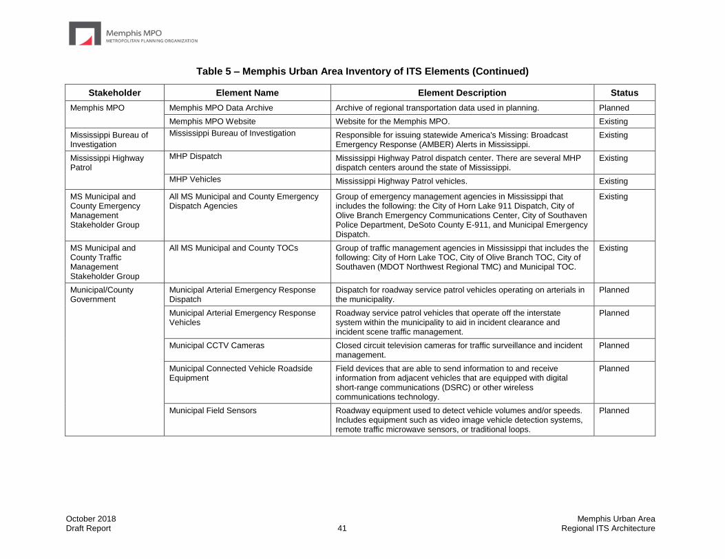
October 2018 Memphis Urban Area Draft Report 41 Regional ITS Architecture
Table 5 – Memphis Urban Area Inventory of ITS Elements (Continued)
Stakeholder Element Name Element Description Status
Memphis MPO Memphis MPO Data Archive Archive of regional transportation data used in planning. Planned
Memphis MPO Website Website for the Memphis MPO. Existing
Mississippi Bureau of Investigation
Mississippi Bureau of Investigation Responsible for issuing statewide America's Missing: Broadcast Emergency Response (AMBER) Alerts in Mississippi.
Existing
Mississippi Highway Patrol
MHP Dispatch Mississippi Highway Patrol dispatch center. There are several MHP dispatch centers around the state of Mississippi.
Existing
MHP Vehicles Mississippi Highway Patrol vehicles. Existing
MS Municipal and County Emergency Management Stakeholder Group
All MS Municipal and County Emergency Dispatch Agencies
Group of emergency management agencies in Mississippi that includes the following: the City of Horn Lake 911 Dispatch, City of Olive Branch Emergency Communications Center, City of Southaven Police Department, DeSoto County E-911, and Municipal Emergency Dispatch.
Existing
MS Municipal and County Traffic Management Stakeholder Group
All MS Municipal and County TOCs Group of traffic management agencies in Mississippi that includes the following: City of Horn Lake TOC, City of Olive Branch TOC, City of Southaven (MDOT Northwest Regional TMC) and Municipal TOC.
Existing
Municipal/County Government
Municipal Arterial Emergency Response Dispatch
Dispatch for roadway service patrol vehicles operating on arterials in the municipality.
Planned
Municipal Arterial Emergency Response Vehicles
Roadway service patrol vehicles that operate off the interstate system within the municipality to aid in incident clearance and incident scene traffic management.
Planned
Municipal CCTV Cameras Closed circuit television cameras for traffic surveillance and incident management.
Planned
Municipal Connected Vehicle Roadside Equipment
Field devices that are able to send information to and receive information from adjacent vehicles that are equipped with digital short-range communications (DSRC) or other wireless communications technology.
Planned
Municipal Field Sensors Roadway equipment used to detect vehicle volumes and/or speeds. Includes equipment such as video image vehicle detection systems, remote traffic microwave sensors, or traditional loops.
Planned
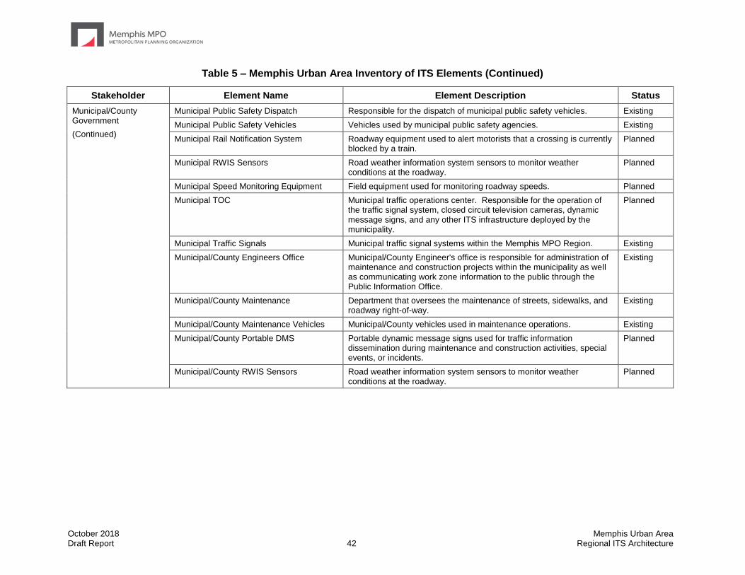
October 2018 Memphis Urban Area Draft Report 42 Regional ITS Architecture
Table 5 – Memphis Urban Area Inventory of ITS Elements (Continued)
Stakeholder Element Name Element Description Status
Municipal/County Government
(Continued)
Municipal Public Safety Dispatch Responsible for the dispatch of municipal public safety vehicles. Existing
Municipal Public Safety Vehicles Vehicles used by municipal public safety agencies. Existing
Municipal Rail Notification System Roadway equipment used to alert motorists that a crossing is currently blocked by a train.
Planned
Municipal RWIS Sensors Road weather information system sensors to monitor weather conditions at the roadway.
Planned
Municipal Speed Monitoring Equipment Field equipment used for monitoring roadway speeds. Planned
Municipal TOC Municipal traffic operations center. Responsible for the operation of the traffic signal system, closed circuit television cameras, dynamic message signs, and any other ITS infrastructure deployed by the municipality.
Planned
Municipal Traffic Signals Municipal traffic signal systems within the Memphis MPO Region. Existing
Municipal/County Engineers Office Municipal/County Engineer's office is responsible for administration of maintenance and construction projects within the municipality as well as communicating work zone information to the public through the Public Information Office.
Existing
Municipal/County Maintenance Department that oversees the maintenance of streets, sidewalks, and roadway right-of-way.
Existing
Municipal/County Maintenance Vehicles Municipal/County vehicles used in maintenance operations. Existing
Municipal/County Portable DMS Portable dynamic message signs used for traffic information dissemination during maintenance and construction activities, special events, or incidents.
Planned
Municipal/County RWIS Sensors Road weather information system sensors to monitor weather conditions at the roadway.
Planned

October 2018 Memphis Urban Area Draft Report 43 Regional ITS Architecture
Table 5 – Memphis Urban Area Inventory of ITS Elements (Continued)
Stakeholder Element Name Element Description Status
Municipal/County Government
(Continued)
Municipal/County Website Municipal or county website that includes information on agency departments. In the future it is envisioned that the website would have real-time information about roadway conditions.
Planned
Other Municipal/County Maintenance Maintenance groups in adjacent municipalities or counties for coordination of maintenance activities.
Existing
NOAA National Weather Service Provides official US weather, marine, fire, and aviation forecasts, warnings, meteorological products, climate forecasts, and information about meteorology.
Existing
Other Agencies Other Maintenance and Construction Management Agencies
Additional maintenance and construction operations agencies with which information is shared for coordination in an emergency situation.
Existing
Other Traffic Management Agencies Additional traffic management agencies with which information is shared for coordination in an emergency situation.
Existing
Private Information Providers
Private Sector Traveler Information Services
Traveler information service operated by a private entity. Existing
Private Transit Information Provider Private company that repackages transit information for subscribers. Existing
Social Networking Services Subscription based services operated by private providers that provide an option for real-time traveler information dissemination. Examples of such services include Facebook or Twitter.
Existing
Private Service Provider Private Contract EMS Vehicles Emergency Medical Services vehicles operating within Shelby County under contract with the Shelby County Fire Department.
Existing
Private Parking Facilities Privately owned public parking facilities that typically charge a fee for parking.
Existing
Private Probe Data Provider Private provider of aggregated vehicle probe data for monitoring of road network conditions.
Planned
Private Transportation Providers Private providers of transportation services in the Region. This includes taxis, Greyhound or other inter-city bus providers, Amtrak and the New Freedoms Program.
Existing
Rail Operators Rail Operator Wayside Equipment Equipment located along the tracks including railroad crossing gates, bells, and lights as well as the interface to the traffic signal controller indicating the presence of a train.
Existing
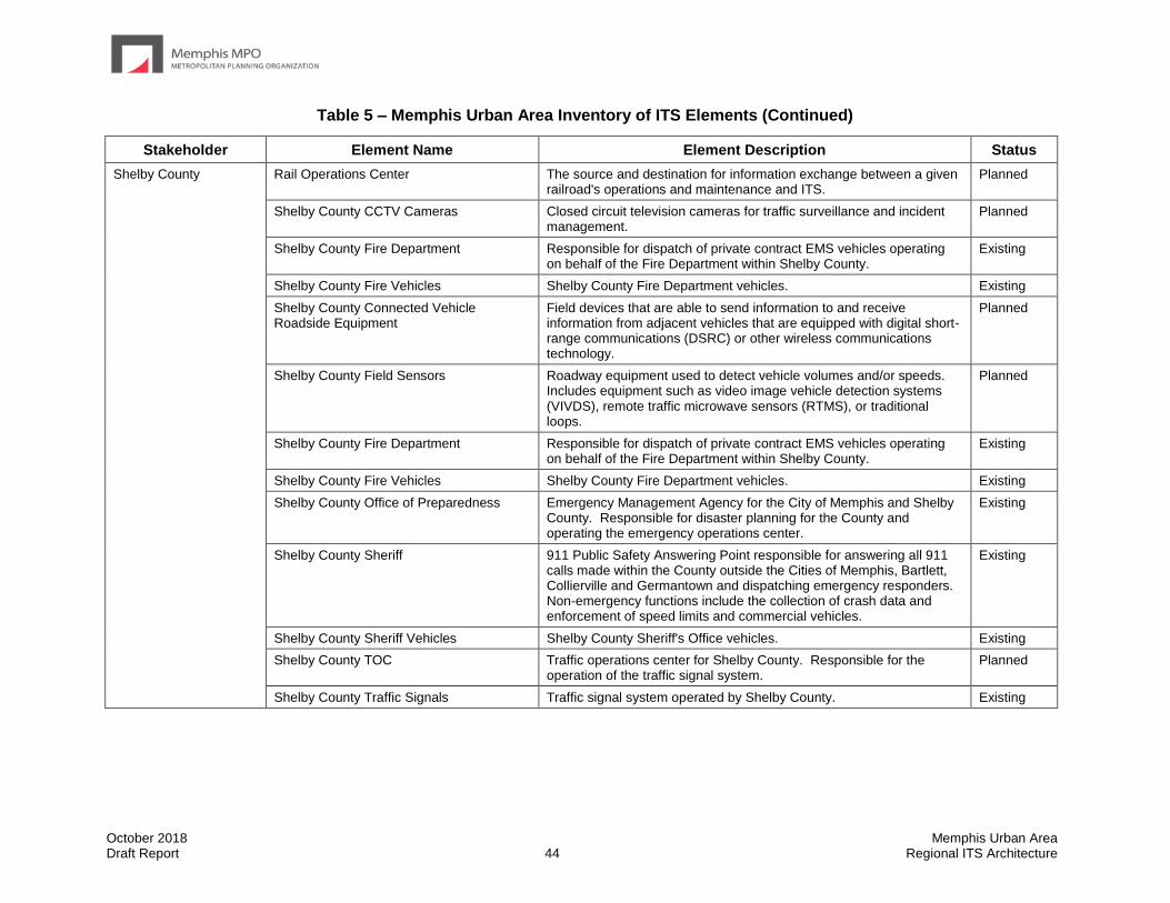
October 2018 Memphis Urban Area Draft Report 44 Regional ITS Architecture
Table 5 – Memphis Urban Area Inventory of ITS Elements (Continued)
Stakeholder Element Name Element Description Status
Shelby County Rail Operations Center The source and destination for information exchange between a given railroad's operations and maintenance and ITS.
Planned
Shelby County CCTV Cameras Closed circuit television cameras for traffic surveillance and incident management.
Planned
Shelby County Fire Department Responsible for dispatch of private contract EMS vehicles operating on behalf of the Fire Department within Shelby County.
Existing
Shelby County Fire Vehicles Shelby County Fire Department vehicles. Existing
Shelby County Connected Vehicle Roadside Equipment
Field devices that are able to send information to and receive information from adjacent vehicles that are equipped with digital short-range communications (DSRC) or other wireless communications technology.
Planned
Shelby County Field Sensors Roadway equipment used to detect vehicle volumes and/or speeds. Includes equipment such as video image vehicle detection systems (VIVDS), remote traffic microwave sensors (RTMS), or traditional loops.
Planned
Shelby County Fire Department Responsible for dispatch of private contract EMS vehicles operating on behalf of the Fire Department within Shelby County.
Existing
Shelby County Fire Vehicles Shelby County Fire Department vehicles. Existing
Shelby County Office of Preparedness Emergency Management Agency for the City of Memphis and Shelby County. Responsible for disaster planning for the County and operating the emergency operations center.
Existing
Shelby County Sheriff 911 Public Safety Answering Point responsible for answering all 911 calls made within the County outside the Cities of Memphis, Bartlett, Collierville and Germantown and dispatching emergency responders. Non-emergency functions include the collection of crash data and enforcement of speed limits and commercial vehicles.
Existing
Shelby County Sheriff Vehicles Shelby County Sheriff's Office vehicles. Existing
Shelby County TOC Traffic operations center for Shelby County. Responsible for the operation of the traffic signal system.
Planned
Shelby County Traffic Signals Traffic signal system operated by Shelby County. Existing
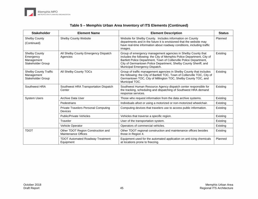
October 2018 Memphis Urban Area Draft Report 45 Regional ITS Architecture
Table 5 – Memphis Urban Area Inventory of ITS Elements (Continued)
Stakeholder Element Name Element Description Status
Shelby County
(Continued)
Shelby County Website Website for Shelby County. Includes information on County departments and in the future it is envisioned that the website may have real-time information about roadway conditions, including traffic images.
Planned
Shelby County Emergency Management Stakeholder Group
All Shelby County Emergency Dispatch Agencies
Group of emergency management agencies in Shelby County that includes the following: the City of Memphis Police Department, City of Bartlett Police Department, Town of Collierville Police Department, City of Germantown Police Department, Shelby County Sheriff, and Municipal Emergency Dispatch.
Existing
Shelby County Traffic Management Stakeholder Group
All Shelby County TOCs Group of traffic management agencies in Shelby County that includes the following: the City of Bartlett TOC, Town of Collierville TOC, City of Germantown TOC, City of Millington TOC, Shelby County TOC, and Municipal TOC.
Existing
Southwest HRA Southwest HRA Transportation Dispatch Center
Southwest Human Resource Agency dispatch center responsible for the tracking, scheduling and dispatching of Southwest HRA demand response services.
Existing
System Users Archive Data User Those who request information from the data archive systems. Existing
Pedestrians Individuals afoot or using a motorized or non-motorized wheelchair. Existing
Private Travelers Personal Computing Devices
Computing devices that travelers use to access public information. Existing
Public/Private Vehicles Vehicles that traverse a specific region. Existing
Traveler User of the transportation system. Existing
Vehicle Operator Operators of commercial vehicles. Existing
TDOT Other TDOT Region Construction and Maintenance Offices
Other TDOT regional construction and maintenance offices besides those in Region 4.
Existing
TDOT Automated Roadway Treatment Equipment
Equipment used for the automated application on anti-icing chemicals at locations prone to freezing.
Planned

October 2018 Memphis Urban Area Draft Report 46 Regional ITS Architecture
Table 5 – Memphis Urban Area Inventory of ITS Elements (Continued)
Stakeholder Element Name Element Description Status
TDOT
(Continued)
TDOT CCTV Cameras Closed circuit television cameras for traffic surveillance and incident management.
Existing
TDOT Changeable Speed Limit Signs TDOT roadway equipment used to lower or raise speed limits on the roadway
Planned
TDOT Connected Vehicle Roadside Equipment
Field devices that are able to send information to and receive information from adjacent vehicles that are equipped with digital short-range communications (DSRC) or other wireless communications technology.
Planned
TDOT District Maintenance Office that handles most of the routine roadway maintenance and responds to incidents when services are requested by local emergency management.
Existing
TDOT DMS Dynamic message signs for traffic information dissemination. Existing
TDOT Dynamic Lane Assignment Sign Blankout signs that inform drivers on the usage of travel lanes. Planned
TDOT Emergency Services Coordinator Coordinator responsible for managing the Tennessee Department of Transportation response in a large scale incident or disaster in which the Tennessee Emergency Management Agency activates the state emergency operations center.
Existing
TDOT Field Sensors Roadway equipment used to detect vehicle volumes and/or speeds. Includes equipment such as video image vehicle detection systems, remote traffic microwave sensors, or traditional loops.
Existing
TDOT HAR Highway advisory radio for traffic information dissemination. Existing
TDOT HELP Vehicles Roadway service patrol vehicles. Currently operate primarily on controlled access highways in Shelby County and are dispatched elsewhere in the Region for large incidents.
Existing
TDOT Infrastructure Monitoring Equipment Equipment that monitors the condition of pavement, bridges, tunnels, associated hardware, and other transportation-related infrastructure using both fixed and vehicle-based sensors and cameras. Sensors collect information such as vibration, stress, temperature, and continuity.
Existing
TDOT Lane Control DMS Dynamic message sign with the ability to display full-color traffic information messages and dynamic lane management.
Planned
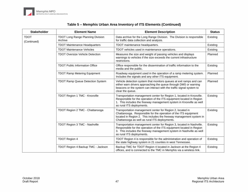
October 2018 Memphis Urban Area Draft Report 47 Regional ITS Architecture
Table 5 – Memphis Urban Area Inventory of ITS Elements (Continued)
Stakeholder Element Name Element Description Status
TDOT
(Continued)
TDOT Long Range Planning Division Archive
Data archive for the Long Range Division. The Division is responsible for traffic data collection and analysis.
Existing
TDOT Maintenance Headquarters TDOT maintenance headquarters. Existing
TDOT Maintenance Vehicles TDOT vehicles used in maintenance operations. Existing
TDOT Oversize Vehicle Detection Measures the size and weight of passing vehicles and displays warnings to vehicles if the size exceeds the current infrastructure restrictions.
Planned
TDOT Public Information Office Office responsible for the dissemination of traffic information to the media and the public.
Existing
TDOT Ramp Metering Equipment Roadway equipment used in the operation of a ramp metering system. Includes the signals and any other ITS equipment.
Planned
TDOT Ramp Queue Detection System Vehicle detection system that monitors queues at exit ramps and can either warn drivers approaching the queue through DMS or warning beacons or the system can interact with the traffic signal system to clear the queue.
Planned
TDOT Region 1 TMC - Knoxville Transportation management center for Region 1, located in Knoxville. Responsible for the operation of the ITS equipment located in Region 1. This includes the freeway management system in Knoxville as well as rural ITS deployments.
Existing
TDOT Region 2 TMC - Chattanooga Transportation management center for Region 2, located in Chattanooga. Responsible for the operation of the ITS equipment located in Region 2. This includes the freeway management system in Chattanooga as well as rural ITS deployments.
Existing
TDOT Region 3 TMC - Nashville Transportation management center for Region 3, located in Nashville. Responsible for the operation of the ITS equipment located in Region 3. This includes the freeway management system in Nashville as well as rural ITS deployments.
Existing
TDOT Region 4 TDOT Region 4 is responsible for the administration and operation of the state highway system in 21 counties in west Tennessee.
Existing
TDOT Region 4 Backup TMC - Jackson Backup TMC for TDOT Region 4 located in Jackson at the Region 4 offices, and is connected to the TMC in Memphis via a wireless link.
Existing

October 2018 Memphis Urban Area Draft Report 48 Regional ITS Architecture
Table 5 – Memphis Urban Area Inventory of ITS Elements (Continued)
Stakeholder Element Name Element Description Status
TDOT
(Continued)
TDOT Region 4 Construction Office Office responsible for oversight of construction projects in Region 4. Existing
TDOT Region 4 Engineer’s Office Office responsible for administration of maintenance and construction projects within the Region as well as communicating work zone information to the public through the Public Information Office.
Existing
TDOT Region 4 HELP Dispatch Roadway service patrol dispatch. Currently operate primarily on controlled access highways in Shelby County and are dispatched elsewhere in the Region for large incidents.
Existing
TDOT Region 4 Maintenance Region 4 maintenance headquarters. Responsible for maintenance operations in the Region; however, most routine maintenance is handled by the District Maintenance Offices. There are several District Maintenance Offices within the Region.
Existing
TDOT Region 4 Smart Work Zone Equipment
Portable ITS equipment that can be used in work zones to more efficiently manage traffic and provide traveler information. Includes portable closed circuit television (CCTV) cameras, vehicle detection, and dynamic message signs (DMS).
Planned
TDOT Region 4 TMC - Memphis Transportation management center for Region 4, located in Memphis. Responsible for the operation of the ITS equipment located in Region 4. This includes the freeway management system in Memphis as well as rural ITS deployments.
Existing
TDOT Oversize Vehicle Detection Measures the size and weight of passing vehicles and displays warnings to vehicles if the size exceeds the current infrastructure restrictions.
Planned
TDOT RWIS Sensors Road weather information system sensors to monitor weather conditions at the roadway.
Planned
TDOT SmartWay Mobile App Mobile phone application that allows users to view traffic images, receive incident information, and monitor traffic speeds.
Existing
TDOT SmartWay Website Website providing road network conditions including incident and construction information and camera views. Much of the data for the website comes from SWIFT.
Existing
TDOT Speed Monitoring Equipment Field equipment used for monitoring roadway speeds. Planned
TDOT Statewide Information for Travelers (SWIFT)
SWIFT is a statewide roadway conditions database. Currently information can be entered by District and Regional maintenance personnel as well as staff at any of the Transportation Management Centers and the Tennessee Highway Patrol. SWIFT feeds the Statewide 511 system and SmartWay website.
Existing
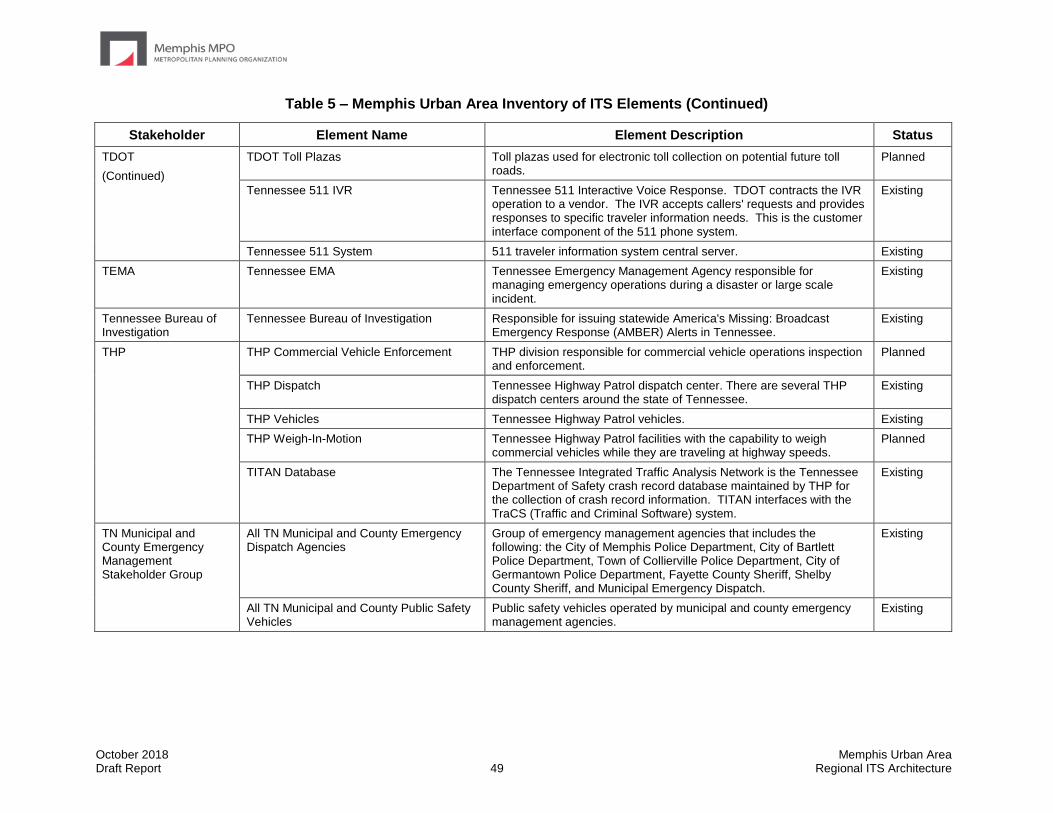
October 2018 Memphis Urban Area Draft Report 49 Regional ITS Architecture
Table 5 – Memphis Urban Area Inventory of ITS Elements (Continued)
Stakeholder Element Name Element Description Status
TDOT
(Continued)
TDOT Toll Plazas Toll plazas used for electronic toll collection on potential future toll roads.
Planned
Tennessee 511 IVR Tennessee 511 Interactive Voice Response. TDOT contracts the IVR operation to a vendor. The IVR accepts callers' requests and provides responses to specific traveler information needs. This is the customer interface component of the 511 phone system.
Existing
Tennessee 511 System 511 traveler information system central server. Existing
TEMA Tennessee EMA Tennessee Emergency Management Agency responsible for managing emergency operations during a disaster or large scale incident.
Existing
Tennessee Bureau of Investigation
Tennessee Bureau of Investigation Responsible for issuing statewide America's Missing: Broadcast Emergency Response (AMBER) Alerts in Tennessee.
Existing
THP THP Commercial Vehicle Enforcement THP division responsible for commercial vehicle operations inspection and enforcement.
Planned
THP Dispatch Tennessee Highway Patrol dispatch center. There are several THP dispatch centers around the state of Tennessee.
Existing
THP Vehicles Tennessee Highway Patrol vehicles. Existing
THP Weigh-In-Motion Tennessee Highway Patrol facilities with the capability to weigh commercial vehicles while they are traveling at highway speeds.
Planned
TITAN Database The Tennessee Integrated Traffic Analysis Network is the Tennessee Department of Safety crash record database maintained by THP for the collection of crash record information. TITAN interfaces with the TraCS (Traffic and Criminal Software) system.
Existing
TN Municipal and County Emergency Management Stakeholder Group
All TN Municipal and County Emergency Dispatch Agencies
Group of emergency management agencies that includes the following: the City of Memphis Police Department, City of Bartlett Police Department, Town of Collierville Police Department, City of Germantown Police Department, Fayette County Sheriff, Shelby County Sheriff, and Municipal Emergency Dispatch.
Existing
All TN Municipal and County Public Safety Vehicles
Public safety vehicles operated by municipal and county emergency management agencies.
Existing
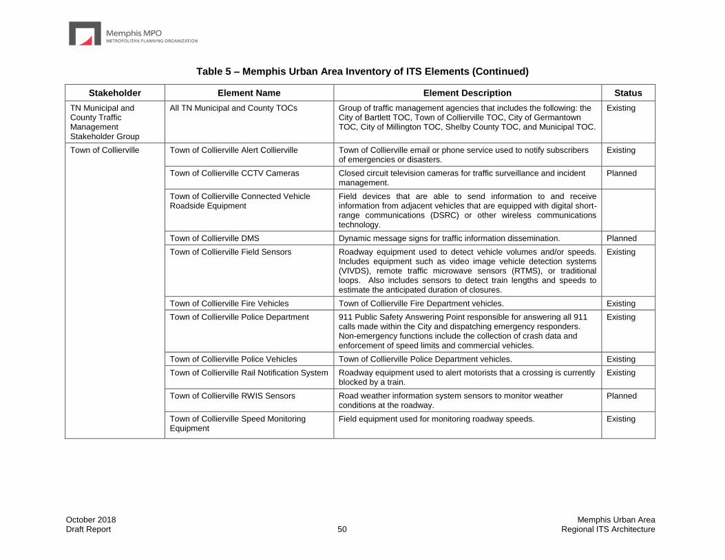
October 2018 Memphis Urban Area Draft Report 50 Regional ITS Architecture
Table 5 – Memphis Urban Area Inventory of ITS Elements (Continued)
Stakeholder Element Name Element Description Status
TN Municipal and County Traffic Management Stakeholder Group
All TN Municipal and County TOCs Group of traffic management agencies that includes the following: the City of Bartlett TOC, Town of Collierville TOC, City of Germantown TOC, City of Millington TOC, Shelby County TOC, and Municipal TOC.
Existing
Town of Collierville Town of Collierville Alert Collierville Town of Collierville email or phone service used to notify subscribers of emergencies or disasters.
Existing
Town of Collierville CCTV Cameras Closed circuit television cameras for traffic surveillance and incident management.
Planned
Town of Collierville Connected Vehicle Roadside Equipment
Field devices that are able to send information to and receive information from adjacent vehicles that are equipped with digital short-range communications (DSRC) or other wireless communications technology.
Town of Collierville DMS Dynamic message signs for traffic information dissemination. Planned
Town of Collierville Field Sensors Roadway equipment used to detect vehicle volumes and/or speeds. Includes equipment such as video image vehicle detection systems (VIVDS), remote traffic microwave sensors (RTMS), or traditional loops. Also includes sensors to detect train lengths and speeds to estimate the anticipated duration of closures.
Existing
Town of Collierville Fire Vehicles Town of Collierville Fire Department vehicles. Existing
Town of Collierville Police Department 911 Public Safety Answering Point responsible for answering all 911 calls made within the City and dispatching emergency responders. Non-emergency functions include the collection of crash data and enforcement of speed limits and commercial vehicles.
Existing
Town of Collierville Police Vehicles Town of Collierville Police Department vehicles. Existing
Town of Collierville Rail Notification System Roadway equipment used to alert motorists that a crossing is currently blocked by a train.
Existing
Town of Collierville RWIS Sensors Road weather information system sensors to monitor weather conditions at the roadway.
Planned
Town of Collierville Speed Monitoring Equipment
Field equipment used for monitoring roadway speeds. Existing
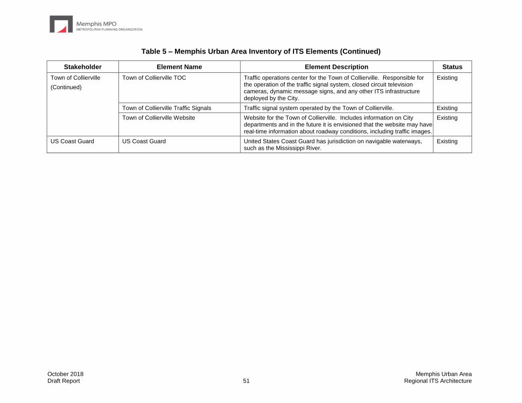
October 2018 Memphis Urban Area Draft Report 51 Regional ITS Architecture
Table 5 – Memphis Urban Area Inventory of ITS Elements (Continued)
Stakeholder Element Name Element Description Status
Town of Collierville
(Continued)
Town of Collierville TOC Traffic operations center for the Town of Collierville. Responsible for the operation of the traffic signal system, closed circuit television cameras, dynamic message signs, and any other ITS infrastructure deployed by the City.
Existing
Town of Collierville Traffic Signals Traffic signal system operated by the Town of Collierville. Existing
Town of Collierville Website Website for the Town of Collierville. Includes information on City departments and in the future it is envisioned that the website may have real-time information about roadway conditions, including traffic images.
Existing
US Coast Guard US Coast Guard United States Coast Guard has jurisdiction on navigable waterways, such as the Mississippi River.
Existing

October 2018 Memphis Urban Area Draft Report 52 Regional ITS Architecture
5.0 Regional ITS Architecture Upon completion of the system inventory, the next step in the development of the Regional ITS Architecture was to identify the ITS services that are important to the Memphis MPO Region. The National ITS Architecture has the twelve groups of ITS service areas shown in Table 6. Each service area is shown in the table with the current level of deployment in the Region and the level of regional interest based on stakeholder feedback aggregated from the interviews and workshop.
Existing, planned, and future systems in the Region were considered in each of the service areas. It is worth noting that while Vehicle Safety service packages are included in the Memphis Urban Area Regional ITS Architecture and assigned to TDOT and MDOT as primary stakeholders, implementation of those service packages will be heavily supported by private sector automobile manufacturers and information service providers.
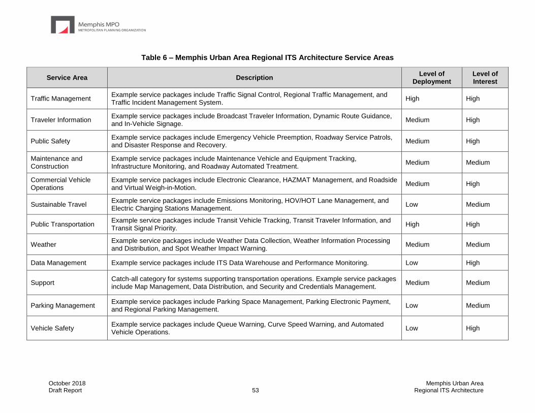
October 2018 Memphis Urban Area Draft Report 53 Regional ITS Architecture
Table 6 – Memphis Urban Area Regional ITS Architecture Service Areas
Service Area Description Level of
Deployment Level of Interest
Traffic Management Example service packages include Traffic Signal Control, Regional Traffic Management, and Traffic Incident Management System.
High High
Traveler Information Example service packages include Broadcast Traveler Information, Dynamic Route Guidance, and In-Vehicle Signage.
Medium High
Public Safety Example service packages include Emergency Vehicle Preemption, Roadway Service Patrols, and Disaster Response and Recovery.
Medium High
Maintenance and Construction
Example service packages include Maintenance Vehicle and Equipment Tracking, Infrastructure Monitoring, and Roadway Automated Treatment.
Medium Medium
Commercial Vehicle Operations
Example service packages include Electronic Clearance, HAZMAT Management, and Roadside and Virtual Weigh-in-Motion.
Medium High
Sustainable Travel Example service packages include Emissions Monitoring, HOV/HOT Lane Management, and Electric Charging Stations Management.
Low Medium
Public Transportation Example service packages include Transit Vehicle Tracking, Transit Traveler Information, and Transit Signal Priority.
High High
Weather Example service packages include Weather Data Collection, Weather Information Processing and Distribution, and Spot Weather Impact Warning.
Medium Medium
Data Management Example service packages include ITS Data Warehouse and Performance Monitoring. Low High
Support Catch-all category for systems supporting transportation operations. Example service packages include Map Management, Data Distribution, and Security and Credentials Management.
Medium Medium
Parking Management Example service packages include Parking Space Management, Parking Electronic Payment, and Regional Parking Management.
Low Medium
Vehicle Safety Example service packages include Queue Warning, Curve Speed Warning, and Automated Vehicle Operations.
Low High

October 2018 Memphis Urban Area Draft Report 54 Regional ITS Architecture
5.1 ITS Service Packages
In the National ITS Architecture, services that are provided by ITS are referred to as service packages. ITS service packages provide a visual representation of how ITS services are deployed and how information is shared. ITS service packages can include several stakeholders and elements that work together to provide a service in the Region. Examples of service packages from the National ITS Architecture include Network Surveillance, Traffic Information Dissemination, and Transit Vehicle Tracking. There is currently a total of 139 ITS service packages identified in the National ITS Architecture Version 8.1, which was the most recent version available of the National ITS Architecture at the time of the Memphis Urban Area Regional ITS Architecture update. It should be noted that in previous versions of the Memphis Urban Area Regional ITS Architecture, ITS service packages were referred to as ITS market packages. The name change has been made to be consistent with the terminology that is now used in Version 7.0 of the national ITS Architecture. Previous versions of the Memphis Urban Area Regional ITS Architecture refer to 97 total service packages previously provided, as opposed to the set of 139 total service packages now available.
5.1.1 Overview of ITS Service Package Structure
A service package is made up of elements and data flows. Each identified system or component in the Memphis Urban Area regional ITS inventory, which is documented in the previous section, was mapped to a subsystem or terminator in the National ITS Architecture. Subsystems and terminators represent the various functional categories that define the role of an element in ITS and the regional architecture. The elements are connected together by architecture flows that document the existing and planned flow of information.
Elements represent the ITS inventory for the Region. Both existing and planned elements have been included in the inventory and incorporated into the architecture through the development of the service package diagrams.
Subsystems are the highest-level building blocks of the physical architecture, and the National ITS Architecture groups them into four major classes: Centers, Fields, Vehicles, and Travelers. Each of these major classes includes various subsystems that represent a set of transportation functions (or processes). Each set of functions is grouped under one agency, jurisdiction, or location, and corresponds to physical elements such as: traffic operations centers, traffic signals, or vehicles. Each element is assigned to one or more subsystems.
Terminators are the people, systems, other facilities, and environmental conditions outside of ITS that need to communicate or interface with ITS subsystems. Terminators help define the boundaries of the National ITS Architecture as well as a regional system. Examples of terminators include drivers, weather services, and information service providers.
Architecture Flows provide a standardized method for documenting the types of information that flow between elements. A flow can be shown as either existing or future/planned. Existing flows indicate a connection that has already been established to share at least a portion of the desired information, but showing a flow as existing is not meant to imply that the function is complete. For example, the traffic information coordination flow between traffic management agencies includes the sharing of video images, incident information and other relevant data. The flow could be shown as existing to capture the sharing of video images while incident information is still a future desired expansion of functionality. Many of the architecture flows have associated technical specifications, known as standards, which define the format of the data being shared.
October 2018 Memphis Urban Area Draft Report 55 Regional ITS Architecture
5.1.2 Selection and Prioritization of Regional Service Packages
In the Memphis MPO Region, the National ITS Architecture service packages were reviewed by the stakeholders and selected based on the relevance of the functionality that the ITS service package could provide to the Region. Stakeholders selected 50 ITS service packages for implementation in the Region. The selected service packages are identified in Table 7. Stakeholders prioritized the selected service packages during the workshops, and the table organizes the service packages into service areas and priority groupings.
TDOT is leading a separate effort to maintain CVISN program. CVISN addresses commercial vehicle operations, including ITS, on a statewide level and includes such applications as electronic clearance, safety enforcement, and registration. Unless a specific need was identified in the Memphis MPO Region that could be addressed locally, the commercial vehicle operations service packages were not selected and instead will be covered in the CVISN effort to ensure consistency.
After selecting the service packages that were applicable for the Region, stakeholders reviewed each service package and the elements that could be included to customize it for the Region. This customization is discussed further in the next section (Section 5.1.3.).

October 2018 Memphis Urban Area Draft Report 56 Regional ITS Architecture
Table 7 – Memphis Urban Area ITS Service Package Prioritization by Functional Area
High Priority ITS Service Packages
Medium Priority ITS Service Packages
Low Priority ITS Service Packages
Traffic Management
TM01 Infrastructure-Based Traffic Surveillance
TM03 Traffic Signal Control
TM06 Traffic Information Dissemination
TM07 Regional Traffic Management
TM08 Traffic Incident Management System
TM04 Connected Vehicle Traffic Signal System
TM05 Traffic Metering
TM13 Standard Railroad Grade Crossing
TM22 Dynamic Lane Management and Shoulder Use
TM02 Vehicle-Based Traffic Surveillance
TM10 Electronic Toll Collection
TM17 Speed Warning and Enforcement
TM20 Variable Speed Limits
TM21 Speed Harmonization
Public Safety
PS01 Emergency Call-Taking and Dispatch
PS02 Routing Support for Emergency Responders
PS03 Emergency Vehicle Preemption
PS07 Incident Scene Safety Monitoring
PS08 Roadway Service Patrols
PS09 Transportation Infrastructure Protection
PS10 Wide-Area Alert
PS12 Disaster Response and Recovery
PS13 Evacuation and Reentry Management
PS14 Disaster Traveler Information
Maintenance and Construction
MC08 Maintenance and Construction Activity Coordination
MC09 Infrastructure Monitoring
MC01 Maintenance and Construction Vehicle and Equipment Tracking
MC06 Work Zone Management
MC03 Roadway Automated Treatment
MC04 Winter Maintenance
Public Transportation
PT01 Transit Vehicle Tracking
PT02 Transit Fixed Route Operations
PT03 Dynamic Transit Operations
PT04 Transit Fare Collection Management
PT05 Transit Security
PT06 Transit Fleet Management
PT07 Transit Passenger Counting
PT08 Transit Traveler Information
PT09 Transit Signal Priority
PT18 Integrated Multi-Modal Electronic Payment
PT10 Intermittent Bus Lanes
PT14 Multi-modal Coordination
PT17 Transit Connection Protection
PT11 Transit Pedestrian Indication
PT12 Transit Vehicle at Station/Stop Warnings
PT15 Transit Stop Request
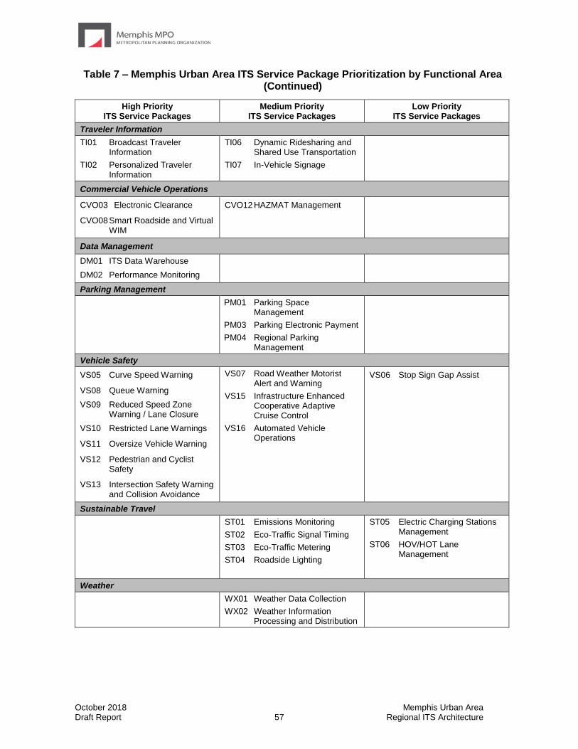
October 2018 Memphis Urban Area Draft Report 57 Regional ITS Architecture
Table 7 – Memphis Urban Area ITS Service Package Prioritization by Functional Area (Continued)
High Priority ITS Service Packages
Medium Priority ITS Service Packages
Low Priority ITS Service Packages
Traveler Information
TI01 Broadcast Traveler Information
TI02 Personalized Traveler Information
TI06 Dynamic Ridesharing and Shared Use Transportation
TI07 In-Vehicle Signage
Commercial Vehicle Operations
CVO03 Electronic Clearance
CVO08 Smart Roadside and Virtual WIM
CVO12 HAZMAT Management
Data Management
DM01 ITS Data Warehouse
DM02 Performance Monitoring
Parking Management
PM01 Parking Space Management
PM03 Parking Electronic Payment
PM04 Regional Parking Management
Vehicle Safety
VS05 Curve Speed Warning
VS08 Queue Warning
VS09 Reduced Speed Zone Warning / Lane Closure
VS10 Restricted Lane Warnings
VS11 Oversize Vehicle Warning
VS12 Pedestrian and Cyclist Safety
VS13 Intersection Safety Warning and Collision Avoidance
VS07 Road Weather Motorist Alert and Warning
VS15 Infrastructure Enhanced Cooperative Adaptive Cruise Control
VS16 Automated Vehicle Operations
VS06 Stop Sign Gap Assist
Sustainable Travel
ST01 Emissions Monitoring
ST02 Eco-Traffic Signal Timing
ST03 Eco-Traffic Metering
ST04 Roadside Lighting
ST05 Electric Charging Stations Management
ST06 HOV/HOT Lane Management
Weather
WX01 Weather Data Collection
WX02 Weather Information Processing and Distribution
October 2018 Memphis Urban Area Draft Report 58 Regional ITS Architecture
5.1.3 Customization of Regional Service Packages
The service packages in the National ITS Architecture were customized to reflect the unique systems, subsystems, and terminators in the Memphis MPO Region. ITS service packages represent a service that will be deployed as an integrated capability. Each service package is shown graphically with the service package name, local agencies involved, and desired data flows. The data flows are shown as either existing or planned/future. Data flows shown as existing indicate that in at least one location within the jurisdiction the connection exists. Data flows shown as existing should not be interpreted to mean that deployment of that service is complete as there are many cases where a data flow exists in a service but a need has been identified to expand the service to additional locations.
Figure 3 is an example of an Traffic Management (TM) service package for traffic information dissemination that has been customized for the Region. This instance focuses on the activities of TDOT Region 4. The service package shows the distribution of traffic information from the TDOT Region 4 TMC to emergency dispatch agencies and the media as well as in the future to transit management agencies. Messages are also placed on DMS and HAR and entered into SWIFT for inclusion on the SmartWay website and 511. Data flows between the subsystems indicate what information is being shared.
The remainder of the service packages that were customized for the Memphis MPO Region are provided in the online interactive RAD-IT database at www.memphismpo.org/plans/safety-mobility/its. To access these diagrams, from the website select the “Interactive Architecture”, then select the “Services” page, then click the desired Service Package Name. The link below the “Diagram” heading will lead to the service package diagram.
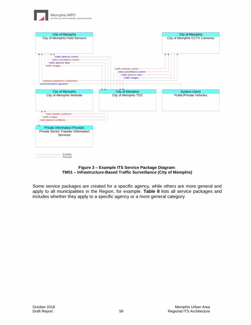
October 2018 Memphis Urban Area Draft Report 59 Regional ITS Architecture
City of MemphisCity of Memphis TOC
City of MemphisCity of Memphis Field Sensors
City of MemphisCity of Memphis CCTV Cameras
City of MemphisCity of Memphis Website
System UsersPublic/Private Vehicles
Private Information ProviderPrivate Sector Traveler Information
Services
traffic detector control
video surveillance control
traffic detector data
traffic images
traffic detector control
video surveillance control
traffic detector data
traffic images
roadway equipment coordination
road network conditions
traffic images
communications signature
road network conditions
ExistingPlanned
Figure 3 – Example ITS Service Package Diagram: TM01 – Infrastructure-Based Traffic Surveillance (City of Memphis)
Some service packages are created for a specific agency, while others are more general and apply to all municipalities in the Region, for example. Table 8 lists all service packages and includes whether they apply to a specific agency or a more general category.
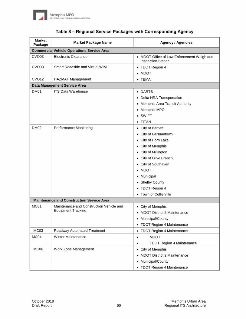
October 2018 Memphis Urban Area Draft Report 60 Regional ITS Architecture
Table 8 – Regional Service Packages with Corresponding Agency
Market Package
Market Package Name Agency / Agencies
Commercial Vehicle Operations Service Area
CVO03 Electronic Clearance • MDOT Office of Law Enforcement Weigh and Inspection Station
CVO08 Smart Roadside and Virtual WIM • TDOT Region 4
• MDOT
CVO12 HAZMAT Management • TEMA
Data Management Service Area
DM01 ITS Data Warehouse • DARTS
• Delta HRA Transportation
• Memphis Area Transit Authority
• Memphis MPO
• SWIFT
• TITAN
DM02 Performance Monitoring • City of Bartlett
• City of Germantown
• City of Horn Lake
• City of Memphis
• City of Millington
• City of Olive Branch
• City of Southaven
• MDOT
• Municipal
• Shelby County
• TDOT Region 4
• Town of Collierville
Maintenance and Construction Service Area
MC01 Maintenance and Construction Vehicle and Equipment Tracking
• City of Memphis
• MDOT District 2 Maintenance
• Municipal/County
• TDOT Region 4 Maintenance
MC03 Roadway Automated Treatment • TDOT Region 4 Maintenance
MC04 Winter Maintenance • MDOT
• TDOT Region 4 Maintenance
MC06 Work Zone Management • City of Memphis
• MDOT District 2 Maintenance
• Municipal/County
• TDOT Region 4 Maintenance
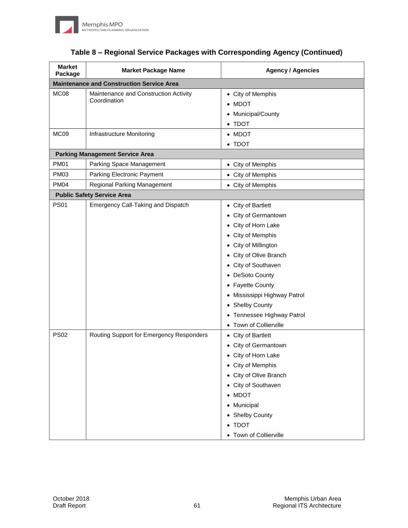
October 2018 Memphis Urban Area Draft Report 61 Regional ITS Architecture
Table 8 – Regional Service Packages with Corresponding Agency (Continued)
Market Package
Market Package Name Agency / Agencies
Maintenance and Construction Service Area
MC08 Maintenance and Construction Activity Coordination
• City of Memphis
• MDOT
• Municipal/County
• TDOT
MC09 Infrastructure Monitoring • MDOT
• TDOT
Parking Management Service Area
PM01 Parking Space Management • City of Memphis
PM03 Parking Electronic Payment • City of Memphis
PM04 Regional Parking Management • City of Memphis
Public Safety Service Area
PS01 Emergency Call-Taking and Dispatch • City of Bartlett
• City of Germantown
• City of Horn Lake
• City of Memphis
• City of Millington
• City of Olive Branch
• City of Southaven
• DeSoto County
• Fayette County
• Mississippi Highway Patrol
• Shelby County
• Tennessee Highway Patrol
• Town of Collierville
PS02 Routing Support for Emergency Responders • City of Bartlett
• City of Germantown
• City of Horn Lake
• City of Memphis
• City of Olive Branch
• City of Southaven
• MDOT
• Municipal
• Shelby County
• TDOT
• Town of Collierville
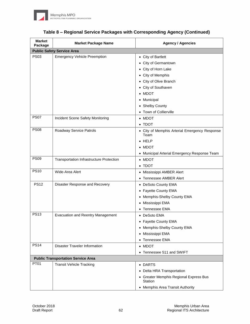
October 2018 Memphis Urban Area Draft Report 62 Regional ITS Architecture
Table 8 – Regional Service Packages with Corresponding Agency (Continued)
Market Package
Market Package Name Agency / Agencies
Public Safety Service Area
PS03 Emergency Vehicle Preemption • City of Bartlett
• City of Germantown
• City of Horn Lake
• City of Memphis
• City of Olive Branch
• City of Southaven
• MDOT
• Municipal
• Shelby County
• Town of Collierville
PS07 Incident Scene Safety Monitoring • MDOT
• TDOT
PS08 Roadway Service Patrols • City of Memphis Arterial Emergency Response Team
• HELP
• MDOT
• Municipal Arterial Emergency Response Team
PS09 Transportation Infrastructure Protection • MDOT
• TDOT
PS10 Wide-Area Alert • Mississippi AMBER Alert
• Tennessee AMBER Alert
PS12 Disaster Response and Recovery • DeSoto County EMA
• Fayette County EMA
• Memphis-Shelby County EMA
• Mississippi EMA
• Tennessee EMA
PS13 Evacuation and Reentry Management • DeSoto EMA
• Fayette County EMA
• Memphis-Shelby County EMA
• Mississippi EMA
• Tennessee EMA
PS14 Disaster Traveler Information • MDOT
• Tennessee 511 and SWIFT
Public Transportation Service Area
PT01 Transit Vehicle Tracking • DARTS
• Delta HRA Transportation
• Greater Memphis Regional Express Bus Station
• Memphis Area Transit Authority
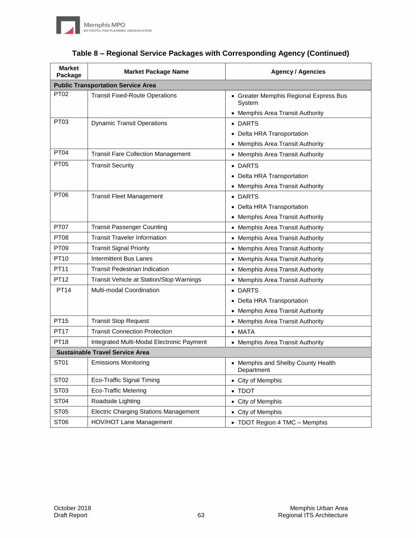
October 2018 Memphis Urban Area Draft Report 63 Regional ITS Architecture
Table 8 – Regional Service Packages with Corresponding Agency (Continued)
Market Package
Market Package Name Agency / Agencies
Public Transportation Service Area
PT02 Transit Fixed-Route Operations • Greater Memphis Regional Express Bus System
• Memphis Area Transit Authority
PT03 Dynamic Transit Operations • DARTS
• Delta HRA Transportation
• Memphis Area Transit Authority
PT04 Transit Fare Collection Management • Memphis Area Transit Authority
PT05 Transit Security • DARTS
• Delta HRA Transportation
• Memphis Area Transit Authority
PT06 Transit Fleet Management • DARTS
• Delta HRA Transportation
• Memphis Area Transit Authority
PT07 Transit Passenger Counting • Memphis Area Transit Authority
PT08 Transit Traveler Information • Memphis Area Transit Authority
PT09 Transit Signal Priority • Memphis Area Transit Authority
PT10 Intermittent Bus Lanes • Memphis Area Transit Authority
PT11 Transit Pedestrian Indication • Memphis Area Transit Authority
PT12 Transit Vehicle at Station/Stop Warnings • Memphis Area Transit Authority
PT14 Multi-modal Coordination • DARTS
• Delta HRA Transportation
• Memphis Area Transit Authority
PT15 Transit Stop Request • Memphis Area Transit Authority
PT17 Transit Connection Protection • MATA
PT18 Integrated Multi-Modal Electronic Payment • Memphis Area Transit Authority
Sustainable Travel Service Area
ST01 Emissions Monitoring • Memphis and Shelby County Health Department
ST02 Eco-Traffic Signal Timing • City of Memphis
ST03 Eco-Traffic Metering • TDOT
ST04 Roadside Lighting • City of Memphis
ST05 Electric Charging Stations Management • City of Memphis
ST06 HOV/HOT Lane Management • TDOT Region 4 TMC – Memphis

October 2018 Memphis Urban Area Draft Report 64 Regional ITS Architecture
Table 8 – Regional Service Packages with Corresponding Agency (Continued)
Market Package
Market Package Name Agency / Agencies
Traveler Information Service Area
TI01 Broadcast Traveler Information • City of Bartlett
• City of Germantown
• City of Memphis
• City of Millington
• City of Olive Branch
• MDOT
• SWIFT
• Town of Collierville
TI02 Personalized Traveler Information • City of Bartlett
• City of Germantown
• City of Millington
• City of Olive Branch
• City of Southaven
• MDOTtraffic
• Tennessee 511
• Town of Collierville
Traffic Management Service Area
TM01 Infrastructure-Based Traffic Surveillance • City of Bartlett
• City of Germantown
• City of Horn Lake
• City of Memphis
• City of Millington
• City of Olive Branch
• City of Southaven
• MDOT Northwest Regional TMC
• Municipal
• Shelby County
• TDOT Region 4 TMC – Memphis
• Town of Collierville

October 2018 Memphis Urban Area Draft Report 65 Regional ITS Architecture
Table 8 – Regional Service Packages with Corresponding Agency (Continued)
Market Package
Market Package Name Agency / Agencies
Traffic Management Service Area
TM02 Vehicle-Based Traffic Surveillance • City of Bartlett
• City of Germantown
• City of Horn Lake
• City of Memphis
• City of Millington
• City of Olive Branch
• City of Southaven
• MDOT Northwest Regional TMC
• Municipal
• Shelby County
• TDOT
• TDOT Region 4 TMC – Memphis
• Town of Collierville
TM03 Traffic Signal Control • City of Bartlett
• City of Germantown
• City of Horn Lake
• City of Memphis
• City of Millington
• City of Olive Branch
• City of Southaven
• MDOT
• Municipal
• Shelby County
• Town of Collierville
TM04 Connected Vehicle Traffic Signal System • City of Bartlett
• City of Germantown
• City of Horn Lake
• City of Memphis
• City of Millington
• City of Olive Branch
• City of Southaven
• MDOT Northwest Regional TMC
• Municipal
• Shelby County
• Town of Collierville
TM05 Traffic Metering • TDOT Region 4 TMC - Memphis
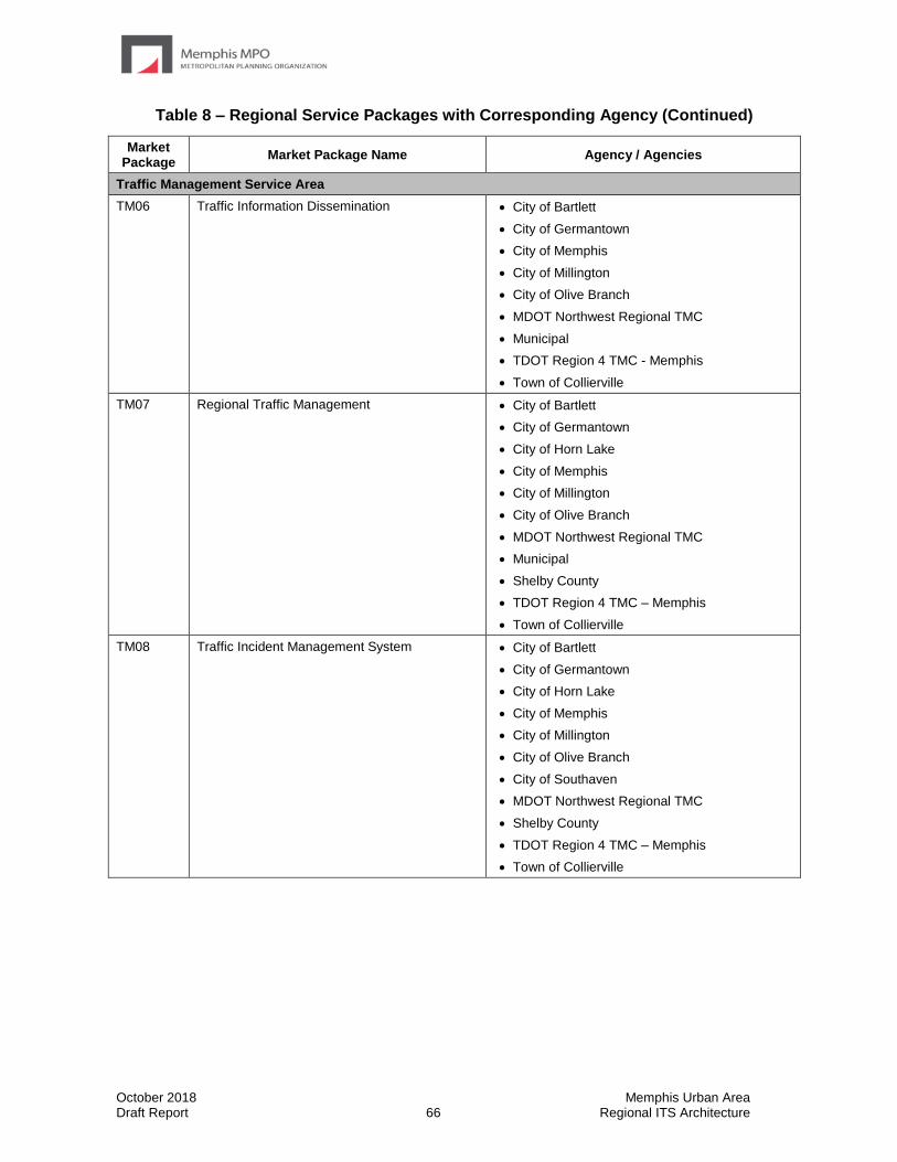
October 2018 Memphis Urban Area Draft Report 66 Regional ITS Architecture
Table 8 – Regional Service Packages with Corresponding Agency (Continued)
Market Package
Market Package Name Agency / Agencies
Traffic Management Service Area
TM06 Traffic Information Dissemination • City of Bartlett
• City of Germantown
• City of Memphis
• City of Millington
• City of Olive Branch
• MDOT Northwest Regional TMC
• Municipal
• TDOT Region 4 TMC - Memphis
• Town of Collierville
TM07 Regional Traffic Management • City of Bartlett
• City of Germantown
• City of Horn Lake
• City of Memphis
• City of Millington
• City of Olive Branch
• MDOT Northwest Regional TMC
• Municipal
• Shelby County
• TDOT Region 4 TMC – Memphis
• Town of Collierville
TM08 Traffic Incident Management System • City of Bartlett
• City of Germantown
• City of Horn Lake
• City of Memphis
• City of Millington
• City of Olive Branch
• City of Southaven
• MDOT Northwest Regional TMC
• Shelby County
• TDOT Region 4 TMC – Memphis
• Town of Collierville

October 2018 Memphis Urban Area Draft Report 67 Regional ITS Architecture
Table 8 – Regional Service Packages with Corresponding Agency (Continued)
Market Package
Market Package Name Agency / Agencies
Traffic Management Service Area
TM13 Standard Railroad Grade Crossing • City of Bartlett
• City of Germantown
• City of Horn Lake
• City of Memphis
• City of Millington
• City of Olive Branch
• MDOT and City of Southaven
• Municipal
• Town of Collierville
TM17 Speed Warning and Enforcement • City of Bartlett
• City of Germantown
• City of Memphis
• City of Millington
• Town of Collierville
TM20 Variable Speed Limits • City of Memphis
• MDOT
• TDOT
TM21 Speed Harmonization • City of Memphis
• MDOT
• TDOT
TM22 Dynamic Lane Management and Shoulder Use • City of Memphis
• MDOT
• TDOT Region 4
Vehicle Safety Service Area
VS05 Curve Speed Warning • City of Bartlett
• City of Germantown
• City of Horn Lake
• City of Memphis
• City of Millington
• City of Olive Branch
• City of Southaven
• MDOT
• Municipal
• Shelby County
• TDOT
• Town of Collierville
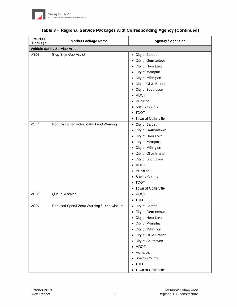
October 2018 Memphis Urban Area Draft Report 68 Regional ITS Architecture
Table 8 – Regional Service Packages with Corresponding Agency (Continued)
Market Package
Market Package Name Agency / Agencies
Vehicle Safety Service Area
VS06 Stop Sign Gap Assist • City of Bartlett
• City of Germantown
• City of Horn Lake
• City of Memphis
• City of Millington
• City of Olive Branch
• City of Southaven
• MDOT
• Municipal
• Shelby County
• TDOT
• Town of Collierville
VS07 Road Weather Motorist Alert and Warning • City of Bartlett
• City of Germantown
• City of Horn Lake
• City of Memphis
• City of Millington
• City of Olive Branch
• City of Southaven
• MDOT
• Municipal
• Shelby County
• TDOT
• Town of Collierville
VS08 Queue Warning • MDOT
• TDOT
VS09 Reduced Speed Zone Warning / Lane Closure • City of Bartlett
• City of Germantown
• City of Horn Lake
• City of Memphis
• City of Millington
• City of Olive Branch
• City of Southaven
• MDOT
• Municipal
• Shelby County
• TDOT
• Town of Collierville

October 2018 Memphis Urban Area Draft Report 69 Regional ITS Architecture
Table 8 – Regional Service Packages with Corresponding Agency (Continued)
Market Package
Market Package Name Agency / Agencies
Vehicle Safety Service Area
VS10 Restricted Lane Warnings • City of Memphis
• MDOT
• TDOT
VS11 Oversize Vehicle Warning • MDOT
• TDOT
VS12 Pedestrian and Cyclist Safety • City of Bartlett
• City of Germantown
• City of Horn Lake
• City of Memphis
• City of Millington
• City of Olive Branch
• City of Southaven
• MDOT
• Municipal
• Shelby County
• Town of Collierville
VS13 Intersection Safety Warning and Collision Avoidance
• City of Bartlett
• City of Germantown
• City of Horn Lake
• City of Memphis
• City of Millington
• City of Olive Branch
• MDOT
• Municipal
• Shelby County
• TDOT
• Town of Collierville
VS15 Infrastructure Enhanced Cooperative Adaptive Cruise Control
• MDOT
• TDOT
VS16 Automated Vehicle Operations • MDOT
• TDOT
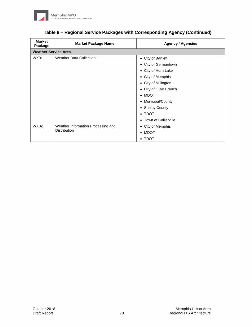
October 2018 Memphis Urban Area Draft Report 70 Regional ITS Architecture
Table 8 – Regional Service Packages with Corresponding Agency (Continued)
Market Package
Market Package Name Agency / Agencies
Weather Service Area
WX01 Weather Data Collection • City of Bartlett
• City of Germantown
• City of Horn Lake
• City of Memphis
• City of Millington
• City of Olive Branch
• MDOT
• Municipal/County
• Shelby County
• TDOT
• Town of Collierville
WX02 Weather Information Processing and Distribution
• City of Memphis
• MDOT
• TDOT
October 2018 Memphis Urban Area Draft Report 71 Regional ITS Architecture
5.1.4 Regional Needs and Corresponding Service Packages
Input received from stakeholders at the Memphis Urban Area Regional ITS Architecture workshops provided valuable input for the service package customization process. The needs identified in the ITS Architecture workshops, as well as needs from the Memphis Urban Area Livability 2040 Regional Transportation Plan are identified in Table 9. The table also identifies which service package documents the particular ITS need.
One fifth of the United States population consists of people with disabilities of various kinds, necessitating innovation travel options and ITS solutions. It is worth noting that several of the service packages in this Regional ITS Architecture are equipped to meet the accessibility needs of people with disabilities. For example, Service Package VS 12 Pedestrian and Cyclist Safety addresses the sensing and warning systems to give ample crossing time to non-motorized travelers with disabilities or inform them when to cross and how to stay aligned with crosswalks or pathways.

October 2018 Memphis Urban Area Draft Report 72 Regional ITS Architecture
Table 9 – Memphis Regional ITS Needs and Corresponding Service Packages
ITS Need Service Package
Traffic Management Needs
Need improved capability to share real-time traffic conditions between transportation agencies (including state departments of transportation, county and municipal transportation agencies, and regional transit agencies).
TM06 Traffic Information Dissemination
TM07 Regional Traffic Management
Need to consider deployment of additional active traffic management strategies in Tennessee like variable speed limits, queue detection, and ramp metering.
TM05 Traffic Metering
TM20 Variable Speed Limits
TM22 Dynamic Lane Management and Shoulder Use
VS05 Curve Speed Warning
VS08 Queue Warning
VS10 Restricted Lane Warnings
Need to complete expansion of the freeway management system in Tennessee and Mississippi.
PS08 Roadway Service Patrols
TM01 Infrastructure-Based Traffic Surveillance
TM02 Vehicle-Based Traffic Surveillance
TM07 Regional Traffic Management
TM08 Traffic Incident Management Systems
TM22 Dynamic Lane Management and Shoulder Use
Need to complete the implementation of the CMAQ arterial ITS program in Shelby County.
TM03 Traffic Signal Control
TM04 Connected Vehicle Traffic Signal System
TM07 Regional Traffic Management
Need to continually improve the traffic incident management systems to clear roadway faster and decrease system recovery time from major incidents.
PS08 Roadway Service Patrols
PS12 Disaster Response and Recovery
PS13 Evacuation and Reentry Management
PS14 Disaster Traveler Information
TM07 Regional Traffic Management
TM08 Traffic Incident Management Systems
TM08 Traffic Incident Management System
Commercial Vehicle Operations Needs
Need to expand CVO electronic clearance system into Tennessee and Mississippi.
CVO03 Electronic Clearance
CVO08 Smart Roadside and Virtual WIM
Traveler Information Needs
Need to improve capability to disseminate accurate and timely traveler information out to the public.
PS14 Disaster Traveler Information
PT08 Transit Traveler Information
TM01 Infrastructure-Based Traffic Surveillance
TM02 Vehicle-Based Traffic Surveillance
TM06 Traffic Information Dissemination
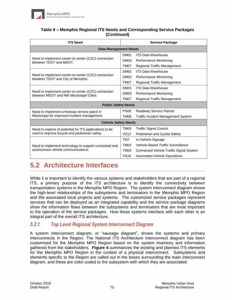
October 2018 Memphis Urban Area Draft Report 73 Regional ITS Architecture
Table 9 – Memphis Regional ITS Needs and Corresponding Service Packages (Continued)
ITS Need Service Package
Data Management Needs
Need to implement center-to-center (C2C) connection between TDOT and MDOT.
DM01 ITS Data Warehouse
DM02 Performance Monitoring
TM07 Regional Traffic Management
Need to implement center-to-center (C2C) connection between TDOT and City of Memphis.
DM01 ITS Data Warehouse
DM02 Performance Monitoring
TM07 Regional Traffic Management
Need to implement center-to-center (C2C) connection between MDOT and NW Mississippi Cities.
DM01 ITS Data Warehouse
DM02 Performance Monitoring
TM07 Regional Traffic Management
Public Safety Needs
Need to implement a freeway service patrol in Mississippi for improved incident management.
PS08 Roadway Service Patrols
TM08 Traffic Incident Management System
Vehicle Safety Needs
Need to explore of potential for ITS applications to be used to improve bicycle and pedestrian safety.
TM03 Traffic Signal Control
VS12 Pedestrian and Cyclist Safety
Need to implement technology to support connected and autonomous vehicle communications.
TI07 In-Vehicle Signage
TM02 Vehicle-Based Traffic Surveillance
TM04 Connected Vehicle Traffic Signal System
VS16 Automated Vehicle Operations
5.2 Architecture Interfaces
While it is important to identify the various systems and stakeholders that are part of a regional ITS, a primary purpose of the ITS architecture is to identify the connectivity between transportation systems in the Memphis MPO Region. The system interconnect diagram shows the high-level relationships of the subsystems and terminators in the Memphis MPO Region and the associated local projects and systems. The customized service packages represent services that can be deployed as an integrated capability and the service package diagrams show the information flows between the subsystems and terminators that are most important to the operation of the service packages. How these systems interface with each other is an integral part of the overall ITS architecture.
5.2.1 Top Level Regional System Interconnect Diagram
A system interconnect diagram, or “sausage diagram”, shows the systems and primary interconnects in the Region. The National ITS Architecture interconnect diagram has been customized for the Memphis MPO Region based on the system inventory and information gathered from the stakeholders. Figure 4 summarizes the existing and planned ITS elements for the Memphis MPO Region in the context of a physical interconnect. Subsystems and elements specific to the Region are called out in the boxes surrounding the main interconnect diagram, and these are color-coded to the subsystem with which they are associated.
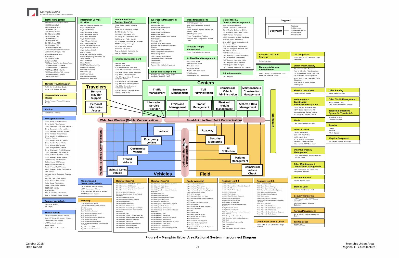
October 2018 Memphis Urban Area Draft Report 74 Regional ITS Architecture
Traveler
Traveler
Pedestrian
Vehicle Operator
Commercial Vehicle Check
MDOT Office of Law Enforcement Weigh-
in-Motion
Traffic Management
ARDOT Crittenden County Local TOC
ARDOT District 1 TMC
ARDOT Statewide TMC
City of Bartlett TOC
Town of Collierville TOC
City of Germantown TOC
City of Horn Lake TOC
City of Memphis TOC
City of Millington TOC
City of Olive Branch TOC
City of Southaven TOC
City of West Memphis TOC
MDOT Emergency Services Coordinator
MDOT Northwest Regional TMC
Mississippi Statewide TMC
Municipal TOC
Rail Operations Center
Shelby County TOC
TDOT Long Range Planning Division Archive
TDOT Region 1 TMC – Knoxville
TDOT Region 2 TMC – Chattanooga
TDOT Region 3 TMC – Nashville
TDOT Region 4 Backup TMC – Jackson
TDOT Region 4 TMC – Memphis
Town of Collierville TOC
Emergency Management
Arkansas DEM
Arkansas State Police
City of Bartlett Police Department
Town of Collierville Police Department
City of Germantown Police Department
City of Horn Lake 911 Dispatch
City of Memphis Arterial Emergency
Response Dispatch
City of Memphis Police Department
City of Millington Police Department
City of Olive Branch Emergency
Communications Center
City of Southaven Police Department
DeSoto County E-911
Transit Management
DARTS Dispatch Center
Delta HRA Transportation Dispatch
Center
Greater Memphis Regional Express Bus
Dispatch Center
MATA Dispatch Center
Private Transportation Providers
Southwest HRA Transportation Dispatch
Center
Maintenance & Construction Management
ARDOT District Maintenance
Arkansas TSIS/IDrive Arkansas.com
City of Memphis Engineering Division
City of Memphis Public Works Division
MDOT District 2 Maintenance
MDOT Emergency Services Coordinator
Municipal/County Maintenance
Other MDOT District Construction and
Maintenance Offices
Other Municipal/County Maintenance
Other TDOT Region Construction and
Maintenance Offices
TDOT District Maintenance
TDOT Emergency Services Coordinator
TDOT Maintenance Headquarters
TDOT Region 4 Construction Office
TDOT Region 4 District Operations
TDOT Region 4 TMC - Memphis
TDOT Statewide Information For Travelers
Information Service Provider
Arkansas TSIS/IDrive Arkansas.com
City of Bartlett Notify Me
City of Bartlett Website
City of Germantown eNotices
City of Germantown Website
City of Horn Lake Website
City of Memphis Website
City of Millington Notify Me
City of Millington Website
City of Olive Branch CodeRED
City of Olive Branch Website
City of Southaven Notify Me
DARTS Website
Delta HRA Transportation Website
Greater Memphis Regional Express Bus System Website
MATA Mobile App
MATA Website
MDOT Public Information Office
Memphis MPO Website
Mississippi 511 System
MDOTtraffic App
MDOTtraffic Website
Municipal/County Website
Private Probe Data Provider
Archived Data Management
DARTS Data Archive
Delta HRA Data Archive
MATA Data Archive
MDOT Data Archive
Memphis MPO Data Archive
TITAN Database
West Memphis MPO Data Archive
Transit Vehicle
DARTS Demand Response Vehicles
Delta HRA Demand Response Vehicles
MATA Fixed Route Vehicles
MATA Paratransit Vehicles
MATA Trolleys
Regional Express Bus Vehicles
Maintenance & Construction Vehicle
City of Memphis Service Vehicles
MDOT Maintenance Vehicles
Municipal/County Maintenance Vehicles
TDOT Maintenance Vehicles
Remote Traveler Support
MATA Bus Arrival Status Boards
MATA Ticket Vending Machines
Personal Information Device
Private Travelers Personal Computing
Devices
Archived Data User Systems
Archive Data User
Regional
Architecture
Elements Map To
National ITS
Architecture
Subsystem
Legend
Emergency Vehicle
City of Bartlett Fire/EMS Vehicles
City of Bartlett Police Vehicles
City of Germantown Fire /EMS Vehicles
City of Germantown Police Vehicles
City of Horn Lake Fire/EMS Vehicles
City of Horn Lake Police Vehicles
City of Memphis Arterial Emergency
Response Vehicles
City of Memphis Fire/EMS Vehicles
City of Memphis Police Vehicles
City of Millington Fire Vehicles
City of Millington Police Vehicles
City of Olive Branch Fire/EMS Vehicles
City of Olive Branch Police Vehicles
City of Southaven Fire/EMS Vehicles
City of Southaven Police Vehicles
DeSoto County Sheriff Vehicles
DeSoto County EMS Vehicles
Fayette County EMS Vehicles
Fayette County Sheriff Vehicles
MDOT Roadway Service Patrol Vehicles
MHP Vehicles
Municipal Arterial Emergency Response
Vehicles
Municipal Public Safety Vehicles
Private Contract EMS Vehicles
Shelby County Fire Vehicles
Shelby County Sheriff Vehicles
TDOT HELP Vehicles
THP Vehicles
Town of Collierville Fire Vehicles
Town of Collierville Police Vehicles
Fleet and Freight Management
Private Fleet Management Systems
Weather Service
National Weather Service
Maintenance & Construction Administrative SystemsCity of Memphis Engineer’s Office
MDOT District 2 Engineer’s Office
Municipal/County Engineer’s Office
TDOT Region 4 Engineer’s Office
Other Traffic Management
AHTD Statewide TMC
Other Traffic Management Agencies
Other Maintenance & Construction Management
Other Maintenance and Construction
Management Agencies
Wayside Equipment
Rail Operator Wayside Equipment
Telecommunications System for Traveler Info
Mississippi 511 IVR
Tennessee 511 IVR
Traveler Card
Electronic Fare Payment Card
RoadwayCity of Bartlett CCTV Cameras
City of Bartlett Connected Vehicle Roadside Equipment
City of Bartlett DMS
City of Bartlett Field Sensors
City of Bartlett Rail Notification System
City of Bartlett RWIS Sensors
City of Bartlett Speed Monitoring Equipment
City of Bartlett Traffic Signals
City of Germantown CCTV Cameras
City of Germantown Connected Vehicle Roadside Equipment
City of Germantown DMS
City of Germantown Field Sensors
Enforcement Agency
City of Bartlett Police Department
Town of Collierville Police Department
City of Germantown Police Department
City of Memphis Police Department
MDOT Office of Law Enforcement CVO
Enforcement
Municipal Public Safety Dispatch
THP Dispatch
Travelers
Vehicles Field
CentersMaintenance &
Construction
Management
Archived Data
Management
Personal
Information
Access
Commercial
Vehicle
Administration
Toll
Administration
Emergency
Management
Fleet and
Freight
Management
Transit
Management
Emissions
Management
Remote
Traveler
Support
Wide Area Wireless (Mobile) Communications
Information
Service
Provider
Traffic
Management
Commercial
Vehicle
Vehicle
Transit
Vehicle
De
dic
ate
d S
ho
rt R
an
ge
Co
mm
un
icati
on
s
Toll
Collection
Commercial
Vehicle
Check
Roadway
Parking
Management
Security
Monitoring
Te
rmin
ato
rs
Fixed-Point to Fixed-Point Communications
Ve
hic
le t
o V
eh
icle
Co
mm
un
icati
on
s
Maint & Const
Vehicle
Emergency
Vehicle
Parking Management
City of Memphis Parking Management
System
Security Monitoring
MATA Transit Facility CCTV Camera
Surveillance
TDOT Infrastructure Monitoring
Equipment
Toll Administration
TDOT Region 4
Toll Collection
TDOT Toll Plazas
Vehicle
Public/Private Vehicles
Information Service Provider (cont’d)
Private Sector Traveler Information
Services
Private Transit Information Provider
Social Networking Services
TDOT Public Information Office
TDOT Region 4 Construction Office
TDOT Region 4 TMC – Memphis
TDOT Statewide Information For Travelers
TDOT SmartWay Mobile App
TDOT SmartWay Website
Tennessee 511 System
Town of Collierville Alert Collierville
Town of Collierville Website
Emergency Management (cont’d)
DeSoto County EMA
DeSoto County EMS Dispatch
Fayette County EMA
Fayette County EMS Dispatch
Fayette County Sheriff
MDOT Roadway Service Patrol Dispatch
MHP Dispatch
Mississippi EMA
Municipal Public Safety Dispatch
Municipal Arterial Emergency Response Dispatch
Shelby County Fire Department
Shelby County Office of Preparedness
Shelby County Sheriff
TDOT Region 4 HELP Dispatch
Tennessee Bureau of Investigation
Tennessee EMA
THP Dispatch
Town of Collierville Police Department
Roadway (cont’d)City of Germantown Rail Notification System
City of Germantown RWIS Sensors
City of Germantown Speed Monitoring Equipment
City of Germantown Traffic Signals
City of Horn Lake CCTV Cameras
City of Horn Lake Connected Vehicle Roadside Equipment
City of Horn Lake Field Sensors
City of Horn Lake Rail Notification System
City of Horn Lake RWIS
City of Horn Lake Traffic Signals
City of Memphis CCTV Cameras
City of Memphis Changeable Speed Limit Signs
City of Horn Lake Connected Vehicle Roadside Equipment
City of Memphis DMS
City of Memphis Dynamic Lane Assignment Sign
City of Memphis Electric Vehicle Charging Station
City of Memphis Variable LED Streetlights
City of Memphis Field Sensors
City of Memphis Pedestrian Hybrid Beacons
City of Memphis Police Portable DMS
City of Memphis Rail Notification System
Roadway (cont’d)Municipal CCTV Cameras
Municipal Connected Vehicle Roadside Equipment
Municipal Field Sensors
Municipal Rail Notification System
Municipal RWIS Sensors
Municipal Traffic Signals
Municipal Speed Monitoring Equipment
Municipal/County Portable DMS
Municipal/County RWIS Sensors
Shelby County CCTV Cameras
Shelby County Connected Vehicle Roadside Equipment
Shelby County Field Sensors
Shelby County Traffic Signals
TDOT Automated Roadway Treatment Equipment
TDOT CCTV Cameras
TDOT Changeable Speed Limit Signs
TDOT Connected Vehicle Roadside Equipment
TDOT DMS
TDOT Dynamic Lane Assignment Sign
TDOT Field Sensors
TDOT HAR
TDOT Infrastructure Monitoring Equipment
Media
Local Print and Broadcast Media
Emissions Management
Memphis and Shelby County Health
Department Pollution Control
Commercial Vehicle
Commercial Vehicles
Rail Freight
Financial Institution
Financial Service Provider
Other Archives
DARTS Data Archive
Delta HRA Data Archive
MATA Data Archive
TDOT Strategic Transportation
Investments Division Archive
West Memphis MPO Data Archive
Roadway (cont’d)City of Southaven Field Sensors
City of Southaven RWIS Sensors
City of Southaven Rail Notification System
City of Southaven Speed Monitoring Equipment
City of Southaven Traffic Signals
MDOT CCTV Cameras
MDOT Changeable Speed Limit Signs
MDOT Connected Vehicle Roadside Equipment
MDOT DMS
MDOT Dynamic Lane Assignment Sign
MDOT Field Sensors
MDOT Infrastructure Monitoring Equipment
MDOT Lane Control DMS
MDOT HAR
MDOT Portable DMS
MDOT Queue Detection System
MDOT Oversize Vehicle Detection
MDOT RWIS Sensors
MDOT Smart Work Zone Equipment
MDOT Speed Monitoring Equipment
MDOT Traffic Signals
Memphis and Shelby County Health Department Emissions Sensors
Other Emergency Management
City of West Memphis Police Department
US Coast Guard
Other Parking
Private Parking Facilities
Commercial Vehicle Administration
MDOT Office of Law Enforcement Truck
Weight and Inspection Station
CVO Inspector
MDOT Office of Law Enforcement CVO
Enforcement
Roadway (cont’d)City of Memphis Speed Monitoring Equipment
City of Memphis Traffic Signals
City of Millington CCTV Cameras
City of Millington Connected Vehicle Roadside Equipment
City of Millington DMS
City of Millington Field Sensors
City of Millington Rail Notification System
City of Millington RWIS Sensors
City of Memphis RWIS Sensors
City of Millington Speed Monitoring Equipment
City of Millington Traffic Signals
City of Olive Branch CCTV Cameras
City of Olive Branch Connected Vehicle Roadside Equipment
City of Olive Branch DMS
City of Olive Branch Field Sensors
City of Olive Branch Rail Notification System
City of Olive Branch RWIS Sensors
City of Olive Branch Speed Monitoring Equipment
City of Olive Branch Traffic Signals
City of Southaven CCTV Cameras
City of Southaven Connected Vehicle Roadside Equipment
Roadway (cont’d)TDOT Lane Control DMS
TDOT Ramp Metering Equipment
TDOT Ramp Queue Detection System
TDOT Region 4 Smart Work Zone Equipment
TDOT Oversize Vehicle Detection
TDOT Speed Monitoring Equipment
TDOT RWIS Sensors
Town of Collierville CCTV Cameras
Town of Collierville Connected Vehicle Roadside Equipment
Town of Collierville DMS
Town of Collierville Field Sensors
Town of Collierville Rail Notification System
Town of Collierville RWIS Sensors
Town of Collierville Speed Monitoring Equipment
Town of Collierville Traffic Signals
Figure 4 – Memphis Urban Area Regional System Interconnect Diagram
October 2018 Memphis Urban Area Draft Report 75 Regional ITS Architecture
5.2.2 Data Flows Between Elements
In the service package diagrams, flows between the subsystems and terminators define the specific information (data) that is exchanged between the elements and the direction of the exchange. The data flows could be requests for information, alerts and messages, status requests, broadcast advisories, event messages, confirmations, electronic credentials, and other key information requirements.
An example of a context diagram that has been filtered for City of Memphis Field Sensors is shown in Figure 5.
Figure 5 – Example Context Diagram: City of Memphis Field Sensors
Context diagrams show the data flows between elements of the architecture. For example, Figure 5 shows a planned connection between the field sensor and a CCTV camera. This connection could enable a CCTV camera to automatically pan to focus on heavy, incident-related traffic detected by the field sensor. Similarly, the planned connection between the field sensor and the DMS could allow vehicle speeds detected by field sensors to be displayed on the DMS.
The context diagrams that were customized for the Memphis MPO Region are provided in the online interactive RAD-IT database at www.memphismpo.org/plans/safety-mobility/its. To access these diagrams, from the website select the “Interactive Architecture”, then select the “Services” page, then click the desired Interfacing Element Name. The “Diagram” link will display the context diagram for that element.

October 2018 Memphis Urban Area Draft Report 76 Regional ITS Architecture
5.3 Functional Requirements
Functions are a description of what the system has to do. In the National ITS Architecture, functions are defined at several different levels, ranging from general subsystem descriptions through somewhat more specific equipment package descriptions to Process Specifications that include substantial detail. Guidance from the USDOT on developing a Regional ITS Architecture recommends that each Region determine the level of detail of the functional requirements for their Region. In the Memphis MPO Region, it is recommended that the development of detailed functional requirements such as the “shall” statements included in process specifications for a system be developed at the project level. These detailed “shall” statements identify all functions that a project or system needs to perform.
For the Memphis Urban Area Regional ITS Architecture, functional requirements have been identified at two levels. The customized service packages, discussed previously in Section 5.1.3, describe the services that ITS needs to provide in the Region and the architecture flows between the elements. These service packages and data flows describe what ITS in the Memphis MPO Region has to do and the data that needs to be shared among elements.
At a more detailed level, functional requirements for the Memphis MPO Region are described in terms of functions that each element in the architecture performs or will perform in the future. Appendix B contains a table that summarizes the functions by element excluding terminators.

October 2018 Memphis Urban Area Draft Report 77 Regional ITS Architecture
5.4 Standards
Standards are an important tool that will allow efficient implementation of the elements in the Memphis Urban Area Regional ITS Architecture over time. Standards facilitate deployment of interoperable systems at local, regional, and national levels without impeding innovation as technology advances, vendors change, and as new approaches evolve. The USDOT’s ITS Joint Program Office is supporting Standards Development Organizations (SDOs) with an extensive, multi-year program of accelerated, consensus-based standards development to facilitate successful ITS deployment in the United States. Table 10 identifies each of the ITS standards that could apply to the Memphis Urban Area Regional ITS Architecture. These standards are based on the physical subsystem architecture flows previously identified in Section 5.2.2.
While Table 10 does not match the standards to specific architecture flows, that information is available through the National ITS Reference Architecture website. Since the website is updated more frequently than the software and links directly to additional information about the applicable standard, the website is the preferred method for determining which standards apply to a particular architecture flow. To locate this information, do the following:
• Go to the main page of the National Architecture website at http://www.arc-it.net/;
• Select the information flows link embedded in the second sub-bullet about Views beneath the first bulleted item, which describes the Architecture menu bar drop-down;
• From the alphabetical list of flows that appears locate and select the desired flow;
• Architecture flows are often used between multiple subsystems so scrolling may be required to find the appropriate information associated with the particular use of the flow, in the descriptive information any applicable standards will be identified; and
• For additional information on the applicable standards the information flow name is a link that when selected leads to a more detailed description of the standards. The Communication Diagrams tab contains a graphic with applicable standards for the communication solution that satisfies the information flow.
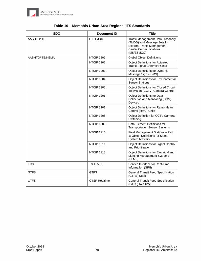
October 2018 Memphis Urban Area Draft Report 78 Regional ITS Architecture
Table 10 – Memphis Urban Area Regional ITS Standards
SDO Document ID Title
AASHTO/ITE ITE TMDD Traffic Management Data Dictionary (TMDD) and Message Sets for External Traffic Management Center Communications (MS/ETMCC)
AASHTO/ITE/NEMA NTCIP 1201 Global Object Definitions
NTCIP 1202 Object Definitions for Actuated Traffic Signal Controller Units
NTCIP 1203 Object Definitions for Dynamic Message Signs (DMS)
NTCIP 1204 Object Definitions for Environmental Sensor Stations
NTCIP 1205 Object Definitions for Closed Circuit Television (CCTV) Camera Control
NTCIP 1206 Object Definitions for Data Collection and Monitoring (DCM) Devices
NTCIP 1207 Object Definitions for Ramp Meter Control (RMC) Units
NTCIP 1208 Object Definition for CCTV Camera Switching
NTCIP 1209 Data Element Definitions for Transportation Sensor Systems
NTCIP 1210 Field Management Stations – Part 1: Object Definitions for Signal System Masters
NTCIP 1211 Object Definitions for Signal Control and Prioritization
NTCIP 1213 Object Definitions for Electrical and Lighting Management Systems (ELMS)
ECS TS 15531 Service Interface for Real-Time Information (SIRI)
GTFS GTFS General Transit Feed Specification (GTFS) Static
GTFS GTSF-Realtime General Transit Feed Specification (GTFS) Realtime
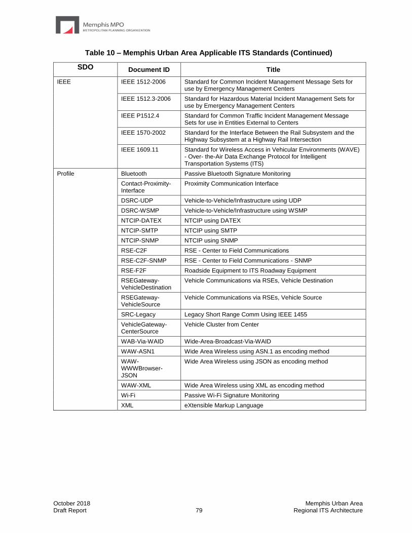
October 2018 Memphis Urban Area Draft Report 79 Regional ITS Architecture
Table 10 – Memphis Urban Area Applicable ITS Standards (Continued)
SDO Document ID Title
IEEE IEEE 1512-2006 Standard for Common Incident Management Message Sets for use by Emergency Management Centers
IEEE 1512.3-2006 Standard for Hazardous Material Incident Management Sets for use by Emergency Management Centers
IEEE P1512.4 Standard for Common Traffic Incident Management Message Sets for use in Entities External to Centers
IEEE 1570-2002 Standard for the Interface Between the Rail Subsystem and the Highway Subsystem at a Highway Rail Intersection
IEEE 1609.11 Standard for Wireless Access in Vehicular Environments (WAVE) - Over- the-Air Data Exchange Protocol for Intelligent Transportation Systems (ITS)
Profile Bluetooth Passive Bluetooth Signature Monitoring
Contact-Proximity-Interface
Proximity Communication Interface
DSRC-UDP Vehicle-to-Vehicle/Infrastructure using UDP
DSRC-WSMP Vehicle-to-Vehicle/Infrastructure using WSMP
NTCIP-DATEX NTCIP using DATEX
NTCIP-SMTP NTCIP using SMTP
NTCIP-SNMP NTCIP using SNMP
RSE-C2F RSE - Center to Field Communications
RSE-C2F-SNMP RSE - Center to Field Communications - SNMP
RSE-F2F Roadside Equipment to ITS Roadway Equipment
RSEGateway-VehicleDestination
Vehicle Communications via RSEs, Vehicle Destination
RSEGateway-VehicleSource
Vehicle Communications via RSEs, Vehicle Source
SRC-Legacy Legacy Short Range Comm Using IEEE 1455
VehicleGateway-CenterSource
Vehicle Cluster from Center
WAB-Via-WAID Wide-Area-Broadcast-Via-WAID
WAW-ASN1 Wide Area Wireless using ASN.1 as encoding method
WAW-WWWBrowser-JSON
Wide Area Wireless using JSON as encoding method
WAW-XML Wide Area Wireless using XML as encoding method
Wi-Fi Passive Wi-Fi Signature Monitoring
XML eXtensible Markup Language
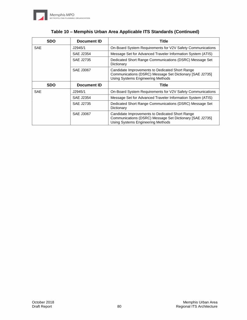
October 2018 Memphis Urban Area Draft Report 80 Regional ITS Architecture
Table 10 – Memphis Urban Area Applicable ITS Standards (Continued)
SDO Document ID Title
SAE J2945/1 On-Board System Requirements for V2V Safety Communications
SAE J2354 Message Set for Advanced Traveler Information System (ATIS)
SAE J2735 Dedicated Short Range Communications (DSRC) Message Set Dictionary
SAE J3067 Candidate Improvements to Dedicated Short Range Communications (DSRC) Message Set Dictionary [SAE J2735] Using Systems Engineering Methods
October 2018 Memphis Urban Area Draft Report 81 Regional ITS Architecture
5.5 Operational Concepts
An operational concept documents each stakeholder’s current and future roles and responsibilities across a range of transportation services, as grouped in the Operational Concepts section of Turbo Architecture, in the operation of the regional ITS. The services covered are:
• Traffic Signal Management – The development of signal systems that react to changing traffic conditions and provide coordinated intersection timing over a corridor, an area, or multiple jurisdictions.
• Traffic Metering Management – The development of systems to monitor freeway traffic flow and roadway conditions, and provide strategies such as ramp metering or lane access control to improve the flow of traffic on the freeway. Includes systems to provide information to travelers on the roadway.
• Incident Management – The development of systems to provide rapid and effective response to incidents. Includes systems to detect and verify incidents, along with coordinated agency response to the incidents.
• Emergency Management – The development of systems to provide emergency call taking, public safety dispatch, and emergency operations center operations.
• Maintenance and Construction Management – The development of systems to manage the maintenance of roadways in the Region, including winter snow and ice clearance. Also includes the management of construction operations and coordination of construction activities.
• Transit Management – The development of systems to more efficiently manage fleets of transit vehicles or transit rail. Includes systems to provide transit traveler information both pre-trip and during the trip.
• Traveler Information – The development of systems to provide static and real-time transportation information to travelers.
• Commercial Vehicle Operations – The development of systems to facilitate the management of commercial vehicles (e.g., electronic clearance).
• Archived Data Management – The development of systems to collect transportation data for use in non-operational purposes (e.g., planning and research).
Table 11 identifies the roles and responsibilities of key stakeholders for a range of transportation services.
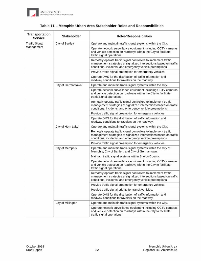
October 2018 Memphis Urban Area Draft Report 82 Regional ITS Architecture
Table 11 – Memphis Urban Area Stakeholder Roles and Responsibilities
Transportation Service
Stakeholder Roles/Responsibilities
Traffic Signal Management
City of Bartlett Operate and maintain traffic signal systems within the City.
Operate network surveillance equipment including CCTV cameras and vehicle detection on roadways within the City to facilitate traffic signal operations.
Remotely operate traffic signal controllers to implement traffic management strategies at signalized intersections based on traffic conditions, incidents, and emergency vehicle preemptions.
Provide traffic signal preemption for emergency vehicles.
Operate DMS for the distribution of traffic information and roadway conditions to travelers on the roadway.
City of Germantown Operate and maintain traffic signal systems within the City.
Operate network surveillance equipment including CCTV cameras and vehicle detection on roadways within the City to facilitate traffic signal operations.
Remotely operate traffic signal controllers to implement traffic management strategies at signalized intersections based on traffic conditions, incidents, and emergency vehicle preemptions.
Provide traffic signal preemption for emergency vehicles.
Operate DMS for the distribution of traffic information and roadway conditions to travelers on the roadway.
City of Horn Lake Operate and maintain traffic signal systems within the City.
Remotely operate traffic signal controllers to implement traffic management strategies at signalized intersections based on traffic conditions, incidents, and emergency vehicle preemptions.
Provide traffic signal preemption for emergency vehicles.
City of Memphis Operate and maintain traffic signal systems within the City of Memphis, City of Bartlett, and City of Germantown.
Maintain traffic signal systems within Shelby County.
Operate network surveillance equipment including CCTV cameras and vehicle detection on roadways within the City to facilitate traffic signal operations.
Remotely operate traffic signal controllers to implement traffic management strategies at signalized intersections based on traffic conditions, incidents, and emergency vehicle preemptions.
Provide traffic signal preemption for emergency vehicles.
Provide traffic signal priority for transit vehicles.
Operate DMS for the distribution of traffic information and roadway conditions to travelers on the roadway.
City of Millington Operate and maintain traffic signal systems within the City.
Operate network surveillance equipment including CCTV cameras and vehicle detection on roadways within the City to facilitate traffic signal operations.
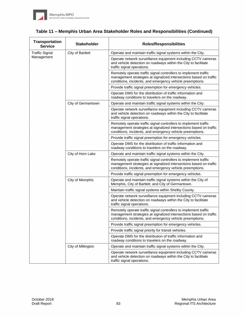
October 2018 Memphis Urban Area Draft Report 83 Regional ITS Architecture
Table 11 – Memphis Urban Area Stakeholder Roles and Responsibilities (Continued)
Transportation Service
Stakeholder Roles/Responsibilities
Traffic Signal Management
City of Bartlett Operate and maintain traffic signal systems within the City.
Operate network surveillance equipment including CCTV cameras and vehicle detection on roadways within the City to facilitate traffic signal operations.
Remotely operate traffic signal controllers to implement traffic management strategies at signalized intersections based on traffic conditions, incidents, and emergency vehicle preemptions.
Provide traffic signal preemption for emergency vehicles.
Operate DMS for the distribution of traffic information and roadway conditions to travelers on the roadway.
City of Germantown Operate and maintain traffic signal systems within the City.
Operate network surveillance equipment including CCTV cameras and vehicle detection on roadways within the City to facilitate traffic signal operations.
Remotely operate traffic signal controllers to implement traffic management strategies at signalized intersections based on traffic conditions, incidents, and emergency vehicle preemptions.
Provide traffic signal preemption for emergency vehicles.
Operate DMS for the distribution of traffic information and roadway conditions to travelers on the roadway.
City of Horn Lake Operate and maintain traffic signal systems within the City.
Remotely operate traffic signal controllers to implement traffic management strategies at signalized intersections based on traffic conditions, incidents, and emergency vehicle preemptions.
Provide traffic signal preemption for emergency vehicles.
City of Memphis Operate and maintain traffic signal systems within the City of Memphis, City of Bartlett, and City of Germantown.
Maintain traffic signal systems within Shelby County.
Operate network surveillance equipment including CCTV cameras and vehicle detection on roadways within the City to facilitate traffic signal operations.
Remotely operate traffic signal controllers to implement traffic management strategies at signalized intersections based on traffic conditions, incidents, and emergency vehicle preemptions.
Provide traffic signal preemption for emergency vehicles.
Provide traffic signal priority for transit vehicles.
Operate DMS for the distribution of traffic information and roadway conditions to travelers on the roadway.
City of Millington Operate and maintain traffic signal systems within the City.
Operate network surveillance equipment including CCTV cameras and vehicle detection on roadways within the City to facilitate traffic signal operations.
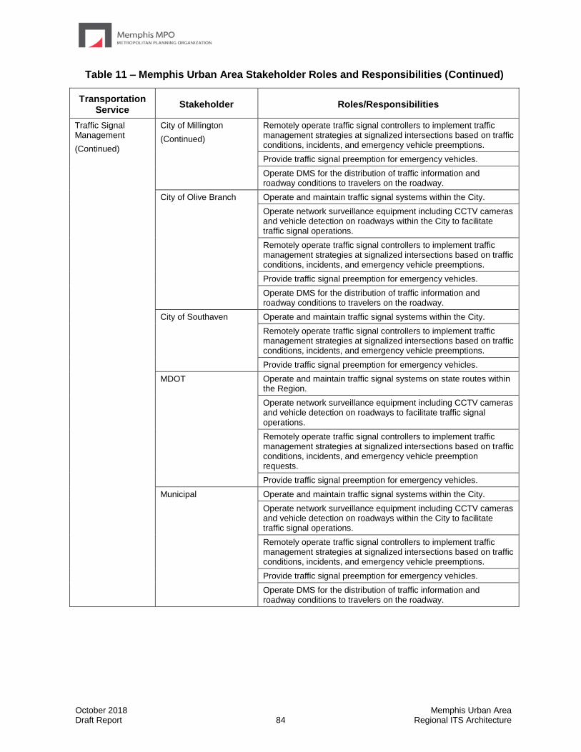
October 2018 Memphis Urban Area Draft Report 84 Regional ITS Architecture
Table 11 – Memphis Urban Area Stakeholder Roles and Responsibilities (Continued)
Transportation Service
Stakeholder Roles/Responsibilities
Traffic Signal Management
(Continued)
City of Millington
(Continued)
Remotely operate traffic signal controllers to implement traffic management strategies at signalized intersections based on traffic conditions, incidents, and emergency vehicle preemptions.
Provide traffic signal preemption for emergency vehicles.
Operate DMS for the distribution of traffic information and roadway conditions to travelers on the roadway.
City of Olive Branch Operate and maintain traffic signal systems within the City.
Operate network surveillance equipment including CCTV cameras and vehicle detection on roadways within the City to facilitate traffic signal operations.
Remotely operate traffic signal controllers to implement traffic management strategies at signalized intersections based on traffic conditions, incidents, and emergency vehicle preemptions.
Provide traffic signal preemption for emergency vehicles.
Operate DMS for the distribution of traffic information and roadway conditions to travelers on the roadway.
City of Southaven Operate and maintain traffic signal systems within the City.
Remotely operate traffic signal controllers to implement traffic management strategies at signalized intersections based on traffic conditions, incidents, and emergency vehicle preemptions.
Provide traffic signal preemption for emergency vehicles.
MDOT Operate and maintain traffic signal systems on state routes within the Region.
Operate network surveillance equipment including CCTV cameras and vehicle detection on roadways to facilitate traffic signal operations.
Remotely operate traffic signal controllers to implement traffic management strategies at signalized intersections based on traffic conditions, incidents, and emergency vehicle preemption requests.
Provide traffic signal preemption for emergency vehicles.
Municipal Operate and maintain traffic signal systems within the City.
Operate network surveillance equipment including CCTV cameras and vehicle detection on roadways within the City to facilitate traffic signal operations.
Remotely operate traffic signal controllers to implement traffic management strategies at signalized intersections based on traffic conditions, incidents, and emergency vehicle preemptions.
Provide traffic signal preemption for emergency vehicles.
Operate DMS for the distribution of traffic information and roadway conditions to travelers on the roadway.
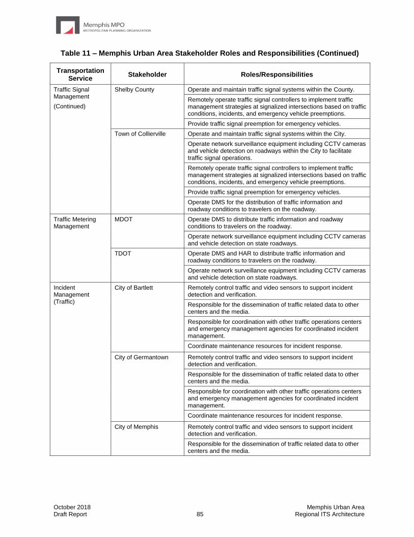
October 2018 Memphis Urban Area Draft Report 85 Regional ITS Architecture
Table 11 – Memphis Urban Area Stakeholder Roles and Responsibilities (Continued)
Transportation Service
Stakeholder Roles/Responsibilities
Traffic Signal Management
(Continued)
Shelby County Operate and maintain traffic signal systems within the County.
Remotely operate traffic signal controllers to implement traffic management strategies at signalized intersections based on traffic conditions, incidents, and emergency vehicle preemptions.
Provide traffic signal preemption for emergency vehicles.
Town of Collierville Operate and maintain traffic signal systems within the City.
Operate network surveillance equipment including CCTV cameras and vehicle detection on roadways within the City to facilitate traffic signal operations.
Remotely operate traffic signal controllers to implement traffic management strategies at signalized intersections based on traffic conditions, incidents, and emergency vehicle preemptions.
Provide traffic signal preemption for emergency vehicles.
Operate DMS for the distribution of traffic information and roadway conditions to travelers on the roadway.
Traffic Metering Management
MDOT Operate DMS to distribute traffic information and roadway conditions to travelers on the roadway.
Operate network surveillance equipment including CCTV cameras and vehicle detection on state roadways.
TDOT Operate DMS and HAR to distribute traffic information and roadway conditions to travelers on the roadway.
Operate network surveillance equipment including CCTV cameras and vehicle detection on state roadways.
Incident Management (Traffic)
City of Bartlett Remotely control traffic and video sensors to support incident detection and verification.
Responsible for the dissemination of traffic related data to other centers and the media.
Responsible for coordination with other traffic operations centers and emergency management agencies for coordinated incident management.
Coordinate maintenance resources for incident response.
City of Germantown Remotely control traffic and video sensors to support incident detection and verification.
Responsible for the dissemination of traffic related data to other centers and the media.
Responsible for coordination with other traffic operations centers and emergency management agencies for coordinated incident management.
Coordinate maintenance resources for incident response.
City of Memphis Remotely control traffic and video sensors to support incident detection and verification.
Responsible for the dissemination of traffic related data to other centers and the media.

October 2018 Memphis Urban Area Draft Report 86 Regional ITS Architecture
Table 11 – Memphis Urban Area Stakeholder Roles and Responsibilities (Continued)
Transportation Service
Stakeholder Roles/Responsibilities
Traffic Signal Management
(Continued)
Shelby County Operate and maintain traffic signal systems within the County.
Remotely operate traffic signal controllers to implement traffic management strategies at signalized intersections based on traffic conditions, incidents, and emergency vehicle preemptions.
Provide traffic signal preemption for emergency vehicles.
Town of Collierville Operate and maintain traffic signal systems within the City.
Operate network surveillance equipment including CCTV cameras and vehicle detection on roadways within the City to facilitate traffic signal operations.
Remotely operate traffic signal controllers to implement traffic management strategies at signalized intersections based on traffic conditions, incidents, and emergency vehicle preemptions.
Provide traffic signal preemption for emergency vehicles.
Operate DMS for the distribution of traffic information and roadway conditions to travelers on the roadway.
Traffic Metering Management
MDOT Operate DMS to distribute traffic information and roadway conditions to travelers on the roadway.
Operate network surveillance equipment including CCTV cameras and vehicle detection on state roadways.
TDOT Operate DMS and HAR to distribute traffic information and roadway conditions to travelers on the roadway.
Operate network surveillance equipment including CCTV cameras and vehicle detection on state roadways.
Incident Management (Traffic)
City of Bartlett Remotely control traffic and video sensors to support incident detection and verification.
Responsible for the dissemination of traffic related data to other centers and the media.
Responsible for coordination with other traffic operations centers and emergency management agencies for coordinated incident management.
Coordinate maintenance resources for incident response.
City of Germantown Remotely control traffic and video sensors to support incident detection and verification.
Responsible for the dissemination of traffic related data to other centers and the media.
Responsible for coordination with other traffic operations centers and emergency management agencies for coordinated incident management.
Coordinate maintenance resources for incident response.
City of Memphis Remotely control traffic and video sensors to support incident detection and verification.
Responsible for the dissemination of traffic related data to other centers and the media.

October 2018 Memphis Urban Area Draft Report 87 Regional ITS Architecture
Table 11 – Memphis Urban Area Stakeholder Roles and Responsibilities (Continued)
Transportation Service
Stakeholder Roles/Responsibilities
Incident Management (Traffic)
(Continued)
City of Memphis
(Continued)
Responsible for coordination with other traffic operations centers and emergency management agencies for coordinated incident management.
Coordinate maintenance resources for incident response.
City of Millington Remotely control traffic and video sensors to support incident detection and verification.
Responsible for the dissemination of traffic related data to other centers and the media.
Responsible for coordination with other traffic operations centers and emergency management agencies for coordinated incident management.
Coordinate maintenance resources for incident response.
City of Olive Branch Remotely control traffic and video sensors to support incident detection and verification.
Responsible for the dissemination of traffic related data to other centers and the media.
Responsible for coordination with other traffic operations centers and emergency management agencies for coordinated incident management.
Coordinate maintenance resources for incident response.
MDOT Remotely control traffic and video sensors from the TMC to support incident detection and verification.
Responsible for the dissemination of traffic related data to other centers and the media.
Operate DMS and HAR to distribute incident information to travelers on the roadway.
Responsible for coordination with other TOCs and emergency management agencies for coordinated incident management.
Responsible for the development, coordination, and execution of special traffic management strategies during an evacuation.
TDOT Remotely control traffic and video sensors from the SmartWay TMC to support incident detection and verification.
Responsible for the dissemination of traffic related data to other centers and the media.
Operate DMS and HAR to distribute incident information to travelers on the roadway.
Responsible for coordination with other TOCs and emergency management agencies for coordinated incident management.
Responsible for the development, coordination, and execution of special traffic management strategies during an evacuation.
Town of Collierville Remotely control traffic and video sensors to support incident detection and verification.
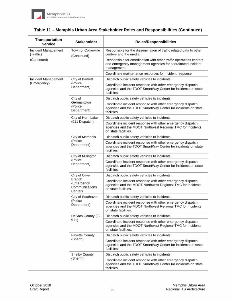
October 2018 Memphis Urban Area Draft Report 88 Regional ITS Architecture
Table 11 – Memphis Urban Area Stakeholder Roles and Responsibilities (Continued)
Transportation Service
Stakeholder Roles/Responsibilities
Incident Management (Traffic)
(Continued)
Town of Collierville
(Continued)
Responsible for the dissemination of traffic related data to other centers and the media.
Responsible for coordination with other traffic operations centers and emergency management agencies for coordinated incident management.
Coordinate maintenance resources for incident response.
Incident Management (Emergency)
City of Bartlett (Police Department)
Dispatch public safety vehicles to incidents.
Coordinate incident response with other emergency dispatch agencies and the TDOT SmartWay Center for incidents on state facilities.
City of Germantown (Police Department)
Dispatch public safety vehicles to incidents.
Coordinate incident response with other emergency dispatch agencies and the TDOT SmartWay Center for incidents on state facilities.
City of Horn Lake (911 Dispatch)
Dispatch public safety vehicles to incidents.
Coordinate incident response with other emergency dispatch agencies and the MDOT Northwest Regional TMC for incidents on state facilities.
City of Memphis (Police Department)
Dispatch public safety vehicles to incidents.
Coordinate incident response with other emergency dispatch agencies and the TDOT SmartWay Center for incidents on state facilities.
City of Millington (Police Department)
Dispatch public safety vehicles to incidents.
Coordinate incident response with other emergency dispatch agencies and the TDOT SmartWay Center for incidents on state facilities.
City of Olive Branch (Emergency Communications Center)
Dispatch public safety vehicles to incidents.
Coordinate incident response with other emergency dispatch agencies and the MDOT Northwest Regional TMC for incidents on state facilities.
City of Southaven (Police Department)
Dispatch public safety vehicles to incidents.
Coordinate incident response with other emergency dispatch agencies and the MDOT Northwest Regional TMC for incidents on state facilities.
DeSoto County (E-911)
Dispatch public safety vehicles to incidents.
Coordinate incident response with other emergency dispatch agencies and the MDOT Northwest Regional TMC for incidents on state facilities.
Fayette County (Sheriff)
Dispatch public safety vehicles to incidents.
Coordinate incident response with other emergency dispatch agencies and the TDOT SmartWay Center for incidents on state facilities.
Shelby County (Sheriff)
Dispatch public safety vehicles to incidents.
Coordinate incident response with other emergency dispatch agencies and the TDOT SmartWay Center for incidents on state facilities.
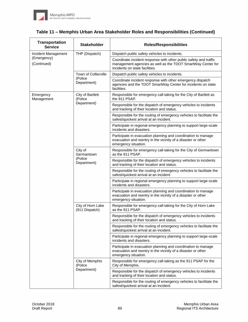
October 2018 Memphis Urban Area Draft Report 89 Regional ITS Architecture
Table 11 – Memphis Urban Area Stakeholder Roles and Responsibilities (Continued)
Transportation Service
Stakeholder Roles/Responsibilities
Incident Management (Emergency)
(Continued)
THP (Dispatch) Dispatch public safety vehicles to incidents.
Coordinate incident response with other public safety and traffic management agencies as well as the TDOT SmartWay Center for incidents on state facilities.
Town of Collierville (Police Department)
Dispatch public safety vehicles to incidents.
Coordinate incident response with other emergency dispatch agencies and the TDOT SmartWay Center for incidents on state facilities.
Emergency Management
City of Bartlett (Police Department)
Responsible for emergency call-taking for the City of Bartlett as the 911 PSAP.
Responsible for the dispatch of emergency vehicles to incidents and tracking of their location and status.
Responsible for the routing of emergency vehicles to facilitate the safest/quickest arrival at an incident.
Participate in regional emergency planning to support large-scale incidents and disasters.
Participate in evacuation planning and coordination to manage evacuation and reentry in the vicinity of a disaster or other emergency situation.
City of Germantown (Police Department)
Responsible for emergency call-taking for the City of Germantown as the 911 PSAP.
Responsible for the dispatch of emergency vehicles to incidents and tracking of their location and status.
Responsible for the routing of emergency vehicles to facilitate the safest/quickest arrival at an incident.
Participate in regional emergency planning to support large-scale incidents and disasters.
Participate in evacuation planning and coordination to manage evacuation and reentry in the vicinity of a disaster or other emergency situation.
City of Horn Lake (911 Dispatch)
Responsible for emergency call-taking for the City of Horn Lake as the 911 PSAP.
Responsible for the dispatch of emergency vehicles to incidents and tracking of their location and status.
Responsible for the routing of emergency vehicles to facilitate the safest/quickest arrival at an incident.
Participate in regional emergency planning to support large-scale incidents and disasters.
Participate in evacuation planning and coordination to manage evacuation and reentry in the vicinity of a disaster or other emergency situation.
City of Memphis (Police Department)
Responsible for emergency call-taking as the 911 PSAP for the City of Memphis.
Responsible for the dispatch of emergency vehicles to incidents and tracking of their location and status.
Responsible for the routing of emergency vehicles to facilitate the safest/quickest arrival at an incident.
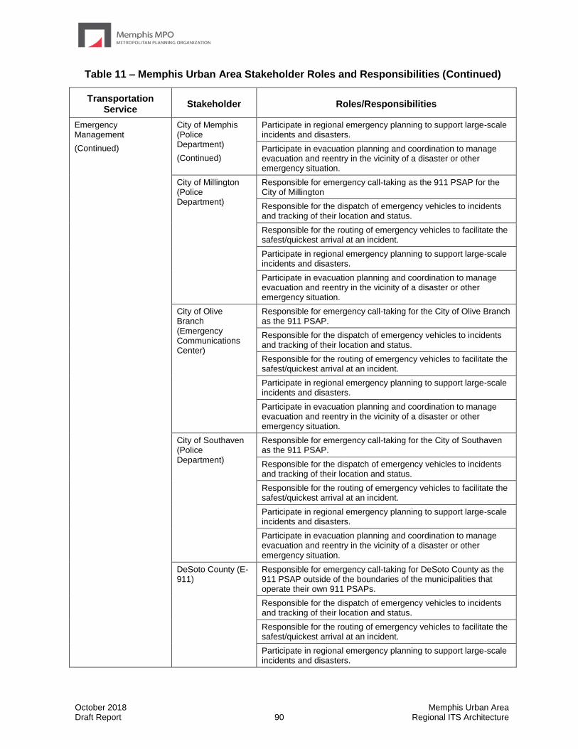
October 2018 Memphis Urban Area Draft Report 90 Regional ITS Architecture
Table 11 – Memphis Urban Area Stakeholder Roles and Responsibilities (Continued)
Transportation Service
Stakeholder Roles/Responsibilities
Emergency Management
(Continued)
City of Memphis (Police Department)
(Continued)
Participate in regional emergency planning to support large-scale incidents and disasters.
Participate in evacuation planning and coordination to manage evacuation and reentry in the vicinity of a disaster or other emergency situation.
City of Millington (Police Department)
Responsible for emergency call-taking as the 911 PSAP for the City of Millington
Responsible for the dispatch of emergency vehicles to incidents and tracking of their location and status.
Responsible for the routing of emergency vehicles to facilitate the safest/quickest arrival at an incident.
Participate in regional emergency planning to support large-scale incidents and disasters.
Participate in evacuation planning and coordination to manage evacuation and reentry in the vicinity of a disaster or other emergency situation.
City of Olive Branch (Emergency Communications Center)
Responsible for emergency call-taking for the City of Olive Branch as the 911 PSAP.
Responsible for the dispatch of emergency vehicles to incidents and tracking of their location and status.
Responsible for the routing of emergency vehicles to facilitate the safest/quickest arrival at an incident.
Participate in regional emergency planning to support large-scale incidents and disasters.
Participate in evacuation planning and coordination to manage evacuation and reentry in the vicinity of a disaster or other emergency situation.
City of Southaven (Police Department)
Responsible for emergency call-taking for the City of Southaven as the 911 PSAP.
Responsible for the dispatch of emergency vehicles to incidents and tracking of their location and status.
Responsible for the routing of emergency vehicles to facilitate the safest/quickest arrival at an incident.
Participate in regional emergency planning to support large-scale incidents and disasters.
Participate in evacuation planning and coordination to manage evacuation and reentry in the vicinity of a disaster or other emergency situation.
DeSoto County (E-911)
Responsible for emergency call-taking for DeSoto County as the 911 PSAP outside of the boundaries of the municipalities that operate their own 911 PSAPs.
Responsible for the dispatch of emergency vehicles to incidents and tracking of their location and status.
Responsible for the routing of emergency vehicles to facilitate the safest/quickest arrival at an incident.
Participate in regional emergency planning to support large-scale incidents and disasters.
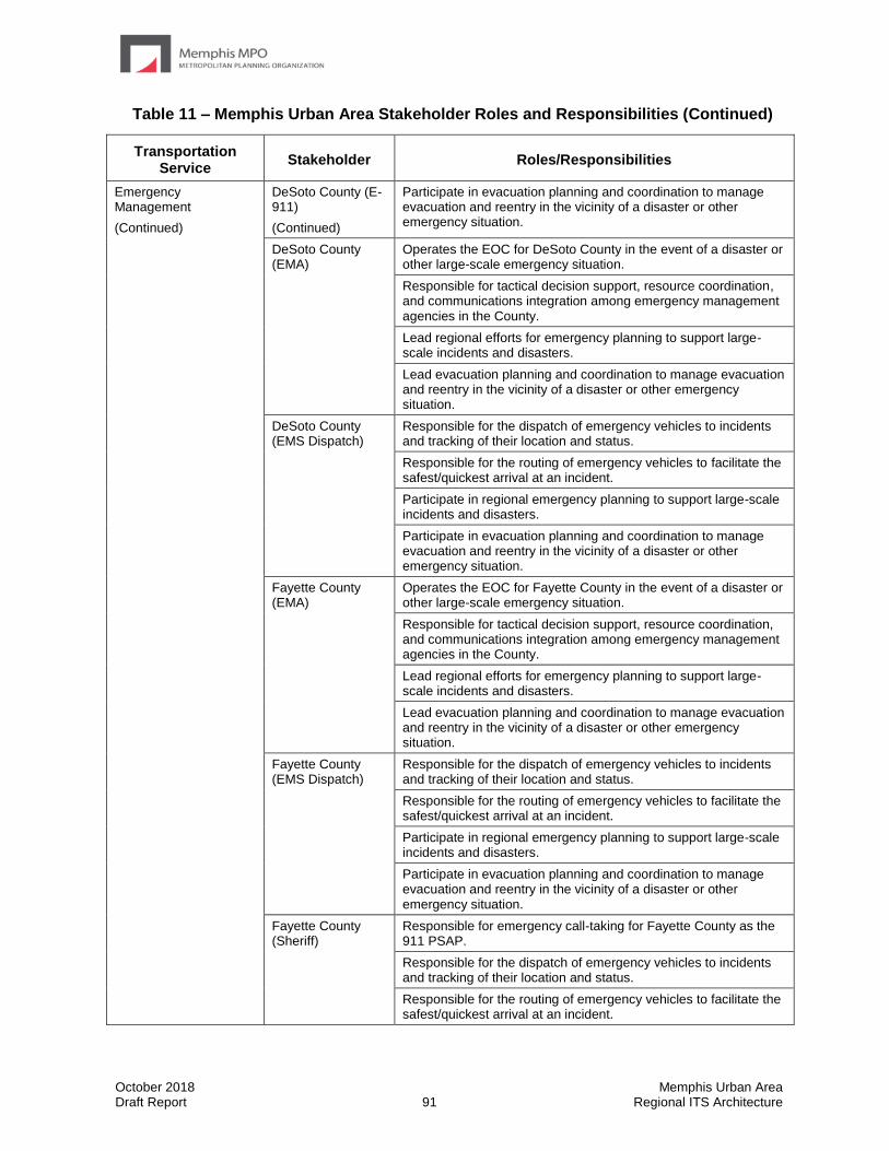
October 2018 Memphis Urban Area Draft Report 91 Regional ITS Architecture
Table 11 – Memphis Urban Area Stakeholder Roles and Responsibilities (Continued)
Transportation Service
Stakeholder Roles/Responsibilities
Emergency Management
(Continued)
DeSoto County (E-911)
(Continued)
Participate in evacuation planning and coordination to manage evacuation and reentry in the vicinity of a disaster or other emergency situation.
DeSoto County (EMA)
Operates the EOC for DeSoto County in the event of a disaster or other large-scale emergency situation.
Responsible for tactical decision support, resource coordination, and communications integration among emergency management agencies in the County.
Lead regional efforts for emergency planning to support large-scale incidents and disasters.
Lead evacuation planning and coordination to manage evacuation and reentry in the vicinity of a disaster or other emergency situation.
DeSoto County (EMS Dispatch)
Responsible for the dispatch of emergency vehicles to incidents and tracking of their location and status.
Responsible for the routing of emergency vehicles to facilitate the safest/quickest arrival at an incident.
Participate in regional emergency planning to support large-scale incidents and disasters.
Participate in evacuation planning and coordination to manage evacuation and reentry in the vicinity of a disaster or other emergency situation.
Fayette County (EMA)
Operates the EOC for Fayette County in the event of a disaster or other large-scale emergency situation.
Responsible for tactical decision support, resource coordination, and communications integration among emergency management agencies in the County.
Lead regional efforts for emergency planning to support large-scale incidents and disasters.
Lead evacuation planning and coordination to manage evacuation and reentry in the vicinity of a disaster or other emergency situation.
Fayette County (EMS Dispatch)
Responsible for the dispatch of emergency vehicles to incidents and tracking of their location and status.
Responsible for the routing of emergency vehicles to facilitate the safest/quickest arrival at an incident.
Participate in regional emergency planning to support large-scale incidents and disasters.
Participate in evacuation planning and coordination to manage evacuation and reentry in the vicinity of a disaster or other emergency situation.
Fayette County (Sheriff)
Responsible for emergency call-taking for Fayette County as the 911 PSAP.
Responsible for the dispatch of emergency vehicles to incidents and tracking of their location and status.
Responsible for the routing of emergency vehicles to facilitate the safest/quickest arrival at an incident.
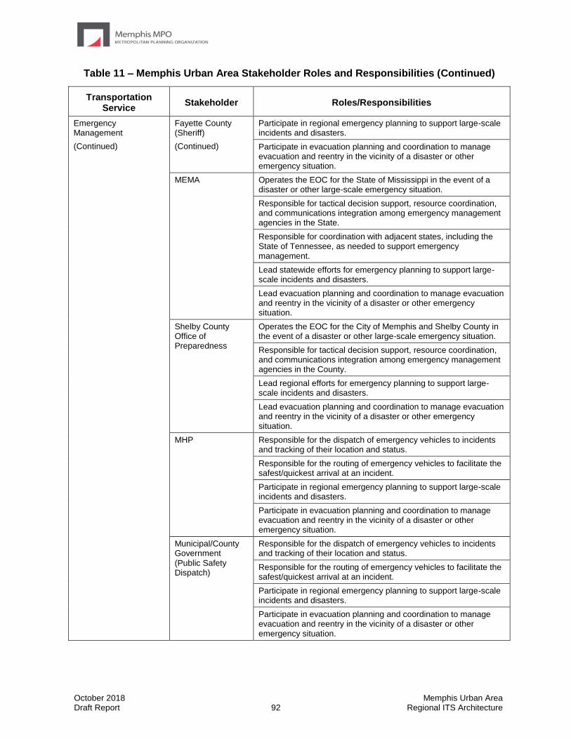
October 2018 Memphis Urban Area Draft Report 92 Regional ITS Architecture
Table 11 – Memphis Urban Area Stakeholder Roles and Responsibilities (Continued)
Transportation Service
Stakeholder Roles/Responsibilities
Emergency Management
(Continued)
Fayette County (Sheriff)
(Continued)
Participate in regional emergency planning to support large-scale incidents and disasters.
Participate in evacuation planning and coordination to manage evacuation and reentry in the vicinity of a disaster or other emergency situation.
MEMA Operates the EOC for the State of Mississippi in the event of a disaster or other large-scale emergency situation.
Responsible for tactical decision support, resource coordination, and communications integration among emergency management agencies in the State.
Responsible for coordination with adjacent states, including the State of Tennessee, as needed to support emergency management.
Lead statewide efforts for emergency planning to support large-scale incidents and disasters.
Lead evacuation planning and coordination to manage evacuation and reentry in the vicinity of a disaster or other emergency situation.
Shelby County Office of Preparedness
Operates the EOC for the City of Memphis and Shelby County in the event of a disaster or other large-scale emergency situation.
Responsible for tactical decision support, resource coordination, and communications integration among emergency management agencies in the County.
Lead regional efforts for emergency planning to support large-scale incidents and disasters.
Lead evacuation planning and coordination to manage evacuation and reentry in the vicinity of a disaster or other emergency situation.
MHP Responsible for the dispatch of emergency vehicles to incidents and tracking of their location and status.
Responsible for the routing of emergency vehicles to facilitate the safest/quickest arrival at an incident.
Participate in regional emergency planning to support large-scale incidents and disasters.
Participate in evacuation planning and coordination to manage evacuation and reentry in the vicinity of a disaster or other emergency situation.
Municipal/County Government (Public Safety Dispatch)
Responsible for the dispatch of emergency vehicles to incidents and tracking of their location and status.
Responsible for the routing of emergency vehicles to facilitate the safest/quickest arrival at an incident.
Participate in regional emergency planning to support large-scale incidents and disasters.
Participate in evacuation planning and coordination to manage evacuation and reentry in the vicinity of a disaster or other emergency situation.
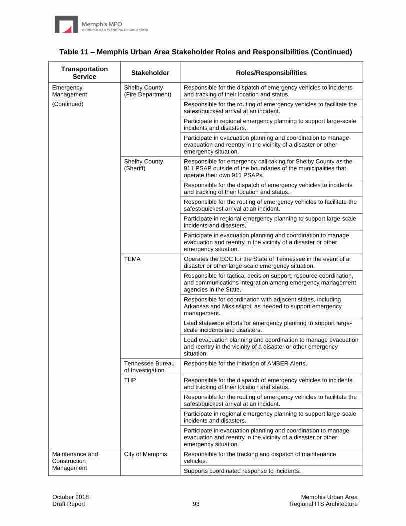
October 2018 Memphis Urban Area Draft Report 93 Regional ITS Architecture
Table 11 – Memphis Urban Area Stakeholder Roles and Responsibilities (Continued)
Transportation Service
Stakeholder Roles/Responsibilities
Emergency Management
(Continued)
Shelby County (Fire Department)
Responsible for the dispatch of emergency vehicles to incidents and tracking of their location and status.
Responsible for the routing of emergency vehicles to facilitate the safest/quickest arrival at an incident.
Participate in regional emergency planning to support large-scale incidents and disasters.
Participate in evacuation planning and coordination to manage evacuation and reentry in the vicinity of a disaster or other emergency situation.
Shelby County (Sheriff)
Responsible for emergency call-taking for Shelby County as the 911 PSAP outside of the boundaries of the municipalities that operate their own 911 PSAPs.
Responsible for the dispatch of emergency vehicles to incidents and tracking of their location and status.
Responsible for the routing of emergency vehicles to facilitate the safest/quickest arrival at an incident.
Participate in regional emergency planning to support large-scale incidents and disasters.
Participate in evacuation planning and coordination to manage evacuation and reentry in the vicinity of a disaster or other emergency situation.
TEMA Operates the EOC for the State of Tennessee in the event of a disaster or other large-scale emergency situation.
Responsible for tactical decision support, resource coordination, and communications integration among emergency management agencies in the State.
Responsible for coordination with adjacent states, including Arkansas and Mississippi, as needed to support emergency management.
Lead statewide efforts for emergency planning to support large-scale incidents and disasters.
Lead evacuation planning and coordination to manage evacuation and reentry in the vicinity of a disaster or other emergency situation.
Tennessee Bureau of Investigation
Responsible for the initiation of AMBER Alerts.
THP Responsible for the dispatch of emergency vehicles to incidents and tracking of their location and status.
Responsible for the routing of emergency vehicles to facilitate the safest/quickest arrival at an incident.
Participate in regional emergency planning to support large-scale incidents and disasters.
Participate in evacuation planning and coordination to manage evacuation and reentry in the vicinity of a disaster or other emergency situation.
Maintenance and Construction Management
City of Memphis Responsible for the tracking and dispatch of maintenance vehicles.
Supports coordinated response to incidents.
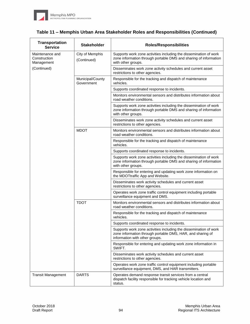
October 2018 Memphis Urban Area Draft Report 94 Regional ITS Architecture
Table 11 – Memphis Urban Area Stakeholder Roles and Responsibilities (Continued)
Transportation Service
Stakeholder Roles/Responsibilities
Maintenance and Construction Management
(Continued)
City of Memphis
(Continued)
Supports work zone activities including the dissemination of work zone information through portable DMS and sharing of information with other groups.
Disseminates work zone activity schedules and current asset restrictions to other agencies.
Municipal/County Government
Responsible for the tracking and dispatch of maintenance vehicles.
Supports coordinated response to incidents.
Monitors environmental sensors and distributes information about road weather conditions.
Supports work zone activities including the dissemination of work zone information through portable DMS and sharing of information with other groups.
Disseminates work zone activity schedules and current asset restrictions to other agencies.
MDOT Monitors environmental sensors and distributes information about road weather conditions.
Responsible for the tracking and dispatch of maintenance vehicles.
Supports coordinated response to incidents.
Supports work zone activities including the dissemination of work zone information through portable DMS and sharing of information with other groups.
Responsible for entering and updating work zone information on the MDOTtraffic App and Website.
Disseminates work activity schedules and current asset restrictions to other agencies.
Operates work zone traffic control equipment including portable surveillance equipment and DMS.
TDOT Monitors environmental sensors and distributes information about road weather conditions.
Responsible for the tracking and dispatch of maintenance vehicles.
Supports coordinated response to incidents.
Supports work zone activities including the dissemination of work zone information through portable DMS, HAR, and sharing of information with other groups.
Responsible for entering and updating work zone information in SWIFT.
Disseminates work activity schedules and current asset restrictions to other agencies.
Operates work zone traffic control equipment including portable surveillance equipment, DMS, and HAR transmitters.
Transit Management DARTS Operates demand response transit services from a central dispatch facility responsible for tracking vehicle location and status.

October 2018 Memphis Urban Area Draft Report 95 Regional ITS Architecture
Table 11 – Memphis Urban Area Stakeholder Roles and Responsibilities (Continued)
Transportation Service
Stakeholder Roles/Responsibilities
Transit Management
(Continued)
DARTS
(Continued)
Provide transit security on transit vehicles through silent alarms and surveillance systems.
Provide transit traveler information to the agency website, local private sector traveler information services, and the Mississippi 511 Traveler Information System.
Participate in evacuation planning and coordination to manage evacuation and reentry in the vicinity of a disaster or other emergency situation.
Delta Human Resource Agency
Operates demand response transit services from a central dispatch facility responsible for tracking vehicle location and status.
Provide transit security on transit vehicles through silent alarms and surveillance systems.
Provide transit traveler information to the agency website, local private sector traveler information services, and the Tennessee 511 System.
Participate in evacuation planning and coordination to manage evacuation and reentry in the vicinity of a disaster or other emergency situation.
MATA Operates fixed-route and paratransit services from a central dispatch facility responsible for tracking their location and status.
Provide transit passenger electronic fare payment on fixed route transit vehicles.
Provide transit security on transit vehicles and at transit terminals through silent alarms and surveillance systems.
Coordinate with the City of Memphis Engineering Division on transit signal priority.
Provide transit traveler information to the agency website, local private sector traveler information services, and the Tennessee 511 system.
Provide real-time MATA Bus Arrival Status Boards at transit stops and bus location information on MATA Website and MATA Mobile App
Operate on-board systems to provide next stop annunciation.
Participate in evacuation planning and coordination to manage evacuation and reentry in the vicinity of a disaster or other emergency situation.
Traveler Information City of Bartlett Responsible for the collection and distribution of traveler information including incident information and maintenance and construction closure information.
Responsible for the collection and distribution of emergency information to the traveling public, including evacuation information and wide-area alerts.
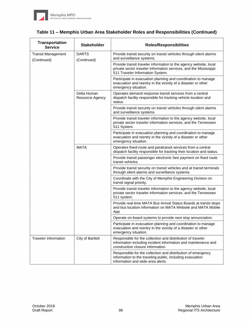
October 2018 Memphis Urban Area Draft Report 96 Regional ITS Architecture
Table 11 – Memphis Urban Area Stakeholder Roles and Responsibilities (Continued)
Transportation Service
Stakeholder Roles/Responsibilities
Transit Management
(Continued)
DARTS
(Continued)
Provide transit security on transit vehicles through silent alarms and surveillance systems.
Provide transit traveler information to the agency website, local private sector traveler information services, and the Mississippi 511 Traveler Information System.
Participate in evacuation planning and coordination to manage evacuation and reentry in the vicinity of a disaster or other emergency situation.
Delta Human Resource Agency
Operates demand response transit services from a central dispatch facility responsible for tracking vehicle location and status.
Provide transit security on transit vehicles through silent alarms and surveillance systems.
Provide transit traveler information to the agency website, local private sector traveler information services, and the Tennessee 511 System.
Participate in evacuation planning and coordination to manage evacuation and reentry in the vicinity of a disaster or other emergency situation.
MATA Operates fixed-route and paratransit services from a central dispatch facility responsible for tracking their location and status.
Provide transit passenger electronic fare payment on fixed route transit vehicles.
Provide transit security on transit vehicles and at transit terminals through silent alarms and surveillance systems.
Coordinate with the City of Memphis Engineering Division on transit signal priority.
Provide transit traveler information to the agency website, local private sector traveler information services, and the Tennessee 511 system.
Provide real-time MATA Bus Arrival Status Boards at transit stops and bus location information on MATA Website and MATA Mobile App
Operate on-board systems to provide next stop annunciation.
Participate in evacuation planning and coordination to manage evacuation and reentry in the vicinity of a disaster or other emergency situation.
Traveler Information City of Bartlett Responsible for the collection and distribution of traveler information including incident information and maintenance and construction closure information.
Responsible for the collection and distribution of emergency information to the traveling public, including evacuation information and wide-area alerts.
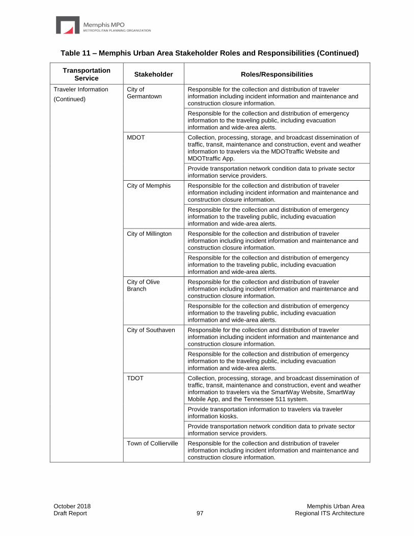
October 2018 Memphis Urban Area Draft Report 97 Regional ITS Architecture
Table 11 – Memphis Urban Area Stakeholder Roles and Responsibilities (Continued)
Transportation Service
Stakeholder Roles/Responsibilities
Traveler Information
(Continued)
City of Germantown
Responsible for the collection and distribution of traveler information including incident information and maintenance and construction closure information.
Responsible for the collection and distribution of emergency information to the traveling public, including evacuation information and wide-area alerts.
MDOT Collection, processing, storage, and broadcast dissemination of traffic, transit, maintenance and construction, event and weather information to travelers via the MDOTtraffic Website and MDOTtraffic App.
Provide transportation network condition data to private sector information service providers.
City of Memphis Responsible for the collection and distribution of traveler information including incident information and maintenance and construction closure information.
Responsible for the collection and distribution of emergency information to the traveling public, including evacuation information and wide-area alerts.
City of Millington Responsible for the collection and distribution of traveler information including incident information and maintenance and construction closure information.
Responsible for the collection and distribution of emergency information to the traveling public, including evacuation information and wide-area alerts.
City of Olive Branch
Responsible for the collection and distribution of traveler information including incident information and maintenance and construction closure information.
Responsible for the collection and distribution of emergency information to the traveling public, including evacuation information and wide-area alerts.
City of Southaven Responsible for the collection and distribution of traveler information including incident information and maintenance and construction closure information.
Responsible for the collection and distribution of emergency information to the traveling public, including evacuation information and wide-area alerts.
TDOT Collection, processing, storage, and broadcast dissemination of traffic, transit, maintenance and construction, event and weather information to travelers via the SmartWay Website, SmartWay Mobile App, and the Tennessee 511 system.
Provide transportation information to travelers via traveler information kiosks.
Provide transportation network condition data to private sector information service providers.
Town of Collierville Responsible for the collection and distribution of traveler information including incident information and maintenance and construction closure information.
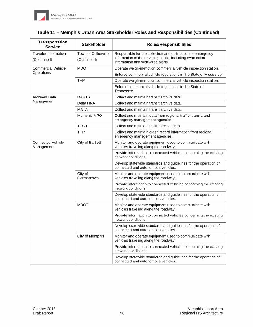
October 2018 Memphis Urban Area Draft Report 98 Regional ITS Architecture
Table 11 – Memphis Urban Area Stakeholder Roles and Responsibilities (Continued)
Transportation Service
Stakeholder Roles/Responsibilities
Traveler Information
(Continued)
Town of Collierville
(Continued)
Responsible for the collection and distribution of emergency information to the traveling public, including evacuation information and wide-area alerts.
Commercial Vehicle Operations
MDOT Operate weigh-in-motion commercial vehicle inspection station.
Enforce commercial vehicle regulations in the State of Mississippi.
THP Operate weigh-in-motion commercial vehicle inspection station.
Enforce commercial vehicle regulations in the State of Tennessee.
Archived Data Management
DARTS Collect and maintain transit archive data.
Delta HRA Collect and maintain transit archive data.
MATA Collect and maintain transit archive data.
Memphis MPO Collect and maintain data from regional traffic, transit, and emergency management agencies.
TDOT Collect and maintain traffic archive data.
THP Collect and maintain crash record information from regional emergency management agencies.
Connected Vehicle Management
City of Bartlett Monitor and operate equipment used to communicate with vehicles traveling along the roadway.
Provide information to connected vehicles concerning the existing network conditions.
Develop statewide standards and guidelines for the operation of connected and autonomous vehicles.
City of Germantown
Monitor and operate equipment used to communicate with vehicles traveling along the roadway.
Provide information to connected vehicles concerning the existing network conditions.
Develop statewide standards and guidelines for the operation of connected and autonomous vehicles.
MDOT Monitor and operate equipment used to communicate with vehicles traveling along the roadway.
Provide information to connected vehicles concerning the existing network conditions.
Develop statewide standards and guidelines for the operation of connected and autonomous vehicles.
City of Memphis Monitor and operate equipment used to communicate with vehicles traveling along the roadway.
Provide information to connected vehicles concerning the existing network conditions.
Develop statewide standards and guidelines for the operation of connected and autonomous vehicles.

October 2018 Memphis Urban Area Draft Report 99 Regional ITS Architecture
Table 11 – Memphis Urban Area Stakeholder Roles and Responsibilities (Continued)
Transportation Service
Stakeholder Roles/Responsibilities
Connected Vehicle Management
(Continued)
City of Millington Monitor and operate equipment used to communicate with vehicles traveling along the roadway.
Provide information to connected vehicles concerning the existing network conditions.
Develop statewide standards and guidelines for the operation of connected and autonomous vehicles.
City of Olive Branch
Monitor and operate equipment used to communicate with vehicles traveling along the roadway.
Provide information to connected vehicles concerning the existing network conditions.
Develop statewide standards and guidelines for the operation of connected and autonomous vehicles.
City of Southaven Monitor and operate equipment used to communicate with vehicles traveling along the roadway.
Provide information to connected vehicles concerning the existing network conditions.
Develop statewide standards and guidelines for the operation of connected and autonomous vehicles.
TDOT Monitor and operate equipment used to communicate with vehicles traveling along the roadway.
Provide information to connected vehicles concerning the existing network conditions.
Develop statewide standards and guidelines for the operation of connected and autonomous vehicles.
Town of Collierville Monitor and operate equipment used to communicate with vehicles traveling along the roadway.
Provide information to connected vehicles concerning the existing network conditions.
Develop statewide standards and guidelines for the operation of connected and autonomous vehicles.
October 2018 Memphis Urban Area Draft Report 100 Regional ITS Architecture
5.6 Phases of Implementation
The Regional ITS Architecture for the Memphis MPO Region has identified many agency interfaces, information exchanges, and integration strategies that would be needed to provide the ITS services and systems identified by the stakeholders in the Region. Interfaces and data flows among public and private entities in the Region will require agreements among agencies that establish parameters for sharing agency information to support traffic management, incident management, provide traveler information, and perform other functions identified in the Regional ITS Architecture.
With the implementation of ITS technologies, integrating systems from one or more agencies, and the anticipated level of information exchange identified in the Regional ITS Architecture, it is likely that formal agreements between agencies will be needed in the future. These agreements, while perhaps not requiring a financial commitment from agencies in the Region, should outline specific roles, responsibilities, data exchanges, levels of authority, and other facets of regional operations. Some agreements will also outline specific funding responsibilities, where appropriate and applicable.
Agreements should avoid being specific with regard to technology when possible. Technology is likely to change and changes to technology could require an update of the agreement if the agreement was not technology neutral. Focus of the agreement should be on the responsibilities of the agencies and types of information that need to be exchanged. Depending on the type of agreement being used, agencies should be prepared for the process to complete an agreement to take several months to years. Agencies must first reach consensus on what should be in an agreement and then proceed through the approval process. The approval process for formal agreements varies by agency and can often be quite lengthy, so it is recommended that agencies plan ahead to ensure that the agreement does not delay the project.
When implementing an agreement for ITS, it is recommended that as a first step any existing agreements are reviewed to determine whether they can be amended or modified to include the additional requirements that will come with deploying a system. If there are no existing agreements that can be modified or used for ITS implementation, then a new agreement will need to be developed. The formality and type of agreement used is a key consideration. If the arrangement will be in effect for an extended duration or involve any sort of long-term maintenance, then written agreements should be used. Often during long-term operations, staff may change and a verbal agreement between agency representatives may be forgotten by new staff.
Common agreement types and potential applications include:
• Handshake Agreement: Handshake agreements are often used in the early stage of a project. This type of informal agreement depends very much on relationships between agencies and may not be appropriate for long-term operations where staff is likely to change.
• Memorandum of Understanding (MOU): A MOU demonstrates general consensus but is not typically very detailed. MOUs often identify high-level goals and partnerships.
• Interagency and Intergovernmental Agreements: These agreements between public agencies can be used for operation, maintenance, or funding projects and systems. They can include documentation on the responsibility of each agency, functions they will provide, and liability.
October 2018 Memphis Urban Area Draft Report 101 Regional ITS Architecture
• Funding Agreements: Funding agreements document the funding arrangements for ITS projects. At a minimum, funding agreements include a detailed scope, services to be performed, and a detailed project budget. Agency funding expectations or funding sources are also typically identified.
• Master Agreements: Master agreements include standard contract language for an agency and serve as the main agreement between two entities which guides all business transactions. Use of a master agreement can allow an agency to do business with another agency or private entity without having to go through the often-lengthy development of a formal agreement each time.
Table 12 provides a list of existing and potential agreements for the Memphis MPO Region based on the interfaces identified in the Regional ITS Architecture. It is important to note that as ITS services and systems are implemented in the Region, part of the planning and review process for those projects should include a review of potential agreements that would be needed for implementation or operations.
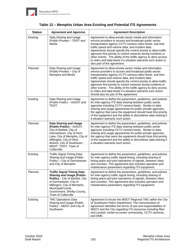
October 2018 Memphis Urban Area Draft Report 102 Regional ITS Architecture
Table 12 – Memphis Urban Area Existing and Potential ITS Agreements
Status Agreement and Agencies Agreement Description
Existing Data Sharing and Usage (Public-Private) – TDOT and Media
Agreement to allow private sector media and information service providers to access and broadcast public sector transportation agency CCTV camera video feeds, real time traffic speed and volume data, and incident data. Agreements should specify the control priority to allow traffic agencies first priority to control cameras during incidents or other events. The ability of the traffic agency to deny access to video and data feeds if a situation warrants such action is also part of the agreement.
Planned Data Sharing and Usage (Public-Private) – City of Memphis and Media
Agreement to allow private sector media and information service providers to access and broadcast public sector transportation agency CCTV camera video feeds, real time traffic speed and volume data, and incident data. Agreements should specify the control priority to allow traffic agencies first priority to control cameras during incidents or other events. The ability of the traffic agency to deny access to video and data feeds if a situation warrants such action should also be part of the agreement.
Existing Data Sharing and Usage (Public-Public) – ARDOT and TDOT
Agreement to define the parameters, guidelines, and policies for inter-agency ITS data sharing between public sector agencies including CCTV camera feeds. Similar to data sharing and usage agreements for public-private agencies, the agency that owns the equipment should have first priority of the equipment and the ability to discontinue data sharing if a situation warrants such action.
Planned Data Sharing and Usage (Public-Public) – ARDOT, City of Bartlett, City of Germantown, City of Horn Lake, City of Memphis, City of Millington, City of Olive Branch, City of Southaven, MDOT, TDOT, Town of Collierville
Agreement to define the parameters, guidelines, and policies for inter-agency ITS data sharing between public sector agencies including CCTV camera feeds. Similar to data sharing and usage agreements for public-private agencies, the agency that owns the equipment should have first priority of the equipment and the ability to discontinue data sharing if a situation warrants such action.
Existing Traffic Signal Timing Data Sharing and Usage (Public-Public) – City of Germantown and City of Memphis
Agreement to define the parameters, guidelines, and policies for inter-agency traffic signal timing, including sharing of timing plans and joint operations of signals, between cities and counties. This agreement also includes operation and maintenance parameters regarding ITS equipment.
Planned Traffic Signal Timing Data Sharing and Usage (Public-Public) – City of Bartlett, City of Germantown, City of Millington, City of Memphis, Municipal/County Government, Shelby County, Town of Collierville
Agreement to define the parameters, guidelines, and policies for inter-agency traffic signal timing, including sharing of timing plans and joint operations of signals, between cities and counties. This agreement also includes operation and maintenance parameters regarding ITS equipment.
Existing TMC Operations Data Sharing and Usage (Public-Public) – MDOT and City of Southaven
Agreement to house the MDOT Regional TMC within the City of Southaven Police Department. The memorandum of agreement identifies the terms of use and responsibilities of MDOT and the City regarding ITS resources including fiber and conduit, center-to-center connectivity, CCTV cameras, and DMS.
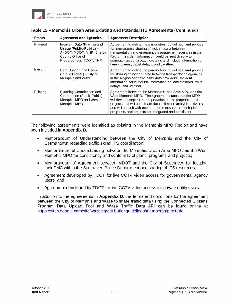
October 2018 Memphis Urban Area Draft Report 103 Regional ITS Architecture
Table 12 – Memphis Urban Area Existing and Potential ITS Agreements (Continued)
Status Agreement and Agencies Agreement Description
Planned Incident Data Sharing and Usage (Public-Public) – ARDOT, MDOT, MHP, Shelby County Office of Preparedness, TDOT, THP
Agreement to define the parameters, guidelines, and policies for inter-agency sharing of incident data between transportation and emergency management agencies in the Region. Incident information could be sent directly to computer-aided dispatch systems and include information on lane closures, travel delays, and weather.
Existing Data Sharing and Usage (Public-Private) – City of Memphis and Waze
Agreement to define the parameters, guidelines, and policies for sharing of incident data between transportation agencies in the Region and third-party data providers. Incident information could include information on lane closures, travel delays, and weather.
Existing Planning Coordination and Cooperation (Public-Public) – Memphis MPO and West Memphis MPO
Agreement between the Memphis Urban Area MPO and the West Memphis MPO. The agreement states that the MPO will develop separate transportation plans, programs, and projects, but will coordinate data collection analysis activities and will consult with one another to ensure that their plans, programs, and projects are integrated and consistent.
The following agreements were identified as existing in the Memphis MPO Region and have been included in Appendix D.
• Memorandum of Understanding between the City of Memphis and the City of Germantown regarding traffic signal ITS coordination;
• Memorandum of Understanding between the Memphis Urban Area MPO and the West Memphis MPO for consistency and conformity of plans, programs and projects;
• Memorandum of Agreement between MDOT and the City of Southaven for locating their TMC within the Southaven Police Department and sharing of ITS resources;
• Agreement developed by TDOT for live CCTV video access for governmental agency users; and
• Agreement developed by TDOT for live CCTV video access for private entity users.
In addition to the agreements in Appendix D, the terms and conditions for the agreement between the City of Memphis and Waze to share traffic data using the Connected Citizens Program Data Upload Tool and Waze Traffic Data API can be found online at https://sites.google.com/site/wazeccpattributionguidelines/membership-criteria.

October 2018 Memphis Urban Area Draft Report 104 Regional ITS Architecture
• 5.7 Phases of Implementation
The Memphis Urban Area has been deploying ITS systems for several decades and continues to grow and enhance the system. Much of their focus is currently on expansion of existing systems, such as the SmartWay Freeway Management System and advanced signal systems on arterial streets. Connectivity continues to be a major focus of the Region. As the capability of agencies to monitor and collect information grows, other agencies see the benefit of connecting and sharing information between agencies.
The services identified in the Memphis Urban Area Regional ITS Architecture will be implemented over time through a series of projects. Though TDOT, MDOT, and many of the larger municipalities have already made significant ITS deployments in the Region, for other agencies key foundation systems will need to be implemented in order to support other systems that have been identified in the Regional ITS Architecture. The deployment of all of the systems required to achieve the final Regional ITS Architecture build out will occur over many years.
Some of the key service packages that will provide the functions for the foundation systems in the Memphis MPO Region are listed below. Service packages that also support the primary needs identified in the Memphis MPO Region are also identified. Projects associated with these and other service packages identified for the Region have been included in the Memphis Urban Area Regional ITS Deployment Plan.
• TM01 – Infrastructure-Based Network Surveillance
• TM03 – Traffic Signal Control
• TM06 – Traffic Information Dissemination
• TM07 – Regional Traffic Management
• TM08 – Traffic Incident Management System
• PS03 – Emergency Vehicle Preemption
• PS08 – Roadway Service Patrols
• PS09 – Transportation Infrastructure Protection
• PT01 – Transit Vehicle Tracking
• PT02 – Transit Fixed Route Operations
• PT03 – Dynamic Transit Operations
• PT04 – Transit Fare Collection Management
• PT08 – Transit Traveler Information
• PT18 – Integrated Multi-Modal Electronic Payment
• TI01 – Broadcast Traveler Information
• DM01 – ITS Data Warehouse
• DM02 – Performance Monitoring
October 2018 Memphis Urban Area Draft Report 105 Regional ITS Architecture
6.0 Regional ITS Deployment Plan The Regional ITS Deployment Plan serves as a tool for the Memphis MPO Region to identify specific projects that should be deployed in order to achieve the desired functionality identified in the Regional ITS Architecture. The Regional ITS Deployment Plan builds on the Regional ITS Architecture by outlining specific ITS project recommendations and strategies for the Region and identifying deployment timeframes so that the recommended projects and strategies can be implemented over time.
The Regional ITS Deployment Plan also shows the correlation between each project and the Regional ITS Architecture by identifying the ITS service packages that correspond to each project. If projects were identified that did not correspond to an ITS service package, the ITS service packages in the Regional ITS Architecture were revised while the Regional ITS Architecture was still in draft format; therefore, the resulting ITS deployment projects are supported by the Regional ITS Architecture.
The Memphis Urban Area Regional ITS Deployment Plan provides stakeholders with a list of regionally significant ITS projects that are consistent with the Regional ITS Architecture and assists with addressing transportation needs in the Region. It is important to note that the Regional ITS Deployment Plan is not fiscally constrained. The projects in the plan represent those projects that stakeholders would like to implement; however, funding will still be needed in order for these projects to actually be implemented.
6.1 Deployment Plan Project Development Process
An overview of the process used to develop the Regional ITS Deployment Plan is provided in Figure 6. This figure demonstrates that a variety of inputs were used to gather information and develop a set of ITS projects for selection by stakeholders, including a review of the regional needs, ITS service package priorities, and regional and local plans.
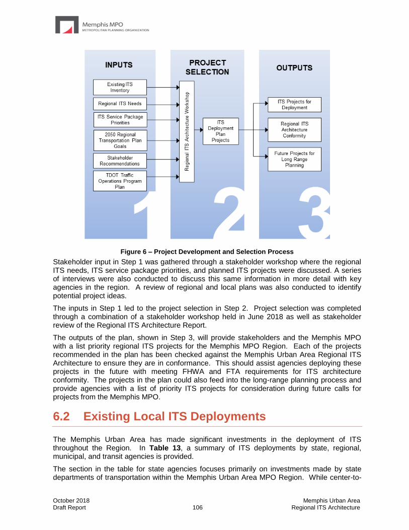
October 2018 Memphis Urban Area Draft Report 106 Regional ITS Architecture
Figure 6 – Project Development and Selection Process
Stakeholder input in Step 1 was gathered through a stakeholder workshop where the regional ITS needs, ITS service package priorities, and planned ITS projects were discussed. A series of interviews were also conducted to discuss this same information in more detail with key agencies in the region. A review of regional and local plans was also conducted to identify potential project ideas.
The inputs in Step 1 led to the project selection in Step 2. Project selection was completed through a combination of a stakeholder workshop held in June 2018 as well as stakeholder review of the Regional ITS Architecture Report.
The outputs of the plan, shown in Step 3, will provide stakeholders and the Memphis MPO with a list priority regional ITS projects for the Memphis MPO Region. Each of the projects recommended in the plan has been checked against the Memphis Urban Area Regional ITS Architecture to ensure they are in conformance. This should assist agencies deploying these projects in the future with meeting FHWA and FTA requirements for ITS architecture conformity. The projects in the plan could also feed into the long-range planning process and provide agencies with a list of priority ITS projects for consideration during future calls for projects from the Memphis MPO.
6.2 Existing Local ITS Deployments
The Memphis Urban Area has made significant investments in the deployment of ITS throughout the Region. In Table 13, a summary of ITS deployments by state, regional, municipal, and transit agencies is provided.
The section in the table for state agencies focuses primarily on investments made by state departments of transportation within the Memphis Urban Area MPO Region. While center-to-
October 2018 Memphis Urban Area Draft Report 107 Regional ITS Architecture
center connections do not exist between the Tennessee, Mississippi, and Arkansas Departments of Transportation,
A majority of municipalities in the Memphis Urban Area have deployed TOCs, centralized traffic signal systems, field sensors, and CCTV cameras. The City of Memphis currently maintains traffic signals for other municipalities in Shelby County.
The regional transit agencies are MATA and DARTS. MATA has expanded its existing transit services to offer 5G Wi-Fi on buses, using intersections as connection points. A transit dashboard is being created for transit data. Transit riders can use Smart Cards to pay fares. The Memphis MPO has completed guidelines for bus stops and rail trolley stops. MATA has implemented a Demand Responsive System, and transit signal priority for buses. MATA no longer offers service in West Memphis.
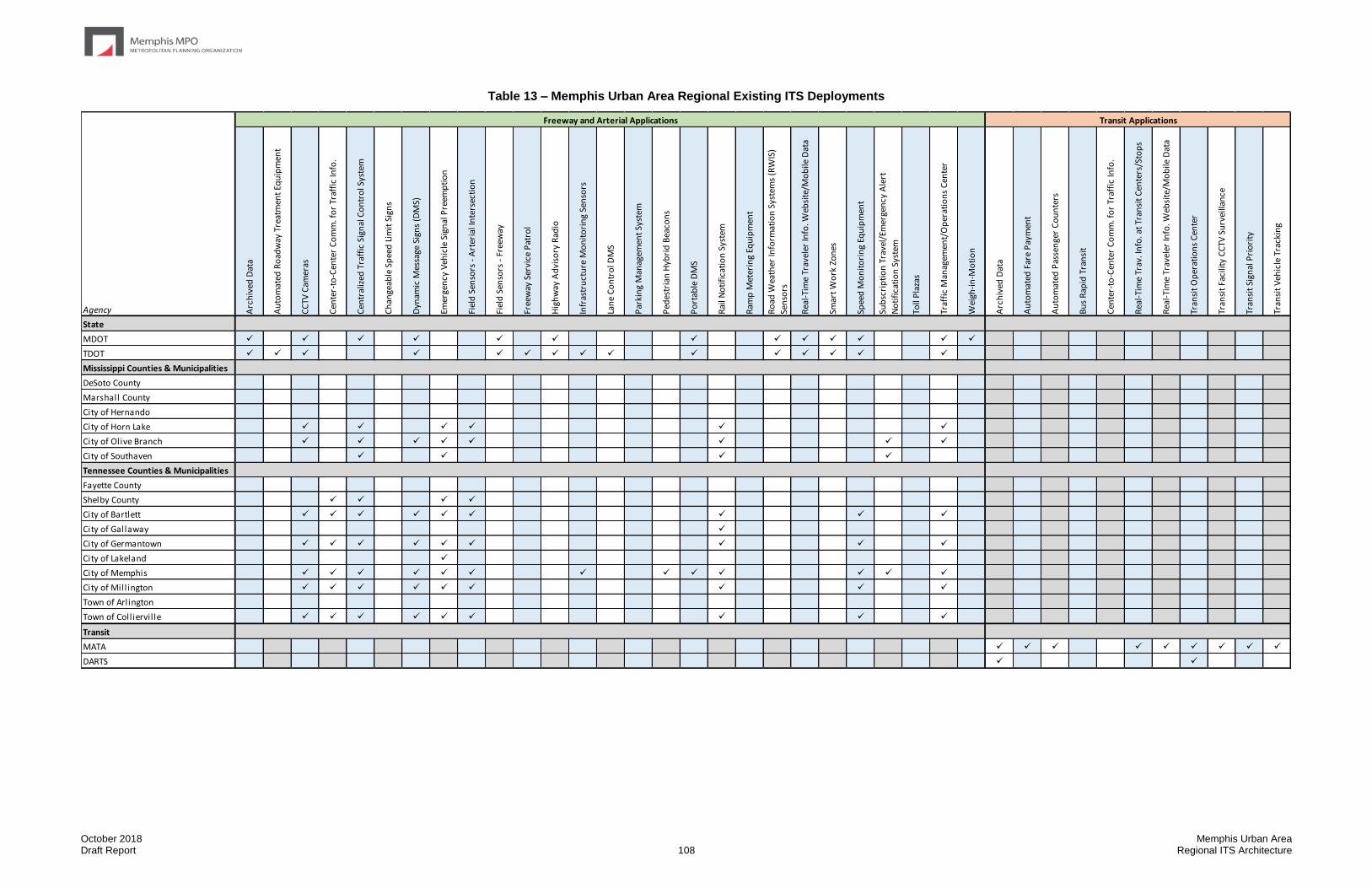
October 2018 Memphis Urban Area Draft Report 108 Regional ITS Architecture
Table 13 – Memphis Urban Area Regional Existing ITS Deployments
Arc
hiv
ed D
ata
Au
tom
ated
Ro
adw
ay T
reat
men
t Eq
uip
men
t
CC
TV C
amer
as
Cen
ter-
to-C
ente
r C
om
m. f
or
Traf
fic
Info
.
Cen
tral
ized
Tra
ffic
Sig
nal
Co
ntr
ol S
yste
m
Ch
ange
able
Sp
eed
Lim
it S
ign
s
Dyn
amic
Mes
sage
Sig
ns
(DM
S)
Emer
gen
cy V
ehic
le S
ign
al P
reem
pti
on
Fiel
d S
enso
rs -
Art
eria
l In
ters
ecti
on
Fiel
d S
enso
rs -
Fre
eway
Free
way
Ser
vice
Pat
rol
Hig
hw
ay A
dvi
sory
Rad
io
Infr
astr
uct
ure
Mo
nit
ori
ng
Sen
sors
Lan
e C
on
tro
l DM
S
Par
kin
g M
anag
emen
t Sy
stem
Ped
estr
ian
Hyb
rid
Bea
con
s
Po
rtab
le D
MS
Rai
l No
tifi
cati
on
Sys
tem
Ram
p M
eter
ing
Equ
ipm
ent
Ro
ad W
eath
er In
form
atio
n S
yste
ms
(RW
IS)
Sen
sors
Rea
l-Ti
me
Trav
eler
Info
. Web
site
/Mo
bile
Dat
a
Smar
t W
ork
Zo
nes
Spee
d M
on
ito
rin
g Eq
uip
men
t
Sub
scri
pti
on
Tra
vel/
Emer
gen
cy A
lert
No
tifi
cati
on
Sys
tem
Toll
Pla
zas
Traf
fic
Man
agem
ent/
Op
erat
ion
s C
ente
r
Wei
gh-i
n-M
oti
on
Arc
hiv
ed D
ata
Au
tom
ated
Far
e P
aym
ent
Au
tom
ated
Pas
sen
ger
Co
un
ters
Bu
s R
apid
Tra
nsi
t
Cen
ter-
to-C
ente
r C
om
m. f
or
Traf
fic
Info
.
Rea
l-Ti
me
Trav
. In
fo. a
t Tr
ansi
t C
ente
rs/S
top
s
Rea
l-Ti
me
Trav
eler
Info
. Web
site
/Mo
bile
Dat
a
Tran
sit
Op
erat
ion
s C
ente
r
Tran
sit
Faci
lity
CC
TV S
urv
eilla
nce
Tran
sit
Sign
al P
rio
rity
Tran
sit
Veh
icle
Tra
ckin
g
State
MDOT ✓ ✓ ✓ ✓ ✓ ✓ ✓ ✓ ✓ ✓ ✓ ✓ ✓
TDOT ✓ ✓ ✓ ✓ ✓ ✓ ✓ ✓ ✓ ✓ ✓ ✓ ✓ ✓ ✓
Mississippi Counties & Municipalities
DeSoto County
Marshall County
City of Hernando
City of Horn Lake ✓ ✓ ✓ ✓ ✓ ✓
City of Olive Branch ✓ ✓ ✓ ✓ ✓ ✓ ✓ ✓
City of Southaven ✓ ✓ ✓ ✓
Tennessee Counties & Municipalities
Fayette County
Shelby County ✓ ✓ ✓ ✓
City of Bartlett ✓ ✓ ✓ ✓ ✓ ✓ ✓ ✓ ✓
City of Gallaway ✓
City of Germantown ✓ ✓ ✓ ✓ ✓ ✓ ✓ ✓ ✓
City of Lakeland ✓
City of Memphis ✓ ✓ ✓ ✓ ✓ ✓ ✓ ✓ ✓ ✓ ✓ ✓ ✓
City of Mill ington ✓ ✓ ✓ ✓ ✓ ✓ ✓ ✓ ✓
Town of Arlington
Town of Colliervil le ✓ ✓ ✓ ✓ ✓ ✓ ✓ ✓ ✓
Transit
MATA ✓ ✓ ✓ ✓ ✓ ✓ ✓ ✓ ✓
DARTS ✓ ✓
Agency
Freeway and Arterial Applications Transit Applications
October 2018 Memphis Urban Area Draft Report 109 Regional ITS Architecture
6.3 TDOT ITS Project Recommendations
In 2017 TDOT completed a Statewide Traffic Operations Plan that included a three-year Strategic Deployment Plan for each of TDOT’s four Districts. Projects were identified as high, medium or low priority and assigned a timeframe for the beginning of implementation of year 1, 2 or 3. Where possible, a cost estimate for the implementation was provided.
Projects from this plan that fall within the boundaries of the Memphis Urban Area MPO are shown in Table 14.
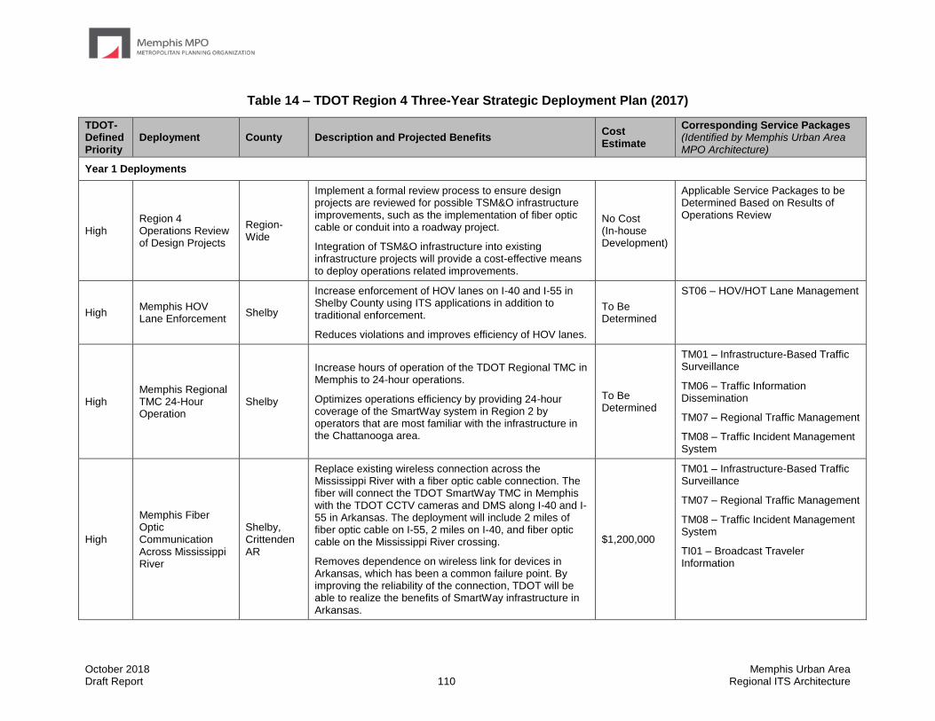
October 2018 Memphis Urban Area Draft Report 110 Regional ITS Architecture
Table 14 – TDOT Region 4 Three-Year Strategic Deployment Plan (2017)
TDOT-Defined Priority
Deployment County Description and Projected Benefits Cost Estimate
Corresponding Service Packages (Identified by Memphis Urban Area MPO Architecture)
Year 1 Deployments
High Region 4 Operations Review of Design Projects
Region-Wide
Implement a formal review process to ensure design projects are reviewed for possible TSM&O infrastructure improvements, such as the implementation of fiber optic cable or conduit into a roadway project.
Integration of TSM&O infrastructure into existing infrastructure projects will provide a cost-effective means to deploy operations related improvements.
No Cost (In-house Development)
Applicable Service Packages to be Determined Based on Results of Operations Review
High Memphis HOV Lane Enforcement
Shelby
Increase enforcement of HOV lanes on I-40 and I-55 in Shelby County using ITS applications in addition to traditional enforcement.
Reduces violations and improves efficiency of HOV lanes.
To Be Determined
ST06 – HOV/HOT Lane Management
High Memphis Regional TMC 24-Hour Operation
Shelby
Increase hours of operation of the TDOT Regional TMC in Memphis to 24-hour operations.
Optimizes operations efficiency by providing 24-hour coverage of the SmartWay system in Region 2 by operators that are most familiar with the infrastructure in the Chattanooga area.
To Be Determined
TM01 – Infrastructure-Based Traffic Surveillance
TM06 – Traffic Information Dissemination
TM07 – Regional Traffic Management
TM08 – Traffic Incident Management System
High
Memphis Fiber Optic Communication Across Mississippi River
Shelby, Crittenden AR
Replace existing wireless connection across the Mississippi River with a fiber optic cable connection. The fiber will connect the TDOT SmartWay TMC in Memphis with the TDOT CCTV cameras and DMS along I-40 and I-55 in Arkansas. The deployment will include 2 miles of fiber optic cable on I-55, 2 miles on I-40, and fiber optic cable on the Mississippi River crossing.
Removes dependence on wireless link for devices in Arkansas, which has been a common failure point. By improving the reliability of the connection, TDOT will be able to realize the benefits of SmartWay infrastructure in Arkansas.
$1,200,000
TM01 – Infrastructure-Based Traffic Surveillance
TM07 – Regional Traffic Management
TM08 – Traffic Incident Management System
TI01 – Broadcast Traveler Information
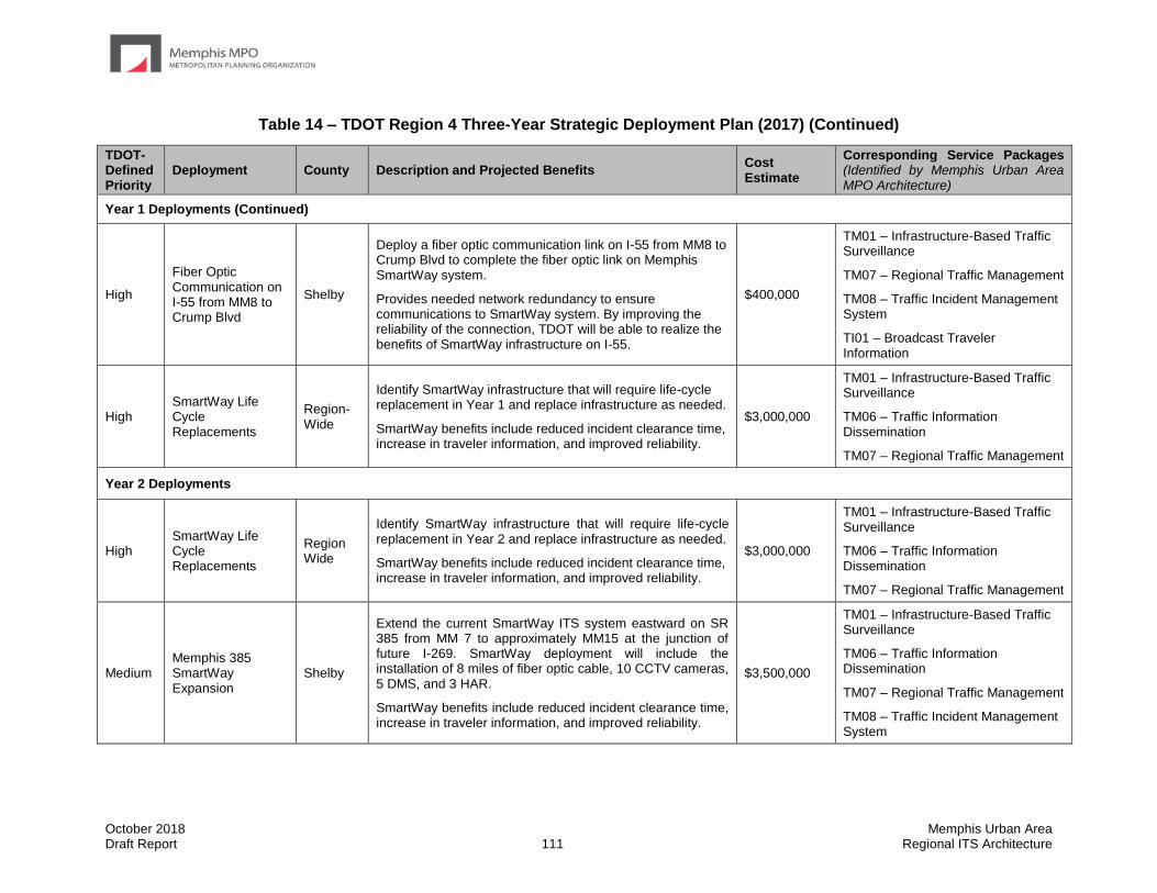
October 2018 Memphis Urban Area Draft Report 111 Regional ITS Architecture
Table 14 – TDOT Region 4 Three-Year Strategic Deployment Plan (2017) (Continued)
TDOT-Defined Priority
Deployment County Description and Projected Benefits Cost Estimate
Corresponding Service Packages (Identified by Memphis Urban Area MPO Architecture)
Year 1 Deployments (Continued)
High
Fiber Optic Communication on I-55 from MM8 to Crump Blvd
Shelby
Deploy a fiber optic communication link on I-55 from MM8 to Crump Blvd to complete the fiber optic link on Memphis SmartWay system.
Provides needed network redundancy to ensure communications to SmartWay system. By improving the reliability of the connection, TDOT will be able to realize the benefits of SmartWay infrastructure on I-55.
$400,000
TM01 – Infrastructure-Based Traffic Surveillance
TM07 – Regional Traffic Management
TM08 – Traffic Incident Management System
TI01 – Broadcast Traveler Information
High SmartWay Life Cycle Replacements
Region-Wide
Identify SmartWay infrastructure that will require life-cycle replacement in Year 1 and replace infrastructure as needed.
SmartWay benefits include reduced incident clearance time, increase in traveler information, and improved reliability.
$3,000,000
TM01 – Infrastructure-Based Traffic Surveillance
TM06 – Traffic Information Dissemination
TM07 – Regional Traffic Management
Year 2 Deployments
High SmartWay Life Cycle Replacements
Region Wide
Identify SmartWay infrastructure that will require life-cycle replacement in Year 2 and replace infrastructure as needed.
SmartWay benefits include reduced incident clearance time, increase in traveler information, and improved reliability.
$3,000,000
TM01 – Infrastructure-Based Traffic Surveillance
TM06 – Traffic Information Dissemination
TM07 – Regional Traffic Management
Medium Memphis 385 SmartWay Expansion
Shelby
Extend the current SmartWay ITS system eastward on SR 385 from MM 7 to approximately MM15 at the junction of future I-269. SmartWay deployment will include the installation of 8 miles of fiber optic cable, 10 CCTV cameras, 5 DMS, and 3 HAR.
SmartWay benefits include reduced incident clearance time, increase in traveler information, and improved reliability.
$3,500,000
TM01 – Infrastructure-Based Traffic Surveillance
TM06 – Traffic Information Dissemination
TM07 – Regional Traffic Management
TM08 – Traffic Incident Management System
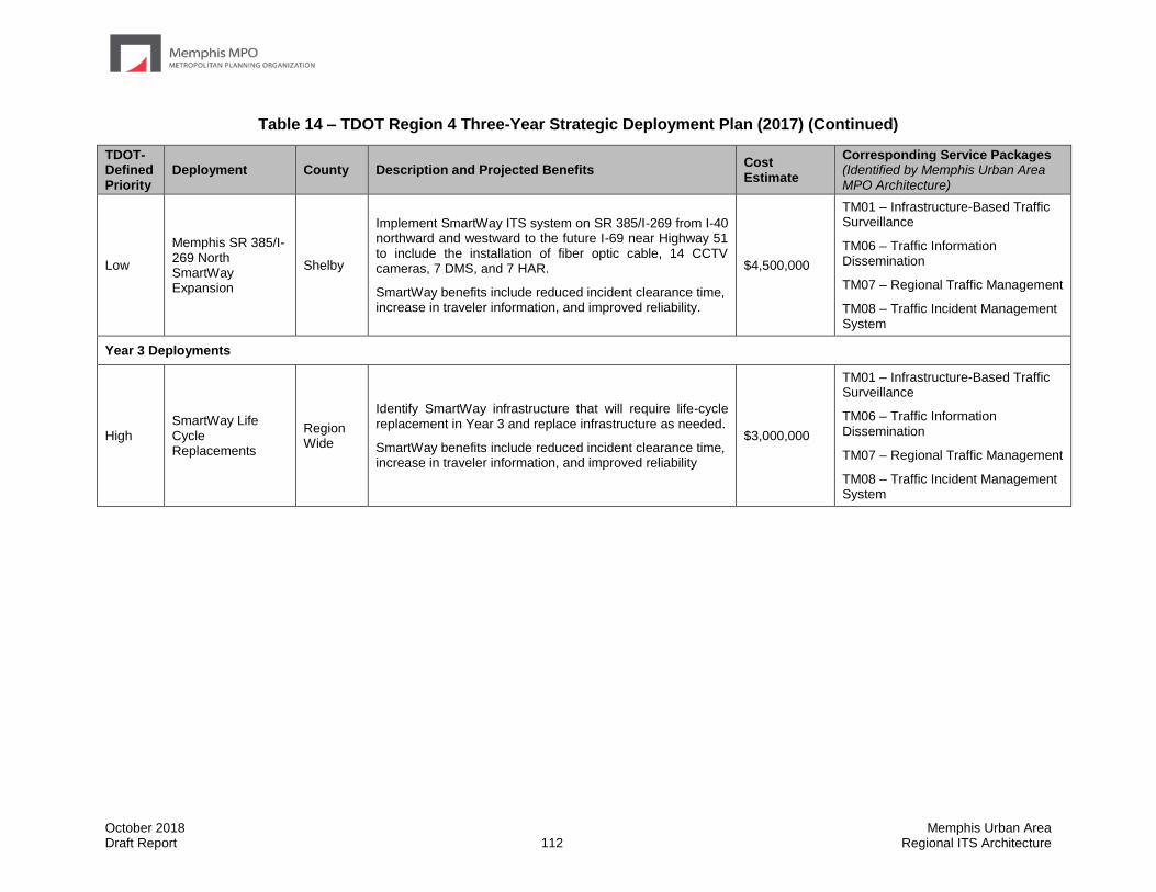
October 2018 Memphis Urban Area Draft Report 112 Regional ITS Architecture
Table 14 – TDOT Region 4 Three-Year Strategic Deployment Plan (2017) (Continued)
TDOT-Defined Priority
Deployment County Description and Projected Benefits Cost Estimate
Corresponding Service Packages (Identified by Memphis Urban Area MPO Architecture)
Low
Memphis SR 385/I-269 North SmartWay Expansion
Shelby
Implement SmartWay ITS system on SR 385/I-269 from I-40 northward and westward to the future I-69 near Highway 51 to include the installation of fiber optic cable, 14 CCTV cameras, 7 DMS, and 7 HAR.
SmartWay benefits include reduced incident clearance time, increase in traveler information, and improved reliability.
$4,500,000
TM01 – Infrastructure-Based Traffic Surveillance
TM06 – Traffic Information Dissemination
TM07 – Regional Traffic Management
TM08 – Traffic Incident Management System
Year 3 Deployments
High SmartWay Life Cycle Replacements
Region Wide
Identify SmartWay infrastructure that will require life-cycle replacement in Year 3 and replace infrastructure as needed.
SmartWay benefits include reduced incident clearance time, increase in traveler information, and improved reliability
$3,000,000
TM01 – Infrastructure-Based Traffic Surveillance
TM06 – Traffic Information Dissemination
TM07 – Regional Traffic Management
TM08 – Traffic Incident Management System
October 2018 Memphis Urban Area Draft Report 113 Regional ITS Architecture
6.4 ITS Project Recommendations
In order to achieve the ITS deployment levels outlined in their Regional ITS Architecture, a region must deploy carefully developed projects that provide the functionality and interoperability identified in their ITS Architecture. A key step toward achieving the Memphis MPO Region’s ITS vision as established in the Regional ITS Architecture is the development of an ITS Deployment Plan that identifies specific projects, timeframes, and responsible agencies.
While past architectures have included an ITS deployment plan with local and regional ITS projects, local projects planned by a single agency are not identified by this Regional ITS Architecture for the following reasons:
• Agencies have various processes and funding mechanisms already in place to plan ITS projects; and
• This architecture is regional in nature, with the focus on bringing agencies together to plan collaborative projects that benefit the Memphis MPO Region as a whole.
This Regional ITS Architecture serves as a guiding document for agencies as they plan, design, and implement their own ITS projects.
Many of the local projects implemented by individual agencies will include elements that assist in the compliance of the Real-time System Management Program (Part 511 of Title 23 Code of Federal Regulations) which requires that metropolitan areas with population exceeding one million to collect and makes accessible real-time traffic information on interstates and designated routes of significance. The information includes roadway blockages, construction activities, roadway weather observations and travel times along interstate highways and other routes of significance. During interviews, stakeholders within the Memphis MPO Region were asked to identify which routes they would like to receive real-time traffic information on in the future. These routes should be considered by the Region when identifying routes of significance to comply with Part 511 of Title 23.
Table 15 depicts the routes that were identified by stakeholders (Memphis MPO and MDOT) where real-time system management information is desired.

October 2018 Memphis Urban Area Draft Report 114 Regional ITS Architecture
Table 15 – Routes Identified for Real-time System Management Information
County Route Limits
Routes Identified by Stakeholders within the Memphis MPO Region
Shelby County, TN
SR 3 From Mississippi State Line to SR 23 (Union Ave.)
SR 4 From Mississippi State Line to I-240
SR 15 From SR 14 (Austin Peay Hwy.) to I-40
SR 23 From SR 3 (Bellevue Blvd.) to I-240
SR 57 From SR 14 (Jackson Ave.) to Houston Levee Rd.
SR 177 From SR 57 (Poplar Ave.) to SR 1
DeSoto County, MS
Airways Boulevard From Church Road to the Tennessee state line (Southaven)
Church Road Within the corporate limits of the City of Southaven; from Horn Lake Road to the western corporate limit of the City of Horn Lake; from the western corporate limit of the city of Olive Branch to Hwy 305
Commerce Street From US Hwy 51 to McIngvale Road
Getwell Road From Church Road to the Tennessee state line
Hacks Cross Road From College Road to the Tennessee state line
Horn Lake Road Within the corporate limits of the City of Southaven; from Church Road to the northern corporate limit of the City of Horn Lake
Hwy 305 From College Road to the Tennessee state line
Stateline Road From Horn Lake Road to Getwell Road
US Hwy 51 From the DeSoto-Tate County line to the southern city limits of Hernando
Routes Identified by Stakeholders within the West Memphis MPO Region
Crittenden County, AR
Hwy 64 From Hwy 70 to Cross County Line
Hwy 70 From I-55 to St. Francis County Line
Hwy 77 From Hwy 70 to I-55
Hwy 118 From Hwy 70 to Hwy 64
October 2018 Memphis Urban Area Draft Report 115 Regional ITS Architecture
6.5 Regional ITS Deployments
Although most agencies are actively deploying ITS within the Memphis Urban Area Region, stakeholders noted a strong need for the implementation of regional systems and programs to meet regional needs. Regional needs generally focused on traveler information, incident management, improved communications, and improved transit service.
Stakeholder identified six regional deployment areas for ITS in the Region. These six areas do not encompass all of the regional ITS needs within the Memphis Urban Area Region, however stakeholders recommended that emphasis be placed on implementation related to these seven areas in order to provide the greatest benefit to travelers. The six areas include:
• Regional Traveler Information Improvements
• Integrated Corridor Management
• Freeway Service Patrol (Mississippi)
• Center-to-Center Communications (State-to-State)
• Center-to-Center Communications (State-to-Local)
• Archived Data Warehouse Implementation
A summary of each of the six regional deployment areas is provided in this section. For each, the following information is provided:
Basis of Need – Describes how the regional deployment project or program meets one of more of the regional ITS needs that were identified in the Regional ITS Architecture.
Stakeholders – Identifies the stakeholder agencies that would be involved in the implementation of projects related to each deployment area. If possible, a lead agency is identified.
Deployment Components – Describes the projects, programs, initiatives, or training that is required to fully implement each of the eight regional deployments.
Best Practices and Current Trends – Describes a summary of best practices and current trends related to each regional deployment area.
Regional ITS Architecture Conformance – Identifies the ITS service packages from the Memphis Regional ITS Architecture that are related to each of the regional deployment areas. Conformance of ITS projects with the Regional ITS Architecture is important in order for any ITS project or program to be eligible for federal ITS funding.
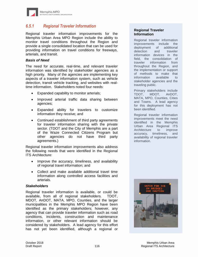
October 2018 Memphis Urban Area Draft Report 116 Regional ITS Architecture
6.5.1 Regional Traveler Information
Regional traveler information improvements for the Memphis Urban Area MPO Region include the ability to monitor travel conditions throughout the Region and provide a single consolidated location that can be used for providing information on travel conditions for freeways, arterials, and transit.
Basis of Need
The need for accurate, real-time, and relevant traveler information was identified by stakeholder agencies as a high priority. Many of the agencies are implementing key aspects of a traveler information system, such as vehicle detection, transit vehicle tracking, and websites with real-time information. Stakeholders noted four needs:
• Expanded capability to monitor arterials;
• Improved arterial traffic data sharing between agencies;
• Expanded ability for travelers to customize information they receive; and
• Continued establishment of third party agreements for traveler information sharing with the private sector. (TDOT and the City of Memphis are a part of the Waze Connected Citizens Program but other agencies do not have third party agreements.)
Regional traveler information improvements also address the following needs that were identified in the Regional ITS Architecture:
• Improve the accuracy, timeliness, and availability of regional travel information; and
• Collect and make available additional travel time information along controlled access facilities and arterials.
Stakeholders
Regional traveler information is available, or could be available, from all of regional stakeholders. TDOT, MDOT, ARDOT, MATA, MPO, Counties, and the larger municipalities in the Memphis MPO Region have been identified as the primary stakeholders; however, any agency that can provide traveler information such as road conditions, incidents, construction and maintenance information, or other relevant information should be considered by stakeholders. A lead agency for this effort has not yet been identified, although a regional or
Regional Traveler Information
Regional traveler information improvements include the deployment of additional detection and traveler information devices in the field, the consolidation of traveler information from throughout the Region, and the implementation or support of methods to make that information available to stakeholder agencies and the traveling public.
Primary stakeholders include TDOT, MDOT, ARDOT, MATA, MPO, Counties, Cities and Towns. A lead agency for this deployment has not been identified.
Regional traveler information improvements meet the need identified in the Memphis Urban Area Regional ITS Architecture to improve accuracy, timeliness, and availability of regional traveler information.

October 2018 Memphis Urban Area Draft Report 117 Regional ITS Architecture
statewide agency such as TDOT, ARDOT, or the MPO would be the most likely agency to lead such an effort.
Deployment Components
Traveler information needs to be accurate, reliable, and timely and can include congestion information, incident information, weather conditions, construction closure information, and transit vehicle arrival times. In order to provide real-time information that travelers need, the infrastructure and coordination efforts necessary to collect road network conditions data, locate transit vehicles, detect incidents, and broadcast the information to the public utilizing various outlets must be in place and continuously enhanced. Agencies must be able to collect travel time information, road weather conditions and view live video from CCTV cameras along major route to understand how the network is performing. CCTV cameras, travel time information, and coordination with emergency management agencies can aid in the detection of incidents. Automatic vehicle location equipment allows transit agencies to monitor the schedule adherence of transit vehicles. Websites, television, and dynamic signs are all outlets by which information can be communicated to drivers and transit riders so that they can adjust their route if necessary. Dissemination of the information at the roadside will generally be the responsibility of public sector agencies, however dissemination of information through other means, such as mobile applications, may be from either public or private agencies.
Stakeholders at the workshop noted that in the Memphis Urban Area MPO Region, Desoto County has deployed many ITS devices as part of their CMAQ grant. MDOT has also deployed ITS on many freeways but has very limited deployments on arterials. Throughout the Region, it is difficult to divert vehicles off freeways onto arterial streets because there is very limited information on arterials.
Regional Traveler Information Improvements in the Memphis Urban Area include the following components:
• Travel times and road conditions
• Planned construction and special event closures
• Transit information
• Connected Citizens Program (Waze)
• Customized information for travelers
Increased Coverage of Detection Systems – Additional detection systems, including Bluetooth or other technologies to determine travel times and individual detection sites to determine speed, volume, and occupancy are needed on freeways and especially on arterials. Major arterials that can serve as alternate routes for enhanced mobility throughout the region are the highest priority for increased coverage.
Improved Access to Private Data – Several privatized providers are able to provide traveler information data, such as INRIX and Waze. This data has become increasing accurate but can be costly to obtain for a single agency. The Region should consider cost sharing models to obtain this type of regional privatized data at a reduced cost.
The City of Memphis has a partnership with Waze through the Connected Citizens Program that allows the City to submit incident and traffic information with a higher priority than the average Waze user. Other agencies could join this program to improve the quality of traveler information in the Region.
October 2018 Memphis Urban Area Draft Report 118 Regional ITS Architecture
Arterial DMS – DMS located along arterial roadways to provide traveler information prior to vehicles entering freeways would be very beneficial to motorists by allowing them to more easily select and follow an alternate route when an incident occurs on the freeway. These signs could also help reduce the queuing or congestion that these additional vehicles would have added had they entered the freeway. TDOT, MDOT, the Memphis MPO and local municipalities could consider cost sharing efforts to deploy these arterial DMS. Stakeholders at the workshop noted that there is a regional need to provide traveler information to motorists on arterial streets prior to them entering the freeway.
Regional Information Consolidation – Traveler information is currently available from many different sources within the Memphis Region, such as TDOT, the City of Memphis, and MATA. A consolidated centralized traveler information system is needed that will pull in traveler information, including travel times, crash locations, and weather information into a single system that can be accessed by public agencies, media, and web and application developers. This system could serve as the catalyst to encourage more privatized development of traveler information website and other systems.
Stakeholders agreed that a single point of access for all regional traveler information would benefit travelers in the Memphis Region. This single point does not have to be a public agency maintained system, and generally stakeholders recommended that a privatized system may be more effective.
Timeframe
The need for real-time regional traveler information was identified as a high priority for the Region and should be implemented in the short-term. A number of agencies are currently investing to expand their detection systems and TDOT currently has access to private data sources such as Google. Several agencies noted the need to invest in arterial DMS in the short-term provided they can use the arterial DMS to provide information on freeway conditions prior to motorist entering. The greatest challenge is consolidating regional information and developing a regional traveler information network. A lead agency needs to be designated for this effort and it should begin within the next three to five years.
Regional ITS Architecture Conformance
Traveler information is identified in almost all of the ITS service areas in the Regional ITS Architecture, including the Traffic Management, Emergency Management, Maintenance and Construction Management, Public Transportation Management, and Traveler Information service areas. The primary ITS service packages that were identified in the Regional ITS Architecture related to Regional Traveler Information Improvements are identified below.
• TM06 Traffic Information Dissemination
• PS14 Disaster Traveler Information
• WX02 Weather Information Processing and Distribution
• PT08 Transit Traveler Information
• TI01 Broadcast Traveler Information
• TI02 Personalized Traveler Information
The ITS service packages related to traveler information are also supported by many of the other ITS service packages that have been identified in the Memphis Region. For example, the TM01 Network Surveillance service package and the PT01 Transit Vehicle Tracking service package provide traffic and transit agencies with important information about road
October 2018 Memphis Urban Area Draft Report 119 Regional ITS Architecture
conditions and bus performance, which can then be passed on to travelers through a variety of methods. The primary supporting ITS service package are identified below.
• TM01 Infrastructure-Based Traffic Surveillance
• TM02 Vehicle-Based Traffic Surveillance
• TM07 Regional Traffic Management
• PM04 Regional Parking Management
• WX01 Weather Data Collection
• MC06 Work Zone Management
• PT01 Transit Vehicle Tracking
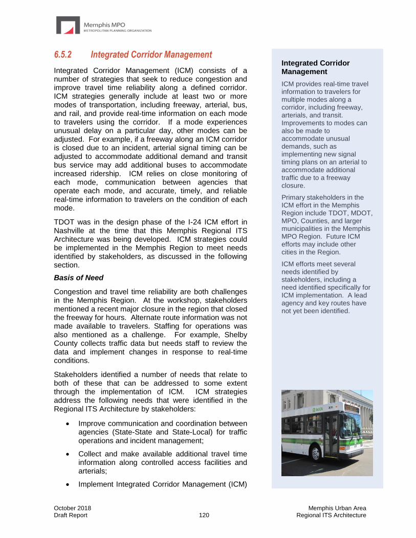
October 2018 Memphis Urban Area Draft Report 120 Regional ITS Architecture
6.5.2 Integrated Corridor Management
Integrated Corridor Management (ICM) consists of a number of strategies that seek to reduce congestion and improve travel time reliability along a defined corridor. ICM strategies generally include at least two or more modes of transportation, including freeway, arterial, bus, and rail, and provide real-time information on each mode to travelers using the corridor. If a mode experiences unusual delay on a particular day, other modes can be adjusted. For example, if a freeway along an ICM corridor is closed due to an incident, arterial signal timing can be adjusted to accommodate additional demand and transit bus service may add additional buses to accommodate increased ridership. ICM relies on close monitoring of each mode, communication between agencies that operate each mode, and accurate, timely, and reliable real-time information to travelers on the condition of each mode.
TDOT was in the design phase of the I-24 ICM effort in Nashville at the time that this Memphis Regional ITS Architecture was being developed. ICM strategies could be implemented in the Memphis Region to meet needs identified by stakeholders, as discussed in the following section.
Basis of Need
Congestion and travel time reliability are both challenges in the Memphis Region. At the workshop, stakeholders mentioned a recent major closure in the region that closed the freeway for hours. Alternate route information was not made available to travelers. Staffing for operations was also mentioned as a challenge. For example, Shelby County collects traffic data but needs staff to review the data and implement changes in response to real-time conditions.
Stakeholders identified a number of needs that relate to both of these that can be addressed to some extent through the implementation of ICM. ICM strategies address the following needs that were identified in the Regional ITS Architecture by stakeholders:
• Improve communication and coordination between agencies (State-State and State-Local) for traffic operations and incident management;
• Collect and make available additional travel time information along controlled access facilities and arterials;
• Implement Integrated Corridor Management (ICM)
Integrated Corridor Management
ICM provides real-time travel information to travelers for multiple modes along a corridor, including freeway, arterials, and transit. Improvements to modes can also be made to accommodate unusual demands, such as implementing new signal timing plans on an arterial to accommodate additional traffic due to a freeway closure.
Primary stakeholders in the ICM effort in the Memphis Region include TDOT, MDOT, MPO, Counties, and larger municipalities in the Memphis MPO Region. Future ICM efforts may include other cities in the Region.
ICM efforts meet several needs identified by stakeholders, including a need identified specifically for ICM implementation. A lead agency and key routes have not yet been identified.
October 2018 Memphis Urban Area Draft Report 121 Regional ITS Architecture
strategies; and
• Improve data sharing among agencies for both operational and planning initiatives.
Stakeholders
ICM stakeholders include TDOT, MDOT, MPO, Counties, and larger municipalities in the Memphis MPO Region. A lead agency has not yet been identified for this effort, but would most likely be either the Memphis MPO or TDOT.
Deployment Components
It is envisioned that ICM in the Memphis Region will include the following components:
• Freeway and arterial monitoring
• CAD incident data sharing
• Freeway service patrol
• Signal timing plans for incidents
• Ramp metering
• Variable speed limits
• Training
Other ICM strategies could include:
• Increased use of alternate routes and modes especially during peak travel times or times.
• Increased use of active transportation and demand management to maximize existing facilities, including dynamic lane assignment, dynamic speed limits, queue warning, congestion pricing, and adaptive signal control.
• Establishment of data-sharing capabilities between all participating transportation agencies.
• Encourage changes in travel behavior such as alternating work hours or telecommuting.
• Use of private sector technology for information sharing.
Timeframe
It is recommended to begin planning ICM implementation in the next two years, including the pursuit of appropriate funding sources for ICM strategies.
Regional ITS Architecture Conformance
Integrated corridor management relies on a combination of capabilities including the ability to monitor real-time conditions on a number of modes of transportation, the ability to share information between stakeholders, and the ability to provide real-time information to travelers regarding a particular corridor both pre-trip and while en-route.
ITS service packages in the Memphis Regional ITS Architecture that provide the monitoring capabilities that ICM relies upon include:
• TM01 Infrastructure-Based Traffic Surveillance

October 2018 Memphis Urban Area Draft Report 122 Regional ITS Architecture
• TM02 Vehicle-Based Traffic Surveillance
• WX01 Weather Data Collection
• PT01 Transit Vehicle Tracking
ITS service packages that provide the ability to share information between stakeholders include:
• TM07 Regional Traffic Management
• PT14 Multi-modal Coordination
ITS service packages that provide the ability to provide pre-trip and en-route traveler information include:
• TM06 Traffic Information Dissemination
• WX02 Weather Information Processing and Distribution
• MC08 Maintenance and Construction Activity Coordination
• PT08 Transit Traveler Information
• TI01 Broadcast Traveler Information
• TI02 Personalized Traveler Information
ICM could also include strategies to improve corridor operations during periods of unusual traffic, such as an incident that causes freeway traffic to divert onto arterials. ITS service packages that provide the ability to control and improve corridor operations, and could possibly be incorporated into future ICM strategies include:
• TM03 Traffic Signal Control
• TM05 Traffic Metering
• TM20 Variable Speed Limits
• TM22 Dynamic Lane Management and Shoulder Use
• PS08 Roadway Service Patrols
• PT09 Transit Signal Priority
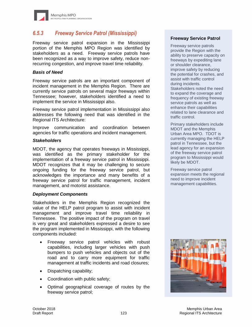
October 2018 Memphis Urban Area Draft Report 123 Regional ITS Architecture
6.5.3 Freeway Service Patrol (Mississippi)
Freeway service patrol expansion in the Mississippi portion of the Memphis MPO Region was identified by stakeholders as a need. Freeway service patrols have been recognized as a way to improve safety, reduce non-recurring congestion, and improve travel time reliability.
Basis of Need
Freeway service patrols are an important component of incident management in the Memphis Region. There are currently service patrols on several major freeways within Tennessee; however, stakeholders identified a need to implement the service in Mississippi also.
Freeway service patrol implementation in Mississippi also addresses the following need that was identified in the Regional ITS Architecture:
Improve communication and coordination between agencies for traffic operations and incident management.
Stakeholders
MDOT, the agency that operates freeways in Mississippi, was identified as the primary stakeholder for the implementation of a freeway service patrol in Mississippi. MDOT recognizes that it may be challenging to secure ongoing funding for the freeway service patrol, but acknowledges the importance and many benefits of a freeway service patrol for traffic management, incident management, and motorist assistance.
Deployment Components
Stakeholders in the Memphis Region recognized the value of the HELP patrol program to assist with incident management and improve travel time reliability in Tennessee. The positive impact of the program on travel is very great and stakeholders expressed a desire to see the program implemented in Mississippi, with the following components included:
• Freeway service patrol vehicles with robust capabilities, including larger vehicles with push bumpers to push vehicles and objects out of the road and to carry more equipment for traffic management at traffic incidents and road closures;
• Dispatching capability;
• Coordination with public safety;
• Optimal geographical coverage of routes by the freeway service patrol;
Freeway Service Patrol
Freeway service patrols provide the Region with the ability to preserve capacity on freeways by expediting lane or shoulder clearance, improve safety by reducing the potential for crashes, and assist with traffic control during incidents. Stakeholders noted the need to expand the coverage and frequency of existing freeway service patrols as well as enhance their capabilities related to lane clearance and traffic control.
Primary stakeholders include MDOT and the Memphis Urban Area MPO. TDOT is currently managing the HELP patrol in Tennessee, but the lead agency for an expansion of the freeway service patrol program to Mississippi would likely be MDOT.
Freeway service patrol expansion meets the regional need to improve incident management capabilities.
October 2018 Memphis Urban Area Draft Report 124 Regional ITS Architecture
• Incorporation into the business processes of MDOT, so that operations and maintenance funding is sustained; and
• Public education plan to make travelers in Mississippi aware of the freeway service patrol.
Timeframe
Freeway service patrols are an important component of incident management, and implementation of the service in Mississippi should occur as soon as possible.
Regional ITS Architecture Conformance
Freeway service patrols are specifically called out in the ITS service package for PS08 Roadway Service Patrols. In the Memphis Regional ITS Architecture, the PS08 Roadway Service Patrols service package has been customized for MDOT, based on their current operations and to show how a future service patrol may be implemented.
In addition to the PS08 Roadway Service Patrols service package, freeway service patrols also play an important role in the TM08 Traffic Incident Management System ITS service package. The coordination between the MDOT Operations Center and freeway service patrol vehicles is included in this service package to demonstrate the dispatching and coordination between the MDOT Operations Center and the freeway service patrol vehicles that will occur during incidents.

October 2018 Memphis Urban Area Draft Report 125 Regional ITS Architecture
6.5.4 Center-to-Center Communications
(State-to-State)
Center-to-center communications provides agencies with the ability to share data, improve coordination, and provide more seamless operations across jurisdictional borders. In the Memphis Region ARDOT and TDOT share a center-to-center connection, and ARDOT and MDOT share a center-to center connection. Stakeholders from TDOT and MDOT expressed interest in establishing their own center-to-center connection between TMCs.
Basis of Need
Center-to-center communication directly supports three regional needs that were identified by Memphis Region stakeholders in the Memphis Urban Area Regional ITS Architecture:
▪ Center-to-center (C2C) connection between TDOT and MDOT;
▪ Improved capability to share real-time traffic conditions between transportation agencies (state departments of transportation, local agencies, and regional transit agencies); and
▪ Improved capability to disseminate accurate and timely traveler information out to the public.
Improved center-to-center communications will also support many other needs identified, such as the need to improve accuracy, timeliness, and availability of regional travel information and the need to implement ICM strategies, which rely heavily on interagency coordination.
Stakeholders
The primary stakeholders for state-to-state center-to-center communications in the Memphis MPO Region are TDOT, MDOT, and ARDOT.
Deployment Components
Center-to-center communications involves more than just connecting two agencies through a fiber or wireless network. A key component is determining which information will be shared, what format it will use, and what (if any) control will be shared through center-to-center. Typical types of information that may be shared include video images, travel times, traffic incident locations, construction closures, weather closures, signal timing plans, and DMS messages. Some types of information may be for sharing only, while other types may include a level of control. For example, CCTV
Center-to-Center Communications
Center-to-center communication was identified as a high priority project by many of the stakeholders in the Memphis Region to share real-time information on travel conditions, construction, incidents, and video feeds.
Primary stakeholders for the desired state-to-state center-to-center connection in the Memphis Region are TDOT and MDOT.
October 2018 Memphis Urban Area Draft Report 126 Regional ITS Architecture
camera images may be shared with the non-owning agency only having the ability to view cameras, or the non-owning agency may be given the ability to control cameras as well.
Typically, center-to-center communications will need to have a concept of operations developed to determine the type of information that is shared and the level of control.
The following state agencies indicated a need for center-to-center communications in the Memphis Region: TDOT center-to-center connection with MDOT.
Timeframe
The completion of I-269 may accelerate the need to implement the center-to-center connection between TDOT and MDOT. During the stakeholder interview conducted in March 2018, both TDOT and MDOT indicated strong interest in deploying center-to-center communications.
Regional ITS Architecture Conformance
Center-to-center coordination primarily provides the services noted in the ATMS07 Regional Traffic Management ITS service packages. Center-to-center communications also support many of the other ITS service packages from the Memphis Urban Area Regional ITS Architecture that require strong communication ties, including the following:
• TM03 Traffic Signal Control
• TM06 Traffic Information Dissemination
• TM07 Regional Traffic Management
• TM08 Traffic Incident Management System
• PS01 Emergency Call-Taking and Dispatch
• WX02 Weather Information Processing and Distribution
• MC08 Maintenance and Construction Activity Coordination
• PT02 Transit Fixed-Route Operations
• PT03 Dynamic Transit Operations
• PT14 Multi-modal Coordination
• DM01 ITS Data Warehouse
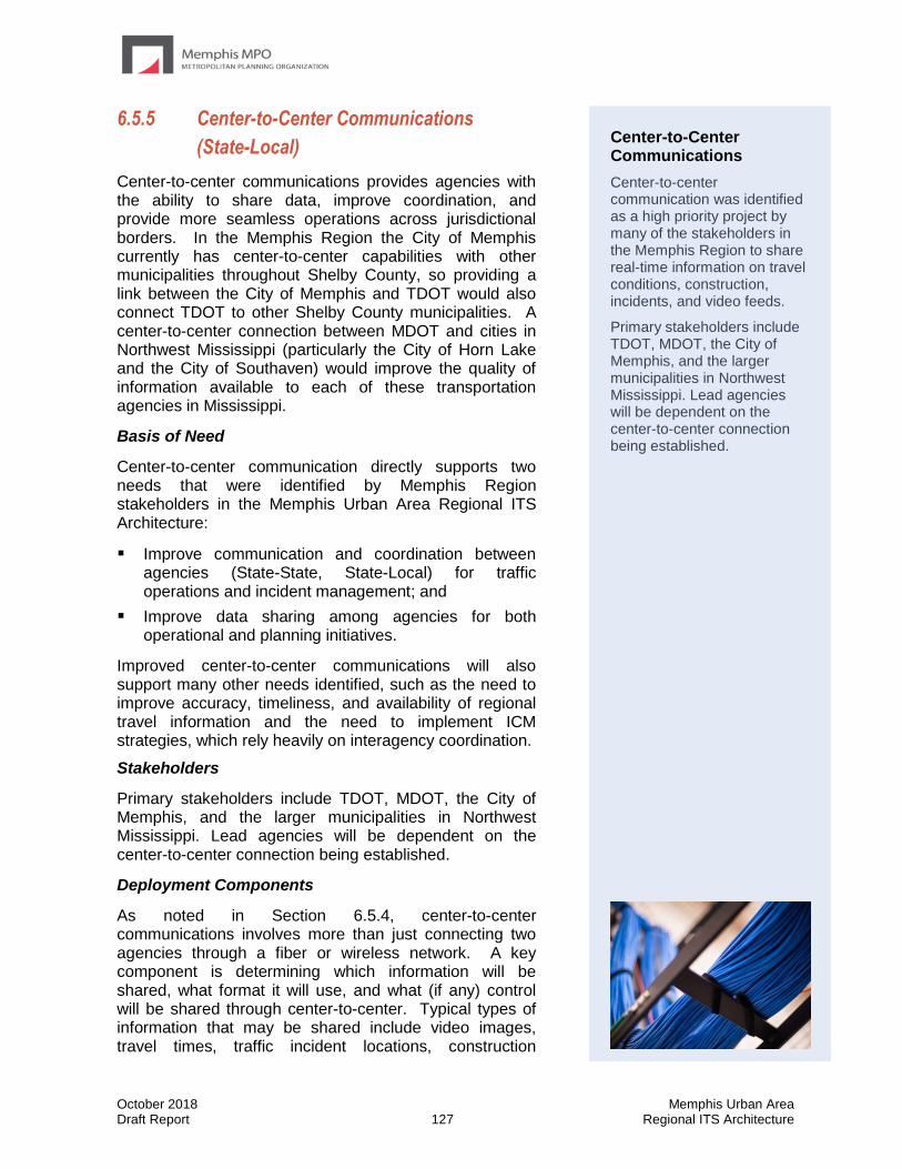
October 2018 Memphis Urban Area Draft Report 127 Regional ITS Architecture
6.5.5 Center-to-Center Communications
(State-Local)
Center-to-center communications provides agencies with the ability to share data, improve coordination, and provide more seamless operations across jurisdictional borders. In the Memphis Region the City of Memphis currently has center-to-center capabilities with other municipalities throughout Shelby County, so providing a link between the City of Memphis and TDOT would also connect TDOT to other Shelby County municipalities. A center-to-center connection between MDOT and cities in Northwest Mississippi (particularly the City of Horn Lake and the City of Southaven) would improve the quality of information available to each of these transportation agencies in Mississippi.
Basis of Need
Center-to-center communication directly supports two needs that were identified by Memphis Region stakeholders in the Memphis Urban Area Regional ITS Architecture:
▪ Improve communication and coordination between agencies (State-State, State-Local) for traffic operations and incident management; and
▪ Improve data sharing among agencies for both operational and planning initiatives.
Improved center-to-center communications will also support many other needs identified, such as the need to improve accuracy, timeliness, and availability of regional travel information and the need to implement ICM strategies, which rely heavily on interagency coordination.
Stakeholders
Primary stakeholders include TDOT, MDOT, the City of Memphis, and the larger municipalities in Northwest Mississippi. Lead agencies will be dependent on the center-to-center connection being established.
Deployment Components
As noted in Section 6.5.4, center-to-center communications involves more than just connecting two agencies through a fiber or wireless network. A key component is determining which information will be shared, what format it will use, and what (if any) control will be shared through center-to-center. Typical types of information that may be shared include video images, travel times, traffic incident locations, construction
Center-to-Center Communications
Center-to-center communication was identified as a high priority project by many of the stakeholders in the Memphis Region to share real-time information on travel conditions, construction, incidents, and video feeds.
Primary stakeholders include TDOT, MDOT, the City of Memphis, and the larger municipalities in Northwest Mississippi. Lead agencies will be dependent on the center-to-center connection being established.
October 2018 Memphis Urban Area Draft Report 128 Regional ITS Architecture
closures, weather closures, signal timing plans, and DMS messages. Some types of information may be for sharing only, while other types may include a level of control. For example, CCTV camera images may be shared with the non-owning agency only having the ability to view cameras, or the non-owning agency may be given the ability to control cameras as well.
Typically, center-to-center communications will need to have a concept of operations developed to determine the type of information that is shared and the level of control.
The following agencies indicated a need for state-to-local center-to-center communications in the Memphis Region:
• TDOT center-to-center connection with the City of Memphis
• MDOT center-to-center connections with the Cities of Horn Lake and Southaven in Northwest Mississippi
Timeframe
Stakeholders expressed a high level of interest in establishing these state-local center-to-center connections for the improvement of transportation operations and incident management in the Memphis MPO Region. These connections should be planned and implemented in the short term if possible.
Regional ITS Architecture Conformance
Center-to-center coordination primarily provides the services noted in the TM07 Regional Traffic Management ITS service packages. Center-to-center communications also support many of the other ITS service packages from the Memphis Urban Area Regional ITS Architecture that require strong communication ties, including the following:
• TM03 Traffic Signal Control
• TM06 Traffic Information Dissemination
• TM08 Traffic Incident Management System
• PS01 Emergency Call-Taking and Dispatch
• WX02 Weather Information Processing and Distribution
• MC08 Maintenance and Construction Activity Coordination
• PT02 Transit Fixed-Route Operations
• PT03 Dynamic Transit Operations
• PT14 Multi-modal Coordination
• DM01 ITS Data Warehouse
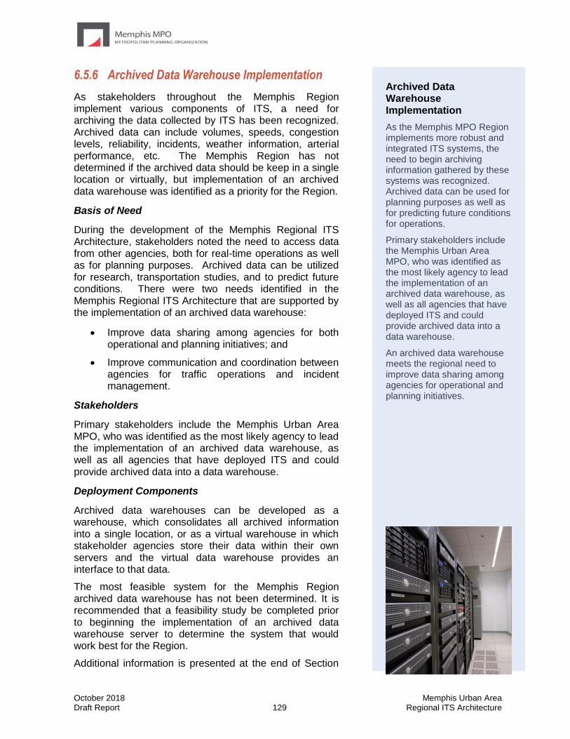
October 2018 Memphis Urban Area Draft Report 129 Regional ITS Architecture
6.5.6 Archived Data Warehouse Implementation
As stakeholders throughout the Memphis Region implement various components of ITS, a need for archiving the data collected by ITS has been recognized. Archived data can include volumes, speeds, congestion levels, reliability, incidents, weather information, arterial performance, etc. The Memphis Region has not determined if the archived data should be keep in a single location or virtually, but implementation of an archived data warehouse was identified as a priority for the Region.
Basis of Need
During the development of the Memphis Regional ITS Architecture, stakeholders noted the need to access data from other agencies, both for real-time operations as well as for planning purposes. Archived data can be utilized for research, transportation studies, and to predict future conditions. There were two needs identified in the Memphis Regional ITS Architecture that are supported by the implementation of an archived data warehouse:
• Improve data sharing among agencies for both operational and planning initiatives; and
• Improve communication and coordination between agencies for traffic operations and incident management.
Stakeholders
Primary stakeholders include the Memphis Urban Area MPO, who was identified as the most likely agency to lead the implementation of an archived data warehouse, as well as all agencies that have deployed ITS and could provide archived data into a data warehouse.
Deployment Components
Archived data warehouses can be developed as a warehouse, which consolidates all archived information into a single location, or as a virtual warehouse in which stakeholder agencies store their data within their own servers and the virtual data warehouse provides an interface to that data.
The most feasible system for the Memphis Region archived data warehouse has not been determined. It is recommended that a feasibility study be completed prior to beginning the implementation of an archived data warehouse server to determine the system that would work best for the Region.
Additional information is presented at the end of Section
Archived Data Warehouse Implementation
As the Memphis MPO Region implements more robust and integrated ITS systems, the need to begin archiving information gathered by these systems was recognized. Archived data can be used for planning purposes as well as for predicting future conditions for operations.
Primary stakeholders include the Memphis Urban Area MPO, who was identified as the most likely agency to lead the implementation of an archived data warehouse, as well as all agencies that have deployed ITS and could provide archived data into a data warehouse.
An archived data warehouse meets the regional need to improve data sharing among agencies for operational and planning initiatives.
October 2018 Memphis Urban Area Draft Report 130 Regional ITS Architecture
6.5.6 on a regional archived data warehouse that was developed for the Phoenix Region by Maricopa County. This information is presented to provide one concept of how a regional agency can implement an archived data warehouse.
Timeframe
The need for real-time regional traveler information was identified at the workshop by stakeholders as a high priority for the Region and should be implemented in the short-term.
Regional ITS Architecture Conformance
The implementation of a regional archived data warehouse directly conforms to a ITS service package in the Memphis Regional ITS Architecture: DM01 ITS Data Warehouse.
This ITS service package shows how an archived data warehouse could be used to archive data from stakeholders throughout the Memphis MPO Region.
Case Study of the Maricopa County (Phoenix Region) Archived Data Server
Maricopa County DOT (MCDOT) Regional Archived Data Server (RADS) was developed in 2003 as a data archive for ITS data from the transportation system in the Phoenix metropolitan area. As a central repository, RADS was well equipped to also function as a tool to collect and disseminate real-time ITS data that could help support the traveling public, thus RADS is now used as both a historical warehouse and a real-time center-to-center (C2C) data integration system for the Region. RADS takes ITS data from systems throughout the Phoenix metropolitan area, stores the data in a centralized archived data server, and then makes the data available for users through a web-based interface.
There are three major components of RADS that have been added to the system over time; these include freeway and arterial data (RADS-FMS); public safety data (RADS-EMS); and traffic signal data (RADS-TS). Initially, the system was comprised of freeway devices, such as CCTV images or RWIS data, which fed the Arizona DOT (ADOT) Highway Conditions Reporting System (HCRS) that provided information to the public via 511 and the ADOT FTP site. The development of RADS allowed for FMS data and travel times to be included in the data repository, with the RADS system serving as the central system that would collect and integrate the additional data to then feed the ADOT HCRS and eventually the 511. The addition of public safety data into the system came from the integration of the Phoenix Fire Department Computer Aided Dispatch (CAD) system, which provided filtered data on emergency dispatch and 911 calls. Finally, local jurisdictions began to implement centralized traffic management systems that created a way to integrate local data into the RADS system. With RADS providing the centralized warehouse and method for integration, most of the available ITS data in the region can be stored and disseminated in one place.
RADS includes real-time data that is automatically populated into the system as well as static data that is manually entered or uploaded. Types of data that is collected and archived through the RADS system includes FMS detector station data (volumes and speeds), travel times, ADOT HCRS events (road conditions, closures and incidents), Phoenix Fire incident data, and traffic signal C2C data such as volume, speed, occupancy, timing plan, and historical data from local municipalities (Scottsdale, Chandler, Gilbert, Tempe, Glendale, Surprise, Peoria, and Phoenix) and Maricopa County.
The centralization of this data allows for improved coordination between agencies for the operation and management of the freeways and arterials in the Region. For example, freeway and arterial DMS signs can be coordinated to provide better and more consistent traveler information including incident information or travel times. 511 systems can disseminate public safety information that is collected and filtered from CAD to provide reliable, real-time data for
October 2018 Memphis Urban Area Draft Report 131 Regional ITS Architecture
travelers and agencies. Finally, RADS provides the ability for local agencies to share their signal timing data so that signal timing can be coordinated throughout the region, rather than just locally.
The original RADS was funded through Federal CMAQ funds with a local match. Since 2010, the RADS system has gone through $700,000 worth of upgrades, including the installation of the AZTech Regional Information System (ARIS), which provided a more focused and streamlined incident management tool for traffic managers in the Phoenix Metropolitan Area. The ongoing maintenance of RADS is funded by MCDOT, and MCDOT is responsible for the management and oversight of RADS. The RADS server is housed at the ADOT TOC, and ADOT provides IT support for the maintenance and operations of the server.
October 2018 Memphis Urban Area Draft Report 132 Regional ITS Architecture
7.0 Use and Maintenance Plan The Regional ITS Architecture developed for the Memphis MPO Region addresses the Region’s vision for ITS implementation at the time the plan was developed. With the growth of the Region, needs will change and as technology progresses new ITS opportunities will arise. Shifts in regional needs and focus as well as changes in the National ITS Architecture will necessitate that the Memphis Urban Area Regional ITS Architecture be updated periodically to remain a useful resource for the Region. As projects are developed and deployed, it will be important that those projects conform to the Regional ITS Architecture so that they are consistent with both the Region’s vision for ITS as well as the National standards described in the Regional ITS Architecture. In some cases, if projects do not conform, it may be necessary to modify the Regional ITS Architecture to reflect changes in the Region’s vision for ITS rather than modify the project. In this Section, a process for determining architecture conformity of projects is presented and a plan for how to maintain and update the Regional ITS Architecture is described.
In 2001 the FHWA issued Final Rule 23 CFR 940, which required that ITS projects using federal funds (or ITS projects that integrate with systems that were deployed with federal funds) conform to a regional ITS architecture and also be developed using a systems engineering process. The purpose of this Section 7 is to discuss how the Memphis Urban Area Regional ITS Architecture can be used to support meeting the ITS architecture conformity and systems engineering requirements. A process for maintaining the Regional ITS Architecture, including the Regional ITS Deployment Plan which has been incorporated as Section 6 of the Regional ITS Architecture, is also presented. In Section 7.2 the systems engineering analysis requirements and the guidance provided by TDOT and the FHWA Tennessee Division are discussed. In Section 7.3, the process for determining ITS architecture conformity of an ITS project is presented.
The Regional ITS Architecture is considered a living document. Shifts in regional focus and priorities, changes and new developments in technology, and changes to the National ITS Architecture will necessitate that the Memphis Urban Area Regional ITS Architecture be updated to remain a useful resource for the Region. In the Regional ITS Architecture, a process for maintaining the plan was developed in coordination with stakeholders. The process covers both major updates to the Regional ITS Architecture that will happen approximately every four years as well as minor changes that may be needed between major updates of the documents. These processes have been included in this document in Sections 7.3 and 7.4.
7.1 Incorporation into the Regional Planning
Process
Stakeholders invested a considerable amount of effort in the development of the Regional ITS Architecture for the Memphis MPO Region. The plans need to be incorporated into the regional planning process so that the ITS vision for the Region is considered when implementing ITS projects in the future, and to ensure that the Region remains eligible for federal funding. The FHWA and FTA require that any project that is implemented with federal funds conform to the Regional ITS Architecture. Many metropolitan or transportation planning
October 2018 Memphis Urban Area Draft Report 133 Regional ITS Architecture
organizations around the country now require that an agency certify that a project with ITS elements conforms to the Regional ITS Architecture before allowing the project to be included in the Transportation Improvement Program (TIP).
Stakeholders in the Memphis MPO Region agreed that as projects are submitted for inclusion in the TIP, each project should be evaluated by the submitting agency to determine if the project includes any ITS elements. If the project contains any ITS elements, then the project needs to be reviewed to determine if the ITS elements in the project are in conformance with the Regional ITS Architecture. The submitting agency will perform this examination as part of the planning process using the procedure outlined in Section 7.3 and the Memphis MPO will review each project to confirm it does conform to the Regional ITS Architecture.
7.2 Systems Engineering Analysis
In order to assist agencies with meeting the requirements of the FHWA’s Final Rule 23 CFR 940, TDOT’s Traffic Operations Division developed a guidance document entitled “ITS Project Development Guidelines.” The document indicates that unless projects are categorically excluded, a systems engineering analysis must be performed for all ITS projects. Categorically excluded projects are those that do not utilize a centralized control, do not share data with another agency, or are expansions or enhancements to existing systems that do not add any new functionality. For example, installation of an isolated traffic signal or expansion of a freeway management system through the deployment of additional CCTV cameras would be categorically excluded and not require a systems engineering analysis.
The goal of performing a systems engineering analysis is to systematically think through the project deployment process, and show that thorough, upfront planning has been shown to help control costs and ensure schedule adherence. A project’s level of risk will determine if a simplified systems engineering analysis form (SSEAF) is sufficient, or if a more detailed systems engineering analysis report (SEAR) is necessary.
The TDOT requirements indicate that the following considerations should be included in a systems engineering analysis:
• Identification of portions of the Regional ITS Architecture being implemented;
• Identification of participating agencies and their roles and responsibilities;
• Definition of system requirements;
• Analysis of alternative system configurations and technology options that meet the system requirements;
• Identification of various procurement options;
• Identification of applicable ITS standards and testing procedures; and
• Documentation of the procedures and resources necessary for operations and management of the system.
The Memphis Urban Area Regional ITS Architecture and associated RAD-IT database can supply information for many of the required components for a systems engineering analysis. These include:
• Portions of the Regional ITS Architecture being implemented;
• Participating agencies and their roles and responsibilities;
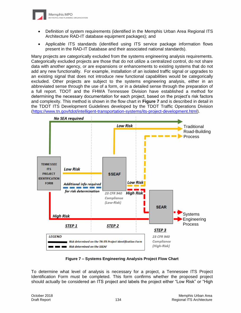
October 2018 Memphis Urban Area Draft Report 134 Regional ITS Architecture
• Definition of system requirements (identified in the Memphis Urban Area Regional ITS Architecture RAD-IT database equipment packages); and
• Applicable ITS standards (identified using ITS service package information flows present in the RAD-IT Database and their associated national standards).
Many projects are categorically excluded from the systems engineering analysis requirements. Categorically excluded projects are those that do not utilize a centralized control, do not share data with another agency, or are expansions or enhancements to existing systems that do not add any new functionality. For example, installation of an isolated traffic signal or upgrades to an existing signal that does not introduce new functional capabilities would be categorically excluded. Other projects are subject to the systems engineering analysis, either in an abbreviated sense through the use of a form, or in a detailed sense through the preparation of a full report. TDOT and the FHWA Tennessee Division have established a method for determining the necessary documentation for each project, based on the project’s risk factors and complexity. This method is shown in the flow chart in Figure 7 and is described in detail in the TDOT ITS Development Guidelines developed by the TDOT Traffic Operations Division (https://www.tn.gov/tdot/intelligent-transportation-systems/its-project-development.html).
Figure 7 – Systems Engineering Analysis Project Flow Chart
To determine what level of analysis is necessary for a project, a Tennessee ITS Project Identification Form must be completed. This form confirms whether the proposed project should actually be considered an ITS project and labels the project either “Low Risk” or “High
Traditional Road-Building Process
Systems Engineering Process

October 2018 Memphis Urban Area Draft Report 135 Regional ITS Architecture
Risk.” Many projects that may have some connection to ITS elements or functions are actually non-ITS projects because they do not add any new functionality to the ITS architecture. The form identifies those projects, which require no further systems engineering analysis and can proceed through the traditional road building project process. In determining risk of projects, the Project Identification Form takes into account project factors including:
• Number of jurisdictions and modes;
• Extent of software creation;
• Extent of proven hardware and communications technology used;
• Number and complexity of new interfaces to other systems;
• Level of detail in requirements and documentation;
• Level of detail in operating procedures and documentation; and
• Service life of technology applied to equipment and software.
Projects which are identified as “High-Risk” on the Project Identification Form will require a systems engineering analysis report (SEAR). Projects which are identified as “Low Risk” or as requiring more information to determine risk on the Project Identification Form are subject to an abbreviated analysis. In these cases, contracting agencies must fill out a Simplified Systems Engineering Analysis Form (SSEAF). This form is submitted to TDOT, which reviews the form and informs the agency and project sponsor of risk determination. If TDOT determines the project to be “High Risk”, a SEAR is required. If TDOT determines the project to be “Low Risk”, the project can follow the traditional road building project process for other non-ITS projects.
The Vee Diagram, shown as Figure 8, is frequently used in systems engineering discussions to demonstrate where the Regional ITS Architecture and systems engineering process fits into the life cycle of an ITS project. The Regional ITS Architecture is shown unattached from the rest of the diagram because it is not specifically project related and an undetermined amount of time can pass between the architecture development and the beginning of project implementation. Traveling along the diagram the systems engineering process addresses concept exploration, the systems engineering management plan framework, concept of operations, and systems requirements.
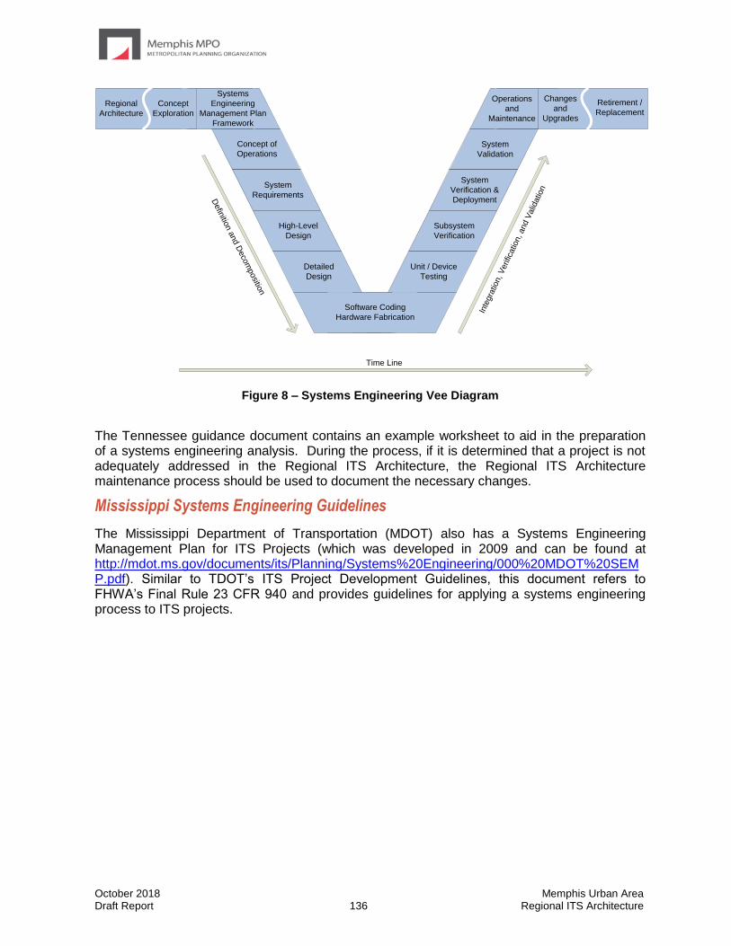
October 2018 Memphis Urban Area Draft Report 136 Regional ITS Architecture
Regional
Architecture
Systems
Engineering
Management Plan
Framework
Concept of
Operations
System
Requirements
High-Level
Design
Detailed
Design
Software Coding
Hardware Fabrication
Unit / Device
Testing
Subsystem
Verification
System
Verification &
Deployment
System
Validation
Operations
and
Maintenance
Changes
and
Upgrades
Retirement /
Replacement
Defin
ition a
nd D
eco
mpositio
n
Inte
gra
tion, V
erific
atio
n, and V
alid
atio
n
Time Line
Concept
Exploration
Figure 8 – Systems Engineering Vee Diagram
The Tennessee guidance document contains an example worksheet to aid in the preparation of a systems engineering analysis. During the process, if it is determined that a project is not adequately addressed in the Regional ITS Architecture, the Regional ITS Architecture maintenance process should be used to document the necessary changes.
Mississippi Systems Engineering Guidelines
The Mississippi Department of Transportation (MDOT) also has a Systems Engineering Management Plan for ITS Projects (which was developed in 2009 and can be found at http://mdot.ms.gov/documents/its/Planning/Systems%20Engineering/000%20MDOT%20SEMP.pdf). Similar to TDOT’s ITS Project Development Guidelines, this document refers to FHWA’s Final Rule 23 CFR 940 and provides guidelines for applying a systems engineering process to ITS projects.

October 2018 Memphis Urban Area Draft Report 137 Regional ITS Architecture
7.3 Process for Determining ITS Architecture
Conformity
The Memphis Urban Area Regional ITS Architecture documents the customized service packages that were developed as part of the ITS architecture process. To satisfy FHWA and FTA requirements and remain eligible to use Federal funds, a project must be accurately documented. The steps of the process are as follows:
• Identify the ITS components in the project;
• Identify the corresponding service packages(s) from the Regional ITS Architecture;
• Locate the component within the service package;
• Compare the connections to other agencies or elements documented in the ITS architecture as well as the information flows between them to the connections that will be part of the project; and
• Document any changes necessary to the Regional ITS Architecture or the project to ensure there is conformance.
The steps for determining ITS architecture conformity of a project are described in more detail on the following page.
October 2018 Memphis Urban Area Draft Report 138 Regional ITS Architecture
Step 1 – Identify the ITS Components
ITS components can be fairly apparent in an ITS focused project such as CCTV or DMS deployments, but could also be included in other types of projects where they are not as apparent. For example, an arterial widening project could include the installation of signal system interconnect, signal upgrades, and the incorporation of the signals in the project limits into a city’s closed loop signal system. These are all ITS functions and should be included in the ITS Architecture.
Step 2 – Identify the Corresponding Service Packages
If a project was included in the list of projects identified in the Memphis Urban Area Regional ITS Deployment Plan, then the applicable service package(s) for that project were also identified. However, ITS projects are not required to be included in the ITS Deployment Plan in order to be eligible for federal funding; therefore, service packages might need to be identified for projects that have not been covered in the ITS Deployment Plan. In that case, the service packages selected and customized for the Memphis Urban Area should be reviewed to determine if they adequately cover the project. Service packages selected for the Memphis Urban Area Regional ITS Architecture are identified in Table 7 of this document and detailed service package definitions are located in Appendix A.
Step 3 – Identify the Component within the Service Package
The customized service packages for the Memphis MPO Region are provided in the online interactive RAD-IT database at www.memphismpo.org/plans/safety-mobility/its. Once the element is located within the appropriate service package, the evaluator should determine if the element name used in the service package is accurate or if a change to the name is needed. For example, a future element called the City of Memphis Arterial Emergency Response Vehicles was included in the Memphis Urban Area Regional ITS Architecture for a future roadway service patrol to be operated by the City of Memphis. Detailed planning for this system has not begun and it would not be unusual for City of Memphis to select a different name for the system once planning and implementation is underway. Such a name change should be documented using the process outlined in Section 7.5.
Step 4 – Evaluate the Connections and Flows
The connections and architecture flows documented in the service package diagrams were selected based on the information available at the time the Regional ITS Architecture was developed. As the projects are designed, decisions will be made on the system layout that might differ from what is shown in the service package. These changes in the project should be documented in the ITS service packages.
Step 5 – Document Required Changes
If any changes are needed to accommodate the project under review, Section 7.5 describes how those changes should be documented. Any changes will be incorporated during the next Regional ITS Architecture update. Conformance will be accomplished by documenting how the service package(s) should be modified so that the connections and data flows are consistent with the project.

October 2018 Memphis Urban Area Draft Report 139 Regional ITS Architecture
7.4 Regional ITS Architecture Maintenance Process
The Memphis MPO will be responsible for leading the process to update the Memphis Urban Area Regional ITS Architecture in coordination with the TDOT Traffic Operations Division. Table 16 summarizes the maintenance process agreed upon by stakeholders in the Region.
Table 16 – Regional ITS Architecture and Deployment Plan Maintenance Summary
Maintenance Details
Regional ITS Architecture and Deployment Plan
Minor Update Major Update
Timeframe for Updates
As needed Approximately every 4 years
Scope of Update Review and update service packages to satisfy architecture compliance requirements of projects or to document other changes that impact the Regional ITS Architecture
Entire Regional ITS Architecture and Deployment Plan
Lead Agency Memphis MPO
Participants Stakeholders impacted by service package modifications
Entire stakeholder group
Results Service package or other change(s) documented for next complete update
Updated Regional ITS Architecture and Deployment Plan document, Appendices, and RAD-IT Architecture database
Stakeholders agreed that a full update of the Regional ITS Architecture and Deployment Plan should occur approximately every four years in the year preceding the Regional Transportation Plan (RTP) update. By completing a full update in the year prior to the RTP update, stakeholders will be able to determine the ITS needs and projects that are most important to the Region and document those needs and projects for consideration when developing the RTP. The Memphis MPO, in coordination with the TDOT Traffic Operations Division, will be responsible for completing the full updates. During the update process, all of the stakeholder agencies that participated in the original development of the Regional ITS Architecture and Deployment Plan should be included as well as any other agencies in the Region that are deploying or may be impacted by ITS projects.
Minor changes to the Regional ITS Architecture and Deployment Plan should occur as needed between full updates of the plan. In Section 7.5 of this document, the procedure for submitting a change to the Regional ITS Architecture is documented. Documentation of changes to the Regional ITS Architecture is particularly important if a project is being deployed and requires a change to the Regional ITS Architecture in order to establish conformity.

October 2018 Memphis Urban Area Draft Report 140 Regional ITS Architecture
7.5 Procedure for Submitting ITS Architecture
Changes Between Major Updates
Updates to the Memphis Urban Area Regional ITS Architecture will occur on a regular basis as described in Section 7.4 to maintain the architecture as a useful planning tool. Between major plan updates, smaller modifications will likely be required to accommodate ITS projects in the Region. Section 7.3 contains step by step guidance for determining whether or not a project requires modifications to the Regional ITS Architecture.
For situations where a change is required, an Architecture Maintenance Documentation Form was developed and is included in Appendix E. This form should be completed and submitted to the architecture maintenance contact person identified on the form whenever a change to the Regional ITS Architecture is proposed. There are several key questions that need to be answered when completing the Architecture Maintenance Documentation Form including those described below.
Change Information: The type of change that is being requested can include an Administrative Change, Functional Change – Single Agency, Functional Change – Multiple Agency, or a Project Change. A description of each type of change is summarized below.
• Administrative Change: Basic changes that do not affect the structure of the ITS service packages in the Regional ITS Architecture. Examples include changes to stakeholder or element names, element status, or data flow status.
• Functional Change: Single Agency: Structural changes to the ITS service packages that impact only one agency in the Regional ITS Architecture. Examples include the addition of a new ITS service package or changes to data flow connections of an existing service package. The addition or change would only impact a single agency.
• Functional Change: Multiple Agencies: Structural changes to the ITS service packages that have the potential to impact multiple agencies in the Regional ITS Architecture. Examples include the addition of a new ITS service package or changes to data flow connections of an existing ITS service package. The addition or changes would impact multiple agencies and require coordination between the agencies.
• Project Change: Addition, modification, or removal of a project in the Regional ITS Deployment Plan Section of the Regional ITS Architecture.
Description of the requested change: A brief description of the change being requested should be included.
Service packages being impacted by the change: Each of the ITS service packages that are impacted by the proposed change should be listed on the ITS Architecture Maintenance Documentation Form. If the proposed change involves creating or modifying an ITS service package, then the agency completing the ITS Architecture Maintenance Documentation Form is asked to include a sketch of the new or modified service package.
Impact of proposed change on other stakeholders: If the proposed change is expected to have any impact on other stakeholders in the Region, then those stakeholders should be listed on the ITS Architecture Maintenance Documentation Form. A description of any coordination that has occurred with other stakeholders that may be impacted by the change should be also included. Ideally all stakeholders that may be impacted by the change should be contacted

October 2018 Memphis Urban Area Draft Report 141 Regional ITS Architecture
and consensus should be reached on any new or modified ITS service packages that will be included as part of the Regional ITS Architecture.
The Memphis MPO will review and accept the proposed changes and forward the form to the TDOT Traffic Operations Division for their records. When a major update is performed, all of the documented changes should be incorporated into the Regional ITS Architecture.
October 2018 Memphis Urban Area Draft Report Regional ITS Architecture
Appendix A – Service Package Definitions
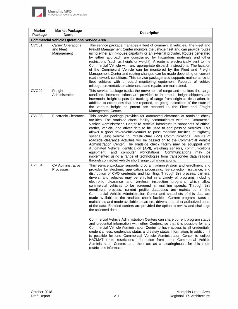
October 2018 Memphis Urban Area Draft Report A-1 Regional ITS Architecture
Market Package
Market Package Name
Description
Commercial Vehicle Operations Service Area
CVO01 Carrier Operations and Fleet Management
This service package manages a fleet of commercial vehicles. The Fleet and Freight Management Center monitors the vehicle fleet and can provide routes using either an in-house capability or an external provider. Routes generated by either approach are constrained by hazardous materials and other restrictions (such as height or weight). A route is electronically sent to the Commercial Vehicle with any appropriate dispatch instructions. The location of the Commercial Vehicle can be monitored by the Fleet and Freight Management Center and routing changes can be made depending on current road network conditions. This service package also supports maintenance of fleet vehicles with on-board monitoring equipment. Records of vehicle mileage, preventative maintenance and repairs are maintained.
CVO02 Freight Administration
This service package tracks the movement of cargo and monitors the cargo condition. Interconnections are provided to intermodal freight shippers and intermodal freight depots for tracking of cargo from origin to destination. In addition to exceptions that are reported, on-going indications of the state of the various freight equipment are reported to the Fleet and Freight Management Center.
CVO03 Electronic Clearance This service package provides for automated clearance at roadside check facilities. The roadside check facility communicates with the Commercial Vehicle Administration Center to retrieve infrastructure snapshots of critical carrier, vehicle, and driver data to be used to sort passing vehicles. This allows a good driver/vehicle/carrier to pass roadside facilities at highway speeds using vehicle to infrastructure (V2I) Communications. Results of roadside clearance activities will be passed on to the Commercial Vehicle Administration Center. The roadside check facility may be equipped with Automated Vehicle Identification (AVI), weighing sensors, communications equipment, and computer workstations. Communications may be implemented using a range of technologies from transponder data readers through connected vehicle short range communications.
CVO04 CV Administrative Processes
This service package supports program administration and enrollment and provides for electronic application, processing, fee collection, issuance, and distribution of CVO credential and tax filing. Through this process, carriers, drivers, and vehicles may be enrolled in a variety of programs including electronic clearance and wireless inspection programs which allow commercial vehicles to be screened at mainline speeds. Through this enrollment process, current profile databases are maintained in the Commercial Vehicle Administration Center and snapshots of this data are made available to the roadside check facilities. Current program status is maintained and made available to carriers, drivers, and other authorized users of the data. Enrolled carriers are provided the option to review and challenge the collected data.
Commercial Vehicle Administration Centers can share current program status and credential information with other Centers, so that it is possible for any Commercial Vehicle Administration Center to have access to all credentials, credential fees, credentials status and safety status information. In addition, it is possible for one Commercial Vehicle Administration Center to collect HAZMAT route restrictions information from other Commercial Vehicle Administration Centers and then act as a clearinghouse for this route restrictions information.
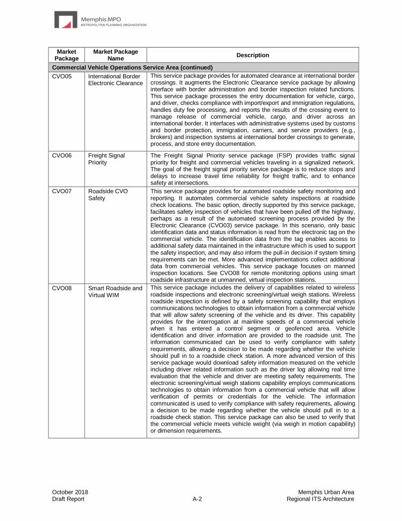
October 2018 Memphis Urban Area Draft Report A-2 Regional ITS Architecture
Market Package
Market Package Name
Description
Commercial Vehicle Operations Service Area (continued)
CVO05 International Border Electronic Clearance
This service package provides for automated clearance at international border crossings. It augments the Electronic Clearance service package by allowing interface with border administration and border inspection related functions. This service package processes the entry documentation for vehicle, cargo, and driver, checks compliance with import/export and immigration regulations, handles duty fee processing, and reports the results of the crossing event to manage release of commercial vehicle, cargo, and driver across an international border. It interfaces with administrative systems used by customs and border protection, immigration, carriers, and service providers (e.g., brokers) and inspection systems at international border crossings to generate, process, and store entry documentation.
CVO06 Freight Signal Priority
The Freight Signal Priority service package (FSP) provides traffic signal priority for freight and commercial vehicles traveling in a signalized network. The goal of the freight signal priority service package is to reduce stops and delays to increase travel time reliability for freight traffic, and to enhance safety at intersections.
CVO07 Roadside CVO Safety
This service package provides for automated roadside safety monitoring and reporting. It automates commercial vehicle safety inspections at roadside check locations. The basic option, directly supported by this service package, facilitates safety inspection of vehicles that have been pulled off the highway, perhaps as a result of the automated screening process provided by the Electronic Clearance (CVO03) service package. In this scenario, only basic identification data and status information is read from the electronic tag on the commercial vehicle. The identification data from the tag enables access to additional safety data maintained in the infrastructure which is used to support the safety inspection, and may also inform the pull-in decision if system timing requirements can be met. More advanced implementations collect additional data from commercial vehicles. This service package focuses on manned inspection locations. See CVO08 for remote monitoring options using smart roadside infrastructure at unmanned, virtual inspection stations.
CVO08 Smart Roadside and Virtual WIM
This service package includes the delivery of capabilities related to wireless roadside inspections and electronic screening/virtual weigh stations. Wireless roadside inspection is defined by a safety screening capability that employs communications technologies to obtain information from a commercial vehicle that will allow safety screening of the vehicle and its driver. This capability provides for the interrogation at mainline speeds of a commercial vehicle when it has entered a control segment or geofenced area. Vehicle identification and driver information are provided to the roadside unit. The information communicated can be used to verify compliance with safety requirements, allowing a decision to be made regarding whether the vehicle should pull in to a roadside check station. A more advanced version of this service package would download safety information measured on the vehicle including driver related information such as the driver log allowing real time evaluation that the vehicle and driver are meeting safety requirements. The electronic screening/virtual weigh stations capability employs communications technologies to obtain information from a commercial vehicle that will allow verification of permits or credentials for the vehicle. The information communicated is used to verify compliance with safety requirements, allowing a decision to be made regarding whether the vehicle should pull in to a roadside check station. This service package can also be used to verify that the commercial vehicle meets vehicle weight (via weigh in motion capability) or dimension requirements.
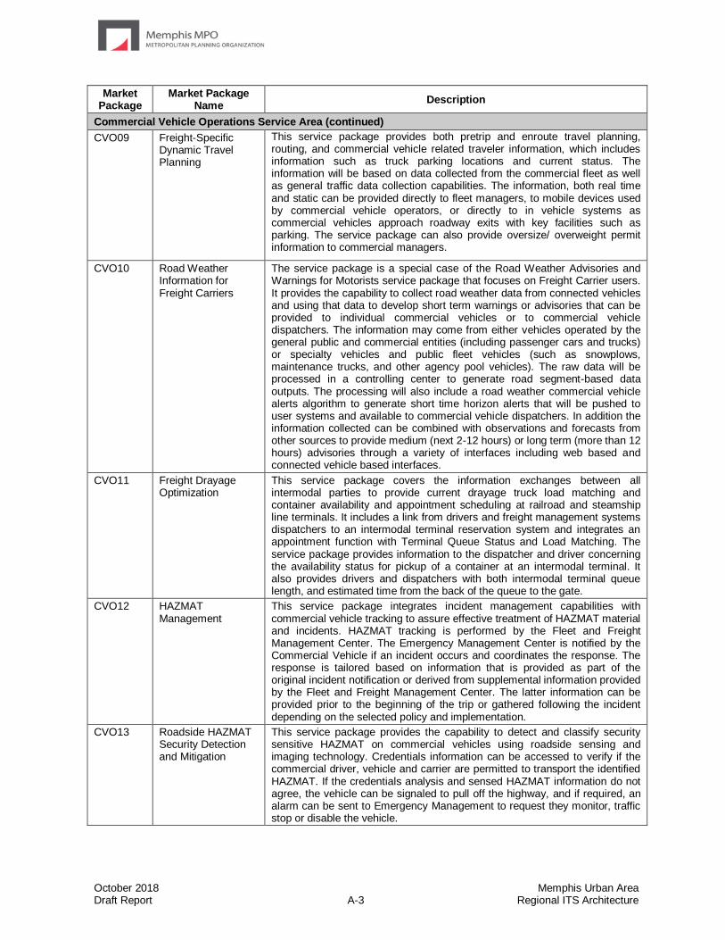
October 2018 Memphis Urban Area Draft Report A-3 Regional ITS Architecture
Market Package
Market Package Name
Description
Commercial Vehicle Operations Service Area (continued)
CVO09 Freight-Specific Dynamic Travel Planning
This service package provides both pretrip and enroute travel planning, routing, and commercial vehicle related traveler information, which includes information such as truck parking locations and current status. The information will be based on data collected from the commercial fleet as well as general traffic data collection capabilities. The information, both real time and static can be provided directly to fleet managers, to mobile devices used by commercial vehicle operators, or directly to in vehicle systems as commercial vehicles approach roadway exits with key facilities such as parking. The service package can also provide oversize/ overweight permit information to commercial managers.
CVO10 Road Weather Information for Freight Carriers
The service package is a special case of the Road Weather Advisories and Warnings for Motorists service package that focuses on Freight Carrier users. It provides the capability to collect road weather data from connected vehicles and using that data to develop short term warnings or advisories that can be provided to individual commercial vehicles or to commercial vehicle dispatchers. The information may come from either vehicles operated by the general public and commercial entities (including passenger cars and trucks) or specialty vehicles and public fleet vehicles (such as snowplows, maintenance trucks, and other agency pool vehicles). The raw data will be processed in a controlling center to generate road segment-based data outputs. The processing will also include a road weather commercial vehicle alerts algorithm to generate short time horizon alerts that will be pushed to user systems and available to commercial vehicle dispatchers. In addition the information collected can be combined with observations and forecasts from other sources to provide medium (next 2-12 hours) or long term (more than 12 hours) advisories through a variety of interfaces including web based and connected vehicle based interfaces.
CVO11 Freight Drayage Optimization
This service package covers the information exchanges between all intermodal parties to provide current drayage truck load matching and container availability and appointment scheduling at railroad and steamship line terminals. It includes a link from drivers and freight management systems dispatchers to an intermodal terminal reservation system and integrates an appointment function with Terminal Queue Status and Load Matching. The service package provides information to the dispatcher and driver concerning the availability status for pickup of a container at an intermodal terminal. It also provides drivers and dispatchers with both intermodal terminal queue length, and estimated time from the back of the queue to the gate.
CVO12 HAZMAT Management
This service package integrates incident management capabilities with commercial vehicle tracking to assure effective treatment of HAZMAT material and incidents. HAZMAT tracking is performed by the Fleet and Freight Management Center. The Emergency Management Center is notified by the Commercial Vehicle if an incident occurs and coordinates the response. The response is tailored based on information that is provided as part of the original incident notification or derived from supplemental information provided by the Fleet and Freight Management Center. The latter information can be provided prior to the beginning of the trip or gathered following the incident depending on the selected policy and implementation.
CVO13 Roadside HAZMAT Security Detection and Mitigation
This service package provides the capability to detect and classify security sensitive HAZMAT on commercial vehicles using roadside sensing and imaging technology. Credentials information can be accessed to verify if the commercial driver, vehicle and carrier are permitted to transport the identified HAZMAT. If the credentials analysis and sensed HAZMAT information do not agree, the vehicle can be signaled to pull off the highway, and if required, an alarm can be sent to Emergency Management to request they monitor, traffic stop or disable the vehicle.
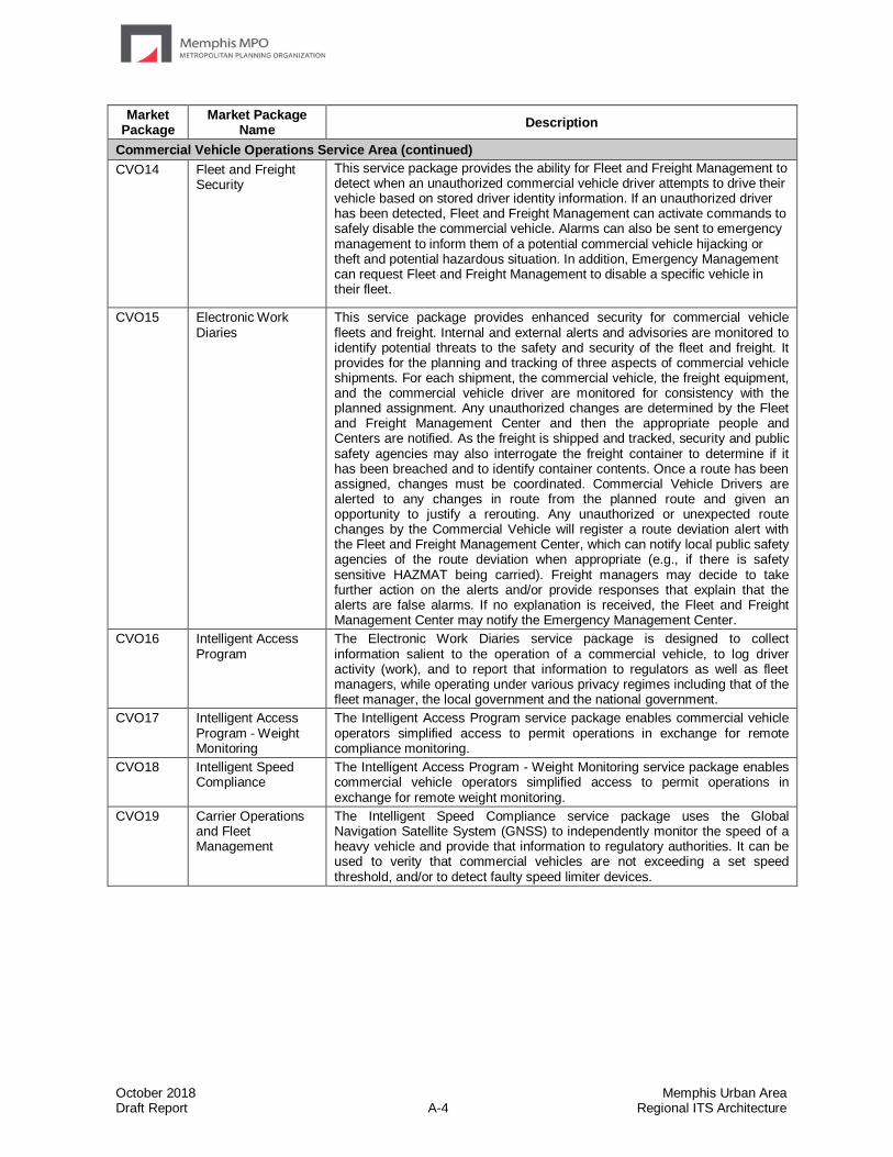
October 2018 Memphis Urban Area Draft Report A-4 Regional ITS Architecture
Market Package
Market Package Name
Description
Commercial Vehicle Operations Service Area (continued)
CVO14 Fleet and Freight Security
This service package provides the ability for Fleet and Freight Management to detect when an unauthorized commercial vehicle driver attempts to drive their vehicle based on stored driver identity information. If an unauthorized driver has been detected, Fleet and Freight Management can activate commands to safely disable the commercial vehicle. Alarms can also be sent to emergency management to inform them of a potential commercial vehicle hijacking or theft and potential hazardous situation. In addition, Emergency Management can request Fleet and Freight Management to disable a specific vehicle in their fleet.
CVO15 Electronic Work Diaries
This service package provides enhanced security for commercial vehicle fleets and freight. Internal and external alerts and advisories are monitored to identify potential threats to the safety and security of the fleet and freight. It provides for the planning and tracking of three aspects of commercial vehicle shipments. For each shipment, the commercial vehicle, the freight equipment, and the commercial vehicle driver are monitored for consistency with the planned assignment. Any unauthorized changes are determined by the Fleet and Freight Management Center and then the appropriate people and Centers are notified. As the freight is shipped and tracked, security and public safety agencies may also interrogate the freight container to determine if it has been breached and to identify container contents. Once a route has been assigned, changes must be coordinated. Commercial Vehicle Drivers are alerted to any changes in route from the planned route and given an opportunity to justify a rerouting. Any unauthorized or unexpected route changes by the Commercial Vehicle will register a route deviation alert with the Fleet and Freight Management Center, which can notify local public safety agencies of the route deviation when appropriate (e.g., if there is safety sensitive HAZMAT being carried). Freight managers may decide to take further action on the alerts and/or provide responses that explain that the alerts are false alarms. If no explanation is received, the Fleet and Freight Management Center may notify the Emergency Management Center.
CVO16 Intelligent Access Program
The Electronic Work Diaries service package is designed to collect information salient to the operation of a commercial vehicle, to log driver activity (work), and to report that information to regulators as well as fleet managers, while operating under various privacy regimes including that of the fleet manager, the local government and the national government.
CVO17 Intelligent Access Program - Weight Monitoring
The Intelligent Access Program service package enables commercial vehicle operators simplified access to permit operations in exchange for remote compliance monitoring.
CVO18 Intelligent Speed Compliance
The Intelligent Access Program - Weight Monitoring service package enables commercial vehicle operators simplified access to permit operations in exchange for remote weight monitoring.
CVO19 Carrier Operations and Fleet Management
The Intelligent Speed Compliance service package uses the Global Navigation Satellite System (GNSS) to independently monitor the speed of a heavy vehicle and provide that information to regulatory authorities. It can be used to verity that commercial vehicles are not exceeding a set speed threshold, and/or to detect faulty speed limiter devices.
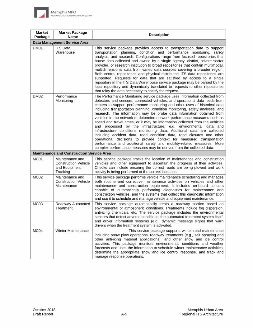
October 2018 Memphis Urban Area Draft Report A-5 Regional ITS Architecture
Market Package
Market Package Name
Description
Data Management Service Area
DM01 ITS Data Warehouse
This service package provides access to transportation data to support transportation planning, condition and performance monitoring, safety analysis, and research. Configurations range from focused repositories that house data collected and owned by a single agency, district, private sector provider, or research institution to broad repositories that contain multimodal, multidimensional data from varied data sources covering a broader region. Both central repositories and physical distributed ITS data repositories are supported. Requests for data that are satisfied by access to a single repository in the ITS Data Warehouse service package may be parsed by the local repository and dynamically translated to requests to other repositories that relay the data necessary to satisfy the request.
DM02 Performance Monitoring
The Performance Monitoring service package uses information collected from detectors and sensors, connected vehicles, and operational data feeds from centers to support performance monitoring and other uses of historical data including transportation planning, condition monitoring, safety analyses, and research. The information may be probe data information obtained from vehicles in the network to determine network performance measures such as speed and travel times, or it may be information collected from the vehicles and processed by the infrastructure, e.g. environmental data and infrastructure conditions monitoring data. Additional data are collected including accident data, road condition data, road closures and other operational decisions to provide context for measured transportation performance and additional safety and mobility-related measures. More complex performance measures may be derived from the collected data.
Maintenance and Construction Service Area
MC01 Maintenance and Construction Vehicle and Equipment Tracking
This service package tracks the location of maintenance and construction vehicles and other equipment to ascertain the progress of their activities. Checks can include ensuring the correct roads are being plowed and work activity is being performed at the correct locations.
MC02 Maintenance and Construction Vehicle Maintenance
This service package performs vehicle maintenance scheduling and manages both routine and corrective maintenance activities on vehicles and other maintenance and construction equipment. It includes on-board sensors capable of automatically performing diagnostics for maintenance and construction vehicles, and the systems that collect this diagnostic information and use it to schedule and manage vehicle and equipment maintenance.
MC03 Roadway Automated Treatment
This service package automatically treats a roadway section based on environmental or atmospheric conditions. Treatments include fog dispersion, anti-icing chemicals, etc. The service package includes the environmental sensors that detect adverse conditions, the automated treatment system itself, and driver information systems (e.g., dynamic message signs) that warn drivers when the treatment system is activated.
MC04 Winter Maintenance This service package supports winter road maintenance including snow plow operations, roadway treatments (e.g., salt spraying and other anti-icing material applications), and other snow and ice control activities. This package monitors environmental conditions and weather forecasts and uses the information to schedule winter maintenance activities, determine the appropriate snow and ice control response, and track and manage response operations.

October 2018 Memphis Urban Area Draft Report A-6 Regional ITS Architecture
Market Package
Market Package Name
Description
Maintenance and Construction Service Area (continued)
MC05 Roadway Maintenance and Construction
This service package supports numerous services for scheduled and unscheduled maintenance and construction on a roadway system or right-of-way. Maintenance services include landscape maintenance, hazard removal (roadway debris, dead animals), routine maintenance activities (roadway cleaning, grass cutting), and repair and maintenance of both ITS and non-ITS equipment on the roadway (e.g., signs, traffic controllers, traffic detectors, dynamic message signs, traffic signals, CCTV, etc.). Environmental conditions information is also received from various weather sources to aid in scheduling maintenance and construction activities.
MC06 Work Zone Management
This service package manages work zones, controlling traffic in areas of the roadway where maintenance, construction, and utility work activities are underway. Traffic conditions are monitored using CCTV cameras and controlled using dynamic message signs (DMS), Highway Advisory Radio (HAR), gates and barriers. Work zone information is coordinated with other groups (e.g., TIC, traffic management, other maintenance and construction centers). Work zone speeds and delays are provided to the motorist prior to the work zones. This service package provides control of field equipment in all maintenance and construction areas, including fixed, portable, and truck-mounted devices supporting both stationary and mobile work zones.
MC07 Work Zone Safety Monitoring
This service package provides warnings to maintenance personnel within a work zone about potential hazards within the work zone. It enables vehicles or the infrastructure to provide warnings to workers in a work zone when a vehicle is moving in a manner that appears to create an unsafe condition (e.g., moving at high speed or entering the work zone).
MC08 Maintenance and Construction Activity Coordination
This service package supports the dissemination of maintenance and construction activity to centers that can utilize it as part of their operations, or to Transportation Information Centers who can provide the information to travelers. Center to center coordination of work plans supports adjustments to reduce disruption to regional transportation operations.
MC09 Infrastructure Monitoring
This service package monitors the condition of pavement, bridges, tunnels, associated hardware, and other transportation-related infrastructure (e.g., culverts) using both fixed and vehicle-based infrastructure monitoring sensors. Fixed sensors monitor vibration, stress, temperature, continuity, and other parameters and mobile sensors and data logging devices collect information on current infrastructure condition. This service package also monitors vehicle probes for vertical acceleration data and other probe data that may be used to determine current pavement condition.
Parking Management Service Area
PM01 Parking Space Management
This service package monitors and manages parking spaces in lots, garages, and other parking areas and facilities. It assists in the management of parking operations by monitoring parking lot ingress and egress, parking space occupancy and availability. Infrastructure-based detectors and/or connected vehicles may be used to monitor parking occupancy. The service package shares collected parking information with local drivers and information providers for broader distribution.
PM02 Smart Park and Ride System
This service package provides real-time information on Park and Ride capacity and supports traveler's decision-making on where best to park and make use of transit alternatives. Transit operators are provided arrival information to support efficient pickup and drop offs and drivers switching to transit are offered current transit information.
PM03 Parking Electronic Payment
This service package supports electronic collection of parking fees. It collects parking fees from in-vehicle equipment, contact or proximity cards, or any smart payment device. User accounts may be established to enhance services offered to frequent customers.
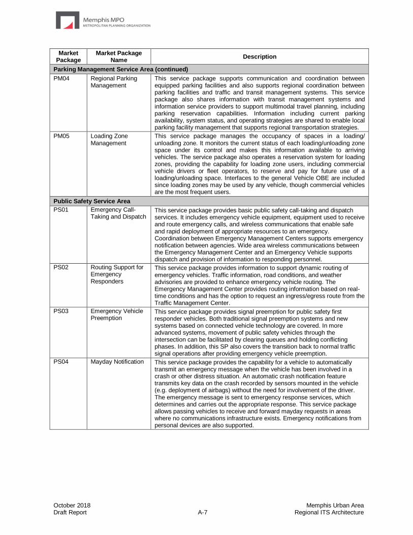
October 2018 Memphis Urban Area Draft Report A-7 Regional ITS Architecture
Market Package
Market Package Name
Description
Parking Management Service Area (continued)
PM04 Regional Parking Management
This service package supports communication and coordination between equipped parking facilities and also supports regional coordination between parking facilities and traffic and transit management systems. This service package also shares information with transit management systems and information service providers to support multimodal travel planning, including parking reservation capabilities. Information including current parking availability, system status, and operating strategies are shared to enable local parking facility management that supports regional transportation strategies.
PM05 Loading Zone Management
This service package manages the occupancy of spaces in a loading/ unloading zone. It monitors the current status of each loading/unloading zone space under its control and makes this information available to arriving vehicles. The service package also operates a reservation system for loading zones, providing the capability for loading zone users, including commercial vehicle drivers or fleet operators, to reserve and pay for future use of a loading/unloading space. Interfaces to the general Vehicle OBE are included since loading zones may be used by any vehicle, though commercial vehicles are the most frequent users.
Public Safety Service Area
PS01 Emergency Call-Taking and Dispatch
This service package provides basic public safety call-taking and dispatch services. It includes emergency vehicle equipment, equipment used to receive and route emergency calls, and wireless communications that enable safe and rapid deployment of appropriate resources to an emergency. Coordination between Emergency Management Centers supports emergency notification between agencies. Wide area wireless communications between the Emergency Management Center and an Emergency Vehicle supports dispatch and provision of information to responding personnel.
PS02 Routing Support for Emergency Responders
This service package provides information to support dynamic routing of emergency vehicles. Traffic information, road conditions, and weather advisories are provided to enhance emergency vehicle routing. The Emergency Management Center provides routing information based on real-time conditions and has the option to request an ingress/egress route from the Traffic Management Center.
PS03 Emergency Vehicle Preemption
This service package provides signal preemption for public safety first responder vehicles. Both traditional signal preemption systems and new systems based on connected vehicle technology are covered. In more advanced systems, movement of public safety vehicles through the intersection can be facilitated by clearing queues and holding conflicting phases. In addition, this SP also covers the transition back to normal traffic signal operations after providing emergency vehicle preemption.
PS04 Mayday Notification This service package provides the capability for a vehicle to automatically transmit an emergency message when the vehicle has been involved in a crash or other distress situation. An automatic crash notification feature transmits key data on the crash recorded by sensors mounted in the vehicle (e.g. deployment of airbags) without the need for involvement of the driver. The emergency message is sent to emergency response services, which determines and carries out the appropriate response. This service package allows passing vehicles to receive and forward mayday requests in areas where no communications infrastructure exists. Emergency notifications from personal devices are also supported.
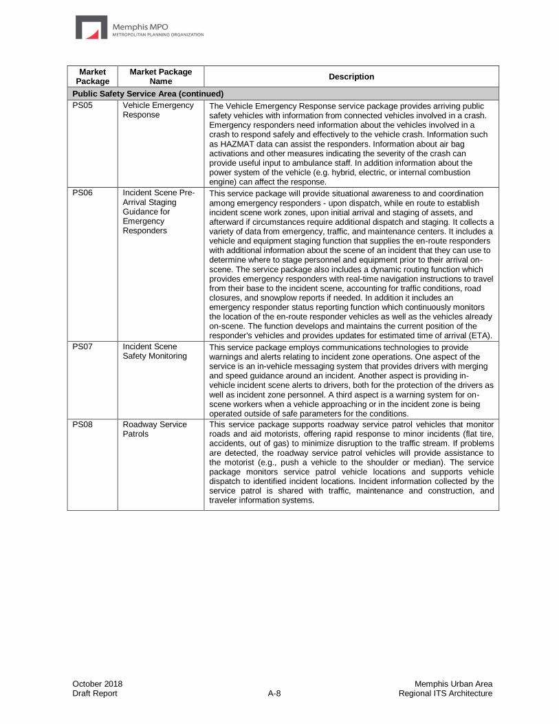
October 2018 Memphis Urban Area Draft Report A-8 Regional ITS Architecture
Market Package
Market Package Name
Description
Public Safety Service Area (continued)
PS05 Vehicle Emergency Response
The Vehicle Emergency Response service package provides arriving public safety vehicles with information from connected vehicles involved in a crash. Emergency responders need information about the vehicles involved in a crash to respond safely and effectively to the vehicle crash. Information such as HAZMAT data can assist the responders. Information about air bag activations and other measures indicating the severity of the crash can provide useful input to ambulance staff. In addition information about the power system of the vehicle (e.g. hybrid, electric, or internal combustion engine) can affect the response.
PS06 Incident Scene Pre-Arrival Staging Guidance for Emergency Responders
This service package will provide situational awareness to and coordination among emergency responders - upon dispatch, while en route to establish incident scene work zones, upon initial arrival and staging of assets, and afterward if circumstances require additional dispatch and staging. It collects a variety of data from emergency, traffic, and maintenance centers. It includes a vehicle and equipment staging function that supplies the en-route responders with additional information about the scene of an incident that they can use to determine where to stage personnel and equipment prior to their arrival on-scene. The service package also includes a dynamic routing function which provides emergency responders with real-time navigation instructions to travel from their base to the incident scene, accounting for traffic conditions, road closures, and snowplow reports if needed. In addition it includes an emergency responder status reporting function which continuously monitors the location of the en-route responder vehicles as well as the vehicles already on-scene. The function develops and maintains the current position of the responder's vehicles and provides updates for estimated time of arrival (ETA).
PS07 Incident Scene Safety Monitoring
This service package employs communications technologies to provide warnings and alerts relating to incident zone operations. One aspect of the service is an in-vehicle messaging system that provides drivers with merging and speed guidance around an incident. Another aspect is providing in-vehicle incident scene alerts to drivers, both for the protection of the drivers as well as incident zone personnel. A third aspect is a warning system for on-scene workers when a vehicle approaching or in the incident zone is being operated outside of safe parameters for the conditions.
PS08 Roadway Service Patrols
This service package supports roadway service patrol vehicles that monitor roads and aid motorists, offering rapid response to minor incidents (flat tire, accidents, out of gas) to minimize disruption to the traffic stream. If problems are detected, the roadway service patrol vehicles will provide assistance to the motorist (e.g., push a vehicle to the shoulder or median). The service package monitors service patrol vehicle locations and supports vehicle dispatch to identified incident locations. Incident information collected by the service patrol is shared with traffic, maintenance and construction, and traveler information systems.
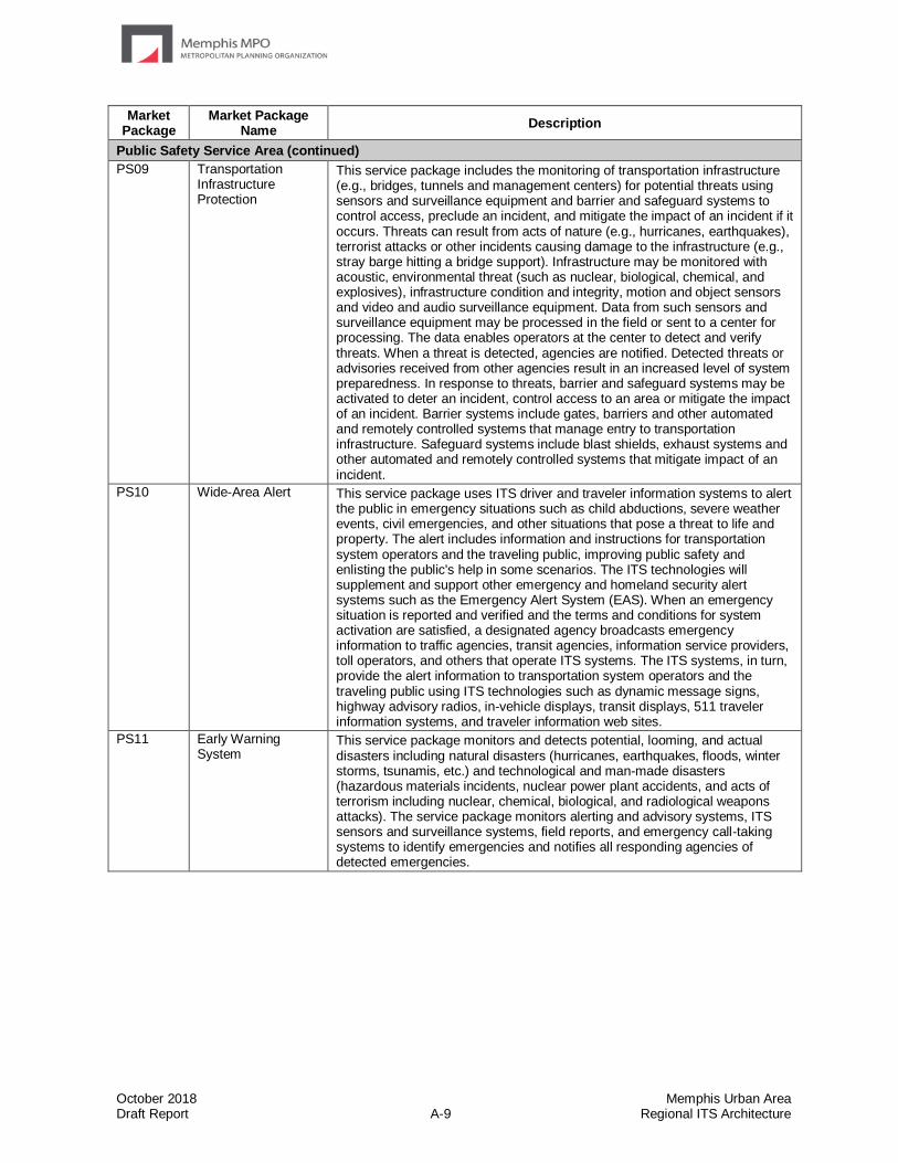
October 2018 Memphis Urban Area Draft Report A-9 Regional ITS Architecture
Market Package
Market Package Name
Description
Public Safety Service Area (continued)
PS09 Transportation Infrastructure Protection
This service package includes the monitoring of transportation infrastructure (e.g., bridges, tunnels and management centers) for potential threats using sensors and surveillance equipment and barrier and safeguard systems to control access, preclude an incident, and mitigate the impact of an incident if it occurs. Threats can result from acts of nature (e.g., hurricanes, earthquakes), terrorist attacks or other incidents causing damage to the infrastructure (e.g., stray barge hitting a bridge support). Infrastructure may be monitored with acoustic, environmental threat (such as nuclear, biological, chemical, and explosives), infrastructure condition and integrity, motion and object sensors and video and audio surveillance equipment. Data from such sensors and surveillance equipment may be processed in the field or sent to a center for processing. The data enables operators at the center to detect and verify threats. When a threat is detected, agencies are notified. Detected threats or advisories received from other agencies result in an increased level of system preparedness. In response to threats, barrier and safeguard systems may be activated to deter an incident, control access to an area or mitigate the impact of an incident. Barrier systems include gates, barriers and other automated and remotely controlled systems that manage entry to transportation infrastructure. Safeguard systems include blast shields, exhaust systems and other automated and remotely controlled systems that mitigate impact of an incident.
PS10 Wide-Area Alert This service package uses ITS driver and traveler information systems to alert the public in emergency situations such as child abductions, severe weather events, civil emergencies, and other situations that pose a threat to life and property. The alert includes information and instructions for transportation system operators and the traveling public, improving public safety and enlisting the public's help in some scenarios. The ITS technologies will supplement and support other emergency and homeland security alert systems such as the Emergency Alert System (EAS). When an emergency situation is reported and verified and the terms and conditions for system activation are satisfied, a designated agency broadcasts emergency information to traffic agencies, transit agencies, information service providers, toll operators, and others that operate ITS systems. The ITS systems, in turn, provide the alert information to transportation system operators and the traveling public using ITS technologies such as dynamic message signs, highway advisory radios, in-vehicle displays, transit displays, 511 traveler information systems, and traveler information web sites.
PS11 Early Warning System
This service package monitors and detects potential, looming, and actual disasters including natural disasters (hurricanes, earthquakes, floods, winter storms, tsunamis, etc.) and technological and man-made disasters (hazardous materials incidents, nuclear power plant accidents, and acts of terrorism including nuclear, chemical, biological, and radiological weapons attacks). The service package monitors alerting and advisory systems, ITS sensors and surveillance systems, field reports, and emergency call-taking systems to identify emergencies and notifies all responding agencies of detected emergencies.

October 2018 Memphis Urban Area Draft Report A-10 Regional ITS Architecture
Market Package
Market Package Name
Description
Public Safety Service Area (continued)
PS12 Disaster Response and Recovery
This service package enhances the ability of the surface transportation system to respond to and recover from disasters. It addresses the most severe incidents that require an extraordinary response from outside the local community. All types of disasters are addressed including natural disasters (hurricanes, earthquakes, floods, winter storms, tsunamis, etc.) and technological and man-made disasters (hazardous materials incidents, nuclear power plant accidents, and national security emergencies such as nuclear, chemical, biological, and radiological weapons attacks).
The service package supports coordination of emergency response plans, including general plans developed before a disaster as well as specific tactical plans with short time horizon that are developed as part of a disaster response. The service package provides enhanced access to the scene for response personnel and resources, provides better information about the transportation system in the vicinity of the disaster, and maintains situation awareness regarding the disaster itself. In addition, this service package tracks and coordinates the transportation resources - the transportation professionals, equipment, and materials - that constitute a portion of the disaster response.
The service package identifies the key points of integration between transportation systems and the public safety, emergency management, public health, and other allied organizations that form the overall disaster response. In this service package, the Emergency Management Center represents the federal, regional, state, and local Emergency Operations Centers and the Incident Commands that are established to respond to the disaster. The interface between the Emergency Management Center and the other centers provides situation awareness and resource coordination among transportation and other allied response agencies. In its role, traffic management implements special traffic control strategies and detours and restrictions to effectively manage traffic in and around the disaster. Maintenance and construction provides damage assessment of road network facilities and manages service restoration. Transit management provides a similar assessment of status for transit facilities and modifies transit operations to meet the special demands of the disaster. As immediate public safety concerns are addressed and disaster response transitions into recovery, this service package supports transition back to normal transportation system operation, recovering resources, managing on-going transportation facility repair, supporting data collection and revised plan coordination, and other recovery activities.
This service package builds on the basic traffic incident response service that is provided by TM08, the Traffic Incident Management service package. This service package addresses the additional complexities and coordination requirements that are associated with the most severe incidents that warrant an extraordinary response from outside the local jurisdictions and require special measures such as the activation of one or more emergency operations centers. Many users of ARC-IT will want to consider both TM08 and this service package since every region is concerned with both day-to-day management of traffic-related incidents and occasional management of disasters that require extraordinary response.
Disaster Response and Recovery is also supported by PS14, the "Disaster Traveler Information" service package that keeps the public informed during a disaster response. See that service package for more information.

October 2018 Memphis Urban Area Draft Report A-11 Regional ITS Architecture
Market Package
Market Package Name
Description
Public Safety Service Area (continued)
PS13 Evacuation and Reentry Management
This service package supports evacuation of the general public from a disaster area and manages subsequent reentry to the disaster area. The service package addresses evacuations for all types of disasters, including disasters like hurricanes that are anticipated and occur slowly, allowing a well-planned orderly evacuation, as well as disasters like terrorist acts that occur rapidly, without warning, and allow little or no time for preparation or public warning.
This service package supports coordination of evacuation plans among the federal, state, and local transportation, emergency, and law enforcement agencies that may be involved in a large-scale evacuation. All affected jurisdictions (e.g., states and counties) at the evacuation origin, evacuation destination, and along the evacuation route are informed of the plan. Information is shared with traffic management agencies to implement special traffic control strategies and to control evacuation traffic, including traffic on local streets and arterials as well as the major evacuation routes. Reversible lanes, shoulder use, closures, special signal control strategies, and other special strategies may be implemented to maximize capacity along the evacuation routes. Transit resources play an important role in an evacuation, removing many people from an evacuated area while making efficient use of limited capacity. Additional shared transit resources may be added and managed in evacuation scenarios. Resource requirements are forecast based on the evacuation plans, and the necessary resources are located, shared between agencies if necessary, and deployed at the right locations at the appropriate times.
Evacuations are also supported by PS14, the "Disaster Traveler Information" service package, which keeps the public informed during evacuations. See that service package for more information.
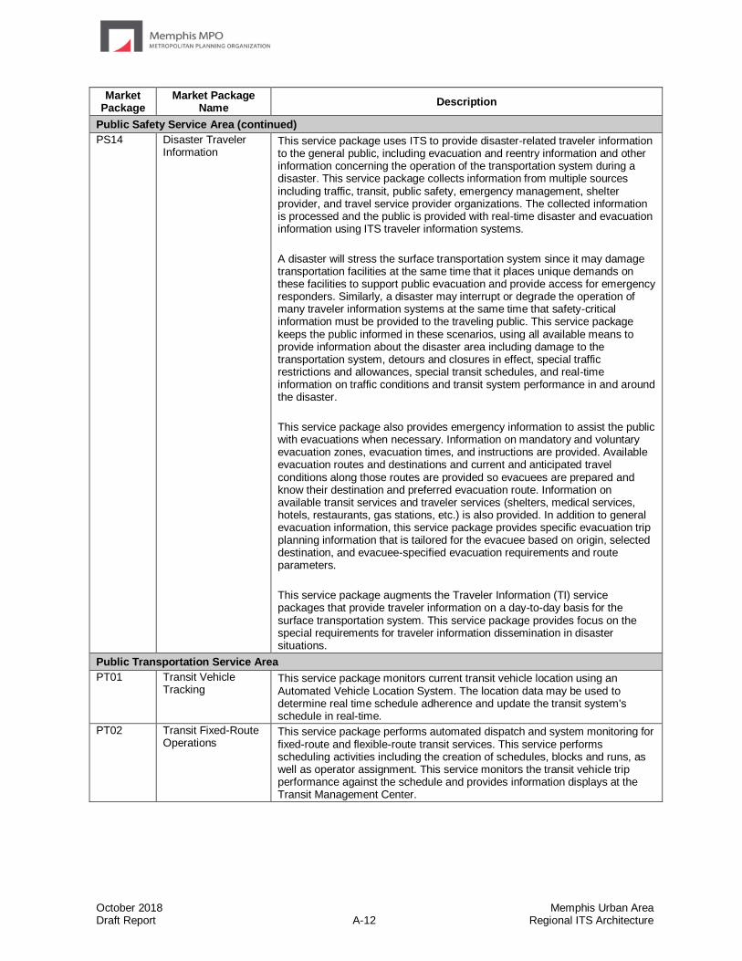
October 2018 Memphis Urban Area Draft Report A-12 Regional ITS Architecture
Market Package
Market Package Name
Description
Public Safety Service Area (continued)
PS14 Disaster Traveler Information
This service package uses ITS to provide disaster-related traveler information to the general public, including evacuation and reentry information and other information concerning the operation of the transportation system during a disaster. This service package collects information from multiple sources including traffic, transit, public safety, emergency management, shelter provider, and travel service provider organizations. The collected information is processed and the public is provided with real-time disaster and evacuation information using ITS traveler information systems.
A disaster will stress the surface transportation system since it may damage transportation facilities at the same time that it places unique demands on these facilities to support public evacuation and provide access for emergency responders. Similarly, a disaster may interrupt or degrade the operation of many traveler information systems at the same time that safety-critical information must be provided to the traveling public. This service package keeps the public informed in these scenarios, using all available means to provide information about the disaster area including damage to the transportation system, detours and closures in effect, special traffic restrictions and allowances, special transit schedules, and real-time information on traffic conditions and transit system performance in and around the disaster.
This service package also provides emergency information to assist the public with evacuations when necessary. Information on mandatory and voluntary evacuation zones, evacuation times, and instructions are provided. Available evacuation routes and destinations and current and anticipated travel conditions along those routes are provided so evacuees are prepared and know their destination and preferred evacuation route. Information on available transit services and traveler services (shelters, medical services, hotels, restaurants, gas stations, etc.) is also provided. In addition to general evacuation information, this service package provides specific evacuation trip planning information that is tailored for the evacuee based on origin, selected destination, and evacuee-specified evacuation requirements and route parameters.
This service package augments the Traveler Information (TI) service packages that provide traveler information on a day-to-day basis for the surface transportation system. This service package provides focus on the special requirements for traveler information dissemination in disaster situations.
Public Transportation Service Area
PT01 Transit Vehicle Tracking
This service package monitors current transit vehicle location using an Automated Vehicle Location System. The location data may be used to determine real time schedule adherence and update the transit system's schedule in real-time.
PT02 Transit Fixed-Route Operations
This service package performs automated dispatch and system monitoring for fixed-route and flexible-route transit services. This service performs scheduling activities including the creation of schedules, blocks and runs, as well as operator assignment. This service monitors the transit vehicle trip performance against the schedule and provides information displays at the Transit Management Center.
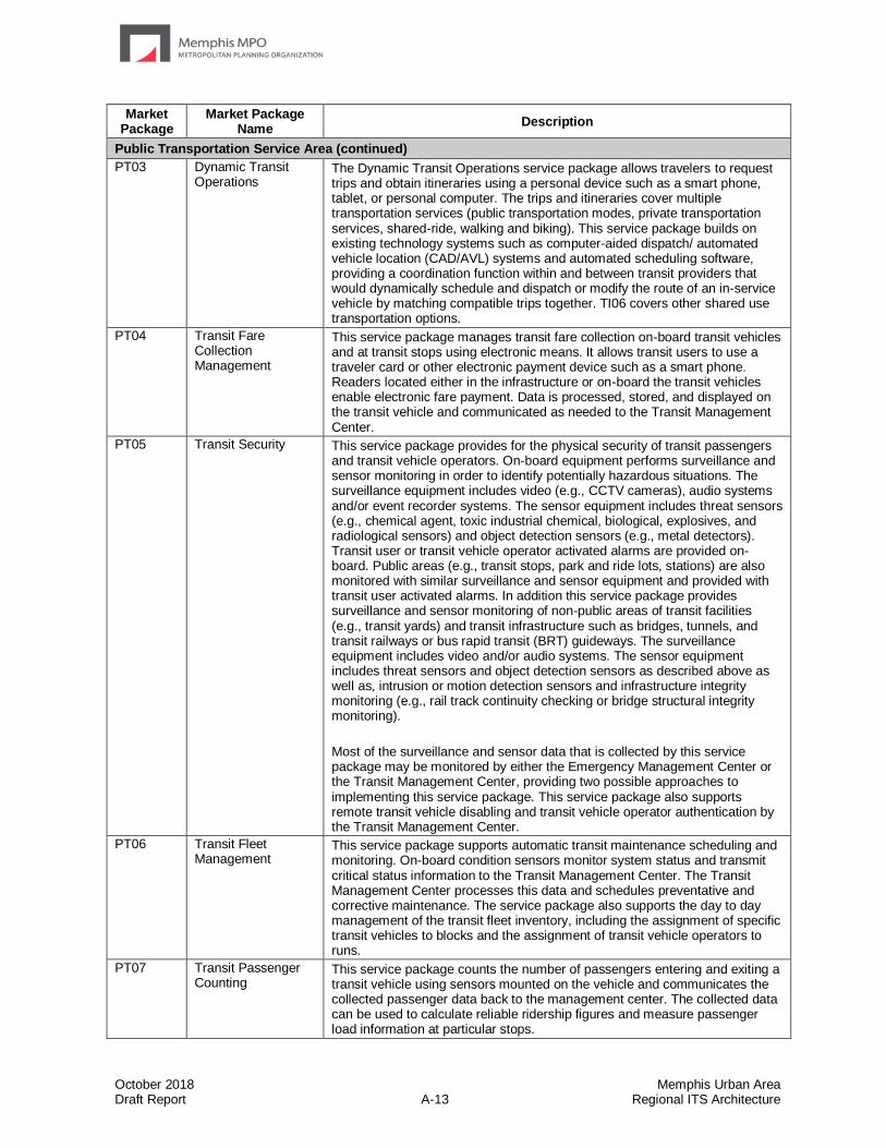
October 2018 Memphis Urban Area Draft Report A-13 Regional ITS Architecture
Market Package
Market Package Name
Description
Public Transportation Service Area (continued)
PT03 Dynamic Transit Operations
The Dynamic Transit Operations service package allows travelers to request trips and obtain itineraries using a personal device such as a smart phone, tablet, or personal computer. The trips and itineraries cover multiple transportation services (public transportation modes, private transportation services, shared-ride, walking and biking). This service package builds on existing technology systems such as computer-aided dispatch/ automated vehicle location (CAD/AVL) systems and automated scheduling software, providing a coordination function within and between transit providers that would dynamically schedule and dispatch or modify the route of an in-service vehicle by matching compatible trips together. TI06 covers other shared use transportation options.
PT04 Transit Fare Collection Management
This service package manages transit fare collection on-board transit vehicles and at transit stops using electronic means. It allows transit users to use a traveler card or other electronic payment device such as a smart phone. Readers located either in the infrastructure or on-board the transit vehicles enable electronic fare payment. Data is processed, stored, and displayed on the transit vehicle and communicated as needed to the Transit Management Center.
PT05 Transit Security This service package provides for the physical security of transit passengers and transit vehicle operators. On-board equipment performs surveillance and sensor monitoring in order to identify potentially hazardous situations. The surveillance equipment includes video (e.g., CCTV cameras), audio systems and/or event recorder systems. The sensor equipment includes threat sensors (e.g., chemical agent, toxic industrial chemical, biological, explosives, and radiological sensors) and object detection sensors (e.g., metal detectors). Transit user or transit vehicle operator activated alarms are provided on-board. Public areas (e.g., transit stops, park and ride lots, stations) are also monitored with similar surveillance and sensor equipment and provided with transit user activated alarms. In addition this service package provides surveillance and sensor monitoring of non-public areas of transit facilities (e.g., transit yards) and transit infrastructure such as bridges, tunnels, and transit railways or bus rapid transit (BRT) guideways. The surveillance equipment includes video and/or audio systems. The sensor equipment includes threat sensors and object detection sensors as described above as well as, intrusion or motion detection sensors and infrastructure integrity monitoring (e.g., rail track continuity checking or bridge structural integrity monitoring).
Most of the surveillance and sensor data that is collected by this service package may be monitored by either the Emergency Management Center or the Transit Management Center, providing two possible approaches to implementing this service package. This service package also supports remote transit vehicle disabling and transit vehicle operator authentication by the Transit Management Center.
PT06 Transit Fleet Management
This service package supports automatic transit maintenance scheduling and monitoring. On-board condition sensors monitor system status and transmit critical status information to the Transit Management Center. The Transit Management Center processes this data and schedules preventative and corrective maintenance. The service package also supports the day to day management of the transit fleet inventory, including the assignment of specific transit vehicles to blocks and the assignment of transit vehicle operators to runs.
PT07 Transit Passenger Counting
This service package counts the number of passengers entering and exiting a transit vehicle using sensors mounted on the vehicle and communicates the collected passenger data back to the management center. The collected data can be used to calculate reliable ridership figures and measure passenger load information at particular stops.
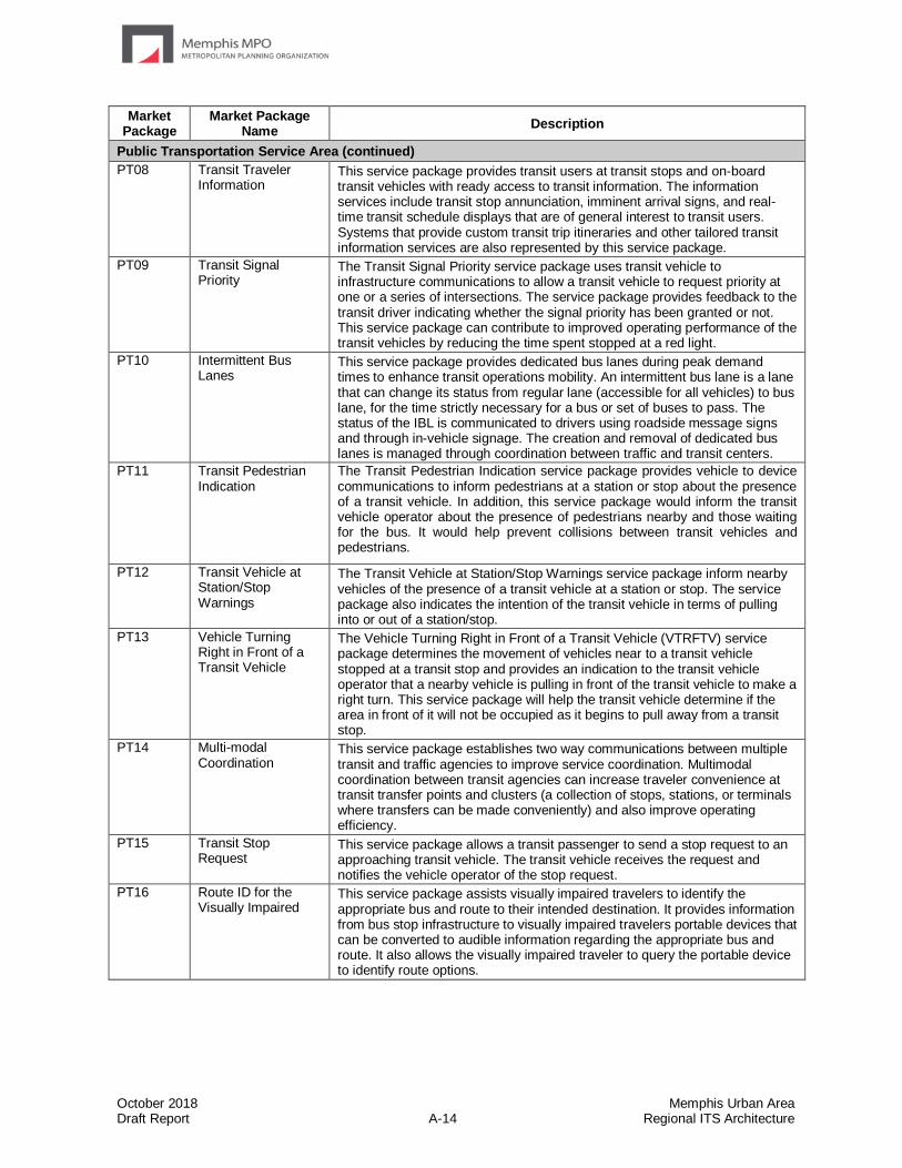
October 2018 Memphis Urban Area Draft Report A-14 Regional ITS Architecture
Market Package
Market Package Name
Description
Public Transportation Service Area (continued)
PT08 Transit Traveler Information
This service package provides transit users at transit stops and on-board transit vehicles with ready access to transit information. The information services include transit stop annunciation, imminent arrival signs, and real-time transit schedule displays that are of general interest to transit users. Systems that provide custom transit trip itineraries and other tailored transit information services are also represented by this service package.
PT09 Transit Signal Priority
The Transit Signal Priority service package uses transit vehicle to infrastructure communications to allow a transit vehicle to request priority at one or a series of intersections. The service package provides feedback to the transit driver indicating whether the signal priority has been granted or not. This service package can contribute to improved operating performance of the transit vehicles by reducing the time spent stopped at a red light.
PT10 Intermittent Bus Lanes
This service package provides dedicated bus lanes during peak demand times to enhance transit operations mobility. An intermittent bus lane is a lane that can change its status from regular lane (accessible for all vehicles) to bus lane, for the time strictly necessary for a bus or set of buses to pass. The status of the IBL is communicated to drivers using roadside message signs and through in-vehicle signage. The creation and removal of dedicated bus lanes is managed through coordination between traffic and transit centers.
PT11 Transit Pedestrian Indication
The Transit Pedestrian Indication service package provides vehicle to device communications to inform pedestrians at a station or stop about the presence of a transit vehicle. In addition, this service package would inform the transit vehicle operator about the presence of pedestrians nearby and those waiting for the bus. It would help prevent collisions between transit vehicles and pedestrians.
PT12 Transit Vehicle at Station/Stop Warnings
The Transit Vehicle at Station/Stop Warnings service package inform nearby vehicles of the presence of a transit vehicle at a station or stop. The service package also indicates the intention of the transit vehicle in terms of pulling into or out of a station/stop.
PT13 Vehicle Turning Right in Front of a Transit Vehicle
The Vehicle Turning Right in Front of a Transit Vehicle (VTRFTV) service package determines the movement of vehicles near to a transit vehicle stopped at a transit stop and provides an indication to the transit vehicle operator that a nearby vehicle is pulling in front of the transit vehicle to make a right turn. This service package will help the transit vehicle determine if the area in front of it will not be occupied as it begins to pull away from a transit stop.
PT14 Multi-modal Coordination
This service package establishes two way communications between multiple transit and traffic agencies to improve service coordination. Multimodal coordination between transit agencies can increase traveler convenience at transit transfer points and clusters (a collection of stops, stations, or terminals where transfers can be made conveniently) and also improve operating efficiency.
PT15 Transit Stop Request
This service package allows a transit passenger to send a stop request to an approaching transit vehicle. The transit vehicle receives the request and notifies the vehicle operator of the stop request.
PT16 Route ID for the Visually Impaired
This service package assists visually impaired travelers to identify the appropriate bus and route to their intended destination. It provides information from bus stop infrastructure to visually impaired travelers portable devices that can be converted to audible information regarding the appropriate bus and route. It also allows the visually impaired traveler to query the portable device to identify route options.
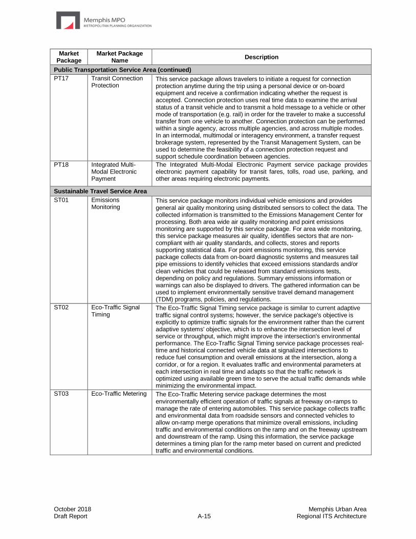
October 2018 Memphis Urban Area Draft Report A-15 Regional ITS Architecture
Market Package
Market Package Name
Description
Public Transportation Service Area (continued)
PT17 Transit Connection Protection
This service package allows travelers to initiate a request for connection protection anytime during the trip using a personal device or on-board equipment and receive a confirmation indicating whether the request is accepted. Connection protection uses real time data to examine the arrival status of a transit vehicle and to transmit a hold message to a vehicle or other mode of transportation (e.g. rail) in order for the traveler to make a successful transfer from one vehicle to another. Connection protection can be performed within a single agency, across multiple agencies, and across multiple modes. In an intermodal, multimodal or interagency environment, a transfer request brokerage system, represented by the Transit Management System, can be used to determine the feasibility of a connection protection request and support schedule coordination between agencies.
PT18 Integrated Multi-Modal Electronic Payment
The Integrated Multi-Modal Electronic Payment service package provides electronic payment capability for transit fares, tolls, road use, parking, and other areas requiring electronic payments.
Sustainable Travel Service Area
ST01 Emissions Monitoring
This service package monitors individual vehicle emissions and provides general air quality monitoring using distributed sensors to collect the data. The collected information is transmitted to the Emissions Management Center for processing. Both area wide air quality monitoring and point emissions monitoring are supported by this service package. For area wide monitoring, this service package measures air quality, identifies sectors that are non-compliant with air quality standards, and collects, stores and reports supporting statistical data. For point emissions monitoring, this service package collects data from on-board diagnostic systems and measures tail pipe emissions to identify vehicles that exceed emissions standards and/or clean vehicles that could be released from standard emissions tests, depending on policy and regulations. Summary emissions information or warnings can also be displayed to drivers. The gathered information can be used to implement environmentally sensitive travel demand management (TDM) programs, policies, and regulations.
ST02 Eco-Traffic Signal Timing
The Eco-Traffic Signal Timing service package is similar to current adaptive traffic signal control systems; however, the service package's objective is explicitly to optimize traffic signals for the environment rather than the current adaptive systems' objective, which is to enhance the intersection level of service or throughput, which might improve the intersection's environmental performance. The Eco-Traffic Signal Timing service package processes real-time and historical connected vehicle data at signalized intersections to reduce fuel consumption and overall emissions at the intersection, along a corridor, or for a region. It evaluates traffic and environmental parameters at each intersection in real time and adapts so that the traffic network is optimized using available green time to serve the actual traffic demands while minimizing the environmental impact.
ST03 Eco-Traffic Metering The Eco-Traffic Metering service package determines the most environmentally efficient operation of traffic signals at freeway on-ramps to manage the rate of entering automobiles. This service package collects traffic and environmental data from roadside sensors and connected vehicles to allow on-ramp merge operations that minimize overall emissions, including traffic and environmental conditions on the ramp and on the freeway upstream and downstream of the ramp. Using this information, the service package determines a timing plan for the ramp meter based on current and predicted traffic and environmental conditions.
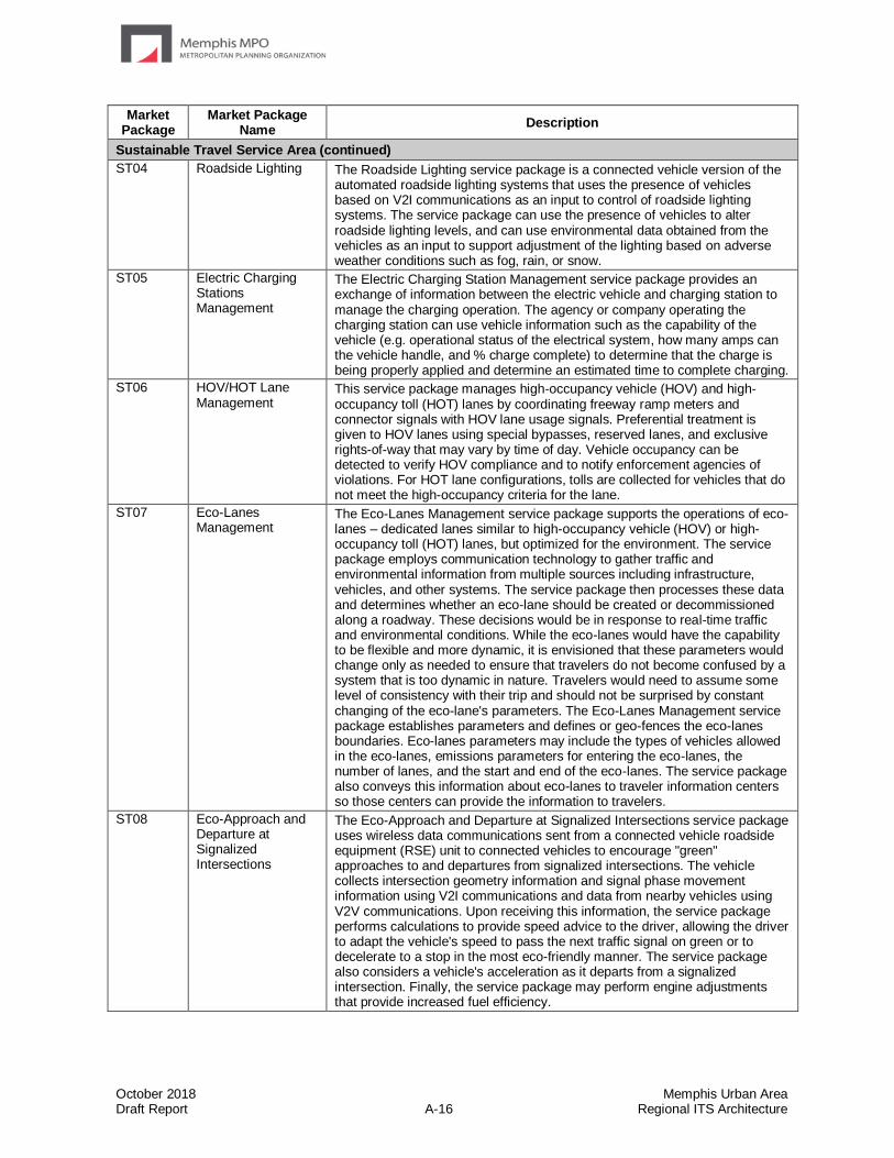
October 2018 Memphis Urban Area Draft Report A-16 Regional ITS Architecture
Market Package
Market Package Name
Description
Sustainable Travel Service Area (continued)
ST04 Roadside Lighting The Roadside Lighting service package is a connected vehicle version of the automated roadside lighting systems that uses the presence of vehicles based on V2I communications as an input to control of roadside lighting systems. The service package can use the presence of vehicles to alter roadside lighting levels, and can use environmental data obtained from the vehicles as an input to support adjustment of the lighting based on adverse weather conditions such as fog, rain, or snow.
ST05 Electric Charging Stations Management
The Electric Charging Station Management service package provides an exchange of information between the electric vehicle and charging station to manage the charging operation. The agency or company operating the charging station can use vehicle information such as the capability of the vehicle (e.g. operational status of the electrical system, how many amps can the vehicle handle, and % charge complete) to determine that the charge is being properly applied and determine an estimated time to complete charging.
ST06 HOV/HOT Lane Management
This service package manages high-occupancy vehicle (HOV) and high-occupancy toll (HOT) lanes by coordinating freeway ramp meters and connector signals with HOV lane usage signals. Preferential treatment is given to HOV lanes using special bypasses, reserved lanes, and exclusive rights-of-way that may vary by time of day. Vehicle occupancy can be detected to verify HOV compliance and to notify enforcement agencies of violations. For HOT lane configurations, tolls are collected for vehicles that do not meet the high-occupancy criteria for the lane.
ST07 Eco-Lanes Management
The Eco-Lanes Management service package supports the operations of eco-lanes – dedicated lanes similar to high-occupancy vehicle (HOV) or high-occupancy toll (HOT) lanes, but optimized for the environment. The service package employs communication technology to gather traffic and environmental information from multiple sources including infrastructure, vehicles, and other systems. The service package then processes these data and determines whether an eco-lane should be created or decommissioned along a roadway. These decisions would be in response to real-time traffic and environmental conditions. While the eco-lanes would have the capability to be flexible and more dynamic, it is envisioned that these parameters would change only as needed to ensure that travelers do not become confused by a system that is too dynamic in nature. Travelers would need to assume some level of consistency with their trip and should not be surprised by constant changing of the eco-lane's parameters. The Eco-Lanes Management service package establishes parameters and defines or geo-fences the eco-lanes boundaries. Eco-lanes parameters may include the types of vehicles allowed in the eco-lanes, emissions parameters for entering the eco-lanes, the number of lanes, and the start and end of the eco-lanes. The service package also conveys this information about eco-lanes to traveler information centers so those centers can provide the information to travelers.
ST08 Eco-Approach and Departure at Signalized Intersections
The Eco-Approach and Departure at Signalized Intersections service package uses wireless data communications sent from a connected vehicle roadside equipment (RSE) unit to connected vehicles to encourage "green" approaches to and departures from signalized intersections. The vehicle collects intersection geometry information and signal phase movement information using V2I communications and data from nearby vehicles using V2V communications. Upon receiving this information, the service package performs calculations to provide speed advice to the driver, allowing the driver to adapt the vehicle's speed to pass the next traffic signal on green or to decelerate to a stop in the most eco-friendly manner. The service package also considers a vehicle's acceleration as it departs from a signalized intersection. Finally, the service package may perform engine adjustments that provide increased fuel efficiency.
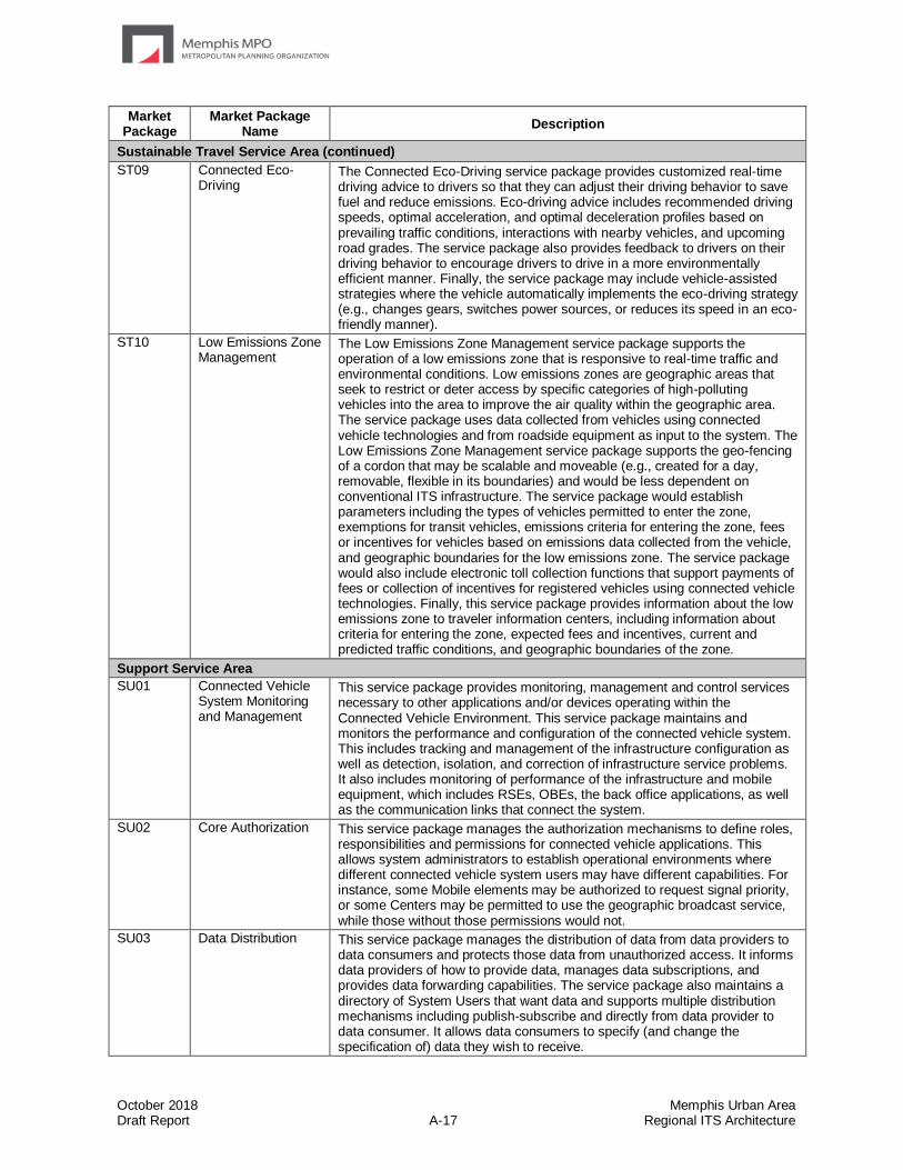
October 2018 Memphis Urban Area Draft Report A-17 Regional ITS Architecture
Market Package
Market Package Name
Description
Sustainable Travel Service Area (continued)
ST09 Connected Eco-Driving
The Connected Eco-Driving service package provides customized real-time driving advice to drivers so that they can adjust their driving behavior to save fuel and reduce emissions. Eco-driving advice includes recommended driving speeds, optimal acceleration, and optimal deceleration profiles based on prevailing traffic conditions, interactions with nearby vehicles, and upcoming road grades. The service package also provides feedback to drivers on their driving behavior to encourage drivers to drive in a more environmentally efficient manner. Finally, the service package may include vehicle-assisted strategies where the vehicle automatically implements the eco-driving strategy (e.g., changes gears, switches power sources, or reduces its speed in an eco-friendly manner).
ST10 Low Emissions Zone Management
The Low Emissions Zone Management service package supports the operation of a low emissions zone that is responsive to real-time traffic and environmental conditions. Low emissions zones are geographic areas that seek to restrict or deter access by specific categories of high-polluting vehicles into the area to improve the air quality within the geographic area. The service package uses data collected from vehicles using connected vehicle technologies and from roadside equipment as input to the system. The Low Emissions Zone Management service package supports the geo-fencing of a cordon that may be scalable and moveable (e.g., created for a day, removable, flexible in its boundaries) and would be less dependent on conventional ITS infrastructure. The service package would establish parameters including the types of vehicles permitted to enter the zone, exemptions for transit vehicles, emissions criteria for entering the zone, fees or incentives for vehicles based on emissions data collected from the vehicle, and geographic boundaries for the low emissions zone. The service package would also include electronic toll collection functions that support payments of fees or collection of incentives for registered vehicles using connected vehicle technologies. Finally, this service package provides information about the low emissions zone to traveler information centers, including information about criteria for entering the zone, expected fees and incentives, current and predicted traffic conditions, and geographic boundaries of the zone.
Support Service Area
SU01 Connected Vehicle System Monitoring and Management
This service package provides monitoring, management and control services necessary to other applications and/or devices operating within the Connected Vehicle Environment. This service package maintains and monitors the performance and configuration of the connected vehicle system. This includes tracking and management of the infrastructure configuration as well as detection, isolation, and correction of infrastructure service problems. It also includes monitoring of performance of the infrastructure and mobile equipment, which includes RSEs, OBEs, the back office applications, as well as the communication links that connect the system.
SU02 Core Authorization This service package manages the authorization mechanisms to define roles, responsibilities and permissions for connected vehicle applications. This allows system administrators to establish operational environments where different connected vehicle system users may have different capabilities. For instance, some Mobile elements may be authorized to request signal priority, or some Centers may be permitted to use the geographic broadcast service, while those without those permissions would not.
SU03 Data Distribution This service package manages the distribution of data from data providers to data consumers and protects those data from unauthorized access. It informs data providers of how to provide data, manages data subscriptions, and provides data forwarding capabilities. The service package also maintains a directory of System Users that want data and supports multiple distribution mechanisms including publish-subscribe and directly from data provider to data consumer. It allows data consumers to specify (and change the specification of) data they wish to receive.

October 2018 Memphis Urban Area Draft Report A-18 Regional ITS Architecture
Market Package
Market Package Name
Description
Support Service Area (continued)
SU04 Map Management This service package defines interfaces that can be used download or update all types of map data used to support intelligent transportation systems. This map data will be accessed by centers, field, and vehicle physical objects. The service package can also be used to harness the Connected Vehicle Environment to provide rich source data that can be used to verify, refine, and enhance geographic map data.
SU05 Location and Time This service package identifies the external systems and interfaces that provide accurate location and time to intelligent transportation system devices and systems.
SU06 Object Registration and Discovery
This service package provides registration and lookup services necessary to allow objects to locate other objects operating within the Connected Vehicle Environment.
An object registry is like a phone book for all the connected centers, systems, and equipment in the transportation system (the "objects"). In this service package, each object registers itself with the ORDS and tells the registry where it lives in the communication network (e.g., host, port, node name) and information about the services it provides - information that other objects can use to determine the type of service, the geographic scope of the service, and other information that helps users of the registry to make informed decisions about which object(s) support a needed service or information stream. This is the "Discovery" part of the service. Connected objects can use the registry to find (discover) objects that can be used to get needed information or services.
SU07 Privacy Protection This service package provides the privacy protection essential to the operation of connected vehicle applications. Privacy Protection obscures the network identifiers of mobile devices in order to allow communications with credentials management and other centers.
SU08 Security and Credentials Management
This service package is used to ensure trusted communications between mobile devices and other mobile devices or roadside devices and protect data they handle from unauthorized access. The service package grants trust credentials to qualified mobile devices and infrastructure devices in the Connected Vehicle Environment so that those devices may be considered trusted by other devices that receive trust credentials from the SCM service package. The service package allows credentials to be requested and revoked and secures the exchange of trust credentials between parties, so that no other party can intercept and use those credentials illegitimately. The service package provides security to the transmissions between connected devices, ensuring authenticity and integrity of the transmissions. Additional security features include privacy protection, authorization and privilege class definition, as well as non-repudiation of origin.
SU09 Center Maintenance This service package supports maintenance of the computers, networks, video walls, and other information technology assets that are installed in a center to support center operations. Like other support service packages, this SP is drawn at a high level of abstraction so the basic interfaces and functionality associated with maintaining center IT assets can be applied to any center.
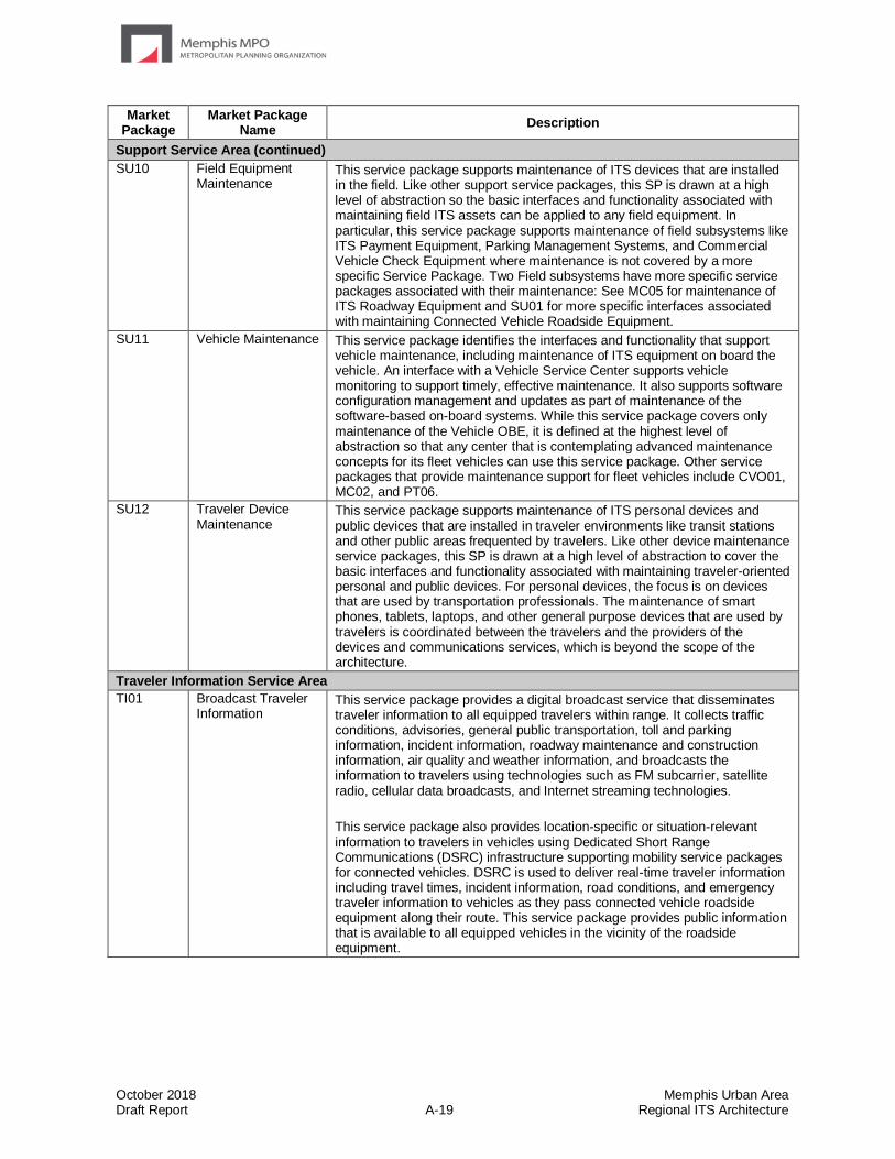
October 2018 Memphis Urban Area Draft Report A-19 Regional ITS Architecture
Market Package
Market Package Name
Description
Support Service Area (continued)
SU10 Field Equipment Maintenance
This service package supports maintenance of ITS devices that are installed in the field. Like other support service packages, this SP is drawn at a high level of abstraction so the basic interfaces and functionality associated with maintaining field ITS assets can be applied to any field equipment. In particular, this service package supports maintenance of field subsystems like ITS Payment Equipment, Parking Management Systems, and Commercial Vehicle Check Equipment where maintenance is not covered by a more specific Service Package. Two Field subsystems have more specific service packages associated with their maintenance: See MC05 for maintenance of ITS Roadway Equipment and SU01 for more specific interfaces associated with maintaining Connected Vehicle Roadside Equipment.
SU11 Vehicle Maintenance This service package identifies the interfaces and functionality that support vehicle maintenance, including maintenance of ITS equipment on board the vehicle. An interface with a Vehicle Service Center supports vehicle monitoring to support timely, effective maintenance. It also supports software configuration management and updates as part of maintenance of the software-based on-board systems. While this service package covers only maintenance of the Vehicle OBE, it is defined at the highest level of abstraction so that any center that is contemplating advanced maintenance concepts for its fleet vehicles can use this service package. Other service packages that provide maintenance support for fleet vehicles include CVO01, MC02, and PT06.
SU12 Traveler Device Maintenance
This service package supports maintenance of ITS personal devices and public devices that are installed in traveler environments like transit stations and other public areas frequented by travelers. Like other device maintenance service packages, this SP is drawn at a high level of abstraction to cover the basic interfaces and functionality associated with maintaining traveler-oriented personal and public devices. For personal devices, the focus is on devices that are used by transportation professionals. The maintenance of smart phones, tablets, laptops, and other general purpose devices that are used by travelers is coordinated between the travelers and the providers of the devices and communications services, which is beyond the scope of the architecture.
Traveler Information Service Area
TI01 Broadcast Traveler Information
This service package provides a digital broadcast service that disseminates traveler information to all equipped travelers within range. It collects traffic conditions, advisories, general public transportation, toll and parking information, incident information, roadway maintenance and construction information, air quality and weather information, and broadcasts the information to travelers using technologies such as FM subcarrier, satellite radio, cellular data broadcasts, and Internet streaming technologies.
This service package also provides location-specific or situation-relevant information to travelers in vehicles using Dedicated Short Range Communications (DSRC) infrastructure supporting mobility service packages for connected vehicles. DSRC is used to deliver real-time traveler information including travel times, incident information, road conditions, and emergency traveler information to vehicles as they pass connected vehicle roadside equipment along their route. This service package provides public information that is available to all equipped vehicles in the vicinity of the roadside equipment.

October 2018 Memphis Urban Area Draft Report A-20 Regional ITS Architecture
Market Package
Market Package Name
Description
Traveler Information Service Area (continued)
TI02 Personalized Traveler Information
This service package provides tailored information in response to a traveler request. Both real-time interactive request/response systems and information systems that "push" a tailored stream of information to the traveler based on a submitted profile are supported. The traveler can obtain current information regarding traffic conditions, roadway maintenance and construction, transit services, ride share/ride match, parking management, detours and pricing information. Although the Internet is the predominate network used for traveler information dissemination, a range of two-way wide-area wireless and fixed-point to fixed-point communications systems may be used to support the required data communications with the traveler. A variety of interactive devices may be used by the traveler to access information prior to a trip or en route including phone via a 511-like portal and web pages via smart phone, tablet, personal computer, and a variety of in-vehicle devices.
TI03 Dynamic Route Guidance
This service package offers advanced route planning and guidance that is responsive to current conditions. The package augments a user's navigation system equipment with a digital receiver capable of receiving real-time traffic, transit, and road condition information, which is used by the user equipment to provide real-time route guidance that factors in current conditions.
TI04 Infrastructure-Provided Trip Planning and Route Guidance
This service package offers the user trip planning and en-route guidance services. It generates a trip plan, including a multimodal route and associated service information (e.g., parking information), based on traveler preferences and constraints. Routes may be based on static information or reflect real time network conditions. Unlike TI03, where the user equipment determines the route, the route determination functions are performed by the center in this service package. The trip plan may be confirmed by the traveler and advanced payment and reservations for transit and alternate mode (e.g., airline, rail, and ferry) trip segments, and ancillary services are accepted and processed. The confirmed trip plan may include specific routing information that can be supplied to the traveler as general directions or as turn-by-turn route guidance depending on the level of user equipment.
TI05 Travel Services Information and Reservation
This service package provides travel service information and reservation services to the traveler pre-trip and while en route. This includes information for tourist attractions, lodging, dining, service stations, parking, emergency services, and other services and businesses of interest to the traveler.
TI06 Dynamic Ridesharing and Shared Use Transportation
This service package addresses dynamic ridesharing/ride matching services to travelers and other forms of shared use transportation. Dynamic ridesharing allows travelers to arrange carpool trips through a personal device with a wireless connection to a ride matching system (e.g., a web-based application). It uses inputs from both passengers and drivers pre-trip, during the trip, and post-trip . These inputs are then translated into "optimal" pairings between passengers and drivers to provide both with a convenient route between their two origin and destination locations. After the trip, information is provided back to the service package to improve the user's experience for future trips.
The shared use aspect of the service package addresses three types of shared use that may be arranged using an internet connected personal device. In the first type, a traveler arranges for the temporary use of a vehicle. In the second type of shared use, a traveler arranges for a vehicle to pick them up at a specific location and take them to another location. The second type of shared use may be implemented as a ride matching or ridesharing service, including those provided by Uber and Lyft. The third type of shared use is a bikeshare capability.
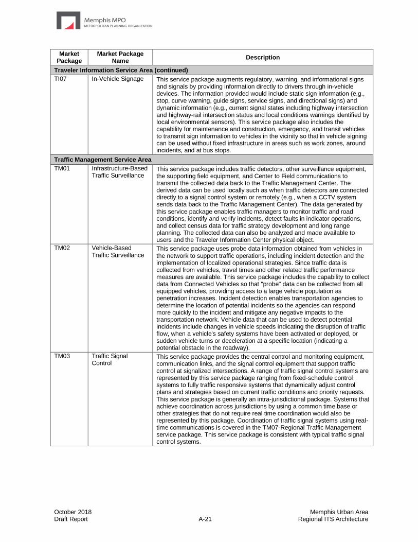
October 2018 Memphis Urban Area Draft Report A-21 Regional ITS Architecture
Market Package
Market Package Name
Description
Traveler Information Service Area (continued)
TI07 In-Vehicle Signage This service package augments regulatory, warning, and informational signs and signals by providing information directly to drivers through in-vehicle devices. The information provided would include static sign information (e.g., stop, curve warning, guide signs, service signs, and directional signs) and dynamic information (e.g., current signal states including highway intersection and highway-rail intersection status and local conditions warnings identified by local environmental sensors). This service package also includes the capability for maintenance and construction, emergency, and transit vehicles to transmit sign information to vehicles in the vicinity so that in vehicle signing can be used without fixed infrastructure in areas such as work zones, around incidents, and at bus stops.
Traffic Management Service Area
TM01 Infrastructure-Based Traffic Surveillance
This service package includes traffic detectors, other surveillance equipment, the supporting field equipment, and Center to Field communications to transmit the collected data back to the Traffic Management Center. The derived data can be used locally such as when traffic detectors are connected directly to a signal control system or remotely (e.g., when a CCTV system sends data back to the Traffic Management Center). The data generated by this service package enables traffic managers to monitor traffic and road conditions, identify and verify incidents, detect faults in indicator operations, and collect census data for traffic strategy development and long range planning. The collected data can also be analyzed and made available to users and the Traveler Information Center physical object.
TM02 Vehicle-Based Traffic Surveillance
This service package uses probe data information obtained from vehicles in the network to support traffic operations, including incident detection and the implementation of localized operational strategies. Since traffic data is collected from vehicles, travel times and other related traffic performance measures are available. This service package includes the capability to collect data from Connected Vehicles so that "probe" data can be collected from all equipped vehicles, providing access to a large vehicle population as penetration increases. Incident detection enables transportation agencies to determine the location of potential incidents so the agencies can respond more quickly to the incident and mitigate any negative impacts to the transportation network. Vehicle data that can be used to detect potential incidents include changes in vehicle speeds indicating the disruption of traffic flow, when a vehicle's safety systems have been activated or deployed, or sudden vehicle turns or deceleration at a specific location (indicating a potential obstacle in the roadway).
TM03 Traffic Signal Control
This service package provides the central control and monitoring equipment, communication links, and the signal control equipment that support traffic control at signalized intersections. A range of traffic signal control systems are represented by this service package ranging from fixed-schedule control systems to fully traffic responsive systems that dynamically adjust control plans and strategies based on current traffic conditions and priority requests. This service package is generally an intra-jurisdictional package. Systems that achieve coordination across jurisdictions by using a common time base or other strategies that do not require real time coordination would also be represented by this package. Coordination of traffic signal systems using real-time communications is covered in the TM07-Regional Traffic Management service package. This service package is consistent with typical traffic signal control systems.
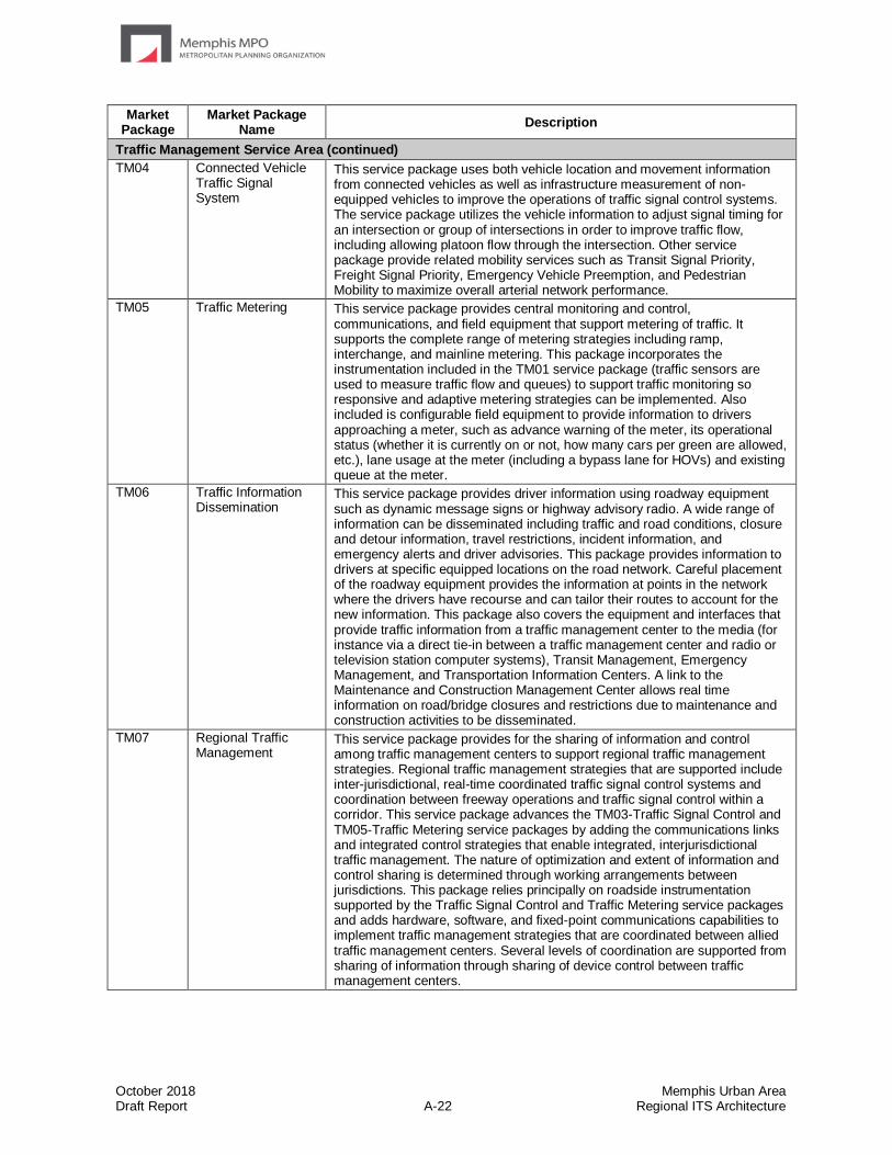
October 2018 Memphis Urban Area Draft Report A-22 Regional ITS Architecture
Market Package
Market Package Name
Description
Traffic Management Service Area (continued)
TM04 Connected Vehicle Traffic Signal System
This service package uses both vehicle location and movement information from connected vehicles as well as infrastructure measurement of non-equipped vehicles to improve the operations of traffic signal control systems. The service package utilizes the vehicle information to adjust signal timing for an intersection or group of intersections in order to improve traffic flow, including allowing platoon flow through the intersection. Other service package provide related mobility services such as Transit Signal Priority, Freight Signal Priority, Emergency Vehicle Preemption, and Pedestrian Mobility to maximize overall arterial network performance.
TM05 Traffic Metering This service package provides central monitoring and control, communications, and field equipment that support metering of traffic. It supports the complete range of metering strategies including ramp, interchange, and mainline metering. This package incorporates the instrumentation included in the TM01 service package (traffic sensors are used to measure traffic flow and queues) to support traffic monitoring so responsive and adaptive metering strategies can be implemented. Also included is configurable field equipment to provide information to drivers approaching a meter, such as advance warning of the meter, its operational status (whether it is currently on or not, how many cars per green are allowed, etc.), lane usage at the meter (including a bypass lane for HOVs) and existing queue at the meter.
TM06 Traffic Information Dissemination
This service package provides driver information using roadway equipment such as dynamic message signs or highway advisory radio. A wide range of information can be disseminated including traffic and road conditions, closure and detour information, travel restrictions, incident information, and emergency alerts and driver advisories. This package provides information to drivers at specific equipped locations on the road network. Careful placement of the roadway equipment provides the information at points in the network where the drivers have recourse and can tailor their routes to account for the new information. This package also covers the equipment and interfaces that provide traffic information from a traffic management center to the media (for instance via a direct tie-in between a traffic management center and radio or television station computer systems), Transit Management, Emergency Management, and Transportation Information Centers. A link to the Maintenance and Construction Management Center allows real time information on road/bridge closures and restrictions due to maintenance and construction activities to be disseminated.
TM07 Regional Traffic Management
This service package provides for the sharing of information and control among traffic management centers to support regional traffic management strategies. Regional traffic management strategies that are supported include inter-jurisdictional, real-time coordinated traffic signal control systems and coordination between freeway operations and traffic signal control within a corridor. This service package advances the TM03-Traffic Signal Control and TM05-Traffic Metering service packages by adding the communications links and integrated control strategies that enable integrated, interjurisdictional traffic management. The nature of optimization and extent of information and control sharing is determined through working arrangements between jurisdictions. This package relies principally on roadside instrumentation supported by the Traffic Signal Control and Traffic Metering service packages and adds hardware, software, and fixed-point communications capabilities to implement traffic management strategies that are coordinated between allied traffic management centers. Several levels of coordination are supported from sharing of information through sharing of device control between traffic management centers.

October 2018 Memphis Urban Area Draft Report A-23 Regional ITS Architecture
Market Package
Market Package Name
Description
Traffic Management Service Area (continued)
TM08 Traffic Incident Management System
This service package manages both unexpected incidents and planned events so that the impact to the transportation network and traveler safety is minimized. The service package includes incident detection capabilities through roadside surveillance devices (e.g. CCTV) and through regional coordination with other traffic management, maintenance and construction management and emergency management centers as well as rail operations and event promoters. Information from these diverse sources is collected and correlated by this service package to detect and verify incidents and implement an appropriate response. This service package supports traffic operations personnel in developing an appropriate response in coordination with emergency management, maintenance and construction management, and other incident response personnel to confirmed incidents. The response may include traffic control strategy modifications or resource coordination between centers. Incident response also includes presentation of information to affected travelers using the Traffic Information Dissemination service package and dissemination of incident information to travelers through the Broadcast Traveler Information or Interactive Traveler Information service packages. The roadside equipment used to detect and verify incidents also allows the operator to monitor incident status as the response unfolds. The coordination with emergency management might be through a CAD system or through other communication with emergency field personnel. The coordination can also extend to tow trucks and other allied response agencies and field service personnel.
TM09 Integrated Decision Support and Demand Management
This service package recommends courses of action to transportation operators in a corridor, downtown area, or other heavily traveled area. Recommendations are based on an assessment of current and forecast transportation network performance and environmental conditions. Multi-modal transportation operational strategies are created that consider all modes and all roads in the travel area to correct network imbalances and effectively manage available capacity. As part of the operational strategies, this service package may also recommend lane restrictions, transit, parking, and toll strategies to influence traveler route and mode choices to support active demand management programs and policies managing both traffic and the environment. Operational strategies, including demand management recommendations, are coordinated to support operational decisions by each transportation operator that are consistent with the recommended strategy. All recommended operational strategies are based on historical evaluation, real-time assessment, and forecast of the roadway network performance based on predicted travel demand patterns. This service package also collects air quality, parking availability, transit usage, and vehicle occupancy data to support operational strategies that manage and balance capacity and demand.
TM10 Electronic Toll Collection
The Electronic Toll Collection service package provides toll operators with the ability to collect tolls electronically and detect and process violations. The fees that are collected may be adjusted to implement demand management strategies. Field-Vehicle Communication between the roadway equipment and the vehicle is required as well as Fixed Point-Fixed Point interfaces between the toll collection equipment and transportation authorities and the financial infrastructure that supports fee collection. Toll violations are identified and electronically posted to vehicle owners. Standards, inter-agency coordination, and financial clearinghouse capabilities enable broad interoperability for these services.
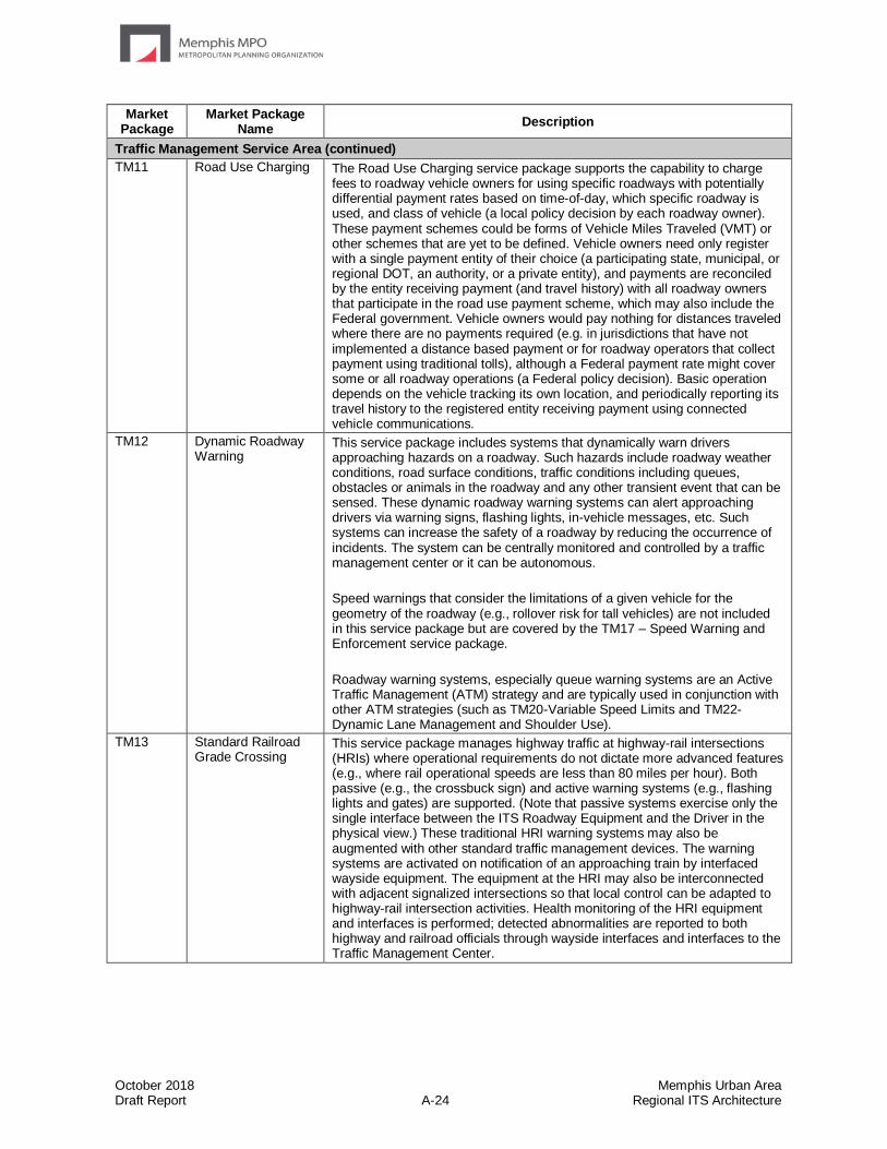
October 2018 Memphis Urban Area Draft Report A-24 Regional ITS Architecture
Market Package
Market Package Name
Description
Traffic Management Service Area (continued)
TM11 Road Use Charging The Road Use Charging service package supports the capability to charge fees to roadway vehicle owners for using specific roadways with potentially differential payment rates based on time-of-day, which specific roadway is used, and class of vehicle (a local policy decision by each roadway owner). These payment schemes could be forms of Vehicle Miles Traveled (VMT) or other schemes that are yet to be defined. Vehicle owners need only register with a single payment entity of their choice (a participating state, municipal, or regional DOT, an authority, or a private entity), and payments are reconciled by the entity receiving payment (and travel history) with all roadway owners that participate in the road use payment scheme, which may also include the Federal government. Vehicle owners would pay nothing for distances traveled where there are no payments required (e.g. in jurisdictions that have not implemented a distance based payment or for roadway operators that collect payment using traditional tolls), although a Federal payment rate might cover some or all roadway operations (a Federal policy decision). Basic operation depends on the vehicle tracking its own location, and periodically reporting its travel history to the registered entity receiving payment using connected vehicle communications.
TM12 Dynamic Roadway Warning
This service package includes systems that dynamically warn drivers approaching hazards on a roadway. Such hazards include roadway weather conditions, road surface conditions, traffic conditions including queues, obstacles or animals in the roadway and any other transient event that can be sensed. These dynamic roadway warning systems can alert approaching drivers via warning signs, flashing lights, in-vehicle messages, etc. Such systems can increase the safety of a roadway by reducing the occurrence of incidents. The system can be centrally monitored and controlled by a traffic management center or it can be autonomous.
Speed warnings that consider the limitations of a given vehicle for the geometry of the roadway (e.g., rollover risk for tall vehicles) are not included in this service package but are covered by the TM17 – Speed Warning and Enforcement service package.
Roadway warning systems, especially queue warning systems are an Active Traffic Management (ATM) strategy and are typically used in conjunction with other ATM strategies (such as TM20-Variable Speed Limits and TM22-Dynamic Lane Management and Shoulder Use).
TM13 Standard Railroad Grade Crossing
This service package manages highway traffic at highway-rail intersections (HRIs) where operational requirements do not dictate more advanced features (e.g., where rail operational speeds are less than 80 miles per hour). Both passive (e.g., the crossbuck sign) and active warning systems (e.g., flashing lights and gates) are supported. (Note that passive systems exercise only the single interface between the ITS Roadway Equipment and the Driver in the physical view.) These traditional HRI warning systems may also be augmented with other standard traffic management devices. The warning systems are activated on notification of an approaching train by interfaced wayside equipment. The equipment at the HRI may also be interconnected with adjacent signalized intersections so that local control can be adapted to highway-rail intersection activities. Health monitoring of the HRI equipment and interfaces is performed; detected abnormalities are reported to both highway and railroad officials through wayside interfaces and interfaces to the Traffic Management Center.

October 2018 Memphis Urban Area Draft Report A-25 Regional ITS Architecture
Market Package
Market Package Name
Description
Traffic Management Service Area (continued)
TM14 Advanced Railroad Grade Crossing
This service package manages highway traffic at highway-rail intersections (HRIs) where operational requirements demand advanced features (e.g., where rail operational speeds are greater than 80 miles per hour). This service package includes all capabilities from the Standard Railroad Grade Crossing service package and augments these with additional safety features to mitigate the risks associated with higher rail speeds and leverage Connected Vehicle technologies. The active warning systems supported by this service package include positive barrier systems that preclude entrance into the intersection when the barriers are activated. Like the Standard package, the HRI equipment is activated on notification by wayside interface equipment which detects, or communicates with the approaching train. In this service package, the wayside equipment provides additional information about the arriving train so that the train's direction of travel, estimated time of arrival, and estimated duration of closure may be derived. This service package will alert and/or warn drivers who are approaching an at-grade railroad crossing if they are on a crash-imminent trajectory to collide with a crossing or approaching train. This enhanced information may be conveyed to the driver prior to, or in context with, warning system activation. This service package also includes additional detection capabilities that enable it to detect an entrapped or otherwise immobilized vehicle within the HRI and provide an immediate notification to highway and railroad officials.
TM15 Railroad Operations Coordination
This service package provides an additional level of strategic coordination between freight rail operations and other transportation centers. Rail operations provides train schedules, maintenance schedules, and any other forecast events that will result in highway-rail intersection (HRI) closures. This information is used to develop forecast HRI closure times and durations that may be used in advanced traffic control strategies or to enhance the quality of traveler information.
TM16 Reversible Lane Management
This service package provides for the management of reversible lane facilities. In addition to standard surveillance capabilities, this service package includes sensory functions that detect wrong-way vehicles and other special surveillance capabilities that mitigate safety hazards associated with reversible lanes. The package includes the field equipment, physical lane access controls, and associated control electronics that manage and control these special lanes. This service package also includes the equipment used to electronically reconfigure intersections and manage right-of-way to address dynamic demand changes and special events.
TM17 Speed Warning and Enforcement
This service package monitors vehicle speeds and supports warning drivers when their speed is excessive. Also the service includes notifications to an enforcement agency to enforce the speed limit of the roadway. Speed monitoring can be made via spot speed or average speed measurements. Roadside equipment can display the speed of passing vehicles and/or suggest a safe driving speed. Environmental conditions and vehicle characteristics may be monitored and factored into the safe speed advisories that are provided to the motorist. For example, warnings can be generated recognizing the limitations of a given vehicle for the geometry of the roadway such as rollover risk for tall vehicles.
This service focuses on monitoring of vehicle speeds and enforcement of the speed limit while the variable speed limits service (covered in TM20-Variable Speed Limits service package) focuses on varying the posted speed limits to create more uniform speeds along a roadway, to promote safer driving during adverse conditions (such as fog) and/or to reduce air pollution.
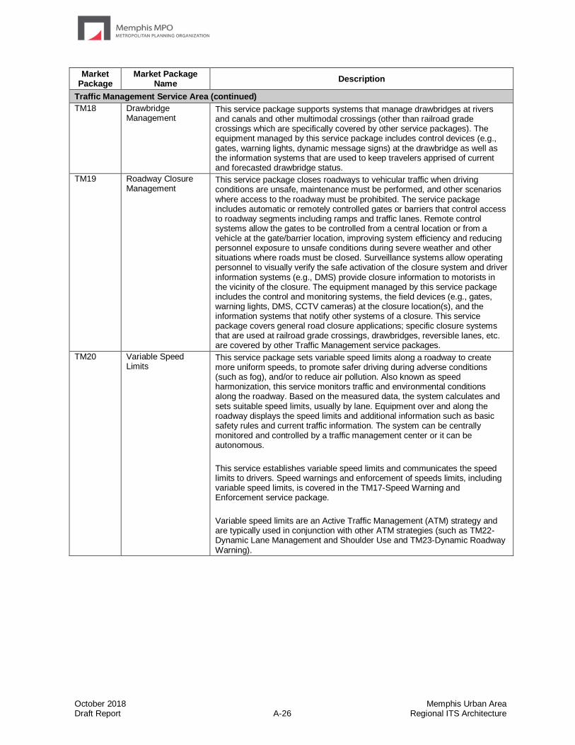
October 2018 Memphis Urban Area Draft Report A-26 Regional ITS Architecture
Market Package
Market Package Name
Description
Traffic Management Service Area (continued)
TM18 Drawbridge Management
This service package supports systems that manage drawbridges at rivers and canals and other multimodal crossings (other than railroad grade crossings which are specifically covered by other service packages). The equipment managed by this service package includes control devices (e.g., gates, warning lights, dynamic message signs) at the drawbridge as well as the information systems that are used to keep travelers apprised of current and forecasted drawbridge status.
TM19 Roadway Closure Management
This service package closes roadways to vehicular traffic when driving conditions are unsafe, maintenance must be performed, and other scenarios where access to the roadway must be prohibited. The service package includes automatic or remotely controlled gates or barriers that control access to roadway segments including ramps and traffic lanes. Remote control systems allow the gates to be controlled from a central location or from a vehicle at the gate/barrier location, improving system efficiency and reducing personnel exposure to unsafe conditions during severe weather and other situations where roads must be closed. Surveillance systems allow operating personnel to visually verify the safe activation of the closure system and driver information systems (e.g., DMS) provide closure information to motorists in the vicinity of the closure. The equipment managed by this service package includes the control and monitoring systems, the field devices (e.g., gates, warning lights, DMS, CCTV cameras) at the closure location(s), and the information systems that notify other systems of a closure. This service package covers general road closure applications; specific closure systems that are used at railroad grade crossings, drawbridges, reversible lanes, etc. are covered by other Traffic Management service packages.
TM20 Variable Speed Limits
This service package sets variable speed limits along a roadway to create more uniform speeds, to promote safer driving during adverse conditions (such as fog), and/or to reduce air pollution. Also known as speed harmonization, this service monitors traffic and environmental conditions along the roadway. Based on the measured data, the system calculates and sets suitable speed limits, usually by lane. Equipment over and along the roadway displays the speed limits and additional information such as basic safety rules and current traffic information. The system can be centrally monitored and controlled by a traffic management center or it can be autonomous.
This service establishes variable speed limits and communicates the speed limits to drivers. Speed warnings and enforcement of speeds limits, including variable speed limits, is covered in the TM17-Speed Warning and Enforcement service package.
Variable speed limits are an Active Traffic Management (ATM) strategy and are typically used in conjunction with other ATM strategies (such as TM22-Dynamic Lane Management and Shoulder Use and TM23-Dynamic Roadway Warning).
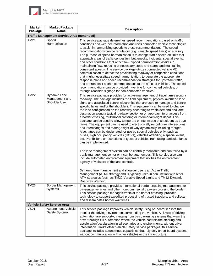
October 2018 Memphis Urban Area Draft Report A-27 Regional ITS Architecture
Market Package
Market Package Name
Description
Traffic Management Service Area (continued)
TM21 Speed Harmonization
This service package determines speed recommendations based on traffic conditions and weather information and uses connected vehicle technologies to assist in harmonizing speeds to these recommendations. The speed recommendations can be regulatory (e.g. variable speed limits) or advisory. The purpose of speed harmonization is to change traffic speed on links that approach areas of traffic congestion, bottlenecks, incidents, special events, and other conditions that affect flow. Speed harmonization assists in maintaining flow, reducing unnecessary stops and starts, and maintaining consistent speeds. The service package utilizes connected vehicle V2I communication to detect the precipitating roadway or congestion conditions that might necessitate speed harmonization, to generate the appropriate response plans and speed recommendation strategies for upstream traffic, and to broadcast such recommendations to the affected vehicles. The speed recommendations can be provided in-vehicle for connected vehicles, or through roadside signage for non-connected vehicles.
TM22 Dynamic Lane Management and Shoulder Use
This service package provides for active management of travel lanes along a roadway. The package includes the field equipment, physical overhead lane signs and associated control electronics that are used to manage and control specific lanes and/or the shoulders. This equipment can be used to change the lane configuration on the roadway according to traffic demand and lane destination along a typical roadway section or on approach to or access from a border crossing, multimodal crossing or intermodal freight depot. This package can be used to allow temporary or interim use of shoulders as travel lanes. The equipment can be used to electronically reconfigure intersections and interchanges and manage right-of-way dynamically including merges. Also, lanes can be designated for use by special vehicles only, such as buses, high occupancy vehicles (HOVs), vehicles attending a special event, etc. Prohibitions or restrictions of types of vehicles from using particular lanes can be implemented.
The lane management system can be centrally monitored and controlled by a traffic management center or it can be autonomous. This service also can include automated enforcement equipment that notifies the enforcement agency of violators of the lane controls.
Dynamic lane management and shoulder use is an Active Traffic Management (ATM) strategy and is typically used in conjunction with other ATM strategies (such as TM20-Variable Speed Limits and TM12-Dynamic Roadway Warning).
TM23 Border Management Systems
This service package provides international border crossing management for passenger vehicles and other non-commercial travelers crossing the border. This service package manages traffic at the border crossing, provides technology to support expedited processing of trusted travelers, and collects and disseminates border wait times.
Vehicle Safety Service Area
VS01 Autonomous Vehicle Safety Systems
This service package improves vehicle safety using on-board sensors that monitor the driving environment surrounding the vehicle. All levels of driving automation are supported ranging from basic warning systems that warn the driver through full automation where the vehicle controls the steering and acceleration/decelaration in all scenarios and environments, without driver intervention. Unlike other Vehicle Safety service packages, this service package includes autonomous capabilities that rely only on on-board systems without communication with other vehicles or the infrastructure.

October 2018 Memphis Urban Area Draft Report A-28 Regional ITS Architecture
Market Package
Market Package Name
Description
Vehicle Safety Service Area (continued)
VS02 V2V Basic Safety This service package exchanges basic safety messages with surrounding Connected Vehicles to support and augment the safety warning and control automation features identified in VS01. These exchanges support Connected Vehicle safety applications defined in SAE J2945/1: Emergency Electronic Brake Lights, Forward Crash Warning, Blind Spot Warning/Lane Change Warning, Intersection Movement Assist, Left Turn Assist, and Control Loss Warning. It also supports Do Not Pass Warning, Motorcycle Approaching indication, Tailgating Advisory, Stationary Vehicle, and Pre-Crash Actions applications from CVRIA.
VS03 Situational Awareness
This service package shares information about potentially hazardous road conditions or road hazards with other vehicles to support enhanced driver warnings and control automation. Vehicles broadcast relevant road condition information that is collected by the vehicle, such as fog or icy roads. This service package supports the capability for connected vehicles to share situational awareness information even in areas where no roadside communications infrastructure exists. It can be useful to vehicles that are not fully equipped with sensors, or vehicles entering an area with hazardous conditions. Roadside communications infrastructure, if available, can extend the situational awareness range to cover wrong way vehicles where closing rates can require notification beyond DSRC communications range.
VS04 V2V Special Vehicle Alert
This service package alerts the driver about the location of and the movement of public safety vehicles responding to an incident, slow moving vehicles, oversized vehicles, and other special vehicles that may require special attention from the driver. These public safety, commercial, and maintenance vehicles share their current status and location with surrounding vehicles so that other drivers in the vicinity can avoid interfering with their actions and avoid collisions.
VS05 Curve Speed Warning
This service package allows connected vehicles to receive information that it is approaching a curve along with the recommended speed for the curve. This capability allows the vehicle to provide a warning to the driver regarding the curve and its recommended speed. In addition, the vehicle can perform additional warning actions if the actual speed through the curve exceeds the recommended speed.
VS06 Stop Sign Gap Assist
This service package is intended to improve safety at non-signalized intersections where only the minor road has posted stop signs. It includes both onboard (for connected vehicles) and roadside signage warning systems (for non-equipped vehicles). The service package helps drivers on a minor road stopped at an intersection understand the state of activities associated with that intersection by providing a warning of unsafe gaps on the major road. The SSGA service package collects all available sensor information (major road, minor road, and median sensors) data and computes the dynamic state of the intersection in order to issue appropriate warnings and alerts.
VS07 Road Weather Motorist Alert and Warning
This service package collects road weather data from connected vehicles and uses that data to develop short term warnings or advisories that can be provided to individual motorists. The information may come from either vehicles operated by the general public and commercial entities (including passenger cars and trucks) or specialty vehicles and public fleet vehicles (such as snowplows, maintenance trucks, and other agency pool vehicles). The raw data will be processed in a controlling center to generate road segment-based data outputs. The processing will also include a road weather motorist alerts algorithm to generate short time horizon alerts that will be pushed to user systems and available to commercial service providers. In addition the information collected can be combined with observations and forecasts from other sources to provide medium (next 2-12 hours) or long term (more than 12 hours) advisories through a variety of interfaces including web based and connected vehicle based interfaces.
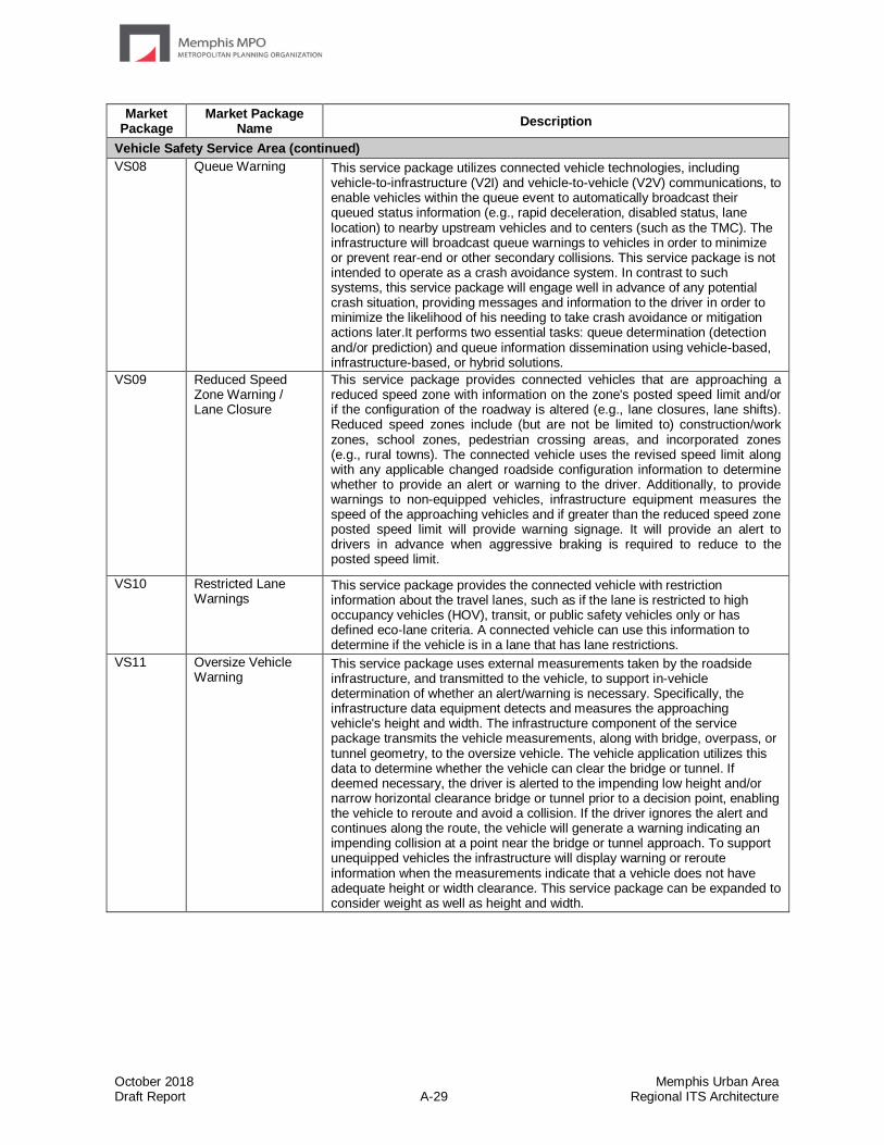
October 2018 Memphis Urban Area Draft Report A-29 Regional ITS Architecture
Market Package
Market Package Name
Description
Vehicle Safety Service Area (continued)
VS08 Queue Warning This service package utilizes connected vehicle technologies, including vehicle-to-infrastructure (V2I) and vehicle-to-vehicle (V2V) communications, to enable vehicles within the queue event to automatically broadcast their queued status information (e.g., rapid deceleration, disabled status, lane location) to nearby upstream vehicles and to centers (such as the TMC). The infrastructure will broadcast queue warnings to vehicles in order to minimize or prevent rear-end or other secondary collisions. This service package is not intended to operate as a crash avoidance system. In contrast to such systems, this service package will engage well in advance of any potential crash situation, providing messages and information to the driver in order to minimize the likelihood of his needing to take crash avoidance or mitigation actions later.It performs two essential tasks: queue determination (detection and/or prediction) and queue information dissemination using vehicle-based, infrastructure-based, or hybrid solutions.
VS09 Reduced Speed Zone Warning / Lane Closure
This service package provides connected vehicles that are approaching a reduced speed zone with information on the zone's posted speed limit and/or if the configuration of the roadway is altered (e.g., lane closures, lane shifts). Reduced speed zones include (but are not be limited to) construction/work zones, school zones, pedestrian crossing areas, and incorporated zones (e.g., rural towns). The connected vehicle uses the revised speed limit along with any applicable changed roadside configuration information to determine whether to provide an alert or warning to the driver. Additionally, to provide warnings to non-equipped vehicles, infrastructure equipment measures the speed of the approaching vehicles and if greater than the reduced speed zone posted speed limit will provide warning signage. It will provide an alert to drivers in advance when aggressive braking is required to reduce to the posted speed limit.
VS10 Restricted Lane Warnings
This service package provides the connected vehicle with restriction information about the travel lanes, such as if the lane is restricted to high occupancy vehicles (HOV), transit, or public safety vehicles only or has defined eco-lane criteria. A connected vehicle can use this information to determine if the vehicle is in a lane that has lane restrictions.
VS11 Oversize Vehicle Warning
This service package uses external measurements taken by the roadside infrastructure, and transmitted to the vehicle, to support in-vehicle determination of whether an alert/warning is necessary. Specifically, the infrastructure data equipment detects and measures the approaching vehicle's height and width. The infrastructure component of the service package transmits the vehicle measurements, along with bridge, overpass, or tunnel geometry, to the oversize vehicle. The vehicle application utilizes this data to determine whether the vehicle can clear the bridge or tunnel. If deemed necessary, the driver is alerted to the impending low height and/or narrow horizontal clearance bridge or tunnel prior to a decision point, enabling the vehicle to reroute and avoid a collision. If the driver ignores the alert and continues along the route, the vehicle will generate a warning indicating an impending collision at a point near the bridge or tunnel approach. To support unequipped vehicles the infrastructure will display warning or reroute information when the measurements indicate that a vehicle does not have adequate height or width clearance. This service package can be expanded to consider weight as well as height and width.
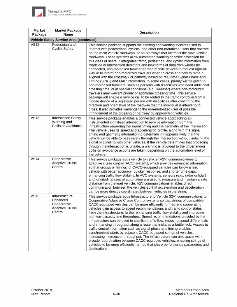
October 2018 Memphis Urban Area Draft Report A-30 Regional ITS Architecture
Market Package
Market Package Name
Description
Vehicle Safety Service Area (continued)
VS12 Pedestrian and Cyclist Safety
This service package supports the sensing and warning systems used to interact with pedestrians, cyclists, and other non-motorized users that operate on the main vehicle roadways, or on pathways that intersect the main vehicle roadways. These systems allow automated warning or active protection for this class of users. It integrates traffic, pedestrian, and cyclist information from roadside or intersection detectors and new forms of data from wirelessly connected, non-motorized traveler-carried mobile devices to request right-of-way or to inform non-motorized travelers when to cross and how to remain aligned with the crosswalk or pathway based on real-time Signal Phase and Timing (SPaT) and MAP information. In some cases, priority will be given to non-motorized travelers, such as persons with disabilities who need additional crossing time, or in special conditions (e.g., weather) where non-motorized travelers may warrant priority or additional crossing time. This service package will enable a service call to be routed to the traffic controller from a mobile device of a registered person with disabilities after confirming the direction and orientation of the roadway that the individual is intending to cross. It also provides warnings to the non-motorized user of possible infringement of the crossing or pathway by approaching vehicles.
VS13 Intersection Safety Warning and Collision Avoidance
This service package enables a connected vehicle approaching an instrumented signalized intersection to receive information from the infrastructure regarding the signal timing and the geometry of the intersection. The vehicle uses its speed and acceleration profile, along with the signal timing and geometry information to determine if it appears likely that the vehicle will be able to pass safely through the intersection without violating the signal or colliding with other vehicles. If the vehicle determines that proceding through the intersection is unsafe, a warning is provided to the driver and/or collision avoidance actions are taken, depending on the automation level of the vehicle.
VS14 Cooperative Adaptive Cruise Control
This service package adds vehicle to vehicle (V2V) communications to adaptive cruise control (ACC) systems, which provides enhanced information so that groups or 'strings' of CACC-equipped vehicles can follow a lead vehicle with better accuracy, quicker response, and shorter time gaps, enhancing traffic flow stability. In ACC systems, sensors (e.g., radar or lidar) and longitudinal control automation are used to measure and maintain a safe distance from the lead vehicle. V2V communications enables direct communication between the vehicles so that acceleration and deceleration can be more directly coordinated between vehicles in the string.
VS15 Infrastructure Enhanced Cooperative Adaptive Cruise Control
This service package adds Infrastructure to Vehicle (I2V) communications to Cooperative Adaptive Cruise Control systems so that strings of compatible CACC-equipped vehicles can be more efficiently formed and cooperating vehicles gain access to speed recommendations and traffic control status from the infrastructure, further enhancing traffic flow stability and improving highway capacity and throughput. Speed recommendations provided by the infrastructure can be used to stabilize traffic flow, reducing speed differentials and enhancing throughput along a route that includes a bottleneck. Access to traffic control information such as signal phase and timing enables synchronized starts by adjacent CACC-equipped strings of vehicles, increasing intersection throughput. The infrastructure can also assist with broader coordination between CACC-equipped vehicles, enabling strings of vehicles to be more efficiently formed that share performance parameters and destinations.
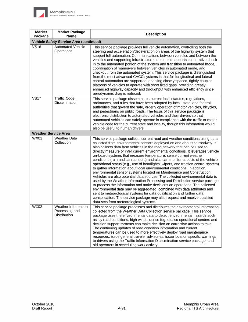
October 2018 Memphis Urban Area Draft Report A-31 Regional ITS Architecture
Market Package
Market Package Name
Description
Vehicle Safety Service Area (continued)
VS16 Automated Vehicle Operations
This service package provides full vehicle automation, controlling both the steering and acceleration/deceleration on areas of the highway system that support full automation. Communications between vehicles and between the vehicles and supporting infrastructure equipment supports cooperative check-in to the automated portion of the system and transition to automated mode, coordination of maneuvers between vehicles in automated mode, and checkout from the automated system. This service package is distinguished from the most advanced CACC systems in that full longitudinal and lateral control automation are supported, enabling closely spaced, tightly coupled platoons of vehicles to operate with short fixed gaps, providing greatly enhanced highway capacity and throughput with enhanced efficiency since aerodynamic drag is reduced.
VS17 Traffic Code Dissemination
This service package disseminates current local statutes, regulations, ordinances, and rules that have been adopted by local, state, and federal authorities that govern the safe, orderly operation of motor vehicles, bicycles, and pedestrians on public roads. The focus of this service package is electronic distribution to automated vehicles and their drivers so that automated vehicles can safely operate in compliance with the traffic or motor vehicle code for the current state and locality, though this information would also be useful to human drivers.
Weather Service Area
WX01 Weather Data Collection
This service package collects current road and weather conditions using data collected from environmental sensors deployed on and about the roadway. It also collects data from vehicles in the road network that can be used to directly measure or infer current environmental conditions. It leverages vehicle on-board systems that measure temperature, sense current weather conditions (rain and sun sensors) and also can monitor aspects of the vehicle operational status (e.g., use of headlights, wipers, and traction control system) to gather information about local environmental conditions. In addition, environmental sensor systems located on Maintenance and Construction Vehicles are also potential data sources. The collected environmental data is used by the Weather Information Processing and Distribution service package to process the information and make decisions on operations. The collected environmental data may be aggregated, combined with data attributes and sent to meteorological systems for data qualification and further data consolidation. The service package may also request and receive qualified data sets from meteorological systems.
WX02 Weather Information Processing and Distribution
This service package processes and distributes the environmental information collected from the Weather Data Collection service package. This service package uses the environmental data to detect environmental hazards such as icy road conditions, high winds, dense fog, etc. so operational centers and decision support systems can make decision on corrective actions to take. The continuing updates of road condition information and current temperatures can be used to more effectively deploy road maintenance resources, issue general traveler advisories, issue location specific warnings to drivers using the Traffic Information Dissemination service package, and aid operators in scheduling work activity.
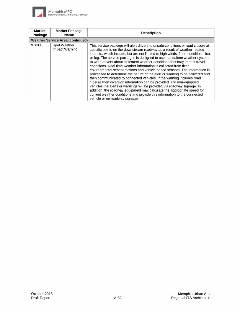
October 2018 Memphis Urban Area Draft Report A-32 Regional ITS Architecture
Market Package
Market Package Name
Description
Weather Service Area (continued)
WX03 Spot Weather Impact Warning
This service package will alert drivers to unsafe conditions or road closure at specific points on the downstream roadway as a result of weather-related impacts, which include, but are not limited to high winds, flood conditions, ice, or fog. The service packages is designed to use standalone weather systems to warn drivers about inclement weather conditions that may impact travel conditions. Real time weather information is collected from fixed environmental sensor stations and vehicle based sensors. The information is processed to determine the nature of the alert or warning to be delivered and then communicated to connected vehicles. If the warning includes road closure then diversion information can be provided. For non-equipped vehicles the alerts or warnings will be provided via roadway signage. In addition, the roadway equipment may calculate the appropriate speed for current weather conditions and provide this information to the connected vehicle or on roadway signage.

October 2018 Memphis Urban Area Draft Report Regional ITS Architecture
Appendix B – Element Functions

October 2018 Memphis Urban Area Draft Report B-1 Regional ITS Architecture
Element Name Equipment Package (Function)
AHTD Crittenden County Local TOC TMC Regional Traffic Management
AHTD District 1 TMC TMC Regional Traffic Management
AHTD District Maintenance MCM Work Activity Coordination
AHTD Statewide TMC TMC Regional Traffic Management
All MS Municipal and County Emergency Dispatch Agencies
Emergency Call-Taking
Emergency Data Collection
Emergency Dispatch
Emergency Evacuation Support
Emergency Response Management
Emergency Routing
Incident Command
All MS Municipal and County TOCs TMC Evacuation Support
TMC Incident Detection
TMC Incident Dispatch Coordination/Communication
TMC Regional Traffic Management
TMC Signal Control
TMC Traffic Information Dissemination
TMC Work Zone Traffic Management
Traffic Data Collection
All Shelby County Emergency Dispatch Agencies Emergency Call-Taking
Emergency Data Collection
Emergency Dispatch
Emergency Evacuation Support
Emergency Response Management
Emergency Routing
Incident Command
All Shelby County TOCs TMC Evacuation Support
TMC Incident Detection
TMC Incident Dispatch Coordination/Communication
TMC Regional Traffic Management
TMC Signal Control
TMC Traffic Information Dissemination
TMC Work Zone Traffic Management
Traffic Data Collection
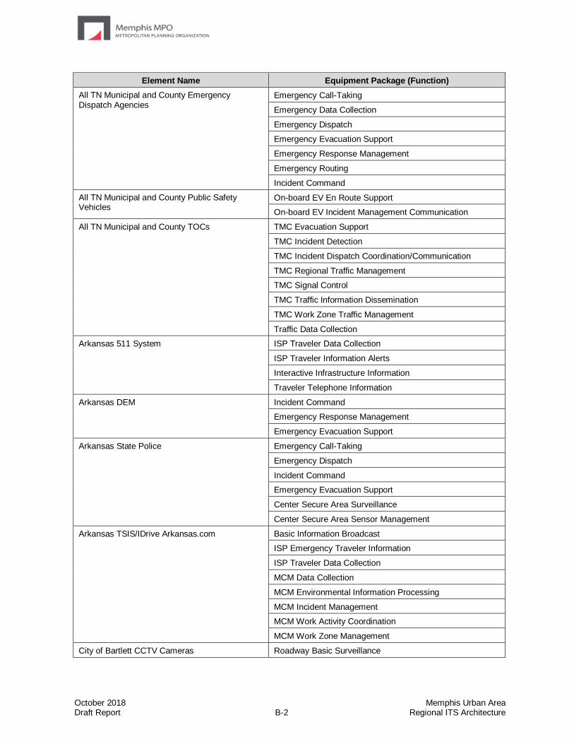
October 2018 Memphis Urban Area Draft Report B-2 Regional ITS Architecture
Element Name Equipment Package (Function)
All TN Municipal and County Emergency Dispatch Agencies
Emergency Call-Taking
Emergency Data Collection
Emergency Dispatch
Emergency Evacuation Support
Emergency Response Management
Emergency Routing
Incident Command
All TN Municipal and County Public Safety Vehicles
On-board EV En Route Support
On-board EV Incident Management Communication
All TN Municipal and County TOCs TMC Evacuation Support
TMC Incident Detection
TMC Incident Dispatch Coordination/Communication
TMC Regional Traffic Management
TMC Signal Control
TMC Traffic Information Dissemination
TMC Work Zone Traffic Management
Traffic Data Collection
Arkansas 511 System ISP Traveler Data Collection
ISP Traveler Information Alerts
Interactive Infrastructure Information
Traveler Telephone Information
Arkansas DEM Incident Command
Emergency Response Management
Emergency Evacuation Support
Arkansas State Police Emergency Call-Taking
Emergency Dispatch
Incident Command
Emergency Evacuation Support
Center Secure Area Surveillance
Center Secure Area Sensor Management
Arkansas TSIS/IDrive Arkansas.com Basic Information Broadcast
ISP Emergency Traveler Information
ISP Traveler Data Collection
MCM Data Collection
MCM Environmental Information Processing
MCM Incident Management
MCM Work Activity Coordination
MCM Work Zone Management
City of Bartlett CCTV Cameras Roadway Basic Surveillance
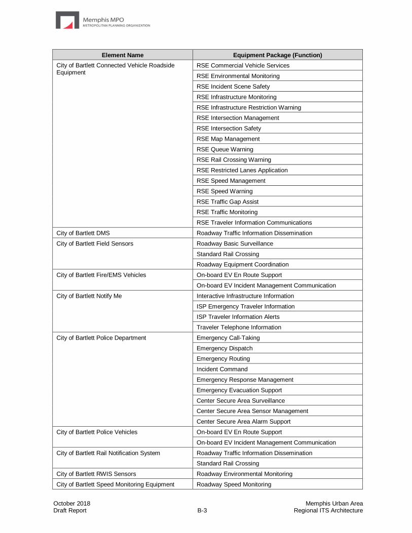
October 2018 Memphis Urban Area Draft Report B-3 Regional ITS Architecture
Element Name Equipment Package (Function)
City of Bartlett Connected Vehicle Roadside Equipment
RSE Commercial Vehicle Services
RSE Environmental Monitoring
RSE Incident Scene Safety
RSE Infrastructure Monitoring
RSE Infrastructure Restriction Warning
RSE Intersection Management
RSE Intersection Safety
RSE Map Management
RSE Queue Warning
RSE Rail Crossing Warning
RSE Restricted Lanes Application
RSE Speed Management
RSE Speed Warning
RSE Traffic Gap Assist
RSE Traffic Monitoring
RSE Traveler Information Communications
City of Bartlett DMS Roadway Traffic Information Dissemination
City of Bartlett Field Sensors Roadway Basic Surveillance
Standard Rail Crossing
Roadway Equipment Coordination
City of Bartlett Fire/EMS Vehicles On-board EV En Route Support
On-board EV Incident Management Communication
City of Bartlett Notify Me Interactive Infrastructure Information
ISP Emergency Traveler Information
ISP Traveler Information Alerts
Traveler Telephone Information
City of Bartlett Police Department Emergency Call-Taking
Emergency Dispatch
Emergency Routing
Incident Command
Emergency Response Management
Emergency Evacuation Support
Center Secure Area Surveillance
Center Secure Area Sensor Management
Center Secure Area Alarm Support
City of Bartlett Police Vehicles
On-board EV En Route Support
On-board EV Incident Management Communication
City of Bartlett Rail Notification System Roadway Traffic Information Dissemination
Standard Rail Crossing
City of Bartlett RWIS Sensors Roadway Environmental Monitoring
City of Bartlett Speed Monitoring Equipment Roadway Speed Monitoring
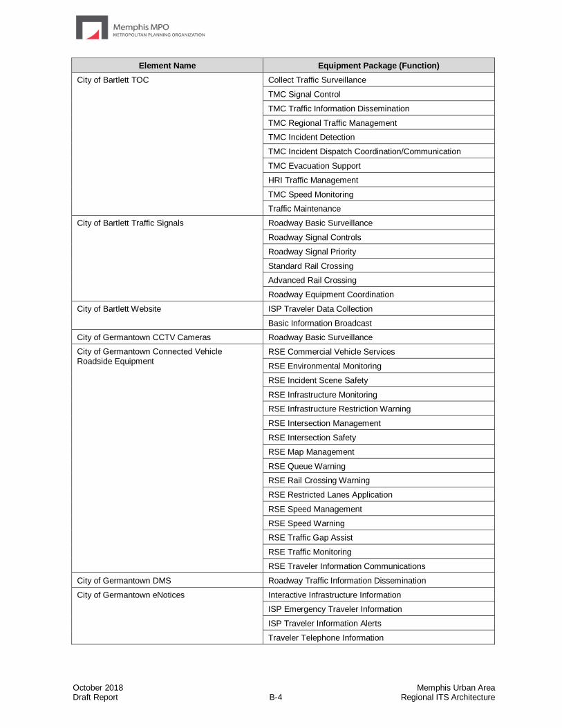
October 2018 Memphis Urban Area Draft Report B-4 Regional ITS Architecture
Element Name Equipment Package (Function)
City of Bartlett TOC Collect Traffic Surveillance
TMC Signal Control
TMC Traffic Information Dissemination
TMC Regional Traffic Management
TMC Incident Detection
TMC Incident Dispatch Coordination/Communication
TMC Evacuation Support
HRI Traffic Management
TMC Speed Monitoring
Traffic Maintenance
City of Bartlett Traffic Signals Roadway Basic Surveillance
Roadway Signal Controls
Roadway Signal Priority
Standard Rail Crossing
Advanced Rail Crossing
Roadway Equipment Coordination
City of Bartlett Website ISP Traveler Data Collection
Basic Information Broadcast
City of Germantown CCTV Cameras Roadway Basic Surveillance
City of Germantown Connected Vehicle Roadside Equipment
RSE Commercial Vehicle Services
RSE Environmental Monitoring
RSE Incident Scene Safety
RSE Infrastructure Monitoring
RSE Infrastructure Restriction Warning
RSE Intersection Management
RSE Intersection Safety
RSE Map Management
RSE Queue Warning
RSE Rail Crossing Warning
RSE Restricted Lanes Application
RSE Speed Management
RSE Speed Warning
RSE Traffic Gap Assist
RSE Traffic Monitoring
RSE Traveler Information Communications
City of Germantown DMS Roadway Traffic Information Dissemination
City of Germantown eNotices Interactive Infrastructure Information
ISP Emergency Traveler Information
ISP Traveler Information Alerts
Traveler Telephone Information
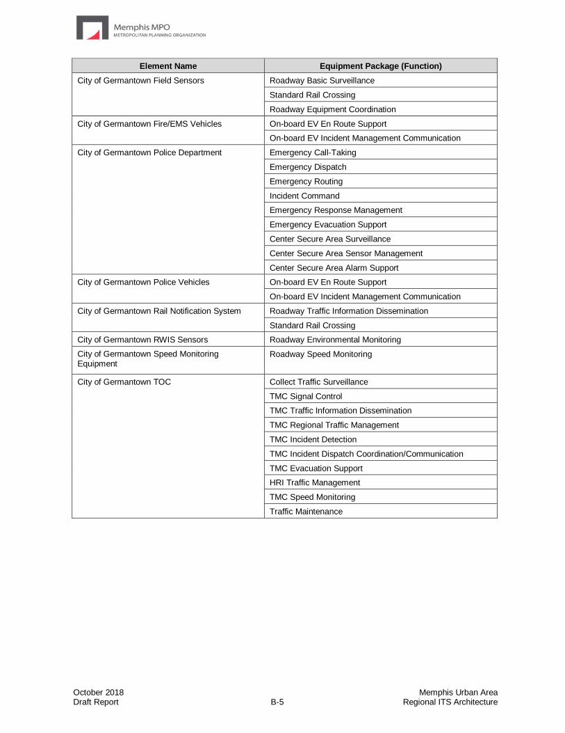
October 2018 Memphis Urban Area Draft Report B-5 Regional ITS Architecture
Element Name Equipment Package (Function)
City of Germantown Field Sensors Roadway Basic Surveillance
Standard Rail Crossing
Roadway Equipment Coordination
City of Germantown Fire/EMS Vehicles
On-board EV En Route Support
On-board EV Incident Management Communication
City of Germantown Police Department Emergency Call-Taking
Emergency Dispatch
Emergency Routing
Incident Command
Emergency Response Management
Emergency Evacuation Support
Center Secure Area Surveillance
Center Secure Area Sensor Management
Center Secure Area Alarm Support
City of Germantown Police Vehicles On-board EV En Route Support
On-board EV Incident Management Communication
City of Germantown Rail Notification System Roadway Traffic Information Dissemination
Standard Rail Crossing
City of Germantown RWIS Sensors Roadway Environmental Monitoring
City of Germantown Speed Monitoring Equipment
Roadway Speed Monitoring
City of Germantown TOC Collect Traffic Surveillance
TMC Signal Control
TMC Traffic Information Dissemination
TMC Regional Traffic Management
TMC Incident Detection
TMC Incident Dispatch Coordination/Communication
TMC Evacuation Support
HRI Traffic Management
TMC Speed Monitoring
Traffic Maintenance
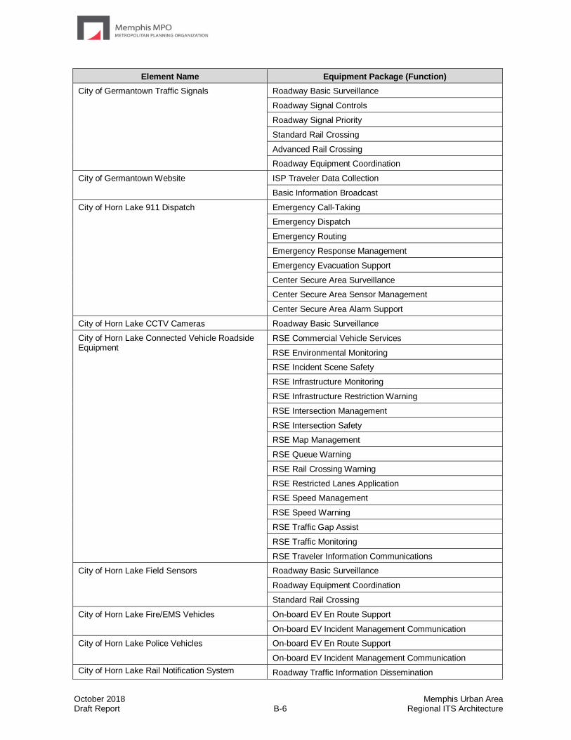
October 2018 Memphis Urban Area Draft Report B-6 Regional ITS Architecture
Element Name Equipment Package (Function)
City of Germantown Traffic Signals Roadway Basic Surveillance
Roadway Signal Controls
Roadway Signal Priority
Standard Rail Crossing
Advanced Rail Crossing
Roadway Equipment Coordination
City of Germantown Website ISP Traveler Data Collection
Basic Information Broadcast
City of Horn Lake 911 Dispatch
Emergency Call-Taking
Emergency Dispatch
Emergency Routing
Emergency Response Management
Emergency Evacuation Support
Center Secure Area Surveillance
Center Secure Area Sensor Management
Center Secure Area Alarm Support
City of Horn Lake CCTV Cameras Roadway Basic Surveillance
City of Horn Lake Connected Vehicle Roadside Equipment
RSE Commercial Vehicle Services
RSE Environmental Monitoring
RSE Incident Scene Safety
RSE Infrastructure Monitoring
RSE Infrastructure Restriction Warning
RSE Intersection Management
RSE Intersection Safety
RSE Map Management
RSE Queue Warning
RSE Rail Crossing Warning
RSE Restricted Lanes Application
RSE Speed Management
RSE Speed Warning
RSE Traffic Gap Assist
RSE Traffic Monitoring
RSE Traveler Information Communications
City of Horn Lake Field Sensors Roadway Basic Surveillance
Roadway Equipment Coordination
Standard Rail Crossing
City of Horn Lake Fire/EMS Vehicles On-board EV En Route Support
On-board EV Incident Management Communication
City of Horn Lake Police Vehicles
On-board EV En Route Support
On-board EV Incident Management Communication
City of Horn Lake Rail Notification System Roadway Traffic Information Dissemination
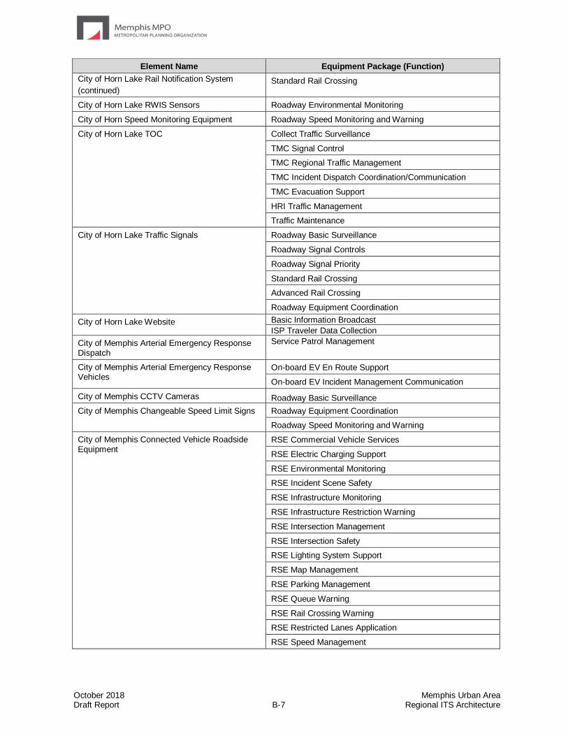
October 2018 Memphis Urban Area Draft Report B-7 Regional ITS Architecture
Element Name Equipment Package (Function)
City of Horn Lake Rail Notification System
(continued) Standard Rail Crossing
City of Horn Lake RWIS Sensors Roadway Environmental Monitoring
City of Horn Speed Monitoring Equipment Roadway Speed Monitoring and Warning
City of Horn Lake TOC
Collect Traffic Surveillance
TMC Signal Control
TMC Regional Traffic Management
TMC Incident Dispatch Coordination/Communication
TMC Evacuation Support
HRI Traffic Management
Traffic Maintenance
City of Horn Lake Traffic Signals Roadway Basic Surveillance
Roadway Signal Controls
Roadway Signal Priority
Standard Rail Crossing
Advanced Rail Crossing
Roadway Equipment Coordination
City of Horn Lake Website Basic Information Broadcast
ISP Traveler Data Collection
City of Memphis Arterial Emergency Response Dispatch
Service Patrol Management
City of Memphis Arterial Emergency Response Vehicles
On-board EV En Route Support
On-board EV Incident Management Communication
City of Memphis CCTV Cameras Roadway Basic Surveillance
City of Memphis Changeable Speed Limit Signs Roadway Equipment Coordination
Roadway Speed Monitoring and Warning
City of Memphis Connected Vehicle Roadside Equipment
RSE Commercial Vehicle Services
RSE Electric Charging Support
RSE Environmental Monitoring
RSE Incident Scene Safety
RSE Infrastructure Monitoring
RSE Infrastructure Restriction Warning
RSE Intersection Management
RSE Intersection Safety
RSE Lighting System Support
RSE Map Management
RSE Parking Management
RSE Queue Warning
RSE Rail Crossing Warning
RSE Restricted Lanes Application
RSE Speed Management

October 2018 Memphis Urban Area Draft Report B-8 Regional ITS Architecture
Element Name Equipment Package (Function)
City of Memphis Connected Vehicle Roadside Equipment
(continued)
RSE Speed Warning
RSE Traffic Gap Assist
RSE Traffic Monitoring
RSE Traveler Information Communications
RSE Work Zone Safety
City of Memphis DMS Roadway Traffic Information Dissemination
City of Memphis Dynamic Lane Assignment Sign Roadway Dynamic Lane Management and Shoulder Use
City of Memphis Electric Vehicle Charging Station
Electric Charging Station Management
City of Memphis Engineering Division MCM Vehicle Tracking
MCM Incident Management
MCM Roadway Maintenance and Construction
MCM Work Zone Management
MCM Work Activity Coordination
City of Memphis Field Sensors Roadway Basic Surveillance
Standard Rail Crossing
Roadway Equipment Coordination
City of Memphis Fire/EMS Vehicles
On-board EV En Route Support
On-board EV Incident Management Communication
City of Memphis Parking Management System
Parking Coordination
City of Memphis Pedestrian Hybrid Beacons Roadway Mixed Use Sensing
Roadway Warning
City of Memphis Police Department Emergency Call-Taking
Emergency Dispatch
Emergency Routing
Incident Command
Emergency Response Management
Emergency Evacuation Support
Center Secure Area Surveillance
Center Secure Area Sensor Management
Center Secure Area Alarm Support
Emergency Data Collection
City of Memphis Police Portable DMS Roadway Work Zone Traffic Control
City of Memphis Police Vehicles On-board EV En Route Support
On-board EV Incident Management Communication
City of Memphis Public Works Division MCM Vehicle Tracking
MCM Environmental Information Processing
MCM Incident Management
MCM Roadway Maintenance and Construction
MCM Work Zone Management
MCM Work Activity Coordination
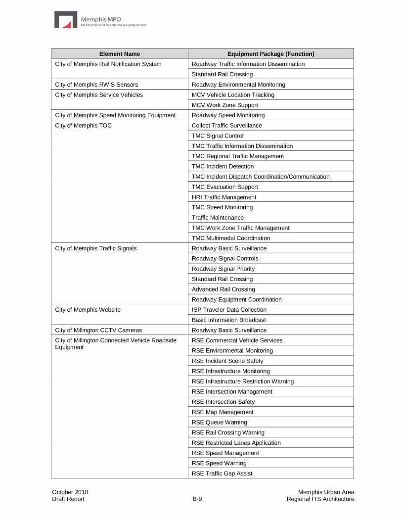
October 2018 Memphis Urban Area Draft Report B-9 Regional ITS Architecture
Element Name Equipment Package (Function)
City of Memphis Rail Notification System Roadway Traffic Information Dissemination
Standard Rail Crossing
City of Memphis RWIS Sensors Roadway Environmental Monitoring
City of Memphis Service Vehicles MCV Vehicle Location Tracking
MCV Work Zone Support
City of Memphis Speed Monitoring Equipment Roadway Speed Monitoring
City of Memphis TOC Collect Traffic Surveillance
TMC Signal Control
TMC Traffic Information Dissemination
TMC Regional Traffic Management
TMC Incident Detection
TMC Incident Dispatch Coordination/Communication
TMC Evacuation Support
HRI Traffic Management
TMC Speed Monitoring
Traffic Maintenance
TMC Work Zone Traffic Management
TMC Multimodal Coordination
City of Memphis Traffic Signals Roadway Basic Surveillance
Roadway Signal Controls
Roadway Signal Priority
Standard Rail Crossing
Advanced Rail Crossing
Roadway Equipment Coordination
City of Memphis Website ISP Traveler Data Collection
Basic Information Broadcast
City of Millington CCTV Cameras Roadway Basic Surveillance
City of Millington Connected Vehicle Roadside Equipment
RSE Commercial Vehicle Services
RSE Environmental Monitoring
RSE Incident Scene Safety
RSE Infrastructure Monitoring
RSE Infrastructure Restriction Warning
RSE Intersection Management
RSE Intersection Safety
RSE Map Management
RSE Queue Warning
RSE Rail Crossing Warning
RSE Restricted Lanes Application
RSE Speed Management
RSE Speed Warning
RSE Traffic Gap Assist

October 2018 Memphis Urban Area Draft Report B-10 Regional ITS Architecture
Element Name Equipment Package (Function)
City of Millington Connected Vehicle Roadside Equipment
(continued)
RSE Traffic Monitoring
RSE Traveler Information Communications
City of Millington DMS Roadway Traffic Information Dissemination
City of Millington Field Sensors Roadway Basic Surveillance
Standard Rail Crossing
Roadway Equipment Coordination
City of Millington Fire Vehicles On-board EV En Route Support
On-board EV incident Management Communication
City of Millington Notify Me Interactive Infrastructure Information
ISP Emergency Traveler Information
ISP Traveler Information Alerts
Traveler Telephone Information
City of Millington Police Department Center Secure Area Alarm Support
Center Secure Area Sensor Management
Center Secure Area Surveillance
Emergency Call-Taking
Emergency Dispatch
Emergency Evacuation Support
Emergency Response Management
Emergency Routing
Incident Command
City of Millington Police Vehicles On-board EV En Route Support
On-board EV incident Management Communication
City of Millington Rail Notification System Roadway Traffic Information Dissemination
Standard Rail Crossing
City of Millington RWIS Sensors Roadway Environmental Monitoring
City of Millington Speed Monitoring Equipment Roadway Speed Monitoring
City of Millington TOC Collect Traffic Surveillance
TMC Signal Control
TMC Traffic Information Dissemination
TMC Regional Traffic Management
TMC Incident Detection
TMC Incident Dispatch Coordination/Communication
TMC Evacuation Support
HRI Traffic Management
TMC Speed Monitoring
Traffic Maintenance
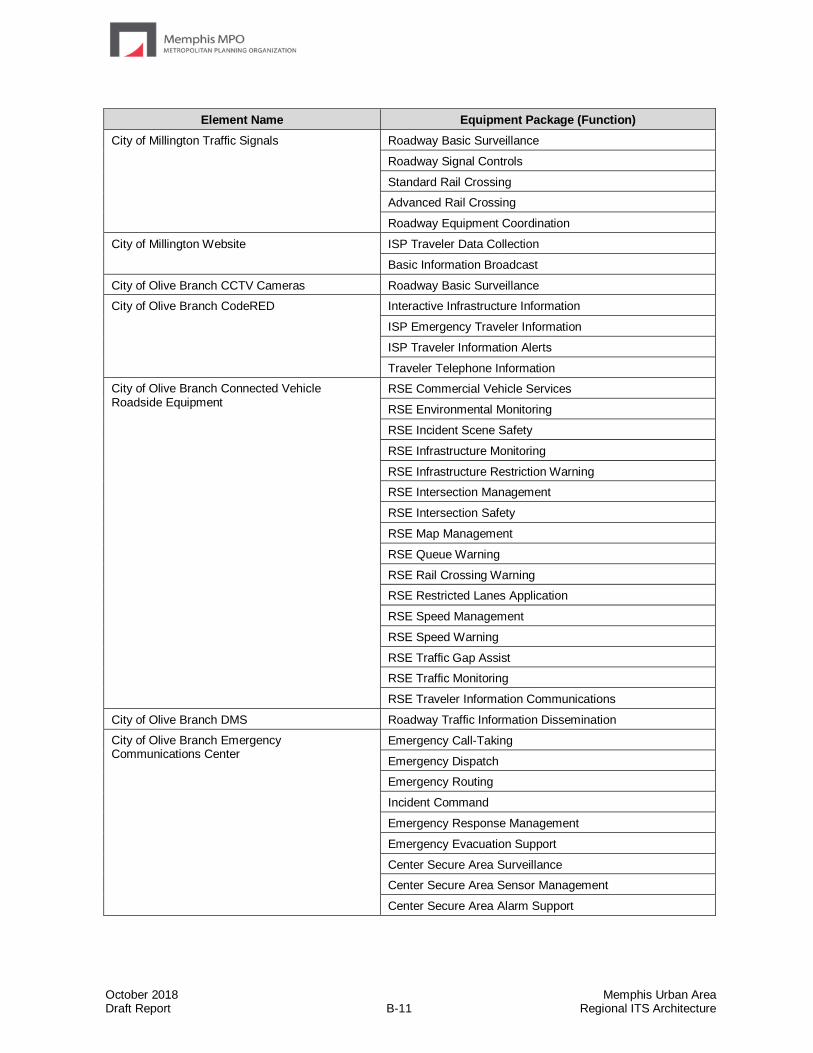
October 2018 Memphis Urban Area Draft Report B-11 Regional ITS Architecture
Element Name Equipment Package (Function)
City of Millington Traffic Signals
Roadway Basic Surveillance
Roadway Signal Controls
Standard Rail Crossing
Advanced Rail Crossing
Roadway Equipment Coordination
City of Millington Website ISP Traveler Data Collection
Basic Information Broadcast
City of Olive Branch CCTV Cameras Roadway Basic Surveillance
City of Olive Branch CodeRED Interactive Infrastructure Information
ISP Emergency Traveler Information
ISP Traveler Information Alerts
Traveler Telephone Information
City of Olive Branch Connected Vehicle Roadside Equipment
RSE Commercial Vehicle Services
RSE Environmental Monitoring
RSE Incident Scene Safety
RSE Infrastructure Monitoring
RSE Infrastructure Restriction Warning
RSE Intersection Management
RSE Intersection Safety
RSE Map Management
RSE Queue Warning
RSE Rail Crossing Warning
RSE Restricted Lanes Application
RSE Speed Management
RSE Speed Warning
RSE Traffic Gap Assist
RSE Traffic Monitoring
RSE Traveler Information Communications
City of Olive Branch DMS Roadway Traffic Information Dissemination
City of Olive Branch Emergency Communications Center
Emergency Call-Taking
Emergency Dispatch
Emergency Routing
Incident Command
Emergency Response Management
Emergency Evacuation Support
Center Secure Area Surveillance
Center Secure Area Sensor Management
Center Secure Area Alarm Support
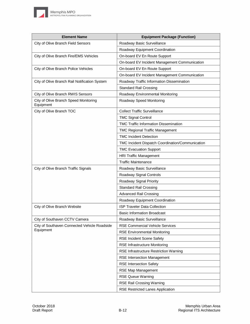
October 2018 Memphis Urban Area Draft Report B-12 Regional ITS Architecture
Element Name Equipment Package (Function)
City of Olive Branch Field Sensors
Roadway Basic Surveillance
Roadway Equipment Coordination
City of Olive Branch Fire/EMS Vehicles On-board EV En Route Support
On-board EV Incident Management Communication
City of Olive Branch Police Vehicles On-board EV En Route Support
On-board EV Incident Management Communication
City of Olive Branch Rail Notification System Roadway Traffic Information Dissemination
Standard Rail Crossing
City of Olive Branch RWIS Sensors Roadway Environmental Monitoring
City of Olive Branch Speed Monitoring Equipment
Roadway Speed Monitoring
City of Olive Branch TOC Collect Traffic Surveillance
TMC Signal Control
TMC Traffic Information Dissemination
TMC Regional Traffic Management
TMC Incident Detection
TMC Incident Dispatch Coordination/Communication
TMC Evacuation Support
HRI Traffic Management
Traffic Maintenance
City of Olive Branch Traffic Signals Roadway Basic Surveillance
Roadway Signal Controls
Roadway Signal Priority
Standard Rail Crossing
Advanced Rail Crossing
Roadway Equipment Coordination
City of Olive Branch Website ISP Traveler Data Collection
Basic Information Broadcast
City of Southaven CCTV Camera Roadway Basic Surveillance
City of Southaven Connected Vehicle Roadside Equipment
RSE Commercial Vehicle Services
RSE Environmental Monitoring
RSE Incident Scene Safety
RSE Infrastructure Monitoring
RSE Infrastructure Restriction Warning
RSE Intersection Management
RSE Intersection Safety
RSE Map Management
RSE Queue Warning
RSE Rail Crossing Warning
RSE Restricted Lanes Application

October 2018 Memphis Urban Area Draft Report B-13 Regional ITS Architecture
Element Name Equipment Package (Function)
City of Southaven Connected Vehicle Roadside Equipment
(continued)
RSE Speed Management
RSE Speed Warning
RSE Traffic Gap Assist
RSE Traffic Monitoring
RSE Traveler Information Communications
City of Southaven Field Sensors Roadway Basic Surveillance
Roadway Standard Rail Crossing
City of Southaven Fire/EMS Vehicles On-board EV En Route Support
On-board EV Incident Management Communication
City of Southaven Notify Me Interactive Infrastructure Information
ISP Emergency Traveler Information
ISP Traveler Information Alerts
Traveler Telephone Information
City of Southaven Police Department Emergency Call-Taking
Emergency Dispatch
Emergency Routing
Emergency Response Management
Center Secure Area Surveillance
Center Secure Area Sensor Management
Center Secure Area Alarm Support
City of Southaven Police Vehicles
On-board EV En Route Support
On-board EV Incident Management Communication
City of Southaven Rail Notification System Roadway Traffic Information Dissemination
Standard Rail Crossing
City of Southaven RWIS Sensors Roadway Environmental Monitoring
City of Southaven Speed Monitoring Equipment Roadway Speed Monitoring
City of Southaven TOC TMC Basic Surveillance
TMC Evacuation Support
TMC Incident Detection
TMC Incident Dispatch Coordination
TMC Regional Traffic Management
TMC Roadway Equipment Monitoring
TMC Signal Control
TMC Standard Rail Crossing Management
TMC Traffic Information Dissemination
City of Southaven Traffic Signals Roadway Basic Surveillance
Roadway Signal Controls
Roadway Signal Priority
Standard Rail Crossing
Advanced Rail Crossing
Roadway Equipment Coordination

October 2018 Memphis Urban Area Draft Report B-14 Regional ITS Architecture
Element Name Equipment Package (Function)
City of Southaven Website TIC Data Collection
TIC Traveler Information Broadcast
City of West Memphis Police Department Emergency Dispatch
Emergency Routing
Emergency Response Management
Center Secure Area Surveillance
Center Secure Area Sensor Management
Center Secure Area Alarm Support
City of West Memphis TOC TMC Regional Traffic Management
City of West Memphis MPO Data Archive ITS Data Repository
Government Reporting Systems Support
On-Line Analysis and Mining
Virtual Data Warehouse Services
Commercial Vehicles On-board Cargo Monitoring
DARTS Data Archive
ITS Data Repository
Traffic and Roadside Data Archival
Government Reporting Systems Support
Virtual Data Warehouse Services
DARTS Demand Response Vehicles On-board Transit Trip Monitoring
On-board Schedule Management
On-board Paratransit Operations
On-board Transit Security
On-board Maintenance
DARTS Dispatch Center Transit Center Vehicle Tracking
Transit Center Paratransit Operations
Transit Center Security
Transit Vehicle Operator Assignment
Transit Garage Maintenance
Transit Vehicle Assignment
Transit Center Multi-Modal Coordination
Transit Evacuation Support
Transit Data Collection
DARTS Transit Facility CCTV Camera Surveillance
Field Secure Area Sensor Monitoring
Field Secure Area Surveillance
DARTS Website Infrastructure Provided Trip Planning
ISP Data Collection
ISP Travel Service Information and Reservation
Delta HRA Data Archive ITS Data Repository
Traffic and Roadside Data Archival
Government Reporting Systems Support
Virtual Data Warehouse Services
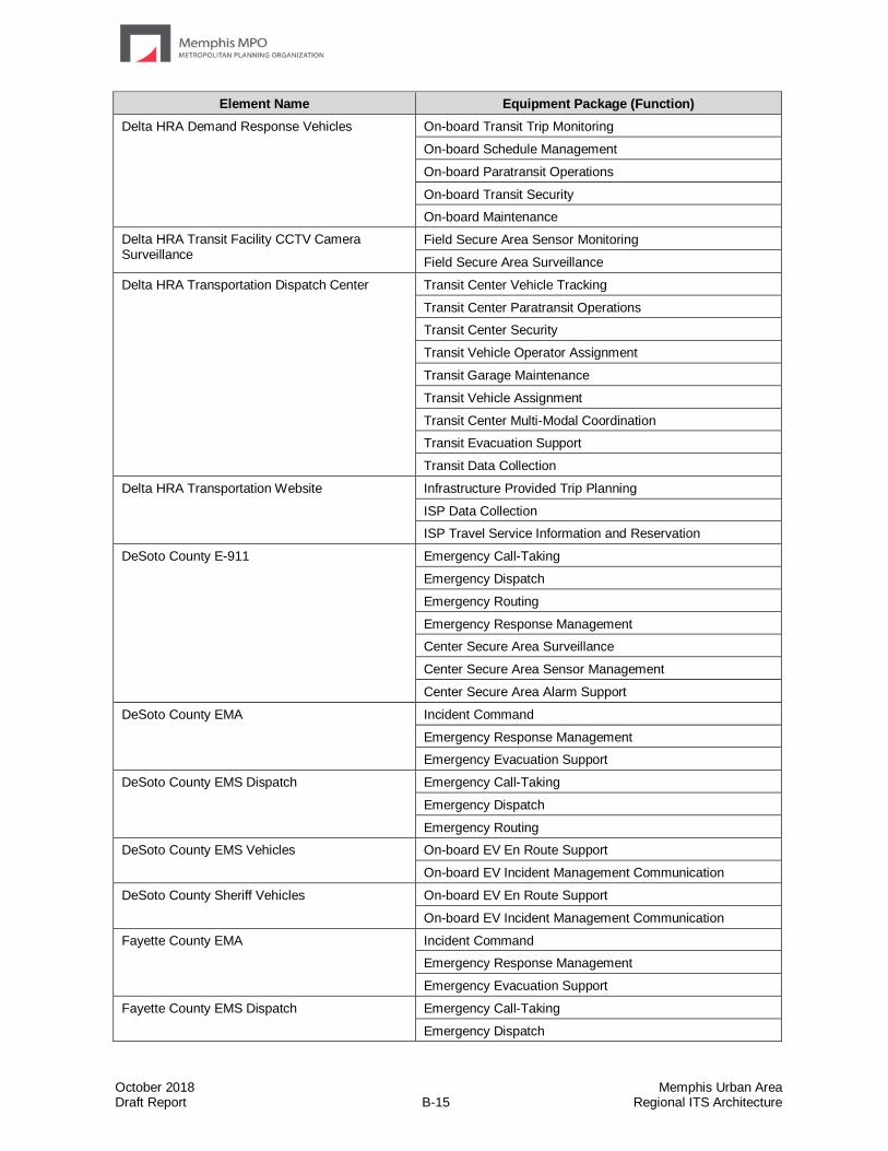
October 2018 Memphis Urban Area Draft Report B-15 Regional ITS Architecture
Element Name Equipment Package (Function)
Delta HRA Demand Response Vehicles On-board Transit Trip Monitoring
On-board Schedule Management
On-board Paratransit Operations
On-board Transit Security
On-board Maintenance
Delta HRA Transit Facility CCTV Camera Surveillance
Field Secure Area Sensor Monitoring
Field Secure Area Surveillance
Delta HRA Transportation Dispatch Center Transit Center Vehicle Tracking
Transit Center Paratransit Operations
Transit Center Security
Transit Vehicle Operator Assignment
Transit Garage Maintenance
Transit Vehicle Assignment
Transit Center Multi-Modal Coordination
Transit Evacuation Support
Transit Data Collection
Delta HRA Transportation Website Infrastructure Provided Trip Planning
ISP Data Collection
ISP Travel Service Information and Reservation
DeSoto County E-911 Emergency Call-Taking
Emergency Dispatch
Emergency Routing
Emergency Response Management
Center Secure Area Surveillance
Center Secure Area Sensor Management
Center Secure Area Alarm Support
DeSoto County EMA Incident Command
Emergency Response Management
Emergency Evacuation Support
DeSoto County EMS Dispatch Emergency Call-Taking
Emergency Dispatch
Emergency Routing
DeSoto County EMS Vehicles On-board EV En Route Support
On-board EV Incident Management Communication
DeSoto County Sheriff Vehicles On-board EV En Route Support
On-board EV Incident Management Communication
Fayette County EMA Incident Command
Emergency Response Management
Emergency Evacuation Support
Fayette County EMS Dispatch Emergency Call-Taking
Emergency Dispatch

October 2018 Memphis Urban Area Draft Report B-16 Regional ITS Architecture
Element Name Equipment Package (Function)
Fayette County EMS Vehicles On-board EV En Route Support
On-board EV Incident Management Communication
Fayette County Sheriff Emergency Call-Taking
Emergency Dispatch
Emergency Routing
Incident Command
Emergency Response Management
Emergency Evacuation Support
Center Secure Area Surveillance
Center Secure Area Sensor Management
Center Secure Area Alarm Support
Fayette County Sheriff Vehicles On-board EV En Route Support
On-board EV Incident Management Communication
Financial Service Provider PAC Payment Adminstration
Greater Memphis Regional Express Bus Dispatch Center
Transit Center Vehicle Tracking
Transit Center Fixed-Route Operations
Transit Center Multi-Modal Coordination
Greater Memphis Regional Express Bus System Website
Infrastructure Provided Trip Planning
ISP Traveler Data Collection
MATA Bus Arrival Status Boards Remote Transit Information Services
MATA Data Archive ITS Data Repository
Traffic and Roadside Data Archival
Government Reporting Systems Support
Virtual Data Warehouse Services
MATA Dispatch Center Transit Center Vehicle Tracking
Transit Center Fixed-Route Operations
Transit Center Paratransit Operations
Transit Center Fare Management
Transit Center Passenger Counting
Transit Center Signal Priority
Transit Center Security
Transit Vehicle Operator Assignment
Transit Garage Maintenance
Transit Vehicle Assignment
Transit Center Information Services
Transit Environmental Monitoring
Transit Center Multi-Modal Coordination
Transit Evacuation Support
Transit Data Collection
Transit Transportation Operations Data Collection
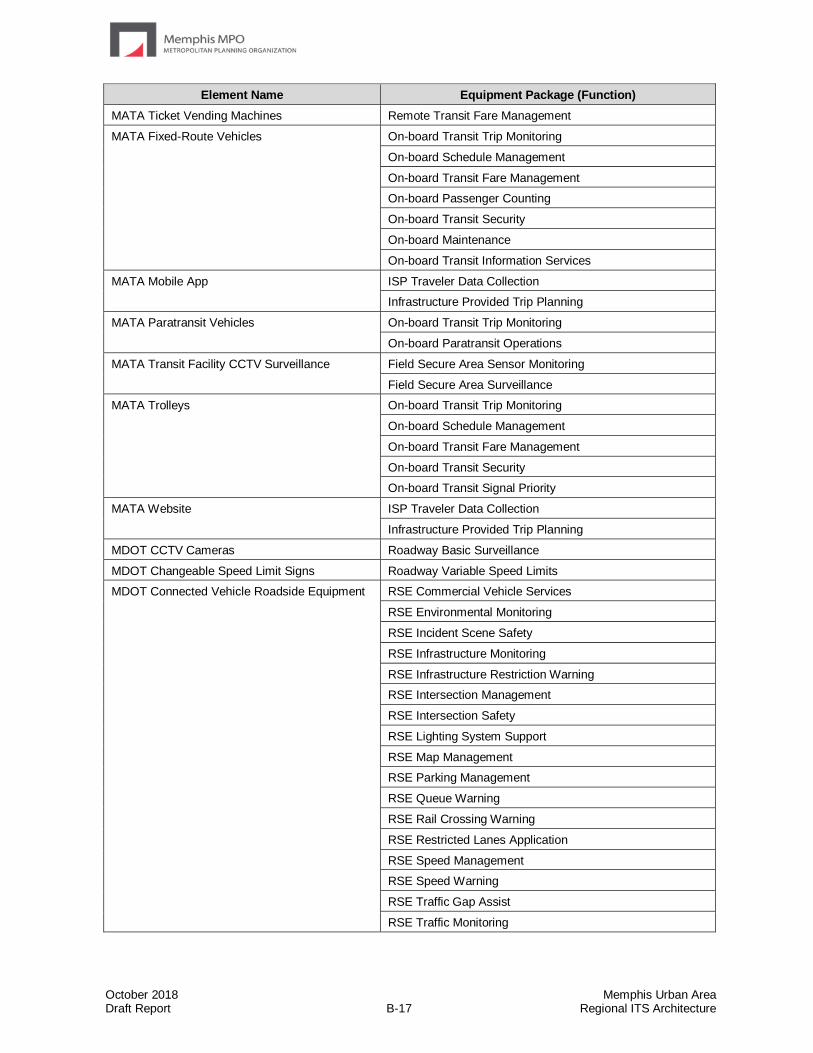
October 2018 Memphis Urban Area Draft Report B-17 Regional ITS Architecture
Element Name Equipment Package (Function)
MATA Ticket Vending Machines Remote Transit Fare Management
MATA Fixed-Route Vehicles On-board Transit Trip Monitoring
On-board Schedule Management
On-board Transit Fare Management
On-board Passenger Counting
On-board Transit Security
On-board Maintenance
On-board Transit Information Services
MATA Mobile App ISP Traveler Data Collection
Infrastructure Provided Trip Planning
MATA Paratransit Vehicles On-board Transit Trip Monitoring
On-board Paratransit Operations
MATA Transit Facility CCTV Surveillance Field Secure Area Sensor Monitoring
Field Secure Area Surveillance
MATA Trolleys On-board Transit Trip Monitoring
On-board Schedule Management
On-board Transit Fare Management
On-board Transit Security
On-board Transit Signal Priority
MATA Website ISP Traveler Data Collection
Infrastructure Provided Trip Planning
MDOT CCTV Cameras Roadway Basic Surveillance
MDOT Changeable Speed Limit Signs Roadway Variable Speed Limits
MDOT Connected Vehicle Roadside Equipment RSE Commercial Vehicle Services
RSE Environmental Monitoring
RSE Incident Scene Safety
RSE Infrastructure Monitoring
RSE Infrastructure Restriction Warning
RSE Intersection Management
RSE Intersection Safety
RSE Lighting System Support
RSE Map Management
RSE Parking Management
RSE Queue Warning
RSE Rail Crossing Warning
RSE Restricted Lanes Application
RSE Speed Management
RSE Speed Warning
RSE Traffic Gap Assist
RSE Traffic Monitoring
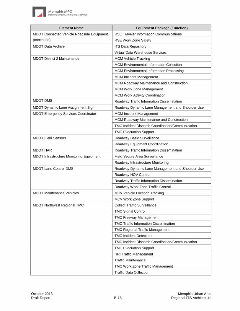
October 2018 Memphis Urban Area Draft Report B-18 Regional ITS Architecture
Element Name Equipment Package (Function)
MDOT Connected Vehicle Roadside Equipment
(continued)
RSE Traveler Information Communications
RSE Work Zone Safety
MDOT Data Archive ITS Data Repository
Virtual Data Warehouse Services
MDOT District 2 Maintenance MCM Vehicle Tracking
MCM Environmental Information Collection
MCM Environmental Information Processing
MCM Incident Management
MCM Roadway Maintenance and Construction
MCM Work Zone Management
MCM Work Activity Coordination
MDOT DMS Roadway Traffic Information Dissemination
MDOT Dynamic Lane Assignment Sign Roadway Dynamic Lane Management and Shoulder Use
MDOT Emergency Services Coordinator MCM Incident Management
MCM Roadway Maintenance and Construction
TMC Incident Dispatch Coordination/Communication
TMC Evacuation Support
MDOT Field Sensors Roadway Basic Surveillance
Roadway Equipment Coordination
MDOT HAR Roadway Traffic Information Dissemination
MDOT Infrastructure Monitoring Equipment Field Secure Area Surveillance
Roadway Infrastructure Monitoring
MDOT Lane Control DMS Roadway Dynamic Lane Management and Shoulder Use
Roadway HOV Control
Roadway Traffic Information Dissemination
Roadway Work Zone Traffic Control
MDOT Maintenance Vehicles MCV Vehicle Location Tracking
MCV Work Zone Support
MDOT Northwest Regional TMC Collect Traffic Surveillance
TMC Signal Control
TMC Freeway Management
TMC Traffic Information Dissemination
TMC Regional Traffic Management
TMC Incident Detection
TMC Incident Dispatch Coordination/Communication
TMC Evacuation Support
HRI Traffic Management
Traffic Maintenance
TMC Work Zone Traffic Management
Traffic Data Collection
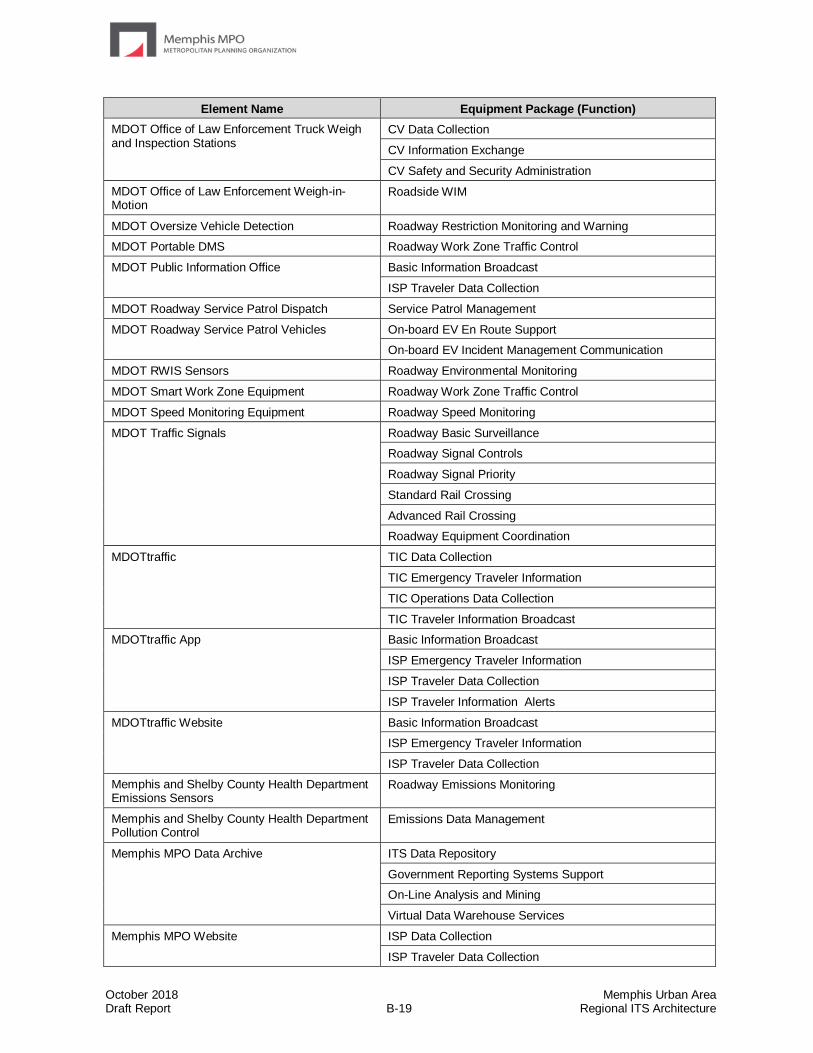
October 2018 Memphis Urban Area Draft Report B-19 Regional ITS Architecture
Element Name Equipment Package (Function)
MDOT Office of Law Enforcement Truck Weigh and Inspection Stations
CV Data Collection
CV Information Exchange
CV Safety and Security Administration
MDOT Office of Law Enforcement Weigh-in-Motion
Roadside WIM
MDOT Oversize Vehicle Detection Roadway Restriction Monitoring and Warning
MDOT Portable DMS Roadway Work Zone Traffic Control
MDOT Public Information Office Basic Information Broadcast
ISP Traveler Data Collection
MDOT Roadway Service Patrol Dispatch Service Patrol Management
MDOT Roadway Service Patrol Vehicles On-board EV En Route Support
On-board EV Incident Management Communication
MDOT RWIS Sensors Roadway Environmental Monitoring
MDOT Smart Work Zone Equipment Roadway Work Zone Traffic Control
MDOT Speed Monitoring Equipment Roadway Speed Monitoring
MDOT Traffic Signals Roadway Basic Surveillance
Roadway Signal Controls
Roadway Signal Priority
Standard Rail Crossing
Advanced Rail Crossing
Roadway Equipment Coordination
MDOTtraffic TIC Data Collection
TIC Emergency Traveler Information
TIC Operations Data Collection
TIC Traveler Information Broadcast
MDOTtraffic App Basic Information Broadcast
ISP Emergency Traveler Information
ISP Traveler Data Collection
ISP Traveler Information Alerts
MDOTtraffic Website Basic Information Broadcast
ISP Emergency Traveler Information
ISP Traveler Data Collection
Memphis and Shelby County Health Department Emissions Sensors
Roadway Emissions Monitoring
Memphis and Shelby County Health Department Pollution Control
Emissions Data Management
Memphis MPO Data Archive ITS Data Repository
Government Reporting Systems Support
On-Line Analysis and Mining
Virtual Data Warehouse Services
Memphis MPO Website ISP Data Collection
ISP Traveler Data Collection
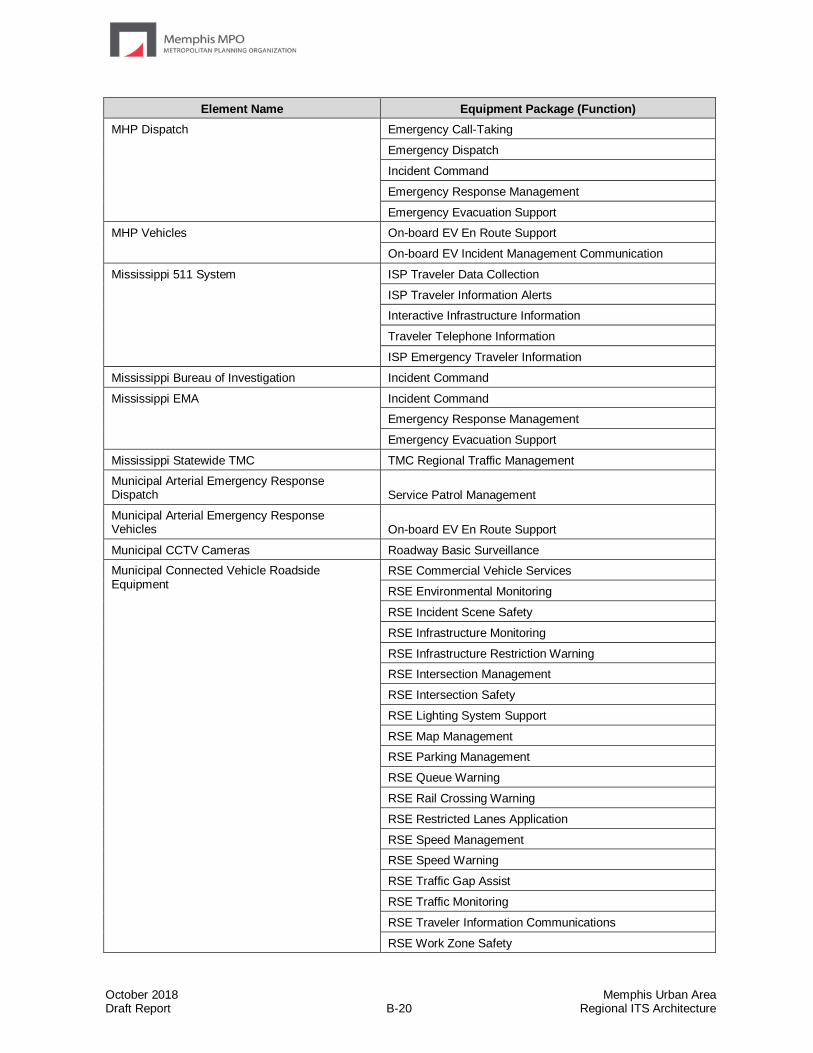
October 2018 Memphis Urban Area Draft Report B-20 Regional ITS Architecture
Element Name Equipment Package (Function)
MHP Dispatch Emergency Call-Taking
Emergency Dispatch
Incident Command
Emergency Response Management
Emergency Evacuation Support
MHP Vehicles On-board EV En Route Support
On-board EV Incident Management Communication
Mississippi 511 System ISP Traveler Data Collection
ISP Traveler Information Alerts
Interactive Infrastructure Information
Traveler Telephone Information
ISP Emergency Traveler Information
Mississippi Bureau of Investigation Incident Command
Mississippi EMA Incident Command
Emergency Response Management
Emergency Evacuation Support
Mississippi Statewide TMC TMC Regional Traffic Management
Municipal Arterial Emergency Response Dispatch Service Patrol Management
Municipal Arterial Emergency Response Vehicles On-board EV En Route Support
Municipal CCTV Cameras Roadway Basic Surveillance
Municipal Connected Vehicle Roadside Equipment
RSE Commercial Vehicle Services
RSE Environmental Monitoring
RSE Incident Scene Safety
RSE Infrastructure Monitoring
RSE Infrastructure Restriction Warning
RSE Intersection Management
RSE Intersection Safety
RSE Lighting System Support
RSE Map Management
RSE Parking Management
RSE Queue Warning
RSE Rail Crossing Warning
RSE Restricted Lanes Application
RSE Speed Management
RSE Speed Warning
RSE Traffic Gap Assist
RSE Traffic Monitoring
RSE Traveler Information Communications
RSE Work Zone Safety
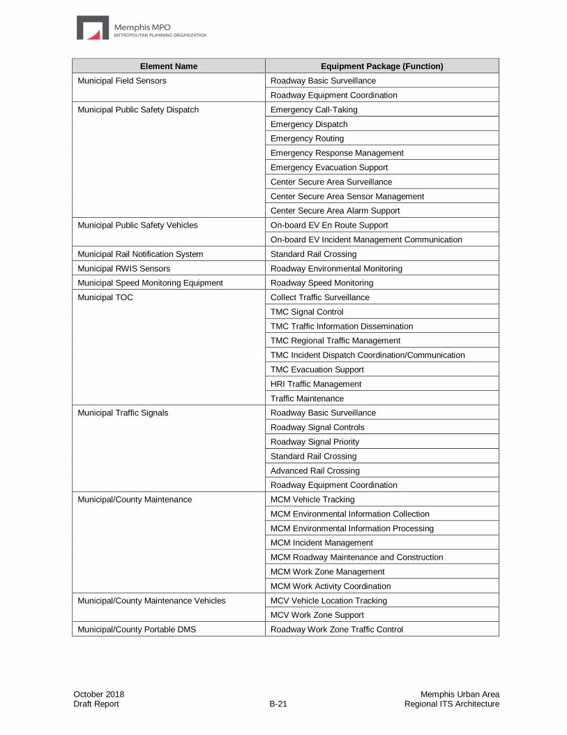
October 2018 Memphis Urban Area Draft Report B-21 Regional ITS Architecture
Element Name Equipment Package (Function)
Municipal Field Sensors Roadway Basic Surveillance
Roadway Equipment Coordination
Municipal Public Safety Dispatch Emergency Call-Taking
Emergency Dispatch
Emergency Routing
Emergency Response Management
Emergency Evacuation Support
Center Secure Area Surveillance
Center Secure Area Sensor Management
Center Secure Area Alarm Support
Municipal Public Safety Vehicles On-board EV En Route Support
On-board EV Incident Management Communication
Municipal Rail Notification System Standard Rail Crossing
Municipal RWIS Sensors Roadway Environmental Monitoring
Municipal Speed Monitoring Equipment Roadway Speed Monitoring
Municipal TOC Collect Traffic Surveillance
TMC Signal Control
TMC Traffic Information Dissemination
TMC Regional Traffic Management
TMC Incident Dispatch Coordination/Communication
TMC Evacuation Support
HRI Traffic Management
Traffic Maintenance
Municipal Traffic Signals Roadway Basic Surveillance
Roadway Signal Controls
Roadway Signal Priority
Standard Rail Crossing
Advanced Rail Crossing
Roadway Equipment Coordination
Municipal/County Maintenance MCM Vehicle Tracking
MCM Environmental Information Collection
MCM Environmental Information Processing
MCM Incident Management
MCM Roadway Maintenance and Construction
MCM Work Zone Management
MCM Work Activity Coordination
Municipal/County Maintenance Vehicles MCV Vehicle Location Tracking
MCV Work Zone Support
Municipal/County Portable DMS Roadway Work Zone Traffic Control
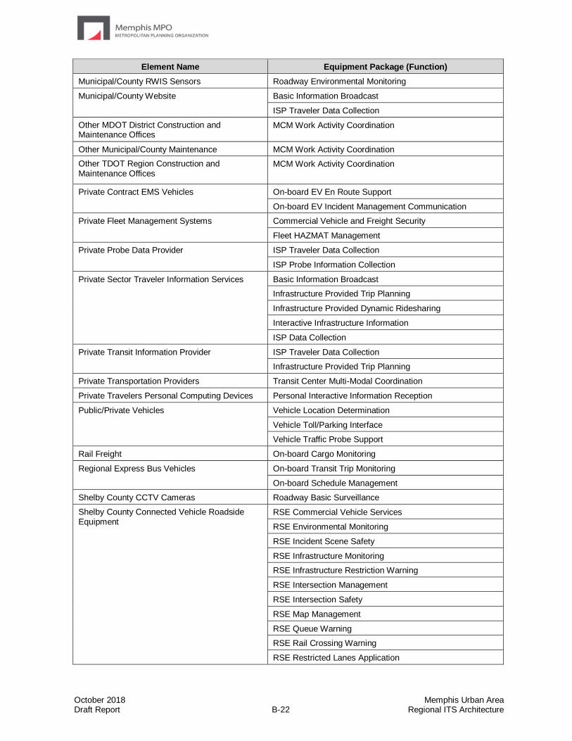
October 2018 Memphis Urban Area Draft Report B-22 Regional ITS Architecture
Element Name Equipment Package (Function)
Municipal/County RWIS Sensors Roadway Environmental Monitoring
Municipal/County Website Basic Information Broadcast
ISP Traveler Data Collection
Other MDOT District Construction and Maintenance Offices
MCM Work Activity Coordination
Other Municipal/County Maintenance MCM Work Activity Coordination
Other TDOT Region Construction and Maintenance Offices
MCM Work Activity Coordination
Private Contract EMS Vehicles On-board EV En Route Support
On-board EV Incident Management Communication
Private Fleet Management Systems Commercial Vehicle and Freight Security
Fleet HAZMAT Management
Private Probe Data Provider ISP Traveler Data Collection
ISP Probe Information Collection
Private Sector Traveler Information Services Basic Information Broadcast
Infrastructure Provided Trip Planning
Infrastructure Provided Dynamic Ridesharing
Interactive Infrastructure Information
ISP Data Collection
Private Transit Information Provider ISP Traveler Data Collection
Infrastructure Provided Trip Planning
Private Transportation Providers Transit Center Multi-Modal Coordination
Private Travelers Personal Computing Devices Personal Interactive Information Reception
Public/Private Vehicles Vehicle Location Determination
Vehicle Toll/Parking Interface
Vehicle Traffic Probe Support
Rail Freight On-board Cargo Monitoring
Regional Express Bus Vehicles On-board Transit Trip Monitoring
On-board Schedule Management
Shelby County CCTV Cameras Roadway Basic Surveillance
Shelby County Connected Vehicle Roadside Equipment
RSE Commercial Vehicle Services
RSE Environmental Monitoring
RSE Incident Scene Safety
RSE Infrastructure Monitoring
RSE Infrastructure Restriction Warning
RSE Intersection Management
RSE Intersection Safety
RSE Map Management
RSE Queue Warning
RSE Rail Crossing Warning
RSE Restricted Lanes Application
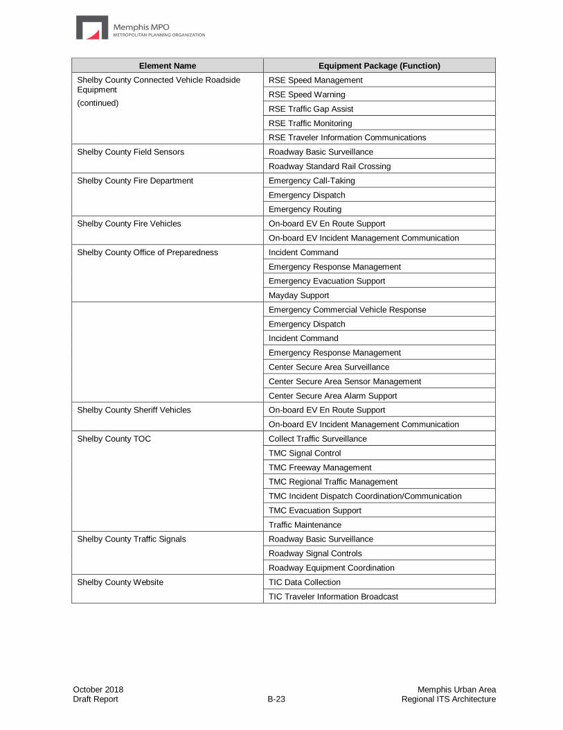
October 2018 Memphis Urban Area Draft Report B-23 Regional ITS Architecture
Element Name Equipment Package (Function)
Shelby County Connected Vehicle Roadside Equipment
(continued)
RSE Speed Management
RSE Speed Warning
RSE Traffic Gap Assist
RSE Traffic Monitoring
RSE Traveler Information Communications
Shelby County Field Sensors Roadway Basic Surveillance
Roadway Standard Rail Crossing
Shelby County Fire Department Emergency Call-Taking
Emergency Dispatch
Emergency Routing
Shelby County Fire Vehicles On-board EV En Route Support
On-board EV Incident Management Communication
Shelby County Office of Preparedness Incident Command
Emergency Response Management
Emergency Evacuation Support
Mayday Support
Emergency Commercial Vehicle Response
Emergency Dispatch
Incident Command
Emergency Response Management
Center Secure Area Surveillance
Center Secure Area Sensor Management
Center Secure Area Alarm Support
Shelby County Sheriff Vehicles On-board EV En Route Support
On-board EV Incident Management Communication
Shelby County TOC Collect Traffic Surveillance
TMC Signal Control
TMC Freeway Management
TMC Regional Traffic Management
TMC Incident Dispatch Coordination/Communication
TMC Evacuation Support
Traffic Maintenance
Shelby County Traffic Signals Roadway Basic Surveillance
Roadway Signal Controls
Roadway Equipment Coordination
Shelby County Website TIC Data Collection
TIC Traveler Information Broadcast
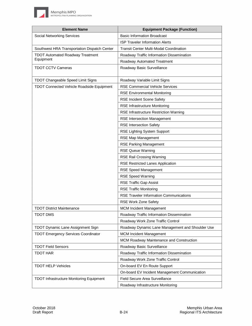
October 2018 Memphis Urban Area Draft Report B-24 Regional ITS Architecture
Element Name Equipment Package (Function)
Social Networking Services Basic Information Broadcast
ISP Traveler Information Alerts
Southwest HRA Transportation Dispatch Center Transit Center Multi-Modal Coordination
TDOT Automated Roadway Treatment Equipment
Roadway Traffic Information Dissemination
Roadway Automated Treatment
TDOT CCTV Cameras Roadway Basic Surveillance
TDOT Changeable Speed Limit Signs Roadway Variable Limit Signs
TDOT Connected Vehicle Roadside Equipment RSE Commercial Vehicle Services
RSE Environmental Monitoring
RSE Incident Scene Safety
RSE Infrastructure Monitoring
RSE Infrastructure Restriction Warning
RSE Intersection Management
RSE Intersection Safety
RSE Lighting System Support
RSE Map Management
RSE Parking Management
RSE Queue Warning
RSE Rail Crossing Warning
RSE Restricted Lanes Application
RSE Speed Management
RSE Speed Warning
RSE Traffic Gap Assist
RSE Traffic Monitoring
RSE Traveler Information Communications
RSE Work Zone Safety
TDOT District Maintenance MCM Incident Management
TDOT DMS Roadway Traffic Information Dissemination
Roadway Work Zone Traffic Control
TDOT Dynamic Lane Assignment Sign Roadway Dynamic Lane Management and Shoulder Use
TDOT Emergency Services Coordinator MCM Incident Management
MCM Roadway Maintenance and Construction
TDOT Field Sensors Roadway Basic Surveillance
TDOT HAR Roadway Traffic Information Dissemination
Roadway Work Zone Traffic Control
TDOT HELP Vehicles On-board EV En Route Support
On-board EV Incident Management Communication
TDOT Infrastructure Monitoring Equipment
Field Secure Area Surveillance
Roadway Infrastructure Monitoring
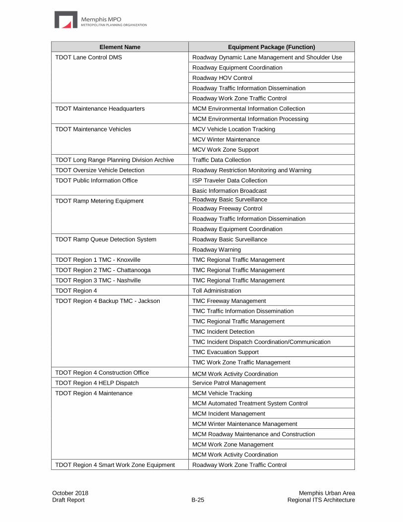
October 2018 Memphis Urban Area Draft Report B-25 Regional ITS Architecture
Element Name Equipment Package (Function)
TDOT Lane Control DMS Roadway Dynamic Lane Management and Shoulder Use
Roadway Equipment Coordination
Roadway HOV Control
Roadway Traffic Information Dissemination
Roadway Work Zone Traffic Control
TDOT Maintenance Headquarters MCM Environmental Information Collection
MCM Environmental Information Processing
TDOT Maintenance Vehicles MCV Vehicle Location Tracking
MCV Winter Maintenance
MCV Work Zone Support
TDOT Long Range Planning Division Archive Traffic Data Collection
TDOT Oversize Vehicle Detection Roadway Restriction Monitoring and Warning
TDOT Public Information Office ISP Traveler Data Collection
Basic Information Broadcast
TDOT Ramp Metering Equipment Roadway Basic Surveillance
Roadway Freeway Control
Roadway Traffic Information Dissemination
Roadway Equipment Coordination
TDOT Ramp Queue Detection System Roadway Basic Surveillance
Roadway Warning
TDOT Region 1 TMC - Knoxville TMC Regional Traffic Management
TDOT Region 2 TMC - Chattanooga TMC Regional Traffic Management
TDOT Region 3 TMC - Nashville TMC Regional Traffic Management
TDOT Region 4 Toll Administration
TDOT Region 4 Backup TMC - Jackson TMC Freeway Management
TMC Traffic Information Dissemination
TMC Regional Traffic Management
TMC Incident Detection
TMC Incident Dispatch Coordination/Communication
TMC Evacuation Support
TMC Work Zone Traffic Management
TDOT Region 4 Construction Office MCM Work Activity Coordination
TDOT Region 4 HELP Dispatch Service Patrol Management
TDOT Region 4 Maintenance MCM Vehicle Tracking
MCM Automated Treatment System Control
MCM Incident Management
MCM Winter Maintenance Management
MCM Roadway Maintenance and Construction
MCM Work Zone Management
MCM Work Activity Coordination
TDOT Region 4 Smart Work Zone Equipment Roadway Work Zone Traffic Control

October 2018 Memphis Urban Area Draft Report B-26 Regional ITS Architecture
Element Name Equipment Package (Function)
TDOT Region 4 TMC - Memphis MCM Environmental Information Processing
MCM Data Collection
Collect Traffic Surveillance
TMC Probe Information Collection
TMC Freeway Management
TMC Traffic Information Dissemination
TMC Regional Traffic Management
TMC Incident Detection
TMC Incident Dispatch Coordination/Communication
TMC Evacuation Support
Traffic Maintenance
TMC Work Zone Traffic Management
Traffic Data Collection
TDOT RWIS Sensors Roadway Environmental Monitoring
TDOT Statewide Information for Travelers (SWIFT)
ISP Traveler Data Collection
Basic Information Broadcast
ISP Emergency Traveler Information
ISP Data Collection
MCM Environmental Information Processing
MCM Incident Management
MCM Work Zone Management
MCM Work Activity Coordination
MCM Data Collection
TDOT SmartWay Mobile App ISP Traveler Data Collection
Basic Information Broadcast
ISP Emergency Traveler Information
ISP Traveler Information Alerts
TDOT SmartWay Website ISP Traveler Data Collection
Basic Information Broadcast
ISP Emergency Traveler Information
TDOT Speed Monitoring Equipment Roadway Speed Monitoring and Warning
TDOT Toll Plazas Toll Plaza Toll Collection
Tennessee 511 System ISP Traveler Data Collection
ISP Traveler Information Alerts
Interactive Infrastructure Information
Traveler Telephone Information
ISP Emergency Traveler Information
Tennessee Bureau of Investigation Incident Command
Tennessee EMA Incident Command
Emergency Response Management
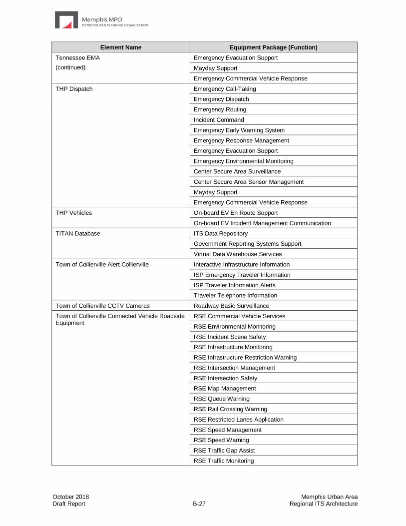
October 2018 Memphis Urban Area Draft Report B-27 Regional ITS Architecture
Element Name Equipment Package (Function)
Tennessee EMA
(continued)
Emergency Evacuation Support
Mayday Support
Emergency Commercial Vehicle Response
THP Dispatch Emergency Call-Taking
Emergency Dispatch
Emergency Routing
Incident Command
Emergency Early Warning System
Emergency Response Management
Emergency Evacuation Support
Emergency Environmental Monitoring
Center Secure Area Surveillance
Center Secure Area Sensor Management
Mayday Support
Emergency Commercial Vehicle Response
THP Vehicles On-board EV En Route Support
On-board EV Incident Management Communication
TITAN Database ITS Data Repository
Government Reporting Systems Support
Virtual Data Warehouse Services
Town of Collierville Alert Collierville Interactive Infrastructure Information
ISP Emergency Traveler Information
ISP Traveler Information Alerts
Traveler Telephone Information
Town of Collierville CCTV Cameras Roadway Basic Surveillance
Town of Collierville Connected Vehicle Roadside Equipment
RSE Commercial Vehicle Services
RSE Environmental Monitoring
RSE Incident Scene Safety
RSE Infrastructure Monitoring
RSE Infrastructure Restriction Warning
RSE Intersection Management
RSE Intersection Safety
RSE Map Management
RSE Queue Warning
RSE Rail Crossing Warning
RSE Restricted Lanes Application
RSE Speed Management
RSE Speed Warning
RSE Traffic Gap Assist
RSE Traffic Monitoring
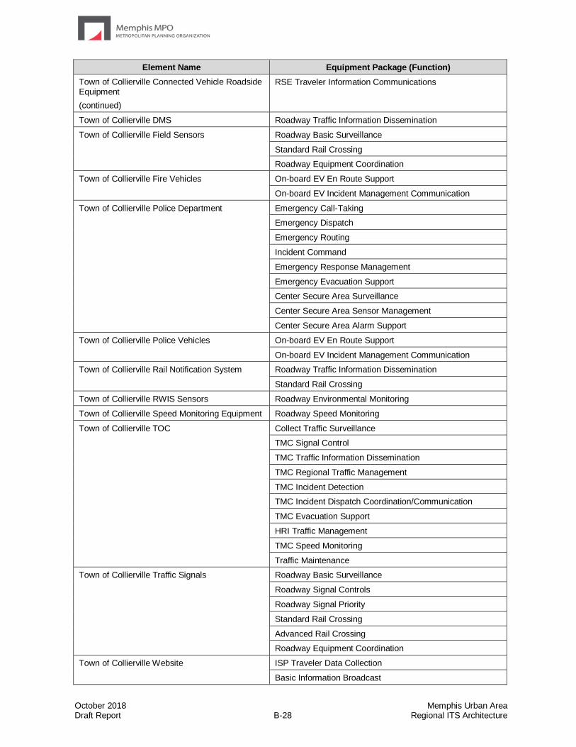
October 2018 Memphis Urban Area Draft Report B-28 Regional ITS Architecture
Element Name Equipment Package (Function)
Town of Collierville Connected Vehicle Roadside Equipment
(continued)
RSE Traveler Information Communications
Town of Collierville DMS Roadway Traffic Information Dissemination
Town of Collierville Field Sensors Roadway Basic Surveillance
Standard Rail Crossing
Roadway Equipment Coordination
Town of Collierville Fire Vehicles
On-board EV En Route Support
On-board EV Incident Management Communication
Town of Collierville Police Department Emergency Call-Taking
Emergency Dispatch
Emergency Routing
Incident Command
Emergency Response Management
Emergency Evacuation Support
Center Secure Area Surveillance
Center Secure Area Sensor Management
Center Secure Area Alarm Support
Town of Collierville Police Vehicles On-board EV En Route Support
On-board EV Incident Management Communication
Town of Collierville Rail Notification System Roadway Traffic Information Dissemination
Standard Rail Crossing
Town of Collierville RWIS Sensors Roadway Environmental Monitoring
Town of Collierville Speed Monitoring Equipment Roadway Speed Monitoring
Town of Collierville TOC Collect Traffic Surveillance
TMC Signal Control
TMC Traffic Information Dissemination
TMC Regional Traffic Management
TMC Incident Detection
TMC Incident Dispatch Coordination/Communication
TMC Evacuation Support
HRI Traffic Management
TMC Speed Monitoring
Traffic Maintenance
Town of Collierville Traffic Signals Roadway Basic Surveillance
Roadway Signal Controls
Roadway Signal Priority
Standard Rail Crossing
Advanced Rail Crossing
Roadway Equipment Coordination
Town of Collierville Website
ISP Traveler Data Collection
Basic Information Broadcast

October 2018 Memphis Urban Area Draft Report B-29 Regional ITS Architecture
Element Name Equipment Package (Function)
West Memphis MPO Data Archive ITS Data Repository
Government Reporting Systems Support
On-Line Analysis and Mining
Virtual Data Warehouse Services

October 2018 Memphis Urban Area Draft Report Regional ITS Architecture
Appendix C – Stakeholder Invitation Database

October 2018 Memphis Urban Area Draft Report C-1 Regional ITS Architecture
Stakeholder Agency Address Contact
Arkansas Department of Transportation 10324 Interstate 30
Little Rock, AR 72209 Alfaraj Hussain
Arkansas Department of Transportation 10324 Interstate 30
Little Rock, AR 72209 Jacob Giffin
Arkansas Department of Transportation 10324 Interstate 30
Little Rock, AR 72209 Joseph Hawkins
Arkansas Department of Transportation 10324 Interstate 30
Little Rock, AR 72209 Dorothy Rhodes
Arkansas Department of Transportation 10324 Interstate 30
Little Rock, AR 72209 Rex Vines
City of Bartlett 6382 Stage Road
Bartlett, TN 38134 Becky Bailey
City of Bartlett 6382 Stage Road
Bartlett, TN 38134 Bill Yearwood
City of Bartlett Engineering Department 6382 Stage Road
Bartlett, TN 38134 Rick McClanahan
City of Gallaway 607 Watson Drive Gallaway, TN 38036 Pat Brown
City of Germantown 1930 Germantown Road South
Germantown, TN 38138 Jeff Beaman
City of Germantown 1930 Germantown Road South
Germantown, TN 38138 Tim Gwaltney
City of Germantown 1930 Germantown Road South Germantown, TN 38138
Tony Ladd
City of Hernando 475 West Commerce Street Hernando, MS 38632
Tom Ferguson
City of Horn Lake 3101 Goodman Rd A
Horn Lake, MS 38637 Willie Davidson
City of Horn Lake 3101 Goodman Rd A
Horn Lake, MS 38637 Spencer Shields
City of Marion 31 Military Road
Marion, AR 72364 Edward Cain
City of Memphis 125 North Main Street - Suite 668
Memphis, TN 38103 Randall Tatum
City of Memphis 65 South Front Street Memphis, TN 38103
Manny Belen
City of Memphis Fire Services 1017 Jefferson Avenue
Memphis, TN 38104 Daryl Payton
City of Memphis Fire Services 1017 Jefferson Avenue
Memphis, TN 38104 Gina Sweat
City of Memphis Police Department 170 N Main Street
Memphis, TN 38103 Don Crowe
City of Memphis Police Department 170 N Main Street
Memphis, TN 38103 Michael Rallings
City of Millington 7930 Nelson Street
Millington, TN 38053 Jason Dixon
City of Olive Branch 9200 Pigeon Roost Road
Olive Branch, MS 38654 Steve Bigelow
City of Olive Branch 9200 Pigeon Roost Road
Olive Branch, MS 38654 BJ Page
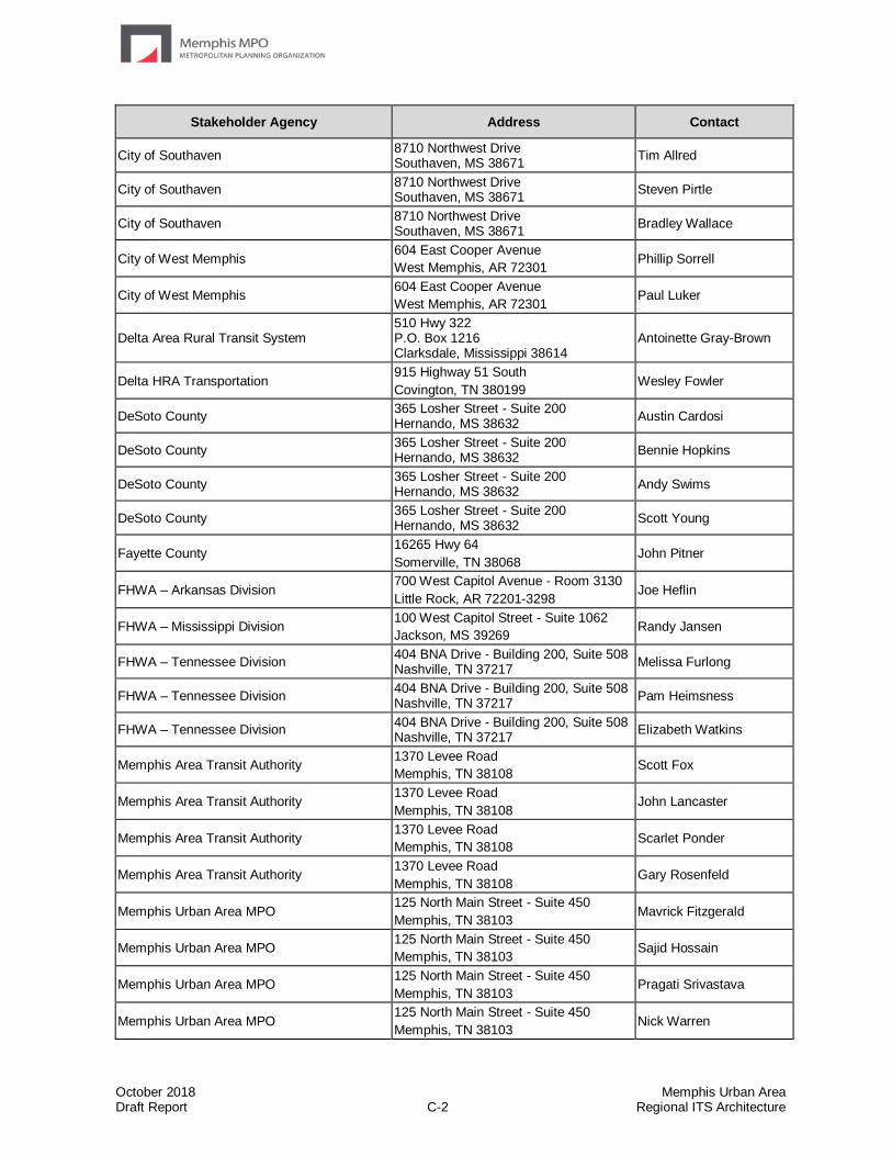
October 2018 Memphis Urban Area Draft Report C-2 Regional ITS Architecture
Stakeholder Agency Address Contact
City of Southaven 8710 Northwest Drive Southaven, MS 38671
Tim Allred
City of Southaven 8710 Northwest Drive Southaven, MS 38671
Steven Pirtle
City of Southaven 8710 Northwest Drive Southaven, MS 38671
Bradley Wallace
City of West Memphis 604 East Cooper Avenue
West Memphis, AR 72301 Phillip Sorrell
City of West Memphis 604 East Cooper Avenue
West Memphis, AR 72301 Paul Luker
Delta Area Rural Transit System 510 Hwy 322 P.O. Box 1216 Clarksdale, Mississippi 38614
Antoinette Gray-Brown
Delta HRA Transportation 915 Highway 51 South
Covington, TN 380199 Wesley Fowler
DeSoto County 365 Losher Street - Suite 200 Hernando, MS 38632
Austin Cardosi
DeSoto County 365 Losher Street - Suite 200 Hernando, MS 38632
Bennie Hopkins
DeSoto County 365 Losher Street - Suite 200 Hernando, MS 38632
Andy Swims
DeSoto County 365 Losher Street - Suite 200 Hernando, MS 38632
Scott Young
Fayette County 16265 Hwy 64
Somerville, TN 38068 John Pitner
FHWA – Arkansas Division 700 West Capitol Avenue - Room 3130
Little Rock, AR 72201-3298 Joe Heflin
FHWA – Mississippi Division 100 West Capitol Street - Suite 1062
Jackson, MS 39269 Randy Jansen
FHWA – Tennessee Division 404 BNA Drive - Building 200, Suite 508 Nashville, TN 37217
Melissa Furlong
FHWA – Tennessee Division 404 BNA Drive - Building 200, Suite 508 Nashville, TN 37217
Pam Heimsness
FHWA – Tennessee Division 404 BNA Drive - Building 200, Suite 508 Nashville, TN 37217
Elizabeth Watkins
Memphis Area Transit Authority 1370 Levee Road
Memphis, TN 38108 Scott Fox
Memphis Area Transit Authority 1370 Levee Road
Memphis, TN 38108 John Lancaster
Memphis Area Transit Authority 1370 Levee Road
Memphis, TN 38108 Scarlet Ponder
Memphis Area Transit Authority 1370 Levee Road
Memphis, TN 38108 Gary Rosenfeld
Memphis Urban Area MPO 125 North Main Street - Suite 450
Memphis, TN 38103 Mavrick Fitzgerald
Memphis Urban Area MPO 125 North Main Street - Suite 450
Memphis, TN 38103 Sajid Hossain
Memphis Urban Area MPO 125 North Main Street - Suite 450
Memphis, TN 38103 Pragati Srivastava
Memphis Urban Area MPO 125 North Main Street - Suite 450
Memphis, TN 38103 Nick Warren

October 2018 Memphis Urban Area Draft Report C-3 Regional ITS Architecture
Stakeholder Agency Address Contact
Mississippi Department of Transportation 2567 N. West Street
Jackson, MS 39157 Perry Brown
Mississippi Department of Transportation 2567 N. West Street
Jackson, MS 39157 John Gilligan
Mississippi Department of Transportation 2567 N. West Street
Jackson, MS 39157 Lauren Landers
Mississippi Department of Transportation 2567 N. West Street
Jackson, MS 39157 Jamie Mote
Mississippi Department of Transportation 2567 N. West Street
Jackson, MS 39157 Celina Sumrall
Mississippi Department of Transportation 2567 N. West Street
Jackson, MS 39157 Jack Wimberly
North Delta Planning and Development
District
220 Power Drive Batesville, MS 38606
Trey Hamby
North Delta Planning and Development
District
220 Power Drive Batesville, MS 38606
Fadlalla Zein, Ph.D.
Shelby County 6463 Haley Road
Memphis, TN Alvin Benson
Shelby County 6463 Haley Road
Memphis, TN 38134 Jim Crook
Shelby County 6463 Haley Road
Memphis, TN 38134 John Modselewski
Shelby County 160 North Main Street - Suite 1127 Memphis, TN 38103
Tom Needham
Shelby County 6463 Haley Road
Memphis, TN 38134 Darren Sanders
Shelby County 6463 Haley Road
Memphis, TN 38134 Clay Stokes
Shelby County 6463 Haley Road
Memphis, TN 38134 Kevin Eason
Shelby County Office of Preparedness Building C, 1075 Mullins Station Road
Memphis, TN 38134 Mike Brazzell
Shelby County Office of Preparedness Building C, 1075 Mullins Station Road
Memphis, TN 38134 Bob Nations, Jr.
TDOT Long Range Planning Division 5334 Boswell Avenue
Memphis, TN 38120 Deborah Fleming
TDOT Office of Community Transportation – Region 4
5334 Boswell Avenue
Memphis, TN 38120 Calvin Abram
TDOT Office of Community Transportation – Region 4
5334 Boswell Avenue
Memphis, TN 38120 Antoine Hawkins
TDOT Office of Community Transportation – Region 4
5334 Boswell Avenue
Memphis, TN 38120 Jennifer Marshall
TDOT Region 4 5334 Boswell Avenue
Memphis, TN 38120 Jason Baker
TDOT Region 4 5334 Boswell Avenue
Memphis, TN 38120 Carl Berry
TDOT Region 4 5334 Boswell Avenue
Memphis, TN 38120 Jason Moody
TDOT Region 4 5334 Boswell Avenue
Memphis, TN 38120 Scott Pate
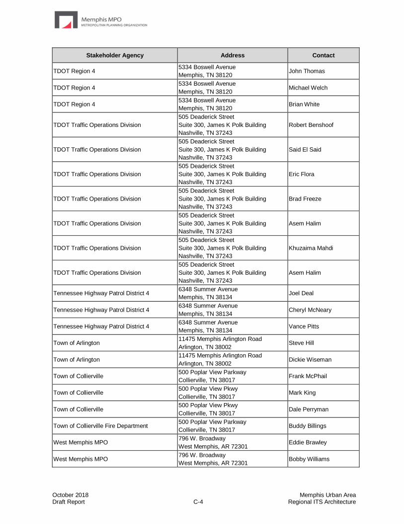
October 2018 Memphis Urban Area Draft Report C-4 Regional ITS Architecture
Stakeholder Agency Address Contact
TDOT Region 4 5334 Boswell Avenue
Memphis, TN 38120 John Thomas
TDOT Region 4 5334 Boswell Avenue
Memphis, TN 38120 Michael Welch
TDOT Region 4 5334 Boswell Avenue
Memphis, TN 38120 Brian White
TDOT Traffic Operations Division
505 Deaderick Street
Suite 300, James K Polk Building
Nashville, TN 37243
Robert Benshoof
TDOT Traffic Operations Division
505 Deaderick Street
Suite 300, James K Polk Building
Nashville, TN 37243
Said El Said
TDOT Traffic Operations Division
505 Deaderick Street
Suite 300, James K Polk Building
Nashville, TN 37243
Eric Flora
TDOT Traffic Operations Division
505 Deaderick Street
Suite 300, James K Polk Building
Nashville, TN 37243
Brad Freeze
TDOT Traffic Operations Division
505 Deaderick Street
Suite 300, James K Polk Building
Nashville, TN 37243
Asem Halim
TDOT Traffic Operations Division
505 Deaderick Street
Suite 300, James K Polk Building
Nashville, TN 37243
Khuzaima Mahdi
TDOT Traffic Operations Division
505 Deaderick Street
Suite 300, James K Polk Building
Nashville, TN 37243
Asem Halim
Tennessee Highway Patrol District 4 6348 Summer Avenue
Memphis, TN 38134 Joel Deal
Tennessee Highway Patrol District 4 6348 Summer Avenue
Memphis, TN 38134 Cheryl McNeary
Tennessee Highway Patrol District 4 6348 Summer Avenue
Memphis, TN 38134 Vance Pitts
Town of Arlington 11475 Memphis Arlington Road
Arlington, TN 38002 Steve Hill
Town of Arlington 11475 Memphis Arlington Road
Arlington, TN 38002 Dickie Wiseman
Town of Collierville 500 Poplar View Parkway
Collierville, TN 38017 Frank McPhail
Town of Collierville 500 Poplar View Pkwy
Collierville, TN 38017 Mark King
Town of Collierville 500 Poplar View Pkwy
Collierville, TN 38017 Dale Perryman
Town of Collierville Fire Department 500 Poplar View Parkway
Collierville, TN 38017 Buddy Billings
West Memphis MPO 796 W. Broadway
West Memphis, AR 72301 Eddie Brawley
West Memphis MPO 796 W. Broadway
West Memphis, AR 72301 Bobby Williams

October 2018 Memphis Urban Area Draft Report C-5 Regional ITS Architecture
Stakeholder Agency Address Contact
West Tennessee RPO 8289 Cordova Road – Suite 103
Cordova, TN 38016 Jasmine Champion

October 2018 Memphis Urban Area Draft Report Regional ITS Architecture
Appendix D – Agreements
Contents of Appendix D – Agreements
Memorandum of Understanding between the City of Memphis and the City of Germantown regarding traffic signal ITS coordination
Memorandum of Understanding between the Memphis Urban Area MPO and the West Memphis MPO for consistency and conformity of plans, programs and projects
Memorandum of Agreement between MDOT and the City of Southaven for locating their TMC within the Southaven Police Department and sharing of ITS resources
Agreement developed by TDOT for live CCTV video access for governmental agency users
Agreement developed by TDOT for live CCTV video access for private entity users

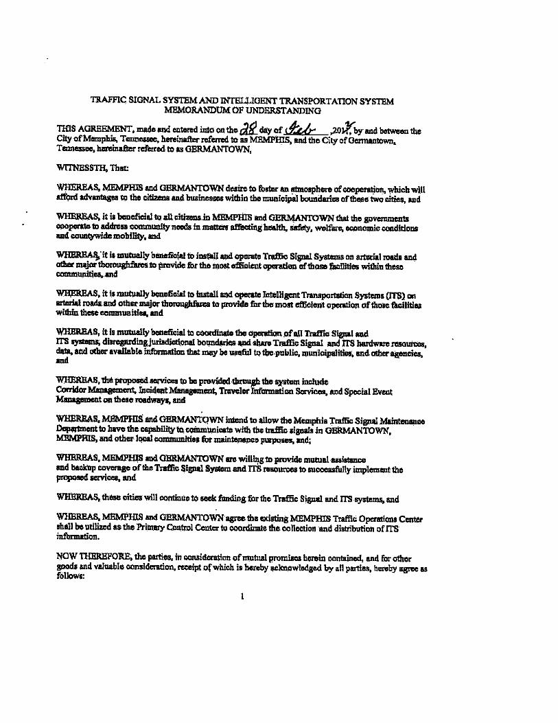
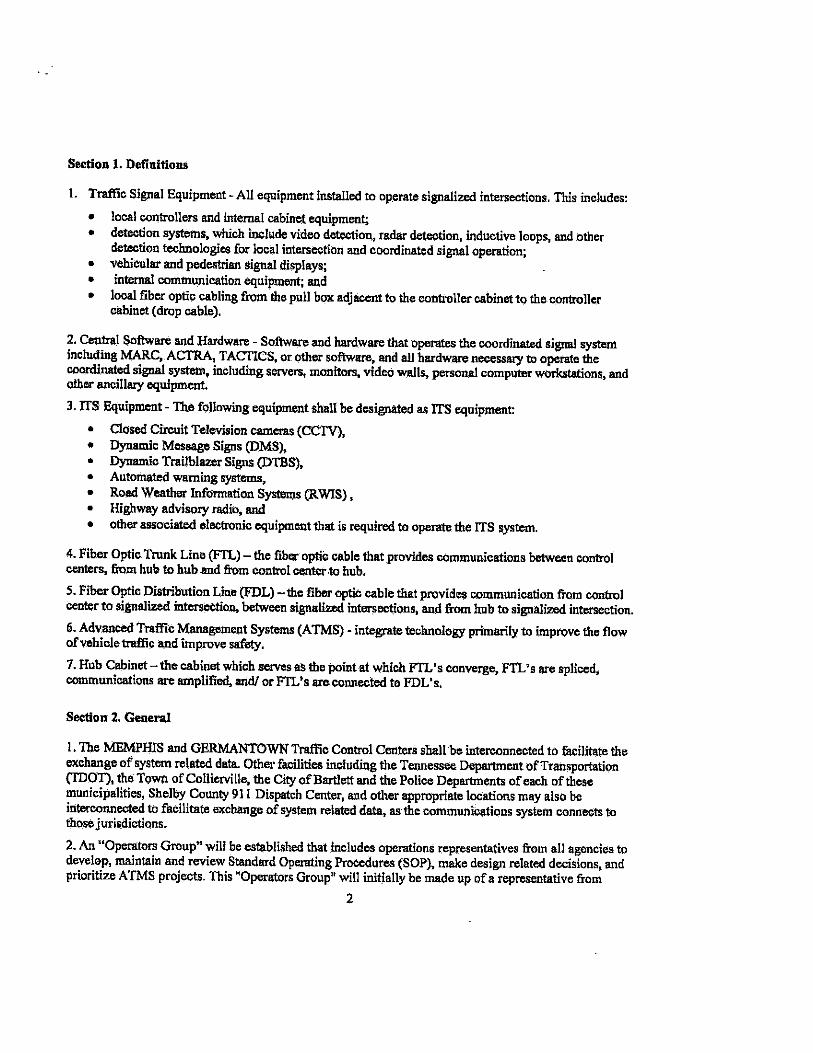


Tennessee Department of Transportation
TRAFFIC OPERATIONS PROGRAM POLICY Effective Date: Title: Access to Live Video
POLICY
The Tennessee Department of Transportation (TDOT) will make live video of traffic conditions from Closed Circuit Television (CCTV) available to the public. CCTV images will be supplied from the Chattanooga Regional Transportation Management Center (RTMC) at the site of the future TDOT Region 2 Complex. The video images provided will be those selected by the RTMC Operators from the images on the traffic surveillance monitors within the RTMC and that are consistent with the objectives of traffic management. Live video images will generally be made available upon request to other government and public agencies to better coordinate traffic management strategies on incidents and crashes, and to private news media and other companies for their use in providing traffic information to the public or their customers.
A non-exclusive access agreement is required in order for governmental and private interests to receive direct access to live video. Costs for the access connection will be determined by TDOT and paid for by the USER. BACKGROUND In order to gather real-time traffic condition information, TDOT has constructed and operates an RTMC at the site of the future Region 2 Complex on Volkswagen Drive. The RTMC is the central collection point for freeway condition information. The RTMC support systems gather and disseminate traffic information using the latest technologies. CCTV has proven to be a significant management and delay-reduction tool for the identification and verification of incidents and crashes, thereby enabling a proper and timely response. The sharing of video information enhances the communication of current traffic conditions, thereby aiding travelers in planning their trip times, routes, and travel mode using the latest available information. TDOT will operate and maintain the CCTV system for the purpose of enhancing response to traffic incidents on the Chattanooga regional freeway system. TDOT wishes to share that traffic information with other transportation operating agencies, incident response agencies and the public.

Live CCTV Video Access Agreement Between Tennessee Department of Transportation
And Governmental Agency Users
Tennessee Department of Transportation And
Governmental Agency Users
ACCESS AGREEMENT FOR LIVE VIDEO This Access Agreement for Live Video (Agreement) is an agreement between the Tennessee Department of Transportation (TDOT) and ___________________________, hereafter referred to as the "USER." The effective date of this Agreement is ______________. The "Access to Live Video" is that video provided by a Closed Circuit Television (CCTV) system developed for traffic management and provided by the Chattanooga Regional Transportation Management Center (RTMC) which is operated by TDOT. The CCTV images will show live traffic conditions, including crashes, stalled vehicles, road hazards, weather conditions, traffic congestion, and maintenance and repair work locations. The purpose of providing the USER with Access to Live Video is to disseminate real-time traffic information to motorists and to help improve incident management response times. The following provisions of this Agreement are provided to ensure that the CCTV system is accessed and its information used for this purpose and this purpose alone. The USER hereby acknowledges that other matters not addressed in this Agreement may arise after the signing of this Agreement. Therefore, TDOT reserves the right to make changes in this Agreement, by adding provisions, deleting provisions, and/or changing existing provisions when in TDOT’s opinion circumstances require such changes. A. GENERAL INFORMATION: 1. TDOT will operate and maintain the CCTV system as a traffic management tool and, consistent with this purpose, TDOT agrees to provide the USER with Access to Live Video. TDOT does not guarantee the continuity of this access, and TDOT does not warrant the quality of any video image or the accuracy of any image or information provided. Any reliance on such images or information is at the risk of the USER. 2. TDOT will not record video images except for staff training purposes, and no videotapes will be made available to the USER under this Agreement. 3. TDOT will maintain exclusive control of the information and images released from the CCTV system to the USER, including but not limited to determining whether and when to provide a CCTV system feed, from what location, and for what duration. No feed will deploy the cameras’ zoom capabilities, and no image will focus on vehicle license plates, drivers, or other personal identification of individuals involved in any

traffic-related incident. No image will focus on any property or person outside the TDOT right-of-way. Access via feed will not be provided for events that are not, in the opinion of TDOT personnel, traffic-related. The decision whether to activate, and upon activation to terminate the access, is exclusively at the discretion of TDOT personnel. 4. RTMC personnel will not accept requests that specific CCTV cameras be operated or that cameras be repositioned. 5. Each USER will receive the same video feed from the CCTV system as any other USER participating in this Agreement. This Agreement in no way limits or restricts TDOT from providing video information to any other potential USER. 6. TDOT reserves the right to terminate this video access program or to change the areas, times, or levels of access within the RTMC at any time.
B. USER’S RESPONSIBILITIES: 1. USER, through this Agreement, may be allowed to control the pan, tilt and zoom capabilities of selected CCTV cameras. TDOT will maintain an override capability of these functions. 2. USER agrees not to focus on vehicle license plates, drivers, or other personal identification of individuals involved in any traffic-related incident, nor focus on any property or person outside the TDOT right-of-way. USER further agrees to access the feed only for traffic-related or emergency response activities. 3. USER may install necessary equipment at the RTMC in order to obtain the video feed; the USER is exclusively responsible for any costs related to the purchase and installation of the equipment. TDOT personnel shall determine at what location within the RTMC the equipment is to be placed, and TDOT reserves the right to inspect all installation of equipment. Under no circumstances shall the placement and installation of USER’s equipment interfere with RTMC equipment or activities of RTMC personnel. The responsibility for the service, maintenance, and upkeep of the installed equipment is exclusively that of the USER. USER must give RTMC personnel reasonable advance notice of any maintenance/repair visits, and RTMC personnel reserve the right to schedule such visits at a time and in such a manner so as to not interrupt or otherwise obstruct RTMC operations. USER assumes any and all liability for the cost of repair and/or other damages to TDOT’s CCTV system caused in any manner by the installation, servicing or maintenance of the USER equipment or by the equipment once installed. USER staff at the RTMC shall be under the general direction of the RTMC Manager for routine conduct, privileges, and protocols within the RTMC. 4. USER shall maintain the security and integrity of the CCTV system by limiting use of the system to trained and authorized individuals, and by insuring that the system is used for the specific purpose stated in this Agreement. No feed shall be purposely

broadcast live or rebroadcast that is zoomed in on an accident where individuals or license numbers are recognizable. 5. USER agrees to move or alter, at its own expense, any of its equipment, hardware, or software, as TDOT deems necessary to accommodate future alterations, improvements, or other changes to the RTMC equipment or facilities. 6. USER accepts all risks inherent with the live video feeds, including, but not limited to, interruptions in the video feed, downtime for maintenance, or unannounced adjustments to the camera displays. TDOT is providing the video feeds as a convenience to the USER and agrees to provide a good faith effort to maintain the video feed from TDOT equipment. 7. USER agrees to provide TDOT with a technical contact person and with a list of all USER’S owned and supplied equipment connected to the RTMC, including the basic operational capabilities of such equipment. USER shall limit calls to the RTMC for monitoring, diagnosing problems or otherwise performing any minor service on USER owned and supplied equipment. 8. USER agrees that video feed will not be used for automated traffic enforcement purposes unless it is specifically allowed by legislation. C. LIABILILTY AND INDEMNITY PROVISIONS: 1. The USER agrees to be responsible for any and all liability and expense, including defense costs and legal fees, caused by the negligent or wrongful act or omission of the USER, or its agents, officers, and employees, in the use, possession, or dissemination of information made available from the CCTV system to the extent provided by law, including but not limited to, personal injury, bodily injury, death, property damage, and/or injury to privacy or reputation. 2. The liability obligations assumed by the USER pursuant to this Agreement shall survive the termination of this Agreement, as to any and all claims, including without limitation liability for any damages to TDOT property or for personal injury, death, property damage, or injury to personal reputation or privacy occurring as a proximate result of information made available from the CCTV system. D. TERMINATION: 1. TDOT or USER may terminate this Agreement any time for any reason by providing written notice of termination. 2. Upon termination of this Agreement by either party, the USER shall promptly remove its equipment from the RTMC as directed by TDOT.

State of Tennessee Department of Transportation By: Date: John Schroer Commissioner Approved as to Form: By:____________________________________ Date: ________________________ General Counsel ________________________________________________________________________ USER AGENCY:______________________________ By___________________________________ (Print Name)___________________________ (Title)_________________________________ Date:__________________________________ Approved by Legal Counsel for USER AGENCY By____________________________________ (Print Name)____________________________ (Title)_________________________________ Date:__________________________________

Tennessee Department of Transportation
TRAFFIC OPERATIONS PROGRAM POLICY Effective Date: July 1st 2012 Title: Access to Live Video
POLICY
The Tennessee Department of Transportation (TDOT) will make live video of traffic conditions from Closed Circuit Television (CCTV) available to the public. CCTV images will be supplied from a Regional Transportation Management Center (RTMC) which are located in each of TDOT’s four regions. The video images provided will be those selected by the RTMC Operators from the images on the traffic surveillance monitors within the RTMC and that are consistent with the objectives of traffic management. Live video images will generally be made available upon request to other government and public agencies to better coordinate traffic management strategies on incidents and crashes, and to private news media and other companies for their use in providing traffic information to the public or their customers.
A non-exclusive access agreement is required in order for governmental and private interests to receive direct access to live video. Costs for access connection are solely the responsibility of the USER and are not set by TDOT. BACKGROUND In order to gather real-time traffic condition information, TDOT has constructed and operates an RTMC within each of TDOT’s four regions. The RTMC is being developed into the central collection point for freeway condition information. The RTMC support systems gather and disseminate traffic information using the latest technologies. CCTV has proven to be a significant management and delay-reduction tool for the identification and verification of incidents and crashes, thereby enabling a proper and timely response. The sharing of video information enhances the communication of current traffic conditions, thereby aiding travelers in planning their trip times, routes, and travel mode using the latest available information. TDOT will operate and maintain the CCTV system for the purpose of enhancing traffic incident response on each regional freeway system. TDOT wishes to share that traffic information with other transportation operating agencies, incident response agencies and the public.

Live CCTV Video Access Agreement Between Tennessee Department of Transportation
And Private Entity Users
Page 1 of 4
Tennessee Department of Transportation
And Private Entity Users
ACCESS AGREEMENT FOR LIVE VIDEO
This Access Agreement for Live Video (Agreement) is an agreement between the Tennessee Department of Transportation (TDOT) and ___________________________, hereafter referred to as the "USER." The effective date of this Agreement is July 1st 2012. This Agreement replaces and supersedes any and all other agreements between the parties with respect to the same subject matter. The "Access to Live Video" is that video provided by a Closed Circuit Television (CCTV) system developed for traffic management and provided by the Regional Transportation Management Center (RTMC) which is operated by TDOT. The CCTV images will show live traffic conditions including crashes, stalled vehicles, road hazards, weather conditions, traffic congestion, and maintenance and repair work locations. The purpose of providing the USER with Access to Live Video is to disseminate real-time traffic information to motorists and to help improve incident management response times. The following provisions of this Agreement are intended to ensure that the CCTV system is accessed and its information used for this purpose and this purpose alone. The USER hereby acknowledges that other matters not addressed in this Agreement may arise after the signing of this Agreement. Therefore, TDOT reserves the right to make changes in this Agreement by adding provisions, deleting provisions, and/or changing existing provisions when in TDOT’s opinion circumstances require such changes. A. GENERAL INFORMATION: 1. TDOT will operate and maintain the CCTV system as a traffic management tool and, consistent with this purpose, TDOT agrees to provide the USER with Access to Live Video. TDOT does not guarantee the continuity of this access, and TDOT does not warrant the quality of any video image or the accuracy of any image or information provided. Any reliance on such images or information is at the risk of the USER.
Page 2 of 4
2. TDOT will not record video images except for staff training purposes, and no video captures will be made available to the USER under this Agreement. 3. TDOT will maintain exclusive control of the information and images released from the CCTV system to the USER, including but not limited to determining whether and when to provide a CCTV system feed, from what location, and for what duration. No feed will deploy the cameras' zoom capabilities, and no image will focus on vehicle license plates, drivers, or other personal identification of individuals involved in any traffic-related incident. No image will focus on any property or person outside the TDOT right-of-way. Access via feed will not be provided for events that are not, in the opinion of TDOT personnel, traffic-related. The decision whether to activate, and upon activation to terminate the access, is exclusively at the discretion of TDOT personnel. 4. RTMC personnel will not accept requests that specific CCTV cameras be operated or that camera’s be repositioned. 5. Each USER will receive the same video feed from the CCTV system as any other USER participating in this Agreement. This Agreement in no way limits or restricts TDOT from providing video information to any other potential USER. 6. TDOT reserves the right to terminate this video access program or to change the areas, times, or levels of access within the RTMC at any time.
B. USER’S RESPONSIBILITIES: 1. USER may install necessary equipment at the RTMC in order to obtain the video feed; the USER is exclusively responsible for any costs related to the purchase and installation of the equipment. TDOT personnel shall determine the amount of rack space that will be provided and at what location within the RTMC the equipment will be placed. TDOT reserves the right to inspect all installed equipment and its configuration. Under no circumstances shall the placement and installation of USER’s equipment interfere with RTMC equipment or activities of RTMC personnel. The responsibility for the service, maintenance, and upkeep of the installed equipment is exclusively that of the USER. USER must give RTMC personnel reasonable advance notice of any maintenance/repair visits, and RTMC personnel reserves the right to schedule such visits at a time and in such a manner so as to not interrupt or otherwise obstruct RTMC operations. USER assumes any and all liability, to the extent provided by law, for the cost of any repair and/or other damages to TDOT’s CCTV system caused in any manner by the installation, servicing or maintenance of the USER’s equipment or by the equipment once installed. USER staff at the RTMC shall be under the general direction of the RTMC Manager for routine conduct, privileges, and protocols within the RTMC. 2. USER shall maintain the security and integrity of the CCTV system by limiting use of the system to trained and authorized individuals, and by insuring the system is used for the specific purpose stated in this Agreement. No feed shall be purposely

Page 3 of 4
broadcast live or rebroadcast that is zoomed in on an accident where individuals or license numbers are recognizable. 3. USER agrees to move or alter, at its own expense, any of its equipment, hardware, or software, as TDOT deems necessary to accommodate future alterations, improvements, or other changes to the RTMC equipment or facilities. 4. USER accepts all risks inherent with the live video feeds, including, but not limited to, interruptions in the video feed, downtime for maintenance, or unannounced adjustments to the camera displays. TDOT is providing the video feeds as a convenience to the USER and agrees to provide a good faith effort to maintain the video feed from TDOT equipment. The USER agrees to hold TDOT harmless, including TDOT employees and TDOT-designated agents, from any damages caused to USER by loss of a video signal due to equipment failure or any act or omission on their part. 5. USER agrees to provide TDOT with a technical contact person and with a list of all USER’s owned and supplied equipment connected to the RTMC, including the basic operational capabilities of such equipment. USER shall limit calls to the RTMC for monitoring, diagnosing problems or otherwise performing any minor service on USER owned and supplied equipment. 6. USER agrees to acknowledge the video images are provided by the Tennessee Department of Transportation. This must be done by showing either of the two TDOT SmartWay logos provided by TDOT (unaltered) that is readable to the viewer and shown during the entire use of camera images. C. LIABILITY AND INDEMNITY PROVISIONS: 1. To the extent provided by law, the USER agrees to defend, indemnify, and hold TDOT harmless from and against any and all liability and expense, including defense costs and legal fees, caused by any negligent or wrongful act or omission of the USER, or its agents, officers, and employees, in the use, possession, or dissemination of information made available from the CCTV system to the extent that such expenses or liability may be incurred by TDOT, including but not limited to, personal injury, bodily injury, death, property damage, and/or injury to privacy or reputation. 2. The liability obligations assumed by the USER pursuant to this Agreement shall survive the termination of this Agreement, as to any and all claims including without limitation liability for any damages to TDOT property or for injury, death, property damage, or injury to personal reputation or privacy occurring as a proximate result of information made available from the CCTV system. D. TERMINATION: 1. TDOT or USER may terminate this Agreement at any time for any reason by providing written notice of termination.
Page 4 of 4
2. Upon termination of this Agreement by either party, the USER shall promptly remove its equipment from the RTMC as directed by TDOT. State of Tennessee Department of Transportation Approved as to Form: By:_________________________________ ___________________________ JOHN C. SCHROER Commissioner General Counsel Date:________________ USER AGENCY__________________________________________________________ By___________________________________ (Print Name)___________________________ (Title)_________________________________ Date:__________________________________ Approved by Legal Counsel for USER AGENCY By____________________________________ (Print Name)___________________________ (Title)_________________________________ Date:__________________________________
October 2018 Memphis Urban Area Draft Report Regional ITS Architecture
Appendix E – Architecture Maintenance
Documentation Form
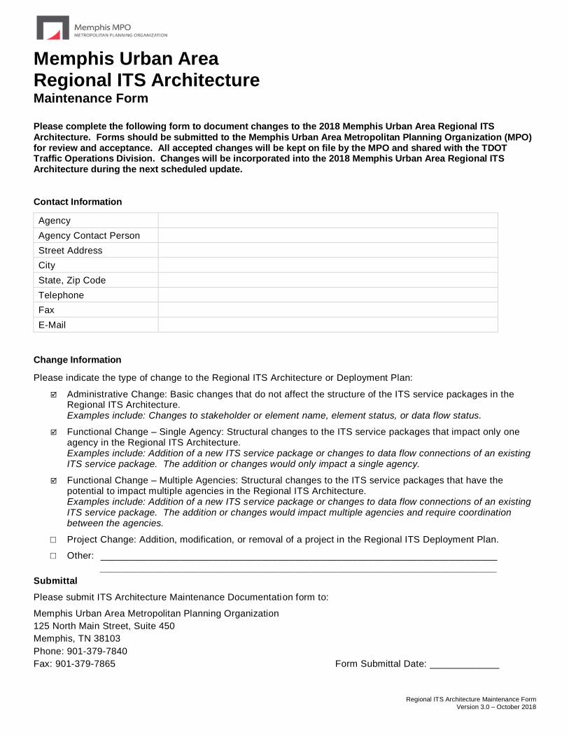
Regional ITS Architecture Maintenance Form Version 3.0 – October 2018
Memphis Urban Area Regional ITS Architecture Maintenance Form
Please complete the following form to document changes to the 2018 Memphis Urban Area Regional ITS Architecture. Forms should be submitted to the Memphis Urban Area Metropolitan Planning Organization (MPO) for review and acceptance. All accepted changes will be kept on file by the MPO and shared with the TDOT Traffic Operations Division. Changes will be incorporated into the 2018 Memphis Urban Area Regional ITS Architecture during the next scheduled update.
Contact Information
Agency
Agency Contact Person
Street Address
City
State, Zip Code
Telephone
Fax
Change Information
Please indicate the type of change to the Regional ITS Architecture or Deployment Plan:
Administrative Change: Basic changes that do not affect the structure of the ITS service packages in the Regional ITS Architecture. Examples include: Changes to stakeholder or element name, element status, or data flow status.
Functional Change – Single Agency: Structural changes to the ITS service packages that impact only one agency in the Regional ITS Architecture. Examples include: Addition of a new ITS service package or changes to data flow connections of an existing ITS service package. The addition or changes would only impact a single agency.
Functional Change – Multiple Agencies: Structural changes to the ITS service packages that have the potential to impact multiple agencies in the Regional ITS Architecture. Examples include: Addition of a new ITS service package or changes to data flow connections of an existing ITS service package. The addition or changes would impact multiple agencies and require coordination between the agencies.
□ Project Change: Addition, modification, or removal of a project in the Regional ITS Deployment Plan.
□ Other: __________________________________________________________________________
__________________________________________________________________________
Submittal
Please submit ITS Architecture Maintenance Documentation form to:
Memphis Urban Area Metropolitan Planning Organization
125 North Main Street, Suite 450
Memphis, TN 38103
Phone: 901-379-7840
Fax: 901-379-7865 Form Submittal Date: _____________

Regional ITS Architecture Maintenance Form Version 3.0 – October 2018
Memphis Urban Area Regional ITS Architecture Maintenance Form
Question 1
Describe the requested change to the Regional ITS Architecture or Deployment Plan.
Question 2
Are any of the Regional ITS Architecture service packages impacted by the proposed change?
□ Yes: Please complete Questions 2A and 2B
□ No: Please proceed to Question 3
□ Unknown: Please coordinate with the Memphis Urban Area MPO to determine impacts of the change to the Regional ITS Architecture
Question 2A
List all of the ITS service packages impacted by the proposed change.
Question 2B
Include a copy of the ITS service packages impacted by the proposed change and mark any proposed modifications to the ITS service packages. Add any additional notes on proposed changes in this section.
Question 3
Does the proposed change impact any stakeholder agencies other than the agency completing this form?
□ Yes: Please complete Questions 3A and 3B
□ No: Form is complete
□ Unknown: Please coordinate with the Memphis Urban Area MPO to determine impacts of change to other agencies in the Regional ITS Architecture
Question 3A
Identify the stakeholder agencies impacted by the change and a contact person for each agency.
Question 3B
Describe the coordination that has occurred with the stakeholder agencies and the results of the coordination?
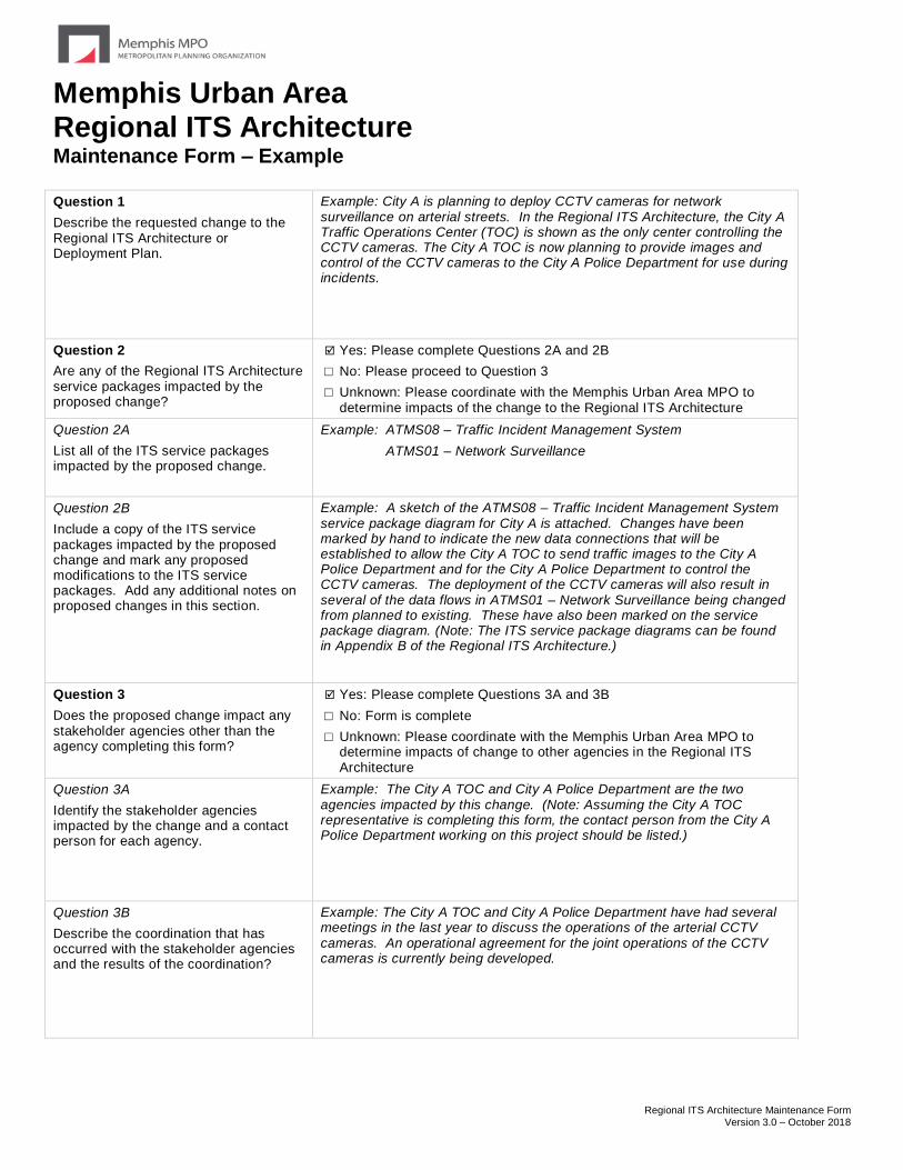
Regional ITS Architecture Maintenance Form Version 3.0 – October 2018
Memphis Urban Area Regional ITS Architecture Maintenance Form – Example
Question 1
Describe the requested change to the Regional ITS Architecture or Deployment Plan.
Example: City A is planning to deploy CCTV cameras for network surveillance on arterial streets. In the Regional ITS Architecture, the City A Traffic Operations Center (TOC) is shown as the only center controlling the CCTV cameras. The City A TOC is now planning to provide images and control of the CCTV cameras to the City A Police Department for use during incidents.
Question 2
Are any of the Regional ITS Architecture service packages impacted by the proposed change?
Yes: Please complete Questions 2A and 2B
□ No: Please proceed to Question 3
□ Unknown: Please coordinate with the Memphis Urban Area MPO to determine impacts of the change to the Regional ITS Architecture
Question 2A
List all of the ITS service packages impacted by the proposed change.
Example: ATMS08 – Traffic Incident Management System
ATMS01 – Network Surveillance
Question 2B
Include a copy of the ITS service packages impacted by the proposed change and mark any proposed modifications to the ITS service packages. Add any additional notes on proposed changes in this section.
Example: A sketch of the ATMS08 – Traffic Incident Management System service package diagram for City A is attached. Changes have been marked by hand to indicate the new data connections that will be established to allow the City A TOC to send traffic images to the City A Police Department and for the City A Police Department to control the CCTV cameras. The deployment of the CCTV cameras will also result in several of the data flows in ATMS01 – Network Surveillance being changed from planned to existing. These have also been marked on the service package diagram. (Note: The ITS service package diagrams can be found in Appendix B of the Regional ITS Architecture.)
Question 3
Does the proposed change impact any stakeholder agencies other than the agency completing this form?
Yes: Please complete Questions 3A and 3B
□ No: Form is complete
□ Unknown: Please coordinate with the Memphis Urban Area MPO to determine impacts of change to other agencies in the Regional ITS Architecture
Question 3A
Identify the stakeholder agencies impacted by the change and a contact person for each agency.
Example: The City A TOC and City A Police Department are the two agencies impacted by this change. (Note: Assuming the City A TOC representative is completing this form, the contact person from the City A Police Department working on this project should be listed.)
Question 3B
Describe the coordination that has occurred with the stakeholder agencies and the results of the coordination?
Example: The City A TOC and City A Police Department have had several meetings in the last year to discuss the operations of the arterial CCTV cameras. An operational agreement for the joint operations of the CCTV cameras is currently being developed.