MEMORANDUM - mieplan.mercergov.org Memo 10.31... · This memorandum documents the trip generation...
18
DRAFT FOR CLIENT REVIEW ONLY TENW Transportation Engineering NorthWest Transportation Planning | Design | Traffic Impact & Operations 11400 SE 8 th Street, Suite 200, Bellevue, WA 98004 | Office (425) 889-6747 MEMORANDUM DATE: August 22, 2017 TO: Patrick Yamashita City of Mercer Island FROM: Chris Forster, P.E. TENW SUBJECT: Trip Generation & Sight Distance Evaluation Chiu Subdivision – Mercer Island, WA TENW Project No. 5523 This memorandum documents the trip generation and sight distance evaluation completed for the proposed 4320 Island Crest Way (Chiu Subdivision) development in Mercer Island, WA. The memo includes a project description, a trip generation estimate, and a sight distance assessment. Key Findings 1. The proposed Chiu Subdivision project is estimated to generate less than 10 new PM peak hour trips. Therefore, based on the City’s General Traffic Impact Analysis Requirements, the project does not require a traffic impact analysis (TIA). 2. Stopping sight distance requirements are met at both site access locations on Island Crest Way. 3. Intersection sight distance is acceptable at both site access locations assuming clearing and regrading is conducted within the right-of-way to achieve clear sight lines looking north and south of the proposed access points. Project Description The project site is located at 4320 Island Crest Way in Mercer Island, WA as shown in Attachment A (vicinity map). The proposed development would include 6 single-family residential detached dwelling units. The existing site includes 2 single-family homes, both of which would be removed with the proposed project, resulting in a net addition of 4 single-family units. Vehicular access to/from five of the proposed lots (north access) would be provided via a new full-access private road onto Island Crest Way approximately 66 feet south of the north property line. This access would replace an existing driveway to the existing home on the north half of the site. Vehicular access to/from one lot (south access) would be provided at a new full access driveway located near the south property line in the same location as an existing driveway serving the existing home on the south half of the site. The project is expected to be constructed in 2018. A preliminary site plan is included as Attachment B.
Transcript of MEMORANDUM - mieplan.mercergov.org Memo 10.31... · This memorandum documents the trip generation...

DRAFT FOR CLIENT REVIEW ONLY TENW Transportation Engineering NorthWest
Transportation Planning | Design | Traffic Impact & Operations
11400 SE 8th Street, Suite 200, Bellevue, WA 98004 | Office (425) 889-6747
MEMORANDUM
DATE: August 22, 2017
TO: Patrick Yamashita
City of Mercer Island
FROM: Chris Forster, P.E.
TENW
SUBJECT: Trip Generation & Sight Distance Evaluation
Chiu Subdivision – Mercer Island, WA
TENW Project No. 5523
This memorandum documents the trip generation and sight distance evaluation completed for the proposed 4320 Island Crest Way (Chiu Subdivision) development in Mercer Island, WA. The memo includes a project description, a trip generation estimate, and a sight distance assessment.
Key Findings
1. The proposed Chiu Subdivision project is estimated to generate less than 10 new PM peak hour trips. Therefore, based on the City’s General Traffic Impact Analysis Requirements, the project does
not require a traffic impact analysis (TIA).
2. Stopping sight distance requirements are met at both site access locations on Island Crest Way.
3. Intersection sight distance is acceptable at both site access locations assuming clearing and regrading is conducted within the right-of-way to achieve clear sight lines looking north and south of the proposed access points.
Project Description
The project site is located at 4320 Island Crest Way in Mercer Island, WA as shown in Attachment A (vicinity map). The proposed development would include 6 single-family residential detached dwelling units. The existing site includes 2 single-family homes, both of which would be removed with the proposed project,
resulting in a net addition of 4 single-family units.
Vehicular access to/from five of the proposed lots (north access) would be provided via a new full-access private road onto Island Crest Way approximately 66 feet south of the north property line. This access would replace an existing driveway to the existing home on the north half of the site. Vehicular access to/from one
lot (south access) would be provided at a new full access driveway located near the south property line in
the same location as an existing driveway serving the existing home on the south half of the site.
The project is expected to be constructed in 2018. A preliminary site plan is included as Attachment B.

DRAFT FOR REVIEW Trip Generation Memorandum Chiu Subdivision – Mercer Island, WA
TENW August 22, 2017
Page 2
Trip Generation Estimate
The weekday daily, AM peak hour, and PM peak hour trip generation estimates for the proposed Chiu Subdivision development were based on trip rates documented in the Institute of Transportation Engineers (ITE) Trip Generation Manual, 9th edition for land use code (LUC) 210 (Single-Family Detached Housing). Table 1 summarizes the trip generation estimate for the project (6 proposed single-family homes less 2 existing single-family homes).
Table 1
Chiu Subdivision Trip Generation Summary
Net New Trips Generated
Time Period In Out Total
Weekday Daily 19 19 38
Weekday AM Peak Hour 1 2 3
Weekday PM Peak Hour 3 1 4
As shown in Table 1, the proposed Chiu Subdivision development is estimated to generate 38 net new weekday daily trips with 3 net new weekday AM peak hour trips (1 entering, 2 exiting), and 4 net new
weekday PM peak hour trips (3 entering, 1 exiting). The detailed trip generation estimates are included in
Attachment C.
Based on the City of Mercer Island General Traffic Impact Analysis Requirements dated 7/15/2015, a project requires a traffic impact analysis if the proposed use will generate 10 or more peak hour trips. The
proposed Chiu Subdivision development is estimated to generate less than 10 net new peak hour trips.
Therefore, the project does not require a traffic impact analysis.
Sight Distance Assessment
The following summarizes the results of the sight distance assessment conducted at the two site access driveways onto Island Crest Way based on a review of engineering standards, field measurements, and aerial photography. The posted speed limit on Island Crest Way in the vicinity of the project is 35 mph. A design speed of 40 MPH (posted speed + 5 MPH) was assumed for this analysis. The grade on Island Crest Way in the vicinity of the proposed site access location is less than 3 percent. Therefore, no adjustments
were made to account for grade.
For this assessment, we analyzed both Intersection Sight Distance (ISD) and Stopping Sight Distance (SSD) based on the standards in AASHTO Policy on Geometric Design of Highways and Streets, 6th Edition, 2011 (AASHTO).
North Access
Intersection Sight Distance (ISD):
Based on AASHTO Policy on Geometric Design of Highways and Streets, 6th Edition, 2011 Table 9-6 (Case B1, Left Turn from Stop), the minimum required left turn ISD for a 40 MPH design speed is 445 feet. Because

DRAFT FOR REVIEW Trip Generation Memorandum Chiu Subdivision – Mercer Island, WA
TENW August 22, 2017
Page 3
Island Crest Way is a multilane roadway (vehicles must cross 2 lanes to turn left from the access driveways), this value was adjusted based on AASHTO standards to 470 feet by adjusting the time gap. ISD was measured based on an entering vehicle driver eye height of 3.5 feet, measured 14.5 feet back from the
edge of traveled way.
ISD Looking North: The available ISD at the Island Crest Way/North Access intersection looking north will meet or exceed 470 feet assuming existing vegetation is cleared and any slope regraded to obtain a clear line of sight. Based on our review of aerial photography and property lines from King County Parcel Viewer, it appears that all required clearing would be within existing City right-of-way (ROW). A diagram showing the ISD sight line looking north is provided in Attachment D.
View looking north on Island Crest Way from north site access location (view is from a point 6 feet behind the existing curb due to existing vegetation)
ISD Looking South: The maximum available ISD at the Island Crest Way/North Access intersection looking south would be approximately 404 feet (does not meet the 470-foot standard) using the existing ROW line as the limiting factor (sight line tangent to ROW line). Meeting the 470-foot standard is not feasible as the line of sight crosses into private property due to the horizontal curve in Island Crest Way. In order for 404 feet of ISD to be achieved, existing vegetation must be cleared and slope regraded within the limits of the
existing ROW.

DRAFT FOR REVIEW Trip Generation Memorandum Chiu Subdivision – Mercer Island, WA
TENW August 22, 2017
Page 4
While 404 feet of ISD is less than the AASHTO standard for left-turns, it is greater than the minimum required ISD for a right turn. Based on AASHTO Policy on Geometric Design of Highways and Streets, 6th Edition, 2011 Table 9-7 Case B2, Right Turn from Stop, the standard for a 40 MPH design speed is 385 feet for
right turns. Considering the fact that a majority of the traffic from these homes will be right turns onto Island Crest Way (as opposed to left-turns), we believe that 404 feet of ISD is acceptable (with clearing/regrading within ROW). In addition, TENW also reviewed the most recent 3-year collision history (2014-2016 WSDOT data) and confirmed that there were no reported collisions at the existing north site driveway (or at
any of the nearby driveways on Island Crest Way). Diagrams showing the ISD sight lines looking south (470 feet and 404 feet) are provided in Attachment D.
View looking south on Island Crest Way from north site access location (view is from a point 6 feet behind the existing curb due to existing vegetation)
Stopping Sight Distance (SSD):
Based on AASHTO Policy on Geometric Design of Highways and Streets, 6th Edition, 2011 Table 3-1 (Stopping Sight Distance on Level Roadways), the minimum required SSD for a 40 MPH design speed is 305 feet. SSD was measured based on an approaching vehicle driver eye height of 3.5 feet and an object height of 2.0 feet. SSD was measured along the centerline of the curb-side lane on Island Crest Way.
Northbound: Based on field measurements, the existing available SSD for a vehicle traveling northbound on Island Crest Way approaching the north access location exceeds 305 feet.

DRAFT FOR REVIEW Trip Generation Memorandum Chiu Subdivision – Mercer Island, WA
TENW August 22, 2017
Page 5
Southbound: Based on field measurements, the existing available SSD for a vehicle traveling southbound on Island Crest Way approaching the north access location exceeds 305 feet.
South Access
Intersection Sight Distance (ISD):
Based on AASHTO Policy on Geometric Design of Highways and Streets, 6th Edition, 2011 Table 9-6 (Case B1, Left Turn from Stop), the minimum required left turn ISD for a 40 MPH design speed is 445 feet. Because Island Crest Way is a multilane roadway (vehicles must cross 2 lanes to turn left from the access driveways),
this value was adjusted based on AASHTO standards to 470 feet by adjusting the time gap. ISD was measured based on an entering vehicle driver eye height of 3.5 feet, measured 14.5 feet back from the edge of traveled way
ISD Looking North: The available ISD at the Island Crest Way/South Access intersection looking north will
meet or exceed 470 feet assuming existing vegetation is cleared and any slope regraded to obtain a clear line of sight (currently the available ISD is only 255 feet due to existing vegetation). Based on our review of aerial photography and property lines from King County Parcel Viewer, it appears that all required clearing would be within existing City right-of-way (ROW). A diagram showing the ISD sight line looking north is provided in Attachment E.
View looking north on Island Crest Way from south site access location (14.5 feet behind curb)

DRAFT FOR REVIEW Trip Generation Memorandum Chiu Subdivision – Mercer Island, WA
TENW August 22, 2017
Page 6
ISD Looking South: The maximum available ISD at the Island Crest Way/South Access intersection looking south would be approximately 310 feet (does not meet the 470-foot standard) using the existing ROW line as the limiting factor (sight line tangent to ROW line). Meeting the 470-foot standard is not feasible as the
line of sight crosses into private property due to the horizontal curve in Island Crest Way. In order for 310 feet of ISD to be achieved, existing vegetation must be cleared and possibly slope regraded within the limits of the existing ROW.
While 310 feet of ISD is less than the AASHTO standard, it is greater than the required SSD standard of
305 feet. Meeting the minimum SSD standard ensures that safe ingress/egress can occur as there will be more than sufficient sight distance available for vehicles travelling on Island Crest Way to be able to stop for conflicting traffic. In addition, it should be noted that this is a driveway to one single family home at a location where one already exists. The existing available ISD looking south at this location is only 145 feet. If the recommended clearing of vegetation and regrading is conducted within the limits of existing ROW, the
resulting ISD will be a significant improvement over existing conditions (more than 2 times the existing ISD). TENW also reviewed the most recent 3-year collision history (2014-2016 WSDOT data) and confirmed that there were no reported collisions at the existing driveway (or at any of the adjacent driveways on Island Crest Way). Based on these considerations, we believe that 310 feet of ISD is acceptable (with
clearing/regrading within ROW) for an access to a single family dwelling. Diagrams showing the ISD sight lines looking south (470 feet and 310 feet) are provided in Attachment E.
View looking south on Island Crest Way from south site access location (14.5 feet behind curb)

DRAFT FOR REVIEW Trip Generation Memorandum Chiu Subdivision – Mercer Island, WA
TENW August 22, 2017
Page 7
Stopping Sight Distance (SSD):
Based on AASHTO Policy on Geometric Design of Highways and Streets, 6th Edition, 2011 Table 3-1 (Stopping Sight Distance on Level Roadways), the minimum required SSD for a 40 MPH design speed is 305
feet. SSD was measured based on an approaching vehicle driver eye height of 3.5 feet and an object height of 2.0 feet. SSD was measured along the centerline of the curb-side lane on Island Crest Way.
Northbound: Based on field measurements, the existing available SSD for a vehicle traveling northbound on Island Crest Way approaching the south access location exceeds 305 feet.
Southbound: Based on field measurements, the existing available SSD for a vehicle traveling southbound on Island Crest Way approaching the south access location exceeds 305 feet
Sight Distance: Conclusions
1. Stopping sight distance requirements are met at both site access locations on Island Crest Way.
2. Intersection sight distance is acceptable at both site access locations assuming clearing and regrading is conducted within the right-of-way to achieve clear sight lines looking north and south of the proposed access points.
If you have any questions regarding the information presented in this memo, please call me at 206-498-
5897 or email at [email protected].
cc: Jayson Taylor Alan Chiu
Attachments
A. Vicinity Map B. Preliminary Site Plan C. Trip Generation Estimate D. Preliminary ISD Sight Line Diagrams – North Access E. Preliminary ISD Sight Line Diagrams – South Access

DRAFT FOR REVIEW Trip Generation Memorandum Chiu Subdivision – Mercer Island, WA
ATTACHMENT A
Site Vicinity Map

DRAFT FOR REVIEW Trip Generation Memorandum Chiu Subdivision – Mercer Island, WA
ATTACHMENT B
Preliminary Site Plan

DRAFT FOR REVIEW Trip Generation Memorandum Chiu Subdivision – Mercer Island, WA
ATTACHMENT C Trip Generation Estimate
Weekday DailyITE Trip Rate
Land Use Units 1 LUC 2 In Out Total In Out Total
Proposed Use
Single-Family 6 DU 210 50% 50% 9.52 28 29 57
Less Existing Use
Single-Family 2 DU 210 50% 50% 9.52 -9 -10 -19
Total Net New Weekday Daily Trips Generated = 19 19 38
AM Peak Hour Trip Generation
ITE Trip Rate
Land Use Units LUC 1 In Out Total In Out Total
Proposed Use
Single-Family 6 DU 210 25% 75% 0.75 1 4 5
Less Existing Use
Single-Family 2 DU 210 25% 75% 0.75 0 -2 -2
Total Net New AM Peak Hour Trips Generated = 1 2 3
PM Peak Hour Trip Generation
ITE Trip Rate
Land Use Units LUC 1 In Out Total In Out Total
Proposed Use
Single-Family 6 DU 210 63% 37% 1.00 4 2 6
Less Existing Use
Single-Family 2 DU 210 63% 37% 1.00 -1 -1 -2
Total Net New PM Peak Hour Trips Generated = 3 1 4
Notes:1 DU = Dwelling Units.2 Institute of Transportation Engineers, Trip Generation Manual, 9th edition Land Use Code.
Directional Split Trips Generated
Directional Split Trips Generated
Directional Split Trips Generated

DRAFT FOR REVIEW Trip Generation Memorandum Chiu Subdivision – Mercer Island, WA
ATTACHMENT D
North Access
ISD Sight Line Diagrams

66'-0
"
5'-6"
470'
-0"
SightLine
NORTH ACCESS:ESD Looking North
40 MPH Design SpeedAASHTO Standard = 470'ESD MET assumingclearing within ROW
80'-0"
CENTER OF SITE ACCESS
D1

80'-0"
66'-0
"
5'-6"
470'-0"
20'-0"
ESD SIGHTLINE OUTSIDEOF CITY RIGHTOF WAY
SightLine
NORTH ACCESS:ESD Looking South
40 MPH Design SpeedAASHTO Standard = 470'ESD NOT MET CENTER OF SITE ACCESS
D2

80.0 ft
66.0
ft5.5 ft
404.0 ft
20.0 ft
SightLine
NORTH ACCESS:ESD Looking South
Approx. Max ESDMeasured = 404 FT(assuming clearingwithin City ROW)
ESD SIGHTLINETANGENTTO CITYRIGHT OFWAY
CENTER OF SITE ACCESS
D3
DRAFT FOR REVIEW Trip Generation Memorandum Chiu Subdivision – Mercer Island, WA
ATTACHMENT E
South Access
ISD Sight Line Diagrams

E1
5'-6"
20'-0"
470'
-0"
80'-0"
SightLine
SOUTH ACCESS:ESD Looking North
40 MPH Design SpeedAASHTO Standard = 470'ESD MET assumingclearing within ROW
CENTER OF SITE ACCESS

E2
90'-0"
5'-6"
470'-0"ESD SIGHTLINEOUTSIDECITY RIGHTOF WAY
SightLine
SOUTH ACCESS:ESD Looking South
40 MPH Design SpeedAASHTO Standard = 470'ESD NOT MET
CENTER OF SITE ACCESS
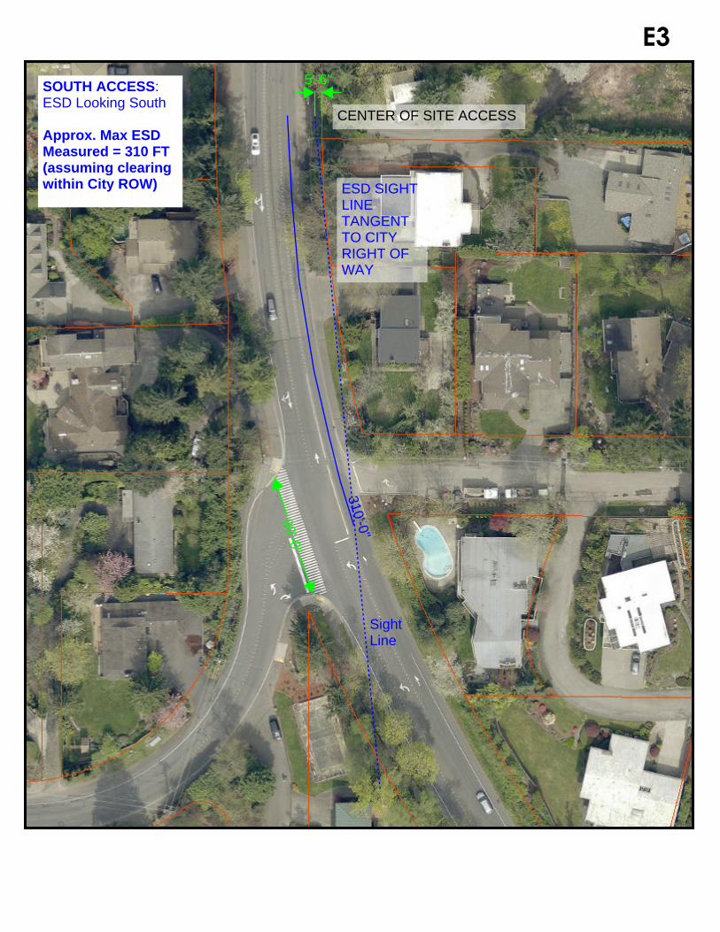
E3
90'-0"
5'-6"
SightLine
310'-0"
SOUTH ACCESS:ESD Looking South
Approx. Max ESDMeasured = 310 FT(assuming clearingwithin City ROW) ESD SIGHT
LINETANGENTTO CITYRIGHT OFWAY
CENTER OF SITE ACCESS