Member Country Report of INDONESIA -...
43
CCOP-53AS/3-7 53 rd CCOP Annual Session 16 – 19 October 2017 Cebu City, Philippines Member Country Report of INDONESIA Submitted by Indonesian Delegation / Geological Agency (For Agenda Item 3) COORDINATING COMMITTEE FOR GEOSCIENCE PROGRAMMES IN EAST AND SOUTHEAST ASIA (CCOP)
Transcript of Member Country Report of INDONESIA -...

CCOP-53AS/3-7
53rd CCOP Annual Session 16 – 19 October 2017 Cebu City, Philippines
Member Country Report of
INDONESIA
Submitted by
Indonesian Delegation / Geological Agency
(For Agenda Item 3)
COORDINATING COMMITTEE FOR GEOSCIENCE PROGRAMMES IN EAST AND SOUTHEAST ASIA (CCOP)

CCOP Member Country Report: INDONESIA 1
ANNUAL MEMBER COUNTRY REPORT
Country: INDONESIA Period: 1 July 2016 - 30 June 2017
I. OUTREACH The technical activities has been reclassified into three sectors and seven programmes as follows: Geo-Resources (Mineral, Energy, Groundwater), Geo-Environment (Coastal, Geohazard, Environmental Geology), and Geo-information (Geo data and Information Management)
GEO-RESOURCES SECTOR
1. MINERAL PROGRAMME 1.1. Summary Several companies holding license for exploration activities in mining for metallic mineral have reported the results of their activities and the development of resources and reserves of several minerals. Several mineral commodities resources and reserves are shown in the following figure.
Figure 1.1. Bar charts of some mineral commodities resources and reserves of Indonesia 2012 - 2016
COORDINATING COMMITTEE FOR GEOSCIENCE PROGRAMMES IN EAST AND SOUTHEAST ASIA (CCOP) CCOP Building, 75/10 Rama VI Road, Phayathai, Ratchathewi, Bangkok 10400, Thailand Tel: +66 (0) 2644 5468, Fax: +66 (0) 2644 5429, E-mail: [email protected], Website: www.ccop.or.th

2 CCOP Member Country Report: INDONESIA
The government has planned to revise Law No. 4/2009 due to some provisions in this regulation that can not be implemented/experiencing obstacles in the implementation, need to be adjusted with Law Number 23 Year 2014 on Local Government, The Constitutional Court Decision, and the government policy to simplify licensing and public services, including in this case licensing of mineral sub-sector.
1.2. Annual Review of Individual Technical Activities During July 2016 – June 2017 period, Geological Agency conducted mineral exploration at several areas. In the second semester of 2016, metallic mineral exploration conducted at Southeast Minahasa, North Sulawesi, Banjar and Tanah Laut, South Kalimantan, and Gowa, South Sulawesi, whereas non metallic mineral exploration has been done at Merangin, South Sumatera, Tanggamus, Lampung and East Kotawaringin, Central Kalimantan . In the first semester of 2017, metallic mineral exploration has been done at Belu, East Nusa Tenggara, Tanah Datar, West Sumatera, Bangka, Bangka Belitung Island, Jayapura, Papua. Joint Geochemical Survey between Geological Agency of Indonesia and China Geological Survey has been carried out in the northern part of Sumatera. Non metallic mineral exploration also carried out in several areas: limestone at South Konawe, Southeast Sulawesi, quartz sand at East Kotawaringin, Central Kalimantan and Kalium at Kudus, Central Jawa.
Figure 1.2. Location Map of Metallic Mineral Survey
in 2nd Semester 2016 – 1st Semester 2017
1.3. Proposed Future Activities Nothing to Report.

CCOP Member Country Report: INDONESIA 3
1.4. Assistance Required from CCOP/Other Member Countries in Support of Future Activities
Capacity building program in exploration methodology and training program for integrated geophysical and geochemical data interpretation especially for REE are needed in order to achieve expected exploration targets and to get more new prospect discoveries. The exchange of various exploration experiences through establishment of special forum dealing with relevant and actual issues between CCOP member countries would be helpful to cope with exploration problems encountered in any exploration project plan.
1.5. Assistance Offered to CCOP/Other Member Countries in Support of Future Activities
Nothing to Report
1.6. Others Comments Direct responses on reviews mentioned above for improvement of project outcomes and for perfecting any exploration plans would be kindly required from technical director of CCOP.
Programme Contact Person: Hedi Hidayat Center for Mineral, Coal and Geothermal Resources Geological Agency of Indonesia Jl. Sukarno Hatta 444 Bandung, West Jawa, Indonesia Phone : +62-22-5202698; +62-22-5205572 Fax : +62-22-5226263 Email : [email protected] 2. ENERGY PROGRAMME 2.1. HYDROCARBON 2.1.1. Summary One of the Indonesian government's strategic program is to increase the Reserve Replacement Ratio (RRR) to more than 100% in the next five years through one of the programs in House of Energy Sovereignty (to conduct aggressive exploration activities). Status of Indonesian total oil reserves in 2016 is 7,251 billion barrels or decreased by 0.049 billion barrels (0.67%) compared to oil reserves in January 1st, 2015 (7.3 billion barrels). For natural gas, there is also decresed in reserves of 151.33 TCF to 144,09 TCF or decreased by 7,27 TCF (4,8%) (LEMIGAS, 2016). Based on data of late 2016, national reserve potential of oil and gas is 5.2 billion barrels of oil equivalent, consisting of 2.7 billion barrels of oil and 14 trillion cubic feet of gas, estimated from 108 proven oil and gas discovery wells (KEN, 2016). To support the government’s policy in order to increase the Reserve Replacement Ratio (RRR) to more than 100% for the next five years, one of the exploration research activities of

4 CCOP Member Country Report: INDONESIA
LEMIGAS during the years 2017 are Intensification of Oil and Gas Exploration in Indonesia (especially eastern area). Indonesia has 82 Tertiary sedimentary basins and 4 pre-Tertiary Basins. 46 of them are located in Eastern Indonesia (BPMIGAS - LAPI ITB, 2008). Based on the basin status of 2017, there are 17 production basins, 14 basins with hydrocarbon discovery, 17 basins with hydrocarbon indication, 38 basins with no hydrocarbon indication. Based on classification of hydrocarbon resources, there are total lead resource around 71019,84 MMSTB of oil and 580274,4 BSCF of gas, total drillable resource around 15930,5 MMSTB of oil and 122346. BSCF of gas, total postdrill resource around 1248,34 MMSTB of oil and 8739,3 BSCF of gas, and total discovery resource around 123,1822 MMSTB of oil and 1790,9 BSCF of gas.
Figure 2.1. Oil and Gas Reserve Map, Status 2016 (LEMIGAS, 2016)
2.1.2. Annual Review of Technical Programs/Activities The study areas for exploration are mostly focused in Papua Island, Arafura Sea, Sulawesi and Kalimantan, including Tanah Merah, Atsy, Merauke, MisoolTimur, East Kai, North Bone Gulf, Tomini and East Tanimbar. To increase the economic value of the blocks, reevaluation of unsold blocks is conducted to Morowali, Sunda Strait IV, Halmahera III and Tarakan II areas. The result of reevaluation reveals that Sunda Strait IV and Tarakan II are interesting in petroleum system perspective, whilst Morowali and Halmahera III are not prospective.

CCOP Member Country Report: INDONESIA 5
Figure 2.2. Oil and gas resources in Indonesia
Figure 2.3. Research area map of oil and gas working area in 2016
2.1.2.1. Intensification of Oil and Gas Exploration in Indonesia Intensification of Oil and Gas Exploration in Indonesia is collaboration research among LEMIGAS, Geological Agency, National Data Center of Minisitry of Energy and Mineral Resources (MEMR) and Directorate General of Oil and Gas. 1) Atsy Block Based on geochemical analysis, this basin has problems in the potential source rock and maturity level of the source rock. In addition, the configuration structure does not support the formation of significant structural traps, and this is characterized by the flat seismic reflector.

6 CCOP Member Country Report: INDONESIA
2) East Kai Block Petroleum system of East Kai area has been active as it is indicated by the occurrence of a number of oil and gas seepages in the Yamtimur area. In general, the East Kai Block has a complete petroleum system elements. Based on a comprehensive review of the hydrocarbon system, the study area has potential to generate and stores hydrocarbon. 3) Tanah Merah Block The Tanah Merah Block is characterized by a thin sedimentary rock sequence that is not supporting for maturation process and the absent of sedimentary rock interval that has potential as a source rock (low content of organic material and maturity level). Related to the reservoir rock, Wonimogi and Kais Formations have a low porosity value (9 - 11%). The research of hydrocarbons potential study of the area is still on progress. 4) Tomini Block The formation with a good quality and quantity of organic material has not be found. Eventually, the speculative volumetric calculation indicates uneconomic potential. 5) Merauke Block Due to thin sedimentary rock sequence, maturation process of source rock is not supported. However, there is minor indication of active petroleum system in the outcrop (seepage) as shown by geological survey done by PSG, whilst oil show from well data is absent. Based on geochemistry analysis, Mesozoikum Piniya Formation is the main candidate to become potential source rock (thickness is 300-400 meters, TOC is 0.8 to 1.4%). The main problems of petroleum system in this area is the absence of good quality of reservoir. 6) Misool Block The Eastern Misool block is located in the offshore northeast of Misool Island which geographically includes in the regional Salawati Basin. Salawati Basin is a mature basin that has been proven to have an active petroleum system as evidenced by the occurences of many seepages of oil and also with some oil and gas fields that have been producing. The source rocks of Permo-trias and Jura intervals have excellent potential and quality with total organic carbon ranges of value is 0.5 to 10% and have reached matured phase with Ro value reaching 1,0. This block has good potential to generate and store hydrocarbon.
2.1.2.2. Unconventional Hydrocarbon The study on the Nias and Meulaboh areas (Sibolga Basin) has been conducted to identify biogenic gas potential. The result of the study indicates that these areas have good potential in both Miocene carbonate and Pliocene siliciclastic plays.
2.1.2.2.1. Biogenic Gas in Nias Area Nias Area is located in The Sibolga basin (fore arc basin) which placed in the western part of Sumatra offshore. The isotope analysis of gas from DST (Measuring 1, Meulaboh-1, Palambak-1, Singkel-1 and Suma-1 wells) shows 98% - 100% methane content which is an indication of biogenic gas. The seismic data shows a significant reflector pattern (flatspots with high amplithude charcter) of gas presence. Based on sub-surface mapping analysis, the accumulation of biogenic gas can be identified in limestone and sandstone with anticline and stratigraphic traps. The reserves calculation shows the economic value about 231.9 BCF (minimum) to 2.94 TCF (maximum).

CCOP Member Country Report: INDONESIA 7
2.1.2.2.2. Hydraulic Fracturing Hydraulic fracturing research was conducted by LEMIGAS as a form of contribution and commitment in the shifting paradigm to start directing exploration activities to unconventional hydrocarbon reserves (Figure 2.4). In 2017, LEMIGAS has been conducting research to develop hydraulic fracturing fluids by using chitosan (waste of shrimp shells). The research is still on progress.
Figure 2.4. One example of the results of hydraulic fracturing experiment
in laboratorium scale (LEMIGAS, 2016)
2.1.2.3. Enhanced Oil Recovery (EOR) Refers to the most of oil fields in Indonesia in recent years are brownfield status, thus they need a treatment to increase their production. On the other hand the greenhouse effect caused by CO2 is also becoming a global issue. Related to these conditions, EOR research activity by using CO2 called Carbon Capture Utilization and Storage (CCUS) has been performed in Beringin Field (Figure 2.5). Feasibility study of pilot-scale CO2 injections in Beringin field in South Sumatera region was carried out by field screening process for EOR CO2 injection, GGR simulation study of Beringin field, Block D, Layer C2, and economic analysis results that included CO2 transport scenario from source to the injection site, as well as the need of CO2 capture facility. The results of reservoir simulation indicates that CO2 injection with flow rate of 150 tons per day for 4 years can increase oil recovery until 47.07% in the prospect area of layer C2, Block D. It means the production increased 5% compared to the end of 2016. The lowest price of CO2 is obtained from scenario II (transported by truck, 48.13 US $ / ton). It can be concluded that pilot-scale CO2 injections at Layer C2, Block D.

8 CCOP Member Country Report: INDONESIA
Figure 2.5. Depth structure and compartmentalization map (left) and hydrocarbon potential
map of layer-C2, Block-D (right) of Beringin Field Programme Contact Person: 1. Panuju, M. T
R&D Center for Oil and Gas Technology “LEMIGAS” Jl. Ciledug Raya Kav. 109, Kebayoran Lama Jakarta 12230, Indonesia Phone : +62-21-7251413 (direct), +62-21-7394422 Fax : +62-21-7251413, +62-21-7246150. Mobile : +62-812-1033834 Email : [email protected]
2. Edy Slameto
Center for Geological Survey Geological Agency of Indonesia Jl. Diponegoro No. 57 Bandung 40122, Indonesia Phone : +62-22-7203205-08 Fax : +62-22-7202669 Mobile : +62-8112240813 Email : [email protected]
2.2. SHALE GAS 2.2.1. Summary Increased energy resources is one of the priorities of Indonesia national development. The government policy in the discovery of new oil and gas reserves has determined that unconventional oil and gas resource (shale hydrocarbon) becomes the priority of attention in the research and verification of unconventional oil and gas potential.

CCOP Member Country Report: INDONESIA 9
Assessment of Shale Gas in Geological Agency is one of priority activities at national energy development and exploration activities in the search for new oil and gas reserves in order to realize national energy security. Some Tertiary and Mesozoic sedimentary sediments in Indonesia show indications of unconventional oil and gas resources, but the potential is not well known due the lack of surface and subsurface geological data and analysis. The survey conducted by Geological Agency (2009), has been successfully identified shale gas resources in main sedimentary basin in Indonesia. Survey of 7 sedimentary basins in Indonesia have been undertaken for unconventional oil and gas resources research. Total resources from all basin in indonesia is about 574 TSCF spreading in Sumatra, Kalimantan, Java and Papua. Sumatra region is the initial target exploration of unconventional hydrocarbon, specially sub-region of Jambi. The Jambi sub-basin has the great potential of hydrocarbon shale at several formations such as Talangakar, Gumai and Lemat Formation. The main source rock in this area has a high organic content of up to 2% with most of them have kerogen type II and type III. Total shale hydrocarbon resource calculation results in the Jambi Sub-Basins are approximately 9586 MMBOE, where the original gas in place (OGIP) is about 54.77 TCF (9.420 MMBOE) and the original oil in place (OOIP) is about 165.55 MMBO.
Figure 2.6. Map of potential area for shale hydrocarbon resources in Indonesia

10 CCOP Member Country Report: INDONESIA
Figure 2.7. Sedimentary Basin Map of Indonesia and research area on selected basin
2.2.2. Annual Review of Individual Technical Activities 2.2.2.1. Central Sumatra Basin (2013-2014) Central Sumatra basin is a basin that has been sufficiently explored so that the data available quite a lot. In shale gas research activities in central Sumatra has done several stages:
- Regional geology analysis - Lithofacies analysis - Organic richness And geochemical analysis - Mineralogy and pore characterization - Subsurface mapping
Central Sumatra Basin was formed during the early Tertiary (Eocene-Oligocene) as a series of sub-parallel north to north-west trending half graben structures, separated by horst blocks. Brown Shales Formation (Eocene to Oligocene), at the early stages of back-arc evolution, comprising lacustrine facies associations, were deposited in a humid, tropical environment. Then Deltaic-Marine shales of the Telisa Formation (Early – Midlle Miocene) are deposited. Half graben structures were filled with nonmarine clastic and lacustrine sediments of the Pematang Group, which a thicknesses of greater than 1800m (6000') in some deep graben areas (Williams et al, 1985). The potential of shale gas in the Central Sumatra Basin lies in the brown shale formation deposited at the age of Eocene to Oligocene and the Early-middle Miocene Telisa Formation with the following characteristics:
- DEPOSITIONAL FACIES: Brown shale formation were deposited in lacustrine environment, while the Telisa shales were deposited in more marine environment.
- ORGANIC RICHNESS: the TOCs content of the Brown Shales Formation is over 2%, with mainly consist of liptinite macerals (alginate), however the Telisa Shales have much lower TOCs content > 0.5%, comprises of predominantly vitrinite macerals.

CCOP Member Country Report: INDONESIA 11
- MATURATION: the brown shale formation has kerogen type I, II and III with maturity from early mature to oil zone category, however the Telisa Shales has mainly kerogen II and III, with maturity level immature to oil zone.
- MINERALOGY: the brown shale formation consists of quite abudance clay minerals account of 30%, while the Telisa Shales comprises of predominantly quartz and pyrite (brittle minerals).
- PORE TYPE CHARACTERISTICS: porosity over 2%, with clay mineral occurs as authigenic mineral, pore lining and pore filling minerals, while pyrite and quartz occurs as detrital material, pore filling dan fracture filling. Porosity type: poros floccullus, interparticle grain, organo porosity dan microfracture.
Figure 2.8. Pore analysis from Brown Shale Formation
2.2.2.2. Bintuni Basin The Bintuni Basin includes a foreland basin located in the southern part of Bird's Head, West Papua. The geometry of this basin extends north-south. The total area of the basin is 45,000 km2. This basin has been shown to produce hydrocarbons. Previous research confirms the existence of two petroleum systems in the Bintuni basin, that is, in the Tertiary and pre-Tertiary periods. Stratigraphy of research areas found in the study area from old to young are: Kemum Formation, Anggi Granite, Mawi Complex, Aifam Group, Cemetery Group (Woniwogi Formation, Piniya Formation, Formation Ekmai), Imskin Formation, Klasafet Formation, and Steenkool Formation.

12 CCOP Member Country Report: INDONESIA
Shale Characteristic Target formation for shale gas exploration in Bintuni Basin are Piniya Formation and Aiduna Formation. The Aiduna Formation is characterized by the lithology of claystone and shale of light gray-dark gray, with a laminate parallel sedimentary structure and wood or root deposits. The formation of Piniya is characterized by the lithology of the formation of mudstone, dark gray, shale; claystone, dark gray, shale, and glauconite sandstone, light gray. Based on the results of field observations, the deposition environment of this Piniya Formation is interpreted in shallow sea areas.
Target Area for Future Study Here are three prospect area for future study, which are:
- Potential Areas of shale 1. This area is located around the Bay area of Mawi, Bald Mountain and surrounding areas. In this area the shales are found on the Aiduna Formation and the Kembelangan Group that is in the Woniwogi Formation.
- Potential Areas of Shale 2. This area is in the vicinity of Tahota - Windesi. In this area there are shales in the Kembelangan Group that is in Piniya Formation. Characteristics of shales in this formation is in the form of mudstone (mudstone), dark gray, shale and clay, dark gray, shale
- Potential Shales Area 3. This area is located in Bintuni area. In this area the shales are found in the Classic Formation. Characteristics of shales in this formation is in the form of clay, fresh gray color, brown weather, shale, calcite vein, massif
2.2.2.3. Akimeugah Basin The Akimeugah Basin is associated with the Papua Basin in Papua New Guinea (PNG) that already produces oil and gas, and is associated with Australian basins that have been proven to produce hydrocarbons. The research sites are located in Wamena and surrounding areas which are administratively included in Jayawijaya, Yalimo and Yahukimo districts including Papua Province. The main purpose of this investigation is to determine the quality and potential of shale gas, thermal maturity, and the implications of shale gas exploration as a new energy source. Other outcomes, which include both lateral and vertical spread, thickness, and shale gas stratigraphic positions, as well as the sequence of rocks that make up the formation, the relationship between formation, the location of the type, the fossil content, the relative age, the deposition environment, and the shape and position of the basin, is expected to be the result of this research activity.

CCOP Member Country Report: INDONESIA 13
Regional Geology and Stratigraphy The potential of shale gas at the study site was found in claystone Kopai Formation and Piniya Formation. Further analysis of physical, chemical, mineralogical, kerogen, maturity, and brittleness index of clay in both formations are available as laboratory results. The Piniya formation is found in all trajectories, but on the Wamena - Bokondini track, the Piniya Formation claystone of the northern part of the track has undergone metamorphism into slate, as a result of the meeting of the Australian Plate and the Pacific Plate. Based on the results of field research and discussion above, rocks that have potential as source rock for shale gas are shale fissile rocks, forming laminates on clay and shale. Based on the shale distribution of each of the above formations, the potential shale flakes as source rock for shale gas are in the following formation. a. Kopai Formation: This formation is found on the Wamena - Elelim path, composed by claystone, with thin sandstone patches. Claystone, gray, brownish yellow, black, clay grain size, flake, massive, in some places react with HCl, there is a cross bedding sediment structure and hummocky cross stratification. The deposition environments of this formation are interpreted on the transition - lower shoreface, characterized by coal and hummocky cross stratification structures showing the lower shoreface deposition environment.
Figure 2.9. SEM result of Kopai Formation (Sample 16 FB 001 / A). Illite (I); quartz (Q); micro porosity (P).
b. Piniya Formation: This formation in the research area is found on the Wamena - Elelim track, the Wamena - Bokondini track, the Wamena - Tolikara trajectory, and the Wamena - Bua track. The formation is composed of massive claystone, limestone, and slate, and a green schist located near the subduction zone on the Wamena - Bokondini track. Claystone, gray - black, clay grain size, reacts with Hcl, flakes, very hard, encountered bivalve gastropod fossils, ammonite, and belemnite. Batulanau, gray, silt grain size, did not react with HCl, found the existence of a flat mineral (muscovite). Slate, black, foliation structure, in some places found the quartz vein. These rocks are interpreted to be derived from the clay of the Piniya Formation, which has undergone metamorphism due to a collision between the Australian Plate and the Pacific Plate. Green shrimp, green, dominated by flat minerals, skisose structure, lepidoblastic texture, very hard because it is adjacent to the collision zone, in some places there is a slate. The deposition environments of this formation are interpreted to be deposited on the shelf.

14 CCOP Member Country Report: INDONESIA
Shale Properties Scanning electron microscope analysis has been done for selected samples. The Appearance of Lower Shale of Kopai Formation (Sample 16 FB 001 / A) shows the domination of Illite (I), there are quartz mineral minerals (Q) and micro porosity (P). The presence of quartz minerals will increase the value of keoyasan (BI) in this shale layer, in addition the presence of micro porosity has the potential to provide a place for gas capture in the shale layer. The Appearance of the Lower Shale of the Piniya Formation (Sample 16 FB 007 / A) Generally composed of Illite (I) clay minerals and micro porosity (P). The presence of micro porosity has the potential to provide a place for gas capture in the shale layer.
Figure 2.10. SEM result of Kopai Formation (Sample 16 FB 001 / A). Illite (I); quartz (Q); micro porosity (P)..
Petrophysic Analysis Petrophysic Analysis has been done from Apauwar-1 well to calculate TOC, Hydrogen Index, and Tmax, for geochemical analysis. The richness of organic materials in the Mamberamo D Member Formation is generally fair up to the 2150 m interval. At depth intervals below 2150 m, in general the organic content materials is good. The maturity of the parent rock at a depth of more than 3820 m has matured, indicated by Tmax that has entered the mature window. 2.2.2.4. Kutai Basin Shale gas potential in Kutai Basin is expected to magnify the understanding and compound more comprehensive data, in order to attract investors and company to provide the capital in this relatively new resource, and be envisaged to lift Indonesia’s revenue up in oil and gas sector. This study is intended to elevate upstream exploration, especially for unconventional oil and gas, which will be beneficial to boost gas reserves in order to achieve energy independence.

CCOP Member Country Report: INDONESIA 15
This aims to propose some unconventional concession recommendations in Kutai Basin, by identifying shale gas rock carrier characteristics in detail, establish stratigraphic setting and the age of the shale, analyze geochemical properties (organic and inorganic), define the mineralogy, geological environment/ facies, thickness estimation and its extent vertically and laterally.
Regional Geology Build upon previous studies literature and surveys, Kutai Basin is the second biggest Tertiary oil and gas producer basin after Central Sumatera Basin with proven reserves more than 11 BBOE (billion barrel oil equivalent) (Courtney, et.al, 1991, Pertamina BPPKA, 1997). Kutai Basin studies have been discussed a lot by some researchers including various aspects, like tectonic (Ott, 1987; Biantoro, et al., 1992; Chambers and Daley, 1995; Fergusen, 1999; Satyana, et al., 1999), stratigraphy and sedimentology (Suleiman, et al., 1995; Stuart, et al., 1996; Carter and Morley, 1996; Hendarman, et al., 1998) and petroleum system (Endarto, 1997; Busono, et al., 1997; Paterson, et al., 1997; Guritno and Chambers, 1999; Dunham and McKee, 2001). Based on geological map and basic shape of gravity anomalies map, Kutai Basin can be distinguished to three sub basin, West Kutai Sub-basin (Upper Kutai Basin), East Kutai Sub-basin (Lower Kutai Basin), and Pasir Sub-basin (Heryanto, et al., 2013).
Field Survey First session of the survey is focused on northern Kutai Basin. The objective is to gain more geological information and complete data obtained in 2015. Aimed for being acknowledged in gas carrier rock extent, this session emphasizes inspection on extension of Pemaluan Formation, Pulaubalang Formation, and Balikpapan Formation. The result of this study will draw conception including geological outcrop track, lithological characteristics and stratigraphic aspects.
Geochemical Analysis Several geochemical analysis has been done from research area. based on geochemical data from Ramin-1 well Pamaluan and Atan Formations will be targerted for shale gas exploration. Pamaluan Formation has TOC value level from fair to good, and generate gas from kerogen type III. Present gas window for this formation will enter below 7000 feet as seen on burial history chart from Busang-1 Well and become potential for shale gas exploration.
Petrophysic Analysis Petrophysic analysis from Ramin-1 well shown that gross thickness of targeted shale formation is 2191.49 ft at this research six well data has been analysis for petrophysic, including thickness, density, TOC, and etc.
Shale Properties Rock sampling in Upper Kutai Basin was just done in 2nd session of field survey in 2017, with Batu Ayau Formation as the formation target. Below are the result of petroleum basin

16 CCOP Member Country Report: INDONESIA
evaluation of Upper Kutai Basin conducted by Lemigas in 2009. Sedimentary rock which acted as source rock in Upper Kutai Basin is black shale from terrestrially Kiham Haloq Formation and shale of Batu Kelau Formation (TOC : 0.67-0.69%, Tmax : 435-4390C, HI : 19-30) and Batu Ayau Formation shale (TOC : 0.77, Tmax : 4400C, HI : 16).
Figure 2.11. Clay mineral identification in sandy claystone in Batuayau Formation.
Microporosities (B-C, 4; B, 7; G-H, 4-5; J-K, 7-8) present as the result of dissolution on detrital clay matrix. Clay mineral variant which captured in this sample are kaolinite and illite forming honeycomb structure.
Shale Potential and Resource Appraisal Shale potential and Resource appraisal has been calculated from existed data the result for East Kutai Sub Basin is 67,84 Tcf and West Kutai Sub Basin is 8,5 Tcf.
2.2.2.5. Singkawang Basin Singkawang Basin Located at West Kallimantan Province, categorized into passive margin basin at pre-Tertiary age. The field survey of this basin was following the program of National Exploration Committee (KEN) to explore the pre Tertiary basin. The purpose of this research is to know the hydrocarbon potential of this basin, both conventional and unconventional hydrocarbon.

CCOP Member Country Report: INDONESIA 17
The study of Singkawang basin (pre Tertiary) focused on some formation, such as Kayan Formation, Bengkayang Group (Sungai Betung Formation and Bannan Formation), Seminis Formation and Pedawan Formation.
Shale Characteristic
- Banan Formation Banan Formation is member of Bengkayang Group, characterized by dark carbonaceous siltstone and many trace fossils with horizontal direction, the most important features of this formation are tuffaceous lithology and rock which were being metamorphic processes with blocky appearances and rock fragments such as slaty structures.
- Sungai Betung Formation Sungai Betung Formation characterized by dark carbonaceous claystone which is large the amount of organic content in rocks and interbedded sandstone, which is Ammonite sp. fossil print.
- Pedawan Formation Pedawan Formation is characterized by the dominance of sandstone lithology and shale, which have a sedimentary structure indicating rocks deposited with turbidite systems. The appearance of sandstone which means many contain feldspar and the number of carbon laminates, locally found fragments of coal and resin.
Geochemical Analysis From the Total Organic Carbon Analysis we know that the contained organic materials are classified from fair–very good with number of 0.45 up to 2.14. The domination of OI (Oxygen Index) show it could be generated to gas. But the value of S2 and HI is 0 (means for Kerogen Type IV). The maceral analysis the maturity of fine sediment indicates that they are mature (peak mature) meaning that this formation has good potential for Shale Hydrocarbon exploration. 2.2.2.6. Ketungau Basin and Melawi Basin The Ketungau Basin, Mandai Basin and the Melawi Basin in West Kalimantan area are the Intercontinent Basin forming as tectonical parts of Sunda Exposure of which the potential for economic conventional oil and gas discoveries have not previously been confirmed. The Ketungau Basin is bordered by the Melawi Basin in the south. Tectonically this basin can be classified as an intercontinental basin confined by Mesozoic rock Bancuh Lubok Antu in the north and the Semitau Metamorphic Complex in the South. Viewed from the geological position of the tectonic pattern, the Ketungau is classified as inter-basin basin. Besides non-ideal trapping mechanisms, another major problem in these basins is source rock maturation. Nevertheless, both basins are promising to be explored for oil shale and shale gas energy resources. Therefore, the aim of this research is to give some perspectives on their source rocks, as an input for the evaluation of the potential of unconventional oil and gas. Samples are collected from the Ketungau and Melawi Basins were analyzed using pyrolysis and organic petrographic methods.

18 CCOP Member Country Report: INDONESIA
The results show a poor to good quality of source rock potential. The Ketungau shale, which is the main source rock in the Ketungau Basin, is dominated by type III, immature, and gas prone kerogen. The Silat shale, which is the main source rock in the Melawi Basin, is dominated by type II, immature to early mature, mixed gas, and oil prone kerogen. In the field, Ketungau and Silat Formations have a widespread distribution, and are typically 900 m to 1000 m thick. Both the Ketungau and Silat shales occur within synclinal structures, which have a poor trapping mechanism for conventional oil or gas targets, but are suitable for oil shale and shale gas exploration. This early stage of research clearly shows good potential for the future development of unconventional energy within the Ketungau and Melawi Basins.
Regional Geology Analysis Surface data collection includes 8 traverse, which are: Nanga Dua traverse, Nanga Raun traverse, Boyan Tanjung traverse, Mawan traverse, Nanga Selangkai traverse, Seiberuang traverse, Nanga Silat-Landau Badai traverse, and Sosok-Beduai traverse. The second transects of this survey is around the Ketungau River. The target of this session is Kantu Formation, Tuutop Formation and Ketungau Formation.
Shale Characteristic in Melawi and Ketungau Basin
- Selangkai Formation Shale with black color, mostly weathered, fissile, lamination, non-carbonate. Another lithologies are sandstone and claystone. Sandstone with greyish and reddish white, fine – medium sand, rounded, well sorted, silica cemented, oxidated, wavy lamination. Claystone, brown, non-carbonate, weathered, lamination.
Figure 2.12. Outcrop of Selangkai Formation
- Mandai Formation
Shale with brownish black color, weathered, fissile, lamination, non-carbonate. Another lithologies are sandstone, claystone and thin bed of coal.

CCOP Member Country Report: INDONESIA 19
Figure 2.13. Outcrop of Mandai Formation
- Silat Formation The Silat Formation consists of 1000 m thick sediments, dominated by black carbonaceous mudstone, shale, slaty shale, minor dark coloured siltstone, fine- to medium-grained sandstone, and occasionally thin layer of coal. In several spots, there are also rich layers of Gastropod, Pelecypod, and plant remains. The depositional environment of Silat shale is fluvio-marine to open marine (Pieters et al., 1987, Heryanto et al., 1993a & b).
Figure 2.14. Outcrop of Silat Formation

20 CCOP Member Country Report: INDONESIA
- Ketungau Formation As a whole packet, the Ketungau Formation is 900 m thick, consisting of claystone, shale, silt, fine sandstone, and thin bedded coal in the upper part. Claystone layers usually contain silt or fine sand concretions and mollusk fossils of Gastropods and Bivalves. Ichnofossils of Planolites, Thalassinoides, and Ophiomorpha were sometimes found in some layers. Sandstone is usually micaceous and contains framboidal pyrite as an indication of marine influence (Stach et al., 1982; Diessel, 1992). Shale layers are flaky, rich in organic matters, and contain mollusk fossils of Gastropods and Bivalves, of which some of them are in juvenile forms. The depositional environment of this formation is fluvio-marine, with the interval of shallow marine sediments appearing periodically (Heryanto et al.,1993a&b).
Figure 2.15. Outcrop of Mandai Formation
Geochemical Analysis Crossplot between hydrogen index and Tmax shows that Ketungau Formation is immature but contrary Silat Formation shows the result is mature. Cross-plot diagram between TOC and PY shows that Silat Formation is oil - gas prone and Ketungau Formation is gas prone.
Assessment for Ketungau Formation The Ketungau Formation is distributed within Ketungau syncline, on an area of about 2216 km2 (equivalent to 855.7 square miles), and the average thickness is 900 m (Santy et al. 2009 and Santy et al. 2010). The potential thickness to be accounted for the resources of oil and gas for the Ketungau Formation is estimated to be 10 % of the total thickness, which is 90 m (Sutjipto, 1992). Maturity becomes a big issue for Ketungau source rock, since most samples from this formation were identified to be immature. However, in order to show the possibility of potential oil shale and shale gas exploration, the volume of oil and gas that can be generated from this source rock will be estimated. TOC and HI calculation from sample 09LS11D has been used for this estimation (TOC 2.79 wt %; HI 160 mg HC/g rock). The Ketungau source rocks mostly consist of kerogen type III that can commonly generate about

CCOP Member Country Report: INDONESIA 21
20% oil and 80% gas as suggested by Waples (1985). However, because in oil shale exploration all fine organic rich sediment fraction can be converted into liquid oil through pyrolysis, probably the amount of organic carbon capable of generating oil is thus 100% of the 2.79% of TOC. Calculating the volume of oil generated, the relationship between f and Ro for humic to mix kerogen (type III), which is 0.35 for the f value. Using the formula suggested by Waples (1985). The total oil that can be converted from the Ketungau source rock is 5,232.2 million barrels. The volume of gas generated is calculated in the similar way, except that f for gas generation it is determined to be 0.07 from the curves of Ro vs f for gas fraction. TOC value is calculated80% of the 2.79% of TOC, or 2.23% (the amount of gas generated from type III kerogen). Constant k is multiplied by 6 (six) to obtain the volume of gas in billion of standard cubic feet per cubic mile of source rock. While, the effective thickness for shale gas layer is estimated 90 m. The total gas that can be produced from the Ketungau shale layer is about 5019.2 BCF. Assessment for Silat Formation Silat Formation is distributed within Silat Syncline, on an area of about 715.4 km2 (equivalent to 276.2 square miles), and 1000 m thick on the average (Heryanto et al., 1993b; Suyono et al., 2009; Santy et al., 2010). Similarly, the potential thickness to be accounted for the resources of oil and gas for the Silat Shale is estimated to be 10% of the total thickness, which is 100 m (Sutjipto, 1992). Maturity calculation for the Silat shale shows that almost all samples analyzed have reach mature levels. TOC and HI calculation from sample 10LS23C has been used for this estimation (TOC 1.72 wt.%; HI 272 mg HC/g rock). Calculating the volume of oil generated, the relationship between f and Ro for humic to mix kerogen (type II), which is 0.5 for the f value. The total oil that can be converted from Silat shale is around 2,532.6 million barrels. The Silat shale source rock mostly consists of kerogen type II that can commonly generate about 90% oil and 10% gas (Waples, 1985). However, most shale gas play in the world comes from type II kerogen instead (Ross and Bustin, 2008; Cipollaet al., 2009). In order to get an illustration about gas potential from the Silat shale, 80% of gas generation from 1.72% of TOC, or 1.55% is used in this calculation. The value of constant k is multiplied by 6 to get the volume of gas in billion of standard cubic feet per cubic mile of source rock. While, the effective thickness for shale gas layer is 100 m. The total gas that can be produced from Silat shale layer is about 1,921.525 BCF or 1.92 TCF.
Programme Contact Person: Edy Slameto Center for Geological Survey Geological Agency of Indonesia Jl. Diponegoro No. 57 Bandung 40122, Indonesia Phone : +62-22-7203205-08 Fax : +62-22-7202669 Mobile : +62-8112240813 Email : [email protected]

22 CCOP Member Country Report: INDONESIA
2.3. COAL AND COALBED METHANE 2.3.1. Summary Total coal resources of Indonesia until 2016 is 128,062.64 million tons which consist of 4,532,79 million ton hypothetical resources, 44.394,72 inferred resources, 38.952,31 indicated resources and 40.182,81 measured resources. Furthermore Indonesia total coal resources can be divided into 44,197.36 million tons (34.50%) low calorie coal, 70,959.96 million tons (55.40%) medium calorie coal, 9,841.19 million tons (7.70%) high calorie coal and 3,064.13 million tons (2.40%) very high calorie coal. On the other hand, coal reserves of Indonesia until 2016 is 28,457.29 million tons consist of 11,484.76 million tons of probable reserves coal and 16,972.53 million tons of proven reserves coal.
Table 2.1. Coal Resources of Indonesia 2016
Hypotetical Inferred Indicated Measured Total Probable Proven TotalLow Calorie 599.17 11,263.95 15,913.98 16,420.26 44,197.36 7,108.27 7,121.47 14,229.74Medium Calorie 3,343.53 27,436.16 19,822.35 20,357.92 70,959.96 3,570.70 6,841.66 10,412.36High Calorie 588.04 3,967.88 2,480.65 2,804.63 9,841.19 541.60 2,769.20 3,310.80Very High Calorie 2.06 1,726.74 735.33 600.00 3,064.13 264.19 240.21 504.39
TOTAL 4,532.79 44,394.72 38,952.31 40,182.81 128,062.64 11,484.76 16,972.53 28,457.29Notes:
1 Coal quality based on calorific value (Keppres 2 Coal Resources Classification 3 Reserves ClassificationNo. 13 Year 2000 and PP No. 45 Tahun 2003) a. Hypotetical Based on Preliminary Survey Probablea. Low Calorie < 5100 kal/gr b. Inferred Based on Prospection Survey Provenb. Medium Calorie 5100 - 6100 kal/gr c. Indicated Based on General Expc. High Calorie 6100 - 7100 kal/gr d. Measured Based on Detailed Expd. Very High Calorie > 7100 kal/gr
Quality Resources (Million Ton) Reserves (Million Ton)
The Government of Indonesia encourage the investors to acquire CBM working areas in Indonesia and offered two working areas for CBM, i.e. CBM Raja and Bungamas blocks in Sumatera.
Figure 2.16. CBM working areas offered in 2016 (Source: Directorate General Oil and Gas Ministry of Energy and Mineral Resources Republic of Indonesia)

CCOP Member Country Report: INDONESIA 23
2.3.2. Annual Review of Individual Technical Activities In the middle of July 2016 - June 2017, the Geological Agency, has conducted several activities in updating and adding energy resources data and information related to coal and CBM. These activities were conducted in Jambi, West Sumatera, South Sumatera, Riau, Central Kalimantan, East Kalimantan, South Sulawesi, and Southeast Sulawesi. In July – September 2016, Geological Agency conducted 1 CBM exploration with 2 drilling activities at Ampah, Central Kalimantan Province. The drilling activities has identified the occurrence of12 coal seams with thickness ranged from 0.50 – 15.35 m. Coal had calorific values (CV) ranged from 5,028 – 6,127 cal/g (adb), moisture (M) content 9.87 – 12.90% (adb), volatile matter (VM) 42.28 – 51.74% (adb), ash content 2.72 – 14.66% (adb) and total Sulphur (S) 0.18 – 2.01% (adb). Coal hypothetical resources in this area was calculated only for coal with thickness greater than or equal to 1 meter while total gas in place (GIP) was calculated from coal resources from 250 – 500 m depth. The calculation result indicated that the area contained 286,663,208.47 tons of coal with total GIP 114,691,020 scf of prospective resources. In July until December 2016, coal preliminary exploration was conducted in 2 regions, namely Sungai Akar (Indragiri Hulu, Riau), and Linggo Sari Baganti (Pesisir Selatan, West Sumatera). In Sungai Akar found 5 coal seams with thickness varied from 0.30 – 2.00 m. Coal calorific values in this area are ranged from 4,057 – 6,784 cal/g (adb), M 4.05 – 8.93% (adb) and ash content between 7.77 – 67.09% (adb). In Batusawar area coal hypothetical resources was estimated to be 5,842,253 tons with VM ranged between 18.26 – 40.43% (adb) and total Sulphur varied between 0.25 – 0.79% (adb).. In Linggo Sari Baganti area, the survey found 5 coal seams with thickness varied between 0. 5 – 3.00 m. Coal in this area is low rank (<5100 cal/g (adb)) with M content 1.26 – 11.14% (adb), ash content between 52.13 – 90.49% (adb), VM between 1.88 – 18.14% (adb) and total Sulphur 0.17 – 0.47% (adb). Coal hypothetical resources is estimated to be 1,194,315 tons.
Figure 2.8. Map of CBM exploration area status July 2016 - June 2017 (Source :
Geological Agency, Ministry of Energy and Mineral Resources, Republic of Indonesia)
24 CCOP Member Country Report: INDONESIA
Geological Agency had been conducted coal prospection survey during July – December 2016 in Pelalawan, Riau Province. Coal found in Petani Formation with thickness ranged between 0.10 – 3.25 m and CV 5,177 – 5,542 cal/g. Moisture content are ranged from 8.95 – 10.18% (adb), ash content 5.13 – 8.40% (adb), VM content 46.26 – 48.94% (adb) and total sulphur value 0.24 – 0.53% (adb). The area contained 19,179,000 tons of inferred resources. From January until June 2017, Geological Agency has conducted 4 coal preliminary surveys 1 coal prospection surveys, 1 CBM exploration drilling and 2 peat preliminary surveys. Coal preliminary surveys were done in Jonggon (Kutai Kartanegara, East Kalimantan), Kemumu (Kerinci, Jambi), Tommo (Mamuju, West Sulawesi) and Padangbindu (Ogan Komering Ulu, South Sumatera) while prospection survey was in Bonehau (Mamuju, West Sulawesi). CBM exploration drilling activity was conducted in Mangunjaya area (Musi Banyuasin, South Sumatera) while peat exploration surveys were done in Indragiri Hilir (Riau) and Kubu Raya (West Kalimantan).
Figure 2.9. Map of coal exploration area status July 2016 - June 2017 (Source :
Geological Agency, Ministry of Energy and Mineral Resources, Republic of Indonesia)
In Bonehau, 3 coal seams of Toraja Formation are found with thickness ranges from 0.10 – 3.00 m. Shallow drilling up to 100 m was conducted in 4 locations namely TML-01, TML-02, TML-03 and TML-04. In Jonggon coal found in Balikpapan Formation, Pulubalang Formation, and Pamaluan Formation with thickness varied between 0.10 – 0.50 m. Shallow drilling up to 100 m was conducted in 4 locations namely TPJ-01, TPJ -02, TPJ -03 and TPJ -04. In Kemumu, coal of Pengasih Formation and Kumun Formation are found as lenses with thickness ranges from 0.30 – 0.65 m. In Tommo, coal was thought to be a part of Batuan Gunungapi Talaya and found embedded in boulders of volcanic rocks. In Padangbindu 8 coal seam was found in Muaraenim and Airbenakat Formations, with thickness ranged from 0.30 – 2.10 m. Coal has characteristic of M 10,04 - 13,40 %, VM 28,74 - 49.15 %, FC 22,73 - 39,07 %, ash 5.05 - 28,15 %, total sulfur 0.50 - 6,99 %, SG / RD. 1.33 - 1.67 and CV 3895 - 5585 cal/gr. Coal inferred resources in this area is calculated to be 31,757,603 tons.

CCOP Member Country Report: INDONESIA 25
Until June 2017, sub surface coal exploration activity in Mangunjaya area conducted through 1 deep drilling up to 500 m deep. The activity has identified 15 coal seams with thickness varied from 0.41 – 13.50 m. The highest gas content of coal in the area reached 52 scf/ton with methane composition around 52.23% . In Indragiri Hilir, peat exploration conducted with hand auger drilling. Peat thickness varied between 1.00 m – 3.25 m. There are 3 blocks of peat prospective areas which are Sungai Gaung, Sungai Gaung Anak Serka and Kempas Jaya. Peat has characteristics of M content 9.71% – 10.92%, VM 52.48% - 54.96%, FC 26.99% - 28.26%, ash 6.91% - 10.78%, total sulphur 0.37% – 0.49% and CV 4519 – 4754 cal/gr (adb). The Indragiri Hilir area contained 539,461,903 tons of dry peat. In Kubu Raya, peat preliminary survey was conducted with hand auger drilling. Peat thickness ranged between 0.60 m – 7.50 m. Four blocks of peat prospective areas were identified; Rasau Jaya, Terentang Ambawang, and Padang Tikar.
Programme Contact Person: Hedi Hidayat Center for Mineral, Coal and Geothermal Resources Geological Agency of Indonesia Jl. Sukarno Hatta 444 Bandung, West Jawa, Indonesia Phone : +62-22-5202698; +62-22-5205572 Fax : +62-22-5226263 Email : [email protected] 2.4. GEOTHERMAL 2.4.1. Summary As of December 2016, Geological Agency has publish total potential geothermal energy about 28,579 MW consisting of 6,596 MW speculative resources, 4,477 MW hypothetical resources, 12,046 MW possible reserves, 2,493 MW probable reserves and 2,967 MW of proven reserves. The potential spreads 331 geothermal locations, approximately 70% of them are located on volcanic areas and rest area on non volcanis areas. Indonesia had set a long-term policy for the development of geothermal energy, as embodied in the Geothermal Development Road Map 2015-2025. Indonesia has a target to develop geothermal energy around five percent of our national energy needs, or about 7,200 MWe generated by geothermal energy in 2025.Currently, Indonesia's geothermal energy produces only about 1,533.5 MW, or 5,4% of the total resource potential of geothermal energy in Indonesia. Nowadays March 2017 geothermal energy produces only about 1,643,5 MW, there are 12 power plants in Indonesia. They produce electricity from geothermal energy consists of 235 MW in Kamojang, 270 MW in Darajat, 377 MW in G. Salak, 12 MW in Sibayak, 227 MW in Wayang Windu, 120 MW in Lahendong, 60 MW in Dieng, 165 MW in Ulubelu, 10 MW in Ulumbu, 55 MW in Patuha, and 2.5 MW in Matalokoand Sarulla 110 Mwe.

26 CCOP Member Country Report: INDONESIA
Figure 2.10. Geothermal Area Distribution Map and Its Potential in Indonesia (Source:
Geological Agency, Ministry of Energy and Mineral Resources, Republic of Indonesia) Early 2017
2.4.2. Annual Review of Technical Programs/Activities Geological Agency conducted detailed surveys, heat flow surveys and thermal gradient drillings. Detailed surveys (3G and Magnetoteluric + TDEM) had been carried out in Bumiayu, Brebes (Central Java), Geragai, Tanjung Jabung (Jambi), Banda Neira (Maluku), Toro, Sigi (Central Sulawesi), Panti, Pasaman (West Sumatera), Sajau, Bulungan (North Kalimantan), Wapsalit, Buru (Maluku), Pincara, Luwu Utara(South Sulawesi), Waesano (Easth Nusa Tenggara), Pantar Island, Alor (Easth Nusa Tenggara). Heat flow surveys had been carried out in Sajau, Bulungan (North Kalimantan), Maritaing, Alor (Easth Nusa Tenggara) and Wapsalit, Buru (Maluku),. Thermal gradient drilling had been carried out in Candi Umbul Telomoyo (Central Java) and Lili Seporakki, Polewali Mandar (West Sulawesi). Geological Agency have proposed 3 location of Geothermal Recomendation working area, consist of : Sirung Mountain, Alor (Easth Nusa Tenggara) with possible reserves 150 MWe, Wapsalit, Buru (Maluku) 26 Mwe, and Lili Seporakki, Polewali Mandar (West Sulawesi) 31MW, two of them i.e. Sirung Mountain (Gn. Sirung) and Wapsalit have been issued as new WKP. Indonesia have 71 Geothermal working area, consist of 20 WKP at Sumatera Island, .27 WKP at Java Island, 1 WKP at Bali Island, 8 at Nusa Tenggara Island, 6 WKP at Sulawesi Island and 6 WKP at Maluku Island.

CCOP Member Country Report: INDONESIA 27
Figure 2.11. Geothermal working area in December 2016
One counterparts who are willing to cooperate to improve human resource capabilities, particularly in the field of geothermal exploration and development is Japan International Cooperation Agency (JICA). Through the mechanism of grant, JICA is willing to train geothermal experts in Geological Agency both in the field and in processing data taken from field activity. Cooperation with JICA activities has been ongoing since 2009 and will continue to run until 2019.
Programme Contact Person: Hedi Hidayat Center for Mineral, Coal and Geothermal Resources Geological Agency of Indonesia Jl. Sukarno Hatta 444 Bandung, West Jawa, Indonesia Phone : +62-22-5202698; +62-22-5205572 Fax : +62-22-5226263 Email : [email protected]

28 CCOP Member Country Report: INDONESIA
3. GROUNDWATER PROGRAMME
3.1. Summary The activity on groundwater conducted by Center of Groundwater Resources and Environmental Geology (CGREG), Geological Agency, during the period of July 1, 2016 – June 30, 2017) can be divided into three groups as follows:
1. Groundwater survey based on groundwater basin (GWB). 2. Groundwater research and development 3. Evaluation and monitoring on groundwater management in Indonesia
The results of the above activities were disseminated to the stakeholders of groundwater by mean of workshop, seminar, and socialization.
3.2. Annual Review of Technical Programmes/Activities Detailed activities related to groundwater which were conducted by CGREG during the period of July 1, 2015 to June 30, 2016 can be described as follows :
Table 3.1. Hydrogeological/Groundwater Activities Conducted by CGREG in 2015/2016
No Description No of Location (Year) 1 Groundwater Survey 8 GB
Survey on Aquifer Conservation of Groundwater Basin (GWB) 1. Lubuk Linggau GWB, Sumatera Island 2. Gedong Meneng GWB, Sumatera Island 3. Kayuagung-Padangaro GWB, Sumatera Island 4. Paloh GWB, Kalimantan Island 5. Ranau GWB, Kalimantan Island 6. Serang Tangerang GWB, Java Island 7. Palangkaraya-Banjarmasin GWB, Sumatera Island 8. Muara Lahai GWB, Sumatera Island
(2016)
(2017)
2 Groundwater Research and Development 1. Groundwater Research on Thousand Islands, Jakarta
2. Groundwater Research on Watuputih Karst Area, Central Java (2016) 2017
3. Groundwater Exploration and Development in Area of Water Shortage a. Groundwater Development in Area of Water Shortage b. Groundwater Exploration in Area of Water Shortage
197 wells (2016)
250 locations (2017) 3 Evaluation and Monitoring on Groundwater Management in Indonesia 1.1 Ministerial Regulation No. 02 Year 2017 on Groundwater Basin in Indonesia
1.2 Ministerial Regulation No. 20 Year 2017 on Guideline for determining the value of groundwater acquisition
(2017) (2017)
3.2.1. Groundwater Survey Based on Groundwater Basin In this period, this survey was focused on investigation of aquifer conservation which is aimed for producing map of conservation zone based on quality and quantity groundwater damage. The groundwater basin which is inter-province transboundary groundwater basin had been investigated during this period are: A. The Year of 2016 (6 Groundwater Basins)
1. Lubuk Linggau GWB, Sumatera 2. Gedong Meneng GWB, Sumatera 3. Kayuagung-Padangaro GWB, Sumatera

CCOP Member Country Report: INDONESIA 29
4. Paloh GWB, Kalimantan 5. Ranau GWB, Kalimantan 6. Serang Tangerang GWB, Java
B. The Year of 2017 (2 groundwater basins) 1. Palangkaraya-Banjarmasin GWB, Sumatera 2. Muara Lahai GWB, Sumatera
3.2.2. Monitoring of Groundwater Quantity and Quality Monitoring of groundwater quantity and quality is conducted to obtain the condition of groundwater in quantity and quality. In this period of year, 3 (three) groundwater monitoring wells were built, especially monitoring for water table measurement. All wells are located in Province of Jakarta.
3.2.3. Groundwater Research and Development A. Groundwater Research in this period was focused on Karst Area and Small Islands,
namely : 1. Groundwater research on Watuputih Karst Area which is located in Rembang, Central
Java. 2. Groundwater research on small islands in Kepulauan Seribu, Jakarta.
B. Groundwater Exploration and Development in Area of Water Shortage In 2016, total number of exploration wells which were then developed to be production wells are 197 wells which carried out in 21 provinces.. While in 2017, groundwater exploration which consists hydrogeology and geophysics investigation are conducted in 250 locations, sphread out in 22 provinces in Indonesia.
3.2.4. Evaluation and Monitoring on Groundwater Management in Indonesia Due to the cancelation of Indonesian Law No. 7 on Water Resources, new regulations on Groundwater Management in Indonesia should be prepared and finished shortly. Presidential Decree No 121/2015 on Water Resoures Enterprise was release in 2015, and the regulation on The Guidance of Permit and Technical Recommendation of Groundwater Use. As the main institution who responsible in groundwater management, we also conduct the evaluation and monitoring on service of permit and technical recommendation on groundwater use in local (province) goverment. In this period, it is conducted in 6 provinces, namely :
1. Bengkulu 2. Sumatera Barat 3. Sumatera Utara 4. Aceh 5. Bangka Belitung 6. Riau Islands

30 CCOP Member Country Report: INDONESIA
Programme Contact Person: Idham Effendi Center of Groundwater Resources and Environmental Geology Geological Agency of Indonesia Jl. Diponegoro No. 57 Bandung 40122, Indonesia Fax : +62-22-7206167 Phone : +62-22-7274705 Mobile : +62-813 – 2816-5571 Emai : [email protected]
GEO-ENVIRONMENT SECTOR
1. COASTAL ZONE PROGRAMME 1.1. Outreach Marine Geological Institute (MGI), Research and Development Agency, Ministry of Energy and Mineral Resouces consist of four (4) research group : (1) Inventory of marine geological and geophysical data for understanding geological concepts focuses on mapping and inventory of the offshore data; (2) Marine mineral resources, focuses on Heavy Mineral & REE placer accumulation and deep sea mineral research; (3) Marine oil and gas energy, to study the sedimentary basin and its hydrocarbon prospects. Prospecting includes both conventional and unconventional resources; (4) Marine renewable energy, concentration in the field of marine renewable energy research.
1.1.1. Summary Marine Geology Instititute have 4 main activities that undertaken during on 1 July 2016 – 30 June 2017 period, by utilizing RV is owned by MGI (Geomarin-3). The methodology used is multi-channel seismic, marine magnet, gravity and multibeam echosounder. Seabed sediment sampling used pistons and gravity corers.
1.1.2. Annual Review of Individual Technical Activities A. Inventory of marine geological and geophysical data for geological concepts: (PIC: Dr.
Hananto Kurnio, email: [email protected]). Location: Arafura to Papua's offshore, Eastern Indonesia Waters. Objectives: to obtain marine geological and geophysical data for hydrocarbon exploration. Status: preparation of data acquisition using RV Geomarin 3. The survey is planned to be executed at the end of August 2017 duration of survey 30 days.
B. Marine Mineral Resources (PIC: Dr. Noor Cahyo D. Aryanto, email: [email protected]) Research topic: Heavy Mineral & REE placer accumulation to support the availability of advanced materials. Location: Central Bangka Waters. Objectives: To know the type and content of heavy minerals as well as the variations and concentrations of REE and

CCOP Member Country Report: INDONESIA 31
to obtain the preliminary data on the pattern and distribution of ancient valleys as a place for the accumulation of minerals and REE associated with geological aspects. Status: Preliminary study.
C. Marine Oil and Gas Energy (PIC: Dr. Subarsyah, email: [email protected]) Research topic: Study biogenic gas offshore and identification of methane hydrates. Location: Kangean Island Waters and Aru Trough Basin, South Maluku. Objectives: to identification the biogenic gas offshore and methane hydrates using characteristics of seismic/acoustic wave interpretation. Status: Preliminary exploration.
1.1.3. Proposed Future Activities
A. Inventory of marine geological and geophysical data for Geology conception
Future activity in 2018 would be Kai Islands located southeast of Maluku Province with the same theme as this year to provide preliminary geological and geophysical data in the frontier area that would be offered to oil and gas industries.
B. Marine Mineral Resources
Marine mineral research in 2018 will be conducted in North Bangka Waters to Riau Islands with goal to find out heavy mineral placer especially tin where occurrs on paleovalley in Bangka Waters and also to know the granitoid types as controller the tectonic setting.
C. Marine Oil and Gas Energy
Next step programme will be arrange to study about how to utilize this gas resources without neglecting its geohazard potential.
1.1.4. Assistance Required from CCOP/Other Member Countries in Support of Future Activities
Activities that require support from CCOP are training and financing, in the fields of: (1) Coastal and Offshore geology survey for geology hazard mitigation and ICZM such as Jakarta bay as waterfront city survey; (2) Advance analysis for geochemical samples, i.e.,: K-Ar or Ar-Ar dating, REE analysis; (3) Biogenic gas or Quaternary swallow gas investigation and (4) Utilization of Marine Renewable Energy
1.1.5. Assistance Offered to CCOP/Other Member Countries in Support of Future Activities
Based on our experience in Marine geology and Geophysical field and also has its own unique offshore geological condition, we would like to offer joint collaborative research in the future to other CCOP Member Countries.
1.1.6. Others Comments We would like to offer the CCOP’s Member Countries to publish their papers on marine geology and geophysics field in our publication is Bulletin of Marine Geology (BoMG).

32 CCOP Member Country Report: INDONESIA
Programme Contact Person: Dr. Noor Cahyo D. Aryanto Marine Geologi Institute Jl.Dr. Djunjunan No 236 Bandung, West Jawa, Indonesia 40174 Phone : +62-22-6032020; +62-22-6032151 Fax : +62-22-6017887 Email : [email protected]
1.2. Cooperation and Partnership 1.2.1. Summary Research and investigation of marine geology, is an activity that has special characteristics, which requires high investment, requires sophisticated technology and reliable human resource capabilities. To expedite the mapping and reveal all the potential of energy and mineral resources, we offer the opportunities for research cooperation in scheme "Cooperation and partnership among CCOP members"
1.2.2. Annual Review of Individual Technical Activities On going status.
1.2.3. Proposed Future Activities Future activity: cooperation discussing in Marine Geosciences with Qingdao Marine Geological Institute (China Geological Survey): On Progress and with Korea Institute of Geoscience and Mineral Resources (KIGAM): implementation stage.
1.2.4. Assistance Required from CCOP in Support of Future Activities We would like to be assisted by other CCOP Member and Supporting Countries for their expertise and fundings especially in Marine Geology Resouces.
1.2.5. Assistance Offered to CCOP/Other Member Countries in Support of Future Activities
Based on our experience in Marine geology and Geophysical field and also has its own unique offshore geological condition, we would like to offer joint collaboraive research in the future to other CCOP Member and Supporting Countries
Programme Contact Person: Pujjito Sarwono Marine Geologi Institute Jl.Dr. Djunjunan No 236 Bandung, West Java, Indonesia 40174 Phone : +62-22-6032020; +62-22-6032151 Fax : +62-22-6017887 Email : [email protected]

CCOP Member Country Report: INDONESIA 33
2. GEOHAZARD PROGRAM 2.1. Summary Geohazard (volcanic eruption, earthquake, tsunami, and landslide) mitigation program in Indonesia is mostly implemented by the Centre for Volcanology and Geological Hazard Mitigation (CVGHM), Geological Agency. Main task of CVGHM is to conduct research, investigation and services of volcanology and geological hazard mitigation. Based on Presidential Regulation of Republic of Indonesia No. 9 of 2016 on one-map policy, preparation of geological hazard maps becomes the authority and responsibility of the Ministry of Energy and Mineral Resources (MEMR), which is implemented by the Geological Agency. Therefore, in the period 2016 – 2019, geohazard program are prioritized to support the one-map policy. One of the efforts in geohazard mitigation is to disseminate information and recommendations on geohazard to the community. Since 2015, CVGHM has created and developed MAGMA Indonesia (Multiplatform Application for Geohazard Mitigation and Assessment in Indonesia). This application contains integrated geological hazard information and recommendation presented to the community in a quasi-realtime and interactive manner. MAGMA Indonesia can be accessed by anyone at https://magma.vsi.esdm.go.id/.
Figure 2.1. Activities location map in July 2016 – June 2017
2.2. Annual Review of Individual Technical Activities 2.2.1. Volcano Indonesia hosts 127 active volcanoes and 69 of them are categorized as persistently active and high risk volcanoes, which are monitored continuously by CVGHM. During the period of July 2016 until June 2017, there were 11 volcanoes that erupted (Table 2.1) and six of them (Semeru, Sinabung, Bromo, Dukono, Ibu and Kerinci) have been erupting intermittently or continuously. Fortunately, there were no casualties caused by those eruptions. Currently there are 18 volcanoes whose activities are in a state above normal (Figure 2.2), consisting of one volcano at alert level IV (Sinabung) and 17 volcanoes at alert level II (Ibu, Dukono,
Coastal Offshore

34 CCOP Member Country Report: INDONESIA
Gamalama, Marapi, Kerinci, Anak Krakatau, Semeru, Bromo, Rinjani, Soputan, Karangetang, Rokatenda, Gamkonora, Lokon, Banda Api, Dempo and Sangeangapi).
Figure 2.2. Current activities of volcanoes in Indonesia
Table 2.1. Volcanic eruption in Indonesia during the period of July 2016 – June 2017 Volcano Date Semeru Intermittent explosion continuously since 2009 up to now
Sinabung Explosions and phyroclastic flows continuously since 15 September 2013 up to now
Bromo Ash emission continuously since December 2015 up to now
Dukono Eruption and ash emission is continuing with maximum height 1300 m of volcanic ash column.
Ibu Eruption is continuing with maximum height 600 m of volcanic ash column along with lava dome formation.
Gamalama August 3rd-4th, 2016: phreatomagmatic eruption produced 300 to 1000 m high of volcanic ash column.
January 4th, 2017: small volcanic ash emission at 08.48 and 09.31 (Local Time).
Rinjani Eruption on September, 27th 2016
Krakatau Lava flow in February 2017
SangeangApi Ash emission and lava flow on February-June 30th, 2017
Dempo Mud explosion in April 2017
Kerinci Intermittent explosions on June 2017
2.2.2. Earthquake During period of July 2016 and June 2017 there are eleven destructive earthquakes occurred in Indonesia, as tabulated in Table 2. The earthquake events caused 104 casualties, more than 700 people are injured and thousands of damaged building. Most of destructive earthquakes related to shallow depth events, which are caused by the movement of active faults and several of them have not been previously defined. In Indonesia, there are plenty of active fault

CCOP Member Country Report: INDONESIA 35
that have not been defined due to lack of detailed research on active fault as well as lack of information on historical earthquake.
Table 2.2. Destructive earthquake period July 2016 – June 2017 in Indonesia
Figure 2.3. Map of Pidie Jaya earthquake impact area and photos of earthquake damage
The most destructive event during this period is occurred in Pidie Jaya Regency, Aceh Province on 7 December 2016. In this regard, the Government of Indonesia has issued a Presidential Instruction No. 5 of 2017 on the acceleration of post-disaster rehabilitation and reconstruction in Pidie Jaya, Aceh. Based on the Presidential Instruction, the MEMR (in this case CVGHM - Geological Agency) is assigned to conduct study of earthquake hazard in the
36 CCOP Member Country Report: INDONESIA
impacted area and provide technical recommendations to be referred for the rehabilitation and reconstruction stage. CVGHM has conducted several earthquake-related studies and submitted the results as well as its technical recommendations to the local government. Several information from CVGHM have become the input of Aceh Governor Regulation No. 47 on 2016 on post-disaster rehabilitation and reconstruction plan of Pidie Jaya earthquake for 2017-2019 period.
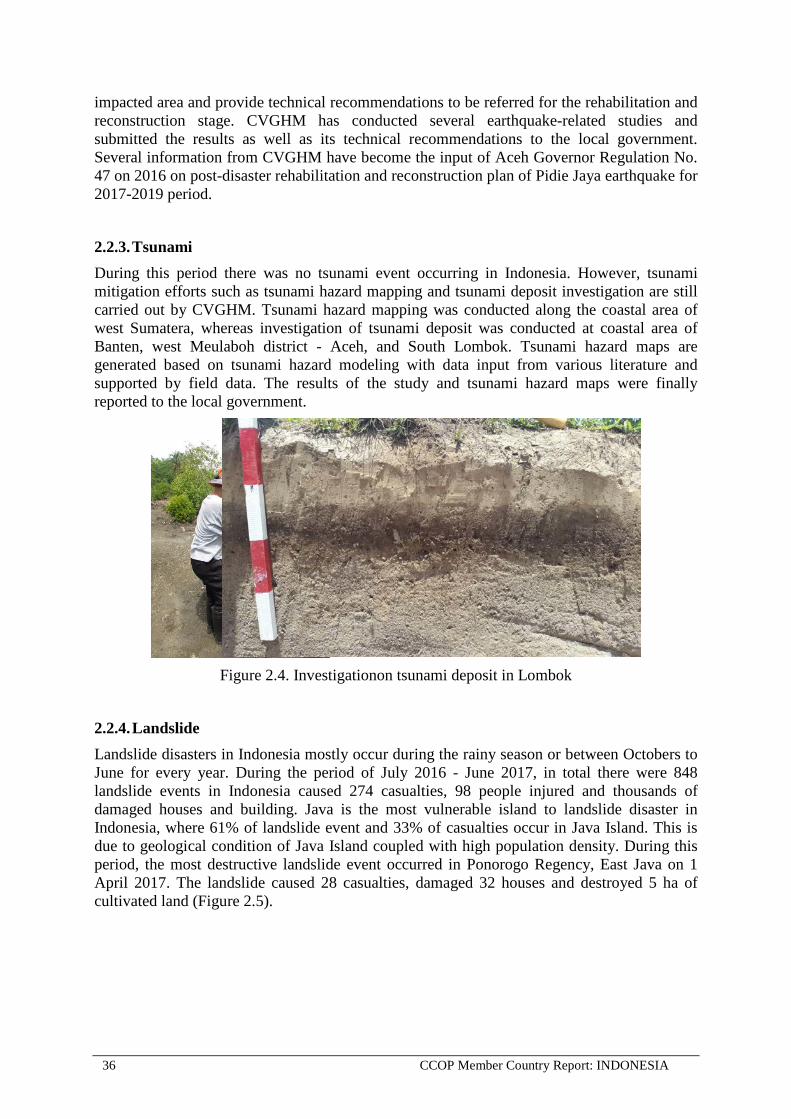
2.2.3. Tsunami During this period there was no tsunami event occurring in Indonesia. However, tsunami mitigation efforts such as tsunami hazard mapping and tsunami deposit investigation are still carried out by CVGHM. Tsunami hazard mapping was conducted along the coastal area of west Sumatera, whereas investigation of tsunami deposit was conducted at coastal area of Banten, west Meulaboh district - Aceh, and South Lombok. Tsunami hazard maps are generated based on tsunami hazard modeling with data input from various literature and supported by field data. The results of the study and tsunami hazard maps were finally reported to the local government.
Figure 2.4. Investigationon tsunami deposit in Lombok
2.2.4. Landslide Landslide disasters in Indonesia mostly occur during the rainy season or between Octobers to June for every year. During the period of July 2016 - June 2017, in total there were 848 landslide events in Indonesia caused 274 casualties, 98 people injured and thousands of damaged houses and building. Java is the most vulnerable island to landslide disaster in Indonesia, where 61% of landslide event and 33% of casualties occur in Java Island. This is due to geological condition of Java Island coupled with high population density. During this period, the most destructive landslide event occurred in Ponorogo Regency, East Java on 1 April 2017. The landslide caused 28 casualties, damaged 32 houses and destroyed 5 ha of cultivated land (Figure 2.5).

CCOP Member Country Report: INDONESIA 37
Figure 2.5. Debris avalanche in Ponorogo, East Java Province, on 1st April 2017
Figure 2.6. Landslide disaster event in Indonesia during the period July 2016 – June 2017
Figure 2.7. Casualties caused by landslide in Indonesia, July 2016 – June 2017

38 CCOP Member Country Report: INDONESIA
Program Contact Person: 1. Sri Hidayati
Center for Volcanology and Geological Hazard Mitigation Geological Agency of Indonesia Jl. Diponegoro No. 57 Bandung 40122, Indonesia Phone : +62-22-727606 Fax :+62-22-7202761 Mobile : +62-081391373669 Email : [email protected] or [email protected]
2. Akhmad Solikhin
Center for Volcanology and Geological Hazard Mitigation Geological Agency of Indonesia Jl. Diponegoro No. 57 Bandung 40122, Indonesia Mobile : +62 081320765402 Email : [email protected] or [email protected]
3. ENVIRONMENTAL PROGRAMME 3.1. Summary During the period of July 2016 to June 2017, the activity of environmental geology conducted to the Center of Groundwater Resources and Environmental Geology (CGREG), Geological Agency. The environmental geology activities cover environmental geology mapping for land use planning and regional development, environmental geology survey in water infiltration, geo-heritage inventory, karst inventory, medical geology, CCS (Carbon Capture Storage) research in Karst, and mud flow disaster monitoring.
3.2. Annual Review of Individual Technical Activities 3.2.1. Environmental Geological Survey
a. The environmental geological mapping for land use planning and regional development activities were done in the urban areas and autonomy regions that have high priority in their development. The activities resulted environmental geological maps and recommendation map for land use development. This activity has been carried out in regency/city of Kendal (Central Java), Medan (North Sumatera), Karo (North Sumatera).
b. Environmental geology survey in water infiltration was done in Cermai (West Java). This activity aims to defines the recharge zone due to land use change
c. Geo-heritage inventory was carried out in the regencies of Bojonegoro (Central Java), d. Karst inventory was done in the province of East Kalimantan, Central Sulawesi, East
Kalimantan – South Kalimantan, North Sumatera – Aceh, South Sulawesi, West Nusa Tenggara, East Nusa Tenggara, Bali, West java and East Java. This activity is done to define karst landscape and distinguish parts that need to be protected

CCOP Member Country Report: INDONESIA 39
e. CCS II (Carbon Capture Storage) research in Karst, a new subject of research that was done in Karst Gunung Sewu. This activity is research-based monitoring of carbon uptake, water discharge and infiltration in karst caves,
f. Mud flow disaster monitoring was done in Sidoarjo (East Java). This activity aims to see the changes of mudflow disaster after year 2006 in series, including debit , crack, subsidence, and blowout
3.2.2. Ministrial Regulation related Karst Conservation and Geo-heritage Area According Government Regulation No. 26/2008 that revise with No 13/2017 on National Spatial Planning, mentioned that Geological Heritage Area should be protected. Geological Agency evaluated and issued determination of Geoheritage Area, that is: Ministry Regulation on Geoheritage Area No 32/2016.
3.3. Proposed Future Activities Geological Agency evaluated Geoheritage in Bojonegoro Distric, Central Java Province , that will be declare as Geoheritage Conservation Area in the end of year 2017.
Programme Contact Person: Dita Arif Yuwana Center of Groundwater Resources and Environmental Geology Geological Agency of Indonesia Jl. Diponegoro No. 57 Bandung 40122, Indonesia Fax : +62-22-7206167 Phone : +62-22-7274705 Mobile : +62-81322222945 Email : [email protected]

40 CCOP Member Country Report: INDONESIA
GEO-INFORMATION SECTOR
1. DATA AND INFORMATION 1.1. Summary During the period of July 2016 to June 2017, the Geological Agency continued to develop geoscience database, publish and service geological data and information. The Geological Agencies activities in relation to Geo-information were:
• Updating some thematic maps to 1:100.000 and 1:50.000 Scale based on the new edition of Indonesia Topographic Map (Peta Rupabumi Indonesia).
• Supporting to the Government of Indonesia Economic Policy Package on Accelerating of One Map Policy
• Supporting to the CCOP Geoinformation Sharing Infrastucture for East Asia and Southeast Asia (GSi) Project.
• Development of Multiplatform Application for Geohazard Mitigation and Assessment in Indonesia.
• Publication Books, Journal and Maps.
1.2. Annual Review of Individual Technical Activities
• The Geological Agency of Indonesia fully supported One Map Policy through 10 thematic GIS map among 85 totally until 2019. The One Map Policy was originally intended to achieve good spatial planning governance, a geospatial information for the Acceleration and Expansion of Indonesia Economic Development. The 10 thematic maps consist of geological map, georesources (mineral, coal, geothermal) map, groundwater map, karst map, and geohazards (volcanoes, earthquake, tsunami, and landslide) maps.
Figure 1.1. One Map Policy Priority

CCOP Member Country Report: INDONESIA 41
• Updating map carried out to support One Map Policy for Geology, Karst, Geohazard, Groundwater, and Georesources Maps in Kalimantan based on the new edition of Indonesian Topographic Map (Peta Rupabumi Indonesia) on 2016, and also Sumatera, Sulawesi, Bali and Nusa Tenggara Island on 2017.
• Co-funded by the Geological Survey of Japan, AIST and the Geological Agency of Indonesia, the First International Workshop of the CCOP Geoinformation Sharing Infrastructure for East and Southeast Asia (GSi) Project was held on 20-22 September 2016 at Hotel Kusuma Sahid Prince, Solo, Indonesia. Forty-seven participants from the member countries (Cambodia, Indonesia, Japan, Republic of Korea, Lao PDR, Malaysia, Myanmar, Philippines, and Thailand) including the staff of the CCOP Technical Secretariat (CCOP TS) attended the workshop.
Figure 1.2. The GSi Activity on 20-22 September 2016 in Solo
All the CCOP member countries represented in the workshop gave a report on their preliminary 5-years data upload plan, name of national and data coordinators, progress of data upload and portal site, requests and suggestions on GSi project and country’s current status of Spatial Data Information System and extent of Geographic Information System usage. Discussion on the GSi system development, data policy, five years working plan, server preparation plan, system development team, collaboration among CCOP member countries, useful applications, data analysis, collaborations with other major projects was made.
• Center for Geological Survey, Geological Agency had been interpret the satellite image covering whole area of Indonesia to produce a systematic geological maps. This activity had been conducted for 6 (six) years during 2010-2016. The activity of interpretation have been produce 3774 sheets of 1:50.000 Geological Maps. This geological maps was launch in December 7th 2016 in Bandung and can be accessed through website as open geoinformation for public. This maps will be compiled with field data to enhance the quality of information. Some thematic maps on selected areas of Indonesia also published

42 CCOP Member Country Report: INDONESIA
by Center for Geological Survey in the end of 2016, consist of geomorphological, seismotectonic, and quaternary geology.
• The Geological Agency has publishing several publication such as: 1. Development And Applied of Volcanic Geology 2. Indonesian Journal on Geoscience (IJoG), international indexes, publish 3 issues per
year 3. Bulletin of Geological Resources, publish 3 issues per year 4. Journal of Geology and Mineral Resources, publish 4 issues per year 5. Geology, Quaternary, Geomorphology, Seismotectonic and Susceptibility to Landslide
Zone Maps updating some regions in Java, Sumatera and Sulawesi
Program Contact Person: 1. Ir. Hadianto
Geological Agency of Indonesia Jl. Diponegoro No. 57 Bandung 40122, Indonesi Phone : +62-21-7215297 Fax : +62-21-7216444 Mobile : +62-8156221524 Email : [email protected]
2. Sinung Baskoro
Center for Geological Survey Geological Agency of Indonesia Jl. Diponegoro No. 57 Bandung 40122, Indonesia Phone : +62-22-7203205-08 Fax : +62-22-7202669 Mobile : +62-81224490110 Email : [email protected]