Melbourne–Brisbane Inland Rail Alignment Study Working ...
78
ARTC Melbourne–Brisbane Inland Rail Alignment Study Working Paper No. 8 Preliminary Land Assessment
Transcript of Melbourne–Brisbane Inland Rail Alignment Study Working ...

ARTC Melbourne–Brisbane
Inland Rail Alignment Study
Working Paper No. 8 Preliminary Land Assessment


ARTC
Melbourne – Brisbane Inland Rail Alignment Study – Working Paper No. 8: Preliminary Land Assessment Page i
Important note This working paper is based on the outcome of Stage 1 of the study as reported in Working Paper No. 5. This concluded that a low capital cost scenario should be adopted for development and analysis in later stages of the study. This option included the use of existing lines, with some upgrading and possible deviations on the section between Narromine, the Werris Creek area and Narrabri. Accordingly this working paper includes an assessment of this section, as part of the Melbourne-Brisbane route. Towards the end of Stage 2 of the study, in the process of trying to identify an economically viable route, the ‘high capital cost’ scenario identified in Stage 1 was further assessed and optimised using additional information gained during Stage 2 activities. The outcome of the analysis was that this scenario, using a shorter route, was determined to offer a better economic result than the low capital cost option. This further analysis is reported in Working Paper No. 12, together with the conclusion that Stage 3 of the study should focus on the shorter route, which is identified as the ‘1690km Inland Rail’ scenario. As a result, the assessment reported in this working paper of the section of route between Narromine and Narrabri will be superseded by further work which will assess a more direct route between these two centres involving substantial new construction. This further assessment will be included in the final report of the study.

ARTC
Melbourne – Brisbane Inland Rail Alignment Study – Working Paper No. 8: Preliminary Land Assessment Page ii
Contents
Page Number
Glossary ................................................................................................................................................ iv
1. Introduction .................................................................................................................................... 1
1.1 Overview 1 1.2 Background to Melbourne-Brisbane Inland Rail 1 1.3 Study objectives, stages and working papers: 1 1.4 Roles of the Lead Technical Consultant (LTC) and the Financial and Economic Consultant (FEC) 3 1.5 Stage 1 analysis 3 1.6 Objectives of Working Paper No. 8 5
2. Land acquisition and valuation ...................................................................................................... 6
2.1 Land acquisition 6 2.2 Land valuation 7
2.2.1 Compensation for compulsory taking part of a property 7 2.2.2 Land valuation practices employed by other agencies 8
2.3 Review of previous land valuation work 9 2.3.1 Overview of land valuation method 9 2.3.2 Land valuation methodology 9 2.3.3 Route optimisation using land constraints 12
3. Approach to land assessment ..................................................................................................... 13
3.1 Identification of key issues 13 3.2 Discussion of land constraints 13
3.2.1 Land use 13 3.2.2 Land zoning 27 3.2.3 Alignment considerations 28
3.3 Opportunities 28
4. Assessment methodology ........................................................................................................... 30
4.1 Overview 30 4.2 Constraint mapping 30 4.3 Route section desktop assessment 30
4.3.1 Identification of opportunities 31
5. Assessment of land constraints of the route .............................................................................. 32
5.1 Overview of the inland route 32 5.2 Assessment of route – Melbourne to Parkes 32
5.2.1 Reference case 32 5.2.2 Deviations 34 5.2.3 Summary of issues and opportunities – Melbourne to Parkes 39
5.3 Assessment of route – Parkes to Moree 40 5.3.1 Reference case 40 5.3.2 Deviations 44 5.3.3 Summary of issues and opportunities – Parkes to Moree 54
5.4 Moree to Brisbane 57 5.4.1 Reference case 57 5.4.2 Deviations 60 5.4.3 Summary of issues and opportunities – Moree to Brisbane 64
6. Conclusion .................................................................................................................................... 68
6.1 Overview 68 6.2 Summary of key issues and opportunities 68
6.2.1 Key risk areas 68 6.2.2 Opportunities 68
6.3 Outline for Stage 3 assessment 69

ARTC
Melbourne – Brisbane Inland Rail Alignment Study – Working Paper No. 8: Preliminary Land Assessment Page iii
List of tables Table 1-1 Working papers 2 Table 3-1 Key land constraints and issues 13 Table 3-2: Land zoning 27 Table 5-1 Summary of issues and opportunities for Melbourne to Parkes 39 Table 5-2 Summary of issues and opportunities for Parkes to Moree 54 Table 5-3 Summary of issues and opportunities for Moree to Brisbane 65 List of figures Figure 1-1 Melbourne Brisbane inland rail corridor (Stage 2) 4 Figure 2-1 Case study route between Moree and Coonamble 10 Figure 2-2 Land use south-west of Moree 11 Figure 2-3 Landholding configuration south of Moree 11 Figure 3-1 Conservation areas, reserves and National Parks – Melbourne to Parkes 14 Figure 3-2 Conservation areas, reserves and National Parks – Parkes to Moree 15 Figure 3-3 Conservation areas, reserves and National Parks – Moree to Brisbane 16 Figure 3-4 Irrigation areas and drainage – Melbourne to Parkes 18 Figure 3-5 Irrigation areas and drainage – Parkes to Moree 19 Figure 3-6 Irrigation areas and drainage – Moree to Brisbane 20 Figure 3-7 Areas of water intensive agriculture – Melbourne to Brisbane 21 Figure 3-8 Areas of intensive crop cultivation – Melbourne to Brisbane 22 Figure 3-9 Coal, mineral and timber resources – Melbourne to Parkes 24 Figure 3-10 Coal, mineral and timber resources – Parkes to Moree 25 Figure 3-11 Coal, mineral and timber resources – Moree to Brisbane 26 Figure 5-1 Reference case and optional deviations between Melbourne and Parkes 33 Figure 5-2 Reference case and optional deviations between Parkes and Moree 41 Figure 5-3 Reference case and optional deviations between Moree and Brisbane 58 List of appendices Appendix A Zoning maps –Melbourne to Brisbane and regional centres

ARTC
Melbourne – Brisbane Inland Rail Alignment Study – Working Paper No. 8: Preliminary Land Assessment Page iv
Glossary ABS Australian Bureau of Statistics AC traction Alternating Current traction motors; used in newer diesel-electric locomotives ACCC Australian Competition and Consumer Commission alignment The exact positioning of track; may be compared with 'route', which gives only
a very general indication of the location of a railway ARA Australasian Railway Association area route For the purposes of the study, a route over an entire area, i.e. areas A, B, C or
D ARTC Australian Rail Track Corporation articulated wagons
Wagons comprising two or more units, with adjacent ends of individual units being supported on a common bogie and permanently coupled
AS 4292 Australian Standard for Railway Safety in six parts 1995-97 ATC Australian Transport Council ATEC Australian Transport and Energy Corridor Ltd ATMS Advanced Train Management System; communication-based safeworking
system currently being developed by ARTC ATSB Australian Transport Safety Bureau axle load The load transmitted to the track by two wheels of one axle of a bogie backhaul Returning wagons to a point where they can be used for their next assignment;
freight moving in the opposite direction to the main flow BAH Booz Allen Hamilton (now Booz & Co) bank engine locomotive used to assist a train on part of its journey, typically to climb a steep
grade; such grades are termed 'banks' in railway parlance BAU Business As Usual BCR Benefit-Cost Ratio BITRE Bureau of Infrastructure, Transport and Regional Economics (formerly BTRE
and BTE) bogie two axles and a sub-frame under each end of a wagon BOOT Build, Own, Operate, Transfer break of gauge Where a line of one track gauge meets a line of a different track gauge. broad gauge Railway track gauge of 1600 mm; used in Victoria except on interstate main
lines and some other lines BTE Bureau of Transport Economics; now the BITRE BTRE Bureau of Transport and Regional Economics; now the BITRE cant Difference in the height of two rails comprising the railway track; cant may also
be described as superelevation. It allows a train to travel through a curve at a speed higher than otherwise. Camber on the curve of a road has a similar function.
capex capital expenditure BCCBA Cost-Benefit-Cost Analysis CCM Capital cost model coastal route The existing rail route from Melbourne to Brisbane via Sydney corridor A strip of land with a width measured in kilometres that is suitable for a railway.
Study of a corridor leads to the identification of route options. CountryLink CountryLink is part of the Rail Corporation of New South Wales (RailCorp). It
operates passenger trains from Sydney to Melbourne, Sydney to Brisbane and to NSW regional centres.
CPI Consumer Price Index CSO Community Service Obligation DBFM Design, Build, Finance, Maintain DC Direct Current; form of electric traction DIRN Defined Interstate Rail Network

ARTC
Melbourne – Brisbane Inland Rail Alignment Study – Working Paper No. 8: Preliminary Land Assessment Page v
distributed locomotives
The practice of providing additional locomotive power within or at the rear of a train as well as in front.
DITRDLG Australian Government Department of Infrastructure, Transport, Regional Development and Local Government
DMU Diesel multiple-unit passenger train DORC Depreciated Optimised Replacement Cost double stacking
Placement of one intermodal freight container on top of another in a specially designed well-wagon
EBITDA Earnings before Interest, Tax, Depreciation and Amortisation EIA United States Energy Information Administration EIRR Economic Internal Rate of Return energy efficiency
Ratio of the transport task to the energy input; a measure of energy efficiency is tonne/km per MegaJoule (MJ)
energy intensity
Ratio of energy input to transport task; the inverse of energy efficiency; a measure of energy intensity is MJ/net tonne/km
FEC Financial and Economic Consultant for the Melbourne-Brisbane Inland Rail Alignment Study, i.e. PricewaterhouseCoopers with ACIL Tasman and SAHA
five-pack wagon
Five wagons operated as one, either through being permanently coupled or the use of articulation
fuel consumption
Measured in litres per gross tonne kilometre (litres/gtk) or sometimes litres per 1,000 gross tonne kilometre (litres/1,000 gtk); sometimes net tonnes are used instead of gross tonnes
GATR Great Australian Trunk Rail System GDP Gross Domestic Product GIS Geographic Information System gross Total mass of a wagon and its payload GST Goods and Services Tax gtk Gross tonne kilometres; a standard measure of track usage; the gross weight
of a train multiplied by kilometres travelled. hr hour IA Infrastructure Australia IEA International Energy Agency IGA Intergovernmental Agreement (1997) between the Commonwealth, NSW,
Victoria, Queensland, Western Australia and South Australia which led to the establishment of ARTC
IPART NSW Independent Pricing and Regulatory Tribunal IRR Internal Rate of Return kg kilogram(s) kg/m kilograms per metre km kilometre(s) km/h kilometres per hour kW kilowatt, a unit of power L Litre(s) L/gtk*1000 Fuel consumption expressed in litres per gross tonne kilometre x 1000 land-bridging Replacement of sea transport with land transport between two sea ports, e.g.
between Brisbane and Melbourne. LEP Local Environmental Plan Line sector In the context of the study, a length of line connecting two nodal points. loading gauge the maximum permissible height and width dimensions for a rail vehicle and its
load; see structure gauge LTC Lead Technical Consultant for the Melbourne-Brisbane Inland Rail Alignment
Study, i.e. Parsons Brinckerhoff with Connell Wagner and Halcrow mass The mass of an object is measured in kilograms; mass and weight are used
interchangeably in the study M-B Melbourne-Brisbane

ARTC
Melbourne – Brisbane Inland Rail Alignment Study – Working Paper No. 8: Preliminary Land Assessment Page vi
MIMS Maintenance Integrated Management System MJ MegaJoule: a unit of both energy and work mm millimetre(s) MPM Major Periodic Maintenance; planned maintenance on infrastructure assets at
intervals of more than once a year. mt million tonnes mt pa million tonnes per annum narrow gauge Railway track gauge of 1067 mm; used in Queensland except on the interstate
line from Sydney to Brisbane NCOP National Code of Practice node In the context of the study, a point at which alternative routes diverge. NPV Net Present Value NPVI Ratio of Net Present Value to Investment Costs (i.e. capital costs) NSRCS North-South Rail Corridor Study completed in 2006 NSW New South Wales ntk net tonne kilometres; the payload of a train multiplied by kilometres travelled opex operating expenses payload Weight of products and containers carried on wagons PB Parsons Brinckerhoff, Lead Technical Consultant PwC PricewaterhouseCoopers, Financial and Economic Consultant Qld Queensland QR Queensland Rail, a corporation owned by the Queensland Government RailCorp RailCorp (Rail Corporation of NSW); owns rail track in the Greater Sydney
region, operates passenger trains in that region, [delete comma] and (under the name Countrylink) to Melbourne and Brisbane and regional NSW.
RAMS Rail Access Management System; manages and records access to ARTC track; RAMS is licensed to other track owners.
RCRM Routine Corrective and Reactive Maintenance; comprises maintenance, inspections and unplanned minor maintenance that is carried out annually or at more frequent cycles
Reference train A notional train specification used in developing the Inland Rail Alignment RIC Rail Infrastructure Corporation, NSW, owner of NSW rail network other than
metropolitan sections owned by RailCorp. Interstate track and certain other sections are leased to ARTC.
RL Stands for reduced level in surveying terminology; elevation relative to a specific datum point
RoA Return on Assets route In the context of the study, primary description of the path which a railway will
follow. RTA Roads and Traffic Authority - various states SA South Australia safeworking Signalling system and associated rules that keep trains a safe distance apart SKM Sinclair Knight Merz SNP Short North Project; capacity increases for freight currently being planned for
the railway between Strathfield and Broadmeadow; 'short north' refers to the railway between Sydney and Newcastle.
SPV Special Purpose Vehicle established for the development and/or the operation of a project.
SSFL Southern Sydney Freight Line; independent track for use by freight trains between Macarthur and Chullora, currently under construction
standard gauge
Railway track gauge of 1435 mm; used on the ARTC network and for the NSW railway system
structure gauge
Specification for the position of structures such as overhead bridges, tunnels, platform, etc, relative to a railway track, to allow adequate clearance for the passage of trains.
superfreighter Term used to describe high-priority intermodal freight trains.

ARTC
Melbourne – Brisbane Inland Rail Alignment Study – Working Paper No. 8: Preliminary Land Assessment Page vii
tal tonnes axle load tare Weight of an empty wagon TCI Track Condition Index; TCI is an indicator of the condition of track by
compilation of a number of measures of its geometry TEU Twenty-foot Equivalent Unit, the standard unit measure of shipping container
size t pa tonnes per annum train kilometre A standard measure of track usage; number of trains multiplied by the total
kilometres travelled TSR Temporary Speed Restriction TTM Train Transit Manager Vic Victoria VicTrack VicTrack, owner of Victoria’s rail network; interstate track and certain other
lines are leased to ARTC VOC Vehicle Operating Cost WA Western Australia well-wagon A wagon where the central loading deck is lower than the bogies at either end,
to allow higher loads to be carried within the loading gauge WP Working Paper WTT Working Timetable

ARTC
Melbourne – Brisbane Inland Rail Alignment Study – Working Paper No. 8: Preliminary Land Assessment Page 1
1. Introduction 1.1 Overview
In March 2008 the Australian Government announced that the Australian Rail Track Corporation (ARTC) had been asked to conduct the Melbourne-Brisbane Inland Rail Alignment Study.
The announcement stated that in developing a detailed route alignment, the ARTC would generally follow the far western sub-corridor identified by the previous North-South Rail Corridor Study. This study, completed in June 2006, established the broad parameters for a potential future inland rail corridor between Melbourne and Brisbane.
1.2 Background to Melbourne-Brisbane Inland Rail The railways of NSW, Victoria and Queensland date from the 19th century. They were constructed using different gauges and developed for differing purposes. At present, the only north-south rail corridor in eastern Australia runs through Sydney. North of Sydney the railway runs fairly close to the coast. For that reason, the existing Melbourne-Brisbane line is referred to as the coastal route throughout this working paper.
In September 2005 the Australian Government commissioned the North-South Rail Corridor Study. The study undertook a high level analysis of various corridors and routes that had been proposed for an inland freight railway between Melbourne and Brisbane.
In its March 2008 announcement the Government stated that the Melbourne-Brisbane Inland Rail Alignment Study would build on previous work by undertaking a more detailed engineering, land corridor and environmental assessment, to allow scoping of the project’s capital cost. In the announcement, the Minister for Infrastructure, Transport, Regional Development and Local Government requested a customer focused and consultative study involving consultations with state governments, industry, local governments and major rail customers.
1.3 Study objectives, stages and working papers: The objectives of the Melbourne-Brisbane Inland Rail Alignment Study (the study) are to determine:
the optimum alignment of the inland railway, taking into account user requirements and the economic, engineering, statutory planning and environmental constraints. The alignment will be sufficiently proven up so it can be quickly taken through the statutory planning and approval process and into the detailed engineering design and construction, should a decision be taken to proceed;
the likely order of construction costs +/-20%;
the likely order of below-rail (infrastructure) operating and maintenance costs;
above-rail operational benefits;
the level and degree of certainty of market take up of the alignment;
a project development and delivery timetable; and
a basis for evaluating the level of private sector support for the project.

ARTC
Melbourne – Brisbane Inland Rail Alignment Study – Working Paper No. 8: Preliminary Land Assessment Page 2
The study is being carried out in three stages, as follows:
Stage 1 – Determination of the route for further analysis;
Stage 2 – Engineering, environmental and land base analysis;
Stage 3 – Development of the preferred alignment.
A series of working papers is being produced within each stage. A list of the planned working papers follows.
Table 1-1 Working papers
Stage Working paper Lead Responsibility
Stage 1 WP1 Demand and Volume Analysis FEC
WP2 Review of Route Options LTC
WP3 Stage 1 Capital Works Costings LTC
WP4 Preliminary Operating and Maintenance Cost Analysis LTC
WP5 Stage 1 Economic and Financial Assessment and Identification of the Route for Further Analysis FEC
Stage 2 WP6 Design Standards LTC
WP7 Preliminary Environmental Assessment LTC
WP8 Preliminary Land Assessment LTC
WP10 Development of Route LTC
WP11 Stage 2 Capital Works Costings LTC
WP12 Stage 2 Economic and Financial Analysis FEC
Stage 3 WP9 Engineering Data Collection LTC
WP13 Preferred Alignments Environmental Assessment LTC
WP14 Preferred Alignments Land Assessment LTC
WP15 Refinement of Preferred Alignments LTC
WP16 Stage 3 Capital Works Costing LTC
WP17 Delivery Program LTC
WP18 Economic and Financial Assessment FEC
WP19 Policy Issues, Options and Delivery Strategies FEC
Note that the list of working papers has been revised since the completion of Stage 1 of the study. Some working papers have been re-titled and/or re-scheduled. In addition, the working papers listed as outputs of Stage 3 will appear as sections or appendices within an integrated final report of the study rather than being published as standalone documents.

ARTC
Melbourne – Brisbane Inland Rail Alignment Study – Working Paper No. 8: Preliminary Land Assessment Page 3
1.4 Roles of the Lead Technical Consultant (LTC) and the Financial and Economic Consultant (FEC) The study’s activities are headed by two lead consultants whose activities are coordinated by ARTC.
The Lead Technical Consultant is responsible for engineering and environmental work and associated activities, including railway operational analysis. The Financial and Economic Consultant is responsible for financial and economic analysis. The two consultants work jointly and collaboratively with each other.
The Lead Technical Consultant (LTC) is Parsons Brinckerhoff (PB) and the Financial and Economic Consultant (FEC) is PricewaterhouseCoopers (PwC). Each consultant acts independently and each has a lead responsibility for specific working papers. Whilst this occurs the other consultant plays a support role for that particular working paper.
Parsons Brinckerhoff has engaged Halcrow to support it in alignment development, operations and maintenance costing and Aurecon to support it in engineering and alignment development. Aurecon has in turn engaged Currie and Brown to assist in capital costing.
PricewaterhouseCoopers has engaged ACILTasman to undertake volume and demand analysis and support it in economic review, and SAHA for peer review.
1.5 Stage 1 analysis Stage 1 analysed numerous routes within the study area in order to determine the route to be analysed in Stage 2 (see Working Paper No. 5 Stage 1 Economic and Financial Analysis and the Identification of the Route for Further Analysis).
The route follows existing rail lines from Melbourne via Albury to Cootamundra, Parkes, Narromine, Dubbo, Werris Creek and Moree to North Star near Goondiwindi; with new construction from North Star to Brisbane via Toowoomba. North of Parkes the railway would require parts of the existing route to be upgraded, including minor deviations to improve its alignment.
The analysis retained a number of options for further analysis in Stage 2 of the study; including possible routes between Junee and Stockinbingal, Premer and Emerald Hill avoiding Werris Creek, North Star and Yelarbon near Inglewood, and in the vicinity of Toowoomba.
The route for further analysis is shown in the map below.
Stage 2 will conduct engineering, environmental and land baseline analysis of the route sections within the area shown to identify the route for refinement in Stage 3.

ARTC
Melbourne – Brisbane Inland Rail Alignment Study – Working Paper No. 8: Preliminary Land Assessment Page 4
Figure 1-1 Melbourne Brisbane inland rail corridor (Stage 2)

ARTC
Melbourne – Brisbane Inland Rail Alignment Study – Working Paper No. 8: Preliminary Land Assessment Page 5
1.6 Objectives of Working Paper No. 8 The objective of this working paper is to identify significant land considerations along the route as an input to the alignment identification process. This focuses on key land zoning and land use constraints along the inland route, thereby assisting the selection of an alignment for further analysis in Stage 3.
Land use and zoning constraints will be mapped on constraints maps. Opportunities to avoid land use constraints will be identified such as:
high value land (e.g. irrigation areas);
resource sterilisation;
impacts on land zoning e.g. residential, environmental protection;
use of road reserves;
minimising severance;
ensuring that property, stock and farm machinery access is not overly restricted.

ARTC
Melbourne – Brisbane Inland Rail Alignment Study – Working Paper No. 8: Preliminary Land Assessment Page 6
2. Land acquisition and valuation 2.1 Land acquisition
The project will traverse a number of private and publically owned properties. Acquisition of parts or all these properties will ultimately be required for the construction of the project. The acquisition of these properties can be undertaken in the following ways:
Consultation with land owners to agree on a sale price and subsequent purchase of these properties; and
Use of state legislation to permit the compulsory acquisition of properties.
Consultation and negotiation with land owners is currently considered best practice for the acquisition of land in Australia. It is recommended that a sale price be established with land owners prior to acquisition occurring. Notwithstanding this, legislation exists in all states that allows for the compulsory acquisition of properties by a government agency. However compulsory acquisition can create social and economic problems.
This section of the working paper provides a brief outline of the compulsory land acquisition process for each of the states where land acquisition would be required, that is, Queensland and NSW.
Queensland In Queensland, land acquisition can occur either by agreement or through a compulsorily process. Compulsory acquisition (sometimes referred to as resumption) may be undertaken by an authority in accordance with a number of Acts. The key legislation for implementing and managing the acquisition of land are:
Acquisition of Land Act 1967 – provides for the acquisition of freehold land;
Land Act 1994 (and various other Acts) – provides for the acquisition of state leasehold land;
The Acquisition of Land Act 1967 - operates in conjunction with the State Development and Public Works Organisation Act 1971.
These Acts provide a framework for the acquisition of land within Queensland. As with the NSW Land Acquisition (Just Terms and Compensation) Act 1991, the objective of the Act is to ensure that land owners are adequately compensated if their land is compulsorily acquired.
The purposes for which land can be acquired are identified in the schedule of the Acquisition of Land Act 1967. Part 1 of this schedule identifies that ‘purposes for taking land’ include ‘purposes relating to transportation’, in particular railways and related purposes.
Under the State Development and Public Works Organisation Act 1971, the Queensland Governor-in-Council is able to declare any part of the state a State Development Area (SDA) if the project is considered to be in the public interest. An SDA does not change the ownership of the land within the declared area. However, under this process the Queensland Government, through the Coordinator-General, may acquire land and/or easements (by agreement or compulsorily) within a State Development Area for purposes that can include the establishment of industry, essential services and infrastructure corridors. With respect to valuation, Part 4 of the Acquisition of Land Act 1967 identifies the relevant legislation and framework for adequate compensation.

ARTC
Melbourne – Brisbane Inland Rail Alignment Study – Working Paper No. 8: Preliminary Land Assessment Page 7
New South Wales Compulsory acquisition in NSW may be carried out by an authority of the state in accordance with the Land Acquisition (Just Terms and Compensation) Act 1991. The Act provides a framework for the acquisition of all land within NSW including both land owned by the Crown (in accordance with the Crown Lands Act 1993) and Native Title land (as defined Commonwealth Native Title Act 1993). The objective of the Act is to ensure that the land owner is adequately compensated either through receipt of money or in some cases goods and services when acquisition occurs.
As discussed above, it is considered best practice to avoid the compulsory acquisition process and to reach agreement with affected landowners. Notwithstanding this, the project may involve compulsory acquisition of land owned privately or by the Crown. There is also the potential for the compulsory acquisition of Native Title land as part of the project.
Commonwealth The acquisition and disposal of any interest in property by the Commonwealth is conducted predominantly under the Lands Acquisition Act 1989 and the Lands Acquisition Regulations 1989. Under this Act, property may be acquired through three principle methods. These methods are:
by negotiated agreement;
by compulsory acquisition; or
by purchase of property available in the open market (i.e. commercial transactions).
Standard commercial property transactions represent approximately 90% of all Commonwealth land transactions. These transactions are predominantly dealt with under delegated authority of the Minister of Finance and Deregulation (under section 139 of the Act). No special process is involved with this type of commercial transaction, although such transactions still require authorisation under the Act.
Where land is acquired in a compulsory manner, the Minister must personally authorise the transaction and manage appropriate compensation. The Minister is also involved in approve a limited range of other commercial transactions including situations where there are intricacies or specific issues with ownership interests or where overseas leasing is involved.
2.2 Land valuation
2.2.1 Compensation for compulsory taking part of a property Whilst the purchase price for the acquisition of whole properties is based on the current market value of the entire property, the Courts have decided over many years that compensation for the taking of a portion of a property is the difference in value of the property before and after land acquisition.
Using this method for determining land acquisition prices, it is considered that the per hectare acquisition cost of land for the rail corridor will generally be worked out based on an unaffected property’s per hectare land value once compensation was taken into account. The amount can be up to 200%, and as much as 400%, of the value per hectare of the ‘before’ market value of the property, based on recent examples of acquisition of land in Queensland for the Tarong to Surat railway (Hudson, 20081).
1 Trevor Hudson & Associates (2008) “ARTC Melbourne to Brisbane Inland Rail Study - Discussion Paper 20 November 2008” (unpublished).

ARTC
Melbourne – Brisbane Inland Rail Alignment Study – Working Paper No. 8: Preliminary Land Assessment Page 8
The market value of a property, i.e. the ‘before cost’ is generally based on the size of the land holding, land use, relative productivity and the level of improvements (e.g. houses, sheds, dams, fencing, irrigation infrastructure, etc), as well as and broader considerations such as geography and topography.
The difference between the ‘before’ value per hectare and the acquisition cost per hectare is due to compensation depending on the alignment of the rail corridor through the property and any impacts that may have on the property. These can include loss of productive lands, loss of income potential, effect on residential amenity, extent of severance of the property and/or the operational land holding that may be an aggregation of non-contiguous lands.
More often than not, the Courts have decided it is fair and reasonable to consider how acquisition may result in the creation of non-contiguous lands in the same ownership or the effect that acquisition may have on other land in different ownership. This can be an important consideration where it can be demonstrated that the land to be acquired forms an integral part of an operational holding.
Limiting the number of private occupational at-grade railway crossings to preserve the operational integrity of the railway could also affect the acquisition cost of land. This can also result in indirect costs being incurred through the need to provide additional access or crossings in alternative locations.
Overall, payment of fair and reasonable compensation for the compulsory acquisition of land under ‘Just Terms’ legislation requires that consideration be given to both the market value of land and ‘value to Owner’.
2.2.2 Land valuation practices employed by other agencies
The NSW Roads and Traffic Authority (RTA) acquires privately owned land under the terms of The Roads Act, 1993. Property acquisition can be done by negotiation and private treaty sale or through a compulsory acquisition process. The RTA follows the Land Acquisition (Just Terms Compensation) Act 1991 which encourages the use of negotiation instead of compulsory acquisition process.
A ‘programmed acquisition’ describes the process of land purchase initiated by the RTA. Payments for acquired land are assessed in accordance with the Land Acquisition (Just Terms) Act, 1991. Mutually acceptable property values may require the owner to engage their own valuer. The cost for a valuation report from a registered valuer may be reimbursed by the RTA, up to a designated amount.
The RTA will normally compensate property owners for the loss of a business or loss in value to a business if the loss is caused by an RTA programmed acquisition. The acquisition of farms on the inland rail alignment may be compared with the process followed by the RTA in relation to a loss of business procedures.
If the RTA proceeds with total acquisition of a property, improvements on the property will be considered. The RTA will pay the ‘market value’ of the property, which is the price of the property had it not been affected by the future road project.
For partial property acquisition, the RTA generally assesses the payment amount based on a ‘before and after’ method. Two separate valuations are performed concurrently. The ‘before’ valuation includes the property’s value had it not been affected by the new road project. The ‘after’ valuation is based on the value of the remaining land assuming road project construction and operation. The payment for partial acquisition is the difference between the ‘before’ and ‘after’ valuations. The RTA also performs property adjustments

ARTC
Melbourne – Brisbane Inland Rail Alignment Study – Working Paper No. 8: Preliminary Land Assessment Page 9
including relocation of services or public utilities, or fences required because of the partial acquisition.
In relation to Inland Rail, partial acquisition of farm land will require the consideration of loss of land productivity arising from severance, reduced access arrangements or other adverse effects on the operation of a property or properties.
2.3 Review of previous land valuation work
2.3.1 Overview of land valuation method A Land Valuation Assessment was undertaken by Trevor Hudson & Associates on behalf of the LTC as part of the Melbourne-Brisbane Inland Rail Alignment Study.
The purpose of the assessment was to assess the variability in land acquisition costs for two similar indicative alignment options by applying the ‘before and after’ valuation approach (refer Section 2.1.1) that is considered necessary when determining acquisition cost and the value of structures, improvements and water entitlements held by a landowner.
2.3.2 Land valuation methodology
The assessment comprised a case study that compared two indicative routes between Coonamble and Moree and further assessment of four selected corridors along the Melbourne to Brisbane route.
The method used for applying assessed land values along the indicative routes was to derive a purchase price per hectare for distinct land uses. The per purchase price hectare was based on compensation for taking part of a property by comparing the before and after value of the property.
The method used considered the loss of total value of the property, taking into account:
Size of affected land holding;
Land use and impact to productive land;
Affect upon residential amenity;
Severance of the subject land holding;
Compensation for impacts to improvements, e.g. irrigation infrastructure.

ARTC
Melbourne – Brisbane Inland Rail Alignment Study – Working Paper No. 8: Preliminary Land Assessment Page 10
Figure 2-1 Case study route between Moree and Coonamble
Sales analysis Data relating to recent land sales was collected for relevant local government areas. The collected and collated sales and valuation/rating data were imported into a MapInfo database containing the rail corridor alignments together with the Digital Cadastral Database within approximately 30 km of each alignment.
Analysis of sales evidence allowed identification of any ‘splitting’ of property sales across local government boundaries and/or being subject to different land uses and/or occupations. The sales data were then further analysed using MapInfo through creating thematic maps based upon various ranges of land size, sale price (and date), ownership and land use.
Land use analysis An aerial imagery overlay was incorporated into the MapInfo system to allow desktop assessment of land use and likely types of structures and land improvements. This information was classified as follows:
Lands within town environs with possible higher use capability;
Small farms or larger rural residential sites;
Irrigation properties separated into:
Medium-size properties with river and or bore water supply;
larger broad-acre properties with river or bore water supply; and/or
overland water harvesting with onsite irrigation water storage and channel reticulation;
Non-irrigated cultivation lands separated according to size and land quality;
Properties with mixed grazing and cultivation pursuits separated by size and land quality;

ARTC
Melbourne – Brisbane Inland Rail Alignment Study – Working Paper No. 8: Preliminary Land Assessment Page 11
Grazing properties separated by size and land quality, and degree of timber treatment;
Predominantly timbered lands.
Figure 2-2 and Figure 2-3 show the approximate extent of irrigated lands and landholding configuration respectively of a section of the two case study alignments.
Figure 2-2 Land use south-west of Moree
Figure 2-3 Landholding configuration south of Moree
Figure 2-2 shows the proliferation of major irrigation water storage tanks that form only part of the irrigation improvements upon these properties. Figure 2-3 shows the landholdings, as units. However the chart does not take into account the possibility of ‘family’ operational units, and/or, the non-contiguous holdings.
The case study routes were apportioned approximately by land use, and the total land value for each alignment was calculated based on indicative per hectare purchase prices for the various forms of land use along the alignment (using a 50 m corridor).

ARTC
Melbourne – Brisbane Inland Rail Alignment Study – Working Paper No. 8: Preliminary Land Assessment Page 12
2.3.3 Route optimisation using land constraints
The key finding of the land valuation assessment case study was that land acquisition costs varied significantly between the two case study alignments, largely due to land use. As an example of how land use can affect the cost model, the case study indicated that cultivated lands with irrigation improvements would be more expensive to acquire than non-irrigated cultivated lands, which would in turn be more expensive to acquire than grazing lands. In addition, factors such as property severance, restriction of access to properties and between severed land parcels and depreciation of infrastructure would influence land acquisition costs.
The findings of the land valuation assessment will be used to assist in the development of the preferred alignment through Stage 3 of the study by optimising alignments based on the following potential land use constraints and opportunities:
Avoidance of high cost land uses such as cultivated land with irrigation improvements;
Minimising severance of properties where practical;
Minimising access restrictions to or across, properties.
By considering these constraints and opportunities during route optimisation, potential property impacts may be minimised and overall land acquisition costs reduced.
Additional considerations that would assist land valuation in the determination of overall property acquisition costs would include identification of:
Scope for possible minor variations in corridor alignment to reduce the impacts of severance and where possible the number of affected properties;
Environmental and other ‘risk areas’ as defined by state and Commonwealth legislation such as the NSW State Environmental Planning Policy (Infrastructure) 2007, the Environmental Protection Biodiversity Conservation Act and the more restrictive aspects of National Parks, Forests, Native Title;
The potential for loss of amenity to towns or other settlements that could delay or prevent securing statutory approvals or licences for a proposed alignment;
Properties for possible total acquisition if it is considered that the project will be forced to provide offset vegetated lands to allow destruction of vegetation within the rail corridor.

ARTC
Melbourne – Brisbane Inland Rail Alignment Study – Working Paper No. 8: Preliminary Land Assessment Page 13
3. Approach to land assessment 3.1 Identification of key issues
The land constraints that have been assessed at the route option level are provided in Table 3-1.
Table 3-1 Key land constraints and issues
Aspect Key land issues
Land-use / tenure Conservation / recreation Residential (residential, townships, industrial) Agriculture (cultivation, grazing, hobby farms) Resources (State Forests, mining)
Zoning Residential / townships Environmental protection (see Working Paper No. 7)
Alignment considerations
Severance Family / group holdings Property access (internal and external) Travelling stock routes Crown land / road reserve
3.2 Discussion of land constraints
3.2.1 Land use Land use defines the way in which property owners, residents or the public use the land. Land use is an important factor when considering the environmental impact of Inland Rail. Land use will determine the severity of constraints such as approvals, severance, access and acquisition. For the purpose of this working paper land use has been broadly divided into four categories.
Conservation/recreation Lands reserved for conservation and recreation purposes are preserved for the conservation of flora and/or fauna or open space to be used by the public for recreational purposes such as swimming, organised sports, etc. As these land uses are vital for the sustainability of flora and fauna as well as communities, new alignments should avoid these land uses where possible. Conservation and recreation areas are shown in Figures 3-1, 3-2 and 3-3.

ARTC
Melbourne – Brisbane Inland Rail Alignment Study – Working Paper No. 8: Preliminary Land Assessment Page 14
Figure 3-1 Conservation areas, reserves and National Parks – Melbourne to Parkes

ARTC
Melbourne – Brisbane Inland Rail Alignment Study – Working Paper No. 8: Preliminary Land Assessment Page 15
Figure 3-2 Conservation areas, reserves and National Parks – Parkes to Moree

ARTC
Melbourne – Brisbane Inland Rail Alignment Study – Working Paper No. 8: Preliminary Land Assessment Page 16
Figure 3-3 Conservation areas, reserves and National Parks – Moree to Brisbane

ARTC
Melbourne – Brisbane Inland Rail Alignment Study – Working Paper No. 8: Preliminary Land Assessment Page 17
Residential and urban areas This form of land use focuses on the residential town centre and associated community and industrial regions. These regions provide focal points for residents to enable living, gathering and working. New alignments should avoid these regions wherever possible.
Agriculture Agriculture refers to the production of food or goods through farming. A variety of agricultural land uses exist, focussing on two main categories: herding of livestock such as cattle and sheep on grazing land and cultivation of crops on arable land.
The type of cultivated product produced from each individual parcel of land could not be determined. Estimates were made based on data concerning the production of various commodities by individual Statistical Local Area (SLA) collected by the Australian Bureau of Statistics. SLAs approximately correspond with Local Government Areas (LGAs). While each individual parcel of cultivated land will not produce these items, a broad generalisation of the type of commodity that may be produced can be made.
Arable land may be further divided into areas of high irrigation and water allocation and those areas without surplus water availability. Land with irrigation infrastructure will be more expensive to acquire and therefore serves as a high level constraint when determining alignment.
Agricultural lands also include hobby farms that are generally small farms not owned or maintained for the purpose of supporting the owner. Figures 3-4, 3-5 and 3-6 show areas of irrigation and drainage along the inland route. Figure 3-7 shows areas of high production of water intensive agriculture (e.g. cotton and rice) and Figure 3-8 shows areas of high production of intensive crop cultivation (e.g. nuts, citrus, grapes and stone fruit).

ARTC
Melbourne – Brisbane Inland Rail Alignment Study – Working Paper No. 8: Preliminary Land Assessment Page 18
Figure 3-4 Irrigation areas and drainage – Melbourne to Parkes

ARTC
Melbourne – Brisbane Inland Rail Alignment Study – Working Paper No. 8: Preliminary Land Assessment Page 19
Figure 3-5 Irrigation areas and drainage – Parkes to Moree

ARTC
Melbourne – Brisbane Inland Rail Alignment Study – Working Paper No. 8: Preliminary Land Assessment Page 20
Figure 3-6 Irrigation areas and drainage – Moree to Brisbane

ARTC
Melbourne – Brisbane Inland Rail Alignment Study – Working Paper No. 8: Preliminary Land Assessment Page 21
Figure 3-7 Areas of water intensive agriculture – Melbourne to Brisbane

ARTC
Melbourne – Brisbane Inland Rail Alignment Study – Working Paper No. 8: Preliminary Land Assessment Page 22
Figure 3-8 Areas of intensive crop cultivation – Melbourne to Brisbane

ARTC
Melbourne – Brisbane Inland Rail Alignment Study – Working Paper No. 8: Preliminary Land Assessment Page 23
Resources / Mineral extraction This type of land use includes State Forests and mining licenses that allow resources to be harvested from the land. These regions represent high financial production. Acquisition of these lands may prove to be excessively costly.
State Forests in NSW are managed by Forests NSW, a public trading enterprise within NSW Department of Primary Industries. In Queensland, forestry is under the Department of Employment, Economic Development & Innovation Primary Industries and Fisheries.
Exploration and mining activities in NSW are conducted on titles issued and administered by the state government. The Queensland system for mining titles is generally similar to the NSW system with an additional level of title between the exploration permit and mining claim, called a mineral development licence. This licence allows the holder to undertake further testing to determine the economic potential of existing minerals.
Exploration licences allow the holder to search for economic deposits of minerals beneath the earth’s surface. Exploration activity is usually short term, approximately between 2 and 5 years. Constraints associated with mining exploration may include existing or planned bore holes, potential sterilisation of resources and agreements or compensation with leaseholders.
Mining leases allow the leaseholder to mine for specific minerals during a defined tenure (generally 20 years) over a select area of land. Additional constraints exist with mining licences in addition to those associated with exploration leases. Mining activities may include open cut or underground mining. These activities may act as physical constraints independently, though underground mining may also cause geotechnical instabilities with concomitant subsidence effects, potentially destabilising the rail alignment. Mining leases are sought for those areas believed to have economically viable resources and are likely to present a higher level of constraint than exploration licences.
Resource harvesting and mineral extraction may however benefit from the existence of a freight railway in the near vicinity of production. Inland Rail may provide a convenient and economic means of transport for these resources.
Figures 3-9, 3-10 and 3-11 show areas of natural resources (e.g. mining leases/titles and state forests) along the inland route.

ARTC
Melbourne – Brisbane Inland Rail Alignment Study – Working Paper No. 8: Preliminary Land Assessment Page 24
Figure 3-9 Coal, mineral and timber resources – Melbourne to Parkes

ARTC
Melbourne – Brisbane Inland Rail Alignment Study – Working Paper No. 8: Preliminary Land Assessment Page 25
Figure 3-10 Coal, mineral and timber resources – Parkes to Moree

ARTC
Melbourne – Brisbane Inland Rail Alignment Study – Working Paper No. 8: Preliminary Land Assessment Page 26
Figure 3-11 Coal, mineral and timber resources – Moree to Brisbane

ARTC
Melbourne – Brisbane Inland Rail Alignment Study – Working Paper No. 8: Preliminary Land Assessment Page 27
3.2.2 Land zoning Land zoning regulates the kinds of activities that may occur in certain areas. Land acquisition for rail will be restricted to specific types of land zones. Residential areas and environmentally protected areas, in particular, should be avoided where possible. Land zones and the level of constraint are summarised in Table 3-2.
Table 3-2: Land zoning
Types of Zoning
Objectives Comment Level of Constraint
Rural Provide for a range of general and intensive agricultural and primary industry.
Depending on land use, fewer constraints through rural zones than through other land zones.
Low
Residential Provide for residential development, facilities or services for the community.
Alignment through residential zones would generally involve significant social / community impacts.
High
Commercial Encourage development of a compatible variety of retail, business centre, commercial, bulky goods retailing and manufacturing industry uses.
Alignment through commercial zones may involve economic and community impacts.
Medium
Industrial Encourage development of a mix of warehouse uses and light, medium and heavy industry land uses sufficiently distanced from sensitive uses.
Alignment through industrial zones may involve economic and community impacts.
Medium
Special uses Recognise public lands for roads, railways, public utilities, community infrastructure, etc. or land uses not provided for in other identified zones.
Depending on existing and designated land use, fewer constraints through this zone than through other land zones.
Medium
Open spaces Recognise areas for public recreation and open space.
Depending on existing and designated land use, fewer constraints through this zone than through other land zones.
Low
Environment protection
Protect and conserve the natural environment and processes for reasons of historic, scientific, landscape, habitat or cultural value.
Provide resource based uses such as mining or forestry.
Alignment through these zones would require additional environmental approvals and/or excessive acquisition costs.
High
National parks and Nature Reserve
Protect areas of significant vegetation, maintain and enhance habitat and habitat corridors for indigenous fauna and maintain or regenerate native vegetation.
Alignment through these zones would require approvals and may involve significant community backlash.
High
Rail corridor Specify land for the current or future railway development.
Alignment through rail corridor zones should result in minimal impact.
Low

ARTC
Melbourne – Brisbane Inland Rail Alignment Study – Working Paper No. 8: Preliminary Land Assessment Page 28
3.2.3 Alignment considerations Severance issues Severance is the separation of a portion of land from the remaining section. Land use will determine the severity of the effect of severance. Grazing land may be minimally affected, while a severed section of cultivated land may affect the manner in which, or even the ability of, land to be cultivated. The shape and accessibility of the severed land may be outside the physical limits of the existing farming equipment or the economic viability of the farm.
Group holdings The data obtained for this stage of the project details the boundaries of individual land parcels. This does not consider the possibility that land owners (individual, family or groups) may own multiple parcels within the locality, ‘family’ operational units and/or non-contiguous holdings. Conversely, the parcels of land may be individually or group owned, but operated as a larger holding or with shared equipment. ‘Family’ operational units and/or contiguous holdings will be an additional constraint to consider in Stage 3.
Access Access considerations must include two types of access: access within the property; and external access to the property from major roads or towns. Land use will determine the required access between separated land sections. Cultivated land may require easy and frequent movement between parcels with large farm equipment, while grazing land may require one single crossing point between land sections.
Travelling stock routes Travelling stock routes (TSRs) are publicly-owned interconnecting routes developed to enable the movement of sheep and/or cattle from one location to another. These routes also provide food and water sources for the livestock during transport.
Moving stock by droving has decreased with the introduction of road and rail. However, these stock routes may provide habitat and connectivity for threatened biodiversity.
Additionally, in light of the potential changes in climate, the costs associated with the movement of livestock by road and/or rail may increase. Stock route networks may therefore once again become an important method of livestock movement.
Crown land Crown land is public land that may be used for various purposes. A separate approvals process must be undertaken in order to obtain this land. The existing land use will determine whether or not the land should be avoided.
3.3 Opportunities Opportunities have been identified to make minor adjustments to the alignment to a more favourable location.
Avoid high constraint areas In some instances, areas that have been identified as a constraint such as residential zoning, irrigation areas or mining titles, etc. can be avoided by shifting the alignment slightly to avoid these areas.
Minimise severance Where the alignment crosses a property, access to both sides of the property must be considered. Refinements to the alignment may minimise the amount of severance or the number of properties subject to severance. Overpasses or underpasses for vehicles may be

ARTC
Melbourne – Brisbane Inland Rail Alignment Study – Working Paper No. 8: Preliminary Land Assessment Page 29
provided in some instances. In other circumstances a property swap between landowners on opposite sides of the alignment may mitigate severance issues.
Other options Where the acquisition of a strip of land makes a property unviable, additional land may be purchased and then offered for sale to those adjacent land owners.

ARTC
Melbourne – Brisbane Inland Rail Alignment Study – Working Paper No. 8: Preliminary Land Assessment Page 30
4. Assessment methodology 4.1 Overview
The land assessment of the Melbourne-Brisbane Inland Rail Alignment in Stage 2 of the study has been undertaken through identification of land use and planning constraints along the reference case routes and deviations that comprise the inland route using the study Geographic Information System (GIS).
The key activities that were undertaken included:
Collection and collation of land use and zoning data and information;
Incorporation of this information into the GIS to generate the constraints map;
Review of the route using the GIS to identify constraints;
Consideration of any opportunities to minimise impacts to the identified constraints.
4.2 Constraint mapping A constraint map was created using available land use, zoning, infrastructure (e.g. roads, rail) and geographical information (topography, drainage) incorporated into the study GIS database. Data and information was sourced from a range of sources, including previous studies, government agencies and departments and other relevant databases. Where information was not able to be sourced as a pre-existing spatial data, layers were generated using records obtained from other sources.
All data was collated and published as an ArcReader file, with each spatial data set represented as a layer on the map, able to be turned on or off depending on the information required to be displayed.
GIS data requirements required to undertake the land assessment during Stage 2 included:
Property information; e.g. Cadastral information, folio identifiers (lot and DP numbers);
Planning and zoning information (e.g. residential, rural, etc);
Land use information, e.g. differentiation of farming uses, such as grazing, cultivation, irrigation uses;
Conservation or resource allocation areas, e.g. World Heritage Listed places, National parks, State Forests, etc;
A full consideration of the data used to date in the study, including an assessment of the accuracy of the date, is provided in Working Paper No. 9 (Engineering Data Collection).
4.3 Route section desktop assessment A detailed qualitative assessment of the route was undertaken utilising the ArcReader file by panning along the route and toggling data layers on/off to view the different land use and zoning information.
Where necessary, review of aerial photographs (e.g. Google Earth) has also been undertaken to assist in identifying types of land uses along the route.
As described in Chapter 3, specific land use types or zonings could constrain development of the railway. The method of assessing each of the key issues, as listed in Table 3-1, is outlined in the following sections. Note that the land assessment focuses primarily on

ARTC
Melbourne – Brisbane Inland Rail Alignment Study – Working Paper No. 8: Preliminary Land Assessment Page 31
greenfield routes. However land uses and zonings have also been identified for areas adjacent to existing sections.
Land use / tenure Assessment of land use focused on those forms of use where acquisition costs are likely to be high. Using information including production of agricultural commodities and the identification of irrigation areas, as well as reviewing aerial photographs and man-made drainage, the following land use types were considered (hierarchically) as a constraint where the route crossed or passed in close proximity:
Urban and residential areas;
Irrigation improved cultivation;
Orchards or infrastructure dependent cultivation (e.g. grapes, nuts or citrus);
Dryland or surface catchment irrigation; and
Grazing lands;
Zoning The land zoning data layers were reviewed to identify areas of land where new alignments were within types of zonings with a high level of constraint as indicated in Table 3-2. Where the route passed through or in close proximity to residential land, land zoned for environmental protection or national parks, this was considered a constraint.
4.3.1 Identification of opportunities Opportunities have been identified where there is a potential to avoid or minimise the extent of the route that crosses either high cost land use types or types of zonings with a high level of constraint as indicated in Table 3-2, generally as a suggested realignment away from or around such areas. However design changes (e.g. tunnels, bridges) may also be a solution in some circumstances to avoid identified land constraints.
In addition where there were opportunities to refine the alignment to avoid large scale property severance, for example by running along property boundaries, or restriction of property access, this was also identified.
Specifically, where there is a choice between the reference case and a deviation, or between deviations, the option with the lower relative land constraint, would present a greater opportunity.
Where identified, opportunities have been listed for further consideration during planning and design.

ARTC
Melbourne – Brisbane Inland Rail Alignment Study – Working Paper No. 8: Preliminary Land Assessment Page 32
5. Assessment of land constraints of the route
5.1 Overview of the inland route Following Stage 1 of the Inland Rail Alignment Study, the study area was reduced from the extensive far-western corridor to the corridor as shown in Figure 1.1 for further assessment and analysis during Stage 2. This route generally follows existing track from Melbourne to Parkes via Junee, then to Narromine, Werris Creek, Moree and North Star, and greenfield railway to Inglewood, Millmerran, Gowrie, Grandchester/Rosewood and Kagaru, and then existing track to Acacia Ridge.
The Stage 2 route also contains a number of options for further examination, including some large deviations between Junee and Stockinbingal, Premer and Emerald Hill, North Star and Yelarbon, and in the vicinity of Toowoomba, as well as numerous town bypasses, local deviations and track upgrades to improve the existing alignment.
To conduct the Stage 2 analysis we have adopted a ‘reference case’ route, being the route with the minimal input required to operate the Melbourne to Brisbane inland rail effectively. The reference case route is defined as:
Use of existing Class 1 and Class 2 track where available;
Reconstruction of existing track that is Class 3 or lower to Class 1 standard (including structures);
Installation of triangles to eliminate reversals at Binnaway and Turilawa (Werris Creek);
Reconstruction of 16 bridges identified as having operational constraints, e.g. severe speed restrictions;
Greenfield construction north of North Star as there is no standard gauge railway from North Star to Kagaru.
The reference case route will be compared to the following alternative options as part of the analysis:
Upgrading Class 2 track to Class 1, including some, but not all, bridges;
Deviations and bypasses at various locations along the alignment.
The analysis of costs, journey times and environmental and land impacts of the three scenarios, or combinations thereof, listed above will be presented in Working Paper No. 12 (Stage 2 Economic and Financial Analysis).
The route is described in terms of route sections, each with a distinct identifier. Route sections start and finish at ‘nodes’. Figures 5-1, 5-2 and 5-3 provide schematic representations of the route sections between Melbourne to Parkes, Parkes to Moree and Moree to Brisbane respectively. Appendix A provides a series of figures showing the land zoning along the inland route. Complete with route section identifiers.
5.2 Assessment of route – Melbourne to Parkes
5.2.1 Reference case The reference case route travelling from Melbourne to Parkes follows the existing track along generally undulating terrain. The alignment passes through or near the following residential

ARTC
Melbourne – Brisbane Inland Rail Alignment Study – Working Paper No. 8: Preliminary Land Assessment Page 33
centres: in Victoria and NSW: Melbourne, Wangaratta, Albury, Wagga Wagga, Junee, Cootamundra, Forbes and Parkes. Land constraints are unlikely to be significant through this section of the overall route because of the use of the existing alignment. Figure 5-1 shows a schematic representation of the route, including route sections, between Melbourne and Parkes.
Figure 5-1 Reference case and optional deviations between Melbourne and Parkes
Zoning The reference case track running from Melbourne to Parkes is primarily through land zoned for rural uses. Smaller sections, near residential areas, may pass through lands zoned for residential or commercial/industrial uses, open spaces and special uses.
The Melbourne to Mangalore (A02) existing track passes through National Parks at Benalla, north of Wangaratta, and north of Conness in Victoria.
A small section of Wodonga Deviation (A03a), on either side of the Murray River, is adjacent to land zoned for National Parks and Nature Reserves and additional land zoned for Environmental Protection.
Another small (0.5 km) piece of track within the Wodonga deviation (north) to Junee (A04) section is adjacent to lands zoned for Environmental Protection in Wagga Wagga, near the Murrumbidgee River.
The Maleeja to Parkes (B18, B19) sections pass through or in close proximity to residential zones in Bribbaree, Quandialla, and Caragabal. In the residential centre of Forbes the alignment crosses through or adjacent to land zoned for rural, residential, industrial,
ARTC
Melbourne – Brisbane Inland Rail Alignment Study – Working Paper No. 8: Preliminary Land Assessment Page 34
commercial, special use, environmental protection, open spaces and rail corridor purposes. Entering Parkes, the alignment crosses through or adjacent to land zoned for transport and other purposes, but in close proximity to residential zones.
Land use No areas of actual or designated irrigation have been identified along the route between Melbourne and Parkes.
The region between Melbourne and Parkes is a highly productive area of cultivation for a variety of commodities. Between Melbourne and Wodonga grapes for wine production are cultivated. Stone fruits are produced between Mangalore and Wodonga, and oranges and other citrus fruits are produced near Wodonga.
Wheat, oats and barley are produced primarily in the region between Wodonga and Parkes. There is a general trend of increasing production of all three grains from Wodonga to Parkes.
The State Forest is located 600 m east of the alignment midway between Bauloora and Yeo Yeo.
The existing alignment (B18) passes 1 km to the east of Eurabba State Forest north of Bribbaree and through Little Caragabal State Forest just south of Caragabal.
North of Albury, the alignment (A04) passes to the immediate west of a mineral exploration licence held by Golden Cross Operations Pty Ltd. Between Junee and Bethungra (B02a1, B02a2) the alignment traverses three mining titles. New South Resources Ltd, Tasman Goldfields NSW Pty Ltd and Carpentaria Exploration Ltd all hold exploration licences in the area.
Opportunities The alignment between Melbourne and Parkes comprises of existing rail track, therefore opportunities to minimise impacts on land use are minimal.
5.2.2 Deviations Junee to Stockinbingal (B01c & B14) The Junee to Stockinbingal section is a new greenfield section through cultivated agricultural land (replaces reference case sections B01, B02, B03, B04, B05, B07, B08, B10, B11 and B12). This option provides an alternative, direct route from Junee on the Main South line to Stockinbingal on the Cootamundra to Parkes line.
Zoning
A portion of section B01c (1.2 km) greenfield track passes through residential zoned land. This portion of the section B01c follows the existing alignment, bisecting the residential town of Junee. The remaining 50 km of track in the combined sections of B01c and B14 are through land zoned for rural purposes. The northern end of this section passes to the west of Stockinbingal residential area.
Land Use
This deviation originates in the residential centre of Junee. To the north of Junee through to Stockinbingal, land use is almost entirely cultivated agriculture. Properties are predominately medium to large in size. The general area produces commodities such as hay, and grain products of oats, wheat and barley.

ARTC
Melbourne – Brisbane Inland Rail Alignment Study – Working Paper No. 8: Preliminary Land Assessment Page 35
The central section of the deviation traverses mineral exploration licences held by a number of companies including New South Resources Ltd, Summer Hill Drilling Pty Ltd and Carpentaria Exploration Ltd.
Near Stockinbingal, the alignment passes near an area of rural residential housing. Because the deviation follows the existing alignment in this area, minimal impact to homes is expected if the alignment uses the existing corridor.
Opportunities
Opportunities to avoid severance of large farms and access issues should be considered. In addition, further details of the ownership or operation of multi-parcel properties will be considered in future stages of the project. This deviation allows the opportunity to avoid the larger residential area of Cootamundra.
Illabo to Stockinbingal (B14a) The Illabo to Stockinbingal deviation bypasses the residential areas of Bethungra and Cootamundra and replaces the reference case sections B02a2, B03, B04, B05, B07, B08, B10, B11, B12 and B15. Just northwest of the residential area of Illabo, the deviation follows the existing alignment in a northeasterly direction for approximately 1 km, before turning in a more northerly direction towards Stockinbingal primarily through greenfield cultivated agricultural land.
Zoning
This deviation is contained within land zoned for rural purposes. The northern end of the deviation passes in close proximity to the residential area of Stockinbingal.
Land use
The land use on either side of the greenfield deviation is predominately cultivated agriculture. Some sections of open and/or grazing area exist along the alignment as well. The alignment may affect various rural residential homes or farm structures.
The southernmost 3.5 km of the deviation traverses an exploration lease held by Tasman Goldfields NSW Pty Ltd.
Opportunities
This deviation bypasses the residential areas of Bethungra and Cootamundra. Further alignments to the west of Stockinbingal may reduce the impact to the residential areas here.
Realignments may reduce the severance or access impacts to properties affected by this deviation. Further information on multi-parcel ownership or operation would help reduce access and severance impacts. In addition, realignments may avoid existing homes or structures.
Bethungra deviation (B03a) The Bethungra deviation (B03a) eliminates the Bethungra spiral of reference case section B03. The new deviation would consist of approximately 8 km of surface track and two tunnels with a total approximate length of 3 km primarily through open spaces.
The option is in close proximity to a Conservation Reserve Park listed on the Register of National Estate, which should be avoided in any alignment adjustments.
Zoning
The B03a deviation is entirely through land zoned for rural use. The southern start of the deviation is in close proximity to residential zones of Junee.
ARTC
Melbourne – Brisbane Inland Rail Alignment Study – Working Paper No. 8: Preliminary Land Assessment Page 36
Land Use
The overall area surrounding Bethungra is used primarily for agricultural purposes. The area produces commodities such as hay, and grain products of oats, wheat and barley.
Rural residential houses or structures are located near the greenfield alignment at the southern end of the deviation. Small water catchments are located in close proximity to the western side of the alignment. Along the rest of the new alignment, the land is primarily open land with sparse to low-density tree coverage.
Opportunities
This alignment may avoid cultivated land in favour of open/grazing land with fewer land constraints. Residential homes and water catchments should be avoided if possible.
Frampton deviation (B05a) The Frampton deviation (B05a) replaces curves on the Main South line (Section B05). This deviation partially follows the existing alignment with partial greenfield track and primarily traverses open land.
The proposed greenfield alignment will bisect two properties in half and sever one small corner from three other properties. The access of three of the five properties will be affected and these properties will now be located between two rail tracks.
Zoning
The B05a deviation is entirely through land zoned for rural use.
Land use
The southern half of the B05a deviation is adjacent to land used for cultivated agriculture while the remaining properties potentially affected by this deviation are grazing/open area with sparse tree covering. This region is a high producer of commodities such as the grain products of oats, wheat and barley.
Opportunities
Opportunities to reduce the number of properties affected by the proposed alignment may exist if the alignment is shifted slightly to the west. However, the proportion of land affected by the alignment for these two properties may be small enough to make a negligible difference.
Frampton to Cootamundra deviation (B07a) The Cootamundra deviation (B07a) replaces the reference case section B07. It is a short section that passes through agricultural land.
The greenfield track affects a number of properties before joining with existing track immediately south of the residential zones of Cootamundra. Some of the existing track may require upgrading.
Zoning
The B07a deviation is entirely within land zoned for rural use.
Land use
This region is a high producer of commodities such as oats, wheat and barley. The land potentially impacted by the greenfield track is primarily cultivated land of varying sized parcels. Smaller sections of open/grazing land exist near the southern end of the deviation. At the northern end of the deviation, the alignment is adjacent to open land of medium

ARTC
Melbourne – Brisbane Inland Rail Alignment Study – Working Paper No. 8: Preliminary Land Assessment Page 37
density tree coverage and areas designated for recreation. In addition, a quarry site is located to the south of the greenfield alignment just south of Cootamundra.
Opportunities
Opportunities exist for realignment to avoid impacts to recreation parks to the south of Cootamundra and to reduce the access impacts on farm land affected by the alignment.
Cootamundra bypass (B09) The Cootamundra Deviation is a new greenfield section through a combination of cultivated and open farmland replacing reference case sections B07 and B08. This deviation bypasses the town of Cootamundra. The deviation would consist of approximately 9 km of surface track and two tunnels with an approximate total length of 1.5 km.
Zoning
The B09 deviation is entirely within land zoned for rural use.
Land use
The greenfield alignment primarily follows the existing road corridor for Suttons Road. The area between the Frampton Deviation and Bauloora is primarily cultivated land with some open space with sparse tree covering. This area produces high quantities of oats, wheat and barley.
The northern section of the deviation passes through an area of rural residential use and some industrial uses. The alignment directly affects a large industrial structure before joining up with the existing alignment.
Opportunities
This deviation would avoid the large residential area of Cootamundra.
The current alignment affects a large number of properties by severing approximately 10% of the western edge of each property. By shifting the alignment slightly to the west closer to Suttons Road, the properties will be minimally impacted.
Rural residential housing should be avoided if possible. Realignments may reduce the impact to rural residential properties and/or industrial properties.
Yeo Yeo deviation (B11a) The Yeo Yeo deviation (B11a) replaces reference case section B11 through cultivated and open farmland.
This current alignment of the deviation affects two properties. Approximately one quarter of the eastern property will be severed with the new alignment, affecting access. A small corner of the western property will be severed.
The Yeo Yeo State Forest is in the vicinity of the deviation, located approximately 2.5 km southeast of the southern end of B11a.
Zoning
The B11a deviation is entirely within land zoned for rural use.
Land use
Land in the area of the deviation, and specifically the affected properties, is used for cultivated or grazing agriculture.

ARTC
Melbourne – Brisbane Inland Rail Alignment Study – Working Paper No. 8: Preliminary Land Assessment Page 38
To the southwest of the Yeo Yeo Deviation (approximately 1 km), Robust Operations Pty Ltd holds a mineral exploration licence.
Opportunities
There are no obvious opportunities to improve the current alignment to reduce severance or access impacts.
Opportunities to avoid impacts to Yeo Yeo State Forest and the area covered by the mining title should be investigated.
Stockinbingal bypass (B17) The Yeo Yeo to Maleeja section is a new greenfield section replacing reference case sections B11, B12, B15 and B16. This option provides a direct route from Yeo Yeo on the Cootamundra to Stockinbingal line to Maleeja on the Stockinbingal to Parkes line through cultivated and open farmland.
The current alignment of the deviation severs many small and large parcels of land.
Zoning
The B17 deviation is entirely within land zoned for rural use.
Land use
Land in the area of the greenfield deviation is primarily used for cultivated agriculture with some open/grazing farmland. The Cootamundra SLA produces oats, wheat and barley.
To the southwest of southern end of B17 (approximately 1 km), Robust Operations Pty Ltd owns a mineral title and operates several metallic mineral sites in the area.
Opportunities
This deviation bypasses the residential areas of Stockinbingal.
Opportunities may exist to minimise severance or access impacts on land owners when more specific information on group or family land holdings is made available.
There is an opportunity to avoid impacts to the area covered by the mining title. However further investigation would be required.
Parkes bypass (B19a) The Parkes deviation replaces B19 of the reference case and bypasses the Parkes town centre which is located on the Orange to Broken Hill line. The deviation provides a connection from the Parkes to Stockinbingal line to the Parkes to Narromine line with connections to the Orange to Broken Hill line.
A number of properties including a golf course, rural residential properties and small agriculture land will be bisected by the current deviation alignment.
Zoning
The current alignment of the deviation is primarily within lands zoned for rural purposes. A small section of open space is traversed less than 1 km from the southern start of the B19a section.
Land use
The current alignment is located immediately to the west of a golf course located to the southwest of Parkes. One rural residential structure will be directly affected by the current

ARTC
Melbourne – Brisbane Inland Rail Alignment Study – Working Paper No. 8: Preliminary Land Assessment Page 39
alignment. A minimal number of other rural residential properties are in the area, but most would not be cut off from the town centre of Parkes.
Mining leases cover the entire extent of the deviation. The southern section of the deviation is contained within land leased by Centaurus Resources Ltd while the remaining alignment is located in land leased by Agricultural Equity Investments Pty Ltd. Seven separate individual mining sites are located along the length of the deviation within 1km of either side of the alignment.
Opportunities
An opportunity to avoid impacts to the golf course by shifting the alignment to the west may eliminate the potentially high price of acquiring this land. Realignments to the west may also reduce impacts to rural residential properties.
Direct impacts to existing and potential mine sites should be addressed during further alignment considerations.
5.2.3 Summary of issues and opportunities – Melbourne to Parkes This section of route between Melbourne and Parkes predominately follows existing track, which results in minimal land constraints. Identified constraints likely to be key issues in the comparison between ‘reference case’ and deviations are summarised in Table 5-1. The table does not include all identified constraints discussed in Section 5.2.2, but only those constraints likely to be affected by the current alignment.
In Stage 3 of this project, route refinement/optimisation of new sections will be undertaken with consideration to minimising road and river crossings and associated impacts. Rural residential housing and structures will be avoided during route refinement, where possible. Any route refinements should consider constraints identified in this paper that are not likely to be affected based on the current indicative alignments.
Table 5-1 Summary of issues and opportunities for Melbourne to Parkes
Section Key issues Opportunities Comments on deviations
Reference case
Melbourne to Wodonga (A01, A02, A03a)
N/A N/A
Wodonga to Parkes (Ao4, B01, B02a1, B02a2, B03, B04, B05, B07, B08, B10, B11, B12 B15, B16, B18, B19)
Impacts to residential areas in Bethungra, Cootamundra , Stockinbingal and Parkes.
Bypass town centres with respective deviation (see below).
Deviations
Junee to Stockinbingal (B01c, B14)
Impacts to residential areas in Junee.
Mineral titles.
Bypasses Cootamundra, Bethungra, Ulandra Nature Reserve, Yeo Yeo State Forest.
Avoid the section of land zoned for business/residential purposes in Junee if possible.
Avoid impact to future/current mineral mining.
Consider deviation.

ARTC
Melbourne – Brisbane Inland Rail Alignment Study – Working Paper No. 8: Preliminary Land Assessment Page 40
Section Key issues Opportunities Comments on deviations
Illabo to Stockinbingal (B14a)
Mining title. Impacts to rural
residential homes and farm structures.
Deviation bypasses Bethungra, Cootamundra.
Realign to reduce impacts to existing structures.
Consider deviation.
Bethungra deviation (B03a)
Rural residential housing.
Proposed tunnelling may avoid/minimise land constraints
Realign to avoid rural residential housing.
Consider deviation.
Frampton deviation (B05a)
N/A N/A No significant constraints identified; consider deviation.
Frampton to Cootamundra deviation (south) (B07a)
Impacts to the outskirts of Cootamundra, including recreational park.
Realignment options to avoid recreational park.
Consider deviation.
Cootamundra bypass (B09)
Northern section of the deviation impacts rural residential housing and industrial sections
Deviation avoids Cootamundra. Realign slightly to the west to reduce
impact to a number of properties. Avoid rural residential
housing/industrial land.
Consider deviation.
Yeo Yeo deviation (B011a)
Mineral titles. Avoid impact to future/current mineral mining.
Impacts to mineral titles still need to be defined.
Stockinbingal bypass (B17)
Mineral titles. Deviation bypasses Stockinbingal. Avoid impact to future/current mineral
mining.
Impacts to mineral titles still need to be defined. Consider deviation.
Parkes bypass (B19a) Rural residential areas.
Golf course to the southwest of Parkes.
Mining titles.
Realign to avoid rural residential housing, golf course.
Avoid impact to future/current mineral mining.
Impacts to mineral titles still need to be defined.
5.3 Assessment of route – Parkes to Moree
5.3.1 Reference case The reference case route from Parkes to Moree predominately comprises existing ARTC tracks with greenfield sections at Merrygoen and Werris Creek.
The existing track passes in close proximity to or directly through the residential centres of Peak Hill, Narromine, Dubbo, Ballimore, Mendooran, Merrygoen, Neilrex, Weetaliba, Premer, Spring Ridge, Caroona, Werris Creek, Breeza, Curlewis, Gunnedah, Boggabri, Narrabri and Moree. Figure 5-2 shows a schematic representation of the route between Parkes and Moree, including route section identifiers.

ARTC
Melbourne – Brisbane Inland Rail Alignment Study – Working Paper No. 8: Preliminary Land Assessment Page 41
Figure 5-2 Reference case and optional deviations between Parkes and Moree

ARTC
Melbourne – Brisbane Inland Rail Alignment Study – Working Paper No. 8: Preliminary Land Assessment Page 42
Zoning
The existing track is primarily through lands zoned for rural purposes. Through residential areas such as Narromine (B20a2, C01a1) and Dubbo (C01a2, C02), the track is through residential (Narromine) or special use (Dubbo) zones. Approximately 15 km west of Dubbo, the existing alignment (C01a2) passes 400 m to the north of lands zoned for Environmental Protection.
From Dubbo (northeast) the existing alignment (C03a1, C03a2, C03a3, C03a4) runs primarily through land zoned for special uses or rural purposes.
From Boomley deviation (south) to Merrygoen deviation (south) (C03a6 and C03a7), the existing track passes through rural zoned land. A large section of Environmental Protection land is located in close proximity to the west of the existing track (C03a6).
Between Merrygoen deviation (south) to Binnaway, the reference case alignment passes through lands zoned for rural purposes and adjacent to small residential sections at Merrygoen (C03a8) and Neilrex (C03a10, C03a11).
The land between Binnaway and Emerald Hill along the reference case section is predominately zoned for rural purposes. The small residential zone of Weetaliba (C04a6) is in close proximity to the alignment as well as the residential zones of Premer (C04a9, C04a10) and Spring Ridge (C05a1). Approximately 6 km east of Premer the alignment (C05a1) passes in close proximity to the south of Environmental Protection zoned land as part of Trinkey State Conservation Area / State Forest. Immediately southwest of Spring Ridge, an area of Environmental Protection, Spring Ridge State Forest, is located immediately on either side of the existing easement (C05a1). The residential zone of Caroona is in close proximity to the reference case (C05a2), which also passes directly to the south of the Environmental Protection zoned Doona State Forest. The reference case remains in land zoned for rural purposes near Werris Creek, but bisects the residential zone of Breeza (C07a1). Near Curlewis, the alignment (C07a2) runs along the eastern border of residential zoned land, with small sections of land zoned for industrial uses and special uses. The existing alignment (C07a2) passes through the residential area of Gunnedah in land zoned for rail corridor and is in close proximity to lands zoned for residential, industrial, commercial, open spaces and special uses.
From Emerald Hill to Moree, the land is predominately zoned for rural purposes. The reference case alignment is contained within rail corridor zoned land, but passes adjacent to residential, industrial, commercial and special uses lands through Boggabri (C08). The reference case passes through a small residential zone in Baan Baa (C09). In Narrabri, the existing alignment (C10) is contained primarily within rail corridor zoned land and is adjacent to residential, industrial, open space and special uses. The reference case (C11) passes along the western border of small residential zones in Edgeroi and Bellata and along the eastern border of a small residential zone in Gurley before reaching the outskirts of Moree. The existing alignment through Moree (C17a1, C17a2) is primarily contained within lands zoned for special uses but also passes through or very near lands zoned for residential, industrial, commercial, open spaces and rural purposes.
Land use
Between Parkes and Dubbo (north east) (B20a1, B20a2, C01a1, C01a2, C02) land is used primarily for cultivated agriculture with some grazing agriculture and residential areas. Between the areas of 20km south of Narromine through to Dubbo, the existing track (B20a2, C01a2, C02) passes through an established area of irrigation.

ARTC
Melbourne – Brisbane Inland Rail Alignment Study – Working Paper No. 8: Preliminary Land Assessment Page 43
The reference case track (C02) passes directly through the town of Dubbo and is adjacent to residential, commercial, industrial and recreational land uses and some agricultural land. The alignment passes over what appears to be the crossing to the cattle market as it leaves Dubbo.
From Dubbo to Boomley deviation (south) (C03a1, C03a2, C03a3, C03a4 and C03a5), land use is primarily cultivated and grazing agriculture with significant portions of the track passing through or near land with varying degrees of tree cover. Near the crossing of Dunedoo Road/Golden Highway, the existing alignment (C03a1) passes through a small State Conservation area and the Beni State Forest is located approximately 3.5 km to the south. The alignment passes close to Barbigal through Ballimore and follows the Golden Highway before diverging to the north. The Yarindury State Forest is located approximately 2.6 km south of Muronbung and the existing alignment.
Between Boomley deviation (south) and Merrygoen (south) (C03a6 and C03a7), the existing alignment passes between Cobbora State Forest (to the east of the alignment) and Goonoo State Forest (to the west of the alignment). The alignment passes through a large section of densely tree-covered land and passes over a number of farm/forestry crossings. Near the residential centre of Mendooran, the existing alignment is adjacent to cultivated agricultural land and smaller sections of low to medium density tree-covered land.
From Merrygoen deviation (south) to Binnaway (C03a8, C03a9, C03a10, C03a11, C03a12, C03a13 and C04b1) the reference case passes primarily through lands used for cultivated agriculture. There are also smaller sections of grazing land and tree-covered land and residential centres of Merrygoen and Neilrex.
Between Binnaway and Emerald Hill (C04a4, C04a5, C04a6, C04a7, C04a8, C04a9, C04a10, c05a1, C05a2, C06a1, C60, C06a2, C07a1 and C07a2), land use is primarily cultivated agriculture with residential areas and open grazing areas with sparse tree covering and small sections of densely tree-covered land. Near Binnaway, the Binnaway Nature Reserve (National Park) is located approximately 4.5 km to the north of the existing alignment (C04a4, C04a5). Approximately 7.5 km east of Premer, the reference case (C05a1 and C05a2) passes within 1 km south of the Trinkey State Forest. At Spring Ridge, the alignment passes through the Spring Ridge State Forest. Near the residential area of Caroona, the alignment is approximately 1.2 km south of Doona State Forest. Between Caroona and Werris Creek (C05a2), the alignment passes through established areas of irrigation. In addition, between Werris Creek and Breeza (C07a1) and Gunnedah and Emerald Hill (C07a2) the alignment passes through or in near proximity to a number of small established areas of irrigation.
From Emerald Hill to Moree (C08, C09, C10, C11, C17a1, C17a2, C17a3 and C17a4), the land is used primarily for cultivated agriculture and various residential areas including Boggabri (C08), Narrabri (C10) and Moree (C17a2). Between Emerald Hill and Boggabri (C08) and near Narrabri (C10 and C11) the existing alignment passes through established areas of irrigation. Some regions of open space with varying densities of tree coverage are adjacent to the reference case alignment. South of Narrabri (C09), state forests lie on either side of the alignment. Leard State Forest is approximately 12.5 km to the east. To the west of the alignment Jacks Creek and Bibblewindi State Forests and Pilliga Nature Reserve are approximately 2.5 km from the alignment at the closest point. Approximately 6 and 10 km north of Narrabri, the existing alignment passes to the west of two State Conservation Areas, Killarney and Bobbiwaa, respectively.

ARTC
Melbourne – Brisbane Inland Rail Alignment Study – Working Paper No. 8: Preliminary Land Assessment Page 44
Opportunities
The existing alignment passes through Narromine. Opportunities to bypass Narromine exist with the Narromine Deviation (C70) and Dubbo (C57), Merrygoen (C03b4), Premer (C16b), Spring Ridge (C62), Werris Creek (C59, C59b, C62), Curlewis (C62), Gunnedah (C62), Narrabri (C58), and Moree (C17b1).
Lands zoned for Environmental Protection or residential uses should be avoided if possible. Areas of major irrigation infrastructure, particularly between Caroona and Werris Creek (C05a2), Werris Creek and Breeza (C07a1), Gunnedah and Emerald Hill (C07a2), and near Narrabri (C10 and C11) should be considered during alignment and upgrade preparations.
5.3.2 Deviations Narromine bypass (C70) This deviation bypasses the residential area of Narromine. The alignment partially follows the boundaries for some properties but bisects a number of other properties and traverses primarily through cultivated agricultural lands.
Zoning
The alignment for this deviation is contained within lands zoned for rural purposes.
Land use
The land use in this area is primarily cultivated agriculture. The Narromine SLA produces a number of commodities including cotton, oats, wheat, barley and hay. The deviation passes through or near areas of rural residential housing.
The area surrounding Narromine associated with the new greenfield track is an established area of irrigation. The eastern half of the greenfield track traverses a mineral exploration title held by Raptor Minerals Ltd.
Opportunities
This deviation bypasses the residential area of Narromine. Specific realignments may minimise impacts to irrigation infrastructure.
Future mining activities should be considered for realignments.
Dubbo bypass (C57) The Dubbo deviation is an 11.3 km long new greenfield section that replaces section C02 and primarily traverses agricultural land. This deviation passes between the town of Dubbo and the Dubbo City Airport.
Zoning
This greenfield deviation passes mainly through lands zoned for rural purposes with smaller sections of special use, industrial and open space.
Land use
The first 2.5 km of the alignment from Dubbo west pass through an established irrigation area.
The current alignment will cut many properties in half. The properties are primarily open grazing land or cultivated land. Multiple farm or rural residential structures will be directly affected by the current alignment. A small nursery farm will be bisected by the new track on the western side of the Newell Highway. On the eastern side of the Highway, multiple land

ARTC
Melbourne – Brisbane Inland Rail Alignment Study – Working Paper No. 8: Preliminary Land Assessment Page 45
parcels, including industrial zoned land (that appears to be cleared) will be bisected by the new route.
The area immediately surrounding the area of Dubbo is part of the Dubbo-Part A SLA and produces low amounts of hay, oats and barley.
The Dubbo City Airport is approximately 1.5 km northwest of the current alignment.
Opportunities
Opportunities exist to adjust alignment to further avoid the industrial and special use areas of Dubbo. In addition, the alignment may be refined to minimise the impacts on irrigation infrastructure in the 2.5 km closest to Dubbo west and residential and farm structures along the length of the deviation. Impact to the airport should be avoided if possible.
Barbigal deviation (C03b1) The C03b1 deviation near Barbigal through agricultural land replaces the reference case section C03a2. The new deviation would consist of newly aligned sections and existing alignment.
Zoning
The deviation passes primarily through land zoned for special uses where the deviation follows the existing alignment. Greenfield sections of the deviation pass through land zoned for rural purposes.
The alignment is adjacent to or in close proximity to land zoned for Environmental Protection. The environmental protection lands follow the length of the alignment to the south.
Land use
The land in this area is already severed by the Golden Highway. An additional four properties may be affected by the realignment. The land use in the area is predominately cultivated agriculture or open grazing areas. Two residential or agricultural structures will now be surrounded by existing rail tracks, and/or Golden Highway and/or the new greenfield deviation.
The deviation is contained within the Dubbo – Part B SLA, which produces hay, oats, wheat and barley.
Opportunities
The current alignment may be adjusted to minimise severance and/or access impacts for the few property owners affected by this deviation.
Muronbung deviation (C03b2) The deviation C03b2 passes primarily through densely forested land and replaces the reference case section C03a4. The deviation would consist of newly aligned sections and existing alignment.
Zoning
The southern, central and northern sections of this deviation follow existing rail alignment. Through these areas, the alignment passes through lands zoned for rail corridor or special uses. Greenfield track passes primarily through lands zone for rural purposes.
The central 1.3 km of the deviation is adjacent to land zoned for Environmental Protection on both the northern and southern side.

ARTC
Melbourne – Brisbane Inland Rail Alignment Study – Working Paper No. 8: Preliminary Land Assessment Page 46
Land use
Land use in the area of this deviation is a mixture of cultivated and grazing agriculture and Environmental Protection. Silos are located immediately adjacent to the southern start of the deviation.
Approximately 3.3 km of the greenfield and existing track passes through heavily forested areas. The approximately 2.5 km of existing alignment south of the Muronbung deviation (north) is adjacent to cultivated agricultural land on the western side. On the eastern side of the alignment, there is a mixture of medium-density and high-density wooded land.
The deviation is primarily contained within the Dubbo – Part B SLA, which produces hay, oats, wheat and barley.
The final 1.2 km of the deviation passes through an area of land included in a coal mining title for Director General NSW Department of Primary Industries on behalf of the Crown.
Opportunities
Adjustments to avoid impact to the Environmental Protection areas should be considered. Future coal mining operations should be considered when final alignments are determined.
Boomley deviation (C03b3) The deviation C03b3 near Boomley through heavily forested land replaces the reference case C03a6. The deviation includes 3 km of new alignment and 23 km of existing alignment.
Cobbora State Forest is located approximately 2 km to the east of the alignment, near Boomley deviation south. Goonoo State Forest is located to the west of the alignment along much of the section and is as close as 400 m approximately 3.5 km south of Boomley deviation (north).
The current greenfield track crosses the existing track twice and will further sever two parcels of land already severed by the existing rail alignment (approximately 1.7 and 3.5 km south of Boomley deviation (north)).
Zoning
This deviation is entirely within land zoned for rural purposes.
Land use
The first 2.5 km of track north of Boomley deviation (south) passes along the existing alignment through open and cultivated land. The next 3.3 km of greenfield track passes predominately through cultivated agricultural land. In addition, the final 4 km of alignment in this deviation is adjacent to land used for both open grazing and cultivated agriculture.
The majority of the section, however, passes through land with medium to high density tree coverage.
Land approximately 5 km to the northwest of the southern end of this alignment is covered by a mineral exploration licence held by Newmont Exploration Pty Ltd. The entire length of the deviation passes through land covered by two separate exploration coal licences (one contains the southernmost 6 km of the alignment, the rest of the alignment is contained within the second title) each held by Director General NSW Department of Primary Industries on behalf of the Crown.
ARTC
Melbourne – Brisbane Inland Rail Alignment Study – Working Paper No. 8: Preliminary Land Assessment Page 47
Opportunities
Adjustments to the current greenfield alignment may be made to minimise crossing of the existing track and to further use the existing rail corridor where possible, particularly though the Environmental Protection lands.
Future coal mining may need to be considered during final alignment considerations.
Merrygoen deviation (C03b4) The Merrygoen deviation C03b4 bypasses the town centre of Merrygoen and replaces the reference case section C03a8. The deviation includes approximately 8.6 km of track through agricultural land.
At either end of this deviation, small sections (less than 1 km) of track following the existing alignment, while the majority of the alignment consists of greenfield track. The greenfield alignment follows Dinykymine Road for approximately 1.2 km.
The greenfield alignment bisects two large parcels of land and severs small pieces from two other properties before rejoining the existing rail corridor.
Zoning
The Merrygoen deviation is entirely within land zoned for rural purposes.
Land use
The majority of this deviation passes through cultivated agricultural land or open/grazing areas. One farm or residential structure will be directly affected by the current alignment.
This deviation is contained within the large Warrumbungle Shire SLA. This SLA produces significant quantities of hay, oats, wheat, barley and grapes.
The length of the deviation traverses land covered by one of two exploration coal licences held by the Director General NSW Department of Primary Industries on behalf of the Crown. The first 4.2 km and the final 600 m of the deviation traverse one title. The remaining section traverses the second title. Land 1 km to the east of the northern end of the deviation is covered by an exploration mineral licence held by St Barbara Ltd.
Opportunities
This deviation avoids the residential centre of Merrygoen. Opportunities to avoid the residential home or future mining sites should be avoided where possible.
Impacts to future coal mining should be reduced where possible.
Toogarlan deviation (C03b5) The deviation C03b5 near Toogarlan replaces the reference case section C03a10. The new deviation would consist of 1.5 km new alignment and 4.6km existing alignment through cultivated and open space land.
The greenfield alignment closely follows the existing Merrygoen Road for approximately 2.3 km.
Zoning
The Toogarlan deviation passes through land zoned for rural purposes. At the northern end of the deviation, near Toogarlan Deviation (north), the alignment passes in close proximity to land zoned for residential purposes in Neilrex.

ARTC
Melbourne – Brisbane Inland Rail Alignment Study – Working Paper No. 8: Preliminary Land Assessment Page 48
Land use
The land use in the vicinity of the Toogarlan deviation is a combination of open grazing land, medium-density tree-covered land and cultivated agricultural land. Small water catchments are visible on either side of the current greenfield alignment.
The deviation passes within land included in a mineral exploration licence held by St Barbara Ltd and a coal exploration licence held by the Director General NSW Department of Primary Industries on behalf of the Crown.
Opportunities
Realignment of the northern-most 3 km of greenfield track closer to Merrygoen Road would reduce severance impacts on affected property.
Water catchment areas should be avoided in future realignments. Future coal and mineral mining should be considered with any alignments.
Piambra deviation (C03b6) The Piambra deviation (C03b6) is 1.8 km, including a tunnel through open space and replaces the reference case section C03a12.
The Castlereagh River lies between 250 m and 700 m to the northwest of the current greenfield alignment.
Zoning
The Piambra deviation passes through land zoned for rural purposes.
Land use
The greenfield section of this deviation passes through a single large parcel of land potentially used for open grazing.
The deviation is contained within land covered by an exploration coal licence held by the Director General NSW Department of Primary Industries on behalf of the Crown.
Opportunities
Impacts to existing or future coal mining operations should be avoided where possible.
Piambra to Ulinda deviation (C03b7) This deviation bypasses Binnaway through open land and cultivated agriculture. This greenfield deviation closely follows the existing road Warrumbungles Way for approximately 7 km. This alignment will affect a number of small land parcels and two larger parcels. One of the two large parcels will be bisected, while the other will have a small corner severed from the rest of the property.
Zoning
The Piambra to Ulinda deviation is entirely within land zoned for rural purposes.
Land use
The western end of the current alignment traverses areas with medium-density tree coverage. The remaining portion of the alignment predominately passes through areas of cultivated agriculture with smaller areas of open grazing land. This deviation is contained within the large Warrumbungle Shire SLA. This SLA produces significant quantities of hay, oats, wheat, barley and grapes.

ARTC
Melbourne – Brisbane Inland Rail Alignment Study – Working Paper No. 8: Preliminary Land Assessment Page 49
The alignment is currently in close proximity to two rural residential and agricultural structures.
The deviation is contained within land under an exploration licence for coal held by the Director General NSW Department of Primary Industries on behalf of the Crown.
Opportunities
This deviation bypasses the residential centre of Binnaway. Further alignments may reduce the access and severance impacts on properties. Additional information on joint owned or operated properties should be considered for future realignments.
Ulinda deviation (C04b2) The Ulinda deviation, C04b2, replaces the reference case section C04a5. The new deviation consists of 3 km new alignment and 1 km existing alignment along primarily open grazing land. The new alignment is located within approximately 200 m of the existing alignment, minimising land constraints with this deviation.
Zoning
The Ulinda Deviation traverses lands zoned for rural purposes.
Land use
Land use in the area of the Ulinda deviation is primarily open grazing area with sparse tree coverage. Small sections of cultivated agricultural land are adjacent to the existing alignment near the southern/western start of the deviation.
The Binnaway Nature Reserve (National Park) is located approximately 4.5 km to the north of the deviation.
This deviation traverses an exploration licence for coal held by the Director General NSW Department of Primary Industries on behalf of the Crown.
Opportunities
Impacts to the Nature Reserve and existing or future mining opportunities should be avoided where possible.
Impacts to existing and future mining activities should be avoided where possible.
Oakey Creek to Premer deviation (C04b3) This deviation bypasses the town centre of Premer and replaces the reference case section C04a7. The new deviation would consist of 20 km new alignment and 7 km existing alignment. The southern section of the deviation traverses open agricultural land while the northern end passes through densely forested land.
The greenfield alignment bisects or severs many land parcels while staying in the near vicinity of the existing rail corridor.
Zoning
This deviation passes through land zoned for rural purposes.
Land use
Land use adjacent to the southern portion of the deviation is primarily open space/grazing land with sparse tree coverage. Parcels of land are also dedicated to cultivated agriculture. This deviation is primarily contained within the large Warrumbungle Shire SLA. This SLA produces significant quantities of hay, oats, wheat, barley and grapes.

ARTC
Melbourne – Brisbane Inland Rail Alignment Study – Working Paper No. 8: Preliminary Land Assessment Page 50
Water catchments are located on either side of the alignment and a farm and/or residential complex is located approximately 300 m to the northwest of the alignment.
The northern end of the deviation traverses land primarily densely covered with trees interspersed with open spaces.
Opportunities
This alignment bypasses the residential centre of Premer.
Opportunities exist to reduce severance or access impacts to a large number of properties along the deviation.
Premer bypass (C16b) This deviation bypasses the town centre of Premer with 4.5 km of greenfield track through densely forested land and cultivated land from Premer (west) to Premer (east). The reference case sections of C04a8, C04a9 and C04a10 are replaced by this deviation.
Zoning
The Premer Deviation passes through lands zoned for rural purposes.
Land use
The southern half of this alignment passes through land covered with a medium to high density of trees. Approximately 1 km south of Premer, the current alignment passes directly through an industrial/intensive farm structure area. The northern half of the alignment passes through open land with a low to medium density of tree covering followed by land used for cultivated agriculture.
Opportunities
The alignment bypasses the residential centre of Premer. Opportunities exist to realign the track to avoid the industrial/farm complex.
Premer to Emerald Hill (C62) The Premer (north) to Emerald Hill section is a new 75 km long greenfield section through cultivated agricultural land. The option provides an alternate, direct route from Premer on the Binnaway to Werris Creek line to Emerald Hill on the Werris Creek to Mungindi line. The option bypasses the residential centres of Spring Creek, Werris Creek, Breeza, Curlewis and Gunnedah and replaces the reference case sections C04a10, C05, C06a1, C60, C06a2 and C07.
The greenfield track alignment passes through a high number of properties and follows some existing road alignments and the borders of some land parcels. The distance of the alignment, however, increases the land constraints.
Trinkey State Forest is located less than 1 km to the east of the current alignment approximately 9 km north of Premer.
Zoning
The entire alignment is contained within lands zoned for rural purposes. The southern start of this deviation is adjacent to land zoned for residential purposes in Premer. The existing alignment passes adjacent to approximately three quarters of the town centre before turning to the east. This deviation continues along the existing alignment along the residential edge of Premer. Approximately 9 km north of Premer, the greenfield alignment passes within 1km to the west of Environmental Protection zoned land.

ARTC
Melbourne – Brisbane Inland Rail Alignment Study – Working Paper No. 8: Preliminary Land Assessment Page 51
Land use
Land on either side of the alignment is almost completely used for cultivated agricultural purposes. The deviation is contained within the Gunnedah SLA, which produces barley, wheat, oats and hay, and cotton.
The alignment directly affects or passes in close proximity to a number of small water catchments along the length of the route. Just south of the Oxley Highway crossing, the existing alignment passes directly through an industrial/intensive farm complex. Where the deviation follows the Oxley Highway, the alignment passes within approximately 130 m to the southeast of a rural residential home.
To the west of Marys Mount, the alignment passes within 130 m to the west of an agricultural complex. Approximately 1 km south of Emerald Hill the greenfield and existing alignments join together. Both alignments pass immediately to the west of an area of irrigation. Three smaller areas of irrigation exist along the length of the current greenfield alignment, but are not closer than 4 km.
The northern half of this deviation traverses an exploration licence for coal held by the Director General NSW Department of Primary Industries on behalf of the Crown. Approximately 15 km south of Emerald Hill, the alignment passes adjacent to an exploration licence for coal held by Namoi Mining Pty Ltd.
Opportunities
Opportunities exist to reduce the severance or access impacts to individual land holders as well as any family or multiple-owner holdings or multiple property operations. Alignments closer to existing roads may decrease impacts to surrounding land parcels.
Alignments to the east, near Trinkey State Forest should be avoided where possible. Major alignments to the west or east should consider areas of irrigation.
This deviation bypasses the residential centres of Werris Creek and Gunnedah, as well as Spring Creek, Breeza and Curlewis.
Spring Ridge to Breeza (C59b) This greenfield deviation from Spring Ridge to Breeze bypasses the town of Werris Creek and Breeza and primarily traverses an area of cultivated agriculture.
Zoning
The deviation passes through land zoned for rural purposes.
Land use
Properties directly impacted by the current greenfield alignment are predominately used for cultivated agriculture. Smaller sections of open space with medium to high density tree coverage are located along or near the alignment. The deviation is contained within the Gunnedah SLA which produces barley, wheat, oats and hay, and cotton.
Spring Ridge State Forest is located approximately 3 km to the southwest of southern start of this deviation. The alignment passes between the Doona State Forest (to the east) and Breeza State Forest (to the west) each between approximately 4 and 5 km from the alignment.
An area of existing irrigation is located approximately 600 m to the north of the northern end of the deviation.

ARTC
Melbourne – Brisbane Inland Rail Alignment Study – Working Paper No. 8: Preliminary Land Assessment Page 52
The southern half of the alignment traverses land under an exploration licence for coal held by Coal Mines Australia Ltd while the northern half traverses land covered under two separate coal exploration licences held by Shenhua Watermark Coal Pty Ltd and by the Director General of NSW Department of Primary Industries on behalf of the Crown.
Opportunities
Realignments may minimise the access or severance impacts of affected properties, particularly those jointly owned or operated holdings.
This deviation bypasses the residential centres of Werris Creek and Breeza.
Werris Creek high speed triangle (C59) The Werris Creek high speed triangle bypasses the town centre of Werris Creek. The new deviation would consist of 2.5 km new alignment and 2 km existing alignment and replaces the reference case section of C06a1, C60 and C06a2. The current greenfield alignment traverses land used for cultivated agriculture.
The deviation extends from Turilawa (high speed west) to Turilawa (high speed north). The current alignment will directly affect at least two structures. A small number of properties will be surrounded by rail alignments.
Zoning
The deviation is contained within land zoned for rural purposes.
Land use
The deviation is primarily adjacent to (existing alignment) or bisects (new alignment) cultivated agricultural land. Small sections of open land surrounding residential and/or farm structures are also bisected by the current alignment.
This deviation traverses a coal exploration licence held by the Director General NSW Department of Primary Industries on behalf of the Crown.
Opportunities
This deviation bypasses the residential centre of Werris Creek. Opportunities for realignment exist to reduce the direct impact to residential/farm structures.
Realignments may minimise the severance and access impacts to those properties that will potentially be surrounded by rail.
Impacts to existing or future mining operations should be avoided where possible.
Narrabri bypass (C58) This greenfield deviation bypasses the residential area of Narrabri and replaces the reference case section C10. The current alignment predominately traverses agricultural land and open spaces.
Zoning
The alignment primarily passes through land zoned for rural purposes with one smaller section of each special use and open space land approximately 1.4 km and 1.8 km south of Narrabri (east).
The alignment passes between the Narrabri residential area and the Narrabri Airport which is located approximately 2 km to the east of the alignment.

ARTC
Melbourne – Brisbane Inland Rail Alignment Study – Working Paper No. 8: Preliminary Land Assessment Page 53
Land use
The southern portion of this deviation passes through a mixture of land uses including cultivated agriculture, grazing agriculture and open spaces. Land traversed by the northern portion of the deviation is predominately used for cultivated agriculture. The deviation is contained within the Narrabri SLA, which produces significant quantities of a variety of commodities including hay, grapes, stone fruit, oranges and cotton.
The majority of the alignment (except the northernmost 1.2 km) traverses an exploration licence for coal held by the Director General of NSW Department of Primary Industries on behalf of the Crown.
The northern half of the alignment passes adjacent to and through established areas of irrigation.
Opportunities
Impacts to existing irrigation infrastructure should be avoided where possible. Major realignments to the east that may affect operation of the airport should be avoided.
Moree bypass (C17b1) This deviation replaces the reference case section C17a2. It bypasses the town of Moree and traverses along the outer eastern edge of the Moree’s outskirts and partially through cultivated agricultural land. The current greenfield alignment passes less than 400 m to the west of a small irrigation area, just north of the Mehi River.
Zoning
The deviation from Moree (south) to Moree (north-east) passes predominately through lands zoned for rural land use. Approximately 2 km of alignment is through lands zoned for industrial purposes and a small section of open space, both located along the south-eastern edge of the residential centre of Moree.
Land use
The alignment passes along the eastern border of the developed industrial region of Moree. It also bisects other industrial or intensive farm regions as well as a sports field and drive-in theatre. Farm buildings and/or houses are also located near the current greenfield alignment.
The majority of the land, especially the northern half of the alignment, affected by the deviation is used for cultivated agriculture. This deviation traverses the Moree Plains SLA. This SLA produces the commodities of hay, oats, wheat, barley, nuts, stone fruit and cotton.
Opportunities
This deviation bypasses the residential centre of Moree. Further alignments to the east may reduce impacts to the industrial zones of Moree.
Major alignments to the east should consider the irrigation area near Mehi River. Alignments to the east may reduce impacts to the residential and industrial outskirts of Moree.
Camurra deviation (C17b2) This greenfield section is located between Camurra (south) and Moree (north). Some properties will be surrounded by two rail lines which may restrict access severely.
Zoning
Land is zoned for rural purposes.

ARTC
Melbourne – Brisbane Inland Rail Alignment Study – Working Paper No. 8: Preliminary Land Assessment Page 54
Land use
Lands affected by the current greenfield alignment are predominately used for cultivated agriculture. This deviation traverses the Moree Plains SLA. This SLA produces the commodities of hay, oats, wheat, barley, nuts, stone fruit and cotton.
A large water catchment is located within 100 m to the southeast of the Camurra (south) node. One rural homestead will be directly impacted by the current alignment.
Approximately 150 m to the southeast of the southern start of the greenfield deviation lies an area of irrigation (just south of the Gwydir River). The final 500 m of the deviation also passes directly through an area of irrigation. The current greenfield alignment is in close proximity to the existing alignment through this area.
Opportunities
Opportunities to realign to the east may reduce the impact to the residential homestead. Realignments should consider irrigation infrastructure, particularly near the northern end of the deviation.
5.3.3 Summary of issues and opportunities – Parkes to Moree This section of the route between Parkes and Moree predominately follows existing track, which results in minimal land constraints. A number of greenfield deviations have been identified. Constraints likely to be key issues in the comparison between ‘reference case’ and deviations are summarised in Table 5-2. The table does not include all identified constraints discussed in Section 5.3.2, but only those constraints likely to be affected by the current alignment.
In Stage 3 of this project, route refinement/optimisation of new sections will be undertaken with consideration to minimising road and river crossings and associated impacts. Rural residential housing and structures will be avoided during route refinement, where possible. Any route refinements should consider constraints identified in this paper that are not likely to be affected based on the current indicative alignments.
Table 5-2 Summary of issues and opportunities for Parkes to Moree
Section Issues Opportunities Comments on deviations
Reference case
Parkes to Dubbo (B20a1, B20a2, C01a1, C01a2, C02)
Impacts to the residential areas of Narromine.
Impacts to the residential areas of Dubbo.
Bypass Narromine with Deviation C70.
Bypass Dubbo with Deviation C57.
Dubbo to Binnaway (C03a1, to C03a13, C04a2, C04a3, C04b1)
Impacts to the residential area of Merrygoen.
Coal mining title.
Bypass residential area with deviation C03b4.
Avoid impacts to existing or future coal mining.
Binnaway to Premer (C04a4 to C04a8)
Impacts to the residential area of Weetaliba.
Avoid impact to residential area.

ARTC
Melbourne – Brisbane Inland Rail Alignment Study – Working Paper No. 8: Preliminary Land Assessment Page 55
Section Issues Opportunities Comments on deviations
Premer to Emerald Hill (C04a9, C04a10, C05a1, C05a2, C06a1, C60, C06a2, C07a1, C07a2)
Impacts to the residential area of Premer.
Impacts to residential area of Spring Ridge.
Impacts to the residential area of Werris Creek.
Impacts to the residential area of Breeza.
Impacts to the residential areas of Curlewis and Gunnedah.
Bypass Premer with Deviation C16b.
Bypass Spring Ridge with Deviation C62.
Bypass Werris Creek with Deviation C59, C59b or C62.
Bypass Breeza with Deviation C59b or C62.
Bypass residential areas with Deviation C62.
Emerald Hill to Moree (C08, C09, C10, C11, C17a1, C17a2, C17a3, C17a4)
Impacts to the residential area of Boggabri.
Impacts to residential area of Baan Baa.
Impacts to residential area of Narrabri.
N/A Impacts to the residential
area of Moree. N/A
Avoid impact to residential area.
Avoid impact to residential area.
Bypass Narrabri with Deviation C58.
N/A Bypass Moree with
Deviation C17b1. N/A
Deviations
Narromine bypass (C70)
Rural residential housing. Impacts to irrigation area. Mineral mining title.
Deviation bypasses Narromine.
Minimise impacts to rural residential housing.
Minimise impacts to irrigation infrastructure.
Existing and future coal mining impacts should be considered.
Impacts to mineral leases still to be defined. Reference case preferred over deviation due to impacts to irrigation.
Dubbo bypass (C57)
Impacts to multiple farm/rural residential structures.
Dubbo City Airport is located 1.5km northwest of the current alignment.
Impacts to established irrigation areas.
Deviation bypasses main residential zones of Dubbo.
Avoid industrial and special use areas of Dubbo and farm/rural residential structures.
Avoid significant realignments to the west that may impact the airport.
Minimise impact to irrigation infrastructure.
Consider deviation.
Barbigal deviation (C03b1)
Impacts to Environmental Protection land.
Minimise impacts on Environmental Protection lands.
Muronbong deviation (C03b2)
Impacts to Environmental Protection land.
Coal mining title.
Minimise impacts on Environmental Protection lands.
Avoid impacts to existing or future coal mining.
Impacts to the mineral leases still to be defined. Consider deviation.
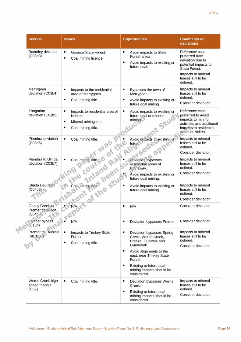
ARTC
Melbourne – Brisbane Inland Rail Alignment Study – Working Paper No. 8: Preliminary Land Assessment Page 56
Section Issues Opportunities Comments on deviations
Boomley deviation (C03b3)
Goonoo State Forest. Coal mining licence.
Avoid impacts to State Forest areas.
Avoid impacts to existing or future coal.
Reference case preferred over deviation due to potential impacts to State Forest. Impacts to mineral leases still to be defined.
Merrygoen deviation (C03b4)
Impacts to the residential area of Merrygoen.
Coal mining title.
Bypasses the town of Merrygoen.
Avoid impacts to existing or future coal mining.
Impacts to mineral leases still to be defined. Consider deviation.
Toogarlan deviation (C03b5)
Impacts to residential area of Neilrex.
Mineral mining title. Coal mining title.
Avoid impacts to existing or future coal or mineral mining.
Reference case preferred to avoid impacts to mining activities and additional impacts to residential areas of Neilrex.
Piambra deviation (C03b6)
Coal mining title. Avoid impacts to existing or future.
Impacts to mineral leases still to be defined. Consider deviation.
Piambra to Ulinda deviation (C03b7)
Coal mining title. Deviation bypasses residential areas of Binnaway.
Avoid impacts to existing or future coal mining.
Impacts to mineral leases still to be defined. Consider deviation.
Ulinda Deviation (C04b2)
Coal mining title. Avoid impacts to existing or future coal mining.
Impacts to mineral leases still to be defined. Consider deviation.
Oakey Creek to Premer deviation (C04b3)
N/A N/A Consider deviation.
Premer bypass (C16b)
N/A Deviation bypasses Premer. Consider deviation.
Premer to Emerald Hill (C62)
Impacts to Trinkey State Forest.
Coal mining title.
Deviation bypasses Spring Creek, Werris Creek, Breeza, Curlewis and Gunnedah.
Avoid alignments to the east, near Trinkey State Forest.
Existing or future coal mining impacts should be considered.
Impacts to mineral leases still to be defined. Consider deviation.
Werris Creek high speed triangle (C59)
Coal mining title. Deviation bypasses Werris Creek.
Existing or future coal mining impacts should be considered.
Impacts to mineral leases still to be defined. Consider deviation.

ARTC
Melbourne – Brisbane Inland Rail Alignment Study – Working Paper No. 8: Preliminary Land Assessment Page 57
Section Issues Opportunities Comments on deviations
Spring Ridge to Breeza (C59b )
Coal mining titles. Deviation bypasses Werris Creek and Breeza.
Existing and future coal mining impacts should be considered.
Impacts to mineral leases still to be defined. Consider deviation.
Narrabri bypass (C58)
Impacts to established irrigation areas.
Mining title. The Narrabri Airport is
located approximately 2km to the east of the alignment.
Deviation bypasses Narrabri.
Impacts to mineral leases still to be defined. Reference case preferred due to potential impacts to irrigation infrastructure and mining activities.
Moree bypass (C17b1)
Sports field, drive-in theatre, farm buildings and/or rural residences.
Industrial/intensive farming areas.
Impacts to established areas of irrigation located 400m east of the alignment.
Deviation bypasses central Moree.
Minor alignments to the east may reduce impacts to the outskirts of Moree.
Major alignments to the east should consider the irrigation area near Mehi River.
Reference case preferred due to impacts to residential and associated areas and potential impacts to the airport and irrigation areas.
Camurra deviation (C17b2)
Impacts to established areas of irrigation.
Minimise impacts to irrigation infrastructure where possible.
Consider deviation.
5.4 Moree to Brisbane
5.4.1 Reference case The reference case route from Moree to Brisbane comprises a mixture of new greenfield routes, new sections adjacent to the existing tracks and upgrades to existing tracks. The lands through which the reference case traverses include a mixture of lands such as agricultural, residential and densely forested land.
The Moree to Boggabilla section uses an upgraded section of the existing Moree to North Star line and a renewed section of the existing North Star to Boggabilla line. The Boggabilla to Inglewood section uses a new greenfield section between Boggabilla and Kildonan and a new standard gauge section adjacent to the existing narrow gauge Warwick to Dirranbandi line.
The Inglewood to Oakey section uses a new greenfield section between Inglewood and Millmerran, a new standard gauge section adjacent to the existing narrow gauge Millmerran to Wyreema line, a new greenfield section between Cecilvale and Yargullen and a new standard gauge section adjacent to the existing narrow gauge Oakey to Cecil Plains line.
The Oakey to Brisbane section uses a new standard gauge section adjacent to the existing narrow gauge Toowoomba to Dalby line, a new greenfield section between Gowrie and Gatton, a new greenfield section between Gatton and Grandchester/Rosewood, a new greenfield section between Grandchester/Rosewood and Kagaru and the existing Class 1

ARTC
Melbourne – Brisbane Inland Rail Alignment Study – Working Paper No. 8: Preliminary Land Assessment Page 58
coastal route from the NSW border to Acacia Ridge. Figure 5-3 shows a schematic representation of the route between Moree and Brisbane.
D01
D02
D03
D04
D06
D07
D08
D14
D15a
D16
D24c1
D25
D26
D28
D17
D05
D15cD09
North Star
Yelarbon
Inglewood
Millmerran
Oakey
Gatton
Grandchester
Kagaru
Acacia Ridge
Gowrie
Boggabilla
Wyreema West
Possible New Track
Existing Class 1
Existing Class 2
Existing Class 3, upgraded to class 1
New Track in Existing Corridor
Moree North
Reference Case
Deviations
Kildonan
Cecilvale
Yargullen
D36c1D24c2
Toowoomba
Figure 5-3 Reference case and optional deviations between Moree and Brisbane
Zoning
Most of the reference case travels through lands zoned for rural purposes or rail corridor. Smaller portions of adjacent land are zoned for special uses. Through Yelarbon, the alignment is adjacent to a combination of residential, commercial, industrial, open space and special uses zones.
Through Inglewood, the alignment is adjacent primarily to open space and special uses land zones. The alignment is, however, in close proximity to residential zoned land. Between Yelarbon and Cecilvale (D06a, D07a and D08a) the alignment passes almost entirely through rural zoned land. The alignment passes through a large section of residential zoned land in Oakey (D15a).
The existing alignment of section of Oakey to Gowrie (D16a) passes primarily through rural zoned land, except passing the residential centre of Kingsthorpe. The alignment is adjacent to or very near residential or open space zoned lands and small sections of commercial and special use zoned land.
Greenfield track from Gowrie to Gatton (D24c) passes through the north-eastern corner of the Toowoomba residential area. The alignment is primarily adjacent to land zoned for rural uses with additional sections through lands zoned for residential, special or industrial uses.
The alignment D24c passes through both rural and residential zones between Toowoomba and Helidon.
Greenfield track from Gatton to Kagaru (D25c, D26c) passes primarily through rural zoned land or along open space or special use corridors. The alignment passes through a large section of industrial zoned land through the area of Ipswich City and residential areas near Forest Hill and Laidley and two small special use zones southeast of Peak Crossing.

ARTC
Melbourne – Brisbane Inland Rail Alignment Study – Working Paper No. 8: Preliminary Land Assessment Page 59
From Kagaru to Acacia Ridge, the alignment runs adjacent to a mixture of residential, industrial, special use, environmental protection and rural land zones.
Land use
The reference case section from Moree North (Camurra) to North Star (D01a) passes through approximately 5 km of irrigation area and an additional area south of Boggabilla.
The area between Moree and Yargullen is primarily used for cultivated agriculture. Near Yargullen the agriculture land is highly organised and segmented within each parcel of land. It may require further investigation as to whether this type of farming increases or decreases the effects of severance or access.
The alignment passes along the northern border of the residential area of Yelarbon and adjacent to an old rubbish tip. The Yelarbon to Inglewood (D06a) section to be upgraded passes directly through a portion of the Whetstone State Forest and in close proximity to the north of Yelarbon State Forest. An existing easement exists through this piece of State Forest. Additional clearing to access or widen the easement may be necessary. The current alignment traverses the southeast border of the residential area of Inglewood.
Inglewood to Millmerran greenfield track (D07c) alignment passes through a corridor between Bringalily and Devine State Forests. The alignment falls within 1 km of each of these State Forests for a considerable length of alignment. The alignment passes through a small region (less than 1 km) of Bringalily Forest. South of Millmerran, the alignment traverses the Commodore Coal Project mining development lease held by Newmont Pacific Energy Pty Ltd.
From Millmerran to Cecilvale (D08a) the existing track passes through a large area of irrigation and near the residential area of Brookstead. Near Motley, the alignment (D14c) passes through Mount Tyson Sanitary Landfill.
Between Gowrie and Grandchester / Rosewood the alignment (D24c1 and D25c) includes a new line adjacent to the existing narrow gauge track, passing predominantly passing through farming land and some residential areas including Helidon, Placid Hills, Gatton Forest Hill and Laidley. North-east of Gowrie, the alignment passes over Bedford Street Dump and Withcott Landfill. Approximately 10 km to the east of Gowrie, the alignment passes through a densely forested area zoned for special uses but designated as a prohibited area. The Toowoomba Quarry Reserve is located immediately south (or is the southern portion of) the prohibited area, the alignment bypasses the town of Laidley between Gatton and Grandchester / Rosewood.
From Grandchester the alignment (D26c) leaves the existing track to Rosewood, heading south and east through generally densely forested land with smaller regions of residential concentration and agricultural uses to Kagaru.
Between Kagaru and Acacia Ridge (D28a) the alignment uses existing track through the residential areas of Brisbane with smaller areas of open space.
Approximately 10 km south of Millmerran, the alignment (D07c) passes approximately 160 m from the eastern boundary of a granted mineral development licence held by Commodore Coal Project.
West of Toowoomba (D24c1) the alignment traverses a mining lease Darling Downs Stone No.2, held by Helidon Sandstone Australia. A number of other mining leases exist in this same area, predominately to the north.

ARTC
Melbourne – Brisbane Inland Rail Alignment Study – Working Paper No. 8: Preliminary Land Assessment Page 60
Approximately 7 km east of Grandchester, the alignment (D26c) passes directly through the centre of a mineral development license area held by the Ebenezer Mining Company (coal) and through an area mapped as the Bremer View East coal resource for approximately 4 km and 1.5 km respectively. The application for the mineral development licence was lodged in 1994 with no permission granted. Bremer View East forms part of the Ipswich Coal Basin (Queensland Government, 2008). The alignment skirts the edges of the residential centre of Peak Crossing and
There are two disused quarries located near Kagaru, along Woollaman Creek, just to the north of the alignment. The alignment also runs along the edge of Greenbank Military Training Area, which is a prohibited zone.
Opportunities
There are numerous opportunities to optimise the alignment to minimise impacts on land use along the route, in particular realignment to minimise access and severance effects to rural properties. Further investigation into multiple parcel ownership or operation would enable the alignment to minimise property impacts.
Opportunities to minimise impacts within the Whetstone State Forest during upgrading works should be explored. The prohibited area to the east of Gowrie may need to be avoided with realignments to the north.
Potential impacts to existing and future mining activities should be considered during route selection.
5.4.2 Deviations North Star to Yelarbon (D05c) The North Star to Yelarbon section is a new greenfield section replacing the sections D02a, D03c and D04b predominately through cultivated agriculture lands with some open and/or grazing lands. The purpose of the option is to provide a direct route from North Star to Yelarbon. This option bypasses the towns of Boggabilla and Kildonan and provides the missing link between NSW and Queensland.
Zoning
This section passes entirely through lands zoned for rural uses.
Land use
The proposed alignment passes through land predominately used for agriculture. The region produces a diversified list of commodities such as hay, cotton, oats, wheat and barley with smaller regions of grapes for wine production and stone fruit near North Star.
Between the southern start of the deviation and the crossing of the Macintyre River, the alignment is primarily adjacent to cultivated agricultural land with smaller sections of open/grazing land.
A gravel pit quarry is located approximately 20 km from North Star on the northern side of the alignment.
Approximately 2.8 km north of the Bruxner Highway crossing, the alignment crosses the south eastern corner of large water catchment. An additional 1.4 km northeast along the alignment, a small lake is located 300 m to the west of the alignment.

ARTC
Melbourne – Brisbane Inland Rail Alignment Study – Working Paper No. 8: Preliminary Land Assessment Page 61
Between the Macintyre River and the Dumaresq River crossings, the alignment passes predominately through open/grazing lands with sparse to low density tree coverage. The Dthinna Dthinnawan Nature Reserve is approximately 500 m to the east of the alignment.
North of the Dumaresq River crossing, a large section of the alignment passes through open space before crossing the Cunningham Highway and then passing through open/grazing areas that may also be used for cultivated agriculture.
At Yelarbon, the alignment passes approximately 350 m to the east of a cemetery and in the near vicinity of a rubbish tip.
Opportunities
Opportunities to avoid the cemetery to the south of Yelarbon should be considered in any further alignment corrections. The alignment should avoid moving further to the west near Yelarbon.
Realignments to the north near the gravel pit quarry should be avoided.
Realignments to the west near Yelarbon should be avoided so as not to affect the cemetery.
Cecilvale to Gowrie via Wyreema West (D09b & D17c) The Cecilvale to Wyreema West section is a new standard gauge section constructed adjacent to the existing narrow gauge Millmerran to Wyreema line. The alignment passes through areas of agriculture and bisects the residential centres of Pittsworth and Southbrook. The Wyreema West to Gowrie section is a new greenfield section passing predominately through cultivated or grazing agriculture land. This section serves as a deviation from the reference case sections D14c, D15a and D16a in conjunction with deviation D17c.
Zoning
The section of alignment passes mainly through rural zoned lands. Through the residential centre of Pittsworth, the alignment is adjacent to lands zoned for open space, residential, industrial and special use.
Through Southbrook, the alignment is adjacent to special use, open space, commercial, industrial and residential.
The alignment does follow the existing track or roads in many locations, reducing the potential land constraints.
Between Wyreema West and Gowrie, the section passes almost entirely through rural land use with small sections of open space approximately 3 km north of Wyreema West and an industrial area approximately 1 km south of Gowrie as well as various sections of open space along the alignment that follow and existing road alignment.
Land use
The land adjacent to the current alignment is a highly developed agriculture area. Immediately southwest of the Cecilvale, there is a large area of irrigation. The overall area produces hay, cotton, barley and hay.
Between Cecilvale and Pittsworth, the alignment crosses properties used for cultivated agriculture and some open spaces with low to medium tree coverage. Near the intersection of Gore Highway and Gap Road/Yandilla Street, the alignment passes in close proximity to a large intensive farm complex.

ARTC
Melbourne – Brisbane Inland Rail Alignment Study – Working Paper No. 8: Preliminary Land Assessment Page 62
Upon leaving Pittsworth residential area, the new alignment passes directly through an industrial section as opposed to following the existing alignment. Approximately 1.5 km northeast of Pittsworth, the alignment directly impacts a farm structure before following the alignment of the existing Gore Highway to Southbrook.
The alignment passes through the residential area of Southbrook and then generally follows an existing rail line through land used for cultivated agriculture or open space with sparse tree coverage. The alignment follows Umbrian Road for approximately 3 km before turning north towards Wyreema West.
Between Wyreema West and Gowrie, adjacent land use is primarily cultivated agriculture with some open grazing areas with low density tree coverage. The alignment follows Westbrook Wyreema Road and then Blackwell Road before veering to the east. The alignment passes directly through a rural residential or farm structure at this location. The SLA containing the southern half of the alignment produces commodities such as hay, cotton, wheat and barley. The northern half of the section passes through an SLA that only produces significant quantities of hay. The northern half of the alignment borders the rural residential outskirts of Toowoomba bypassing sporting grounds and rural residential housing. Some of these rural residential buildings will be directly impacted by the alignment. The alignment passes through a small section of open / grazing agriculture land before reaching Gowrie.
Approximately 6 km south of the deviation, a Mining Development Mdl Qld is held by Newmont Pacific Energy Pty Ltd, a coal resource CRA Qld is held by Felton, and a Mining Lease is held by Ml Qld.
Opportunities
Opportunities exist to realign this section of track away from the residential area of Pittsworth and Southbrook to one side or the other.
Section D17c passes adjacent to the major residential area of Toowoomba. Opportunities exist to minimise impact on residential housing in further alignments.
Cecilvale to Gatton (south of Toowoomba) (D09b & D36c1) The Cecilvale to Wyreema West section is a new standard gauge section constructed adjacent to the existing narrow gauge Millmerran to Wyreema line. The alignment passes through areas of agriculture and bisects the residential centres of Pittsworth and Southbrook. The Wyreema West to Gatton section is a new greenfield section passing predominately through cultivated land, rural residential areas and open space. It passes near the residential centre of Hodgson Vale and Silver Ridge before reaching Gatton. This section serves as a deviation from the reference case sections between Cecilvale and Gatton.
Zoning
The section of alignment passes mainly through rural zoned lands. Through the residential centre of Pittsworth, the alignment is adjacent to lands zoned for open space, residential, industrial and special use.
Through Southbrook, the alignment is adjacent to special use, open space, commercial, industrial and residential.
The alignment does follow the existing track or roads in many locations, reducing the potential land constraints.

ARTC
Melbourne – Brisbane Inland Rail Alignment Study – Working Paper No. 8: Preliminary Land Assessment Page 63
Between Wyreema West and Gatton, the alignment passes through lands predominately zoned for rural purposes. Small sections of residential zoned land are crossed as well.
Land Use
The land adjacent to the current alignment is a highly developed agriculture area. Immediately southwest of the Cecilvale, there is a large area of irrigation. The overall area produces hay, cotton, barley and hay.
Between Cecilvale and Pittsworth, the alignment crosses properties used for cultivated agriculture and some open spaces with low to medium tree coverage. Near the intersection of Gore Highway and Gap Road/Yandilla Street, the alignment passes in close proximity to a large intensive farm complex.
On leaving Pittsworth residential area, the new alignment passes directly through an industrial section as opposed to following the existing alignment. Approximately 1.5 km northeast of Pittsworth, the alignment directly impacts a farm structure before following the alignment of the existing Gore Highway to Southbrook.
The alignment passes through the residential area of Southbrook and then generally follows an existing rail line through land used for cultivated agriculture or open space with sparse tree coverage. The alignment follows Umbrian Road for approximately 3 km before turning north towards Wyreema West.
Between Wyreema West and Gatton, the alignment passes through a variety of land uses. Closest Wyreema West, the alignment traverses lands used for cultivated agriculture and rural residential living. A number of individual homes or small communities will be affected or severed from the rest of the community based on the current alignment.
Between Hodgson Vale and Silver Ridge, the alignment traverses open space and rural residential living areas. From Silver Ridge to the crossing of the Warrego Highway, the alignment passes predominately through open space/open grazing areas. From the Highway crossing to Lockyer Siding the alignment skirts the edge of rural residential areas and predominately traverses open space. Approximately 1.75 km northeast of Postmans Ridge, the alignment passes directly through water storage facilities associated with a large industrial complex.
Between Lockyer Siding and Gatton, the alignment predominately follows the existing rail alignment or road corridor, resulting in minimal land impacts.
Opportunities
Opportunities exist to minimise the impacts on rural residential houses and/or communities with further adjustments in alignment. The industrial complex and water facilities should be avoided if possible.
Oakey bypass (D15c) The Yargullen to Oakey section is a new greenfield section through land used for cultivated agriculture. The option provides a direct route from Yargullen and Oakey and bypasses the town of Oakey. This deviation replaces the reference case section of D15a.
Zoning
This section of greenfield track passes through rural zoned land.

ARTC
Melbourne – Brisbane Inland Rail Alignment Study – Working Paper No. 8: Preliminary Land Assessment Page 64
Land uses
This section of track passes predominately through highly organised and developed cultivated land and smaller sections of open land sparsely covered with trees. A number of residential or farm structures are directly impacted by the current alignment or located in near proximity to the alignment. All alignments near Yargullen will involve significant impact to cultivated land.
Opportunities
This option allows the residential centre of Oakey to be bypassed. Opportunities to reduce access and severance impacts on cultivated farms should be further investigated.
Gowrie to Gatton low speed (D24c2) The Gowrie to Gatton section is a new standard gauge section that serves as a deviation from the reference case section D24c1. The alignment predominately passes through open, tree-covered land.
Zoning
Near the southern end of the deviation, the alignment passes through lands zoned for rural, special uses and the outer residential areas of Toowoomba. The rest of the alignment predominately passes through land zoned for rural purposes with additional areas of residential or special uses.
Land use
Near Gowrie, the alignment follows an existing track and/or the existing road corridor for East Paulsens Road. Approximately 4.5 km south east of Gowrie, the current alignment passes through a sewage treatment plant. In addition, the alignment passes through a designated rubbish tip.
After the alignment crosses the Gowrie Creek and Goombungee Road, it passes predominately through open space with sparse to medium density tree coverage. This portion of the alignment also passes through or near a number of rural residential dwellings at various locations through to Spring Bluff. Just north of Ballard, the alignment passes through an orchard or tree farm.
Between Spring Bluff and Upper Lockyer, the alignment passes almost entirely through land covered with trees to a medium density and approximately 1.2 km of White Mountain Forest Reserve. Along this section, the alignment also traverses 500 m of the Mining Lease named Titan Sandstone 1, held by Global Sandstone Industries Pty Ltd. The alignment also traverses the Mining Lease, Darling Downs Stone No. 2, held by Helidon Sandstone (Australia) Pty Ltd. Near Upper Lockyer, the alignment generally follows the local creek system including Murphys Creek and Lockyer Creek.
Opportunities
Minor realignments to the west will eliminate interference with the sewage treatment plant). Opportunities to reduce the impact to rural residential housing should be considered.
5.4.3 Summary of issues and opportunities – Moree to Brisbane The route between Moree and Brisbane primarily consists of new and upgraded sections. A minimal number of additional deviations have been identified. Constraints likely to be key issues in the comparison between ‘reference case’ and deviations are summarised in

ARTC
Melbourne – Brisbane Inland Rail Alignment Study – Working Paper No. 8: Preliminary Land Assessment Page 65
Table 5-3. The table does not include all identified constraints discussed in Section 5.4.2, but only those constraints likely to be affected by the current alignment.
In Stage 3 of the project, route refinement/optimisation of new sections will be undertaken with consideration to minimising road and river crossings and associated impacts. Rural residential housing and structures will be avoided during route refinement, where possible. Any route refinements should consider constraints identified in this paper that are not likely to be impacted based on the current indicative alignments.
Table 5-3 Summary of issues and opportunities for Moree to Brisbane
Section Issues Opportunities Comments on deviations
Reference case
Moree (north) to Inglewood (D01a, D02a, D03c, D04b. D06a)
Impacts to the residential areas of Croppa Creek, North Star and Inglewood.
Impacts to established area of irrigation near Moree.
Impacts to Whetstone State Forest.
Minimise impacts to residential areas.
Avoid or minimise impacts to irrigation area north of Moree.
Avoid construction sites for upgrading works in the vicinity of Whetstone State Forest.
Inglewood to Cecilvale (D07c, D08a)
Impacts to Bringalily and Devine State Forest.
Mineral Development Application.
Impacts to areas of irrigation.
Impacts to residential area of Brookstead.
Avoid alignments and minimise impacts vicinity of Bringalily and Devine State Forests.
Avoid impacts to existing or future mining operations.
Avoid or minimise impacts to irrigation areas.
Minimise impacts to the residential area of Brookstead.
Cecilvale to Gowrie (D14c, D15a, D16a)
Impacts to the residential area of Oakey and Kingsthorpe.
Impacts to Mount Tyson Sanitary Landfill.
Bypass Oakey town centre with Deviation D15c or D09b & D17c.
Bypass Kingsthorpe with Deviation D09b & D17c or minimise impacts to residential centre of Kingsthorpe during upgrades.
Realignment to avoid impacts to landfill.
Gowrie to Grandchester / Rosewood (D24c, D25c)
Impacts to the residential area of Toowoomba and surrounding residential zones.
Impacts to residential areas of Helidon, Placid Hills, Gatton Forest Hill and Laidley.
Prohibited area east of Gowrie.
Realignment to avoid residential areas of Toowoomba and surrounds.
Realignment to avoid residential areas of Gatton and Laidley.
Realignment to avoid impacts to landfills.
Avoid impacts to existing or future mining

ARTC
Melbourne – Brisbane Inland Rail Alignment Study – Working Paper No. 8: Preliminary Land Assessment Page 66
Section Issues Opportunities Comments on deviations
Impacts to Bedford St. Dump, Withcott Landfill, QAC Traini Sanitary Landfill.
Mining titles.
operations.
Grandchester / Rosewood to Acacia Ridge (D26c, D28a)
Mining titles. Avoid impacts to existing or future mining operations.
Deviations
North Star to Yelarbon (D05c)
Alignment constraints due to a gravel pit quarry 20km north-east of North Star.
Alignment constraints due to a cemetery near Yelarbon.
Avoid realignment to the west to prevent impacts to the cemetery near Yelarbon.
Avoid realignments to the north near the gravel pit quarry.
Consider deviation.
Cecilvale to Gowrie (D09b, D17c)
Impacts to residential areas of Pittsworth and Southbrook.
Impacts to residential areas of Toowoomba, Wyreema.
Rural residential housing on the western fringe of Toowoomba.
Realign to minimise impacts on residential areas or select reference case section.
Realign option to minimise impacts on Toowoomba, Wyreema and rural residential communities or select reference case section.
Consider deviation.
Cecilvale to Gatton (south of Toowoomba) (D09b, D36c1)
Passes through the residential centres of Southbrook and Pittsworth. Adjacent land is zoned for open space, residential, commercial, industrial and special uses.
Passes through small sections of residential zoned land between Wyreema West and Gatton.
Passes through highly developed agriculture area between Cecilvale and Pittsworth and impacts an irrigation area southwest of Cecilvale. Passes close to large intensive farm complex at Gore Highway / Gap Road crossroads, through an industrial area east of Pittsworth and impacts farm infrastructure northeast of Pittsworth.
Potential impacts to rural residences and communities around
The alignment follows existing track or roads in many locations, reducing the potential land impacts.
Opportunities exist to minimise the impacts on rural residential houses and/or communities with further adjustments in alignment.
Avoid identified farm infrastructure, industrial facilities and water storage facilities if possible.
Reference case preferred.

ARTC
Melbourne – Brisbane Inland Rail Alignment Study – Working Paper No. 8: Preliminary Land Assessment Page 67
Section Issues Opportunities Comments on deviations
Wyreema, between Hodgson Vale and Silver Ridge, and west of Lockyer Siding.
Impacts to water storage facilities associated with a large industrial complex northeast of Postmans Ridge.
Oakey Deviation (D15c)
N/A Deviation bypasses the residential area of Oakey.
Consider deviation.
Gowrie to Gatton low speed (D24c2)
Passes through outer residential areas of Toowoomba.
Passes through a sewage treatment plant and near a designated rubbish tip (Bedford St. Dump) approximately 4.5km south east of Gowrie.
Passes through or near a number of rural residential dwellings through to Spring Bluff. Passes through an orchard or tree farm north of Ballard.
Passes through 1.2km of White Mountain Forest Reserve between Spring Bluff and Upper Lockyer.
Mining lease.
Realign to the west to avoid passing through the White Mountain Forest Reserve.
Minor realignments to the west will eliminate interference with the sewage treatment plant.
Opportunities to reduce the impact to rural residential housing should be considered.
Avoid impacts to existing or future mining operations.
Reference case preferred.

ARTC
Melbourne – Brisbane Inland Rail Alignment Study – Working Paper No. 8: Preliminary Land Assessment Page 68
6. Conclusion 6.1 Overview
The determination of land use is likely to be the biggest factor in determining both land constraints and land valuation. Land use, particularly the presence of irrigation capabilities or water resources, greatly increases the value of the land and in turn will significantly increase land acquisition costs.
Land acquisition costs and constraints must be considered when determining route alignments to eliminate or minimise costly acquisition or lengthy approvals processes where possible.
6.2 Summary of key issues and opportunities
6.2.1 Key risk areas The key risk areas identified in this report focus mainly on the following areas:
1. Land that may have onerous or prohibitive restrictions placed on it with regards obtaining to planning approval. This includes land uses where the zoning objectives and development restrictions may limit the development of a railway, e.g. residential land uses, Environmental Protection zones and National Parks and conservation areas.
2. Land with a potentially high acquisition cost. This includes areas with large-scale irrigation improvements or where intensive crop cultivation occurs, which may result in a higher acquisition costs once compensation is taken into account.
3. Land with existing and future resource extraction/harvesting. This includes State Forests and active and future mining leases / operations where further consideration of implications of resource sterilisation or offsetting, or impacts to the railway (e.g. subsidence) would be required.
These areas are likely to involve problems in relation to approvals, land acquisition costs and program delays due to negotiations and consultation with landowners and other stakeholders.
6.2.2 Opportunities
Various opportunities to avoid regions or centres of high level constraints have been identified where possible. These opportunities focus on minor changes in alignment. In addition, land constraints that should be avoided near tracks potentially in need of upgrading have been identified. Construction work sites should be localised outside these regions to minimise impacts.
There are also many instances of potential impacts to individual residential, agricultural and industrial structures or facilities along the route that should be considered during route optimisation.

ARTC
Melbourne – Brisbane Inland Rail Alignment Study – Working Paper No. 8: Preliminary Land Assessment Page 69
Other opportunities have been identified where the development of the inland rail may be beneficial in some areas, for example, by providing freight access to rural areas or mining operations.
6.3 Outline for Stage 3 assessment Further assessment of the preferred alignment in Stage 3 should focus firstly on avoiding areas considered as land constraints in this paper, in conjunction with consideration of other issues such as environmental and engineering constraints.
Once an optimal alignment has been selected, it is proposed to undertake a more detailed land valuation assessment in Stage 3 to gain a more accurate understanding of the potential land acquisition costs for the project. This would include:
In depth investigation of land ownership, a detailed sales analysis of properties sold and discreet ‘without property’ inspections to determine the actual land use and other factors that affect the land acquisition cost;
Possible adjustment of land acquisition costs depending on provision of access to severed lands, curtailment in number of at grade public road crossings and additional impacts on land use; and
Estimation of reinstatement of fencing, water supply, and in particular, the impacts on any irrigation system.
Additional considerations that would assist land valuation in the determination of overall property acquisition costs would include identification of:
Scope for possible minor variations in corridor alignment to reduce the impacts of severance and where possible the number of affected properties;
Environmental and other ‘risk areas’ as defined by state and Commonwealth legislation such as the NSW State Environmental Planning Policy (Infrastructure) 2007, the Environmental Protection Biodiversity Conservation Act and the more restrictive aspects of National Parks, Forests, Native Title;
The potential for loss of amenity to towns or other settlements that could delay or prevent securing statutory approvals or licences for a proposed alignment;
Properties for possible total acquisition if it is considered that the project will be forced to provide offset vegetated lands to allow destruction of vegetation within the rail corridor;
Implications of railway development through active or future mining lease areas or operations, noting the potential sterilisation of mineral resources or the potential for subsidence within the railway alignment.