
Melbourne Water's Mornington Peninsula Shire waterways update
8
The Tanti Creek Wetland in Mornington was constructed to increase flood protection and naturally treat and reduce the pollutants in stormwater entering Tanti Creek and Port Phillip Bay Melbourne Water is actively working with Council and the local community to achieve healthy waterways and provide flood protection for people and property. We’re responsible for approximately 8,400 kilometres of rivers and creeks and over 1,400 kilometres of drains in the main drainage system within the Port Phillip and Westernport region. We also manage over 200 flood retarding basins, 100 urban lakes and 300 waterways treatment systems, including wetlands. Significant waterways in the Mornington Peninsula Shire region include the Merricks, Main, Balcombe, Dunns, Manton, Stony, Watsons, Warringine, Drum Drum Alloc, Chinamans, Kackeraboite and Tanti Creeks and the new Tanti Wetland. We care for waterways and drainage systems through an ongoing program of works and community grants. We care for waterways and drainage systems through an ongoing program of works and community grants. THIS UPDATE INCLUDES: • what we’ve done or started in 2009/10 • what’s coming up MORNINGTON PENINSULA KEY Wetland MELBOURNE WATER’S WATERWAYS MANAGEMENT DISTRICT Waterbody Swale Municipal boundary Major waterway Town N Mornington Moorooduc Hastings Red Hill Somers Flinders Cape Schank Rye Portsea MERRICKS CREEK TANTI CREEK HARRAP CREEK HOPETOUN CREEK LANG LANG CREEK DRUM DRUM CREEK Mornington Peninsula Shire Waterways local update 2009 / 2010
-
Upload
philip-jensen -
Category
Documents
-
view
215 -
download
2
description
Melbourne Water's Mornington Peninsula Shire waterways update 2009/2010
Transcript of Melbourne Water's Mornington Peninsula Shire waterways update

The Tanti Creek Wetland in Mornington was constructed to increase flood protection and naturally treat and reduce the pollutants in stormwater entering Tanti Creek and Port Phillip Bay
Melbourne Water is actively working with Council and the local community to achieve healthy waterways and provide flood protection for people and property.
We’re responsible for approximately 8,400 kilometres of rivers and creeks and over 1,400 kilometres of drains in the main drainage system within the Port Phillip and Westernport region. We also manage over 200 flood retarding basins, 100 urban lakes and 300 waterways treatment systems, including wetlands.
Significant waterways in the Mornington Peninsula Shire region include the Merricks, Main, Balcombe, Dunns, Manton, Stony, Watsons, Warringine, Drum Drum Alloc, Chinamans, Kackeraboite and Tanti Creeks and the new Tanti Wetland. We care for waterways and drainage systems through an ongoing program of works and community grants. We care for waterways and drainage systems through an ongoing program of works and community grants.
THIS UPDATE INCLUDES:
• what we’ve done or started in 2009/10 • what’s coming up
MORNINGTON PENINSULAKEY
Wetland
MELBOURNE WATER’S WATERWAYS MANAGEMENT DISTRICT
Waterbody
Swale Municipal boundary
Major waterway
Town
N
Mornington
Moorooduc
Hastings
Red Hill
Somers
FlindersCape Schank
Rye
Portsea
MERRICKS CREEK
TANTI CREEK
HARRAP CREEKHOPETOUN CREEK
LANG LANG CREEK
DRUM DRUM CREEK
Mornington Peninsula ShireWaterways local update 2009 / 2010

Tanti Creek Wetland in Mornington
WHERE WATERWAYS WHAT WE’VE DONE
Dunns Creek Road, Dromana Dunns Creek Carried out works to remove weeds. We also worked to stabilise existing rock structures and establish a fish passageway.
Merricks Creek (downstream) from Stanleys Road, Red Hill South
Merricks Creek Carried out works to remove weeds and revegetate the area.
Peninsula Gardens Reserve, Rosebud
Drum Drum Alloc Creek
We’ve constructed a rock control structure to help prevent erosion. Revegetation will take place to stabilise the channel and its surrounds. This will also encourage the re-colonisation of native vegetation to provide important habitat for the native Swamp Skink.
Hopetoun Creek, downstream of Uralla Road, Mount Martha
Hopetoun Creek We’ve removed pine trees to allow the establishment of native vegetation which will provide habitat and stabilise the creek banks.
In 2009/10 we undertook a range of works, focused mainly on weed control, bank stabilisation and revegetation.
Managing waterways
Managing our assets
We’re responsible for natural and constructed rivers, creeks and wetlands, underground drains, pump stations, retarding basins and traps that prevent litter and other items from polluting waterways. We are also the caretakers of sites of biological significance, many of which are home to endangered plant and animal species.
Throughout the year we remove litter, debris and excess sediment from your waterways. We install fences for protection, remove and spray weeds, cut grass, plant native trees, plants and grasses and provide solutions to erosion problems. We also respond to events that may cause risk to the public, our assets or our environment.
Waterways local update 2009/10 | Mornington Peninsula Shire | 2
What we’ve done or started

In 2009/10 we undertook a range of works to ensure sufficient environmental flows. (‘Environmental flow’ refers to the volume of water that needs to flow through a waterway to keep it healthy.)
Managing environmental flows
WATERWAYS WHO WE’VE WORKED WITH
WHAT WE’VE BEEN WORKING ON
WHY
Mornington Peninsula Shire region
Southern Rural Water
Managed surface water and ground water extractions.
To improve environmental flow outcomes.
WHERE WHAT WE'VE DONE WHY
Balcombe Estuary sediment hot spots, Mount Martha, Mornington Peninsula
Assisted Mornington Peninsula Shire Council with identifying 4 sites for sediment generation. These sites are considered to have an impact on sediment in the estuary.
Sediment has been identified as a key issue in the estuary. This will reduce sediment load to the Balcombe Estuary.
In 2009/10 we worked to improve the quality of stormwater and catchment runoff entering rivers, creeks and bays.
We’ve been working with Council and the local community to raise awareness of the ways in which good management of stormwater contributes to healthy waterways.
Raingardens are garden design features that help protect your local waterway. Raingardens use natural processes to filter out pollutants in stormwater. Our 10,000 Raingardens program promotes the things that you can do at home to improve stormwater quality — like building a raingarden.
To find out more, please visit melbournewater.com.au/raingardens
Managing water quality
We’re a key supporter of Clearwater, a not-for-profit organisation that aims to build sustainable water management knowledge and skills across Victoria. Clearwater offers training, advice, technical information and events for those who plan, design, develop and manage our cities and towns.
To find out more, please visit clearwater.asn.au
Raingarden
Drum Drum Alloc Creek in Rosebud. We have placed rockwork in the creek for erosion control and removed weeds to protect and strengthen existing vegetation.
Waterways local update 2009/10 | Mornington Peninsula Shire City | 3

In 2009/10 we carried out studies to map floodplains and overland flow paths to assess flood risks and provide guidelines to developers.
We also work with the Bureau of Meteorology and the State Emergency Service (SES) to provide flood warning services to the community.
Flood management and drainage
WHAT WE’VE DONE WHY WE’VE DONE THIS
Tanti Creek Retarding Basin within Tanti Creek Floodplain, Mornington.
Constructed a retarding basin to allow for better management of peak flows. This shall minimise nutrient loads, sediment and toxicants from entering Tanti Creek.
Undertaken Flood Mapping in Dromana, Safety Beach, Mount Eliza, Rosebud, Hastings and Mornington.
To update our knowledge on flooding, help us better manage the drains and assess flood risks in the catchment.
Council has signed up to work with Melbourne Water to develop a Flood Management Plan (programmed to be completed in 2010/11).
To better understand and manage flood risks and improve collaboration between flood management agencies.
Managing urban growth
REfERRAL NUMBER REfERRED IN 2010 WHY
Land subdivisions 272 Subdivision referrals enable Melbourne Water to set conditions that relate to drainage outfall or treatment of stormwater. Easements or reserves may also be required for floodplain, drainage or waterway management purposes.
Development applications
36 To establish whether proposed developments are compatible with flood risks.
The flood risk to people and property is minimised by setting appropriate conditions on planning permits.
Flood information requests
576 To enable us to advise property owners and people interested in purchasing or redeveloping a property on flood levels and hundred-year flood events.
Melbourne Water has a statutory obligation to manage urban growth and redevelopment. Through our town planning and subdivision process we ensure that flood protection standards are met, stormwater runoff and quality meet best practice standards and the health of our waterways is protected.
We manage a Hydrologic Data Collection Network which monitors rainfall and flows in waterways. We also support Council and the SES in flood response plans.
Waterways local update 2009/10 | Mornington Peninsula Shire | 4
WHERE WHAT WHY
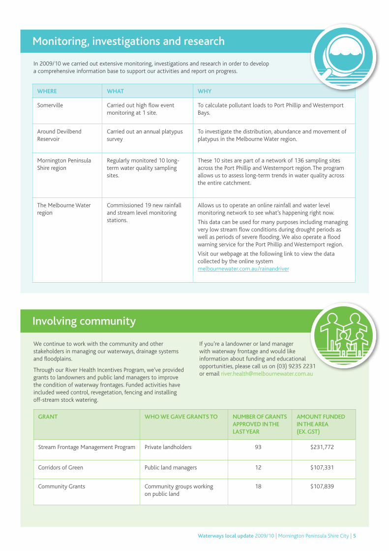
Somerville Carried out high flow event monitoring at 1 site.
To calculate pollutant loads to Port Phillip and Westernport Bays.
Around Devilbend Reservoir
Carried out an annual platypus survey
To investigate the distribution, abundance and movement of platypus in the Melbourne Water region.
Mornington Peninsula Shire region
Regularly monitored 10 long-term water quality sampling sites.
These 10 sites are part of a network of 136 sampling sites across the Port Phillip and Westernport region. The program allows us to assess long-term trends in water quality across the entire catchment.
The Melbourne Water region
Commissioned 19 new rainfall and stream level monitoring stations.
Allows us to operate an online rainfall and water level monitoring network to see what’s happening right now.
This data can be used for many purposes including managing very low stream flow conditions during drought periods as well as periods of severe flooding. We also operate a flood warning service for the Port Phillip and Westernport region.
Visit our webpage at the following link to view the data collected by the online system melbournewater.com.au/rainandriver
In 2009/10 we carried out extensive monitoring, investigations and research in order to develop a comprehensive information base to support our activities and report on progress.
Monitoring, investigations and research
GRANT WHO WE GAVE GRANTS TO NUMBER Of GRANTS APPROVED IN THE LAST YEAR
AMOUNT fUNDED IN THE AREA (Ex. GST)
Stream Frontage Management Program Private landholders 93 $231,772
Corridors of Green Public land managers 12 $107,331
Community Grants Community groups working on public land
18 $107,839
We continue to work with the community and other stakeholders in managing our waterways, drainage systems and floodplains.
Through our River Health Incentives Program, we’ve provided grants to landowners and public land managers to improve the condition of waterway frontages. Funded activities have included weed control, revegetation, fencing and installing off-stream stock watering.
Involving community
If you’re a landowner or land manager with waterway frontage and would like information about funding and educational opportunities, please call us on (03) 9235 2231 or email [email protected]
Waterways local update 2009/10 | Mornington Peninsula Shire City | 5

EvEnt/ProjEct Who WE WorkEd With What WE did
Waterwatch Schools Program
Tootgarook Primary School, St Macartan’s Primary School, Chisholm Institute of TAFE, Rosebud Primary School, Penbank School, Balcombe Grammar School, Baxter Primary School and Boneo Primary School
Ran a Healthy Waterways Waterwatch schools program, this included a planning session with teachers and up to five sessions with students. The aim was to connect students to their local rivers and creeks.
Waterwatch engagement sessions
Probus Club – McCrae Ladies Inc. and Melbourne Water staff
Presented on catchments, water supply and local waterway fauna.
Ongoing water quality monitoring
Friends of Chinamans Creek Inc., Balcombe Estuary Rehabilitation Group (BERG) Inc., Merricks Drainage Monitor, Manton and Stony Creek Landcare Group, Merricks-Coolart Catchment Group, Watsons Creek Catchment Landcare Group, Main Creek Catchment Landcare Group and Tanti Creek Friends
Supported Waterwatch community water quality monitoring groups with field visits, equipment maintenance and data validation exercises.
Council festivals and events
Mornington Peninsula Shire Council and local schools
Attended 4 days at the Mornington Peninsula Environment Expo.
Highlights of 2009/10 include:
Involving community cont.
The important work described in this report is made possible by the waterways and drainage charge that is included in water bills and collected by water retail companies on our behalf.
Healthy Waterways Waterwatch is a government funded, fun, hands-on river health education and engagement program hosted by Melbourne Water that supports community, schools and businesses to be actively involved in monitoring and protecting the health of our rivers and creeks.
To learn more about your river and creek with Healthy Waterways Waterwatch, go to waterwatchmelbourne.org.au
We work with local schools in the Mornington Peninsula region as part of our Healthy Waterways Waterwatch program
There are 106 Mornington Peninsula Shire community members in our Community Rain Reader network. We have over 500 community rain readers across the Port Phillip and Westernport area. Every day, these hardy volunteers read their rain gauge (usually located in their backyard) and record data. This data, together with data from our automated gauges, provides us with valuable rainfall information.
To look at this information, please go to melbournewater.com.au/communityrainreaders
Waterways local update 2009/10 | Mornington Peninsula Shire | 6

Drum Drum Alloc Creek in Rosebud. By stabilising the banks to control erosion and removing weeds we are protecting and enhancing the creek and the unique environment that surrounds it.
WHAT WE'LL DO WHY
Remove a fish barrier along Stony Creek at Byrnes Road Fishway.
To improve fish passage and allow the entire upstream reach of Stony Creek to be accessible to native migratory fish species.
Carry out weed removal works along Balcombe Harrap Creek.
Weed control work to help protect and improve river health values and natural habitat for native plants and animals and potentially threatened species within Harrap Creek.
Carry out weed control and revegetation works along Chinamans Creek, Village Glen retirement village.
The removal and eradication of high threat weeds and subsequent revegetation with native species shall provide enhanced habitat for the threatened Swamp Skink.
Investigate the removal of a fish barrier at the mouth of Main Creek.
To improve accessibility for native fish, especially Tupong, to the entire upstream reaches of Main Creek.
Carry out weed control along Balcombe Creek within Mt Eliza Regional Park in cooperation with the Mornington Peninsula Shire Council.
This is the most upstream part of Balcombe Creek that has significant remnant vegetation. Weed control in this reach will help to protect significant vegetation downstream.
Managing waterways
We’ve planned a range of works, focused mainly around weed control, bank stabilisation and revegetation.
Waterways local update 2009/10 | Mornington Peninsula Shire City | 7
What’s coming up

Hopetoun Creek Mount Martha. Maintenance work on trees in action.
WHAT WE’LL DO WHY
Provide a range of Healthy Waterways Waterwatch activities and programs in the Mornington Peninsula region.
Effective education programs lead to a well informed, environmentally aware and engaged community.
Support Healthy Waterways Waterwatch Community water quality monitoring groups with field visits, equipment maintenance and data validation exercises.
Biodiversity will continue to be monitored, conserved and improved.
Involving community
Melbourne Water 100 Wellington Parade, East Melbourne PO Box 4342 Melbourne Victoria 3001
Telephone 131 722 Facsimile 03 9235 7200 melbournewater.com.au
ISSN: 1838-2185 ISSN: 1837-0276
Copyright © Melbourne Water Corporation
July 2010. All rights reserved.
Managing urban growth
WHERE WHAT WE’LL DO WHY
Baxter Construct major drainage works between the Peninsula Link and Watsons Creek to service existing development and future urban growth within the catchment.
To remove potential flood risk within the area and provide additional capacity to the existing drainage system.
What’s coming up
cont.


![[Re]constructing the Water's Edge](https://static.fdocuments.us/doc/165x107/568c49cc1a28ab4916959698/reconstructing-the-waters-edge.jpg)