MEETING SUMMARY - codot
72
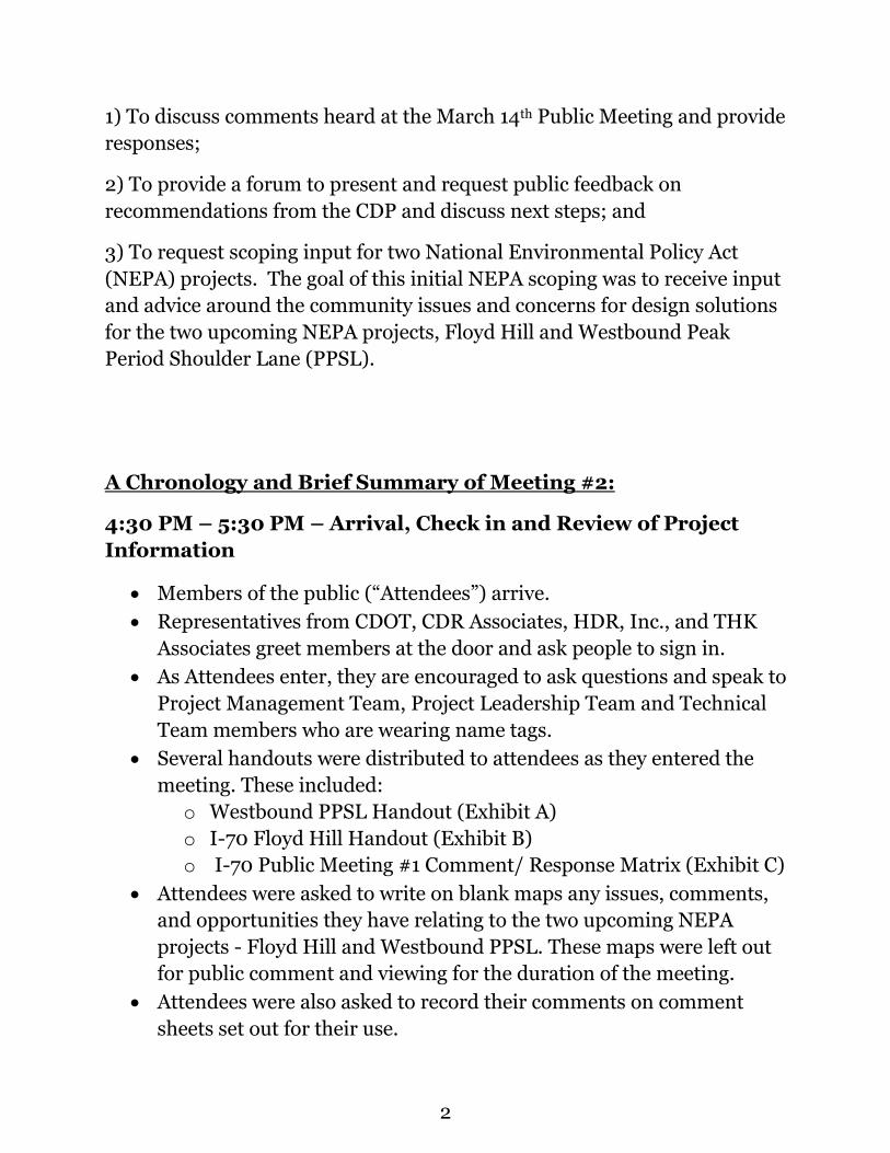
MEETING SUMMARY Public Meeting #2 Westbound I-70 Concept Development Process/NEPA Scoping July 26 th , 2017 | 5 PM – 7PM United Center, Idaho Springs Table of Contents Document Pages Public Meeting Summary 1-7 Exhibit A—WB PPSL Handout 8-11 Exhibit B—Floyd Hill Handout -15 Exhibit C—Public Meeting #1 Public Comment Handout 16-20 Exhibit D—Public Meeting #2 PowerPoint 21-57 Exhibit E—Public Meeting #2 Public Comments Received 58-60 Exhibit F—Petition Regarding Greenway 61-71 Exhibit G—Jim White’s Email Correspondence 72 Background of Public Meeting #2 Public Meeting #2 (“Meeting #2”) was the second of two public meetings for the Concept Development Process (CDP) (the first was held on March 14, 2017 at the Clear Creek Rec Center). The WB I-70 Mountain Corridor Project Leadership Team advanced these public meetings in order to involve constituents and projects stakeholders throughout the process. Approximately 70 members of the general public attended this Meeting #2. Purpose The purpose of Meeting #2 was: 1
Transcript of MEETING SUMMARY - codot
MEETING SUMMARY
Public Meeting #2
Westbound I-70 Concept Development Process/NEPA
Scoping
July 26th, 2017 | 5 PM – 7PM
United Center, Idaho Springs
Table of Contents
Document Pages
Public Meeting Summary 1-7
Exhibit A—WB PPSL Handout 8-11
Exhibit B—Floyd Hill Handout 12-15
Exhibit C—Public Meeting #1 Public Comment Handout 16-20
Exhibit D—Public Meeting #2 PowerPoint 21-57
Exhibit E—Public Meeting #2 Public Comments Received 58-60
Exhibit F—Petition Regarding Greenway 61-71
Exhibit G—Jim White’s Email Correspondence 72
Background of Public Meeting #2
Public Meeting #2 (“Meeting #2”) was the second of two public meetings
for the Concept Development Process (CDP) (the first was held on March
14, 2017 at the Clear Creek Rec Center). The WB I-70 Mountain Corridor
Project Leadership Team advanced these public meetings in order to
involve constituents and projects stakeholders throughout the process.
Approximately 70 members of the general public attended this Meeting #2.
Purpose
The purpose of Meeting #2 was:
1
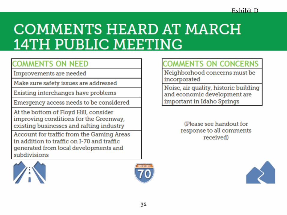
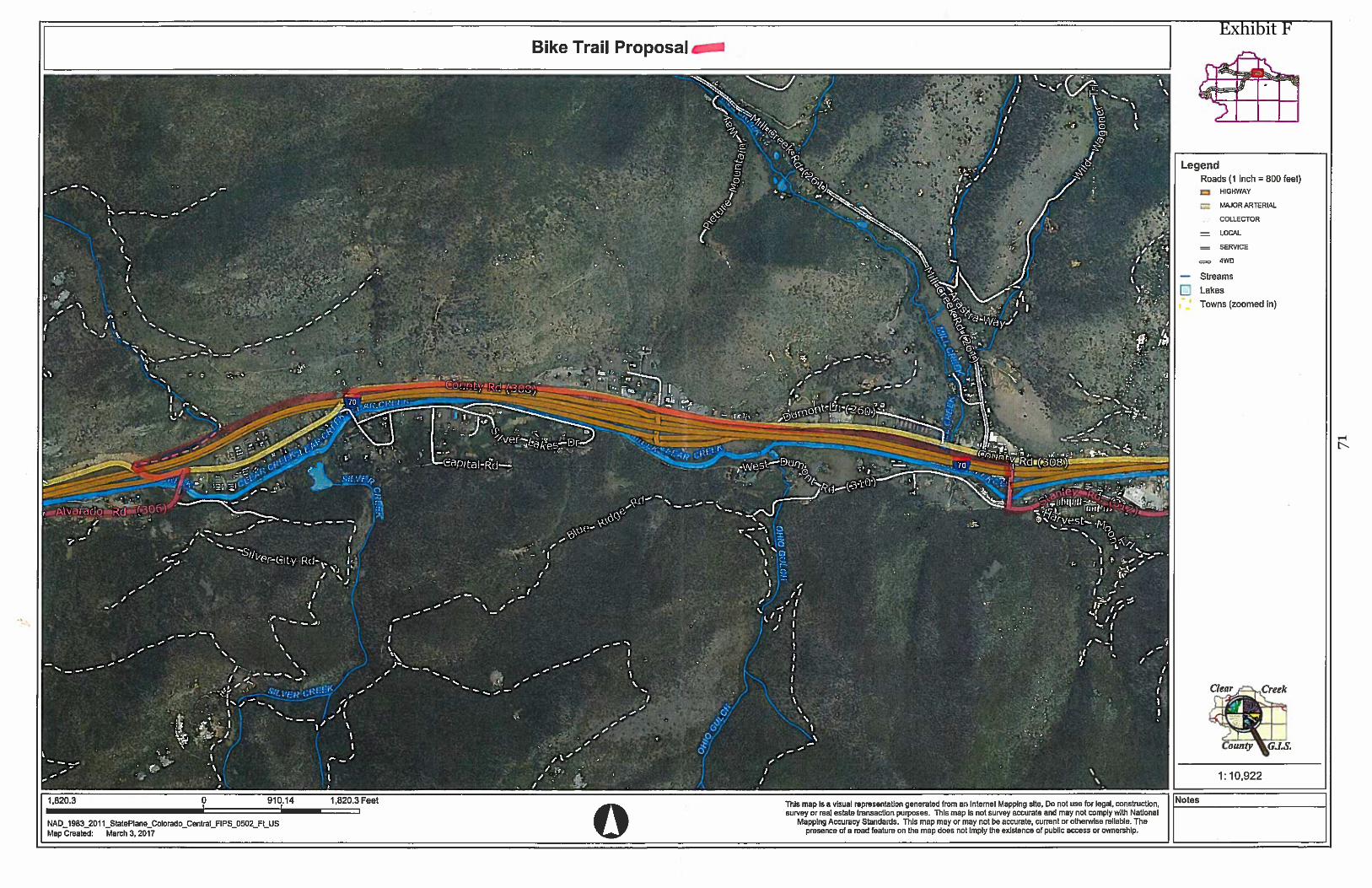
1) To discuss comments heard at the March 14th Public Meeting and provide
responses;
2) To provide a forum to present and request public feedback on
recommendations from the CDP and discuss next steps; and
3) To request scoping input for two National Environmental Policy Act
(NEPA) projects. The goal of this initial NEPA scoping was to receive input
and advice around the community issues and concerns for design solutions
for the two upcoming NEPA projects, Floyd Hill and Westbound Peak
Period Shoulder Lane (PPSL).
A Chronology and Brief Summary of Meeting #2:
4:30 PM – 5:30 PM – Arrival, Check in and Review of Project
Information
• Members of the public (“Attendees”) arrive.
• Representatives from CDOT, CDR Associates, HDR, Inc., and THK
Associates greet members at the door and ask people to sign in.
• As Attendees enter, they are encouraged to ask questions and speak to
Project Management Team, Project Leadership Team and Technical
Team members who are wearing name tags.
• Several handouts were distributed to attendees as they entered the
meeting. These included:
o Westbound PPSL Handout (Exhibit A)
o I-70 Floyd Hill Handout (Exhibit B)
o I-70 Public Meeting #1 Comment/ Response Matrix (Exhibit C)
• Attendees were asked to write on blank maps any issues, comments,
and opportunities they have relating to the two upcoming NEPA
projects - Floyd Hill and Westbound PPSL. These maps were left out
for public comment and viewing for the duration of the meeting.
• Attendees were also asked to record their comments on comment
sheets set out for their use.
2
5:30 PM -6:00 PM Project Presentation
• Jonathan Bartsch, CDR Associates, provided opening remarks.
• Tim Mauk, Clear Creek County Commissioner, welcomed Attendees
and gave an overview of the purpose of the meeting and the
importance of community input.
• Jonathan Bartsch, presented Eastbound data (Exhibit D)
• Steve Harelson, CDOT, presented an award from FHWA to Clear
Creek County and Idaho Springs for the Context Sensitive Solutions
Process used on the Eastbound PPSL project.
• Matt Hogan from Kraemer Construction presented an award to Idaho
Springs and Clear Creek County for the Twin Tunnels project. The
award was from the American Society of Civil Engineers (ASCE) for
Best Highway/Bridge Project - Mountain States 2016
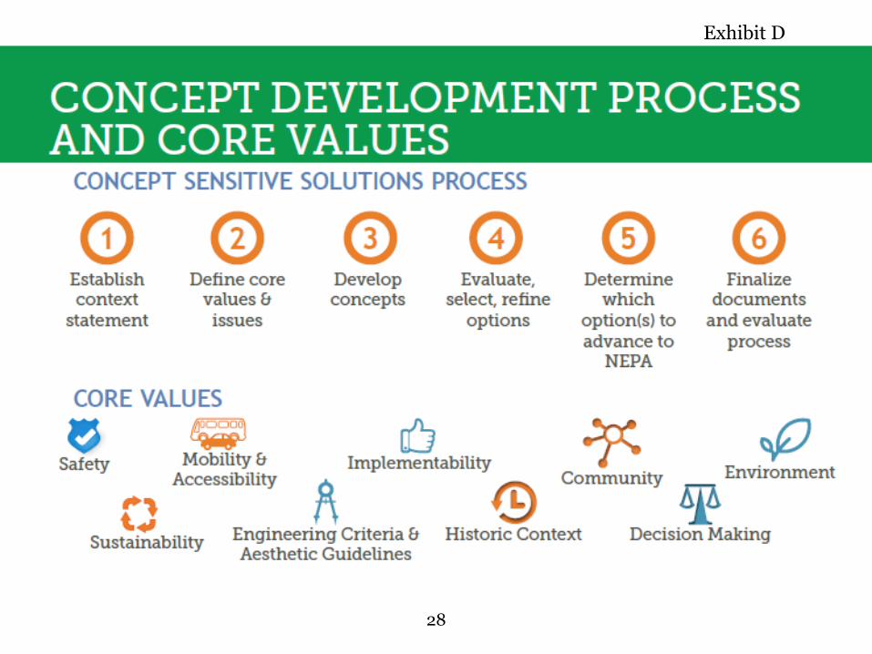
• Jonathan Bartsch presented information on the 6 – Step Decision
Making Process (as part of the Concept Sensitive Solutions Process)
(Exhibit D):
o Establish Context Statement
o Define Core Values and Critical Issues
o Develop Concepts
o Evaluate, select, refine options
o Determine which option(s) to advance to NEPA
o Finalize documents and evaluate process
• Jonathan Bartsch further presented (Exhibit D) the Core Values of
the CDP. These were used to develop and evaluate concepts:
o Safety
o Mobility and Accessibility
o Implementability
o Community
o Environment
o Sustainability
o Engineering Criteria and Aesthetic Guidelines
o Historic Context
o Decision Making
3
• Gina McAfee, HDR Inc., presented comments received during Public
Meeting #1 and explained how those comments helped to develop
Concepts that were presented during Meeting #2.
o Public input, needs and concerns that were identified during
the CDP were to be taken into the two NEPA processes, Floyd
Hill and Westbound PPSL.
• Gina McAfee, explained the Evaluation Matrices that were used in the
CDP. These matrices were used to:
▪ Evaluate alignment and interchange concepts using the
public input, needs and concerns for Segment 1
▪ Determine cross section concepts for Segments 2 and 3
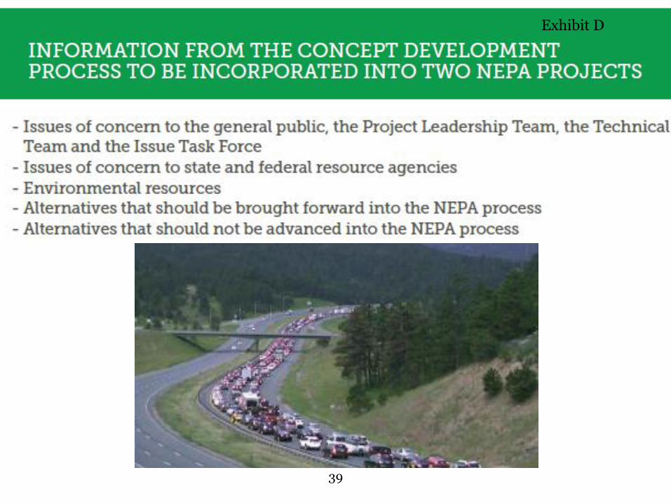
o Gina McAfee also discussed what information from the CDP is
being carried into the NEPA processes:
o 1. Issues of concern to the general public, the Project
Leadership Team, the Technical Team and the Issue Task Force
o 2. Issues of concern to state and federal resource agencies
o 3. Environmental resources
o 4. Concepts that should be brought forward into the NEPA
processes (These are indicated on the evaluation matrices at the
back of the room)
o 5. Concepts that should not be advanced into the NEPA
process.
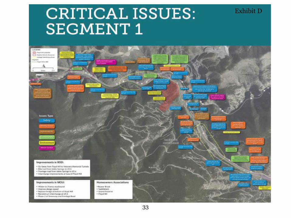
• Steve Long, HDR Inc., presented the concepts proposed for Segment
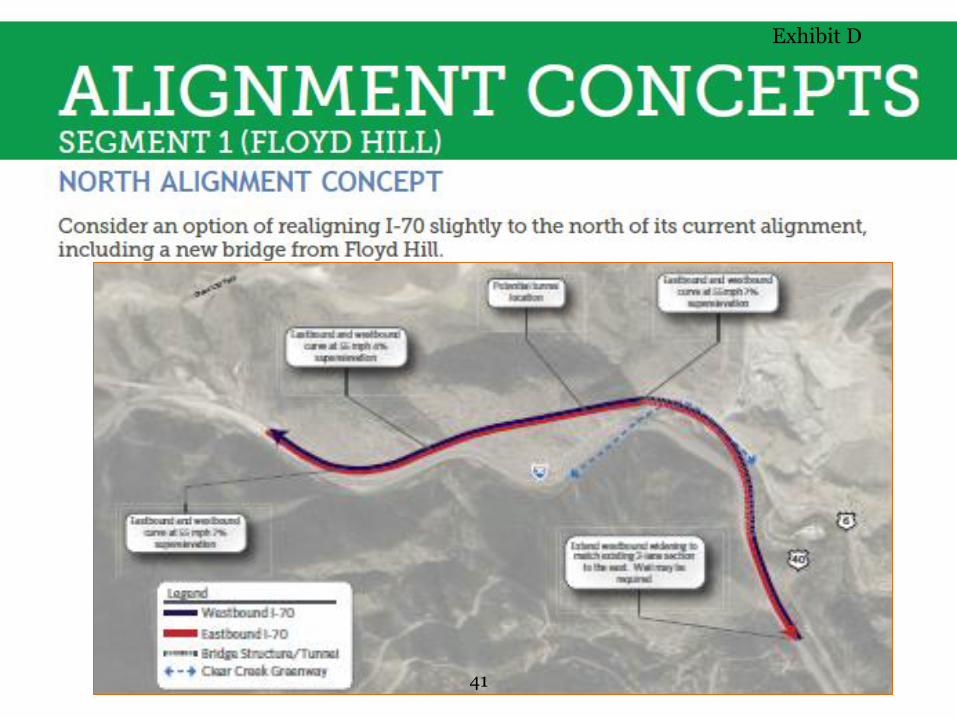
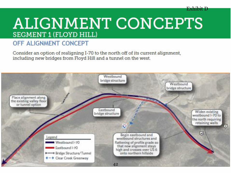
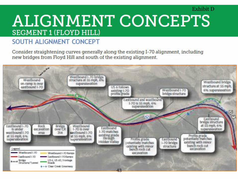
1 and Segments 2/3
o Segment 1 concepts explored how to get down, around, or
through Floyd Hill with several families of concepts including:
▪ North Alignment Concepts
▪ Off Alignment Concepts
▪ South Alignment Concepts
▪ Interchange Concepts (there are four of those)
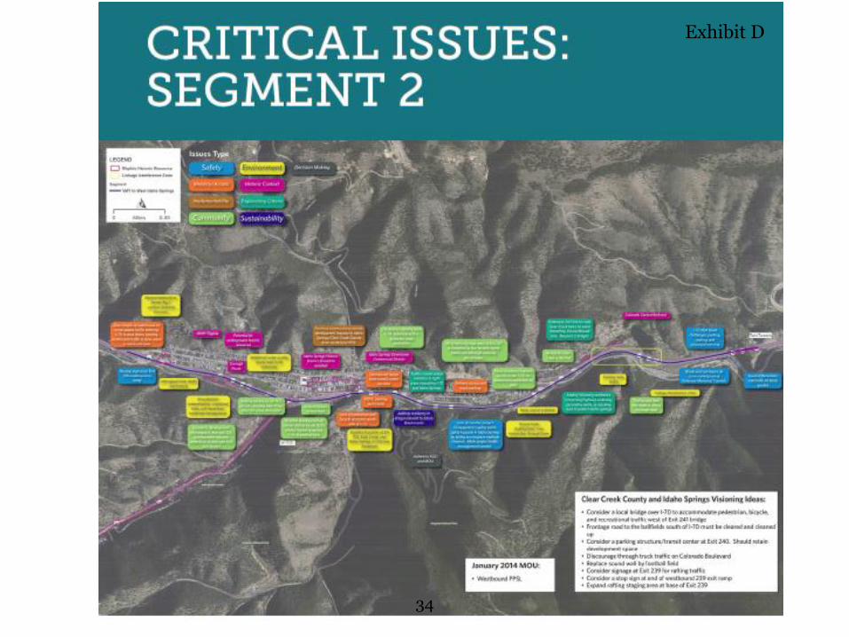
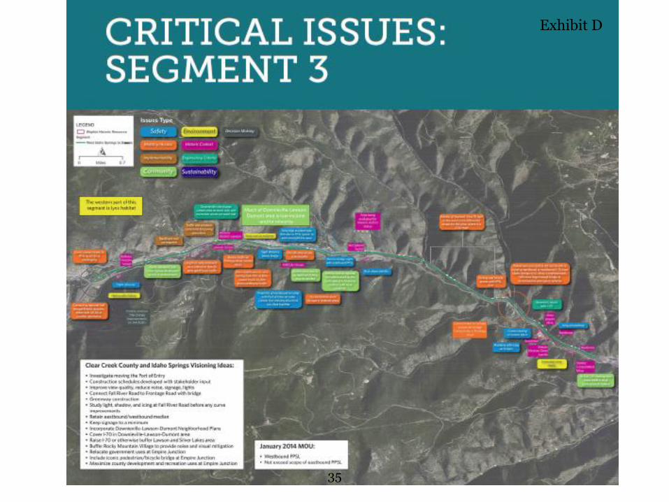
o Segment 2 concepts explored the options for a Westbound PPSL
and also looked at how to begin east of Idaho Springs and how
to end in the Empire Junction interchange area.
6:00 PM – 6:45 PM Public Comment Period
4
Following the presentation, the floor is open for a public “Question and
Answer” session. All questions from the public were written on large easel
paper in the room. Below are questions that were brought up by several of
the attendees. Further questions and comments can be found in Exhibit E.
Question: Are we considering the induced demand that improvements
will cause? Answer: Yes, During NEPA there will be a traffic design model
that will project what conditions will be like with and without the project 20
years from now.
Question: Are we looking at the fiscal implications of these concepts?
Answer: Throughout the NEPA process, costs will be refined. However, as
of right now there are just guesses as to the fiscal implications of each. In
regards to the fiscal impacts of rock cuts vs. median changes, the design will
go foot by foot along the corridor and determine which method to widen.
No cost estimates were prepared during the CDP.
Question: Throughout the country there are examples of aesthetically
pleasing overpasses, the overpass at exit 240 is not aesthetically pleasing,
are we going to consider aesthetics in concepts? Answer: There are
aesthetic guidelines to consider during design, the idea is to highlight the
natural beauty of the corridor.
Question: Should the project area be extended east towards El Rancho,
where the traffic issues stretch towards? Answer: We have looked at
extending the study area. The decision on the limits will be made during
the NEPA process for Floyd Hill.
Question: Are these improvements still being considered an interim
project based upon the Record of Decision (ROD)? This doesn’t include the
Advanced Guideway System (AGS) or other long-term, permanent
solutions? Answer: Yes, these are considered interim improvements. In
2011, FHWA and CDOT agreed to the Programmatic Environmental Impact
Statement (PEIS) ROD. At the time of the PEIS ROD, there was a question
of feasibility in technical terms and in fiscal terms. In 2014, CDOT
undertook the AGS feasibility study which found that AGS is technically
feasible. Financially, the farebox revenue is expected to cover operational
5
costs but not the capital costs. One thing to our advantage, technology is
advancing. In 2011, this technology (assumed to be magnetic levitation) was
in its infancy, but now more installations are being made around the world.
Question: Should the Frontage Road at the bottom of Floyd Hill near
Idaho Springs be finished before rock scaling or other improvements? That
way it could be used as a construction detour during Floyd Hill
construction. Answer: In the ROD, the commitment was to build the
Frontage Road and connect from US 6 west to Idaho Springs. The ROD
commits to connectivity through the canyon.
Question: Has there been consideration of a pedestrian bridge over I-70
in Idaho Springs? Answer: The Project Leadership Team has looked at a
pedestrian bridge at the new parking garage/transit center that is being
considered by Idaho Springs.
Question: How are we going to ensure that the next construction projects
look like the Twin Tunnels model of success? Answer: CDOT is well aware
of the issues with the Eastbound PPSL contractor. We will look at ways to
make future contractors more responsive to community and business
community issues.
Comment: 1,100 people depend on Homestead Road at Exit 247 as their
only way in and out leaving us with a safety issue. Don’t make the area on
the south side by Exit 247 any worse. Keep as much traffic as possible away
from that area. As you look at your matrix, you may want to separate things
like safety and mobility and consider the local impacts differently from the
through traffic issues. One option you’re not carrying forward, I would
suggest not carrying all of that traffic up the hill; something closer to the
bottom of the hill is safer for the community. There are opportunities to use
the same facility in the summer time to access open space and serve as a
staging area in the winter.
Comment: One of the big problems we have (Dumont/Lawson area) is
noise. We need a jake brake law. Sound barriers on both sides of the
highway to funnel traffic up would helpful. The rumble strip on the
6
expanded side of the road should be pushed to the edge of the road since
that also causes more noise.
Comment: Want to make sure that truck access to the quarry to and from
US 6 is ensured.
6:45 PM – 7:00 PM Open House
• Attendees continued to look at Segment Maps and Project Boards.
Attendees provided comments in the comment box and had the
opportunity to speak to Project Management Team, Project
Leadership Team or Technical Team members one-on-one to provide
additional comments and ask questions.
7:00 PM – Close
7
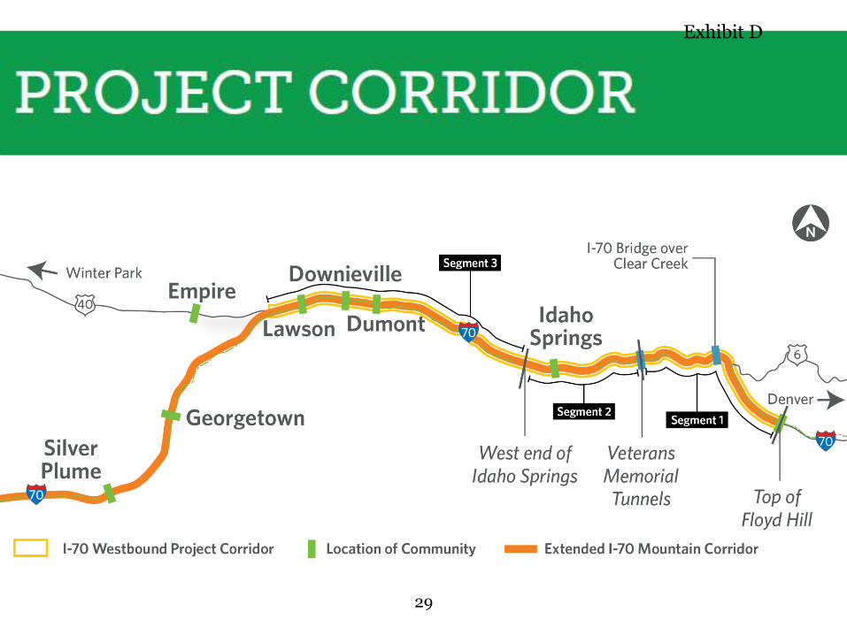
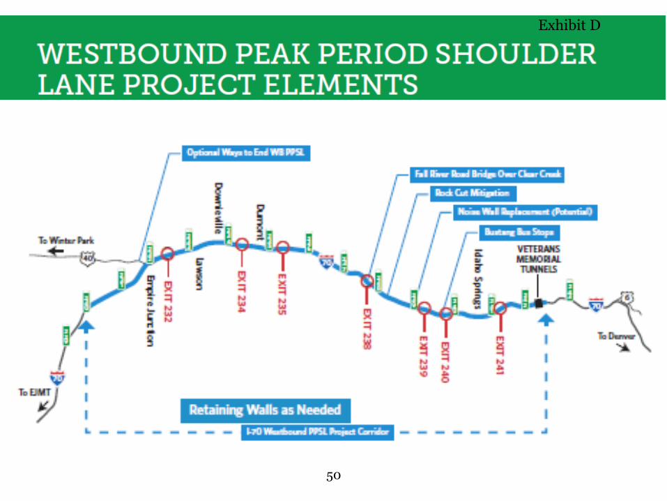
WESTBOUND I-70 MOUNTAIN CORRIDOR IMPROVEMENTS Westbound Peak Period Shoulder Lane (WB PPSL) Project—
Veterans Memorial Tunnels to Empire Junction
1 of 4
AGENDA 5:00-5:30 p.m.: Please sign-in and feel free to walk around to the different stations.
5:30-6:00 p.m.: We invite you to join us for a presentation about the Westbound I-70 Mountain Corridor Concept Development Process and our transition into the National Environmental Policy Act.
6:00-6:30 p.m.: Question and answer session following the presentation.
6:30-7:00 p.m.: Please feel free to walk around and view the various stations. If you have any questions or comments, walk up to any of the agency officials with a name tag and they’ll be happy to speak with you.
Comment sheets are available if you wish to write to us.
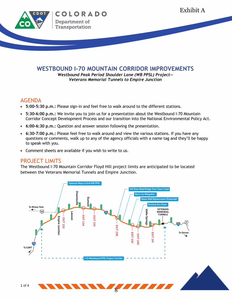
PROJECT LIMITS
The Westbound I-70 Mountain Corridor Floyd Hill project limits are anticipated to be located
between the Veterans Memorial Tunnels and Empire Junction.
8
Exhibit A
WESTBOUND I-70 MOUNTAIN CORRIDOR IMPROVEMENTS Westbound Peak Period Shoulder Lane (WB PPSL) Project—
Veterans Memorial Tunnels to Empire Junction
2 of 4
PROJECT PURPOSE
Information collected during the Concept Development Process helps to identify the purpose for
highway improvements in the WB PPSL section. There is traffic congestion during peak hours, there
is a lack of reliable travel, and there is a need for improved emergency response. This information
will be confirmed and additional information collected during the upcoming NEPA process.
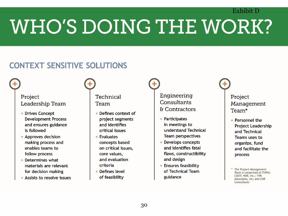
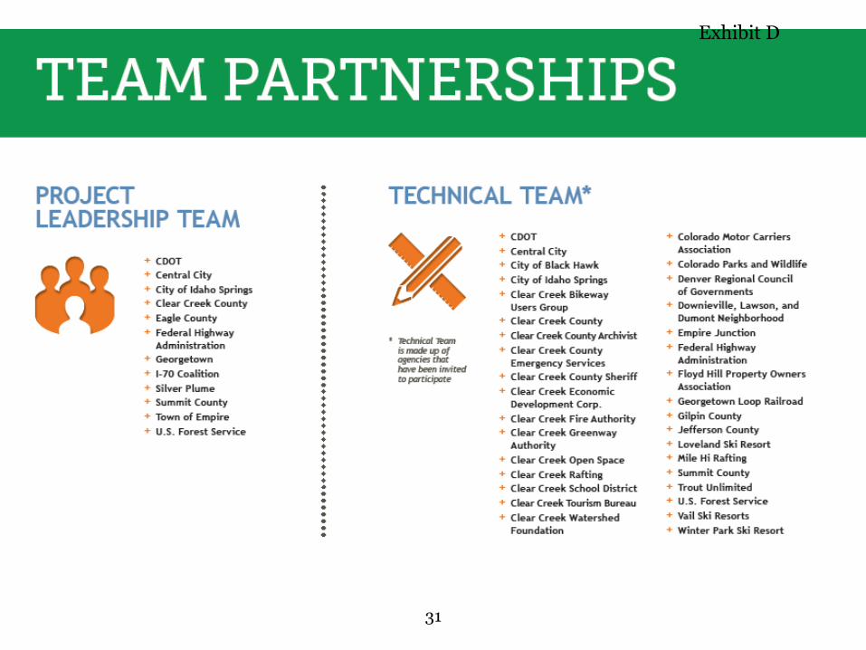
SUMMARY OF CONCEPT DEVELOPMENT FINDINGS Individuals from local jurisdictions, communities, state and federal agencies and special interest
groups were a part of an 18-member Project Leadership Team and a 48-member Technical Team that guided the concept development process.
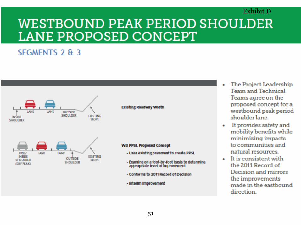
There is agreement that a similar approach regarding the peak period shoulder lane can be pursued in the westbound direction as was recently constructed in the eastbound direction.
The 2011 Record of Decision did not identify this section of I-70 for any additional highway capacity (for the Minimum Program of Improvements).
Many suggestions and concerns were identified during the eight month Concept Development Process. These will be forwarded to the National Environmental Policy Act (NEPA) WB PPSL team for their consideration during the upcoming NEPA process.
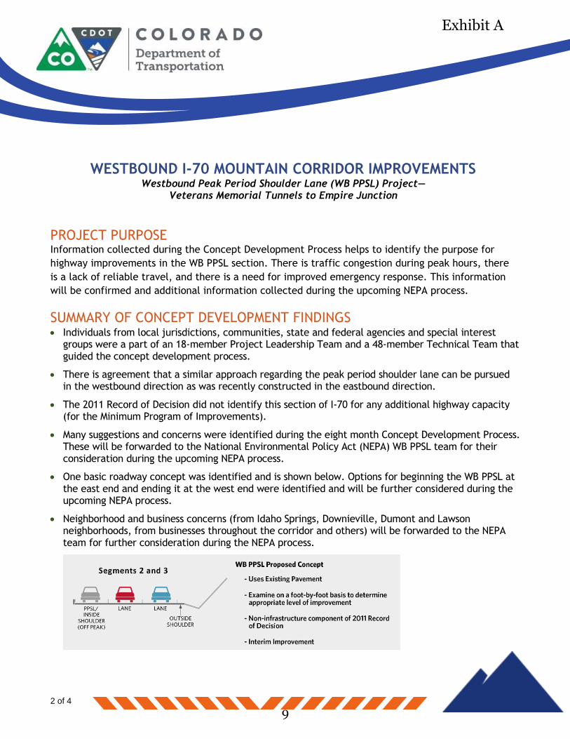
One basic roadway concept was identified and is shown below. Options for beginning the WB PPSL at the east end and ending it at the west end were identified and will be further considered during the upcoming NEPA process.
Neighborhood and business concerns (from Idaho Springs, Downieville, Dumont and Lawson neighborhoods, from businesses throughout the corridor and others) will be forwarded to the NEPA team for further consideration during the NEPA process.
9
Exhibit A
WESTBOUND I-70 MOUNTAIN CORRIDOR IMPROVEMENTS Westbound Peak Period Shoulder Lane (WB PPSL) Project—
Veterans Memorial Tunnels to Empire Junction
3 of 4
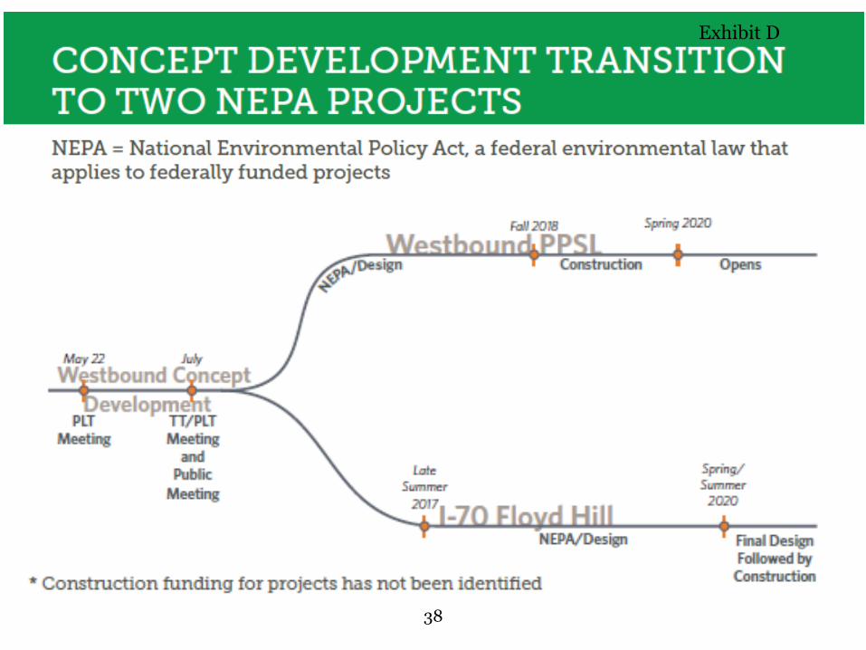
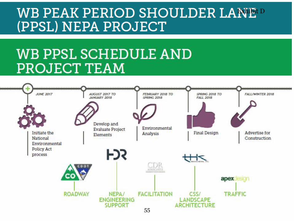
UPCOMING NEPA PROCESS The NEPA process for the WB PPSL project began in June 2017. A Project Leadership Team
(comprised of the Federal Highway Administration, the Colorado DOT, Clear Creek County, Jefferson
County and others) has been formed to begin the Context Sensitive Solutions process in late July.
The basic steps of the NEPA process include:
1. Scoping to identify items to be considered in the upcoming NEPA process. The July 26, 2017 public meeting is a part of this process. Additional input will be sought through the I-70 Mountain Corridor Context Sensitive Solutions process.
2. Data collection (traffic, safety, environmental, engineering)
3. Refine Proposed Concept from the Concept Development Process. This will be done together with the CSS participants (the Project Leadership Team, and other groups such as a Technical Team and Issue Task Forces as needed.)
4. Analyze Refined Proposed Concept to determine its environmental impacts.
5. Prepare NEPA documentation (this is anticipated to be a Categorical Exclusion similar to the Eastbound Peak Period Shoulder Lane project).
6. Public and agency involvement will be conducted throughout this process
CONTEXT SENSITIVE SOLUTIONS PROCESS
The I-70 Mountain Corridor Context Sensitive Solutions process was developed five years ago and is a
required part of every project on the I-70 Mountain Corridor. This process is being followed
throughout the WB PPSL process. This includes establishment of a Project Leadership Team, a
Technical Team and Issue Task Forces as needed. It also includes following the six step decision-
making process of:
1. Defining desired outcomes and actions 2. Endorsing the process 3. Establishing core values, issues and evaluation criteria 4. Developing alternatives with project CSS teams and public 5. Evaluating, selecting, and refining alternatives 6. Finalizing documentation and evaluating the process
10
Exhibit A
WESTBOUND I-70 MOUNTAIN CORRIDOR IMPROVEMENTS Westbound Peak Period Shoulder Lane (WB PPSL) Project—
Veterans Memorial Tunnels to Empire Junction
4 of 4
For more information, please see: https://www.codot.gov/projects/contextsensitivesolutions.
WHAT’S NEXT?
WB PPSL NEPA project Timeline
Summer/Fall 2017: Begin data collection and project concept refinement
Winter 2017/2018—Spring 2018: NEPA documentation
Fall/Winter 2018: Final Design
Winter 2018: Construction
TELL US YOUR IDEAS Want to learn more or have questions? Send your additional comment and questions to
[email protected] or go online to codot.gov/projects/i-70mountaincorridor.
Materials from the July 26, 2017, meeting are available at:
https://www.codot.gov/projects/i-70mountaincorridor/concept-development-process.
11
Exhibit A
WESTBOUND I-70 MOUNTAIN CORRIDOR IMPROVEMENTS Floyd Hill Project—Top of Floyd Hill to the Veterans Memorial Tunnel
AGENDA • 5:00-5:30 p.m.: Please sign-in and feel free to walk around to the different stations. • 5:30-6:00 p.m.: We invite you to join us for a presentation about the Westbound I-70 Mountain
Corridor Concept Development Process and our transition into the National Environmental Policy Act.
• 6:00-6:30 p.m.: Question and answer session following the presentation. • 6:30-7:00 p.m.: Please feel free to walk around and view the various stations. If you have any
questions or comments, walk up to any of the agency officials with a name tag and they’ll be happy to speak with you.
• Comment sheets are available if you wish to write to us.
PROJECT LIMITS The Westbound I-70 Mountain Corridor Floyd Hill project limits are anticipated to be located between the top of Floyd Hill and the Veterans Memorial Tunnels.
PROJECT PURPOSE Information collected during the Concept Development Process helps to identify the purpose for highway improvements in the Floyd Hill section. With a total of 5.5 million residents in Colorado (and counting), congestion along westbound I-70 has gotten increasingly worse each
1 of 4
12
Exhibit B
WESTBOUND I-70 MOUNTAIN CORRIDOR IMPROVEMENTS Floyd Hill Project—Top of Floyd Hill to the Veterans Memorial Tunnel
year. Congestion also contributes to hazards along the corridor and leaves locals stranded. In addition, the tight curves in the Floyd Hill project contribute to crashes. This information will be confirmed and additional information collected during the upcoming NEPA process.
SUMMARY OF CONCEPT DEVELOPMENT FINDINGS Individuals from local jurisdictions, communities, state and federal agencies and special interest groups were a part of an 18-member Project Leadership Team and a 48-member Technical Team that guided the concept development process. Below is a summary of their findings:
There is a need for capacity improvements to overcome safety and congestion problems.
The 2011 Tier 1 Record of Decision identified this section of I-70, from the top of Floyd Hill to the Veterans Memorial Tunnel, as an area that could allow for six lane capacity improvements.
Many suggestions and concerns that were identified during the eight month Concept Development Process will be forwarded to the National Environmental Policy Act (NEPA) Floyd Hill team for their consideration during the upcoming Floyd Hill NEPA process.
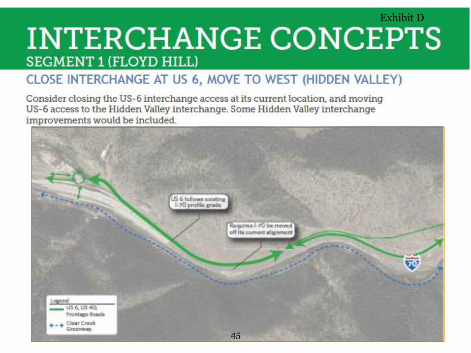
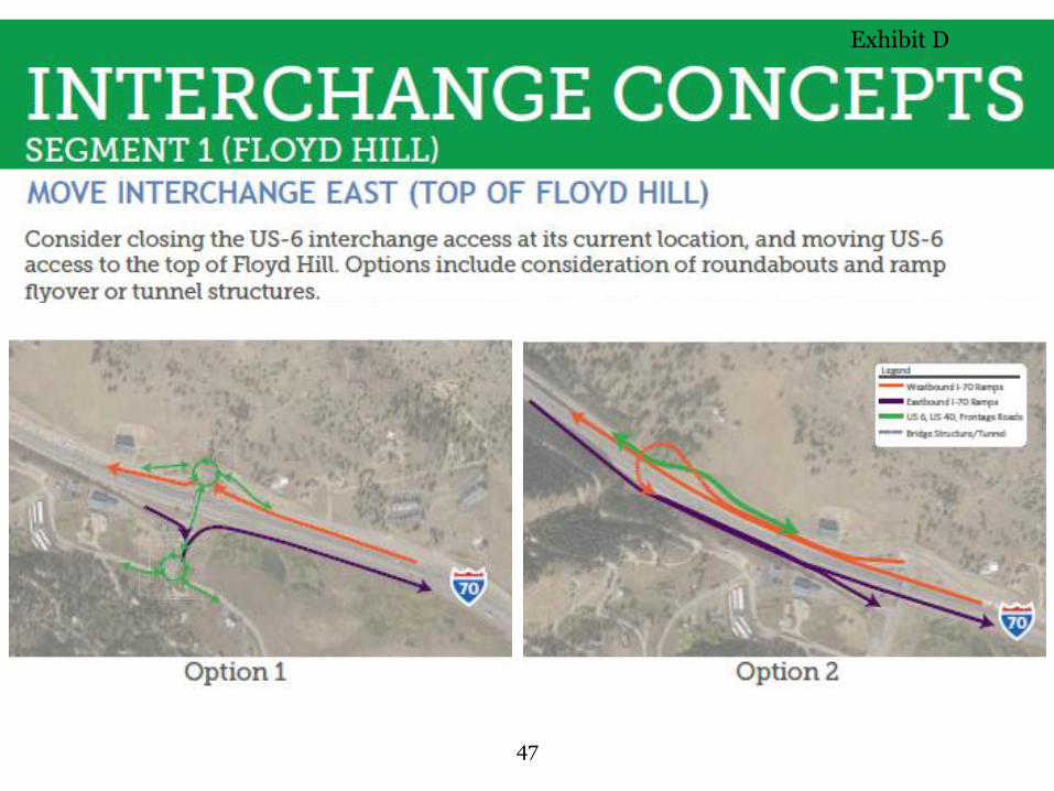
Concepts were identified for three alignments (North, South and Off-Alignment) and four interchanges (improving the US 6 interchange at its current location, moving the interchange to Hidden Valley, moving it just east of US 6 or moving it to the top of Floyd Hill.) All of these will be considered during the upcoming NEPA process.
Additional concepts for westbound I-70 (interchanges, bike and pedestrian considerations, transit, advanced technology, emergency response) are likely to be developed and considered during the upcoming NEPA process.
Neighborhood and business concerns (from Floyd Hill neighborhoods, businesses at the bottom of Floyd Hill and others) will be forwarded to the NEPA team for further consideration during the NEPA process.
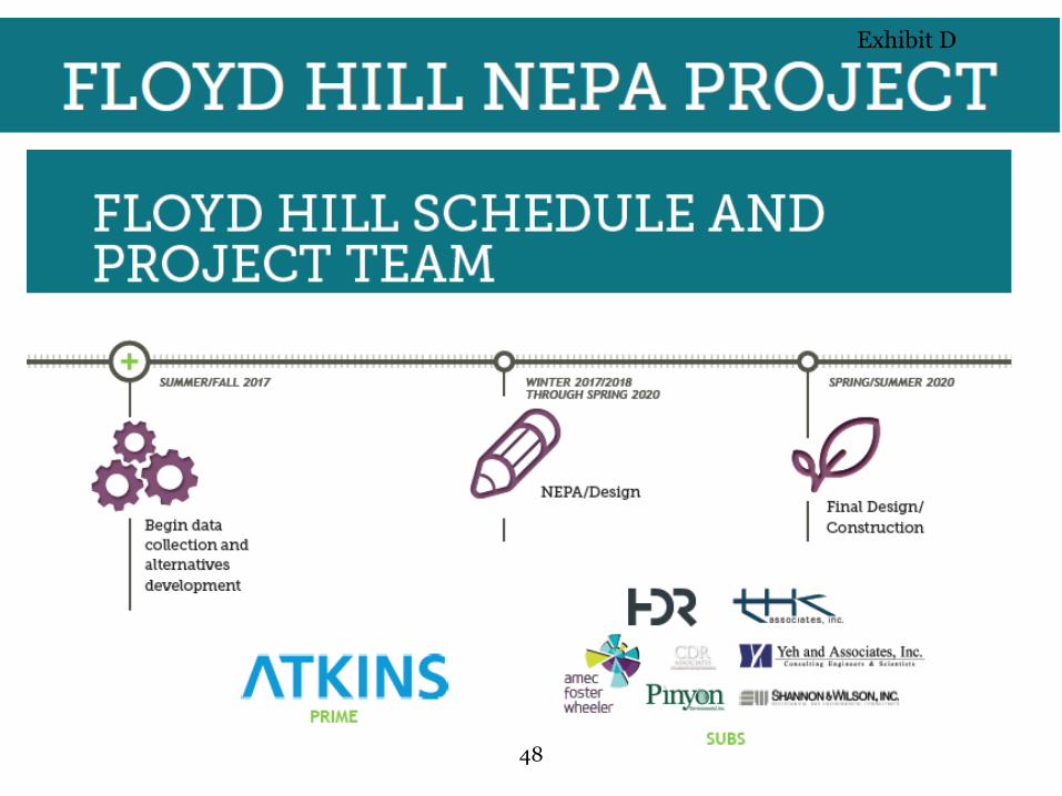
UPCOMING NEPA PROCESS The NEPA process for the Floyd Hill project will begin in August 2017 to help promote the enhancement of the environment. A Project Leadership Team (comprised of the Federal Highway
2 of 4
13
Exhibit B

WESTBOUND I-70 MOUNTAIN CORRIDOR IMPROVEMENTS Floyd Hill Project—Top of Floyd Hill to the Veterans Memorial Tunnel
Administration, the Colorado DOT, Clear Creek County, Jefferson County and others) will be formed to begin the Context Sensitive Solutions process. The basic steps of the NEPA process include:
1. Scoping to identify items to be considered in the upcoming NEPA process. The July 26, 2017 public meeting is a part of this process. Additional input will be sought through the I-70 Mountain Corridor Context Sensitive Solutions process.
2. Data collection (traffic, safety, environmental, engineering)
3. Develop alternatives. This will be done together with the CSS participants (the Project Leadership Team, and other groups such as a Technical Team and Issue Task Forces as needed.)
4. Analyze alternatives to determine a reasonable range of alternatives to advance into the NEPA process
5. Evaluate impacts of reasonable alternatives
6. Prepare a draft environmental report (could be an Environmental Assessment or a Draft Environmental Impact Statement)
7. Solicit public input
8. Prepare a decision document
9. Public and agency involvement will be conducted throughout this process
CONTEXT SENSITIVE SOLUTIONS PROCESS The I-70 Mountain Corridor Context Sensitive Solutions process is being followed throughout the Floyd Hill NEPA process. This includes establishment of a Project Leadership Team, a Technical Team, and Issue Task Forces as needed. It also includes following the six-step decision-making process of: 1. Defining desired outcomes and actions 2. Endorsing the process 3. Establishing core values, issues and evaluation criteria 4. Developing alternatives with project CSS teams and public 5. Evaluating, selecting, and refining alternatives 6. Finalizing documentation and evaluating the process
For more information, please see https://www.codot.gov/projects/contextsensitivesolutions.
3 of 4
14
Exhibit B

WESTBOUND I-70 MOUNTAIN CORRIDOR IMPROVEMENTS Floyd Hill Project—Top of Floyd Hill to the Veterans Memorial Tunnel
WHAT’S NEXT? Floyd Hill NEPA project Timeline: • Summer/Fall 2017: Begin data collection and alternatives development • Winter 2017/2018 through Spring 2020: NEPA/Design • Spring/Summer 2020: Final design followed by Construction
TELL US YOUR IDEAS Want to learn more or have questions? Send your additional comment and questions to [email protected] or go online to codot.gov/projects/i-70mountaincorridor.
Materials from the July 26, 2017 meeting are available at: https://www.codot.gov/projects/i-70mountaincorridor/concept-development-process.
4 of 4
15
Exhibit B
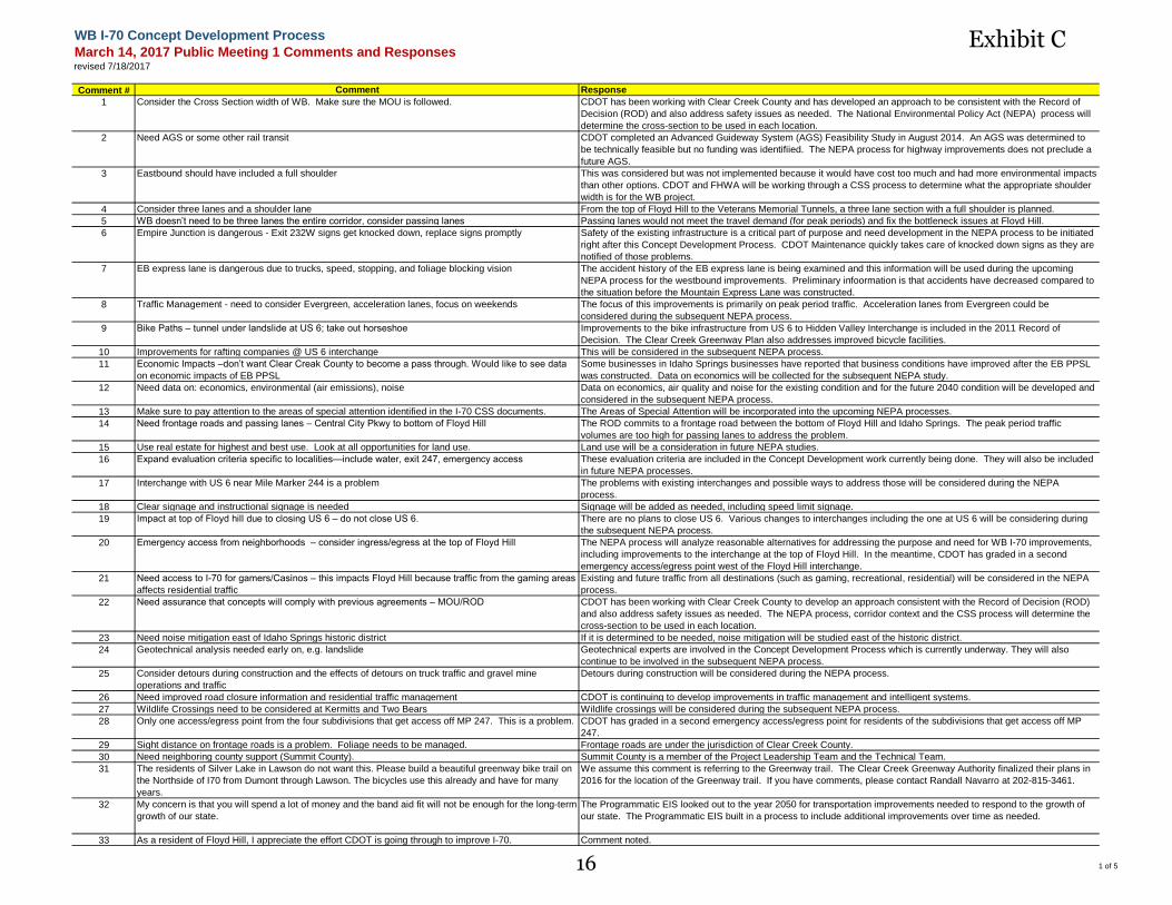
WB I-70 Concept Development Process
March 14, 2017 Public Meeting 1 Comments and Responsesrevised 7/18/2017
Comment # Comment Response
1 Consider the Cross Section width of WB. Make sure the MOU is followed. CDOT has been working with Clear Creek County and has developed an approach to be consistent with the Record of
Decision (ROD) and also address safety issues as needed. The National Environmental Policy Act (NEPA) process will
determine the cross-section to be used in each location.
2 Need AGS or some other rail transit CDOT completed an Advanced Guideway System (AGS) Feasibility Study in August 2014. An AGS was determined to
be technically feasible but no funding was identifiied. The NEPA process for highway improvements does not preclude a
future AGS.
3 Eastbound should have included a full shoulder This was considered but was not implemented because it would have cost too much and had more environmental impacts
than other options. CDOT and FHWA will be working through a CSS process to determine what the appropriate shoulder
width is for the WB project.
4 Consider three lanes and a shoulder lane From the top of Floyd Hill to the Veterans Memorial Tunnels, a three lane section with a full shoulder is planned.
5 WB doesn’t need to be three lanes the entire corridor, consider passing lanes Passing lanes would not meet the travel demand (for peak periods) and fix the bottleneck issues at Floyd Hill.
6 Empire Junction is dangerous - Exit 232W signs get knocked down, replace signs promptly Safety of the existing infrastructure is a critical part of purpose and need development in the NEPA process to be initiated
right after this Concept Development Process. CDOT Maintenance quickly takes care of knocked down signs as they are
notified of those problems.
7 EB express lane is dangerous due to trucks, speed, stopping, and foliage blocking vision The accident history of the EB express lane is being examined and this information will be used during the upcoming
NEPA process for the westbound improvements. Preliminary infoormation is that accidents have decreased compared to
the situation before the Mountain Express Lane was constructed.
8 Traffic Management - need to consider Evergreen, acceleration lanes, focus on weekends The focus of this improvements is primarily on peak period traffic. Acceleration lanes from Evergreen could be
considered during the subsequent NEPA process.
9 Bike Paths – tunnel under landslide at US 6; take out horseshoe Improvements to the bike infrastructure from US 6 to Hidden Valley Interchange is included in the 2011 Record of
Decision. The Clear Creek Greenway Plan also addresses improved bicycle facilities.
10 Improvements for rafting companies @ US 6 interchange This will be considered in the subsequent NEPA process.
11 Economic Impacts –don’t want Clear Creak County to become a pass through. Would like to see data
on economic impacts of EB PPSL
Some businesses in Idaho Springs businesses have reported that business conditions have improved after the EB PPSL
was constructed. Data on economics will be collected for the subsequent NEPA study.
12 Need data on: economics, environmental (air emissions), noise Data on economics, air quality and noise for the existing condition and for the future 2040 condition will be developed and
considered in the subsequent NEPA process.
13 Make sure to pay attention to the areas of special attention identified in the I-70 CSS documents. The Areas of Special Attention will be incorporated into the upcoming NEPA processes.
14 Need frontage roads and passing lanes – Central City Pkwy to bottom of Floyd Hill The ROD commits to a frontage road between the bottom of Floyd Hill and Idaho Springs. The peak period traffic
volumes are too high for passing lanes to address the problem.
15 Use real estate for highest and best use. Look at all opportunities for land use. Land use will be a consideration in future NEPA studies.
16 Expand evaluation criteria specific to localities—include water, exit 247, emergency access These evaluation criteria are included in the Concept Development work currently being done. They will also be included
in future NEPA processes.
17 Interchange with US 6 near Mile Marker 244 is a problem The problems with existing interchanges and possible ways to address those will be considered during the NEPA
process.
18 Clear signage and instructional signage is needed Signage will be added as needed, including speed limit signage.
19 Impact at top of Floyd hill due to closing US 6 – do not close US 6. There are no plans to close US 6. Various changes to interchanges including the one at US 6 will be considering during
the subsequent NEPA process.
20 Emergency access from neighborhoods – consider ingress/egress at the top of Floyd Hill The NEPA process will analyze reasonable alternatives for addressing the purpose and need for WB I-70 improvements,
including improvements to the interchange at the top of Floyd Hill. In the meantime, CDOT has graded in a second
emergency access/egress point west of the Floyd Hill interchange.
21 Need access to I-70 for gamers/Casinos – this impacts Floyd Hill because traffic from the gaming areas
affects residential traffic
Existing and future traffic from all destinations (such as gaming, recreational, residential) will be considered in the NEPA
process.
22 Need assurance that concepts will comply with previous agreements – MOU/ROD CDOT has been working with Clear Creek County to develop an approach consistent with the Record of Decision (ROD)
and also address safety issues as needed. The NEPA process, corridor context and the CSS process will determine the
cross-section to be used in each location.
23 Need noise mitigation east of Idaho Springs historic district If it is determined to be needed, noise mitigation will be studied east of the historic district.
24 Geotechnical analysis needed early on, e.g. landslide Geotechnical experts are involved in the Concept Development Process which is currently underway. They will also
continue to be involved in the subsequent NEPA process.
25 Consider detours during construction and the effects of detours on truck traffic and gravel mine
operations and traffic
Detours during construction will be considered during the NEPA process.
26 Need improved road closure information and residential traffic management CDOT is continuing to develop improvements in traffic management and intelligent systems.
27 Wildlife Crossings need to be considered at Kermitts and Two Bears Wildlife crossings will be considered during the subsequent NEPA process.
28 Only one access/egress point from the four subdivisions that get access off MP 247. This is a problem. CDOT has graded in a second emergency access/egress point for residents of the subdivisions that get access off MP
247.
29 Sight distance on frontage roads is a problem. Foliage needs to be managed. Frontage roads are under the jurisdiction of Clear Creek County.
30 Need neighboring county support (Summit County). Summit County is a member of the Project Leadership Team and the Technical Team.
31 The residents of Silver Lake in Lawson do not want this. Please build a beautiful greenway bike trail on
the Northside of I70 from Dumont through Lawson. The bicycles use this already and have for many
years.
We assume this comment is referring to the Greenway trail. The Clear Creek Greenway Authority finalized their plans in
2016 for the location of the Greenway trail. If you have comments, please contact Randall Navarro at 202-815-3461.
32 My concern is that you will spend a lot of money and the band aid fit will not be enough for the long-term
growth of our state.
The Programmatic EIS looked out to the year 2050 for transportation improvements needed to respond to the growth of
our state. The Programmatic EIS built in a process to include additional improvements over time as needed.
33 As a resident of Floyd Hill, I appreciate the effort CDOT is going through to improve I-70. Comment noted.
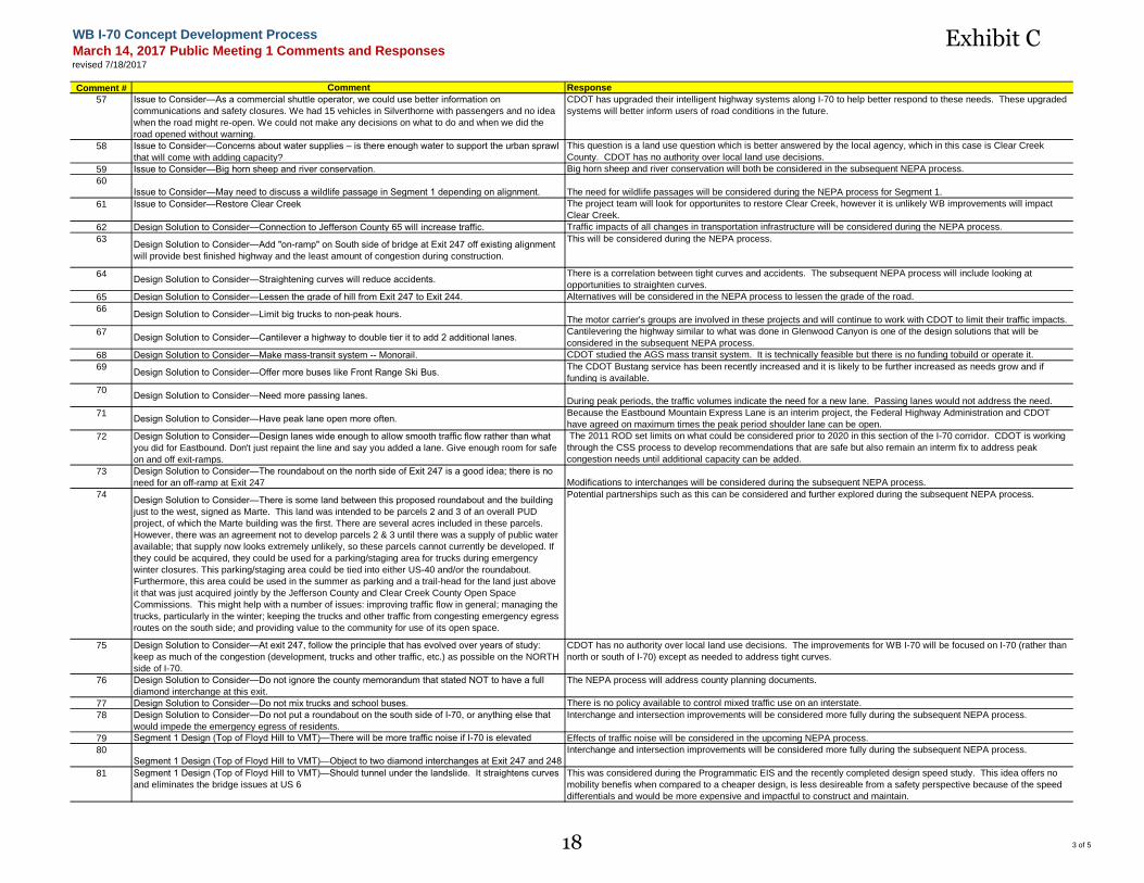
1 of 516
Exhibit C
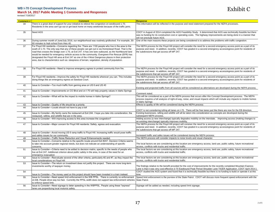
WB I-70 Concept Development Process
March 14, 2017 Public Meeting 1 Comments and Responsesrevised 7/18/2017
Comment # Comment Response
34 There is a great deal of support for your initiative to relieve the congestion on westbound 1-70.
Residents in the area can't go out or get back home on many weekends because of the traffic jams.
This information will be reflected in the purpose and need statement prepared for the NEPA processes.
35 Need AGS CDOT in August of 2014 completed the AGS Feasibility Study. It determined that AGS was technically feasible but there
was no funding for its construction cost or operating costs. The highway improvements are being done in a manner that
will not preclude future AGS.
36 During summer month of June/July 2016, our neighborhood was routinely gridlocked. For example, 30-
60 minutes to high school from Hwy 40.
One of the main reasons these projects are being considered is to address the problems with traffic congestion.
37 For Floyd Hill residents—Concerns regarding fire: There are 1100 people who live in the area to the
south of 1-70. The only way that any of these people can get out is via Homestead Road. That is the
road that crosses the bridge over 1-70, at Exit 247. It has one lane outbound, as the Northbound lane
would be needed for emergency vehicle access to the community. Evergreen Fire Rescue (EFR) has
designated the Floyd Hill area at Exit 247 as one of the 4 Most Dangerous places in their protection
area, due to characteristics such as: steepness of terrain, vegetation, density of population.
The NEPA process for the Floyd Hill project will consider the need for a second emergency access point as a part of its
purpose and need. In addition, recently, CDOT has graded in a second emergency access/egress point for residents of
the subdivisions that get access off MP 247.
38 For Floyd Hill residents—Need to improve emergency egress to protect community from fire. The NEPA process for the Floyd Hill project will consider the need for a second emergency access point as a part of its
purpose and need. In addition, recently, CDOT has graded in a second emergency access/egress point for residents of
the subdivisions that get access off MP 247.
39 For Floyd Hill residents—Improve the safety for Floyd Hill residents wherever you can. This includes
doing things like an emergency egress at Sawdust Court.
The NEPA process for the Floyd Hill project will consider the need for a second emergency access point as a part of its
purpose and need. In addition, recently, CDOT has graded in a second emergency access/egress point for residents of
the subdivisions that get access off MP 247.
40 Issue to Consider—Too much traffic from gaming area on US 6 and US 40
Existing and projected traffic from all sources will be considered as alternatives are developed during the NEPA process.
41 Issue to Consider—Improvements on CO Blvd and on I-70 will help property values in Idaho Springs
Comment noted.
42 Issue to Consider—What will be the impact to mobile homes in Idaho Springs? This will be considered as a part of the NEPA process that occurs after this Concept Development process. The NEPA
process requires a full analysis of right-of-way, noise, and visual impacts which will include any impacts to mobile homes
in Idaho Springs
43 Issue to Consider—Quality of life should be a priority Effects to quality of life will be considered during the NEPA process
44 Issue to Consider—Locals should not have to pay a toll
CDOT is not considering tolling all lanes on I-70. There will be free lanes just like there are now for the EB direction.
45 Issue to Consider—My family owns the restaurant at Exit 244. I hope you take into consideration, the
restaurant, rafting, and wildlife that are in the area.
Existing businesses, rafting and wildlife will all be taken into consideration as concepts are developed during the
subsequent NEPA process.
46 Issue to Consider—Will improving access to this area increase the congestion? Adding access (a new interchange) typically degrades mobility on the interstate. Improving access (making changes to
an existing interchange) typically improves mobility.
47 Issue to Consider—Major concern for Floyd Hill residents: Safety, egress and evacuation. The NEPA process for the Floyd Hill project will consiser the need for a second emergency access point as a part of its
purpose and need. In addition, recently, CDOT has graded in a second emergency access/egress point for residents of
the subdivisions that get access off MP 247.
48 Issue to Consider—Avoid moving US 6 ramp traffic to Floyd Hill. Increasing traffic would pose traffic
and safety issues for our community. Increased traffic and safey issues will be considered during the NEPA process.
49 Issue to Consider—Traffic Noise Reduction and Visual Enhancements needed. The NEPA process will consider impacts to noise levels and visual character.
50 Issue to Consider—Concerns relative to the specific locale around Exit #247. Decision Criteria seems
to take into account greater regional needs, but does not indicate an understanding of specific
concerns.
The local factors we are considering at this location are emergency access, land use, public safety, future recreational
access, conflicts with trucks and residential traffic.
51 Issue to Consider—Criteria need to be added to decision matrix, specific to the needs of people who
live at Exit 247. Additional criterion about public safety in the area, in case of the need for an
emergency evacuation
The local factors we are considering at this location are emergency access, land use, public safety, future recreational
access, conflicts with trucks and residential traffic.
52 Issue to Consider—Reevaluate several of the other criteria, particularly #2 and #7, as they impact the
local considerations on Floyd Hill
The local factors we are considering at this location are emergency access, land use, public safety, future recreational
access, conflicts with trucks and residential traffic.
53 Issue to Consider—The return on investment does not justify this project. There are more long-term
investments worthy of taxpayer money. The findings relative to the benefit provided for the cost of improvements for the recently completed Mountain Express
Lane is that it was very cost-effective (I-70 Eastbound Peak Period Shoulder Lane TIGER Application, CDOT April 2014.)
54
Issue to Consider—The money used on this project should have been invested in a train instead.
CDOT studied the AGS system and found that it is technically feasible but there is no funding to build or operate it at this
time.
55 Issue to Consider—Need speed limit enforcement in the WB PPSL. There is currently no enforcement
on EB. People drive way too fast. Currently the PPSL width does not support law enforcement vehicles
to enforce speed limit.
Speed limit enforcement is the purview of the State Patrol. CDOT will discuss more frequent speed enforcement with the
State Patrol.
56 Issue to Consider—Need signage to deter speeding in the WBPPSL. People using these "express"
lanes are jeopardizing local motorist safety.
Signage will be added as needed, including speed limit signage.
2 of 517
Exhibit C
WB I-70 Concept Development Process
March 14, 2017 Public Meeting 1 Comments and Responsesrevised 7/18/2017
Comment # Comment Response
57 Issue to Consider—As a commercial shuttle operator, we could use better information on
communications and safety closures. We had 15 vehicles in Silverthorne with passengers and no idea
when the road might re-open. We could not make any decisions on what to do and when we did the
road opened without warning.
CDOT has upgraded their intelligent highway systems along I-70 to help better respond to these needs. These upgraded
systems will better inform users of road conditions in the future.
58 Issue to Consider—Concerns about water supplies – is there enough water to support the urban sprawl
that will come with adding capacity?
This question is a land use question which is better answered by the local agency, which in this case is Clear Creek
County. CDOT has no authority over local land use decisions.
59 Issue to Consider—Big horn sheep and river conservation. Big horn sheep and river conservation will both be considered in the subsequent NEPA process.
60
Issue to Consider—May need to discuss a wildlife passage in Segment 1 depending on alignment. The need for wildlife passages will be considered during the NEPA process for Segment 1.
61 Issue to Consider—Restore Clear Creek The project team will look for opportunites to restore Clear Creek, however it is unlikely WB improvements will impact
Clear Creek.
62 Design Solution to Consider—Connection to Jefferson County 65 will increase traffic. Traffic impacts of all changes in transportation infrastructure will be considered during the NEPA process.
63Design Solution to Consider—Add "on-ramp" on South side of bridge at Exit 247 off existing alignment
will provide best finished highway and the least amount of congestion during construction.
This will be considered during the NEPA process.
64Design Solution to Consider—Straightening curves will reduce accidents.
There is a correlation between tight curves and accidents. The subsequent NEPA process will include looking at
opportunities to straighten curves.
65 Design Solution to Consider—Lessen the grade of hill from Exit 247 to Exit 244. Alternatives will be considered in the NEPA process to lessen the grade of the road.
66Design Solution to Consider—Limit big trucks to non-peak hours.
The motor carrier's groups are involved in these projects and will continue to work with CDOT to limit their traffic impacts.
67Design Solution to Consider—Cantilever a highway to double tier it to add 2 additional lanes.
Cantilevering the highway similar to what was done in Glenwood Canyon is one of the design solutions that will be
considered in the subsequent NEPA process.
68 Design Solution to Consider—Make mass-transit system -- Monorail. CDOT studied the AGS mass transit system. It is technically feasible but there is no funding tobuild or operate it.
69Design Solution to Consider—Offer more buses like Front Range Ski Bus.
The CDOT Bustang service has been recently increased and it is likely to be further increased as needs grow and if
funding is available.
70Design Solution to Consider—Need more passing lanes.
During peak periods, the traffic volumes indicate the need for a new lane. Passing lanes would not address the need.
71Design Solution to Consider—Have peak lane open more often.
Because the Eastbound Mountain Express Lane is an interim project, the Federal Highway Administration and CDOT
have agreed on maximum times the peak period shoulder lane can be open.
72 Design Solution to Consider—Design lanes wide enough to allow smooth traffic flow rather than what
you did for Eastbound. Don't just repaint the line and say you added a lane. Give enough room for safe
on and off exit-ramps.
The 2011 ROD set limits on what could be considered prior to 2020 in this section of the I-70 corridor. CDOT is working
through the CSS process to develop recommendations that are safe but also remain an interm fix to address peak
congestion needs until additional capacity can be added.
73 Design Solution to Consider—The roundabout on the north side of Exit 247 is a good idea; there is no
need for an off-ramp at Exit 247 Modifications to interchanges will be considered during the subsequent NEPA process.
74Design Solution to Consider—There is some land between this proposed roundabout and the building
just to the west, signed as Marte. This land was intended to be parcels 2 and 3 of an overall PUD
project, of which the Marte building was the first. There are several acres included in these parcels.
However, there was an agreement not to develop parcels 2 & 3 until there was a supply of public water
available; that supply now looks extremely unlikely, so these parcels cannot currently be developed. If
they could be acquired, they could be used for a parking/staging area for trucks during emergency
winter closures. This parking/staging area could be tied into either US-40 and/or the roundabout.
Furthermore, this area could be used in the summer as parking and a trail-head for the land just above
it that was just acquired jointly by the Jefferson County and Clear Creek County Open Space
Commissions. This might help with a number of issues: improving traffic flow in general; managing the
trucks, particularly in the winter; keeping the trucks and other traffic from congesting emergency egress
routes on the south side; and providing value to the community for use of its open space.
Potential partnerships such as this can be considered and further explored during the subsequent NEPA process.
75 Design Solution to Consider—At exit 247, follow the principle that has evolved over years of study:
keep as much of the congestion (development, trucks and other traffic, etc.) as possible on the NORTH
side of I-70.
CDOT has no authority over local land use decisions. The improvements for WB I-70 will be focused on I-70 (rather than
north or south of I-70) except as needed to address tight curves.
76 Design Solution to Consider—Do not ignore the county memorandum that stated NOT to have a full
diamond interchange at this exit.
The NEPA process will address county planning documents.
77 Design Solution to Consider—Do not mix trucks and school buses. There is no policy available to control mixed traffic use on an interstate.
78 Design Solution to Consider—Do not put a roundabout on the south side of I-70, or anything else that
would impede the emergency egress of residents.
Interchange and intersection improvements will be considered more fully during the subsequent NEPA process.
79 Segment 1 Design (Top of Floyd Hill to VMT)—There will be more traffic noise if I-70 is elevated Effects of traffic noise will be considered in the upcoming NEPA process.
80
Segment 1 Design (Top of Floyd Hill to VMT)—Object to two diamond interchanges at Exit 247 and 248
Interchange and intersection improvements will be considered more fully during the subsequent NEPA process.
81 Segment 1 Design (Top of Floyd Hill to VMT)—Should tunnel under the landslide. It straightens curves
and eliminates the bridge issues at US 6
This was considered during the Programmatic EIS and the recently completed design speed study. This idea offers no
mobility benefis when compared to a cheaper design, is less desireable from a safety perspective because of the speed
differentials and would be more expensive and impactful to construct and maintain.
3 of 518
Exhibit C
WB I-70 Concept Development Process
March 14, 2017 Public Meeting 1 Comments and Responsesrevised 7/18/2017
Comment # Comment Response
82 Moving US 6 interchange to Floyd Hill area—Inappropriate to the traveling public - It would take them
far out of the direction in which they are traveling. Travelers going westbound from US-6 would have to
go 3 or 4 miles out of their way, and then backtrack the same amount. They would also have to climb
800 feet of altitude, just to descend the hill to where they started.
This will be further considered during the NEPA process.
83
Moving US 6 interchange to Floyd Hill area—It is an anathema to the residents of Floyd Hill - It would
draw traffic congestion just where they do not want it. It would further endanger people in case of an
emergency evacuation.
This will be further considered during the NEPA process.
84 Moving US 6 interchange to Floyd Hill area—Find a way to create a full movement interchange from US-
6 onto both eastbound and westbound I-70 at or near the current location of Exit 244. Do not move any
part of this interchange to exit 243 or 247, as that would be inconsistent with many things, including: the
specific guidance from the county, the safety of people on Floyd Hill, the consideration of highway
travelers, who would be taken far out of their direction of travel.
Development of interchange modifications will be more fully considered during the NEPA process.
85
Moving US 6 interchange to Floyd Hill area—Add criteria in your decision matrix specifically relevant to
the needs and safety concerns for people who live at the specific exits where you are considering
modifications.
Safety is one of the evaluation criteria for this process and will continue to be for the upcoming NEPA process.
Neighborhood issues will be also be considered during the NEPA process.
86 Segment 2 Design (Idaho Springs)—PPSL must have wider shoulders and better sight distance than
EB does
The width of shoulders will be determined during the NEPA process through a CSS design.
87 Segment 2 Design (Idaho Springs)—Build bridges off line This is being considered, particularly in Segment 1.
88 Segment 2 Design (Idaho Springs)—CC Parkway to US 6 should be considered a frontage road A frontage road between Central City Parkway and US 6 is an improvement that is committed to in the ROD.
89Segment 2 Design (Idaho Springs)—Need more parking in Idaho Springs
If parking is impacted due to the project, it will be mitigated. The City is working with CDOT on a plan to put in the
parking garage.
90 Segment 2 Design (Idaho Springs)—Acceleration ramp from SH 103 to EB is too short CDOT is aware of this issue and looking into ways to address it.
91 Segment 2 Design (Idaho Springs)—On the 1900 block of Miner St – we’ve been asking CDOT for a
noise wall for 35 years. At exit 239 – the RR tie wall – how will it be impacted?
Noise abatement (if determined to be needed) will be a part of the subsequent NEPA process. If the RR tie wall is
impacted, it or another wall will be added in the same location.
92 Segment 2 Design (Idaho Springs)—On the 2000 block of Miner St – the concern is the footprint behind
the houses and what kind of impact or treatment will be provided
Effects to area behind the houses in Idaho Springs will be considered during the NEPA process.
93 Segment 2 Design (Idaho Springs)—Are the EB lanes required width by state law – they seem too
narrow. So will WB be the legal width?
The improvements will be designed in a context senstive manner. FHWA determines if any variances to normal interstate
standards are acceptable
94 Segment 2 Design (Idaho Springs)—On the 400 block of Idaho there was a previous agreement with
the property owner to not impact any additional property. How will this be dealt with?
One of the key factors in the NEPA process in the vicinity of Idaho Springs will be to minimize any new right-of-way
needs.
95Segment 2 Design (Idaho Springs)—The design of the SH 103 bridge is an accident waiting to happen.
Visibility for off ramp drivers is terrible. Need to almost get into oncoming traffic to see adequately.
CDOT is aware of this issue and looking into ways to address it.
96 Segment 2 Design (Idaho Springs)—Would eventually like to see metering of traffic as it is with E-470
and/or west of the EJMT tunnel – when only a certain number of cars may pass. That way with
continued new residents of Colorado the I-70 E/W can continue to carry traffic
CDOT conducted some experiments with speed harmonization and the benefits were not clear. This could be considered
in the future
97 Segment 3 Design (Empire Junction to west of Idaho Springs)—Greenway should be on the north side
of I-70 where bicyclists have been riding for years
The location of the Greenway has been finalized by the Greenway Authority. If you have further questions, please contact
202-815-3461.
98 Segment 3 Design (Empire Junction to west of Idaho Springs)—The Greenway could come up Stanley
Road, cross I-70 at the overpass at Dumont then continue west along the north side of I-70 past
Lawson.
The location of the Greenway has been finalized by the Greenway Authority. If you have further questions, please
contact Randall Navarro at 202-815-3461.
99 Segment 3 Design (Empire Junction to west of Idaho Springs)—Need new bridge over to the frontage
road from Fall River Road
This will be considered during the NEPA process.
100Segment 3 Design (Empire Junction to west of Idaho Springs)—Need new access to Fall River Road
This will be considered during the NEPA process.
101 Segment 3 Design (Empire Junction to west of Idaho Springs)—Need to control speed to be more
consistent – recommend speed signs to harmonize
Signage over all lanes was considered for the eastbound lanes but was not put in because it was too visually obtrusive. It
could be considered in the future.
102 Segment 3 Design (Empire Junction to west of Idaho Springs)—The cross section of Eastbound is
dangerous at MP 234
Safety data from the EB PPSL is being evaluated to be used on the upcoming NEPA processes.
103 Construction Feedback—Residents in Idaho Springs were experiencing deteriorating air quality during
Eastbound construction with 10 – 12 black top trucks present.
Ways to address potential air quality impacts during construction will be considered during the NEPA process.
104Construction Feedback—Use recycled pavement in road base.
Contractors frequently choose to use recycled pavement during construction. CDOT has specifications that encourage
this.
105Construction Feedback—Construction went on for too long.
Trying to minimize the disruption to travelers and communities during construction is one of the main aims of these
projects.
106 Construction Feedback—A third party contractor installing fiber optic line was allowed to construct all
night and noise was a real issue.
Minimizing noise during construction and especially at night will be considered during the NEPA process.
4 of 519
Exhibit C
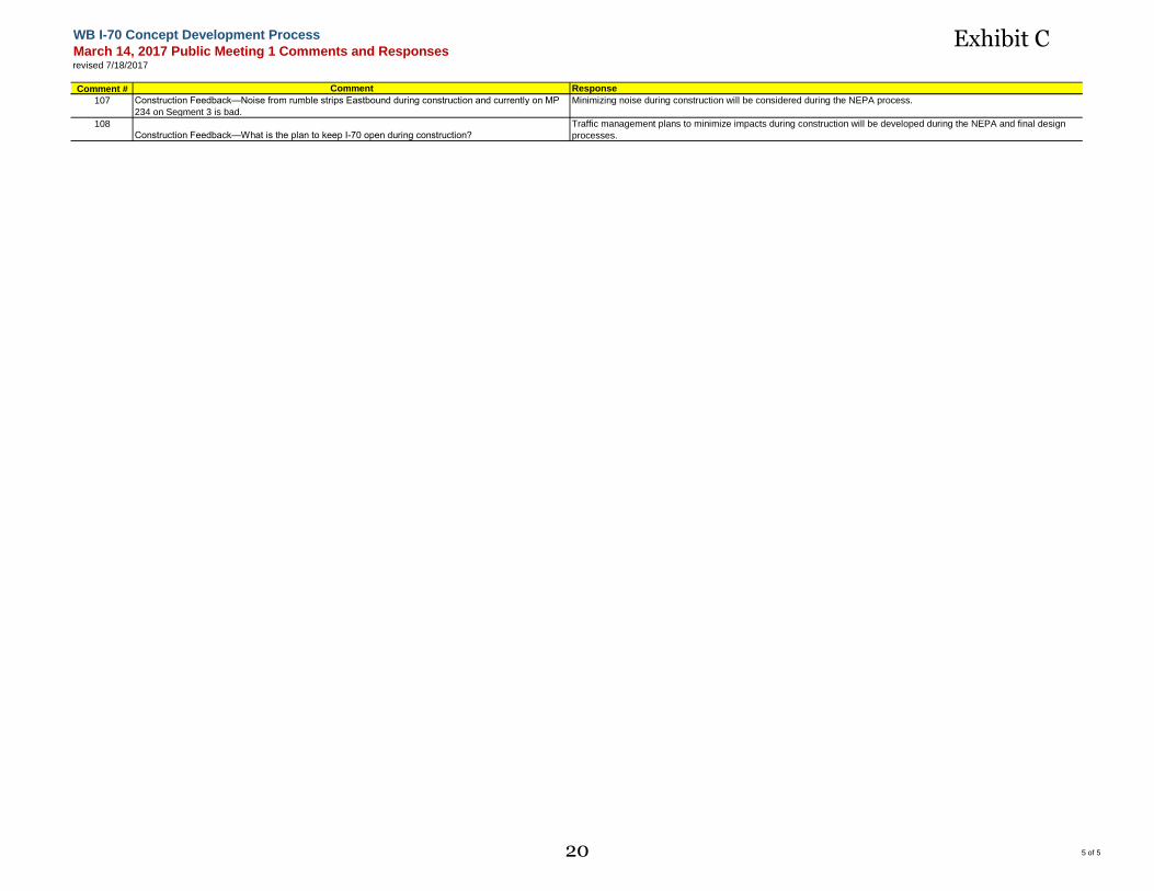
WB I-70 Concept Development Process
March 14, 2017 Public Meeting 1 Comments and Responsesrevised 7/18/2017
Comment # Comment Response
107 Construction Feedback—Noise from rumble strips Eastbound during construction and currently on MP
234 on Segment 3 is bad.
Minimizing noise during construction will be considered during the NEPA process.
108
Construction Feedback—What is the plan to keep I-70 open during construction?
Traffic management plans to minimize impacts during construction will be developed during the NEPA and final design
processes.
5 of 520
Exhibit C
21
Exhibit D
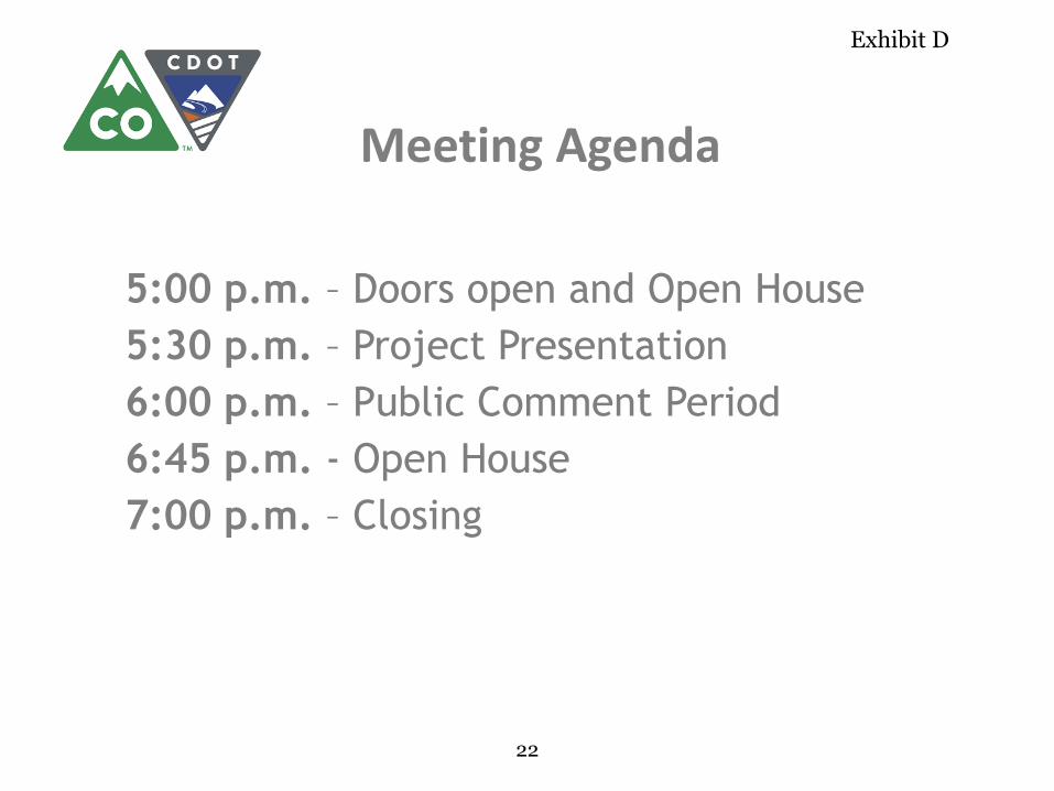
Meeting Agenda
5:00 p.m. – Doors open and Open House
5:30 p.m. – Project Presentation
6:00 p.m. – Public Comment Period
6:45 p.m. - Open House
7:00 p.m. – Closing
22
Exhibit D
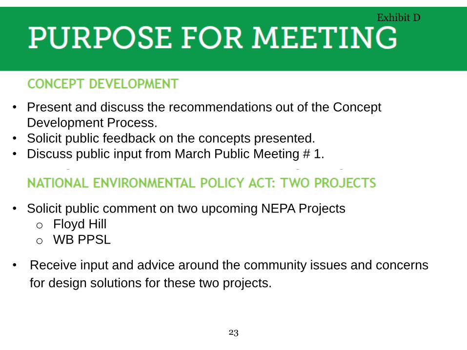
• Receive input and advice around the community issues and concerns
for design solutions for these two projects.
• Present and discuss the recommendations out of the Concept
Development Process.
• Solicit public feedback on the concepts presented.
• Discuss public input from March Public Meeting # 1.
• Solicit public comment on two upcoming NEPA Projects
o Floyd Hill
o WB PPSL
23
Exhibit D
24
Exhibit D
25
Exhibit D

26
Exhibit D

27
Exhibit D
28
Exhibit D
29
Exhibit D
30
Exhibit D
31
Exhibit D
32
Exhibit D
33
Exhibit D
34
Exhibit D
35
Exhibit D
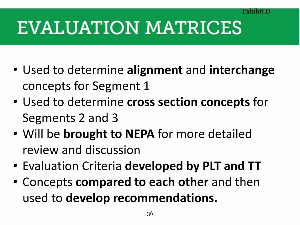
• Used to determine alignment and interchangeconcepts for Segment 1
• Used to determine cross section concepts for Segments 2 and 3
• Will be brought to NEPA for more detailed review and discussion
• Evaluation Criteria developed by PLT and TT• Concepts compared to each other and then
used to develop recommendations.36
Exhibit D
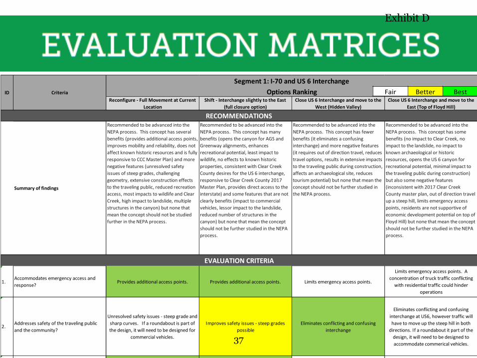
Reconfigure - Full Movement at Current
Location
Shift - Interchange slightly to the East
(full closure option)
Close US 6 Interchange and move to the
West (Hidden Valley)
Close US 6 Interchange and move to the
East (Top of Floyd Hill)
Summary of findings
Recommended to be advanced into the
NEPA process. This concept has several
benefits (provides additional access points,
improves mobility and reliability, does not
affect known historic resources and is fully
responsive to CCC Master Plan) and more
negative features (unresolved safety
issues of steep grades, challenging
geometry, extensive construction effects
to the traveling public, reduced recreation
access, most impacts to wildlife and Clear
Creek, high impact to landslide, multiple
structures in the canyon) but none that
mean the concept should not be studied
further in the NEPA process.
Recommended to be advanced into the
NEPA process. This concept has many
benefits (opens the canyon for AGS and
Greenway alignments, enhances
recreational potential, least impact to
wildlife, no effects to known historic
properties, consistent with Clear Creek
County desires for the US 6 interchange,
responsive to Clear Creek County 2017
Master Plan, provides direct access to the
interstate) and some features that are not
clearly benefits (impact to commercial
vehicles, lessor impact to the landslide,
reduced number of structures in the
canyon) but none that mean the concept
should not be further studied in the NEPA
process.
Recommended to be advanced into the
NEPA process. This concept has fewer
benefits (it eliminates a confusing
interchange) and more negative features
(it requires out of direction travel, reduces
travel options, results in extensive impacts
to the traveling public during construction,
affects an archaeological site, reduces
tourism potential) but none that mean the
concept should not be further studied in
the NEPA process.
Recommended to be advanced into the
NEPA process. This concept has some
benefits (no impact to Clear Creek, no
impact to the landslide, no impact to
known archaeological or historic
resources, opens the US 6 canyon for
recreational potential, minimal impact to
the traveling public during construction)
but also some negative features
(inconsistent with 2017 Clear Creek
County master plan, out of direction travel
up a steep hill, limits emergency access
points, residents are not supportive of
economic development potential on top of
Floyd Hill) but none that mean the concept
should not be further studied in the NEPA
process.
1.Accommodates emergency access and
response?Provides additional access points. Provides additional access points. Limits emergency access points.
Limits emergency access points. A
concentration of truck traffic conflicting
with residential traffic could hinder
operations
2.Addresses safety of the traveling public
and the community?
Unresolved safety issues - steep grade and
sharp curves. If a roundabout is part of
the design, it will need to be designed for
commercial vehicles.
Improves safety issues - steep grades
possible
Eliminates conflicting and confusing
interchange
Eliminates conflicting and confusing
interchange at US6, however traffic will
have to move up the steep hill in both
directions. If a roundabout it part of the
design, it will need to be designed to
accommodate commerical vehicles.
3. Improves mobility and reliability? Direct access to Interstate. Direct access to Interstate.Adds out of direction travel. Reduces
travel options.
Adds out of direction travel. Reduces
travel options.
Segment 1: I-70 and US 6 Interchange
Options Ranking
RECOMMENDATIONS
CriteriaID
EVALUATION CRITERIA
Fair Better Best
37
Exhibit D
38
Exhibit D
39
Exhibit D
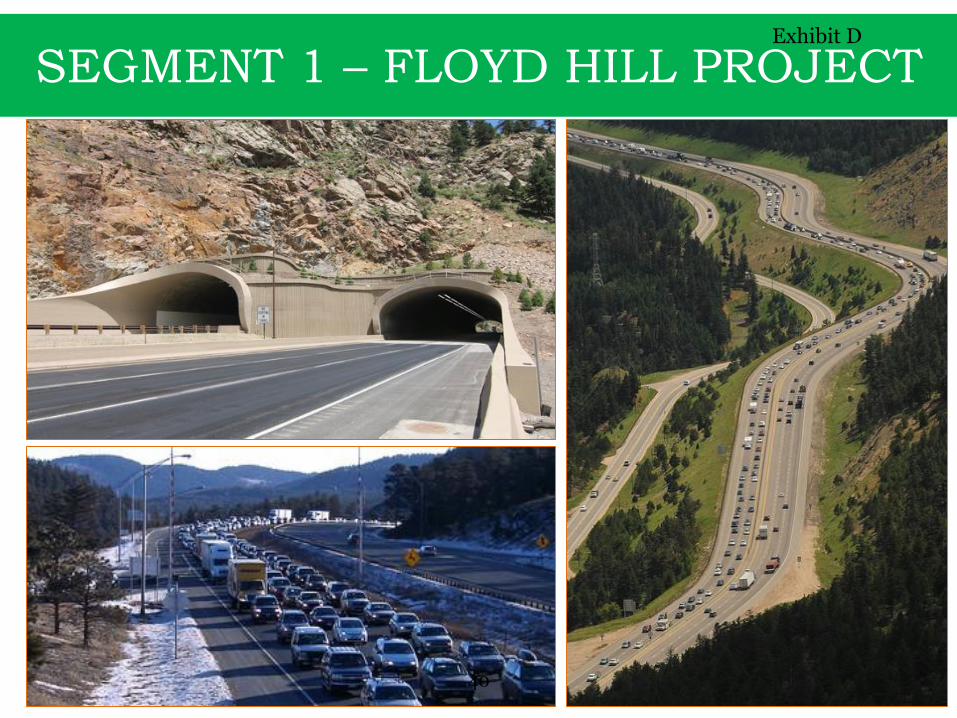
SEGMENT 1 – FLOYD HILL PROJECT
40
Exhibit D
41
Exhibit D
42
Exhibit D
43
Exhibit D
44
Exhibit D
45
Exhibit D

46
Exhibit D
47
Exhibit D
48
Exhibit D
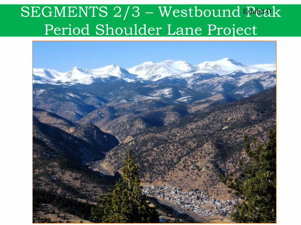
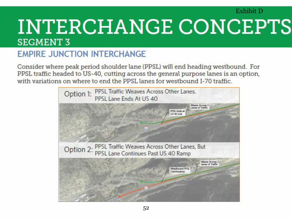
SEGMENTS 2/3 – Westbound Peak
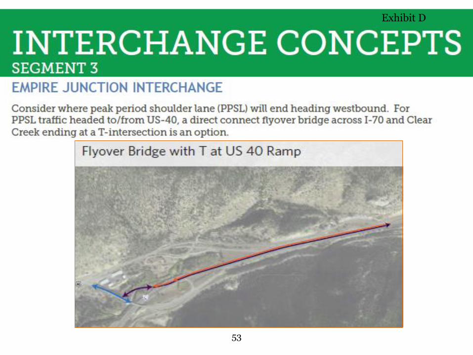
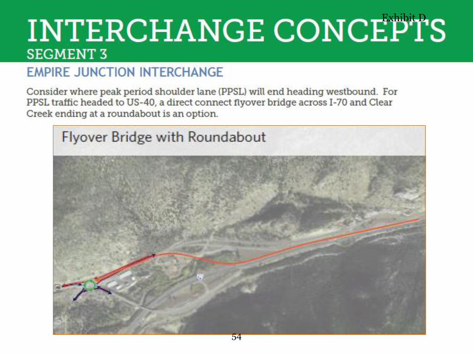
Period Shoulder Lane Project
49
Exhibit D
50
Exhibit D
51
Exhibit D
52
Exhibit D
53
Exhibit D
54
Exhibit D
55
Exhibit D

56
Exhibit D
57
Exhibit D
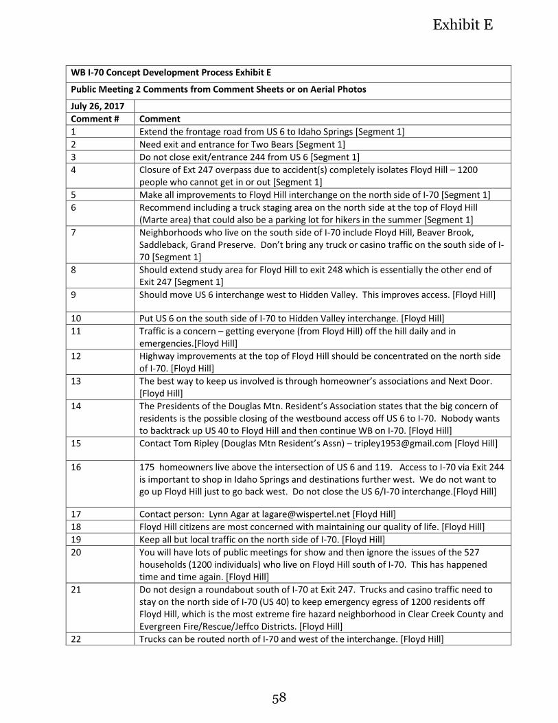
WB I-70 Concept Development Process Exhibit E
Public Meeting 2 Comments from Comment Sheets or on Aerial Photos
July 26, 2017
Comment # Comment
1 Extend the frontage road from US 6 to Idaho Springs [Segment 1]
2 Need exit and entrance for Two Bears [Segment 1]
3 Do not close exit/entrance 244 from US 6 [Segment 1]
4 Closure of Ext 247 overpass due to accident(s) completely isolates Floyd Hill – 1200 people who cannot get in or out [Segment 1]
5 Make all improvements to Floyd Hill interchange on the north side of I-70 [Segment 1]
6 Recommend including a truck staging area on the north side at the top of Floyd Hill (Marte area) that could also be a parking lot for hikers in the summer [Segment 1]
7 Neighborhoods who live on the south side of I-70 include Floyd Hill, Beaver Brook, Saddleback, Grand Preserve. Don’t bring any truck or casino traffic on the south side of I-70 [Segment 1]
8 Should extend study area for Floyd Hill to exit 248 which is essentially the other end of Exit 247 [Segment 1]
9 Should move US 6 interchange west to Hidden Valley. This improves access. [Floyd Hill]
10 Put US 6 on the south side of I-70 to Hidden Valley interchange. [Floyd Hill]
11 Traffic is a concern – getting everyone (from Floyd Hill) off the hill daily and in emergencies.[Floyd Hill]
12 Highway improvements at the top of Floyd Hill should be concentrated on the north side of I-70. [Floyd Hill]
13 The best way to keep us involved is through homeowner’s associations and Next Door. [Floyd Hill]
14 The Presidents of the Douglas Mtn. Resident’s Association states that the big concern of residents is the possible closing of the westbound access off US 6 to I-70. Nobody wants to backtrack up US 40 to Floyd Hill and then continue WB on I-70. [Floyd Hill]
15 Contact Tom Ripley (Douglas Mtn Resident’s Assn) – [email protected] [Floyd Hill]
16 175 homeowners live above the intersection of US 6 and 119. Access to I-70 via Exit 244 is important to shop in Idaho Springs and destinations further west. We do not want to go up Floyd Hill just to go back west. Do not close the US 6/I-70 interchange.[Floyd Hill]
17 Contact person: Lynn Agar at [email protected] [Floyd Hill]
18 Floyd Hill citizens are most concerned with maintaining our quality of life. [Floyd Hill]
19 Keep all but local traffic on the north side of I-70. [Floyd Hill]
20 You will have lots of public meetings for show and then ignore the issues of the 527 households (1200 individuals) who live on Floyd Hill south of I-70. This has happened time and time again. [Floyd Hill]
21 Do not design a roundabout south of I-70 at Exit 247. Trucks and casino traffic need to stay on the north side of I-70 (US 40) to keep emergency egress of 1200 residents off Floyd Hill, which is the most extreme fire hazard neighborhood in Clear Creek County and Evergreen Fire/Rescue/Jeffco Districts. [Floyd Hill]
22 Trucks can be routed north of I-70 and west of the interchange. [Floyd Hill]
58
Exhibit E
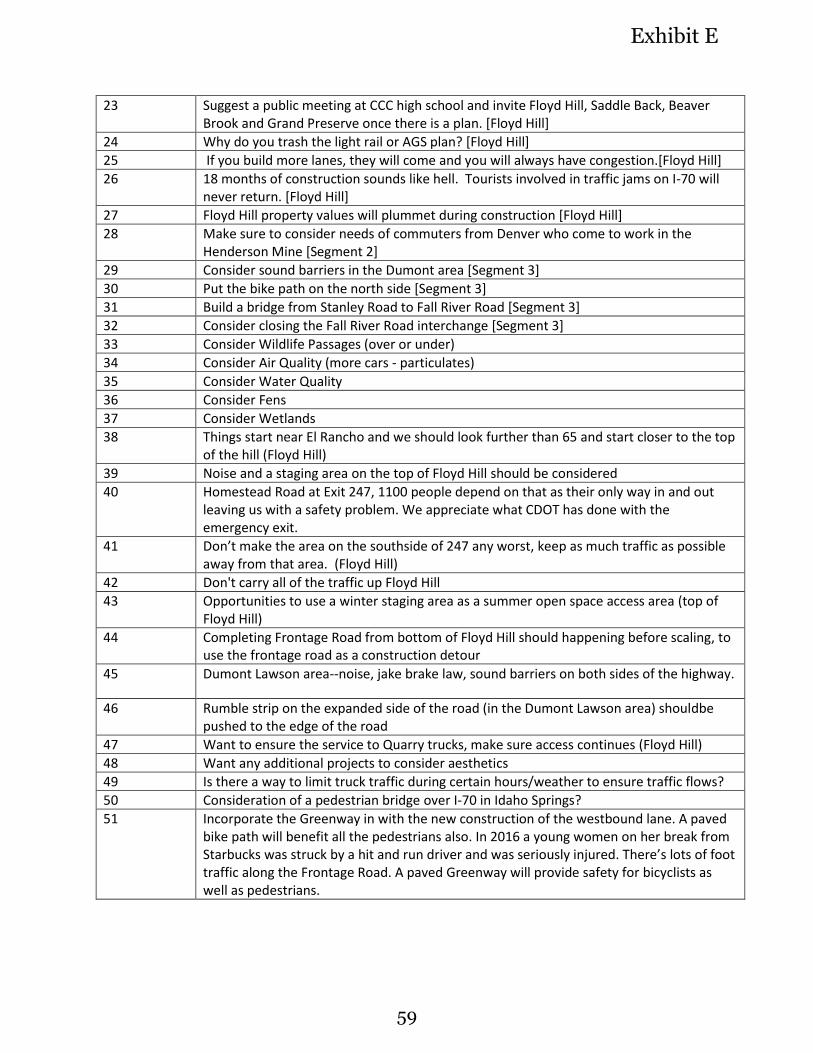
23 Suggest a public meeting at CCC high school and invite Floyd Hill, Saddle Back, Beaver Brook and Grand Preserve once there is a plan. [Floyd Hill]
24 Why do you trash the light rail or AGS plan? [Floyd Hill]
25 If you build more lanes, they will come and you will always have congestion.[Floyd Hill]
26 18 months of construction sounds like hell. Tourists involved in traffic jams on I-70 will never return. [Floyd Hill]
27 Floyd Hill property values will plummet during construction [Floyd Hill]
28 Make sure to consider needs of commuters from Denver who come to work in the Henderson Mine [Segment 2]
29 Consider sound barriers in the Dumont area [Segment 3]
30 Put the bike path on the north side [Segment 3]
31 Build a bridge from Stanley Road to Fall River Road [Segment 3]
32 Consider closing the Fall River Road interchange [Segment 3]
33 Consider Wildlife Passages (over or under)
34 Consider Air Quality (more cars - particulates)
35 Consider Water Quality
36 Consider Fens
37 Consider Wetlands
38 Things start near El Rancho and we should look further than 65 and start closer to the top of the hill (Floyd Hill)
39 Noise and a staging area on the top of Floyd Hill should be considered
40 Homestead Road at Exit 247, 1100 people depend on that as their only way in and out leaving us with a safety problem. We appreciate what CDOT has done with the emergency exit.
41 Don’t make the area on the southside of 247 any worst, keep as much traffic as possible away from that area. (Floyd Hill)
42 Don't carry all of the traffic up Floyd Hill
43 Opportunities to use a winter staging area as a summer open space access area (top of Floyd Hill)
44 Completing Frontage Road from bottom of Floyd Hill should happening before scaling, to use the frontage road as a construction detour
45 Dumont Lawson area--noise, jake brake law, sound barriers on both sides of the highway.
46 Rumble strip on the expanded side of the road (in the Dumont Lawson area) shouldbe pushed to the edge of the road
47 Want to ensure the service to Quarry trucks, make sure access continues (Floyd Hill)
48 Want any additional projects to consider aesthetics
49 Is there a way to limit truck traffic during certain hours/weather to ensure traffic flows?
50 Consideration of a pedestrian bridge over I-70 in Idaho Springs?
51 Incorporate the Greenway in with the new construction of the westbound lane. A paved bike path will benefit all the pedestrians also. In 2016 a young women on her break from Starbucks was struck by a hit and run driver and was seriously injured. There’s lots of foot traffic along the Frontage Road. A paved Greenway will provide safety for bicyclists as well as pedestrians.
59
Exhibit E
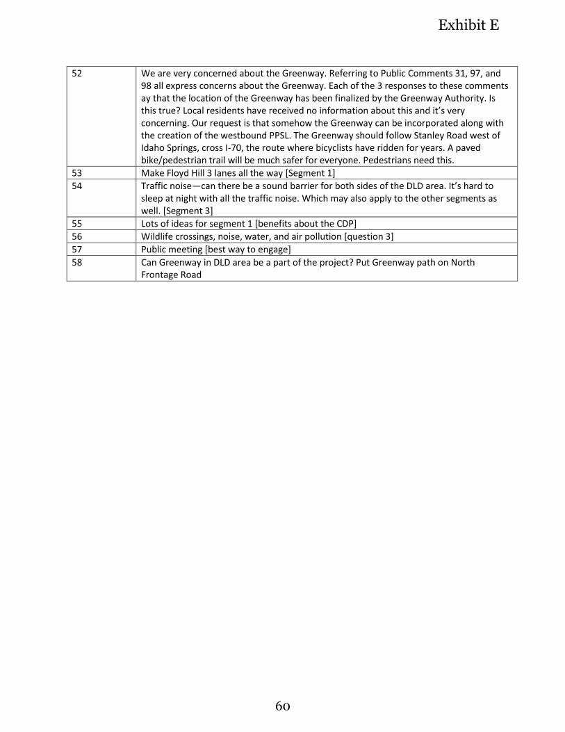
52 We are very concerned about the Greenway. Referring to Public Comments 31, 97, and 98 all express concerns about the Greenway. Each of the 3 responses to these comments ay that the location of the Greenway has been finalized by the Greenway Authority. Is this true? Local residents have received no information about this and it’s very concerning. Our request is that somehow the Greenway can be incorporated along with the creation of the westbound PPSL. The Greenway should follow Stanley Road west of Idaho Springs, cross I-70, the route where bicyclists have ridden for years. A paved bike/pedestrian trail will be much safer for everyone. Pedestrians need this.
53 Make Floyd Hill 3 lanes all the way [Segment 1]
54 Traffic noise—can there be a sound barrier for both sides of the DLD area. It’s hard to sleep at night with all the traffic noise. Which may also apply to the other segments as well. [Segment 3]
55 Lots of ideas for segment 1 [benefits about the CDP]
56 Wildlife crossings, noise, water, and air pollution [question 3]
57 Public meeting [best way to engage]
58 Can Greenway in DLD area be a part of the project? Put Greenway path on North Frontage Road
60
Exhibit E
61
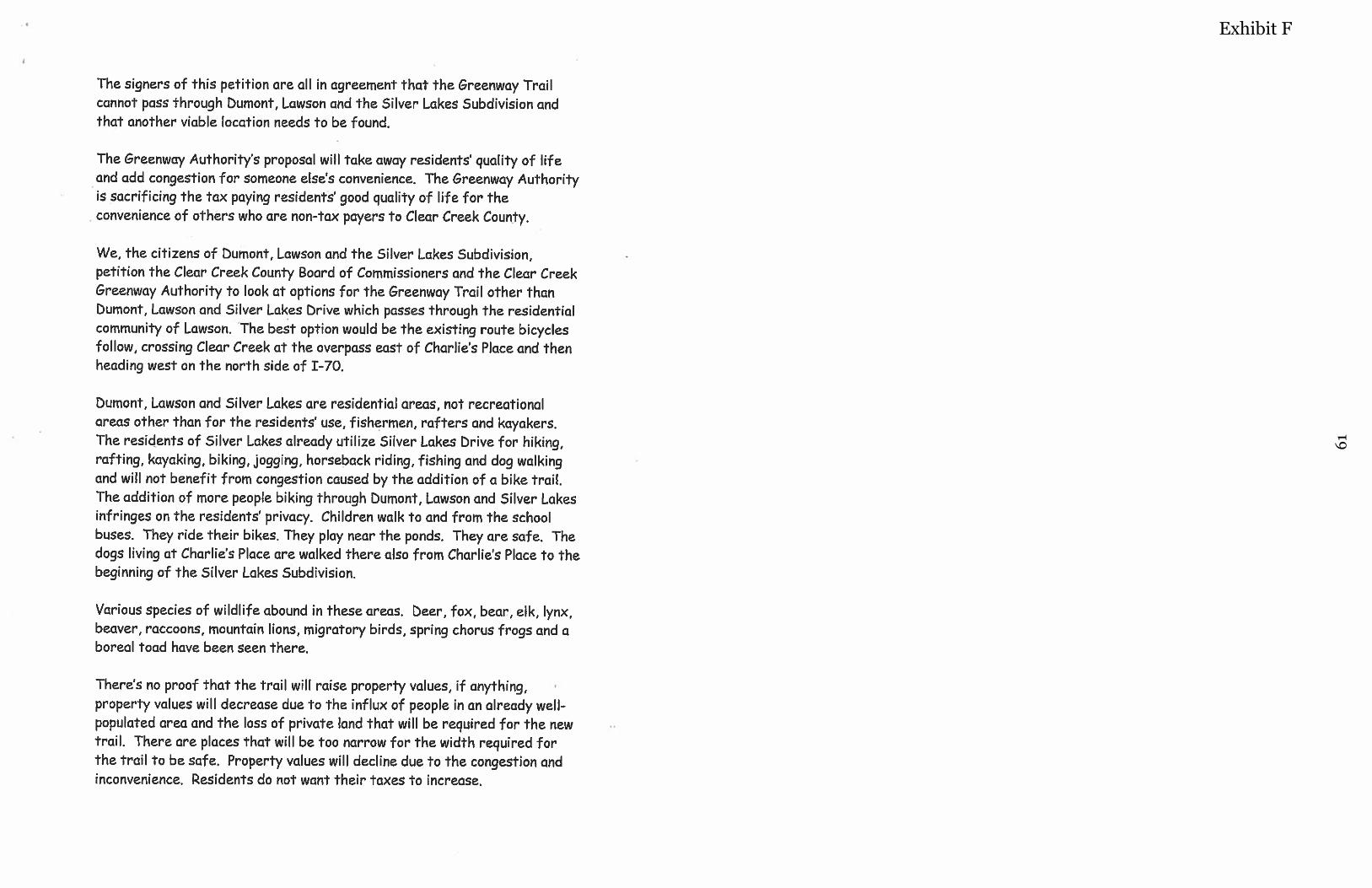
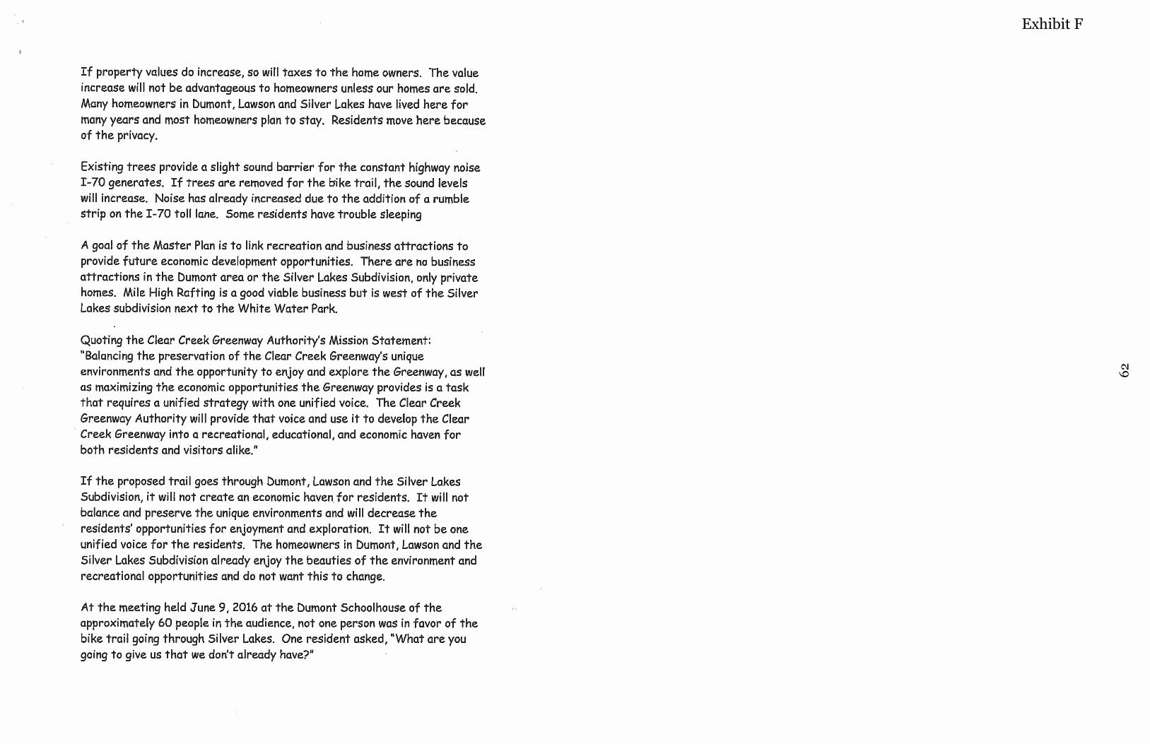
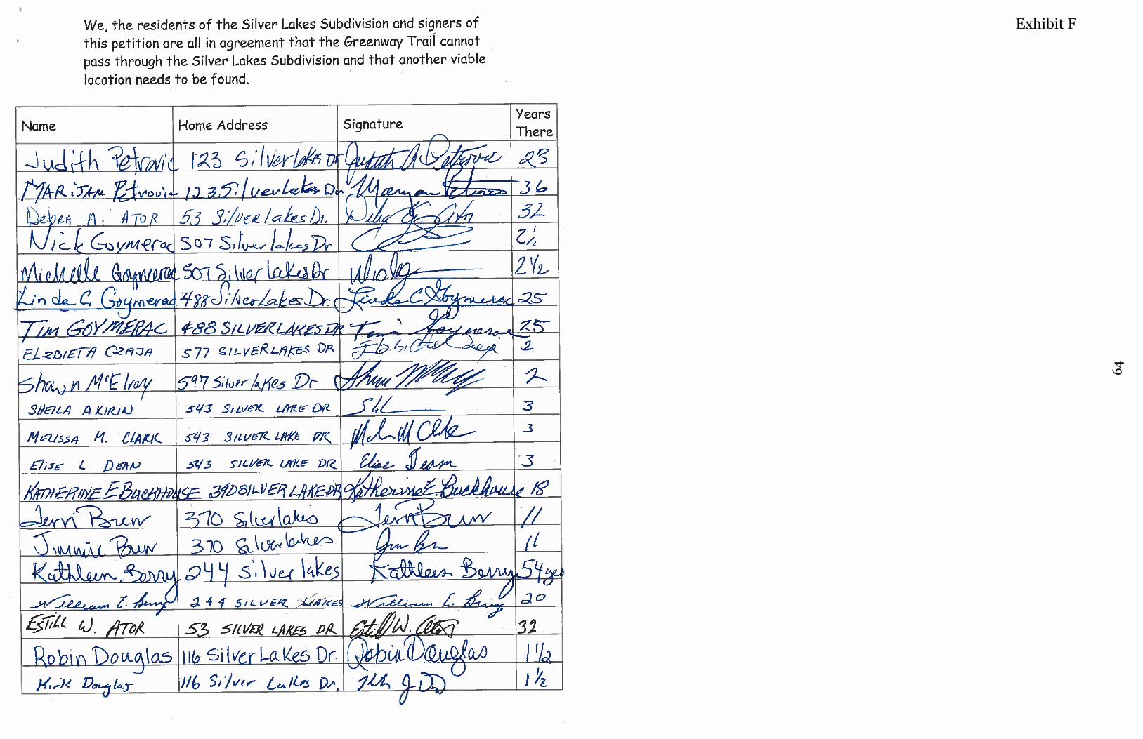
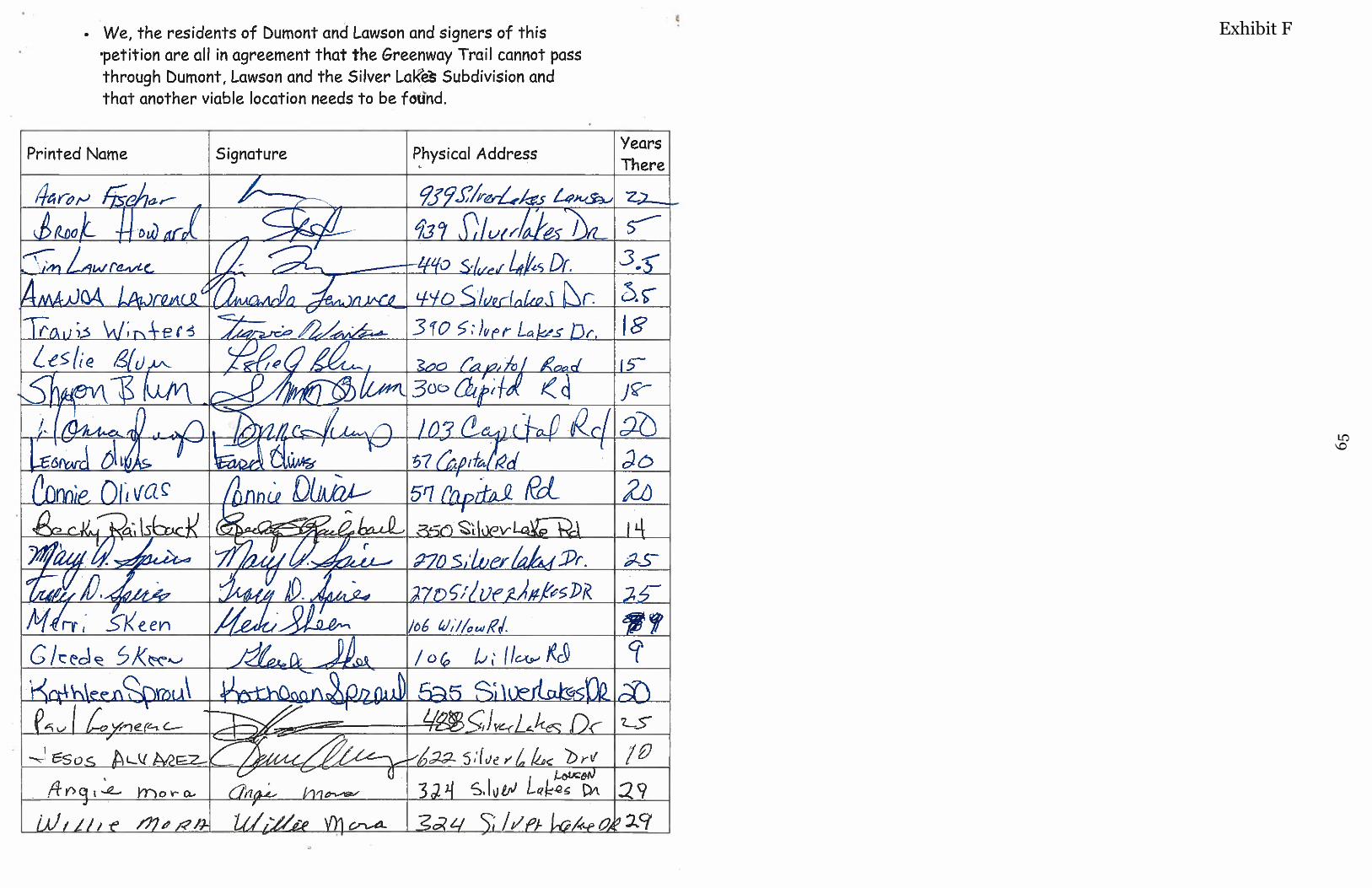
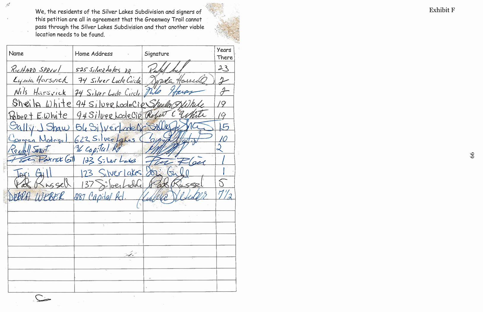
Exhibit F
62
Exhibit F

63
Exhibit F
64
Exhibit F
65
Exhibit F
66
Exhibit F
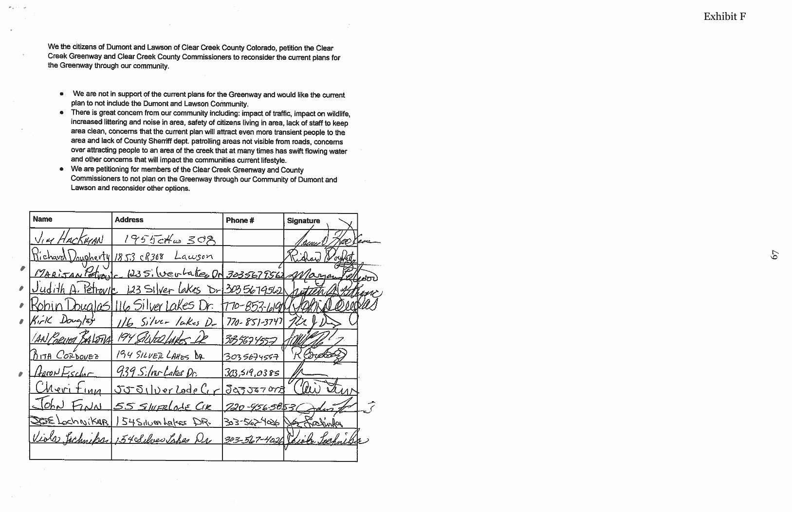
67
Exhibit F
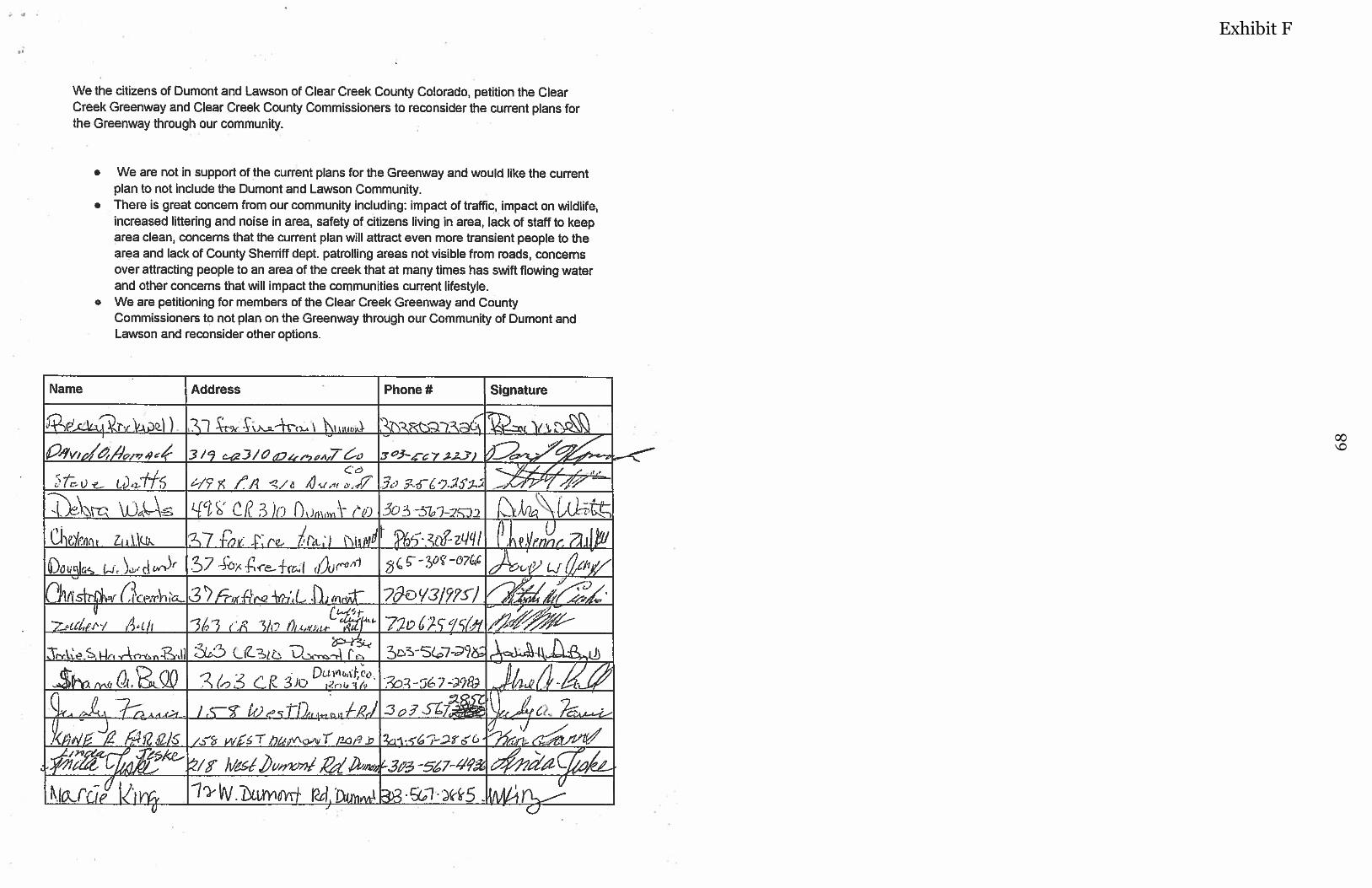
68
Exhibit F
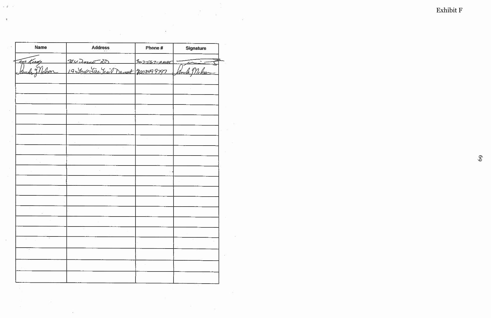
69
Exhibit F
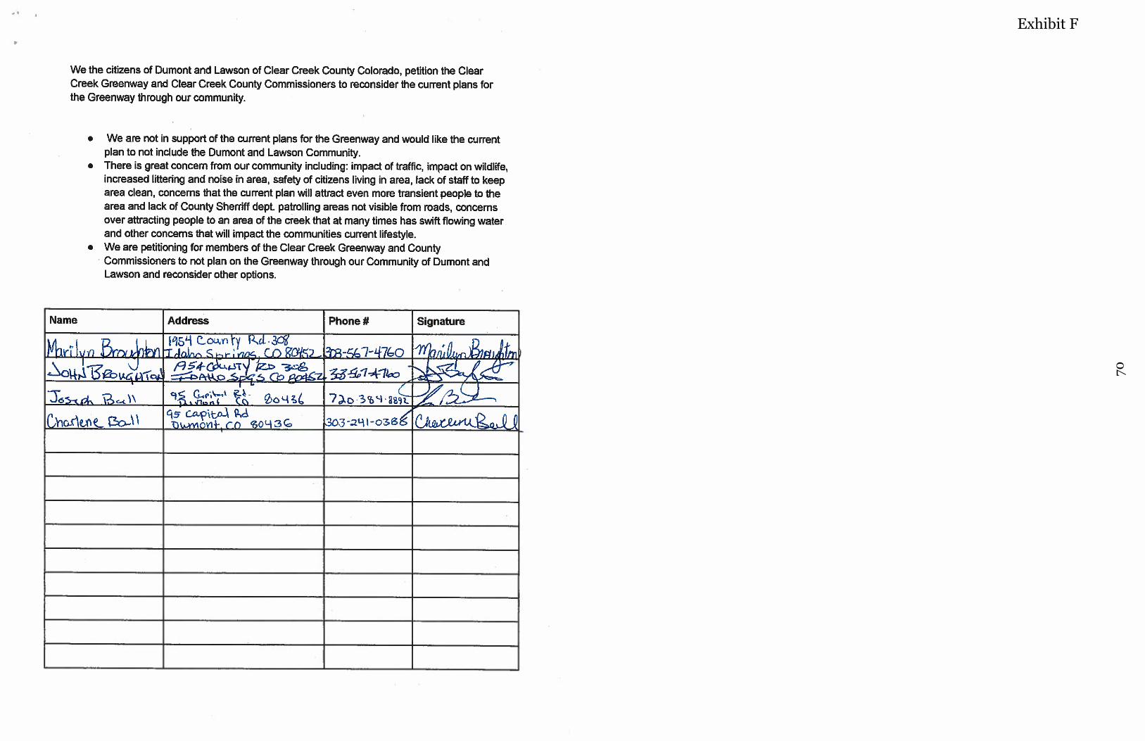
70
Exhibit F
71
Exhibit F
Jim White’s Email Correspondence Received: Friday August 4th, 2017
As you know, lots of people on Floyd Hill have major problems with CDOT’s 4th concept for the interchange between US-6 and I-70. This is the concept of moving that interchange up to the top of Floyd Hill. (See the attached excerpt from the storyboards at the July 28 public meeting.) The idea of a roundabout on the north side of I-70 could be helpful. It would improve a dangerous intersection. In fact there is adjacent land available that could be acquired, and in conjunction with a north-side roundabout could help staging and managing truck traffic in winter weather. However the idea of moving interchange traffic to this point has so many severe issues that it should be abandoned as an alternative. The routing of through traffic 3-4 miles up the hill and then the same distance back down the hill is a terrible idea. That idea is made even worse since through-traffic motorists who had to take the trip could see how far they had been taken out of their way, as the downhill route is visible from the uphill route. Motorists from Golden and Boulder who use US-6 as a way to get to recreation in Clear Creek and Summit Counties would find that they had 7 miles and 800 feet of altitude added to a 15-mile trip up the creek. This would create such a problem that it would probably divert a fair amount of traffic from US-6 onto I-70 up Mount Vernon Canyon; this is the opposite of what we are trying to achieve for I-70. Yet more importantly, the evaluation of criteria #1 through #4 in the Evaluation Matrix for the interchanges focuses only on through traffic. There is also a lot of local traffic through the interchange at the top of the hill. Criterion #1 evaluation admits that the concept would limit emergency access to residents (and the school) in this area. But it does not document that there is not enough capacity for emergency EGRESS from the area. Residents greatly appreciate the work that CDOT did to facilitate the use of Sawdust Court as an emergency egress route; in an emergency that will save lives. However, the capacity of the remaining egress route is still insufficient to get all of the people whose sole option is the road over the bridge on the top of Floyd Hill at MM 247 (Homestead Road). The concept of bringing more truck and gaming traffic up to this point is directly counter to the safety of residents and students at the school; in the event of an emergency, more people would not survive. Criterion #2 evaluation again addresses only the safety of through traffic. It does not consider the safety of the 1100 residents, plus several hundred school students, who would have to use this route in an emergency evacuation. Evergreen Fire Rescue has told us that this is a life-and-death issue. Criterion #3 evaluation admits that this alternative would add out of direction travel and reduce travel options for through traffic, but it does not address the potential for adding traffic to I-70 through Mount Vernon Canyon. Furthermore, the evaluation ignores the problem of how hard it is for LOCAL traffic to go out and get home during peak traffic periods. Through traffic already uses US-40 as an additional lane of traffic during peak periods, effectively blocking local access to and from their homes. Bringing more truck and gaming traffic to this critical juncture would just make this aggravating problem much worse. Criterion #4 evaluation admits that multiple operational conflicts have been identified, even as far as through traffic is concerned. These operational conflicts increase many times as local traffic for residents and for the school are considered.
When the local traffic considerations are taken into account, the concept of bringing the interchange traffic up to the top of Floyd Hill becomes unthinkable. What would it take to make sure that this alternative is NOT advanced to the NEPA process? - Jim White
72
Exhibit G