Meeting of the Joint Steering Group for the IODE ODP, and ...
116
MEETING OF THE JOINT STEERING GROUP FOR THE IODE OCEAN DATA PORTAL AND THE WIGOS PILOT PROJECT FOR JCOMM (GENEVA, SWITZERLAND, 18-19 SEPTEMBER 2008) FINAL REPORT JCOMM MEETING REPORT NO. 59
Transcript of Meeting of the Joint Steering Group for the IODE ODP, and ...

MEETING OF THE JOINT STEERING GROUP FOR THE IODE OCEAN DATA PORTAL AND THE WIGOS PILOT PROJECT FOR JCOMM
(GENEVA, SWITZERLAND, 18-19 SEPTEMBER 2008)
FINAL REPORT
JCOMM MEETING REPORT NO. 59


WORLD METEOROLOGICAL ORGANIZATION
_____________
INTERGOVERNMENTAL OCEANOGRAPHIC COMMISSION (OF UNESCO)
___________
MEETING OF THE JOINT STEERING GROUP FOR THE IODE OCEAN DATA PORTAL AND THE WIGOS PILOT PROJECT FOR JCOMM
(GENEVA, SWITZERLAND, 18-19 SEPTEMBER 2008)

- iii -
NOTES
WMO DISCLAIMER
Regulation 42 Recommendations of working groups shall have no status within the Organization until they have been approved by the responsible constituent body. In the case of joint working groups the recommendations must be concurred with by the presidents of the constituent bodies concerned before being submitted to the designated constituent body.
Regulation 43 In the case of a recommendation made by a working group between sessions of the responsible constituent body, either in a session of a working group or by correspondence, the president of the body may, as an exceptional measure, approve the recommendation on behalf of the constituent body when the matter is, in his opinion, urgent, and does not appear to imply new obligations for Members. He may then submit this recommendation for adoption by the Executive Council or to the President of the Organization for action in accordance with Regulation 9(5). © World Meteorological Organization, 2008 The right of publication in print, electronic and any other form and in any language is reserved by WMO. Short extracts from WMO publications may be reproduced without authorization provided that the complete source is clearly indicated. Editorial correspondence and requests to publish, reproduce or translate this publication (articles) in part or in whole should be addressed to: Chairperson, Publications Board World Meteorological Organization (WMO) 7 bis, avenue de la Paix Tel.: +41 (0)22 730 84 03 P.O. Box No. 2300 Fax: +41 (0)22 730 80 40 CH-1211 Geneva 2, Switzerland E-mail: [email protected]
IOC (OF UNESCO) DISCLAIMER The designations employed and the presentation of material in this publication do not imply the expression of any opinion whatsoever on the part of the Secretariats of UNESCO and IOC concerning the legal status of any country or territory, or its authorities, or concerning the delimitation of the frontiers of any country or territory.
____________

- iv -
C O N T E N T S Executive Summary .......................................................................................................... 1 Session Report .......................................................................................................... 3 Annex I Agenda ........................................................................................... 19 Annex II List of Participants .......................................................................... 20 Annex III Project outline ................................................................................. 23 Annex IV Project Plan .................................................................................... 29 Annex V Implementation Plan ....................................................................... 43 Annex VI Review process for the Pilot Project ............................................... 85 Annex VII Potential data-sets to consider in the WIGOS framework .............. 89 Annex VIII JCOMM synopsis of ocean data systems....................................... 95 Annex IX Action items arising from the meeting........................................... 108 Annex X Acronym list .................................................................................. 110
____________

- 1 -
EXECUTIVE SUMMARY
The meeting of the Joint Steering Group for the IODE Ocean Data Portal and the WIGOS Pilot Project for JCOMM was held at the WMO headquarters in Geneva, Switzerland, from 18 to 19 September 2008. The goal of the meeting was to review the project plan, the draft implementation plan, discuss the business plan, capacity-building issues, and address the core deliverables of the WIGOS Pilot Project for JCOMM and the IODE Ocean Data Portal.
In particular, the Meeting addressed interoperability issues between the ODP and the WIS, and between other ocean data systems and the WIS. The Meeting agreed that interoperability with the WIS would be mainly achieved through: (i) ocean data centres contributing to the ODP and (ii) ODP becoming fully interoperable with the WIS. While recognizing that it was difficult at this point to make precise recommendation regarding the convergence of the WMO Core Metadata Profile, and other metadata profiles used in the marine community (e.g., MCP, CDI), the meeting recommended submitting MCP and / or any other relevant metadata profile through the JCOMM / IODE standards process for review by a wider community. This would also help MCP to build on WIS specifications, and permit to identify specific recommendations that will permit achieving interoperability with the WIS. The Meeting addressed instrument best practices and the development of better cooperation between JCOMM and CIMO and with HMEI. The Meeting recommended that the JCOMM Observing Panels and associated programmes address the issue of documenting their best practices in light of the WIGOS developments. A strategy was proposed for the updating of the WMO guide to meteorological instruments and methods of observation (WMO No. 8 – CIMO Guide) to better integrate oceanographic issues. Future updates concerning the Guide should be submitted to the JCOMM Focal Point on CIMO matters and the CIMO Focal Point for WMO No. 8. The Meeting proposed that instrument best practices related to surface meteorological and marine observations be included in the relevant chapter of the CIMO Guide while inviting JCOMM to consider developing similar best practices for the sub-surface observations as part of a separate document. All relevant documentation would avoid duplication, provide for appropriate links, and be referenced in the JCOMM Catalogue of Best Practices and Standards. This work will have to be coordinated between WMO and IOC accordingly. The EC WG WIGOS-WIS was invited to address this issue again - taking IOC’s ownership into account - and provide further guidance to the Pilot Project.
The meeting discussed establishment of marine instrument centres using CIMO as a model. The NOAA National Data Buoy Centre (NDBC) offered to investigate feasibility and agreed starting acting as such on a trial basis. The JCOMM Focal Point on CIMO matters was invited to review and draft the Terms of Reference (ToR) for marine instrument centres and develop a proposal to be circulated to the joint Steering Group.
Quality management aspects agreed upon at the ad hoc planning meeting (Ostend, Belgium, 29 March 2008) have been included in the Project and Implementation Plans.
The Meeting noted the excellent progress made with regard to the development of Version 1 of the IODE Ocean Data Portal (ODP). While a Version 2 of the ODP is also being developed for the next two years, the Meeting agreed that the Pilot Project should - as part of the Pilot Project deliverables - target Version 1 for connecting specific data sets to the ODP and the WIS. This strategy will also permit to refine the requirements for Version 2.
The Meeting reviewed potential partners and data contributions. It noted that discussions had taken place since the March 2008 meeting to address some of them, namely the SeaDataNET, the GHRSST-PP, and the Global Collecting Centres (GCCS). The Meeting noted with appreciation the development of a virtual constellation for the measurement of Ocean Surface Vector Wind. Thirteen potential partners were identified for providing key data sets to the Pilot

- 2 - Projects as key deliverables. The Secretariat was asked to write to the relevant organizations in order to seek their participation in the Pilot Project. The Meeting updated its Project Plan, reviewed the draft Implementation Plan, adopted them, and proposed a strategy for reviewing progress considering risks, and trade-offs between time to deliver the project, costs and available resource, and quality of the deliverables. The Implementation Plan was rationalized to avoid overlap, include specific tasks with identified deadlines, and groups or individuals responsible for carrying out those tasks and / or following up their implementation. The Meeting discuss issues and progress to report to the Sub-group of the WMO Executive Council Working Group on WIGOS-WIS as well as to the twentieth Session of the IODE. The Meeting addressed capacity-building issues, and focused on the cooperation of developing countries in the Ocean Data Portal Project. These issues included the need for collaboration in the development of training materials between WMO and IOC on topics related to JCOMM, the promotion of WIGOS at the national level, and the organization of training courses in topics relevant to the WIGOS Pilot Project for JCOMM. The Meeting stressed that the Pilot Project could not realistically achieve success without receiving appropriate funding for the coordination of the Pilot Project. The Steering Group urged the WMO and IOC to commit CHF 50.000 and CHF 30.000 in 2009, respectively, and CHF 30.000 and CHF 20.000 in 2010, respectively.
____________

- 3 -
GENERAL SUMMARY OF THE WORK OF THE SESSION 1. ORGANIZATION OF THE SESSION 1.1 Mr Greg Reed, Co-chairperson of the Joint Steering Group for the IODE Ocean Data Portal and the WIGOS Pilot Project for JCOMM, opened the meeting at 0900 hours at the WMO Secretariat headquarters, Geneva, Switzerland, on 18 September 2008. In his opening address, Mr Reed noted that this was the first formal meeting of the Joint Steering Group for the IODE Ocean Data Portal and the WIGOS Pilot Project for JCOMM, which had been established as a result of the ad hoc meeting that took place in Oostende, Belgium, in March 2008. He then invited Dr Wenjian Zhang, Director, Observing and Information System Department, to address the meeting. 1.2 Dr Zhang recalled that WMO’s fifteenth congress (Cg-XV, Geneva, Switzerland, May 2007), had decided to embark on enhancing the integration between the WMO Observing Systems. WMO Executive Council also established its Working Group on the WMO Integrated Global Observing Systems (WIGOS) and the WMO Information System (WIS) to steer and monitor this activity and to achieve the broadest possible collaboration and cooperation. The Working Group developed the first version of the “WIGOS Development and Implementation Plan” and an initial draft of the “WIGOS Concept of Operations” which contains goals, objectives, major characteristics, operational framework, data policy and benefits of WIGOS. The Group further agreed on three basic integration levels within the WIGOS and discussed the status of WIGOS Pilot projects. The Group welcomed the JCOMM initiative, praised the approach, and recommended that other Pilot Projects should use this approach as a model. The development of the WIGOS Pilot Project for JCOMM is fully consistent with the recommendations of the EC Working Group on WIGOS/WIS. At the sixtieth WMO Executive Council (EC-LX) (June, 2008), approved these recommendations and noted with appreciation the development of the Pilot Project. 1.3 Dr Zhang stated that the implementation of the WIGOS concept should offer unprecedented opportunity to include all WMO and WMO-sponsored networks and sub-systems in the integration process, thus allowing WMO to more effectively respond to new challenges and evolving user requirements. EC-LX urged Members’ National Meteorological and Hydrological Services to strengthen cooperation with oceanographic agencies to ensure the development of interoperable arrangements between their data systems and WIS and commit resources for the implementation of JCOMM’s Strategic Work Plan for “Building a Sustained Global Ocean Observing System”. He also expressed his appreciation for the excellent cooperation established with the Intergovernmental Oceanographic Commission (IOC) – through the IODE / JCOMM joint Steering Group - and the development by the IODE of the Ocean Data Portal (ODP) in coordination with WIS and WIGOS. The new in situ and space-based data sets will also have to be considered. Dr Zhang further invited the Steering Group to discuss with WMO CBS Experts on how to enhance the relationships between JCOMM and the CBS regarding the development of the Pilot Project. 1.4 After the opening remarks, the participants reviewed and adopted the agenda for the session. 1.5 The Meeting then received information on local arrangements. 2. INTEROPERABILITY WITH THE WIS 2.1 This agenda item relates to both the Ocean Data Portal and the JCOMM Pilot Project for the WIGOS. 2.2 Mr David Thomas (WIS Programme Manager, WMO Secretariat) (on behalf of Mr Eliot Christian, Steering Group Member) recalled the vision and goals of the WMO Information System

- 4 - (WIS) per guidance from Cg-XIV and Cg-XV. The last session of WMO Congress (Cg-XV), stated that the three types of services that the WIS will be providing would be to provide: (i) routine collection and dissemination service for time-critical and operation-critical data and products based on real-time “push” using dedicated telecommunication; (ii) data discovery, access and retrieval service-based on request / reply “pull” via Internet; and (iii) timely delivery service for data and products: based on delayed-mode “push” using a combination of dedicated and public networks. Congress also emphasized that WIS would be implemented in an evolutionary manner, with two parallel parts:
• Part A: the continued consolidation and further improvements of GTS for time-critical and operation-critical data; and
• Part B: the extension of services through flexible data discovery, access and
retrieval services, as well as flexible timely delivery. 2.3 Mr Thomas reported on recent developments of the WIS, its Implementation Plan, and the requirements for ocean data systems to develop interoperable arrangement with the WIS. He particularly summarized Version 1.0 of the WIS Compliance Specifications document, which had been approved formally by the Inter-Commission Coordination Group on WIS (ICG-WIS) (Brasilia, Brazil, 14-17 July 2008). 2.4 The document provides for detailed requirements for the development of interoperability arrangements between ocean data systems and the WIS in the context of the WIGOS Pilot Project for JCOMM. It is now the authoritative source for "interoperable interfaces" required of Global Information System Centre (GISC), Data Collection or Production Centre (DCPC) and National Centre (NC). 2.5 He presented the major components and services of the WIS, including for interoperability and WIS networking, WIS connectivity, discovery, access and retrieval catalogue, and dataflow. He also presented the technical specification of fifteen WIS Interoperable Interfaces, which have been described as minimum requirements of an NC, DCPC and GISC. These interfaces deal with uploading files of metadata and data, authentication and authorization of candidate or current users of WIS, maintaining data and product catalogues as well as service catalogues, disseminating data and products, and Reporting of Quality of Service. Any centre is welcome to implement interfaces beyond the minimum, and the functions of some DCPCs may be extensive. Accordingly, the interfaces should be regarded as "mandatory if applicable". 2.6 Mr Reed reported on his work to compare the Marine Community Profile (MCP), the WMO Core Metadata Profile, and the SeaDataNET Common Data Index (CDI). He also indicated that work was about to be completed before the end of the month, and would be circulated to the Steering Group for review (action, G. Reed, end-September 2008). 2.7 The Meeting also noted that at the first meeting of the CBS Expert Team on the Assessment of Data Representation Systems (ET-ADRS) (Silver Spring, United States of America, from 23 to 25 April 2008), recommended a standard approach for data representation leading to the development of a WMO Core profile of the ISO 19100 series for data and metadata, encompassing the WMO Core profile of the ISO 19115. This exercise would lead to the definition of ISO 191xx feature catalogues, application schemas, and data product specifications. 2.8 The Meeting noted that the third meeting of the CBS Inter-Programme Expert Team on Metadata Implementation (IPET-MI) (Geneva, Switzerland, from 30 June to 2 July 2008), recommended removing the proposed WMO Core extensions from the WMO metadata profile that are deviations from the ISO Standard 19115. It recommended working at submitting proposals to the ISO Technical Committee 211 to add required extensions in the ISO 19115 standard itself. As an alternative to extending the ISO standard, the IPET-MI recommended producing a “Best Practice” document to explain amongst other things how to create metadata, including in particular, how to incorporate essential elements that have been deleted from the WMO profile in other fields

- 5 - such as abstracts. 2.9 After discussion, the Meeting agreed that content needed to be consistent across the WMO and IOC communities. Noting the recommendations from the IPET-MI and the differences noted with the MCP, which is proposing three extended elements, the Meeting recognized that they were not in a position at this point to recommend one profile versus another. However, the Meeting recommended submitting MCP and / or any other relevant metadata profile through the JCOMM / IODE standards process for review by a wider community (action, Co-chairperson SG PP, October 2008). This would also help MCP to build on WIS specifications, and permit to identify specific recommendations to eventually achieve interoperability with the WIS. 2.10 Regarding the implementation of interoperability with WIS, the Meeting recognized that there were basically two options for potential candidates contributing data sets, i.e.: (i) contributing to ODP and therefore automatically contributing to WIS as the ODP would eventually become a WIS DCPC; or (ii) contributing directly to WIS as NC or DCPC. The Meeting noted the following options for candidate centres to start acting as WIS NCs or DCPCs:
1) The Permanent Representative of a country with WMO or the JCOMM Co-presidents nominates a national centre to become a WIS NC and / or DCPC; and
2) An NODC can contribute via the ODP and via WIS as specific DCPC and / or NC.
2.11 The Meeting agreed that the option of pushing data onto the GTS through the ODP should be considered and noted that this was technically feasible. It further recommended to include it as part of the ODP documentation (action, N. Mikhaylov, ASAP). 3. INSTRUMENT BEST PRACTICES 3.1 Mr Rainer Dombrowsky Co-Chairperson of the joint Steering Group, and Vice-president, CIMO) reported on the integration of “Instrument Best Practices” and how this issue relates to the JCOMM / IODE standards process. Mr Dombrowsky recalled how better cooperation could be established between the JCOMM, IODE and the WMO Commission for Instruments and Methods of Observation (CIMO). 3.2 The Meeting noted that the two domains of marine meteorology and oceanography have different histories that have resulted in different practices. For marine meteorology, there is a long history of working within the framework of the WMO and the various regulations and observing practices that have been established. In contrast, oceanographic observations are more recent and most originate from a research environment. As a result, new methods and procedures are frequently being tested resulting in less standardization of practice, though best practices are evolving. 3.3 The Meeting agreed that there was a need to better integrate those practices and proposed the following strategy fully reflected in the Pilot Project overarching Implementation Plan:
• Data and information management:
o Assembling and reviewing documentation that describe the NODCs “Best Practices”;
o Updating IODE relevant IOC Manuals and Guides;
o Consideration of IODE / JCOMM ocean data standards process in the WIGOS
framework;
o Collection of platform / instrument metadata, including WMO Publication No.

- 6 -
47, and consideration of the developments being undertaken under the META-T Pilot Project. The Pilot Project recommended following the META-T approach and investigate the consideration of other variables than SST and water temperature profiles.
• Observing practices:
o Assessing integration issues, reviewing and updating best practices
documentation that have been produced by the JCOMM Observations Programme area Panels (DBCP, SOT and GLOSS) and associated programmes (Argo, OceanSITES and IOCCP);
o Reviewing and providing input to the WMO Guide to Meteorological
Instruments and Methods of Observation (WMO No. 8 - CIMO Guide);
o Establishment of instrument centres;
o Enhanced cooperation with HMEI, including through organization of training workshops on instrument use;
• Contributing assembled documents to the JCOMM Catalogue of Best Practices and
Standards. 3.4 The Meeting reviewed the WMO Publication No. 8 (CIMO Guide) and Chapter 4, Part II of the Marine Observations, as well as Chapter 3, Part III, Quality Management, in particular. The Meeting noted that these proposed changes had been proposed by the SOT, and reviewed and endorsed by the SOT Task Team on Instrument Standards. It agreed that they could now be submitted to the CIMO rapporteur for WMO Publication No. 8 for further review (action, WMO Secretariat, ASAP). Future updates should eventually be submitted through the JCOMM Focal Point on CIMO matters and the CIMO Focal Point for WMO Publication No. 8. 3.5 The Meeting discussed the two options of: (i) updating the CIMO Guide to fully address instrument best practices for marine and other appropriate oceanographic instruments; and (ii) updating appropriate JCOMM documents and referring to them from the CIMO Guide. The Meeting agreed that duplication of information should be avoided, and cross-links to relevant documents developed as appropriate. The Meeting agreed that surface marine meteorological instruments should also be addressed in the CIMO Guide. On the other hand, the Meeting agreed that sub-surface oceanographic instrumentation should be addressed by JCOMM in a separate document guide, perhaps using the CIMO Guide as a model. A short-term goal would be to produce the required information as part of the exercise to develop the JCOMM Catalogue of Best Practices and Standards. In any case, coordination will be required between the WMO and IOC to maintain the documentation consistent. The Meeting recommended that the EC Working Group on WIGOS-WIS re-addresses the issue, taking IOC’s ownership with regard to some of the components of the observing system into account, in the view to make further recommendations in this regard (action, WG WIGOS-WIS, December 2008). 3.5 The Meeting considered how the work undertaken by the JCOMM so far, in terms of instrument standards and methods of observation for shipboard AWS, could be regarded as an element for expanding the marine chapter of the WMO Publication No. 8, or as a reference to a more in depth marine guide for instruments and methods of observation. It then proposed a strategy for updating the Guide. 3.6 The Meeting welcomed the nomination by the JCOMM OPA Coordinator, Ms Candyce Clark, of Dr Chung-Chu Teng, NDBC, as JCOMM expert to liaise with CIMO on ocean instrument matters. The Meeting invited Dr Teng to engage a dialogue with CIMO on the need to update WMO Publication No. 8, develop Instrument Centres, address instrument calibration issues, instrument deployment and siting, conduct inter-comparisons and organize training events.

- 7 - The Meeting noted that CIMO maintained a list of contact points for dealing with specific instrumentation in the CIMO Guide. It asked the WMO Secretariat to ensure that Dr Teng be included in the list for marine instrument matters (action, WMO Secretariat), ASAP). 3.7 The Meeting also discussed the possible establishment of regional or specialized ocean instrument centres for monitoring the performances of instruments and their traceability to standards, providing calibration facilities, providing assistance with regard to instrument inter-comparisons, as well as for providing training facilities. The Meeting noted the limitation of resources could eventually impact the quality of the services provided by the instrument centres once established. To address this issue, CIMO has created a dual system of instrument centres with fully capable instrument centres on one hand, and specialized centres on the other hand; the latter having more limited capabilities. The Meeting noted with appreciation the offer from the NOAA National Data Buoy Center (NDBC), USA, to act as an instrument centre on a trial basis. It also thanked the NDBC for that offer and noted that the centre could initially run at a minimal level of operations, develop appropriate documentation, and perhaps organize a first training session during the course of the Pilot Project (action, NDBC, mid-2009). The Meeting recommended that Dr Teng review the draft Terms of Reference (ToR) for regional marine instrument centres in liaison with Mr Rainer Dombrowsky, and develop a proposal to be circulated to the Steering Group (action, Dr Teng, ASAP). The NDBC was also invited to liaise with CIMO on metrology issues. 3.8 The Meeting noted with appreciation that funds had been identified to eventually support the development of the JCOMM Catalogue of Best Practices and Standards. It recommended to proceed with the recruitment of a consultant in order to have a draft available by March 2009 (action, Secretariat, ASAP). 3.9 The Meeting recommended that the JCOMM Observing Panels (DBCP; SOT and GLOSS) and associated programmes (IOCCP, OceanSITES and Argo) address the issue of documenting their best practices in light of the WIGOS developments and for eventually providing input to the CIMO Guide and other relevant documentation comprised in the JCOMM Catalogue of Best Practices and Standards (action, JCOMM OPA, ongoing). 3.10 Regarding the development of better links with HMEI, while noting that JCOMM Observing Panels had established direct links with the manufacturers, the Meeting recommended that the DBCP and the SOT (e.g., integration of ASAP launchers) address the issue at their twenty-fourth and fifth sessions, respectively, and report back to the Co-chairpersons of the Steering Group (action, DBCP-XXIV and SOT-V, mid-2009). 3.11 The Meeting agreed that the strategy detailed above should permit, as WIGOS gets mature and better observational coverage of the oceans is achieved, to realize integration between land and sea observations. 4. QUALITY MANAGEMENT 4.1 This agenda item was introduced by Mr Etienne Charpentier, (Observing Systems Division, WMO Secretariat), referring to document 4. Mr Charpentier reminded the Meeting that one of the core goals of the Pilot Project is to coordinate the development of cost-effective Quality Management Systems by Members and to propose practical solutions or examples. The ad hoc planning meeting for the Pilot Project (Ostend, Belgium, 29 March 2008) agreed on a number of aspects that need to be included in the Project Plan. The proposed inclusion was provided in the Appendix to document 4. 4.2 The Meeting was invited to discuss the minimum requirements for developing Quality Management Systems (QMS) as part of the Pilot Project and noted that there are nine quality principles in the ISO Quality Management as described in ISO 9000:2000 and ISO 9004:2000 (see http://www.iso.org/iso/iso9000-14000/understand/qmp.html): Customer focus, Leadership, Involvement of people, Process approach, System approach to management, Continual

- 8 - improvement, Factual approach to decision making and Mutually beneficial supplier relationships. Further, it was noted that the guidelines for implementing QMS could be proposed for inclusion in the Business Plan. 4.3 The Meeting noted that implementing the ISO9000 standard would be very resource demanding and thus probably unrealistic for the pilot project. The Meeting decided that a more realistic approach would be to invite partners, who agreed to participate in the pilot project as data providers, to carefully document quality management procedures they now utilize. These could include, inter alia, quality control practices, monitoring, feedback, response capabilities, etc. The combined input received from all partners could then be compared with the view of identifying common procedures. These could then be submitted to the IODE / JCOMM Ocean Data Standards Pilot Project for adoption as a standard. It was further recommended to add this information to the JCOMM Catalogue of Best Practices and Standards (action, PP partners, 2010). (See also agenda item 6.3). 5. IODE OCEAN DATA PORTAL 5.1 Technical overview of the Ocean Data Portal 5.1.1 This agenda item was introduced by Mr Nikolay Mikhaylov, referring to document 5.1. In his presentation, Mr Mikhaylov provided the preliminary technical design decisions for the IODE / JCOMM Ocean Data Portal (ODP), Version 2. He recalled that the objective of the Ocean Data Portal (ODP) is to facilitate and promote the exchange and dissemination of marine data and services. The ODP will provide a seamless access to collections and inventories of marine data from the NODCs in the IODE network, data centres of JCOMM and other IOC projects. The ODP will allow for the discovery, evaluation (through visualization and metadata review) and access to data via web services. The Ocean Data Portal will also deliver a standards-based infrastructure that provides the integration of marine data and information from a network of distributed IODE NODCs, as well as the resources from other participating systems as illustrated in Figure 1.
IODE Portal
Portal of system 1 (e.g. SeaDataNet)
Portal of system N (e.g. WIS)
Portal Web-services
Portal Web-services Portal Web-services Metadata Metadata
Network of distributed IODE
data centres
Data Data
Internet
Figure 1: The integration of marine data based upon the Ocean Data Portal

- 9 - 5.1.2 The Ocean Data Portal will provide an on-line access to the marine data and information resources of the IODE and other participating data centres including:
− operational and delayed data;
− data and services from the oceanographic and marine meteorological domains;
− data and services from multiple data source formats and local data systems (DBMS, data files, GIS and electronic documents); and
− data and services from multiple data providers in different geographic regions.
5.1.3 The Ocean Data Portal will provide the full range of processes including data discovery, access and visualization. The following functionalities are envisaged:
− IODE and other participating data centres will generate discovery metadata about their datasets for distributed data search and retrieval;
− The Portal will periodically harvest these metadata, monitor the accessibility of
remote data sources and update the portal metadata catalogue;
− Users can access the system via a web browser and search for single or multiple data types from a distributed set of sources;
− Data request will be sourced from the appropriate data centre and returned to the
Portal; and
− Portal tools will fuse the aggregated data and services in real time to produce a new product or service of value to the user.
5.1.4 The Ocean Data Portal will primarily focus on issues with substantial societal benefit such as prevention and mitigation of natural hazards, climate change, safeguarding oceans ecosystems, and integrated coastal area management. 5.1.5 Data sharing principles of the Ocean Data Portal will comply with the IOC Oceanographic Data Exchange Policy (http://www.iode.org/policy). 5.1.6 Mr Mikhaylov then provided detailed information on functional specifications of ODP such as distributed marine data infrastructure building and operation, data discovery and access, data provision to users, user management and system monitoring and reporting. 5.1.7 He further stressed that the Ocean Data Portal will not create a new data system. The key principles of the Portal will be interoperability with existing systems and resources. Participating data centres will need to accept and implement a set of agreed interoperable arrangements including the technical specifications and Web-services for the integration and shared use of the metadata and data. 5.2 Contribution of the Ocean Data Portal to the WIGOS Pilot Project 5.2.1 Mr Sergey Belov, (Russian Federation NODC), then informed the Meeting about the current version (Version 1) of the Ocean Data Portal. Mr Belov reported that the website http://www.oceandataportal.org provides general information on the IODE Ocean Data Portal Project, as well as technical documentation and self-training instructional material. 5.2.2 Ocean Data Portal (further, ODP) can be considered as a specific and multifunctional

- 10 - external application (in E2EDM technology terms) providing the full range of processes: data discovery, access, delivery, and publishing (visualization, copies of data, etc.) based on E2EDM technology. The E2EDM technology is based on existing technologies / systems and standards and provides the functionality for building the distributed data system with IODE / JCOMM Ocean Data Portal. 5.2.3 The overall model of the IODE / JCOMM Ocean Data Portal is shown in Figure 2 below. This model takes into account regional and project-oriented activities of IODE and JCOMM.
5.2.4 V1 contains following components:
• Data provider tools, able to register resources and provide access to their local data through ODP and create discovery metadata (for portal catalogue);
• Metadata components – discovery metadata catalogue. Provides services for
harvesting metadata from distributed data providers and other portals. Includes common codes and dictionaries services;
• Search and browse tools and services;
• Data access components – providing access to the distributed data sources and
data transportation using common protocol;
• ODP website;
• ODP user web-interface, including GIS-oriented user interface, metadata and data search interfaces, data download and visualisation components;
Delivery - Transport Data File
Integration Server Monitoring, Discovery, Interaction services
End-Users
Ocean Data Portal
Administrating and publishing services (end-user applications)
Other system
Data Provider
Data Provider
DBMS, data files (structured), object files (documents,images…), web-applications
Data Provider
Data Exchange Protocol
IODE/JCOMM Data Centres
Distributed Data System
Local Data Systems
System Coordinator Centre
Data Access
Figure 2: The overall scheme of Ocean Data Portal based on E2EDM technology

- 11 -
• Connectivity mechanisms for interaction with other ocean portals and projects (SeaDataNet, WIS, etc.).
5.2.5 The ODP contributes to the WMO Information System (WIS) prototype as one of the WIS prototype components, which ensures the operation of the JCOMM Data Collection and Processing Centre (DCPC) of the WMO Information System. This WIS component has been installed on the RNODC/RIHMI-WDC (Obninsk) platform. 5.2.6 In terms of the WIGOS Pilot Project the following actions are planned:
• Documenting and integrating best practices and standards: The goal is to define and agree on common standards for the organization and handling of the data and information to serve consistent quality data to both the general user and modelling communities; and
• Making marine data systems and WIS interoperable: The goal is to provide access
to marine meteorological and oceanographic data and information to serve a number of applications, including climate, in an integrated way via the WIS.
5.2.7 The following way forward was proposed:
• Selection of concrete data sources to be connected to the ODP;
• Installation of the Data provider software;
• Construction of the interface with the SeaDataNet Project (can be based on current implementations, provided by NODC of the Russian Federation, on CDI metadata catalogue);
• Interface with other portals under development by NODCs (WFS, WMS, etc.); and
• Improvement and extension of the interface with WIS.
5.2.8 The Meeting was informed that the development of Version 2 of the ODP would take approximately two years. 5.2.9 The Meeting noted that the WIGOS Pilot Project would need to be based on Version 1 of the ODP. The Meeting further agreed that the Pilot Project would work with a small group of data providers (action, PP partners, 2010). The experience of these partners would result in valuable technical remarks and recommendations that will contribute to the development of Version 2. It was further noted that some support would be needed by the Obninsk team to adjust ODP to WIS technical specifications. 5.2.10 The Meeting requested Mr David Thomas review document 5.2 to ensure interoperability with WIS (action, D. Thomas, end-2008). 5.2.11 The Meeting recommended that more attention should be given to the services that will benefit from the cooperation with IODE NODCs, noting that the system will provide marine data access to the WMO community and marine meteorological data to the IODE community. 5.2.12 The Meeting noted the need to agree upon requirements and procedure for registration of data providers (action, PP Steering Group, end-2008). (See also agenda item 6.4). 6. WIGOS PILOT PROJECT FOR JCOMM

- 12 - 6.1 Business plan for the Pilot Project 6.1.1 Ms Candyce Clark, Chairperson of the JCOMM Observations Coordination Group (OCG), recalled that the ad hoc planning meeting (Ostend, Belgium, 29 March 2008) had reviewed and discussed the potential benefits that the Meteorological and Oceanographic agencies could gain from developing the Pilot Project. These have been included in the Project Plan. The Meeting agreed that it would be useful for the Pilot Project to develop a business case to be used by the Directors of these agencies to make the case at the national level for becoming a partner in the JCOMM Pilot Project for WIGOS. This would therefore facilitate their engagement the necessary developments, funded nationally, to meet the requirements eventually proposed under the Pilot Project. While remaining relatively simple through a qualitative approach, the Business Plan document should include the information necessary for funding to be obtained. 6.1.2 The Meeting discussed the elements of a realistic Business Plan that would generate national support for the development of interoperability arrangements between the NODCs, and in particular, the WIS. It was suggested to focus on the National Oceanographic Data Centres (NODCs) initially, while realizing that it was difficult during this phase of the Pilot Project to quantify the costs and benefits. The Meeting agreed that the partners who volunteered to commit data sets in the Pilot Project were in a good position to document functional requirements and develop assessments nationally, but that it was premature at this point to produce a generic document to be used by the Directors of the NODCs. The Meeting also agreed that the Business Plan should be produced towards the end of the Pilot Project based on experience gained with the partners, other WIGOS Pilot Projects, and the Demonstration Projects (action, Steering Group, 2010). Better synergies with the Demonstration Projects should also be developed accordingly. Examples of derived benefits needed to be documented, such as:
• Benefits already stated in the CONOPS and the WIGOS Pilot Project for JCOMM Project Plan;
• Participation in GEOSS thanks to data made available to a wider community through
the WIS (only one interface developed leading to more efficient maintenance);
• Cleaner access to the GTS and push the data to the GTS as with the present situation (e.g., NODCs being able to specify the GTS bulletins they need directly);
• More effective communication; and
• Less redundancy.
6.2 Project Plan review 6.2.1 The Meeting reviewed the Project Plan as agreed at the ad hoc planning meeting, which was held in Ostend, Belgium, 29 March 2008. The Meeting proposed some changes to make it fully compliant with the ad hoc planning meeting’s conclusions and the group’s recommendations. The new version is provided in Annex IV. In particular, the Meeting approved the proposed changes to the Terms of Reference (ToR) for the joint Steering Group for the IODE Ocean Data Portal and the WIGOS Pilot Project for WIGOS (Annex I of the Plan). 6.2.2 The Meeting then discussed review mechanisms for the Pilot Project. The joint Steering Group realized that it must remain vigilant as it reviews and adopts its Implementation Plan. The greatest threat to any project is scope creep. This phenomena involves trade-offs inherent in any project between time (the time to deliver the project), cost (represents the amount of funds or resources available), and quality (represents the goal that the project must achieve to be deemed a success). The relationship between these elements can adversely affect a project’s success. The Meeting agreed many issues had to be addressed, including but not limited to: (i) clear understanding of the stakeholders expectations; (ii) consideration of self-correcting mechanism in case of problems appearing during the course of the project’s implementation (e.g. funding);

- 13 - (iii) quality / time / funding aspects impacting each other; (iv) estimation of critical funding required for the project as well as critical expertise; (v) basic management requirements; (vi) definition of metrics to measure progress as we move forward, and consequent review of the Implementation Plan as some of the tasks might have to be reconsidered and / or rescaled; (vii) consideration of the fact that requirements might have to be adjusted later on and assessment of impacts; (viii) prioritization of the tasks; and (ix) risk factors considering that many of the deliverables will rely on the good will of the Members. 6.2.3 The Meeting therefore proposed a strategy for addressing implementation of the Pilot Project and reviewing progress. This strategy is reproduced in Annex VI to this report. 6.2.4 The Meeting requested the Secretariat to write to directors of the institutes identified as potential contributors for specific data sets (see paragraph 6.4.3 and 6.4.4 below), to ask whether they would be willing to actually contribute and submit a letter of intent (action, Secretariat, 31 October 2008). The Meeting agreed that their contribution to WIS could be made either by providing the data sets through the ODP or directly to the WIS. Contributors would eventually choose whatever solution is preferable to them for cost or practical reasons. 6.3 Completion of the Implementation Plan 6.3.1 Mr Robert Keeley, Chairperson of the JCOMM Data Management Coordination Group (DMCG), presented the draft overarching implementation plan for the Joint ODP and WIGOS Pilot Project for the IODE and JCOMM that he had developed in coordination with the Co-chairpersons and the WMO and IOC Secretariats since the ad hoc planning meeting. While restating some of the material contained in the Project Plan and other material relevant to WIGOS, it breaks the discussion into the three deliverables for the Pilot Project and itemizes actions to undertake to accomplish these deliverables. 6.3.2 Considering the strategy proposed in Annex VI, the Meeting reviewed the draft Implementation Plan in detail, suggested some rationalization to avoid overlap and proposed specific target dates and deadlines as well as group or individual responsible for carrying up the tasks and / or following up their implementation. The Meeting considered that the Implementation Plan as adopted and provided in Annex V was sufficient at this point for the Pilot Project to move forward. 6.3.3 The Meeting also considered the funding issues carefully, and identified the following funding requirements:
(i) There was a need to organize a third meeting of the joint Steering Group towards the end of 2009 and before the meeting of the WMO Executive Council Working Group on WIGOS WIS. The Group proposed to have the meeting in Geneva or Ostend (exact place to be decided later on by the Co-chairpersons) tentatively the week of 28 September 2009 after OceanObs’09 conference (Venice, Italy, 21-25 September 2009). (CHF 20.000 in 2009);
(ii) A fourth meeting should be organized in 2010 to review the Pilot Project
accomplishments, address legacy issues, and make recommendations to the WMO and IOC Executive Bodies. The IODE was invited to consider making commitments for funding the fourth meeting. (CHF 20.000 in 2010);
(iii) It is estimated that ODP-WIS experts should visit about five agencies willing to
develop interoperability arrangements with the WIS for specific data sets. (CHF 6.000 per visit, i.e., CHF 30.000 total for 2009-2010);
(iv) A consultant should be recruited to compile, edit, and produce appropriate
documentation. (CHF 15.000 for 2009, and CHF 15.000 for 2010, respectively); and

- 14 -
(v) The JCOMM Catalogue of Best Practices and Standards was a key deliverable of the Pilot Project; a consultant was needed to review existing documentation, identify gaps, overlaps, discrepancies, and elements requiring updating, compile the collected documentation, edit the catalogue, and submit it for review to the JCOMM Management Committee. (CHF 30.000 in 2009).
6.3.4 The Meeting therefore agreed that the following budget would be required for 2009 and 2010:
2009 (CHF)
2010 (CHF)
Third meeting 20.000 Fourth meeting 20.000 Visits 15.000 15.000 Consultant 15.000 15.000 JCOMM Best Practices and Standards Catalogue
30.000
Total 80.000 50.000 6.3.5 The Meeting identified the following potential contributions:
2009 (CHF) 2010 (CHF)
WMO 50.000 30.000 IOC 30.000 20.000 Total 80.000 50.000
6.3.5 The Meeting stressed that the Pilot Project could not realistically achieve success without receiving appropriate funding for the coordination of the Pilot Project. The Steering Group urged the WMO and IOC to realize the commitments proposed in the budget tables above. 6.4 Potential partners and data contributors 6.4.1 The Meeting reviewed the partners that can be potentially associated to the WIGOS initiative. As agreed at the ad hoc planning meeting (Ostend, Belgium, 29 March 2008), the system of National Oceanographic Data Centres (NODC) of the IOC International Oceanographic Data and Information Exchange (IODE) is a natural partner in the Pilot Project since the beginning, thanks mostly to the development of the End-to-End Technology (E2E) and the Ocean Data Portal (ODP). Many data sets, including historical and recent data sources, will be accessible through the WIS thanks to interoperability arrangements that will be developed between the ODP and the WIS (see also agenda item 5.2). 6.4.2 The Meeting recalled that the ad hoc planning meeting had also proposed to consider a number of additional data sets for inclusion in the WIGOS framework. The Project is planning to facilitate access to those ocean data sets through WIS while respecting: (i) WMO, IOC, and specific data policies as appropriate, as well as (ii) IOC’s ownership regarding some of the components of the Global Ocean Observing System (GOOS). 6.4.3 The Meeting reviewed again the potential partners and data contributors, investigated what additional agency / agencies or centre(s) could be invited to participate in the Pilot Project, and received reports on work undertaken to approach some of them since the ad hoc planning meeting (GHRSST, SeaDataNET, ICOADS and GCCs). The list of potential data sets to consider in the WIGOS framework was updated accordingly, and is fully detailed in Annex VII. The Meeting agreed to place priority on the following data sets and identified joint Steering Group Members to investigate feasibility and follow up developments:
- 15 -
• The World Ocean Atlas (WOA) (Dr Kenneth Casey);
• The World Ocean Database (WOD) (Dr Kenneth Casey);
• The pan-European infrastructure for Ocean and Marine Data Management (SeaDataNet) (Mr Nikolay Mikhaylov, in liaison with Mr Robert Keeley);
• The Argo data system (Ms Candyce Clark);
• The Responsible National Oceanographic Data Centre for Drifting Buoys (RNODC /
DB) (Mr Robert Keeley, in liaison with Mr Nikolay Mikhaylov);
• The GODAE High-Resolution SST (GHRSST) Pilot Project (Dr Kenneth Casey);
• XBT data (Mr Greg Reed to investigate feasibility regarding Australian data, consult and follow up with relevant centres regarding other XBT data sets);
• The International Comprehensive Ocean-Atmosphere Data Set (ICOADS)
(Mr Robert Keeley to consult with Mr Scott Woodruff);
• Delayed-mode VOS data collected by the Global Collecting Centres (GCCs) of the United Kingdom (Met Office) and Germany (DWD) as a contribution to the Marine Climatological Summaries Scheme (MCSS) (Ms Nicola Scott);
• Instrument / platform metadata (META-T, ODASMS) (Mr Bill Burnett, and
Mr Robert Keeley);
• The Global Temperature and Salinity Profile Programme (GTSPP) (Dr Kenneth Casey);
• The virtual constellation for Ocean Surface Vector winds (Mr Ken Casey in liaison
with Mr Paul Cheng and Mr Stan Wilson); and
• HF Radars (Dr Jack Harlan). 6.4.4 As noted in paragraph 6.2.4, the Secretariat was asked to write to the relevant agencies asking to confirm by the end of 2008 whether they will be in a position to participate actively in the Pilot Project and commit the identified data sets to the ODP and / or WIS. Information on requirements and a checklist shall be provided with the letter in order to assist them in the decision making process. 6.4.5 With regard to the pan-European infrastructure for Ocean and Marine Data Management (SeaDataNet), Mr David Thomas (WIS Programme Manager), attended the second SeaDataNET annual plenary meeting in Athens, Greece, from 3 to 4 April 2008, and presented the Pilot Project. The SeaDataNET was very interested in WIS, especially the linking of search capabilities through the search standard ISO 23950 and the metadata standard ISO 19115. Both the WIS and the ODP will be key links with SeaDataNet for the purposes of WIGOS in facilitating the integration of observation systems. Mr Nikolay Mikhaylov agreed to follow up the developments in this regard (action, N. Mikhaylov, ongoing). 6,4,6 Regarding the GODAE High-Resolution SST (GHRSST) Pilot Project, Mr Etienne Charpentier, WMO Secretariat, Observing Systems Division, attended the ninth meeting of the GHRSST-PP Science Team meeting in Perros Guirres, Brittany, France, from 9 to13 June 2008. The Science Team welcomed the development of the WIGOS Pilot Project for JCOMM, and agreed to work at developing interoperability arrangements between the GHRSST Data Processing Specification (GDS) and the WMO Information System (WIS). The GHRSST is currently using ISO 19115 compliant GHRSST Master Metadata Repository (MMR), which should

- 16 - connect relatively easily to the WIS. Dr Kenneth Casey agreed to follow up the developments in this regard (action, K. Casey, ongoing). 6.4.7 Regarding delayed-mode VOS data collected by the Global Collecting Centres (GCCs) of the United Kingdom (Met Office) and Germany (DWD) as a contribution to the Marine Climatological Summaries Scheme (MCSS), the issue of participating in WIGOS has been addressed at the first meeting of the JCOMM cross-cutting Task Team on Delayed-Mode VOS Data (TT-DMVOS) (Gdynia, Poland, 10 May 2008). Mr Etienne Charpentier and Mr Robert Keeley (JCOMM DMPA Coordinator) provided some information to the Task Team on the WIGOS Pilot Project for JCOMM and the outcome from the ad hoc planning meeting (Ostend, Belgium, 29 March 2008). It was agreed that in the modernisation of the Marine Climatology Summaries Scheme (MCSS), it would be useful to connect the GCCs to the WIS and have them participate as delayed-mode data provider. Formats other than BUFR are now being considered in the pilot project; IMMT and / or IMMA could be recommended. It was also noted that making quarterly data available via an FTP may be in line with WIGOS strategies. Mr Reinhard Zöllner (DWD, Germany, and JCOMM ETMC Member) indicated that he would investigate the WIS requirements with Professor Geerd-Rüdiger Hoffmann (Chairperson, ICG-WIS). Ms Nicola Scott agreed to follow up the developments in this regard (action, N. Scott, ongoing). 6.4.8 The Meeting noted the development of a proposal for an Ocean Surface Vector Wind Virtual Constellation to be established under the Committee on Earth Observing Satellites (CEOS). A draft study report and implementation plan for the OSVW virtual constellation, prepared by Mr Stan Wilson (NOAA, USA), was presented to the Steering Group. This study was also presented to the CEOS Strategic Implementation Team (SIT) at its twenty-second meeting in Tokyo, Japan, September from 17 to18 2008. The Meeting agreed that the proposal connected well with the WIGOS exercise and invited CEOS to consider its integration in the WIGOS framework in line with the WIGOS CONOPS. 6.4.9 The Meeting also noted with appreciation the JCOMM synopsis on ocean data systems drafted by Mr Thomas Loubrieu (IFREMER, France) and presented to the CBS Expert Team on Assessment of Data Representation Systems (ET-ADRS, Silver Spring, United States of America, from 23 to 25 April 2008). This document includes a detailed description of data sets available in the ocean community. This document is reproduced as Annex VIII to this document. 6.4.10 The Meeting agreed that the ODP and ODP-WIS interconnection documentation had to be made available very quickly in order for the potential partners to be in a position to make informed decisions. The Meeting noted with appreciation the setting up of the ODP information website (www.oceandataportal.org) in addition to the ODP itself (www.oceandataportal.net). It requested the IOC Secretariat to make sure the required information is made available from the ODP information web site (action, IOC Secretariat, ASAP). 6.4.11 The Meeting reviewed the Terms of Reference (ToR) and membership for the joint Steering Group. The new agreed upon ToRs are reflected in Annex I of the Project Plan (Annex IV). 6.5 Report to the Sub-group of the WMO Executive Council Working Group on WIGOS-WIS 6.5.1 The Meeting outlined the report to be presented to the Sub-group of the WMO Executive Council Working Group on WIGOS-WIS (Geneva, Switzerland, from 10 to 13 November 2008). This report shall include the list of items where progress was made. 6.5.2 This report will eventually be prepared by the WMO Secretariat in liaison with the joint Steering Group (action, WMO Secretariat, ASAP). 6.6 Report to IODE-XX on the involvement of IODE in the WIGOS Pilot Project for JCOMM 6.6.1 The Meeting outlined the report to be presented to the twentieth session of the IODE

- 17 - regarding the involvement of IODE in the WIGOS Pilot Project for JCOMM. The report shall include information on progress made with regard to the ODP in particular. Demonstration of ODP based on contributing data sets shall be made during the IODE Session. The report will also call NODCs to participate in the Pilot Project and contribute data sets. 6.6.2 This report will eventually be prepared by the IOC Secretariat in liaison with the joint Steering Group (action, IOC Secretariat, ASAP). 7. CAPACITY-BUILDING 7.1 Mr Peter Pissierssens, Head, IOC Project Office for IODE, recalled that the ad hoc planning meeting for the JCOMM Pilot Project for the WMO Integrated Global Observing Systems (WIGOS) (Ostend, Belgium, 29 March 2008) had addressed capacity-building issues that will engage developing countries to become part of the Project. In this regard, the Meeting had identified two issues: (i) contribution of data to the WIS and ODP; and (ii) accessing data from the WIS and ODP. The Meeting had further identified eight tasks that will contribute to capacity-building within the framework of the project:
(i) “…the meeting requested Mr Greg Reed to ask the ODINAFRICA planning committee to consider the inclusion of ODP and WIGOS activities in the ODINAFRICA-IV proposal. (action: Greg Reed, as soon as possible) (JCOMM-MR-57-WIGOS1 para 7.2)”. It was reported that the ODINAFRICA-IV ODINAFRICA Review and Planning Workshop (Mombasa, Kenya, from 14 to 16 July 2008) decided that one of the ODINAFRICA-IV work packages would focus on “Development of African and national / regional ocean data and information portals” thereby using ODP technology. This element has been included in the ODINAFRICA-OV Project Proposal;
(ii) “The meeting noted that the WMO Education and Training Programme (ETRP)
would be an effective mechanism for promoting WIGOS and the JCOMM Pilot Project in developing countries by providing training materials and training courses to them. It requested the Secretariat to investigate how ETRP could be involved in the development of the project plan. (action: WMO Secretariat, May 2008) (JCOMM-MR-57-WIGOS1 para 7.3)”. The Meeting was informed that contact had been made with the WMO Education and Training Office, Development and Regional Activities Department (DRA) with the objective to seek ways to seek cooperation between IOC / IODE’s OceanTeacher system and similar tools in WMO. The Meeting was informed that NOAA is developing training tools as well. Mr Rainer Dombrowsky was requested to seek more information on these developments (action, R. Dombrowsky, ASAP).
(iii) “The meeting also agreed that one or more of the WIGOS Demonstration Projects
should be associated to the JCOMM Pilot Project. The meeting at least identified Morocco (RA I), USA (RA IV), Australia (RA V), and the Russian Federation (RA VI) as potential candidates. It asked the WMO Secretariat to check the current status of the demonstration projects, to approach them and investigate whether interest was expressed by some of them to be associated (action, WMO Secretariat, May 2008). (JCOMM-MR-57-WIGOS1 para 7.4)”. No concrete progress was reported on this task but it was noted that demonstration projects have been established in RA I - Kenya, Namibia and Morocco, RA II - Republic of Korea, RA III – Brazil, RA IV - United States of America, RA V – Australia, and RA VI - Russian Federation. The Meeting recommended that possible marine components should be further investigated (action, WMO Secretariat, ASAP).
(iv) “The meeting noted that a Training Course on the End-To-End Technology was
successfully organized at the IODE Project Office for IODE in 2007. The meeting recommended that the IODE PO Secretariat contact all the participants at the

- 18 -
Training Course, invite them to participate in the Pilot Project, and ask them to list any additional requirements they might have in terms of training (action, IODE PO, April 2008). (JCOMM-MR-57-WIGOS1 para 7.5)”: The Meeting requested the IOC / IODE Secretariat, Mr Mikhaylov and Mr Belov, to urgently contact the trainees of the Training Course on the End-to-End Technology (IOC Project Office for IODE, 2007) inviting them to collaborate in the OceanDataPortal project or to identify remaining capacity-building requirements impeding such collaboration (action, IOC Secretariat, N. Mikhaylov and S. Belov, ASAP).
(v) “The meeting agreed that training materials had to be developed. At the same time,
it noted that the JCOMM DMCG had an action item to review and update 11 documents relevant to the End-To-End (E2E) technology and appropriate for the Pilot Project. (JCOMM-MR-57-WIGOS1 para 7.6)”: Mr Robert Keeley reported that four out of the eleven documents have been completed. Reference was made to the Implementation Plan.
(vi) “The meeting recommended that the JCOMM Observations Programme Area and
its Sub-Panels review the marine chapter of the WMO Publication No. 8 with the view to provide feedback and proposed updates to CIMO (action, OPA, ongoing). (JCOMM-MR-57-WIGOS1 para 7.7)”: This topic is further discussed under agenda item 3.
(vii) “The meeting agreed that visits of experts to national meteorological and
oceanographic agencies will be required to promote the implementation of WIGOS at the national level, and to assist with development of interoperability arrangements with the WIS. While noting that funding requirements in this regard would remain low during the first year, it was likely to increase in the following years. It recommended the ad hoc Steering Group to precisely evaluate required resources in this regard for inclusion on the project plan (action, ad hoc Steering Group, Sept 2008). (JCOMM-MR-57-WIGOS1 para 7.8)”. The Meeting decided that funding for five expert visits would be included in the Implementation Plan.
(viii) “The meeting noted that CIMO was cooperating with the HMEI in terms of Capacity
Building and requested the WMO Secretariat to contact HMEI to investigate how HMEI could assist the Pilot Project in a similar way (action, Secretariat, April 2008). (JCOMM-MR-57-WIGOS1 para 7.9). This topic is discussed in agenda item 3.
7.2 The Meeting recalled the discussions under agenda item 3 (paragraph 3) on Instrument Centres, and in particular on the organization of training events on instrument calibration issues, instrument deployment and siting. It was decided that these matters should be dealt with by CIMO. Regarding the possible establishment of regional or specialized ocean instrument centres (agenda item 3, paragraph 3.7), the Meeting recalled its recommendation to review the Terms of Reference for regional marine instrument centres in liaison with Mr Rainer Dombrowsky, and develop a proposal to be circulated to the Steering Group (action, Dr Teng, ASAP). The NDBC was also invited to liaise with CIMO on metrology issues (action, Dr Teng, ASAP). 8. CLOSURE OF THE SESSION 8.1 The Meeting reviewed and agreed on the actions arising from the meeting. These are summarized in Annex IX. 8.2 The Meeting of the joint Steering Group of the IODE Ocean Data Portal and the WIGOS Pilot Project for JCOMM closed at 1600 hours on 19 September 2008.
____________

- 19 -
ANNEX I
AGENDA 1. ORGANIZATION OF THE SESSION
1.1 Opening of the meeting 1.2 Adoption of the agenda 1.3 Working arrangements
2. INTEROPERABILITY WITH THE WIS 3. INSTRUMENT BEST PRACTICES 4. QUALITY MANAGEMENT 5. IODE OCEAN DATA PORTAL
5.1 Technical overview of the Ocean Data Portal 5.2 Contribution of the Ocean Data Portal to the WIGOS Pilot Project
6. WIGOS PILOT PROJECT FOR JCOMM
6.1 Business plan for the Pilot Project 6.2 Project plan review 6.3 Completion of the Implementation Plan 6.4 Potential partners and data contributors 6.5 Report to the Sub-group of the WMO Executive Council Working Group on WIGOS-
WIS 6.6 Report to IODE-XX on the involvement of IODE in the WIGOS Pilot Project for
JCOMM 7. CAPACITY-BUILDING 8. CLOSURE OF THE SESSION
____________

- 20 -
ANNEX II
LIST OF PARTICIPANTS JOINT STEERING GROUP MEMBERS
Mr Rainer N. DOMBROWSKY Co-chairperson, ODP-WIGOS Steering Group Vice-president, CIMO
111 Clubside Drive TANEYTOWN, MD 21787-1509 United States of America Tel.: +1 410 756 2521 Fax: E-mail: [email protected]
Mr Greg REED Executive Officer, Australian Ocean Data Centre Joint Facility Co-chairperson, ODP-WIGOS Steering Group IODE Co-chairperson
Australian Ocean Data Centre Joint Facility Level 2, Building 89, Garden Island POTTS POINT NSW 2011 Australia Tel.: +61 2 9359 3141 Fax: +61 2 9359 3120 E-mail: [email protected]
Dr Kenneth CASEY (Acting) Technical Director
National Oceanographic Data Center (NODC) 1315 East-West Highway SILVER SPRING, MD 20910-3282 United States of America Tel.: +1 301 713 3272, ext. 133 Fax: +1 301 713 3300 E-mail: [email protected]
Ms Candyce CLARK Co-ordinator, JCOMM Observations Programme Area Chairperson, JCOMM Observations Coordination Group
NOAA Climate Programme Office 1100 Wayne Avenue, Suite 1202 SILVER SPRING, MD 20910-5603 United States of America Tel.: +1 301 427 2463 Fax: +1 301 427 0033 E-mail: [email protected]
Dr Jack A. HARLAN Project Manager HF Radar Ocean Remote Sensing Integrated Ocean Observing System (IOOS) Programme
NOAA – National Ocean Service 1100 Wayne Avenue, Suite 1225 SILVER SPRING, MD 20910-5603 United States of America Tel.: +1 240 478 9942 Fax: +1 301 427 2073 E-mail: [email protected]
Mr John Robert KEELEY Senior Advisor ISDM Co-ordinator, JCOMM Data Management Programme Area Chairperson, JCOMM Data Management Co-oordination Group
ISDM 1202-200 Kent Street OTTAWA, Ontario K1A 0E6 Canada Tel.: +1 613 990 0246 Fax: +1 613 993 4658 E-mail: [email protected]
- 21 - Mr Nikolay MIKHAYLOV Head of Russian NODC Chairperson, JCOMM / IODE Expert Team on Data Management Practices
Russian National Oceanographic Data Centre (NODC) All-Russian Research Institute of Hydrometeorological Information – World Data Center (RIHMI-WDC) 6, Koroleva Street, Kaluga District OBNINSK 249035 Russian Federation Tel.: +7 484 397 4907 Fax: +7 499 795 2225 E-mail: [email protected]
Ms Nicola SCOTT JCOMM ETMC Member Global Marine Data Manager and UK GCC
Met Office Saughton House Broomhouse Drive EDINBURGH EH11 3XQ Scotland Tel.: +44 131 528 7312 Fax: +44 131 528 7345 E-mail: [email protected]
INVITED OBSERVERS
Mr Derrick SNOWDEN Operations Officer
NOAA Climate Programme Office Climate Observation Division 1100 Wayne Avenue, Suite 1202 SILVER SPRING, MD 20910 United States of America Tel.: +1 301 427 2464 Fax: +1 301 427 0033 E-mail: [email protected]
Ms Jixiang CHEN Senior Engineer (NMDIS)
National Marine Data and Information Service (NMDIS) 93 Liuwei Road, Hedong District TIANJIN China Tel.: +86 22 2401 0833 Fax: +86 22 2401 0926 E-mail: [email protected]
Mr Sergey BELOV
Russian National Oceanographic Data Centre (NODC) All-Russian Research Institute of Hydrometeorological Information – World Data Center (RIHMI-WDC) 6, Koroleva Street, Kaluga District OBNINSK 249035 Russian Federation Tel.: +7 484 397 4194 Fax: +7 499 795 2225 E-mail: [email protected]

- 22 - Mr Bill BURNETT
NOAA National Data Buoy Center (NDBC) 1100 Balch Blvd. STENNIS SPACE CENTER, MS 39529 United States of America Tel.: +1 228 688 4766 Fax: +1 228 688 1364 E-mail: [email protected]
IOC SECRETARIAT
UNESCO / IOC Project Office for IODE Wandelaarkaai 7/61 8400 OOSTENDE
Belgium
IODE Website
www.iode.org
Mr Peter PISSIERSSENS Head, IOC Project Office for IODE
Tel.: +32 59 340 158 Fax: +32 59 340 152 E-mail: [email protected]
WMO SECRETARIAT
7 bis, avenue de la Paix CH-1211 GENEVA 2
Switzerland
WWW Website
www.wmo.int/web/www/www.html
Mr Miroslav ONDRÁŠ Chief, Observing Systems Division Observing and Information Systems Deparment
Tel.: +41 22 730 8409 Fax: +41 22 730 8021 E-mail: [email protected]
Mr Etienne CHARPENTIER Scientific Officer Observing Systems Division Observing and Information Systems Department
Tel.: +41 22 730 8223 Fax: +41 22 730 8021 E-mail: [email protected]
Mr David THOMAS WMO Information System Project Manager Observing and Information Systems Department
Tel.: +41 22 730 8241 Fax: +41 22 730 8021 E-mail: [email protected]
Mr Eliot CHRISTIAN Senior Scientific Officer WMO Information System Observing and Information Systems Department
Tel. +41 22 730 8171 Fax: +41 22 730 8021 E-mail: [email protected]
____________
- 23 -
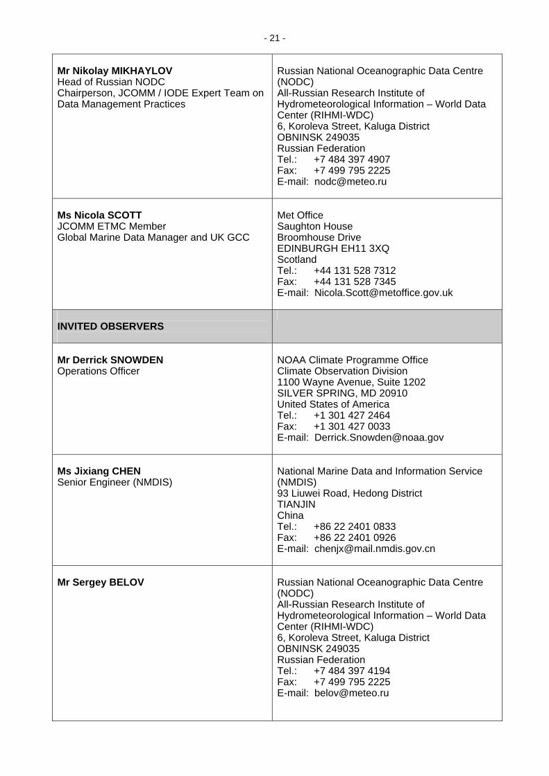
ANNEX III
THE WIGOS PILOT PROJECT FOR JCOMM (OUTLINE) (19 September 2008)
“Integration of marine meteorological and other appropriate oceanographic observations
into the WMO Integrated Global Observing Systems” Project Name JCOMM Pilot Project for WIGOS Acronym
N/A
Project Type
Pilot
Project Status
The Pilot has defined a detailed implementation plan at the meeting of the joint Steering Group for the IODE Ocean Data Portal (ODP) and the WIGOS Pilot Project for JCOMM (Geneva, Switzerland, from 18 to19 September 2008). The Project plan was defined at the ad hoc planning meeting for the JCOMM Pilot Project for WIGOS (Ostend, Belgium, 29 March 2008). Mechanisms have been defined for providing input to the CIMO Guide (WMO No. 8) and other appropriate JCOMM documentation. A standards process for developing ocean data standards is being established in cooperation with IOC. The development of a JCOMM Catalogue of Best Practices and Standards is planned. Thirteen key potential partners have been identified (see below) for providing data through WIS. The Pilot Project is considering establishing regional marine instrument centres. It is engaging in a stronger cooperation with HMEI.
Project Overview
Development of the Pilot Project is coordinated by a Steering Group, providing liaison with appropriate WMO Programmes and Technical Commissions, the WMO EC-WG on WIGOS-WIS (and its sub group), and the International Oceanographic Data and Information Exchange (IODE) of IOC. The Steering Group is responsible for producing the Pilot Project Plan and promoting the continued development and implementation of a system of interoperable systems that provides consistent, documented data and information of known quality from a sustained and coordinated global ocean observing system. Three components are proposed in the development of the Pilot Project: (i) promoting and documenting best practices; (ii) promoting interoperable arrangements between ocean data systems and the WIS; and (ii) quality management. The Project will recognize and respect the ownership of all partner organizations as well as the WMO and IOC data policies.
Project Aims
Enable the integration of marine and other appropriate oceanographic observations (in situ, surface marine and satellite), real-time and delayed-mode data and products (e.g., models) within the oceanographic marine community. The Pilot Project will also consider assembled in situ fields, biochemistry, model outputs, surface and underwater marine climatologies and measurements.

- 24 -
The Pilot Project will aim at making the appropriate identified data sets interoperable with the wider WMO and IOC communities. It will develop and agree on consistent standards to be used across the community. It will increase accessibility of data; ensure standards and best practices; as well as set guidelines regarding capacity-building and training programme.
Partners/Participants
• International organizations co-sponsoring GOOS: WMO, IOC, UNEP and ICSU;
• WMO and IOC Technical Commissions and Programmes (e.g., CIMO, CBS, GOOS and IODE);
• WMO Information Systems and its Expert Teams, ICT-WIS; • Ocean Data Portal and ETDMP Task Team on ODP / JCOMM
Pilot Project WIGOS; • ETDMP Task Team on standards process; • IODE Ocean Data and Information Networks (ODINs); • JCOMM E2E prototype (Russian Federation NODC, Obninsk); • Instrument centres; • Observing Panels; • Association of Hydro-Meteorological Equipment Industry
(HMEI); and • Partners hosting relevant data sets (in situ, space-based ocean
observations data sets, as well as products); o Integrated data sets:
The World Ocean Database (WOD); SeaDataNet; and The Global Temperature and Salinity Profile
Programme (GTSPP); o Data from specific networks:
Argo profiling float data; RNODC/DB (drifter data); XBT data; and Instrument / platform metadata (META-T,
ODASMS); o Remote-sensing:
The Virtual constellation for Ocean Surface Vector winds;
The GODAE High-Resolution SST (GHRSST) Pilot Project; and
Surface-based remote-sensing (e.g. HR Radar); o Climatologies:
World Ocean Atlas (WOA); Marine Climatological Summaries, e.g., delayed-
mode VOS data collected by the Global Collecting Centres (GCCs);
Blended quality climatology products such as the International Comprehensive Ocean-Atmosphere Data Set (ICOADS);
o Metadata about the platforms/instruments (e.g. META-T); and
• Additional participants and partners to be discussed and defined.

- 25 -
Funding Source(s)
The Project will, to the maximum extent possible, make use of the expertise to be provided through the working structure of JCOMM, IOC / IODE, and its WIGOS partners. Additional support will be required through the WMO budget and / or WIGOS-WIS Trust Fund. Implementation costs will be met by the Members.
Project Timescale
2007 – did-2008: Establishment of the Pilot Project and proposal for its Steering Group Terms of Reference and Membership; September 2008: First meeting of the Pilot Project Steering Group; Adoption of the project implementation plan; November / December 2008: Reporting to the WMO EC WG WIGOS-WIS; End 2008 – 2009: discussions with partner observing programmes (DBCP, SOT, GLOSS, Argo, etc.) and organizations (IOC and IODE); November 2009: Third Session of JCOMM; 2010-2011: Implement the projects; and End 2010: Report to sixteen session of WMO Congress (Cg-XVI) finalized. Implementation schedule will depend upon how well WIS is progressing.
Expected Key Deliverables
The Pilot Project will address Result Based Management of WMO and IOC (i.e., it will link its deliverables to the Expected Results). The Pilot Project will have the following deliverables: (i) Business Plan to be used by the directors of NMHS and Oceanographic institutes to make the case at the national level for engaging in the necessary developments, funded nationally, to meet the requirements for the Pilot Project; (ii) Project Plan; (iii) Implementation Plan; (iii) Documenting and integrating best practices and standards among the marine meteorological and oceanographic communities; (iv) Developing interoperable arrangements between the marine and oceanographic data systems and the WMO Information System (WIS) in close cooperation with the IOC ocean community; (v) Establishing compliance with the WMO Quality Management Framework (QMF); and (vi) Participation in the WMO ET-EGOS Rolling Review of Requirements (RRR) process and provide input to the WMO Database (instrument performances and requirements).
Project Links
http://www.wmo.int/pages/prog/www/wigos/index_en.html http://www.oceandataportal.net http://www.oceandatastandards.org

- 26 -
Project Summary
The Pilot Project is an interdisciplinary exercise seeking the integration of in situ and space-based observing systems. These will be implemented and sustained by the WMO and IOC Members through JCOMM in order to make appropriate data sets available in real-time and delayed mode to WMO and IOC applications through interoperability arrangements with the WIS and ODP. The data sets will be produced according to agreed upon standards and the quality control procedures documented according to QMS principles. This integration will enhance the coherence and consistency of the data sets and the availability of relevant instrument/platform metadata. More timely and better quality data will be expected while duplicates will be minimized. - 1 - Documenting and integrating best practices and standards. The goal is to define and agree on common standards between the meteorological (WMO) and oceanographic (IOC) communities for instruments and methods of observation as well as subsequent organization and handling of the data and information to serve consistent and better quality data to both the broad user and modelling communities. - 2 - Making marine data systems and WIS interoperable. The goal is to provide access to marine meteorological and oceanographic data and information to serve a number of applications, including climate. This shall be done in an integrated way via the WIS and thereby facilitating access to well documented and standardized data. Much work remains to develop interoperability between the WMO and IOC communities at both the data discovery (metadata) and data level (compatible formats). The Pilot Project will address these two aspects. - 3 - Quality Management. The goal is to coordinate the development of cost-effective Quality Management Systems by Members and to propose practical solutions or examples. At different steps of the data production line, it is expected that improved quality management will result in better, timelier data, minimized duplication, and an operational data delivery system. This will be achieved through the compilation of regulatory documentation in a way consistent with the eight Quality Management Principles developed under ISO/TC176/SC2/WG15 (User / customers focus, Leadership, Involvement of people, Process approach, System approach to management, Continual improvements, Factual approach for decision making and, Mutually beneficial supplier relationships).
Date of Last Update
19/09/2008

- 27 -
JCOMM Contact Name Organization Address Telephone Fax E-Mail
Mr Robert Keeley Integrated Science Data Management Department of Fisheries and Oceans Canada 12W082 - 200 Kent Street OTTAWA, ONTARIO K1A 0E6 Canada +1 613 990-0246 +1 613 993-4658 [email protected]
____________

- 28 -
ANNEX IV
WIGOS PILOT PROJECT FOR JCOMM, PROJECT PLAN (as of 6 November 2008)
INTEGRATION OF MARINE METEOROLOGICAL AND OTHER APPROPRIATE OCEANIC OBSERVATIONS INTO THE WMO GLOBAL OBSERVING SYSTEMS
1. BACKGROUND
Assisted by fifteenth WMO Congress (Cg-XV), the high-level WIGOS-WIS goal is to establish a comprehensive, coordinated, and sustainable system of observing systems with ensured access to its component observing systems’ data and products through interoperable arrangements. WIGOS, the WMO sponsored system of observing systems and the WMO sponsored Information System (WIS) provides the access through the interoperable arrangements. WIGOS-WIS will address all WMO Programme requirements, ensure availability of required information, meet data quality standards, and facilitate access to real / quasi-real-time data as well as to archived information. The WIGOS Pilot Project for JCOMM will make an important contribution in the development of WIGOS-WIS. 2. SCOPE AND DELIVERABLES 2.1 Scope 2.1.1 Following guidance from the WMO Executive Council Working Group on the WMO Integrated Global Observing System (WIGOS) and the WMO Information System (WIS) (EC WG WIGOS-WIS), this Project Plan recommends a Steering Group to coordinate and facilitate the development and implementation of the WIGOS Pilot Project for JCOMM (including relevant WIS items) as well as the International Oceanographic Data and Information Exchange (IODE) Ocean Data Portal (ODP). 2.1.2 The Pilot Project will be required to coordinate with appropriate WMO Technical Commissions and Expert Teams:
• The WMO Commission for Basic Systems (CBS) is responsible, in particular, for the cooperation with Members, other technical commissions and relevant bodies in the development and operation of integrated systems for observing, data-processing, telecommunications, and data management in response to requirements of all WMO Programmes and opportunities provided by technological developments. The development of the WIS is undertaken in the framework of the CBS. The WIS will be at the heart of the Pilot Project as the development interoperability between ocean data management systems and the WIS will be one of the key Pilot Project deliverables. The development of the WIS is coordinated through the Inter Commission Coordination Group on WIS (ICT-WIS). Three Expert Teams have also been established by the CBS to undertake specific aspects of the WIS development and are as follows: (i) the Inter - Programme Expert Team on Metadata Implementation (IPET-MI); (ii) the Expert Team on Global Information System Centres (GISC) and Data Collection and Production Centres (DCPC); and (iii) the Expert Team on WIS-GTS, Communication Techniques and Structures (ET-CTS). Liaison with these Expert Teams will be developed further in the future. (See further details listed under 3.5.); and
• The WMO Commission for Instruments and Methods of Observation (CIMO) is
responsible for matters relating to international standardization and compatibility of instruments and methods of observation of meteorological, related geophysical, and environmental variables. The work of CIMO relates directly to one of the deliverables of the Pilot Project, (i.e. documenting and integrating best practices and

- 29 -
standards being used amongst the marine meteorological and oceanographic communities). As standards and best practices have in some cases been developed separately between the meteorological (via CIMO) and oceanographic (via IOC and its IODE) communities, enhanced coordination between the two will be required. (See further details listed under 3.5.).
2.1.3 In addition, this will require coordination with:
• The JCOMM Management Committee (MAN) with regard to the overall development of the Pilot Project, and JCOMM cross cutting issues;
• The JCOMM Observations Programme Area (OPA) and its Observations Panels, in
collaboration with CIMO, to assist in the development of best practices and standards, and ensure that the flow of real-time and delayed-mode observations will eventually be provided through the WIS and partner ocean data systems;
• The JCOMM Data Management Programme Area (DMPA) will assist in the
development of standards through it’s standards development and accreditation process, as well as to facilitate the development of interoperable arrangements between the ocean data systems and the WIS;
• The IOC of UNESCO, through the IODE committee, will assist in the development
of standards through it’s standards development and accreditation process, to coordinate the development of interoperable arrangements between the ocean data systems and the WIS, to ensure a sufficient level of compatibility between the Marine Community Metadata profile (MCP) and the WMO Core Profile, as well as to connect IODE National Oceanographic Data Centres (NODC) and the ODP with the WIS; and
• The IOC-WMO-ICSU-UNEP Global Ocean Observing System (GOOS) and the
GOOS Scientific Steering Committee (GSSC) will also be required to ensure that the standards and best practices developed meet their expressed requirements. Through linkages between NODCs and World Data Centres (WDC) of ICSU, the project will endeavour to engage at least one WDC Oceanography.
2.1.4 Progress will be reported to the JCOMM MAN and to the WMO EC Working Group on WIGOS-WIS by the JCOMM Pilot Project representative at their regular Sessions. 2.2 Deliverables 2.2.1 The Pilot Project will promote the following: (i) documentation and integration of best practices and standards among the marine meteorological and oceanographic communities; (ii) interoperability of marine data systems with the WIS in close cooperation with the IOC ocean community; and (iii) establish compliance with the WMO Quality Management Framework (QMF). This will be realized according to the following guidelines. 2.2.2 Document and integrate instrument best practices and related standards 2.2.2.1 The goal is to define and agree on common standards for instruments and methods of observation as well as subsequent organization and handling of the data and information to deliver consistent and better quality data to both the broad user and modelling communities. Data records must be traceable to standards. Maintenance and calibration are critical for ensuring stability and sustainability of systems. To understand system and component performance, a thorough documentation of observing platform siting and history as well as the recording and updating of metadata are critical in the elimination of inhomogeneities in data records. For example, one of the challenges proposed by the climate community was to conduct instrument intercomparisons over a long enough period, usually on the order of about 10 years. Best practices and standards have

- 30 - sometimes been developed separately between the oceanographic (e.g., sea level) and the marine meteorological (e.g., voluntary observing ships) communities when there was no clear connection. However, there are instances where these have been developed in common between the WMO and IOC (e.g., ships of opportunity and data buoys). Still, much work remains to be undertaken. 2.2.2.2 Some documentation of instrument related standards already exists. The Pilot Project will identify instrument standards and best practices that are relevant to WIGOS, identify those publications that need updating, and make recommendations for updating them. Updating existing standards or developing new ones will be made in a way consistent with the process that has been developed jointly by JCOMM and IODE under the new ET-DMP Pilot Project. 2.2.2.3 To achieve integration of instrument best practices, the Project Plan will be promoting the establishment of instrument centres dedicated to marine and other appropriate oceanographic instruments. Such centres will facilitate having all WIGOS observational data and metadata and processed observational products to adhere to WIGOS standards for instruments and methods of observation as well as standard observing network practices and procedures. This effort will assist in the exchange of data via WIS using agreed upon data and metadata representation forms and formats. They will be essential for monitoring instrument performance, calibration procedures, providing assistance with regard to intercomparisons, as well as providing for appropriate training facilities that would complement what the manufacturers are currently providing. Invited ocean experts will be in a position to provide required training. CIMO has experience in this regard and will be assisting the Pilot Project in the establishment of such centres (http://www.wmo.int/pages/prog/www/IMOP/IMOP-home.html). Links will be established with the climate community as climate instrument centres have also been developed. The Pilot Project will also cooperate with the Association of Hydro-Meteorological Equipment Industry (HMEI) – who will be invited to participate in the Pilot Project - for evaluating instrument performances and documenting them. 2.2.2.4 The WIGOS CONOPS recommends that all WIGOS observational data and metadata (including platform / instrument metadata and discovery metadata) should adhere to WIGOS standards and be exchanged via WIS using agreed upon data and metadata representation forms and formats. Within JCOMM DMPA, there is the Water Temperature platform / instrument Metadata (META-T) Project. One of the META-T’s objectives is the consolidation of instrument and other metadata to describe sea temperature measurements. There are two centres contributing infrastructure to this project, one in the United States and the other in China. The ODP-WIGOS Pilot Project for IODE and JCOMM should consider how to include this work, as well as propose a strategy for including variables other than Sea Surface Temperature and water temperature profiles in the platform / instrument metadata collection, distribution, and archiving system being developed. 2.2.3 Build marine data systems that are interoperable with the WIS 2.2.3.1 The goal is to provide access to marine meteorological and oceanographic data and information to serve a number of applications, including climate, in an integrated way via the WIS and thereby facilitating access to well documented and standardized data. Despite WMO Resolution 40, which designates marine data as essential, currently it is difficult for the oceanographic community to access the Global Telecommunication System (GTS) in order to obtain marine observations in real-time or delayed mode as well as providing data for circulation on the GTS. 2.2.3.2 The WIS was designed as an overarching, integrated system meeting the requirements for data exchange of all WMO Programmes, affiliated international organizations and programmes, as well as relevant national non-NMHS users such as disaster prevention and mitigation agencies and research facilities. The main functional components of WIS are the National Centres (NC), Data Collection or Product Centres (DCPC), Global Information System Centres (GISC) and data communication networks connecting the components. The WIS provides for: (i) routine collection and automated dissemination of operation-critical data; (ii) timely delivery of high-volume data and

- 31 - processed products (“push”); (iii) discovery, access, retrieval services for data from WMO Programmes and Co-sponsored programmes (“pull”); and (iv) common procedures for real- and non-real-time data exchange and standardized data formats and metadata. 2.2.3.3 At the same time, the ocean community has real-time and delayed-mode data systems that will need to be interoperable. Work has already begun with the development of (i) the JCOMM / IODE End-To-End Data Management technology, and the DCPC prototype developed at the Russian Federation NODC in Obninsk and (ii) the ODP at the data discovery level. Much work remains to develop the interoperability between the two communities at both the data discovery (metadata) and data level (compatible formats). The Pilot Project will address these two aspects. 2.2.4 Promote Quality Management and standards 2.2.4.1 The goal is to coordinate the development of cost-effective Quality Management System (QMS) by Members and to propose practical solutions or examples. At different steps of the data production line, it is expected that improved quality management will provide the following benefits:
(i) more quality data to meet the requirements of a broad and varied community of users;
(ii) the data quality and the conditions under which the measurements are made will be
known;
(iii) data quality will improve as well as their consistency due to the wider acceptance of documented standards;
(iv) data will be more timely in reaching their targeted applications and data assimilation
systems;
(v) data duplication will be avoided and the origin of the data identified;
(vi) over time users will develop an increased trust in the data; and finally; and
(vii) products and services using these data will improve. 2.2.4.2 These benefits will be achieved through the following:
(i) The development and implementation of the QMS that complies with the WMO and IOC quality policies should be promoted in the context of the Pilot Project with the recommendation to compile, at the national level, regulatory documentation produced in a way consistent with the eight Quality Management Principles developed under ISO / TC176 / SC2 / WG15 (User / customers focus, Leadership, Involvement of people, Process approach, System approach to management, Continual improvements, Factual approach for decision making, and Mutually beneficial supplier relationships). This may lead in some instances to the certification of such QMS related to the products using the observational data. ISO 9001 certification will be not be mandatory, as some of the meteorological and / or oceanographic services participating in the Pilot Project might wish to comply with other standards than ISO;
(ii) Better access to data will be achieved through: (i) interoperability arrangements
between the ocean and meteorological communities (deliverable 2); (ii) establishing procedures to manage duplicate data and methods for avoiding them; and (iii) collection and distribution of instrument / platform metadata (part of deliverable 1);

- 32 -
(iii) The IODE-JCOMM Standards process will also provide a framework for the Pilot Project to further the development of appropriate widely accepted quality management standards to address issues such as instrument best practices, real-time and delayed-mode quality control procedures (automatic and / or manual), data collection and exchange formats, and products using the observational data; it must be noted that this item also relates to deliverable 1 but is not limited to instrument best practices and standards;
(iv) The Pilot Project will assist in the production of a catalogue on JCOMM best
practices and standards to be published as a JCOMM Technical Document. The Pilot Project will use both the IODE OceanTeacher training facility and the new WIGOS web site to share appropriate documentation;
(v) Quality Management issues related to instrument best practices are being
addressed under deliverable 1. 3. PILOT PROJECT APPROACH, ROLES AND RESPONSIBILITIES 3.1 Cooperation with the ocean community 3.1.1 Operational models of the interior of the oceans have been significantly improved with the success of the Argo Pilot Project deploying an increasing number of instruments and having now attained the 3000 float target. A number of countries are engaged in combining multi-level atmospheric and oceanographic models and installing real-time modelling functions. With this ability, the oceanographic community is seeing important advantages to becoming involved in making, reporting and using ocean observations in real-time. The ocean observing components of JCOMM that are not currently reporting by way of the GTS will be encouraged to submit their data in real-time through the WIS. 3.1.2 It is expected that the importance of historical data to modelling will increase. Historical data are valuable as tests of the ability of models to reproduce past conditions and so provide confidence that they can also make reliable predictions. As well as providing higher-resolution, high-quality delayed-mode data that reach data centres in the ocean community will be important for hind casting conditions in areas that have been poorly sampled in the past by improving the forecasts of operational models that use real-time data only. 3.1.3 The following aspects will be considered for the Pilot Project:
(i) Providing access, through the WIS, to historical and recent data holdings in ocean data centres. This work will exploit the prototype JCOMM End-To-End Data Management (E2EDM) effort, which has already begun. However, substantial effort remains to integrate the various sources of in situ and satellite data (e.g., Argo, OceanSITES, GHRSST, XBT, Ocean carbon, sea level stations, satellite altimetry data, etc.). The Pilot Project will consider prioritization for the integration of these different components. Managers of the data systems involved in these programmes will be approached to encourage them to install the necessary software infrastructure to support data exchange. Those systems for which data exchange is a relatively simple process will be converted first;
(ii) At the same time that marine data managers are being approached to provide
access to their data, they will also be encouraged to join the efforts in developing documentation in the form of discovery metadata, and standards and best practices for such data. This will result in more consistent processing thus, making documentation available for users explaining where the data can be found and the processes through which the data have gone.
- 33 -
(iii) The Ocean Community is developing the Ocean Data Portal under the auspices of the IODE. The ODP operates on a standards-based infrastructure that provides for the integration of marine data and information from a network of distributed IODE NODCs. The key principle behind the ODP is its interoperability with existing systems and resources. The ODP will require IODE data centres to generate discovery metadata about their datasets for data search and retrieval. The OPD will periodically harvest these metadata, monitor the accessibility of a remote data source and update the portal metadata catalogue. Hence, users will be able to search for single or multiple data types from a distributed set of sources. The ocean community will contribute to the Pilot Project through interoperability arrangements of the ODP with the WIS; and
(iv) To recognize ownership of both the WMO and IOC marine and oceanographic
observing systems, the development of marine and oceanographic instrument centres will be created within the framework of JCOMM. Such instrument centres will be hosted by either a National Meteorological and Hydrological Services (NMHS) or an oceanographic institute.
3.2 Benefits 3.2.1 There are clear advantages for the ocean community to participate in the Pilot Project and provide interoperability with the WIS. These include:
• Improving their visibility with NMHSs while keeping their independence regarding parallel data systems they have put in place;
• Gaining better access to meteorological data input for ocean modelling and
research applications regarding ocean-atmosphere interactions, climate data input for ocean modelling, and hydrological data related to river discharges into the oceans through direct WIS access. Currently, it is more difficult to access some of these data outside of the scope of the Pilot Project;
• Solidifying links between meteorological and oceanographic data centres by
providing time-critical and delayed-mode ocean data to the WIS and accessing multi-disciplinary data from the WIS;
• Accessing more data of known quality obtained through consistent, coherent, and
traceable instrumentation that meet standards agreed upon between both the meteorological and oceanographic communities. This will permit a better use of data for the production of consistent quality products as well as facilitating observational data intercomparisons, and data quality monitoring; and
• Enhancing the development of operational oceanography nationally and globally for
delivery of products and services that better serve the end-users. 3.2.2 At the same time, there will be advantages for the WMO and NMHS, including:
• Gaining better access to oceanographic data to feed into operational and research applications;
• WIS will provide for multi-disciplinary access to data; and
• Enhancing NMHS cooperation with the oceanographic centres nationally or globally
for delivering products and services that better serve the end users (weather forecasts, marine services, marine climatology, climate monitoring and prediction).

- 34 - 3.3 Joint Steering Group for the IODE Ocean Data Portal and the WIGOS Pilot Project
for JCOMM 3.3.1 The development of the WIGOS Pilot Project for JCOMM and the IODE Ocean Data Portal will be coordinated by a joint Steering Group, providing liaison with appropriate WMO and IOC Programmes and subsidiary bodies. The Terms of Reference (ToR) for the Steering Group are provided in Appendix A. 3.3.2 The Members of the Steering Group are:
• IODE Representative (Co-chairperson) - Mr Greg Reed;
• CIMO Representative (Co-chairperson) - Mr Rainer Dombrowsky;
• JCOMM DMPA Co-ordinator - Mr Robert Keeley;
• JCOMM OPA Representative - Ms Candyce Clark;
• JCOMM ET-DMP Chairperson - Mr Nikolay Mikhaylov;
• WIS Representative - Mr Eliot Christian;
• US-IOOS Representative - Dr Jack Harlan;
• US NODC Representative - Ms Margarita Gregg; and
• MCSS and GCC Representative - Ms Nicola Scott. 3.4 Participants in the Pilot Project 3.4.1 The following organizations and programmes have indicated their commitment as partners in the Pilot Project:
• US NODC:
o World Ocean Atlas;
o World Ocean Database; and
o US NODC GTSPP;
• Surface currents from HF radar;
• Russian Federation NODC:
o End-to-End prototype technology (Russian Federation);
• GTS operational database, marine surface climatology (air T, SST, sub-sal, oxygen);
• Canada, ISDM:
o Upper-ocean T & S gridded in situ fields; and
o Ocean currents derived from surface drifters;
- 35 -
• Permanent Service for Mean-Sea Level (PSMSL);
• Marine Climatological Summaries and Global Collecting Centres (GCCs) (UK Met Office or DWD via Virtual GISC);
• Blended-quality climatology products (e.g., ICOADS); and
• Global High-Resolution Sea Surface Temperature Pilot Project (GHRSST-PP).
3.4.2 The following organizations and programmes have been identified as potential partners and will be approached to confirm their commitment to the Pilot Project:
• In situ data sets from the JCOMM Observations Programme Area such as:
o Profiling floats (Argo);
o Deep ocean time-series reference stations (OceanSITES);
o Tropical moorings (TAO);
o Drifters (DBCP);
o Ship-based observations in the SOT (ASAP, VOS, XBTs);
o Tide gauges (GLOSS);
o Water temperature and salinity profiles (GTSPP);
o Surface underway data (GOSUD); and
o Ocean carbon (IOCCP), etc.
• Model output fields (e.g., GODAE);
• Metadata about the platforms / instruments (e.g., META-T);
• Integrated data systems (e.g., SeaDataNet, DMAC);
• ODINs (Provision of datasets, by way of the ODP, to the WIS);
• Fast delivery sea level data (University of Hawaii Sea Level Center);
• Instrument Centres; and
• Ocean current data from VOS. 3.4.3 While the Steering Group will be relatively small and focus on the project plan, a more comprehensive list of individuals is proposed in parallel as “participants”. The participants include the following:
• Members of the IODE / JCOMM ET-DMP Task Team for Ocean Data Portal and the WIGOS Pilot Project for JCOMM regular meetings required; financial implications are estimated at a level of about $15K per year;
• Members of the IODE / JCOMM ET-DMP Task Team for Standards Process

- 36 -
(functions mainly by email; financial implications are low);
• Committed partners listed above and not belonging to the ad hoc Steering Group (i.e., Messrs Terry Tielking, Scott Woodruff, and Mrs Leslie Rickards);
• JCOMM DBCP Chairperson - Mr David Meldrum;
• JCOMM SOT Chairperson - Mr Graeme Ball; and
• Other participant, as required.
3.5 Roles
The following table lists the bodies that will have a direct role in working with the Pilot Project Steering Group
Body: Role(s):
EC WG WIGOS-WIS
The WMO Executive Council Working Group on WIGOS and WIS (EC WG WIGOS-WIS) provides for the overall vision and guidance.
SG-WIGOS The Sub-Group on the WIGOS (SG-WIGOS-WIS) of the EC WG WIGOS-WIS provides overall technical guidance, assistance and support for the implementation of the WIGOS concept. The Sub-Group works with each WIGOS component, proposes new components and coordinates agreed inter-actions with other partners (e.g., co-sponsored systems, international initiatives’ systems, etc.). It refines the concept of WIGOS operations, including its basic definitions. It coordinates the WIGOS planning phases and implementation (including the Pilot Projects) according to the over-arching WIGOS and WIS Development and Implementation Plans.
JCOMM OPA The JCOMM Observations Coordination Group (OCG) coordinates and promotes the development, documentation, and integration of best practices and QMS. It ensures the flow of the data to the WIS.
JCOMM DMPA The JCOMM Data Management Coordination Group (DMCG) coordinates and promotes the development of interoperability arrangements. It coordinates and promotes the development, the documentation, and the integration of data management best practices and QMS.
JCOMM ET-DMP The JCOMM / IODE Expert Team on Data Management Practices (ET-DMP) proposes practical steps regarding the development of interoperability arrangements and implementation of QMS. It also administers the process by which standards and best practices are agreed to between JCOMM and IODE (Task Team of the Pilot Project on the IODE / JCOMM Standards Process). The ET-DMP provides guidance to the Steering Group of the IODE Ocean Data Portal and the WIGOS Pilot Project for JCOMM.
JCOMM ET-MC The JCOMM Expert Team on Marine Climatology (ET-MC) coordinates and promotes the development, the documentation, and the integration of QMS regarding delayed-mode marine data and Marine Climatological Summaries.
CIMO The WMO Commission for Instruments and Methods of Observation (CIMO) will consider JCOMM requirements in terms of standards and best practices. It will assist with the inclusion of appropriate best practices or references to best practices in the WMO Publication No. 8, Guide on Instruments and Methods of Observation.

- 37 -
IODE The International Oceanographic Data and Information Exchange (IODE) programme of IOC will assist in the development of interoperability arrangements, assist in the integration of best practices, and assist in the development and integration of QMS.
Members Members will provide expertise and commit resources to the Pilot Project. They will continue to develop, implement, and sustain the observing systems in a coordinated way and following recommended best practices and provide the observational data through the WIS. Implement QMS at required levels of the data production line.
4. SCHEDULE 4.1 Proposed Schedule and Actions (depending on resources allocation):
i. September 2008. Pilot Project Steering Group meeting to monitor progress, make adjustments and refine targets for the next year, and propose a formal Steering Group;
ii. October 2008. Discussion with the Data Buoy Co-operation Panel at its twenty-
fourth session (South Africa). Expected outcome: progress regarding integration of best practices and standards regarding buoy observations;
iii. December 2008. Progress report to the seventh session of the JCOMM
Management Committee;
iv. April 2009. Discussion with the JCOMM Ship Observations Team at its fifth session. Expected outcome: progress regarding integration of best practices and standards regarding ship observations;
v. May 2009. Twentieth session of IODE. Expected outcome: formal endorsement
from IODE and Resolution;
vi. June 2009. Reporting to the sixty-first session of the WMO EC (EC-LXI);
vii. November 2009. Third session of JCOMM. Expected outcome: formal endorsement from JCOMM and Resolution; and
viii. Implement the projects by November 2010 reporting to the JCOMM Management
Committee and EC WG and finally Cg-XVI (May 2011). 4.2 Completed Schedule and Actions:
i. 3-6 December 2007. Sixth session of the JCOMM Management Committee. Draft proposal presented for discussion;
ii. 21-25 January 2008. IODE / JCOMM Forum on Oceanographic Data Management
and Exchange Standards, Ostend, Belgium. Draft proposal presented for discussion;
iii. 26-28 March 2008. Third session of the JCOMM Data Management Coordination
Group, Ostend, Belgium. Draft proposal presented for discussion;
iv. 29 March 2008. Ad hoc planning meeting for the Pilot Project, Ostend, Belgium. Finalizing Project Plan, Business Plan, identified potential participants and data sources, and proposed Steering Group Terms of Reference and membership;
v. 3-4 April 2008. SeaDataNet, Athens, Greece. Presentation of the Pilot Project at

- 38 -
the SeaDataNet annual plenary meeting;
vi. April 2008. Consultations with the ad hoc Steering Group, the JCOMM Management Committee, and the IODE Officers, and reports on progress and proposed strategy by the Pilot Project. Consolidated report by the WMO Secretariat for review by the Sub-Group of the EC WG WIGOS-WIS;
vii. 9-13 June 2008. Ninth meeting of the GHRSST Pilot Project Science Team,
Perros-Guirrec, Brittany, France. Presentation of the Pilot Project; 5. ESTIMATED COSTS 5.1 The Pilot Project Steering Group will have to meet at least once a year during three years. Experts will have to attend specific meetings in order to promote the Pilot Project (e.g., SeaDataNET, DMAC, IODE and DBCP). Experts will have to visit key data centres in order to explain the Pilot Project requirements and provide assistance regarding the implementation of the interoperability arrangements. A consultant will be required to assist in the production of relevant documentation for the Pilot Project.
Item: Yearly: Total 3 years: Meetings of the Steering Group (10 people meeting once a year)
CHF 20.000 CHF 60.000
Experts attending specific meetings or visiting data centres on behalf of the Pilot Project (5 missions per year)
CHF 10.000 CHF 30.000
Consultant (one person x month per year) CHF 10.000 CHF 30.000 Total CHF 40.000 CHF 120.000
5.2 It is important to note that the estimates outlined above do not cover software, hardware or personnel costs that will be required by individual contributors. In the end, it is the identification and use of such funds that will allow the linking of data collections across organizations to accomplish the goals of the Pilot. Costs to individual organizations to take part in this Pilot Project will vary depending on their present computing capabilities. It is expected that more than a one cost solution will be proposed to organizations in order to reduce the impact of funding.

- 39 -
ANNEX I (OF ANNEX IV)
TERMS OF REFERENCE FOR THE JOINT STEERING GROUP FOR THE IODE OCEAN DATA PORTAL AND THE WIGOS PILOT PROJECT FOR JCOMM
The development of the WIGOS Pilot Project for JCOMM and the IODE Ocean Data Portal will be coordinated by a joint Steering Group, providing liaison with appropriate WMO and IOC Programmes and subsidiary bodies. The Steering Group will be responsible for:
a) Producing the respective Pilot Project Plans in a coherent and consistent way;
b) Liaising with the EC-WG/WIGOS-WIS Sub-Group on WIGOS (SG-WIGOS) regarding the development of the Pilot Project and refinement of the WIGOS Concept of Operations (CONOPS);
c) Liaising with the IODE Officers regarding the development of the ODP;
d) Promoting the continued development and implementation of a system that provides
data and information from a sustained and coordinated global ocean observing system;
e) Coordinating and promoting the development, documentation, and integration of
best practices for the different components of the marine observing and data systems;
f) Coordinating and promoting the development of interoperability arrangements
between different components of the marine data system, and the provision of the real-time and delayed mode observational data through the WIS and ODP;
g) Coordinating and promoting the development, documentation, and integration of
QMS at the required levels of the data production line from marine observations to the delivery of data and products;
h) Coordinate its activities with the other WIGOS Pilot Projects as well as the WIGOS
Demonstration Projects;
i) Seeking resources to be committed to the Pilot Project; and
j) Guiding the implementation of the Project Plan and working with the WMO and IOC Secretariats to facilitate its implementation.
The Steering Group will report to the WMO EC-WG/WIGOS-WIS Sub-Group on WIGOS
(SG-WIGOS) and to the IOC International Oceanographic Data and Information Exchange (IODE) Committee. Reporting will also be provided to the Joint WMO-IOC Technical Commission for Oceanography and Marine Meteorology (JCOMM).
____________

- 40 -
ANNEX II (OF ANNEX IV)
ACRONYM LIST ASAP Automated Shipboard Aerological Programme CBS WMO Commission for Basic Systems CIMO WMO Commission on Instruments and Methods of Observation CONOPS WIGOS Concept of Operations DBCP Data Buoy Co-operation Panel DCPC Data Collection and Production Centre (of WIS) DMAC IOOS Data Management and Communications (USA) DMCG JCOMM Data Management Coordination Group DMPA JCOMM Data Management Programme Area DWD Deutscher Wetterdienst E2EDM End-to-End Data Management Pilot Project EC WMO Executive Council EC-WG Executive Council Working Group ET-CTS Expert Team on WIS-GTS, Communication Techniques and Structures ET-DMP JCOMM Expert Team on Data Management Practices ET-MC JCOMM Expert Team on Marine Climatology GCC Global Collecting Centre GHRSST GODAE High Resolution SST Pilot Project GISC Global Information System Centres (of WIS) GLOSS JCOMM Global Sea-level Observing System GODAE Global Ocean Data Assimilation Experiment GOOS IOC-WMO-UNEP-ICSU Global Ocean Observing System GOSUD Global Ocean Surface Underway Data Pilot Project GSSC GOOS Scientific Steering Committee GTS Global Telecommunication System GTSPP Global Temperature and Salinity Profile Programme HMEI Association of Hydro-Meteorological Equipment Industry ICOADS International Comprehensive Ocean-Atmosphere Data Set ICSU International Council for Science ICT-WIS Inter Commission Coordination Group on WIS IOC Intergovernmental Oceanographic Commission IOOS Integrated Ocean Observing System (USA) IOCCP IOC International Ocean Carbon Coordination Project IODE IOC International Oceanographic Data and Information Exchange Programme IPET-MI CBS Inter Programme Expert Team on Metadata Implementation ISDM Integrated Science Data Management (Canada) ISO International Organization for Standardization JCOMM Joint WMO-IOC Technical Commission for Oceanography and Marine
Meteorology MAN JCOMM Management Committee MCP Marine Community Metadata Profile MCSS Marine Climatological Summaries Scheme META-T Water Temperature Metadata Pilot Project NC National Centres NMHS National Meteorological and Hydrographic Service NODC IODE National Oceanographic Data Centre OceanSITES Ocean Sustained Interdisciplinary Timeseries Environment observation System OCG JCOMM Observations Coordination Group ODIN IODE Ocean Data and Information Network ODP IODE Ocean Data Portal OPA JCOMM Observations Programme Area PO Project Office PSMSL Permanent Service for Mean Sea Level

- 41 - QMF WMO Quality Management Framework QMS Quality Management System SeaDataNet Pan-European infrastructure for Ocean & Marine Data Management SOT JCOMM Ship Observations Team SST Sea Surface Temperature TAO Tropical Atmosphere Ocean network of tropical moorings VOS Voluntary Observing Ship WDC ICSU World Data Centre WIGOS WMO Integrated Global Observing Systems WIS WMO Information System WMO World Meteorological Organization XBT Expendable Bathythermograph
____________

- 42 -
ANNEX V
OVERARCHING IMPLEMENTATION PLAN FOR THE
ODP1 AND WIGOS2 PILOT PROJECT FOR THE IODE3 AND JCOMM4
(6 November 2008)
BACKGROUND
Assisted by the WMO fifteenth Congress (Cg-XV), the high-level WIGOS / WIS goal is to establish a comprehensive, coordinated, and sustainable system of observing systems with assured access to data and products from the component observing systems by interoperability arrangements. WIGOS is the system of observing systems and the WMO Information System (WIS) provides the access through interoperability arrangements. The WIGOS / WIS will address all WMO Programme requirements through its Rolling Review of Requirements (RRR) to ensure availability of required information5, meet data quality standards, and facilitate access to real-time data as well as to archived information.
Cooperation between the IODE and JCOMM, through its joint Expert Team on Data Management Practices (ETDMP), has resulted in the development of the End-to-End data management (E2EDM) technology that provides the functionality for building the distributed data system known as the Ocean Data Portal (ODP).
The objective of the ODP is to facilitate and promote the exchange and dissemination of marine data and services. The ODP provides the full range of processes including data discovery, access, and visualization, and delivers a standards-based infrastructure that provides the integration of marine data and information from the network of distributed IODE NODCs, data centres of JCOMM and other participating systems.
The development of the ODP and its linking to the WIGOS objectives furthers the objectives of both JCOMM and IODE. The ODP-WIGOS Pilot Project for IODE and JCOMM will provide WIGOS with links to oceanography and marine meteorology data and products.
A project plan was prepared, which listed three deliverables. They were:
• Document and integrate instrument best practices and related standards;
• Build marine data systems that are interoperable with the WIS; and
• Promote quality management and standards.
Details of the work expected to be carried out to meet these deliverables can be found in the project plan.
A proposed schedule and actions also appears in the project plan and were:
a. Sixth session of the Joint WMO-IOC Technical Commission for Oceanography and Marine Meteorology (JCOMM) Management Committee (JCOMM MAN-VI), (Paris, France, 3-6 December 2007). Draft proposal presented for discussion;
1 ODP: Ocean Data Portal 2 WIGOS: WMO Integrated Global Observing Systems 3 IODE: IOC’s International Oceanographic Data and Information Exchange 4 JCOMM: Joint WMO-IOC Technical Commission for Oceanography and Marine Meteorology 5 Unless specified otherwise, the use of the word information in this document refers to the WMO definition of it (such as in WMO Information System) and relates to data and metadata in general which exchange is required to meet the requirements of WMO Programmes and Co-sponsored Programmes.

- 43 -
b. International Oceanographic Data and Information Exchange (IODE) / JCOMM
Forum on Oceanographic Data Management and Exchange Standards (Ostend, Belgium, 21-25 January 2008). Draft proposal presented for discussion;
c. Third session of the JCOMM Data Management Coordination Group (DMCG-III),
(Ostend, Belgium, 26-28 March 2008). Draft proposal presented for discussion;
d. Pilot Project initial Steering Group ad hoc meeting to finalize project plan and membership (Ostend, Belgium, 29 March, 2008). Meeting held;
e. Representation of the Pilot Project at the annual plenary meeting of the
Pan-European infrastructure for Ocean and Marine data Management (SeaDataNet), (Athens, Greece, 3-4 April 2008). Presentation made;
f. March / April 2008. Consultations with the Steering Group and reports on progress
and proposed strategy by the Pilot Project. Consolidated report by the WMO Secretariat for review by the WMO Executive Council Working Group on WIGOS-WIS (EC WG WIGOS-WIS) and guidance by the sixtieth session of the WMO Executive Council (EC-LX - June 2008). Reports delivered;
g. July 2008: Consultation with the Management Committee and the Pilot Project
Steering Group to incorporate EC-LX guidance and decisions into their final plans. Consultation held;
h. September 2008: Pilot Project Steering Group meeting to report on progress of
planning activities, make adjustments to the draft Implementation Plan and refine targets for the next year. Meeting held;
i. October / November 2008: discussion with the Data Buoy Co-operation Panel
(DBCP) at it’s twenty-fourth session (Cape Town, South Africa). Expected outcome: progress regarding integration of best practices and standards regarding buoy observations. Discussion held;
j. April 2009: discussion with the JCOMM Ship Observations Team (SOT) at its fifth
Session. Expected outcome: progress regarding integration of best practices and standards regarding ship observations;
k. Twentieth session of the IODE, May 2009. Expected outcome: formal endorsement
from IODE and Resolution;
l. Third session of JCOMM, fall 2009. Expected outcome: formal endorsement from JCOMM and Resolution; and
m. Implementation of the project by November 2010 reporting to the JCOMM
Management Committee, EC WG WIGOS-WIS and finally Cg-XVI (May 2011).
Finally, the project plan estimated costs for coordination of the project to be as follows.

- 44 -
OVERALL BUDGET AND CONTRIBUTIONS BY EACH PROJECT PARTNER (CHF)
2008 2009 2010
Item:
IOC WMO IOC WMO IOC WMO Total
Meetings of the Steering Group
7.500 30.000 20.000 20.000 77.500
Experts attending specific meetings or visiting data centres on behalf of the Pilot Project
0 0 15.000 15.000 30.000
Consultant 0 0 15.000 15.000 30.000 JCOMM Best Practices and Standards Catalogue
0 0 30.000 30.000
Total 7.500 30.000 30.000 50.000 20.000 30.000 167.500
It was especially noted that the actual cost of implementation will be higher and these will be borne by the participants in the project.
The ODP-WIGOS Pilot Project for IODE and JCOMM was initiated in 2008 and has two years to complete. This Implementation Plan provides details of the project. It does so by: first addressing each of the three deliverables separately, identifying specific tasks to each deliverable, and projecting a time line for each. A section addresses the requirement for overall project management tying together all activities needed to accomplish ODP-WIGOS Pilot Project for IODE and JCOMM deliverables. A final section constructs a timeline of actions for the entire project.
ODP-WIGOS PILOT PROJECT FOR IODE AND JCOMM CONCEPT OF OPERATIONS
This Pilot Project is the contribution of JCOMM to the WIGOS / WIS developments of WMO. Because it is being developed in conjunction with the IOC / IODE Ocean Data Portal, it also contributes to that project. The WIGOS has developed a Concept of Operations (CONOPS) document that provides the umbrella principles and objectives of WIGOS / WIS. The description here borrows heavily from that document but provides a focus on marine observations, information, and specifics of importance to the marine community.
There is a broadly recognized need for a comprehensive, coordinated and sustainable global observing system. The WIGOS is the organizational response of WMO to this need and therefore is committed to the very strong cooperation that is needed among all partners to accomplish the broad objectives. The WIGOS is a comprehensive, coordinated and sustainable system of observing systems based on all WMO Programmes’ observational requirements. It ensures availability of required data and information and facilitates access through the WMO Information System (WIS) according to identified temporal, geographical and organizational requirements, including those for real-time, near-real time and delayed-modes to all required information and in doing so it respects data sharing policies. Additionally, it helps ensure high data quality standards and benefits from archival and technological innovations.
WIGOS development and implementation proceeds in parallel with the planning and implementation of the WMO Information System. The combination of both efforts allows for an integrated WMO end-to-end system of systems designed to improve Member’s capability to effectively provide a wide range of services and to better serve research programme requirements.
The WIS is used in the collection and sharing of information for all WMO and related international programmes. It provides a flexible and extensible structure to allow participating centres to enhance their capabilities as their national and international responsibilities grow.
- 45 -
Its implementation builds upon the successful components of existing WMO information systems in an evolutionary process. Its communication network is based on links used within the World Weather Watch (WWW) for distribution of high priority real-time data. It utilizes international agreed-upon standards for protocols, hardware and software.
The WIGOS objectives for integration encompass:
a. Improving WMO management and governance (use of resources, planning, institutional and programme structures, and monitoring);
b. Increasing interoperability between systems with particular attention given to
space-based and in situ components of the systems;
c. Addressing the needs of the atmospheric, hydrologic, oceanographic, cryospheric domains within the operational scope of a comprehensive integrated system; and
d. Ensuring that broader governance frameworks (e.g. inter-agency co-sponsorship of
systems) and relationships with other international entities are sustained and strengthened.
The WIGOS objectives:
a. Ensure the availability of all required information produced within JCOMM, with
particular emphasis on information generated by satellites, RADAR, airborne systems, in situ ocean platforms, and other next generation observing systems;
b. Facilitate the access in real / near-real time and delayed-mode of observations
required for WMO and WMO co-sponsored programmes as well as relevant international conventions which are generated by systems implemented and managed by cooperating agencies, organizations and programmes;
c. Ensure required data quality standards are met and sustained for all programme
requirements;
d. Facilitate improved data management including archival and data retrieval capabilities;
e. Facilitate technological innovation opportunities;
f. Continue on-going coordination with instrument manufacturers and scientific
institutes in the development and testing of next generation observation instruments;
g. Develop appropriate regulatory documentation including organization and
recommended practices and procedures; and
h. Link existing technologies in an integrated manner to provide societal benefits.
JCOMM, through WIGOS:
• contributes to strategies to satisfy observational requirements from WMO Programmes and international partners through the WMO Rolling Review of Requirements (RRR) Process;
• contributes to strategies to guarantee system interoperability, including data quality
of observing systems and instruments;

- 46 -
• evaluates existing WIGOS capabilities before developing, acquiring, and or deploying new observing systems or sensors;
• exploits existing platforms and employs multi-sensor platform concepts to the
maximum possible extent;
• coordinates requirements, plans and activities with all appropriate Technical Commissions, Regional Associations and Programmes; and
• builds upon existing observing systems/networks as a global system of observing
systems.
The WIGOS integration objective will be accomplished at three levels:
• Standardization of instruments and methods of observations (instruments and methods of observation level);
• Common information infrastructure, (WIS data level); and
• End-product (e.g., observations, analyzed fields, model output), quality assurance
(QM / QA / QC product level), and standards needed to ensure data quality to project defined minimal requirements.
Standardization and interoperability, including data compatibility, are primary factors for
enabling integration. JCOMM will meet several WIGOS sub-goals as follows:
• Improve the production, use and application of data and information from across all observing systems sponsored and co-sponsored by WMO, in a seamless way, to satisfy user requirements;
• Be designed to accommodate the diversity among Members with respect to their
capabilities and needs;
• Through capacity-building, improve capabilities of Members to access and utilize observations and analysis products from all WMO and sponsored observing systems;
• Ensure compatibility, connectivity and interoperability including interface
arrangements within and among all WMO and sponsored observing systems components and externally with other users;
• Allow for the continuous review of the requirements placed on the integrated system
and have the capability to effectively adjust and respond to changing requirements;
• Ensure the continuing sense of ownership by the various groups that have initiated and developed the individual observing system components through directly involving these groups in the planning and implementation of the WIGOS;
• Promote the development, testing and comparison of new observing capabilities
and provide mechanisms to easily integrate them into WMO and sponsored operational observing systems;
• Ensure the optimum integration of the various components of all observing
programmes;

- 47 -
• Increase efficiencies by reducing as far as possible redundancies and overlaps of systems and the management activities supporting them;
• Facilitate more rapid and efficient assimilation of technological advances and apply
them as far as possible across all observing programmes;
• Foster co-location of observing sites of complementary systems as far as practical thereby reducing redundancies; and
• Ensure the involvement of the various scientific and user communities in the
activities of setting requirements, and the monitoring and assessing system performance.
The ODP-WIGOS Pilot Project for IODE and JCOMM will respect the data policies of
partner organizations, including those of both the WMO and IOC. The IODE and JCOMM will strive to ensure that the conditions placed by the originator on the additional data and products are respected and made known to initial and subsequent recipients for the exchange of data and products including guidelines on relationships in commercial activities.
DELIVERABLE 1: DOCUMENT AND INTEGRATE INSTRUMENT BEST PRACTICES AND RELATED STANDARDS
The two domains of marine meteorology and oceanography have different histories that have resulted in different practices. For marine meteorology, there is a long history of working within the framework of the WMO and the various regulations and observing practices that have been established. In contrast, oceanographic observations are more recent and most originate from a research environment. As a result, new methods and procedures are frequently being tested and this results in less standardization of practice, though best practices are evolving.
This Pilot Project is focused on the practices that impact data collection, processing, archiving and dissemination. The standards and practices used in observing the atmosphere and ocean need to be well documented and ensure that sufficient detail accompanies observations so that a user can interpret the measurements correctly. Information on Meteorological Parameters:
The practices used for making meteorological observations have been standardized by WMO through its Commission for Instruments and Methods of Observation (CIMO). CIMO is responsible for the WMO Guide to Meteorological Instruments and Methods of Observations (WMO Publication No. 8 - CIMO Guide), which includes a marine chapter that describes these practices and standards. This material needs to be reviewed during the course of this Pilot Project to update and / or add content that reflects present operations of marine meteorological practices. [Action 1.1] Information from the JCOMM Observations Programme Area (OPA) Panels:
Instrument best practices, calibration procedures, operating / implementation / deployment procedures and guides, quality control procedures and / or guidelines (delayed-mode, real-time, automatic, or manual), data processing techniques, and formats (e.g., data collection formats) have been developed over the years by the different marine observing systems whose implementation is coordinated through the JCOMM Observations Programme Area (OPA) and the predecessors of JCOMM, i.e., the WMO Commission for Marine Meteorology (CMM), and the WMO-IOC Integrated Global Ocean Services System (IGOSS). The OPA includes the Data Buoy Co-operation Panel (DBCP), the Global Sea Level Observing System (GLOSS), the Ship Observations Team (SOT), and associated groups such as the Ocean Sustained Interdisciplinary Timeseries Environment observation System (OceanSITES), the Argo Steering Group (AST), and the IOC International Ocean Carbon Coordination Project (IOCCP).

- 48 -
The documentation produced is being maintained by these Panels and there is benefit in reviewing the relevant information on instrumentation best practices and standards, addressing integration issues, i.e. identifying compatibilities, avoiding duplication of information, proposing higher levels of standards, including joint WMO-ISO standards. Documentation should be updated accordingly, higher level standards proposed and integrated into relevant parts of the appropriate WMO and / or IOC Manuals and Guides, or at least cross-reference between the various documentation should be included as appropriate. The review of such documentation should begin as part of the development of the JCOMM Catalogue of Best Practices and Standards. [Action 1.2] Documenting Instrument Best Practices: As standards for instruments and methods of observation are adopted, they will be submitted for inclusion in the marine chapter of the CIMO Guide (surface marine meteorological measurements) and other appropriate IOC Manuals and guides (sub-surface oceanographic measurements). An editor from the Pilot Project will work in collaboration with the Rapporteur on the CIMO Guide to preparing material for inclusion. [Action 1.3] Instrumentation Centres:
The WIGOS Concept of Operations (CONOPS) recommended that all WIGOS observational data and metadata and processed observational products should adhere to WIGOS standards for instruments and methods of observation. To achieve this, a key element is the promotion of instrument centres dedicated to marine and other appropriate oceanographic instruments. Such Centres would be essential for monitoring instrument performance, calibration procedures, providing assistance with regard to intercomparisons, as well as providing for appropriate training facilities that would complement what the manufacturers are already providing. In addition to instrument centre staff, invited ocean experts and instrument manufacturers would be invited to participate in such instrument training.
Currently there is only limited experience in oceanography for conducting formal regional or global instrument intercomparisons. Indeed, the recent revisiting of the XBT fall rate question underlines the importance of a formal mechanism to carry out these studies. So, too, is the experience in the deployment of Argo floats where it is now encouraged to carry out an initial test dive and surfacing coincident with a CTD cast to provide an initial intercomparison.
It is generally accepted that systematic intercomparisons of new with legacy instruments is needed. However, operating such intercomparisons at sea and in a variety of ocean areas and conditions would seem to be a greater challenge than normally associated with land-based meteorological instrumentation centres. CIMO has experience with meteorological instrument centres and climate instrument centres and collaboration with such experts to translate the more usual, land-based testing to ocean-based work would be valuable. The ad hoc planning meeting (Ostend, 29 March 2008) recommended that the OPA nominate someone to liaise with CIMO on instrument and best practices matters. Since the meeting, Dr Chung-Chu Teng, NOAA National Data Buoy Centre (NDBC) has been nominated by the JCOMM OPA Coordinator. Dr Teng will be invited to begin this dialogue with CIMO, and liaise with appropriate OPA experts, such as the Chairperson of the Ship of Opportunity Programme Implementation Panel (SOOPIP) and the DBCP.
Depending on the outcome of the discussions with CIMO, the Pilot Project may have to develop and propose Terms of Reference (ToR) for JCOMM Instrument Centres, as well as provide guidelines regarding exactly what would be involved in the operations of these instrument centres, e.g. providing facilities for training and organizing training events, providing facilities for the calibration and maintenance of marine instruments, holding high level equipment for the

- 49 -
calibration of instruments, seeking ISO standards - through the IODE / JCOMM standards process - for such high-level calibration equipment, etc.
The Pilot Project would also propose strategies for addressing the costs for establishing and operating JCOMM Instrument Centres. This will require developing a proposal for an agreed upon host supported operation based on in kind contributions and the proposal of accepted mechanisms for funding additional activities going beyond a typical operating budget. [Action 1.4]
Platform / Instrument Metadata:
The WIGOS CONOPS recommends that all WIGOS observational data and metadata (including platform / instrument metadata and discovery metadata) should be exchanged via WIS using agreed upon data and metadata representation forms and formats. Within JCOMM DMPA, there is the Water Temperature platform / instrument Metadata (META-T) Project. One of the META-T’s objectives is the consolidation of instrument and other metadata to describe sea temperature measurements. There are two centres contributing infrastructure to this project, one in the United States and the other in China. The ODP-WIGOS Pilot Project for IODE and JCOMM should consider how to include this work, as well as propose a strategy for including variables other than Sea Surface Temperature and water temperature profiles in the platform / instrument metadata collection, distribution, and archiving system being developed.
Within the Voluntary Observing Ship (VOS) scheme and the VOS Climate Project (VOSClim) there are also platform / instrument metadata being assembled concerning, among other information, the siting of meteorological instruments on voluntary observing ships as well as information on air flow patterns around ship’s superstructures. Such valuable information can assist in the interpretation of measurements. Just as for the META-T, these metadata should be considered for inclusion in the ODP-WIGOS Pilot Project for IODE and JCOMM. [Action 1.5, 1.6] Cooperation with the manufacturers
The Ostend Meeting noted the co-operation established by CIMO with the Association of Hydro-Meteorological Equipment Industry (HMEI) in terms of evaluating instrument performance and their documentation, as well as their assistance in capacity building activities. In this regard, the WMO Secretariat was asked to approach HMEI to seek their participation in the ODP-WIGOS Pilot Project for IODE and JCOMM. Early dialogue with the HMEI concluded that it has been demonstrated that HMEI can efficiently act as a relay between the meteorological instrument manufacturers and the meteorological observing community. However, with respect to marine instrument manufacturers and the marine observing community, beneficial links have already been established between them through direct contact, including manufacturers being invited to JCOMM meetings, as appropriate. Therefore, the marine instrument manufacturers do not necessarily feel the need for their participation in HMEI. At the same time, not all manufacturers attend the JCOMM meetings when invited, and when they do, they naturally tend to represent the interests of their particular company rather than those of the manufacturers as a whole. To address this issue several strategies are possible:
(i) formally recognizing the role that HMEI could play in representing the marine instrument manufacturers with the WMO and IOC through JCOMM;
(ii) WMO and IOC informing by means of formal letters the manufacturers of the role
they will be invited to play with both Organizations, including JCOMM Expert Teams and Panels;
(iii) discouraging direct participation of manufactures at JCOMM meetings except when
formally representing HMEI; and

- 50 -
(iv) encouraging participation of HMEI member manufacturers for specific activities such
as pilot projects, technology development, instrument evaluation, and intercomparisons.
In terms of capacity-building activities, HMEI members could provide assistance to
developing countries by participating and collaborating with the WMO and IOC in conducting training workshops on instrument use, instrumental calibration and testing, communication and coding training. The HMEI encourages the development and possible fabrication of instruments in developing countries. The worldwide traceability of measurements to SI and development of instrument standards are also aided by HMEI involvement and participation within ISO standard setting teams. [Action 1.7]
Actions: 1.1 Review the marine chapter of the CIMO Guide. Provide updates and additions on
meteorological instruments and methods of observation as necessary. 1.2 Assemble reference material on instrument best practices and standards available from
the JCOMM OPA Panels and associated observing programmes for inclusion in the JCOMM catalogue of best practices and standards.
1.3 As standards are adopted, editors from the Pilot Project and CIMO will need to work
together to prepare the material for inclusion in the marine chapter of the CIMO Guide. 1.4 Dr Teng will discuss with CIMO about ocean instrument centres, and liaise with
appropriate OPA experts, such as the Chairperson of the SOOPIP, the DBCP and other appropriate Panels. The Project may need to propose and agree on Terms of Reference (ToR) for the JCOMM Instrument Centres, and develop guidelines for running them. It should propose guidelines regarding the costs involved for setting up and running such centres.
1.5 The Pilot Project should determine if and how the information assembled by the JCOMM
META-T Project can be included, as well as propose a strategy for including other variables than SST and water temperature profiles in the platform / instrument metadata collection, distribution, and archiving system being developed.
1.6 The Pilot Project should determine if and how the information assembled by the VOS and
VOSClim Projects can be included. 1.7 The WMO and IOC Secretariats to write to the marine instrument manufacturers and invite
them to be represented through the Association of Hydro-Meteorological Equipment Industry (HMEI), to consider organizing training workshops and developing cooperation with the Pilot Project.
DELIVERABLE 2: BUILD MARINE DATA SYSTEMS THAT ARE INTEROPERABLE WITH THE WIS
Access objectives of this Pilot Project will be achieved through improved interoperability between oceanographic and meteorological communities. The Ostend Meeting itemized a number of potential organizations that could be approached to contribute data sets they support to the Pilot Project. The lists were qualified by potential, meaning those that appeared to be available, and tentatively committed, meaning those that were prepared to initiate discussions to assess the resource implications of their participation. These were:

- 51 -
Potential:
• In situ data sets from the JCOMM Observations Programme Area such as:
o Profiling floats (Argo);
o Deep ocean time-series reference stations (OceanSITES);
o Tropical moorings (TAO);
o Drifters (DBCP);
o Ship-based observations in the SOT (ASAP, VOS, XBTs);
o Tide gauges (GLOSS);
o Water temperature and salinity profiles (GTSPP);
o Surface underway data (GOSUD); and
o Ocean carbon (IOCCP), etc.
• Satellite products and analysis, and merged in situ / satellite products (e.g., GHRSST);
• Model output fields (e.g., GODAE);
• Metadata about the platforms / instruments (e.g., META-T);
• Integrated data systems (e.g., SeaDataNet, DMAC);
• ODINs (Demonstration projects, because some of them had E2E training course
already they could provide data sets and get access to the WIS);
• Fast delivery sea level data (University of Hawaii Sea Level Center);
• Instrument Centres; and
• Ocean current data from VOS.
Tentatively committed:
• US NODC (Mr Terry Tielking):
o World Ocean Atlas;
o World Ocean Database; and
o US NODC GTSPP (Mr Charles Sun)
• Surface currents from HF radar (Dr Jack Harlan);
• Russian Federation NODC (Mr Nikolay Mikhaylov):
o End-To-End prototype technology (Russian Federation);

- 52 -
• GTS operational database, marine-surface climatology (air T, SST, sub-sal, oxygen);
• Canada, ISDM (Mr Robert Keeley):
o Upper-ocean T & S gridded in situ fields; and
o Ocean currents derived from surface drifters
Permanent Service for Mean Sea Level (PSMSL) (Mrs Lesley Rickards);
• Marine Climatological Summaries and Global Collecting Centres (GCCs) (UK Met Office or DWD via Virtual GISC) (Ms Nicola Scott); and
• Blended quality climatology products (e.g., ICOADS) (Mr Scott Woodruff).
Since the Ostend meeting, strong interest has been expressed by the GHRSST-PP
(Global High Resolution Sea Surface Temperature Pilot Project) to be included in this Pilot Project. The GHRSST (recently renamed the Group for High Resolution SST) agreed that its participation in this Pilot Project would be an effective mechanism for the GHRSST to deliver its information to users. New GHRSST sub-groups (on "metadata requirements" and on "buoy quality") will provide information to this Pilot Project. GHRSST is using ISO 19115 compliant GHRSST Master Metadata Repository (MMR) that should connect relatively easily to the WIS. One or more GHRSST data centres could eventually be acting as WIS Data Collection and Production Centres (DCPCs). Mr David Thomas (WIS Programme Manager, WMO Secretariat) attended a SeaDataNet meeting in April 2008, and presented the Pilot Project. SeaDataNet was very interested in WIS, especially the linking of search capabilities through the search standard ISO 23950 and the metadata standard ISO 19115. With SeaDataNet's close link to INSPIRE and focus on interoperability, there are many similarities between the objectives of WIS and those of the SeaDataNet. There are also strong opportunities for technical discussions with SeaDataNet developers, including ideas on security and metadata.
Infrastructure:
a) End-to-End technology
The Russian NODC has been leading the way in the development of a prototype linking the WIS with their End-to-End system (E2E). They have constructed software that allows their centre to operate as a DCPC. This requires the installation of certain software on a server that is exposed to the Internet. Any other centre taking part in the Pilot Project that wants to function as a DCPC will need to do the same installation.
A contributor can play the role of a data provider to the E2E system. This requires the installation of a smaller set of software than for a DCPC. Flexibility built into the operating software provides access to flat files, relational databases and data within the netCDF structure.
To provide access to data, it is necessary to provide discovery metadata in the WMO core profile of the ISO 19115 standard. Metadata in another form may be transformed into this structure, or if the metadata do not exist, they will need to be created. Tools within the E2E software can facilitate this process.
Extensive documentation has been prepared to describe the operation of the software both at a high-level and at a more detailed level. The documentation is currently under review and should be available in the near future. Once completed it will be made widely available to help potential data and information contributors understand what they must do to be contributors to the Pilot Project.

- 53 -
b) Specific developments by candidate National Centres (NC) or DCPCs
The use of the E2E technology is not the only option. A candidate partner in the Pilot
Project may wish to develop or use specific infrastructure, tools and software (Opensource, self-developed or developed in a wider cooperation context, or even purchased) to provide for WIS connectivity. A centre can act as a WIS NC or DCPC. Requirements are detailed in WIS documentation and available at http://www.wmo.int/pages/prog/www/WIS-Web/RefDocuments.html and particularly in the WIS compliance specifications of Global Information System Centre (GISC), Data Collection and Production Centre (DCPC), and National Centre (NC) document (draft version 1.0, December 2007).
Access to data and information:
There is a wide variety of types of data and information represented in the list of data sets of the potential and tentatively committed organizations. This translates to a wide variety of hardware platforms, computer security environments and software environments. But though each is different, there are common steps that will be required in order for those data sets to become available through this Pilot Project. These steps are as follows:
a. Each contributor needs to examine the state of the data collections they are considering and to identify which ones they will offer to the Pilot Project;
b. Those contributors wishing to use the E2E technology need to have a discussion
with technical experts from the Russian Data Centre to identify exactly what they must do in order for their data sets to become available via ODP. This includes what software must be installed, what information files must be created and where data collections must be placed to be visible;
c. Those contributors wishing to develop or use specific infrastructure, tools and
software need to consult with WIS experts to identify exactly what they must do in order for their data sets to become available via WIS. This includes what software must be installed, what information files must be created and where data collections must be placed to be visible;
d. Each contributor needs to commit to devoting resources to make their data
collections available. They will also need to identify a local contact for the project and the time frame for completion that is no later than December 2010 (the end of this Pilot Project);
e. Each contributor will work with Russian or WIS experts, as appropriate, to install the
necessary software, create any necessary information files and whatever other technical tasks are needed to expose the data collections to the Pilot Project;
f. Each contributor will work with Russian or WIS experts, as appropriate, to verify that
their data collections are visible to WIS and ODP; and
g. The Pilot Project will have to define a work plan for making the ODP and WIS interoperable, and ODP acting as a WIS DCPC.
Actions:
2.1 Complete the editorial review of ODP software documentation and make this widely
available. 2.2 Each contributor to carry out the necessary steps (as listed above) to provide access to
their data or information.

- 54 -
2.3 Define a work plan for making the ODP and WIS interoperable, and ODP acting as a WIS
DCPC.
DELIVERABLE 3: PROMOTE QUALITY MANAGEMENT AND STANDARDS
The ad-hoc meeting in Ostend noted that one of the core goals of the Pilot Project would be to coordinate the development of cost-effective end product Quality Management Systems by Members and to propose practical solutions or examples. As stated in the WIGOS Concept of Operations (CONOPS), many of the WIGOS aims relate to Quality Management, and in particular the following:
Access: Facilitate the access, in real/near-real time and delayed-mode, of observations required for WMO and WMO co-sponsored programmes as well as relevant international conventions which are generated by systems implemented and managed by cooperating agencies, organizations and programmes;
Standards: Ensure required data quality standards are met and sustained for all programme requirements;
Quality Management Systems: Facilitate improved data management including data processing, archival and data retrieval capabilities; and
Documentation: Develop appropriate regulatory documentation including organization and recommended practices and procedures.
This Implementation Plan has addressed the issues related to instrument best practices
and standards in a previous deliverable. This deliverable covers all of the other practices and standards related to data processing and access. As the state of standards in oceanography is relatively immature, there will be a significant amount of organizational work required. It will be advantageous for this Pilot Project to designate someone, possibly a contractor, to take on this work, to consult with the appropriate observing panels to assemble existing materials, identify differences to be resolved, encourage submission of documentation and standards and work with CIMO to determine what material is appropriate for WMO and what lies outside. [Action 3.1]
JCOMM Catalogue of Best Practices and Standards:
WMO has engaged in the Quality Management Framework (QMF) where one of the goals is to produce a catalogue of technical publications related to quality management and their review to ensure adherence to quality management principles. In December 2007, the JCOMM Management Committee recommended producing a catalogue on JCOMM best practices and standards to be published as a JCOMM Technical Document as a high priority need. The Meeting agreed that the ODP-WIGOS Pilot Project for IODE and JCOMM should assist in its development and production. The Meeting also agreed that both the IODE OceanTeacher training facility and the new WIGOS website should be used by the Pilot Project to share appropriate documentation. [Action 3.2]
JCOMM/IODE Standards process Assembly of the documentation material from contributors is only the beginning. In January 2008, the IODE and JCOMM held a Standards Forum (see http://www.oceandatastandards.org/) with the objective of agreeing on international standards

- 55 -
for managing the data and information6 collected on and in the ocean. The expectation is that this will create a focus for groups to suggest community standards, to have these evaluated, to get agreement from the broad community to accept the agreed upon standards, and their adoption. The authors of the documented practices of contributors to this Pilot Project will be encouraged to submit these to this Standards Process. In some cases, there will be overlaps in material and differing procedures for the collection, processing or dissemination of data or information about the same parameter. The committee that oversees the standards process, the IODE-JCOMM Expert Team on Data Management Practices (ETDMP), will encourage authors to resolve these differences so that a single practice can move forward.
As standards are recommended, documentation of them should be included in appropriate IOC and WMO publications. Use of the IODE OceanTeacher and a new WIGOS website for sharing this documentation is something to be considered. In particular, the division of material between these two sites, and the marine chapter of the CIMO Guide needs to be resolved. This has strong overlaps with actions identified in deliverable 1. [Action 3.3]
Marine Climatology Information
Meteorological data are collected routinely from ships, buoys, or other platforms and often reported within hours. The data circulate on the GTS and are used in Member and partner operated Numerical Weather Prediction (NWP) systems. There are also systems operated to assemble these data for climatological purposes. These are all managed within the Marine Climatological Summaries Scheme (MCSS) of two Global Collection Centres assembling the various data. These Centres check the data and build a composite data set for distribution to Members and partners. These data also contribute to the International Comprehensive Ocean and Atmosphere Data Set (ICOADS), a collection of all available surface marine observations dating from the late 1700s to present.
Documentation of the procedures that are followed in processing and archiving the marine meteorological data should be included in appropriate WMO or IOC publications. [Action 3.4]
Data from NODCs: In oceanography, there is a well established system of National Oceanographic Data Centres (NODCs), which was established by the IOC’s IODE Programme in 1960 to share data and resources. At the global level, the NODCs collaborate with the International Council for Science (ICSU) World Data Centres (WDCs) for oceanography. Each of these NODCs manages the data collected by their own country. Some Centres also manage global data sets. Each of these NODCs operates separately, but meets regularly as the Members of the IODE Committee to discuss issues of international exchange of ocean data. Through some of the international activities between NODCs, some common practices are beginning to emerge. For those NODCs that contribute to this Pilot Project, it will be necessary to assemble the documentation that describes their procedures. [Action 3.4]
IOC / IODE Information: Within the IOC community, there are a number of guides, manuals and technical material that describe various aspects of managing oceanographic data. Some of these have been recently updated, whereas some need updating and some are obsolete. A list of these documents and an initial assessment of what needs to be done with each has been compiled, and was made available at the recent Data Management Coordination Group meeting (Ostend, Belgium, March 2008). Some of this material will be superseded as standards are generated through the IODE / 6 The word information in this paragraph is used in both WMO and IODE contexts, i.e. it relates to both data and metadata, and to bibliographic information

- 56 -
JCOMM process, but the timing and strategy for conducting this activity has yet to be determined. One approach to be considered is to focus on documents describing practices that are likely to be updated by standards submitted by contributors to the Pilot Project. It is envisioned that for these documents, minimal updates would be undertaken simply to ensure that present status is represented. Whatever approach is applied to this task, an editor and expert reviewers will be needed to bring this documentation up to date and to coordinate with WMO / CIMO how this material should be referenced. [Action 3.4] Information from Oceanographic Observing Projects: It has become common for international projects in oceanography to establish a Global Data Assembly Centre (GDAC), which is responsible for data assembly and distribution of the data for the project. These GDACs perform a centralized function not only for data, but for information about the project and the project operations and procedures. Some projects are open-ended in time, and once a GDAC is established, it is expected to continue providing this function on a continuing basis. Each Project and GDAC operates autonomously to set up data management procedures. However, because of overlaps in personnel between projects, there are strong similarities between the GDACs due to the adoption of a few common practices rather than a concerted effort at standardization. For those GDACs that become part of the Pilot Project, it will be necessary to assemble and compare the material they have describing their operations, then to include them in the JCOMM catalogue of Best Practices and Standards, and make reference to relevant parts in the WMO and / or IOC Manuals and Guides. Appropriate material will be encouraged to be submitted to the IODE/JCOMM Standards Process. [Action 3.5]
Information about Data Management Projects: In the past few years, individual countries (e.g., Australia, United States) and consortia of countries (such as the European Union’s SeaDataNet Project) have started to build comprehensive data management systems for marine data. Each of these projects has had the need to address standards and they are producing national or project documentation that describes what has been decided. Contributions to the Pilot Project are going to come from individual countries, and to the extent that they have standards, they will be encouraged to submit them to the IODE / JCOMM Standards Process for broader review, possible modification and adoption. The ET-DMP will need to play the same coordination role here as for documentation from GDACs. [Action 3.6]
Actions: 3.1 An editor and reviewers are needed to assemble the documentation on standards and
best practices of contributors to this project. Their task is also to recommend where such material should be stored and how it can be made available.
3.2 The organizational task identified in action 3.1 should also assume the task of providing
appropriate references to the JCOMM Catalogue of Best Practices and Standards. 3.3 The person responsible for organizing documentation as referenced in action 3.1 should
also resolve the most appropriate location for documentation to be held, between the IODE OceanTeacher, WIGOS website and the CIMO Guide.
3.4 Assemble the documentation or references that describe data management procedures
carried out at MCSS centres and at NODCs that contribute to this Pilot Project. There is also material in IOC Manuals and Guides and other such publications that are relevant and should be considered.

- 57 -
3.5 Assemble material or references that describe operations of the various GDACs
contributing to the Pilot Project, include them in the JCOMM Catalogue of Best Practices and Standards, and make reference to relevant parts in appropriate WMO and / or IOC manuals and guides.
3.6 Assemble material or references that describe operations of national or multi-national data
management projects particularly as they develop standards. Encourage the authors of the documented practices of contributors to this Pilot Project to submit these to the joint IODE / JCOMM Standards Process.
PROJECT MANAGEMENT
This ODP-WIGOS Pilot Project for IODE and JCOMM is funded by the WMO until the end
of 2010. By this date, participants will need to show that a significant number of marine data collections are available to the WIGOS/WIS, or that developments have started and plans and commitments are being made by Members to realize it. The precise timing of what data collections become available is difficult to identify at this point. This will become clearer as discussions are held between the individual data holders and Russian experts in the E2E technology or WIS experts, as appropriate. For this reason, the timetable listed in the Annexes is less precise than it should be. However, it includes all of the actions listed in this implementation plan, and the order in which they should be completed and suggested due dates for completion.
The Pilot Project should refine its Business Plan and particularly develop a cost / benefit analysis. For example, it would be useful for convincing the WMO and IOC Members to commit resources in the Pilot Project if they had information about the improvements in final products – serving end user needs - gained from additional observing stations, better quality data, more timely data, or the integration of additional data sets in the WIS. Those improvements should be quantified, the costs involved in making those improvements estimated, and then compared with the estimated benefits for each targeted end user (e.g., insurance companies, transportation industry, energy industry, safety authorities, etc.). [Action 4.1]
The Pilot Project should designate members of the Steering Group to be responsible to follow up and remain pro-active with regard to the integration of specific datasets and the development of synergies with specific demonstration projects and reporting. [Actions 4.2, 4.3]
Actions: 4.1 Refine the business plan and initiate a cost / benefits analysis. 4.2 Nominate Pilot Project Steering Group members to follow up integration of specific
data sets and the development of synergies with specific demonstration projects. 4.3 Provide reports as required to parent bodies of WMO and IOC. DEMONSTRATION PROJECTS AND CAPACITY-BUILDING
The ad hoc planning meeting (Ostend, Belgium, 29 March) agreed that one or more of the WIGOS Demonstration Projects should be associated with the WIGOS Pilot Project for JCOMM. The Meeting identified Morocco (RA I), USA (RA IV), Australia (RA V), and the Russian Federation (RA VI) as potential candidates. Meanwhile, Brazil has refined its Pilot Project, which also shows some interesting potential synergies with the ODP-WIGOS Pilot Project for IODE and JCOMM. The Pilot Project will approach those Pilot Projects, explore the synergies, and make recommendations for establishing collaborations, as appropriate.

- 58 -
In terms of capacity-building, the Pilot Project has already identified the following possible actions:
• Producing appropriate training materials, updating the E2E documentation, and reviewing the marine chapter of the WMO Publication No. 8 (CIMO Guide);
• Organizing training courses at the IOC Project Office for IODE in Ostend, Belgium.
Themes for the training courses can include E2E technology, WIS interoperability, best practices and standards, instrument evaluation and intercomparisons;
• Asking participants of the 2007 E2E training courses to participate in the Pilot
Project;
• The WMO Education and Training Programme (ETRP) would be an effective mechanism for promoting WIGOS and the JCOMM Pilot Project in developing countries by providing training materials and training courses to them;
• The IODE Ocean Data and Information Networks (ODINs) could substantially help
developing countries to benefit from the Pilot Project by engaging in it as partners; and
• Providing experts to visit centres willing to join the Pilot Project.
Action:
5.1 Address capacity-building issues according to the guidelines mentioned-above. LEGACY
The Pilot Project is aiming at rationalizing documentation on instrument best practices and standards, promoting the establishment of regional or specialized marine instrument centres, integrating several marine data sets in the WIGOS framework through interoperability arrangements with the WIS, and addressing quality management issues and how specific centres could implement Quality Management Systems (QMS). Much work will remain after the end of the Pilot Project in order to achieve the vision expressed in the WIGOS CONOPS. The Pilot Project will have to propose the governance through which the principles developed under WIGOS will permit continued progress and managing the sustainability of the integrated observing system.
Action: 6.1 Address legacy issues in the view to make proposals for the WMO Cg-XVI through the
WMO EC WG on WIGOS-WIS and its sub-group, as appropriate.
____________

- 59 -
ANNEX I (OF ANNEX V)
ACTION ITEMS AND RELATED SUB-TASKS OF THE ODP-WIGOS PILOT PROJECT FOR IODE AND JCOMM Deliverable 1: Documenting and integrating instrument best practices and related standards Responsibility: Actions and related Sub-Tasks: Status / Comments: Due Date: Cost : PP Steering Group Representative to coordinate with the ETMC, SOT, DBCP, GLOSS and Argo.
Action 1.1: Review the marine chapter of the CIMO Guide. Provide updates and additions on meteorological instruments and methods of observation, as necessary.
Pending. Agreement is being secured for some changes. Sub-surface component of the instrument best practices should go in appropriate IOC M & G. CIMO Guide will make references to IOC material. JCOMM MAN and OPA to address the issue.
4Q 2009
for coordination
Sub-tasks: PP Steering Group 1.1.1 Monitor progress, make adjustments
and refine targets of action. Ongoing / Some adjustments have been made already. Establish links to JCOMM Catalogue.
Chairperson OCG to liaise with OPA Panels and address additions to Guide at OCG-III.
1.1.2 Secure agreement on proposed changes from within the marine community, including WMO Members, regarding the operation, of marine instruments and methods of observation.
Pending / Identify additions needed in the CIMO Guide and JCOMM Catalogue while avoiding duplication. Standards level can be raised to ISO via WMO-ISO agreement. Possibility to add a new chapter in CIMO Guide for sub-surface observations.
1Q 2009
Chairperson OCG 1.1.3 Conduct discussions with the Data Buoy Co-operation Panel at its twenty-fourth session (Cape Town, South Africa). Expected outcome is progress regarding integration of best practices and standards for buoy observations and a submission to the IODE / JCOMM Standards Process.
Pending. 4Q 2008
Co-chairpersons PP 1.1.4 Co-chairpersons will participate in discussions with the JCOMM Ship Observations Team at its fifth Session.
Pending. Apr 2009
R. Dombrowsky to identify ongoing CIMO
1.1.5 Coordinate changes with the Rapporteur on the CIMO Guide.
Pending. - Initial is R. Dombrowsky, later on Dr Teng.
3Q 2009

- 60 - representative to the PP

- 61 - Deliverable 1: Documenting and integrating instrument best practices and related standards Responsibility: Actions and related Sub-Tasks: Status / Comments: Due Date: Cost : PP Steering Group, Secretariats, contractor, CIMO Guide Rapporteur, Chairperson OCG
Action 1.2: Assemble reference material on instrument best practices and standards available from the JCOMM OPA Panels and associated observing programmes for inclusion in the JCOMM catalogue of best practices and standards.
Pending. (a) Contractor (to be identified by PP Steering Group and Secretariats) to coordinate production of the JCOMM Catalogue (3-4 months total for the Catalogue). Table of content to be presented to JCOMM-III.(b) Draft catalogue available at JCOMM-III
(a) Draft TOC: 1Q 2009 (b) Draft Catalogue: 4Q 2009
Sub-tasks: Chairperson OCG 1.2.1 Monitor progress, make adjustments
and refine targets of action. Ongoing.
Chairperson OCG 1.2.2 Begin assembly of relevant documentation and / or references.
Pending.
4Q 2008
Chairperson OCG 1.2.3 Work with CIMO, WMO and IOC Representatives to determine what material is appropriate for CIMO, for WMO or IOC Manuals and Guides.
Pending. First draft: 1Q 2009

- 62 - Deliverable 1: Documenting and integrating instrument best practices and related standards Responsibility: Actions and related Sub-Tasks: Status / Comments: Due Date: Cost : Dr Chung-Chu Teng, ET-DMP, Chairperson OCG, CIMO Guide Rapporteur
Action 1.3: As standards are adopted, editors from the Pilot Project and CIMO will need to work together to prepare the material for inclusion in the marine chapter of the CIMO Guide.
Pending. OCG Chairperson to Coordinate in liaison with Dr Teng of NOAA’s National Data Buoy Center.
Initial standards: 3Q 2009. Continuing to 4Q 2010
Sub-tasks: Chair ET-DMP, Chairperson OCG, CIMO Guide Rapporteur
1.3.1 Monitor progress, make adjustments and refine targets of action.
Ongoing.
Chair ET-DMP, Chairperson OCG
1.3.2 Collect standards. Pending. Start: 4Q 2008
Chairperson ET-DMP, Chairperson OCG
1.3.3 Reconcile differences in standards. Pending. As required
Dr Chung-Chu Teng, ET-DMP, Chairperson OCG, CIMO Guide Rapporteur
1.3.4 Prepare agreed upon standards for inclusion into CIMO Guide.
Pending.
Initial standards: 3Q 2009

- 63 - Deliverable 1: Documenting and integrating instrument best practices and related standards Responsibility: Actions and related Sub-Tasks: Status / Comments: Due Date: Cost : Dr Teng, OPA Panel Chairpersons, Chairperson OCG, CIMO Guide Rapporteur
Action 1.4: Dr Teng will discuss with CIMO about ocean instrument centres, and liaise with appropriate OPA experts, such as the Chairperson of the SOOPIP, the DBCP and other appropriate Panels. The Project may need to propose and agree on Terms of Reference (ToR) for the JCOMM Instrument Centres, and develop guidelines for running them. It should propose guidelines regarding the costs involved for setting up and running such centres.
Pending.
Begin: 4Q 2008. Report: 1Q 2010
Sub-tasks: Dr Teng 1.4.1 Monitor progress, make adjustments
and refine targets of action. Ongoing.
PP Steering Group 1.4.2 Begin collaboration with CIMO, the WIGOS / WIS Development Team, and other program representatives involved in WIGOS and preparing for the potential future development of ocean instrument centres.
Pending.
4Q 2008
Dr Teng, R. Dombrowsky, J. Gorman
1.4.3 Investigate the need for and if required develop a proposal for the creation of regional ocean instrument centres (and address the level of operations of instrument centres to include Terms of Reference to be presented at the next OCG meeting.
Pending.
Jan 2009
Dr Teng, R. Dombrowsky, J. Gorman
1.4.4 Following OCG agreement to the proposal, identify potential Ocean Instrument Centres and select one of the candidate centres as the initial demonstration prototype.
TBD. 2Q 2009
Dr Teng, R. Dombrowsky, John Gorman
1.4.5 Prepare and present a report on the project.
TBD.
1Q 2010

- 64 - Deliverable 1: Documenting and integrating instrument best practices and related standards Responsibility: Actions and related Sub-Tasks: Status / Comments: Due Date: Cost : Co-chairperson PP, Chairperson Meta-T, S. Belov and E. Christian
Action 1.5: The Pilot Project should determine if and how the information assembled by the JCOMM META-T Project can be included, as well as propose a strategy for including other variables than SST and water temperature profiles in the platform / instrument metadata collection, distribution, and archiving system being developed.
Pending. Asking META-T to develop a proposal for the IODE / JCOMM Standards process.
Initial response: 4Q 2008, Demonstrate: 2010
Sub-tasks: D. Snowden 1.5.1 Monitor progress, make adjustments
and refine targets of action. Ongoing.
S. Belov, D. Snowden, J. Chen, B. Burnett
1.5.2 Begin collaboration with the Chairperson of the META-T, Russian experts, ET-AWS, ET-DRC, and the WIS IPET-MI Expert Teams on how information should be assembled within WIGOS / WIS.
Pending. Sep 2008
D. Snowden, J. Chen, B. Burnett
1.5.3 Develop a proposal for meeting the requirements for such data collection, distribution and archival.
Pending. End 2008
J. Chen, B. Burnett 1.5.4 Following acceptance of the proposal, begin the implementation of the proposed strategy.
Pending. End 2008
D. Snowden 1.5.5 Prepare a report on the status of the implementation.
Pending. End 1Q 2009
J. Chen, B. Burnett 1.5.6 Demonstration by JCOMM-III. Pending. 4Q 2009 S. Belov 1.5.7 Demonstrate ODP connectivity. Pending. 2010

- 65 - Deliverable 1: Documenting and integrating instrument best practices and related standards Responsibility: Actions and related Sub-Tasks: Status / Comments: Due Date: Cost : Co-chairperson PP, Chairperson VOS / VOSClim , S. Belov, WIS Support Team
Action 1.6: The Pilot Project should determine if and how the information assembled by the VOS and VOSClim Projects can be included.
Pending.
2Q 2009
Sub-tasks: S. Woodruff, J. Fletcher, N. Scott
1.6.1 Monitor progress, make adjustments and refine targets of action.
Ongoing.
S. Woodruff, J. Fletcher, N. Scott, N. Mikhaylov, S. Belov
1.6.2 Begin collaboration with the VOS / VOSClim and Russian experts and WIS Support Team.
Pending.
4Q 2008
S. Woodruff, J. Fletcher, N. Scott, N. Mikhaylov, S. Belov
1.6.3 If determined to be feasible, prepare a proposal for inclusion of VOS and VOSClim projects.
TBD 2Q 2009
S. Woodruff, J. Fletcher, N. Scott, N. Mikhaylov, S. Belov
1.6.4 Begin implementation. TBD 2Q 2009

- 66 - Deliverable 1: Documenting and integrating instrument best practices and related standards Responsibility: Actions and related Sub-Tasks: Status / Comments: Due Date: Cost : WMO and IOC Secretariats
Action 1.7: WMO and IOC Secretariats to write to the marine instrument manufacturers and invite them to be represented through the Association of Hydro-Meteorological Equipment Industry (HMEI), to consider organizing training workshops and developing cooperation with the Pilot Project.
Pending. First contact: 3Q 2008. Complete: January 2009
Sub-tasks: WMO Secretariat 1.7.1 Monitor progress, make adjustments
and refine targets of action. Ongoing.
WMO and IOC Secretariats
1.7.2 Initiate correspondence with HMEI and resolve any concerns HMEI and non-HMEI may have with establishing a process by which manufacturers become more actively involved with WIGOS activities.
Pending. End 2008
WMO Secretariat 1.7.3 Invite HMEI representative(s) within the WMO to future Steering Group session.
Pending. End 2008
WMO and IOC Secretariats
1.7.4 Secure agreements similar to those that CIMO has with HMEI, through which HMEI assists, in conducting instrument training workshops.
Pending. January 2009

- 67 - Deliverable 2: Build marine data systems that are interoperable with the WIS Responsibility: Actions and related Sub-Tasks: Status / Comments: Due Date: Cost : Review Group (G. Reed, R. Keeley, S. Belov), WIS Support Team
Action 2.1: Complete the editorial review of software documentation and make this widely available.
Pending. 4Q 2008
Sub-tasks: Review Group, WIS-PO 2.1.1 Monitor progress, make adjustments
and refine targets of action. Ongoing.
Review group, DMCG, PP Steering Group, WIS-PO
2.1.2 Review software documentation. Pending. Review has completed 4 documents.
4Q 2008
WIS-PO, E. Christian 2.1.3 Organize E2E Workshop with WIS PO to address E2E and WIS technologies and interoperability issues in order to refine ODP v1, and produce plan for ODP v2. In collaboration with the WIS Project Office, prepare a summary of the results and making them widely available.
Pending. 1Q 2009 CHF 5000 (from WIS-PO)

- 68 - Deliverable 2: Build marine data systems that are interoperable with the WIS Responsibility: Actions and related Sub-Tasks: Status / Comments: Due Date: Cost : Candidate centre representatives, WIS Support Team, PP Support Team
Action 2.2: Each contributing centre to carry out the necessary steps (as listed in deliverable 2 of the document) to provide access to their data or information.
Pending. Visits to be conducted by PP Support Team (S. Belov, N. Mikhaylov) as required.
December 2010
Sub-tasks: PP Steering Group 2.2.1 Monitor progress, make adjustments
and refine targets of action. Ongoing.
Candidate centre representatives, PP Support Team
2.2.2 Coordinate with contributors to identify which data sets they will offer to the Pilot Project. Consider developing virtual infrastructure for connecting specific data sets.
Pending. End 1Q 2009
WMO and IOC Secretariats, S Belov
2.2.3 Determine which contributors will be utilizing the E2E technology and direct them to technical experts from the Russian Data Centre to identify exactly what they must do in order for their data sets to become available via ODP. This includes software to be installed, the creation of information files and where data collections must be placed for visibility and user access.
Pending. (a) Secretariats to write to Members (WMO PRs, IOC action addressees, cc to Directors of the agency proving data-sets) asking what they could contribute. (b) Develop questionnaire (S. Belov). (c) Send second letter with questionnaires to those who responded (Secretariat).
(a) 31 October 2008(b)15 October 2008(c) End 2008
WMO and IOC Secretariats, PP Support Team
2.2.4 Identify local contacts for the project. Pending. 1Q 2009
PP Support Team 2.2.5 Discuss with each contributor what commitment is needed to WIS, as well as the level of resources required to make their data collections available.
Pending. 1Q 2009
PP Support Team 2.2.6 As needed visit candidate centres for completion of implementation that is no later than end of 2Q 2009.
Pending. End 2Q 2009 PP Budget
PP Steering Group 2.2.6 Insure that implementation is completed by December 2010, the end of this Pilot Project.
Pending. December 2010

- 69 - Deliverable 2: Build marine data systems that are interoperable with the WIS Responsibility: Actions and related Sub-Tasks: Status / Comments: Due Date: Cost : Candidate centre representatives, WIS Support Team, PP Support Team, ODP
Action 2.3: Define a work plan for making the ODP and WIS interoperable, and ODP (v1) acting as a WIS DCPC.
Pending. End 2009
Sub-tasks: PP Steering Group 2.3.1 Monitor progress, make adjustments
and refine targets of action.
Ongoing.
B. Burnett, E. Christian, S. Belov
2.3.2 Contributors who wish to develop or use specific infrastructure, tools and software to consult with WIS experts to identify exactly what they must do in order for their data sets to become available via WIS.
Pending. End 2009

- 70 - Deliverable 3: Promote Quality Management standards Responsibility: Actions and related Sub-Tasks: Status / Comments: Due Date: Cost : PP Steering Group, IODE Officers, CIMO Representative
Action 3.1: An editor and reviewers are needed to assemble the documentation on standards and best practices of contributors to this project. Their task is also to recommend where such material should be stored and how it can be made available.
Pending. PP Steering Group will work with the Secretariat in securing a contractor.
1Q 2010
Sub-tasks: IODE Officers 3.1.1 Monitor progress, make adjustments
and refine targets of action. Ongoing.
R. Dombrowsky, IODE Officers
3.1,2 Identify the ad hoc working group of editors and reviewers of IOC / IODE materials.
Done – IODE Officers and R. Dombrowsky for CIMO
4Q 2008
IODE Officers 3.1.3 Identify IOC /I ODE material requiring an update.
Pending. Some initial work has been completed.
4Q 2008
IODE Officers 3.1.4 Discuss and prepare materials for publication.
Pending. 1Q 2009
IODE Officers 3.1.5 Publish material. Pending. Start: 3Q 2009

- 71 - Deliverable 3: Promote Quality Management standards Responsibility: Actions and related Sub-Tasks: Status / Comments: Due Date: Cost : Contractor, Chairperson OCG, Chairperson DMCG
Action 3.2: The organizational task identified in action 3.1 should also assume the task of providing appropriate references to the JCOMM Catalogue of Best Practices and Standards.
Pending. Suggest JCOMM representatives by chairs of DMCG and OCG.
3Q 2009
Sub-tasks: IODE-PO, Chairperson OCG
3.2.1 Monitor progress, make adjustments and refine targets of action.
Ongoing.
Contractor 3.2.2 Assemble existing materials. Pending. 4Q 2008 Contractor 3.2.3 Identify and resolve differences in the
materials assembled. Pending. 1Q 2009
ET-DMP 3.2.4 Submission of new standards or updates to existing standards for review and approval.
Pending. 2Q 2009
Chairperson DMCG 3.2.5 Collaborate with WMO and IODE to determine the appropriate disposition of all submitted materials.
Pending. 3Q 2009

- 72 - Deliverable 3: Promote Quality Management standards Responsibility: Actions and related Sub-Tasks: Status / Comments: Due Date: Cost : Contractor, CIMO, IODE-PO and ETRP.
Action 3.3: The person responsible for organizing documentation as referenced in action 3.1 should also resolve the most appropriate location for documentation to be held, between the IODE OceanTeacher, WIGOS website and CIMO Guide.
Pending. See action 3.1.
3Q 2009
Sub-tasks: IODE-PO, Chairperson OCG
3.3.1 Monitor progress, make adjustments and refine targets of action.
Ongoing.
IODE-PO, R. Dombrowsky
3.3.2 Begin collaboration with the IODE OceanTeacher, WIGOS development team and CIMO on the development of a strategy for organizing documentation on ocean monitoring instruments, methods of observation, data and products.
Pending.
4Q 2008
Contractor 3.3.3 Develop a proposal for the cross-referencing ocean related information on monitoring instruments, methods of observation, data and products.
Pending.
End 1Q 2009
PP Steering Group 3.3.4 Acquire approval of proposal. Pending. 2Q 2009 PP Steering Group 3.3.5 Begin Proposal Implementation
process. Pending. 3Q 2009

- 73 - Deliverable 3: Promote Quality Management standards Responsibility: Actions and related Sub-Tasks: Status / Comments: Due Date: Cost : PP Steering Group, Chairperson OCG, Chairperson DMCG
Action 3.4: Assemble the documentation or references that describe data management procedures carried out at MCSS centres and at NODCs that contribute to this Pilot Project. There is also material in IOC Manuals and Guides and other such publications that are relevant and should be considered.
Pending. ODP procedures (E2E docs) need to be made available to the NODCs and / or other JCOMM Agencies contributing data sets. For those committing data sets, documentation describing the datasets must be made available to the Pilot Project Steering Group.
First draft: 2Q 2009, Final 3Q 2009
Sub-tasks: PP Steering Group 3.4.1 Monitor progress, make adjustments
and refine targets of action Ongoing.
PP Steering Group , S. Belov
3.4.2 Begin assembly of relevant documentation and / or references
Pending. Make information available on ODP website.
4Q 2008
Chairperson DMCG 3.4.3 Consult with the appropriate groups to assemble existing materials, identify differences to be resolved, encourage submission of documentation and standards.
Pending.
2Q 2009
Dr Teng, CIMO Guide Rapporteur
3.4.4 Work with CIMO to determine what material is appropriate for the WMO CIMO Guide and what lies outside.
Pending.
2Q 2009

- 74 - Deliverable 3: Promote Quality Management standards Responsibility: Actions and related Sub-Tasks: Status / Comments: Due Date: Cost : PP Steering Group, Secretariats, Contractor
Action 3.5: Assemble material or references that describe operations of the various GDACs contributing to the Pilot Project, include them in the JCOMM Catalogue of Best Practices and Standards, and make reference to relevant parts as appropriate to WMO and / or IOC Manuals and Guides
Pending. (a) Contractor (to be identified by PP Steering Group and Secretariats) to coordinate production of the JCOMM Catalogue (3-4 months total for the catalogue). Table of content to be presented to JCOMM-III.(b) Draft catalogue available at JCOMM-III.
(a) Draft TOC: 1Q 2009 (b) Draft Catalogue: 4Q 2009
Sub-tasks: Chairperson OCG 3.5.1 Monitor progress, make adjustments
and refine targets of action. Ongoing.
Chairperson OCG 3.5.2 Begin assembly of relevant documentation and / or references.
Pending.
4Q 2008
Chairperson OCG 3.5.3 Work with WMO and IOC Representatives to determine what material is appropriate for WMO or IOC Manuals and Guides.
Pending. First draft: 1Q 2009

- 75 - Deliverable 3: Promote Quality Management standards Responsibility: Actions and related Sub-Tasks: Status / Comments: Due Date: Cost : DMPA, ET-DMP, Contractor
Action 3.6: Assemble material or references that describe operations of national or multi-national data management projects particularly as they develop standards. Encourage the authors of the documented practices of contributors to this Pilot Project to submit these to the joint IODE / JCOMM Standards Process.
Pending.
Initial documents: 2Q 2009
Sub-tasks: Chairperson DMCG, Chairperson ET-DMP
3.6.1 Monitor progress, make adjustments and refine targets of action.
Ongoing.
ET-DMP 3.6.2 Secure and compare inputs provided by contributors to the Pilot Project.
Pending.
4Q 2008
ET-DMP 3.6.3 Mediate differences for resolution. Pending. 1Q 2009 IODE-PO 3.6.4 Post an updated document stating
the IODE / JCOMM Standards Process. Pending. 2Q 2009

- 76 - Deliverable 4: Project Management Responsibility: Actions and related Sub-Tasks: Status / Comments: Due Date: Cost : PP Steering Group Action 4.1: Refine the business plan and
initiate a cost / benefits analysis. Pending. End 2010
Sub-tasks: PP Steering Group 4.1.1 Monitor progress, make adjustments
and refine targets of action. Ongoing.
PP Steering Group 4.1.2 As an element of the Business Plan prepare a cost/benefit analysis.
Pending. End 2010

- 77 - Deliverable 4: Project Management Responsibility: Actions and related Sub-Tasks: Status / Comments: Due Date: Cost : Secretariat, contributing centre representatives, WIS Support Team
Action 4.2: Nominate Pilot Project Steering Group members to follow up integration of specific data-sets and the development of synergies with specific demonstration projects.
Pending. Done for some specific data sets: 1) WOA - Kenneth Casey. 2) WOD - Kenneth Casey. 3) SeaDataNet - Nikolay Mikhaylov, in liaison with Robert Keeley. 4) Argo - Candyce Clark. 5) RNODC/DB - Robert Keeley, in liaison with Nikolay Mikhailov. 6) GHRSST- Kenneth Casey. 7) XBTs - Greg Reed. 8) ICOADS - Robert Keeley to consult with Scott Woodruff. 9) GCCs - Nicola Scott. 10) META-T, ODASMS - Bill Burnett, and Robert Keeley. 11) GTSPP - Kenneth Casey. 12) Virtual const SVW - Kenneth Casey in liaison with Paul Cheng and Stan Wilson. 13) HF Radars - Jack Harlan
Initial: September 2008 Begin: implementation of others: 2Q 2009
Sub-tasks: PP Steering Group 4.2.1 Monitor progress, make adjustments
and refine targets of action. Ongoing
PP Steering Group 4.2.2 Nomination of Steering Group Members.
Done IODE - Mr Greg Reed. CIMO - Mr Rainer Dombrowsky. JCOMM DMPA - Mr Robert Keeley. JCOMM OPA - Ms Candyce Clark. JCOMM ETDMP - Mr Nikolay Mikhaylov. WIS - Mr Eliot Christian. US-IOOS - Dr Jack Harlan. US NODC – Dr Kenneth Casey. MCSS and GCC - Ms Nicola Scott.

- 78 -
PP Steering Group 4.2.3 Identify specific data sets, which
have the greatest potential for developing synergies with WIGOS pilot and demonstration projects.
Pending. September 2008
PP Steering Group 4.2.4 Approach these projects to see how the ODP-WIGOS Pilot Project for IODE and JCOMM could assist / partner through the integration of data sets.
Pending. Solicit responses from agencies whether or not they will contribute.
4Q 2008
Individual contributors, N. Mikhaylov
4.2.5 Prepare a strategy for data collaboration with the identified projects.
Pending. R. Dombrowsky to contact NOSA Council (NOAA Observing System Assessment) and see what overall role NOAA could play in WIGOS.
May 2009
Individual contributors, N. Mikhaylov
4.2.6 Implement the agreed upon strategy.
Pending. 2Q 2009

- 79 - Deliverable 4: Project Management Responsibility: Actions and related Sub-Tasks: Status / Comments: Due Date: Cost : Chairperson PP Steering Group
Action 4.3 Steering Group Reports, Presentations and Meetings
Pending. As required
Sub-tasks: Chairperson of PP Steering Group, R. Dombrowsky
4.3.1 Prepare and provide periodic status reports on the progress of the PP to the Sub-Group WIGOS-WIS per EC-WIGOS WIS Working Group requirements.
Pending. Initial report 10-13 November 2008 and as required
R. Keeley or G. Reed 4.3.2 Report pilot project progress to JCOMM Management Committee.
Pending December 2008
R. Dombrowsky 4.3.3 Attend Working-Group WIGOS-WIS planning and reporting sessions.
Pending. 16-18 December 2008 and as required
G. Reed 4.3.4 Presentation to IODE-XX: Expected outcome: formal endorsement and Resolution from IODE on participation of ODP in this Pilot Project.
Pending. May 2009
PP Steering Group 4.3.5 Meeting to assess progress and address (Action 6.1) Steering Group to address legacy of WIGOS PP.
Pending. Sep 2009
R. Keeley 4.3.6 Presentation to JCOMM-III. Expected outcome: formal endorsement and Resolution calling the WMO and IOC Members to participate and contribute to the Pilot Project.
Pending. Keeley or alternate. Nov 2009
PP Steering Group 4.3.7 Meeting to assess progress and address (Action 6.1) Steering Group to address legacy of PP.
Pending. September 2010
4.3.8 Presentation to JCOMM Management Committee meeting (after JCOMM-III) reporting PP progress.
Pending. End 2010
Chairperson of PP Steering Group
4.3.9 Draft report for WMO Cg-XVI. Legacy of WIGOS proposed by the Pilot Project.
Pending. End 2009

- 80 - 4.3.10 Report to WMO Cg-XVI on legacy of
WIGOS proposed by the Pilot Project. Early 2011

- 81 - Deliverable 5: Demonstration projects and capacity-building Responsibility: Actions and related Sub-Tasks: Status / Comments: Due Date: Cost : JCOMM, ODP representatives in collaboration with ETRP
Action 5.1: Address capacity-building Issues according to the guidelines provided within the document.
Pending. ODP to identify representatives.
3Q 2009
Sub-tasks: JCOMM, ODP representatives in collaboration with ETRP
5.1.1 Monitor progress, make adjustments and refine targets of action
Ongoing. Education of staff at RIC. Production of training material.
S. Belov, CIMO Representative
5.1.2 Review existing training materials, updating the E2E documentation, and reviewing the marine chapter of the WMO Publication No. 8 (CIMO Guide) and update, as appropriate.
Pending. 2Q 2009
IODE-PO, PP Support Team
5.1.3 Organize training courses at the IODE Project Office. Suggested themes for training courses to include such topics as E2E technology, WIS interoperability, best practices and standards, instrument evaluation and intercomparisons.
Pending. For ODINAfrica and other regions, using OceanTeacher facilities.
Progress report: 3Q 2009
IODE-PO 5.1.4 Approach the WMO Education and Training Programme (ETRP) for promoting WIGOS and the JCOMM Pilot Project in developing countries by providing training materials and training courses for their delivery.
Pending. COMET is another resource to consider.
3Q 2009

- 82 -
Deliverable 6: Legacy Responsibility: Actions and related Sub-Tasks: Status / Comments: Due Date: Cost : PP Steering Group Action 6.1: Address legacy issues in the
view to make proposals for the WMO Cg-XVI through the WMO EC WG on WIGOS-WIS and its sub-group, as appropriate.
Pending. End 2010
Sub-tasks: PP Steering Group 6.1.1 Monitor progress, make adjustments
and refine targets of action. Ongoing.
PP Steering Group 6.1.2 Prepare its final report for WMO Cg-XVI through the WMO EC WG on WIGOS-WIS and its Sub-group.
Pending. End 2010
PP Steering Group 6.1.3 Conduct meeting to assess pilot progress and address legacy of ODP-WIGOS Pilot Project for IODE and JCOMM and prepare presentation.
Pending. End 2010
Chairperson of PP Steering Group
6.1.4 Provide presentation of progress to JCOMM Management Committee.
Pending. End 2010
____________

- 83 -
ANNEX II (OF ANNEX V)
ACRONYMS
Argo Profiling float programme (not an acronym) ASAP Automated Shipboard Aerological Programme AST Argo Steering Group (AST) CB Capacity-Building Cg WMO Congress CIMO WMO Commission for Instruments and Methods of Observation CMM Former WMO Commission for Marine Meteorology (now JCOMM) CONOPS WIGOS Concept of Operations CTD Conductivity / Temperature / Depth DBCP WMO-IOC Data Buoy Co-operation Panel DCPC WIS Data Collection and Production Centre DMAC IOOS Data Management and Communications (USA) DMCG JCOMM Data Management Coordination Group DMPA JCOMM Data Management Programme Area E2E End-to-End data management EC Executive Council EC-LX Sixtieth WMO Executive Council EC WG WIGOS-WIS WMO Executive Council Working Group on WIGOS-WIS ET Expert Team ETDMP IODE-JCOMM Expert Team Data Management Practices ETRP WMO Education and Training Programme GCC Global Collecting Centres GDAC Global Data Assembly Centre GHRSST GODAE High-Resolution SST Pilot Project GISC WIS Global Information System Centres GLOSS Global Sea Level Observing System GLOSS Global Sea Level Observing System GODAE Global Ocean Data Assimilation Experiment GOSUD Global Ocean Surface Underway Data Pilot Project GTSPP Global Temperature and Salinity Profile Programme HMEI Association of Hydro-Meteorological Equipment Industry ICOADS International Comprehensive Ocean and Atmosphere Data Set ICSU International Council for Science IGOSS Former WMO-IOC Integrated Global Ocean Services System (now JCOMM) INSPIRE Infrastructure for Spatial Information in Europe IOC Intergovernmental Oceanographic Commission IOCCP IOC International Ocean Carbon Coordination Project (IOCCP) IODE International Oceanographic Data and Information Exchange (of IOC) IOOS Integrated Ocean Observing System (USA) ISDM Integrated Science Data Management (Canada) JCOMM Joint WMO-IOC Technical Commission for Oceanography and Marine Meteorology MCSS WMO Marine Climatological Summaries Scheme META-T Water Temperature platform/instrument Metadata MMR Master Metadata Repository NC WIS National Centre NDBC NOAA National Data Buoy Centre (USA) NODC IODE National Oceanographic Data Centre OceanSITES Ocean Sustained Interdisciplinary Timeseries Environment observation System OCG JCOMM Observations Coordination Group ODIN Ocean Data and Information Network (of IOC) ODP IOC / IODE Ocean Data Portal ODP-WIGOS PP Joint ODP and WIGOS Pilot Project for IODE and JCOMM

- 84 - OPA JCOMM Observations Programme Area PSMSL Permanent Service for Mean Sea Level QA Quality Assurance QC Quality Control QM Quality Management QMF WMO Quality Management Framework QMS Quality Management System RA WMO Regional Association RRR Rolling Review of Requirements SeaDataNet Pan-European infrastructure for Ocean & Marine data Management SOOPIP Ship Of Opportunity Programme Implementation Panel SOT JCOMM Ship Observations Team SST Sea Surface Temperature TAO Array of Tropical moorings VOS Voluntary Observing Ship VOSClim VOS CLimate Project WDC ICSU World Data Centre WIGOS WMO Integrated Global Observing Systems WIS WMO Information System WMO World Meteorological Organization WWW World Weather Watch XBT Expendable Bathythermograph
____________

- 85 -
ANNEX VI
REVIEW PROCESS FOR THE WIGOS PILOT PROJECT FOR JCOMM
(INTEGRATION OF MARINE METEOROLOGICAL AND OTHER APPROPRIATE OCEANIC OBSERVATIONS INTO THE WMO GLOBAL OBSERVING SYSTEMS)
1. BACKGROUND
Assisted by the fifteenth WMO Congress (Cg-XV), the high-level WIGOS-WIS goal is to establish a comprehensive, coordinated, and sustainable system of observing systems with ensured access to its component observing systems’ data and products through interoperable arrangements. WIGOS, the WMO sponsored system of observing systems and the WMO sponsored Information System (WIS) provides the access through the interoperable arrangements. WIGOS-WIS will address all WMO Programme requirements, ensure availability of required information, meet data quality standards, and facilitate access to real / quasi-real-time data as well as to archived information. The WIGOS Pilot Project for JCOMM will make an important contribution in the development of WIGOS-WIS.
In response to Cg-XV, JCOMM has drafted an implementation plan detailing the initial steps necessary for achieving its ultimate contributions to WIGOS, thus meeting the goals of the marine and ocean communities and the larger global WIGOS community. 2. SCOPE AND STRATEGY 2.1 Scope - The Pilot Project will promote the following: (i) documentation and integration of best practices and standards among the marine meteorological and oceanographic communities; (ii) interoperability of marine data systems with the WIS in close cooperation with the IOC ocean community; and (iii) establish compliance with the WMO Quality Management Framework (QMF). 2.1.1 The Steering Committee must remain vigilant as it reviews and adopts its draft implementation plan. The greatest threat to any project is scope creep. This phenomena involves trade-offs inherent in any project between time (the time to deliver the project), cost (represents the amount of funds or resources available), and quality (represents the goal that the project must achieve to be deemed a success). The relationship between these elements can adversely affect a project’s success. 2.1.2 In a normal situation, one of these factors is fixed and the other two will vary in inverse proportion to each other. For example, “Time” is often fixed and the “Quality” of the end product will depend on the “Cost” or resources available. Similarly if you are working to a fixed level of “Quality” then the “Cost” of the project will largely be dependent upon the “Time” available (if you have longer you can do it with fewer people). 2.2 Strategy - To meet pilot project goals and WIGOS/WIS milestones set for the pilot project by the Cg-XV and the EC WIGOS-WIS WG; the Steering Group must address each of the elements above from the stand points of efficiency, cost and sustainability. This will require greater coordination both within JCOMM and the WMO and externally with existing and newly invited WIGOS partners. Through such collaboration, JCOMM and other WIGOS partners may be able to identify how each can benefit from leveraging off partnered activities. Such collaboration will be an essential element in achieving pilot project and in some instances demonstration project goals. It was strongly suggested that each deliverable and its associated activities link to the scientific-technical, economic and societal objectives of thematic priorities contained in the WIGOS CONOPS. 2.2.1 If the Steering Committee hopes to deliver a successful project in a finite amount of time, it needs to agree on the final state of the project it expects achieve and set a concrete goal(s) for the project. The Committee will not be operating in an environment where it has infinite amounts of

- 86 - time or resources. In order to accomplish this, the Committee needs to develop a process for selecting the best solution from a range of possible approaches. The first and most important step in this process is defining what will actually constitute a success. Then the Committee can evaluate the range of reasonable possibilities against its definition of success and select the best fit. The more precise the Committee can be about defining pilot objectives, the more likely it will be to succeed. 2.2.2 The Steering Committee must ask itself; does it know its stakeholders? Stakeholders are an integral part of a project. They are the end-users or clients, the people from whom requirements are drawn, the people who will influence the design and, ultimately, the people who will reap the benefits of this completed project. It is extremely important to involve stakeholders in all phases of this project for two reasons. First of all, experience shows that their involvement in the project significantly increases the chances of success by building in a self-correcting feedback loop. Secondly, involving them in the project builds confidence in the project and will greatly ease its acceptance in your expanded target audience. 2.2.3 To achieve pilot project goals a prioritization of activities and associated tasks must be conducted taking into account available project resources and time required to complete priority tasks. This process will further refine which activities can and should be pursued and those that may need to be scaled back or pushed outside the scope of the pilot project at this time. The Steering Committee should address each proposed activity of the pilot in terms of its benefits to partners as well as challenges in embarking on each activity. The process will assist in identifying which activities may need to be deferred or scaled back. 2.2.4 Gathering a critical mass of funding for the pilot project - For this and other pilot projects, the gathering of a critical mass of funding is paramount to achieving success. Also, gathering a critical mass of expertise is essential to achieving the desired levels of operational integration as described in the WIGOS Concept of Operations (CONOPS). These elements must be finalized prior to moving on to the most important element, the establishment of an overall management framework for the project prior to the launching the implementation process. Under this framework, day-to-day implementation activities must be monitored and facilitated. Agreement on the framework must be the first order of business in preparing for implementation of the pilot project. 2.2.5 In the management of the pilot project, the Steering Group must address basic management requirements, establish reporting procedures and dates and identify mechanisms for addressing problems. As is the nature of implementation, things will soon start to go off the planned track. Active monitoring and routine reporting are essential, as is a process calling for early decisions to take corrective action or amend plans, and must be agreed to and in place so that control of the project is not lost. The initial meeting of the Steering Group is a good time to establish positive working practices among all partners and set the tone for all future conduct. This important phase of the project should itself be well prepared and managed so that good practices are firmly established. 2.2.5.1 Many projects often lack even the simplest requirements-related measurements to help manage the project to successful completion, avoid rework, control scope, or manage change during the project. 2.2.5.2 The set of requirements for a project are constantly in flux, especially during the earlier phases of development. Some requirements may have been approved and will be incorporated into the project. Others may have been proposed by one or more stakeholders, but there is not yet agreement about whether they will be included in the project. Other requirements will be in various stages of development. Still, others may be on hold pending clarification of certain issues. Having a clear understanding of exactly what the state of each requirement is and where it is in the development process enables the project manager to effectively manage the project, avoid requirements and scope creep, and take corrective actions to deliver the project on time and within budget while assuring that all the critical business needs are satisfied.

- 87 - 2.2.5.3 Independent studies confirm that requirement errors are the most frequent project errors. These errors can precipitate defects in architecture, design, and implementation. 2.2.5.4 To track even the simplest requirements-related measurements basic metrics for requirements, management have been universally reviewed and studied. The text in 2.2.5.6 contains a simple list of metrics that the steering committee should consider as it establishes its project management requirements. The metrics provided can be applied to the project through their application to requirements management practices and the existing project development process, or as part of a broader effort to improve the process of eliciting, documenting, and managing requirements supporting organizational goals; in this instance ODP-WIGOS goals. 2.2.5.5 There is general agreement that metrics fall into three categories. First, there are metrics that help assess the quality of the requirements process itself. Second, there are metrics that provide the project manager and project leaders with objective information to help guide the project to successful completion. Finally, there are metrics to help assess the impact requirements management is having on overall project costs and product quality. Some of these metrics can be gathered from requirements management tools; others need to be gathered from the tools used for managing change requests or tracking defects. 2.2.5.6 The following requirements measure the amount of change on a project and whether those changes are related to the requirements. Excessive requirements-related change will require corrective action and may be an indicator of a broken requirements process (Reference Borland ® 2004).
• Frequency of change in the total requirements set;
• Rate of introduction of new requirements;
• Number of requirements changes to a requirements baseline;
• Percentage of defects with requirement errors as the root cause; and
• Number of requirements-related change requests (as opposed to defects found in testing or inspections).
2.2.5.7 Several of the metrics can assist the project manager and project leaders in acquiring an objective measure of the state of a project and, if necessary, take corrective action. Alternatively, the metrics may indicate the project is ahead of plan and may be able to deliver more business value than originally anticipated. While the metrics above are readily extracted, if the members of the project team are updating information about the requirements using the Rolling Requirements Review management tool, the metrics need to be interpreted within the context of the project and where it is in its lifecycle. 2.2.6 Capacity-building has risen in importance internationally because of concerns about failed program efforts or a lack of sustainability. These concerns have triggered a greater interest in the evaluation of initiatives and systems that seek to promote efficiency and sustainability. WIGOS definitely falls into the category, and the various pilot and demonstration projects must be closely monitored and evaluated as to whether they truly are sustainable. Therefore, the Steering Group needs to plan its strategy carefully to insure the greatest chance for success. This will require consideration for adequate of human, organizational, and financial resources to meet project goals related to training and education across all phases of implementation. 2.2.7 Once the issues of project management and capacity-building have been addressed, the next suggested step would be to address the pilot project in following terms:
• Standards for measurements and methods of observation integration;

- 88 -
• Standards for data exchange via WIS; and
• Standards for end-products (QMF / QA / QC). Each of the elements identified within the statement of scope and the IP activities are associated with one of these levels of WIGOS integration. Therefore, it was suggested that a point of contact be identified to provide oversight for activities associated with each level of integration. These individuals would be responsible for monitoring activity progress and reporting to the Steering Committee Co-chairpersons. Each point of contact would receive status reports from each activity lead identified within the Project Plan, and the Draft Overarching Implementation Plan for the ODP-WIGOS Pilot Project for IODE and JCOMM.
____________

- 89 -
ANNEX VII
POTENTIAL DATA SETS TO CONSIDER IN THE WIGOS FRAMEWORK Data set Type of data Real-
time Web site
Discovery metadata
Best practices
Host & contact point Strategy Status
SeaDataNET Standardized distributed system for managing the large and diverse data sets collected by the oceanographic fleets and the new automatic observation systems of the SeaDataNET participating agencies (>40 centres)
No Here SeaDataNET Common Data Index (CDI)
SeaDataNET Standards and Vocabularies
>40 hosts. IFREMER is the project Coordinator [email protected] MARIS BV (NL) is Technical Coordinator
SeaDataNET providing WIS NCs? Interoperability between CDI and WMO core profile
Mr David Thomas (WIS Project Manager) attended the SeaDataNET Steering Team meeting, Athens, April 2008.
World Ocean Atlas
A set of objectively analyzed (1° grid) climatological fields of in situ temperature, salinity, dissolved oxygen, Apparent Oxygen Utilization (AOU), percent oxygen saturation, phosphate, silicate, and nitrate at standard depth levels for annual, seasonal, and monthly compositing periods for the World Ocean. It also includes associated statistical fields of observed oceanographic profile data interpolated to
No Here WOA Product documentation
US NODC [email protected]
Data sets to be referenced through ODP and / or WIS using MCP and / or WMO Core Profile
US NODC participating in the ODP-WIGOS Steering Group and investigating feasibility

- 90 - Data set Type of data Real-
time Web site
Discovery metadata
Best practices
Host & contact point Strategy Status
standard depth levels on both 1° and 5° grids.
World Ocean Database
Scientifically quality-controlled database of selected historical in situ surface- and sub-surface oceanographic measurements. 11 datasets included, i.e., Ocean Station Data – OSD; High-resolution Conductivity-Temperature-Depth – CTD; Mechanical / Digital / Micro Bathythermograph – MBT; Expendable Bathythermograph – XBT; Surface – SUR; Autonomous Pinniped Bathythermograph – APB; Moored Buoy – MRB; Profiling Float – PFL; Drifting Buoy – DRB; Undulating Oceanographic Recorder – UOR; and Glider – GLD.
No Here WOD05 documentation
US NODC [email protected]
Data sets to be referenced through ODP and / or WIS using MCP and / or WMO Core Profile
US NODC participating in the ODP-WIGOS Steering Group and investigating feasibility
Argo Data System
Real-time and delayed-mode profiling float data (T & S)
Yes France USA
No Argo Data Management handbook Argo QC Manual
Two GDACs at Coriolis (IFREMER), France and FNMOC, USA [email protected] [email protected]
GDACs acting as WIS DCPCs
RNODC/DB Drifting buoy data No Here Inventory ISDM, Canada [email protected]
Data sets to be referenced through ODP
Robert Keeley participating

- 91 - Data set Type of data Real-
time Web site
Discovery metadata
Best practices
Host & contact point Strategy Status
and / or WIS using MCP and/or WMO Core Profile
in the ODP-WIGOS Steering Group and investigating feasibility
OceanSITES Multi-disciplinary data from deep ocean reference stations
Some Here No OceanSITES Users manual
Two GDACs at Coriolis (IFREMER), France, and NOAA / NDBC, USA [email protected] [email protected]
Data sets to be referenced through ODP and / or WIS using MCP and / or WMO Core Profile
GHRSST SST products (merged satellite and in situ, analyzed fields). Standardized distributed system for managing the large and diverse data sets collected by the oceanographic fleets and the new automatic observation systems. L2P integrated SST observation products; L4 SST gridded analysis products.
Yes Here ISO 19115 compliant GHRSST Master Metadata Repository (MMR)
GHRSST-PP Data Processing Specification (GDS)
Various data systems in place e.g., GHRSST Long Term Stewardship and Reanalysis Facility at the US NODC NASA JPL GHRSST GDAC [email protected] [email protected] [email protected]
One or more GHRSST data centres acting as WIS DCPCs
Mr Etienne Charpentier attended GHRSST-PP Science Team meeting, Perros Guirrec, Brittany, France, June 2008; good feedback received for participation in WIGOS
GTSPP Delayed-mode quality controlled temperature and salinity profiles from in situ observing stations (XBTs, Argo, tropical moorings)
No Here GTSPP Data Processing and quality control processing manuals
US NODC and ISDM, Canada [email protected]
WIS DCPC Data sets to be referenced through ODP and / or WIS using MCP and / or WMO Core Profile
Mr Robert Keeley investigating feasibility

- 92 - Data set Type of data Real-
time Web site
Discovery metadata
Best practices
Host & contact point Strategy Status
IOCCP Ocean carbon data No Here Guide to best practices for ocean CO2 measurements Requirements for WOCE Hydrographic Programme Data Reporting (WOCE Report 67/91)
A number of data centres for Hydrography, underway CO2, time series stations, and ocean colour. [email protected]
Data sets to be referenced through ODP and / or WIS using MCP and / or WMO Core Profile
GLOSS & PSMSL
Sea level data Yes PSMSL Fast delivery
Proudman Oceanography Laboratory, UK University of Hawaii Sea Level Centre (fast delivery) [email protected] (Dr Lesley Rickards) [email protected] (Dr Mark Merryfield)
WIS DCPC Data sets to be referenced through ODP and / or WIS using MCP and / or WMO Core Profile
ICOADS Observations and monthly summary statistics
No Here NOAA/ESRL, USA [email protected]
WIS DCPC Data sets to be referenced through ODP and / or WIS using MCP and / or WMO Core Profile
Scott Woodruff investigating feasibility
GCCs
Quality controlled delayed-mode VOS data
No UK Germany
No WMO Manual (No. 558) and Guide (No. 471) to Marine Meteorological Services Minimum
Met Office, UK DWD, Germany [email protected] [email protected]
GCCs acting as WIS DCPCs
GCCs approached at CLIMAR-III and the first meeting of the TT-DMVOS

- 93 - Data set Type of data Real-
time Web site
Discovery metadata
Best practices
Host & contact point Strategy Status
Quality Control Standards (MQCS)
META-T Pilot Project
Platform / instrument metadata related to SST and water temperature profile data
Yes China USA
To be developped
In development
NMDIS, China NOAA/NDBC, USA [email protected] (Ms Jixiang Chen) [email protected]
META-T servers acting as WIS DCPC
ODASMS ODAS Metadata No China Search tool NMDIS, China [email protected] (Ms Shaouha Lin)
WIS DCPC together with META-T
OSMC JCOMM Observing System Monitoring Centre (OSMC). Ocean observing platform monitoring data and real-time ocean data
Yes USA To be developed
To be developed
NOAA/NDBC NOAA/PMEL NOAA/NGDC [email protected]
WIS DCPC Data sets to be referenced through ODP and / or WIS using MCP and / or WMO Core Profile
GOSUD Surface underway T and S data
No Here No TSG Installation guide, QC procedures
IFREMER, France [email protected]
GDAC act a DCPC or Data sets to be referenced through ODP and / or WIS using MCP and / or WMO Core Profile
TAO moorings
Measurements of surface ocean and met variables and subsurface T (sometimes S)
Y Here No Techincal information on web site
PMEL Dr Mike McPhadden
Data sets to be referenced through ODP and / or WIS using MCP and / or WMO Core Profile

- 94 -
Data set Type of data Real-time
Web site
Discovery metadata
Best practices
Host & contact point Strategy Status
GODAE Satellite measurements of SST
Y? Here No? UKMO Dr Mike Bell
GDAC act a DCPC?
IODE ODINs Information N See IODE
No Need further discussion with IODE-PO
____________

- 95 -
ANNEX VIII
JCOMM SYNOPSIS ON OCEAN DATA SYSTEMS
(Report presented at the CBS ET-ADRS meeting, Silver Spring, MD USA, April 2008) T Loubrieu, G Maudire, S Pouliquen, T Carval, IFREMER E. Charpentier, WMO S. Woodruff, NOAA 1. Introduction .................................................................................................................... 96
1.1 Marine data systems .............................................................................................. 96 1.2 Current status regarding GTS ................................................................................ 96
2. Overview of marine data management systems ............................................................ 96 2.1 Observation networks............................................................................................. 96
2.1.1 Argo............................................................................................................ 96 2.1.2 OceanSites................................................................................................. 97 2.1.3 GOSUD...................................................................................................... 98 2.1.4 Drifting buoys ............................................................................................. 98 2.1.5 Voluntary Observation Ships...................................................................... 98 2.1.6 GTSPP....................................................................................................... 98 2.1.7 GLOSS....................................................................................................... 99 2.1.8 GHRSST .................................................................................................... 99
2.2 Integrated systems : monitoring and forecasting the ocean (Mersea/MyOcean) . 100 2.3 Data Management Infrastructure (SeaDataNet)................................................... 100
3. Overall analysis of the Marine data management systems.......................................... 101 3.1 Content................................................................................................................. 101 3.2 Pictorial display .................................................................................................... 101 3.3 Alerts / Operation activity loging (warning, …) ..................................................... 102 3.4 Transmission of information to users ................................................................... 102
3.4.1 Discovery ................................................................................................. 102 3.4.2 Viewing..................................................................................................... 103 3.4.3 Download ................................................................................................. 103
3.5 Storage of information within systems.................................................................. 103 3.6 Compliance with standards .................................................................................. 103
3.6.1 Metadata .................................................................................................. 103 3.6.2 Download data ......................................................................................... 104 3.6.3 References, background (to be used)...................................................... 104
3.7 Translation of data representation........................................................................ 104 4. Practical experiments................................................................................................... 104
4.1 SeaDataNet controlled vocabularies .................................................................... 104 4.2 Mersea download service..................................................................................... 105
5. Conclusion, strategic JCOMM initiatives in standardisation process ........................... 105
____________

- 96 -
JCOMM SYNOPSIS ON OCEAN DATA SYSTEMS 1. INTRODUCTION 1.1 Marine data systems
Several Marine Data Systems have been developed, eventually by different teams.
Each team focuses on:
1. datasets (profilers, moorings, voluntary observation ship, thermosalinographs, sea level station);
2. functional requirements (monitoring and forecasting open ocean or coastal seas);
and
3. Overall data management infrastructure (SeaDataNet).
Each of them have specific technical features (architecture, quality process, data formats), but some overall features can be pointed out anyway. 1.2 Current status regarding GTS
Most of the Marine data are being exchanged in real-time through the GTS using the recommended formats (SHIP, BUOY, BATHY, TESAC, TRACKOB, WAVEOB, BUFR and CREX).
Migration to table driven codes has been engaged especially with regards to buoy, Argo, XBT (BUFR) and sea level data (CREX). Works remains for the VOS (BUFR). 2. OVERVIEW OF MARINE DATA MANAGEMENT SYSTEMS 2.1 Observation networks 2.1.1 Argo
More than 3000 profiling floats measure temperature, salinity, dissolved oxygen and other ocean parameters. Each delivers every 10 days one vertical profile from 2000 meters depth to surface.
The architecture is composed by six regional data assembly centres and two global data centres (mirrors).
The quality assessment procedures are harmonized.
The data delivery delays are near real-time and delayed-mode.
These deliveries are based on ftp repositories and harmonized netCDF files (for data and metadata).
____________

- 97 -
Figure 3: Argo data management architecture
Relevant links: Home http://www-argo.ucsd.edu/ gdac coriolis http://www.coriolis.eu.org/ gdac usgodae http://www.usgodae.org/argo/argo.html file formats http://www.coriolis.eu.org/cdc/argo_rfc.htm Contact [email protected] 2.1.2 OceanSITES
OceanSites is a project for mooring data management.
The ocean parameters measured covers geo-physical and geo-chemical fields.
The information technologies used for the OceanSite data management are inherited from the Argo project. Relevant links: Home http://www.oceansites.org
products and format http://www.oceansites.org/data/index.html

- 98 -
2.1.3 GOSUD
Gosud is project for thermosalinograph data management. Data are stored as homogeneous netCDF files and disseminated on ftp sites. Relevant links: products and format http://www.ifremer.fr/gosud/gdac.htmhttp://www.ifremer.fr/gosud/gdac.htmContact [email protected]
2.1.4 Drifting buoys
Drifting buoys data are managed at ISDM and at CORIOLIS data centre. Relevant link:
Home (ISDM) http://www.meds-sdmm.dfo-mpo.gc.ca/meds/Databases/DRIBU/drifting_buoys_e.htm
2.1.5 Voluntary Observation Ships
Marine observations from voluntary ships are transmitted thanks to the GTS (F-13 SHIP format).
IMMT and IMMA binary formats are used for transmission and archived within the system.
ICOADS data centre is responsible for analysing the data and doing climatological studies. ICOADS delivers its results as netCDF files. Relevant links: collecting centre and format (IMMT) http://www.metoffice.gov.uk/research/interproj/gcc/index.html
ICOADS home http://icoads.noaa.gov/ IMMA (archival format) http://icoads.noaa.gov/e-doc/imma/
Contact [email protected]
2.1.6 GTSPP GTSPP provides a timely and complete data and information base of ocean temperature and salinity profile data of known and documented quality. Relevant link: Home http://www.nodc.noaa.gov/GTSPP/gtspp-home.html

- 99 -
Figure 4: GTSPP data management architecture 2.1.7 GLOSS
GLOSS federates a 'Global Core Network' (GCN) of 290 sea level stations around the world for long-term climate change and oceanographic sea level monitoring.
Three different centralized facilities are provided:
1. A permanent service managing delayed mode data (PSMSL). It disseminates ASCII files;
2. A station directory and link to regional data management facility (non-harmonized);
and
3. A fast-mode delivery service. It disseminates with OPeNDAP and ASCII files). Relevant links: Home http://www.gloss-sealevel.org/ Permanent Service http://www.pol.ac.uk/psmsl/psmsl_individual_stations.html Delayed-mode, station directory
http://www.bodc.ac.uk/data/information_and_inventories/gloss_handbook/stations/
Fast-mode access, ASCII http://ilikai.soest.hawaii.edu/uhslc/woce.html Fast-mode access, OPeNDAP http://uhslc1.soest.hawaii.edu/uhslc/fast.html 2.1.8 GHRSST
GHRSST manages remote sensing observations for the sea surface temperature (SST) ocean parameter.
Harmonized quality assessment and file dissemination (L2 products) in real-time through data centres (ftp/http) are provided by the system.
Analysis, gridded products mixing datasets from different satellites (L4) are also provided.

- 100 -
Two central facilities are available:
1. for indexing the datasets (MMR); and
2. for archiving and re-analysing them (LTSRF).
Relevant links: Home http://www.ghrsst-pp.org/index.htm l2P product specification http://www.ghrsst-pp.org/L2Pcore-specification-.html Contact [email protected] 2.2 Integrated systems: monitoring and forecasting the ocean (Mersea / MyOcean)
Mersea project (followed by MyOcean by the end of the year) aims at monitoring and forecasting the global and regional ocean.
Mersea / MyOcean provide this service for application providers (oil spill monitoring, ship routing) and policy makers in the European area.
The system involves five modelling and forecasting centers and three thematic assembly centres.
The information flows are federated through standards back-end services (FTP / NetCDF, OPeNDAP, OGC/WXX interfaces operated by data providers) and central facilities (catalogue, viewing portal, system monitoring). Relevant links: Home http://www.mersea.eu.org/
product catalogue http://www.mersea.eu.org/html/information/catalog/products/catalog.html
integrated viewing service http://bulletin.mersea.eu.org/html/produits/mersea_vs/ dynamic quickview http://lovejoy.nerc-essc.ac.uk:8080/ncWMS/mersea.html download service http://www.mersea.eu.org/Information/DownloadService.html Contact [email protected]
Links for ECOOP (coastal monitoring and forecasting): Home http://www.ecoop.eu/ Contact [email protected] 2.3 Data Management Infrastructure (SeaDataNet)
SeaDataNet aims at setting up a network infrastructure for managing the large and diverse datasets collected by the oceanographic fleets and the automatic observation systems.
SeaDataNet especially sets up reference services (vocabularies, catalogues, user’s directory) before setting up a federating infrastructure for European marine observation data sharing. Home http://www.seadatanet.org/ services (catalogues, vocabulaires) http://www.seadatanet.org/services Common Data Index http://seadatanet.maris2.nl/cdi/ EDMED (product catalogue) http://www.sea-search.net/edmed/welcome.html EDIOS (observing systems catalogue) http://www.edios.org/ Contact gilbert.maudire@ifremer;fr
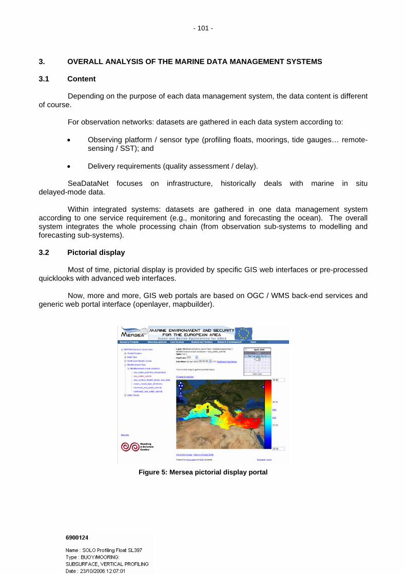
- 101 -
3. OVERALL ANALYSIS OF THE MARINE DATA MANAGEMENT SYSTEMS 3.1 Content
Depending on the purpose of each data management system, the data content is different of course.
For observation networks: datasets are gathered in each data system according to:
• Observing platform / sensor type (profiling floats, moorings, tide gauges… remote-sensing / SST); and
• Delivery requirements (quality assessment / delay).
SeaDataNet focuses on infrastructure, historically deals with marine in situ
delayed-mode data.
Within integrated systems: datasets are gathered in one data management system according to one service requirement (e.g., monitoring and forecasting the ocean). The overall system integrates the whole processing chain (from observation sub-systems to modelling and forecasting sub-systems). 3.2 Pictorial display
Most of time, pictorial display is provided by specific GIS web interfaces or pre-processed quicklooks with advanced web interfaces.
Now, more and more, GIS web portals are based on OGC / WMS back-end services and generic web portal interface (openlayer, mapbuilder).
Figure 5: Mersea pictorial display portal

- 102 -
3.2 Alerts / Operation activity
mmunity.
However, a few technica .
For example:
• Grey list for profiling floa
•
• us of process) within a
OGC / CSW is likely to be used for requesting these catalogues (to be done).
Figure 6: Argo profile visualization (using Google Earth)
logging (warning)
No real-time alerting system for population is known within the ocean co
l or system alerts are used (but not standardized)
ts status (ARGO);
Textual information on web site (e.g., GTSPP, pressure warning); and
Automatic mail report for activity (end of process, statproduction unit (e.g., at CORIOLIS data centre).
On-going developments aim at providing standardized monitoring engines.
The data availability is automatically checked on a real-time basis. The NAGIOS tool
verifies in real-time OPeNDAP services for Mersea / MyOcean.
Later on, standardized reports (e-mail or RSS) may be used for monitoring the activity of MyOcean production units to Service Desk. 3.4 Transmission of information to users
Usually dissemination services are divided into:
• Discovery;
• Viewing; and
• Download. 3.4.1 Discovery
Discovery disseminates products catalogues or dataset inventories with ISO 19115 / XML and THREDDS catalogues.

- 103 -
.4.2 Viewing
Pre-processed quicklooks can be browsed in specific web interfaces.
OGC / WMS is being more widely used for map quicklooks.
No standard way of dealing with non-map view (vertical profiles, time series, vertical cross section)
.4.3 Download
Most of time, ftp server are used for dissemination of netCDF / CF files with specific extra-co
Other file formats that are used:
• ODV ASCII file format for SeaDataNet;
• MEDS-ASCII or various ASCII flavours for time series, profiles, etc.; and
• IMMT / IMMA binary file format for VOS (ICOADS).
For dynamic sub-setting and download:
• OPeNDAP interfaces for dynamic sub-setting (using THREDDS Data Server):
• OPeNDAP / Dapper interface for profile data at CORIOLIS (DAP4COR).
3.5
The storage for integrated system may be under responsibility of each production units.
The ITIL standard is considered for information management in the operational oceanog
For example, the subset of an archived should be restored upon user request within an agreed d
For delayed-mode marine datasets, the storage is under NODC (National Ocean Data Centers)
For GHRSST, GLOSS, ARGO, a specific central archive and reanalysis facility is provided
.6 Compliance with standards
.6.1 Metadata
XML / ISO 19115 is widely used with different profiles depending on requirements (SeaDat
THREDDS is used for simple metadata index (Mersea/MyOcean).
Images: OGC/WMS (not extended for non-map representation).
3
is commonly agreed yet. 3
nvention for file format (ARGO, OceanSite, Mersea / MyOcean, etc.).
Mersea / MyOcean; and
Storage of information within systems
raphy so Service Level Agreement is going to be used to agree on these responsibilities. Indicators will have to be defined to properly measure if the storage is actually done according to the agreements (driven by requirements).
elay.
responsibility.
. 3 3
aNet, Mersea/MyOcean).

- 104 -
.6.2 Download data
NetCDF file format with CF convention are used.
OPeNDAP interfaces are provided (supported and checked by the information manage
OGC / WFS and OGC/WCS are still emerging and are not used yet.
Generally speaking, download interfaces require further standardization / convention
.6.3 References, background (to be used)
SeaDataNet provides an important contribution for marine vocabularies. Web services are prov
SeaDataNet provides guidelines for usage of metadata standard for marine datasets (metada
CDM (Common Data Model) and CSML (Climate Science Modelling Language) provide federate
A meeting with the CSML team and European Marine data management people has been held in B
.7 Translation of data representation
Before being able to properly translate data representation from one system to another, the data
The Common Data Model or CSML may be used in the future to standardize the semantic level in t
For translating ancillary or reference information (such as parameters names or geograp
. PRACTICAL EXPERIMENTS
.1 SeaDataNet controlled vocabularies
SeaDataNet provides web services for controlled vocabularies and ontologies.
These ontologies are fully interoperable and manages ‘deprecated’ flags for managing changes
Each term is identified with a URN (Unified Resource Naming). SeaDataNet maintain a namespa
In addition to that, SeaDataNet is proposing an extension to ISO 19115 / XML so that it is possible
3
ment team in Mersea). (tighten them at least) for non-gridded datasets. 3
ided to access and operate these lists of terms (get synonyms).
ta profile, useful extensions).
d data model for ocean / atmosphere dataset. They are driven by different requirements (CDM for netCDF storage of data, CSML for OGC / INSPIRE interoperability) but both are quite similar and interacts with each other.
rest last March. The Marine community is going to push for achieving the full compliancy of these data models. 3
sets from the different data systems have to be made interoperable at the semantic level.
he Marine Community.
hical references), Marine Data management systems have to rely on external authorities who does that well (SeaDataNet for ontologies, OGC for geolocation, etc.). 4 4
.
ce (‘sdn’) for that purpose.
to embed controlled vocabularies within the metadata description.

- 105 -
.2 Mersea download service
Mersea provides an integrated download system. The different data providers host servers
A central facility indexes the distributed catalogue, as a search engine does.
A user, thanks to a dedicated desktop interface, can request this ocean data search engine, a
4
which operated interfaces for dataset index (THREDDS catalogues) and data subset and download (OPeNDAP). These servers are actually THREDDS Data Server (TDS) developed by UNIDATA.
nd then can subset and download the relevant dataset from the data provider, wherever it is located).
Figure 7: Mersea download service architecture
Real-time monitoring of the distributed system for improving the reliability (status: ok, late
delivery,S
down): from product and service catalogue, configuration of NAGIOS monitoring tool. 5. CONCLUSION, STRATEGIC JCOMM INITIATIVES IN STANDARDISATION PROCES

- 106 -
INSPIRE
Figure 8: data management and main technologies map for Marine systems
In addition to the work done for Marine data management at the level of each data systems (which has been presented before), some JCOMM overall initiative are ongoing.
JCOMM and IODE have engaged in the « Standard process » (ontologies, temporal and geospatial references, platforms, quality control). One meeting has already been held in Ostend, Belgium, January 2008.
The JCOMM Pilot Project for WIGOS (2008-2010) aims at making the appropriate identified data sets interoperable with the wider WMO and IOC communities. It will develop and agree on consistent standards to be used across the community (at metadata and data level).
Guidelines are expected from ET-ADRS. 6. OTHER RELEVANT REFERENCES
Home: http://cf-pcmdi.llnl.gov/ CF metadata
Contact: [email protected]
Draft specification:http://www.unidata.ucar.edu/software/netcdf-java/CDM/
Common Data Model
Contact: [email protected]
Home http://ndg.nerc.ac.uk/csml/ Climate Science Modeling
Language Contact:
PMEL / DAPPER Home: http://www.epic.noaa.gov/epic/software/dapper/
Server:
http://www.ifremer.fr/dap4cor/
CORIOLIS / DAP4COR
Documentation: ftp://ftp.ifremer.fr/ifremer/coriolis/tools/dap4cor/ JCOMM and IODE Ocean Standard Home: http://www.oceandatastandards.org/

- 107 -
JCOMM Pilot Project for WIGOS Home:
http://www.iode.org/index.php?option=com_oe&task=viewDocumentRecord&docID=1860
____________
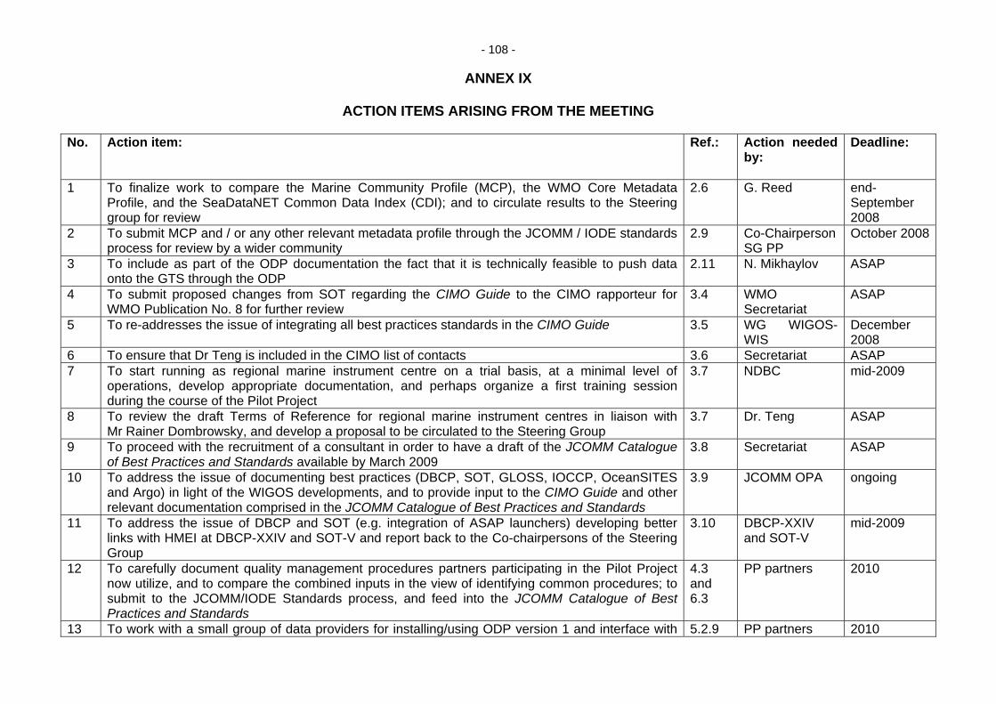
- 108 -
ANNEX IX
ACTION ITEMS ARISING FROM THE MEETING No. Action item: Ref.: Action needed
by:
Deadline:
1 To finalize work to compare the Marine Community Profile (MCP), the WMO Core Metadata Profile, and the SeaDataNET Common Data Index (CDI); and to circulate results to the Steering group for review
2.6 G. Reed end-September 2008
2 To submit MCP and / or any other relevant metadata profile through the JCOMM / IODE standards process for review by a wider community
2.9 Co-Chairperson SG PP
October 2008
3 To include as part of the ODP documentation the fact that it is technically feasible to push data onto the GTS through the ODP
2.11 N. Mikhaylov ASAP
4 To submit proposed changes from SOT regarding the CIMO Guide to the CIMO rapporteur for WMO Publication No. 8 for further review
3.4 WMO Secretariat
ASAP
5 To re-addresses the issue of integrating all best practices standards in the CIMO Guide 3.5 WG WIGOS-WIS
December 2008
6 To ensure that Dr Teng is included in the CIMO list of contacts 3.6 Secretariat ASAP 7 To start running as regional marine instrument centre on a trial basis, at a minimal level of
operations, develop appropriate documentation, and perhaps organize a first training session during the course of the Pilot Project
3.7 NDBC mid-2009
8 To review the draft Terms of Reference for regional marine instrument centres in liaison with Mr Rainer Dombrowsky, and develop a proposal to be circulated to the Steering Group
3.7 Dr. Teng ASAP
9 To proceed with the recruitment of a consultant in order to have a draft of the JCOMM Catalogue of Best Practices and Standards available by March 2009
3.8 Secretariat ASAP
10 To address the issue of documenting best practices (DBCP, SOT, GLOSS, IOCCP, OceanSITES and Argo) in light of the WIGOS developments, and to provide input to the CIMO Guide and other relevant documentation comprised in the JCOMM Catalogue of Best Practices and Standards
3.9 JCOMM OPA ongoing
11 To address the issue of DBCP and SOT (e.g. integration of ASAP launchers) developing better links with HMEI at DBCP-XXIV and SOT-V and report back to the Co-chairpersons of the Steering Group
3.10 DBCP-XXIV and SOT-V
mid-2009
12 To carefully document quality management procedures partners participating in the Pilot Project now utilize, and to compare the combined inputs in the view of identifying common procedures; to submit to the JCOMM/IODE Standards process, and feed into the JCOMM Catalogue of Best Practices and Standards
4.3 and 6.3
PP partners 2010
13 To work with a small group of data providers for installing/using ODP version 1 and interface with 5.2.9 PP partners 2010

- 109 -
WIS 14 To review Document 5.2 to ensure interoperability with WIS 5.2.10 D. Thomas end-2008 15 To agree upon requirements and procedure for registration of data providers 5.2.12
& 6.4 PP Steering Group
end-2008
16 To produce the business plan based on experience gained with the partners, other WIGOS Pilot Projects, and the Demonstration Projects
6.1.2 Steering Group 2010
17 To write to directors of the institutes identified as potential contributors for specific data sets, to ask whether they will be in a position to participate actively in the Pilot Project by submitting a letter of intent and committing the identified data sets to the ODP and / or WIS
6.2.4, 6.4.3 and 6.4.4
Secretariat 31 October 2008
18 To follow up the developments with regard to SeaDataNET’s participation in the Pilot Project 6.4.5 N. Mikhaylov ongoing 19 To follow up the developments with regard to GHRSST’s participation in the Pilot Project 6.4.6 K. Casey ongoing 20 To follow up with regard to the GCCs’ participation in the Pilot Project 6.4.7 N. Scott ongoing 21 To make sure the ODP and ODP-WIS interconnection documentation is made available from the
ODP information website 6.4.10 IOC Secretariat ASAP
22 To draft the report to the Sub-group of the WMO Executive Council Working Group on WIGOS-WIS in liaison with the joint Steering Group
6.5.2 WMO Secretariat
ASAP
23 To draft the report to IODE-XX on the involvement of IODE in the WIGOS Pilot Project for JCOMM in liaison with the joint Steering Group
6.6.2 IOC Secretariat ASAP
24 To seek more information on the developments of NOAA training tools 7.1 (ii) R. Dombrowsky ASAP 25 To investigate possible marine components as part of the Demonstration Projects 7.1 (iii) Secretariat ASAP 26 To urgently contact the trainees of the Training Course on the End-to-End Technology (IOC
Project Office for IODE, 2007) inviting them to collaborate in the OceanDataPortal project or to identify remaining capacity building requirements impeding such collaboration
7.1(iv) IOC Secretariat, N. Mikhaylov and S. Belov
ASAP
27 To review the Terms of Reference for regional marine instrument centres in liaison with Mr Rainer Dombrowsky, develop a proposal to be circulated to the Steering Group, and liaise with CIMO on metrology issues
3.7 & 7.2
Dr Teng ASAP
____________

- 110 -
ANNEX X
ACRONYM LIST AOPC Atmospheric Observation Panel for Climate ASAP Automated Shipboard Aerological Programme BOM Bureau of Meteorology (Australia) CB Capacity-Building CBS WMO Commission for Basic Systems CDI SeaDataNET Common Data Index CIMO WMO Commission on Instruments and Methods of Observation CONOPS WIGOS Concept of Operations DBCP Data Buoy Co-operation Panel DCPC Data Collection and Production Centre (of WIS) DMAC IOOS Data Management and Communications (USA) DMCG JCOMM Data Management Coordination Group DMPA JCOMM Data Management Programme Area DWD Deutscher WetterDienst E2E End-to-End Data Management E2EDM End-to-End Data Management Pilot Project EC Executive Council EC WG WIGOS-WIS Executive Council working Group on WIGOS and WIS ET-EGOS CBS Expert Team on the Evolution of the Global Observing System ETRP WMO Education and Training Programme ET-WISC CBS Expert Team on WIS GISCS and DCPCs ET-DMP JCOMM Expert Team on Data Management Practices GAW Global Atmosphere Watch GCC Global Collecting Centre GEO Group on Earth Observations GEOSS Global Earth Observation System of Systems GHRSST GODAE High Resolution SST Pilot Project GISC Global Information System Centres (of WIS) GLOSS JCOMM Global Sea-level Observing System GODAE Global Ocean Data Assimilation Experiment GOOS IOC-WMO-UNEP-ICSU Global Ocean Observing System GOS WMO Global Observing System GOSUD Global Ocean Surface Underway Data Pilot Project GTS Global Telecommunication System GTSPP Global Temperature and Salinity Profile Programme HMEI Association of Hydro-Meteorological Equipment Industry ICOADS International Comprehensive Ocean-Atmosphere Data Set ICG-WIS Inter-commission Coordination Group on the WMO Information System ICSU International Council for Science ICT IOS Implementation-Coordination Team on IOS ICTT-QMF Inter Commission Task Team on Quality Management Framework IOC Intergovernmental Oceanographic Commission IODE International Oceanographic Data and Information Exchange IOOS Integrated Ocean Observing System (USA) IOS Integrated Observing Systems IMOP WMO Programme for Instruments and Methods of Observation INSPIRE Infrastructure for Spatial Information in Europe IOCCP IOC International Ocean Carbon Coordination Project IODE IOC International Oceanographic Data and Information Exchange IPET-MI CBS Inter Programme Expert Team on Metadata Implementation ISDM Integrated Science Data Management (Canada) ISO International Organization for Standardization

- 111 -
JCOMM Joint WMO-IOC Technical Commission for Oceanography and Marine Meteorology
MAN JCOMM Management Committee MCP Marine Community Profile MCSS Marine Climatological Summaries Scheme MCS Marine Climatological Summary META-T Water Temperature metadata Pilot Project MQCS Minimum Quality Control Standards NetCDF Network Common Data Form NMHS National Meteorological and Hydrographic Service NOAA National Oceanic and Atmospheric Administration (USA) NODC IODE National Oceanographic Data Centre NWP Numerical Weather Prediction OBIS Ocean Biogeographical Information System OceanSITES OCEAN Sustained Interdisciplinary Timeseries Environment observation
System OCG JCOMM Observations Coordination Group ODAS Ocean Data Acquisition System ODIN IOC Ocean Data and Information Network ODINAFRICA ODIN for Africa ODINBlackSea ODIN for the Black Sea ODINCARSA ODIN for the Caribbean and South America ODP IODE Ocean Data Portal OPA JCOMM Observations Programme Area OPAG Open Programme Area Group OT OceanTeacher PA Programme Area (of JCOMM) PO Project Office PSMSL Permanent Service for Mean Sea Level QA Quality Assurance QC Quality Control QMF WMO Quality Management Framework QMS Quality Management System RA WMO Regional Association RRR Rolling Review of Requirements SeaDataNet Pan-European infrastructure for Ocean and Marine Data Management SOT JCOMM Ship Observations Team SST Sea Surface Temperature TAO Tropical Atmosphere Ocean network of tropical moorings VGISC Virtual GISC (Europe) VOS Voluntary Observing Ship WDC ICSU World Data Centre WIGOS WMO Integrated Global Observing Systems WIS WMO Information System WMO World Meteorological Organization XBT Expendable Bathythermograph XML Extensible Markup Language
____________