Medieval Arab navigation on the Indian Ocean: Latitude Determinations
15
Medieval Arab navigation on the Indian Ocean: Latitude Determinations Author(s): Alfred Clark Source: Journal of the American Oriental Society, Vol. 113, No. 3 (Jul. - Sep., 1993), pp. 360- 373 Published by: American Oriental Society Stable URL: http://www.jstor.org/stable/605386 . Accessed: 06/09/2013 07:22 Your use of the JSTOR archive indicates your acceptance of the Terms & Conditions of Use, available at . http://www.jstor.org/page/info/about/policies/terms.jsp . JSTOR is a not-for-profit service that helps scholars, researchers, and students discover, use, and build upon a wide range of content in a trusted digital archive. We use information technology and tools to increase productivity and facilitate new forms of scholarship. For more information about JSTOR, please contact [email protected]. . American Oriental Society is collaborating with JSTOR to digitize, preserve and extend access to Journal of the American Oriental Society. http://www.jstor.org This content downloaded from 129.173.72.87 on Fri, 6 Sep 2013 07:22:42 AM All use subject to JSTOR Terms and Conditions
-
Upload
alfred-clark -
Category
Documents
-
view
212 -
download
0
Transcript of Medieval Arab navigation on the Indian Ocean: Latitude Determinations
Medieval Arab navigation on the Indian Ocean: Latitude DeterminationsAuthor(s): Alfred ClarkSource: Journal of the American Oriental Society, Vol. 113, No. 3 (Jul. - Sep., 1993), pp. 360-373Published by: American Oriental SocietyStable URL: http://www.jstor.org/stable/605386 .
Accessed: 06/09/2013 07:22
Your use of the JSTOR archive indicates your acceptance of the Terms & Conditions of Use, available at .http://www.jstor.org/page/info/about/policies/terms.jsp
.JSTOR is a not-for-profit service that helps scholars, researchers, and students discover, use, and build upon a wide range ofcontent in a trusted digital archive. We use information technology and tools to increase productivity and facilitate new formsof scholarship. For more information about JSTOR, please contact [email protected].
.
American Oriental Society is collaborating with JSTOR to digitize, preserve and extend access to Journal ofthe American Oriental Society.
http://www.jstor.org
This content downloaded from 129.173.72.87 on Fri, 6 Sep 2013 07:22:42 AMAll use subject to JSTOR Terms and Conditions

MEDIEVAL ARAB NAVIGATION ON THE INDIAN OCEAN: LATITUDE DETERMINATIONS
ALFRED CLARK
ROCHESTER, NEW YORK
The ingenious methods used by medieval navigators on the Indian Ocean to determine latitudes are compared with modern stellar methods using spherical trigonometry, the navigational triangle and data from nautical publications. Relative accuracies are established, and in addition, the trigo- nometric calculations justify the empirically derived medieval methods, and provide an insight into them. In comparing the change in star altitude per unit change in Pole Star altitude, a critical factor in all medieval methods, the agreement is exact for single stars on the observer's meridian, less ac-
curate, but still reasonably close, in most cases of abddl and "fettering" methods involving pairs of
stars, off the observer's meridian, considering all the opportunities for discrepancies. Contrary to me- dieval and previous modern ideas, the only method that gives a constant change in star altitudes over
increasing and decreasing increments of latitude for the entire range uses single stars on the observ- er's meridian. However, with single stars and star pairs off the meridian selected by medieval navi-
gators, the true variation in that change is small enough to have caused them no serious problems.
INTRODUCTION1
THE PURPOSE OF THIS PAPER is to compare the empiri- cal methods of medieval Arab navigators on the Indian Ocean for determining latitudes with modern stellar methods using spherical trigonometry, the navigational
1 To visualize the spatial concepts of latitude determinations
by medieval Arab navigators does not require a mastery of
spherical trigonometry. One need understand only that the dis- tant stars, beyond our solar system, are essentially "fixed" over a long period of time. The positions of these stars with respect to each other do not change, the pattern remains constant. As the earth turns through its daily cycle from west to east, the heavens
appear to rotate from east to west. At the same moment, observ- ers at different points on earth will get different views of the
stars, but over a 24-hour period, all will have seen the entire
panorama. The Arab navigator made use of this constant pat- tern, picking out certain single stars as they crossed his meridian
(due north or south), like the Pole Star or the Great Bear, or cer- tain configurations of two stars off his meridian. In order to use substitutes for the Pole Star, when that star was invisible, Arab
navigators would check the various configurations at a series of latitudes against the Pole Star when it was visible, so that when it was clouded over they could relate its altitude to the altitudes of the substitute stars. The altitude of the Pole Star gives the latitude of the observer. When the observer was at the Equator, the Pole Star would be just about on the horizon (zero degrees latitude), and when at the North Pole, the star would be almost
directly overhead (90 degrees latitude).
triangle and data from nautical publications. Not only are relative accuracies established, but in addition the
trigonometric calculations provide an insight into the
empirically derived medieval methods. Ibn Mfjid (d. c. 1500 A.D.), one of the last and most
famous of Indian Ocean navigators prior to the arrival of the Portuguese, gives about seventy different stars or combinations of them for use in determining latitudes. Sulaimfn al-Mahri (d. c. 1550 A.D.), another famous Arab navigator, reduces the list considerably, claiming that not all of those mentioned by Ibn Mfjid were nec-
essary for the navigator to know. As best can be judged from the works of Ibn Majid and Sulaiman al-Mahri, about fifteen most important stars or combinations of them were used by Arab navigators to determine lati- tudes. The various methods used involving these stars will be discussed.
The preferred method determines latitude directly from the Pole Star (al-jih). Other stars or combinations of them were used when the Pole Star was not visible; and in each case, star altitudes were referred back to the corresponding Pole Star altitude. In general, the
procedure involved knowing first, the altitudes of both the substitute star and the Pole Star at some previously selected reference position, and second, the change in star altitude per one-degree change in Pole Star alti- tude. If this change remains reasonably constant over a
sufficiently broad range of latitude, the altitude of the Pole Star, and so the observer's latitude, could be cal- culated when the Pole Star was invisible. Our main
360
This content downloaded from 129.173.72.87 on Fri, 6 Sep 2013 07:22:42 AMAll use subject to JSTOR Terms and Conditions
CLARK: Medieval Arab Navigation
concern in the following will be with these changes in star altitude per unit change in Pole Star altitude. First, however, we give a brief description of the direct method using the Pole Star. Ibn Majid's and Sulaiman al-Mahri's data are obtained from Tibbetts (ref. 1) and Ferrand (ref. 2).
THE POLE STAR (AL-JAH)
The latitude of an observer on earth is the altitude of the north or south celestial pole. No star is located ex-
actly at either celestial pole, but the Pole Star is not far from the north celestial pole, making a small orbit about it once every twenty-four hours. Corrections (ref. 3) applied to the Pole Star altitude bring it to the true altitude of the celestial pole, and thus to the latitude of the observer.
Medieval Arab navigators also made corrections to the altitude of the Pole Star, but not to the celestial
pole. Instead they corrected it to the Pole Star's posi- tion of minimum altitude on its orbit as it crossed the observer's meridian. At this point, the correction is zero. When the star is at its maximum position on the orbit, again on the observer's meridian, the correction is equal to the diameter of the orbit, which, according to medieval Arabs, was 4 isbac (Arabic for "finger")2 or approximately 61/2 degrees (1 isba = 1.61?). The correction to the celestial pole itself, which Arabs did not use, was one-half that figure, the radius of the or- bit. These corrections the Arabs called bdshi, and they varied from zero at the lowest position to the diameter of the orbit at the maximum position. The bdshi was the amount in angular units to be subtracted from the Pole Star's altitude to bring it to the minimum position.
To identify the positions of the Pole Star on its daily orbit around the celestial pole and to correct them to the
position of minimum altitude, zero bashi, on the observ- er's meridian, they used the Lunar Mansions, twenty- eight groups of stars through which the moon passes successively on its monthly path around the earth. When a mansion, or rather the principal star for which it is named, drifts across an observer's meridian, it correlates with a particular position of the Pole Star on its orbit. Arab navigators would say, for example, the bashi of al- sarfa (Deneb) is zero, meaning that the Pole Star is in its position of minimum altitude when the Lunar Man- sion called al-sarfa crosses the observer's meridian; or
2 Ibn Majid always uses the singular form, isbac (finger), rather than the plural form, asdblf (fingers), probably in the sense of "an 8-finger Pole Star altitude," for example.
the bashi of al-farc al-thdni (P Equulei) is 4 isbac when the Pole Star is in its maximum position. There were occasional indecisions and arguments about the Lunar Mansion assignments to Pole Star positions, especially at the minimum (zero bashi) and maximum (4 bashi). As the Pole Star moves across the top or bottom of its orbit, there is only a small change in altitude, which is difficult to measure accurately during the time that one or more Lunar Mansions pass the observer's meridian. As a result, zero bashi was sometimes associated with Deneb (al-sarfa), at other times with P Virginis (Caw- wa'), and still other times with a Virginis (simak); while the maximum bdshi was represented either by a Equulei (al-far' al-awwal) or ,3 Equulei (al-farc al-thdni). On the other hand, as the Pole Star traversed the mean po- sition (2 bashi), its altitude is changing rapidly so that an observer could measure fractions of a single Lunar Mansion during the passage.
Another problem connected with the use of Lunar Mansions to identify Pole Star positions came from differences in the exact point selected within the Lunar Mansion to represent a particular bashi value. Theoret- ically, the mid-point is believed to have been selected, and on the basis that all Lunar Mansions were of the same size, that is, they passed the meridian in equal time intervals. In practice, however, mariners mea- sured the position of the mansion by the position of the star for which it was named. This was usually the brightest star in the mansion, and positions varied from one mansion to another. Consequently, bashi assign- ments to Lunar Mansions would change depending on the relative position of the star used with respect to the mid-point of the mansion.
A major disadvantage of using the Pole Star's position of minimum altitude as the reference point for determin- ing latitude is that the altitude of this position changes with precession of the earth's axis. In other words, the di- ameter of the Pole Star's orbit is not a time-independent constant. The phenomenon of precession is a slow rota- tion of the earth's axis about an axis making an angle of 231/20 with it. As the earth's axis precesses (rotates), it traces a conical path like a spinning top, making a com- plete circuit every 25,800 years.3 During this time, star altitudes measured by an observer at a given point would change considerably, reaching a maximum when half the circuit has been traced-12,900 years. At the present
3 In whatever position the earth's axis is located on its pre- cessional rotation, it points directly toward the celestial north pole (and south pole), and therefore changes the position of those poles with respect to the "fixed" stars.
361
This content downloaded from 129.173.72.87 on Fri, 6 Sep 2013 07:22:42 AMAll use subject to JSTOR Terms and Conditions

Journal of the American Oriental Society 113.3 (1993)
time, the earth's axis is pointing very close to the direc- tion of the Pole Star, and the Pole Star's orbit around the celestial pole is very small, and getting smaller. In about 200 years, the earth's axis will be pointing right at the Pole Star, which will then be directly over the North Pole. At that point, the diameter of the Pole Star's orbit will be zero, and the star will remain fixed in the sky as the earth rotates. And the bashi corrections used by me- dieval Arab navigators would remain constant at zero bashi. In about 8000 years, the earth's axis will be point- ing directly at Deneb, and that star will no longer serve, as it did Ibn Majid, to indicate on crossing the observer's meridian the minimum position of the Pole Star at zero bashi, for it would then remain fixed on the observer's meridian wherever he might be standing in the Northern Hemisphere, while the Pole Star would be as far from the celestial pole as Deneb is now. Deneb would have be- come the Pole Star. And someday in the Southern Hemi- sphere, there may be a "South Star" directly over the South Pole.
Ibn Majid, Sulaiman al-Mahri and other medieval In- dian Ocean mariners may or may not have known about the phenomenon of precession. Ibn Majid at least no- ticed that ancients used a value of 6 isbac for the diam- eter of the Pole Star's orbit rather than 4 isbac, but we are not sure whether he considered it an ancient error or the change with time due to precession. The fact that he de- nied the value of 6 isbac so frequently and so vigorously seems to confirm that there was a great deal of confusion in some quarters. Sulaiman al-Mahri, on the other hand, seemed certain of the 4-isbac value and referred to the 6- isbac value only as a historical curiosity. At any rate, any medieval navigator using the ancient value in 1500 A.D. would have been way off base with his bashi.
THE NAVIGATIONAL TRIANGLE4
The heart of modern celestial navigation is the navi- gational triangle with solutions (see ref. 4). It is a spherical triangle lying on the earth's surface. Its sides
4 See ref. 7. The main purpose of this section is to describe for those who want to go into considerable detail the naviga- tional triangle and its use in calculating star altitudes according to U. S. Navy publications. It is not necessary to understand either the description or the calculations in order to appreciate the results obtained and displayed in the tables below. The
navigational triangle provides the means for obtaining these results. The important points to note in the tables are (a) how
steady are the values of change in star altitude per 1? change in Pole Star altitude (latitude) over a range of observer latitudes, and (b) how well medieval values agree with them.
Fig. 1. The modern navigational triangle. (All sides are segments of great circles.)
fall along great circles. As shown in figure 1, the sides are named as follows: (a) Polar Distance, the angular distance between the Pole and the position on earth directly below the star (90? altitude) called the Geo- graphical Position (G.P.), whose latitude remains con- stant as the star transits the sky from rising to setting; (b) the Colatitude, the angular distance between the Pole and the observer's meridian position; and (c) the Coaltitude, the angular distance between the observer and the Geographical Position. Its angles are: the Me- ridian Angle at the Pole, the Azimuthal Angle at the ob- server, and the Parallactic Angle at the Geographical Position. The entering arguments in the U.S. Navy tables (ref. 4) are: the Observer's Latitude (90? - Colati- tude); the Meridian Angle; and the Declination (90?- Polar Distance). "Declination," the term used in U.S. Navy tables, strictly refers to the celestial coordinates of a star, but is exactly equal to the latitude of the Geo-
graphical Position of the star observed. It is in the latter sense, as latitude, that the tables use the term, a sense to which we conform hereafter. The computed values in the tables are: altitude (90? - Coaltitude) and Azimuth
Angle, and are given for intervals of 1? latitude, 30' of declination up to 29? and at selected intervals beyond that, and 1? of Meridian Angle. These tables along with nautical tables (ref. 5) for data on specific celestial bod- ies were used for making the calculations whose results are reported below for comparison with empirical me-
362
This content downloaded from 129.173.72.87 on Fri, 6 Sep 2013 07:22:42 AMAll use subject to JSTOR Terms and Conditions

CLARK: Medieval Arab Navigation
dieval data. Occasionally, calculations using spherical trigonometry were carried out directly.
SINGLE STARS ON THE MERIDIAN
All Indian Ocean navigators favored the use of stars on the meridian for determining latitude: first the Pole Star, and when that star was beclouded or below the horizon, they switched to some other star at culmina- tion,5 such as 0 Ursae Minoris (the Greater Farqad), the brightest star in the vicinity of the North Pole, or Achernar (sulbar) in the Southern Hemisphere. Ibn
Majid stresses repeatedly the use of culminating stars in his Fawadid (ref. 1). It is quite obvious that for each rise or fall of the Pole Star by 1 isbac, other stars on the observer's meridian would rise or fall by exactly the same amount, and this holds for the entire range of latitudes from Equator to poles. Stars off the meridian, one rising, the other setting, always change altitudes by less than 1? per 1? change in Pole Star, and the change is not exactly constant with change in observer's lati- tude. However, the change is often sufficiently small and gradual so that an average value could be used without causing any significant loss of accuracy, in fact, remaining well within the limits of accuracy of medieval altitude-measuring instruments.6 For stars on the meridian, medieval and modern theories agree ex- actly, giving a 1? change in star altitude per 1? change in Pole or Pole Star altitude. Throughout the entire lat- itude range in the tables of U.S. Navy Pub. H.O. 214, the change in altitude of stars on the meridian (Azi- muth Angle, 0? or 180?) is exactly 1? per 1? change in latitude. Treatment of stars off the meridian fall well within the scope of the abdal method discussed next.
ABDAL METHOD7
Abdal (plural of badal) means "substitutes," and it is anyone's guess what Arab navigators were substituting
5 The culmination of a star occurs when it crosses the ob- server's meridian, that is, when it is due north or south or di-
rectly over the head of the observer at a given longitude. 6 The change in altitude of an off-meridian star, caused by the
earth's curvature, per 1? change in observer latitude, as he moves in increments north or south, is an extremely important figure. If this figure is shown to hold fairly steady over a signifi- cant range of latitude, then it can be used along with a single reference latitude to calculate latitude by measuring altitudes of the off-meridian stars alone when the Pole Star is beclouded.
7 This is the first of the two-star configurations used by me- dieval Arab navigators for determining latitude. It consists of
it for-perhaps the Pole Star. Two abdal stars have
equal altitudes and equal declinations when located symmetrically about the observer's meridian. The term declination, as mentioned above, refers to the north- south position of a star on the celestial sphere and is equal exactly to the latitude of the star's Geographical Position on earth. A pair of abdal stars and the Pole Star form the apices of an isosceles triangle, and the
mid-point of the line drawn between the stars lies on the observer's meridian. Two stars having equal alti- tudes when they lie one on each side of the meridian, but unequal declinations, will be unsymmetrically ar-
ranged, not equidistant from the meridian-a case which Ibn Majid also considers under the general head- ing of abdal.
Having found stars in abdal position, how did Arab
navigators use them to determine latitude (qiyas)? First they measured the altitude of the two stars at a known altitude of the Pole Star at its basic position. Then they determined the drop (or rise) in abdal star altitude per 1 isbac drop (or rise) in Pole Star altitude. If this
change in abdal altitude remained sufficiently constant over a significant range of latitude, the altitude of the Pole Star could be calculated at positions other than its reference position. For example, if the altitude of the abdal stars was 50 isbac when the Pole Star was 30 isbac, and the change in abdal altitude per 1 isbac change in Pole Star altitude was /2 isbac, then the Pole Star altitude when the abdal altitude was 40 isbac would be 10 isbac, a drop of 2 isbac for each isbac drop in abdal star altitude.
Two stars exactly abdal are rarely found; approxi- mately abdal stars with declinations not equal reduce the accuracy of the method, introducing successive drifts in the abdal star altitude change per unit change in Pole Star altitude as the observer's latitude position is raised or lowered. There is actually a very slow drift even for stars exactly abdal, and the further the stars are from the observer's meridian, the greater the variation and the smaller the range of latitude over which the method can be used. This can easily be shown using the
two stars at equal altitude, one on either side of the observer's meridian, and with the Geographical Positions either on the same parallel of latitude, in which case they are symmetrical about the observer's meridian, or on different parallels, in which case they are unsymmetrical. The modern method solves the problem by spherical trigonometry calculations; the medi- eval solution is strictly empirical, measuring abdal and Pole Star altitudes over a range of latitudes for later use when the Pole Star is not visible as explained in n. 6 above. See figure 2 for a modern picture of the abdal process.
363
This content downloaded from 129.173.72.87 on Fri, 6 Sep 2013 07:22:42 AMAll use subject to JSTOR Terms and Conditions

Journal of the American Oriental Society 113.3 (1993)
Fig. 2. Navigational triangle for abdal stars. (Showing change in Azimuth Angle with Observer's Position.)
navigational triangle. Only when the distance of the two stars from the meridian of the observer decreases to zero and both stars have "coalesced" on the meridian does the method work exactly-which, of course, re- duces to the single-star method discussed above. As the distance of the stars from the meridian increases, the change in star altitude per unit change in Pole Star alti- tude decreases gradually from 1?, and the values vary as much as 4 percent as the observer moves over, say, five degrees of latitude range, which could make an error of about 14 miles in north-south distance. Figure 2 shows qualitatively the changes in Azimuth Angle which bring about a non-linear drift of the abdal star altitude as the observer's position changes from 01 to 02 to 03.
Ibn Majid calls Capella and Vega the best abdal stars, but gives no data. Their declinations are some distance apart-approximately 46? and 38? north, respectively.8 There is a star pair, Deneb and Capella, whose declina- tions now are less than 1? apart, that are in much better abddl relation, perhaps the best of all navigational stars in the sky for this purpose, with no more than a 6% variation for the change in abddl star altitude per 1? change in Pole Star altitude over at least a range of 12
8 Unless two stars at equal altitude, one on either side of the observer's meridian, have the same declination, they will be un- symmetrical about the meridian, that is, one star will be further away from the meridian than the other.
degrees of latitude. But no medieval data have been re- corded for these stars either. Indeed, neither Ibn Majid nor Sulaiman al-Mahri give quantitative information on latitude determinations using stars that closely approxi- mate exact abdal conditions. The stars for which they do give information have widely differing declinations; and at equal altitudes they are far from being equidistant from the observer's meridian. It is inconceivable that they could have used the normal abdal method as al- ready described above without some modification.9 For with two stars at widely differing distances from the ob- server's meridian, they would show differences in alti- tude change per 1? change in Pole Star or Pole altitude, so that their altitudes would not remain equal as the ob- server moved on the same meridian away from the ini- tial reference latitude, whereas exact abdal stars retain their equal altitude relationship on the observer's merid- ian at all latitudes. In this case, navigators could not determine the moment of equal altitude, as they were accustomed to, by correlating with the culmination of some Lunar Mansion or other celestial body. At each new latitude position, the observer would have to use the culmination of a different mansion at a different time to determine the moment of equal altitude. The naviga- tor could, however, by making a series of direct mea- surements of the altitudes covering the short time-span just before and just after the equal altitude position, de- termine the desired altitude value at the right moment for each new position that he assumes. In this way, by adjusting to equal altitude at each new latitude position, the navigator could obtain a reasonably accurate method for use with stars of unequal declination-a sort of gen- eralized abddl method. If the star altitude change per 1? change in Pole Star altitude remained fairly steady over a sufficiently broad range of latitudes, the medieval nav- igator could then proceed further to calculate his lati-
9 Two stars, initially at the same altitude but different dis- tances from the observer's meridian, will drop in altitude at
slightly different rates as the observer drops his latitude posi- tion by successive increments. And the greater the differences in distance apart, the greater the differences in rate of fall of the two stars. Over, say, a 10? drop in observer's latitude, the stars
might have considerably different altitudes and altitude drops per 1? drop in observer latitude. To preserve closer equality be- tween the stars in rate of altitude decrease, it is better, when
making new altitude measurements on the stars at each incre- ment of drop in observer latitude, to wait at each increment for the stars in their transits to have moved into a new position of equal altitude. We call this the "generalized abdal approach," as opposed to "normal abdal," when the stars are equal in al- titude and symmetrical about the observer's meridian.
364
This content downloaded from 129.173.72.87 on Fri, 6 Sep 2013 07:22:42 AMAll use subject to JSTOR Terms and Conditions

CLARK: Medieval Arab Navigation
Table 1 Abddl Calculations for Capella and Vega
Normal Abdal Generalized Abddl
Alt. Change Alt. Change Lat.N Altitude per 1? Pole Altitude per 1 ?Pole
Cap. Vega Cap. Vega Cap.-Vega Cap.-Vega 19? 20.03020.03? 20.03? 18? 19.40 19.45 38.0' 35.0' 19.40 38.0' 15? 17.34 17.69 17.51 14? 16.64 17.10 41.9' 35.6' 16.86 38.9' 7? 11.69 12.86 12.24
6? 10.98 12.24 43.0' 37.0' 11.60 38.6'
tude as described earlier. For such stars, Ibn Majid has left a few quantitative data, and these may be compared with modern calculations using the American Nautical Almanac (ref. 5) for data on specific stars with which to enter the navigational triangle tables of Navy Pub. H.O. 214, and read off the altitudes.
Before comparing modern and medieval calculations of altitudes by the generalized abdal method, let us look first at a modern calculation by both the normal and generalized abdal method for the case of two stars whose declinations are moderately different, in order to note how imprecise the normal method is when there is a spread in declination values between the two stars. The stars Capella and Vega, with declinations of 45057.4' and 38044.5' respectively, both north, using the normal abddl method, we note from table 1, are measured when their altitudes are equal at the reference latitude of 19? north, though they are not equidistant from the observer's meridian as a result of their differ-
ing declinations. At the same time, an observer at 18? north latitude would find that the stars' altitudes were different; and the final observer at 6? north latitude would measure the difference in altitude of the two stars to be 1? 15.6'. It will also be noticed that the drop in altitude per 1? drop in Pole altitude is different for each star, and also changes by an appreciable amount- about 5' per degree of latitude for Capella-in moving from 19? north latitude to 6?. Using the generalized ab- ddl method where at each latitude the observer mea- sures equal altitudes, we note that the change in altitude per 1? change in latitude over a range from 19? to 6? north latitude is less than one minute. As mentioned earlier, these are the stars which Ibn Mfjid says are the best for abddl measurements, but gives no data.
Turning to the comparison of modern and medieval determinations of latitude using the generalized abddl approach, we note in table 2 first that Ibn Mfjid's data
are sparse and dotted with lacunae, so that comparisons are not complete by any means. Second we note that of the seven star-pairs in the table, four show reasonable agreement between modern and medieval values for al- titude change per 1? latitude; three have no data at all from Ibn Majid, and one of the three-Arcturus- Spica-shows how poorly star-pairs could behave in
generalized abddl measurements, and how selective one must be. Ibn Majid says this last pair is of no use at all in making landfalls since both stars are rising, and therefore on the same side of the observer's merid- ian. In general, pairs consisting of two rising (or set-
ting) stars are not good for generalized abdal use. Of all other star pairs in the table, one star in each is rising and the other is setting. Of those star-pairs in reason- able agreement, Ibn Majid mentions specifically the importance of Arcturus and Canopus.
What does "reasonable" mean in the drift of star al- titude changes per 1? change in Pole or Pole Star alti- tude? We note disagreements in these values as much as 10 minutes star altitude change per 1? change in lati- tude, which if used over a range of 5 degrees would mean a possible error of nearly 60 miles in north-south distance. This error was perhaps not too serious. For the land around the Indian Ocean was so arranged that the points which navigators aimed for lay on elongated coastlines, like East Africa, the two coasts of India, and the Burmese-Malay coasts that were difficult to miss. And if they did miss the exact point they were aiming for, they could easily sail up or down the coast until they reached it. A miss of 60 miles would involve perhaps an extra half-day of sailing or slightly longer to arrive at the desired port-irritating, but by no means calamitous.
AL-QAID METHOD10
The final method of determining latitude that we shall discuss is called "fettering" (al-qaid). More complex than abddl, it demands a more detailed explanation.
10 Al-qaid, the second method employed by medieval Arab
navigators in determining latitude, quite ingeniously anticipates the modem circle of equal altitude used in conjunction with the
navigational triangle to duplicate the medieval empirical pro- cess. Ibn Majid and other contemporary navigators merely mea- sured one star at a series of observer latitude positions always when it reached a pre-selected altitude, and then measured the other star's altitude at the same time. Having predetermined the
corresponding Pole Star altitudes in a calibration run, they could use the method when the Pole Star was beclouded. See figure 3 for a modern picture of the al-qaid process.
365
This content downloaded from 129.173.72.87 on Fri, 6 Sep 2013 07:22:42 AMAll use subject to JSTOR Terms and Conditions
Journal of the American Oriental Society 113.3 (1993)
Table 2 Generalized Abdil: Modern/Ibn Majid
Latitude Range Alt. Change per 1? Pole
Arcturus-Canopus (Declinations: 19?23.8'N, 52?47.2'S)
Modern 19? - 10?N 36.2' - 33.3' Ibn Majid - 30'
Capella-Vega (Declinations: 45?57.4'N, 38?44.5'N)
Modern 19? - 6?N 38.6' - 38.0' Ibn Majid
Achernar-Canopus (Declinations: 57?26.9'S, 52?40.7'S)
Modern 19? - 6?N 56.5' - 56.1' Ibn Majid
Achernar-Sirius (Declinations: 57?26.7'S, 16?39.8'S)
Modern 190 - 10?N 58.2' - 53.0' Ibn Majid 22? - 17?N 60'
a Centauri-Sirius (Declinations: 60?39.9'S, 16?39.8'S)
Modern 19? - 10?N Ibn Majid 10? - northward
47.3' - 46.6' 50' - 45'
a Centauri-p Orionis (Declinations: 60?39.9'S, 8?15.2'S)
Modern 190 - 10?N Ibn Majid Approx. 10?N?
40.9' - 40.0' 50'
Arcturus-Spica (Declinations: 19?25.8'N, 10?56.8'S)
Modern Ibn Majid
190 - 14?N 4009.6' - 2058.1'
Theoretically, any two stars may be used as long as they are bright enough, not too high or too low in the sky. One of them, Star A, is allowed to rise and fall with the Pole Star as the observer moves from point to point, while the other, Star B, remains at fixed altitude. To re- main at fixed altitude with respect to Star B, the ob- server is always located on a circle of equal altitude whose center on earth is the Geographical Position, di- rectly below Star B at its zenith. The altitudes of Star A
and the Pole Star depend on the location of the observer on the circle. The problem is to determine the change of altitude of Star A per 1? change in Pole Star altitude which accompanies a shift in position of the observer on the circle of equal altitude of Star B. If this change re- mains reasonably steady with shift in position of the ob- server, then, as in the abdal case, the new latitude of the observer can be calculated knowing the altitude of both the Pole Star and Star A at some reference point. It is convenient, but not necessary, to start with Star A and Star B at equal altitude, just as in the abdal case. Ibn Majid's data can then be compared with calculations made using the navigational triangle and the nautical tables cited earlier.1
A few remarks about circles of equal altitude will provide background for "fettering." The altitude of the fettered star to the observer at the Geographical Posi- tion is 90?, and extension of the line from the star to the Geographical Position passes through the center of the earth. Around the point on earth directly below the star at zenith, the Geographical Position, there is an infinite number of concentric circles of increasing diameter starting at zero diameter at the Geographical Position and spreading out continuously to larger and larger di- ameters. The greater the diameter of the circle, the lower the altitude of the star, for as mentioned earlier the great circle distance from observer to Geographical Position in angular units gives the coaltitude (90? - alti- tude). The Geographical Position moves at constant latitude across the earth as the star makes its transit from rising to setting, and the circles of equal altitude move with it. Observers occupying the periphery of a circle of equal altitude will cover the range of compass directions radiating from the Geographical Position. But all will see the star itself from the same direction at a given point on its trajectory across the sky, because the star is so far away that it has zero parallax-all light rays coming from it to earth are parallel. The star's al- titude changes, of course, from one circle of equal alti- tude to another, as a result of the earth's curvature. A final remark: those two observers on a circle of equal al- titude, one of whom is due north and the other due south
1l To visualize a circle of equal altitude, picture a maypole with children encircling the pole, each holding a streamer at- tached to the top of the pole. Now let the top of the pole rise
higher and higher, the streamers gradually approaching the ver- tical position. In the limit, at the height of a fixed star (at least 4 light-years), the streamers (light rays from the star) become
essentially vertical, all parallel to each other, and the bottom of the pole on the ground is the Geographical Position.
366
This content downloaded from 129.173.72.87 on Fri, 6 Sep 2013 07:22:42 AMAll use subject to JSTOR Terms and Conditions

CLARK: Medieval Arab Navigation
of the Geographical Position will see the star at culmi- nation on their common meridian.
It is essential to describe in some detail the modem
computational method and the medieval empirical method to ensure the validity of the comparisons which we shall make between them. To make the modern cal- culations, the following information must be available: the selected position of the observer, both latitude and
longitude; the declinations and sidereal Hour Angles of both stars, and a table of Greenwich Hour Angles for Aries as a function of time. Step-by-step use of this information in making the calculations is given in the
Appendix. Figure 3 is a schematic diagram roughly like the pattern for the star-pair Capella-Vega of table 8 with Capella fettered at 20? altitude. A single circle of equal altitude is used and the observer is moved in intervals of 1? latitude on this circle, and altitudes of the unfettered star are calculated at each interval in or- der that their differences per 1? Pole (latitude) may be determined. The circle of equal altitude is very large, the great circle distance between observer and Capella G.P. being about 70? coaltitude for an altitude of 20?. The portion of the circle's periphery used by the ob- server is very small, covering only about 10? of lati- tude (Ol to 02). Over a broader range, the change in altitude of Vega per 1? change in Pole is not suffi-
ciently steady. With the observer near the top or bot- tom of the circle of equal altitude, the change in Vega altitude per 1 change in latitude becomes very large.
Using the empirical al-qaid method of the medieval
period, it is necessary to make calibrations when the Pole Star as well as the other two stars are visible (ref. 1). At an increasing or decreasing series of Pole Star al- titudes, the altitude of one star was measured at the time that another star reached a certain altitude previously selected. From these measurements, the change in alti- tude of the unfettered star per 1? change in Pole Star al- titude could be determined. If this change remained
sufficiently steady over a broad enough range of lati- tude, the method could be used satisfactorily for mea-
suring latitude in that range. For example, if the change in altitude of the unfettered star per 1? change in Pole Star altitude was 2?, and the initial Pole Star and unfet- tered star altitudes were 8? and 10?, respectively, then at 16? unfettered star altitude the Pole Star altitude (lati- tude) would be 1?.
The calibration measurements could be taken either by several ships on the same night at different latitudes and at the moment when the fettered star reached its stipu- lated position, or one ship could sail a course and make all the measurements. There is no information available describing which procedure was used. But certainly the
Fig. 3. A schematic diagram of a star-pair used in al-
qaid method of determining latitude, similar in pattern to Capella-Vega with Capella fettered.
method when applied would involve a single ship. In any case, it would not have been easy to measure the alti- tudes of two widely separated stars at the exact moment when they reached the desired positions. The less the time lag between measurements on the two stars as they moved across the sky, the more accurate the results.
The navigator had a much wider choice of initial conditions with "fettering" than with either type of ab- dal. In the latter, he had the choice of observer latitude, and from then on accepted what the heavens presented to him. But in "fettering," he not only had the choice of latitude, he could also choose at the initial point any combination of altitudes of the star pair that he had decided to use. He also had the choice of which star to fetter. Only after he had made all these selections was he restricted to what the heavens revealed to him.
A ship's course would not follow the periphery of a single circle of equal altitude as modern calculations do; rather, it would follow the route dictated by the destinations of its cargo. The ship could be on any one of the circles of the same diameter associated with the Geographical Position as it moved with the star cross- ing the sky; for the relative positions of fixed stars change extremely slowly over the 25,800-year cycle of precession. Shifts along parallels do not change the results. Only the times at which the navigator would
367
This content downloaded from 129.173.72.87 on Fri, 6 Sep 2013 07:22:42 AMAll use subject to JSTOR Terms and Conditions

Journal of the American Oriental Society 113.3 (1993)
Fig. 4. Envelope of equal altitude circles showing the band of latitude whose width is twice the coaltitude of the fettered star.
see the stars at the desired altitude would change with his meridional position. The time would also change at a given meridian as the earth made its annual circuit around the sun.
So long as the ship sailed within a latitude range whose width never exceeded the diameter selected for the circle of equal altitude of the fettered star, as shown in figure 4, the navigator could use the al-qaid method. On deck, anticipating the approach of the rising or setting star to the fettered altitude, he would set his instrument, probably a kamal, consisting of a thin rect- angular piece of wood or horn with a knotted string at- tached to its center. The distance between a knot held in his teeth, the string taut to the wooden piece, was cali- brated in isbac. Knowing the appropriate knot for the al- titude selected for the fettered star, he would wait until the critical moment when the upper edge of the wooden piece just touched the star and the lower edge grazed the horizon. He would then turn immediately to sight the unfettered star, adjusting the distance between teeth and wooden piece to the appropriate knot for its altitude.
There was good reason to select a low altitude (10?- 20?), since this would give him a larger circle whose ra- dius is the coaltitude. A small radius would restrict his measurements to a small range of latitude (see fig. 4) and involve the greater imprecision of measuring high alti- tudes. It was also more convenient, as mentioned earlier, to use star pairs as equal altitudes initially with either equal or unequal declinations as in abdal measurements.
On the basis of the explanations above, we feel that the comparison of medieval empirical al-qaid data and moder calculations are reasonably valid. Modern calcu- lations follow the empirical al-qaid process faithfully.12
In order to compare abdal and "fettering" methods, table 3 shows one star pair of nearly equal declinations and another pair whose declinations differ considerably,
12 It is important to understand that the observer on his ship need not remain on the circle of equal altitude corresponding to his initial latitude measuring position in order that his measure- ments be comparable to results obtained by modern spherical trigonometry calculations. For example, if he is east of a posi-
and one star of each pair fettered-both pairs calculated using the modern nautical and navigational triangle ta- bles. The pair Deneb and Capella is almost exact abdal, having nearly equal altitudes and equal declinations at all latitudes when symmetrical about the observer's me- ridian. For an exactly abddl pair there is no distinction between normal and generalized abdal treatment and re- sults. The second pair in table 3, Achernar-Sirius, is typical generalized abddl with widely different declina- tions. Here again we have selected the reference latitude at 19?N, and the altitudes of the two stars equal. Note the difference in altitude change per 1? Pole between fettered and abdal modes, especially for Deneb and Capella. This results from measuring altitudes in the al- qaid case from star to periphery of the circle of equal al- titude which continuously bends away from or toward the unfettered star, thus giving greater incremental ex- tensions of horizontal distance per 1 of latitude change compared to the abdal case, where measurements are made from star to meridian. Note also how steady these changes are in all four cases.
A few comparisons of Ibn Majid's results and mod- ern "fettering" calculations will reveal the scope of the method. Again, as in abdal mode, Ibn Majid's data are sparse and poorly coordinated, though sufficient occa- sionally to derive some information from comparisons with modern calculations. Some confusion still exists and the opportunities for it are greater than for abddl, because the number of different ways of "fettering" at each position of latitude is much greater and Ibn Majid is not always careful to distinguish. And again there are differences, occasionally very large, between me- dieval and modern results, usually greater than in the abddl cases. After nearly half a millennium, these differences cannot be explained specifically-faulty measurements, miscalculations, miscopying of scribes, Ibn Majid's fuzziness about the exact conditions of his observations-all probably played a role, and all were more likely to occur in this more complex method. With so many variations on the al-qaid tune, it will be interesting to get some idea of how critical selection of star-pairs and conditions of application might be. How
tion on the initial circle and at the same latitude, he will observe the star further east (at an earlier time) for the same fettered al- titude. The Geographical Position and the circle of equal alti- tude associated with it corresponding to that star will also be further east, and since relative positions between stars remain fixed, the unfettered star will also have moved correspondingly east. In short, figure 3 may be shifted east or west with no change in pattern. Thus there will be no difference in measure- ments made on the original circle and on the new circle.
368
This content downloaded from 129.173.72.87 on Fri, 6 Sep 2013 07:22:42 AMAll use subject to JSTOR Terms and Conditions

CLARK: Medieval Arab Navigation
Table 3
Comparison of Abdal and "Fettering"
Alt. at Change in Alt. per 1? Pole Star-Pair Lat. Range 19? Lat. Fettered Abdal
Deneb-Capella* 19?-14?N 31022.5' 1?22.7'-1? 24.8' 40.5-41.8' Achernar-Sirius* 19?-14?N 13014.3' 1?01.7'-1? 01.2' 57.4-58.2'
*Fettered Stars. Declinations: Deneb-Capella, 45?07.7'N, 45?57.4'N; Acherar-Sirius, 57026.9'S, 16039.8'S.
important is the selection of reference latitudes and fet- tered altitudes? What change occurs in results if we switch the fettered star in a star pair? What difference does it make whether the stars have equal altitudes or not at the initial position? What difference equal or un-
equal declinations? At the same time we may compare these calculations with Ibn Majid's data whenever they are available.
Table 4 contains information obtained from navi-
gational triangle calculations and nautical tables, and represents typical kinds of observations that a naviga- tor might have made while checking out a pair of stars for use in determining latitude by the "fettering" method-in this case, Arcturus-Canopus. These two stars have quite different declinations. Arcturus is fet- tered at 10? altitude at each observer latitude and the corresponding altitude of the other star calculated from modern tables or directly by spherical trigonometry. Any value of the altitude of the fettered star could have been chosen, including the one which at the initial point has the same altitude as that of the unfettered star, Canopus. Having determined these altitude values at a series of latitudes, rising or falling, the changes in altitude per 1? change in Pole altitude, if reasonably constant, may be used to determine latitude at any point, referred to the reference latitude, and could then be compared with the medieval values. The change in altitude of Canopus per 1? change in Pole altitude re- mains quite steady over at least a range of about 1,050 miles. The agreement with Ibn Majid's value is poor, differing by as much as about 45 minutes per 1? change in latitude. Since Ibn Majid gives no latitude range over which his measurements were made, the compari- son is not firm. But he does give the fettered altitude of Arcturus as about 10? as in table 4; and the table cov- ers a wide range of latitudes, at least the range over which Ibn Majid usually sailed, so it would appear that the difference between Ibn Majid's and modern values are real discrepancies.
The fettered altitude, 10?, is low, so the diameter of the circle of equal altitude is very large. In fact, the
Table 4 "FETTERING"
Effect of Change of Reference Latitude at Constant Fettered Altitude
Arcturus (Fettered at 10? altitude)-Canopus (Declinations: 19?23.8'N, 52?40.7'S)
Canopus Change in
Observer Star Alt. Latitude Altitude per 1? Pole
Reference Lat. 19?N 19?N 13?22.8' 18? 14010.0' 47.2'
Reference Lat. 10?N 10? 20044.7' 11? 19056.2' 48.5'
Reference Lat. 6?N 6? 23055.7' 7? 23008.4' 47.3'
Reference Lat. 4?N 4? 25029.2' 5? 24043.2' 46.0'
Ibn Majid fetters at approximately 10? altitude, but gives no latitude range. With Arcturus fettered, he gives a change of Canopus altitude of 1?33' per 1? change in Pole Star.
equal altitude circle covers a range about ten times greater than the latitude range in the table-1,050 miles. An interesting question is: how steady does the change in altitude of the unfettered star, Canopus, per 1? change in Pole remain around the entire circle of equal altitude? This is a complex question that depends on the relative positions of the two stars and the size of the circle of equal altitude, and need not be fully ex- plored here. If the fettered star's Geographical Position is at the North Pole, then the circles of equal altitude re- main always parallel to latitude lines, and the observer on them never sees any change in Pole altitude. With the Geographical Position on the Equator, the Naviga- tor on a circle of equal altitude will continuously change direction as he moves about it, except on the largest circle, which is a meridian. To summarize briefly, we may say that the closer the navigator's
369
This content downloaded from 129.173.72.87 on Fri, 6 Sep 2013 07:22:42 AMAll use subject to JSTOR Terms and Conditions
Journal of the American Oriental Society 113.3 (1993)
Table 5 "FETTERING"
Effect of Change of Fettered Altitude at Constant Ref. Latitude
Canopus (Fettered at Reference Latitude 11?N)- Fomalhaut
Canopus, Fomalhaut Fettered Observer Alt. Change/01 Pole Altitude Latitude Altitude Modern Ibn Majid
6026.4' 11?N 28011.6' 13028.6' 11? 17042.6'
6026.4' 12? 26023.2' 1048.4' 2? 13028.6' 12? 15037.6' 2005.0'
(16.6')*
6026.4' 13? 24033.4' 1049.9' 2? 13028.6' 130 13027.7' 2009.9'
(20.0')
6026.4' 14? 22041.3' 1?52.1' 2? 13028.6' 14? 11?13.9' 2013.8'
(21.7')
6026.4' 15? 20048.4/ 1?52.9' 2? 13028.6' 15? 8054.9' 2?19.0'
(26.1')
6026.4' 16? 18053.6/ 1054.8' 2? 13028.6' 16? 6030.1' 2024.8'
(30.0')
*Difference between change in alt. per 1? Pole at fettered alti- tude of 6026.4' and 13028.6' for each observer latitude. Declinations: Canopus, 52?40.7'S; Fomalhaut, 29?50.5'S.
course to north-south, the smaller the change in altitude of the unfettered star per 1? change in Pole altitude; and the larger it will be as his direction approaches east- west. With the very large-diameter circles of equal alti- tude used in the present examples one would expect fairly broad ranges of latitude of reasonably steady changes in star altitude per 1? Pole.13
Table 5 shows the effect of changing the fettered alti- tude at constant latitude. The change in altitude per 1? change in latitude remains fairly constant at each fettered
Table 6 "FETTERING"
Effect of Switching the Fettered Star in a Star Pair (Initial Position of Stars at Equal Altitude)
Capella (Fettered: Alt. 31?22.3'; Lat. 19?N)-Deneb (Declinations: 45?57.4'N, 45?07.7'N)
Observer Deneb Latitude Altitude Alt. Change/l?Pole
19?N 18?
31022.8' 30000.7'
15? 14?
25?49.1' 24024.3/
10? 90
18032.9' 17?01.1'
1022.1'
1?24.8'
1031.8'
Deneb (Fettered: Alt. 31?22.8'; Lat. 19?N)-Capella
Capella 19?N 18?
31022.3' 30002.0'
15? 14?
25055.8' 24033.6'
10? 90
18047.5' 17?17.1'
1020.3'
1022.2'
1030.4'
value, in one case varying about 6 minutes in a 5-degree latitude change, or 7 miles in a north-south distance of 350 miles; while in the other case, 20 minutes, or about 23 miles over the same distance. As the fettered altitude of Canopus increases from 6026.4' to 13?28.6', the free star, Fomalhaut, decreases at each observer latitude, for Canopus is rising toward the observer's meridian, and Fomalhaut is setting away from him. A change in a star's altitude moves its G.P. along the parallel of latitude closer to or further away from the observer on his me- ridian. And it is this position with respect to the observer that determines the change in altitude of the star as the observer moves one degree of latitude. As the observer proceeds from 110 to 16? north latitude, we note in table 5 a gradually increasing difference in values of changes in altitude per 1? change in Pole in going from fettered
13 Near the north and south extremities of any circle drawn on the globe, an observer would travel a considerable distance east or west to raise or lower his latitude by 1?, thus decreasing or in-
creasing the altitude of a star to the west far more than he would if he traveled 1? of latitude on the east and west extremities of the circle, where his path would be almost due north or south.
370
This content downloaded from 129.173.72.87 on Fri, 6 Sep 2013 07:22:42 AMAll use subject to JSTOR Terms and Conditions

CLARK: Medieval Arab Navigation
Table 7 "FETTERING"
Effect of Switching the Fettered Star in a Star Pair
(Initial Position of Stars at Equal Altitude)
Vega (Fettered: Alt. 13045.0'; Lat. 19?N)-Procyon (Declinations: 38?44.5'N, 5?19.8'N)
Observer Procyon Latitude Altitude Alt. Change/01 Pole
19?N 18?
15? 14?
13045.4' 12059.8'
10035.9' 9050.9'
7?23.6' 6040.3'
110 10?
45.6'
45.0'
43.3'
Procyon (Fettered: Alt. 13?45.4'; Lat. 19?N)-Vega
Vega 19?N
18?
15? 14?
110
10?
13045.0' 13008.3'
11015.9'
10037.7'
8?41.4' 8?02.1'
36.7'
38.2'
39.3'
Table 8 "FETTERING"
Effect of Switching the Fettered Star in a Star Pair (Initial Position of Stars at Equal Altitude)
Capella (Fettered: Alt. 20?04.3'; Lat.. 19?N)-Vega (Declinations: 45?57.4'N, 38?44.5'N)
Observer Vega Latitude Altitude Alt. Change/10 Pole
19?N 18?
15? 14?
10? 90
20003.8' 18042.8'
14?38.1' 13015.0'
7039.9' 6?14.6'
1?21.0'
1023.1'
1?25.3'
Vega (Fettered: Alt. 20?03.8'; Lat. 19?N)-Capella
Capella 19?N 18?
15? 14?
10? 90
20004.3' 18052.4'
15015.5' 14?01.1'
9009.1' 7048.7'
1?11.9'
1?14.4'
1?20.4'
Ibn Majid's figures with either star fettered for the change per 1? change in Pole is 30.0'. No latitude range given.
altitude of 6?26.4' to 13028.6' (see figures in parentheses in the table). At 16? north latitude, the difference reaches a value of 30 minutes.
Ibn Majid sets Fomalhaut's altitude at 17?42.6' with
Canopus fettered at 6?26.4', as in the first example of table 5. For the unfettered star he gives a constant
change of 2? per 1? Pole Star. We note also from the table that Fomalhaut's altitude decreases steadily from 28?11.6' at 11? north latitude to 18?53.6' at 16? north latitude at the constant fettered value of Canopus alti- tude of 6?26.4'. Assuming no error in Ibn Mfjid's alti- tude measurement of 17042.6' for Fomalhaut with Canopus fettered at 6?26.4', he must have been work- ing at some latitude just north of 16? north latitude.
Tables 6, 7, and 8 show the effect of switching the fettered star in a star pair. The initial altitude of both stars is selected equal, measured from the observer's position, but symmetrical about his meridian only when the stars have the same declination, a condition
With Vega fettered, Ibn Majid gives the change in Capella al- titude per 1? change in Pole = 1?. No latitude range given.
which Deneb and Capella approximate very closely. In the other two star pairs, Vega-Procyon and Capella- Vega, declinations of the stars in each pair are differ- ent. With respect to two stars exactly symmetrical (equal declinations and altitudes) about the observer's meridian, switching makes no difference at all-to which the pair Deneb and Capella come very close. For the other two pairs, much greater differences in
changes of unfettered star altitude per 1? change in latitude are encountered. But within each star pair and for a given fettered star, the change is quite small, and each of the six conditions for the three star pairs would serve to determine latitude over a fairly broad range, as the calculations in the tables indicate.
One point in the preceding calculations needs further justification. Comparisons between medieval observa- tions and modern calculations have been made using current coordinates of star positions. But these coordi- nates change with time as a result of precession of the
371
This content downloaded from 129.173.72.87 on Fri, 6 Sep 2013 07:22:42 AMAll use subject to JSTOR Terms and Conditions
Journal of the American Oriental Society 113.3 (1993)
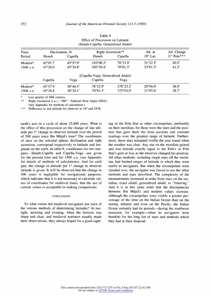
Table 9 Effect of Precession on Latitude
(Deneb-Capella: Generalized Abddl)
Time Declination, N Right Ascension** Alt. at Alt. Change Period Deneb Capella Deneb Capella 19? Lat. /1? Pole***
Modern* 45?07.7 45057.9' 310000.3' 78023.9' 31022.5' 40.5'
1500 A.D. 43?29.0 45028.8' 305059.4' 70001.5' 33001.5' 41.5'
(Capella-Vega: Generalized Abdal) Capella Vega Capella Vega
Modern* 45?57.9 38044.5' 78023.9' 278023.2' 20004.0' 38.0' 1500 A.D. 45?28.8 38020.1' 70001.5' 275003.0' 21005.6' 36.7'
* Last quarter of 20th century. ** Right Ascension (r.a.) = 360? - Sidereal Hour Angle (SHA).
(See Appendix for methods of calculation.) *** Difference in star altitude for observer at 19? and 18?N.
earth's axis in a cycle of about 25,800 years. What is the effect of this precession on the change of star alti- tude per 1? change in observer latitude over the period of 500 years since Ibn Majid's time? The coordinates of stars on the celestial sphere, declination and right ascension, correspond respectively to latitude and lon-
gitude on the earth. In table 9, coordinates for two star- pairs-Deneb-Capella and Capella-Vega-are given for the present time and for 1500 A.D. (see Appendix for details of methods of calculations). And for each pair, the change in altitude per 1? change in observer latitude is given. It will be observed that the change in 500 years is negligible for navigational purposes, which indicates that it is not necessary to calculate val- ues of coordinates for medieval times, that the use of current values is acceptable in making comparisons.
CONCLUSIONS
To what extent did medieval navigators use each of the various methods of determining latitudes? At twi- light, morning and evening, when the horizon was sharp and clear, and medieval mariners usually made their observations, they always hoped for a good sight-
ing of the Pole Star or other circumpolars, preferably on their meridian, for these were the stars and the posi- tion that gave them the most accurate and constant readings over the greatest range of latitude. Further- more, these stars remained visible the year round when the weather was clear. Any star on the meridian gained and lost altitude exactly equal to the Pole's or Pole Star's gain or loss as the observer changed his position. All other methods, including single stars off the merid- ian, had limited ranges of latitude in which they were useful to navigators. But when the circumpolars were clouded over, the navigator was forced to use the other methods and stars described. The complexity of the measurements increased in order from stars on the me- ridian, exact abdal, generalized abdal, to "fettering." And it is in this same order that the discrepancies between Ibn Majid's and modern values increase. Although the circumpolars were visible a greater per- centage of the time on the Indian Ocean than on the stormy Atlantic and even on the Pacific, the Indian Ocean certainly had its periods-during the southwest monsoon, for example-when its navigators were thankful for the long list of stars and methods which they had at their disposal.
372
This content downloaded from 129.173.72.87 on Fri, 6 Sep 2013 07:22:42 AMAll use subject to JSTOR Terms and Conditions

CLARK: Medieval Arab Navigation
APPENDIX
Details of abdal Calculations
1. Select observer's position (always taken in this work at long. 60? E, lat. 19? N and south in the Arabian Sea).
2. Select Aries GHA (Greenwich Hour Angle). 3. Add Aries GHA to SHA (Sidereal Hour Angle) to
obtain GHA (star) for each star. SHA from Nauti- cal Almanac.
4. Convert GHA (star) to longitude of star's Geo- graphical Position. GHA measured westward 0? to 360?; longitude measured 0? to 180? east and west.
5. Take difference of G.P. longitude and observer longitude to obtain Meridian Angle.
6. Using Meridian Angle, observer latitude and dec- lination (from Nautical Almanac) determine star altitude (from H.0.214).
7. Repeat 1-6 until star altitudes are equal. 8. Repeat 1-7 for 1? increments of observer latitude
to determine change in star altitude per 1? change in Pole.
Details of al-qaid Calculations
Follow steps 1-6 under abdal for the initial observer position. For each successive position of observer, it is necessary to determine a new longitude position of the observer as he moves 1? latitude on the circle of equal altitude. This is done as follows:
1. With fettered star's declination and constant alti- tude, the observer's latitude, enter Tables H.0.214 to read off the Meridian Angle.
REFE
(1) TIBBETTS, G. R. 1971. Arab Navigation on the Indian Ocean before the Coming of the Portuguese, translation of Ibn Majid's Kitab al-Fawd'idfi usil wa'l-qawadid, includ-
ing notes and commentaries on Arab navigation. London.
(2) FERRAND, GABRIEL. 1986. Introduction a I'astronomie nau-
tique arabe, ed. FUAT SEZGIN. Frankfurt am Main (Nach- druck der Aufgabe, Paris, 1928).
(3) American Nautical Almanac, published annually by the U.S. Government Printing Office, Polaris (Pole Star) Tables.
2. Add (subtract) the new Meridian Angle to (from) the constant longitude of the fettered star's G.P. to obtain the new longitude of the observer.
To determine the new altitude of the unfettered star: 1. Take the difference in longitude between the un-
fettered star's G.P. and the observer to obtain the unfettered star's Meridian Angle.
2. Enter Tables H.0.214 with unfettered star's Me- ridian Angle and declination, and the observer's latitude to find the new altitude.
Details of Calculations of the Effects of Precession on Star Positions (ref. 6):
1. Calculation of change in declination with time: New dec = dec + 20.04" x cos (r.a.) x N N = years from 2000 A.D., negative before, posi- tive after. r.a. = right ascension. Standard epoch, 2000 A.D. Declination on the celestial sphere corresponds to latitude on earth.
2. Calculation of change in right ascension with time: New r.a. = r.a. + [3.074s + 1.336s x sin (r.a.) x tan
(dec)]N ls = 15"; Im = 15'; hr = 150; 24 hrs. = 360? r.a. = 360 - SHA SHA is used to calculate Meridian Angle of navi- gational triangle as in abdal calculations above.
U.S. Navy H.0.214 for navigational triangle solu- tions is entered with observer latitude, Meridian Angle and declination.
ERENCES
(4) Tables of Computed Altitude and Azimuth, U.S. Navy Hy- drographic Office Publication, no. 214 (H.O.214).
(5) American Nautical Almanac, published annually by the U.S. Government Printing Office, Star Tables.
(6) MENZEL, DONALD H. and PASACHOFF, JAY M. 1990. A Field
Guide to Stars and Planets. Boston. Pp. 8, 415. (7) Dutton's Navigation and Piloting, Prepared by Com-
mander John C. Hill II, Lt. Commander Thomas F. Uter- gaard, and Gerard Riordan; U.S. Naval Institute (1959).
373
This content downloaded from 129.173.72.87 on Fri, 6 Sep 2013 07:22:42 AMAll use subject to JSTOR Terms and Conditions