Measuring Individuals’ Rights to Land · 2019-10-09 · Measuring Individuals’ Rights to Land 5...
72
Measuring Individuals’ Rights to Land An Integrated Approach to Data Collection for SDG Indicators 1.4.2 and 5.a.1
Transcript of Measuring Individuals’ Rights to Land · 2019-10-09 · Measuring Individuals’ Rights to Land 5...
Measuring Individuals’ Rights to LandAn Integrated Approach to Data Collection for
SDG Indicators 1.4.2 and 5.a.1

Measuring Individuals’ Rights to Land
An Integrated Approach to Data Collection for SDG Indicators 1.4.2 and 5.a.1
Citation: FAO; The World Bank; UN-Habitat. 2019. Measuring Individuals’ Rights to Land: An Integrated Approach to Data Collection for SDG Indicators 1.4.2 and 5.a.1. Washington, DC: World Bank.© FAO, The World Bank, and UN-Habitat. License: CC BY-NC-SA 3.0 IGO
Copyright © 2019 by International Bank for Reconstruction and Development/The World Bank, the Food and Agriculture Organization of the United Nations, and UN-Habitat
Disclaimer
The designations employed and the presentation of material in this information product do not imply the expression of any opinion whatsoever on the part of the Food and Agriculture Organization of the United Nations (FAO), United Nations Human Settlements Programme (UN-Habitat), or The World Bank concerning the legal or development status of any country, territory, city or area or of its authorities. The boundaries, colours, denominations, and other information shown on any map in this work do not imply any judgment on the part of FAO, UN-Habitat, or The World Bank concerning the endorsement or acceptance of such boundaries. FAO, UN-Habitat and The World Bank do not guarantee the accuracy of the data included in this work. The mention of specific companies or products of manufacturers, whether or not these have been patented, does not imply that these have been endorsed or recommended by FAO, UN-Habitat, or The World Bank in preference to others of a similar nature that are not mentioned. The findings, interpretations and conclusions expressed in this information product are those of the author(s) and do not necessarily reflect the views or policies of FAO, UN-Habitat, or The World Bank, World Bank Board of Executive directors, or the governments and members represented by these institutions. FAO, UN Habitat and The World Bank encourage the use, reproduction and dissemination of material in this information product. Except where otherwise indicated, material may be copied, downloaded and printed for private study, research and teaching purposes, or for use in non-commercial products or services, provided that appropriate acknowledgement of FAO, UN Habitat and The World Bank as source and copyright holders is given and that FAO, UN Habitat or The World Bank’s endorsement of users’ views, products or services is not implied in any way.
All queries on rights and licenses should be addressed to:
World Bank PublicationsThe World Bank Group1818 H Street NW, Washington, DC 20433, USA E-mail: [email protected].
Acknowledgements
This document was prepared jointly by the FAO, the UN-Habitat, and the World Bank. Sydney Gourlay (World Bank) coordinated and collated contributions from a team of authors across three organizations, and from other agencies. The contributors (listed alphabetically for each agency) include Chiara Brunelli and Yonca Gurbuzer of FAO; Everlyne Nairesiae, Oumar Sylla, and Robert Ndugwa of UN-Habitat; and Daniel Ali, Calogero (Gero) Carletto, Klaus Deininger, Sydney Gourlay, Thea Hilhorst, Talip Kilic, and Alberto Zezza of the World Bank. Substantive inputs were also provided by Donatien Beguy (UN-Habitat), Diana Fletschner (Landesa), Heather Moylan (World Bank), Lauren Pandolfelli (UNICEF), and the UNSD Evidence and Data for Gender Equality (EDGE) Project.
Cover Photos: World Bank/Dominic Chavez; Chor Sokunthea; A’Melody LeeLayout: Stefanie Freccia, Judith MulingePrinting: UNON, Publishing Services Section, Nairobi, ISO 14001:2004-certified

Measuring Individuals’ Rights to LandAn Integrated Approach to Data Collection for SDG Indicators 1.4.2 and 5.a.1

EXECUTIVE SUMMARY .............................................................................................................................5
PART I – BACKGROUND ............................................................................................................................7
1) LAND RIGHTS AND GENDER EQUALITY IN THE SUSTAINABLE DEVELOPMENT GOALS AGENDA ........10
a) Importance of tenure security and land rights ..........................................................................11
b) Emphasis on gender equality ....................................................................................................11
2) THE INDICATORS: 1.4.2 AND 5.A.1 ...................................................................................................13
a) Indicator 1.4.2 .........................................................................................................................14
b) Indicator 5.a.1 . ........................................................................................................................16
c) Differences between indicators 1.4.2 and 5.a.1: why do we need both? ..................................18
PART II – DATA COLLECTION THROUGH A HARMONIZED QUESTIONNAIRE MODULE ..............................20
1) MODULE CUSTOMIZATION AND COUNTRY-SPECIFIC METADATA ......................................................22
2) RESPONDENT SELECTION ..................................................................................................................24
3) LEVEL OF DATA COLLECTION: PARCEL LEVEL OR ‘ANY LAND’ ...........................................................29
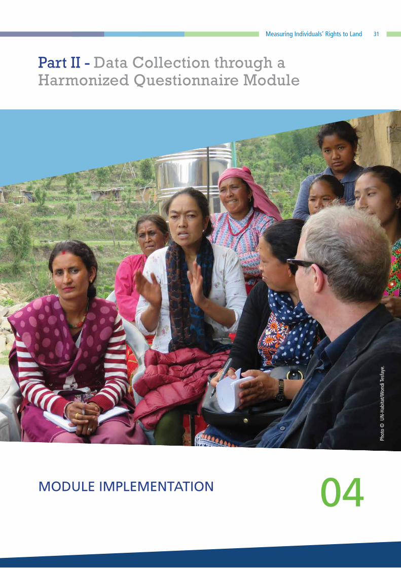
4) MODULE IMPLEMENTATION ..............................................................................................................31
a) Questionnaire module options .................................................................................................33
b) Question–by–question guidance ...............................................................................................35
REFERENCES ..........................................................................................................................................44
ANNEX I – GLOSSARY ............................................................................................................................47
ANNEX II – IDENTIFYING THE AGRICULTURAL POPULATION ....................................................................50
QUESTIONNAIRES 1-5 ............................................................................................................................54
CONTENTS
5Measuring Individuals’ Rights to Land
Land is a key economic resource inextricably linked
to access to, use of and control over other economic
and productive resources. Recognition of this, and the
increasing stress on land from the world’s growing
population and changing climate, has driven demand
for strengthening tenure security for all. This has created
the need for a core set of land indicators that have
national application and global comparability, which
culminated in the inclusion of indicators 1.4.2 and 5.a.1
in the Sustainable Development Goals (SDGs) agenda.
Having indicators on land ownership and rights in the
SDG framework is an opportunity to routinely generate
comparable, sex-disaggregated data to support
evidence-based decision making on responsible land
governance for sustainable development.
The custodians of SDG indicators 1.4.2 (UN-Habitat and
the World Bank) and 5.a.1 (FAO) have joined forces to
develop a standardized and succinct survey instrument
designed to collect the essential data for computation
of both indicators simultaneously. As the data collection
requirements for each indicator largely overlap, great
gains in efficiency are possible by implementing a joint
module in existing survey questionnaires. This document
aims to facilitate the successful, efficient, and cross-
country comparable data collection for computation
of SDG indicators 1.4.2 and 5.a.1 in line with the
methodologies approved by the IAEG-SDGs. The survey
instrument discussed in this document was designed
with an eye for the integration of essential questions for
both indicators into existing survey instruments, with
the possibility of stand-alone implementation. Use of
the proposed module encourages the standardization
of indicator definitions and data comparability across
countries and over time.
Significant attention is paid to the concept of respondent
selection and the implications of this for indicators
measurement. While the majority of household surveys
currently rely on proxy respondents, studies of self-
respondent versus proxy respondent reporting of
assets suggest that proxy respondent reporting has
the potential to distort information. Therefore, the
custodians strongly recommend the use of respondent
self-reporting wherever feasible, though options are
presented for proxy respondent implementation as
well.
This methodological note is prepared primarily for use
by national statistical offices (NSOs) and other survey
practitioners, in order to inform the monitoring of
these two indicators and to provide guidance on the
collection of data necessary for their regular reporting.
The document provides an overview of the indicators,
a discussion of the various questionnaire modules
proposed, and detailed question-by-question guidance
for each. Questionnaire modules have been designed
for use with self- and proxy-respondent approaches,
and for integration in surveys with and without a
parcel roster. As Indicator 1.4.2 is relevant for all land,
not only agricultural land as in the case of Indicator
5.a.1, integration of the proposed module is suitable
with nationally-representative household surveys (e.g.
income and expenditure surveys, household budget
surveys, living standard measurement surveys, etc.).
EXECUTIVE SUMMARY
Phot
o ©
Wor
ld B
ank/
A’M
elod
y Le
e.
6

Part 1Background
77

8
BACKGROUND
The importance of land tenure in sustainable
development has been recently recognized by the
establishment of Sustainable Development Goal (SDG)
indicators 1.4.2 and 5.a.1. In order to measure and
monitor progress towards reaching these goals, along
with the many other SDG targets, wide-reaching
data collection efforts are necessary. The custodians
of indicators 1.4.2 (UN Habitat and the World Bank)
and 5.a.1 (FAO), with the support of GDWGL and
GLII,1 have joined forces to develop a standardized
and succinct survey instrument designed to collect
the essential data for computation of both indicators
simultaneously, based on the meta data as presented to
the IAEG-SDG. Use of the proposed module encourages
the standardization of indicator definitions and data
comparability across countries.
As the data collection requirements for each indicator
largely overlap, great gains in efficiency are possible
by implementing a joint module that captures data for
both indicators. The survey instrument discussed in this
document was designed with an eye for integration
in existing survey instruments, yet with the possibility
of stand-alone implementation whenever feasible. Of
utmost importance is the sample universe of the stand-
alone survey or the survey in which the module is to
be integrated. The module is suitable with nationally-
representative household surveys (e.g. income and
expenditure surveys, household budget surveys, living
standard measurement surveys, etc.).
1 GDWGL is the Global Donor Working Group on Land; GLII is the Global Land Indicators Initiative, established in 2012 and hosted by the Global Land Tool Network.
This methodological note is prepared primarily for use
by national statistical offices (NSOs) and other survey
practitioners. The aim is to provide the rationale for
the SDG indicators on land tenure security for men
and women (1.4.2 and 5.a.1) as well as guidance
for data collection to enable reporting on these two
indicators.2 Ultimately, the document aims to facilitate
the successful, efficient, and cross-country comparable
data collection for computation of SDG indicators 1.4.2
and 5.a.1.
In what follows, an overview of the indicators is
provided, as well as key definitions, a discussion of
the questionnaire module (and variations thereof) and
detailed, question-by-question guidance.
2 While there are additional SDG indicators related to land rights and use, including indicators 5.a.2, 11.7.1, and 15.3.1, these fall outside the scope of this document as they do not rely on survey data for computation. Indicator 5.a.2: Percentage of countries where the legal framework (including customary law) guarantees women’s equal rights to land ownership and/or control. Indicator 11.7.1: Average share of the built-up area of cities that is open space for public use for all, by sex, age and persons with disabilities. Indicator 15.3.1: Portion of land that is degraded over total land area.
Part I - Background

Measuring Individuals’ Rights to Land 9
SDG INDICATOR 1.4.2
PROPORTION OF TOTAL ADULT POPULATION
WITH SECURE TENURE RIGHTS TO LAND, WITH
(A) LEGALLY RECOGNIZED DOCUMENTATION; AND
(B) WHO PERCEIVE THEIR RIGHTS TO LAND AS SECURE,
BY SEX AND BY TYPE OF TENURE
SDG INDICATOR 5.A.1
(A) PROPORTION OF TOTAL AGRICULTURAL POPULATION
WITH OWNERSHIP OR SECURE RIGHTS OVER
AGRICULTURAL LAND BY SEX; AND
(B) SHARE OF WOMEN AMONG OWNERS OR RIGHTS-
BEARERS OF AGRICULTURAL LAND, BY TYPE OF
TENURE

10
LAND RIGHTS AND GENDER EQUALITY IN THE SUSTAINABLE DEVELOPMENT GOALS AGENDA
01
Phot
o ©
UN
-Hab
itat/J
ean
duPl
essi
s.
Part I - Background

11Measuring Individuals’ Rights to Land
a) Importance of tenure security and land rights
Land is a key economic resource inextricably linked to
access to, use of and control over other economic and
productive resources and livelihoods. Especially in rural
and peri-urban areas, agricultural land is a key input
for agricultural production; it can be used as collateral
to access financial resources, extension services or
producer organizations. In both rural and urban areas,
if rented or sold, land can generate income. Access,
ownership and/or control of land is critical for poverty
reduction, food security, fostering of gender equality
and inclusiveness, and reduction of land degradation,
amongst other sustainable development objectives.
Tenure systems are increasingly under pressure as
the world’s population grows and as urbanization,
environmental degradation and climate change affect
land use and productivity. The governance of tenure is
a crucial element in determining if and how people,
communities, indigenous groups, and others acquire
rights and their associated obligations to use and control
land and natural resources. All forms of tenure should
provide people with a degree of tenure security, with
states protecting rights, ensuring that people are not
arbitrarily evicted and that their rights are not otherwise
extinguished or infringed. People’s perception of their
tenure rights is also important as it influences the way
in which they use the land and the degree to which
they are willing to invest in it.
Increasing demand for strengthening tenure security
for all, particularly for women and vulnerable groups,
has created the need to track progress on tenure
security through a core set of land indicators that have
national application and global comparability; this has
culminated in the inclusion of SDG indicators 1.4.2
and 5.a.1 in the SDG agenda. The placement of the
indicators under goals 1 and 5 signals the importance of
tenure security for poverty reduction and gender equity.
Having global indicators on land tenure rights in the
SDG framework is an opportunity for countries to track
progress and use data for planning and policy decisions
on land governance for sustainable development,
leaving no one behind. SDG indicators are universal and
all countries have committed to collect data and report
on these, which is an important improvement relative
to the Millennium Development Goals (MDGs).
b) Emphasis on gender equality
From a gender perspective, the SDGs are a significant
step forward from the MDGs, covering, for the first
time, all core areas of the women’s empowerment
agenda. While Goal 3 of the MDGs promoted gender
equality in primary and secondary education, Goal 5 of
the SDGs looks at gender parity from many perspectives
and considers several gender dimensions. In addition,
many SDG targets call for parity between men and
women, and they require the corresponding indicators
to be disaggregated by sex. In particular, in line with the
aspiration to “leave no one behind”, the SDG agenda
acknowledges the importance of securing women’s
land rights and monitoring gender equality in land and
property rights.
Women’s equal access to and control over economic
resources, land, and natural resources is critical for the
achievement of gender equality and empowerment of
women and for equitable and sustainable economic
growth and development. Long-lasting inequalities
in the gender distribution of economic and financial
resources put women at a disadvantage relative to
men in their ability to participate in, contribute to
and benefit from broader processes of development.

12
Greater gender equality in the distribution of economic
resources contributes to economic efficiency and
has positive multiplier effects for the achievement
of a range of key development outcomes, including
poverty reduction, food security, and the welfare of
households, communities, and countries. Women’s land
ownership and control has been linked to important
gains in women’s welfare, productivity, equality, and
empowerment. The right to bequeath reflects women’s
ability to influence intergenerational land transfers and
is an important aspect of female empowerment.
Access, ownership, and/or control of land, particularly
but not exclusively in agricultural societies, is one of the
few mechanisms with which women can guarantee
their economic security and avoid poverty, especially in
the absence of safety nets and/or functioning labour
markets. Development practitioners recognize that
secure tenure rights have a strong empowering effect
on women: this security reduces their reliance on
male partners and relatives, increases their bargaining
power within the household and improves their
chances of accessing extension services and credit.
The confidence gained from increased tenure security
can further encourage women to undertake or expand
their business investments and, in rural areas, to join
producer organizations.
Gender equality in land ownership and control is a
human right. For example, the International Covenant on
Civil and Political Rights (ICCPR) prohibits discrimination
based on sex and preserves equality before the law. It
can be applied to defend women’s right to equality, not
only with respect to civil and political rights, but also
with economic and social rights.
The relevance of gender equality on land rights is
particularly evident in Target A of Goal 5 of the
SDGs, which aims to track progress on how countries
“undertake reforms to give women equal rights to
economic resources, as well as access to ownership
and control over land and other forms of property,
financial services, inheritance and natural resources, in
accordance with national laws”. Gender parity on land
and property rights is also explicitly recognized in Target
1.4 of Goal 1, which aims to ensure that, by 2030,
“all men and women, in particular the poor and the
vulnerable, have equal rights to economic resources, as
well as access to basic services, ownership and control
over land and other forms of property, inheritance,
natural resources, appropriate new technology and
financial services, including microfinance”. Under these
two goals, indicators 5.a.1 and 1.4.2, detailed below,
are designed to measure and monitor sex-disaggregated
land tenure security.
Part I - Background

13Measuring Individuals’ Rights to Land
THE INDICATORS: 1.4.2 AND 5.A.1 02
Phot
o ©
Wor
ld B
ank/
Arne
Hoe
l.
Part I - Background

14
a) Indicator 1.4.2
Indicator 1.4.2, for which UN-Habitat and the World Bank
are custodian agencies, is defined as:
”Proportion of total adult population with secure tenure rights to land, with (a) legally recognized documentation; and (b) who perceive their rights to land as secure, by sex and by type of tenure.”
The indicator is composed of two complementary sub-
indicators that proxy secure tenure rights by looking at
“legally recognized documentation” of tenure rights
to land and “perceptions of tenure security”, given
the need to complement formal measures of tenure
security with perception-based measures. Indicator
1.4.2 focuses on all adults, regardless of their place
of residence, means of livelihood, wealth, ethnicity,
sex, etc. Thus, Indicator 1.4.2 measures the sex-
disaggregated status of tenure security on all types of
land and is applicable in both rural and urban contexts.
The two sub-indicators need not coincide. A comparison
of the two sub-indicators can provide a more nuanced
understanding of a country’s tenure security landscape.
For example, there may be contexts where there is a
considerable portion of the population with valid legal
documentation to prove their rights but individuals
may still feel tenure insecure if they have limited trust
in the land administration services, fear of duplicated
or forged documents, if they have inadequate access
to the institutions responsible for enforcing their
rights, or if cultural norms or family members may
prevent them from realizing their rights. Conversely,
individuals may perceive themselves as tenure secure
even without legally recognized documentation. This
could be the case, for example, in contexts where
rights are not formally recorded but are respected, such
as in customary tenure systems or trusted local land
governance arrangements.
For the purpose of constructing sub-indicator (a), all
relevant tenure arrangements in the country will need
to be identified and all tenure-related documents
identified as those that constitute legally recognized
documentation and those that do not. Examples
include titles, leaseholds, use rights certificates,
rental agreements, etc. Adults will be classified as
having legally recognized documentation if, for
at least one parcel of land, (a) they have access to
the land under a tenure arrangement identified
and legally recognized by the government, and (b)
the document lists their name as a rights holder.
Disaggregation by gender and tenure type is required,
however, additional levels of disaggregation are
recommended for country level analysis and policy
guidance.
Part I - Background
15Measuring Individuals’ Rights to Land
For the purpose of constructing sub-indicator (b),
perceptions of tenure security are based on a fear of
involuntary loss of the land within the next five years
and the landholder’s right to bequeath the land.
The potential data sources used for reporting on
Indicator 1.4.2 are multi-topic household surveys,
household budget surveys, labour force surveys,
and population and housing censuses conducted
by national statistical offices or other agencies.
THE INDICATORS: 1.4.2 AND 5.A.1
Further, administrative data on land tenure, such as land
registries or cadastres, often generated by national land
institutions, may inform the identification of metadata,
such as types and coverage of various tenure systems.
Indicator 1.4.2 will be disaggregated by sex and type
of tenure. The data collected through the instrument
proposed here will be sufficient for the computations
of the 1.4.2 sub-indicators. The two sub-indicators will
be reported separately.
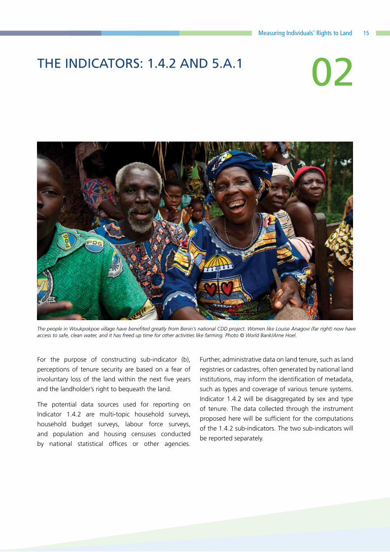
The people in Woukpokpoe village have benefited greatly from Benin’s national CDD project. Women like Louise Anagovi (far right) now have access to safe, clean water, and it has freed up time for other activities like farming. Photo © World Bank/Arne Hoel.
02
16
b) Indicator 5.a.1.
FAO is the sole custodian agency for Indicator 5.a.1,
with United Nations Statistics Division (UNSD) and UN
Women as contributing agencies. While Indicator 1.4.2
measures tenure security on all types of land, Indicator
5.a.1 focuses on agricultural land as this is a key input
in low- and middle-income countries where poverty
reduction and development strategies are frequently
based on the agricultural sector. In particular, Indicator
5.a.1 aims to measure gender disparities in tenure
rights over agricultural land.
Indicator 5.a.1 is defined as follows:
“(a) Proportion of total agricultural population with
ownership or secure rights over agricultural land by
sex; and (b) share of women among owners or rights-
bearers of agricultural land, by type of tenure”
Indicator 5.a.1 is composed of two sub-indicators,
which are based on the same data and use people
living in agricultural households as the reference
population. The sub-indicators monitor tenure rights
from two different angles. Sub-indicator (a) reports the
prevalence of men and women with tenure rights over
agricultural land, while sub-indicator (b) focuses on the
individuals with tenure rights over agricultural land and
reports which share of those individuals are women, by
type of tenure.
The reference population for Indicator 5.a.1 deserves
special attention. While 1.4.2 considers the total adult
population, 5.a.1 refers only to the adult agricultural
population. For the purposes of this indicator, and to
ensure comparability of the indicator across time and
context, the adult agricultural population is defined as:
all adult individuals living in agricultural households
– i.e. households who operated land for agricultural
purposes and/or raised/tended livestock in the past
12 months, regardless of the final destination of the
production
It is important to note that households in which members
were engaged in agriculture only through wage
labour are excluded from the reference population.
Investigating household’s involvement in agriculture is
not trivial. The seasonality of agricultural engagement,
the common misalignment of time investment in
agriculture and cash income from agriculture, and
the prevalence of subsistence agriculture over market
activity complicate the identification of agricultural
households. If the survey adopted to monitor SDG
indicators 1.4.2 and 5.a.1, and in which we propose
embedding the joint module, does not already allow
for the identification of agricultural households (using
the definition above), it is recommended that the set
of questions found in Annex II be included. This set of
questions will allow identification of the appropriate
denominator for Indicator 5.a.1.
Indicator 5.a.1 focuses on the de facto tenure rights
over agricultural land and aims to generate a measure
which is valid across countries with differing levels of
legal document penetration. Therefore, in addition to
considering a person’s possession of legally recognized
documentation, the indicator takes into account the
person’s alienation rights over agricultural land, which
can be present even in contexts where tenure rights are
not documented.3
3 Alienation is defined as the ability to transfer a given asset during lifetime or after death. It regards the disposition of land as opposed to a simple generic self-reported declaration of tenure rights over land.
Part I - Background

17Measuring Individuals’ Rights to Land
In summary, Indicator 5.a.1 relies on the three proxies for tenure rights:
• the possession of a legally recognized document in the name of the individual,
• the individual’s right to sell, and
• the individual’s right to bequeath the land.
The presence of one of the three proxies is sufficient to define a person as de-facto ‘owner’ or ‘holder’ of
tenure rights over agricultural land. The advantage of this approach is its applicability to countries with
different level of penetration of legally binding documents.
Having defined these proxies, Indicator 5.a.1 can be expressed as follows:
Sub-indicator (a):
Number of adult individuals in agricultural households who have their name on a legally
recognized document OR have the right to sell OR bequeath agricultural land
_______________________________________________________________________________
Total adult individuals living in agricultural households
Sub-indicator (b):
Number of adult women in agricultural households whose name is on a legally recognized
document OR who have the right to sell OR bequeath agricultural land
_____________________________________________________________________________
Total adult individuals in agricultural households whose name is on a legally recognized
document OR who have the right to sell OR bequeath agricultural land
* 100, by sex
* 100 , by type
of tenure
THE INDICATORS: 1.4.2 AND 5.A.1 02

18
The required level of disaggregation for Indicator
5.a.1, in particular, sub-indicator (a), is the sex of
the individuals. However, to inform policy making,
additional levels of disaggregation for both sub-
indicators are recommended. The recommended levels
of disaggregation for both sub-indicators wherever
feasible and/or relevant include, but are not limited to:
type of tenure, type of legally recognized document,
income level, age group and geographic location
(urban/rural).
The potential data sources used for reporting on Indicator
5.a.1 are agricultural surveys or multi-topic household
surveys. If multi-topic household surveys are used, it
is necessary to identify agricultural households, which
are the reference population of the SDG Indicator 5.a.1
(see Annex II guidance). In addition, a pre-screening
and oversampling may be needed, especially in
countries/regions with a low proportion of households
engaged in agriculture. Censuses can be considered an
alternative data source, while administrative data are
not recommended, mainly because they do not allow
focusing on the reference population – i.e. adults living
in agricultural households.
The methodology for SDG Indicator 5.a.1 has been
developed and tested within the framework of the
Evidence and Data for Gender Equality (EDGE) project, an
initiative led by UNSD and UN Women and implemented
in collaboration with the Asian Development Bank,
FAO, ILO, OECD and the World Bank. The pilot studies
conducted under the EDGE initiatives served to identify
the minimum set of questions for Indicator 5.a.1 (UNSD,
forthcoming).
c) Differences between indicators 1.4.2 and 5.a.1: why do we need both?
While at first glance the indicators appear to be very
similar, there are key differences of which to be aware.
Both indicators focus on individual-level rights to land
and promote sex-disaggregated data. However, the
differences between the two are important.
• The two indicators monitor different reference
populations: Indicator 1.4.2 looks at the adult
population in the country as a whole, while Indicator
5.a.1 considers only the adult population for whom
agricultural land is relevant – i.e. individuals living in
agricultural households.
• The two indicators take into consideration
different types of land: Indicator 1.4.2 considers
all types of land use, including residential land, land
used for business, forest land, agricultural land, etc.
On the other hand, Indicator 5.a.1 is focused on
agricultural land only.
• The two indicators differ in the land tenure
rights measured: Indicator 1.4.2 proxies secure
tenure rights with having legally recognized
documentation and/or perceiving tenure rights as
secure. Indicator 5.a.1 focuses on legally recognized
documentation and an individual’s alienation rights.
Indicators 1.4.2 and 5.a.1 are complementary and
together provide the unique opportunity to monitor
a range of individual-level land tenure rights and
associated tenure security, disaggregated by sex.
Part I - Background

Measuring Individuals’ Rights to Land 19
Phot
o ©
FAO
/Flo
renc
e To
nnoi
r.

Part IIData Collection through a Harmonized Questionnaire Module
2020
21Measuring Individuals’ Rights to Land
Although the two indicators focus on different aspects
of land tenure security, the data requirements from
household surveys are broadly similar. In order to
take advantage of the overlap in data requirements
and minimize the implementation burden on national
statistics offices and other implementing agencies, the
custodians of both indicators have worked together
to design a questionnaire instrument to collect the
required data for both indicators simultaneously. The
proposed module is suitable for integration into
nationally-representative surveys.4
Data collection for indicators 1.4.2 and 5.a.1 is likely
to be completed as part of many different survey
operations and design, several of which may involve
pre-existing survey instruments. For countries that
already include land tenure security related questions in
existing survey instruments, the module should serve as
a checklist to expand or refine these questions.5
4 For example, an agricultural census would not be a recommended survey for integration of the module due to the restriction of the sample to agricultural households. This would omit any non-agricultural households from the computation of Indicator 1.4.2. The questions for Indicator 5.a.1 could be asked in an agricultural census, however. If carefully done, it could be possible to compute the indicators using two different surveys in the same country, depending on the representativeness of the samples. (For example, it is plausible that one could supplement data from a nationally representative agricultural survey with data from a second survey that is nationally representative of all non-agricultural households.)
5 When modifying questions in an existing questionnaire instrument to match those of the proposed module, specifically in the case of panel surveys, practitioners should be aware that changes in a question from one round of implementation to the next may influence the comparability of data across waves. It should be made clear in the documentation and data that the question has been modified (for example, by using a different variable name for the modified question).
Due to the various survey designs in which this module
could be integrated, multiple versions of the module
have been designed to allow it to be inserted easily into
a number of different scenarios. The version selection,
discussed in more detail below, depends on whether:
I. one person responds on behalf of other
household members (proxy respondent
approach) or each individual is asked
specifically about his or her land tenure rights
(self-respondent approach);
II. data is collected at the parcel level or the
household/farm level.
While the most preferable approach is to have parcel-
level data and a self-respondent approach (see Box
1), this may not be possible because of the time and
budget constraints under which most multi-topic
surveys operate.
The following sections highlight the key components of
module implementation which must be considered for
successful data collection for indicators 1.4.2 and 5.a.1.
First, context-specific customization requirements are
discussed followed by a critical discussion on respondent
selection. Finally, the various questionnaire modules
are outlined and question-by-question guidance is
provided.
DATA COLLECTION THROUGH A
HARMONIZED QUESTIONNAIRE
MODULE
Part II - Data Collection through a Harmonized Questionnaire Module

22
MODULE CUSTOMIZATION AND COUNTRY-SPECIFIC METADATA
01
Phot
o ©
Wor
ld B
ank/
Ghu
llam
Abb
as F
arza
mi.
Part II - Data Collection through a Harmonized Questionnaire Module

23Measuring Individuals’ Rights to Land
The country-specific metadata prepared by an NSO
or other implementing agency should include, at a
minimum:
I. a comprehensive list of all tenure types
applicable to the country;
II. a comprehensive list of land tenure-related
documents, specifying which ones the
government considers as legally recognized;
III. images of the documents considered legally
recognized;
IV. a context-specific definition of alienation
rights; and,
V. linkages between survey and administrative
data, if applicable.
Additionally, customization for the context will be
needed in terms of the response codes for some
questions, such as traditional land area units. Refer to
the Living Standards Measurement Study guidebook on
land area measurement in household surveys for more
information.6 In the question-by-question guidance
that follows, customization needs are noted.
6 Gero Carletto, Sydney Gourlay, Siobhan Murray, and Alberto Zezza. “Land Area Measurement in Household Surveys: Empirical Evidence & Practical Guidance For Effective Data Collection”. July 2016. Available online.
While the module has been designed to be as universal
as possible, the variation in land tenure arrangements,
cultural context and regulatory frameworks, for
example, across and within countries, will inevitably
require a degree of customization while taking care
to ensure comparability. Before going to the field,
therefore, survey practitioners must carefully research
the necessary metadata for a given context which will
feed directly into the questionnaire.
This metadata instrument will ensure consistency of
definitions across countries and document country
specific customization, and, as such, should be released
along with the data. The primary function of the
metadata is to identify which types of documentation
are legally recognized, as that is a crucial attribute for
the computation of these indicators. The metadata will
vary by country and will, therefore, need to be released
along with the computation of the indicator for
transparency. Metadata need to be regularly reviewed
and should be updated in the case of changes in the
regulatory frameworks.
01

24
RESPONDENT SELECTION 02
Phot
o ©
Wor
ld B
ank/
Dom
inic
Cha
vez.
Part II - Data Collection through a Harmonized Questionnaire Module

25Measuring Individuals’ Rights to Land
The questionnaire module options that are presented in
the subsequent section for collecting the necessary data
for the SDG indicators 1.4.2 and 5.a.1 aim to collect data
on specific household members, disaggregated by sex.
As such, the identification of the respondent(s) for the
questionnaire module becomes a non-trivial exercise.
Could one household member answer accurately
on behalf of other household members regarding
ownership of and rights to land and perceived tenure
security? Could the incentives of a proxy respondent
differ from those of the person of interest, leading to
differing responses? Can we (and should we) interview
each individual directly?
While both options - proxy respondent and self-
reported - provide helpful information, the distinction
is worth highlighting. Unless we are willing to assume
that everybody in the household faces similar conditions
and that family members fully share information,
interviewing the head of the household or the most
knowledgeable person will often not offer reliable
insights into the reality experienced by other members
of his/her household. In the case of indicators 1.4.2 and
5.a.1, for example, if a male head of the household is
the interviewed about the tenure status of his spouse,
he may provide biased answers about his wife because
he does not know about a document that she has.
When it comes to perceptions of tenure security, the
case against proxy respondents is even stronger. For
example, a proxy respondent may not be aware of how
worried his wife is about her tenure security if he does
not fully acknowledge troublesome dynamics with her
in-laws, or he may refuse to report that his wife worries
about her tenure insecurity because of domestic
violence. In short, surveys that rely on proxy respondents
may collect biased data on land documents and offer
limited insights on perceptions of tenure security.
To further support this point empirically, Kilic and
Moylan (2016) studied microdata collection on
ownership of and rights to assets and they provide
proof of distortionary proxy respondent effects based
on the analysis of the Methodological Experiment on
Measuring Asset Ownership from a Gender Perspective
(MEXA).7 The findings from this study, and the emerging
findings from the Malawi Fourth Integrated Household
Survey (IHS4) 2016/17 and the Integrated Household
Panel Survey (IHPS) 2016, point strongly towards the
benefits for data quality of interviewing adult household
members in individual-specific interviews, and inquiring
directly about their personal ownership of and rights
to assets (refer to Box I). These recommendations are
buttressed also by previous calls for collecting data
on ownership of and rights to assets at the individual
level (Grown et al., 2005; Doss et al., 2011, 2017) and
the methodological research that has been conducted
under the Evidence and Data for Gender Equality (EDGE)
initiative (UNSD, forthcoming).
7 MEXA was conducted by the Uganda Bureau of Statistics, under the partnership between the Evidence and Data for Gender Equality (EDGE) initiative and the World Bank LSMS. MEXA was the first of seven pilot studies supported by the EDGE initiative and implemented by the respective national statistical offices that have informed the international guidelines on the individual-level measurement of asset ownership and control.
02

26
BOX 1. KEY FINDINGS FROM THE MALAWI IHS4 2016/17 AND THE IHPS 2016
In 2016, Malawi National Statistical Office concurrently implemented (i) the Fourth Integrated
Household Survey 2016/17 (IHS4) - a cross-sectional, nationally-representative survey of 12,480
households, and (ii) the Integrated Household Panel Survey 2016 (IHPS) - a longitudinal survey
of 2,500 households that have been followed since 2010.
The IHPS was the first Living Standards Measurement Study (LSMS)-type household survey
attempting to interview each adult household member in private regarding their personal
ownership of and rights to assets. The individual interviews were conducted (i) following
the administration of all applicable questionnaires; (ii) simultaneously, if possible; and (iii)
with a gender match between the enumerators and the respondents. On dwelling (inclusive
of the residential plot) and agricultural land, the IHPS administered adapted versions of the
questionnaire modules that had been developed as part of the Methodological Experiment
on Measuring Asset Ownership from a Gender Perspective (Kilic and Moylan, 2016) and that
inquired directly regarding the respondents’ personal, exclusive as well as joint, ownership of
and rights to a dwelling and each agricultural parcel, as applicable. In contrast, the IHS4 followed
the traditional (i.e. business-as-usual) approach of interviewing the most knowledgeable
household member, who could have varied by parcel and would have been the individual
providing information on household members’ ownership of and rights to each parcel.
The parallel implementation of the IHPS and the IHS4 offers an opportunity to assess the
effects of conducting individual-level interviews vis-à-vis the business-as-usual approach on
the measurement of ownership of and rights to land among adult household members. Kilic,
Moylan and Koolwal (forthcoming) report the findings from these analyses, which focus on
the IHPS-IHS4 differences in individual-level variables that capture overall, exclusive and joint
versions of (i) reported, economic and documented ownership of and (ii) rights to (sell, and
separately bequeath) agricultural land. Within the IHPS sample specifically, the authors also
compare the information provided by different respondents in the same household regarding
the same set of agricultural parcels that are identified uniquely across multiple interviews and
explore the drivers of (within-household) discrepancies in parcel-level reporting. The results and
implementation experience give guidance on opportunities and trade-offs involved and the
scope for NSOs to produce high-quality data within their existing constraints.
Part II - Data Collection through a Harmonized Questionnaire Module

27Measuring Individuals’ Rights to Land
RESPONDENT SELECTION
The authors find that for agricultural land, implementing the business-as-usual approach to
interviewing respondents (as in the IHS4), vis-a-vis conducting personal interviews of adult
household members (as in the IHPS), leads to higher men’s exclusive reported and/or economic
ownership, with some stronger negative effects on joint reported/economic ownership for
adult men and women. Following the business as usual approach also leads to a significant
decrease in joint reported and/or economic ownership for women.
Conversely, for the rights to sell and bequeath, the business-as-usual approach leads to an
increase for both men and women, driven by a positive effect on reporting of joint rights. Since
the SDG 5.a.1 indicator is composed of these two rights (as well as documented ownership,
whose incidence is almost negligible in the Malawian context), the business-as-usual approach
increases the estimated value for this indicator for both males and females. This difference in
results for ownership and rights holdership is at least partially driven by questionnaire design.
In implementing the business-as-usual approach, the IHS4, following the prevailing practice in
other surveys of its kind, allowed the respondents to report any adult household member as
having a particular right, irrespective of their reported or documented ownership. Conversely,
in the IHPS, the adult household members would not have responded to the questions on their
personal rights if they had not reported themselves as among the owners. To put this into
context, 9 percent of adult household members that were identified with the right to sell in the
IHS4 data were not among the reported owners.
Finally, to better understand the intra-household dynamics underlying the results, Kilic, Moylan
and Koolwal (forthcoming) examine spouses’ reporting discrepancies over the same agricultural
parcel. Among couples that were interviewed as part of the IHPS, they find substantial
agreement in reporting over reported ownership of and rights to agricultural parcels. However,
when there are discrepancies, indicators of greater household status for women (headship, age,
matrilineal marriage and, in particular, being the main decision-maker over crops) are positively
associated with discrepancy scenarios where the woman attributes at least some landholding
status to herself.
On the whole, the authors provide further evidence for survey practitioners to move away
from collecting information on land ownership and rights using the traditional approach of
interviewing the most knowledgeable household member. In parallel, they highlight how
different ownership and rights constructs may be defined and interpreted differently by
respondents (particularly in the context of joint ownership and rights) - an area of future
research that may result in the refinement of the recommended questionnaire modules and
field protocols.
02

28
Considering these arguments, the gold standard
approach to respondent selection for collecting the
necessary data for the SDG indicators 1.4.2 and 5.a.1
is interviewing either all adult8 household members
or a randomly selected subsample of adult household
members (with the option of interviewing one
randomly selected household member) about their own
tenure rights (i.e. self-respondent approach). 9These
alternatives will work towards ensuring an unbiased
and representative individual sample of respondents.
Note that interviewing all adult household members
will provide more analytical value than interviewing
only a random subset of adult members, but that the
random selection of adult members is sufficient for
computation of indicators 5.a.1 and 1.4.2.
In addition, qualitative fieldwork suggests it is advisable
that the individual-specific interviews are conducted
alone and that a gender-match is ensured between the
respondent and the enumerator whenever possible. In
the case of multiple individual interviews per household,
consideration should be given to conducting intra-
household individual interviews in a simultaneous
fashion (UNSD, forthcoming).
The custodians and contributing agencies to the SDG
indicators 1.4.2 and 5.a.1 recognize that ensuring the
take-up of the recommended approach to respondent
selection will require close engagement with and
capacity building within the national statistical system
and the broader survey community. The principal
8 For the purposes of global monitoring, ‘adult’ should be defined as 18 years old or older. For country-specific monitoring, national legal definitions of ‘adult’ should be used.
9 Randomization can be implemented using the Kish method, as described by Kish (1965). In the context of CAPI-based survey implementation, the random selection of adult household members for individual interviews can be handled automatically by the CAPI application, eliminating the need to rely on a manual randomization method.
challenges associated with the implementation of self-
respondent interviews are the individual respondent
availability, particularly in urban areas, and the
additional time requirements. Therefore, it may require
additional resources.
In some cases, time and budgetary constraints may lead
the survey implementing agencies to implement the
use of proxy respondents reporting on behalf of other
household members, and to maintain the ‘business as
usual’ approach. This approach is known to result in
some biases; nonetheless, there are low-cost steps that
can be taken to optimize the respondent selection. In
the case of a parcel-level survey instrument, for example,
it is recommended that a ‘group interview’ approach
is followed prior to administration of the module,
in which the group of all available adult household
members come together to identify which household
member among the available pool of respondents
is ‘most knowledgeable’ on each parcel. In this
approach, the same respondent would not necessarily
be interviewed about every parcel. The identity of the
respondent should be recorded in the module to track
who responds to each parcel, as is routinely done in
the World Bank Living Standards Measurement Study
(LSMS) surveys.
To summarize, the recommended respondent
selection strategy is the use of self-respondents,
with a carefully implemented proxy respondent approach
acting as an alternative only where the self-respondent
approach is not feasible. Survey documentation should
indicate what approach was used and any additional
details on how it was implemented.
In the sections that follow, multiple versions of the
module are presented which correspond to different
respondent selection strategies.
Part II - Data Collection through a Harmonized Questionnaire Module

29Measuring Individuals’ Rights to Land
03LEVEL OF DATA COLLECTION: PARCEL LEVEL OR ‘ANY LAND’
Phot
o ©
Wor
ld B
ank/
A’M
elod
y Le
e.
Part II - Data Collection through a Harmonized Questionnaire Module

30
In addition to the respondent selection issues discussed
above, household surveys may also differ in the level at
which they collect land-related data. Some collect land
data at the parcel level, while others collect this data
only at the household level. Household surveys with
an emphasis on agriculture, for example, commonly
collect data at the parcel level. That is, data is collected
separately for each parcel of land, commonly defined
as a contiguous piece of land with uniform tenure and
physical characteristics. Because tenure security can vary
across parcels, we strongly recommend gathering data
using a parcel-level approach as it yields disaggregated,
potentially more accurate information since respondents
do not have to compare or summarize parcel-specific
responses. Disaggregating data at the parcel level, rather
than farm or household level, allows for the indicators
to be constructed for various subgroups of parcels and
people, including tenure system, acquisition type, land
use, land area and other land characteristics. In addition
to informing computation of the indicators 5.a.1
and 1.4.2, land tenure data at the parcel level holds
significant analytical value, particularly with respect
to agricultural productivity analysis. Parcel-level data
collection requires the collection of a parcel roster, a list
of the parcels owned or used by the household, with
unique names and identification codes so that parcels
can be matched across modules of the questionnaire.
The section below presents modules designed for
parcel-level data collection, as well as surveys in which
parcel-level data is not collected.
Part II - Data Collection through a Harmonized Questionnaire Module
31Measuring Individuals’ Rights to Land
MODULE IMPLEMENTATION
Phot
o ©
UN
-Hab
itat/W
ondi
Tesf
aye.
Part II - Data Collection through a Harmonized Questionnaire Module
04

32
The questionnaire in which the proposed module is being
integrated needs to be considered, if applicable. Many
household surveys with a focus on agriculture include a
full parcel roster in the questionnaire, while many only
ask respondents to report information at the level of
the entire household. Respondent selection strategies
may also differ depending on the questionnaire. These
two topics are discussed in more detail below.
In some cases, like a labour force survey or a household
survey without any land tenure information, adding the
complete module is the most effective and appropriate
method. Note, however, that if the questions are
being integrated into an existing survey instrument,
it may be the case that the questions proposed in the
modules below need to be shuffled around in order
to appropriately accommodate the questionnaire in
which you are integrating. For example, if integrating
into a multi-topic household survey that already
includes a parcel roster for agricultural land, but not
one for non-agricultural land, you may use the existing
agricultural parcel roster and add a second roster for
non-agricultural land, or expand the scope of the
existing parcel roster. What is critical is the content of
the questions in the modules and the types of land for
which they are administered, not that the modules are
used in a separate module as presented here.
The questionnaire has been designed for paper-assisted
personal interviewing (PAPI) implementation to have
the widest reach. However, an electronic version of the
questionnaire will be created by the custodians for use
in computer-assisted personal interviewing (CAPI). The
electronic questionnaire will be created using the World
Bank’s open access CAPI platform, Survey Solutions
(solutions.worldbank.org) and will be made publicly
available. The CAPI application can be customized from
the base module as necessary. Implementation of the
module via CAPI is recommended as this can minimize
data entry errors, allow for more immediate data review
and analysis, and enable quick use of photo aids (which
can improve data quality).
In what follows, factors to be considered for the optimal
module selection are discussed, including respondent
selection options and a detailed discussion on the
various module design options.
Part II - Data Collection through a Harmonized Questionnaire Module

33Measuring Individuals’ Rights to Land
a) Questionnaire module options
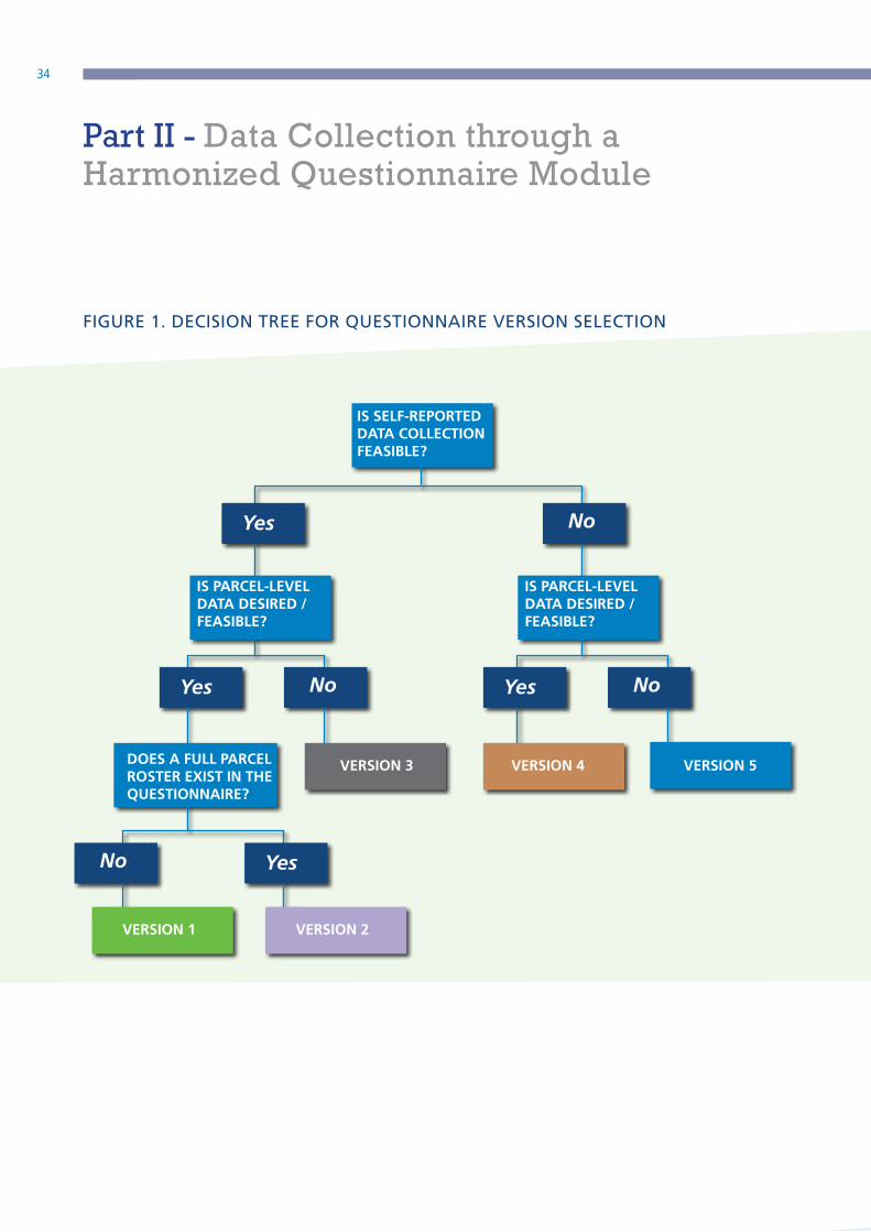
Five versions of the questionnaire module are provided.
Which module is appropriate for a given survey depends
on: (i) the respondent selection approach, (ii) whether
or not the survey collects data at the parcel-level and
(iii) whether or not the existing survey includes a parcel
roster. The decision tree found in Figure 1 can be used
to guide the selection of the appropriate version based
on these three characteristics. Note that each version
of the module assumes that a separate household
member roster exists and that the sex of each household
member is captured in that roster.
In choosing which version of the questionnaire module
to use, the first decision is on the respondent selection.
If a self-respondent approach is implemented,
the questions must be framed to address only the
respondent directly, rather than address all household
members through a proxy-respondent. Where possible,
it is advised to implement a self-respondent approach.
Versions 1, 2 and 3 are designed for self-respondent
data collection, while versions 4 and 5 are designed for
a proxy respondent approach.
The second decision concerns the desire and/or
feasibility of collecting data at the parcel-level. Versions
1, 2 and 4 all collect data at the parcel level. Versions
3 and 5 do not collect data at the parcel level. Rather,
they aggregate all land owned or held by the identified
respondent at the individual household member level.
Use of the ‘any land’ approach taken in versions 3 and 5
will allow for the computation of the overall indicators
but will not allow disaggregation of the indicators over
various subgroups (such as type of tenure, for example).
The module allows the capturing the numerator of
both indicators 1.4.2 and 5.a.1. Since the denominator
of Indicator 1.4.2 is the entire adult population, this
indicator only requires that the age of household
members is captured. The denominator of Indicator
5.a.1 are individuals living in agricultural households,
therefore this indicator requires a set of screening
questions to be administered in order to identify
the agricultural households and determine the
corresponding denominator (see Annex II).
If the module is being inserted into a questionnaire
where a parcel roster exists, the existing parcel roster
can be used to shorten the land tenure module by (i)
feeding forward the parcel identifications and parcel
names, and (ii) using the data collected in the parcel
roster or including questions in the parcel roster that are
not strongly affected by or do not vary by respondent
(such as tenure system or the type of legally recognized
document). Version 1 is designed to be included in
questionnaires with no existing parcel roster and
therefore collects a full roster of parcels owned or held
by the identified respondent. Version 2 is to be used
when the module is being inserted in a questionnaire
where a full parcel roster does exist.
MODULE IMPLEMENTATION 04
34
IS SELF-REPORTED DATA COLLECTION FEASIBLE?
IS PARCEL-LEVEL DATA DESIRED / FEASIBLE?
DOES A FULL PARCEL ROSTER EXIST IN THE QUESTIONNAIRE?
VERSION 3 VERSION 4 VERSION 5
VERSION 2VERSION 1
IS PARCEL-LEVEL DATA DESIRED / FEASIBLE?
Yes
Yes
Yes
Yes
No
No
No
No
FIGURE 1. DECISION TREE FOR QUESTIONNAIRE VERSION SELECTION
Part II - Data Collection through a Harmonized Questionnaire Module

35Measuring Individuals’ Rights to Land
IN SUMMARY:
Version 1: Parcel-level data; self-respondent approach;
no parcel roster elsewhere; assumes
separate household member roster which
records individual sex; administered to (a)
one or more randomly selected individuals
or (b) all adult household members.
Version 2: Parcel-level data; self-respondent
approach; assumes parcel roster elsewhere
which can be fed forward to either (a)
the interview of one or more randomly
selected individuals or (b) the interviews
of all adult household members; assumes
separate household member roster with
sex.
Version 3: Individual level data; self-respondent
approach; not reported at parcel level;
administered to (a) one or more randomly
selected individuals or (b) all adult
household members.
Version 4: Parcel-level data; proxy respondent
approach; no parcel roster elsewhere;
assumes separate household member
roster with sex.
Version 5: Individual level data; proxy respondent
approach; not reported at parcel level.
Each version offers advantages and disadvantages. The
potential bias incurred by allowing proxy respondents
has already been made clear. Versions 3 and 5, the
modules in which parcel-level data is not collected,
should only be used when the others are not feasible.
These particular versions offer limited additional
information for analysis and policy design. Indeed, they
still permit the computation of SDG indicators 1.4.2
and 5.a.1, but they do not allow disaggregating of the
indicators by anything other than sex. These versions
may fit more easily into a wider variety of household
surveys that do not typically collect agricultural data
(and therefore may not be willing to accommodate
parcel-level data), such as DHS and MICS surveys or
income and expenditure surveys without an agricultural
module. 10
b) Question–by–question guidance
This module being a guide on generating statistical
data should not be intuitive in implementation, rather,
it should be guided by a certain demand to reform or
improve land governnace issues in the implementing
country. It is the complexity or variability of the
implementing country’s land governance status that
should guide its implementation. Detailed explanatory
notes on each question are found below, which can be
used to develop such manuals. Where customization
is necessary, this is indicated. Questions should be
read out in full to the respondents. Instructions for the
enumerators (not to be read out) are provided in capital
letters and skip patterns are indicated by the arrow sign
‘>>’.
Guidance on each questionnaire version is laid out
below. All questions are described for Version 1,
which also serves as the base module for versions 2
and 4 (where version-specific adjustments are noted).
Version 3 is described in full. Version 5 is a modification
of Version 3, and adjustments from this version are
explained.
10 Caution needs to be taken when including this module into a DHS or a MICS because these surveys administer questions to a limited group of respondents based on a predefined age range and this would result in limitations to comparability of the indicators.
MODULE IMPLEMENTATION 04

36
VERSION 1: PARCEL-LEVEL DATA WITH SELF-RESPONDENT
estimation of parcel area should be collected
for all parcels. Additionally, GPS measurement
of parcels is strongly advised wherever feasible,
as recent evidence points to systematic bias in
farmer estimates of land area (Carletto et al,
2016).
Land area units must be customized for the
country context.
Q3: Parcel acquisition type is used as a filter question
for the following questions, allowing for
maximum efficiency in skipping questions where
possible. Response codes to be reviewed in light
of the country context.
Q4: The type of land tenure of the parcel is used to
disaggregate Indicator 1.4.2. Response codes to
be reviewed in light of the country context.
Q5: The use of the parcel is used to identify land
subject to Indicator 5.a.1, which pertains to
agricultural land (thus the focus is on agricultural
and pastoral land). In some cases, such as when
land is rented out, the actual use may not be
known, hence the inclusion of the “Don’t Know”
response. However, wherever possible, the actual
use of the land should be recorded.
Q6: This module only seeks to identify the possession
of documents that are pre-determined to be
legally recognized in the given context. Question
6, therefore, asks about the possession of
documents issued by or registered at a specific
government agency(ies). Examples of relevant
documents are embedded in the question to
provide context to the respondent and to clarify
that documents other than title deeds are
relevant.
Version 1 collects a full parcel roster, acting under the
assumption that a parcel roster is not already available
elsewhere in the questionnaire to which this module
is being added. It is designed for the self-respondent
approach, where individuals respond for themselves
only, not on behalf of others.
Q0: Question 0 is a filter question to identify if this
individual needs to be administered this module.
If the individual does not own or hold use rights
to any parcels of land, irrespective of use of the
land, the module is not administered.
Q1: The roster of parcels should contain all parcels
for which the identified respondent holds use
rights or owns at the time of the interview.
Alternatively, a single set date could be identified
for a given survey. This option is especially
applicable in when fieldwork is conducted over
an extended period of time (such as a 12-month
rolling fieldwork design). The first parcel listed
should be the parcel on which the household
resides, if the selected individual owns or holds
use rights to that parcel.
The parcel name must be unique to each parcel,
as it will be used to refer to the specific parcel
throughout the remainder of the module. In the
case of panel surveys, or surveys with multiple
visits, parcel names referring to a crop grown, for
example, should be avoided as that may change
over time.
Q2: Parcel area has been included in the module to
allow for disaggregation of the indicators or a
more in-depth analysis of the data (for example,
land area held by men and women). Farmer
Part II - Data Collection through a Harmonized Questionnaire Module

37Measuring Individuals’ Rights to Land
VERSION 1: PARCEL-LEVEL DATA WITH SELF-RESPONDENT
The government agency(ies) and example
documents embedded in the question must be
customized at country level. Refer to the section
above on metadata for guidance on determining
what is to be classified as legally recognized.
Q7: If the response to question 6 is “yes”, question
7 is answered to record the specific type of
documents held by the household, and if the
respondent’s name is listed on each document
as an owner/use right holder. If the respondent
is only listed on the document as a witness, for
example, they should not be indicated as an
owner/use right holder.
Response options must be customized at country
level to include all legally recognized documents
(as determined through the pre-survey
preparation of metadata). Rental contracts of
some form should be included, as long as rights
are legally protected.
To minimize errors in naming and classifying
documents, a photo aid containing an image
of all legally recognized documents should be
constructed and shown to the respondent. The
integration of visual aids (e.g. a photo of an actual
document or the reproduction of a facsimile) is
most easily done in a CAPI application, but can
also be integrated in traditional PAPI interviews.
Questions 6 and 7 jointly feed into the
computation of indicators 1.4.2 and 5.a.1, by
identifying the presence of legally recognized
documentation and the individuals who are
explicitly listed on those documents.
Q8: Question 8 captures the right to sell the parcel.
The question is phrased to ask specifically about
the respondent’s right to sell, either alone or
jointly with someone else. This question is
skipped for parcels acquired through short-term
rentals (<3 years) and sharecropping-in, as these
two types of arrangements do not allow the
right to sell land. The right to sell is used for the
computation of Indicator 5.a.1 only and is one of
the three proxies informing Indicator 5.a.1.
Q9: Question 9 asks about the right to bequeath
the parcel. The question is phrased to ask
specifically about the respondent’s right to
bequeath, either alone or jointly with someone
else. Here, bequeath is defined as the de facto
ability to transfer rights to the parcel either in life
or in death. This question is skipped for parcels
acquired through short-term rentals (<3 years)
and sharecropping-in, as these two types of
arrangements do not allow the right to bequeath
land. The right to bequeath land is one of the
three proxies informing Indicator 5.a.1 and it is
one of the two questions used to compute sub-
indicator (2) of Indicator 1.4.2
Q10: This question identifies the likelihood of the
respondent involuntarily losing ownership/
use rights to the parcel in the next five years.
Responses are made on a scale from 1 to 5, with
1 being not at all likely and 5 being extremely
likely. Responses should be specific to the
respondent’s individual rights to the parcel, not
the household’s rights. This question, together
with Q9, is used to compute sub-indicator (2) of
Indicator 1.4.2.
MODULE IMPLEMENTATION 04
38
VERSION 2: PARCEL-LEVEL DATA WITH SELF-RESPONDENT; PARCEL ROSTER FED FORWARD
FROM EXISTING PARCEL ROSTER
Version 2 is a truncated version of Version 1. It is to be
used when a parcel roster has already been included in
a separate part of the questionnaire, most likely using
a proxy respondent. It is, therefore, structured such
that the parcel roster, including parcel identification
and name, is fed forward from the proxy respondent
module to the self-respondent module in order to
enable matching between this module and the parcel
roster. This module assumes that questions 1, 2, 3, 4,
and 5 from Version 4 (proxy respondent module at
parcel level) are captured in the parcel roster. Version
2 may be administered to one randomly selected
respondent or all adults in the household individually
(one module completed per adult).
Care should be taken when integrating this module
into an existing survey. Feeding forward information
from the full parcel roster that is answered by a proxy
respondent requires additional thought. Depending on
the survey set-up, it will likely be necessary to also feed
forward the questions (with responses) from the proxy
respondent module, not only the parcel ID and name.
The respsonses to the questions in the proxy module
(i.e., questions 1-5 in Version 4) cand be useful in (i)
assisting the individual self-respondent in identifying
the parcel (as a different household member had named
the parcels), and (ii) facilitiating the proper skip patterns
(for example, questions 5 and 6 in Version 2 are skipped
if the parcel is sharecropped in, and this sharecropping
information is asked in the proxy module). Individual
self-respondents may elect to alter the information tt
was fed forward from Version 4, if they deem it to be
incorrect. Additionally, the individual self-respondent
should have the option to add additional parcels of that
land may have been omitted during the completion
of the initial parcel roster, either intentionally or
unitentionally.
Q0: Question 0 is a filter question to identify if this
individual needs to be administered by this
module. If the individual does not own or hold
use rights to any parcels of land, irrespective of
use of the land, the module is not administered.
Q1: The parcel name and identification code are to
be fed forward from the full parcel roster. This
is critical to ensure it is possible to match the
parcels across modules, as all required questions
are not asked in this self-respondent module. It
may also be useful to feed forward the questions
and responses to Questions 1-5 in Version 4, the
proxy-reported parcel roster (see note above).
Q2: Question 2 is to be asked of all parcels fed
forward from the full parcel roster. This will
determine for which parcels the individual should
be administered the module.
Q3: Refer to Q6 in Version 1
Q4: Refer to Q7 in Version 1
Q5: Refer to Q8 in Version 1
Q6: Refer to Q9 in Version 1
Q7: Refer to Q10 in Version 1
Part II - Data Collection through a Harmonized Questionnaire Module

39Measuring Individuals’ Rights to Land
VERSION 3: INDIVIDUAL-LEVEL DATA WITH SELF-RESPONDENT; NO PARCEL DISAGGREGATION
As explained above, Version 3 differs from the other
versions in that it does not collect disaggregated
data for each parcel. Rather, it asks about a specific
individual’s land holdings in aggregate. The module
is thus structured such that an individual, whether it
be one randomly selected adult household member
or repeated for all adult household members, is asked
each question only once (one row per individual).
Fewer questions are included in this version as it is
not possible to address parcel-related attributes, such
as area, acquisition, and tenure system, at this level of
data collection. Questions are repeated for agricultural
land and non-agricultural land as distinction between
the two is necessary for computation of Indicator 5.a.1.
Q1: The identity of the individual being administered
the module should be recorded, as it corresponds
to the household roster.
Q2: Questions 2 – 7 ask about agricultural land
specifically. Question 2 is a filter question to
determine if the individual owns or holds use
rights to any agricultural land. Note that if any
land owned or held by the respondent is rented
out but used for agricultural purposes, the
response should be “yes”. If the individual does
not own or hold use rights to any agricultural
land, answer “no” and skip to Q8.
Q3: Question 3 corresponds to Q6 in Version 1.
However, in this case the question is not asked
at the parcel level. If there is a legally recognized
document for any agricultural land that is owned
or held by the respondent (either jointly or alone),
the response is “yes”.
Q4: Question 4 corresponds to Q7 in Version 1. The
specific types of legally recognized documents
held for all agricultural land owned or held by
the respondent should be listed. Additionally,
indicate whether the respondent is named on
the document as an owner/use right holder.
A photo aid containing examples of all legally
recognized documentation should be shown to
the respondent.
Q5: Question 5 corresponds to Q8 in Version 1.
However, in this version, the question is asked
about all agricultural land owned or held by
the respondent in aggregate. If the respondent
has the right to sell any of the agricultural land
(either alone or jointly with someone else), the
response is “yes”.
Q6: Question 6 corresponds to Q9 in Version 1.
However, in this version, the question is asked
about all agricultural land owned or held by the
respondent in aggregate. If the respondent has
the right to bequeath any of the agricultural land
(either alone or jointly with someone else), the
response is “yes”.
Q7: Question 7 corresponds to Q10 in Version 1.
However, in this version, the question is asked
about all agricultural land owned or held by the
respondent in aggregate. If the likelihood of
involuntarily losing different parcels of agricultural
land held by the respondent varies, the response
should indicate the greatest likelihood across all
agricultural parcels.
Q8-13
Questions 8-13 ask about non-agricultural land
owned or held by the respondent. The questions
mirror Q2-7.
MODULE IMPLEMENTATION 04

40
VERSION 4: PARCEL-LEVEL DATA WITH A POTENTIAL PROXY RESPONDENT
Version 4 is very similar to Version 1. Many of the
questions are phrased exactly the same and should
follow the guidance above listed under Version 1. The
fundamental difference between the two versions is
that Version 4 is designed for the proxy respondent
approach, so data is collected on all parcels for which
any household member owns or holds use rights and
the proxy respondent is expected to report who in the
household owns or holds use rights, whose name(s)
are on the documents, who has the right to sell/
bequeath, etc. Therefore, where applicable, questions
are rephrased as “any household member”, rather than
to that specific respondent as was seen in Version 1.
Q0: Question 0 is a filter question to identify which
households need to be administered this module.
If no household members own or hold use rights to
any parcels of land, irrespective of use of the land, the
module is not administered.
RESPONDENT
ID: The respondent identification is the identity
of the person responding for the respective
parcel, recorded from the household roster. The
respondent should be the most knowledgeable
household member for each parcel. Therefore,
the respondent may differ for each parcel.
The optimal respondent should be identified
through a discussion amongst the enumerator
and all adult members of the household (or as
many as possible) prior to beginning the module.
During this meeting, the roster of parcels
should be recorded and the optimal respondent
identified for each.
Q1: The roster of parcels should contain all parcels for
which any household member(s) holds use rights
or owns at the time of the interview. Alternatively,
a single set date could be identified for a given
survey. This option is especially applicable when
fieldwork is conducted over an extended period
of time (such as a 12-month rolling fieldwork
design). The first parcel listed should be the
parcel on which the household resides.
The parcel name must be unique to each parcel,
as it will be used to refer to the specific parcel
throughout the remainder of the module. In the
case of panel surveys, or surveys with multiple
visits, parcel names referring to a crop grown, for
example, should be avoided as that may change
over time.
Q2: Refer to Q2 in Version 1.
Q3: Refer to Q3 in Version 1.
Q4: Refer to Q4 in Version 1.
Q5: Refer to Q5 in Version 1.
Q6: Question 6 identifies the owner(s) or use right
holder(s) of the parcel, as reported by the
respondent. Multiple household members may
be listed, as joint ownership/use right holding is
common.
Part II - Data Collection through a Harmonized Questionnaire Module

41Measuring Individuals’ Rights to Land
VERSION 4: PARCEL-LEVEL DATA WITH A POTENTIAL PROXY RESPONDENT ... continued
Q7: This module only seeks to identify the possession
of documents that are pre-determined to be
legally recognized in the given context. Question
7, therefore, asks about the possession of
documents issued by or registered at a specific
government agency(ies). Examples of relevant
documents are embedded in the question to
provide context to the respondent and to clarify
that documents other than title deeds are
relevant.
The government agency(ies) and example
documents embedded in the question must be
customized for the country context. Refer to
the section above on metadata for guidance on
determining what is to be classified as legally
recognized.
Q8: If the response to question 7 is “yes”, question
8 is answered to record the specific type of
documents held by the household, and which
members are named on each. Response options
must be customized at country level to include
all legally recognized documents (as determined
through the pre-survey preparation of metadata).
Rental contracts of some form should be included,
as long as rights are legally protected.
To minimize errors in naming and classifying
documents, a photo aid containing an image
of all legally recognized documents should be
constructed and shown to the respondent. The
integration of visual aids (e.g. a photo of an actual
document or the reproduction of a facsimile) is
most easily done in a CAPI application, but can
also be integrated in traditional PAPI interviews.
Q9: The right to sell the parcel is captured in questions
9 and 10. Question 9 is a filter question, asking
if any household member has the right to sell
the parcel, either alone or jointly. That is, if any
household member has the right to sell whether
that be alone or with the approval/signature/etc.
of another person either within or outside the
household, the respond should be “yes”. This
question is skipped for parcels acquired through
short-term rentals (<3 years) and sharecropping-
in, as these types of arrangements do not allow
selling land. Questions on the right to sell are
used for computation of Indicator 5.a.1 only, as
right to sell is one of the three proxies informing
Indicator 5.a.1.
Q10: List the identification codes of the household
members who have the right to sell the parcel.
If there are any external members who have the
right to sell, enter the code accordingly. This
question is skipped for parcels acquired through
short-term rentals (<3 years) and sharecropping-
in, as these types of arrangements do not allow
selling land.
MODULE IMPLEMENTATION 04

42
Q11: The right to bequeath the parcel is captured
in questions 10 and 11. Question 10 is a filter
question, asking if any household member has
the right to bequeath the parcel, either alone
or jointly. That is, if any household member has
the right to bequeath whether that be alone
or with the approval/signature/etc. of another
person either within or outside the household,
the response should be “yes”. This question is
skipped for parcels acquired through short-term
rentals (<3 years) and sharecropping-in. Here,
bequeath is defined as the ability to transfer
rights to the parcel either in life or in death. The
right to bequeath land is one of the three proxies
informing Indicator 5.a.1 and it is one of the two
questions used to compute sub-indicator (2) of
Indicator 1.4.2
Q12: List the identification codes of the household
members who have the right to bequeath the
parcel. If there are any external members who
have the right to bequeath, enter the code
accordingly. This question is skipped for parcels
acquired through short-term rentals (<3 years)
and sharecropping-in.
Q13: Question 13 identifies the likelihood of
involuntarily losing ownership/use rights to the
parcel in the next five years. Responses are made
on a scale from 1 to 5, with 1 being not at all
likely and 5 being extremely likely.
This question is asked about each owner/use
right holder separately who was identified
in question 6 (but asked all to the same
parcel-level respondent). This formulation
of the question allows for the observance
of intra-household insecurity, for example
involuntary transfer of rights from female to
male household members, although these
involuntary intra-household transfers may be
underreported when using proxy respondents.
For parcels acquired through short-term rental
(<3 years), the question will be asked for
likelihood of involuntary loss in the remaining
duration of the contract.
VERSION 4: PARCEL-LEVEL DATA WITH A POTENTIAL PROXY RESPONDENT ... continued
Part II - Data Collection through a Harmonized Questionnaire Module

43Measuring Individuals’ Rights to Land
Version 5 is extremely similar to Version 3 in that it
collects data at the individual level. However, Version
5 is designed for the proxy respondent approach.
This module should still be asked for each selected
adult household member (either all adult members or
the randomly selected adult members, depending on
the survey strategy), but the respondent may not be
the individual him or herself. The names of the adult
household members should be fed forward to the
module from the household roster.
Q1: The identity of the individual being administered
the module should be recorded, as it corresponds
to the household roster. This module is designed
to allow for proxy respondents, so the respondent
may not be equivalent to the individual being
asked about.
Q2-13:
Questions 2 - 13 correspond directly to questions
2 - 13 in Version 3. The difference is that the
question is framed to ask about “[NAME]” (the
specific individual being asked about) rather than
“you” (who is the respondent in Version 3).
VERSION 5: INDIVIDUAL-LEVEL DATA WITH PROXY
RESPONDENT; NO PARCEL DISAGGREGATION
Phot
o ©
FAO
/Lev
y Bo
uass
a &
Ges
hril
Men
gom
e.
MODULE IMPLEMENTATION 04

44
References

45Measuring Individuals’ Rights to Land
REFERENCES
Carletto, G., Gourlay, S., Murray, S. and Zezza, A. (2016). Land Area Measurement in Household Surveys.
Washington D.C.: World Bank.
Doss, C. R. (2017). Including both equity and efficiency claims for international development. Canadian Journal of
Development Studies / Revue canadienne d’études du développement, 1-5.
Doss, C., Deere, C. D., Oduro, A. D., Swaminathan, H., Suchitra, J. Y., Lahoti, R., Baah-Boateng, W., Boakye-
Yiadom, L., Contreras, J., Twyman, J. & Catanzarite, Z. (2011). The gender asset and wealth gaps: evidence
from Ecuador, Ghana, and Karnataka, India. Bangalore: Indian Institute of Management Bangalore, 2.
Food and Agriculture Organization (2012). Voluntary Guidelines on the Responsible Governance of Tenure of
Land, Fisheries and Forests in the Context of National Food Security. Rome: FAO.
Food and Agriculture Organization (2016). Beyond Ownership: Tracking Progress on Women’s Land Rights in
Sub-Saharan Africa. Rome: FAO.
Food and Agriculture Organization (2017). World Programme for the Census of Agriculture 2020. Rome: FAO.
Food and Agriculture Organization (2017). Guidelines for collecting data for sex-disaggregated and gender-
specific indicators in national agricultural surveys. Rome: FAO.
Grown, C., Gupta, G. R., & Kes, A. (2005). Taking Action: Achieving gender equality and empowering women.
Earthscan.
Kilic, T. and Moylan, H. (2016). Methodological experiment on measuring asset ownership from a gender
perspective (MEXA): technical report. Washington D.C.: World Bank. Available at: http://siteresources.worldbank.
org/INTLSMS/Resources/3358986-1423600559701/MEXA_Technical_Report. pdf.
Kilic, T., Moylan, H., and Koolwal, G. (Forthcoming). “Getting the (Gender-Disaggregated) Lay of the Land: The
Impact of Survey Respondent Selection on Measuring Land Ownership and Rights.” World Bank Policy Research
Working Paper.
Kish, L. (1965). Survey sampling.
United Nations Statistics Division (forthcoming). Guidelines for producing statistics on asset ownership from a
gender perspective. Department of Economic and Social Affairs, Statistics Division. New York: UNSD.

46C
amel
s h
erd
in D
ertu
, Ken
ya. P
ho
to @
mill
enn
ium
pro
mis
e.
Phot
o ©
FAO
/J. T
hom
pson
.
47Measuring Individuals’ Rights to Land
Annex 1
48
GLOSSARY
In order to fully understand the nuances of the
indicators, it is critical to define the following concepts:
Adult:
For the purposes of global monitoring of SDGs, “adult”
should be defined as 18 years of age and above. For
country-level monitoring, however, the national legal
definition of “adult” should be used.
Agricultural land:
In compliance with the classification proposed by the
World Census of Agriculture 2020 (WCA 2020), land is
considered ‘agricultural land’ according to its use (FAO,
2017). In particular, agricultural land includes:
• land under temporary crops11
• land under temporary meadows and pastures12
• land temporarily fallow13
• land under permanent crops14
• land under permanent meadows and
pastures15
11 Defined as: “all land used for crops with a less than one-year growing cycle” (WCA 2020). Temporary crops comprise all the crops that need to be sown or planted after each harvest for new production (e.g. cereals). The full list of crops classified as ‘temporary’ is provided in the WCA 2020, p. 165 (http://www.fao.org/3/a-i4913e.pdf).
12 Defined as land that has been cultivated for less than five years with herbaceous or forage crops for mowing or pasture.
13 When arable land is kept at rest for at least one agricultural year because of crop rotation or other reasons, such as the impossibility of planting new crops, it is defined as temporarily fallow. This category does not include the land that it is not cultivated at the time of the survey but will be sowed and planted before the end of the agricultural year.
14 Area that is cultivated with long-term crops that do not need to be replanted every year, such as fruits and nuts, some types of stimulant crops, etc.
15 Land cultivated with herbaceous forage crops or is left as wild prairie or grazing land for more than five years.
Since Indicator 5.a.1 focuses on agricultural land, it
excludes all the forms of land that are not considered
‘agricultural’16. An exception can be made for farmyards
if they are considered to have an important role on the
household economy and food security.
Agricultural population:
An official definition of agricultural population does not
exist. However, for the scope of the SDG Indicator 5.a.1,
agricultural population is defined as all adult individuals
living in agricultural households – i.e. households who
operated land for agricultural purposes and/or raised/
tended livestock in the past 12 months, regardless of
the final destination of the production. Households
in which members were engaged in agriculture only
through wage labour are not considered ‘agricultural
households’. Refer to Annex II
Alienation rights:
Alienation is defined as the ability to transfer land
during lifetime or after death. The right to sell and
to bequeath are considered to be objective rights as
opposed to a simple self-reported declaration of tenure
rights over land. In particular:
• the right to sell refers to the ability of an
individual to permanently transfer the land in
question in return for cash or in-kind benefits
• the right to bequeath refers to the ability of an
individual to pass on the land to other persons
after his or her death, by written will, oral will
(if recognized in the given context) or, when
the deceased left no will, through intestate
succession. In this survey module, “bequeath”
is used to describe the transfer of land in death
and in life, with no compensation, either in
cash or in-kind.
16 These are: land under farm buildings and farmyards, forest and other wooded land, area used for aquaculture and other areas not otherwise classified.

49Measuring Individuals’ Rights to Land
The right to bequeath is more widely held than the right
to sell. Indeed, while the right to sell does not apply in
some countries and traditional societies where the land
cannot be sold, the right to bequeath can still hold.
Land governance:
Rules, processes and structures through which decisions
are made regarding access to and the use (and transfer)
of land, how those decisions are implemented and the
way that conflicting interests in land are managed.
States provide legal recognition for tenure rights
through policies, law and land administration services,
and define the categories of rights that are considered
official.
Legally recognized documentation:
This refers to the recording and publication of
information on the nature and location of land, rights
and right holders in a form that is recognized by
government and is therefore official.
Ownership:
Ownership is defined as providing the landholder with a
complete bundle of rights, including the right to possess,
exclude, use and transfer land. However, in systems
where land is owned by the state, the term refers to
possession of the rights most akin to ownership in a
private property system; for instance, long-term leases,
occupancy, tenancy or use rights granted by the state,
often for several decades, and that are transferrable.
In these contexts, it is more appropriate to speak of
‘tenure rights’ rather than ‘ownership’.
Perception of tenure security:
Perception of tenure security refers to an individual’s
perception of the likelihood that s/he could lose their
rights to land involuntarily. Threats that may affect
someone’s perception of tenure security include, but
are not limited to, nature-related events, economic
or health shocks, displacement due to government or
private land investments, family disputes, etc.
Tenure:
How people, communities and others gain access to
land and natural resources (including fisheries and
forests) is defined and regulated by societies through
systems of tenure. These tenure systems determine who
can use which resources, for how long and under what
conditions. Tenure systems may be based on written
policies and laws as well as on unwritten customs and
practices. No tenure right, including private ownership,
is absolute. All tenure rights are limited by the rights of
others and by the measures taken by states for public
purposes (VGGT, 2012).
Tenure typology:
A tenure typology is country specific and refers to
categories of tenure rights, for example customary,
leasehold, public and freehold. Rights can be held
collectively, jointly or individually and may cover one
or more elements of the bundle of rights (the right of
possession, of control, of exclusion, of enjoyment and
of disposition).

50
Annex 2

51Measuring Individuals’ Rights to Land
IDENTIFYING THE AGRICULTURAL POPULATION
Indicator 5.a.1 focuses on measuring gender disparities
in tenure rights over agricultural land. Since agricultural
land includes crop land, meadows and pastures, this
indicator is relevant for households operating land and/
or raising or tending livestock. As a consequence, the
reference population for Indicator 5.a.1 consists of all
adult individuals living in households who operated
land for agricultural purposes and/or raised livestock
over the past 12 months, regardless of the final purpose
of the production. Households that do not operate land
for agricultural purposes or raise livestock are excluded
from the reference population because their livelihood
is not linked to agriculture and, therefore, having tenure
rights over agricultural land is not relevant.
Households whose members are engaged in the
agricultural sector only as wage labourers are excluded
from the reference population because these individuals
participate in the agriculture sector as employees and
should be not considered as ‘deprived’ simply because
they do not hold tenure rights over land. Households
who have tenure rights over agricultural land but
do not operate the land either directly or indirectly
(through managers and hired labourers) are excluded
from the reference population, because the indicator
focuses on households whose livelihood is linked to
practising agriculture. This is the case, for instance,
with households who rent out their agricultural land.
In such cases, the households receive an income from
the agricultural land, however they do not practice
agriculture.
Once a household is classified as an ‘agricultural
household’, all of its adult members are considered part
of the agricultural population for the purpose of 5.a.1
computation and are, therefore, eligible to be part of
the denominator.17
Investigating households’ involvement in agriculture is
not trivial, because:
I. Agricultural work is highly irregular and
strongly affected by seasonality, therefore if
the survey questions adopt a short recall period
there is a risk of excluding individuals engaged
in agriculture because they did not practise
agriculture at the time of the survey or simply
because they were interviewed off-season.
II. Agricultural work may take a lot of an
individual’s time – and so be the main activity
– but is not necessarily the main source of
income. Therefore, it is challenging to draw a
line between those households involved and
those not involved in agriculture.
III. Agriculture is sometimes practised only or
primarily for self-consumption, without any
market orientation (so, with no or little income)
and is therefore not necessarily perceived as an
economic activity. However, Indicator 5.a.1 is
relevant to households practising agriculture
mainly for their own consumption/use as well
as households practicing agriculture for profit.
17 If a self-respondent approach is used and only some (or one) randomly selected household members are interviewed about their tenure rights, only the selected members are part of the denominator. If a proxy respondent approach is used, all the adult individuals living in the agricultural households are part of the denominator.
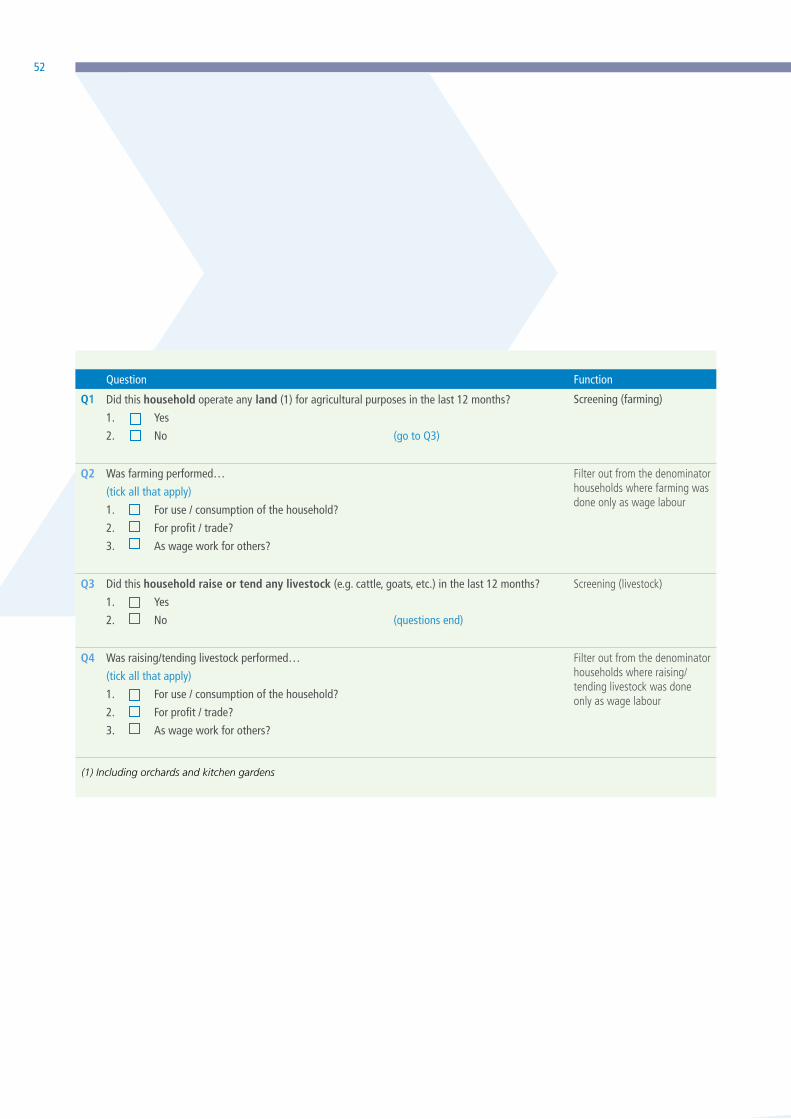
52
(1) Including orchards and kitchen gardens
Question Function
Q1 Did this household operate any land (1) for agricultural purposes in the last 12 months?
1. Yes
2. No (go to Q3)
Screening (farming)
Q2 Was farming performed…
(tick all that apply)
1. For use / consumption of the household?
2. For profit / trade?
3. As wage work for others?
Filter out from the denominator households where farming was done only as wage labour
Q3 Did this household raise or tend any livestock (e.g. cattle, goats, etc.) in the last 12 months?
1. Yes
2. No (questions end)
Screening (livestock)
Q4 Was raising/tending livestock performed…
(tick all that apply)
1. For use / consumption of the household?
2. For profit / trade?
3. As wage work for others?
Filter out from the denominator households where raising/tending livestock was done only as wage labour

53Measuring Individuals’ Rights to Land
As a consequence, in identifying agricultural households,
it is crucial to formulate questions in a way that they
minimize exclusion and inclusion errors. If the survey in
which this module is embedded does not already allow
for the identification of agricultural households (using
the definition above), the following set of questions
is recommended to be included in order to identify
agricultural households:
Households who operated land for agricultural
purposes and/or raised or tended livestock over the past
12 months (Q1=yes and/or Q3=yes) either for own use
or for profit (Q2=1 or 2 and/or Q4=1 or 2) are classified
as ‘agricultural households’. All adult members in
these households are eligible to be asked about their
rights to agricultural land and will be included in the
denominator of sub-indicator (a) of Indicator 5.a.1.
The questions above are consistent with those typically
included in population and housing censuses to identify
agricultural households for future agricultural censuses
or to update the frames for agricultural surveys.
If a country monitors Indicator 5.a.1 through a national
household survey, the screening and identification
of agricultural households is necessary. In addition,
especially in countries/regions where the proportion of
households engaged in agricultural production is low,
a pre-screening and oversampling may be needed,
especially in urban and peri-urban areas. If a country
monitors Indicator 5.a.1 through agricultural surveys
pre-screening and oversampling are not needed, as
the unit of analysis of these surveys are agricultural
holdings and very frequently a one-to-one relationship
exists in the household sector between holdings and
households.

54
QUESTIONNAIREVERSION
01- 05

55Measuring Individuals’ Rights to Land
Phot
o ©
Wor
ldBa
nk/T
ran
Thi H
oa.

56
QUESTIONNAIRE VERSION 01
VERSION 1 - PARCEL-LEVEL DATA; SELF-RESPONDENT APPROACH; NO PARCEL ROSTER ELSEWHERE; ASSUMES SEPARATE HOUSEHOLD MEMBER ROSTER WHICH RECORDS INDIVIDUAL SEX; ADMINISTERED TO (A) ONE OR MORE RANDOMLY SELECTED INDIVIDUALS OR (B) ALL ADULT HOUSEHOLD MEMBERS.
Implementation/
CAPI Notes
Use “currently” or set a specific date -- country level decision
Local/traditional area unit codes to be customized at country level Codes to be customized at country level
Codes to be customized at country level
Respondent Roster ID: _______
Q0. Do you use, own, or hold use rights for any parcel of land, either alone or jointly with someone else, irrespective of whether the parcel is used by your or another household, and irrespective of the use of the parcel (including dwelling plot, agricultural, pastoral, forest and business/commercial plots)?
YES...1
NO....2 >> END OF QUESTIONS
ENUMERATOR: AFTER CREATING THE ROSTER OF PARCELS, GO THROUGH THE ENTIRE MODULE ONE PARCEL AT A TIME.
PARCEL ID 1.
Parcel Name:
Please tell me about each parcel for which you currently use, own, or hold use rights for, either alone or with someone else. Please describe or give me the name of each parcel, starting with the parcel you reside on, if applicable.
2.
What is the area of the [PARCEL]?
CODES FOR UNIT:
ACRE .................1HECTARE ............2SQUARE METERS ....3OTHER (SPECIFY)....4
3. How was this [PARCEL] acquired?
GRANTED BY CUSTOMARY/
COMMUNITY
AUTHORITIES...........1
ALLOCATED BY
GOVERNMENT.............2
ALLOCATED BY
FAMILY MEMBER.........3
INHERITED BY THE
DEATH OF A
FAMILY MEMBER.......4 PURCHASED...................5
RENTED IN,SHORT-TERM
(<3 YEARS)...............6 >> 5
RENTED IN LONG-TERM...7
SHARECROPPED IN..........8 >> 5
BORROWED FOR FREE......9
BRIDE PRICE...............10
GIFT FROM
NON-HOUSEHOLD
MEMBER................11
MOVED IN WITHOUT
PERMISSION...........12
>> NEXT PARCEL
OTHER (SPECIFY)........13
4.
Under which tenure system is this [PARCEL]?
CUSTOMARY.......1
FREEHOLD.........2
LEASEHOLD.......3
STATE..............4
COMMUNITY/GROUP
RIGHT.......5
COOPERATIVES...6
OTHER
(SPECIFY)...7
a) b)
FARMER ESTIMATION GPS MEASURES
AREA UNIT AREA IN ACRES
1 – – – – .– – – – – – .– – – – – – .– –
2 – – – – .– – – – – – .– – -– – – – .– –
3 – – – – .– –- – – – – .– – – – – – .– –
4 – – – – .– – – – – – .– – – – – – .– –
5 – – – – .– – – – – – .– – – – – – .– –
Color Codes: SDG 1.4.2 SDG 5.1.1 Both 1.4.2 & 5.a.1 Analytical purposes only

57Measuring Individuals’ Rights to Land
1
2
3
4
5
VERSION 1- continued
Named agencies and examples to be customized for context
Codes to be customized at country level - to include all legally recognized documents. Rental contracts of some form should be included, as long as rights are legally protected
Photo aid to be shown to respondents.
skip for short term rental, sharecropped in, and borrowed for free
skip for short term rental, sharecropped in, and borrowed for free
5.
What are the current uses of this [PARCEL]?
SELECT ALL THAT APPLY
RESIDENTIAL.......1
AGRICULTURAL.....2
PASTORAL...........3
FOREST...............4
BUSINESS COMMERCIAL........5
DON’T KNOW........6
OTHER(SPECIFY)...7
6.
Is there a document for this [PARCEL] issued by or registered at the Land Registry/Cadastral Agency, such as a title deed, certificate of ownership, certificate of hereditary acquisition, lease or rental contract?
YES...1 NO....2 >> 8
7.
What type of documents are there for this [PARCEL], and is your name listed on any of the documents as owner or right use holder?
LIST UP TO 3, SHOW PHOTO AID
CODES FOR DOCUMENT TYPE:
TITLE DEED.........................1
CERTIFICATE OF USTOMARY
OWNERSHIP..........................2
CERTIFICATE OF OCCUPANCY....3
CERTIFICATE OF HEREDITARY A
CQUISITION LISTED IN
REGISTRY............................4
SURVEY PLAN......................5
RENTAL CONTRACT,
REGISTERED........................6
LEASE, REGISTERED..............7
OTHER (SPECIFY).................8
8.
Do you have the right to sell this [PARCEL], either alone or jointly with someone else?
YES.............1
NO..............2
DONT’KNOW..98
REFUSAL.....99
9.
Do you have the right to bequeath this [PARCEL], either alone or jointly with someone else?
YES............1
NO..............2
DONT’KNOW..98
REFUSAL.....99
10.
On a scale from 1 to 5, where 1 is not at all likely and 5 is extremely likely, how likely are you to involuntarily lose ownership or use rights to this [PARCEL] in the next 5 years?
NOT AT ALL
LIKELY............1
SLIGHTLY
LIKELY............2
MODERATELY
LIKELY............3
VERY LIKELY.....4
EXTREMELY
LIKELY............5
DOCUMENT #1 DOCUMENT #2 DOCUMENT #3
DOC. TYPE
NAME LISTED?
DOC. TYPE
NAME LISTED?
DOC. TYPE
NAME LISTED?
CODES FOR NAME
LISTED?
YES.........1
NO..........2
DONT’KNOW..98
REFUSAL....99
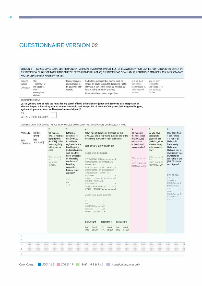
58
QUESTIONNAIRE VERSION 02
VERSION 2 – PARCEL-LEVEL DATA; SELF-RESPONDENT APPROACH; ASSUMES PARCEL ROSTER ELSEWHERE WHICH CAN BE FED FORWARD TO EITHER (A) THE INTERVIEW OF ONE OR MORE RANDOMLY SELECTED INDIVIDUALS OR (B) THE INTERVIEWS OF ALL ADULT HOUSEHOLD MEMBERS; ASSUMES SEPARATE HOUSEHOLD MEMBER ROSTER WITH SEX.
Impleme- ntation/
CAPI Notes
Use “currently” or set a specific date -- country level decision
Named agencies and examples to be customized for context
Codes to be customized at country level - to include all legally recognized documents. Rental contracts of some form should be included, as long as rights are legally protected
Photo aid to be shown to respondents.
skip for short term rental, sharecropped in, and borrowed for free
skip for short term rental, sharecropped in, and borrowed for free
Respondent Roster ID: _______
Q0. Do you use, own, or hold use rights for any parcel of land, either alone or jointly with someone else, irrespective of whether the parcel is used by your or another household, and irrespective of the use of the parcel (including dwelling plot, agricultural, pastoral, forest and business/commercial plots)?
YES...1
NO....2 >> END OF QUESTIONS
ENUMERATOR: AFTER CREATING THE ROSTER OF PARCELS, GO THROUGH THE ENTIRE MODULE ONE PARCEL AT A TIME.
PARCEL ID
[FED FORWARD]
1.
PARCEL NAME
[FED FORWARD]
2.
Do you use, own, or hold use rights for this [PARCEL], either alone or jointly with someone else?
YES......... 1
NO............2
>> NEXT
PARCEL
3.
Is there a document for this [PARCEL] issued by or registered at the Land Registry/Cadastral Agency, such as a title deed, certificate of ownership, certificate of hereditary acquisition, lease or rental contract?
YES......... 1
NO.......... 2
>> 5
4.
What type of documents are there for this [PARCEL], and is your name listed on any of the documents as owner or right use holder?
LIST UP TO 3, SHOW PHOTO AID
CODES FOR DOCUMENT
TYPE:TITLE DEED.................1
CERTIFICATE OF CUSTOMARY
OWNERSHIP..........................2
CERTIFICATE OF OCCUPANCY...3
CERTIFICATE OF HEREDITARY
ACQUISITION LISTED IN
REGISTRY............................4
SURVEY PLAN......................5
RENTAL CONTRACT,
REGISTERED.........................6
LEASE, REGISTERED..............7
OTHER (SPECIFY).................8
CODES FOR NAME LISTED?
YES....................1
NO.....................2
DONT’KNOW.........98
REFUSAL.............99
OTHER(SPECIFY)....8
5.
Do you have the right to sell this [PARCEL], either alone or jointly with someone else?
YES.............1
NO..............2
DONT’KNOW..98
REFUSAL.....99.
6.
Do you have the right to bequeath this [PARCEL], either alone or jointly with someone else?
YES.............1
NO..............2
DONT’KNOW..98
REFUSAL.....99
7.
On a scale from 1 to 5, where 1 is not at all likely and 5 is extremely likely, how likely are you to involuntarily lose ownership or use rights to this [PARCEL] in the next 5 years?
NOT AT ALL
LIKELY.........1
SLIGHTLY
LIKELY.........2
MODERATELY
LIKELY.........3
VERY
LIKELY.........4
EXTREMELY
LIKELY.........5
DOCUMENT 1 DOCUMENT 2 DOCUMENT 3
DOC. TYPE
NAME LISTED?
DOC. TYPE
NAME LISTED?
DOC. TYPE
NAME LISTED?
1
2
3
4
5
Color Codes: SDG 1.4.2 SDG 5.1.1 Both 1.4.2 & 5.a.1 Analytical purposes only

59Measuring Individuals’ Rights to Land
QUESTIONNAIRE VERSION 02
VERSION 2 – PARCEL-LEVEL DATA; SELF-RESPONDENT APPROACH; ASSUMES PARCEL ROSTER ELSEWHERE WHICH CAN BE FED FORWARD TO EITHER (A) THE INTERVIEW OF ONE OR MORE RANDOMLY SELECTED INDIVIDUALS OR (B) THE INTERVIEWS OF ALL ADULT HOUSEHOLD MEMBERS; ASSUMES SEPARATE HOUSEHOLD MEMBER ROSTER WITH SEX.
Impleme- ntation/
CAPI Notes
Use “currently” or set a specific date -- country level decision
Named agencies and examples to be customized for context
Codes to be customized at country level - to include all legally recognized documents. Rental contracts of some form should be included, as long as rights are legally protected
Photo aid to be shown to respondents.
skip for short term rental, sharecropped in, and borrowed for free
skip for short term rental, sharecropped in, and borrowed for free
Respondent Roster ID: _______
Q0. Do you use, own, or hold use rights for any parcel of land, either alone or jointly with someone else, irrespective of whether the parcel is used by your or another household, and irrespective of the use of the parcel (including dwelling plot, agricultural, pastoral, forest and business/commercial plots)?
YES...1
NO....2 >> END OF QUESTIONS
ENUMERATOR: AFTER CREATING THE ROSTER OF PARCELS, GO THROUGH THE ENTIRE MODULE ONE PARCEL AT A TIME.
PARCEL ID
[FED FORWARD]
1.
PARCEL NAME
[FED FORWARD]
2.
Do you use, own, or hold use rights for this [PARCEL], either alone or jointly with someone else?
YES......... 1
NO............2
>> NEXT
PARCEL
3.
Is there a document for this [PARCEL] issued by or registered at the Land Registry/Cadastral Agency, such as a title deed, certificate of ownership, certificate of hereditary acquisition, lease or rental contract?
YES......... 1
NO.......... 2
>> 5
4.
What type of documents are there for this [PARCEL], and is your name listed on any of the documents as owner or right use holder?
LIST UP TO 3, SHOW PHOTO AID
CODES FOR DOCUMENT
TYPE:TITLE DEED.................1
CERTIFICATE OF CUSTOMARY
OWNERSHIP..........................2
CERTIFICATE OF OCCUPANCY...3
CERTIFICATE OF HEREDITARY
ACQUISITION LISTED IN
REGISTRY............................4
SURVEY PLAN......................5
RENTAL CONTRACT,
REGISTERED.........................6
LEASE, REGISTERED..............7
OTHER (SPECIFY).................8
CODES FOR NAME LISTED?
YES....................1
NO.....................2
DONT’KNOW.........98
REFUSAL.............99
OTHER(SPECIFY)....8
5.
Do you have the right to sell this [PARCEL], either alone or jointly with someone else?
YES.............1
NO..............2
DONT’KNOW..98
REFUSAL.....99.
6.
Do you have the right to bequeath this [PARCEL], either alone or jointly with someone else?
YES.............1
NO..............2
DONT’KNOW..98
REFUSAL.....99
7.
On a scale from 1 to 5, where 1 is not at all likely and 5 is extremely likely, how likely are you to involuntarily lose ownership or use rights to this [PARCEL] in the next 5 years?
NOT AT ALL
LIKELY.........1
SLIGHTLY
LIKELY.........2
MODERATELY
LIKELY.........3
VERY
LIKELY.........4
EXTREMELY
LIKELY.........5
DOCUMENT 1 DOCUMENT 2 DOCUMENT 3
DOC. TYPE
NAME LISTED?
DOC. TYPE
NAME LISTED?
DOC. TYPE
NAME LISTED?
1
2
3
4
5
Phot
o ©
Wor
ld B
ank/
Dom
inic
Cha
vez.

60
QUESTIONNAIRE VERSION 03
VERSION 3 - INDIVIDUAL LEVEL DATA; SELF-RESPONDENT APPROACH; NOT REPORTED AT PARCEL LEVEL; ADMINISTERED TO (A) ONE OR MORE RANDOMLY SELECTED INDIVIDUALS OR (B) ALL ADULT HOUSEHOLD MEMBERS.
Impl
emen
tatio
n/CA
PI N
otes
Use “currently” or set a specific date - country level decision
Named agencies and examples to be customized for context
Codes to be customized at country level - to include all legally recognized documents. Rental contracts of some form should be included, as long as rights are legally protected
Photo aid to be shown to respondents.
skip for short term rental, sharecropped in, and borrowed for free
skip for short term rental, sharecropped in, and borrowed for free
Q0. Do you or does any member of your household use, own, or hold use rights for any parcel of land, either alone or jointly with someone else, irrespective of whether the parcel is used by your or another household, and irrespective of the use of the parcel (including dwelling plot, agricultural, pastoral, forest and business/commercial plots)?
YES...1
NO....2 >> END OF QUESTIONS
Agricultural Land
R
ESPO
NDE
NT
ID
2.
Do you currently use, own, or hold use rights for any agricultural land (including pastoral land), either alone or jointly with someone else?
YES...1
NO....2 >> Q8
3.
Is there a document for any agricultural land you own or hold use rights to that is issued by or registered at the Land Registry/Cadastral Agency, such as a title deed, certificate of ownership, certificate of hereditary acquisition, lease or rental contract?
YES...1
NO....2 >> 5
4.
What type of documents are there for the agricultural land you own or hold use rights to, and is your name listed on any of the documents as owner or right use holder?
LIST UP TO 3, SHOW PHOTO AID
CODES FOR DOCUMENT TYPE:
TITLE DEED.........................1
ERTIFICATE OF CUSTOMARY
OWNERSHIP..........................2
CERTIFICATE OF OCCUPANCY...3
CERTIFICATE OF EREDITARY
ACQUISITION LISTED
IN REGISTRY.......................4
SURVEY PLAN......................5
ENTAL CONTRACT,
REGISTERED........................6
LEASE, REGISTERED..............7
OTHER (SPECIFY).................8
5.
Do you have the right to sell any of the agricultural land you own or hold use rights to, either alone or jointly with someone else?
YES.............1
NO..............2
DONT’KNOW..98
REFUSAL.....99
6.
Do you have the right to bequeath any of the agricultural land you own or hold use rights to, either alone or jointly with someone else?
YES.............1
NO..............2
DONT’KNOW..98
REFUSAL.....99
7.
On a scale from 1 to 5, where 1 is not at all likely and 5 is extremely likely, how likely are you to involuntarily lose ownership or use rights to any of the agricultural land you own or hold use rights to in the next 5 years?
NOT AT ALL
LIKELY............1
SLIGHTLY
LIKELY............2
MODERATELY
LIKELY............3
VERY LIKELY.....4
EXTREMELY
LIKELY............5
DOCUMENT 1 DOCUMENT 2 DOCUMENT 3
DOC. TYPE
NAME LISTED?
DOC. TYPE
NAME LISTED?
DOC. TYPE
NAME LISTED?
1
2
3
4
5
1.
CODES FOR
NAME LISTED?
YES.............1
NO..............2
DONT’KNOW..98
REFUSAL.....99
Color Codes: SDG 1.4.2 SDG 5.1.1 Both 1.4.2 & 5.a.1 Analytical purposes only
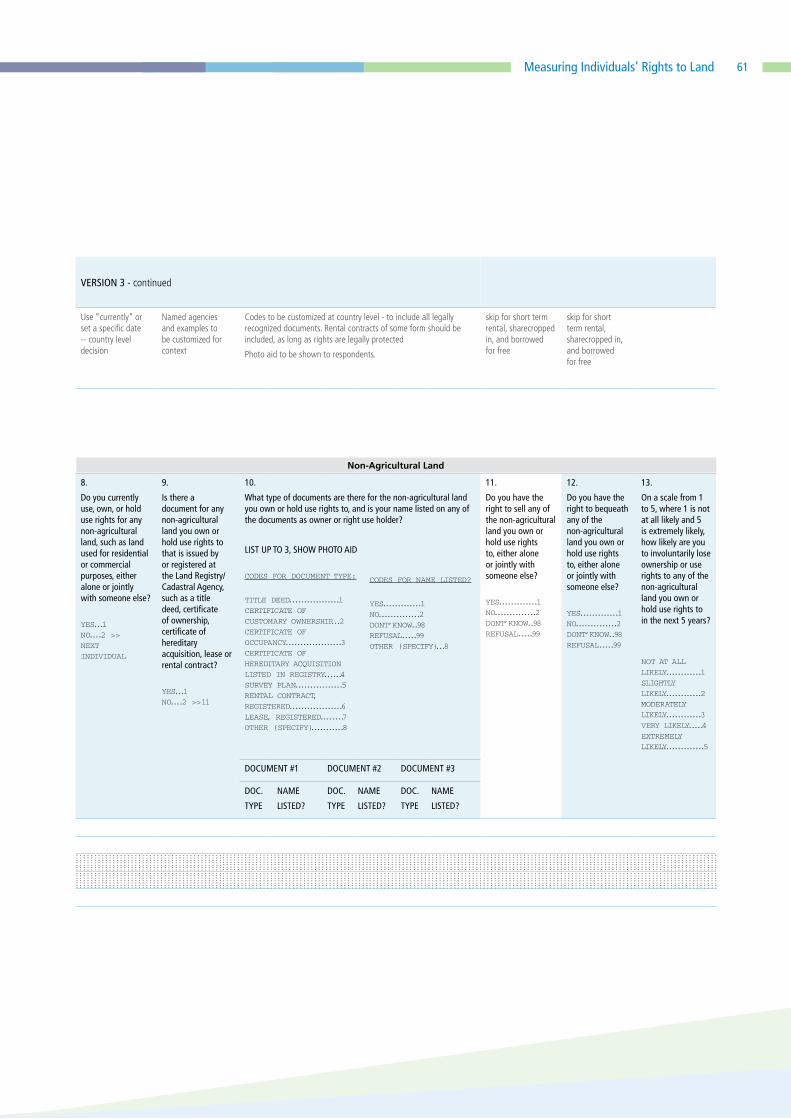
61Measuring Individuals’ Rights to Land
VERSION 3 - continued
Use “currently” or set a specific date -- country level decision
Named agencies and examples to be customized for context
Codes to be customized at country level - to include all legally recognized documents. Rental contracts of some form should be included, as long as rights are legally protected
Photo aid to be shown to respondents.
skip for short term rental, sharecropped in, and borrowed for free
skip for short term rental, sharecropped in, and borrowed for free
8.
Do you currently use, own, or hold use rights for any non-agricultural land, such as land used for residential or commercial purposes, either alone or jointly with someone else?
YES...1
NO....2 >>
NEXT
INDIVIDUAL
9.
Is there a document for any non-agricultural land you own or hold use rights to that is issued by or registered at the Land Registry/Cadastral Agency, such as a title deed, certificate of ownership, certificate of hereditary acquisition, lease or rental contract?
YES...1
NO....2 >> 11
10.
What type of documents are there for the non-agricultural land you own or hold use rights to, and is your name listed on any of the documents as owner or right use holder?
LIST UP TO 3, SHOW PHOTO AID
CODES FOR DOCUMENT TYPE:
TITLE DEED.................1
CERTIFICATE OF
CUSTOMARY OWNERSHIP...2
CERTIFICATE OF
OCCUPANCY...................3
CERTIFICATE OF
HEREDITARY ACQUISITION
LISTED IN REGISTRY......4
SURVEY PLAN................5
RENTAL CONTRACT,
REGISTERED..................6
LEASE, REGISTERED........7
OTHER (SPECIFY)...........8
11.
Do you have the right to sell any of the non-agricultural land you own or hold use rights to, either alone or jointly with someone else?
YES.............1
NO..............2
DONT’KNOW..98
REFUSAL.....99
12.
Do you have the right to bequeath any of the non-agricultural land you own or hold use rights to, either alone or jointly with someone else?
YES.............1
NO..............2
DONT’KNOW..98
REFUSAL.....99
13.
On a scale from 1 to 5, where 1 is not at all likely and 5 is extremely likely, how likely are you to involuntarily lose ownership or use rights to any of the non-agricultural land you own or hold use rights to in the next 5 years?
NOT AT ALL
LIKELY............1
SLIGHTLY
LIKELY............2
MODERATELY
LIKELY............3
VERY LIKELY.....4
EXTREMELY
LIKELY.............5
DOCUMENT #1 DOCUMENT #2 DOCUMENT #3
DOC.
TYPE
NAME
LISTED?
DOC.
TYPE
NAME
LISTED?
DOC.
TYPE
NAME
LISTED?
CODES FOR NAME LISTED?
YES.............1
NO..............2
DONT’KNOW..98
REFUSAL.....99
OTHER (SPECIFY)...8
Non-Agricultural Land
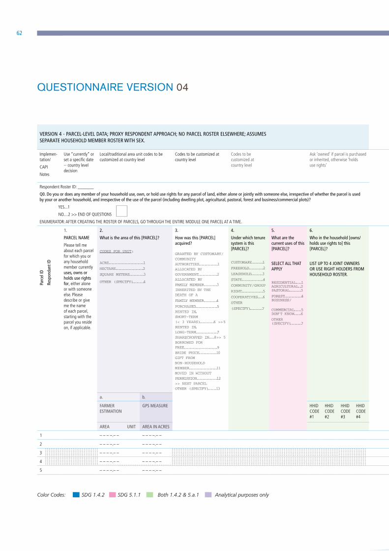
62
QUESTIONNAIRE VERSION 04
VERSION 4 - PARCEL-LEVEL DATA; PROXY RESPONDENT APPROACH; NO PARCEL ROSTER ELSEWHERE; ASSUMES SEPARATE HOUSEHOLD MEMBER ROSTER WITH SEX.
VERSION 4 - continued
Implemen-tation/
CAPI
Notes
Use “currently” or set a specific date -- country level decision
Local/traditional area unit codes to be customized at country level
Codes to be customized at country level
Codes to be customized at country level
Ask ‘owned’ if parcel is purchased or inherited, otherwise ‘holds use rights’
Named agencies and examples to be customized for context
Codes to be customized at country level - to include all legally recognized documents. Rental contracts of some form should be included, as long as rights are legally protected
Photo aid to be shown to respondents.
Respondent Roster ID: _______
Q0. Do you or does any member of your household use, own, or hold use rights for any parcel of land, either alone or jointly with someone else, irrespective of whether the parcel is used by your or another household, and irrespective of the use of the parcel (including dwelling plot, agricultural, pastoral, forest and business/commercial plots)?
YES...1
NO....2 >> END OF QUESTIONS
ENUMERATOR: AFTER CREATING THE ROSTER OF PARCELS, GO THROUGH THE ENTIRE MODULE ONE PARCEL AT A TIME.
P
arce
l ID
R
espo
ndan
t ID
1.
PARCEL NAME
Please tell me about each parcel for which you or any household member currently uses, owns or holds use rights for, either alone or with someone else. Please describe or give me the name of each parcel, starting with the parcel you reside on, if applicable.
2.
What is the area of this [PARCEL]?
CODES FOR UNIT:
ACRE........................1
HECTARE...................2
SQUARE METERS..........3
OTHER (SPECIFY)........4
3.
How was this [PARCEL] acquired?
GRANTED BY CUSTOMARY/
COMMUNITY
AUTHORITIES.............1
ALLOCATED BY
GOVERNMENT.............2
ALLOCATED BY
FAMILY MEMBER.........3
INHERITED BY THE
DEATH OF A
FAMILY MEMBER.........4
PURCHASED...............5
RENTED IN,
SHORT-TERM
(< 3 YEARS)..........6 >> 5
RENTED IN,
LONG-TERM...............7
SHARECROPPED IN....8>> 5
BORROWED FOR
FREE.......................9
BRIDE PRICE............10
GIFT FROM
NON-HOUSEHOLD
MEMBER...................11
MOVED IN WITHOUT
PERMISSION..............12
>> NEXT PARCEL
OTHER (SPECIFY)......13
4.
Under which tenure system is this [PARCEL]?
CUSTOMARY........1
FREEHOLD..........2
LEASEHOLD........3
STATE...............4
COMMUNITY/GROUP
RIGHT...............5
COOPERATIVES....6
OTHER
(SPECIFY).........7
5.
What are the current uses of this [PARCEL]?
SELECT ALL THAT APPLY
RESIDENTIAL....1 AGRICULTURAL..2 PASTORAL........3
FOREST............4 BUSINESS/
COMMERCIAL.....5 DON’T KNOW.....6
OTHER (SPECIFY)........7
6.
Who in the household [owns/ holds use rights to] this [PARCEL]?
LIST UP TO 4 JOINT OWNERS OR USE RIGHT HOLDERS FROM HOUSEHOLD ROSTER.
7.
Does your household have a document for this [PARCEL] issued by or registered at the Land Registry/Cadastral Agency, such as a title deed, certificate of ownership, certificate of hereditary acquisition, lease or rental contract?
YES...1
NO....2 >> 9
8.
What type of documents does your household have for this [PARCEL], and which household members are listed as owners or use rights holders on each?
LIST UP TO 3, SHOW PHOTO AID
DOCUMENT TYPE:
TITLE DEED..........................................1
CERTIFICATE OF CUSTOMARY OWNERSHIP.....2
CERTIFICATE OF OCCUPANCY.....................3
CERTIFICATE OF HEREDITARY ACQUISITION LISTED IN REGISTRY............4
SURVEY PLAN........................................5
RENTAL CONTRACT,REGISTERED.................6
LEASE, REGISTERED...............................7
OTHER (SPECIFY)..................................8
IF NO HOUSEHOLD MEMBER ON DOCUMENT, ENTER “98”
IF DON’T KNOW, ENTER “99”
a. b. DOCUMENT #1 DOCUMENT #2 DOCUMENT #3
FARMER ESTIMATION
GPS MEASURE HHID CODE #1
HHID CODE #2
HHID CODE #3
HHID CODE #4
DOC. TYPE
HHID CODE #1
HHID CODE #2
HHID CODE #3
HHID CODE #4
DOC. TYPE
HHID CODE #1
HHID CODE #2
HHID CODE #3
HHID CODE #4
DOC. TYPE
HHID CODE #1
HHID CODE #2
HHID CODE #3
HHID CODE #4
AREA UNIT AREA IN ACRES
1 – – – –.– – – – – –.– – 1
2 – – – –.– – – – – –.– – 2
3 – – – –.– – – – – –.– – 3
4 – – – –.– – – – – –.– – 4
5 – – – –.– – – – – –.– – 5
Color Codes: SDG 1.4.2 SDG 5.1.1 Both 1.4.2 & 5.a.1 Analytical purposes only
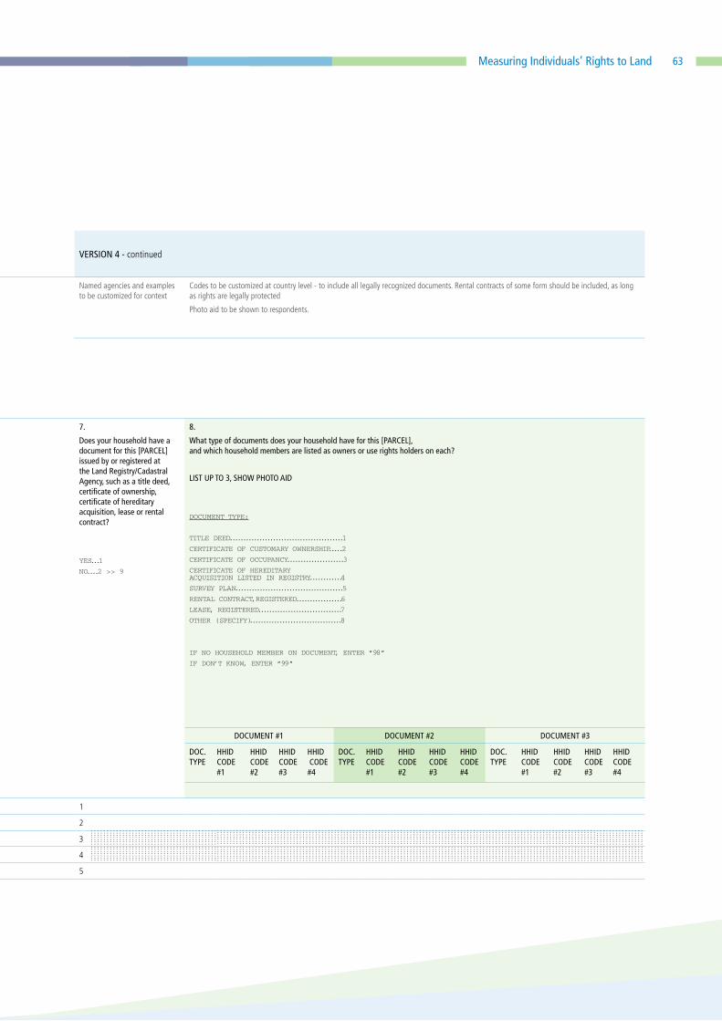
63Measuring Individuals’ Rights to Land
QUESTIONNAIRE VERSION 04
VERSION 4 - PARCEL-LEVEL DATA; PROXY RESPONDENT APPROACH; NO PARCEL ROSTER ELSEWHERE; ASSUMES SEPARATE HOUSEHOLD MEMBER ROSTER WITH SEX.
VERSION 4 - continued
Implemen-tation/
CAPI
Notes
Use “currently” or set a specific date -- country level decision
Local/traditional area unit codes to be customized at country level
Codes to be customized at country level
Codes to be customized at country level
Ask ‘owned’ if parcel is purchased or inherited, otherwise ‘holds use rights’
Named agencies and examples to be customized for context
Codes to be customized at country level - to include all legally recognized documents. Rental contracts of some form should be included, as long as rights are legally protected
Photo aid to be shown to respondents.
Respondent Roster ID: _______
Q0. Do you or does any member of your household use, own, or hold use rights for any parcel of land, either alone or jointly with someone else, irrespective of whether the parcel is used by your or another household, and irrespective of the use of the parcel (including dwelling plot, agricultural, pastoral, forest and business/commercial plots)?
YES...1
NO....2 >> END OF QUESTIONS
ENUMERATOR: AFTER CREATING THE ROSTER OF PARCELS, GO THROUGH THE ENTIRE MODULE ONE PARCEL AT A TIME.
P
arce
l ID
R
espo
ndan
t ID
1.
PARCEL NAME
Please tell me about each parcel for which you or any household member currently uses, owns or holds use rights for, either alone or with someone else. Please describe or give me the name of each parcel, starting with the parcel you reside on, if applicable.
2.
What is the area of this [PARCEL]?
CODES FOR UNIT:
ACRE........................1
HECTARE...................2
SQUARE METERS..........3
OTHER (SPECIFY)........4
3.
How was this [PARCEL] acquired?
GRANTED BY CUSTOMARY/
COMMUNITY
AUTHORITIES.............1
ALLOCATED BY
GOVERNMENT.............2
ALLOCATED BY
FAMILY MEMBER.........3
INHERITED BY THE
DEATH OF A
FAMILY MEMBER.........4
PURCHASED...............5
RENTED IN,
SHORT-TERM
(< 3 YEARS)..........6 >> 5
RENTED IN,
LONG-TERM...............7
SHARECROPPED IN....8>> 5
BORROWED FOR
FREE.......................9
BRIDE PRICE............10
GIFT FROM
NON-HOUSEHOLD
MEMBER...................11
MOVED IN WITHOUT
PERMISSION..............12
>> NEXT PARCEL
OTHER (SPECIFY)......13
4.
Under which tenure system is this [PARCEL]?
CUSTOMARY........1
FREEHOLD..........2
LEASEHOLD........3
STATE...............4
COMMUNITY/GROUP
RIGHT...............5
COOPERATIVES....6
OTHER
(SPECIFY).........7
5.
What are the current uses of this [PARCEL]?
SELECT ALL THAT APPLY
RESIDENTIAL....1 AGRICULTURAL..2 PASTORAL........3
FOREST............4 BUSINESS/
COMMERCIAL.....5 DON’T KNOW.....6
OTHER (SPECIFY)........7
6.
Who in the household [owns/ holds use rights to] this [PARCEL]?
LIST UP TO 4 JOINT OWNERS OR USE RIGHT HOLDERS FROM HOUSEHOLD ROSTER.
7.
Does your household have a document for this [PARCEL] issued by or registered at the Land Registry/Cadastral Agency, such as a title deed, certificate of ownership, certificate of hereditary acquisition, lease or rental contract?
YES...1
NO....2 >> 9
8.
What type of documents does your household have for this [PARCEL], and which household members are listed as owners or use rights holders on each?
LIST UP TO 3, SHOW PHOTO AID
DOCUMENT TYPE:
TITLE DEED..........................................1
CERTIFICATE OF CUSTOMARY OWNERSHIP.....2
CERTIFICATE OF OCCUPANCY.....................3
CERTIFICATE OF HEREDITARY ACQUISITION LISTED IN REGISTRY............4
SURVEY PLAN........................................5
RENTAL CONTRACT,REGISTERED.................6
LEASE, REGISTERED...............................7
OTHER (SPECIFY)..................................8
IF NO HOUSEHOLD MEMBER ON DOCUMENT, ENTER “98”
IF DON’T KNOW, ENTER “99”
a. b. DOCUMENT #1 DOCUMENT #2 DOCUMENT #3
FARMER ESTIMATION
GPS MEASURE HHID CODE #1
HHID CODE #2
HHID CODE #3
HHID CODE #4
DOC. TYPE
HHID CODE #1
HHID CODE #2
HHID CODE #3
HHID CODE #4
DOC. TYPE
HHID CODE #1
HHID CODE #2
HHID CODE #3
HHID CODE #4
DOC. TYPE
HHID CODE #1
HHID CODE #2
HHID CODE #3
HHID CODE #4
AREA UNIT AREA IN ACRES
1 – – – –.– – – – – –.– – 1
2 – – – –.– – – – – –.– – 2
3 – – – –.– – – – – –.– – 3
4 – – – –.– – – – – –.– – 4
5 – – – –.– – – – – –.– – 5

64
QUESTIONNAIRE VERSION 04
VERSION 4 - continued
skip for short term rental, sharecropped in, and borrowed for free
skip for short term rental, sharecropped in, and borrowed for free
skip for short term rental, sharecropped in, and borrowed for free
skip for short term rental, sharecropped in, and borrowed for free
Asked for each owner/use right holder separately, where [NAME of owner/use right holder] is linked to all persons reported in Q6.
If short term rental, rephrase as [In the remaining duration of the rental contract].
9. Does anyone in the household have the right to sell [PARCEL], either alone or with someone else?
YES.............1
NO..............2 >>11
DONT’KNOW..98 >>11
REFUSAL.....99 >>11
10. Who can decide whether to sell [PARCEL]?
LIST UP TO 4 ID CODES FROM HOUSEHOLD ROSTER AND 1 CODE FROM OUTSIDE HOUSEHOLD, IF APPLICABLE.
CODE FOR NON-HH MEMBER:
RELATIVE...............1
LOCAL OFFICIAL......2
CUSTOMARY LEADER..3
OTHER....................4
11. Does anyone in the household have the right to bequeath this [PARCEL], either alone or with someone else?
YES.............1
NO..............2 >>13
DONT’KNOW..98 >>13
REFUSAL.....99 >>13
12. Who can decide whether to bequeath this [PARCEL]?
LIST UP TO 4 ID CODES FROM HOUSEHOLD ROSTER AND 1 CODE FROM OUTSIDE HOUSEHOLD, IF APPLICABLE.
CODE FOR NON-HH MEMBER:
RELATIVE...............1
LOCAL OFFICIAL......2
CUSTOMARY LEADER..3
OTHER....................4
13. On a scale from 1 to 5, where 1 is not at all likely and 5 is extremely likely, how likely is [NAME of owner/use right holder] to involuntarily lose ownership or use rights to this [PARCEL] in the next 5 years?
REFER TO ID CODES IN Q6
NOT AT ALL LIKELY......1
SLIGHTLY LIKELY.........2
MODERATELY LIKELY.....3
VERY LIKELY...............4
EXTREMELY LIKELY.......5
Individual
1
Individual 2
Individual
3
Individual
4
HHID CODE #1
HHID CODE #2
HHID CODE #3
HHID CODE #4
Non HH member
HHID CODE #1
HHID CODE #2
HHID CODE #3
HHID CODE #4
Non HH member
ID ID ID ID
Response Response Response Response
1
2
3
4
5
Color Codes: SDG 1.4.2 SDG 5.1.1 Both 1.4.2 & 5.a.1 Analytical purposes only

65Measuring Individuals’ Rights to Land
Phot
o ©
Wor
ld B
ank/
Aish
a Fa
quir.

66
QUESTIONNAIRE VERSION 05
VERSION 5 - INDIVIDUAL LEVEL DATA; PROXY RESPONDENT APPROACH; NOT REPORTED AT PARCEL LEVEL. VERSION 5 - continued
Implemen- tation/
CAPI Notes
Use “currently” or set a specific date - country level decision
Named agencies and examples to be customized for context
Codes to be customized at country level - to include all legally recognized documents. Rental contracts of some form should be included, as long as rights are legally protected
Photo aid to be shown to respondents.
Use “currently” or set a specific date -- country level decision
Named agencies and examples to be customized for context
Codes to be customized at country level - to include all legally recognized documents. Rental contracts of some form should be included, as long as rights are legally protected
Photo aid to be shown to respondents.
Q0. Do you or does any member of your household use, own, or hold use rights for any parcel of land, either alone or jointly with someone else, irrespective of whether the parcel is used by your or another household, and irrespective of the use of the parcel (including dwelling plot, agricultural, pastoral, forest and business/commercial plots)?
YES...1 >> ASK FOLLOWING QUESTIONS ABOUT EACH ADULT HOUSEHOLD MEMBER
NO....2 >> END OF QUESTIONS
LIST ALL ADULT HOUSEHOLD MEMBERS FROM HOUSEHOLD ROSTER
[FED FORWARD]
1. ENTER THE ID OF THE INDIVIDUAL RESPONDING FOR [NAME]
2. Does [NAME] currently use, own, or hold use rights for any agricultural land (including pastoral land), either alone or jointly with someone else?
YES...1
NO....2 >> Q8
3. Is there a document for any agricultral land [NAME] owns or holds use rights to that is issued by or registered at the Land Registry/Cadastral Agency, such as a title deed, certificate of ownership, certificate of hereditary acquisition, lease or rental contract?
YES...1
NO....2 >> 5
4. What type of documents are there for the agricultural land [NAME] owns or holds use rights to, and is [NAME] listed on any of the documents as owner or right use holder?
LIST UP TO 3, SHOW PHOTO AID
CODES FOR DOCUMENT TYPE:
TITLE DEED.................1
CERTIFICATE OF
CUSTOMARY OWNERSHIP.....2
CERTIFICATE OF OCCUPANCY...3
CERTIFICATE OF
HEREDITARY ACQUISITION
LISTED IN REGISTRY......4
SURVEY PLAN................5
RENTAL CONTRACT,
REGISTERED............6
LEASE, REGISTERED..........7
OTHER (SPECIFY)............8
5. Does [NAME] have the right to sell any of the agricultural land [NAME] owns or holds use rights to, either alone or jointly with someone else?
6. Does [NAME] have the right to bequeath any of the agricultural land [NAME] owns or holds use rights to, either alone or jointly with someone else?
7. On a scale from 1 to 5, where 1 is not at all likely and 5 is extremely likely, how likely is [NAME] to involuntarily lose ownership or use rights to any of the agricultural land [NAME] owns or holds use rights to in the next 5 years?
8. Does [NAME] currently use, own, or hold use rights for any non-agricultural land, such as land used for residential or commecial purposes, either alone or jointly with someone else?
YES...1
NO....2 >> NEXT INDIVIDUAL
9. Is there a document for any non-agricultral land [NAME] owns or holds use rights to that is issued by or registered at the Land Registry/Cadastral Agency, such as a title deed, certificate of ownership, certificate of hereditary acquisition, lease or rental contract?
YES...1
NO....2 >> 11
10. What type of documents are there for the non-agricultural land [NAME] owns or holds use rights to, and is [NAME] name listed on any of the documents as owner or right use holder?
LIST UP TO 3, SHOW PHOTO AID?
11. Does [NAME] have the right to sell any of the non-agricultural land [NAME] owns or holds use rights to, either alone or jointly with someone else?
YES.........1
NO..........2
DONT’KNOW..98
REFUSAL....99
12. Does [NAME] have the right to bequeath any of the non-agricultural land [NAME] owns or holds use rights to, either alone or jointly with someone else?
YES.........1
NO..........2
DONT’KNOW..98
REFUSAL....99
13.
On a scale from 1 to 5, where 1 is not at all likely and 5 is extremely likely, how likely is [NAME] to involuntarily lose ownership or use rights to any of the non-agricultural land [NAME] owns or holsd use rights to in the next 5 years?
NOT AT ALL LIKELY..1
SLIGHTLY LIKELY....2
MODERATELY LIKELY..3
VERY LIKELY........4
EXTREMELY LIKELY...5
DOCUMENT #1 DOCUMENT #2 DOCUMENT #3 DOCUMENT #1 DOCUMENT #2 DOCUMENT #3
DOC. TYPE
NAME LISTED?
DOC. TYPE
NAME LISTED?
DOC. TYPE
NAME LISTED?
DOC. TYPE
NAME LISTED?
DOC. TYPE
NAME LISTED?
DOC. TYPE
NAME LISTED?
1.
2.
3.
4.
5.
CODES FOR NAME LISTED?
YES.........1
NO..........2
DONT’KNOW..98
REFUSAL....99
Color Codes: SDG 1.4.2 SDG 5.1.1 Both 1.4.2 & 5.a.1 Analytical purposes only

67Measuring Individuals’ Rights to Land
QUESTIONNAIRE VERSION 05
VERSION 5 - INDIVIDUAL LEVEL DATA; PROXY RESPONDENT APPROACH; NOT REPORTED AT PARCEL LEVEL. VERSION 5 - continued
Implemen- tation/
CAPI Notes
Use “currently” or set a specific date - country level decision
Named agencies and examples to be customized for context
Codes to be customized at country level - to include all legally recognized documents. Rental contracts of some form should be included, as long as rights are legally protected
Photo aid to be shown to respondents.
Use “currently” or set a specific date -- country level decision
Named agencies and examples to be customized for context
Codes to be customized at country level - to include all legally recognized documents. Rental contracts of some form should be included, as long as rights are legally protected
Photo aid to be shown to respondents.
Q0. Do you or does any member of your household use, own, or hold use rights for any parcel of land, either alone or jointly with someone else, irrespective of whether the parcel is used by your or another household, and irrespective of the use of the parcel (including dwelling plot, agricultural, pastoral, forest and business/commercial plots)?
YES...1 >> ASK FOLLOWING QUESTIONS ABOUT EACH ADULT HOUSEHOLD MEMBER
NO....2 >> END OF QUESTIONS
LIST ALL ADULT HOUSEHOLD MEMBERS FROM HOUSEHOLD ROSTER
[FED FORWARD]
1. ENTER THE ID OF THE INDIVIDUAL RESPONDING FOR [NAME]
2. Does [NAME] currently use, own, or hold use rights for any agricultural land (including pastoral land), either alone or jointly with someone else?
YES...1
NO....2 >> Q8
3. Is there a document for any agricultral land [NAME] owns or holds use rights to that is issued by or registered at the Land Registry/Cadastral Agency, such as a title deed, certificate of ownership, certificate of hereditary acquisition, lease or rental contract?
YES...1
NO....2 >> 5
4. What type of documents are there for the agricultural land [NAME] owns or holds use rights to, and is [NAME] listed on any of the documents as owner or right use holder?
LIST UP TO 3, SHOW PHOTO AID
CODES FOR DOCUMENT TYPE:
TITLE DEED.................1
CERTIFICATE OF
CUSTOMARY OWNERSHIP.....2
CERTIFICATE OF OCCUPANCY...3
CERTIFICATE OF
HEREDITARY ACQUISITION
LISTED IN REGISTRY......4
SURVEY PLAN................5
RENTAL CONTRACT,
REGISTERED............6
LEASE, REGISTERED..........7
OTHER (SPECIFY)............8
5. Does [NAME] have the right to sell any of the agricultural land [NAME] owns or holds use rights to, either alone or jointly with someone else?
6. Does [NAME] have the right to bequeath any of the agricultural land [NAME] owns or holds use rights to, either alone or jointly with someone else?
7. On a scale from 1 to 5, where 1 is not at all likely and 5 is extremely likely, how likely is [NAME] to involuntarily lose ownership or use rights to any of the agricultural land [NAME] owns or holds use rights to in the next 5 years?
8. Does [NAME] currently use, own, or hold use rights for any non-agricultural land, such as land used for residential or commecial purposes, either alone or jointly with someone else?
YES...1
NO....2 >> NEXT INDIVIDUAL
9. Is there a document for any non-agricultral land [NAME] owns or holds use rights to that is issued by or registered at the Land Registry/Cadastral Agency, such as a title deed, certificate of ownership, certificate of hereditary acquisition, lease or rental contract?
YES...1
NO....2 >> 11
10. What type of documents are there for the non-agricultural land [NAME] owns or holds use rights to, and is [NAME] name listed on any of the documents as owner or right use holder?
LIST UP TO 3, SHOW PHOTO AID?
11. Does [NAME] have the right to sell any of the non-agricultural land [NAME] owns or holds use rights to, either alone or jointly with someone else?
YES.........1
NO..........2
DONT’KNOW..98
REFUSAL....99
12. Does [NAME] have the right to bequeath any of the non-agricultural land [NAME] owns or holds use rights to, either alone or jointly with someone else?
YES.........1
NO..........2
DONT’KNOW..98
REFUSAL....99
13.
On a scale from 1 to 5, where 1 is not at all likely and 5 is extremely likely, how likely is [NAME] to involuntarily lose ownership or use rights to any of the non-agricultural land [NAME] owns or holsd use rights to in the next 5 years?
NOT AT ALL LIKELY..1
SLIGHTLY LIKELY....2
MODERATELY LIKELY..3
VERY LIKELY........4
EXTREMELY LIKELY...5
DOCUMENT #1 DOCUMENT #2 DOCUMENT #3 DOCUMENT #1 DOCUMENT #2 DOCUMENT #3
DOC. TYPE
NAME LISTED?
DOC. TYPE
NAME LISTED?
DOC. TYPE
NAME LISTED?
DOC. TYPE
NAME LISTED?
DOC. TYPE
NAME LISTED?
DOC. TYPE
NAME LISTED?
1.
2.
3.
4.
5.

68

69Measuring Individuals’ Rights to Land
Phot
o ©
Wor
ld B
ank/
Arne
Hoe
l.


The World Bank Group
The World Bank Group is one of the world’s largest sources of funding and knowledge for developing countries. It comprises five closely associated institutions: the International Bank for Reconstruction and Development (IBRD) and the International Development Association (IDA), which together form the World Bank; the International Finance Corporation (IFC); the Multilateral Investment Guarantee Agency (MIGA); and the International Centre for Settlement of Investment Disputes (ICSID). Each institution plays a distinct role in the mission to fight poverty and improve living standards for people in the developing world. For more information, please visit www.worldbank.org, www.miga.org, and www.ifc.org.
The Food and Agriculture Organization of the United Nations - FAO
The Food and Agriculture Organization of the United Nations (FAO) is a specialized agency of the United Nations that leads international efforts to combat hunger. FAO’s mission is to achieve food security for all and to make sure that people have regular access to enough high-quality food to lead active, healthy lives. To meet the demands posed by global trends in agricultural development and challenges faced by member nations, FAO has identified the following areas of work to concentrate its efforts in striving to achieve its vision and global goals. These are to: eliminate hunger, food insecurity and malnutrition, increase productivity and sustainability of agriculture, forestry and fishery, reduce rural poverty, enable inclusive and efficient agricultural and food systems, and increase the resilience to threats and crises. For more information, please visit www.fao.org
The United Nations Human Settlements Programme - UN Habitat
UN-Habitat helps the urban poor by transforming cities into safer, healthier, greener places with better opportunities where everyone can live in dignity. UN-Habitat works with organizations at every level, including all spheres of government, civil society and the private sector to help build, manage, plan and finance sustainable urban development. Our mission is to promote socially and environmentally sustainable human settlements development and the achievement of adequate shelter for all. For more information, visit www.unhabitat.org.

The World Bank Group1818 H Street NW, Washington DC 20433, USA
Food and Agriculture Organization of the United Nations (FAO) Viale delle Terme di Caracalla00153, Rome, Italy
United Nations Human Settlements Programme (UN Habitat)United Nations Office in NairobiUN Avenue.GigiriNairobi, Kenya
About this publication
This document aims to facilitate the successful, efficient, and cross-country comparable data collection for computation of SDG indicators 1.4.2 and 5.a.1 in line with the methodologies approved by the IAEG-SDGs. It provides an overview of the indicators, a discussion on the various questionnaire modules proposed, and detailed question-by-question guidance for each. It is targeted primarily for use by national statistical offices (NSOs) and other survey practitioners, in order to inform the monitoring of these two indicators and to providing guidance on the collection of data necessary for their regular reporting.