Mcollum 2007 Volcanic Eruptions Earthquakes and Tsunamis
81
Transcript of Mcollum 2007 Volcanic Eruptions Earthquakes and Tsunamis
Earth’s Journey Through Space
Electromagnetism, and How It Works
Gravity, and How It Works
Great Extinctions of the Past
Great Inventions of the 20th Century
Great Moments in Space Exploration
Volcanic Eruptions, Earthquakes, and TsunamisWeather, and How It Works

By Sean McCollum
Scientific American: Volcanic Eruptions, Earthquakes, and Tsunamis
Copyright 2007 by Infobase Publishing
Scientific American is a registered trademark of Scientific American, Inc. Its use is pursuant to a license with Scientific American, Inc.
All rights reserved. No part of this book may be reproduced or utilized in any form or by any means, electronic or mechanical, including photocopying,recording, or by any information storage or retrieval systems, without permis-sion in writing from the publisher. For information contact:
Chelsea HouseAn imprint of Infobase Publishing132 West 31st StreetNew York, NY 10001
Library of Congress Cataloging-in-Publication DataMcCollum, Sean, 1963–
Volcanic eruptions, earthquakes, and tsunamis / Sean McCollum.p. cm. — (Scientific american)
Includes bibliographical references and index.ISBN-13: 978-0-7910-9047-3 (hardcover)ISBN-10: 0-7910-9047-7 (hardcover)1. Volcanic eruptions—Juvenile literature. 2. Earthquakes—Juvenile
literature. 3. Tsunamis—Juvenile literature. I. Title. II. Series.QE522.M34 2007551.2–dc22 2007017740
Chelsea House books are available at special discounts when purchased in bulk quantities for businesses, associations, institutions, or sales promotions. Please call our Special Sales Department in New York at (212) 967-8800 or (800) 322-8755.
You can find Chelsea House books on the World Wide Web athttp://www.chelseahouse.com
Series designed by Gilda HannahCover designed by Takeshi Takahashi and Joo Young An
Printed in the United States of America
Bang GH 10 9 8 7 6 5 4 3 2 1
This book is printed on acid-free paper.
All links and Web addresses were checked and verified to be correct at the time of publication. Because of the dynamic nature of the Web, some addresses and links may have changed since publication and may no longer be valid.

CHAPTER ONE This Restless Planet 7
CHAPTER TWOVolcanic Eruptions: When the Magma Rises 18
CHAPTER THREE Earthquakes: Shocks from Underground 31
CHAPTER FOURTsunamis: Killer Waves 41
CHAPTER FIVE Building for “The Big One” 50
CHAPTER SIXThe Probability of Predicting Disaster 59
Glossary 73Bibliography 75Further Exploration 76Index 77About the Author 80Picture Credits 80
Contents

g g g g g g g

This Restless PlanetThis Restless Planet
This Restless Planet 7
he ocean wind carried the stink of rotten eggs to the Icelandcoast. Sensitive scientific instruments registered small earth-
quakes. The Icelanders recognized the signs: somewhere a vol-cano was spewing gases and preparing to erupt. The people thereknew the destructive power of volcanoes. Several were active ontheir island country. But where was this one rumbling?
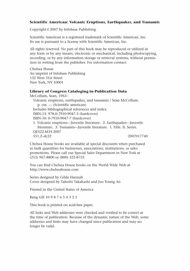
The crew of a fishing boat was the first to spot it on November14, 1963: a plume of smoke and steam billowing out of the At-lantic Ocean. The volcano had been growing underwater 33 miles(53 kilometers) from Iceland’s coast. Now the volcano’s cone hadreached the surface.
Scientists rushed to the spot to observe something they rarelyhad the chance to see: the fiery birth of a new island. For the nextthree years, this volcano erupted again and again. Sometimes itexploded and threw molten rock into the air. At other times,glowing orange lava oozed out and cooled into red-black rock.Each eruption created a new layer of land. In time, the volcanoformed an island 1.7 square miles (2.7 km2) in area and 300 feet(91 meters) high.
The new island was called Surtsey. Icelanders named it afterSurtur, a fire giant of Icelandic myth.
CHAPTER ONE
T
g
Undersea volcanic eruptions near Iceland formed the island of Surtsey.These eruptions continued off and on from 1963 through 1967.
Earth’s Supernatural PowerIt’s easy to understand why people link volcanoes and earth-quakes to giants, gods, and other supernatural beings. Thedestruction caused by earth-shaking seismic activity can bebeyond belief. (Seismic is the Greek term for “shaking.”) Forexample, the force of the 1980 eruption of Mount St. Helens inOregon was equal to a massive nuclear explosion. A powerful1999 earthquake in Turkey killed more than 17,000 people. In2004, a tsunami—a giant ocean wave launched by an underseaearthquake—destroyed towns and cities along the coasts of SouthAsia. More than 220,000 people died.
But volcanoes and earthquakes create as well as destroy. Theisland of Surtsey is one small example. Mountain ranges, pushedup when two landmasses collide, are much bigger ones. Earth’ssurface is slowly but constantly creating and remodeling itself. Inthe last 100 years, scientists have discovered more and more
8 Volcanic Eruptions, Earthquakes, and Tsunamis
Today, people often look to science for answers about the worldaround them. But in the past, people often turned to myths—ancientstories that give supernatural reasons for natural events, includingearthquakes and volcanoes.
In Japanese tradition, for example, earthquakes are caused bynamazu—a giant catfish that lives in the mud beneath Japan. TheKashima god keeps the fish in check beneath a magic rock. But whenthe god lets down his guard the catfish thrashes around, shaking theearth. In the traditions of India, Australia, and the Americas, mythic ani-mals are also the causes of seismic disasters.
Elsewhere, gods are held responsible. In Hawaii, the moody Pele isthe goddess of volcanoes. When she stamps her feet in anger, says thelegend, the ground moves and lava flows.The word volcano itself comesfrom Vulcan, the Roman god of fire, who is said to live in a volcano inItaly. There, in his fiery forge he hammers out weapons and armor forthe other gods.
This Restless Planet 9
about how Earth does this. Their work is saving lives as it unlocksthe secrets hidden far underground.
Unearthing Earth’s StructureThe key to understanding volcanoes and earthquakes liesbeneath the ground. For much of human history people assumedthat Earth was solid rock through and through. But about 500years ago, some wondered if the planet was mainly water withcontinents floating on top. Others observed lava bursting fromunderground and figured Earth’s interior must consist of thisfiery, melted rock.
It hasn’t been easy to discover the truth. Earth is about 3,960miles (6,378 km) from surface to center. Compare that to howdeep humans have penetrated the Earth. The deepest cavers haveever crept and crawled is about 1.3 miles (2.08 km) underground.The deepest mine reaches down only about 2.5 miles (about 4 km). The deepest humans have ever drilled is about 9 miles
MYTHS FOR SHAKY GROUND
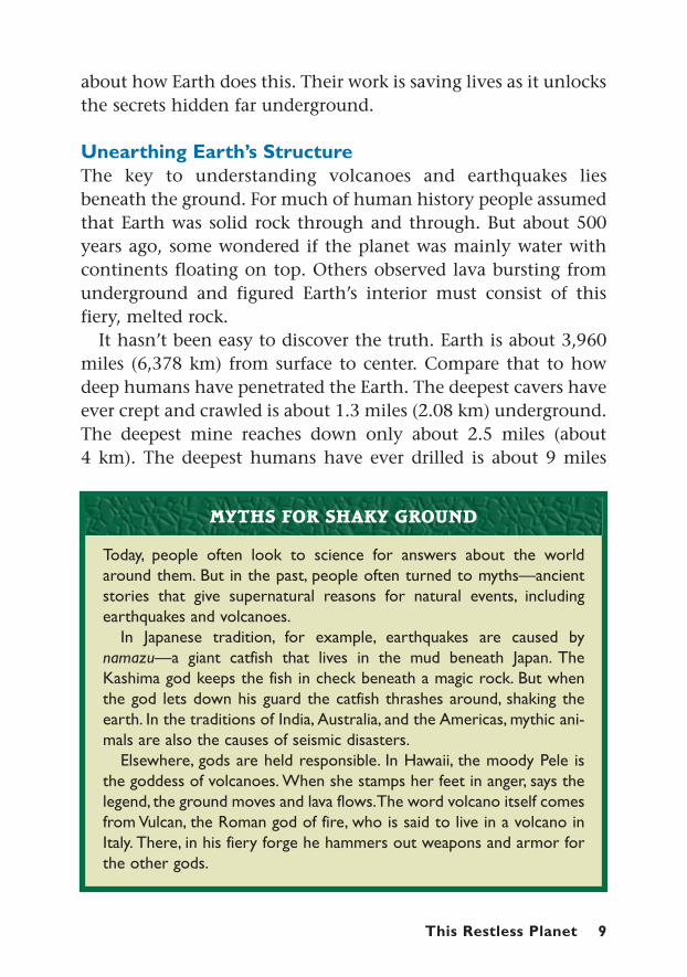
Lava from deep underground erupts in Iceland in 1973. The rock, minerals,and gases that reach the surface provide scientists with important informa-tion about Earth’s interior.
(14.5 km) deep. When it comes to exploring our planet, humanshave really only scratched the surface.
So how do scientists “explore” Earth’s inner reaches where noone has ever set foot? They study rocks that have been pushed upfrom deep underground. They also drill into Earth’s crust andbring up rock samples.
To investigate even deeper, researchers measure how vibrations,or seismic waves, move through the planet. They rely on sensi-tive instruments called seismometers to record and measurethese vibrations. Seismic waves move at different speeds throughdifferent materials, giving clues about what’s inside the Earth. In away, this process uses sound waves to take an x-ray of the planet.
Based on their findings, geologists now think Earth consistsof three main layers. On the surface is a hard and brittle outer
10 Volcanic Eruptions, Earthquakes, and Tsunamis

This diagram reveals Earth’s structure. Scientists believe that the planet con-sists of a solid superheated core and a liquid outer core.The upper andlower mantles are thick, semi-fluid layers of rocks and minerals. Earth’s crustis a thin, solid layer on the planet’s surface.
crust up to 50 miles (80 km) thick. This includes the continentsand seafloor. Below that is the mantle, a thick, semi-fluid layerof solid and molten rock that reaches down 1,800 miles (2,900km). And in Earth’s center is the core, a ball of partly solid, part-ly molten iron and nickel measuring about 1,800 to 3,960 miles(2,900–6,378 km) in diameter. Temperatures there may exceed9,000° F (5,000° C).
This Restless Planet 11
670 kmMantle
Outer core(liquid)
Crust
Innercore
(solid)
Upper mantle
Lower mantle
670 km
2,250 km 1,220 km
2,900 km
6,370 km
Upper mantle
Crust (5–80 km)
© Infobase Publishing
CH90477Volcanic Eruptions, Earthquakes, and Tsunamisfilename: CH90477-1-1-ErthCntr.aiIllustrator CS2origin: Encyclopedia of Earthquakes and Volcanoes/ertvol-23B.ai/63028-EthVol-35-ErthCntr.aifirst pass: 3/19/06
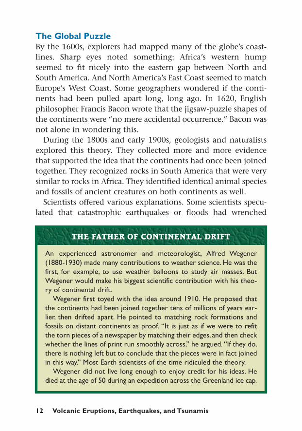
The Global PuzzleBy the 1600s, explorers had mapped many of the globe’s coast-lines. Sharp eyes noted something: Africa’s western humpseemed to fit nicely into the eastern gap between North andSouth America. And North America’s East Coast seemed to matchEurope’s West Coast. Some geographers wondered if the conti-nents had been pulled apart long, long ago. In 1620, Englishphilosopher Francis Bacon wrote that the jigsaw-puzzle shapes ofthe continents were “no mere accidental occurrence.” Bacon wasnot alone in wondering this.
During the 1800s and early 1900s, geologists and naturalistsexplored this theory. They collected more and more evidencethat supported the idea that the continents had once been joinedtogether. They recognized rocks in South America that were verysimilar to rocks in Africa. They identified identical animal speciesand fossils of ancient creatures on both continents as well.
Scientists offered various explanations. Some scientists specu-lated that catastrophic earthquakes or floods had wrenched
12 Volcanic Eruptions, Earthquakes, and Tsunamis
An experienced astronomer and meteorologist, Alfred Wegener(1880-1930) made many contributions to weather science. He was thefirst, for example, to use weather balloons to study air masses. ButWegener would make his biggest scientific contribution with his theo-ry of continental drift.
Wegener first toyed with the idea around 1910. He proposed thatthe continents had been joined together tens of millions of years ear-lier, then drifted apart. He pointed to matching rock formations andfossils on distant continents as proof. “It is just as if we were to refitthe torn pieces of a newspaper by matching their edges, and then checkwhether the lines of print run smoothly across,” he argued. “If they do,there is nothing left but to conclude that the pieces were in fact joinedin this way.” Most Earth scientists of the time ridiculed the theory.
Wegener did not live long enough to enjoy credit for his ideas. Hedied at the age of 50 during an expedition across the Greenland ice cap.
THE FATHER OF CONTINENTAL DRIFT
entire continents and oceans to new locations. Others arguedthat at one time there must have been land bridges connectingthe different continents. Plants and animals could have wan-dered across these links. They said that these land bridges musthave later sunk into the ocean.
Other facts, though, were at odds with the land bridge idea. Sci-entists discovered fossils of warm-weather plants on the icy conti-nent of Antarctica. They found evidence of glaciers in lands fartoo warm for them to exist today. This suggested that the conti-nents themselves had moved from warm regions to cold regions,and vice versa.
In 1912, a German scientist named Alfred Wegener delivered acontroversial theory: continental drift. He suggested thatabout 300 million years ago, all the continents were joinedtogether. They formed a supercontinent, which he called Pan-gaea, a Greek term for “all earth.” The continents then split apartand drifted away. Wegener suggested that the continents movedthrough the Earth’s crust like ships plowing through ice.
Most geologists met Wegener’s ideas with skepticism and evenscorn. They argued that the continents were too soft to ripthrough the hard rocks of the ocean floor. And no one couldimagine a force powerful enough to move the continents. Wegen-er could not come up with satisfactory responses to these doubts.He died without ever having won much support for his ideas.
New clues, though, were waiting on the ocean floor. Startingin the 1940s, new technologies such as sonar and submarinesgreatly advanced deep-sea exploration. One discovery was thatthe ocean floor wasn’t smooth like the bottom of most lakes.The depths hid a lively landscape of undersea mountain rangesand deep trenches. This suggested that the ocean floor was notunchanging, but active and developing. Tests also showed thatthe ocean crust was much younger than scientists had thought.
In 1959, American geologist Harry Hess proposed an explana-tion for these discoveries: seafloor spreading. He speculatedthat magma was squeezing up through large ridges that had been
This Restless Planet 13

found in the ocean floor. The force pushed away the crust oneither side of the ridge. Then the lava hardened into rock, creat-ing a new section of crust. These undersea eruptions were repeat-ed again and again over millions of years. Elsewhere, old crustwas being forced back into deep undersea trenches.
Additional research supported the idea of seafloor spreading. Inthe 1960s and 1970s, a specially designed ship called the GlomarChallenger drilled into the ocean floor. It retrieved some 19,000samples across miles of ocean. The farther the samples got fromthe volcanic ridges, the older the rocks were. In other words, thenew crust was pushing older crust away from the ridge. Tests ofthe ocean floor’s magnetic fields supported this idea.
All these findings confirmed the process of seafloor spreading.Earth is constantly churning out new crust through these ridges.Older crust is recycled back into the mantle in the deep-seatrenches.
14 Volcanic Eruptions, Earthquakes, and Tsunamis
This image was made using sonar and echo-sounding technology, whichbounces sound waves off the ocean floor. Located beneath the South PacificOcean, these underwater volcanoes are known as the Three Wise Men. Suchvolcanoes often develop near ridges where seafloor spreading occurs.
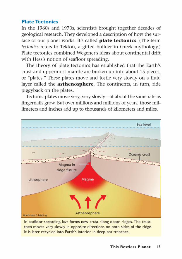
In seafloor spreading, lava forms new crust along ocean ridges. The crustthen moves very slowly in opposite directions on both sides of the ridge.It is later recycled into Earth’s interior in deep-sea trenches.
Plate TectonicsIn the 1960s and 1970s, scientists brought together decades ofgeological research. They developed a description of how the sur-face of our planet works. It’s called plate tectonics. (The termtectonics refers to Tekton, a gifted builder in Greek mythology.)Plate tectonics combined Wegener’s ideas about continental driftwith Hess’s notion of seafloor spreading.
The theory of plate tectonics has established that the Earth’scrust and uppermost mantle are broken up into about 15 pieces,or “plates.” These plates move and jostle very slowly on a fluidlayer called the asthenosphere. The continents, in turn, ridepiggyback on the plates.
Tectonic plates move very, very slowly—at about the same rate asfingernails grow. But over millions and millions of years, those mil-limeters and inches add up to thousands of kilometers and miles.
This Restless Planet 15

Thi
s w
orld
map
sho
ws
Eart
h’s
maj
or t
ecto
nic
plat
es.A
rrow
s in
dica
te t
he d
irec
tion
of t
heir
mov
emen
t.M
ost
volc
anoe
s an
d ea
rthq
uake
s oc
cur
whe
re t
he p
late
s gr
ind
agai
nst
each
oth
er.
16 Volcanic Eruptions, Earthquakes, and Tsunamis

Currently, scientists think there are two main forces drivingplate movement. One is convection. The mantle beneath theplates circulates, fueled by heat from the planet’s core. The man-tle heats up near the core causing it to rise toward the Earth’scrust. Near the surface and away from the heat source, it coolsand flows downward again. The rising and falling goop in a lavalamp is a good example of convection at work. Inside the Earth,the convection of the mantle slowly drives plate movement.
Gravity also applies force on tectonic plates. In the deep-seatrenches, gravity pulls down on the leading edge of the plate thatis sinking into the mantle. Ocean plates are heavier and denserthan continental plates, so they always dive under continentalplates. Like a tug on the edge of a tablecloth, the diving edgepulls the rest of the plate along with it.
We no longer think of Earth as a big, solid rock. Scientists nowdescribe a dynamic planet that is constantly changing little bylittle. Where the planet’s plates collide, grind together, and pullapart the world is its most restless. And that’s where most volca-noes and earthquakes do their creating and destroying.
This Restless Planet 17
Plate tectonics are constantly remodeling our planet. But lucky formapmakers, millions of years must pass before significant changes be-come noticeable.
The distant future will bring many changes to the globe’s appear-ance. Among others, the Atlantic Ocean will become wider and thePacific Ocean will narrow. Australia will move north and probably raminto Asia. A chunk of East Africa will begin to tear loose creating aninland sea. The coast of California will also pull away and drift north.Furthermore, the strip of land that connects North and South Ameri-ca will be pulled apart.
Hundreds of millions of years after that, the continents will all drifttogether to create a new supercontinent. Then they will move apartand wander away again.
OUR FUTURE GLOBE
18 Volcanic Eruptions, Earthquakes, and Tsunamis
Volcanic Eruptions:When the Magma Rises
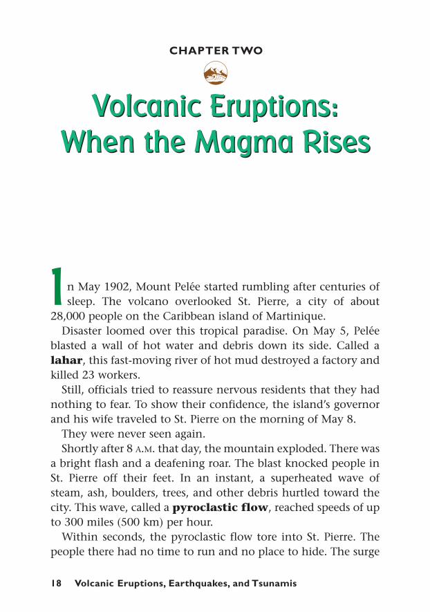
n May 1902, Mount Pelée started rumbling after centuries ofsleep. The volcano overlooked St. Pierre, a city of about
28,000 people on the Caribbean island of Martinique. Disaster loomed over this tropical paradise. On May 5, Pelée
blasted a wall of hot water and debris down its side. Called alahar, this fast-moving river of hot mud destroyed a factory andkilled 23 workers.
Still, officials tried to reassure nervous residents that they hadnothing to fear. To show their confidence, the island’s governorand his wife traveled to St. Pierre on the morning of May 8.
They were never seen again. Shortly after 8 A.M. that day, the mountain exploded. There was
a bright flash and a deafening roar. The blast knocked people inSt. Pierre off their feet. In an instant, a superheated wave ofsteam, ash, boulders, trees, and other debris hurtled toward thecity. This wave, called a pyroclastic flow, reached speeds of upto 300 miles (500 km) per hour.
Within seconds, the pyroclastic flow tore into St. Pierre. Thepeople there had no time to run and no place to hide. The surge
Volcanic Eruptions:When the Magma Rises
CHAPTER TWO
g
I
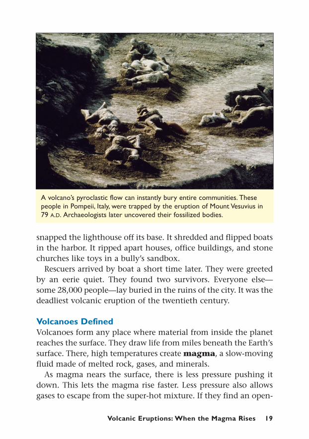
A volcano’s pyroclastic flow can instantly bury entire communities. Thesepeople in Pompeii, Italy, were trapped by the eruption of Mount Vesuvius in79 A.D. Archaeologists later uncovered their fossilized bodies.
snapped the lighthouse off its base. It shredded and flipped boatsin the harbor. It ripped apart houses, office buildings, and stonechurches like toys in a bully’s sandbox.
Rescuers arrived by boat a short time later. They were greetedby an eerie quiet. They found two survivors. Everyone else—some 28,000 people—lay buried in the ruins of the city. It was thedeadliest volcanic eruption of the twentieth century.
Volcanoes DefinedVolcanoes form any place where material from inside the planetreaches the surface. They draw life from miles beneath the Earth’ssurface. There, high temperatures create magma, a slow-movingfluid made of melted rock, gases, and minerals.
As magma nears the surface, there is less pressure pushing itdown. This lets the magma rise faster. Less pressure also allowsgases to escape from the super-hot mixture. If they find an open-
Volcanic Eruptions: When the Magma Rises 19

20 Volcanic Eruptions, Earthquakes, and Tsunamis
ing to the surface, the magma and gases bubble or burst out toform a volcano. Once magma reaches the surface, it is called lava.
The power of the eruption depends on the kinds of gasesreleased as well as the magma’s thickness. The thicker the magma,the more difficult it is for gases to escape. This causes more andmore pressure to build up. The higher the pressure is, the moreviolent the eruption.
Volcanologists sometimes compare volcanic eruptions toopening a can of carbonated soda. In their book This DynamicEarth: The Story of Plate Tectonics, authors W. Jacqueline Kious andRobert I. Tilling wrote: “Such an explosive process can be com-pared to putting your thumb over an opened bottle of a carbon-ated drink, shaking it vigorously, and then quickly removing thethumb. The shaking action separates the gases from the liquid toform bubbles, increasing the internal pressure. Quick release ofthe thumb allows the gases and liquid to gush out with explosivespeed and force.”
Today, there are approximately 500 to 600 active volcanoes inthe world. In addition, many undersea volcanoes still await dis-covery. An active volcano is one that has erupted sometime in
A.D. 79 Vesuvius Italy 16,0001169 Etna Italy 15,0001661 Etna Italy 20,0001793 Unsen Island Japan 50,0001815 Tambora Indonesia 12,0001883 Krakatoa Indonesia 36,0001902 La Soufrière Martinique 15,0001902 Pelée Martinique 28,0001902 Santa Maria Guatemala 6,0001985 Nevado del Ruiz Colombia 22,000
THE 10 DEADLIEST ERUPTIONS ON RECORD
DATE VOLCANO LOCATION DEATHS
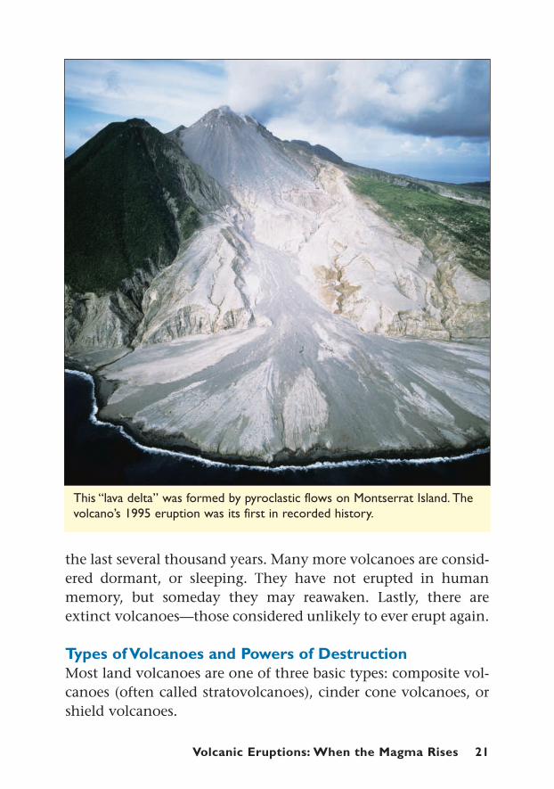
This “lava delta” was formed by pyroclastic flows on Montserrat Island. Thevolcano’s 1995 eruption was its first in recorded history.
the last several thousand years. Many more volcanoes are consid-ered dormant, or sleeping. They have not erupted in humanmemory, but someday they may reawaken. Lastly, there areextinct volcanoes—those considered unlikely to ever erupt again.
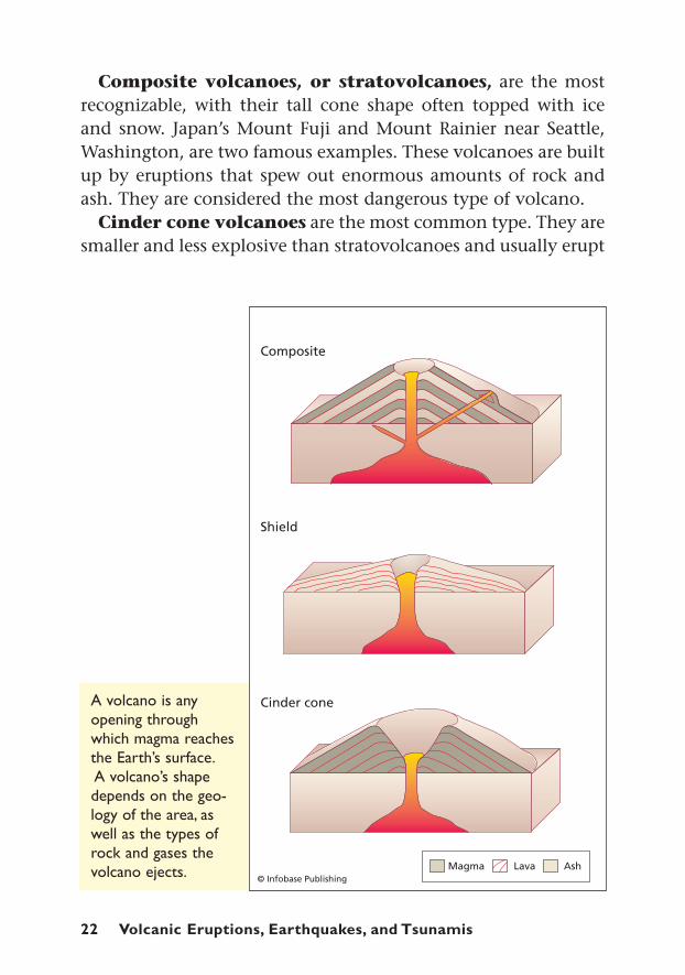
Types of Volcanoes and Powers of DestructionMost land volcanoes are one of three basic types: composite vol-canoes (often called stratovolcanoes), cinder cone volcanoes, orshield volcanoes.
Volcanic Eruptions: When the Magma Rises 21
22 Volcanic Eruptions, Earthquakes, and Tsunamis
A volcano is anyopening throughwhich magma reachesthe Earth’s surface.A volcano’s shapedepends on the geo-logy of the area, aswell as the types ofrock and gases thevolcano ejects.
Composite volcanoes, or stratovolcanoes, are the mostrecognizable, with their tall cone shape often topped with iceand snow. Japan’s Mount Fuji and Mount Rainier near Seattle,Washington, are two famous examples. These volcanoes are builtup by eruptions that spew out enormous amounts of rock andash. They are considered the most dangerous type of volcano.
Cinder cone volcanoes are the most common type. They aresmaller and less explosive than stratovolcanoes and usually erupt
a single time. One or more may form around the base of a strato-volcano.
Shield volcanoes get their name from their shape. With theirgradual slopes, they look like a warrior’s shield set flat on theground. Hawaii’s Kilauea and Mauna Loa are both examples ofshield volcanoes. Their explosions are rarely explosive, but theyproduce impressive shows of spraying and flowing lava.
Most volcanic destruction is not actually caused by lava. Red-hot lava will burn up and bulldoze anything it touches. But itusually moves so slowly that people and animals can easilyescape. Buildings and other property, though, are not so lucky.
Volcanoes’ most destructive punches almost always come fromlahars and pyroclastic flows. Lahars, or volcanic mudslides, arecaused when an eruption ejects water or instantly melts the
Volcanic Eruptions: When the Magma Rises 23
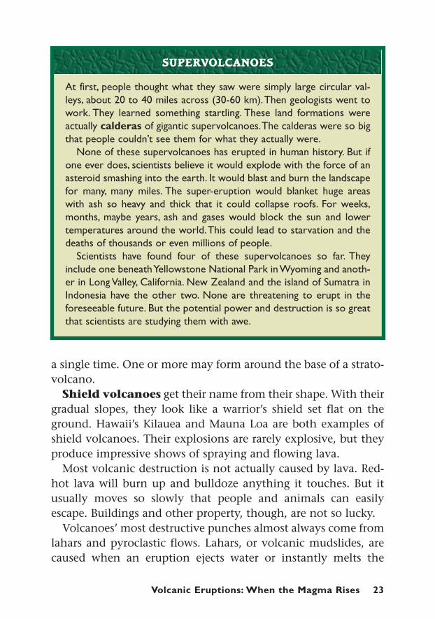
At first, people thought what they saw were simply large circular val-leys, about 20 to 40 miles across (30-60 km).Then geologists went towork. They learned something startling. These land formations wereactually calderas of gigantic supervolcanoes.The calderas were so bigthat people couldn’t see them for what they actually were.
None of these supervolcanoes has erupted in human history. But ifone ever does, scientists believe it would explode with the force of anasteroid smashing into the earth. It would blast and burn the landscapefor many, many miles. The super-eruption would blanket huge areaswith ash so heavy and thick that it could collapse roofs. For weeks,months, maybe years, ash and gases would block the sun and lowertemperatures around the world.This could lead to starvation and thedeaths of thousands or even millions of people.
Scientists have found four of these supervolcanoes so far. Theyinclude one beneath Yellowstone National Park in Wyoming and anoth-er in Long Valley, California. New Zealand and the island of Sumatra inIndonesia have the other two. None are threatening to erupt in theforeseeable future. But the potential power and destruction is so greatthat scientists are studying them with awe.
SUPERVOLCANOES

24 Volcanic Eruptions, Earthquakes, and Tsunamis
Kilauea volcano in Hawaii National Park begins to erupt in 1983. Lava flowsin definite paths down its sides.

mountain’s ice and snow. This can generate a massive flash floodand mudslide that wipes out anything in its path. Lahars canreach speeds of more than 60 miles (100 km) per hour.
A pyroclastic flow, like the one that destroyed St. Pierre, is alsocalled nuée ardente, meaning “glowing cloud” in French. It is agiant, superheated blast of poisonous gas, rocks, ash, and otherdebris that nothing can withstand.
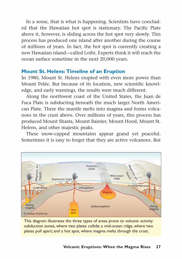
Where the Volcanoes Are FormedVolcanologists have identified three areas in Earth’s crust wherevolcanoes form: 1) along undersea ridges where the ocean flooris spreading; 2) along subduction zones where one tectonicplate is diving under another tectonic plate; and 3) in hot spotsin the center of a tectonic plate.
Scientists are just beginning to understand volcanism as itrelates to ocean-floor spreading. To study deep-sea volcanoes, sci-entists must descend miles under water in small submarinescalled submersibles.
There, undersea mountain ranges mark where two plates areseparating. The Mid-Atlantic Ridge runs like a zipper through theAtlantic Ocean crust from north to south. Major ridges also existin the Indian Ocean and the Pacific Ocean. As the plates moveapart, mantle rock rises to fill the gap. This mantle rock melts andbecomes lava when it oozes out to the ocean floor. Once the lavareaches water, it quickly cools and hardens, adding new rock tothe Earth’s crust.
Volcanoes caused by subduction zones are the most active andpowerful. These zones, also called convergent boundaries,occur where the edge of an ocean plate is diving under a neigh-boring continental plate. Subduction zones are marked by deepundersea trenches.
Most scientists now think that the increased heat and pressurein subduction zones cause the sinking plate to release water. Thewater helps melt the rock in the mantle above the diving plate.
Volcanic Eruptions: When the Magma Rises 25
26 Volcanic Eruptions, Earthquakes, and Tsunamis
This produces the magma that works its way through the conti-nental crust to create volcanoes on land.
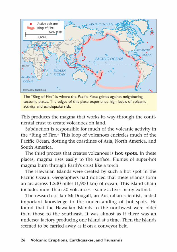
Subduction is responsible for much of the volcanic activity inthe “Ring of Fire.” This loop of volcanoes encircles much of thePacific Ocean, dotting the coastlines of Asia, North America, andSouth America.
The third process that creates volcanoes is hot spots. In theseplaces, magma rises easily to the surface. Plumes of super-hotmagma burn through Earth’s crust like a torch.
The Hawaiian Islands were created by such a hot spot in thePacific Ocean. Geographers had noticed that these islands forman arc across 1,200 miles (1,900 km) of ocean. This island chainincludes more than 50 volcanoes—some active, many extinct.
The research of Ian McDougall, an Australian scientist, addedimportant knowledge to the understanding of hot spots. Hefound that the Hawaiian Islands to the northwest were olderthan those to the southeast. It was almost as if there was anundersea factory producing one island at a time. Then the islandsseemed to be carried away as if on a conveyor belt.
The “Ring of Fire” is where the Pacific Plate grinds against neighboring tectonic plates. The edges of this plate experience high levels of volcanicactivity and earthquake risk.
In a sense, that is what is happening. Scientists have conclud-ed that the Hawaiian hot spot is stationary. The Pacific Plateabove it, however, is sliding across the hot spot very slowly. Thisprocess has produced one island after another during the courseof millions of years. In fact, the hot spot is currently creating anew Hawaiian island—called Loihi. Experts think it will reach theocean surface sometime in the next 20,000 years.
Mount St. Helens: Timeline of an EruptionIn 1980, Mount St. Helens erupted with even more power thanMount Pelée. But because of its location, new scientific knowl-edge, and early warnings, the results were much different.
Along the northwest coast of the United States, the Juan deFuca Plate is subducting beneath the much larger North Ameri-can Plate. There the mantle melts into magma and forms volca-noes in the crust above. Over millions of years, this process hasproduced Mount Shasta, Mount Rainier, Mount Hood, Mount St.Helens, and other majestic peaks.
These snow-capped mountains appear grand yet peaceful.Sometimes it is easy to forget that they are active volcanoes. But
This diagram illustrates the three types of areas prone to volcanic activity:subduction zones, where two plates collide; a mid-ocean ridge, where twoplates pull apart; and a hot spot, where magma melts through the crust.
Volcanic Eruptions: When the Magma Rises 27
28 Volcanic Eruptions, Earthquakes, and Tsunamis
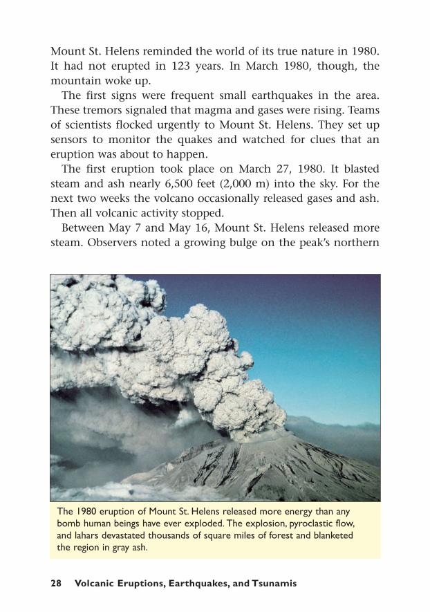
The 1980 eruption of Mount St. Helens released more energy than anybomb human beings have ever exploded. The explosion, pyroclastic flow,and lahars devastated thousands of square miles of forest and blanketed the region in gray ash.
Mount St. Helens reminded the world of its true nature in 1980.It had not erupted in 123 years. In March 1980, though, themountain woke up.
The first signs were frequent small earthquakes in the area.These tremors signaled that magma and gases were rising. Teamsof scientists flocked urgently to Mount St. Helens. They set upsensors to monitor the quakes and watched for clues that aneruption was about to happen.
The first eruption took place on March 27, 1980. It blastedsteam and ash nearly 6,500 feet (2,000 m) into the sky. For thenext two weeks the volcano occasionally released gases and ash.Then all volcanic activity stopped.
Between May 7 and May 16, Mount St. Helens released moresteam. Observers noted a growing bulge on the peak’s northern
side. The bulge suggested that a surge of magma was building upthere.
On May 18, volcanologist David Johnston woke up to a sunnyday. He aimed his binoculars at Mount St. Helens from about sixmiles (10 km) north of the mountain. At 8:30 A.M., an earthquakerocked the area. The disturbance caused the bulge to collapse.Gases and magma under high pressure suddenly had an opening.They erupted from the side of the mountain with incredible force.“This is it!” Johnston radioed to his research base.
Within 10 minutes, the eruption’s billowing cloud had reachednearly 12 miles (19 km) into the sky. A pyroclastic flow toreacross neighboring hills and valleys. The sudden heat instantlymelted the ice and snow. The water gushed down the mountain-side, producing massive lahars that buried the forest landscape ingray mud.
When the smoke cleared, almost 1,000 feet (300 m) had beenripped off the top of Mount St. Helens. Volcanic ash fell like snowfor hundreds of miles. Millions of trees lay flattened and burnedon the scorched landscape. Property damage totaled $1.1 billion.
Volcanic Eruptions: When the Magma Rises 29
In 1815,Tambora erupted in the Asian country of Indonesia. Scientiststhink it may have been the most powerful eruption in recorded hist-ory—much greater than that of Mount St. Helens. Tambora’s blastkilled some 12,000 people.
The terrible effects, though, were not just felt in Indonesia.The erup-tion sent tons of ash and gases high into the atmosphere. Air currentscarried them around the world. Volcanic particles blocked out the sun.Sulfur dioxide, a volcanic gas, reflected the sun’s heat back into space.
Without the sun’s full energy, the year 1816 was much cooler inNorth America. Cold, frost, and snow killed crops and left peoplestarving. A June blizzard dropped six inches of snow in New England.
That year went down in history as “The Year Without a Summer.” Itdemonstrated the global reach of volcanoes’ awesome power.
THE YEAR WITHOUT A SUMMER
30 Volcanic Eruptions, Earthquakes, and Tsunamis
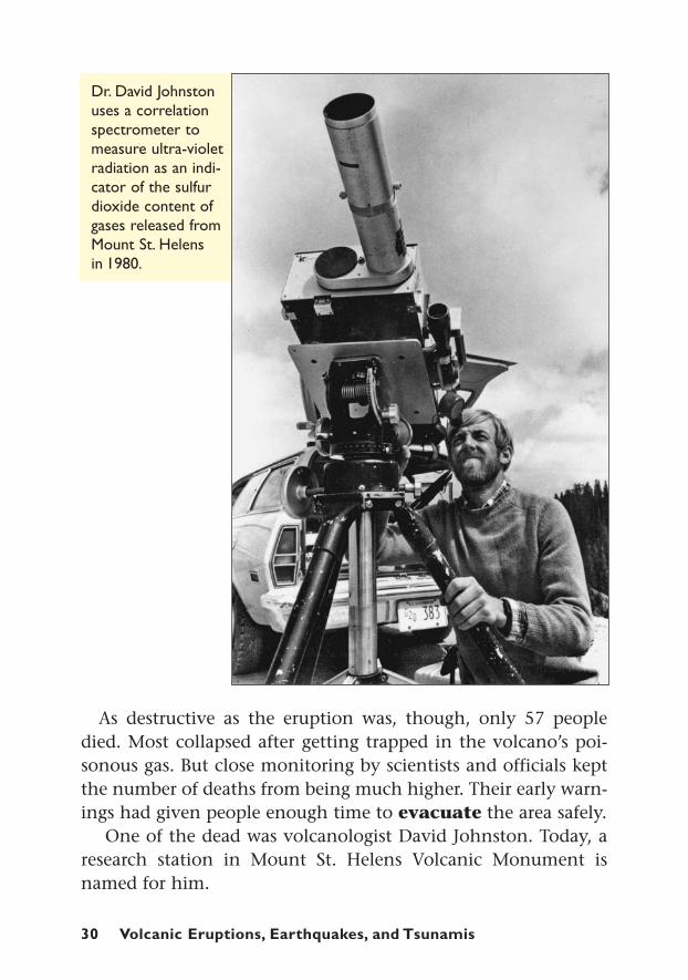
Dr. David Johnstonuses a correlationspectrometer tomeasure ultra-violetradiation as an indi-cator of the sulfurdioxide content ofgases released fromMount St. Helens in 1980.
As destructive as the eruption was, though, only 57 peopledied. Most collapsed after getting trapped in the volcano’s poi-sonous gas. But close monitoring by scientists and officials keptthe number of deaths from being much higher. Their early warn-ings had given people enough time to evacuate the area safely.
One of the dead was volcanologist David Johnston. Today, aresearch station in Mount St. Helens Volcanic Monument isnamed for him.
Earthquakes: Shocksfrom Underground
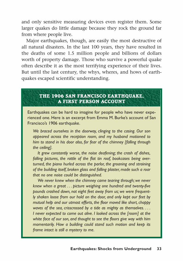
n the early morning of April 18, 1906, the people of San Fran-cisco got the rudest of wake up calls. The strange whining and
yapping of dogs had already awakened some of them. At the firedepartment, the horses went berserk and broke down their stalls.Then came a low rumbling sound.
About 5:12 A.M., the earthquake struck. The ground heavedand shook like a live animal. People were thrown from their beds.One woman reported that “the . . . trees [were] rising and fallingon each wave, like ships at sea. . . .” Buildings twisted, toppled,and sank into the ground.
The shaking only lasted about 45 seconds. The destruction,though, was far from over. The quake had toppled stoves andruptured underground gas pipes. Fire quickly spread. At the sametime, the water mains had burst, so there was nothing to fightthe flames with. For three days, San Franciscans watched help-lessly as most of their city burned. Historians believe that morethan 3,000 people died.
For seismologist Harry Fielding Reid, though, inspiration rosefrom the ruins. Before the quake, the land around San Franciscohad twice been carefully surveyed. Reid checked these reports and
Earthquakes: Shocksfrom Underground
CHAPTER THREE
g
I
Earthquakes: Shocks from Underground 31

32 Volcanic Eruptions, Earthquakes, and Tsunamis
The 1906 SanFrancisco earth-quake and firedestroyed muchof the city. Yet,the disaster ledto new discover-ies in quake andscience safety.
found that streams, fences, and roads that crossed a certain stripof land—the San Andreas Fault—had been gradually bendingbefore the quake. After the quake, a new survey was done. Thistime, measurements showed that the same streams, fences, androads had split apart or shifted dramatically. In some places, theland had slipped as much as 21 feet (7 m). These findings gaveReid a breakthrough idea about the causes of earthquakes.
In some parts of the globe, earthquakes are common events.The United States Geological Survey estimates that more than 3million quakes take place worldwide each year. That equals 8,000earthquakes a day. Most are so small that people do not feel them,
Earthquakes: Shocks from Underground 33
and only sensitive measuring devices even register them. Somelarger quakes do little damage because they rock the ground farfrom where people live.
Major earthquakes, though, are easily the most destructive ofall natural disasters. In the last 100 years, they have resulted inthe deaths of some 1.5 million people and billions of dollarsworth of property damage. Those who survive a powerful quakeoften describe it as the most terrifying experience of their lives.But until the last century, the whys, wheres, and hows of earth-quakes escaped scientific understanding.
Earthquakes can be hard to imagine for people who have never expe-rienced one. Here is an excerpt from Emma M. Burke’s account of SanFrancisco’s 1906 earthquake.
We braced ourselves in the doorway, clinging to the casing. Our sonappeared across the reception room, and my husband motioned tohim to stand in his door also, for fear of the chimney [falling throughthe ceiling].
It grew constantly worse, the noise deafening; the crash of dishes,falling pictures, the rattle of the flat tin roof, bookcases being over-turned, the piano hurled across the parlor, the groaning and strainingof the building itself, broken glass and falling plaster, made such a roarthat no one noise could be distinguished.
We never knew when the chimney came tearing through; we neverknew when a great . . . picture weighing one hundred and twenty-fivepounds crashed down, not eight feet away from us; we were frequent-ly shaken loose from our hold on the door, and only kept our feet bymutual help and our utmost efforts, the floor moved like short, choppywaves of the sea, crisscrossed by a tide as mighty as themselves. . . .I never expected to come out alive. I looked across the [room] at thewhite face of our son, and thought to see the floors give way with himmomentarily. How a building could stand such motion and keep itsframe intact is still a mystery to me.
THE 1906 SAN FRANCISCO EARTHQUAKE, A FIRST PERSON ACCOUNT
34 Volcanic Eruptions, Earthquakes, and Tsunamis
The Power of Plates and Slipping FaultsEarthquakes are caused by sections of the Earth’s crust gettingstuck and then unstuck. That was Harry Fielding Reid’s ground-breaking idea. The Earth’s tectonic plates move at a slow butsteady rate. But along the edges, the plates do not always slidesmoothly. Their edges get caught on each other. The rest of thegigantic plate, though, continues moving. Stress builds up andthe ground stretches as much as it can. This explained the bend-ing of the ground Reid noted when he compared the two surveysdone before 1906.
Earthquakes are triggered when the force of the moving tecton-ic plates overcomes the friction that locks the edges together.Then the sections lurch abruptly to catch up with the rest of theplate. In a way, earthquakes are like when a person pushesagainst a stuck door. The harder the person has to push, the moreenergy gets stored up. When the door pops loose, the energy isreleased, and the person lurches forward. Likewise during anearthquake, if a lot of energy has been stored up, the crust lurch-es violently. It sends waves of energy flowing through the groundin the form of earthquakes.
Earthquakes often happen in a series. The series might beginwith smaller tremors known as foreshocks. The biggest quakein a sequence is called the mainshock. This is usually followedby aftershocks—multiple but less powerful tremors that mayhit hours and days after the mainshock.
Reid’s research did more than present a basic model of whatcauses quakes. It also helped make the case for plate tectonics. Byanalyzing where quakes occur most often, scientists have beenable to trace the outlines of the Earth’s tectonic plates.
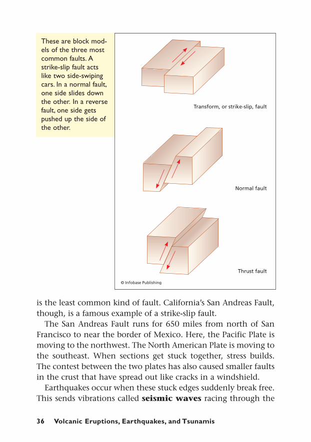
Faults and WavesAlmost all earthquakes occur in fault zones. Faults mark bound-aries where tectonic plates grind against each other. Scientistscategorize three main types of faults: normal faults, thrust faults,
Earthquakes: Shocks from Underground 35
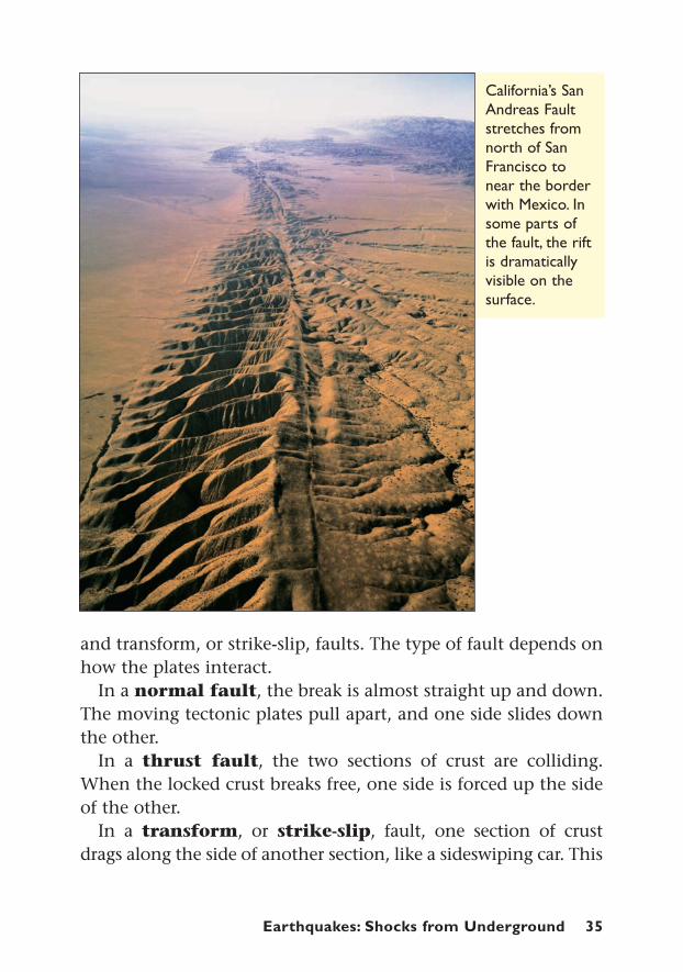
California’s SanAndreas Faultstretches fromnorth of SanFrancisco tonear the borderwith Mexico. Insome parts ofthe fault, the riftis dramaticallyvisible on thesurface.
and transform, or strike-slip, faults. The type of fault depends onhow the plates interact.
In a normal fault, the break is almost straight up and down.The moving tectonic plates pull apart, and one side slides downthe other.
In a thrust fault, the two sections of crust are colliding.When the locked crust breaks free, one side is forced up the sideof the other.
In a transform, or strike-slip, fault, one section of crustdrags along the side of another section, like a sideswiping car. This
36 Volcanic Eruptions, Earthquakes, and Tsunamis
These are block mod-els of the three mostcommon faults. Astrike-slip fault actslike two side-swipingcars. In a normal fault,one side slides downthe other. In a reversefault, one side getspushed up the side ofthe other.
is the least common kind of fault. California’s San Andreas Fault,though, is a famous example of a strike-slip fault.
The San Andreas Fault runs for 650 miles from north of SanFrancisco to near the border of Mexico. Here, the Pacific Plate ismoving to the northwest. The North American Plate is moving tothe southeast. When sections get stuck together, stress builds.The contest between the two plates has also caused smaller faultsin the crust that have spread out like cracks in a windshield.
Earthquakes occur when these stuck edges suddenly break free.This sends vibrations called seismic waves racing through the
Earthquakes: Shocks from Underground 37
ground. The waves move away from the quake like ripples froma rock splashing in a pool.
These quake waves take different forms. The first two areknown as body waves since they move through the body of theEarth. The first and fastest body wave is called the primarywave, or P wave. P waves stretch and compress the ground likean accordion. People usually feel these as a kind of thud.
Close behind P waves come secondary waves, or S waves.These usually move sharply up and down or from side to side,like a jump rope being whipped.
The waves that follow are known as surface waves becausethey travel along the Earth’s surface. They are slower than bodywaves and cause the most vibration and damage.
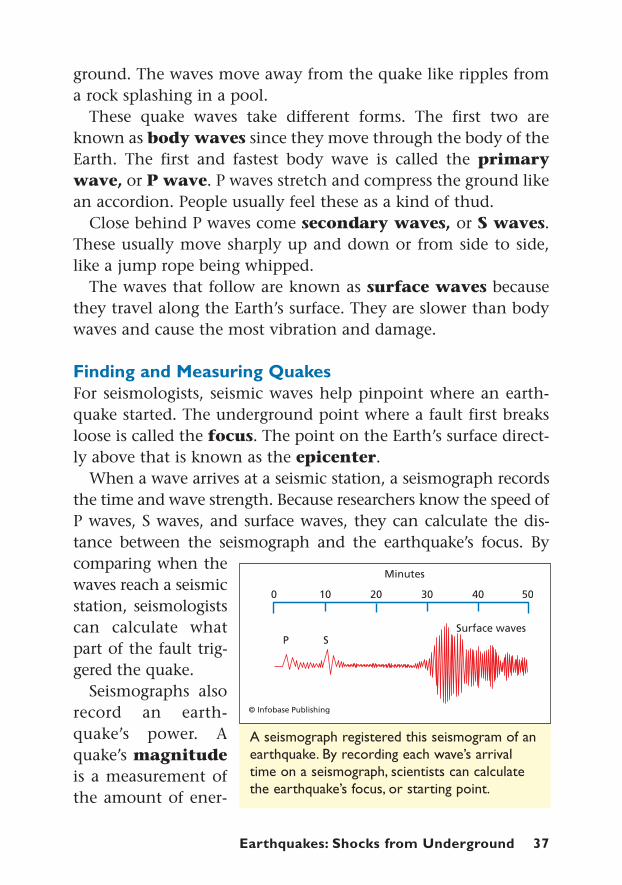
Finding and Measuring QuakesFor seismologists, seismic waves help pinpoint where an earth-quake started. The underground point where a fault first breaksloose is called the focus. The point on the Earth’s surface direct-ly above that is known as the epicenter.
When a wave arrives at a seismic station, a seismograph recordsthe time and wave strength. Because researchers know the speed ofP waves, S waves, and surface waves, they can calculate the dis-tance between the seismograph and the earthquake’s focus. Bycomparing when thewaves reach a seismicstation, seismologistscan calculate whatpart of the fault trig-gered the quake.
Seismographs alsorecord an earth-quake’s power. Aquake’s magnitudeis a measurement ofthe amount of ener-
A seismograph registered this seismogram of anearthquake. By recording each wave’s arrivaltime on a seismograph, scientists can calculatethe earthquake’s focus, or starting point.
38 Volcanic Eruptions, Earthquakes, and Tsunamis
A 1960 earthquake in Chile registered a magnitude 9.5 and caused extensivedamage.This quake remains the most powerful on record.
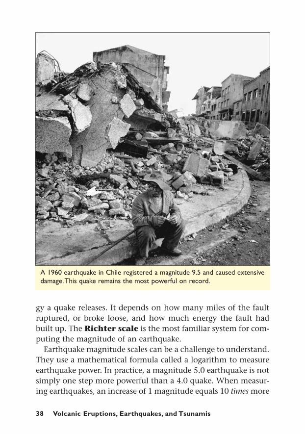
gy a quake releases. It depends on how many miles of the faultruptured, or broke loose, and how much energy the fault hadbuilt up. The Richter scale is the most familiar system for com-puting the magnitude of an earthquake.
Earthquake magnitude scales can be a challenge to understand.They use a mathematical formula called a logarithm to measureearthquake power. In practice, a magnitude 5.0 earthquake is notsimply one step more powerful than a 4.0 quake. When measur-ing earthquakes, an increase of 1 magnitude equals 10 times more
Earthquakes: Shocks from Underground 39
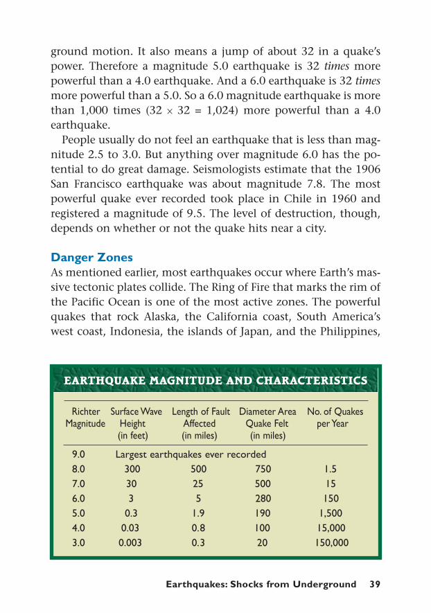
ground motion. It also means a jump of about 32 in a quake’spower. Therefore a magnitude 5.0 earthquake is 32 times morepowerful than a 4.0 earthquake. And a 6.0 earthquake is 32 timesmore powerful than a 5.0. So a 6.0 magnitude earthquake is morethan 1,000 times (32 x 32 = 1,024) more powerful than a 4.0earthquake.
People usually do not feel an earthquake that is less than mag-nitude 2.5 to 3.0. But anything over magnitude 6.0 has the po-tential to do great damage. Seismologists estimate that the 1906San Francisco earthquake was about magnitude 7.8. The mostpowerful quake ever recorded took place in Chile in 1960 andregistered a magnitude of 9.5. The level of destruction, though,depends on whether or not the quake hits near a city.
Danger ZonesAs mentioned earlier, most earthquakes occur where Earth’s mas-sive tectonic plates collide. The Ring of Fire that marks the rim ofthe Pacific Ocean is one of the most active zones. The powerfulquakes that rock Alaska, the California coast, South America’swest coast, Indonesia, the islands of Japan, and the Philippines,
9.0 Largest earthquakes ever recorded8.0 300 500 750 1.57.0 30 25 500 156.0 3 5 280 1505.0 0.3 1.9 190 1,5004.0 0.03 0.8 100 15,0003.0 0.003 0.3 20 150,000
EARTHQUAKE MAGNITUDE AND CHARACTERISTICS
Richter Surface Wave Length of Fault Diameter Area No. of QuakesMagnitude Height Affected Quake Felt per Year
(in feet) (in miles) (in miles)

40 Volcanic Eruptions, Earthquakes, and Tsunamis
are all products of the movements of the Pacific Plate and itsneighboring plates.
Another band of high seismic activity runs for 2,500 milesfrom eastern Asia to southern Europe. Here, multiple tectonicplates contribute to the restless crust. They are the source ofearthquakes in Italy, Greece, and other countries around theMediterranean Sea. The band also runs through Turkey and otherparts of Central Asia.
Farther east, the tectonic plate carrying India and Australia isplowing into southern Asia. This collision of plates forces Earth’scrust skyward. One result is the majestic Himalayan Mountains—the tallest peaks in the world. Another consequence is frequentearthquakes. With the dense population of people in countriessuch as India and China, quakes there are often deadly. Asia suf-fers from the destructive power of earthquakes more than anyother continent.
1556 Shenshu, China 830,0001976 Tangshan, China 7.6 650,0001737 Calcutta, India 300,0001803 Tokyo, Japan 200,0001927 China 200,0001920 Kansu, China 8.6 180,0001923 Tokyo and
Yokohama, Japan 8.3 143,0001857 Tokyo, Japan 107,0002005 Pakistan 7.6 73,0001908 Messina, Sicily 7.5 73,000
10 DEADLIEST EARTHQUAKES IN HISTORY
Date Location Magnitude Death Toll(if available)

Tsunamis: Killer Waves 41
Tsunamis: Killer WavesTsunamis:
Killer Waves
illy Smith noticed something weird. The 11-year-old Britishgirl watched as the ocean seemed to drain quickly from the
beach. “I noticed that . . . the sea was all frothy like on the top ofa beer,” she told the British Broadcasting Corporation. “It wasbubbling.” Sunbathers wandered out to look at the flopping fishand other undersea creatures exposed by the retreating water.
Then Tilly remembered a school geography lesson from twoweeks earlier. She had seen a video about a tsunami, a killer oceanwave. She instantly realized that her family and everyone nearthe beach were in danger.
It was the morning of December 26, 2004. Tilly and her parentsand sister had been soaking up the sun during their vacation inThailand. This Asian country juts out into the Indian Ocean. Atthat moment, waves of incredible power were already speedingtoward them.
Tilly had recognized the signs and knew what would follow. “Isaid, ‘Seriously, there is definitely going to be a tsunami’,” Tillyrecalled. At first her parents were slow to believe her. Then her
CHAPTER FOUR
g
T

42 Volcanic Eruptions, Earthquakes, and Tsunamis
The tsunami that hit southern Asia on December 26, 2004, wiped awaycoastal villages and killed more than 200,000 people. These islets used to be part of Banda Aceh, the capital city of Indonesia’s Aceh province.
dad told a security guard. The alert quickly spread up and downthe beach. People ran inland. Tilly’s family climbed to the thirdfloor of their hotel.
Minutes later, a wall of unstoppable ocean swept over thatbeach and other Indian Ocean coastlines. More than 220,000people were killed. Millions more were left homeless. It was oneof the most destructive natural disasters in human history.Thanks to Tilly and her geography lesson, though, her familyand others at the beach escaped with their lives.
Tsunamis are powerful waves that can travel at high speedsacross thousands of miles of ocean. Tsu nami is Japanese for “har-bor wave,” and Japan has experienced more than its share.
Fortunately, tsunamis are rare. Every year about two of thesewaves do some local damage. About every 15 years, a majortsunami strikes coastlines across a wide region. Eighty-five per-cent of tsunamis occur in the Pacific Ocean. They are difficult todetect before they reach land, which can make them deadly. The
Tsunamis: Killer Waves 43
2004 tsunami took a terrible toll, but it also gave scientists theirbest chance yet to study this force of nature.
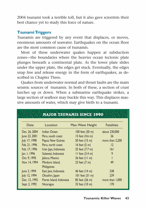
Tsunami TriggersTsunamis are triggered by any event that displaces, or moves,enormous amounts of seawater. Earthquakes on the ocean floorare the most common cause of tsunamis.
Most of these underwater quakes happen at subductionzones—the boundaries where the heavier ocean tectonic plateplunges beneath a continental plate. As the lower plate slidesunder the upper plate, the edges get stuck. Eventually, the edgessnap free and release energy in the form of earthquakes, as de-scribed in Chapter Three.
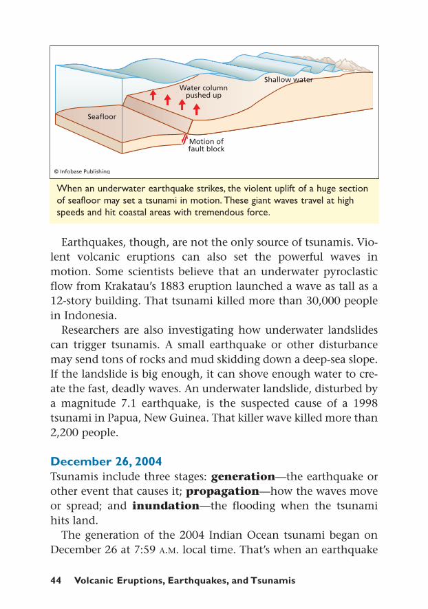
Quakes from underwater normal and thrust faults are the mainseismic sources of tsunamis. In both of these, a section of crustlurches up or down. When a submarine earthquake strikes, alarge section of seafloor may buckle this way. This displaces mas-sive amounts of water, which may give birth to a tsunami.
Dec. 26, 2004 Indian Ocean 100 feet (30 m) about 230,000June 23, 2001 Peru, south coast 15 feet (4.6 m) 26July 17, 1998 Papua New Guinea 50 feet (15 m) more than 2,200Feb. 21, 1996 Peru, north coast 16 feet (5 m) 12Feb. 17, 1996 Irian Jaya, Indonesia 25 feet (7.7 m) 161Jan. 1, 1996 Sulawesi, Indonesia 11 feet (3.4 m) 9Oct. 9, 1995 Jalisco, Mexico 36 feet (11 m) 1Nov. 14, 1994 Mindoro Island, 23 feet (7 m) 49
PhilippinesJune 2, 1994 East Java, Indonesia 46 feet (14 m) 238July 12, 1994 Okushiri, Japan 101 feet (31 m) 239Dec. 12, 1992 Flores Island, Indonesia 85 feet (26 m) more than 1,000Sept. 2, 1992 Nicaragua 33 feet (10 m) 170
MAJOR TSUNAMIS SINCE 1990
Date Location Max.Wave Height Fatalities
44 Volcanic Eruptions, Earthquakes, and Tsunamis
When an underwater earthquake strikes, the violent uplift of a huge sectionof seafloor may set a tsunami in motion. These giant waves travel at highspeeds and hit coastal areas with tremendous force.
Earthquakes, though, are not the only source of tsunamis. Vio-lent volcanic eruptions can also set the powerful waves inmotion. Some scientists believe that an underwater pyroclasticflow from Krakatau’s 1883 eruption launched a wave as tall as a12-story building. That tsunami killed more than 30,000 peoplein Indonesia.
Researchers are also investigating how underwater landslidescan trigger tsunamis. A small earthquake or other disturbancemay send tons of rocks and mud skidding down a deep-sea slope.If the landslide is big enough, it can shove enough water to cre-ate the fast, deadly waves. An underwater landslide, disturbed bya magnitude 7.1 earthquake, is the suspected cause of a 1998tsunami in Papua, New Guinea. That killer wave killed more than2,200 people.
December 26, 2004Tsunamis include three stages: generation—the earthquake orother event that causes it; propagation—how the waves moveor spread; and inundation—the flooding when the tsunamihits land.
The generation of the 2004 Indian Ocean tsunami began onDecember 26 at 7:59 A.M. local time. That’s when an earthquake
Tsunamis: Killer Waves 45
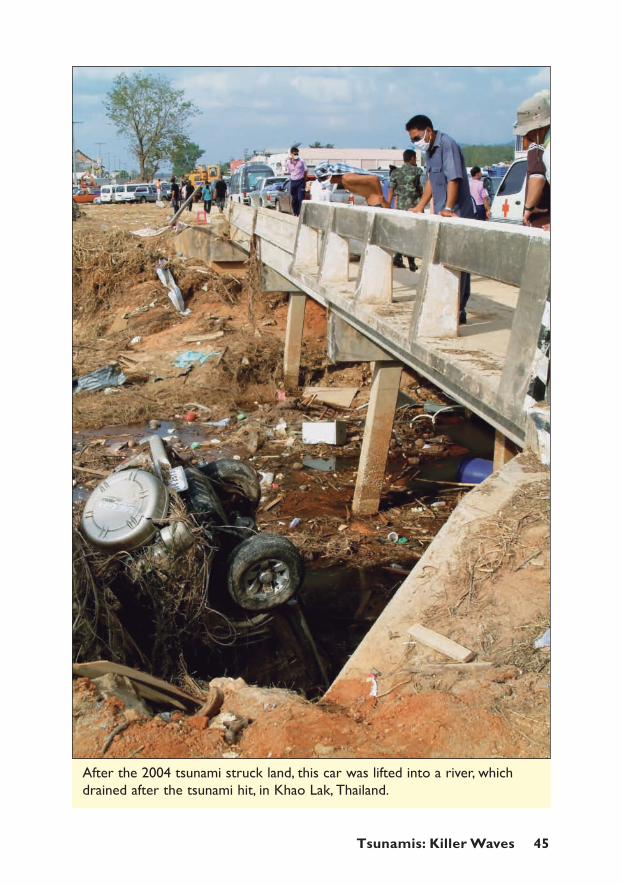
After the 2004 tsunami struck land, this car was lifted into a river, whichdrained after the tsunami hit, in Khao Lak, Thailand.
46 Volcanic Eruptions, Earthquakes, and Tsunamis
struck in a fault off the coast of Sumatra. A 750-mile (1,200-km)section of seafloor violently lurched upward by as much as 26feet (8 m). This sudden shift catapulted billions of cubic feet ofwater into motion.
A global network of seismic stations soon sensed the powerfulquake. Researchers, though, could not confirm that a tsunamiwas on the move. And even if they had known for sure, there wasno system in place to warn people in the tsunami’s path.
The tsunami’s propagation, or spread, was astonishingly fast. Thefirst waves raced through the Indian Ocean at speeds worthy of acommercial jet—about 300 to 600 miles (500 to 1,000 km) per hour.
In the deep ocean, a tsunami may be barely noticeable. At suchdepths of water, a tsunami’s energy and shape are spread through-out a vast volume of water. Sailors might not even feel its wavespass beneath their boat.
But a powerful tsunami has global reach. Within 20 minutes ofthe quake, the December 2004 tsunami blasted the northern
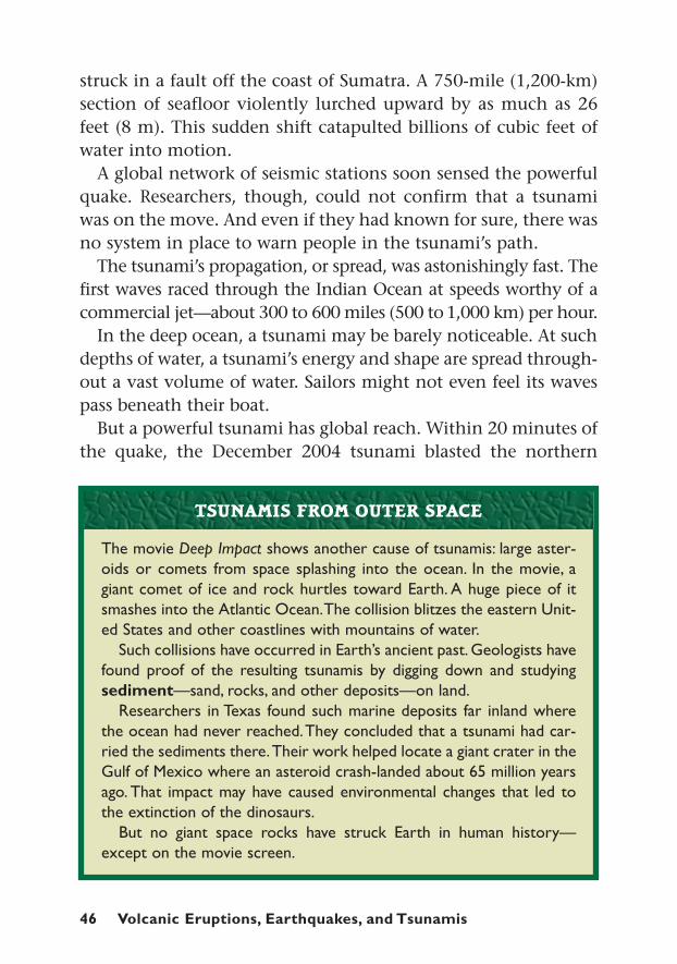
The movie Deep Impact shows another cause of tsunamis: large aster-oids or comets from space splashing into the ocean. In the movie, agiant comet of ice and rock hurtles toward Earth. A huge piece of itsmashes into the Atlantic Ocean.The collision blitzes the eastern Unit-ed States and other coastlines with mountains of water.
Such collisions have occurred in Earth’s ancient past. Geologists havefound proof of the resulting tsunamis by digging down and studyingsediment—sand, rocks, and other deposits—on land.
Researchers in Texas found such marine deposits far inland wherethe ocean had never reached.They concluded that a tsunami had car-ried the sediments there.Their work helped locate a giant crater in theGulf of Mexico where an asteroid crash-landed about 65 million yearsago. That impact may have caused environmental changes that led tothe extinction of the dinosaurs.
But no giant space rocks have struck Earth in human history—except on the movie screen.
TSUNAMIS FROM OUTER SPACE

Tsunamis: Killer Waves 47
This computer-generated model shows the waves of the December 2004tsunami just as they reach Sri Lanka. The giant waves raced out from a magnitude 9.0 quake, which struck near the city of Banda Aceh.
coast of Sumatra. Within three hours it reached the coasts ofThailand, Myanmar, and Malaysia to the east, and Sri Lanka andIndia to the west. Within 11 hours, the wave traveled 8,000 mileswest to South Africa where it was blamed for at least one death.Eventually, the fading tsunami reached all the way to the easternshores of South and North America.
Inundation or flooding is a tsunami’s last stage. That is whenit wreaks destruction on land. As the waves approach a coastline,
48 Volcanic Eruptions, Earthquakes, and Tsunamis
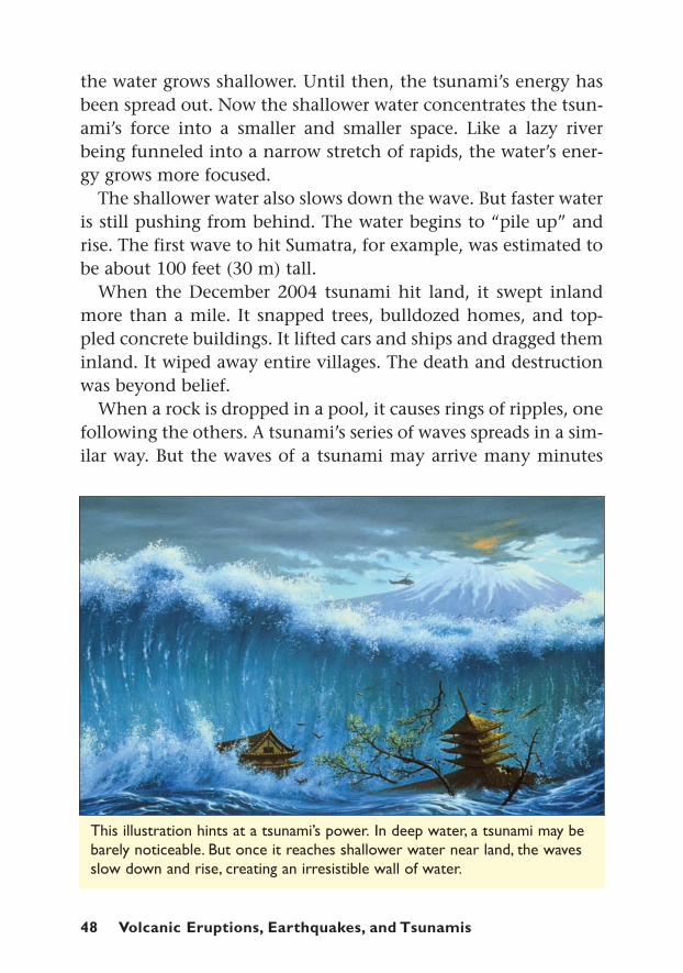
This illustration hints at a tsunami’s power. In deep water, a tsunami may bebarely noticeable. But once it reaches shallower water near land, the wavesslow down and rise, creating an irresistible wall of water.
the water grows shallower. Until then, the tsunami’s energy hasbeen spread out. Now the shallower water concentrates the tsun-ami’s force into a smaller and smaller space. Like a lazy riverbeing funneled into a narrow stretch of rapids, the water’s ener-gy grows more focused.
The shallower water also slows down the wave. But faster wateris still pushing from behind. The water begins to “pile up” andrise. The first wave to hit Sumatra, for example, was estimated tobe about 100 feet (30 m) tall.
When the December 2004 tsunami hit land, it swept inlandmore than a mile. It snapped trees, bulldozed homes, and top-pled concrete buildings. It lifted cars and ships and dragged theminland. It wiped away entire villages. The death and destructionwas beyond belief.
When a rock is dropped in a pool, it causes rings of ripples, onefollowing the others. A tsunami’s series of waves spreads in a sim-ilar way. But the waves of a tsunami may arrive many minutes
Tsunamis: Killer Waves 49
apart. Often unsuspecting people return to the water’s edge afterthe first wave hits, only to be caught off-guard and washed awayby the next.
Tsunami-ReadyJust three months after the December 2004 disaster, anotherstrong earthquake struck. It tore at the same underwater faultnear Sumatra. This time, the results were much different. Thequake occurred under shallower water. That meant less water wasdisplaced when the seafloor shifted. And the island of Sumatrablocked much of the tsunami from hitting Thailand and othercoastal countries.
Also, people near the quake’s epicenter immediately ran inlandas soon as they felt the ground shake. They had learned that atremor might signal an oncoming tsunami. All these factorsadded up to a lower death toll.
Both Tilly Smith’s warning and the March 2005 tsunamidemonstrated an important point. When it comes to natural dis-asters, education is the best bet to save lives. If people in tsuna-mi-prone areas can recognize danger signs—such as anearthquake or retreating water—they improve their chances ofescape. If they plan and mark escape routes for their community,they will increase their odds of survival.
Aceh (AH-chay), on the Indonesian island of Sumatra, was one of theareas hardest hit by the December 2004 tsunami. More than 30,000people died in that region.The disaster, though, may have had a silverlining for the people there. It helped bring an end to a 30-year-old war.
The Free Aceh Movement had been seeking independence fromIndonesia. But after the tsunami, the group declared a ceasefire. Theyaccepted help from the Indonesian government and international aidgroups. The cooperation led to a peace agreement in August 2005.
A DISASTER’S SILVER LINING
50 Volcanic Eruptions, Earthquakes, and Tsunamis
Building for "The Big One"
ith a thud, the two-story white house shudders, thenbegins to sway. The hanging light swings wildly. Lamps
and a computer screen pitch to the floor. Vases and knick-knacksfall with a crash. The water heater flips over, and a filing cabinettips onto its front.
In an upstairs bedroom, the shaking is even worse. An entirebookshelf collapses. A bed shakes so much that it moves awayfrom the wall and into the middle of the room.
In less than 15 seconds, the quaking ends. The small houseseems okay—no broken walls or collapsed ceilings. But inside,the rooms are a junkyard of tossed furniture and broken glass.
Fortunately, this earthquake was very localized. It took placeinside a laboratory at the University of California at San Diego.Engineers there had built the house on a large shake table. Shaketables allow researchers to observe and experiment with howbuildings perform during earthquakes.
The testers used the shake table and computers to simulate thepower and motion of the 1994 Northridge earthquake in Califor-nia. That quake registered a magnitude of 6.7. It caused more than
W
Building for "The Big One"
CHAPTER FIVE
g

Building for “The Big One” 51
A 2007 earthquake in Japan ripped apart this road. Collapsing roads, bridges,buildings, and other structures are the biggest killers during an earthquake.In addition, repair costs often run into the billions of dollars.
$40 billion in property damage, one of the costliest disasters in U.S.history. Yet only 61 people were killed. Fortunately, the quake hitat 4:30 A.M. before people were on the road to work or school.Good construction also played a part in keeping people safe.
There is a saying in earthquake science: “Earthquakes don’t killpeople; buildings kill people.” In other words, collapsing build-ings and falling objects are the biggest threat during an earth-quake, not the heaving ground. That is why people are told tostand in a doorway, or crawl under a desk or heavy table, theinstant they feel a tremor. These are two of the safest places insideany building during an earthquake. People outdoors are instruct-ed to move away from places where bricks or other debris mightcome crashing down.
Constructing better, safer buildings is the most importantaction that communities in earthquake zones can take. It may
52 Volcanic Eruptions, Earthquakes, and Tsunamis
never be possible to predict when a quake will hit. But smart dis-aster planning and sound construction have the potential to savemany, many lives.
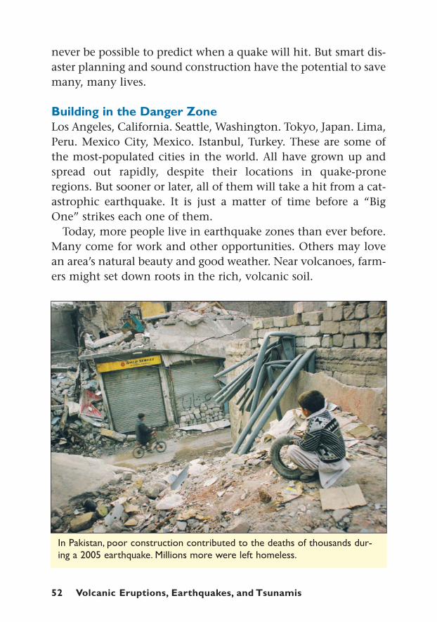
Building in the Danger ZoneLos Angeles, California. Seattle, Washington. Tokyo, Japan. Lima,Peru. Mexico City, Mexico. Istanbul, Turkey. These are some ofthe most-populated cities in the world. All have grown up andspread out rapidly, despite their locations in quake-proneregions. But sooner or later, all of them will take a hit from a cat-astrophic earthquake. It is just a matter of time before a “BigOne” strikes each one of them.
Today, more people live in earthquake zones than ever before.Many come for work and other opportunities. Others may lovean area’s natural beauty and good weather. Near volcanoes, farm-ers might set down roots in the rich, volcanic soil.
In Pakistan, poor construction contributed to the deaths of thousands dur-ing a 2005 earthquake. Millions more were left homeless.

Building for “The Big One” 53
Human beings have short memories, for better or worse. Anarea may not experience a major earthquake or a volcanic erup-tion for many, many years—even centuries. People then tend toforget the instant destruction and death these seismic events can
The Federal Emergency Management Administration (FEMA) is thegovernment agency responsible for helping U.S. communities when dis-asters hit. FEMA recommends that every family put together a Disas-ter Supply Kit. The idea is that families will have what they need to gothree days without electricity, running water, or access to supermarketsor other stores.
The disaster kit should be set aside where no one will raid it forsnacks or other things. Then it will be ready to go if an earthquake orother disaster strikes.
Here is some of what FEMA suggests families put in their kit (Forthe complete list, go to http://www.fema.gov/kids/dizkit.htm.):
Water—There is no guarantee that pipes won’t break or electrici-ty will be available to pump water.That’s why there should be enoughbottled water so that each person has one gallon per day, plus extrafor pets.
Food—There should be enough food to last for three days. Themenu might include canned meat, fruit, vegetables, juice, milk, and soup;high-energy foods like peanut butter, granola bars, and nuts; fun foodslike candy and cookies; and special food for babies, if necessary. All ofthese foods should be able to last without refrigeration.
First Aid Kit—This should include adhesive bandages, pain reliev-ers, and other medical supplies.
Tools and Supplies—The toolkit should contain a flashlight,matches, candles, whistle, toilet paper, can opener, battery-poweredradio, Swiss Army knife, and other equipment.These should be packedin a backpack in case people are forced to leave their home.
Clothing and Bedding—Everyone in the house should have stur-dy shoes and a complete change of clothes ready and waiting. Equip-ment should also include raingear, warm underwear, and blankets orsleeping bags.
FAMILY SURVIVAL KIT
54 Volcanic Eruptions, Earthquakes, and Tsunamis
cause. They may stop taking the threat seriously and thereforebuild carelessly.
If a quake-prone community has the commitment and re-sources, though, it will build earthquake safety into its structuresand streets. Its government will pass and enforce strict buildingcodes. These are laws and standards that make sure constructionis done properly. People need to know that their home or officewon’t collapse during a strong earthquake.
In poorer countries, many communities simply lack theresources or know-how to build safely. In many parts of the Mid-dle East, Central Asia, and South America, people use whatevermaterial is available: mud bricks, stone, adobe, or concrete. Thesematerials are very solid and heavy, but also brittle and inflexible.Most structures are not reinforced with steel rods and other sup-ports that would make them safer. During an earthquake, these
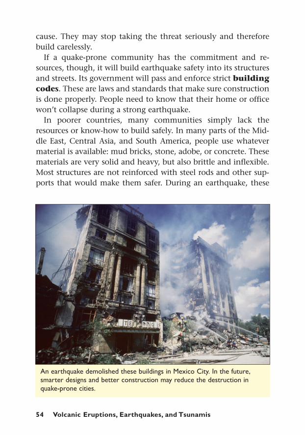
An earthquake demolished these buildings in Mexico City. In the future,smarter designs and better construction may reduce the destruction inquake-prone cities.
Building for “The Big One” 55
homes may crumble without warning, trapping or killing familiesinside. Multi-story buildings may “pancake”—each floor drop-ping onto the next.
The result is a high death toll. In October 2005, approximately73,000 people died in the country of Pakistan, victims of a magni-tude 7.6 quake. Nearly 4 million people were left homeless. After-ward, researchers found that more than half the buildings in theregion were built of un-reinforced concrete block. The earthquakedestroyed 60% of these buildings. Many children died when theirpoorly built schools fell on them.
“Most loss of life and property has been due to the collapse of[old] and unsafe structures,” said seismologist Charles Richter,creator of the Richter scale. “In every area of the world wherethere is earthquake risk, there are still many buildings of thistype; it is very frustrating to try to get rid of them.”
Building Smart, Not StrongIn the fairy tale “The Three Little Pigs,” the solid brick house foilsThe Big Bad Wolf. The straw and wood houses cannot stand upto his huffing and puffing.
When it comes to foiling earthquakes, the opposite is true. Flex-ibility is often more important than strength in creating structuresthat can withstand side-to-side shaking. If a house or other build-ing can sway a little, it is more likely to survive. Wood-framehouses can often ride out a medium-sized shock because of theirflexibility.
Steel also has qualities that make it hold up well during anearthquake. If bent slightly, steel can snap back. If twisted severe-ly, it will bend but usually not break. For these reasons, steel rodsare often sealed into concrete walls. These rods reinforce the con-crete to keep it from collapsing in a disaster.
Basic construction improvements can reduce home damageand physical hazards in an earthquake zone. First, careful buildersbolt the house to its concrete base, called the foundation. Thiskeeps the house from slipping during a quake. Chimneys should
56 Volcanic Eruptions, Earthquakes, and Tsunamis
also be secured to reduce their chances of falling. Inside, home-owners should batten down water heaters, refrigerators, and top-heavy furniture to keep them from tipping over. Stores in quakezones often put up special shelves that keep bottles from fallingto the floor.
For houses built of brick, adobe, or other rigid material, engi-neers recommend that the walls be reinforced with fiber mesh.Steel rods can be built into the walls. The roof, ceiling, and wallsshould be strapped together with steel straps so that they rein-force each other.
In many communities, building codes require these safeguardsin new homes. Experts, though, worry about older houses. Theystrongly suggest that homeowners upgrade their property so thatit can withstand earthquake damage. The improvements mayeven save their families’ lives.
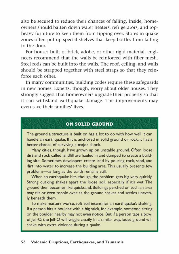
The ground a structure is built on has a lot to do with how well it canhandle an earthquake. If it is anchored in solid ground or rock, it has abetter chance of surviving a major shock.
Many cities, though, have grown up on unstable ground. Often loosedirt and rock called landfill are hauled in and dumped to create a build-ing site. Sometimes developers create land by pouring rock, sand, anddirt into water to increase the building area. This usually presents fewproblems—as long as the earth remains still.
When an earthquake hits, though, the problem gets big very quickly.Strong quaking shakes apart the loose soil, especially if it’s wet. Theground then becomes like quicksand. Buildings perched on such an areamay tilt or even topple over as the ground shakes and settles uneven-ly beneath them.
To make matters worse, soft soil intensifies an earthquake’s shaking.If a person hits a boulder with a big stick, for example, someone sittingon the boulder nearby may not even notice. But if a person taps a bowlof Jell-O, the Jell-O will wiggle crazily. In a similar way, loose ground willshake with extra violence during a quake.
ON SOLID GROUND
Building for “The Big One” 57
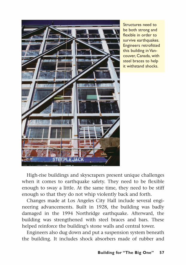
Structures need tobe both strong andflexible in order tosurvive earthquakes.Engineers retrofittedthis building in Van-couver, Canada, withsteel braces to helpit withstand shocks.
High-rise buildings and skyscrapers present unique challengeswhen it comes to earthquake safety. They need to be flexibleenough to sway a little. At the same time, they need to be stiffenough so that they do not whip violently back and forth.
Changes made at Los Angeles City Hall include several engi-neering advancements. Built in 1928, the building was badlydamaged in the 1994 Northridge earthquake. Afterward, thebuilding was strengthened with steel braces and bars. Thesehelped reinforce the building’s stone walls and central tower.
Engineers also dug down and put a suspension system beneaththe building. It includes shock absorbers made of rubber and

58 Volcanic Eruptions, Earthquakes, and Tsunamis
steel. This assembly acts like the suspension in a car. It cushionsthe building when the ground moves and will absorb some of theshock when a quake hits.
Scientists and engineers are also teaming up to develop “smartbuildings” for the future. These structures would include a com-puterized system. In response to a quake, the computers wouldsense the direction and intensity of the destructive waves. Thenthe system would automatically tighten and loosen differentjoints to allow the building to protect itself.
Buildings are not the only structures that require attention.Highway bridges and overpasses, for example, can also collapseduring a quake. They have a better chance to remain standing iftheir columns are reinforced with extra steel and anchored deepin the ground. Another improvement involves constructingunderground tunnels with flexible joints. That way a tunnel canwiggle and twist without snapping. This improvement wouldhelp protect water pipes, electric and gas lines, and subway sys-tems during a quake.
Preparing for an earthquake or other natural disaster is truly ateam effort. Government officials, scientists, engineers, phoneand power repair crews, emergency workers, and citizens must allwork together. They must practice how they will react when the“Big One” hits. Because when it does, they will not have time tofumble around figuring out what to do.
The Probability of Predicting Disaster 59
The Probability ofPredicting DisasterThe Probability of Predicting Disaster
t was going to hit sometime between 1984 and 1992. That wasthe period of time a team of scientists believed an earthquake
would rock the ground near the small town of Parkfield, Califor-nia. Scientific research showed that magnitude 6.0 or highershocks had shaken that area regularly. Now researchers were try-ing to calculate the next big thumping.
They were hopeful that close monitoring would help identifyprecursors. These are signs that the fault is about to break looseand release its earthshaking energy. If they could spot before-quake clues, perhaps it would help them better predict futureshocks.
They zeroed in on 1988, plus or minus four years. They set upseismometers, tiltmeters, and other sensors. They measuredmovement in the Earth’s crust. They monitored the water levelsand other details.
They waited—1988 came and went. And waited—1992 cameand went. The quake they were watching for finally struck in 2004.
Afterward, researchers studied all the readings from the sen-sors. They searched for some hint that the earthquake had beenabout to happen. To their frustration, they found nothing. Thequake had hit without any warning that they could see.
CHAPTER SIX
g
I
60 Volcanic Eruptions, Earthquakes, and Tsunamis
Like meteorologists predicting a storm, earth scientists wish theycould foretell earthquakes and other seismic events. But most seis-mologists believe that specific, reliable earthquake forecasting liesdecades in the future. Some believe it may never be possible. That’sbecause the tectonic plates that cause quakes interact in a verycomplex fashion. Countless factors go into what happens as theplates push against and squeeze past each other.
Still, seismology remains a very young science. Every year, newknowledge and better technology help earth scientists better under-stand why and where the ground shakes and volcanoes erupt.
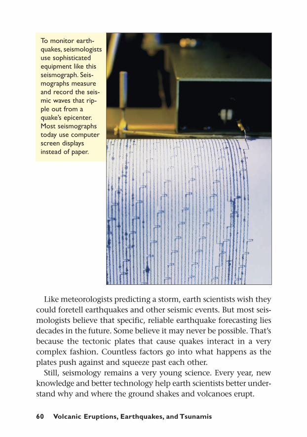
To monitor earth-quakes, seismologistsuse sophisticatedequipment like thisseismograph. Seis-mographs measureand record the seis-mic waves that rip-ple out from aquake’s epicenter.Most seismographstoday use computerscreen displaysinstead of paper.
The Search for Earthquake PrecursorsIn the days or hours before a major earthquake hits, people some-times report unusual details. Water from their wells suddenlytastes bad, or they see strange lights in the sky. Their pets or farmanimals become nervous or frantic.
For years, scientists have sorted through such information forcommon clues about when an earthquake is about to let loose.So far, they have found nothing reliable.
The most common earthquake precursor is foreshocks. Thesesmaller quakes may precede the mainshock. Most often, though,a small earthquake is just a small earthquake. Fewer than one outof twenty small earthquakes is followed by a mainshock.
In at least one case, though, everyday observations helped alertpeople about a coming quake. In 1975, Haicheng, China, sufferedhundreds of small tremors. Water levels in wells fell. People report-ed strange animal behavior. Hibernating snakes, for example, weresaid to have awakened and slithered out of their holes. Officialshad told people that such signs might predict a coming quake.
Officials evacuated the area. The decision paid off when a mag-nitude 7.4 quake struck. Few lives were lost.
Chinese officials and scientists congratulated themselves. Theythought that, perhaps, they had found a practical way to predictbig earthquakes. But they were mistaken. Less than a year lateranother quake hit near Tangshan. This time no one noticed any-thing unusual beforehand. No evacuation took place and morethan 250,000 people died. The conclusion: earthquake precursorsrarely, if ever, follow recognizable patterns.
Stress-TriggeringOne hypothesis, or theory, may be helping earth scientists ex-plore how some faults behave and interact, however. They callthe idea “stress triggering.”
Earthquakes occur when a stuck fault suddenly breaks free. Atthat point the ground releases stress. But the stress-triggering the-ory suggests that the stress does not simply disappear. Some of it
The Probability of Predicting Disaster 61

62 Volcanic Eruptions, Earthquakes, and Tsunamis
transfers to nearby faults or to another part of the same fault.This idea helped earth scientists recognize an earthquake threatin Turkey.
In August 1999, a stretch of the North Anatolian Fault slippedthere. The resulting magnitude 7.4 quake rocked the city of Izmitto the ground. Concrete buildings collapsed in clouds of graydust, killing some 25,000 people. It was the twelfth major shockto strike along that fault since 1939.
A group of earth scientists had noticed a pattern in the quakes.Each shock seemed to strike farther west along the fault. The sci-entists, including geologist Aykut A. Barka, suspected that eachquake had transferred stress to the next section of the fault. Thiswould increase the chances of a quake happening there. If theywere right, they figured that the next earthquake would strike
The December 2004 tsunami killed tens of thousands of people in Asia.One of the countries hardest hit was Sri Lanka. Yet wildlife officialsthere noticed something odd. They found few dead wild animals in thedisaster’s aftermath. There were also reports in Thailand about howsome work elephants grew agitated that day. They stamped their feet,broke their chains, and fled before the tsunami hit.
Scientists have long wondered if animals have unique abilities tosense coming disaster. History features many tales about dogs howlingand birds falling silent before a large earthquake hits. Perhaps animalsfeel sudden changes in air pressure or in Earth’s electromagnetic field,experts have speculated. Perhaps keen animal hearing or super-sensi-tivity to vibrations alerts them to dangers before humans know some-thing is wrong.
Most of these stories, though, are anecdotal. That means that theyare based on personal stories, not on scientific research.A team of sci-entists at Japan’s University of Osaka is trying to change that. In theirlab, they are closely watching catfish to see if they change behaviorshortly before an earthquake. But so far, any hope for reliable animalearthquake predictors remains unproven.
CAN FIDO FORECAST DISASTER?
The Probability of Predicting Disaster 63
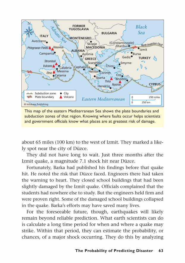
This map of the eastern Mediterranean Sea shows the plate boundaries andsubduction zones of that region. Knowing where faults occur helps scientistsand government officials know what places are at greatest risk of damage.
about 65 miles (100 km) to the west of Izmit. They marked a like-ly spot near the city of Düzce.
They did not have long to wait. Just three months after theIzmit quake, a magnitude 7.1 shock hit near Düzce.
Fortunately, Barka had published his findings before that quakehit. He noted the risk that Düzce faced. Engineers there had takenthe warning to heart. They closed school buildings that had beenslightly damaged by the Izmit quake. Officials complained that thestudents had nowhere else to study. But the engineers held firm andwere proven right. Some of the damaged school buildings collapsedin the quake. Barka’s efforts may have saved many lives.
For the foreseeable future, though, earthquakes will likelyremain beyond reliable prediction. What earth scientists can dois calculate a long time period for when and where a quake maystrike. Within that period, they can estimate the probability, orchances, of a major shock occurring. They do this by analyzing
64 Volcanic Eruptions, Earthquakes, and Tsunamis
stress in the Earth’s crust, the number of years since the fault’slast big quake, activity in nearby faults, and other factors.
These probabilities are not very precise. They may stretch overdecades of time. Seismologists may never be able to say, “This weekthere is a 50% chance of a magnitude 6.0 earthquake in our area,”for example. But they can let fire departments, hospitals, and otherpublic services assess the future risk their area faces. Communitiesand households can then decide how best to prepare.
In 2007, for example, scientists and government officials inSouthern California announced the probability of a major quakein their region. They said that within 30 years, there was a 30%to 70% chance of a very destructive shock near Los Angeles. Toraise awareness of the threat, they launched the “Dare to Pre-pare” program. It asked people to develop emergency plans andpack disaster kits for their families.
If no major quake hits the area within 30 years, people mayshake their heads and complain that the experts were wrong. Butif the “Big One” does hit, the public will thank earth scientists forthe heads up. The value of being prepared must outweigh irrita-tion about an incorrect prediction.
Monitoring Volcanic EruptionsIn 1985, the eruption of Nevado del Ruiz in Colombia set off amassive lahar, or mudslide. The wall of mud and debris wiped outtown of Armero, killing more than 22,000 people. In response,the United States Geological Survey formed the Volcano DisasterAssistance Program (VDAP). This team of volcanologists standsready to jet to stirring volcanoes around the world. They carrywith them the latest in technological equipment.
Once on-site, VDAP joins with local scientists to watch closelyfor signs of a coming eruption. They also assist local officials increating emergency plans, including plans for evacuating peoplein the area. This program has saved thousands of lives already.
Usually, volcanic eruptions offer more precursors than earth-quakes do. That means volcanologists can gather more clues about
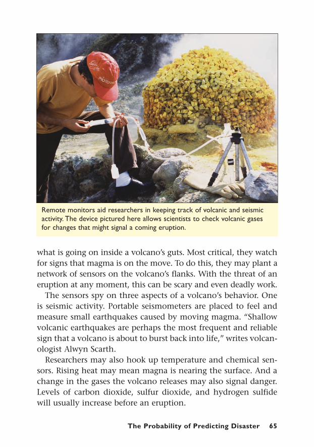
The Probability of Predicting Disaster 65
Remote monitors aid researchers in keeping track of volcanic and seismicactivity. The device pictured here allows scientists to check volcanic gasesfor changes that might signal a coming eruption.
what is going on inside a volcano’s guts. Most critical, they watchfor signs that magma is on the move. To do this, they may plant anetwork of sensors on the volcano’s flanks. With the threat of aneruption at any moment, this can be scary and even deadly work.
The sensors spy on three aspects of a volcano’s behavior. Oneis seismic activity. Portable seismometers are placed to feel andmeasure small earthquakes caused by moving magma. “Shallowvolcanic earthquakes are perhaps the most frequent and reliablesign that a volcano is about to burst back into life,” writes volcan-ologist Alwyn Scarth.
Researchers may also hook up temperature and chemical sen-sors. Rising heat may mean magna is nearing the surface. And achange in the gases the volcano releases may also signal danger.Levels of carbon dioxide, sulfur dioxide, and hydrogen sulfidewill usually increase before an eruption.
Thirdly, volcanologists may set up tiltmeters. These devices cansense tiny changes in the shape of the ground. Often, parts of avolcano will bulge or collapse as a precursor to eruptions.
More and more, volcanologists rely on satellite monitoring ofvolcanoes. Sophisticated instruments can measure changes oftemperature from orbits high above Earth. By placing markers onthe volcano, researchers can also use the global positioning sys-tem, or GPS, to watch for telltale changes in the volcano’s shape.(GPS is a network of satellites that can pinpoint a surface locationwithin inches.)
To date, the eruption of Pinatubo in the Philippines stands outas the most glowing success of volcanology and VDAP. Scientistsestimated that this volcano had not erupted in 400 to 600 years.But in April 1991, it began showing signs of life. Some 15,000people farmed this stratovolcano’s fertile slopes. Another halfmillion lived in the surrounding area. All were at risk from amajor eruption. Philippine volcanologists and VDAP gathered tojudge the danger.
In May 1991, the Philippine Institute of Volcanology pub-lished a hazard map. This map highlighted the areas most at riskfrom lahars, pyroclastic flows, and ashfall. TV stations alsorepeatedly broadcast a show about volcanic threats. These educa-tional efforts informed the public about what it faced and read-ied them for action.
That same month, seismometers measured about 1,800 smallearthquakes. Chemical sensors picked up a 1,000% increase insulfur dioxide gas. On June 6, a tiltmeter signaled that the sum-mit was bulging out at a faster rate. The signs added up to thepossibility of a major eruption. The monitoring team recom-mended a mass evacuation, and local officials put their plan inmotion. More than 100,000 people left the danger zone.
Pinatubo experienced a series of short eruptions in the secondweek of June. Then on June 15, the mountain blew nearly 1,000feet (300 m) off its top. It sent a thundercloud of ash more than
66 Volcanic Eruptions, Earthquakes, and Tsunamis

The Probability of Predicting Disaster 67
The 1991 eruption of Pinatubo in the Philippines covered the region in ash.The ash fall caused the deaths of dozens of people when their roofs col-lapsed on top of them.
6 miles (10 km) into the sky. Pyroclastic flows blasted from themountain’s sides. Lahars flowed down the river valleys.
The death toll, though, only numbered in the hundreds. Manyof these victims died when their roofs collapsed from the weightof falling ash. Many thousands more might have died withoutthe close cooperation of these scientists and public officials.
Pinatubo, Mount St. Helens, and other volcanoes gave clearwarnings that they would soon erupt. At the same time, suppos-edly extinct volcanoes may give no hint that they are alive—
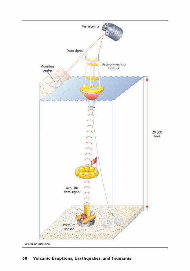
68 Volcanic Eruptions, Earthquakes, and Tsunamis
until they explode. Since 1900, more than a dozen volcanoeshave violently erupted without any previous sign that they wereactive. Volcanologists argue that this offers the best reason toexpand and improve the monitoring of volcanoes worldwide.
Sensing TsunamisThere was no tsunami-warning system in place in the IndianOcean on December 26, 2004. That was the day a huge earth-quake sent a tsunami charging at Asian coastlines.
The lack of such a system contributed to the deaths of some220,000 people across the Indian Ocean. For those on Sumatra,the large island nearest the huge tsunami-causing quake, thekiller waves arrived too fast for any alert to have done muchgood. But for other coastal countries, the tsunami took two tothree hours to reach their shores. For them, a warning systemcould have saved thousands of lives.
Underwater earthquakes trigger most tsunamis, as mentionedearlier. So quake detection is often the first hint that a tsunamimay be on its way. That is why a network of earthquake sensorsis an important feature in tsunami prediction. But for peoplewho live near an underwater quake’s epicenter, their best hope isto run for high ground as soon as they feel a strong tremor.
At the same time, scientists are hurrying to set up a reliable net-work of tsunami-sensing equipment in the Indian Ocean. Such asystem is already operating in the Pacific Ocean. This systemincludes placing tsunami-sensing technology in the deep ocean.The farther from shore a tsunami is spied, the more warningcoastlines will have.
This high-tech system includes a buoy anchored to the deep-ocean floor. The buoy is linked to a pressure sensor, also planted
The Probability of Predicting Disaster 69
(opposite): This is a diagram of a deep-sea tsunami sensor. The pressure sensor on the seafloor can sense a tsunami’s unique wave pattern. A satellitethen relays the information to a warning center.

70 Volcanic Eruptions, Earthquakes, and Tsunamis
This image is a computer simulation of the December 26, 2004 tsunami.The darker pink areas in the Indian Ocean indicate the tallest waves. Power-ful computers are helping scientists understand and predict the behavior oftsunamis, earthquakes, and volcanoes.
on the ocean floor. This pressure sensor has the ability to distin-guish more powerful tsunami waves from the ocean’s normalwave action.
If the sensor does identify a tsunami, it sends a signal to thebuoy floating on the ocean surface. The buoy contains a satelliteuplink that can instantly alert scientists to the danger. Scientistscan then communicate the danger to coastline areas.
The weak link in the system may be getting the message to com-munities in a tsunami’s path. As the 2004 tsunami demonstrated,many coastal villages are poor and lack modern communications.This shortcoming will have to improve for tsunami-warning sys-tems to be widely effective.

The Probability of Predicting Disaster 71
Humans will never have the power to stop volcanoes, earth-quakes, and tsunamis from unleashing their destructive power.But good research can help scientists reduce the number of cata-strophic surprises.
Still, the restless Earth will always be full of surprises. Thus, themost useful response to seismic threats remains preparation.Being prepared means that people learn the risks facing theircommunities. It means the dependable construction of buildingsso that they will stay standing when the earth shakes. It meansmaintaining well-trained fire departments and other emergencyservices to come to the rescue when disaster does strike.
Being prepared closer to home means families, schools, andbusinesses developing emergency plans and packing disaster kits.It means practicing emergency drills so that people know what todo. In these ways, scientists, community leaders, and the publiccan team up when the Earth gets restless.
Scientists cannot study earthquakes under microscopes or constantlyobserve them as they do wild animals. Quakes strike and stop, oftenwithout warning. And they usually last less than a minute. For seismol-ogists, this makes quakes very difficult to study.
To get around this problem, Earth scientists program supercomput-ers to create computer models of quake-prone areas. Using math for-mulas and maps, they try to recreate faults and how they act. Theyinput millions of math equations and data from scientific research thattell the model what to do.When a real earthquake hits, they take meas-urements from it and add it to the model to improve accuracy.
Computer models allow researchers to study how one fault mightadd stress to another fault. They can also predict how a quake willaffect a city or region.
Earth scientists also use computer models to study volcanoes andtsunamis. In time, experts hope that creating these artificial disasterswill give them the power to predict and prepare for real ones.
COMPUTER QUAKES

g g g g g g g
asthenosphere – semi-fluid layer of mantle on which the Earth’s tectonicplates slowly move
building codes – construction rules and standards
calderas – large hollows caused by the explosion or collapse of a volcano
composite volcano – see “stratovolcano”
continental drift – the theory that Earth’s continents split off from onesupercontinent and slowly moved apart
convection – a pattern of circulation in which heated gas or liquid rises beforecooling and sinking
core – the center part of Earth, thought to consist of superheated metal
crust – the surface layer of Earth
epicenter – a spot on the Earth’s surface directly above an earthquake’s focus
eruption – release of gases and lava from a volcano
evacuate – to leave a dangerous place for a safer location
fault – the boundary between tectonic plates
focus – the spot underground where a fault breaks free, causing an earthquake
friction – the force that slows movement and produces heat when two sur-faces rub
geologist – a scientist who studies the earth and its life, especially as it isrecorded in rocks
hot spot – the area in the center of a tectonic plate where magma burnsthrough, forming a volcano
hypothesis – an educated prediction
lahar – a flash flood and mudslide caused by a volcano
lava – melted rock that comes out of a volcano and hardens
magma – melted rock beneath or within the Earth’s crust
magnitude – a measurement for gauging the power of an earthquake
mantle – the layer between the Earth’s core and crust
plate tectonics – the theory that the Earth’s crust is made of moving sections
precursor – a sign that an earthquake, volcanic eruption, or other disaster isabout to happen
primary, or P wave – the fastest body wave of an earthquake that compressesand expands the earth
Glossary 73
Glossary
pyroclastic flow – an avalanche of lava and hot gases from a volcanic eruption
Richter scale – a system for measuring the energy released by an earthquake
secondary, or S-wave – the second-fastest seismic body wave that movessharply up and down or sideways
seafloor spreading – the place where two tectonic plates are moving apart,and lava is forming new ocean floor
sediment – deposits of sand, rocks, and other material that were carried bywater
seismic wave – the vibration from an earthquake that passes through theearth
seismometer – an instrument for detecting and measuring earthquakes
seismologist – a scientist who analyzes earthquakes
stratovolcano – steep-sided volcanic cone
subduction zone – an area where one tectonic plate is dragged down underanother tectonic plate
surface wave – a slow seismic wave that ripples out along the earth’s surface
tectonic plate – a giant segment of rock within the Earth’s crust
tiltmenter – an instrument that detects small changes in the ground’s shape
volcano – an opening in the Earth’s crust where hot gases and melted rockescape from the mantle
74 Glossary
Achenbach, Joel. “The Next Big One.” National Geographic. April 2006, pp. 120–147.
Ballard, Robert D. Exploring Our Living Planet. Washington, D.C.: National Geo-graphic Society, 1983.
Bindeman, Ilya N. “The Secrets of the Supervolcanoes.” Scientific American. June2006, pp. 36–43.
British Broadcasting Corporation. “Award for Tsunami Warning Pupil.” BBC NewsWebsite, September 9, 2005. Available online athttp://news.bbc.co.uk/2/hi/uk_news/4229392.stm.
Erickson, Jon. Volcanoes and Earthquakes. Blue Ridge Summit, Pa.: TAB Books, Inc.,1988.
Geist, Eric L., et al. “Tsunami: Wave of Change.” Scientific American. January 2006,pp. 56–63.
González, Frank I. “Tsunami!” Scientific American. May 1999, pp. 56–65.
Hough, Susan Elizabeth. Earthshaking Science. Princeton, N.J.: Princeton UniversityPress, 2002.
Kious, W. Jacqueline and Robert I. Tilling. This Dynamic Earth: The Story of Plate Tectonics. USGS Special Interest Publication, 1996.
Klampe, Michelle L. “Southern Californians urged: Prepare for a really big quake.”Scripps-McClatchy Western Service, January 10, 2007.
Lambourne, Helen. “Tsunami: Anatomy of a Disaster,” BBC News Online, March 27,2005. Available online at http://news.bbc.co.uk/2/hi/science/nature/4381395.stm.
LeVay, Simon. “Riding the Rumble.” Scientific American. October 2000, pp. 17–18.
Prager, Ellen J. Furious Earth. New York: McGraw Hill, 2000.
Ritchie, David and Alexander E. Gates. Encyclopedia of Earthquakes and Volcanoes.New York: Checkmark Books, 2001.
Scarth, Alwyn. Volcanoes. College Station, Tex.: Texas A & M Press, 1994.
Stein, Ross S. “Earthquake Conversations.” Scientific American. January 2003, pp. 72–79.
The Virtual Museum of the City of San Francisco. “The Great 1906 Earthquake andFire.” Available online at www.sfmuseum.org/1906/06.html.
Walker, Bryce. Earthquake. Alexandria, Va.: Time-Life Books, 1982.
Bibliography 75
Bibliography

BOOKS
Bonar, Samantha. Tsunamis. Mankato, Minn.: Capstone Press, 2006.
DK Publishing. Eyewitness: Volcano & Earthquake. New York: DK Publishing, 2004.
Ganeri, Anita. Violent Volcanoes and Earth-Shattering Earthquakes. New York: Scholas-tic, 2006.
Johnson, Rebecca L. Plate Tectonics. Minneapolis, Minn.: Lerner Books, 2006.
Rosi, Mauro, et al. Volcanoes. Buffalo, N.Y.: Firefly Books Ltd., 2003.
Simon, Seymour. Earthquakes. New York: HarperCollins, 2006. Princeton, N.J.:Princeton University Press, 2002.
Stille, Darlene R. Plate Tectonics: Earth’s Moving Crust. Mankato, Minn.: CompassPoint Books, 2007.
Torres, John Albert. Disaster in the Indian Ocean: Tsunami 2004. Hockessin, Del.:Mitchell Lane Publishers, 2005.
Townsend, John. Earthquakes And Volcanoes – a Survival Guide: Earth’s Physical Processes. Chicago, Ill.: Raintree, 2006.
WEB SITES
www.enchantedlearning.com/subjects/astronomy/planets/earth/Continents.shtmlPlate tectonics—animated
www.pbs.org/wnet/savageearth/index.htmlThe Public Broadcasting Station’s site explores plate tectonics, volcanoes, earthquakes, andtsunamis—animated
http://earthquake.usgs.gov/learning/students.phpInteractive earthquake hazards program, maintained by the United States Geological Survey
http://volcano.und.edu/Up-to-date information on volcanic activity, plus volcano-related facts and activities
http://homeschooling.gomilpitas.com/explore/tsunami.htmScience of tsunamis
76 Further Exploration
Further Exploration

Italics indicate illustrations
Aceh, 49aftershocks, 34animals, 31, 61, 62Armero, Colombia, 64asteroids, 46asthenosphere, 15
Bacon, Francis, 12Banda Aceh, 42, 47, 49. See also southern
Asia 2004 tsunamiBarka, Aykut A., 62–63body waves, 37building codes, 54, 56. See also construc-
tionBurke, Emma M., 33
catfish, 9, 62Chile, 38, 39China, earthquakes in, 61cinder cone volcanoes, 21, 22, 22–23climate, 29comets, 46composite volcanoes, 21, 22, 22computers, 58, 70, 71construction
in danger zones, 52, 52–55, 54, 57importance of, 51–52
continental drift, 12, 13convection, 17convergent boundaries, 25–26, 27, 43, 63conveyor belts, 26–27core, 11, 11crust, 10–11, 11, 13–14, 15, 17
“Dare to Prepare” program, 64Deep Impact, 46Disaster Supply Kits, 53dogs, 31, 61, 62drilling, exploration and, 10Düzce, Turkey, 63
Earth, distance to center of, 9earthquakes. See also specific locations
construction and, 52–58danger zones for, 39–40deadliest, 40faults, waves and, 34–37locations of, 26, 37–39plate tectonics and, 16, 34precursors of, 61stress-triggering and, 61–64testing and, 50–52tsunamis and, 43, 44, 69
education, importance of, 49, 71electromagnetic field, 62epicenter, 37
family survival kits, 53fault zones, 34–36, 35, 36Federal Emergency Management Admin-
istration (FEMA), 53fires, 31, 32first aid kits, 53flexibility, 55–56, 57flooding, 44, 47–48, 48focus, defined, 37foreshocks, 34, 61foundations, 55Free Aceh Movement, 49friction, 34Fuji, Mount, 22
gases, volcanoes and, 20generation, 44global positioning systems (GPS), 66Glomar Challenger, 14gravity, 17ground, stability of, 56
Hawaiian Islands, 23, 24, 26–27Hess, Harry, 13–14Himalayan Mountains, 40hot spots, 25, 26–27, 27
Index 77
Index
Iceland, 7, 8, 10Indonesia. See southern Asia 2004
tsunamiinundation, 44, 47–48, 48island formation, 7, 8, 26–27Izmit, Turkey, 62–63
Johnston, David, 29, 30Juan de Fuca plate, 27
Kashima god, 9Kilauea, 23, 24Krakatau, 20, 44
lahars, 18, 23–25, 28, 29, 64land bridge, 13lava deltas, 21Loihi, 27Los Angeles City Hall, 57–58
magma, 19–20magnitude, 37–39, 38, 39, 40mainshock, 34Malaysia. See southern Asia 2004
tsunamimantle, 11, 11, 17Martinique, 18–19Mauna Loa, 23McDougall, Ian, 26Mediterranean Sea, 63Mexico City, 54Montserrat Island, 21mudslides, 18, 23–25, 28, 29, 64myths, 9, 15
namazu, 9Nevado de Ruiz, 64New Zealand, 23normal faults, 34–35, 36North Anatolian Fault, 62–63Northridge earthquake, 50nuée ardente, defined, 25
oceans. See also tsunamisseafloor spreading and, 13–14, 15underwater volcanoes and, 14, 20–21,
25, 27, 44
Pakistan, 52, 55Pangaea, 13Papua, New Guinea, 44Pele, 9Pelée, Mount, 18–19, 20, 25Philippines, 66–67Pinatubo, 66–67, 67plate tectonics, 15–17, 16, 34, 63Pompeii, 19precursors, 59prediction
earthquake precursors and, 61probability of, 59–60seismographs and, 60stress-triggering and, 61–64tsunami sensing and, 69–71volcanic monitoring and, 64–69
preparation, importance of, 71primary wave (P wave), 37propagation, 44, 46–47pyroclastic flows, 18–19, 21, 25, 28, 29,
44
radius of Earth, 9Rainier, Mount, 22, 27Reid, Harry Fielding, 31–32, 34reverse faults, 36Richter, Charles, 55Richter scale, 38, 39Ring of Fire, 26, 26, 39–40roads, 51, 58roofs, collapse of, 67, 67
San Andreas Fault, 32, 35, 36San Francisco, 31–32, 32, 33, 39satellite monitoring, 66, 68, 70Scarth, Alwyn, 65seafloor spreading, 13–14, 15secondary waves (S waves), 37seismic, defined, 8seismic waves, 36–37, 37seismographs, 10, 37, 37, 59, 60shake tables, 50shield volcanoes, 21, 22, 23shock absorbers, 57–58simulations, 70, 71smart buildings, 58
78 Index
Smith, Tilly, 41–42, 49soda analogy, 20southern Asia 2004 tsunami
Banda Aceh and, 42computer simulation of, 70destruction from, 8, 45lack of warning system for, 69overview of, 41–42, 44–49statistics on, 43
Sri Lanka. See southern Asia 2004 tsunami
St. Helens, Mount, 8, 27–30, 28St. Pierre, 18–19, 25stability, 56steel, 55, 57, 58stratovolcanoes, 21, 22, 22stress-triggering, 61–64strike-slip faults, 35–36, 36subduction zones, 25–26, 27, 43, 63submersible vehicles, 25sulfur dioxide, 29, 30, 65Sumatra, 23, 49. See also southern Asia
2004 tsunamisupervolcanoes, 23suprcontinents, 13, 17surface waves, 37Surtsey, 7, 8survival kits, 53suspension systems, 57–58
Tambora, 29tectonics. See plate tectonicsTekton, 15temperature of Earth’s core, 11Thailand. See southern Asia 2004 tsunamiThree Wise Men, 14
thrust faults, 34, 35, 36tiltmeters, 59, 66tool kits, 53transform faults, 35–36, 36tsunamis. See also southern Asia 2004
tsunamimajor since 1990, 43preparation for, 49sensing of, 62, 68, 69–71simulation of, 70triggers of, 43–44, 44, 46, 69waves of, 48
Turkey, 8, 62–63
Vesuvius, Mount, 19, 20Volcano Disaster Assistance Program
(VDAP), 64–65volcanoes. See also specific volcanoes
deadliest, 20defined, 19–21locations of, 14, 25–27, 26monitoring of, 64–69, 65myths of, 9plate tectonics and, 16tsunamis and, 45types of, 21–25
Vulcan, 9
warning systems, lack of, 46water, 53, 61waves, 36–37. See also tsunamisweather balloons, 12Wegener, Alfred, 12, 13well water, 61
Year Without a Summer, 29
Index 79

Sean McCollum is an award-winning author of 20 nonfiction booksfor children and teens. He is a regular contributor to National Geo-graphic Kids, Boys’ Life, and Scholastic. He is also a writing instructorat Front Range Community College in Colorado. A traveler to about50 countries, McCollum has yet to experience an earthquake or atsunami but has hiked to the top of several volcanoes.
80 About the Author / Picture Credits
About the Author
Picture CreditsPAGE: 3: Stephen & Donna O’Meara/Photo Researchers, Inc.
8: Ragnar Larusson/Photo Researchers, Inc.10: Krafft /Photo Researchers, Inc.11: © Infobase Publishing14: Dr. Ken MacDonald/Photo Researchers, Inc.15: © Infobase Publishing17: © Infobase Publishing19: Lee Battaglia/Photo Researchers, Inc.21: Bernhard Edmaier/Photo Researchers, Inc.22: © Infobase Publishing24: United States Geological Survey26: © Infobase Publishing27: © Infobase Publishing28: Explorer/Photo Researchers, Inc.30: United States Geological Survey32: Corbis/Bettmann35: David Parker/Photo Researchers, Inc.36: © Infobase Publishing37: © Infobase Publishing38: AP Images/William J. Smith42: AP Images/Eugene Hoshiko44: © Infobase Publishing45: © Salamanderman/Shutterstock47: © Infobase Publishing48: David Hardy/Photo Researchers, Inc.51: AP Images/Koji Sasahara52: AP Images/Tomas Munita54: Wesley Bocxe/Photo Researchers, Inc.57: Fletcher and Baylis/Photo Researchers, Inc.60: James King-Holmes/Photo Researchers, Inc.63: © Infobase Publishing65: Philippe Bourseiller/Photo Researchers, Inc.67: Mauro Fermariello/Photo Researchers, Inc.68: © Infobase Publishing70: Yalciner, Kuran, Taymaz/Photo Researchers, Inc.
COVER (LEFT TO RIGHT):
Mt. St. Helens in Washington State spews smoke and ash into the sky in April 1980. (AP Images/Jack Smith)
A tsunami hits the shore in Ao Nang, Krabi Province, Thailand during the 2004 Indian Ocean Earthquake and Tsunami. (© David Rydevik)
A road cracked by earthquakes in the town of Solok in Indonesia’s West Sumatra province on March 7, 2007. (Reuters/Muhammad Fitrah/Landov)


![Physical modeling of tsunamis generated by three ......[2] Tsunamis are water waves generated by impulsive disturbances such as submarine earthquakes and landslides, volcanic eruptions](https://static.fdocuments.us/doc/165x107/605705a83642e512411472aa/physical-modeling-of-tsunamis-generated-by-three-2-tsunamis-are-water.jpg)

