May Township Geological Report Sudbury Mining … Township Geological Report Sudbury Mining Division...
11
RECEIVED JUN vo 2CC1 GEOSCIENCE ASSESSMENT .J3.FFICE______l May Township Geological Report Sudbury Mining Division By: Mark Hall B.Se. Geology June 2001 41J08SE2003 2.21647 MAY 010
Transcript of May Township Geological Report Sudbury Mining … Township Geological Report Sudbury Mining Division...

RECEIVEDJUN vo 2CC1
GEOSCIENCE ASSESSMENT .J3.FFICE______l
May Township Geological Report Sudbury Mining Division
By: Mark Hall B.Se. Geology June 2001
41J08SE2003 2.21647 MAY 010

INDEX
. Introduction
. Property Description
. Location and Access
. Regional Geology
. Local Geology
. History of Exploration
. Recent Exploration by Bailey, Orchard and Hall
. Recommendations
. Figures
41J08SE2003 2.21647 MAY 0 10C

IntroductionThe location was selected by R. Orchard, B. Bailey and M. Hall on the basis of the similarity of the geology to the Shakespeare and Dunlop gabbro. The apparent correlation between these two intrusive bodies suggested the mineral potential here was favorable. The partners carried out geologic mapping in the summers of 1999 and 2000. R. Orchard and B. Bailey assisted while M. Hall mapped the geology on and adjacent to traverse lines. While assays were not encouraging, the geology appears favorable, and should be further examined for areas of platinum group element (PGE) enrichment.
Property DescriptionThe property is a 6 unit un-patented mining claim held by Ron Orchard, Bob Bailey and Mark Hall number S-1229123.
Location and access.The property is located on the north shore of Salmay Lake in May township being in the north half of Lot 12 Con V. Beginning at Highway #17, just east of the town of Massey, approximately 400 meters east of Sable River bridge, take the Salter - May township boundary road north. Follow this road north for approximately 4.2 kilometers to where a "T". Turn Left. From here you can see Salmay Lake. Follow this road to the west end of the lake. From here one can park just off the road and launch a boat to access the southern boundary of the claim on the north shore of the lake, or walk along the north shore or travel about 200 meters further on the road to a trail running east. This road will take you to the west side of the claim.
Regional GeologyThe regional geology consists of Huronian aged volcanics, gabbros, anorthositic gabbros, and sediments. Underlying these rocks are archean aged granites and gneisses. All are intruded by Nippissing diabase and later dykes. The anorthositic gabbros, the focus of exploration, lie at the contact between the archean basement and Huronian sediments.
This intrusive anorthositic gabbro extends easterly from Salter Township to Porter Township. It is apparently equivalent to the "East Bull Lake Gabbro" and Shakespeare - Dunlop gabbros.. It has been the subject of Copper - Nickel exploration in the past by WMC and others. Interest has been recently renewed in these gabbros for the platinum and palladium potential. Two properties, located in Salter Township, were the subject of minor copper production. They are the Hermina and Massey Mines situate in the northern half of the township. These deposits appear to be spatially associated with the Murray Fault and the previously Gabbro and/or Nippissing Diabase.
The Murray Fault is a major structural feature in the region. It strikes approximately west-southwest, and is represented by Robertson (GR - 136) as being located 800 meters south of the claim.

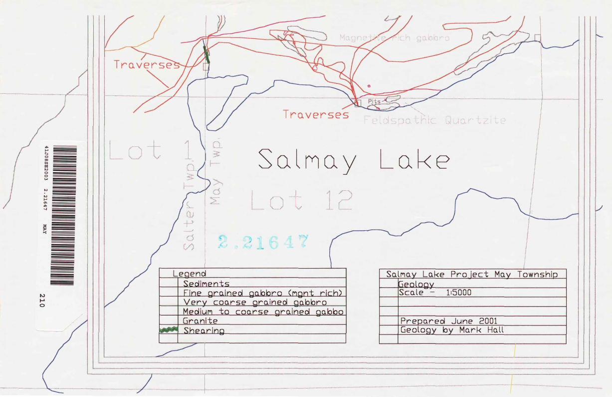
Local GeologyThe claim covers part of a layered anorthositic gabbro equivalent to the Shakespeare - Dunlop and East Bull Lake Gabbros. It is situated between the archean basement (composed of granite and felsic gneisses), and Huronian sediments. The sediments are composed mainly of feldspathic quartzites. Robertson (1976) suggests that this gabbro may have been partially eroded before sediments were deposited, implying that the section was originally much thicker. He also indicates that the geology strikes approximately east west and dips steeply to the south. The southern portion of the gabbro has been mapped as mafic volcanics, and apparent extrusive equivalent to the gabbro in the northern part of the claim. The gabbro is easily identifiable on magnetic maps as a mag high. Robertson indicated in his report that Nippissing diabase is also present on the claim.
History of ExplorationAir borne mag and EM survey by WMC 1990's Magnetometer and VLF surveys by Shunk 1977-78 Stripping and drilling by A. Alexander 1968 -1969
Recent Exploration by Bailey, Orchard and HallThe geology of the claim was examined to determine the presence of geology favorable to copper - nickel and platinum group elements (PGE"s), and to locate past trenches and pits in order and sample to test for the presence of PGE's. The conclusion is that the claim is host to a layered gabbro with potential for hosting PGE mineralization.
While traversing, the group located three trenches on the north shore of the lake and one pit in the south central portion of the claim as indicated on preliminary map P-0702. All were located in sediments presumably to test for the presence of uranium. Minor ^507o) pyrite and chalcopyrite were present in the trenches. Trench samples were not assayed. The north shore of Salmay Lake is the approximate contact between the sediments and the gabbro. An additional two pits, indicated on old assessment files (see o) indicated as hosting chalcopyrite, were not located, despite extensive searching.
The strike of the sediments and gabbro is roughly 80 0 . In contact with the north edge of the sediments is a locally magnetite rich (up to 50*^ in hand samples) gabbro (amphibolite) It is approximately 200 meters thick and contains occasional minor (than 3^o) pyrite - pyrrhotite - chalcopyrite. It is a black-green, fine to medium grained amphibolite. Samples were with obvious chalcopyrite taken , but initial assays were not encouraging. This is apparently the unit mapped by Robertson as volcanics, but some outcrops appear as intrusive. Freshly stripped exposures of the magnetite rich unit at the south central portion of the claim, revealed sulphides ^3"Xo cpy) While common along shearing, it is also present in small concentrations ^207o) disseminated within the gabbro. Grab samples from this location were not encouraging.
North of the magnetite rich gabbro is a very coarse to pegmetitic - anorthositic gabbro. Amphibole and plagioclase grain size varies from 0.5 cm to 4 cm in length. In some locations hand samples are up to 90Vo plagioclase. The contact with the previous

described unit was not observed... Robertson mapped this as a Nippissing Diabase but it may simply be a zone within the larger gabbro body. Local shearing is present in several areas, specifically observed in the north south traverse in the center of the claim and at the south portion of traverse to the west boundary of the claim. Most shearing is in a east west direction, the exception is the north south shearing at the southern limit of the western most traverse.
The most northerly unit of the gabbro is a medium to coarse grained gabbro. This unit, similar to the rest is, altered to amphibolite. The contact with the granite is disturbed with clasts of the granite incorporated into the gabbro.
The granite is light salmon color, very coarse grained with large blebby patches of quartz, and quartz veining. It forms a prominent ridge in the north portion of the claim.
RecommendationsThe remaining trenches shown on the assessment maps should be located and assayed for PGE's. It appears chalcopyrite is preferentially located in the magnetite rich gabbro in the south portion of the claim. Assessment work on file indicates that this unit is host to VLF conductors. It should be mapped in detail to determine if there is any significant sulfide (cpy) enrichment. Existing assessment work on file with the MNDM should be reviewed and all conductors ground checked. .
Geologic mapping and EM surveys at 100 meter intervals should be performed to identify mineralization and EM conductors in order to identify stripping and drill targets.
The contact between the sediments and gabbro should be examined to determine if it is an erosional contact and if possible to better understand how much of the gabbro has been eroded.
The granite at the north of the claim, should be mapped in order to determine if there is any mineralization that could represent footwall style deposition. If present, mapping should be followed up by an EM survey.
Figures
1 Location Map2 Geology Map including traverses.
Mark Hall B. Se. Geology

ED
UC
AT
ION
VE
RS
ION
- N
OT
FO
R C
OM
ME
RC
IAL
UG
E

ONTARIO MINISTRY OF NORTHERN DEVELOPMENT AND MINES
Transaction No: W0 170. 30346
Recording Date: 2001-JUN-20
Approval Date: 2001-SEP-05
Client(s):
Work Report Summary
Status: APPROVED
Work Done from : 1 999- J U L-07
to: 2001-JUN-18
303181
Survey Type(s):
HALL, MARK
GEOL
Work Report Details:
Claim#
S 1229123
Perform
34,359
S4.359
Perform Approve
34,359
34,359
Applied
34,359
34,359
Applied Approve
34,359
34,359
Assign
soso
Assign Approve
0
30
Reserve
30
so
Reserve Approve
soso
Due Date
2002-JUL-05
Status of claim is based on information currently on record.
41J08SE2003 2.21647 MAY900
2001-Sep-12 15:52 Armstrong-d Page 1 of 1
Ministry ofNorthern Developmentand Mines
Date:2001-SEP-06
Ministere duDeveloppement du Nord et des Mines Ontario
GEOSCIENCE ASSESSMENT OFFICE 933 RAMSEY LAKE ROAD, 6th FLOOR SUDBURY, ONTARIO P3E6B5
MARK HALL 580 KANTOLA ROAD LIVELY, ONTARIO P3Y1H8 CANADA
Tel: (888) 415-9845 Fax:(877)670-1555
Dear Sir or Madam
Submission Number: 2 21647 Transaction Number(s): W0170.30346
Subject: Approval of Assessment Work
We have approved your Assessment Work Submission with the above noted Transaction Number(s). The attached Work Report Summary indicates the results of the approval.
At the discretion of the Ministry, the assessment work performed on the mining lands noted in this work report may be subject to inspection and/or investigation at any time.
PLEASE NOTE:
The geological map did not include several items. In future, please show outcrops designated by a letter or number code, show the character of the overburden, the nature of the vegetation, identify and provide strikes and dips for structural features, and identify any zones of mineralization or alteration.
If you have any question regarding this correspondence, please contact JIM MCAULEY by email at [email protected] or by phone at (705) 670-5855.
Yours Sincerely,
Roy SpoonerSupervisor, Geoscience Assessment Office
Gc: Resident Geologist
Mark Hall (Claim Holder)
Assessment File Library
Mark Hall (Assessment Office)
Visit our website at http://www.gov.on.ca/MNDM/LANDS/mlsmnpge.htm Page: 1 Correspondence 10:16326

A*) UK h S
PROVINCIAL MN IN O
MINING LAND TENURE
MAP
ra ft)
to lo
to o o
^^'Silff^1^^
tiiitJi^
OIO fe'-i'Mit^ifeKUii..^.^-^
;,-:.,... j^, .....OB,
';jfife^:^^;- ̂ ^
,.:^' -X l-
ti:l
General Information and Llm ItalianswrioinnMn vtirf Mlnn fH .WWtnm Wtorn,*|Wi HIE ilitinrnnn*(fcn itmwi BM (titii m*|i.taeiPiii[rilid rr.iri^^^ui ni Tvfct *r ft*fl(iirv Oftfc*. gi td.Mdrtitu'a/tfnittbiaarcn.
Dale i' T i mtl of Issue Sap G 2001
TOWNSHIP l AREA
MAY
13:54h Eastern
PLAN
G-2971
ADMINISTRATIVE DISTRICTS i D IVISIONSMining Division Sudbury
Land Titles/Registry Division SUDBURY
Mfnlttry of Natural Rtaourctt District SUDBURY
TOPOGRAPHIC
OLi!a
LAND TENURE
Q
Q .
0 --
Q I'f: if?w*8r ' uidim ewm
LAND TENURE WITHDRAWALS
q Art wmtimL If K*
W^ r.,,,. M,^nM |.
IMPORTANT NOTICES
LAND TENURE WITHDRAWAL DESCRIPTIONS
mi PZVM WMD Mm i i" i W* VLC iiWLL PiilW 0*1 WA* t? W MtV
IMPORTANT NOTICESAp*n wtiMi i*ith iMtlil i MrfMtoni, hn* M tom o condiitaMt inM ihi* *1*ct MOJH^I MPW
6
mmilfel din WIHM* mih* Prwlritu nintta f^c*f4*rr QAc4 vltng iiDrti 4f Mutlitiy of HanhHn DMFHipmrtH in* Hlnn MD m.
Traverses
ainay
Leaend
#tf#*
SedimentsFine grained gabbro Cngnt rich)Very coarse arained gabbroMedium to coarse orained gabboGraniteShearing
Salnay Lake Pro iect May TownshipneologyScale - 1:5000
Prepared JuneGeology
2001by Mark Hall

41J0
8S
E2003
2.2
1647
MA
Y220