Matters of State Environmental Signifcance v5 Methodology · Matters of state environmental...
27
Method for mapping Matters of state environmental significance for the- State Planning Policy 2017 Environmental Offset Regulation 2014
Transcript of Matters of State Environmental Signifcance v5 Methodology · Matters of state environmental...

Method for mapping
Matters of state environmental significance for the-
State Planning Policy 2017
Environmental Offset Regulation 2014

2
© State of Queensland, 2017.
The Queensland Government supports and encourages the dissemination and exchange of its information. The copyright in this
publication is licensed under a Creative Commons Attribution 3.0 Australia (CC BY) licence.
Under this licence you are free, without having to seek our permission, to use this publication in accordance with the licence
terms.
You must keep intact the copyright notice and attribute the State of Queensland as the source of the publication.
For more information on this licence, visit http://creativecommons.org/licenses/by/3.0/au/deed.en
Disclaimer
This document has been prepared with all due diligence and care, based on the best available information at the time of
publication. The department holds no responsibility for any errors or omissions within this document. Any decisions made by
other parties based on this document are solely the responsibility of those parties. Information contained in this document is
from a number of sources and, as such, does not necessarily represent government or departmental policy.
If you need to access this document in a language other than English, please call the Translating and Interpreting Service (TIS
National) on 131 450 and ask them to telephone Library Services on +61 7 3170 5470.
This publication can be made available in an alternative format (e.g. large print or audiotape) on request for people with vision
impairment; phone +61 7 3170 5470 or email <[email protected]>.

iii
Contents Updates ......................................................................................................................................................................... 5
MSES ‘NextGen’: a new mapping approach ............................................................................................................. 5
Purpose and methods ................................................................................................................................................... 5
Purpose of the mapping: for land use planning, development and offsets ............................................................... 5
SPP MSES Definition ................................................................................................................................................ 5
MSES in relation to existing laws and policies .......................................................................................................... 7
Limitations of MSES mapping ................................................................................................................................... 7
How to access the mapping ...................................................................................................................................... 7
Update and amendment policy ................................................................................................................................. 7
MSES mapping methodology tables ............................................................................................................................ 8
MSES mapping layers ............................................................................................................................................... 8
Methodology based on ArcGIS software and data ................................................................................................... 8
Table 1: Matters of State environmental significance (MSES) ................................................................................... 22
Appendix A – Guidelines and principles for mapping wildlife habitat ......................................................................... 22
Wildlife habitat principles ......................................................................................................................................... 22
Utilising habitat suitability models ........................................................................................................................... 22
Utilising species point records ................................................................................................................................. 23
Table 2. MSES high mobility fauna ......................................................................................................................... 23
EHP requirements when using other methods ....................................................................................................... 25
Appendix B –Applying the regulated vegetation watercourse distance...................................................................... 26
Table 3 – Distance from the defining banks of watercourses based on bioregion and stream order. .................... 26

5
Updates
MSES ‘NextGen’: a new mapping approach
The latest version of MSES mapping aims for a product that is accurate, up-to-date and reliable to the end user. The new mapping also aims to be a more complete representation of MSES values, which are separately defined under instruments in the Planning Act 2016 and Environmental Offset Act 2014.
Unlike previous versions of MSES mapping, the product is now entirely dependent on existing data sources. Each layer is separate, with a links to the SPP MSES definition, and has the ability to be updated independently from each other.
The method uses automated scripts to extract the information from the source layer (An example being the Regulated Vegetation mapping). This means that the MSES layer has the same structure as the original data source, reducing the need to find more information and the risk of data quality issues.
Purpose and methods
Purpose of the mapping: for land use planning, development and offsets
This document has been prepared to describe the methodology used to spatially represent matters of state environmental significance (MSES) used for plan making, development assessment and offsets.
The State Planning Policy 2017 (SPP) sets out the state’s interest for biodiversity as:
‘Matters of environmental significance are valued and protected, and the health and resilience of biodiversity is maintained or enhanced to support ecological integrity.’
Schedule 2 of the Environmental Offsets Regulation 2014 (Offset regulation) also defines a list of matters of state environmental significance, which is a prescribed matter under the Environmental Offsets Act 2014. The code provisions under the State Development Assessment Provisions (SDAP) refer to the definition under the Offset regulation.
SPP MSES Definition
The State Planning Policy 2017 (SPP) defines matters of state environmental significance as:
i) protected areas (including all classes of protected area except coordinated conservation areas) under the
Nature Conservation Act 1992
ii) ‘marine national park’, ‘conservation park’, ‘scientific research’, ‘preservation’ or ‘buffer’ zones under the
Marine Parks Act 2004
iii) areas within declared fish habitat areas that are management A areas or management B areas under the
Fisheries Regulation 2008
iv) a designated precinct, in a strategic environmental area under the Regional Planning Interests Regulation
2014, schedule 2, part 5, s15(3)
v) wetlands in a wetland protection area or wetlands of high ecological significance shown on the map of
referable wetlands under the Environmental Protection Regulation 2008
vi) wetlands and watercourses in high ecological value waters identified in the Environmental Protection
(Water) Policy 2009, schedule 1
vii) legally secured offset areas as defined under the Environmental Offsets Act 2014.
viii) threatened wildlife under the Nature Conservation Act 1992 and special least concern animals under the
Nature Conservation (Wildlife) Regulation 2006
ix) marine plants under the Fisheries Act 1994 (excluding marine plants in an urban area)
x) waterways that provide for fish passage under the Fisheries Act 1994 (excluding waterways providing for
fish passage in an urban area)
xi) High risk area on the flora survey trigger as described by the Environmental offsets Regulation 2014,
schedule 2, part6(1)

6
xii) regulated vegetation under the Vegetation Management Act 1999 that is:
a. category B areas on the regulated vegetation management map, that are ‘endangered’ and ‘of
concern’ regional ecosystems
b. category C areas on the regulated vegetation management map that are ‘endangered’ and ‘of
concern’ regional ecosystems
c. category R areas on the regulated vegetation management map
d. areas of essential habitat on the essential habitat map for an animal that is ‘endangered wildlife’ or
‘vulnerable wildlife’ or a plant that is ‘endangered wildlife’ or ‘vulnerable wildlife’ wildlife prescribed
as ‘endangered wildlife’ or ‘vulnerable wildlife’ under the Nature Conservation Act 1992
e. category A,B,C,R areas that are located within a defined distance8 from the defining banks of a
relevant watercourse identified on the vegetation management watercourse and drainage feature
map
f. category A,B,C,R areas that are located within 100 metres from the defining bank of a wetland
identified on the vegetation management wetlands map.
NOTE: mapping associated with ix), x) or xi) categories of MSES will not be displayed for SPP purposes.

7
MSES in relation to existing laws and policies
The MSES mapping product is a guide to assist planning and development assessment decision-making. Its primary purpose is to support implementation of the SPP biodiversity policy. While it supports the SPP, the mapping does not replace the regulatory mapping or environmental values specifically called up under other laws or regulations. Similarly, the SPP biodiversity policy does not override or replace specific requirement of other Acts or regulations.
Limitations of MSES mapping
This is a biophysical mapping product. The data used to create it is scale dependent and care needs to be exercised in using the mapping at very large scales and it should not be used as a ‘point of truth’. It provides an indication of where the biodiversity values are expected to exist in the landscape. Site surveys will generally be required to determine if the depicted values are present. If site surveys show that MSES values are not present, the SPP biodiversity policy does not apply. Please see the SPP (biodiversity) guideline for more information regarding site surveys mapping amendments.
How to access the mapping
MSES mapping is published online by the Department of Infrastructure Local Government and Planning (DILGP) and viewable to an allotment scale from the SPP Interactive Mapping System (IMS) or the development assessment mapping system (DAMS), available at www.dilgp.qld.gov.au. The mapping data can be obtained for use in a geographic information system (GIS) from the Queensland Spatial Catalogue (QSpatial) at http://qspatial.information.qld.gov.au.
For further information, refer to the SPP and associated guideline for biodiversity or email [email protected].
Table 1 MSES methodology refers to layer names that are available on QSpatial on Internal government databases. A MSES mapping methodology can also be located on the EHP website at https://www.ehp.qld.gov.au/management/planning-guidelines/method-mapping-mses.html.
Update and amendment policy
MSES mapping is not based on new or unique data. The primary mapping product draws data from a number of environment databases and geo-referenced information sources. The base data includes, but is not limited to:
vegetation management regulated maps
regional ecosystems remnant vegetation
threatened species sightings (WildNet and other databases)
protected area tenure mapping
marine park zoning information
Queensland wetland mapping
To update MSES mapping, it is important to notify the custodians of the base data so that it is updated instead. Please see the metadata of each dataset for contacts. These updates should appear in the next version of MSES mapping.
8
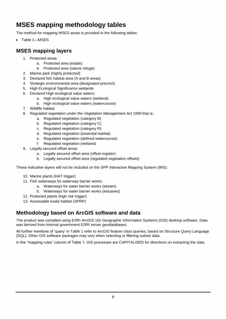
MSES mapping methodology tables The method for mapping MSES areas is provided in the following tables:
Table 1—MSES
MSES mapping layers
1. Protected areas:
a. Protected area (estate)
b. Protected area (nature refuge)
2. Marine park (highly protected)
3. Declared fish habitat area (A and B areas)
4. Strategic environmental area (designated precinct)
5. High Ecological Significance wetlands
6. Declared High ecological value waters:
a. High ecological value waters (wetland)
b. High ecological value waters (watercourse)
7. Wildlife habitat
8. Regulated vegetation under the Vegetation Management Act 1999 that is:
a. Regulated vegetation (category B)
b. Regulated vegetation (category C)
c. Regulated vegetation (category R)
d. Regulated vegetation (essential habitat)
e. Regulated vegetation (defined watercourse)
f. Regulated vegetation (wetland)
9. Legally secured offset areas
a. Legally secured offset area (offset register)
b. Legally secured offset area (regulated vegetation offsets)
These indicative layers will not be included on the SPP Interactive Mapping System (IMS):
10. Marine plants (HAT trigger)
11. Fish waterways for waterway barrier works:
a. Waterways for water barrier works (stream)
b. Waterways for water barrier works (estuaries)
12. Protected plants (high risk trigger)
13. Assessable koala habitat (SPRP)
Methodology based on ArcGIS software and data
The product was compiled using ESRI ArcGIS 10x Geographic Information Systems (GIS) desktop software. Data was derived from internal government ESRI server geodatabases.
All further mentions of ‘query’ in Table 1 refer to ArcGIS feature class queries, based on Structure Query Language (SQL). Other GIS software packages may vary when selecting or filtering subset data.
In the “mapping rules” column of Table 1, GIS processes are CAPITALISED for directions on extracting the data.

22
Table 1: Matters of State environmental significance (MSES)
MSES layers SPP definition Overview Mapping rules Derived dataset locations
1. Protected areas: a. Protected area
(estate) b. Protected area
(nature refuge)
Nature Conservation Act 1992
Protected areas (including all classes of protected area except coordinated conservation areas) under the Nature Conservation Act 1992
Include following categories only:
National Park
National Park (Aboriginal land)
National Park (Torres Strait Islander land)
National Park (Cape York Peninsula Aboriginal land)
Conservation Park
Resources Reserve
Forest Reserve
Nature Refuge Areas^
Areas of critical habitat*
Notes:
^Nature Refuge Area extents are not defined by cadastral property boundaries. Ensure that the data only contains the refuge area portion of a property and not include the whole cadastral boundary, unless specified.
*currently, there are no areas of this class of protected area declared under the NCA.
State Forests are not included as MSES.
Direction:
1. For estates, SELECT listed estate types using the query:
EST_TENURE IN ('NP', 'NS' , 'NY' , 'CP', 'FR', 'RR')
2. For nature refuges, COPY the entire dataset.
QSpatial data:
Protected areas of Queensland
Nature Refuges - Queensland
Internal use data:
QPWS_SIS.QLD_ESTATE_DCDB/QPWS_SIS.ESTATE
EN.QLD_NATURE_REFUGE
2. Marine park (highly protected)
‘marine national park’,
‘conservation park’,
‘scientific research’,
Include the following Highly Protected MP zones only:
Direction:
1. SELECT listed Marine Park
QSpatial data:
Queensland State Marine

23
MSES layers SPP definition Overview Mapping rules Derived dataset locations
Marine Parks Act 2004 (MPA)
‘preservation’ or ‘buffer’
zones under the Marine
Parks Act 2004
Marine National Park zone
Marine Conservation Park zone
Scientific Research zone
Preservation zone
Buffer zone
Zones using the query:
ZONE IN ( 'Marine National Park Zone', 'Conservation Park Zone', 'Scientific Research Zone', 'Preservation Zone', 'Buffer Zone')
Parks Zoning:
Moreton Bay marine park zoning 2008
Great Barrier Reef coast marine park zoning
Internal use data:
QPWS_SIS.QLD_STATE_MARINE_PARKS
3. Declared fish habitat area (A and B areas)
Fisheries Act 1994
Areas within declared
fish habitat areas that
are management A
areas or management B
areas under the
Fisheries Regulation
2008
Include:
Fish Habitat Areas A and B
Direction:
1. SELECT listed Fish Habitat Areas using the query:
TYPE_ABBR IN ( 'FHAA', 'FHAB')
Note: currently, copying the data entirely also suffices.
QSpatial data:
Queensland fish habitat areas
Internal use data:
QPWS_SIS.QLD_FISH_HABITAT_AREA
4. Strategic environmental area (designated precinct)
Regional Planning Interests Act
A designated precinct, in
a strategic
environmental area
under the Regional
Planning Interests
Regulation 2014,
schedule 2, part 5,
s15(3)
Include:
Strategic Environmental Areas- Designated Precincts
Direction:
2. SELECT of DILGP Strategic Environmental Areas layer. Designated precincts only using the query:
RPITYPE = 'Strategic Environmental Area - Designated Precinct'
QSpatial data:
Regional Planning Interests Act- Strategic Environmental Areas
Internal use data:
DSDIP.QLD_DSDIP_RPI_SEA
5. High Ecological Significance
Wetlands in a wetland
protection area or
wetlands of high
Include:
HES wetlands on the
Direction:
1. Extract the following:
QSpatial data:
Map of Referable Wetland

24
MSES layers SPP definition Overview Mapping rules Derived dataset locations
wetlands
Environmental Protection Act 1994
ecological significance
shown on the map of
referable wetlands under
the Environmental
Protection Regulation
2008
Map of Referable Wetlands
Exclude:
In the “wetland protection Area-wetland” layer, any recent WPA wetland map amendments made under s144D of the Environmental Protection Regulation
Note: The data used on the Map of Referable Wetlands is based on Queensland Wetlands Mapping Version 2 (2009). To ensure currency, the latest version of the mapping can be used to validate wetlands on the Map of Referable Wetlands.
‘HES’ wetlands from the Wetland management dataset, using the “DATASET” field
All wetlands from the Wetland Protection Area dataset
2. Remove
Any Map Amendment Register amendments
QSpatial directions
1. For Wetland Management Wetlands, SELECT HES wetlands using the query:
DATASET ='HES'
2. For Wetland Protection Wetlands, COPY the entire dataset.
3. UNION datasets for complete MSES HES wetland coverage.
-wetland layers:
Wetland management area wetlands
Wetland protection area wetlands
Internal use data:
ENVEP.QLD_WETLMGMTAREA_WETLANDS
ENVEP.GBR_WETLPROTAREA_HES_WETLANDS
6. Declared High ecological value waters: a. High ecological
value waters (wetland)
b. High ecological value waters (watercourse)
Environmental Protection Act 1994
Wetlands and
watercourses in high
ecological value waters
identified in the
Environmental
Protection (Water) Policy
2009, schedule 1
For MSES layer include:
Natural wetlands on the Queensland wetlands mapping that are within (clipped to) HEV areas
For MSES Drainage layer, include:
River/drainage lines that are within (clipped to) HEV areas
Direction:
EHP Healthy Waters have produces MSES-specific data for the two layers:
HEV wetlands, and
HEV watercourses
HEV wetlands
Derived directly from Wetlands v4.
1. SELECT natural wetlands from the Queensland Wetland
QSpatial data:
HEV waters:
EPP Water (multiple locations) intent for waters
Source Wetlands:
Queensland Wetland Mapping (Current version 4, 2015)
Source Watercourses:
Vegetation

25
MSES layers SPP definition Overview Mapping rules Derived dataset locations
Mapping:
Query:
HYDROMOD NOT IN ('H2M1','H2M3','H2M5','H2M3P','H2M7', 'H3C1', 'H3C2', 'H3C3','H2M6') AND HYDROMOD IS NOT NULL AND LEGEND NOT IN( '01-50_RE' )
2. SELECT HEV waters from the “intent for waters” EPP. There are 3 regional datasets if QSpatial datasets are used. SELECT MI_TYPE IN( 'HEV' , 'HEVm_fw' , 'HEVm_mar' )
3. INTERSECT wetlands with HEV waters.
HEV watercourses
4. For watercourses, use the regulated vegetation watercourse layer
5. As above, SELECT MI_TYPE IN( 'HEV' , 'HEVm_fw' , 'HEVm_mar' )
6. INTERSECT watercourses with HEV waters.
management watercourse and drainage feature map (1:100000 and 1:250000) – latest version 1.4
Internal use data:
ENVHW.QLD_EPP_HEV_OUTLINE
ENVHW.QLD_EPP_HEV_WETLANDS
ENVHW.QLD_EPP_HEV_WATERCOURSE
7. Wildlife habitat
Nature Conservation Act 1992
Threatened wildlife
under the Nature
Conservation Act 1992
and special least
concern animals under
the Nature Conservation
Include: Modelled or known habitat for current species that are:
Threatened wildlife under Nature Conservation Act 1992 including: o ‘Endangered’
Direction:
Note: The Threatened and Special Least Concern Animal layer originates from the previous MSES version (4.1, dated at 2014). The layer does not represent currently listed species and is subject to further review.
QSpatial data:
Species data from MSES version 4,1, 2014:
Wildnet database species records
habitat suitability models (various)

26
MSES layers SPP definition Overview Mapping rules Derived dataset locations
(Wildlife) Regulation
2006
o ‘Vulnerable’
Special least concern animals under the Nature Conservation Act 1992 including: o Echidna o platypus o migratory birds
(JAMBA,CAMBA, Bonn)
Appendix A provides guidance on the principles of mapping wildlife habitat.
The following is an extract from MSES version 4.1, 2014:
For all species habitat (in order of preference):
VMA Essential habitat (if applicable); or
Modelled habitat (peer reviewed and accepted); or
Mapped area based on known habitat factors (climate, elevation, bioregion, regional ecosystems); or
point records buffered to 1000m that are within remnant or regrowth REs (see Notes)
Species specific layers:
1. Dugongs: dugong protection areas
2. SEQ koalas: SEQ koala habitat value
3. Migratory birds: SEQ wader survey collation data and Ramsar sites
For specific layers above include:
1. Include: a. dugong protection zones A
and B 2. Include:
a. ‘High Value’, ‘Medium Value’ and ‘Low Value’ koala ‘bushland’ mapping in
Koala planning areas version 1-2 - South East Queensland - data package-Wader Site Data Collation and Survey Project for South East Queensland-see EHP
Ramsar sites
Dugong Protection Areas

27
MSES layers SPP definition Overview Mapping rules Derived dataset locations
eastern SEQ (see notes). b. keep all non-remnant
vegetation. DO NOT remove Built up areas or VMA ‘X’ areas
3. Include: a. 'critical' migratory bird
habitat using "KEY" field b. all Ramsar sites
Exclude
For all species habitat:
Inaccurate precision point records. (i.e. >500m accuracy)
Point records that pre-date 1975 for fauna and 1950 for flora.
Highly mobile fauna species point records, except where the record is a known breeding or roosting site. Highly mobile species are identified in Appendix B
Duplicates and doubtful records (invalidated records )
Specific layers:
For dugong protection areas (1), exclude areas landward of the coastline or above the low water mark^
For koala bushland habitat (2), all other values in koala SPP - habitat values
For migratory birds (3), all other values in "KEY" field
28
MSES layers SPP definition Overview Mapping rules Derived dataset locations
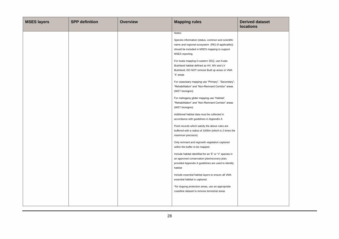
Notes:
Species information (status, common and scientific
name and regional ecosystem (RE) (if applicable))
should be included in MSES mapping to support
MSES reporting
For koala mapping in eastern SEQ, use Koala
Bushland habitat defined as HV, MV and LV
Bushland. DO NOT remove Built up areas or VMA
‘X’ areas
For cassowary mapping use “Primary”, “Secondary”,
“Rehabilitation” and “Non-Remnant Corridor” areas
(WET bioregion)
For mahogany glider mapping use “Habitat”,
“Rehabilitation” and “Non-Remnant Corridor” areas
(WET bioregion)
Additional habitat data must be collected in
accordance with guidelines in Appendix A
Point records which satisfy the above rules are
buffered with a radius of 1000m (which is 2 times the
maximum precision).
Only remnant and regrowth vegetation captured
within the buffer to be mapped.
Include habitat identified for an ‘E’ or ‘V’ species in
an approved conservation plan/recovery plan,
provided Appendix A guidelines are used to identify
habitat
Include essential habitat layers to ensure all VMA
essential habitat is captured.
^for dugong protection areas, use an appropriate
coastline dataset to remove terrestrial areas
29
MSES layers SPP definition Overview Mapping rules Derived dataset locations
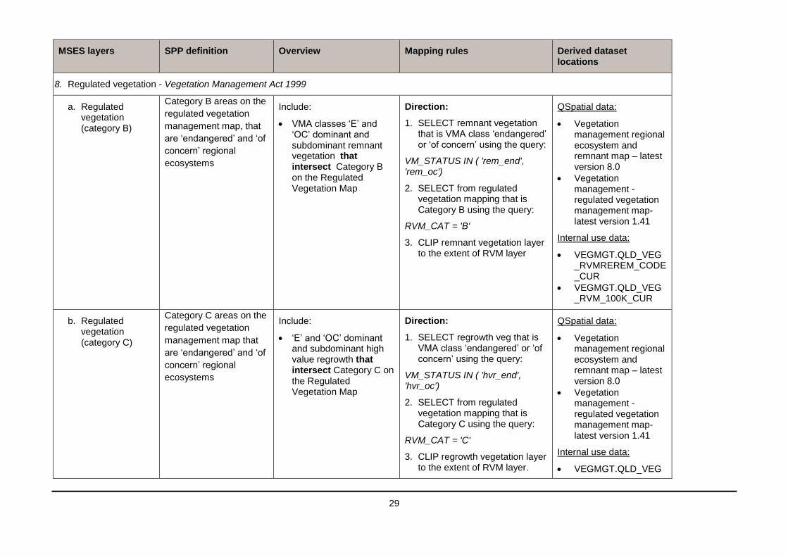
8. Regulated vegetation - Vegetation Management Act 1999
a. Regulated vegetation (category B)
Category B areas on the
regulated vegetation
management map, that
are ‘endangered’ and ‘of
concern’ regional
ecosystems
Include:
VMA classes ‘E’ and ‘OC’ dominant and subdominant remnant vegetation that intersect Category B on the Regulated Vegetation Map
Direction:
1. SELECT remnant vegetation that is VMA class ‘endangered’ or ‘of concern’ using the query:
VM_STATUS IN ( 'rem_end', 'rem_oc')
2. SELECT from regulated vegetation mapping that is Category B using the query:
RVM_CAT = 'B'
3. CLIP remnant vegetation layer to the extent of RVM layer
QSpatial data:
Vegetation management regional ecosystem and remnant map – latest version 8.0
Vegetation management - regulated vegetation management map- latest version 1.41
Internal use data:
VEGMGT.QLD_VEG_RVMREREM_CODE_CUR
VEGMGT.QLD_VEG_RVM_100K_CUR
b. Regulated vegetation (category C)
Category C areas on the
regulated vegetation
management map that
are ‘endangered’ and ‘of
concern’ regional
ecosystems
Include:
‘E’ and ‘OC’ dominant and subdominant high value regrowth that intersect Category C on the Regulated Vegetation Map
Direction:
1. SELECT regrowth veg that is VMA class ‘endangered’ or ‘of concern’ using the query:
VM_STATUS IN ( 'hvr_end', 'hvr_oc')
2. SELECT from regulated vegetation mapping that is Category C using the query:
RVM_CAT = 'C'
3. CLIP regrowth vegetation layer to the extent of RVM layer.
QSpatial data:
Vegetation management regional ecosystem and remnant map – latest version 8.0
Vegetation management - regulated vegetation management map- latest version 1.41
Internal use data:
VEGMGT.QLD_VEG

30
MSES layers SPP definition Overview Mapping rules Derived dataset locations
_RVMREREM_CODE_CUR
VEGMGT.QLD_VEG_RVM_100K_CUR
c. Regulated vegetation (category R)
Category R areas on the
regulated vegetation
management map
Include:
all Category R areas on the Regulated Vegetation Management Map.
Direction:
1. SELECT Regulated Vegetation Mapping that is Category R using the query:
RVM_CAT = 'R'
QSpatial data:
Vegetation management - regulated vegetation management map- latest version 1.41
Internal use data:
VEGMGT.QLD_VEG_RVM_100K_CUR
d. Regulated vegetation (essential habitat)
Areas of essential
habitat on the essential
habitat map for an
animal that is
‘endangered wildlife’ or
‘vulnerable wildlife’ or a
plant that is ‘endangered
wildlife’ or ‘vulnerable
wildlife’ wildlife
prescribed as
‘endangered wildlife’ or
‘vulnerable wildlife’
under the Nature
Conservation Act 1992
Include:
Regulated vegetation that is areas of essential habitat under the Vegetation Management Act 1999
Direction:
1. COPY the latest regulated vegetation essential habitat mapping.
QSpatial data:
Vegetation management - essential habitat map – latest version 4.41
Internal use data:
VEGMGT.QLD_VEG_EHAB_CODE_NOATTRIB_CUR
e. Regulated vegetation
Category A,B,C,R areas
that are located within a Include:
Watercourses and drainage
Direction:
1. COPY the latest regulated
QSpatial data:

31
MSES layers SPP definition Overview Mapping rules Derived dataset locations
(defined watercourse)
defined distance from
the defining banks of a
relevant watercourse
identified on the
vegetation management
watercourse and
drainage feature map
feature shown on the Vegetation Management Watercourse Map
Note:
The state-wide MSES watercourse mapping is currently linear.
‘Buffering’ the data does not apply the MSES definition.
See Appendix B for information on how to apply a local distance to the MSES mapping.
vegetation watercourse mapping.
Vegetation management watercourse and drainage feature map (1:100000 and 1:250000) – latest version 1.4
f. Regulated vegetation (wetland)
Category A,B,C,R areas
that are located within
100 metres from the
defining bank of a
wetland identified on the
vegetation management
wetlands map.
Include:
Regulated vegetation categories (A,B,C,R) that intersect the regulated vegetation wetlands, buffered by 100m.
Direction:
1. SELECT Regulated Vegetation Mapping (RVM) that is Category A,B,C or R using the query:
RVM_CAT IN ('A','B','C’,'R')
2. BUFFER regulated vegetation wetland mapping by 100 metres (GDA94).
3. CLIP RVM to the extent of buffered wetlands layer.
QSpatial data:
Vegetation management - regulated vegetation management map- latest version 1.41
Vegetation management wetlands map – latest version 2.41 Regulated vegetation wetlands
Internal use data:
VEGMGT.QLD_VEG_RVMREREM_CODE_CUR
Remnant wetlands
VEGMGT.QLD_VEG

32
MSES layers SPP definition Overview Mapping rules Derived dataset locations
_REGROWTHWETL_100K_CUR
Regrowth wetlands
VEGMGT.QLD_VEG_REGROWTHWETL_100K_CUR
9. Legally secured offsets a. Legally secured
offset area (offset register)
b. Legally secured offset area (regulated vegetation offsets)
Environmental Offsets Act 2014
Offset areas legally secured under a covenant, conservation agreement or development approval condition.
Include:
Offset Register offset location sites
Property map of assessable vegetation offset areas (current, s20B(1)(b) and RVM Category A)
Direction:
1. For Offset register offset locations (a), COPY Offset location sites from the Offset Register.
2. For vegetation offsets (b), SELECT from the PMAV layer using the query:
PMAV_TYPE = ‘s20B(1)(b)’AND PMAV_STAT = ‘Current’ AND PMAV_CAT = ‘A’
QSpatial data:
For Offset register offset locations (a):
Data not yet currently publicly available for the Offset Register. Contact EHP for offset register data.
For PMAV vegetation offsets (b):
Vegetation Management Act property maps of assessable vegetation
Internal use data:
For Offset register offset locations (a):
ENVOFF.OFFSET_REGISTER\ENVOFF.OFFSET_LOCATIONS
For PMAV vegetation offsets (b):

33
MSES layers SPP definition Overview Mapping rules Derived dataset locations
ENVOFF.OFFSET_REGISTER\ENVOFF.PMAV_OFFSET_SITES
MSES layers that will not appear on the SPP Interactive Mapping System, for information only
10. Marine plants (HAT trigger)
Fisheries Act 1994
Marine plants under the Fisheries Act 1994 (excluding marine plants in an urban area)
The trigger area for Marine plants, which is Highest Astronomical Tide (HAT).
Note: this is an information layer only, which indicates the trigger for Marine Plants and not the MSES value.
Direction:
1. COPY the latest Highest Astronomical Tide mapping.
QSpatial data:
Highest astronomical tide – Queensland
Internal use data:
ENVESR.QLD_ESA_AREA_BELOW_HAT
11. Fish waterways for waterway barrier works: a. Waterways for
water barrier works (stream)
b. Waterways for water barrier works (estuaries)
Fisheries Act 1994
Waterways that provide
for fish passage under
the Fisheries Act 1994
(excluding waterways
providing for fish
passage in an urban
area)
Include:
Streams and estuaries that are waterways for waterway barrier works.
Direction:
1. COPY the latest waterways for water barrier works from QSpatial which includes: a. streams (lines) b. estuary (polygon)
QSpatial data:
Queensland waterways for waterway barrier works
12. Protected plants (high risk trigger)
Nature Conservation Act 1992
High risk area on the
flora survey trigger as
described by the
Environmental offsets
Regulation 2014,
schedule 2, part 6(1)
Include:
The high risk area from the flora survey trigger map
Direction:
1. COPY the latest protect plants flora survey trigger map.
QSpatial data:
Nature Conservation Act protected plants flora survey trigger map spatial layer
Internal use data:
ENVWIL.QLD_NCA_

34
MSES layers SPP definition Overview Mapping rules Derived dataset locations
PROTPLANTS_TRIGGERMAP
13. Assessable koala habitat (SPRP)
Environmental Offsets Act 2014
This definition is not in
the SPP. However it is
an MSES under the
Environmental offsets
Regulation 2014,
schedule 2, part 6(3).
This MSES is currently
managed by relevant
SEQ local governments.
A non-juvenile koala
habitat tree located in an
area shown as bushland
habitat, high value
rehabilitation habitat or
medium value
rehabilitation habitat on
the map called ‘Map of
Assessable
Development Area
Koala Habitat Values’
that applies under the
South East Queensland
Koala Conservation
State Planning
Regulatory Provisions is
a matter of State
environmental
significance.
Include:
Koala bushland habitat and high/medium rehabilitation Habitats that are within SPRP assessable development areas.
Priority koala assessable development area (PKADA)
Koala assessable development area (KADA)
Direction:
1. SELECT from the koala habitat layer using the query:
FID_SPRP_A <> -1 AND HABVAL IN ( 'HV Bushland', 'LV Bushland', 'MV Bushland', 'MV Rehab' ,'HV Rehab')
QSpatial data:
Koala planning areas version 1-2 - South East Queensland - data package
Internal use data:
ENVEP.SEQ_KOALA_SPP_HABVAL

22
Appendix A – Guidelines and principles for mapping wildlife habitat Note: The Threatened and Special Least Concern Animal layer originates from the previous MSES version (4.1, dated at 2014). The layer does not represent currently listed species and is subject to further review.
The purpose of this guideline is to provide the approach used in the mapping of MSES wildlife habitat and to give principles and guidance to users who would prefer to use a different approach to those outlined below.
Wildlife habitat principles
When mapping wildlife habitat for MSES, The following principles should be followed ensure that the products are current, transparent and repeatable.
use of the most recent and up-to-date information available
prioritise the most rigorous methods for identifying and mapping habitat
as far as possible information should be drawn from centralised databases and broadly available spatial data.
Wildlife habitat is mapped in MSES using the most appropriate data listed in order of preference and subject to availability:
1. peer-reviewed modelled habitat (peer reviewed and accepted); or 2. expert approved habitat suitability models that have been accepted by the relevant government authority;
or 3. point records buffered to 1000m that are within with remnant, wetlands, and other areas of possible habitat
such as regrowth and landscape features.
Utilising habitat suitability models
For a model to be used in MSES, the model must be depict the areas within the landscape that define the most important areas for a species (core habitat) rather than broad species distributions. It is advisable that habitat models follow the overall Habitat Suitability Model (HSM) Framework employed by the Queensland Department of Environment and Heritage Protection.
The HSM framework determines the known extent, possible extent and importance of habitat for threatened taxa listed under Queensland and/or Australian government legislation and for priority taxa listed as part of bioregional assessments. The approach shifts the conservation focus away from specific point locations (sites of taxa presence based on historic records) in the landscape to areas where the taxon is, or is likely to be present. The framework aims to be consistent, repeatable and transparent, documenting reasons for a particular level of assessment. It is conducted irrespective of tenure or the significance of areas for other conservation reasons.
Habitat areas are classified into known and possible, preferred and general, to produce four habitat value categories: preferred habitat known (PHK); preferred habitat possible (PHP); general habitat known (GHK); or general habitat possible (GHP).
Preferred habitat is an area or location with crucial resources for the maintenance of populations of the taxon. Preferred habitat may be defined from known records or potential areas according to expert knowledge of habitat relationships.
Preferred habitat known (PHK): Preferred habitat is considered known where the taxon is present (based on high accuracy records) and there are indications of reproduction, or where a significant number of individuals are present, or important resources (such as nest sites, roost caves, major food sources) are present, or where important movement corridors for breeding and/or non-breeding (including migratory) individuals have been identified.
Preferred habitat possible (PHP): Preferred habitat is considered possible where there exists suitable habitat capable of supporting one or more breeding units, and/or important resources (such as nest sites, roost caves, major food sources) are present, or the area is proximal to populations, or may act as a potentially important corridor for the species.
General habitat is an area or location that has been used by transient individuals of a taxon, or where a species

23
has been recorded but there is insufficient information to assess the area as preferred habitat.
General habitat known (GHK): General habitat is considered known where the taxon is present.
General habitat possible (GHP): General habitat is considered possible according to expert knowledge of habitat relationships, and may include areas of sub-optimal habitat.
A confidence level is then applied to particular location and its habitat value based upon the level of certainty in the ascribed value and its importance. Confidence values usually range from Very High to Low (e.g. PHK Very High).
Core habitat comprises a combination of habitat value and confidence which experts consider best define the most important areas for the taxon. Remaining areas of habitat for the taxon are identified as being non-core.
Utilising species point records
The rules in section 3 in Table 1 must be satisfied before species point records are accepted.
It is recommended that species point data records are submitted to WildNet which the Queensland Government standard database for species records and information. As much detail as possible on the record should be provided. Please refer to the Queensland WildNet guidelines for more information (https://www.ehp.qld.gov.au/licences-permits/plants-animals/documents/wildnet-data-form-guidelines.pdf).
MSES wildlife habitat mapping from species records uses recent and accurate flora and fauna sightings from WildNet and other reputable sources. The records are then filtered using the following criteria:
recent sightings later than 1975 for fauna,
recent sightings later than 1950 for flora,
precision (accuracy) of sighting to within 500m,
highly mobile species listed as ‘endangered’ or ‘vulnerable’ are only included where the location is a known roosting and breeding site,
all species that have approved habitat suitability models for a particular extent will have their point records removed to avoid duplication.
If records (outside of WildNet) are used in mapping, the above criteria must be applied.
In terms of highly mobile species. Table 1 of this appendix provides a list of high mobility fauna that are listed for protection in the Nature Conservation Act 1992 as ‘endangered’ and ‘vulnerable’. High mobility fauna have been determined via expert elicitation and contain species that have large home ranges (greater than 100ha per reproductive unit). Where no home range information exists, the allocation is based on life history characters or taxa of similar size and biology.
Experts may recommend the inclusion of additional species or exclusion of species on the list where more accurate information on species mobility becomes available. Sightings of highly mobile threatened fauna that are not known to be breeding or important roost sites should be excluded from essential habitat and MSES mapping as of the rules in section 7, Table 1.
Table 2. MSES high mobility fauna
Scientific name Common name Class NCA Status
Anthochaera phrygia Regent Honeyeater Aves E
Arctocephalus tropicalis Subantarctic Fur Seal Mammalia V
Calyptorhynchus lathami Glossy Black-Cockatoo Aves V
Carcharias taurus Greynurse Shark Pisces E
Caretta caretta Loggerhead Turtle Reptilia E
Chelonia mydas Green Turtle Reptilia V

24
Scientific name Common name Class NCA Status
Crocodylus porosus Estuarine Crocodile Reptilia V
Cyclopsitta diophthalma coxeni Coxen's Fig-Parrot Aves E
Cyclopsitta diophthalma macleayana
Macleay's Fig-Parrot Aves V
Dermochelys coriacea Leatherback Turtle Reptilia E
Diomedea antipodensis Antipodean Albatross Aves V
Diomedea exulans Wandering Albatross Aves V
Diomedea gibsoni Gibson's Albatross Aves V
Dugong dugon Dugong Mammalia V
Eclectus roratus macgillivrayi Eclectus Parrot Aves V
Eretmochelys imbricata Hawksbill Turtle Reptilia V
Erythrotriorchis radiatus Red Goshawk Aves E
Esacus magnirostris Beach Stone-curlew Aves V
Grantiella picta Painted Honeyeater Aves V
Lathamus discolor Swift Parrot Aves E
Lepidochelys olivacea Olive Ridley Turtle Reptilia E
Lophochroa leadbeateri Major Mitchell's Cockatoo Aves V
Macroderma gigas Ghost Bat Mammalia V
Macronectes giganteus Southern Giant-Petrel Aves E
Macronectes halli Northern Giant-Petrel Aves V
Megaptera novaeangliae Humpback Whale Mammalia V
Natator depressus Flatback Turtle Reptilia V
Ninox rufa queenslandica Rufous Owl (southern subsp.) Aves V
Ninox strenua Powerful Owl Aves V
Pezoporus occidentalis Night Parrot Aves E
Phaethon rubricauda Red-tailed Tropicbird Aves V
Phoebetria fusca Sooty Albatross Aves V
Psephotus chrysopterygius Golden-shouldered Parrot Aves E

25
Scientific name Common name Class NCA Status
Pterodroma heraldica Herald Petrel Aves E
Rostratula australis Australian Painted Snipe Aves V
Sternula albifrons Little Tern Aves E
Thalassarche bulleri Buller's Albatross Aves V
Thalassarche carteri Yellow-nosed Albatross Aves V
Thalassarche cauta Shy Albatross Aves V
Thalassarche chrysostoma Grey-headed Albatross Aves V
Thalassarche steadi White-capped Albatross Aves V
Tyto novaehollandiae kimberli Masked Owl (northern subsp.) Aves V
As most special least concern species are migratory and highly mobile by definition, all records have been retained
in this version. For future versions of MSES, options will be explored to specifically exclude the small number of
sightings for highly mobile species that are not breeding or important roost sites.
EHP requirements when using other methods
If another method for mapping MSES wildlife habitat mapping for planning purposes is applied, the following is required:
EHP must receive a copy of the methodology highlighting the different approach used and any references to similar methods supplied
all species that are listed as MSES must be incorporated into the mapping
if species records are used, they should be sourced from WildNet in preference to other data sources. If it is found that alternatively sourced data is not adequately reflected in WildNet, the minimum collection standards, and the filtering guidelines stated above must be applied. It is highly recommended that alternatively sourced records be submitted to WildNet to rectify these differences.

26
Appendix B –Applying the regulated vegetation watercourse distance The mapping data in MSES 8E VEG Watercourse only depicts the centreline of a watercourse, which requires further local application of the MSES definition. Underlined terms are defined in the Glossary of terms.
To be a defined MSES, a distance from the watercourse defining bank is required to be applied. Any RVM category areas (A, B, C or R) within that distance is MSES. Distance varies dependant on the location (coastal or non-coastal bioregion - see figure 1) and the stream order (see figure 2). For some areas in Queensland, a stream order is provided in the attributes of the dataset which supports the identification of a distance from the bank of a watercourse. Where a stream order is not provided for in the dataset, determine the stream order using the process identified in figure 2.
Once the coastal/non-coastal bioregion and stream order is identified, the local MSES watercourse map can be developed using the relevant distance stipulated by Table 3 below. This distance is applied from the defining bank of the watercourse using a rectified image of an appropriate scale.
For more information, contact the Department of Natural Resources and Mines at:
Email: [email protected]
phone: 135VEG (135834)
online: https://www.dnrm.qld.gov.au/our-department/contact-us/vegetation-contacts/online-enquiries
Table 3 – Distance from the defining banks of watercourses based on bioregion and stream order.
Watercourse stream order Distance from the defining bank (meters)
Coastal bioregions and sub-regions
1 or 2 10
3 or 4 25
5 or greater 50
Non-coastal bioregions and sub-regions
1 or 2 25
3 or 4 50
5 or greater 100

27
Figure 1 Location of coastal and non-coastal bioregions and sub-regions
When two streams of the same order join, the resulting watercourse becomes one stream order larger. If two streams of different orders join, the resultant stream order is that of the larger stream.

28
Figure 2 Diagrammatic view of stream ordering
Glossary of terms for this section
Defining bank is the bank which confines the seasonal flows but may be inundated by flooding from time to time. This can be either:
(1) the bank or terrace that confines the water before the point of flooding, or
(2) where there is no bank the seasonal high water line which represents the point of flooding.
Stream order is a numerical ordering classification of each watercourse segment according to its position within a catchment, as shown in Figure 2. Stream orders are determined using the vegetation management watercourse and drainage feature map.