Mattabesset River Stakeholder Group Management Plan W atershed · Tom ODell Chair, Middlesex County...
88
Mattabesset River Stakeholder Group Management Plan for the Mattabesset River Watershed September 2000 Mattabesset River Stakeholder Group Management Plan for the Mattabesset River Watershed September 2000 Mattabesset River Stakeholder Group Management Plan for the Mattabesset River Watershed September 2000
Transcript of Mattabesset River Stakeholder Group Management Plan W atershed · Tom ODell Chair, Middlesex County...

Mattabesset River Stakeholder Group
Management Planfor the
Mattabesset RiverWatershed
September 2000
Mattabesset River Stakeholder Group
Management Planfor the
Mattabesset RiverWatershed
September 2000
Mattabesset River Stakeholder Group
Management Planfor the
Mattabesset RiverWatershed
September 2000

MANAGEMENT PLAN FOR THE MATTABESSET RIVER WATERSHED
TorringtonHartford
Waterbury
Meriden
Danbury
Long Island Sound
New Haven
Bridgeport
Norwalk
Stamford
Norwich
New London95
95
9184
91 84
691
395
2
CONNECTICUT
Housatonic River
Thames
River
Connecticut River
Mattabesset RiverWatershed
3
Matt
abessetRiver
Middletown
9
The Mattabesset River watershed is located in central Connecticut.
Editor: Stephanie Shakofsky
Contributing Editors: Jane BrawermanDanielle Piraino
Graphic Design: Pat Rasch
Macroinvertebrate & Fish Illustrations: Joyce Powzyk
Cartoon Illustrations: Pat Rasch
Photography: Stephanie Shakofsky, Pat Rasch, Cloe Poisson/The Hartford Courant, Jane Brawerman, Tom Ladny, Ed Pawlak, Ann Hadley, Danielle Piraino,Gina Amoroso/The Middletown Press,Corey Lowenstein/The Hartford Courant,Clyde Selner
Archival Material: Cromwell Belden Library, Berlin-PeckMemorial Library, The NatureConservancy, Middlesex County Soil &Water Conservation District Archives

Table of ContentsVision Statement . . . . . . . . . . . . . . . . . . . . . . . . . . . . . . . . . . . . . . . . . . . . . 3
Stakeholder Groups/ Affiliations . . . . . . . . . . . . . . . . . . . . . . . . . . . . . . . . . 6
Acknowledgements . . . . . . . . . . . . . . . . . . . . . . . . . . . . . . . . . . . . . . . . . . . 7
List of Acronyms. . . . . . . . . . . . . . . . . . . . . . . . . . . . . . . . . . . . . . . . . . . . . . 9
Executive Summary. . . . . . . . . . . . . . . . . . . . . . . . . . . . . . . . . . . . . . . . . . . 10
Nine Goals of the Plan Summary . . . . . . . . . . . . . . . . . . . . . . . . . . . . . . . . 11
Our Partnership . . . . . . . . . . . . . . . . . . . . . . . . . . . . . . . . . . . . . . . . . . . . . . 12
Project History. . . . . . . . . . . . . . . . . . . . . . . . . . . . . . . . . . . . . . . . . . . . . . . 14
State of the Watershed. . . . . . . . . . . . . . . . . . . . . . . . . . . . . . . . . . . . . . . . . 15
Introduction . . . . . . . . . . . . . . . . . . . . . . . . . . . . . . . . . . . . . . . . . . . . . . . 16
Historical . . . . . . . . . . . . . . . . . . . . . . . . . . . . . . . . . . . . . . . . . . . . . . . . . 18
Water Resources . . . . . . . . . . . . . . . . . . . . . . . . . . . . . . . . . . . . . . . . . . . . 21
Water Quantity. . . . . . . . . . . . . . . . . . . . . . . . . . . . . . . . . . . . . . . . . 21
Water Quality . . . . . . . . . . . . . . . . . . . . . . . . . . . . . . . . . . . . . . . . . . 25
Recent Records . . . . . . . . . . . . . . . . . . . . . . . . . . . . . . . . . . . . . 25
Special Concern: Turbidity . . . . . . . . . . . . . . . . . . . . . . . . . . . . 28
Benthic Macroinvertebrates . . . . . . . . . . . . . . . . . . . . . . . . . . . 30
Historical Records . . . . . . . . . . . . . . . . . . . . . . . . . . . . . . . . . . . 32
Wetlands & Watercourses. . . . . . . . . . . . . . . . . . . . . . . . . . . . . . . . . 33
Water Supply . . . . . . . . . . . . . . . . . . . . . . . . . . . . . . . . . . . . . . . . . . 34
Dams/Impoundments . . . . . . . . . . . . . . . . . . . . . . . . . . . . . . . . . . . 35
Discharges & Waste . . . . . . . . . . . . . . . . . . . . . . . . . . . . . . . . . . . . . 35
Ongoing Pollution . . . . . . . . . . . . . . . . . . . . . . . . . . . . . . . . . . . . . . 36
Land Use . . . . . . . . . . . . . . . . . . . . . . . . . . . . . . . . . . . . . . . . . . . . . . . . . . 38
Land Use Regulation. . . . . . . . . . . . . . . . . . . . . . . . . . . . . . . . . . . . . 39
Wetlands & Watercourse Regulation . . . . . . . . . . . . . . . . . . . . . . . . 40
Stormwater Regulation. . . . . . . . . . . . . . . . . . . . . . . . . . . . . . . . . . . 41
Erosion & Sedimentation Control Regulation . . . . . . . . . . . . . . . . . 42
Impervious Surface . . . . . . . . . . . . . . . . . . . . . . . . . . . . . . . . . . . . . . 43
Residential . . . . . . . . . . . . . . . . . . . . . . . . . . . . . . . . . . . . . . . . . . . . 45
Open Space . . . . . . . . . . . . . . . . . . . . . . . . . . . . . . . . . . . . . . . . . . . . 46
Habitat . . . . . . . . . . . . . . . . . . . . . . . . . . . . . . . . . . . . . . . . . . . . . . . 48
Continued
1
MANAGEMENT PLAN FOR THE MATTABESSET RIVER WATERSHED TABLE OF CONTENTS
TABLE OF CONTENTS MANAGEMENT PLAN FOR THE MATTABESSET RIVER WATERSHED
The Plan . . . . . . . . . . . . . . . . . . . . . . . . . . . . . . . . . . . . . . . . . . . . . . . . . . . 51
Introduction . . . . . . . . . . . . . . . . . . . . . . . . . . . . . . . . . . . . . . . . . . . . . . 52
Goal #1: Create Public Awareness . . . . . . . . . . . . . . . . . . . . . . . . . . . . 53
Goal #2: Educate Public on Land Use and Water Pollution Linkage . . 56
Goal #3: Promote Sustainable Land Use . . . . . . . . . . . . . . . . . . . . . . . . 59
Goal #4: Restore and Maintain Wildlife Habitat . . . . . . . . . . . . . . . . . 62
Goal #5: Protect Wetlands from Development. . . . . . . . . . . . . . . . . . . 64
Goal #6: Identify and Correct Pollution Problems . . . . . . . . . . . . . . . . 66
Goal #7: Restore Habitat for Healthy Fish . . . . . . . . . . . . . . . . . . . . . . 71
Goal #8: Evaluate Stream Flow . . . . . . . . . . . . . . . . . . . . . . . . . . . . . . . 74
Goal #9: Obtain Consistent and Stable Funding Stream . . . . . . . . . . . 76
References . . . . . . . . . . . . . . . . . . . . . . . . . . . . . . . . . . . . . . . . . . . . . . . . . . 77
Glossary . . . . . . . . . . . . . . . . . . . . . . . . . . . . . . . . . . . . . . . . . . . . . . . . . . . 80
Contacts & Information. . . . . . . . . . . . . . . . . . . . . . . . . . . . . . . . . . . . . . . 82
2

WE, the undersigned, recognize that the Mattabesset River Watershed contains a wealthof natural resources that have the potential to provide valuable ecological, recreational,and commercial benefits to the community and its wildlife. We pledge to support theMattabesset River Stakeholder Group and to work towards achieving the goals of theManagement Plan for the Mattabesset River Watershed:
1. To restore and maintain fishable and swimmable conditions in the Mattabesset RiverWatershed consistent with the goals of the state water quality standards;
2. To encourage and promote land use most appropriate for ensuring the protection andimprovement of water quality, habitat, and recreation opportunities throughpartnership with public and private entities;
3. To make watershed information a basic component of the community’s knowledge;and
4. To identify and obtain funding sources to support the implementation of the goals andobjectives of the Management Plan for the Mattabesset River Watershed.
3
MANAGEMENT PLAN FOR THE MATTABESSET RIVER WATERSHED VISION STATEMENT
Vision Statement The vision of the Mattabesset River Stakeholder Group is that heightenedawareness and respect for the Mattabesset River Watershed will lead toimprovements in land use and water management in the watershed, andthat, in turn, the health of the Mattabesset River will be restored to aswimmable and fishable condition.
Signature Affiliation

4
VISION STATEMENT SIGNATURES MANAGEMENT PLAN FOR THE MATTABESSET RIVER WATERSHED
Signature Affiliation

5
MANAGEMENT PLAN FOR THE MATTABESSET RIVER WATERSHED VISION STATEMENT SIGNATURES
Signature Affiliation

6
STAKEHOLDERS MANAGEMENT PLAN FOR THE MATTABESSET RIVER WATERSHED
Stakeholder GroupsAetnaBerlin Conservation CommissionBerlin Land TrustBerlin Planning and Zoning CommissionCapitol Region Council of GovernmentsCentral Connecticut Health DistrictCentral Connecticut Regional Planning AgencyCity of MeridenCity of MiddletownCity of New BritainCromwell Conservation CommissionCromwell Department of Public WorksCromwell Inland Wetlands CommissionCromwell Planning CommissionCT Department of Environmental ProtectionCT General AssemblyHungerford Nature CenterMattabassett Sewer DistrictMattabeseck AudubonMattabesset River Watershed AssociationMiddlesex County Chamber of CommerceMiddlesex Land TrustMidstate Regional Planning AgencyNew Britain Water DepartmentNortheast UtilitiesRocky Hill Inland Wetlands CommissionSawmill PubStanchem Inc.Town of BerlinTown of CromwellTown of MiddlefieldTown of NewingtonTown of Rocky HillTown of SouthingtonTrout UnlimitedUnited States Geological SurveyUnited States Department of Agriculture/Natural Resources Conservation ServiceUnited States Environmental Protection Agency

7
MANAGEMENT PLAN FOR THE MATTABESSET RIVER WATERSHED ACKNOWLEDGEMENTS
AcknowledgementsThe Mattabesset River Stakeholder Group would like to thank all who have contributed theirknowledge, ideas, time, and hard work to the production of the Management Plan for theMattabesset River Watershed. The Mattabesset River Stakeholder Group realizes that allefforts to produce this management plan stem from the voluntary, heartfelt desires of ourmembers to improve the health of their watershed.
Greg Anders Citizen of the Town of Rocky Hill
Peter Arburr Town Engineer, Town of Newington
Jerry Bannock Trout Unlimited
Jane Brawerman Director, Connecticut River Watch Program
Christian Bratina Mattabassett Sewer District
Arthur Christian CT Department of Environmental Protection
Dominik Caruso City Planner, City of Meriden
Mike Colombo U.S. Geological Survey
Clarence Corbin City Engineer, City of New Britain
Mel Coté United States Environmental Protection Agency
Jim Creighton Mattabesset River Watershed Association (MRWA)
Fred Curtin Inland Wetlands and Zoning Officer, Town of Cromwell
Larry Cyrulik Mattabeseck Audubon Society
Elizabeth Doran CT Department of Environmental Protection
Roger Eisner Town of Rocky Hill Open Space/Wetlands Commission
Vivian Felten U.S. Department of Ag./Natural Resources Conservation Service
Charlie Fredette CT Department of Environmental Protection
Alison Guinness Mattabeseck Audubon Society
Neal Hagstrom CT Department of Environmental Protection, Fisheries
Dr. John Harmon Central Connecticut State University
Guy Hoffman CT Department of Environmental Protection
William Hogan CT Department of Environmental Protection
James Horbal Town Engineer, Town of Berlin
James Hurd University of Connecticut
Alan Hurst Middlesex Land Trust
Elizabeth Marks CT Department of Environmental Protection
Joseph Mazurek Town Engineer, Town of Cromwell
Douglas McKain Berlin Land Trust
Edmund Meehan Town Planner, Town of Newington
Brian Miller Director of Developmental Services, Town of Berlin
Craig Minor Town Planner, Town of Cromwell
Jon Morrison United States Geological Survey
Thomas Nigosanti Chief Engineer, City of Middletown
Robert Nerney Town Planner, Town of Southington
Tom ODell Chair, Middlesex County Soil and Water Conservation District
Michael Osicki Meriden Water Bureau
Lorraine Panciera Citizen of the City of Middletown
Peter Patton Wesleyan University
John Peshka New Britain Water Department
Chuck Phillips CT Department of Environmental Protection, Fisheries
Danielle Piraino Middlesex County Soil and Water Conservation District
Kim Ricci Town Planner, Town of Rocky Hill
Guy Russo Middletown Sewer Department
Steve Schiller City Planner, City of New Britain
Richard Schmidt Berlin Conservation Commission
Daryl Scott Mattabesset River Watershed Association
Clyde Selner Berlin Land Trust
Stephanie Shakofsky Middlesex County Soil and Water Conservation District
Donald Sisko City of Middletown Water Supply
Jim Sipperly Planning/Environmental Specialist, City of Middletown
James Sollmi Director of Engineering Town of Rocky Hill
Joel Stocker University of Connecticut Cooperative Extension System
Tara Swinchatt Northeast Utilities
John Thiesse City of New Britain
David Titus Mattabeseck Audubon Society
Norman Topf Town of Rocky Hill Open Space/ Wetlands Commission
William West StanChem Inc.
Jimmie Woods Aetna
8
ACKNOWLEDGEMENTS MANAGEMENT PLAN FOR THE MATTABESSET RIVER WATERSHED

List of Organization Acronyms
CRWP . . . . . . . . . . . . Connecticut River Watch Program
CT DEP . . . . . . . . . . . Connecticut Department of EnvironmentalProtection
MRWA . . . . . . . . . . . . Mattabesset River Watershed Association
MSG . . . . . . . . . . . . . Mattabesset River Stakeholder Group
NEMO . . . . . . . . . . . . Nonpoint Education for Municipal Officials
NRCS . . . . . . . . . . . . . Natural Resources Conservation Service
SWCD . . . . . . . . . . . . Soil and Water Conservation District
TU . . . . . . . . . . . . . . . Trout Unlimited
US EPA. . . . . . . . . . . . United States Environmental Protection Agency
USGS . . . . . . . . . . . . . United States Geological Survey
9
MANAGEMENT PLAN FOR THE MATTABESSET RIVER WATERSHED LIST OF ACRONYMS
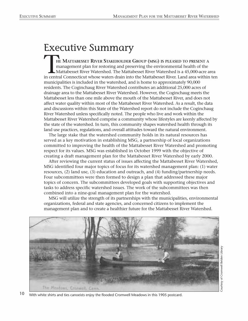
THE MATTABESSET RIVER STAKEHOLDER GROUP (MSG) IS PLEASED TO PRESENT Amanagement plan for restoring and preserving the environmental health of theMattabesset River Watershed. The Mattabesset River Watershed is a 45,000-acre area
in central Connecticut whose waters drain into the Mattabesset River. Land area within tenmunicipalities is included in the watershed, and is home to approximately 90,000residents. The Coginchaug River Watershed contributes an additional 25,000 acres ofdrainage area to the Mattabesset River Watershed. However, the Coginchaug meets theMattabesset less than one mile above the mouth of the Mattabesset River, and does notaffect water quality within most of the Mattabesset River Watershed. As a result, the dataand discussions within this State of the Watershed report do not include the CoginchaugRiver Watershed unless specifically noted. The people who live and work within theMattabesset River Watershed comprise a community whose lifestyles are keenly affected bythe state of the watershed. In turn, this community shapes watershed health through itsland use practices, regulations, and overall attitudes toward the natural environment.
The large stake that the watershed community holds in its natural resources hasserved as a key motivation in establishing MSG, a partnership of local organizationscommitted to improving the health of the Mattabesset River Watershed and promotingrespect for its values. MSG was established in October 1999 with the objective ofcreating a draft management plan for the Mattabesset River Watershed by early 2000.
After reviewing the current status of issues affecting the Mattabesset River Watershed,MSG identified four major topics of focus for its watershed management plan: (1) waterresources, (2) land use, (3) education and outreach, and (4) funding/partnership needs.Four subcommittees were then formed to design a plan that addressed these majortopics of concern. The subcommittees developed goals with supporting objectives andtasks to address specific watershed issues. The work of the subcommittees was thencombined into a nine-goal management plan for the watershed.
MSG will utilize the strength of its partnerships with the municipalities, environmentalorganizations, federal and state agencies, and concerned citizens to implement themanagement plan and to create a healthier future for the Mattabesset River Watershed.
10
EXECUTIVE SUMMARY MANAGEMENT PLAN FOR THE MATTABESSET RIVER WATERSHED
Executive Summary
With white shirts and ties canoeists enjoy the flooded Cromwell Meadows in this 1905 postcard.
Cou
rtes
y of
Cro
mw
ell B
elde
n Li
brar
y

Flow WorkGroupWaterAllocation
1234-45678
BANK
NNECT ICUT
BR . 2678
b a n k . c o m
20
OR BEARER
L L A R S$
MattabessetRiver
100 Foot
Regulato
ry
Review
Area
100 Foot
Regulato
ry
Review
Area
Nine Goals of the PlanGOAL #1 Create awareness among watershed
residents about the network ofrivers and streams that comprise theMattabesset River Watershed.
GOAL #2 Educate watershed residents aboutthe link between land use andwater quality.
GOAL #3 Promote sustainable land usepractices in the Mattabesset RiverWatershed.
GOAL #4 Restore and maintain wildlifehabitat in the Mattabesset RiverWatershed.
GOAL #5 Protect wetland and watercourseareas from development and otherdisturbances.
GOAL #6 Identify, investigate, correct, andprevent pollution problems.
GOAL #7 Restore and maintain in-stream andriparian habitat to support healthyfish populations and otheraquatic life.
GOAL #8 Evaluate and balance in-stream flowneeds, including flow volumesnecessary for aquatic life habitat,drinking water supply, and otherconsumptive water uses.
GOAL #9 Obtain a consistent and stablefunding stream to accomplish theaction plan’s objectives.
11
MANAGEMENT PLAN FOR THE MATTABESSET RIVER WATERSHED GOALS
Illus
trat
ion—
Pat
Rasc
h

MANAGEMENT PLAN FOR THE MATTABESSET RIVER WATERSHEDGOALS MANAGEMENT PLAN FOR THE MATTABESSET RIVER WATERSHED
Goal #1: Create Public Awareness
Utilize public resources and facilities to educate citizens of all ages about the basics of watershed science
Sponsor community recreational events drawing attention to the watershed’s river, streams, and land
Use mass media channels to distribute information throughout the watershed
Goal #2: Educate Public on Land Use and Water Pollution Linkage
Inform the watershed community about land use practices that reduce impacts to streams
Provide education to municipal officials regarding stormwater and nonpoint source pollution
Goal #3: Promote Sustainable Land Use
Develop a comprehensive inventory to identify areas for preservation, restoration and recreation
Assist in the protection of open space through acquisition or other means to improve ecosystem health
Facilitate appropriate recreational uses along the Mattabesset River and its tributaries
Encourage conservation development practices that minimize impact on natural resources
Goal #4: Restore and Maintain Wildlife Habitat
Control or diminish the prevalence of invasive species
Reduce fragmentation and destruction of wildlife habitat by inappropriate land use practices
Goal #5: Protect Wetlands from Development
Promote buffer regulations in watershed towns to improve water quality and wildlife habitat
Protect wetland systems
Goal #6: Identify and Correct Pollution Problems
Continue water quality monitoring and assess changes in water quality
Continue to improve stormwater management throughout the watershed
Continue to improve erosion and sediment control regulations throughout the watershed
Develop a sanitary sewage maintenance plan for the watershed
Develop a septic system maintenance program to assure the effective functioning of septic systems
Goal #7: Restore Habitat for Healthy Fish
Minimize the impacts of development on riparian and in-stream habitat
Restore or enhance streamside and in-stream physical conditions
Restore anadromous fish populations in the Mattabesset River and tributaries
Foster cold water fisheries in the Mattabesset River and tributaries
Goal #8: Evaluate Stream Flow
Calculate a water budget for the Mattabesset watershed to resolve water use conflicts
Establish a Flow Work Group of individuals and organizations to develop a flow allocation policy
Goal #9: Obtain Consistent and Stable Funding Stream
Identify potential and appropriate funding mechanisms
Our Local, State, and Federal Partnership
12

13
MANAGEMENT PLAN FOR THE MATTABESSET RIVER WATERSHED GOALS
Land CT US SWCD Towns MSG Trusts MRWA CRWP TU NEMO DEP EPA NRCS USGS
◆ ◆ ◆ ◆ ◆ ◆
◆ ◆ ◆ ◆ ◆ ◆
◆ ◆ ◆ ◆ ◆ ◆
◆ ◆ ◆ ◆ ◆ ◆ ◆
◆ ◆ ◆ ◆ ◆ ◆ ◆
◆ ◆ ◆
◆ ◆ ◆ ◆ ◆
◆ ◆
◆ ◆ ◆
◆
◆ ◆ ◆
◆ ◆ ◆ ◆
◆ ◆ ◆
◆ ◆ ◆ ◆ ◆ ◆ ◆
◆ ◆ ◆ ◆ ◆
◆ ◆ ◆
◆ ◆
◆ ◆ ◆ ◆ ◆
◆ ◆ ◆
◆ ◆ ◆ ◆ ◆ ◆
◆ ◆
◆ ◆ ◆ ◆ ◆
◆ ◆ ◆ ◆
◆ ◆
◆

For the past seven years, the Middlesex County Soil and Water Conservation District has beenworking on this long-term effort to improve water quality conditions in the Mattabesset River,with the ultimate goal of restoring the river to a fishable and swimmable condition. TheMattabesset project is funded in part by the CT Department of Environmental Protectionthrough an EPA Clean Water Act Section 319 nonpoint source grant.
Watershed project activities have focused on implementation of Best Management Practicesto mitigate the effects of stormwater runoff; restoration of degraded areas; and education oftown staff, land use commissioners, developers and contractors on the methods needed toprevent and control polluted runoff. The District has also initiated inter-town cooperationand coordination in the watershed toward the development of a comprehensive watershedmanagement plan, assessing water quality conditions and stream health, and public outreachand involvement.
The District’s nationally recognized Connecticut River Watch Program (CRWP), a volunteerriver monitoring, protection, and improvement program, monitors the health of theMattabesset River and its tributaries. CRWP, developed and implemented in 1992 as part ofthe Mattabesset River Watershed Project, is designed to meet two major objectives: to buildawareness about river resources and water quality, and to collect scientifically credible datathat can be used to identify and address water quality problems.
In the last year the District completed a comparative review of municipal land useregulations in the watershed towns, produced a State of the Watershed Report (1999) whichhas been used as the basis for development of the watershed management plan and issummarized in the following section.
14
PROJECT HISTORY MANAGEMENT PLAN FOR THE MATTABESSET RIVER WATERSHED
Project History
Canoeists enjoy a day on the river. Although Route 9 is a only few hundred feet away, it is well hidden by thestreamside forested buffer.
Phot
o—Pa
t Ra
sch

A community volunteer helps with a river clean-up.
Phot
o by
Clo
e Po
isso
n /
The
Har
tfor
d C
oura
nt
State of the Watershed
15
MANAGEMENT PLAN FOR THE MATTABESSET RIVER WATERSHED
State of the Watershed
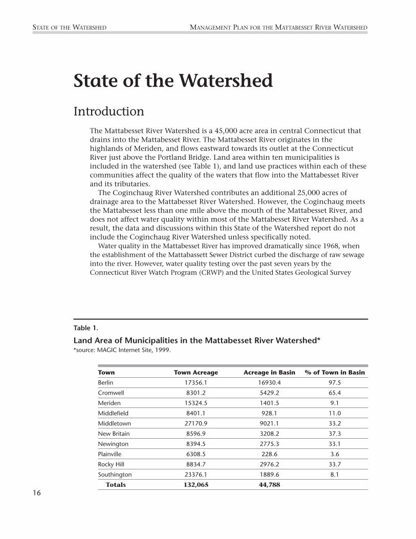
IntroductionThe Mattabesset River Watershed is a 45,000 acre area in central Connecticut thatdrains into the Mattabesset River. The Mattabesset River originates in thehighlands of Meriden, and flows eastward towards its outlet at the ConnecticutRiver just above the Portland Bridge. Land area within ten municipalities isincluded in the watershed (see Table 1), and land use practices within each of thesecommunities affect the quality of the waters that flow into the Mattabesset Riverand its tributaries.
The Coginchaug River Watershed contributes an additional 25,000 acres ofdrainage area to the Mattabesset River Watershed. However, the Coginchaug meetsthe Mattabesset less than one mile above the mouth of the Mattabesset River, anddoes not affect water quality within most of the Mattabesset River Watershed. As aresult, the data and discussions within this State of the Watershed report do notinclude the Coginchaug River Watershed unless specifically noted.
Water quality in the Mattabesset River has improved dramatically since 1968, whenthe establishment of the Mattabassett Sewer District curbed the discharge of raw sewageinto the river. However, water quality testing over the past seven years by theConnecticut River Watch Program (CRWP) and the United States Geological Survey
STATE OF THE WATERSHED MANAGEMENT PLAN FOR THE MATTABESSET RIVER WATERSHED
Table 1.
Land Area of Municipalities in the Mattabesset River Watershed**source: MAGIC Internet Site, 1999.
Town Town Acreage Acreage in Basin % of Town in Basin
Berlin 17356.1 16930.4 97.5
Cromwell 8301.2 5429.2 65.4
Meriden 15324.5 1401.5 9.1
Middlefield 8401.1 928.1 11.0
Middletown 27170.9 9021.1 33.2
New Britain 8596.9 3208.2 37.3
Newington 8394.5 2775.3 33.1
Plainville 6308.5 228.6 3.6
Rocky Hill 8834.7 2976.2 33.7
Southington 23376.1 1889.6 8.1
Totals 132,065 44,78816

(USGS) shows that the Mattabesset River and its tributaries still experience degradationdue to nonpoint source pollution, or what we call “polluted runoff.” Potential sources ofpolluted runoff include contaminants picked up by rainwater running over driveways,roads, agricultural fields and lawns; failing septic systems and sewage infrastructure;and poorly contained waste disposal sites. As a result of one or more of these sources,extensive stretches of river within the watershed experience high bacteria andnutrient levels.
Accommodating the needs of a growing population has required alterations to bemade to the natural state of the watershed. Although the construction of roads, houses,industries, and commercial buildings are perhaps the most obvious adjustments to thewatershed, several other developments affect the condition of the Mattabesset River.Withdrawal of water for public drinking supplies and industrial or agricultural uses canaffect the flow rates of the Mattabesset River and its tributaries. The construction ofdams and culverts along the river may mitigate the damage incurred by floods, butthey also cause erosion and sedimentation in the river channels and impede fishmigration routes.
17
MANAGEMENT PLAN FOR THE MATTABESSET RIVER WATERSHED STATE OF THE WATERSHED
Culvert at the mouth of Coles Brook in Cromwell discourages fish migration by disturbing the naturalstreambed and disrupting the natural streamflow.
Phot
o—St
epha
nie
Shak
ofsk
y

An Historical Perspective of the Mattabesset River Watershed
The Mattabesset River and its tributaries flow through the Central Lowlands, or CentralValley1, of Connecticut, an area characterized by large meandering rivers and generallyflat land, interrupted occasionally by rolling hills and divided lengthwise by adistinctive north-south ridge. The landscapes and patterns of land use in the Lowlandsderive from the geological history and make-up of the area (Bell, 1985).
Often referred to as Connecticut’s Central Park, this areabegan formation about 225 million years ago, during the earlyMesozoic Era, when the super-continent Pangaea began tobreak apart into the separate continents we know today.Connecticut was located near the center of Pangaea close to theequator, creating a hot, often wet, climate. A “great crack,” orrift, formed a long, narrow and deep valley through the middleof our state. This depression filled with sediments from theeroding hills to the east and west and with lava flows that rosefrom the earth’s interior. The sediments were compacted intosoft, easily eroded, red and brown sandstones, while the lavaflows solidified into very hard traprock (basalt). These depositswere tipped to the east and later faulted and eroded to createthe highly visible traprock ridge (the Metacomet) of the CentralValley, part of which forms the drainage divide of theMattabesset watershed (Bell, 1985).
Since its formation during the Mesozoic, drastic climatechange has occurred within the Connecticut Valley. Above the bedrock lie extensiveglacial deposits, which record the existence of large glaciers, the last of which began toretreat from Connecticut about 18,000 years ago. The rivers and streams in thewatershed flow through sediments deposited by the glacier, including “glacial till” and“stratified drift.” Glacial till blankets most of Connecticut and consists of a mixture ofdifferent size particles—silt, sand, and gravel—that was transported by the glacial ice.Stratified drift occurs in the present river valleys, and consists of sorted layers of sandand gravel carried by the streams and lakes that formed during the melting of glacial ice.
Beginning about 10,000 years ago, as the last glacial ice retreated from New England,Native American populations settled Connecticut and the areas along the Mattabessetand Coginchaug rivers. When Europeans arrived, the Mattabessec and Wangunk Indiantribes inhabited this area, and have been nicknamed the “River Indians” due to theirreliance on the rivers for subsistence (Guillette, 1979). The main staple for the RiverIndians was corn, and the Indians planted their cornfields along the fertile riverfloodplains of the Mattabesset River. In addition to agriculture, the tribes used the landwithin the watershed for hunting, gathering, and fishing. They led a semi-sedentarylifestyle, moving their villages to the forests during the winter months for hunting, andreturning to the rivers in the spring for fishing and agriculture.
Once Europeans began to settle Connecticut, land use along the Mattabesset River
18
STATE OF THE WATERSHED MANAGEMENT PLAN FOR THE MATTABESSET RIVER WATERSHED
CLIMATEToday, Connecticut’s climate liessomewhere between the warmtropics of the Jurassic and the frigidice age that existed 18,000 years ago.Connecticut has a humid temperateclimate, with cold, snowy winters andwarm summers. Temperature variesaccording to season, with minimumJanuary temperatures between 7.5°Fand 26°F, and maximum Julytemperatures between 77°F and 88°F.Precipitation occurs throughout theyear, with an average annual rainfallof 30–50 inches (NWDC website).
1 This unusual region goes by several names, including Connecticut Valley, Central Valley and Central Lowlands. Because region isnot actually one big valley, but a broad low-lying zone divided in two by a high ridge (the Metacomet) that runs its entire length,Central Lowlands is perhaps the most accurate of the three (Bell, 1985).

changed. By 1765, most of the Wangunk and Mattabessec land had been sold toEuropean settlers (DeForest, 1851). Agriculture continued to be the dominant land usepractice through the Revolutionary War era. However, the availability of more fertilelands in western New York, northern Ohio, and Pennsylvania led to the massabandonment and great migration of Connecticut farmers during the 1800s. Those whostayed worked in the many factories that were springing up along the rivers andstreams, and manufacturing became a major economic force (Gibbons et al., 1992).
Beginning in the mid-1800s, brick-making became an industry that flourished forabout 100 years. Brick companies mined the thick clays that had been deposited duringthe retreat of the last glacier. By 1900, over 30 clay pits had been excavated in centralConnecticut (Loughlin, 1905). Brick-making activities within the MattabessetWatershed centered along Newfield Street in Middletown (Klattenberg, 1992) andwithin a 2 square mile area in Berlin and New Britain, along Farmington Ave andChristian Lane in Berlin and from Willow Brook Park to South Street in New Britain(Teski, pers. comm.).
The dramatic change in land use practices over the past century from farming tobusiness and industry manifests itself as a decline in agricultural acreage (Figure 1).
MANAGEMENT PLAN FOR THE MATTABESSET RIVER WATERSHED STATE OF THE WATERSHED
19
Cou
rtes
y of
Cro
mw
ell B
elde
n Li
brar
y
A 1905 postcard shows the Quarry Hole in Cromwell.

20
STATE OF THE WATERSHED MANAGEMENT PLAN FOR THE MATTABESSET RIVER WATERSHED
Figure 2. Population Growth in the Mattabesset Watershed since 1930*
0
10000
20000
30000
40000
50000
60000
70000
80000
90000
1925 1945 1965 1985 2005Year
Popu
latio
n Projected Growth to 2003
*Source: Fine, 1971; CDEC, 1999
Figure 2.
Population Growth in the Mattabesset River Watershed since 1980*
0
5000
10000
15000
20000
25000
30000
35000
40000
45000
1920 1940 1960 1980 2000Year
Acre
s of
Agr
icul
tura
l Lan
d
*Source: Fine, 1971; Civco, D
Figure 1.
Agricultural Land Use in the Mattabesset River Watershed Since 1930(including the Coginchaug River Watershed)*
Population growth also soars during this time, almost tripling in number between 1930(about 30,000 residents) and 1998 (about 77,000 residents) (Figure 2).
Prior to the 1930’s population growth and the accompanying stresses on the river,the Mattabesset provided valuable recreational opportunities. The river supported asignificant fish population, as well as a large fishing club. In 1903, the MiddletownPress reported that an eight pound shad had been caught in the Mattabesset. Todayvery few shad are found in the river.

21
MANAGEMENT PLAN FOR THE MATTABESSET RIVER WATERSHED STATE OF THE WATERSHED
Water Resources
Water Quantity
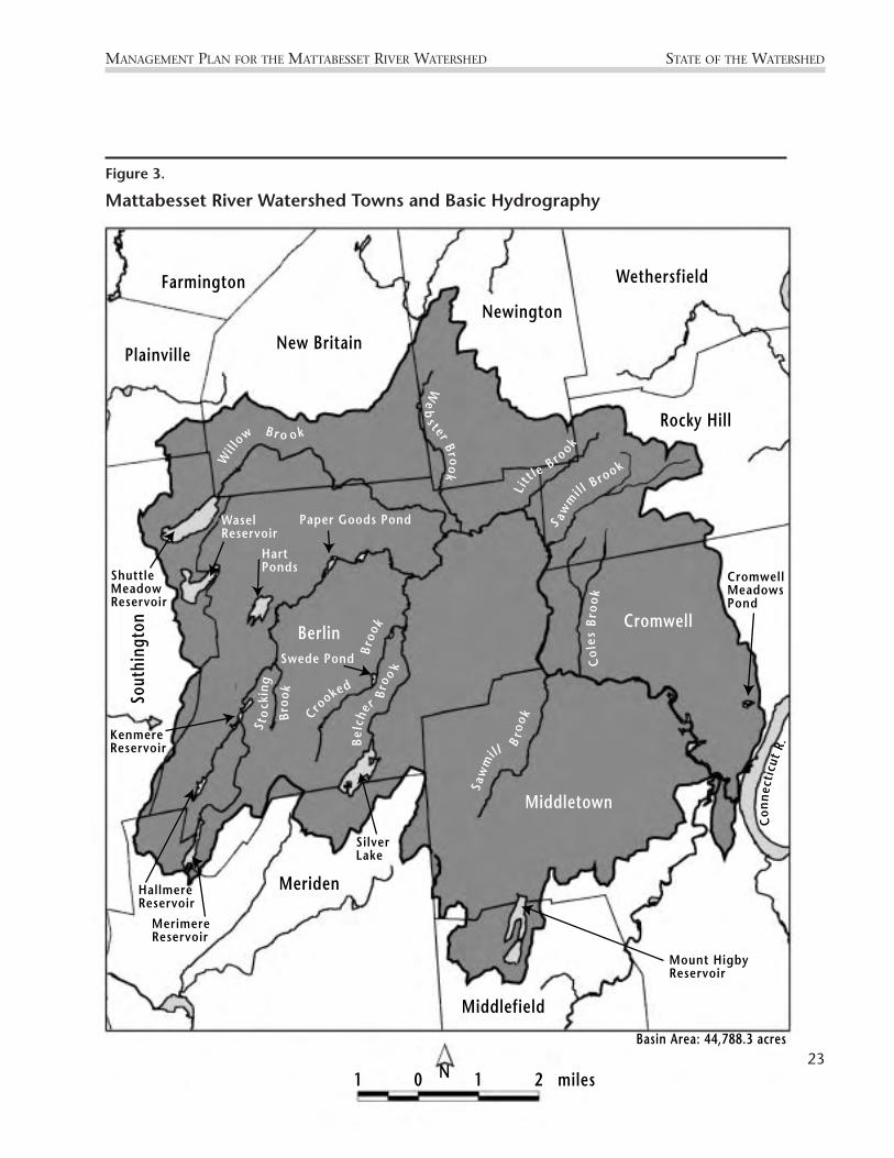
The Mattabesset River Watershed comprises a regional drainage basin within the largerConnecticut River Major Basin (CT DEP, 1982) (Figure 3). The natural headwaters of theMattabesset River are the intermittent streams that feed Merimere Reservoir (394 feetabove sea level) in Meriden. These streams are born from the rain and groundwaterflowing from East Peak, a section of Meriden’s traprock ridge system known as theHanging Hills. East Peak is the highest point in the Mattabesset River Watershed at anelevation of 976 feet a.s.l. Merimere Reservoir feeds Stocking Brook, which flowsnortheast through Berlin and eventually combines with John Hall Brook to form theMattabesset River (Nosal, 1997).
The Mattabesset River has been designated as a “water quality hotspot” by theConnecticut River Forum due to the degradation it experiences from low flow rates,pesticide contamination, nutrient enrichment, bacteria concentration, and turbidity(Connecticut River Forum, 1998). The low-flow, low-gradient characteristics of theMattabesset River contribute to the river’s susceptibility to pollution impacts, aspollutants cannot be effectively diluted. The mean daily discharge rate in theMattabesset River averages about 75 cubic feet per second (cfs) at the USGS gagingstations in East Berlin (Table 2). However, high precipitation as well as spring runoffmay cause much greater flow rates, with peak discharges in the Mattabesset recorded ashigh as 2980 cfs (USGS Internet Site).
Along its course, the volume of the Mattabesset River increases as a result ofcontribution from tributary basins. Belcher Brook, Willow Brook, Webster Brook, andSawmill Brook comprise four major tributaries of the Mattabesset River, and theConnecticut DEP has delineated subregional basins around each of these.
Belcher Brook flows northward through the town of Berlin and is the first majortributary to empty into the Mattabesset River. Travelling east, the Mattabesset Rivernext receives inflow from Willow Brook and Webster Brook, which flow southeastthrough New Britain and Berlin. Finally, Sawmill Brook flows northward throughMiddletown and meets the Mattabesset River about 4 miles from its mouth.
Inflowing water from tributary subbasins contributes not only to the discharge rate ofthe Mattabesset River, but also to its water quality. The Connecticut Water Qualityclassifications for the Mattabesset River and tributaries provide a framework forassessing the health of the watershed.
Connecticut Water Quality Standards are established in accordance with Section 22a-426 of the Connecticut General Statutes and Section 303 of the Federal Clean WaterAct. The Standards include water quality classifications, which are used to establishpriorities for pollution abatement projects. The classification system specifies thedesignated uses that must be supported in a water body, as well as criteria that definethe water quality necessary to support those uses. Surface waters are designated as ClassAA, A, B, C, or D (Table 3).
Classifications also can be expressed as an existing condition, with a higher waterquality goal. For example, in a Class B/A water body the present water conditions
support a classification of “B,” but the water quality goal for that water body is “A.”Water bodies designated as Classes C or D do not meet water quality conditions for oneor more designated uses in Class B waters. Pollution of Class C waters usually originatesfrom combined sewer overflows, urban runoff, inadequate water treatment, orcommunity-wide septic system failures. In Class D waters, contamination is evident notonly in the water, but also as toxic compounds within bottom sediments and/or fishand shellfish tissues (CT Water Quality Standards, 1992).
Upstream of Willow Brook, the Mattabesset River is classified as a Class AA inlandsurface water in the reservoirs, and as Class A and B/A waters within the stream itself.Belcher Brook contributes B/A waters to the Mattabesset River. Due to the pollutedinflow of Willow Brook, a Class C/B river in its lower reaches, the Mattabesset River’swaters also degrade to Class C/B status downstream. Webster Brook and Sawmill Brookhave been given respective water quality classifications of B/A and A (Murphy, 1987).
22
STATE OF THE WATERSHED MANAGEMENT PLAN FOR THE MATTABESSET RIVER WATERSHED
Table 2.
Mattabesset River Discharge Rates
Water Year Annual Discharge Average Discharge(cubic feet/ year) (cubic feet / sec)
1961 2.39 x 10⁹ 75.8
1962 2.02 x 10⁹ 64.0
1963 2.27 x 10⁹ 71.8
1964 1.87 x 10⁹ 59.3
1965 1.61 x 10⁹ 51.2
1966 2.56 x 10⁹ 81.2
1967 2.58 x 10⁹ 81.5
1968 2.36 x 10⁹ 75.0
1969 3.05 x 10⁹ 96.8
1970 2.00 x 10⁹ 63.3
1995 - 51.9
1996 3.38 x 10⁹ 107.0
1997 3.04 x 10⁹ 96.5
Average 2.43 x 10⁹ 75.0
*Source: USGS Water Resources internet site: http://h2o.usgs.gov
MANAGEMENT PLAN FOR THE MATTABESSET RIVER WATERSHED STATE OF THE WATERSHED
Farmington
PlainvilleNew Britain
Newington
Wethersfield
Middlefield
Meriden
Sout
hing
ton
Berlin
Middletown
Cromwell
Rocky Hill
Wil l
ow B r o ok
We
bs t er
Br ook
Saw
mill
Bro
o kS aw
mil l
B rook
Crooked
Bro
okB
e lch
er
Bro
o
k Col
esB
rook
L itt l
e B ro
okShuttleMeadowReservoir
WaselReservoir
Hart Ponds
Paper Goods Pond
Swede Pond
SilverLake
Mount HigbyReservoir
CromwellMeadowsPond
Conn
ecti
cut
R.
KenmereReservoir
HallmereReservoir
MerimereReservoir
Sto
ckin
g
Broo
k
N1 0 1 2 miles
Basin Area: 44,788.3 acres
Figure 3.
Mattabesset River Watershed Towns and Basic Hydrography
23

24
STATE OF THE WATERSHED MANAGEMENT PLAN FOR THE MATTABESSET RIVER WATERSHED
Table 3.
Designated Uses for CT Inland Surface Water Quality Classifications
Designated Uses ClassificationAA A B C D
Existing/ proposed drinking water supply X
Potential drinking water supply X X
Fish & wildlife habitat X X X
Recreation X X X
Agriculture supply X X X
Industrial supply X X X
Navigation X X
*Source: CT Water Quality Standards, 1992
Designated uses ofClass C and D watersvary among waterbodies according toindividual conditions.
Connecticut’s most recent statewide water quality classification update was compiledin 1987 (Murphy, 1987). Consequently, the classifications of the streams describedabove may not accurately reflect current conditions for all streams. At present, CT DEPis working to update their classifications of Connecticut’s water bodies. Revisions areexpected to be complete sometime during the year 2000.
The Mattabesset River runs under the old trolley bridge behind West Lake development in Middletown.
Phot
o—Pa
t Ra
sch
Water Quality
Recent RecordsIn 1992, the Connecticut River Watch Program (CRWP) initiated a water qualitymonitoring program in the Mattabesset River Watershed and presently is undertakingits eighth year of data collection. Data have been assimilated from 23 sites along theMattabesset River and its tributaries. Each year, water chemistry and bacterial data arecollected during July and August, and benthic macroinvertebrate data are collectedduring the fall. Parameters such as pH and total alkalinity consistently show healthylevels of acidity in the watershed. However, at most sampling sites bacterial counts,nutrient levels, and metal concentrations indicate significant problems with nonpointsource pollution in the river.
One pollution indicator in the Mattabesset River Watershed is the high levels ofenterococcus group and fecal coliform bacteria found in the main stem and tributarystreams. Between 1992–1998 all of CRWP’s sampling locations in the Mattabesset RiverWatershed, except the headwaters site at John Hall Brook, exceeded the criteria in the CTWater Quality Standards for enterococcus group and fecal coliform bacteria levels inClass B inland surface waters (Brawerman, 1999)2. High concentrations of these bacteriaindicate possible contamination of the water body by human and/or animal waste, andpoint toward the possible presence of other disease-causing organisms that make waterunsafe for swimming.
Exact sources of indicator bacteria are often difficult to pinpoint, but could includefailing on-site septic systems, domestic and wild animal manure, and urban runoff.Bacterial concentrations in the Mattabesset River tend to peak during rainfall events. Thispattern supports the argument that storm runoff carries waste products to theMattabesset, and that nonpoint source pollution is a significant problem in thewatershed. Conversely, bacterial concentrations in the Mattabesset River remain higheven during base flow conditions, when rainfall and storm runoff do not contribute tostream discharge. These chronically high bacteria levels suggest that, in addition to stormrunoff, steady sources of bacteria such as failing septic systems probably exist within theMattabesset River Watershed (Brawerman, 2000).
Bacterial measurements made by USGS at the East Berlin gaging station support theproblem with waste pollution in the Mattabesset River. Between 1995–1997, forty-fourpercent (44%) of samples collected at the USGS station exceeded the Class B standardfor fecal coliform (not to exceed 400 colonies/100mL in more than 10% of samples).Further, seventy-five percent (75%) of USGS samples exceeded the Class B standard forenterococci (not to exceed 61 colonies/100mL in any one sample) (Davies et al., 1996;Davies et al., 1997; Davies et al., 1998).
In addition to contributing high bacteria counts to the rivers, waste pollution andrunoff from fertilized land manifest themselves as high nutrient (i.e. nitrogen andphosphorus) levels in the Mattabesset River and in certain tributaries. A stream’snutrient load is the total mass of nutrient that flows through the stream over a giventime. In the Mattabesset River, nutrient loads tend to increase with distance
25
MANAGEMENT PLAN FOR THE MATTABESSET RIVER WATERSHED STATE OF THE WATERSHED
2 Enterococci levels not to exceed 61 col/100mL in any one sample and not to exceed a geometric mean of 33 col/100mL over a30-day period. Fecal coliform levels not to exceed 400 col/100mL for 10% of samples and not to exceed a geometric mean of 200ol/100mL over a 30-day period.

downstream as the river runs through more urban areas and receives input from stormrunoff and polluted tributaries (Figure 4).
In typical aquatic ecosystems, phosphorus is the nutrient that limits growth of algaeand aquatic plants. Because natural concentrations of phosphorus vary greatly among
aquatic ecosystems, neither the state ofConnecticut nor the US EPA designatesspecific water quality criteria for phosphorus.However, the EPA does have an historicalguideline for phosphorus levels in streams,which states that,
“to prevent the development of biologicalnuisances and to control accelerated orcultural eutrophication, total phosphates…should not exceed… 0.1 mg/L total P.”
Between 1993 and 1997, CRWP data showthat phosphorus concentrations in theMattabesset River exceeded the EPA guidelinein 50% of the main stem samples and in the
20% of tributary samples. Phosphorus as well as nitrogen loads increase in theMattabesset during high flow events (Figures 5 & 6), pointing to storm runoff andnonpoint source pollution as the primary sources of nutrients to the river.
26
STATE OF THE WATERSHED MANAGEMENT PLAN FOR THE MATTABESSET RIVER WATERSHED
Figure 4. Nitrogen Loading (lbs/day) on the Mattabesset River Sites Listed from Upstream to Downstream
Date: 5/20/99*
0
500
1000
1500
2000
2500
3000
Tota
l Nitr
ogen
(lb
s/da
y)
Upstream Downstream
Figure 4.
Nitrogen Loading (lbs/day) on the Mattabesset River Main Stem Listed from Upstream to Downstream
Nutrient LoadingThe amounts of nutrients shed off our land and into ourrivers is even more pronounced if we add up nutrientloading in the Mattabesset over an entire year. Anaverage of 50 lbs of phosphorus flows into theMattabesset River each day, which sums to more than18,000 lbs of phosphorus each year. Nitrogen loading iseven greater, with an average of 594 lbs/day, or almost217,000 lbs of nitrogen per year flowing through theMattabesset River. Much of the nutrient load in theMattabesset originates from polluted runoff that flowsover agricultural fields, urban streets, and lawns.
*Source: Mattabesset Sewer District
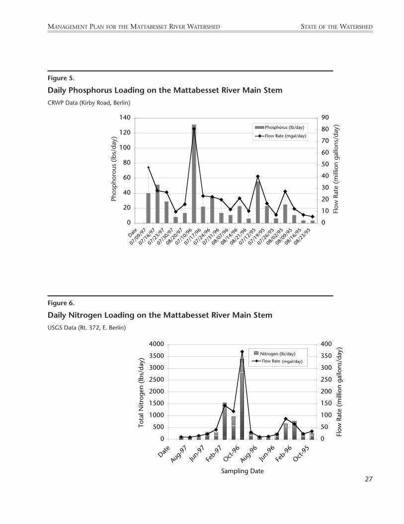
Figure 6. Daily Nitrogen Loading on the Mattabesset River Main Stem: USGS Data (Station No. 01192704)
0
500
1000
1500
2000
2500
3000
3500
4000
Date
Aug-9
7
Jun-9
7
Feb-
97
Oct-96
Aug-9
6
Jun-9
6
Feb-
96
Oct-95
Sampling Date
Tota
l Nitr
ogen
(lb
s/da
y)
0
50
100
150
200
250
300
350
400Fl
ow R
ate
(mill
ion
gallo
ns/d
ay)
Flow Rate (mgal/day)
Nitrogen (lb/day)
MANAGEMENT PLAN FOR THE MATTABESSET RIVER WATERSHED STATE OF THE WATERSHED
Figure 6.
Daily Nitrogen Loading on the Mattabesset River Main StemUSGS Data (Rt. 372, E. Berlin)
Ploading
Figure 5. Daily Phosphorus Loading on the Mattabesset River Main Stem: CRWP Data
0
20
40
60
80
100
120
140
Date
07/0
9/97
07/1
6/97
07/2
3/97
07/3
0/97
08/2
0/97
07/1
0/96
07/1
7/96
07/2
4/96
07/3
1/96
08/0
7/96
08/1
4/96
08/2
1/96
07/1
2/95
07/1
9/95
07/2
6/95
08/0
2/95
08/0
9/95
08/1
6/95
08/2
3/95
Phos
pho
rus
(lbs/
day)
0
10
20
30
40
50
60
70
80
90
Flow
Rat
e (m
illio
n ga
llons
/day
)
Phosphorus (lb/day)
Flow Rate (mgal/day)
Figure 5.
Daily Phosphorus Loading on the Mattabesset River Main StemCRWP Data (Kirby Road, Berlin)
27
Flow
Rat
e (m
illio
n ga
llons
/day
)
Phos
phor
ous
(lbs/
day)
–◆–
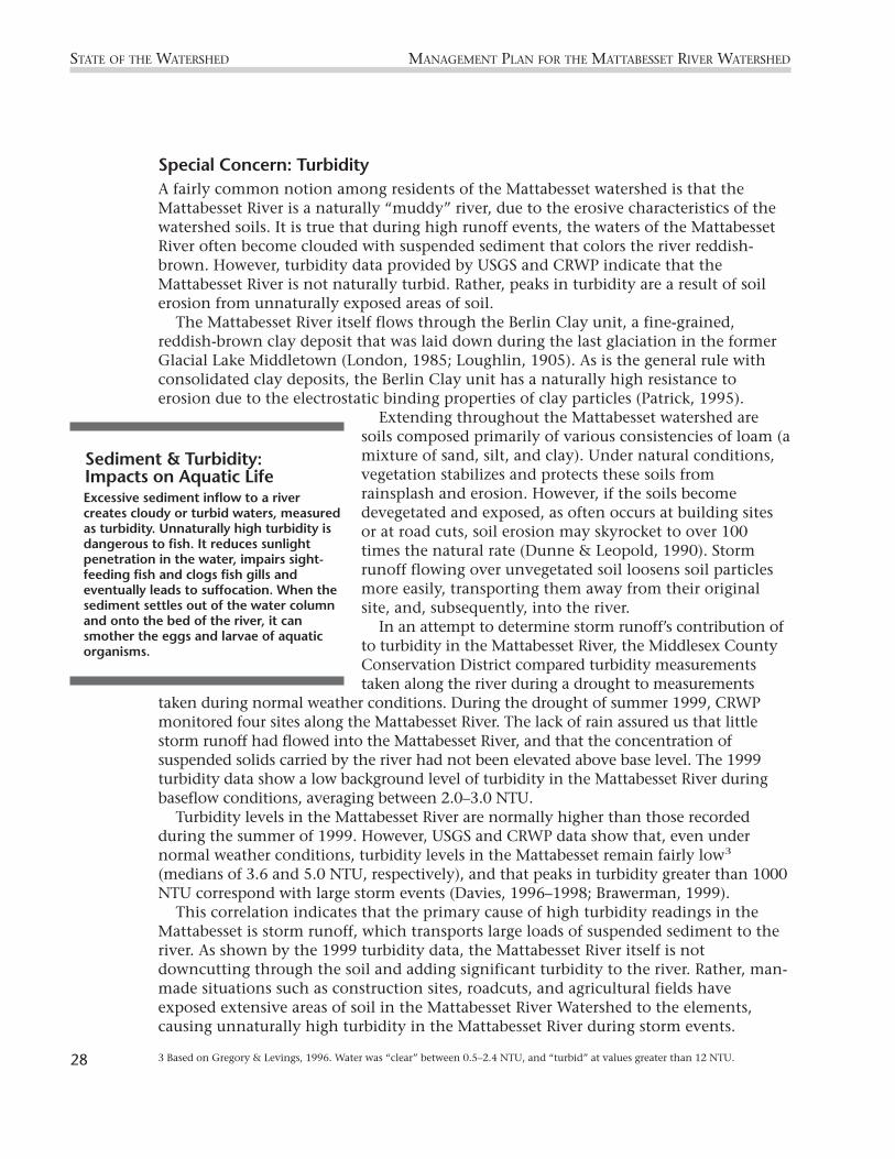
Special Concern: TurbidityA fairly common notion among residents of the Mattabesset watershed is that theMattabesset River is a naturally “muddy” river, due to the erosive characteristics of thewatershed soils. It is true that during high runoff events, the waters of the MattabessetRiver often become clouded with suspended sediment that colors the river reddish-brown. However, turbidity data provided by USGS and CRWP indicate that theMattabesset River is not naturally turbid. Rather, peaks in turbidity are a result of soilerosion from unnaturally exposed areas of soil.
The Mattabesset River itself flows through the Berlin Clay unit, a fine-grained,reddish-brown clay deposit that was laid down during the last glaciation in the formerGlacial Lake Middletown (London, 1985; Loughlin, 1905). As is the general rule withconsolidated clay deposits, the Berlin Clay unit has a naturally high resistance toerosion due to the electrostatic binding properties of clay particles (Patrick, 1995).
Extending throughout the Mattabesset watershed aresoils composed primarily of various consistencies of loam (amixture of sand, silt, and clay). Under natural conditions,vegetation stabilizes and protects these soils fromrainsplash and erosion. However, if the soils becomedevegetated and exposed, as often occurs at building sitesor at road cuts, soil erosion may skyrocket to over 100times the natural rate (Dunne & Leopold, 1990). Stormrunoff flowing over unvegetated soil loosens soil particlesmore easily, transporting them away from their originalsite, and, subsequently, into the river.
In an attempt to determine storm runoff’s contribution ofto turbidity in the Mattabesset River, the Middlesex CountyConservation District compared turbidity measurementstaken along the river during a drought to measurements
taken during normal weather conditions. During the drought of summer 1999, CRWPmonitored four sites along the Mattabesset River. The lack of rain assured us that littlestorm runoff had flowed into the Mattabesset River, and that the concentration ofsuspended solids carried by the river had not been elevated above base level. The 1999turbidity data show a low background level of turbidity in the Mattabesset River duringbaseflow conditions, averaging between 2.0–3.0 NTU.
Turbidity levels in the Mattabesset River are normally higher than those recordedduring the summer of 1999. However, USGS and CRWP data show that, even undernormal weather conditions, turbidity levels in the Mattabesset remain fairly low3
(medians of 3.6 and 5.0 NTU, respectively), and that peaks in turbidity greater than 1000NTU correspond with large storm events (Davies, 1996–1998; Brawerman, 1999).
This correlation indicates that the primary cause of high turbidity readings in theMattabesset is storm runoff, which transports large loads of suspended sediment to theriver. As shown by the 1999 turbidity data, the Mattabesset River itself is notdowncutting through the soil and adding significant turbidity to the river. Rather, man-made situations such as construction sites, roadcuts, and agricultural fields haveexposed extensive areas of soil in the Mattabesset River Watershed to the elements,causing unnaturally high turbidity in the Mattabesset River during storm events.
STATE OF THE WATERSHED MANAGEMENT PLAN FOR THE MATTABESSET RIVER WATERSHED
3 Based on Gregory & Levings, 1996. Water was “clear” between 0.5–2.4 NTU, and “turbid” at values greater than 12 NTU.
Sediment & Turbidity: Impacts on Aquatic LifeExcessive sediment inflow to a rivercreates cloudy or turbid waters, measuredas turbidity. Unnaturally high turbidity isdangerous to fish. It reduces sunlightpenetration in the water, impairs sight-feeding fish and clogs fish gills andeventually leads to suffocation. When thesediment settles out of the water columnand onto the bed of the river, it cansmother the eggs and larvae of aquaticorganisms.
28

MANAGEMENT PLAN FOR THE MATTABESSET RIVER WATERSHED STATE OF THE WATERSHED
29Heavy rains swell the River with muddy or turbid waters.
Phot
o—Ja
ne B
raw
erm
an
Improperly installed silt fence at a construction site. Silt fencing acts as a trap capturing sediment before itleaves a site. Fencing should be buried at least 6 inches below the ground surface to efficiently trap anysediment (note the sunlight under the fencing).
Phot
o—St
epha
nie
Shak
ofsk
y
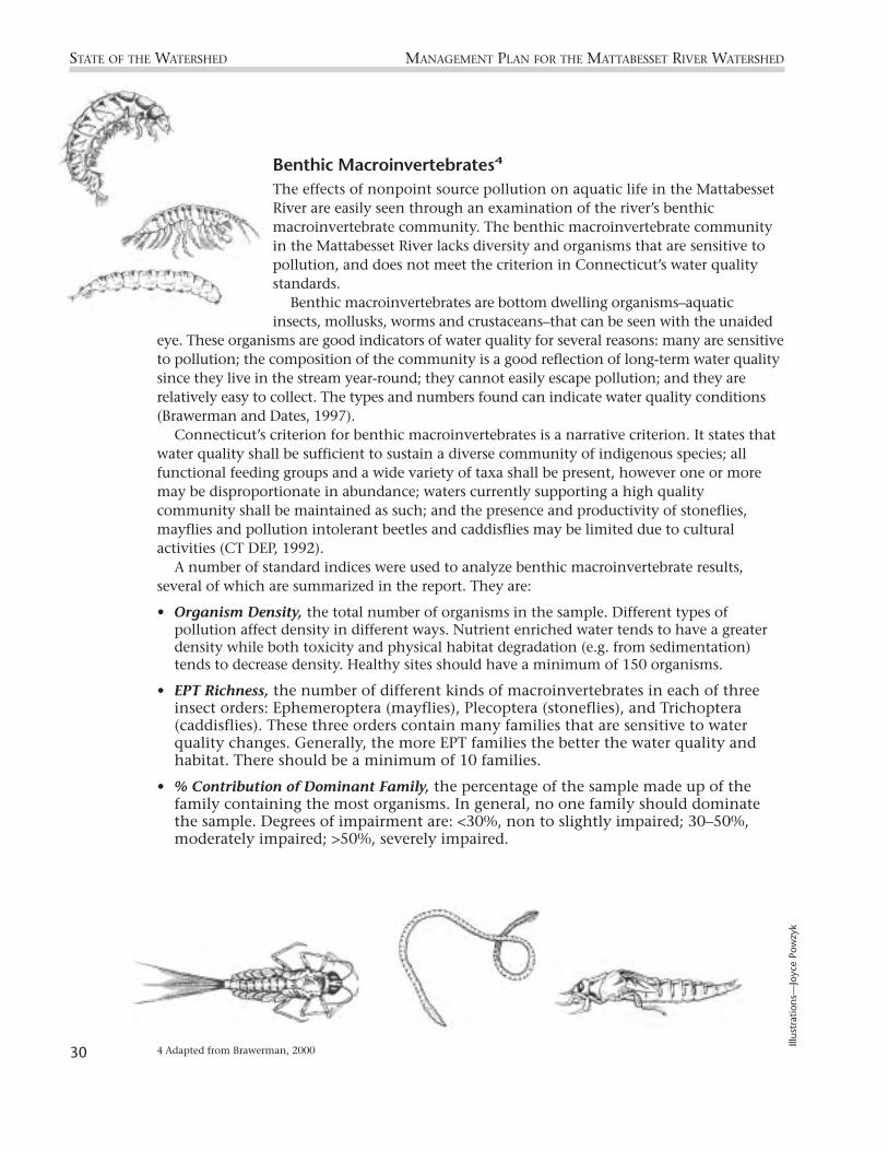
Benthic Macroinvertebrates4
The effects of nonpoint source pollution on aquatic life in the MattabessetRiver are easily seen through an examination of the river’s benthicmacroinvertebrate community. The benthic macroinvertebrate communityin the Mattabesset River lacks diversity and organisms that are sensitive topollution, and does not meet the criterion in Connecticut’s water qualitystandards.
Benthic macroinvertebrates are bottom dwelling organisms–aquaticinsects, mollusks, worms and crustaceans–that can be seen with the unaided
eye. These organisms are good indicators of water quality for several reasons: many are sensitiveto pollution; the composition of the community is a good reflection of long-term water qualitysince they live in the stream year-round; they cannot easily escape pollution; and they arerelatively easy to collect. The types and numbers found can indicate water quality conditions(Brawerman and Dates, 1997).
Connecticut’s criterion for benthic macroinvertebrates is a narrative criterion. It states thatwater quality shall be sufficient to sustain a diverse community of indigenous species; allfunctional feeding groups and a wide variety of taxa shall be present, however one or moremay be disproportionate in abundance; waters currently supporting a high qualitycommunity shall be maintained as such; and the presence and productivity of stoneflies,mayflies and pollution intolerant beetles and caddisflies may be limited due to culturalactivities (CT DEP, 1992).
A number of standard indices were used to analyze benthic macroinvertebrate results,several of which are summarized in the report. They are:
• Organism Density, the total number of organisms in the sample. Different types ofpollution affect density in different ways. Nutrient enriched water tends to have a greaterdensity while both toxicity and physical habitat degradation (e.g. from sedimentation)tends to decrease density. Healthy sites should have a minimum of 150 organisms.
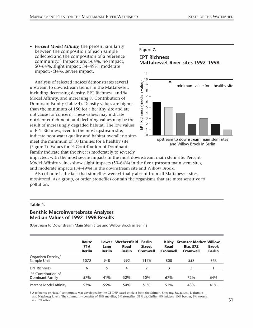
• EPT Richness, the number of different kinds of macroinvertebrates in each of threeinsect orders: Ephemeroptera (mayflies), Plecoptera (stoneflies), and Trichoptera(caddisflies). These three orders contain many families that are sensitive to waterquality changes. Generally, the more EPT families the better the water quality andhabitat. There should be a minimum of 10 families.
• % Contribution of Dominant Family, the percentage of the sample made up of thefamily containing the most organisms. In general, no one family should dominatethe sample. Degrees of impairment are: <30%, non to slightly impaired; 30–50%,moderately impaired; >50%, severely impaired.
STATE OF THE WATERSHED MANAGEMENT PLAN FOR THE MATTABESSET RIVER WATERSHED
4 Adapted from Brawerman, 200030
Illus
trat
ions
—Jo
yce
Pow
zyk
• Percent Model Affinity, the percent similaritybetween the composition of each samplecollected and the composition of a referencecommunity.5 Impacts are: >64%, no impact;50–64%, slight impact; 34–49%, moderateimpact; <34%, severe impact.
Analysis of selected indices demonstrates severalupstream to downstream trends in the Mattabesset,including decreasing density, EPT Richness, and %Model Affinity, and increasing % Contribution ofDominant Family (Table 4). Density values are higherthan the minimum of 150 for a healthy site and arenot cause for concern. These values may indicatenutrient enrichment, and declining values may be theresult of increasingly degraded habitat. The low valuesof EPT Richness, even in the most upstream site,indicate poor water quality and habitat overall; no sitesmeet the minimum of 10 families for a healthy site(Figure 7). Values for % Contribution of DominantFamily indicate that the river is moderately to severelyimpacted, with the most severe impacts in the most downstream main stem site. PercentModel Affinity values show slight impacts (50–64%) in the five upstream main stem sites,and moderate impacts (34–49%) in the downstream site and Willow Brook.
Also of note is the fact that stoneflies were virtually absent from all Mattabesset sitesmonitored. As a group, or order, stoneflies contain the organisms that are most sensitive topollution.
MANAGEMENT PLAN FOR THE MATTABESSET RIVER WATERSHED STATE OF THE WATERSHED
Table 4.
Benthic Macroinvertebrate Analyses Median Values of 1992–1998 Results
(Upstream to Downstream Main Stem Sites and Willow Brook in Berlin)
Route Lower Wethersfield Berlin Kirby Krauszer Market Willow71A Lane Road Street Road Rte. 372 Brook
Berlin Berlin Berlin Cromwell Cromwell Cromwell Berlin
Organism Density/Sample Unit 1072 948 992 1176 808 558 363
EPT Richness 6 5 4 2 3 2 1
% Contribution of Dominant Family 57% 41% 52% 50% 67% 72% 64%
Percent Model Affinity 57% 55% 54% 51% 51% 48% 41%
5 A reference or “ideal” community was developed by the CT DEP based on data from the Salmon, Shepaug, Saugatuck, Eightmileand Natchuag Rivers. The community consists of 38% mayflies, 5% stoneflies, 31% caddisflies, 8% midges, 10% beetles, 1% worms,and 7% other.
0
1
2
3
4
5
6
7
8
9
10
11
EPT
Rich
ness
(m
edia
n va
lue)
upstream to downstream main stem sitesand Willow Brook in Berlin
minimum value for a healthy site
31
Figure 7.
EPT RichnessMattabesset River sites 1992–1998

Historical RecordsAlthough degradation of water quality in the Mattabesset River is apparent today, thedecline in direct sewage discharge to the river has improved its water quality tremendouslysince 1968. At present, average levels of fecal coliform in the Mattabesset River range from278–1039 col/100mL. In contrast, monthly monitoring records during the summers of1946–1949 showed consistent concentrations of fecal coliform above 24,000 colonies/100mL, reaching as high as 200,000 col/100mL during the summer of 1949 (CT Departmentof Health, 1946–1949). Similar bacterial concentrations (coliform ≥ 20,000 col/100mL) wererecorded in the river between 1967 and 1968. These numbers contrast sharply with thoserecorded after 1968, when the Mattabassett Sewer Authority came into existence. Almost
immediately after the Mattabassett Sewer Authority begantreating sewage from the Mattabesset River Watershed,coliform levels dropped to as low as 2400 col/100mL, andremained below 20,000 col/100mL in 80% of the samplestaken between 1969 and 1970 (CT DEP 1967–1973).
In only a few years, the Mattabesset River was restoredfrom a virtual sewer drain to its present condition as avaluable water resource. Such a drastic improvement inwater quality shows that there is still hope of addressingthe current water quality issues in the Mattabesset River,even if nonpoint source pollution is more difficult toeradicate than point source pollution.
STATE OF THE WATERSHED MANAGEMENT PLAN FOR THE MATTABESSET RIVER WATERSHED
“In the early 1960s the Mattabesset Riverran grey and the smell was so bad somedays it ’bout knocked you over. When thesewer District went on line in 1968 it tookabout three years before the fish cameback and the river ran blue again.”
—Long Time Mattabesset River Resident
32 Turbid water from the Mattabesset River enters the Connecticut River after a large storm event. This photowas taken from the Portland bridge looking downstream of confluence.
Phot
o—To
m L
adny

Wetlands and Watercourses
One component of restoring the water quality of a river involves preserving wetland areasand other natural buffer zones between the river and developed areas. Wetlands and bufferzones help to preserve water quality by providing infiltration areas for otherwise directurban runoff, thus decreasing stream bank erosion and filtering out certain pollutants beforethey enter the river.
Adopted in 1972, Connecticut’s Inland Wetlands and Watercourses Act has encouragedthe preservation of wetlands and buffer zones by giving the DEP and municipal authoritiesjurisdiction to regulate construction surrounding wetlands and watercourses. Allmunicipalities in the Mattabesset River Watershed require permitting of regulated activitieswithin wetlands under section 22a-36–22a-45 of the Connecticut General Statutes. Sometowns require specific buffer zones adjacent to wetlands and watercourses while othersdetermine setback requirements on a case by case basis (Table 9).
At present, 1629.2 acres of wetlands exist within the Mattabesset River Watershed,including 1621.2 acres of forested wetland and 8.0 acres of unforested wetland (Civco, D).Cromwell Meadows is the largest wetland within the watershed, and covers over 600 acres atthe confluence of the Mattabesset and Coginchaug rivers (Fine, 1971). Recent physicalsurveys conducted along the Mattabesset River and tributaries revealed that stream buffersof less than twenty-five (25) feet exist in many locations between watercourses anddeveloped areas. Further, a number of lawns extend to the edge of the stream banks withoutallowing for growth of naturally vegetated buffer zones (Bowers & Brawerman, 1999).
MANAGEMENT PLAN FOR THE MATTABESSET RIVER WATERSHED STATE OF THE WATERSHED
Streamside vegetation has been removed from John Hall Brook where it flows through a golf course in Berlin.
Phot
o—Ed
Paw
lak
33

STATE OF THE WATERSHED MANAGEMENT PLAN FOR THE MATTABESSET RIVER WATERSHED
Water Supply
As of 1985 in the state of Connecticut, a supply population of about 3.2 million peopleaveraged over 400 million gallons per day (mgd) of water use, with 75% of the water supply(296 mgd) drawn from surface water bodies and 26% of the water supply (105 mgd) drawnfrom ground water sources (MacBroom, 1998). Extensive suburban development in theMattabesset River Watershed makes it inevitable that some surface water must be extractedfrom the watershed for residential, industrial, and commercial uses. However, excessive waterwithdrawal from a watershed becomes a concern if stream flow diminishes to unnaturallylow levels. A low-flow river may become too shallow for fish migration, dissolved oxygenlevels may decline, and pollutants may become concentrated to toxic levels.
Seven drinking water reservoirs are located within the Mattabesset River Watershed,and serve the towns of Middletown, Meriden, and New Britain (Table 5).
Hallmere Reservoir, Kenmere Reservoir, and Hart Ponds are designated as water storagesites, and are used for water supply only during drought. However, daily water withdrawalfrom the four distributional reservoirs in the watershed totals between 9.8–15.1 milliongallons per day (mgd). The average daily withdrawal of water from the reservoirs (12.9mgd) is equal to 27% of the average daily flow in the Mattabesset River (48.4 mgd).
Because each of these reservoirs feeds a stream that eventually drains into theMattabesset River, increased withdrawals from these reservoirs could decrease thealready low flow of the Mattabesset River, especially during droughts. Such a problem isevident in Crooked Brook in Berlin, a tributary of the Mattabesset River that frequentlydries up before reaching Swede Pond as a result of withdrawals from residential waterpumps (J. Creighton, pers. comm.).
Table 5.
Daily Withdrawals and Capacities of Drinking Water Reservoirs in the Mattabesset River Watershed
Water Subregional Average CapacityDepartment Reservoir Basin Purpose Daily (million
Withdrawal gallons)(mgd)
Middletown Mount Higby 4604 Distribution 1.3 260(Sawmill Bk)
Meriden Merimere 4600 Distribution 1.5–1.8 340(Mattabesset)
Hallmere 4600 Storage - 128
Kenmere 4600 Storage - 109
New Britain Shuttle 4602Meadow (Willow Bk) Distribution 6–8 1356
Wasel 4602 Distribution 2–4 900
Hart Ponds 4600 Storage - 252
34

Dams/Impoundments
Dammed drinking water reservoirs retain significant volumes of water within theMattabesset River Watershed. Although these reservoirs are not always full, they couldtheoretically hold up to 3.3 billion gallons of water within the watershed.
In addition to the drinking water reservoirs, three additional impoundments exist alongthe Mattabesset River main stem. StanChem Pond, Railroad Pond, and Paper Goods Pond arelocated within the town of Berlin, and all were constructed for industrial purposes in theearly 1900s. Railroad Pond was dammed in 1903 and supplied cooling water to a steamelectric plant. Paper Goods Pond is the former site of hydroelectric power generation forSherwood Industries, but has been out of service for over 40 years. Industrial use of Railroadand Paper Goods ponds ceased during the latter part of the 20th century, and the town ofBerlin acquired the two impoundments as town property in 1976 and 1997, respectively.StanChem Pond is the only impoundment of the three that remains operational today forindustrial use. At present, StanChem Inc. recirculates cooling water from their manufacturingplant through StanChem Pond (Joe Shaskis, pers. comm.). All three of the impoundmentsretain river water, but perhaps more importantly, the location of these dams along the mainstem of the Mattabesset River makes them an impediment to fish migration.
Discharges and Wastewater Treatment
At present, only two permits are held for point source discharges into the Mattabesset River.In February 1996, the DEP issued an NPDES permit (National Pollutant DischargeElimination System) to StanChem Inc. allowing the company to discharge non-contactcooling water into StanChem Pond at an average rate of 250,000 gallons/day and at amaximum rate of 676,800 gallons/day. The permit specifies that the temperature of thedischarge must not raise the temperature of the receiving stream above 85%°F or more than4°F above the normal temperature of the stream. StanChem is required to perform quarterlymonitoring in the Pond for acute toxicity of discharge waters.
The Water Management Bureau of the DEP holds the only other NPDES permit for a pointsource discharge to the Mattabesset River. For the purpose of improving fisheries habitat andrecreational boating, the DEP has undertaken the project of dredging Silver Lake, a formerpeat bog on the border of Berlin and Meriden that previously had been dammed andconverted into a lake. The permit allows DEP to discharge an average of 2,400,000gallons/day and a maximum of 4,800,000 gallons/day of dredge waters out of Silver Lake,which feeds Belcher Brook. Issued in 1995, this discharge permit expires in February 2000.
As mentioned above, the construction of sewage treatment facilities such as theMattabassett Sewer Authority (est. 1968) has reduced greatly the volume of sewage dischargeto the Mattabesset River. The expansion of sewer connections has also decreased the numberof septic systems within the watershed municipalities (Table 6).
Although the construction of sewer lines has decreased the volume of sewage that flowsinto the Mattabesset River, the inflow of sewage to the river has not been eliminated. Failingsewage infrastructure and illegal hook-ups to sanitary and storm sewer lines can cause leaksin the pipes, as well as overflows during high flow events.
An aging sewer system and recent failures of sewer lines has forced New Britain to
MANAGEMENT PLAN FOR THE MATTABESSET RIVER WATERSHED STATE OF THE WATERSHED
35

evaluate the health of its entire sanitary sewer system. In 1996, the city carried out a Phase Istudy to pinpoint segments of the collection system to be investigated under a Phase IISewer System Evaluation Survey (SSES). Eight (8) of the eleven (11) segments highlighted forthe Phase II inflow study, and six (6) of the fourteen (14) segments highlighted for Phase IIinfiltration study are located within the Mattabesset watershed (Maguire Group, 1998). NewBritain completed its Phase II SSES in 1998. At present, the city is negotiating a contractwith Maguire Group, for a five-year, $10 million sewer construction and remediationproject, which is expected to begin in April 2000 (John Thiesse, pers. comm).
On-going Pollution Clean-up
Pollution within the Mattabesset River watershed threatens community drinking water suppliesas well as the health of fish and wildlife resources within the watershed. It is not necessary todischarge pollutants directly into a water body in order to contaminate the water body. Illegalwaste disposal by manufacturers and industries, and improper use and disposal of householdproducts allow harmful chemicals such as oil, pesticides, herbicides, PCBs, and solvents toinfiltrate into groundwater or to be carried away with runoff during storm events. In eithercase, the contaminants eventually end up in the lakes and rivers within the watershed.
Through government programs such as CERCLA (Comprehensive EnvironmentalResponse, Compensation, and Liability Act, otherwise known as “Superfund”), and the DEPBureau of Water Management, at least twelve hazardous waste disposal sites have beenidentified in the Mattabesset River Watershed (CT DEP, 1999). Under the direction of stateremedial programs and the Property Transfer Program, seven of the twelve sites have
STATE OF THE WATERSHED MANAGEMENT PLAN FOR THE MATTABESSET RIVER WATERSHED
Table 6.
Statistics on Sewer Connections in Mattabesset Watershed Towns*
Sewer District Volume Treated Municipality Sewered Unsewered / Discharge Loc. Population Population
# % # %
Mattabassett District 19mgd /Sewer Authority Connecticut River Berlin 11,300 75% 3,820 25%
Cromwell 4,700 59% 3,300 41%
Middletown 4,635 35% 8,660 65%
New Britain 75,622 100% 0 0%
Middletown 3.5mgd / Sewer Dept. Connecticut River Middletown 18,120 60% 12,080 40%
Metropolitan 9mgd / District Sewer Connecticut River Newington 26,765 95% 1,410 5%
Meriden Sewage 8.9mgd/ Treatment Plant Quinnipiac River Meriden 50,785 ~90% 5,640 ~10%
* Note: Table 6 does not include expansion of sewer connections in recent years.
36

undergone pollution remediation treatment. Remediation activities at these sites include (1) cleaning up solvents and metals dumped into
lagoons, (2) excavating and removing illegally buried waste drums, (3) conducting groundwaterstudies to minimize the contamination from waste spills, (4) capping and containing landfills,and (5) eliminating discharges of acids and metals into dry wells and sewers.
In addition to industrial waste problems, everyday incidents such as oil and gas leaksfrom cars, littering, spraying lawn and garden pesticides, or allowing car-wash soap to runinto storm drains contribute to the contamination of our water resources. The MiddlesexCounty Soil and Water Conservation District and the Mattabesset River WatershedAssociation have held public outreach activities such as River Week and a storm drainstenciling project with hopes of educating the community on ways to decrease pollutionand maintain a healthier watershed.
In 1998, community volunteers for the Connecticut River Watch Program identifiedseveral areas requiring clean-up or remediation activities along watershed streams.Volunteers conducted physical surveys on 23 stream segments in the watershed. A list ofdegraded areas and sites indicating potential pollution sources was compiled from thesurvey results (Bowers & Brawerman, 1999). The more general findings of the stream walksurveys are listed below.
• Stream buffers of less than twenty-five (25) feet exist in many locations due toadjacent development.
• Suburban development is the most commonly sited land use in areas adjacent tostreams, with some forest, agriculture and commercial/industrial.
• Lawns are kept right up to the edge of streams in many areas, and yard waste wasfound in and near the streams.
• Stream banks were eroding in many locations.
• Algae growth in streams is prevalent.
• Stormwater discharge pipes were noted often as impairments.
MANAGEMENT PLAN FOR THE MATTABESSET RIVER WATERSHED STATE OF THE WATERSHED
37Loss of streamside vegetation and nearby development are common problems in the Mattabesset watershed.
Phot
o—A
nn H
adle
y

Land UseLand use patterns and zoning determine the image of a town—how much forested uplandand open space is preserved; the layout of neighborhoods, commercial areas, and industrialareas; and quality of life issues such as traffic flow, noise, and air pollution.
Land use planning has a direct effect on the amount of nonpoint source pollutionreaching the streams and water bodies within a watershed. Whether a parking lot isconstructed directly on the border of a stream, or with grassland or vegetated buffer zonesbetween the lot and the stream, will affect the concentrations of automobile gas and oilreaching the stream.
By siting development appropriately through watershed-conscious zoning, land-use planscan help municipalities to maintain the health of their water resources. One difficulty informulating a watershed-friendly land use plan is the fact that several towns may existwithin one watershed. Ideally, all watershed towns should convene as a single planning unitdespite corporate boundaries.
We must traverse the corporate boundaries of ten municipalities and three counties inorder to consider the entire Mattabesset River Watershed. The watershed also lies within thejurisdiction of four regional planning districts, and three county conservation districts(Table 7). Some municipalities contribute larger areas to the watershed than others, but eachhas a stake in shaping watershed development.
STATE OF THE WATERSHED MANAGEMENT PLAN FOR THE MATTABESSET RIVER WATERSHED
Table 7.
Jurisdictions of Regional Planning Districts and Conservation Districts
Town % of town area Regional Planning County & Conservationin watershed District District
Berlin 97.5 Central Hartford
Cromwell 65.4 Mid State Middlesex
Meriden 9.1 South Central New Haven
Middlefield 11.0 Mid State Middlesex
Middletown 33.2 Mid State Middlesex
New Britain 37.3 Central Hartford
Newington 33.1 Capitol Hartford
Plainville 3.6 Central Hartford
Rocky Hill 33.7 Capitol Hartford
Southington 8.1 Central Hartford
38

Land Use Regulation
Municipal land use regulations and plans of conservation and development demonstrate atown’s current view of how it should be developed, including what type of development(i.e. residential, commercial) and where it can occur. Land use commissions (i.e. planning &zoning and inland wetlands) are established in each municipality to enforce compliancewith the town’s building codes, zoning and wetland regulations, and other townordinances. Towns are required by state statute to update their plans of conservation anddevelopment every 10 years.
Table 8 shows the dates of publication or enactment of land use regulation documents foreach municipality in the Mattabesset River Watershed. Contained within these documentsare the municipal regulations for wetlands & watercourses buffer zones, stormwatermanagement, and erosion & sedimentation control. Each of these regulations affectsstormwater runoff and hydrologic conditions within the watershed.
MANAGEMENT PLAN FOR THE MATTABESSET RIVER WATERSHED STATE OF THE WATERSHED
Table 8.
Municipal Regulations: Dates published or enacted*
Municipality Plan of Zoning Wetlands & Floodplain Subdivision Development regulations watercourses Management regulations
Berlin 1992 1950; 1997 1990 1977; 1982 1949; 1995
Cromwell 1994 1974; 1998 1988; 1994 See zoning 1954; 1994regulations
Meriden 1985; 1989 1927; 1998 1975; 1998 N/A 1950; 1988
Middlefield 1978 1998 1998 See zoning 1976; 1992regulations
Middletown 1991; 19971 1992; 1998 1997 See zoning 1992and subdivision regulations
New Britain 1984 1967; 1999 1989; 1999 1998 1968; 1993
Newington 1996 1929; 1998 1991 See zoning 1940regulations
Rocky Hill 1985; 1987 1988; 1999 1989; 1999 1980 1979; 1986
Southington 1991 1957; 1999 1974; 1999 See plan of 1956; 1999development & zoning regulations
* Where there are two dates, the first indicates date enacted; the second, amended portions.
1 Individual chapters and amendments enacted in 1989, 1991 & 1997. Two publications reviewed: “Basic Information 1997” (Pub. 1997) and“Guiding the Future: Plan of Development for the Year 2000” (Pub. 1991)
39

Wetlands & Watercourses Regulation
Regulatory review areas between developments and wetlands or stream corridors areimportant for maintaining water quality, as well as flood control, habitat and visual buffers.A regulatory review area is that area of land between the boundary of a wetland orwatercourse and a specified distance within which the town requires a permit for anyactivity that may occur in that area. Wetland and watercourse regulations vary greatlyamong towns. Some towns require a 100-foot review area for permits while other townsrequire no specific review zone (Table 9). The town of Rocky Hill has recently increased theirreview area from 50 feet to 100 feet.
STATE OF THE WATERSHED MANAGEMENT PLAN FOR THE MATTABESSET RIVER WATERSHED
Table 9.
Inland Wetland Regulations & Regulatory Review Area Requirements
Municipality General Wetlands Other Regulation Requirements& Watercourses Setback Requirements Vegetative Buffer Buffer free of Structures
Berlin No specific 100’ For Open Space 200’ For Open Space Review area Subdivision & Subdivsion &
Design Open Space Design Open Space Development Only Development Only
Cromwell 50’
Meriden 50’
Middlefield Within 100’ requires permit
Middletown 50’ 100’ required for watercourses & wetlands of public water supply.
New Britain No Specific Review area
Newington 100’ 50’ 50’ for principal buildings
Rocky Hill 100’
Southington 20–50’
40
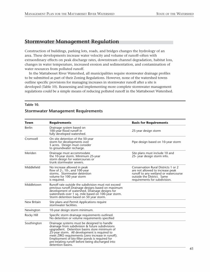
Stormwater Management Regulation
Construction of buildings, parking lots, roads, and bridges changes the hydrology of anarea. These developments increase water velocity and volume of runoff–often withextraordinary effects on peak discharge rates, downstream channel degradation, habitat loss,changes in water temperature, increased erosion and sedimentation, and contamination ofwater resources from polluted runoff.
In the Mattabesset River Watershed, all municipalities require stormwater drainage profilesto be submitted as part of their Zoning Regulations. However, none of the watershed townsoutline specific provisions for managing increases in stormwater runoff after a site isdeveloped (Table 10). Reassessing and implementing more complete stormwater managementregulations could be a simple means of reducing polluted runoff in the Mattabesset Watershed.
MANAGEMENT PLAN FOR THE MATTABESSET RIVER WATERSHED STATE OF THE WATERSHED
Table 10.
Stormwater Management Requirements
Town Requirements Basis for Requirements
Berlin Drainage system based on 100-year flood runoff in 25-year design storm fully developed watershed.
Cromwell On site detention of the 50-year storm for developments over Pipe design based on 10-year storm5 acres. Design must consider to groundwater recharge.
Meriden Drainage must accommodate Site plans must include 10 and the 10-year storm. Minimum 25-year 25- year design storm info.storm design for watercourses ortrunk stormwater sewers.
Middlefield No increase allowed in peak Conservation Rural Districts 1 or 2 flow of 2-, 10-, and 100-year are not allowed to increase peak storms. Stormwater detention runoff to any wetland or watercourse volume for 100 year storm outside the District. Same is required. requirements for subdivision.
Middletown Runoff rate outside the subdivision must not exceed previous runoff.Drainage designs based on maximum development of watershed. Drainage designs for watersheds over 1 sq. mile based on 100-year storm. Storm detention based on 50 year storm.
New Britain Site plans and Permit Applications require stormwater facilities.
Newington 10-year design storm minimum.
Rocky Hill Specific storm drainage requirements outlined. No detention or volume requirements specified
Southington Drainage systems must be designed to handle drainage from subdivision & future subdivisions upgradient. Detention basins store minimum of 25-year storm. All development is required to meet ZIRO requirements (zero increase in runoff). Employment of bio-filter ponds is required for pre-treating runoff before being discharged into detention basins.
41

Erosion & Sedimentation (E&S) Control Regulation
Especially at large suburban development sites, builders excavate massive amounts of soiland remove trees and vegetation for the purpose of modifying the landscape and makingconstruction easier. Without proper E&S control, huge influxes of sediment can flow intonearby streams during storms, even to the point of clogging the stream flow.
Numerous excavation and construction projects are presently underway in the uplands ofthe Mattabesset River Watershed. In order to prevent erosion of silt, sand, and debris fromsuch sites, responsible builders or project foremen use a few simple methods of E&S controlduring construction activities. Building temporary structures such as silt fences createsphysical barriers to sediment runoff. Further, phasing in clearing and grading activities sothat only small portions of the site are cleared at any one time, and planting cleared land assoon as possible, prevent long-term exposure of bare land to the elements. Contractors mustsubmit Erosion & Sedimentation Control Plans as part of the site application required by atown’s zoning regulations, subdivision regulations, and inland wetland and watercourseregulations (Table 11).
STATE OF THE WATERSHED MANAGEMENT PLAN FOR THE MATTABESSET RIVER WATERSHED
Table 11.
Erosion & Sediment Control Regulations
Municipality Responsible Authority Requirements
Berlin P&Z Commission Zoning regs. detail requirements. Singlefamilies exempt if < 0.5 acres.
Cromwell P&Z Commission Any plan including subdivision requirescontrol plan.
Meriden Planning Commission Control plan required over 0.5 acre, under 0.5acre optional by comm. Single family exempt.Policy for new site plans & developments ofzero increase in runoff.
Middlefield P&Z Commission Plan required for over 0.5 acre disturbance.
Middletown P&Z Commission Plan required for more than 0.5 acredisturbance.
New Britain P&Z Commission Plan required for over 0.5 acre disturbance.
Newington P&Z Commission Plan required for over 0.5 acre disturbance.
Rocky Hill P&Z Commission Plan required for over 0.5 acre, single familyexempt & farming or nursery stock exempt.
Southington P&Z Commission Site plans, subdivision plans, and zoning plotsplans require E&S control plan.
42

Impervious Surface
The conversion of farmland, forest and wetland to rooftops, roads, parking lots, andsidewalks creates a layer of impervious surface. These surfaces cannot absorb or infiltraterainfall, and thus impervious surface is a useful indicator with which to measure the impactof land development on our waterways. Recent research has shown that the amount ofimpervious surface in a watershed can be used to predict how severe stream degradation willbe. As little as ten-percent impervious surface in a watershed has beenlinked to stream degradation, with the degradation becoming moresevere as impervious cover increases (Figure 9)6.
A recent analysis of the amount of impervious surface in theMattabesset River watershed shows 18.35% impervious surface in thewatershed, a level that causes definite impacts to our streams (Table12). Further, a build-out analysis based on current zoning indicatesthat impervious surfaces could reach over 50% in the near future(Veklund et al, 1998).
MANAGEMENT PLAN FOR THE MATTABESSET RIVER WATERSHED STATE OF THE WATERSHED
0
10
20
30
40
50
60
70
80
Stream Degradation
Protected
Impacted
Degraded
Figure 9.
River Health & Imperviousness
6 adapted from: Schueler, 1994.
Impervious Surfaces& RunoffBecause of impervious surfaces, atypical street generates 9 timesmore runoff than a wooded areaof the same size.
—U.S. EPA
43
Mattabesset

STATE OF THE WATERSHED MANAGEMENT PLAN FOR THE MATTABESSET RIVER WATERSHED
Table 12.
Land Use in Watershed (impervious categories in bold type)
Categories Acres Percentage
Commercial, Industrial & Pavement 3,793 8.5
Residential & Commercial+ 6,302 14.1
Rural Residential+ 343 0.8
Turf & Tree Complex 4,904 11.0
Turf & Grass 1,982 4.4
Nursery Stock 51 0.1
Pasture & Hay & Grass* 4,457 10.0
Pasture & Hay / Exposed Soil* 325 0.7
Exposed Soil / Cropland* 390.4 0.9
Scrub & Shrub* 144 0.3
Deciduous and Mixed Forest* 14,274 31.9
Coniferous Forest* 5,225 11.7
Forest / Clear Cut 39 0.1
Deep Water 1,074 2.4
Shallow Water & Mud Flats 168 0.4
Non-forested Wetland 496 1.1
Forested Wetland 126 0.3
Exposed Soil and Sand 683 1.5
Total 44,775.2 100%
+ Only partially impervious
* Open Space
Adapted from: 1995, University of Connecticut, Storrs.
44
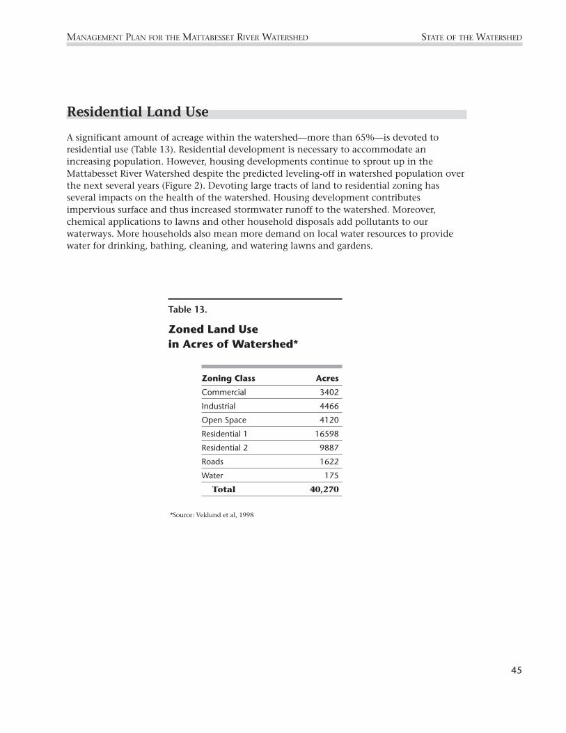
Residential Land Use
A significant amount of acreage within the watershed—more than 65%—is devoted toresidential use (Table 13). Residential development is necessary to accommodate anincreasing population. However, housing developments continue to sprout up in theMattabesset River Watershed despite the predicted leveling-off in watershed population overthe next several years (Figure 2). Devoting large tracts of land to residential zoning hasseveral impacts on the health of the watershed. Housing development contributesimpervious surface and thus increased stormwater runoff to the watershed. Moreover,chemical applications to lawns and other household disposals add pollutants to ourwaterways. More households also mean more demand on local water resources to providewater for drinking, bathing, cleaning, and watering lawns and gardens.
MANAGEMENT PLAN FOR THE MATTABESSET RIVER WATERSHED STATE OF THE WATERSHED
45
Table 13.
Zoned Land Use in Acres of Watershed*
Zoning Class Acres
Commercial 3402
Industrial 4466
Open Space 4120
Residential 1 16598
Residential 2 9887
Roads 1622
Water 175
Total 40,270
*Source: Veklund et al, 1998

46
MANAGEMENT PLAN FOR THE MATTABESSET RIVER WATERSHEDSTATE OF THE WATERSHED MANAGEMENT PLAN FOR THE MATTABESSET RIVER WATERSHED
Open Space
In order to mitigate the impactsof extensive residential andcommercial development in thewatershed, towns have acquiredparcels of open space thatremain protected fromdevelopment. Open spaceincludes the preserved naturalareas, as well as developedrecreational facilities and schoolgrounds. The most recent list ofdesignated open space in theMattabesset River Watershedwas compiled in 1971 (Table 15) (Fine, 1971). Unfortunately, this list is not current. Landtrusts, utility companies, and municipalities have added several areas of protected openspace over the last 25 years.
The 1971 open space report recommended the preservation of five critical areas in thewatershed as open space (Fine, 1971). The first tract was named the “Mattabesset Wetlands,”located in Berlin on the south side of the Mattabesset River south of Corbin Avenue, nearBerlin Station. Today, a small portion of this area is preserved as open space by the town ofBerlin, and most of the remaining area is used for agriculture. The entire area is zoned aseither single family or single and two-family residential use.
The Mattabesset River itself flows through the second area, called the “Mattabesset Landand Water Conservation Area.” This parcel of land is located in Berlin and is bounded byWethersfield Road on the north, Berlin Street on the south, Beckley Road on the west andinterstate 91 on the east. A small amount of land is kept as open space by the town ofBerlin. The remaining open areas are used as utility right of way or open woodland andriparian areas. The unprotected sections of this parcel are zoned as “planned industrial”.
The third area is described as the Mattabesset River Linear Green Belt. It is located onboth sides of the Mattabesset River, south of route 372, to the west and north of CromwellMeadows. It was recommended for purchase as a buffer strip and “to prevent costlydevelopment in the flood plain”.
The fourth recommendation for protection by easement or purchase was to add 100 acresto the 500-acres of state-owned area in Boggy Meadow, at the confluence of the Mattabessetand Coginchaug rivers.
Finally, the fifth recommended parcel consisted of a 30-acre parcel adjacent to HighlandPond, now protected by Mattabeseck Audubon Society and Middlesex Land Trust. This area wasalso recommended for open space preservation in the 1989 Middletown Plan of Development.
Though some land has been purchased since the Fine Report in 1971, most areas have notbeen preserved as open space. In all five cases, however, large areas of the recommendedplots are still undeveloped and potentially available for purchase.
Even as remaining open areas come under increasing pressure from development, criticalhabitat and recreational areas are being preserved. For example, the city of Middletown hasadded approximately 727 acres of open space to the city since 1991. There are many
Spruce Brook, which begins in Middletown and traverses throughBerlin before meeting the Mattabesset is threatened by development.
Phot
o—D
anie
lle P
irain
o

organizations concerned with preserving open space in the watershed, including: the BerlinLand Trust, Middlesex Land Trust, Mattabeseck Audubon Society, The Nature Conservancy,home owner associations, utility companies, town conservation or open space commissions,and various public agencies. In more urbanized areas of the watershed, remainingundeveloped land tends to be situated in critical areas such as steep slopes and ridge tops orland adjacent to waterbodies.
MANAGEMENT PLAN FOR THE MATTABESSET RIVER WATERSHED STATE OF THE WATERSHED
Large tracts of forested areas in the watershed remain vulnerable to development.
Phot
o—D
istr
ict
Arc
hive
s
47

48
STATE OF THE WATERSHED MANAGEMENT PLAN FOR THE MATTABESSET RIVER WATERSHED
Habitat
Several important and unusual natural habitats that exist within theregion of the Mattabesset River Watershed include freshwater tidalwetlands, freshwater and migratory fish habitat, and traprock ridges.
Freshwater Tidal WetlandsCromwell Meadows, also known as Round Meadow and BoggyMeadow, is a large freshwater tidal wetland located at the
confluence of the Coginchaug and Mattabesset rivers. The NatureConservancy recognizes Cromwell Meadows as a critical site in theTidelands Area of the Connecticut River, one of the forty “last greatplaces in the Western Hemisphere.” Cromwell Meadows is also a SpecialFocus Area with a high priority rank within the Silvio O. Conte NationalFish and Wildlife Refuge, due to its special biological values. The largewetland area provides habitat for migrating wood ducks, black ducks,teal, and nesting wood ducks. It is also an important nursery foranadromous fish species (fish that migrate from the ocean to freshwateror tidal streams) including alewife, blueback herring, American shad,gizzard shad, sea lamprey and white perch (semi-anadromous) (U.S. Fish& Wildlife Service, 1995). These fish species depend on the Mattabessetfor reproduction, and travel upstream from the Connecticut River as faras the Stanchem Pond.
Fish HabitatThe Mattabesset River itself becomes an important habitat for severalfreshwater and migratory7 fish species. Of particular importance is thehabitat that the river provides for brook lamprey, a threatenedfreshwater fish species that has been surveyed within its reaches.Tributaries of the Mattabesset provide habitat for rainbow and brooktrout that are stocked by the Department of Environmental Protection(CT DEP, 1999). Although the Mattabesset main stem is no longer aprime trout fishing area, populations of wild brown trout have beensurveyed in the upper reaches of the river: north of Route 71A in Berlin,and at the Berlin Street crossing in Berlin (Hagstrom, pers. comm.).
Traprock RidgesIn addition to providing habitat for aquatic species, the Mattabesset River Watershedprovides critical habitat for upland species. Traprock ridges form the southern and westernborders of the Mattabesset River Watershed, and offer a unique collection of habitats thatsupport several uncommon plant and animal species.
Calcium-rich soils, created by the weathering of basalt, provide the nutrients necessary tosustain plants usually associated with limestone soils (Lee, 1985).
7 Migratory fish include anadromous and catadromous species. Anadromous fish migrate from the ocean to freshwater tidal streamsto spawn, and catadromous fish migrate from freshwater streams to the ocean to spawn.
Some Fish Species ofthe Mattabesset
Freshwater:BluegillBrook lamprey
(a state threatened species)Brook troutBrown bullheadBrown troutChain pickerelCommon shinerFallfishLargemouth bassPumpkinseedRedfin pickerelWhite sucker
Migratory:AlewifeAmerican eelAmerican shadBlueback herringSea lampreyWhite perch
(Hagstrom et al, 1990)

Heat-loving species enjoy the warm, dry microclimates ofexposed ridgetops and talus slopes. The yellow corydalis flower(Corydalis flavula) and the falcate orange-tip butterfly(Anthocharis midea), two species common to the warmer climateof the southeastern United States, have been found at the top ofMount Higby and other Connecticut ridges. The prickly pearcactus (Opuntia humifosa), a resident of desert environments,survives in the dry, rocky soils of the ridgetops. New England’sonly lizard, the five-lined skink, enjoys the dry environment ofthe talus slopes. Rare amphibians flourish on the moist easternslopes of the ridges. The state-listed box turtle and marbled,spotted, and red-backed salamanders abound in thisenvironment (Lee, 1985).
The traprock ridge habitats have been threatened in recentyears by the spread of housing developments. In 1995, the state of Connecticut passedlegislation allowing towns to restrict development on ridges. Within the Mattabesset RiverWatershed, Berlin, Meriden, and Middlefield passed new regulations that prohibitdevelopment within 150 feet of ridges. The City of Middletown also tried to pass similarregulations, but without success.
ConclusionThis report has outlined the state of the Mattabesset River Watershed in a general sense.Beyond the scope of this report, the stakeholders who live and work within the watershedwill decide which topics require further investigation, and which actions will be taken todetermine the future of the Mattabesset River Watershed.
49
MANAGEMENT PLAN FOR THE MATTABESSET RIVER WATERSHED STATE OF THE WATERSHED
Found along traprock ridges inthe Mattabesset watershed, theprickly pear cactus sportsgorgeous yellow blooms.
The Importance of Traprock RidgesLamentation and Ragged mountains inBerlin, the Hanging Hills of Meriden,and Middletown’s Mount Higby are allpart of a nearly continuous series oftraprock ridges that extends fromBranford, CT to Northampton, MA(Bell, 1985).
The nutrient-rich soils and diversemicroclimates of traprock ridges aretwo features that allow rare species toflourish there.
Traprock ridges are also importantsources of drinking water in theMattabesset River Watershed, and feedthe reservoirs located at their bases,including Hallmere, Merimere, Mt.Higby, Shuttle Meadow, and Waselreservoirs.
Phot
o—Pa
t Ra
sch

50
STATE OF THE WATERSHED MANAGEMENT PLAN FOR THE MATTABESSET RIVER WATERSHED
Table 15.
Existing Open Space in the Mattabesset River Watershed
Name Town Acres Facilities
West Peak State Park Berlin 35 A, L, M
Merimere Reservoir Berlin/Meriden 50 B, E
Hallmere Reservoir Berlin 20 B, E
Kenmere Reservoir Berlin 20 B, E
Kensington Fish Hatchery Berlin 41 B
Silver Lake Berlin/Meriden 150 A, G, I
Lamentation Mountain State Park Berlin/Meriden 48 A, M
North Brook Well Site Berlin 8 C
Timberline Golf Course Berlin 338 B, Q
Hart Ponds Berlin 100 B, E
Ragged Mt. Memorial Reserve Berlin 553 B, L, N
Wasel Reservoir Berlin/Southington 103 B, E
Shuttle Meadow Reservoir Southington 205 B, E
New Britain Water Company Site New Britain/Southington 143 B
Shuttle Meadow Country Club New Britain/Berlin 338 C, I, P, Q
Walnut Hill Park New Britain 89 B, O
Martha Hart Park New Britain 38 B, O, P, R
Willow Brook Park New Britain/Berlin 87 B, H, O, T
Hungerford Park Berlin 85 B, N, O
Paper Goods Pond Berlin 20 B, I
Railroad Pond Berlin 15 B, I
Brickyard Ponds Berlin 126 C, I
Willow Brook Site Berlin 40 C
Patterson School Newington 73 B, O
Webster Brook Site Newington 5 B
Webster Park Berlin 52 B, J
Berlin Fair Berlin 120 C, R
Middletown Water Company Site Middletown/Middlefield 1000 B
Mt. Higby Reservoir Middletown/Middlefield 122 B, E
Van Buren Moody School Middletown 34 B, O
Westfield Falls Middletown 4 B, I, M
Camp Poplar Middletown 18 C, H, O
Cromwell Meadows Middletown/Cromwell 500 A, D, K
Facilities
A State Owned
B MunicipallyOwned
C PrivatelyOwned
D Wetlands
E Water Supply
F Fish Hatchery
G Boating
H Swimming
I Fishing
J Camping
K Hunting
L Hiking
M Picnicking
N Riding
O Playfields
P Tennis
Q Golf Course
R Winter Sports
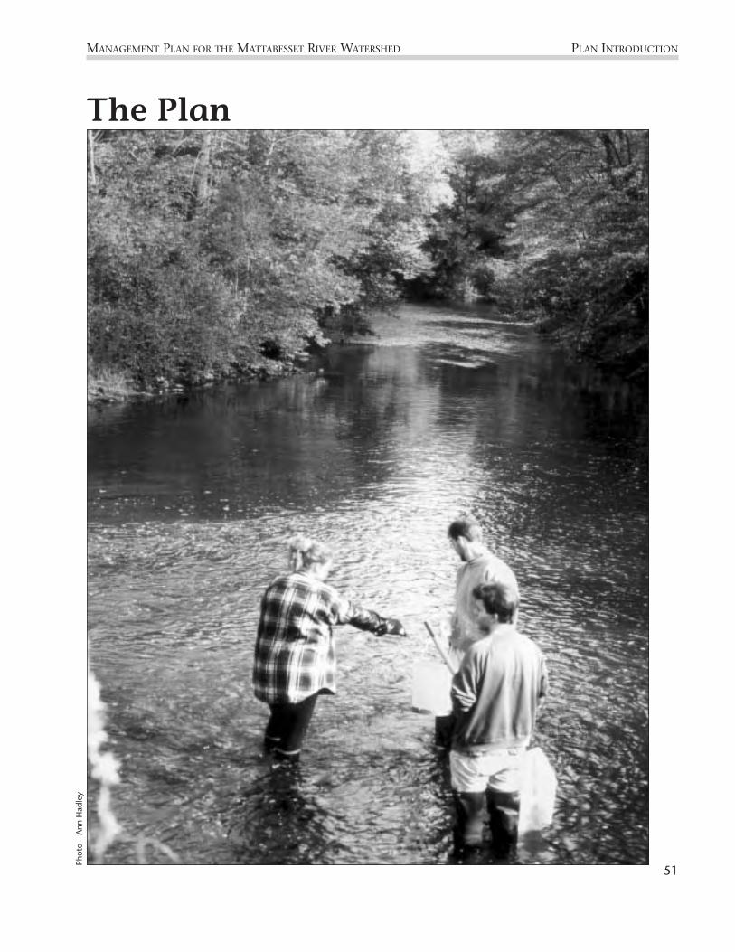
51
MANAGEMENT PLAN FOR THE MATTABESSET RIVER WATERSHED PLAN INTRODUCTION
The PlanPh
oto—
Ann
Had
ley

PLAN INTRODUCTION MANAGEMENT PLAN FOR THE MATTABESSET RIVER WATERSHED
52
The management plan is a culmination of efforts by the District, municipalities, land-owners, affected businesses, federal and state environmental agencies, and environmentalorganizations in the watershed. The planning process for the development of themanagement plan began in July 1999. Project oversight was delegated to the workingsubcommittees and the Steering Committee which were formed in September 1999.
Plan ImplementationThe Mattabesset Management Plan is a partnership among local governments, busi-nesses, state and federal regulatory agencies, and environmental organizationsthroughout the watershed. Oversight and coordination of the plan will be administeredby the Steering Committee which is composed of the four subcommittee chairs, fourmunicipal representatives, four state and federal agency representatives, two non-profitrepresentatives, two landowners, one open seat, and a seat for the Middlesex CountySoil and Water Conservation District as convener.
The plan has been organized into three phases. The beginning phase (Phase I),scheduled for implementation in the first 18 months, will focus on on completing highprofile, in-progress projects with an emphasis on community outreach and education.
In Phase II of the plan we will build on our successes in Phase I and begin toimplement projects that will draw on the resources of the local, state, and federalagencies. Phase II is scheduled for implementation in years 2 to 5.
Phase III of the plan includes the long-term projects that will rest on the success of PhaseI and Phase II implementation. Phase III is scheduled for implementation in years 5 to 10.
The Mattabesset River Stakeholder Group recognizes that this plan and itsimplementation are a significant beginning to the management of development,redevelopment, and individual decisions about land-use and water resourcesmanagement in the watershed. We also recognize the need to accommodate growth inthe Mattabesset watershed while protecting this sensitive natural resource.
Introduction
Young River Watch volunteers assist in water quality monitoring of the river.
Phot
o—G
ina
Am
oros
o /
The
Mid
dlet
own
Pres
s

53
MANAGEMENT PLAN FOR THE MATTABESSET RIVER WATERSHED GOAL #1
Phase IObjective: Utilize public resources and facilities to educate citizens of all ages about the basics ofwatershed science, the flora and fauna that live in different watershed habitats, and thebenefits of a clean and healthy watershed.
Supporting Tasks:1. Provide information to residents about the Mattabesset watershed using library
displays that show the entire watershed, but focus on areas of the River and thetributary streams that are within their municipality.
2. Install signs that label the River and tributaries at all road crossings.
Objective: Sponsor recreational opportunities for the general public in the watershed that drawattention to the watershed’s river,streams, and the land within.
Supporting Tasks:1. During the spring and summer,
sponsor regular canoe trips downthe Mattabesset for the public.
2. Sponsor watershed upland hikesto bring citizens into the head-water areas of the watershed.
3. Sponsor clean-ups along theRiver and tributary streams.
Objective: Use mass media channels to distribute information throughout the watershed.
Supporting Tasks:1. Disseminate information via the Mattabesset River Watershed Association website
(www.crosswinds.net/~mrwa).
2. Cultivate local newspaper contacts that will readily pick up a story pertaining to theMattabesset River Watershed.
Create awareness among watershed residents ofthe network of rivers and streams that comprisethe Mattabesset River Watershed.
A critical task for implementing the management plan is to first create awareness about thevalue and importance of the watershed. Even the best-designed watershed plan will founderwithout sufficient community support and, in turn, community support is often necessaryfor official government support.
GOAL#1
What is a watershed anyway?A watershed is an area of land that, due to its natural drainagepattern, collects precipitation and deposits it into specific marshes,streams, rivers or lakes.
Often called a drainage basin or hydrologic unit, a watershed can cover a large multi-state area like the Connecticut Riverwatershed, which, in turn, is composed of smaller areas like thewatershed of the Mattabesset. The Mattabesset, in turn, iscomposed of even smaller watersheds like Willow Brook watershedin New Britain and Coles Brook watershed in Cromwell.
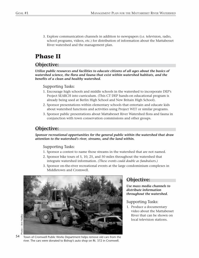
3. Explore communication channels in addition to newspapers (i.e. television, radio,school programs, videos, etc.) for distribution of information about the MattabessetRiver watershed and the management plan.
Phase IIObjective: Utilize public resources and facilities to educate citizens of all ages about the basics ofwatershed science, the flora and fauna that exist within watershed habitats, and thebenefits of a clean and healthy watershed.
Supporting Tasks:1. Encourage high schools and middle schools in the watershed to incorporate DEP’s
Project SEARCH into curriculum. (This CT DEP hands-on educational program isalready being used at Berlin High School and New Britain High School).
2. Sponsor presentations within elementary schools that entertain and educate kidsabout watershed functions and activities using Project WET or similar programs.
3. Sponsor public presentations about Mattabesset River Watershed flora and fauna inconjunction with town conservation commissions and other groups.
Objective: Sponsor recreational opportunities for the general public within the watershed that drawattention to the watershed’s river, streams, and the land within.
Supporting Tasks:1. Sponsor a contest to name those streams in the watershed that are not named.
2. Sponsor bike tours of 5, 10, 25, and 50 miles throughout the watershed thatintegrate watershed information. (These events could double as fundraisers.)
3. Sponsor on-the-river recreational events at the large condominium complexes inMiddletown and Cromwell.
Objective: Use mass media channels to distribute informationthroughout the watershed.
Supporting Tasks:1. Produce a documentary
video about the MattabessetRiver that can be shown onlocal television stations.
54
GOAL #1 MANAGEMENT PLAN FOR THE MATTABESSET RIVER WATERSHED
Town of Cromwell Public Works Department helps remove old cars from theriver. The cars were donated to Bishop’s auto shop on Rt. 372 in Cromwell.
Phot
o— A
nn H
adle
y

Phase IIIObjective: Use mass media channels to distribute information throughout the watershed.
Supporting Tasks:1. Continue to disseminate information via the Mattabesset River Watershed
Association website (www.crosswinds.net/~mrwa)
2. Continue to cultivate local newspaper contacts with regular press releases andinvitations to all watershed events.
MANAGEMENT PLAN FOR THE MATTABESSET RIVER WATERSHED GOAL #1
55Middletown Boy Scout troop members stencil storm drains with “Don’t DumpDrains to River” reminder.
Phot
o—A
nn H
adle
y

Educate the community about the link between land useand water quality.
How we use and develop the land directly affects the health of our streams and thesurrounding habitats. Everyday activities—constructing roads and buildings, usingfertilizers, herbicides and pesticides on farmland and lawns, walking our dogs, driving towork, washing cars—cause pollution that may eventually end up our streams. Fortunately,simple changes in how we carry out these activities can reduce the amount of pollution thatwe leave on the landscape, and greatly improve water quality in our rivers and streams.
Phase I Objective: Inform the watershed community about land use practices that reduce impacts tostreams.
Supporting Tasks:1. Target outreach and education to all streamside property owners about the
importance of maintaining and restoring riparian buffers.
Phase IIObjective: Inform the watershed community about land use practices that reduce impacts tostreams.
Supporting Tasks:1. Educate citizens about the harmful effects of disposing of wastes into storm drains.
2. Educate citizens about the detrimental effects of excessive use of fertilizers, pesticidesand herbicides on their lawns and gardens, and how best to apply them tominimize harm.
3. Educate citizens about the importance of timely street sweeping. Encourage citizensto request sweeping records from their town halls.
4. Educate citizens about the need for buffer regulations to protect streams in theirtowns. Send mailings with petitions that citizens can send to town officials toencourage establishing or enlarging buffers along streams.
5. Educate citizens about the harmful effects of impervious surface development to theRiver, streams and riparian areas.
GOAL #2 MANAGEMENT PLAN FOR THE MATTABESSET RIVER WATERSHED
GOAL#2
56

Objective: Provide education to municipal officials about stormwater and flood management.
Supporting Tasks:1. Provide education and technical assistance to municipalities, CT DOT, and
contractors in support of the Phase II Storm Water Rule.
2. Hold workshops for municipal officials on innovative stormwater managementtechniques and ground water recharge.
3. Hold workshops for local flood control officials with the goal of adopting acoordinated drainage standard.
4. Incorporate the Mattabesset River watershed community into the CT DEP’smunicipal flood plain management and mitigation workshops.
5. Educate watershed municipalities on ways to reduce flood insurance rates for theirresidents through the Community Rating System (i.e. outreach projects, keepingflood-related documents in the public libraries, implementing good storm watermanagement, performing drainage system maintenance, and seeking open spacepreservation).
Phase IIIObjective: Inform the watershed community about land use practices that reduce impacts tostreams.
Supporting Tasks:1. Continue to educate residents, land use boards and commissions, developers, and
other relevant groups about the value and importance of watershed stewardship.
2. Educate residents, land use boards and commissions, developers, and other relevantgroups about the value and importance of wetlands.
3. Inform residents, land use boards and commissions, developers, and other relevantgroups about the detrimental effects of non-native invasive species.
4. Educate developers of the importance of establishing stream buffers.
5. Educate towns on alternative building practices such as conservation developments.
6. Educate landowners, developers, and municipal officials about the benefits of energyefficient homes and alternative building materials, and provide a resource list ofenvironmentally responsible building alternatives.
7. Educate towns about the benefits of alternative waste water systems, gray water andseptic systems.
MANAGEMENT PLAN FOR THE MATTABESSET RIVER WATERSHED GOAL #2
57

A Day in the Lifeof a Polluter
1. Test your soil to determine the correctamount of fertilizers and keep fertilizer offpaved areas so that it doesn’t wash nutrientsinto streets and storm drains. Landscape withnative plants that support native wildlife andrequire less water and fewer pesticides.
2. Select porous materials like gravel forwalkways and driveways to increaseinfiltration and decrease surface runoff.
3. Never pour toxic household chemicals downthe drain or on the ground. Take them to yourlocal hazardouswaste collection center.
4. Clean up after pets to avoid runoff ofnutrients and pathogens into streams andrivers.
5. Recycle used oil and antifreeze at your localservice stations. Schedule regular tuneups foryour car to reduce deposits of toxic pollutants.
58
GOAL #2 MANAGEMENT PLAN FOR THE MATTABESSET RIVER WATERSHED
Illus
trat
ion—
Pat
Rasc
h
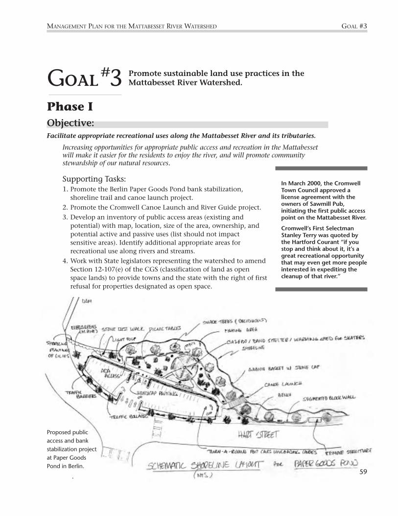
Promote sustainable land use practices in theMattabesset River Watershed.
Phase IObjective: Facilitate appropriate recreational uses along the Mattabesset River and its tributaries.
Increasing opportunities for appropriate public access and recreation in the Mattabessetwill make it easier for the residents to enjoy the river, and will promote communitystewardship of our natural resources.
Supporting Tasks: 1. Promote the Berlin Paper Goods Pond bank stabilization,
shoreline trail and canoe launch project.
2. Promote the Cromwell Canoe Launch and River Guide project.
3. Develop an inventory of public access areas (existing andpotential) with map, location, size of the area, ownership, andpotential active and passive uses (list should not impactsensitive areas). Identify additional appropriate areas forrecreational use along rivers and streams.
4. Work with State legislators representing the watershed to amendSection 12-107(e) of the CGS (classification of land as openspace lands) to provide towns and the state with the right of firstrefusal for properties designated as open space.
MANAGEMENT PLAN FOR THE MATTABESSET RIVER WATERSHED GOAL #3
GOAL#3
Proposed publicaccess and bankstabilization projectat Paper GoodsPond in Berlin.
In March 2000, the CromwellTown Council approved alicense agreement with theowners of Sawmill Pub,initiating the first public accesspoint on the Mattabesset River.
Cromwell’s First SelectmanStanley Terry was quoted bythe Hartford Courant “if youstop and think about it, it’s agreat recreational opportunitythat may even get more peopleinterested in expediting thecleanup of that river.”
59

Phase IIObjective: Develop a comprehensive inventory of watershed lands to identify areas for preservation,improvement/restoration, and appropriate recreation.
The Mattabesset River Watershed hosts a wide range of land uses, including downtownareas, suburban neighborhoods, rural farmlands, forests, traprock ridges, and richwetlands. Our natural resources can sustain a certain level of development before theybegin to degrade becoming unsuitable for wildlife habitat. By creating a readily accessibleinventory of land in the watershed, land planners can identify the natural resources anddevelopment potential of each area, and make informed decisions about municipal zoning,open space preservation, and recreational use.
Supporting Tasks:1. Identify parcel size, location, ownership, and land use category utilizing a Geographic
Information System (GIS) and create a database with parcel attributes.
2. Create a map showing land uses and natural resource features (overlay with existingGIS street and hydrology maps).
Objective: Assist in the protection of open space through acquisition or other means to improveecosystem health and to enhance aesthetics within the watershed.
Acquiring and protecting undeveloped land is an effective method for preserving criticalhabitat. In the Mattabesset River Watershed, natural areas that are most easily damagedby urban and suburban development include wetlands, floodplains, forests, and traprockridges. These habitats can be protected through purchase, easements, and tax breaks.
Supporting Tasks:1. Adopt land selection criteria (for example: high priority may be given to land closer to
headwaters, land that has high biodiversity, or areas of critical habitat).
2. Using the land use inventory, identify open space lands to be protected and develop alist of prioritized land acquisitions, protection and enhancement/restoration areas.
3. Investigate the state of existing regional open space plans and determine their stage ofimplementation.
4. Provide landowners and towns with open space protection informational packet. Forexample, educate eligible property owners of the Public Act 490 program. Public Act490 allows farms, forests, and open space lands to be taxed at a “use value” ratherthan the higher tax category of “market value”.
5. Ensure that watershed towns’ plans of conservation and development include an openspace component and that the goals are consistent with the MSG Management Plan.
6. In coordination with watershed towns and local land trusts, identify and utilizeexisting funding mechanisms including the State Farmland Preservation Programand the State Open Space Grant Program to acquire lands.
60
GOAL #3 MANAGEMENT PLAN FOR THE MATTABESSET RIVER WATERSHED

MANAGEMENT PLAN FOR THE MATTABESSET RIVER WATERSHED GOAL #3
61
Objective: Encourage conservation development practices that minimize impact on natural resources.
In the face of a growing economy, land development is almost inevitable. However,alternative methods of development exist that minimize the erosion, pollution, and loss ofhabitat associated with development. By implementing these alternative methods ofdevelopment, we can effectively support the growth needs of our community and preserveour natural environment at the same time.
Supporting Tasks: 1. Review existing regulations for environmental appropriateness, e.g. road width,
impervious surfaces, curbing, sidewalks, and bicycle paths/lanes.
2. Educate towns and the public on the benefits of open space associated withdeveloped areas.
3. Provide citizens and town planning staff with visual representations of redevelopingexisting “strip mall” areas into smaller pedestrian friendly commerce villages thatprovide housing, retail stores, and restaurants.
Phase IIIObjective: Encourage conservation development practices that minimize impact on natural resources.
Supporting Tasks: 1. Encourage towns to promote use of existing or vacant structures for new businesses
through tax incentives.
2. Modify regulations in watershed towns to incorporate stream protection requirementsinto regulations to promote conservation-based development (for example, encouragethe reduction of impervious surfaces by modifying requirements for road width andusing engineered swales instead of curbing where practical).
Using porous pavement, like this stone driveway, instead of impervious surfaces like blacktop increasesinfiltration and decreases runoff pollution.
Phot
o—St
epha
nie
Shak
ofsk
y

Restore and maintain wildlife habitat in theMattabesset River Watershed.
Phase IObjective: Control or diminish the prevalence of invasive species.
Invasives are plant species that are not native to an area but, once introduced, have theability to colonize large areas and replace the native vegetation. Invasive non-native speciesare a threat to natural ecosystems because they often replace native species that provideimportant food sources and habitat for native wildlife, thereby reducing biological diversityin the watershed.
Supporting Tasks: 1. Provide a list of invasive non-native species to appropriate groups. Encourage local
nurseries and home improvement centers to offer more native species and discouragethe sale of invasive non-native species.
Phase IIObjective: Control or diminish the prevalence of invasive species.
Supporting Tasks: 1. On a subwatershed basis, identify sites degraded by invasive non-native species and
design and implement specific invasive species reduction/restoration projects.
2. Develop and implement an ongoing monitoring program to measure the success ofthe program.
62
GOAL #4 MANAGEMENT PLAN FOR THE MATTABESSET RIVER WATERSHED
Phragmites Stand in Cromwell Meadows
What’s an invasive species?Invasive non-native species don’t usually show up on lists of major environmental problems. Butdespite their relative lack of public recognition, invasive species pose one of the greatest threats tobiological diversity, behind habitat loss and degradation. Nationwide, non-native species have beenimplicated in the decline of 42% of species listed under the Endangered Species Act.
Freed from the control of the predators, parasites, and competitors found in their originalhabitats, invasive non-native species often spread unhindered—degrading naturalcommunities, altering ecological processes, and threatening the survival of native plantsand wildlife.
Purple loosestrife, the “purple plague” that chokes wetlands, is still sold for landscaping inmany Connecticut garden centers.
GOAL#4
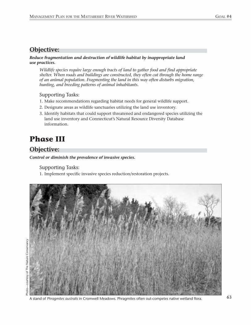
Objective: Reduce fragmentation and destruction of wildlife habitat by inappropriate land use practices.
Wildlife species require large enough tracts of land to gather food and find appropriateshelter. When roads and buildings are constructed, they often cut through the home rangeof an animal population. Fragmenting the land in this way often disturbs migration,hunting, and breeding patterns of animal inhabitants.
Supporting Tasks: 1. Make recommendations regarding habitat needs for general wildlife support.
2. Designate areas as wildlife sanctuaries utilizing the land use inventory.
3. Identify habitats that could support threatened and endangered species utilizing theland use inventory and Connecticut’s Natural Resource Diversity Databaseinformation.
Phase IIIObjective: Control or diminish the prevalence of invasive species.
Supporting Tasks: 1. Implement specific invasive species reduction/restoration projects.
MANAGEMENT PLAN FOR THE MATTABESSET RIVER WATERSHED GOAL #4
A stand of Phragmites australis in Cromwell Meadows. Phragmites often out-competes native wetland flora.
Phot
o—co
urte
sy o
f The
Nat
ure
Con
serv
ancy
63
Protect wetland and watercourse areas fromdevelopment and other disturbances.
Phase IObjective: Promote a standard regulatory review area in watershed towns to improve water quality,aquatic habitat, and riparian wildlife habitat.
Regulatory review areas are distances from the edge of wetlands and watercourses thatmay not be disturbed unless a special permit from the town is obtained. These regulatoryreview areas are important for protecting and maintaining water quality, groundwaterinfiltration, stream bank stability, and wildlife habitat. Establishing a minimum 100 feet
review area in all watershed towns will help to preventfuture degradation of our water resources.
Supporting Tasks: 1. Develop an information package to enable watershed
towns to compare and contrast their regulatoryreview regulations, and to make informed decisionsabout the benefits of establishing a 100-footregulatory review area adjacent to wetlands andwatercourses.
2. Follow up with Inland Wetlands/ConservationCommissions to assist in the adoption of the 100-foot regulatory review area.
Phase IIObjective: Protect intact wetland systems
Wetlands are extremely critical and sensitive areas. Wetlands protect water quality byfiltering pollutants as water flows through them, and they provide essential habitat to adiverse assemblage of bird, amphibian, and insect species. Extreme caution should be usedwhen developing the land around wetlands—even minor changes in slope of the land canchange the way water flows to a wetland, causing the wetland either to dry up or to drown.
Supporting Tasks: 1. Complete a wetlands inventory for each subwatershed and develop an updated
wetlands map.
2. Encourage the re-establishment, restoration, and enhancement of wetlands as part ofnew development or redevelopment projects.
64
GOAL #5 MANAGEMENT PLAN FOR THE MATTABESSET RIVER WATERSHED
GOAL#5
Wetlands: Special PlacesHistorically considered “wastelands” to be filledin for development, today we recognizewetlands as indispensable natural environments.Many wildlife species depend on wetlands forsome portion of their life cycle.
We now know that wetlands are also critical tomaintaining water quality. They produceoxygen, filter pollutants, remove silts andsediments, absorb organic and inorganicchemicals, and recycle and reuse these nutrients.
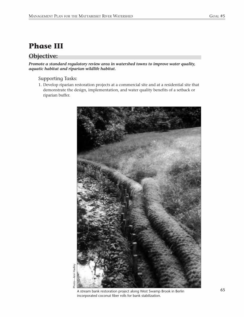
Phase IIIObjective: Promote a standard regulatory review area in watershed towns to improve water quality,aquatic habitat and riparian wildlife habitat.
Supporting Tasks: 1. Develop riparian restoration projects at a commercial site and at a residential site that
demonstrate the design, implementation, and water quality benefits of a setback orriparian buffer.
65
MANAGEMENT PLAN FOR THE MATTABESSET RIVER WATERSHED GOAL #5
A stream bank restoration project along West Swamp Brook in Berlinincorporated coconut fiber rolls for bank stabilization.
Phot
o—A
nn H
adle
y

Identify, investigate, correct, and preventpollution problems.
Phase IObjective: Continue water quality monitoring and assess changes in water quality.
Collecting stream flow and water quality data at regular intervals helps us to assess thepresent health of our streams and the environmental issues facing them, and alerts us topotential sources of water pollution. Long-term water quality monitoring is needed in orderto detect changes in stream health over time.
Supporting Tasks:1. Reinstate the United States Geological Survey (USGS) gaging station and continue the
water quality monitoring program on the Mattabesset River.
2. Continue monitoring water quality in the Mattabesset River and its tributariesthrough the Connecticut River Watch Program (CRWP). Prioritize monitoring sitesand water quality indicators for more detailed investigations of pollution problems.
3. Designate a Connecticut DEP water permits and enforcement field inspector for theMattabesset River Watershed.
Phase IIObjective: Continue water quality monitoring and assess changes in water quality.
Supporting Tasks:1. Establish a technical advisory committee to interpret water quality monitoring results
and design future monitoring projects to assess water quality and key issues in theMattabesset River Watershed.
2. Initiate or continue focused monitoring projects for issues or activities of concern inthe watershed. Potential projects include (a) storm-event monitoring, (b) Silver Lakeand Paper Goods Pond reclamation projects, (c) construction site runoff monitoring,and (d) monitoring possible failing sewer and septic systems.
3. Initiate a stream segment adoption program to provide continuing visual monitoringof the watershed.
4. Maintain the State of the Watershed database for water quality related informationcollected in the watershed. Obtain relevant data and information from theConnecticut River Watch Program, Middlesex County SWCD, USGS, local HealthDepartments, CT DEP, and other sources.
66
GOAL #6 MANAGEMENT PLAN FOR THE MATTABESSET RIVER WATERSHED
GOAL#6

Objective: Continue to improve stormwater management throughout the watershed.
When it rains or snows, the water that runs off city streets, parking lots, and constructionsites washes sediment, oil, grease, toxins, pathogens, and other pollutants into nearbystorm drains. Once this pollution enters the sewer system, it flows—untreated—into localstreams and rivers. Known as stormwater runoff, this pollution is a leading threat to publichealth and the environment.
Supporting Tasks:1. CT DEP will issue a general
permit for municipal separatestormwater systems (MS4s) incompliance with the NPDESPhase II Stormwater Rule, andsubject all municipalities andstate-owned or operated roadswithin the Mattabesset RiverWatershed to its requirements.
MANAGEMENT PLAN FOR THE MATTABESSET RIVER WATERSHED GOAL #6
Connecticut River Watch lab volunteers identify macroinvertebrates from a sample taken from theMattabesset River. Because of their sensitivity to pollution, macroinvertebrate populations are an indication ofwater quality.
Phot
o by
Cor
ey L
owen
stei
n /
The
Har
tfor
d C
oura
nt
In 1987, amendments to the federal Clean Water Act required EPAto establish regulations for managing stormwater runoff throughthe National Pollutant Discharge Elimination System (NPDES).Phase I of the program, initiated in 1990, regulated municipalstormwater systems serving large populations (over 100,000),construction sites above 5 acres, and most industrial activities. OnDecember 8, 1999, the Stormwater Phase II Rule took effect. ThePhase II Rule is the next step in EPA’s effort to “preserve, protect,and improve the Nation’s water resources from pollutedstormwater runoff” and will improve control on stormwater runofffrom smaller urbanized areas and smaller construction sites.
67

2. Work with watershed municipalities and the Connecticut Department ofTransportation (CT DOT) to obtain permit coverage under the stormwater generalpermit for MS4s, which requires municipalities and other owners or operators ofroads in “urbanized areas” to implement programs and practices to control pollutedstormwater runoff.
3. All watershed municipalities and CT DOT will develop and implement programs andpractices to control polluted stormwater runoff, components of which will include:(1) public education and outreach; (2) public participation/ involvement; (3) illicitdischarge detection and elimination; (4) construction site runoff control; (5) post-construction runoff control; and (6) pollution prevention/good housekeeping.
4. Identify areas on a subwatershed basis in need of stormwater retrofits through aerialphotography and ground-truthing, and prioritize the retrofits based on location inwatershed, severity of the problem, stream sensitivity and hydrologic energybalances including flood prone or potential flood areas.
5. Watershed municipalities will adopt consistent stormwater drainage standards intotheir zoning regulations, which meet the requirements of different land use andhabitat characteristics.
GOAL #6 MANAGEMENT PLAN FOR THE MATTABESSET RIVER WATERSHED
68
Stormwater Runoff vs Raw Sewage (Treated and Untreated)(all values in milligrams/liter or parts per million)
Urban Raw TreatedContaminant Runoff Sewage Sewage
Total Suspended Solids 150 220 20
Total Phosphorous 0.36 8 2
Total Nitrogen 2 40 30
Lead 0.18 0.10 0.05
Copper 0.05 0.22 0.03
Zinc 0.21 0.28 0.08
Fecal Coliform/100milliliter 50,000 100,000,000 200

Objective: Continue to improve erosion and sediment control regulations throughout the watershed.
In the Mattabesset River fine muds blanketmuch of the formerly rocky streambed, andduring storm events, suspended sediments colorthe River a deep reddish-brown. Such pollution iscaused by the unnatural erosion of soil fromareas stripped of their vegetation. Improvementsin erosion and sediment control regulations inthe watershed are needed to reduce the influx ofsediment to our streams, and to restore theaquatic habitats smothered by silt.
Supporting Tasks:1. Encourage watershed municipalities to
modify existing erosion and sedimentcontrol regulations to require that an erosionand sediment control specialist (provided bythe developer) be responsible for eachdevelopment project, based on modelregulations.
2. Work with watershed towns to modifyexisting erosion and sediment controlregulations to require construction sitephasing, based on model regulations.
Objective: Develop a septic system maintenance program to assure the effective functioning of septicsystems in the watershed.
Eight years of summertime water quality data collected by the Connecticut River WatchProgram show that bacterial levels in streams of the Mattabesset River Watershedconsistently exceed Connecticut’s Water Quality Criteria. These chronically high bacterialevels point to failing septic systems as one possible cause of the contamination. Septicsystems require periodic maintenance in order to function properly, and simple upkeep canextend the lifetimes of septic systems and dramatically reduce the input of human wasteto streams.
Supporting Tasks:1. Within each municipality, establish accurate maps of existing septic systems,
including the location, size, and age of each system.
2. Conduct preliminary investigations of non-sewered areas to determine wherepollution from failing septic systems is likely (e.g. visual surveys, bacteria testing innearby streams).
MANAGEMENT PLAN FOR THE MATTABESSET RIVER WATERSHED GOAL #6
NaturalVegetation Acts as a Filter:
Vegetation absorbsthe energy of fallingrain.
Roots hold soilparticles in place.
Vegetation helps tomaintain absorptivecapacity.
Vegetation slowsrunoff velocity andcatches sediment.
69

Phase III Objective: Continue to improve stormwater management throughout the watershed.
Supporting Tasks:1. Implement high priority stormwater retrofit projects in the watershed.
Objective: Develop a sanitary sewage maintenance plan for the watershed.
Failing sewage infrastructure and illegal hook-ups to sanitary sewer lines can result in leaksin the pipes, as well as overflows during high flow events. Improved maintenance of sewerlines in the Mattabesset River Watershed will minimize sewage inflows to the streams andreduce bacterial contamination caused by human waste.
Supporting Tasks:1. Within each watershed municipality, establish accurate maps of (a) the existing
sanitary sewer system and (b) areas targeted for future sanitary sewer service. Mapswill include the location, size, age, and construction materials of each system.
2. Encourage watershed municipalities to inspect their sewer lines through the SewerSystem Evaluation Survey, and to implement the recommended corrections. (Thissurvey is in progress in New Britain and is in the planning stages in Berlin).
3. Implement a recurring 5-year maintenance program for televising andcleaning the sanitary sewage system.
4. Purchase the equipment necessary for proper maintenance of the sewersystem and provide contracts for such maintenance.
5. Conduct an assessment of capital improvement needs of all wastewater-pumping stations and develop a multi-year implementation plan.
6. Conduct an assessment of the response capabilities of the sewer system toblockage, backup into basements, overflows, and mechanical failure.
7. State and regional agencies will provide technical assistance tomunicipalities in support of the above tasks.
Objective: Develop a septic system maintenance program to assure the effective functioning of septicsystems in the watershed.
Supporting Tasks:1. Based on preliminary investigations, conduct sanitary surveys of non-sewered areas to
determine the extent and severity of failing septic systems.
2. Implement corrective actions in areas of failing septic systems (for example: repair ofindividual systems or extension of sanitary sewers).
3. Develop and adopt an incentive-based model ordinance for septic system inspectionand maintenance for watershed municipalities. Include an education program forindividuals and businesses affected by the ordinance.
GOAL #6 MANAGEMENT PLAN FOR THE MATTABESSET RIVER WATERSHED
A 1997 survey ofMattabesset watershedresidents showed that of504 residents surveyed,492 strongly felt that theirtown should do more toprotect the quality of theriver (that’s 98%)!
70

MANAGEMENT PLAN FOR THE MATTABESSET RIVER WATERSHED GOAL #7
Restore and maintain in-stream and riparianhabitat to support healthy fish populations andother aquatic life.
Phase IObjective: Minimize the impacts of development on in-stream habitat.
In many areas, the Mattabesset River and tributaries have been disrupted by humanactivities, damaging in-stream habitat. Eroded stream banks, very low flows, loss ofstreamside vegetation, and unnaturally silted and sandy streambeds are among theproblems that threaten aquatic life throughout the watershed. These impacts can make astream inhospitable to certain fish species and many species of aquatic insects. Anunnatural source of sand in streams is road sand. The accumulation of road sand instream can be easily prevented through timely street sweeping, minimizing applicationrates, and other management practices.
Supporting Tasks:1. Work with each watershed town to reduce the amount of road sand in the stream
bottom through a prioritization of street sweeping and catch basin cleanout based onsize, location to stream, sensitivity of stream, time of year, and integrity of the currentstormwater mitigation system.
2. Meet with Department of Transportation to review the Department’s road sandpolicies.
GOAL#7
Typical streamside restoration measures.
Install native rockcheck dam toreduce velocities
Plant treesto shadewater
Place bouldersfor fish cover
Formgravel-bedriffle
Install flowdetector
Removetrash anddebris
Plant bankson outsideof bends
Save existingtrees
Road
Enlarge orremove crossculverts, removefish barriers
Excavate pool
Provide naturetrail and publicaccess
Removetrash anddebris
Preserve ox-bow lake
71
Cou
rtes
y, C
onne
ctic
ut D
epar
tmen
t of
Env
ironm
enta
l Pro
tect
ion

Phase IIObjective: Minimize the impacts of development on riparian and in-stream habitat.
Supporting Task:1. Follow up with outreach to the watershed towns to reduce the deposition of road sand in
the stream bottom on a watershed wide basis through minimizing application rates andfurther improving maintenance activities (e.g. street sweeping, catch basin clean-out).
Objective: Restore or enhance streamside and in-stream physical conditions.
Both in-stream and streamside improvements are needed in the Mattabesset watershed torestore natural stream habitat conditions and foster healthy aquatic ecosystems. Forexample, stream bank plantings will improve stream shading and stabilize banks, andstructures placed in the stream like boulders will provide cover for fish.
Supporting Tasks: 1. Identify and evaluate streamside and in-stream conditions and develop
recommendations for streamside and in-stream restoration/enhancement projects ona subwatershed basis.
Objective: Restore anadromous fish populations in the Mattabesset River and tributaries.
Anadromous fish are those fish species that migrate from the ocean to freshwater tospawn. At least five anadromous fish species have been found in the MattabessetRiver including alewife, american eel, blueback herring, american shad, sea lamprey.However, dams and degraded streambed conditions in the Mattabesset River mayprevent these species from migrating to proper upstream habitats to live and breed.
Supporting Tasks:1. Research historic use of the Mattabesset River and tributaries by anadromous
fish populations.
2. Evaluate existing stream conditions and barriers to passage and designstructures (e.g. fish ladders) and in-stream improvements that encourage use ofthe streams by anadromous fish.
Objective: Foster cold water fisheries in the Mattabesset River and tributaries.
Cold water fish species, including trout, require cool stream temperatures, adequate streamflow, and a gravelly streambed in order to thrive. In the Mattabesset River Watershed, coldwater fisheries suffer due to summertime low flow conditions, elevated water temperatures,and unnaturally silty and sandy streambeds. Projects to improve stream shading, and
GOAL #7 MANAGEMENT PLAN FOR THE MATTABESSET RIVER WATERSHED
72
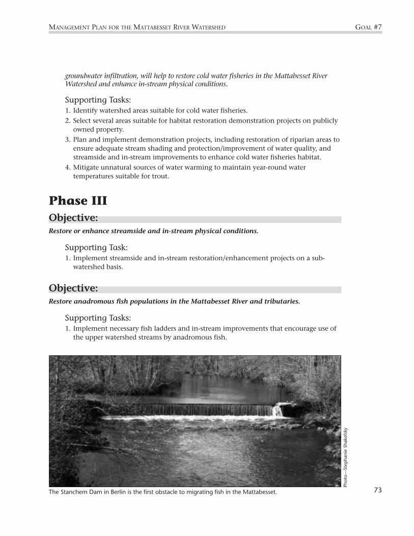
groundwater infiltration, will help to restore cold water fisheries in the Mattabesset RiverWatershed and enhance in-stream physical conditions.
Supporting Tasks: 1. Identify watershed areas suitable for cold water fisheries.
2. Select several areas suitable for habitat restoration demonstration projects on publiclyowned property.
3. Plan and implement demonstration projects, including restoration of riparian areas toensure adequate stream shading and protection/improvement of water quality, andstreamside and in-stream improvements to enhance cold water fisheries habitat.
4. Mitigate unnatural sources of water warming to maintain year-round watertemperatures suitable for trout.
Phase IIIObjective: Restore or enhance streamside and in-stream physical conditions.
Supporting Task: 1. Implement streamside and in-stream restoration/enhancement projects on a sub-
watershed basis.
Objective: Restore anadromous fish populations in the Mattabesset River and tributaries.
Supporting Tasks: 1. Implement necessary fish ladders and in-stream improvements that encourage use of
the upper watershed streams by anadromous fish.
MANAGEMENT PLAN FOR THE MATTABESSET RIVER WATERSHED GOAL #7
The Stanchem Dam in Berlin is the first obstacle to migrating fish in the Mattabesset. 73
Phot
o—St
epha
nie
Shak
ofsk
y

Evaluate and balance in-stream flow needs,including flow volumes necessary for aquatic lifehabitat, drinking water supply, and otherconsumptive water uses.
Phase IObjective: Calculate a water budget for the Mattabesset watershed to resolve water use conflicts andallow for the development of comprehensive flow and water allocation management plans.
The Mattabesset River and its tributaries suffer from extremely low levels of stream flowduring summer months. These low flow levels result in elevated stream temperatures andbacteria concentrations in the Mattabesset. By quantifying water withdrawal and waterdetention, and by determining the natural flow rates of the streams in the watershed, wewill equip ourselves with the information necessary to create a sustainable plan for waterallocation.
GOAL #8 MANAGEMENT PLAN FOR THE MATTABESSET RIVER WATERSHED
GOAL#8
Merimere Reservoir in Meriden, part of the City of Meriden’s water supply, is the headwaters of the Mattabesset River.
Phot
o—C
lyde
Sel
ner
74

Supporting Tasks:1. Gather information about the status of water allocation in the watershed. Compile
and review other relevant data and information including benthic macroinvertebratecommunity data and fisheries community data. Develop a list of potential sources ofwater to the Mattabesset River, including water conservation, storm water infiltration,upstream storage, and others.
2. Review current and historical watershed flow information, and identify streams at riskof inadequate flow. Utilize hydrologic modelling to determine minimum flowrequirements for streams at risk of inadequate flow.
3. Calculate a Water Budget for the Mattabesset River Watershed to show where water isand what it is doing over extended time.
4. Obtain and disseminate information about DEP’s report to General Assembly and itsimplication for the Mattabesset River Watershed. The Connecticut DEP has compileda report for the Connecticut General Assembly that recommends a re-evaluation ofregistered water diversions. Prior to 1983, individuals did not need to obtain a permitfor diverting water. This report recommends that diversions registered before 1983 gothrough a renewal process for their diversions.
Phase IIObjective: Establish a Flow Work Group of individuals and organizations in the watershed whorepresent various water use interests to develop a flow allocation policy.
Accounting for all water use needs in the Mattabesset River Watershed and balancing theseneeds with flow volumes for aquatic life requires input from all parties with specificinterests in water use.
Supporting Tasks:1. Identify all individuals and organizations with specific water use interests and solicit
their participation in the Flow Work Group.
2. Develop a flow allocation policy.
Phase III
Objective: Establish a Flow Work Group of individuals and organizations in the watershed whorepresent various water use interests to develop a flow allocation policy.
Supporting Tasks: 1. Implement the flow allocation policy in the watershed.
MANAGEMENT PLAN FOR THE MATTABESSET RIVER WATERSHED GOAL #8
75

Obtain a consistent and stable funding stream toaccomplish the plan’s objectives.
Phase IObjective : Identify potential and appropriate funding mechanisms
Supporting Tasks: 1. Compile a directory of funding sources available through federal,
state, and local governments, private foundations, and otherorganizations. Cooperate with watershed-based organizations tosupport their fundraising efforts.
2. Conduct a survey of watershed towns to measure the potentialsuccess of instituting a municipal fee structure. (Based on similarfee structures across the nation, these fees could be used forconstruction and maintenance of stormwater drainage systems,review of stormwater management plans, inspection andenforcement activities, watershed planning, and water qualitymonitoring.)
3. Identify projects/activities requiring non-monetary resources andconnect those projects to their appropriate resource.
Phase IIObjective:Identify potential and appropriate funding mechanisms
Supporting Tasks: 1. Cooperate with watershed-based organizations to support their fundraising efforts
through federal, state, local, and private funding sources.
2. Identify projects/activities requiring non-monetary resources and connect thoseprojects to their appropriate resource.
Phase IIIObjective :Identify potential and appropriate funding mechanisms.
Supporting Tasks: 1. Continue to pursue local, state, and federal grants, donations, and memberships.
2. Identify projects/activities requiring non-monetary resources and connect thoseprojects to their appropriate resource.
GOAL #9 MANAGEMENT PLAN FOR THE MATTABESSET RIVER WATERSHED
GOAL#9
76
Stormwater utilities are awell-established, equitable, andfeasible financing option thatprovide a dedicated revenue sourcefor stormwater and watershedmanagement. A Natural ResourceDefense Council report stated thatas of 1996 over 300 stormwaterutilities were in operation in at least20 states (by contrast, there arethousands of water, sewer, andirrigation districts in the country.)
ReferencesArnold, C. L. Jr. & Gibbons, C. J., 1996. Impervious Surface Coverage: the Emergence of a
Key Environmental Indicator. Journal of the American Planning Association, Vol. 62,No. 2.
Bell, M., 1985. The Face of Connecticut, Connecticut Geological and Natural HistorySurvey of Connecticut, Bulletin 110. Hartford, Connecticut.
Berlin, Town of, Building Department. Compiled building permit data July 1, 1998through June 30, 1999 and annual data for 1997–1998.
Bogar, J. C. Jr., 1988. DEP Property: Connecticut Department of Environmental ProtectionOwned and Managed Property, Connecticut Natural Resources Atlas Series, scale1:125,000.
Bowers, L. & Brawerman, J., 1999. Mattabesset River Watershed Stream Walk Survey FinalReport, Connecticut River Watch Program, Middlesex County Soil and WaterConservation District.
Brawerman, J., 1999. The Mattabesset River—A Study of Water Quality and Stream Health,Connecticut River Watch Program, Middlesex County Soil and Water ConservationDistrict.
Brawerman, J. & Dates, G., 1995. Connecticut River Watch Program 1993 Final Report,Middlesex County Soil and Water Conservation District.
Civco, D. Land cover data from late 1980s satellite imagery (Thematic Mapper) http://magic.lib.uconn.edu, University of Connecticut.
Connecticut Department of Economic and Community Development, 1999. ConnecticutTown Profiles 1998–1999, internet address: www.state.ct.us/ecd/research.
Connecticut River Forum, 1998. The Health of the Watershed: A Report of the ConnecticutRiver Forum.
Creighton, J., 1999. Results of survey compiled for the production of “CommunicationCampaign for the Mattabesset River Watershed,” unpublished draft.
CT DEP, 1999. Fisheries Information Circular: Connecticut Fish Distribution Report, 1999Edition.
CT DEP, 1999a. Inventory of Hazardous Waste Disposal Sites in Connecticut, Bureau ofWater Management: Permitting, Enforcement, and Remediation Division (PERD).
CT DEP, 1992. Water Quality Standards, Water Management Bureau.
CT DEP, 1982. Atlas of the Public Water Supply Sources & Drainage Basins of Connecticut,DEP Bulletin No. 4. State of Connecticut Natural Resources Center.
CT DEP, Water Quality Sampling Program, Station No. CS-12, Mattabesset River,Middletown, data from 1967–1973.
CT Department of Health, Report on Examination of Surface Waters, Sewages andIndustrial Wastes, data from 1946–1949.
Davies 3rd, B.S., Morrison, J., Bohr, J.R., and Sargent, T.C., 1998. Water Resources DataConnecticut Water Year 1997, USGS Water-Data Report CT-97-1.
MANAGEMENT PLAN FOR THE MATTABESSET RIVER WATERSHED REFERENCES
77

REFERENCES MANAGEMENT PLAN FOR THE MATTABESSET RIVER WATERSHED
CT DEP, 2000. Report to the General Assembly on State Water Allocation Policies Pursuant toPublic Act 98-224.
Davies 3rd, B.S., Morrison, J., Kiesman, S.S., and Colombo, M.J., 1997. Water ResourcesData Connecticut Water Year 1996, USGS Water-Data Report CT-96-1.
Davies 3rd, B.S., Bohr, J.R., Morrison, J., Kiesman, S.S., and Loos, D.A., 1996. WaterResources Data Connecticut Water Year 1995, USGS Water-Data Report CT-95-1.
DeForest, J.W., 1851. History of the Indians of Connecticut from the Earliest Known Period to1850, Hamersley.
Dunne, T. & Leopold, L.B., 1990. Water in Environmental Planning, W.H. Freeman andCompany, New York.
Federal Emergency Management Agency (FEMA), 1998. Flood Insurance Study, City ofNew Britain, CT, Hartford County.
Federal Emergency Management Agency (FEMA), 1997. Flood Insurance Study, Town ofCromwell, CT, Middlesex County, Revised September 17, 1997.
Federal Emergency Management Agency (FEMA), 1993. Flood Insurance Study, Town ofBerlin, CT, Hartford County, Revised May 3, 1993.
Federal Emergency Management Agency (FEMA), 1990. Flood Insurance Study, City ofMiddletown, CT, Middlesex County, Revised July 16, 1990.
Fine, M.S., 1971. Open Space in the Coginchaug and Mattabesset River Valleys, State ofConnecticut Department of Agriculture and Natural Resources.
Gibbons, J. and Gibbons, G., 1992. The Coginchaug River Greenway–Proposed ManagementPlan, University of Connecticut Cooperative Extension System, Haddam,Connecticut.
Guillette, M., 1979. American Indians in Connecticut: Past to Present, State of ConnecticutIndian Affairs Council, Hartford, Connecticut.
Hagstrom, N.T. Stream Fisheries Data Sheet, September 11, 1998
Hagstrom, N.T., Humphreys, M., and Hyatt, W.A., 1990. A Survey of Connecticut Streamsand Rivers—Connecticut River Tributaries, Scantic River, Mattabesset River, Salmon River,Coginchaug River and Eightmile River Drainages, F-66-R-2: Progress Report, CT DEPInland Fisheries, April 1, 1989–September 30, 1990.
Keib, Valerie J., 1995. Municipal Regulatory Approaches to Nonpoint Source Pollution inCoastal Connecticut’s Sasco Brook Watershed. Master’s Thesis, Antioch University.
Klattenberg, M.M., 1992. The Michael Kane Brick Company, unpublished.
Lake Champlain Basin Program, 1994. Opportunities for Action: An Evolving Plan for theFuture of the Lake Champlain Basin (DRAFT).
Lee, C., 1985. West Rock to the Barndoor Hills: the Traprock Ridges of Connecticut.Vegetation of Connecticut Natural Areas No. 4, State Geological and NaturalHistory Survey of Connecticut, Department of Environmental Protection.
London, E.H., 1985. “Deglaciation of the Middletown Basin and the Question ofReadvance,” in Guidebook for Fieldtrips in Connecticut and Adjacent Areas of New Yorkand Rhode Island. DEP Guidebook No. 6, NEIGC 77th Annual Meeting. Edited byRobert J. Tracy.
78

MANAGEMENT PLAN FOR THE MATTABESSET RIVER WATERSHED REFERENCES
Loughlin, G.F., 1905. The Clays and Clay Industries of Connecticut. State Geological andNatural History Survey, Bulletin No. 4.
MacBroom, J.G., 1998. The River Book: the Nature and Management of Streams in GlaciatedTerranes, CT DEP Bulletin No. 28, Natural Resources Center.
MAGIC Internet Site, 1999: http://magic.lib.uconn.edu. Data layers compiled from state-archived data by Joel Stocker, NEMO Project, UCONN Extension System,.
Maguire Group, 1998. Report on Infiltration/ Inflow Analysis and Sewer System EvaluationSurvey: Phase I/II. Prepared for the city of New Britain, Connecticut (revised July 29,1999).
Middlesex County Soil and Water Conservation District, 1998. The Mattabesset RiverWatershed Planning Project: Review of Existing Municipal Regulations.
Middlesex County Soil and Water Conservation District, 1999. State of the Watershed,Mattabesset River.
Murphy, J.E., 1987. Water Quality Classifications Map of Connecticut, Connecticut NaturalResources Atlas Series, CT DEP. Scale 1:125,000.
Nosal, T., 1997. Gazetteer of Drainage Areas of Connecticut, Water Resources Bulletin No.45, CT DEP Natural Resources Center. DEP Technical Publication Program,Hartford, CT.
NWDC (National Weather Data Center). Internet address: http://www.nwdc.com.
Patrick, R., 1995. Rivers of the United States Volume II: Chemical and PhysicalCharacteristics, John Wiley & Sons Inc.
Rodgers, 1985. Bedrock Geological Map of Connecticut, Connecticut Geological andNatural History Survey, Natural Resources Center, Department of EnvironmentalProtection, in cooperation with U.S. Geological Survey, Hartford, Connecticut.
Schueler, T., 1994. The Importance of Imperviousness, Watershed Protection Techniques,volume 1(3), 100–111.
Teski, Joan, Berlin Historical Society. Personal communication with Danielle Piraino,August 1999.
The Nature Conservancy, Tidelands of the Connecticut River: Where New England’s GreatestRiver Meets Long Island Sound, brochure.
US EPA, 1997. Section 319 Success Stories: Volume II Highlights of State and Tribal NonpointSource Programs, Office of Water, Washington, D.C.
U.S. Fish and Wildlife Service, 1995. The Silvio O. Conte National Fish and Wildlife RefugeFinal Action Plan and Environmental Impact Statement.
USGS Internet Site: Water Resources of the United States, NWIS-W Data Retrieval, http://waterdata.usgs.gov/nwis-w/CT.
Veklund, R., Caponera, C., Lago, T.K., Gagnon, J., 1998. Impervious Surface BuildoutAnalysis: Mattabesset Watershed, Central Connecticut State University, Geography478 Final Project.
79

GLOSSARY MANAGEMENT PLAN FOR THE MATTABESSET RIVER WATERSHED
Glossaryalkalinity: a measure of the capacity of water to neutralize acids. Compounds such as
bicarbonates, carbonates, and hydroxides combine with or release hydrogenions as a means of buffering drastic changes in pH. Alkalinity must be morethan 20mg/L to effectively neutralize acids.
buffer zones: naturally vegetated borders that help to reduce runoff and nonpoint sourcepollution to a water body by providing zones of infiltration and bankstabilization adjacent to the stream, river, pond or water body, as well asproviding homes for wildlife.
culvert: a drain or channel constructed for the purpose of directing surface waterflow.
degradation: the act of lowering the quality of water or other natural resources to a lessusable state.
discharge rate: the volume of water flowing through a watercourse over a specified unit oftime; usually measured as cubic feet per second (cfs) or million gallons perday (MGD).
drainage basin: land area from which all water drains into a common outlet, same aswatershed.
enterococci: a subgroup of the fecal streptococci group of bacteria that is fecal specificand can be found in domestic animals and birds as well as humans. TheDEP and the Department of Health Services have adopted Enterococci asthe preferred indicator for evaluating the sanitary quality of bathing waters.
erosion: the process of breaking up soil and rock through the actions of wind, water,and ice to produce sediment.
eutrophication: the process of nutrient enrichment in aquatic systems, which causes algalblooms and growth of aquatic weeds. It is a natural aging process thatoccurs in lakes and reservoirs, ultimately converting them to dry land, butactivities that overload water bodies with nutrients and sediment canaccelerate the process.
fecal coliform: a broad-based indicator of possible fecal contamination from a variety ofsources such as untreated wastewater and/or the presence of animal feceswhich may contain disease-causing bacteria.
hazardous waste: any waste material, source material, or special nuclear material which maypose a present or potential hazard to human health or the environmentwhen improperly disposed of, treated, stored, or transported (CT GeneralStatutes 22a-38).
headwaters: the natural waterbody located at the highest elevation within thewatershed.
80

MANAGEMENT PLAN FOR THE MATTABESSET RIVER WATERSHED GLOSSARY
impervious surfaces that do not allow infiltration of water into the ground, i.e. surfaces:paved roads, parking lots, and roofs.
infiltration: percolation of water into soil or other porous material beneath the landsurface.
nonpoint source any water contamination that does not originate from a pointpollution: source (see point source pollution); contamination that occurs when
rainwater or snowmelt washes over plowed fields, city streets, or suburbanbackyards, picking up soil particles and pollutants (i.e. nutrients, pesticides),and eventually flowing into a groundwater or surface water body.
NTU: abbreviation for “Nephelometric Turbidity Units,” a measure of lightscattering and clarity of the water. . . . . . . . . . .
pH: a measure of the acidity, or the concentration of hydrogen (H+) ions, in awater body. It is measured on a scale of 0 (most acidic) to 14 (most alkaline),with 7 considered “neutral.”
point source water contamination originating from a clearly identified pollution: discharge source, such as an industrial.
remediation: any action taken to improve, restore, or protect the natural ecologicalcondition within the watershed.
riparian: land and vegetation adjacent or near the banks of a stream, river, lake, orpond. This term originates from the latin word ripa meaning bank or shore.
runoff: water from rain, snow, or irrigation that flows over the land surface to aparticular water body instead of percolating into the ground.
sedimentation: the transportation and deposition of loose material produced by erosionalprocesses.
septic system: an on-site system that provides for the treatment and disposal of domesticwaste. Usually consists of a septic tank, where organic solids settle out andare partially broken down, and a drainage bed or leach field, where theremaining liquid wastewater is dispersed and treated by filtering throughthe soil.
watercourses: rivers, streams, lakes, ponds, swamps, and all other bodies of water, naturalor artificial, public or private (CT General Statutes 22a-38).
watershed: a geographic region within which all ground and surface water drains into acommon outlet.
wetlands: land that consists of any of the soil types designated as poorly drained, verypoorly drained, alluvial, and floodplain by the National Cooperative SoilsSurvey (CT General Statutes 22a-38).
81

CONTACTS AND RESOURCE INFORMATION MANAGEMENT PLAN FOR THE MATTABESSET RIVER WATERSHED
Contacts and Resource InformationVolunteeringThese organizations are involved in various river improvement activities:
Mattabesset River Watershed Assoc.P.O. Box 7174Kensington, CT 06037Contact: Dick Schmidt (860) 828-0803
The Nature Conservancy55 High StreetMiddletown, CT 06457Contact: Katherine Doak (860) 344-0716
Connecticut River Watch ProgramdeKoven House, 27 Washington St.Middletown, CT 06457Contact: Jane Brawerman (860) 346-3282
Technical AssistanceThe following organizations provide services which may include educational materialsresource publications, and hands-on project assistance:
Middlesex County Soil and Water Conservation DistrictdeKoven House, 27 Washington St.Middletown, CT 06457Contact: Stephanie Shakofsky (860) 346-3282
Nonpoint Education for Municipal Officials (NEMO)UCONN Cooperative Extension Center1066 Old Saybrook Road, P.O. Box 70Haddam, CT 06438Contact: Leslie Kane (860) 345-4511
Natural Resources Conservation ServiceConnecticut Basin Area627 River StreetWindsor, CT 06095Contact: Vivian Felten (860) 688-7725
Hartford County Soil & Water Conservation District627 River StreetWindsor, CT 06095Contact: Mike Kallen (860) 688-7725
Department of Environmental ProtectionRivers Program79 Elm StreetHartford, CT 06106Contact: Elizabeth Marks (860)424-3704
82

Educational MaterialsThe following organizations provide educational guides and materials on enhancing andprotecting your watershed:
Connecticut River Watershed CouncilOne Ferry StreetEasthampton, MA 01027Contact: Tom Maloney (413) 529-9500
The Rivers Alliance of Connecticut111 Main StreetCollinsville, CT 06022Contact: Margery Winters (860) 693-1602
CT Department of Environmental Protection79 Elm StreetHartford, CT 06106Contact: General Info (860) 424-3000
Trout Unlimited of Connecticut186 Sandy Hollow RoadGales Ferry, CT 06335Contact: Curt Nelson (860) 464-8246
US EPA Region 1Office of Ecosystem ProtectionNonpoint SourceOne Congress StreetSuite 1100 (CCT)Boston, MA 02114-2023(617) 465-3564
83
MANAGEMENT PLAN FOR THE MATTABESSET RIVER WATERSHED CONTACTS AND RESOURCE INFORMATION

84
NOTES MANAGEMENT PLAN FOR THE MATTABESSET RIVER WATERSHED

A 1905 postcard shows a canopied boat on the Mattabesset. The MattabessetRiver has also been known as the Little River and the Sebethe River.
Cou
rtes
y of
Cro
mw
ell B
elde
n Li
brar
y

Mattabesset Fishing Club, 1910
Prepared byMiddlesex County Soil and Water Conservation District
Funded in part by the Connecticut DEP through a US EPS Clean Water Act §319 nonpoint source grant.
Cou
rtes
y of
Ber
lin—
Peck
Mem
oria
l Lib
rary