MARYLAND HISTORICAL TRUST NR-ELIBILITY...
64
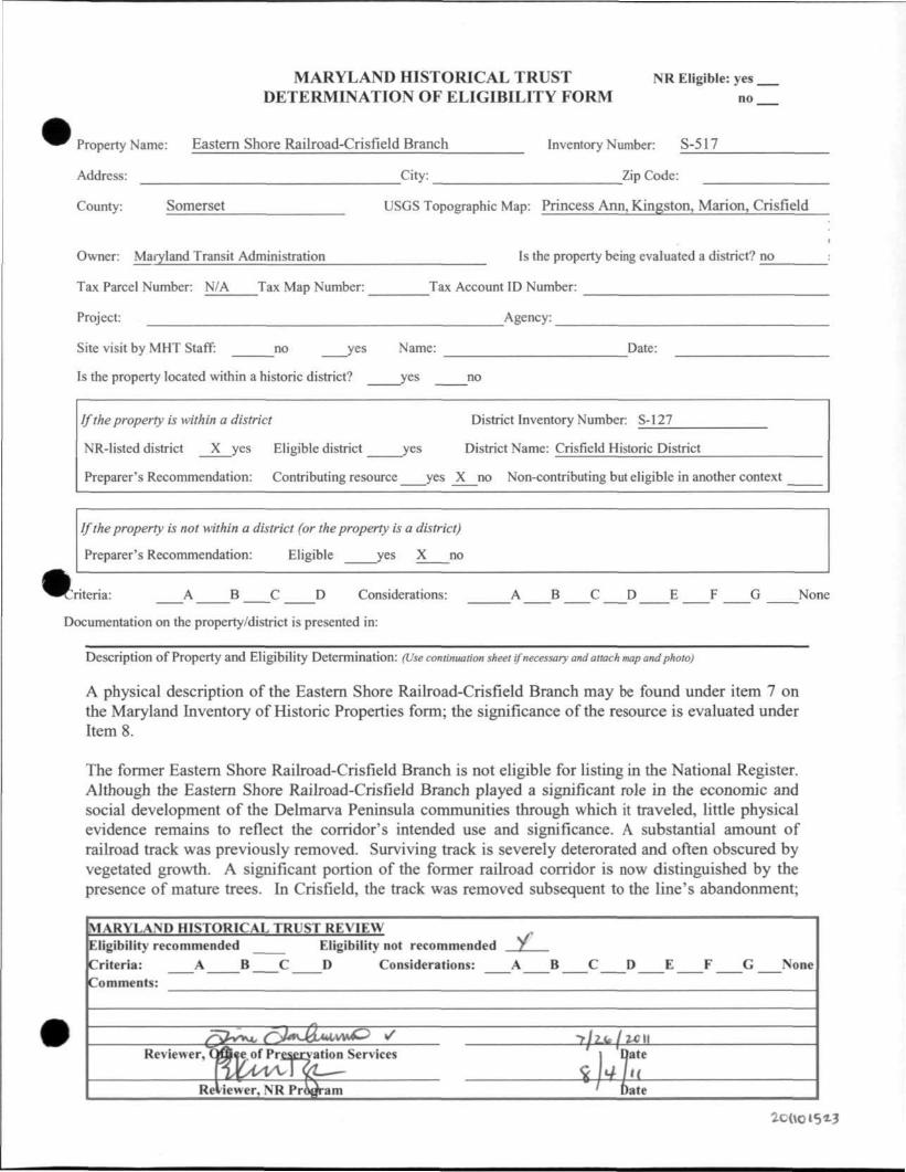
MARYLAND HISTORICAL TRUST NR Eligible: yes. DETERMINATION OF ELIGIBILITY FORM no. Property Name: Eastern Shore Railroad-Crisfield Branch Inventory Number: S-517 Address: City: Zip Code: County: Somerset USGS Topographic Map: Princess Ann, Kingston, Marion, CrisField Owner: Maryland Transit Administration Is the property being evaluated a district? no Tax Parcel Number: N/A Tax Map Number: Tax Account ID Number: Project: Agency: Site visit by MHT Staff: no yes Name: Date: Is the property located within a historic district? yes no If the property is within a district District Inventory Number: S-127 NR-listed district X yes Eligible district yes District Name: Crisfield Historic District Preparer's Recommendation: Contributing resource yes X no Non-contributing but eligible in another context If the property is not within a district (or the property is a district) Preparer's Recommendation: Eligible yes X no criteria: A B C D Considerations: A B C D E F G None Documentation on the property/district is presented in: Description of Property and Eligibility Determination: (Use cominualion sheet if necessary and attach map and photo) A physical description of the Eastern Shore Railroad-Crisfield Branch may be found under item 7 on the Maryland Inventory of Historic Properties form; the significance of the resource is evaluated under Item 8. The former Eastern Shore Railroad-Crisfield Branch is not eligible for listing in the National Register. Although the Eastern Shore Railroad-Crisfield Branch played a significant role in the economic and social development of the Delmarva Peninsula communities through which it traveled, little physical evidence remains to reflect the corridor's intended use and significance. A substantial amount of railroad track was previously removed. Surviving track is severely deterorated and often obscured by vegetated growth. A significant portion of the former railroad corridor is now distinguished by the presence of mature trees. In Crisfield, the track was removed subsequent to the line's abandormient; MARYLAND HISTORICAL TRUST REVIEW Eligibility recommended Eligibility not recommended Y Criteria: A B C D Considerations: A B C D E F G None Comments: Reviewer, Office of Preservation Services Date Reviewer, NR Program Date
Transcript of MARYLAND HISTORICAL TRUST NR-ELIBILITY...
MARYLAND HISTORICAL TRUST NR Eligible: yes. DETERMINATION OF ELIGIBILITY FORM no.
Property Name: Eastern Shore Railroad-Crisfield Branch Inventory Number: S-517
Address: City: Zip Code:
County: Somerset USGS Topographic Map: Princess Ann, Kingston, Marion, CrisField
Owner: Maryland Transit Administration Is the property being evaluated a district? no
Tax Parcel Number: N/A Tax Map Number: Tax Account ID Number:
Project: Agency:
Site visit by MHT Staff: no yes Name: Date:
Is the property located within a historic district? yes no
If the property is within a district District Inventory Number: S-127
NR-listed district X yes Eligible district yes District Name: Crisfield Historic District
Preparer's Recommendation: Contributing resource yes X no Non-contributing but eligible in another context
If the property is not within a district (or the property is a district)
Preparer's Recommendation: Eligible yes X no
criteria: A B C D Considerations: A B C D E F G None
Documentation on the property/district is presented in:
Description of Property and Eligibility Determination: (Use cominualion sheet if necessary and attach map and photo)
A physical description of the Eastern Shore Railroad-Crisfield Branch may be found under item 7 on the Maryland Inventory of Historic Properties form; the significance of the resource is evaluated under Item 8.
The former Eastern Shore Railroad-Crisfield Branch is not eligible for listing in the National Register. Although the Eastern Shore Railroad-Crisfield Branch played a significant role in the economic and social development of the Delmarva Peninsula communities through which it traveled, little physical evidence remains to reflect the corridor's intended use and significance. A substantial amount of railroad track was previously removed. Surviving track is severely deterorated and often obscured by vegetated growth. A significant portion of the former railroad corridor is now distinguished by the presence of mature trees. In Crisfield, the track was removed subsequent to the line's abandormient;
MARYLAND HISTORICAL TRUST REVIEW Eligibility recommended Eligibility not recommended Y Criteria: A B C D Considerations: A B C D E F G None Comments:
Reviewer, Office of Preservation Services Date
Reviewer, NR Program Date

MARYLAND HISTORICAL TRUST NR-ELIBILITY REVIEW FORM
Continuation Sheet No. 1
and the former corridor now serves as the center median for Maryland Avenue, State Route 413. With the exception of the Marion passenger and freight stations, none of the line's former stations exist. Signage at road crossing has been dismantled. The superstructure of the bridge crossing over the Big Annemessex River, the corridor's lone bridge crossing has been removed. This determination has been made in accordance with the National Register Bulletin entitled How to Apply the National Register Criteria for Evaluation (National Park Service 1988) and the National Register Bulletin entitled Guidelines for Evaluating and Documenting Rural Historic Landscapes (National Park Service 1989, revised 1999).
Prepared by: Joseph Schuchman Date Prepared:March 8, 2011

Maryland Historical Trust Maryland Inventory of Historic Properties Form
Inventory No. S-517
1. Name of Property (indicate preferred name)
historic Eastern Shore Railroad-Crisfield Branch
other King's Creek-Crisfield Railroad
2. Location
street and number not for publication
city, town vicinity
county Somerset
3. Owner of Property (give names and mailing addresses of all owners)
name Mary land Transit Admin is t ra t ion
street and number 6 St. Paul Street telephone (410) 539-5000
city, town Bal t imore state M D zip code 21202-1614
4. Location of Legal Description courthouse, registry of deeds, etc. N/A liber folio
city, town tax map tax parcel tax ID number
5. Primary Location of Additional Data Contributing Resource in National Register District Contributing Resource in Local Historic District Determined Eligible for the National Register/Maryland Register
JC Determined Ineligible for the National Register/Maryland Register Recorded by HABS/HAER Historic Structure Report or Research Report at MHT Other:
6. Classification
Category X district
building(s) structure site object
Ownership public private both
Current Function agriculture commerce/trade defense domestic education funerary government health care industry
Resource Count landscape recreation/culture religion social transportation work in progress unknown
X vacant/not in use other:
Contributing Noncontributing 2 buildings
__! sites 1 stnjctures
objects 2 2 Total
Number of Contributing Resources previously listed in the Inventory
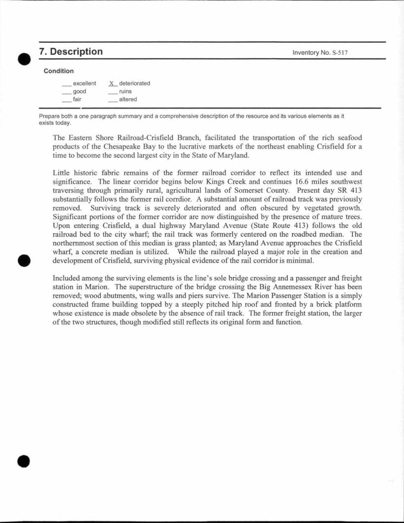
7. Description Inventory No. S-517
Condition
excellent . good
fair
X deteriorated ruins altered
Prepare both a one paragraph summary and a comprehensive description of the resource and its various elements as it exists today.
The Eastern Shore Railroad-Crisfield Branch, facilitated the transportation of the rich seafood products of the Chesapeake Bay to the lucrative markets of the northeast enabling Crisfield for a time to become the second largest city in the State of Maryland.
Little historic fabric remains of the former railroad corridor to reflect its intended use and significance. The linear corridor begins below Kings Creek and continues 16.6 miles southwest traversing through primarily rural, agricultural lands of Somerset County. Present day SR 413 substantially follows the former rail corrdior. A substantial amount of railroad track was previously removed. Surviving track is severely deteriorated and often obscured by vegetated growth. Significant portions of the former corridor are now distinguished by the presence of mature trees. Upon entering Crisfield, a dual highway Maryland Avenue (State Route 413) follows the old railroad bed to the city wharf; the rail track was formerly centered on the roadbed median. The northernmost section of this median is grass planted; as Maryland Avenue approaches the Crisfield wharf, a concrete median is utilized. While the railroad played a major role in the creation and development of Crisfield, surviving physical evidence of the rail corridor is minimal.
Included among the surviving elements is the line's sole bridge crossing and a passenger and freight station in Marion. The superstructure of the bridge crossing the Big Annemessex River has been removed; wood abutments, wing walls and piers survive. The Marion Passenger Station is a simply constructed frame building topped by a steeply pitched hip roof and fronted by a brick platform whose existence is made obsolete by the absence of rail track. The former freight station, the larger of the two structures, though modified still reflects its original form and function.
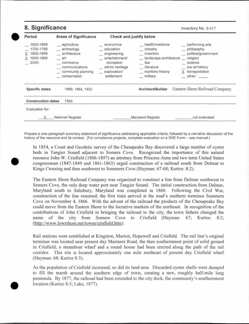
8. Significance Inventory No. S-517
Period
_ 1600-1699 _ 1700-1799 X 1800-1899 X 1900-1999
2000-
Areas of Significance
agriculture archeology architecture
_ art commerce communications community planning conservation
Check and justify below
economics education engineering entertainment/
recreation ethnic heritage exploration/ settlement
health/medicine industry invention landscape architecture law literature maritime history military
performing arts philosophy politics/government religion science socal history
X transportation other:
Specific dates 1866.1884,1922 Architect/Builder Eastern Shore Railroad Company
Construction dates 1866
Evaluation for:
X National Register Maryland Register _not evaluated
Prepare a one-paragraph summary statement of significance addressing applicable criteria, followed by a narrative discussion of the history of the resource and its context. (For compliance projects, complete evaluation on a DOE Form - see manual.)
In 1854, a Coast and Geodetic survey of the Chesapeake Bay discovered a large number of oyster beds in Tangier Sound adjacent to Somers Cove. Recognized the importance of this natural resource John W. Crisfield (1806-1897) an attorney from Princess Aime and two term United States congressman (1847-1849 and 1861-1863) urged construction of a railroad south from Delmar to Kings Crossing and then southwest to Sommers Cove (Hayman: 67-68; Kurtze: 8:2).
The Eastern Shore Railroad Company was organized to construct a line from Delmar southwest to Somers Cove, the only deep water port near Tangier Sound. The initial construction from Delmar, Maryland south to Salisbury, Maryland was completed in 1860. Following the Civil War, construction of the line resumed; the first train arrived at the road's southern terminus Sommers Cove on November 4, 1866. With the advent of the railroad the products of the Chesapeake Bay could move from the Eastern Shore to the lucrative markets of the northeast. In recognition of the contributions of John Crisfield in bringing the railroad to the city, the town fathers changed the name of the city from Somers Cove to Crisfield (Hayman: 67; Kurtze: 8:2; (http://www.lowrshore.net/towns/crisfield.htm).
Rail stations were established at Kingston, Marion, Hopewell and Crisfield. The rail line's original terminus was located near present day Mariners Road, the then southernmost point of solid ground in Crisfield; a steamboat wharf and a round house had been erected along the path of the rail corridor. This site is located approximately one mile northeast of present day Crisfield wharf (Hayman: 68; Kurtze 8-3).
As the population of Crisfield increased, so did its land area. Discarded oyster shells were dumped to fill the marsh around the southern edge of town, creating a new, roughly half-mile long peninsula. By 1877, the railroad had been extended to the city dock, the community's southernmost location (Kurtze 8-3; Lake, 1877).

Maryland Historical Trust Maryland Inventory of Inventory No. S-517
Historic Properties Form
Name Continuation Sheet
Number 8 Page 1
As Crisfield's importance in maritime commerce increased, the town boomed with rapid construction of oyster plants, commercial structures and quickly erected housing. The combination of the railroad and the oysters helped fiael the development of secondary industries in the city including steam canneries, barrel makers, and blacksmiths (http://www.livingclassrooms.org/lbo).
Crisfield would become known as the "Seafood Capital of the World". By 1904, the City of Crisfield was the second largest city in the State of Maryland, a distinction it would briefly hold (http://www.lowrshore.net/towns/crisfield.htm).
Crisfield was not the only beneficiary of the railroad's presence. In the early 1900s, the community of Marion was famous for being the world's leader in strawberry production earning the title "Strawberry Capital of the World." Several hundred ice refrigerated railroad cars, fially loaded with berries left the Marion Station each day during the peak of the season. One could see trucks and wagons loaded with strawberries lined up for over a mile waiting to go through the "auction block" located in the center of town (http://www.trainweb.com/marionstation).
On June 1, 1884, the Eastern Shore Railroad was merged into the New York, Philadelphia and Norfolk (N. Y. P. & N) Railroad. Still operated as a branch railroad, the Crisfield line continued to do brisk business. Although the Pennsylvania Railroad acquired control of the N.Y. P. & N. in 1908, the latter railroad continued to operate under its own organization (Hayman: 71-2).
In 1922, under a long term lease the Pennsylvania Railroad assumed operation of the New York, Philadelphia and Norfolk Railroad, which had proved to be a profitable line. The economic upheaval of the Great Depression coincided with the depletion of the Chesapeake Bay oyster beds as a result of overfishing, bringing a halt to Crisfield's economic development and an end to the railroad's prosperous years ( Hayman: 159; Kurtz: 8-5).
Passenger service was hit hardest. On Apr. 23, 1949, passenger service ended between Kings Creek and Crisfield. The Pennsylvania Railroad became the ill-fated Perm Central in 1968. When Conrail was formed from Perm Central and the other bankrupt northeastern railroads in 1976, the Crisfield Branch was officially abandoned (Baer, http://www.prrths.com/Hagley/PRR_hagley_intro.htm).

9. Major Bibliographical References Inventory No. S-517
The Maryland Room Collection, Talbot County Library, Clippings Files.
Publications: Clark, Charles B., Eastern Shore of Maryland and Virginia (Vol. 2) (New York, NY: Lewis Historical Publishing Co., 1950). Hayman, John C, Rails Along the Chesapeake, A History of Railroading on the Delmarva Peninsula, 1827-1978 (Marvadel Publishers, 1979) Kurtze, Peter and Touart, Paul, National Register of Historic Places Nomination, Crisfield Historic District (Unpublished document, May, 1989.
Maps: Lake, Griffing and Stevenson, Atlas of Wicomico. Somerset and Worcester Counties, Maryland (1877) as reprinted in "The 1877 Atlases and Other Early Maps of the Eastern Shore of Maryland" (Salisbury: The Wicomico Bicentennial Commission, 1976). Crisfield, Maryland, United States Geological Survey, 1903. Crisfield, Maryland (New York: Sanbom Map & Publishing Company, August, 1885). Deal Island, Maryland, United States Geological Survey, 1903. Penndel Corporation , Formerly Right of Way and Track Map, New York, Philadelphia and Norfolk Railroad, Crisfield Branch, Station 105+60 to Station 158+40, Office of Division Engineer, Cape Charles, Virginia, June, 1915. Map of the Pennsylvania Railroad Company's Lines East of Pittsburgh and Erie, Dated July 1, 1899. Marion, Somerset County, Maryland (New York: Sanbom Map & Publishing Company, March, 1917). New Railroad Map of the States of Maryland, Delaware and the District of Columbia (Philadelphia: O. W. Gray and Sons, 1877. Pennsylvania Railroad and its Connections, December 1, 1911. Princess Anne, Maryland, United States Geological Survey, 1901.
Websites: Baer, Christopher T., A General Chronology of the Pennsylvania Railroad Company, Predecessors, and Successors and its Historical Context, 2949 Chronology, 1976 Chronology (http://www.prrths.com/Haglev/PRR haglev intro.htm). Crisfield, Maryland and the Surrounding Areas (http://www.lowershore.net/towns/crisfield.htm) Marion Station Railroad Museum, (http://www.trainweb.com/marionstation). Waterman, Glenn, The Last Waterman (http://www.livingclassrooms.org/lbo).
10. Geographical Data
Acreage of surveyed property N/A 50.30 Acreage of historical setting N/A Quadrangle name Princess Anne, Md; Kingston, MP Quadrangle scale: 1:24 OOP
Marion, MP; Crisfield. MP
Verbal boundary description and justification
This resource encompasses the right-of-way of the former Eastern Shore Railroad-Crisfield Branch. The northern boundary of the railroad begins below Kings Creek at the former juncture of the Eastern Shore Railroad's Crisfield Branch and Newtown Branch. The rail corridor continues 16.6 miles southwest traversing through primarily rural, agricultural lands of Somerset County, embracing the communities of Westover, Kingston, Marion, and Hopewll prior to continuing down Crisfield's Main Street to its southern terminus at the Crisfield dock. Present day SR 413 substantially follows the former rail corrdior. Remaining sections of track are deteriorated and overgrown; significant portions of the corridor are now distinguished by the presence of mature trees. At grade crossings, the track has either been paved over or removed. Surviving features indue the single line track corrdidor, associated road crosings, and signage, the remnants of a railroad bridge across the Big Annemessex River and the Marion passenger and freight station. Upon entering Crisfield, a dual highway Maryland Avenue (State Route 413), follows the old railroad bed to the city wharf; the rail track was formerly centered on the roadbed median.
Maryland Historical Trust Maryland Inventory of Historic Properties Form
Inventory No. S-517
Name Continuation Sheet
Number 8 Page 1
11. Form Prepared by
name/title Joseph Schuchman
organization STV Inc date March 8, 2011
street & number 205 West Welsh Drive telephone (610)385-8360
city or town Douglassville state PA
The Maryland Inventory of Historic Properties was officially created by an Act of the Maryland Legislature to be found in the Annotated Code of Maryland, Article 41, Section 181 KA, 1974 supplement.
The survey and inventory are being prepared for information and record purposes only and do not constitute any infringement of individual property rights.
return to: Maryland Historical Trust Maryland Department of Planning 100 Community Place Crownsville, MD 21032-2023 410-514-7600

Figure 1 Eastern Shore Railroad, Crisfield Branch-S-517 IVIaryland Inventory of Historic Properties Form
Created by: STV Incorporated Four Gateway Center, Suite 800 Pittsburgh, PA 15222 (412)392-3500 February 2011
Source: U.S. Geological Survey, Somerset County, MD Topographic Quadrangle Mosaic
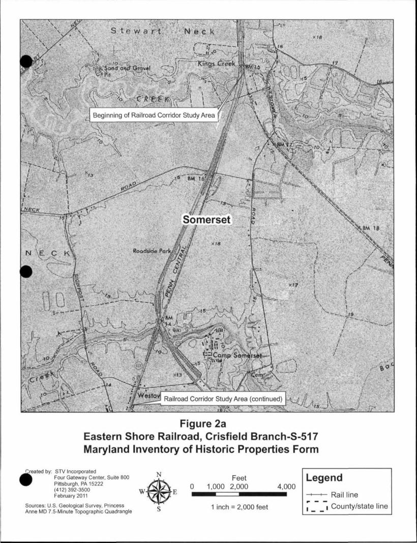
Figure 2a Eastern Shore Railroad, Crisfield Branch-S-517 Maryland Inventory of Historic Properties Form
Created by: STV Incorporated Four Gateway Center, Suite 800 Pittsburgh, PA 15222 (412) 392-3500 February 2011
Sources: U.S. Geological Survey, Princess Anne MD 7.5-Minute Topograptiic Quadrangle

Figure 2b Eastern Shore Railroad, Crisfield Branch-S-517 IViaryland Inventory of Historic Properties Form
Created by: STV Incorporated Four Gateway Center, Suite 800 Pittsburgh, PA 15222 (412) 392-3500 February 2011
Sources: U.S. Geological Survey, Kingston MD 7.5-Minute Topograptiic Quadrangle

Figure 2c Eastern Shore Railroad, Crisfield Branch-S-517 IVIaryland Inventory of Historic Properties Form
Created by: STV Incorporated Four Gateway Center, Suite 800 Pittsburgh, PA 15222 (412) 392-3500 February 2011
Sources: U.S. Geological Survey, Kingston MD and Marion MD 7.5-Minute Topographic Quadrangles

Figure 2d Eastern Shore Railroad, Crisfield Branch-S-517 IVIaryland Inventory of Historic Properties Form
Created by: STV Incorporated Four Gateway Center, Suite 800 Pittsburgh, PA 15222 (412) 392-3500 February 2011
Sources: U.S. Geological Survey, Marion MD 7 5-Minute Topographic Quadrangle

Figure 2e Eastern Shore Railroad, Crisfield Branch-S-517 IVIaryland Inventory of Historic Properties Form
Created by: STV Incorporated Four Gateway Center, Suite 800 Pittsburgh, PA 15222 (412) 392-3500 February 2011
Sources; U.S. Geological Survey, Marion MD and Crisfield MD 7.5-Minute Topographic Quadrangles

REFERENCE: 1873 New Railroad Map of the States of Maryland, Delaware and the District of Columbia
FIGURE 3 THE EASTERN SHORE RAILROAD - 1873
EASTERN SHORE RAILROAD - CRISFIELD BRANCH - S-517 SOMERSET COUNTY, MARYLAND
MARYLAND INVENTORY OF HISTORIC PROPERTIES FORM

REFERENCE: Pennsylvania Railroad Company's Lines East of Pittsburgh and Erie, Dated July 1, 1899
FIGURE 4 THE CRISFIELD BRANCH, NEW YORK, PHILADELPHIA AND NORFOLK RAILROAD - 1899
EASTERN SHORE RAILROAD - CRISFIELD BRANCH - S-517 SOMERSET COUNTY, MARYLAND
MARYLAND INVENTORY OF HISTORIC PROPERTIES FORM
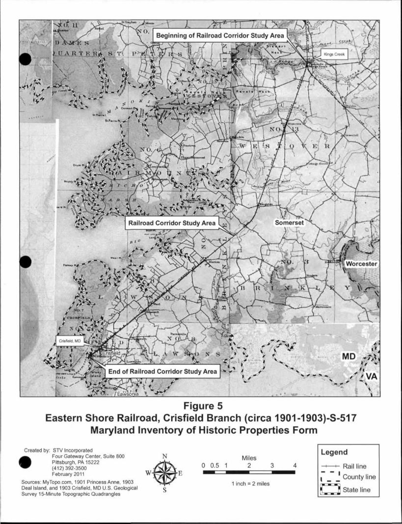
Figure 5 Eastern Shore Railroad, Crisfield Branch (circa 1901-1903)-S-517
Maryland Inventory of Historic Properties Form
Created by: STV Incorporated Four Gateway Center, Suite 8(X) Pittsburgh, PA 15222 (412)392-3500 February 2011
Sources: MyTopo.com. 1901 Princess Anne, 1903 Deal Island, and 1903 Crisfield, MD U.S. Geological Survey 15-Minute Topographic Quadrangles
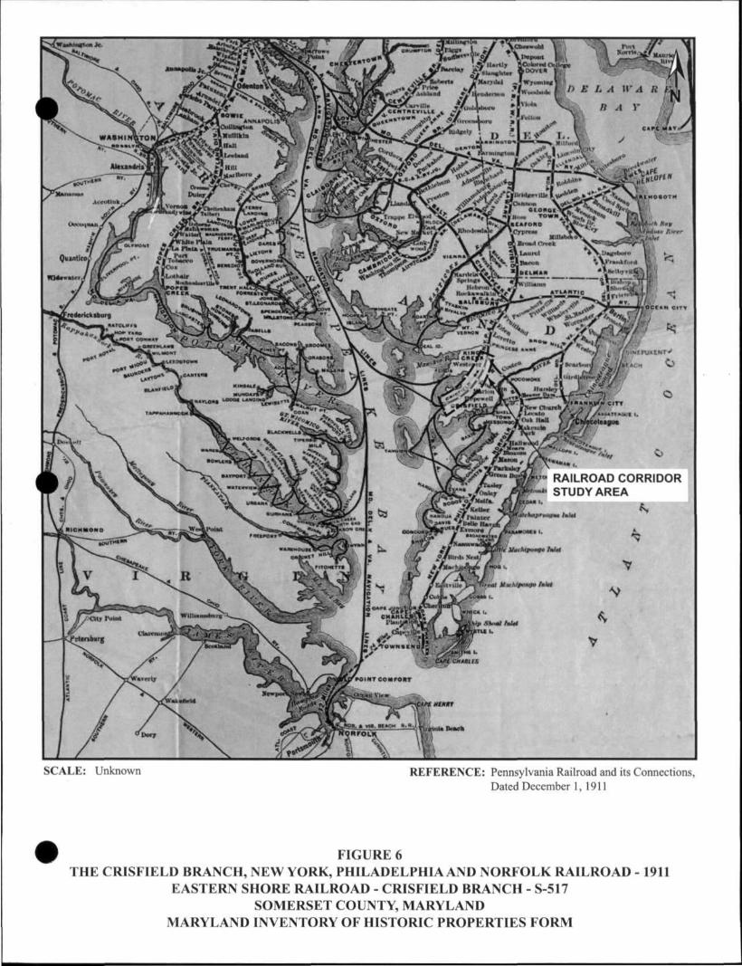
SCALE: Unknown REFERENCE: Pennsylvania Railroad and its Connections, Dated December 1, 1911
FIGURE 6 THE CRISFIELD BRANCH, NEW YORK, PHILADELPHIA AND NORFOLK RAILROAD - 1911
EASTERN SHORE RAILROAD - CRISFIELD BRANCH - S-517 SOMERSET COUNTY, MARYLAND
MARYLAND INVENTORY OF HISTORIC PROPERTIES FORM

SCALE: Unknown REFERENCE: Atlas of Wicomico, Somerset and Worcester Counties, Maryland Dated 1877
FIGURE 7 EASTERN SHORE RAILROAD - 1877
EASTERN SHORE RAILROAD - CRISFIELD BRANCH - S-517 SOMERSET COUNTY, MARYLAND
MARYLAND INVENTORY OF HISTORIC PROPERTIES FORM
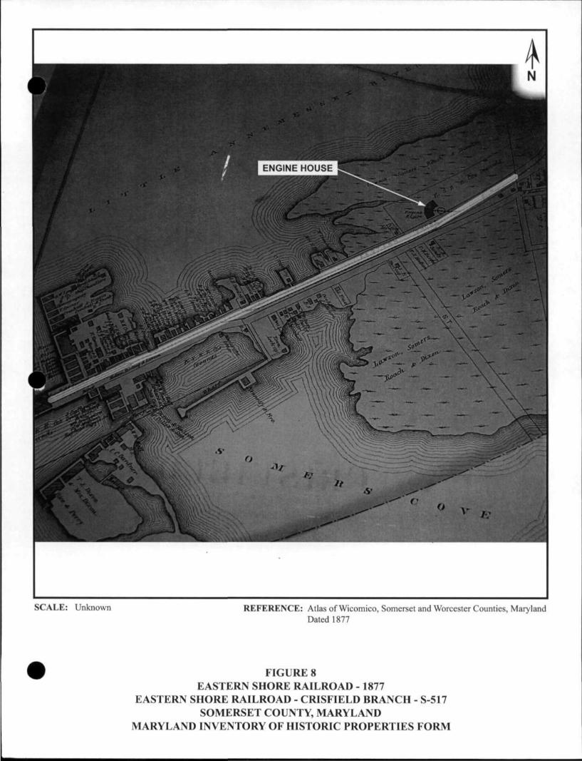
SCALE: Unknown REFERENCE: Atlas of Wicomico, Somerset and Worcester Counties, Maryland Dated 1877
FIGURE 8 EASTERN SHORE RAILROAD - 1877
EASTERN SHORE RAILROAD - CRISFIELD BRANCH - S-517 SOMERSET COUNTY, MARYLAND
MARYLAND INVENTORY OF HISTORIC PROPERTIES FORM
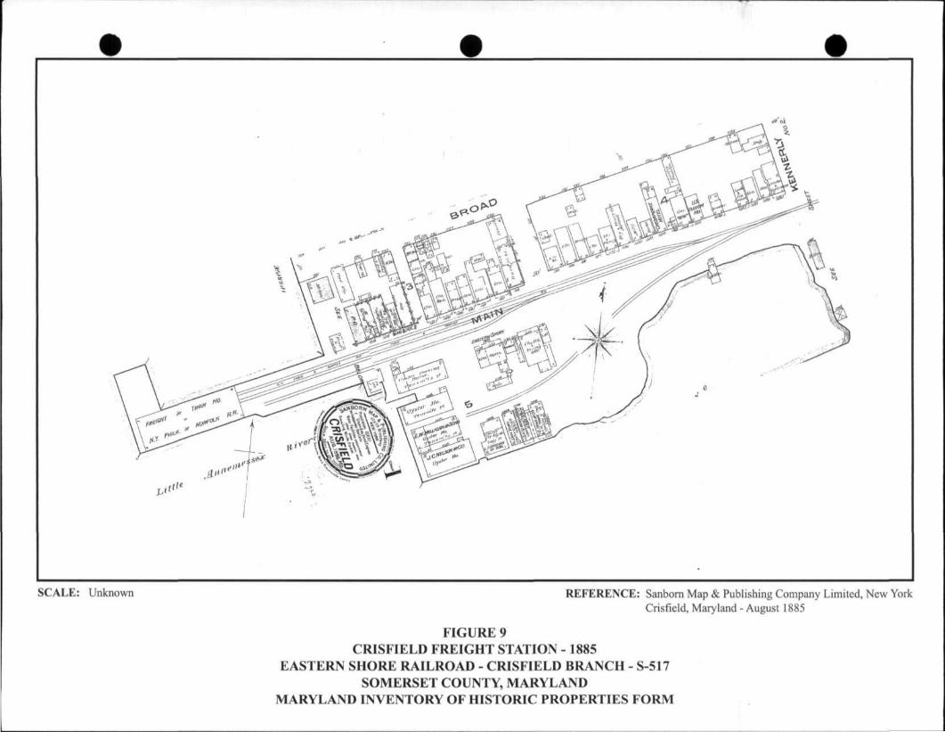
SCALE: Unknown REFERENCE: Sanborn Map & Publishing Company Limited, New York Crisfield, Maryland - August 1885
FIGURE 9 CRISFIELD FREIGHT STATION - 1885
EASTERN SHORE RAILROAD - CRISFIELD BRANCH - S-517 SOMERSET COUNTY, MARYLAND
MARYLAND INVENTORY OF HISTORIC PROPERTIES FORM

SCALE: Unknown REFERENCE: Sanborn Map Company - Marion, Somerset County, Maryland - March 1917
FIGURE 10 MARION PASSENGER AND FREIGHT STATIONS - 1917
EASTERN SHORE RAILROAD - CRISFIELD BRANCH - S-517 SOMERSET COUNTY, MARYLAND
MARYLAND INVENTORY OF HISTORIC PROPERTIES FORM

S-517 Eastern Shore Railroad, Crisfield Branch Somerset County, Maryland Joseph Schuchman, Photographer Ink and Paper used as listed in National Register of Historic Places Photograph Policy: Epson Ultra Chrome Pigmented Inks and prints produced on Epson Premium Glossy paper.
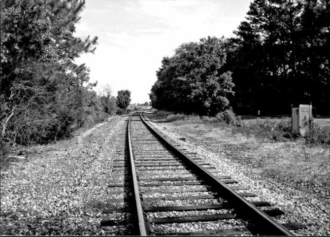
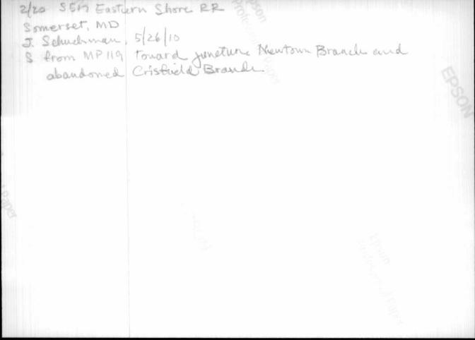
Photograph 1: S517_2010-05-26_01.tif- View from Mile Post 119 towards the Eastern Shore Railroad looking north above the juncture of the Crisfield Branch and Newtown Branch.
Photograph 2: S517_2010-05-26_02.tif- View looking south from Mile Post 119 illustrating the approximate location at which the rail lines diverged, the existing line, the Newtown branch, continuing southeast towards Cape Charles, Virginia. Little physical evidence remains of former Crisfield branch which extended southwest from this location.
Photograph 3: S517_2010-05-26_03.tif- View looking northeast from Sam Barnes Road (SR 673) towards the corridor of the Eastern Shore Railroad, Crisfield Branch, Westover vicinity.
Photograph 4: S517_2010-05-26_04.tif- View looking northeast from Ritzel Road towards the corridor of the Eastern Shore Railroad, Crisfield Branch, Westover vicinity.
Photograph 5: S517_2010-05-26_05.tif- View looking southwest from Ritzel Road towards the corridor of the Eastern Shore Railroad, Crisfield Branch, Westover vicinity
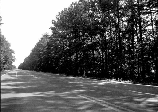
Photograph 6: S517_2010-05-26_06.tif- View looking northeast from Towes Campus Drive, Westover vicinity towards the Crisfield Highway (SR 413). The tree line to the right of the road distinguishes a substantial portion of the former Crisfied Branch railroad corridor between Kingston and Crisfield.
Photograph 7: S517_2010-05-26_07.tif- View looking southwest from Towes Campus Drive, Westover vicinity towards the Crisfield Highway (SR 413). The tree line to the left of the road distinguishes a substantial portion of the former Crisfield Branch railroad corridor between Kingston and Crisfield.
Photograph 8: S517_2010-05-26_08.tif- View looking south-southeast toward the surviving piers and foundation walls of Bridge No. 5.96 which formerly carried the Eastern Shore Railroad, Crisfield Branch across the Big Annemessex River, Westover vicinity.
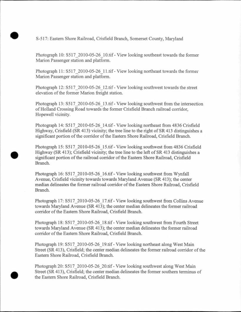
Photograph 9: S517_2010-05-26_09.tif- View looking south towards the former Marion Passenger station and platform.
S-517: Eastern Shore Railroad, Crisfield Branch, Somerset County, Maryland
Photograph 10: S517_2010-05-26_10.tif- View looking southeast towards the former Marion Passenger station and platform.
Photograph 11: S517_2010-05-26_l 1 .tif - View looking northeast towards the former Marion Passenger station and platform.
Photograph 12: S517_2010-05-26_12.tif- View looking southwest towards the street elevation of the former Marion freight station.
Photograph 13: S517_2010-05-26_13.tif- View looking southwest from the intersection of Holland Crossing Road towards the former Crisfield Branch railroad corridor, Hopewell vicinity.
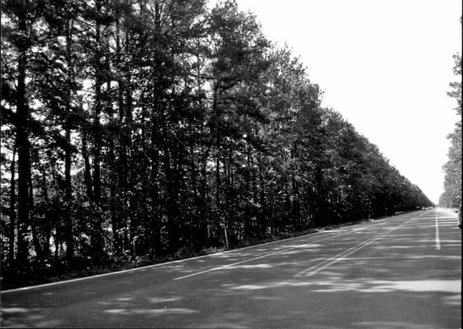
Photograph 14: S517_2010-05-26_14.tif- View looking northeast from 4836 Crisfield Highway, Crisfield (SR 413) vicinity; the tree line to the right of SR 413 distinguishes a significant portion of the corridor of the Eastern Shore Railroad, Crisfield Branch.
Photograph 15: S517_2010-05-26_15.tif- View looking southwest from 4836 Crisfield Highway (SR 413); Crisfield vicinity; the tree line to the left of SR 413 distinguishes a significant portion of the railroad corridor of the Eastern Shore Railroad, Crisfield Branch.
Photograph 16: S517_2010-05-26_16.tif- View looking southwest from Wynfall Avenue, Crisfield vicinity towards towards Maryland Avenue (SR 413); the center median delineates the former railroad corridor of the Eastern Shore Railroad, Crisfield Branch.
Photograph 17: S517_2010-05-26_17.tif- View looking southwest from Collins Avenue towards Maryland Avenue (SR 413); the center median delineates the former railroad corridor of the Eastern Shore Railroad, Crisfield Branch.
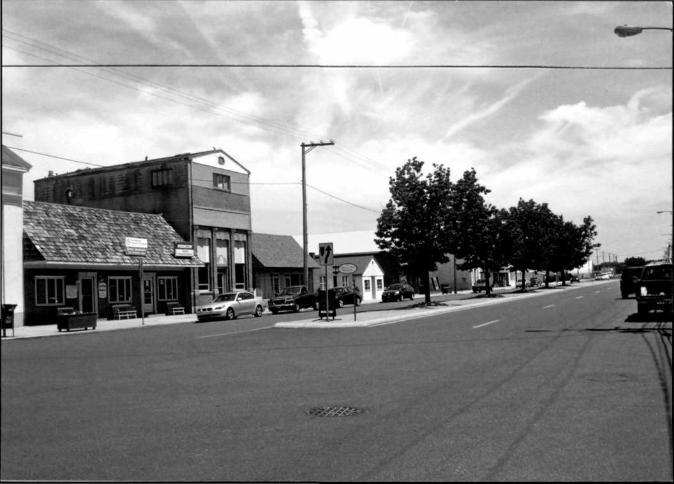
Photograph 18: S517_2010-05-26_18.tif- View looking southwest from Fourth Street towards Maryland Avenue (SR 413); the center median delineates the former railroad corridor of the Eastern Shore Railroad, Crisfield Branch.
Photograph 19: S517_2010-05-26_19.fif - View looking northeast along West Main Street (SR 413), Crisfield; the center median delineates the former railroad corridor of the Eastern Shore Railroad, Crisfield Branch.
Photograph 20: S517_2010-05-26_20.fif - View looking southwest along West Main Street (SR 413), Crisfield; the center median delineates the former southern terminus of the Eastern Shore Railroad, Crisfield Branch.


![Property 452 Reviewer-[Vena Verga] Property Midterms Reviewer](https://static.fdocuments.us/doc/165x107/55cf8a9355034654898bef13/property-452-reviewer-vena-verga-property-midterms-reviewer.jpg)