Maryland Historical Trust Inventory No. BA-3248 Maryland ...
8
Maryland Historical Trust Inventory No. BA-3248 Maryland Inventory of Historic Properties Form 1. Name of Property (indicate preferred name) historic Matthews House other Morrill House 2. Location street and number 20030 Valley Mill Road not for publication city, town Freeland vicinity county Baltimore County 3. Owner of Property (give names and mailing addresses of all owners) name Todd & Karen Morrill street and number 2401 Benson Mill Road telephone city, town Sparks state MD zip code 21152 4. Location of Legal Description courthouse, registry of deeds, etc. Baltimore County Courthouse tax map and parcel map 11, parcel 121 city, town Towson liber 25843 folio 315 5. Primary Location of Additional Data Contributing Resource in National Register District Contributing Resource in Local Historic District Determined Eligible for the National Register/Maryland Register Determined Ineligible for the National Register/Maryland Register Recorded by HABS/HAER Historic Structure Report or Research Report at MHT X Other: BC Office of Planning 6. Classification Category Ownership Current Function Resource Count district public agriculture landscape Contributing Noncontributing _X_building(s) X private commerce/trade recreation/culture 2 buildings structure both defense religion sites site X domestic social structures object education transportation objects funerary work in progress 2 Total government unknown health care vacant/not in use Number of Contributing Resources industry other: previously listed in the Inventory 0
Transcript of Maryland Historical Trust Inventory No. BA-3248 Maryland ...
Maryland Historical Trust Inventory No. BA-3248
Maryland Inventory of Historic Properties Form
1. Name of Property (indicate preferred name)
historic Matthews House
other Morrill House
2. Location street and number 20030 Valley Mil l Road not for publication
city, town Freeland vicinity
county Baltimore County
3. Owner of Property (give names and mailing addresses of all owners)
name Todd & Karen Morrill
street and number 2401 Benson Mill Road telephone
city, town Sparks state MD zip code 21152
4. Location of Legal Description courthouse, registry of deeds, etc. Baltimore County Courthouse tax map and parcel map 11, parcel 121
city, town Towson liber 25843 folio 315
5. Primary Location of Additional Data Contributing Resource in National Register District Contributing Resource in Local Historic District Determined Eligible for the National Register/Maryland Register Determined Ineligible for the National Register/Maryland Register Recorded by HABS/HAER Historic Structure Report or Research Report at MHT
X Other: BC Office of Planning
6. Classification
Category Ownership Current Function Resource Count district public agriculture landscape Contributing Noncontributing
_X_building(s) X private commerce/trade recreation/culture 2 buildings structure both defense religion sites site X domestic social structures object education transportation objects
funerary work in progress 2 Total government unknown health care vacant/not in use Number of Contributing Resources industry other: previously listed in the Inventory
0
7. Description Inventory No. BA-3248
Condition
X excellent deteriorated good ruins fair altered
Prepare both a one paragraph summary and a comprehensive description of the resource and its various elements as it exists today.
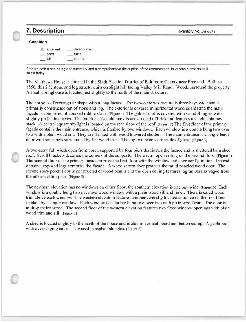
The Matthews House is situated in the Sixth Election District of Baltimore County near Freeland. Built ca. 1856, this 2 14 stone and log structure sits on slight hill facing Valley Mill Road. Woods surround the property. A small springhouse is located just slightly to the north of the main structure.
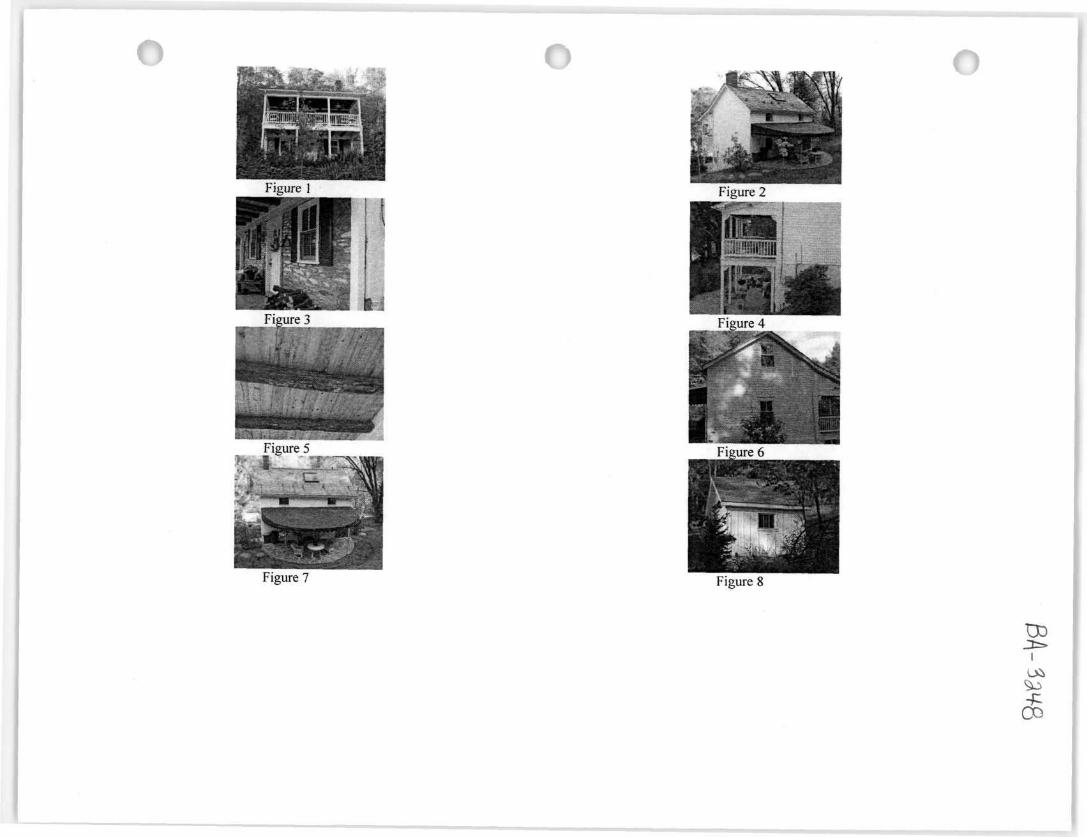
The house is of rectangular shape with a long facade. The two-'/2 story structure is three bays wide and is primarily constructed out of stone and log. The exterior is covered in horizontal wood boards and the main facade is comprised of coursed rubble stone. (Figure 1) The gabled roof is covered with wood shingles with slightly projecting eaves. The interior offset chimney is constructed of brick and features a single chimney stack. A central square skylight is located on the rear slope of the roof. (Figure 2) The first floor of the primary facade contains the main entrance, which is flanked by two windows. Each window is a double hung two over two with a plain wood sill. They are flanked with wood louvered shutters. The main entrance is a single leave door with six panels surrounded by flat wood trim. The top two panels are made of glass. (Figure 3)
A two-story full width open front porch supported by four piers dominates the facade and is sheltered by a shed roof. Scroll brackets decorate the corners of the supports. There is an open railing on the second floor. (Figure 4) The second floor of the primary facade mirrors the first floor with the window and door configuration. Instead of stone, exposed logs comprise the facade. A wood screen door protects the multi paneled wood door. The second story porch floor is constructed of wood planks and the open ceiling features log timbers salvaged from the interior attic space. (Figure 5)
The northern elevation has no windows on either floor; the southern elevation is one bay wide. (Figure 6) Each window is a double hung two over two wood window with a plain wood sill and lintel. There is eared wood trim above each window. The western elevation features another centrally located entrance on the first floor flanked by a single window. Each window is a double hung two over two with plain wood trim. The door is multi-paneled wood. The second floor of the western elevation features two fixed window openings with plain wood trim and sill. (Figure 7)
A shed is located slightly to the north of the house and is clad in vertical board and batten siding. A gable roof with overhanging eaves is covered in asphalt shingles. (Figure 8)
8. Significance Inventory No. BA-3248
Period Areas of Significance Check and justify below
1600-1699 agriculture economics health/medicine performing arts 1700-1799 archeology education X industry philosophy
X 1800-1899 X architecture _ engineering invention politics/government 1900-1999 art entertainment/ landscape architecture religion 2000- commerce recreation law science
communications ethnic heritage literature X social history community planning exploration/ maritime history transportation conservation settlement military other:
Specific dates Architect/Builder Unknown
Construction dates ca. 1856
Evaluation for:
National Register Maryland Register X not evaluated
Prepare a one-paragraph summary statement of significance addressing applicable criteria, followed by a narrative discussion of the history of the resource and its context. (For compliance projects, complete evaluation on a DOE Form - see manual.)
The Matthews House is located in the Sixth Election District of Baltimore County in the vicinity of Freeland. Built ca. 1856 by the Matthews family, this stone and log structure sits on land once part of a larger tract called "Jarrett's Intention". The proximity of the area surrounding Valley Mill Road to the Little Gunpowder Falls facilitated the operation of several paper mills in the area, including the Valley Paper Mill once known as Shauck's Mill. The collection of buildings in the area represent the influence of the paper mill industry on its growth. Names of families like Matthews, Price, and Wilhelm formed a large part of the area's farming population and made many contributions to their community. The structure was likely built to be a rental property, possibly by mill workers. The house is part of a collection of buildings that have retained their historic integrity and contribute to the well preserved historic setting along Valley Mill Road. It is an excellent example of stone and log construction and significant for its association with the Matthews and Wilhelm families.
The land on which the Matthews House occupies is located between the towns of Freeland and Bentley's Springs. The acreage was carved out of a larger 427-acre tract of land called "Jarrett's Intention" which Jessie Jarrett first patented in 1800.' Jarrett sold 241 acres to Edward Matthews Sr. in 1800. Matthews immigrated to the United States in the 1770's and married Sarah Tracey in 1782. He retained a majority of the acreage for his farm but eventually sold parts of the property.2 After his death in 1830, he willed 61 acres to his son William, which was in addition to the 80 acres he had conveyed to him in 1829.' Members of the Matthews family, including Edward and William, maintained separate farms but were located within close proximity of one another. Many of the families in the area intermarried and the names Briggs, Price, Tracey, and Stabler are commonly found in the Matthews' family tree. The Matthews property was located near the Little Gunpowder River, which not only attracted farmers but also mills that relied on a clean and clear source of water.4 This water was imperative to making paper, as was access to markets in Baltimore and southern Pennsylvania. The Sixth Election District proved to be an ideal location and by 1850, ten out of the thirteen paper mills in the County were located there.5 One of those mills was the Valley Paper Mill, which was established ca. 1823 by Phillip Kroh.6
1 Patented Certificate 2578 1800/10/25 Jarretts Intention, Jesse Jarrett, 427 Acres 01/25/02/21 2 Family Line of Edward Matthews Sr. & Sarah Tracey of Baltimore County, Maryland. Retrieved from http://familvlreerri;iker. genealogy. com/users/p/e/a/William-S-Pearce/FIU.;/0002page.litm) on October 21, 2009, 1. 5 Ibid, 1. 4 Sidney, J. C. Map of the City and County of Baltimore, Maryland, from Original Surveys. Baltimore, MD: James M. Stephens, 1850. 5 Brooks, Neal A. and Eric G. Rockel. A History of Baltimore County. Towson, MD: Friends of the Towson Library, Inc., 1979, 215. 6 John McGrain. Notes on Valley Paper Mill, District 6, Baltimore County, BA-401, Baltimore County Office of Planning Files, August 27, 1982, 1.
Maryland Historical Trust Maryland Inventory of Inventory No. BA-3248
Historic Properties Form
Name Matthews House, 20030 Valley Mill Road, Freeland Continuation Sheet
Number 8 Page 2
Kroh lost the mill soon after due to extensive debts that he could not pay. The mill plus several residential and agricultural buildings were auctioned off and acquired by the Krout, or Crout, family who ultimately sold it to Jarrett Shauck
in 1851.7 By 1857, a number of mills were located along the Little Gunpowder including Gore's Mill and Hoffman's Mill." Many residents were attracted to the area due to the plentiful work that was available. Farmers were not necessarily always pleased with paper mills as it was claimed in some cases that the mills dumped poisonous compounds into the river. In the early 1870's a local farmer brought a suit against the Gladfelter & Dushane paper manufacturer claiming that they were polluting the Little Gunpowder Falls with bleaching powder and sulfuric acid. The farmer won in court and although he was awarded only one cent in damages, it set a precedent that gave farmers the right to file suit against other mills, which effectively ended much of the pollution.9 Papermaking influenced the growth of the community as it also supported other trades.1" Mill buildings housed some workers and others managed to rent or buy homes near the mill. The Valley Paper Mill passed through several different owners and was operative until the 1960's. By the 1980's the mill was the most perfect paper mill still surviving in Baltimore County, however, in 1985 the new purchasers had the paper mill demolished."
The early houses that were built surrounding the mill appear to be houses intended for farm families. A few smaller houses existed, including the Matthews House. The house does not appear on the 1833 tax list for Baltimore County12 nor does it appear on a Baltimore County atlas until 1877." By the early 1830's, log dwellings were not uncommon in Baltimore County. There are also many cases when log construction is accompanied by a stone addition. Baltimore Countians had a large influx of German immigration that brought with it a tradition of building log and basic stone structures.14 The 1798 Federal Tax List showed that the Gunpowder and Mine Run Hundreds together had about 80% log sites with 237 outbuildings made of log.15 By the late 1700's, a large number of settlers knew the techniques of log construction. Buildings were often constructed from materials available locally and the abundance of timber provided a natural resource and helped clear the land of impediments to future construction. Common materials used were chestnut, poplar, oak and some pine. Although there is multiple types of log wall notches used in log building construction, the most common joint used in Baltimore County was the V-notch.16 Use of this indicated that there was some effort required in workmanship and demonstrated that it was not a hastily built building. It was also relatively common to have covered up the logs with clapboard siding or shingles. The advent of the railroad brought with it changes
7 Ibid,2. 8 Map of the city and county of Baltimore, Maryland. From actual surveys by Robert Taylor. Lith by Hunckel & Son, 1857. 'Brooks 217-218. 10 Ibid, 217. 11 McGrain, 3. 12 Maryland State Archives, Baltimore County Tax Ledger-District 5, 1833. " Atlas of Baltimore County, Maryland. Philadelphia, PA: G. M. Hopkins, 1877, Sixth District. 14 John McGrain. Stone House Tradition, Baltimore County Office of Planning Files, November 16, 2001, 3. 15 Federal Direct Tax List, Baltimore County, Maryland, 1798, microfilm owned by Office of Planning, Towson. 16 McGrain, John.. "History of Architecture." Towson, MD: Baltimore County Office of Planning, November, 2005
Maryland Historical Trust Maryland Inventory of Inventory No. BA-3248
Historic Properties Form
Name Matthews House, 20030 Valley Mill Road, Freeland Continuation Sheet
Number 8 Page 3
in building traditions due to the availability of sawn lumber. Frame buildings eventually replaced folk traditions of construction, including building with logs.17 The log structures that do remain, including both residential and accessory, represent an architectural style that is no longer dominant. The utilitarian design of many of the early log and stone structures found in Baltimore County make the Matthews House notable due to the condition of the structure and the details still visible in its construction.
William T. Matthews inherited numerous acres from his father Edward Matthews Sr., including the land on which his farm sat." He sold this approximately six-acre parcel to his stepdaughter Elizabeth Curfman Dougherty and her husband William in 1856 for $82.50. At the time of the conveyance, they resided in York County, Pennsylvania." By the 1860 Census, the Dougherty family lived in the Sixth Election District with real estate valued at $500.00. It could mean that the building was constructed some time between 1856 and 1860. Unlike the rest of the Matthews' family, Dougherty was listed as a laborer on the census rather than as a farmer.20 The Dougherty family held the property until 1874 when they conveyed it to Samuel C. Wilhelm for $350.00.21 This would indicate that there were improvements on the site. Sam Wilhelm appeared on the 1870 census without any valued real estate assets. The Dougherty family were not listed which could possibly indicate that Wilhelm rented the house before buying it.22 His occupation was a trader and in 1880 he worked in the paper mill.2'The Miller family ended up acquiring the property in 1916 from the estate of Samuel's son, William T. Wilhelm.24 The Baltimore County tax record for 1918 reported that Ella C. Miller had a house worth $393.00 and a total estate worth $523.00.25 Her family sold the property in 1938 and it subsequently changed hands several times over the next decades until the current owner acquired the property in 2007.26 The present owners performed extensive rehabilitation work to the property that strived to retain as many historical features as possible.
17 McAlester. Virginia & Lee. A Field Guide to American Houses. Alfred A. Knopf, 1984,64. 18 Will of Edward Matthews of Baltimore County, dated September 6, 1829. Retrieved from http:/7familytreemaker. genealogy, com/use rs/p/e/a/Will iam-S-Pearce/FILE/0017pagc.html on October 21, 2009. "Baltimore County Land and Will Records. Baltimore County Courthouse, Towson, Maryland: HMF 17:328. 20 Ancestry.com. United States I860 Federal Census [database on-line]. Provo, UT, USA: Ancestry.com Operations Inc, 2004. District 6, 22. 21 Baltimore County Land and Will Records. Baltimore County Courthouse, Towson, Maryland: HMF 17:328. 22 Ancestry.com. United States 1870 Federal Census [database on-line], Provo, UT, USA: Ancestry.com Operations Inc, 2004. District 6, 313A. 23 Ancestry.com. United States 1880 Federal Census [database on-line], Provo, UT, USA: Ancestry.com Operations Inc, 2004. District 6, 15. 24 Baltimore County Land and Will Records. Baltimore County Courthouse, Towson, Maryland: WPC 477:34. 25 Baltimore County Tax Account Book, Baltimore County, Maryland, 1918, Election District 6, microfilm owned by Office of Planning, Towson. 20 Baltimore County Land and Will Records. Baltimore County Courthouse, Towson, Maryland: SM 25843:315.
9. Major Bibliographical References Inventory No. BA-3248
Ancestry.com. United States Federal Census [database on-line]. Provo, UT, USA: Ancestry.com Operations Inc, 2004. Atlas of Baltimore County, Maryland. Philadelphia, PA: G. M. Hopkins, 1877. Baltimore County Land and Will Records. Baltimore County Courthouse, Towson, Maryland Baltimore County Office of Planning Files Baltimore County Tax Account Book, Baltimore County, Maryland, 1833, 1918, Old Election District 5, Election District 6,
microfilm owned by Office of Planning, Towson. Brooks, Neal A. and Eric G. Rockel. A History of Baltimore County. Towson, MD: Friends of the Towson Library, Inc., 1979. Notes on the Matthews/Pearce Family http://familytreemaker.genealogy.com Map of Baltimore County. Philadelphia, PA: G. W. Bromley, 1898. Map of Baltimore County. Philadelphia, PA: G. W. Bromley, 1915. Map of the city and county of Baltimore, Maryland. From actual surveys by Robert Taylor. Lith by Hunckel & Son, 1857. Maryland State Archives, Baltimore County Circuit Court Land Survey, Subdivision, and Condominium Plats Patented Certificate
01/25/02/21 McAlester, Virginia & Lee, A Field Guide to American Houses, Alfred A. Knopf, 1984 Sidney, J. C. Map of the City and County of Baltimore, Maryland, from Original Surveys. Baltimore, MD: James M. Stephens, 1850.
10. Geographical Data
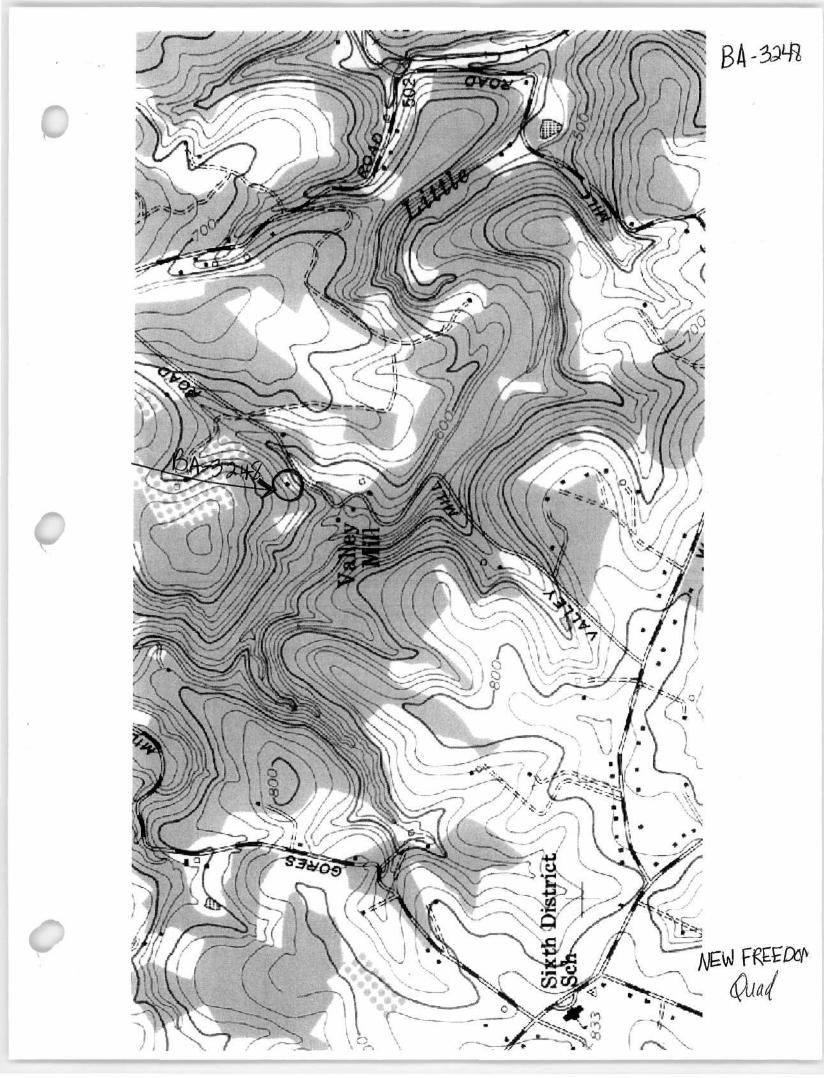
Acreage of surveyed property 4.57 Acres Acreage of historical setting 4.57 Acres Quadrangle name Freeland Quadrangle scale: 1:24,000
Verbal boundary description and justification
The house is located at 20030 Valley Mill Road in the Sixth Election District of Baltimore County. It is associated with Tax Map 11, Parcel 121.
11. Form Prepared by
name/title Teri Rising, Historic Planner
organization Baltimore County Office of Planning date February 15,2010
street & number 105 West Chesapeake Avenue telephone 410.887.3495
city or town Towson state MD
The Maryland Inventory of Historic Properties was officially created by an Act of the Maryland Legislature to be found in the Annotated Code of Maryland, Article 41, Section 181 KA, 1974 supplement.
The survey and inventory are being prepared for information and record purposes only
and do not constitute any infringement of individual property rights.
return to: Maryland Historical Trust DHCD/DHCP 100 Community Place Crownsville, MD 21032-2023 410-514-7600