MARSH ROAD NEIGHBORHOOD DEVELOPMENT PLAN · The Marsh Road Neighborhood Development Plan is the...
52
MARSH ROAD NEIGHBORHOOD DEVELOPMENT PLAN City of Madison Department of Planning and Development Planning Unit October 1999 Adopted by the Madison Plan Commission: September 27, 1999 Adopted by the Madison Common Council: Octobe r 5, 1999
Transcript of MARSH ROAD NEIGHBORHOOD DEVELOPMENT PLAN · The Marsh Road Neighborhood Development Plan is the...
MARSH ROAD NEIGHBORHOOD DEVELOPMENT PLAN
City of Madison Department of Planning and Development
Planning Unit
October 1999
Adopted by the Madison Plan Commission: September 27, 1999
Adopted by the Madison Common Council: October 5, 1999
������������
�� ��������������
������������
��� �����
�����
������������
�
�
�
�
�
�
��
��
���������� ��������
��������������������� ��������������������������������������������������������������������������� �������������������������
�������������
������� ����������
��� ����������
�������
��������
���������������������������
��������
��� !�� ����"��#������$"�%%�����
& '&&& (���
���� ��������� !�� ������#����%�������)��)���������!���'***�����%���%����� ���� ���!�#��������+����������#���
�
�� ,�����������
-�����������.�����������/
0����������������.�#�� ���/
�������.���%����/�
"���1�������������%����1���������2���#����%������������3���������4$'*$&5����%
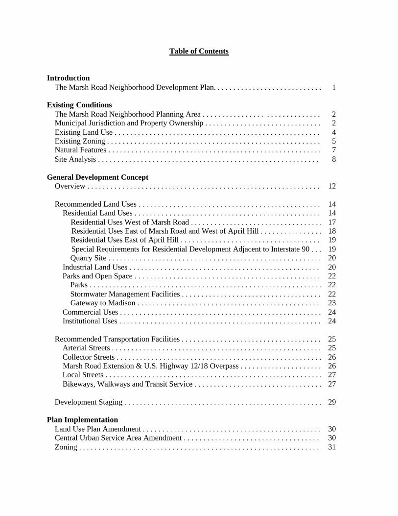
Table of Contents Introduction The Marsh Road Neighborhood Development Plan. . . . . . . . . . . . . . . . . . . . . . . . . . . . 1
Existing Conditions The Marsh Road Neighborhood Planning Area . . . . . . . . . . . . . . . . . . . . . . . . . . . . . . 2 Municipal Jurisdiction and Property Ownership . . . . . . . . . . . . . . . . . . . . . . . . . . . . . . 2 Existing Land Use . . . . . . . . . . . . . . . . . . . . . . . . . . . . . . . . . . . . . . . . . . . . . . . . . . . . . 4 Existing Zoning . . . . . . . . . . . . . . . . . . . . . . . . . . . . . . . . . . . . . . . . . . . . . . . . . . . . . . . 5 Natural Features . . . . . . . . . . . . . . . . . . . . . . . . . . . . . . . . . . . . . . . . . . . . . . . . . . . . . . . 7 Site Analysis . . . . . . . . . . . . . . . . . . . . . . . . . . . . . . . . . . . . . . . . . . . . . . . . . . . . . . . . . 8 General Development Concept Overview . . . . . . . . . . . . . . . . . . . . . . . . . . . . . . . . . . . . . . . . . . . . . . . . . . . . . . . . . . . . 12 Recommended Land Uses . . . . . . . . . . . . . . . . . . . . . . . . . . . . . . . . . . . . . . . . . . . . . . . 14 Residential Land Uses . . . . . . . . . . . . . . . . . . . . . . . . . . . . . . . . . . . . . . . . . . . . . . . . 14 Residential Uses West of Marsh Road . . . . . . . . . . . . . . . . . . . . . . . . . . . . . . . . . . 17 Residential Uses East of Marsh Road and West of April Hill . . . . . . . . . . . . . . . . 18 Residential Uses East of April Hill . . . . . . . . . . . . . . . . . . . . . . . . . . . . . . . . . . . . 19 Special Requirements for Residential Development Adjacent to Interstate 90 . . . 19 Quarry Site . . . . . . . . . . . . . . . . . . . . . . . . . . . . . . . . . . . . . . . . . . . . . . . . . . . . . . . 20 Industrial Land Uses . . . . . . . . . . . . . . . . . . . . . . . . . . . . . . . . . . . . . . . . . . . . . . . . . 20 Parks and Open Space . . . . . . . . . . . . . . . . . . . . . . . . . . . . . . . . . . . . . . . . . . . . . . . . 22 Parks . . . . . . . . . . . . . . . . . . . . . . . . . . . . . . . . . . . . . . . . . . . . . . . . . . . . . . . . . . . . 22 Stormwater Management Facilities . . . . . . . . . . . . . . . . . . . . . . . . . . . . . . . . . . . . 22 Gateway to Madison . . . . . . . . . . . . . . . . . . . . . . . . . . . . . . . . . . . . . . . . . . . . . . . 23 Commercial Uses . . . . . . . . . . . . . . . . . . . . . . . . . . . . . . . . . . . . . . . . . . . . . . . . . . . . 24 Institutional Uses . . . . . . . . . . . . . . . . . . . . . . . . . . . . . . . . . . . . . . . . . . . . . . . . . . . . 24 Recommended Transportation Facilities . . . . . . . . . . . . . . . . . . . . . . . . . . . . . . . . . . . . 25 Arterial Streets . . . . . . . . . . . . . . . . . . . . . . . . . . . . . . . . . . . . . . . . . . . . . . . . . . . . . . 25 Collector Streets . . . . . . . . . . . . . . . . . . . . . . . . . . . . . . . . . . . . . . . . . . . . . . . . . . . . . 26 Marsh Road Extension & U.S. Highway 12/18 Overpass . . . . . . . . . . . . . . . . . . . . . 26 Local Streets . . . . . . . . . . . . . . . . . . . . . . . . . . . . . . . . . . . . . . . . . . . . . . . . . . . . . . . . 27 Bikeways, Walkways and Transit Service . . . . . . . . . . . . . . . . . . . . . . . . . . . . . . . . . 27 Development Staging . . . . . . . . . . . . . . . . . . . . . . . . . . . . . . . . . . . . . . . . . . . . . . . . . . . 29 Plan Implementation Land Use Plan Amendment . . . . . . . . . . . . . . . . . . . . . . . . . . . . . . . . . . . . . . . . . . . . . . 30 Central Urban Service Area Amendment . . . . . . . . . . . . . . . . . . . . . . . . . . . . . . . . . . . 30 Zoning . . . . . . . . . . . . . . . . . . . . . . . . . . . . . . . . . . . . . . . . . . . . . . . . . . . . . . . . . . . . . . 31
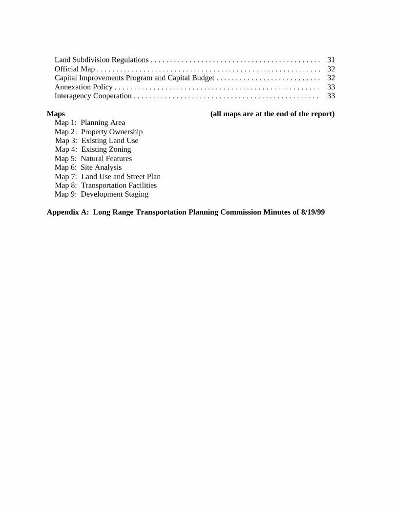
Land Subdivision Regulations . . . . . . . . . . . . . . . . . . . . . . . . . . . . . . . . . . . . . . . . . . . . 31 Official Map . . . . . . . . . . . . . . . . . . . . . . . . . . . . . . . . . . . . . . . . . . . . . . . . . . . . . . . . . . 32 Capital Improvements Program and Capital Budget . . . . . . . . . . . . . . . . . . . . . . . . . . . 32 Annexation Policy . . . . . . . . . . . . . . . . . . . . . . . . . . . . . . . . . . . . . . . . . . . . . . . . . . . . . 33 Interagency Cooperation . . . . . . . . . . . . . . . . . . . . . . . . . . . . . . . . . . . . . . . . . . . . . . . . 33 Maps (all maps are at the end of the report) Map 1: Planning Area Map 2: Property Ownership Map 3: Existing Land Use Map 4: Existing Zoning Map 5: Natural Features Map 6: Site Analysis Map 7: Land Use and Street Plan Map 8: Transportation Facilities Map 9: Development Staging Appendix A: Long Range Transportation Planning Commission Minutes of 8/19/99
1
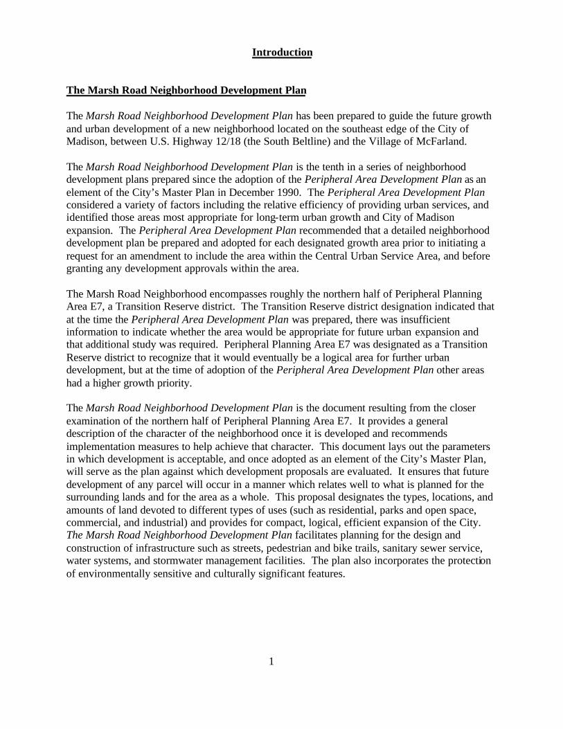
Introduction The Marsh Road Neighborhood Development Plan The Marsh Road Neighborhood Development Plan has been prepared to guide the future growth and urban development of a new neighborhood located on the southeast edge of the City of Madison, between U.S. Highway 12/18 (the South Beltline) and the Village of McFarland. The Marsh Road Neighborhood Development Plan is the tenth in a series of neighborhood development plans prepared since the adoption of the Peripheral Area Development Plan as an element of the City’s Master Plan in December 1990. The Peripheral Area Development Plan considered a variety of factors including the relative efficiency of providing urban services, and identified those areas most appropriate for long-term urban growth and City of Madison expansion. The Peripheral Area Development Plan recommended that a detailed neighborhood development plan be prepared and adopted for each designated growth area prior to initiating a request for an amendment to include the area within the Central Urban Service Area, and before granting any development approvals within the area. The Marsh Road Neighborhood encompasses roughly the northern half of Peripheral Planning Area E7, a Transition Reserve district. The Transition Reserve district designation indicated that at the time the Peripheral Area Development Plan was prepared, there was insufficient information to indicate whether the area would be appropriate for future urban expansion and that additional study was required. Peripheral Planning Area E7 was designated as a Transition Reserve district to recognize that it would eventually be a logical area for further urban development, but at the time of adoption of the Peripheral Area Development Plan other areas had a higher growth priority. The Marsh Road Neighborhood Development Plan is the document resulting from the closer examination of the northern half of Peripheral Planning Area E7. It provides a general description of the character of the neighborhood once it is developed and recommends implementation measures to help achieve that character. This document lays out the parameters in which development is acceptable, and once adopted as an element of the City’s Master Plan, will serve as the plan against which development proposals are evaluated. It ensures that future development of any parcel will occur in a manner which relates well to what is planned for the surrounding lands and for the area as a whole. This proposal designates the types, locations, and amounts of land devoted to different types of uses (such as residential, parks and open space, commercial, and industrial) and provides for compact, logical, efficient expansion of the City. The Marsh Road Neighborhood Development Plan facilitates planning for the design and construction of infrastructure such as streets, pedestrian and bike trails, sanitary sewer service, water systems, and stormwater management facilities. The plan also incorporates the protection of environmentally sensitive and culturally significant features.
2
Existing Conditions
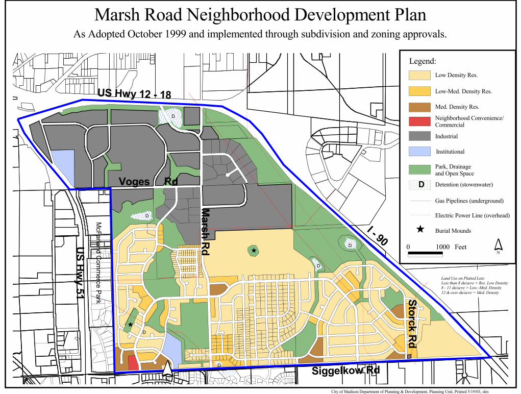
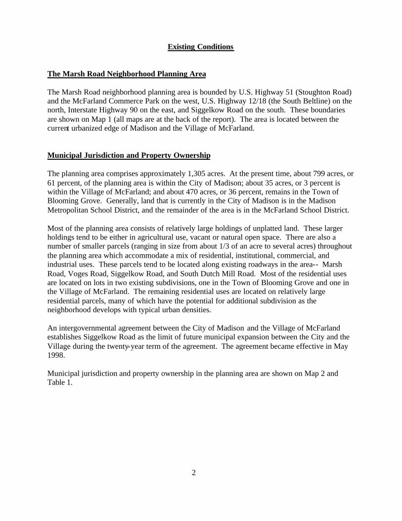
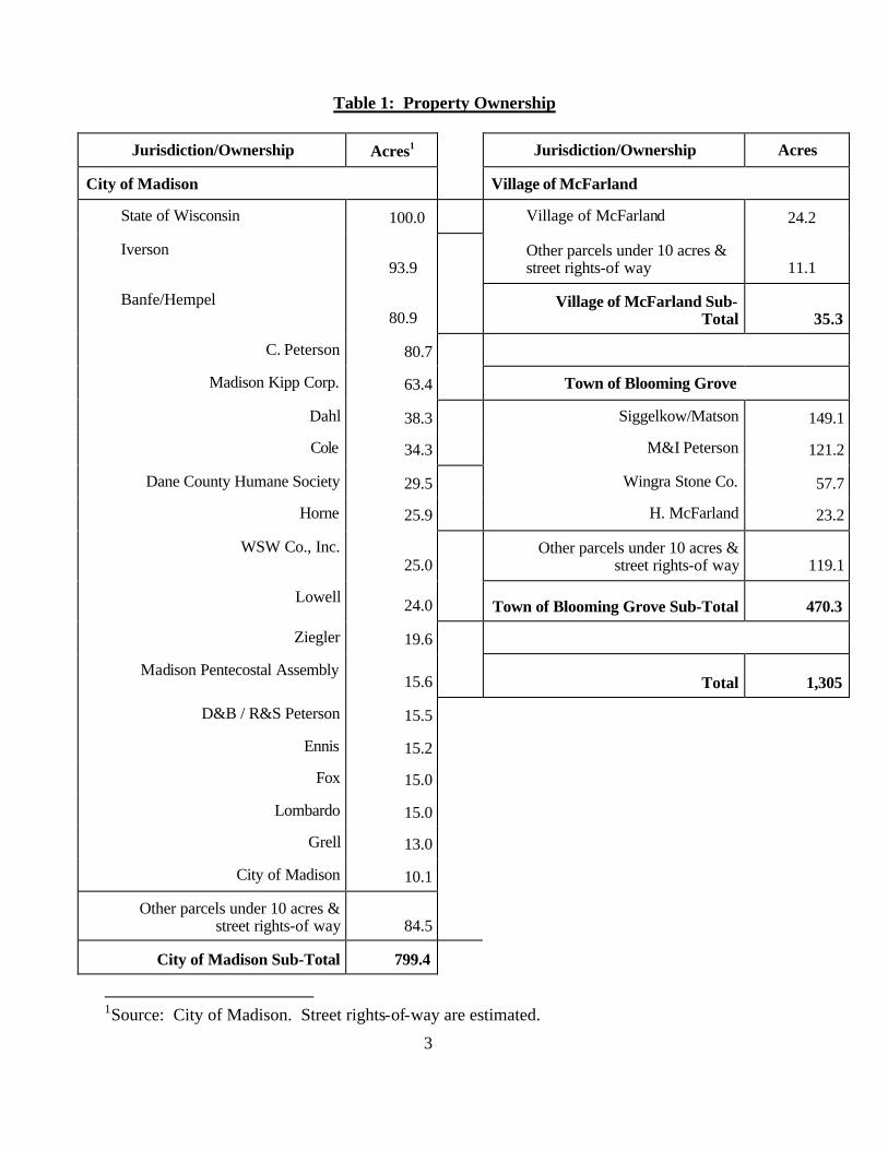
The Marsh Road Neighborhood Planning Area The Marsh Road neighborhood planning area is bounded by U.S. Highway 51 (Stoughton Road) and the McFarland Commerce Park on the west, U.S. Highway 12/18 (the South Beltline) on the north, Interstate Highway 90 on the east, and Siggelkow Road on the south. These boundaries are shown on Map 1 (all maps are at the back of the report). The area is located between the current urbanized edge of Madison and the Village of McFarland. Municipal Jurisdiction and Property Ownership The planning area comprises approximately 1,305 acres. At the present time, about 799 acres, or 61 percent, of the planning area is within the City of Madison; about 35 acres, or 3 percent is within the Village of McFarland; and about 470 acres, or 36 percent, remains in the Town of Blooming Grove. Generally, land that is currently in the City of Madison is in the Madison Metropolitan School District, and the remainder of the area is in the McFarland School District. Most of the planning area consists of relatively large holdings of unplatted land. These larger holdings tend to be either in agricultural use, vacant or natural open space. There are also a number of smaller parcels (ranging in size from about 1/3 of an acre to several acres) throughout the planning area which accommodate a mix of residential, institutional, commercial, and industrial uses. These parcels tend to be located along existing roadways in the area-- Marsh Road, Voges Road, Siggelkow Road, and South Dutch Mill Road. Most of the residential uses are located on lots in two existing subdivisions, one in the Town of Blooming Grove and one in the Village of McFarland. The remaining residential uses are located on relatively large residential parcels, many of which have the potential for additional subdivision as the neighborhood develops with typical urban densities. An intergovernmental agreement between the City of Madison and the Village of McFarland establishes Siggelkow Road as the limit of future municipal expansion between the City and the Village during the twenty-year term of the agreement. The agreement became effective in May 1998. Municipal jurisdiction and property ownership in the planning area are shown on Map 2 and Table 1.
3
Table 1: Property Ownership
Jurisdiction/Ownership Acres1 Jurisdiction/Ownership Acres
City of Madison Village of McFarland
State of Wisconsin 100.0 Village of McFarland 24.2
Iverson 93.9
Other parcels under 10 acres & street rights-of way 11.1
Banfe/Hempel 80.9
Village of McFarland Sub-Total 35.3
C. Peterson 80.7
Madison Kipp Corp. 63.4 Town of Blooming Grove
Dahl 38.3 Siggelkow/Matson 149.1
Cole 34.3 M&I Peterson 121.2
Dane County Humane Society 29.5 Wingra Stone Co. 57.7
Horne 25.9 H. McFarland 23.2
WSW Co., Inc. 25.0
Other parcels under 10 acres & street rights-of way 119.1
Lowell 24.0 Town of Blooming Grove Sub-Total 470.3
Ziegler 19.6
Madison Pentecostal Assembly 15.6 Total 1,305
D&B / R&S Peterson 15.5
Ennis 15.2
Fox 15.0
Lombardo 15.0
Grell 13.0
City of Madison 10.1
Other parcels under 10 acres & street rights-of way 84.5
City of Madison Sub-Total 799.4
1Source: City of Madison. Street rights-of-way are estimated.
4
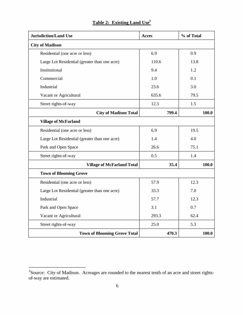
Existing Land Use A variety of land uses currently exist within the Marsh Road Neighborhood planning area. Most of the lands within the area (approximately 73.4 percent) are in agricultural uses, vacant, or in various forms of natural open space. Residential uses on lots of less than one acre, which are mostly located in the two existing residential subdivisions, occupy approximately 5.5 percent of the area. Large lot (greater than 1 acre) residential uses account for an additional 11.1 percent of the total area. Commercial, industrial, and institutional uses account for about 7 percent. Street right-of-way consumes the remaining 2.9 percent. Map 3 and Table 2 show existing land uses in the planning area. Some of the more prominent existing land uses are discussed below. State Department of Transportation Lands: The State of Wisconsin Department of Transportation owns approximately 100 acres in the northern portion of the neighborhood adjacent U.S. Highway 12/18. Most of this now-vacant property was used as a containment and settling area for materials dredged during construction of the South Beltline Highway. Sufficient settling has now occurred and the State intends to make this land available for purchase and development. Residential Uses: A wide array of residential uses is present in the area. April Hill, a 150-lot rural subdivision (served by private wells and septic systems) is located in the south central part of the planning area, in the Town of Blooming Grove. Calico Court, a recently-platted 16- lot subdivision is also located in the south central part of the planning area, in the Village of McFarland. There are a number of other large- lot residential uses dispersed throughout the area. Wingra Stone Quarry: An active 57-acre quarry is situated in the center of the planning area, in the Town of Blooming Grove. The owner of the quarry, Wingra Stone Company, also owns an adjacent 25-acre site to the south in the City of Madison that is utilized as access to the quarry. William McFarland Park: William McFarland Park is a 24-acre park in the south central part of the planning area, in the Village of McFarland. Two newer buildings, housing an ice arena and curling club are located at the park. The park also provides open space for soccer fields and other recreational uses. The intergovernmental agreement between the City and the Village provides that the City will implement a plan to expand this park on lands located in Madison in accordance with this neighborhood development plan. South Dutch Mill Road Area: Crossroads Church and Bright Start Children’s Center are located at the intersection of Voges Road and South Dutch Mill Road, in the extreme northwestern part of the neighborhood. A few residential and small commercial and industrial uses are also located along this segment of South Dutch Mill Road.
5
Dane County Humane Society Animal Shelter: The Dane County Humane Society plans on constructing a new animal shelter on a 30-acre site it owns along the north side of Voges Road. A portion of the site was rezoned in 1997 to allow for this use and construction is anticipated to begin in the Spring of 1999. Northern Marsh Road Area: Westside Cabinet and Millwork and Fox Construction Company are located along Marsh Road north of Voges Road.
[Table 2: Existing Land Use is on the following page] Existing Zoning The City of Madison and the Village of McFarland exercise zoning jurisdiction over their respective portions of the planning area. Dane County zoning requirements apply to the portion of the planning area in the Town of Blooming Grove. Map 4 shows the existing zoning. City of Madison: Most of the land north of Voges Road is zoned M1 (Limited Manufacturing District). The Iverson property, east of Marsh Road and north of the quarry, is also zoned M1. Properties with frontage on South Dutch Mill Road are zoned C3 (Highway Commercial District). A small portion of the northeast corner of the planning area is zoned W (Wetland District). The remainder of the land in the City is zoned A (Agriculture District). While farming and other agricultural uses are allowed as permitted uses, the City’s zoning ordinance states that the purpose of the Agriculture District is to preserve, in agricultural uses, lands suited to future urban development pending proper timing and economical provision of public utilities and community facilities to ensure compact and orderly land use development.2 Village of McFarland: Land in McFarland is subject to the Village’s zoning ordinance. The ice arena and curling club located in William McFarland Park are zoned C-L (Limited Commercial), while the remainder of the park is zoned CO (Conservancy). The Calico Court subdivision located south of the park is zoned R-1 (Single-Family Residential), and three adjacent parcels are zoned R-1A (Single-Family Residential). A small amount of land fronting on Siggelkow Road is zoned A-1 (Agricultural Transition).
2City of Madison Zoning Ordinance. Sec. 28.07(3)(a).
6
Table 2: Existing Land Use3
Jurisdiction/Land Use Acres % of Total
City of Madison
Residential (one acre or less) 6.9 0.9
Large Lot Residential (greater than one acre) 110.6 13.8
Institutional 9.4 1.2
Commercial 1.0 0.1
Industrial 23.6 3.0
Vacant or Agricultural 635.6 79.5
Street rights-of-way 12.3 1.5
City of Madison Total 799.4 100.0
Village of McFarland
Residential (one acre or less) 6.9 19.5
Large Lot Residential (greater than one acre) 1.4 4.0
Park and Open Space 26.6 75.1
Street rights-of-way 0.5 1.4
Village of McFarland Total 35.4 100.0
Town of Blooming Grove
Residential (one acre or less) 57.9 12.3
Large Lot Residential (greater than one acre) 33.3 7.0
Industrial 57.7 12.3
Park and Open Space 3.1 0.7
Vacant or Agricultural 293.3 62.4
Street rights-of-way 25.0 5.3
Town of Blooming Grove Total 470.3 100.0
3Source: City of Madison. Acreages are rounded to the nearest tenth of an acre and street rights-of-way are estimated.
7
Town of Blooming Grove: Land in the Town is governed by the Dane County zoning ordinance. A majority of the land in the Town is zoned A-1ex (Agriculture Exclusive). A small parcel along Marsh Road west of the quarry is zoned A-2 (Agriculture). The April Hill subdivision is zoned R-2 (Single-Family Residence), while a small grouping of parcels in the extreme southeast corner of the planning area is zoned either RH-1, RH-2, or RH-3 (all Rural Homes districts). Natural Features The natural topography of the study area varies from moderately rolling farmland dominating the southern two-thirds to lowlands and wetlands in the northern and northeastern portions. Natural surface drainage in the area generally runs north and west. Map 5 illustrates the drainage patterns and other natural features of the area. Environmental corridors are delineated only within Urban Service Areas. Aside from land in the Village of McFarland, only a small portion of the northwest corner of the neighborhood is currently in the Central Urban Service Area. An environmental corridor is identified in this section to accommodate a drainageway along the southern edge of U.S. Highway 12/18.4 Environmental Corridor Maps also identify proposed parks, greenways, or conservancy lands outside of Urban Service Areas. In the Marsh Road Neighborhood, these lands follow the main drainage patterns in the area, and are designated to accommodate stormwater management needs. The elevation of the northern portion of the study area is very low and is comprised mostly of flat meadows. A stormwater management study commissioned by the City for this part of the neighborhood indicates the presence of a series of small, mostly minor, wetlands.5 The study also identifies more important wetlands, with the one running along Interstate 90 being “especially significant because of its size, riparian position, and capacity to process large overbank floods.” The study further states that the wetland just southwest of the intersection of Voges Road and Tormey Lane “has the capacity to filter large amounts of runoff due to its size and landscape position.” A contiguous area including the wetlands adjacent to Interstate 90, the original drainageway across the State-owned parcel, the Westside Cabinet and Millwork property, and the Dane
4Environmental Corridors of the Central Urban Service Area. Dane County Regional Planning Commission. December 1988. 5Southeast Regional Stormwater Management Plan. Madison, Wisconsin. Mead and Hunt, Inc. January 1997.
8
County Humane Society property is located in the 100-year floodplain. 6 However, City Engineering has completed a preliminary review of the revisions necessary to bring the floodplain map into compliance with existing conditions. This initial review indicates that the floodplain may be significantly larger than indicated on the existing floodplain map. Development of areas north of Voges Road (approximate) may be complicated by permitting issues with the following agencies: FEMA, WDNR, WDOT, and the US Army Corps. The Soil Survey of Dane County indicates the presence of soils series in some areas which could pose problems for shallow excavations, dwellings with basements, and roadway development. The problems associated with these soil groups tend to be related to the water table and wetness. These soils are generally found in the area north of Voges Road, and in proximity to the wetlands and prominent drainageway areas. Identified soil groups include the following: Wacousta, Colwood, Houghton, Orion, Plano, and Radford. Site Analysis While the gently rolling topography provides an attractive setting, extensive challenges to development exist in the Marsh Road Neighborhood planning area which accentuate the need for a neighborhood development plan. Most of these challenges pertain to working with the manmade and natural features which are illustrated on the Site Analysis Map (Map 6). The natural features are described in the preceding section. This section provides an overview of the built, cultural, and other planning considerations identified on the Site Analysis Map. Wingra Stone Company Quarry: The Wingra Stone Company has been actively quarrying this site for many years and plans to continue its operation until the site is quarried out-- estimated to be at least thirty years. Quarry activities have substantially altered the original topography of the site and it remains unclear how the site will ultimately relate to surrounding lands and long-term future land use in the area. Due to the uncertainties of the final depth and extent of excavation, and the suitability of the site for either future residential or industrial use, it will be necessary to continue to monitor this site. Measures will be required to ensure that existing residential uses in the vicinity and those developed pursuant to this plan are not degraded by future uses of the site. Wingra Stone Company has no plans to quarry the adjacent 25-acre site it owns to the south that is utilized as access to the quarry. Madison Metropolitan Sewer District Interceptors: The Madison Metropolitan Sewerage District (MMSD) has a sanitary sewer interceptor traversing the area from east to west approximately mid-way between U.S. Highway 12/18 and Voges Road. A segment of this interceptor also parallels Interstate 90. Two branches of another
6A portion of this drainageway originally cut diagonally across the State-owned land, but was relocated to parallel the northern property line.
9
MMSD interceptor run north from McFarland and converge in the drainageway west of William McFarland Park before continuing north to intersect with the previously-noted interceptor. Natural Gas and Petroleum Pipelines: Several underground gas and petroleum pipelines cross the area, creating significant limitations to locating buildings, streets, and landscaping. Restrictions associated with pipeline easements prohibit buildings, and limit streets and plantings in the easement areas. This will affect the buildable area of platted lots which possess these easements. Future street alignments and street crossings will also be impacted by these easements. Streets are not allowed to run linearly over the pipelines and a minimum depth of cover must be maintained where streets cross a pipeline. The precise location and buried depth of the pipelines will ultimately have to be determined in the field in conjunction with future land subdivisions. Some adjustment to the street pattern proposed in this plan may be needed as a result of this field verification. The first pipeline bisects the area running east and west. This is an eight- inch liquid gas and oil pipeline owned by Koch Refining Company, and is located in a 60-foot wide easement. A northwest-southeast pipeline traverses the eastern portion of the study area. This is a ten-inch natural gas pipeline owned by ANR Pipeline Company and is located in a 50-foot wide easement. ANR Pipeline Company also owns a pair of natural gas pipelines (a six- inch and a ten-inch pipe) situated in a 75-foot wide easement in the extreme southeast corner of the area. A high-pressure gas pipeline, owned by Badger Pipeline Company, lies in the southwesterly portion of the area. A 50-foot wide easement must be maintained to accommodate this pipeline. Wisconsin Power & Light Electric Transmission Line: Wisconsin Power and Light owns a high voltage (69kv) overhead electric transmission line that runs north-south across the eastern third of the planning area. This transmission line is located in an 80-foot wide easement which carries many of the same restrictions as the pipeline easements described above. Native American Effigy Mounds: There are several Native American effigy mounds located in the planning area. The State Historical Society has jurisdiction over these mounds and must approve development plans for any properties containing burial sites. State Statutes require that burial sites be surveyed prior to development, and that a perimeter of at least five feet be maintained around the edge of the mounds. At this time, the only surveyed mound groups are located at the Wingra Stone quarry and on the Celestia Peterson property. Information received from the State and County indicate that additional mounds may have once been located on the Banfe/Hempel and Iverson properties. While decades of cultivation have apparently severely damaged or destroyed these mounds, subsurface features may still exist. Tax Incremental Finance (TIF) District Number 24: Tax Incremental Finance (TIF) District Number 24 was adopted by the City in July 1995 and includes a majority of the land in the northern half of the planning area. The TIF district is an
10
implementation and financing plan that was established to encourage industrial development consistent with the City’s Objectives and Policies, Land Use Plan, and Economic Development Plan. Adjacent Land Uses: The Marsh Road Neighborhood is located between urban Madison and McFarland and is surrounded on all sides by developed lands. These adjacent uses influenced the proposed design of the neighborhood, particularly near the edges. Land south of Siggelkow Road, west of Holscher Road, is developed in residential uses. While most of the land east of Holscher Road is currently farmed, it is anticipated that the predominate future land use will be residential. The proposal for the land north of Siggelkow Road is planned to be compatible with this existing and future development. Land bordering the neighborhood to the west includes the McFarland Commerce Park (which contains industrial and commercial uses) and other industrial uses. The neighborhood development plan recognizes these existing uses in creating a design that maximizes the compatibility with this area. Interstate 90 and U.S. Highway 12/18 comprise the eastern and northern boundaries of the planning area. The relationship of these roadways to the neighborhood needs to be considered in the plan. Noise exposure will be an issue in certain parts of the neighborhood. These roadways also form important entryways into the City and aesthetic issues need to be addressed in the neighborhood design. Street Connectivity: Proposed streets need to provide access to the neighborhood, and connectivity within the neighborhood and to adjacent areas. The April Hill subdivision was developed with several streets extending to the edges of the plat to facilitate the continuation of the streets to anticipated development on adjoining lands. There are several opportunities to make logical street connections to existing development in McFarland. Currently, the only direct roadway connection from the Marsh Road Neighborhood to the north is via U.S. Highway 51. The concept of providing an additional crossing of U.S. Highway 12/18 has been discussed for some time. Although not viewed as a necessity for the development of this area, the new growth here and in McFarland make this linkage more timely. Soils: The Soil Survey of Dane County indicates the presence of soils series in some areas which could pose problems for shallow excavations, dwellings with basements, and roadway development. While it is anticipated that some of the soils constraints can be overcome through the development of a regional stormwater management system and applied engineering practices, the actual limitations will be identified as better information is obtained in conjunction with specific

11
development proposals. Portions of lands containing these soils should be incorporated within drainage and open space features.
12
General Development Concept Overview The general development concept proposed in this plan accommodates residential and industrial land use elements within a single comprehensive development plan. Elements such as topography, natural drainage patterns, and existing development (including natural gas and petroleum pipelines and electric transmission lines) were used to help organize and define logical land use relationships and street patterns. With its location between developed lands in the City of Madison to the north and east, and developed lands in the Village of McFarland to the west and south, the Marsh Road Neighborhood is considered as more of an infill area than true “edge” development. The development concept seeks to incorporate future development into the existing fabric of this surrounding development by transitioning from the industrial uses in the north to the residential neighborhoods in the south. The residential densities and mix of dwelling types proposed for the Marsh Road Neighborhood are intended to be compatible with the relative lower densities in the McFarland area. Further integration with the surrounding area will be achieved through the extension of key streets into the neighborhood from McFarland. The proposed concept incorporates natural features into the development of the neighborhood. The location of these natural features played a key role in defining the limits of each type of land use. They also provided for a logical separation between industrial and residential uses in several locations. Where existing natural features are insufficient to ensure the integrity of this transition, landscaped buffers will be required as development occurs. Existing natural drainageways are integrated into the neighborhood plan as greenways which will convey stormwater runoff as well as provide open space amenities. An effort has been made to locate park facilities along anticipated travel routes and at the end of local streets. This was done in an effort to maximize the visibility, accessibility and aesthetic contribution of the park features to the neighborhood. The concept plan seeks to promote connectivity and disperse traffic throughout the neighborhood by providing a grid- like street pattern that offers alternative travel routes. To provide additional access to the neighborhood, this plan identifies a potential north-south connection between Marsh Road and Agriculture Drive, which would require a bridge crossing over U.S. Highway 12/18. Bicycle and pedestrian facilities are also given a high priority in the concept plan. The Marsh Road Neighborhood is an important gateway to the city. With its prominent location at the intersection of two major arterials (Interstate Highway 90 and U.S. Highway 12/18), this neighborhood will be among the first urbanized areas encountered when entering the city from the south or east on these roadways. It is important to take advantage of this opportunity to make a positive first impression. Providing a landscaped open space corridor along the eastern and

13
northern edges of the neighborhood coupled with sensitive urban design will enhance this gateway. The following sections describe the recommended land uses, the recommended transportation facilities, and the development staging components of this development concept.
14
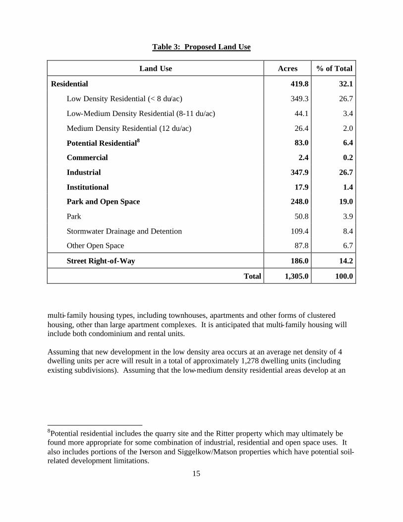
Recommended Land Uses The planning area encompasses approximately 1,305 acres. The proposed development plan for the area recommends three major types of land use-- residential, industrial, and parks and open space. Residential uses comprise approximately 32.1 percent of the area and are located in the southern portion of the neighborhood. This percentage rises to 38.5 if the lands designated as potential residential are added (see Table 3). Industrial uses comprise approximately 26.7 percent of the area and are concentrated in the northern portion of the neighborhood. Land devoted to parks and open space is integrated throughout the neighborhood and totals approximately 19 percent of the area. Institutional uses total approximately 1.4 percent. A small commercial site in the southwest corner is included that covers approximately 0.2 percent. The remaining 14.2 percent of the neighborhood will be required for street right-of-way. The general land use concept is discussed below. Recommended land uses within the Marsh Road Neighborhood are presented on the Land Use and Street Plan (Map 7) and are summarized in Table 3.
[Table 3: Proposed Land Use is on the following page.] Residential Land Uses A total of 502.8 net acres is recommended for residential uses in the Marsh Road Neighborhood. The land use plan provides for a variety of housing opportunities by designating proposed residential locations for either low, low-medium, or medium density development. The mapped locations within each density range are illustrative of the recommended development pattern, but some flexibility in implementing the recommendations is assumed. It is not expected that every residential development will necessarily correspond exactly to the specific density indicated-- but that the general pattern and distribution of densities and housing types are consistent with the intent of the neighborhood plan recommendations. The distribution of residential densities illustrated in the neighborhood development plan provides approximately 349.3 acres for low density development, approximately 44.1 acres for low-medium density development, and approximately 26.4 acres for medium density development. An additional 83 acres is designated for potential residential development.7 Most of the low-density housing will consist of single-family units on a variety of lot sizes. The low-medium density housing will mostly consist of small- lot single-family development, duplexes, townhouses, and small apartment buildings. The medium density housing will consist of
7See Table 3.
15
Table 3: Proposed Land Use
Land Use Acres % of Total
Residential 419.8 32.1
Low Density Residential (< 8 du/ac) 349.3 26.7
Low-Medium Density Residential (8-11 du/ac) 44.1 3.4
Medium Density Residential (12 du/ac) 26.4 2.0
Potential Residential8 83.0 6.4
Commercial 2.4 0.2
Industrial 347.9 26.7
Institutional 17.9 1.4
Park and Open Space 248.0 19.0
Park 50.8 3.9
Stormwater Drainage and Detention 109.4 8.4
Other Open Space 87.8 6.7
Street Right-of-Way 186.0 14.2
Total 1,305.0 100.0
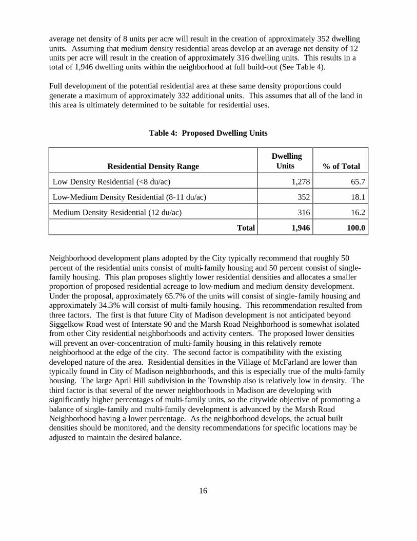
multi- family housing types, including townhouses, apartments and other forms of clustered housing, other than large apartment complexes. It is anticipated that multi- family housing will include both condominium and rental units. Assuming that new development in the low density area occurs at an average net density of 4 dwelling units per acre will result in a total of approximately 1,278 dwelling units (including existing subdivisions). Assuming that the low-medium density residential areas develop at an
8Potential residential includes the quarry site and the Ritter property which may ultimately be found more appropriate for some combination of industrial, residential and open space uses. It also includes portions of the Iverson and Siggelkow/Matson properties which have potential soil-related development limitations.
16
average net density of 8 units per acre will result in the creation of approximately 352 dwelling units. Assuming that medium density residential areas develop at an average net density of 12 units per acre will result in the creation of approximately 316 dwelling units. This results in a total of 1,946 dwelling units within the neighborhood at full build-out (See Table 4).
Full development of the potential residential area at these same density proportions could generate a maximum of approximately 332 additional units. This assumes that all of the land in this area is ultimately determined to be suitable for residential uses.
Table 4: Proposed Dwelling Units
Residential Density Range Dwelling
Units % of Total
Low Density Residential (<8 du/ac) 1,278 65.7
Low-Medium Density Residential (8-11 du/ac) 352 18.1
Medium Density Residential (12 du/ac) 316 16.2
Total 1,946 100.0
Neighborhood development plans adopted by the City typically recommend that roughly 50 percent of the residential units consist of multi- family housing and 50 percent consist of single-family housing. This plan proposes slightly lower residential densities and allocates a smaller proportion of proposed residential acreage to low-medium and medium density development. Under the proposal, approximately 65.7% of the units will consist of single-family housing and approximately 34.3% will consist of multi- family housing. This recommendation resulted from three factors. The first is that future City of Madison development is not anticipated beyond Siggelkow Road west of Interstate 90 and the Marsh Road Neighborhood is somewhat isolated from other City residential neighborhoods and activity centers. The proposed lower densities will prevent an over-concentration of multi- family housing in this relatively remote neighborhood at the edge of the city. The second factor is compatibility with the existing developed nature of the area. Residential densities in the Village of McFarland are lower than typically found in City of Madison neighborhoods, and this is especially true of the multi- family housing. The large April Hill subdivision in the Township also is relatively low in density. The third factor is that several of the newer neighborhoods in Madison are developing with significantly higher percentages of multi- family units, so the citywide objective of promoting a balance of single-family and multi- family development is advanced by the Marsh Road Neighborhood having a lower percentage. As the neighborhood develops, the actual built densities should be monitored, and the density recommendations for specific locations may be adjusted to maintain the desired balance.
17
The streetscape is an important factor in establishing the physical character of a neighborhood. In general, it is recommended that both multi- family and single-family developments seek to work within the recommended street sys tem rather than proposing isolated enclaves of development served by private streets. It is also recommended that residential structures be oriented toward the street and that street frontages not be dominated by garages protruding in front of the house.
Quarry operations within the area are expected to continue well into the future. At the time of platting, notification shall be recorded on the deeds of all new residential development in the vicinity of the quarry that quarrying operations include blasting. Persons seeking to purchase residential property in the area should be advised of the potential impacts of the quarry. Residential Uses West of Marsh Road This residential area includes the land west of Marsh Road and east of the McFarland Commerce Park. The area is proposed to be developed primarily as a low density residential neighborhood with some higher density residential uses generally located near Siggelkow Road. The McFarland Commerce Park contains light industrial and commercial uses which are oriented toward Triangle Street and generally located near the front of the lots, which lessens the possible negative impacts on future residential development. Lots adjacent to the McFarland Commerce Park are designed to be slightly deeper than surrounding lots to provide additional opportunities for landscaping. A major drainage greenway bisects this area running from south to north. At the northern end of this residential area it widens into a wooded wetland area, providing a natural buffer and logical transition between the proposed residential uses and the proposed light industrial uses to the north. A wooded hill containing steep slopes located on the Celestia Peterson property contains three Native American burial mounds. The plan proposes to preserve these mounds as an open space feature at the rear of residential lots and incorporates a walking path for pedestrian access. The street pattern east of the greenway and north of the park is “grid- like” with relatively short blocks. Adjacent to the southwest portion of the park is a 15.6-acre site owned by Madison Pentecostal Assembly. This property was acquired for development of church facilities, but there are no plans to do so in the near future. Should the owners decide not to utilize this site for church facilities, an acceptable alternative would be to develop the land for low density residential uses. The proposed alignment of a street along the western side of this property was, in part, influenced by the Assembly’s desire to keep a large portion of the property intact to potentially accommodate their facilities in the future. Street patterns in this area provide for a connection to North Autumn Lane south of Siggelkow Road. Should this land be proposed for
18
residential development, it may be desirable to adjust the proposed street alignments to accommodate additional streets and residential lotting. Low-medium and medium density residential uses in the area west of Marsh Road are concentrated around the proposed commercial site, adjacent to the industrial park on the west, and across Siggelkow Road from a park and multi- family uses in McFarland. This type of use provides a transition from the commercial use to the lower-density residential neighborhood. The greater level of design flexibility inherent in multi- family projects presents an opportunity to take advantage of some uniquely-shaped parcels and to create an attractive entrance into the neighborhood. Additional low-medium density uses are also recommended in small amounts to illustrate the appropriateness of mixed housing types in this area. Some flexibility in the exact locations of each type is consistent with the plan objectives.
Where residential uses will be adjacent to industrial uses, it is recommended that landscaped buffer areas be required on the industrial land and encouraged on the residential lands. Residential Uses East of Marsh Road and West of April Hill This residential area encompasses the 68 acres between Marsh Road and the April Hill subdivision, south of the quarry, including a non-quarried 25-acre parcel owned by the Wingra Stone Company. The predominant recommended land use in this area is single-family residential, with multi- family development proposed along Marsh Road. The street layout in this area incorporates two existing east-west streets located in the north and south ends of the April Hill subdivision to provide important internal connectivity within the neighborhood. Drainage patterns facilitate a predominantly north-south street orientation, which compliments the street layout of April Hill. Lots with frontage on Marsh Road, between Siggelkow Road and the proposed street opposite the entrance to William McFarland Park, will have access to internal streets only. This will help to minimize traffic conflicts along this higher-traffic segment of Marsh Road.
Multi- family residential uses are recommended along Marsh Road, with small concentrations on the non-quarried Wingra Stone Company parcel and at the intersection of Marsh Road and Siggelkow Road. The multi- family development near Siggelkow Road is proposed, in part, because of the design flexibility in accommodating a stormwater detention area planned at this corner. This detention basin will be required to meet stormwater runoff needs. Its visibility provides an opportunity to create an attractive entryway into the neighborhood. Multi- family uses are also located across Siggelkow Road in McFarland.
19
Residential Uses East of April Hill All of the land in the planning area east of the April Hill plat is recommended for residential uses, with the exception of designated parks and open space. The street design of this area reflects an effort to incorporate and extend street patterns initiated in April Hill, and is heavily influenced by the need to work within the constraints created by existing power lines, pipelines and natural drainageways to the east. The area in the vicinity of the wooded hill in the extreme southeast corner of the neighborhood, totaling approximately 30 acres, is proposed to remain in large- lot residential uses. A piece of the Iverson property east of and adjacent to the quarry, and a piece of the Siggelkow/Matson property to the east of that, are shown as low density residential. In the neighborhood context, this area is appropriate for residential development. However, available information regarding the soils in this area indicates that its suitability for such use may be marginal. For that reason, the land use plan indicates the desired land use, but since the potential for development is questionable, the street pattern is not extended into the area. It is included in this plan to indicate that if the soils issues can be overcome, low-density residential development is an appropriate use. The development of areas to the south shall include street stubs to provide access in the event of future development. Low-medium and medium density uses are recommended in proximity to the proposed parks located in this portion of the neighborhood. The first cluster is proposed to be located adjacent the park facility formed by combining additional park dedication with the existing neighborhood park in April Hill. The second cluster is near a proposed new park facility located on Storck Road. The intent is to promote access to park facilities where typically there would be a higher concentration of neighborhood residents and greater demands placed on private on-site open space. Low-medium density development is proposed just west of the proposed drainage greenway. Additional land near the southeast corner of this area is proposed for multi- family to illustrate the appropriateness of mixed housing types in the area, and to minimize unnecessary traffic through lower-density areas by locating higher-density uses closer to Siggelkow Road. Special Requirements for Residential Development Adjacent to Interstate 90
Residential developments on lands adjacent to Interstate 90 will be required to comply with Federal, State, and local regulations regarding mitigation of traffic noise from these roadways. Similar requirements also apply to recreational uses. In summary, these regulations provide that, before any new residential or recreational development adjacent to the Interstate Highway can be approved, the developer must demonstrate that sound levels at the site are within permissible levels, or that adequate sound attenuation measures will be incorporated to reduce sound levels to permissible levels. The buffer zone along the Interstate shown on the Land Use and Street Plan Map (Map 7) is illustrative of the need for sound attenuation, and is not an estimation of the area required for berms or other attenuation measures. This information is provided only as a
20
summary overview. Property owners and potential developers have the responsibility to determine how the sound attenuation regulations may affect the plans or costs to develop specific properties, and to take the measures needed to attenuate the noise or otherwise comply with the regulations.
Quarry Site The concept plan shows the quarry site as potential low-density residential. However, because the owners plan on continuing quarrying operations for the next several decades and a reclamation plan does not currently exist that addresses the post-quarrying state of the property, it serves little purpose to prepare subdivision layouts for this site. However, designating the future land use as residential provides some direction as to what land uses are initially considered compatible in the context of the larger neighborhood. The concept plan also anticipates that at least some part of the quarry may ultimately be more suitable for industrial use. The residential designation is intended to promote an awareness that if a change to a non-residential use should ultimately be proposed, efforts to ensure the integrity of adjacent residential uses will be given proper consideration. The ultimate land use pattern for this property should be further studied as the reclamation plan is being developed. The preservation of existing burial mounds on this site must also be provided for as more detailed plans are prepared.
Since a portion of lands to the south is also owned by the Wingra Stone Company and accommodates the quarry’s access drive and scales, it is not anticipated that these lands will develop prior to the close of the quarry operation. However, should development of this parcel be pursued prior to determining the long-term land use for the quarry site, a street stub should be provided to ensure connectivity to a residential use of the quarry.
Industrial Land Uses A total of 348 net acres is recommended for industrial uses in the Marsh Road Neighborhood. Several factors make this area particularly well suited for industrial uses. The first is tha t most of the land is flat. The types of industrial uses being proposed usually involve structures built on slabs (as opposed to basements). This type of construction is more suitable for low-lying areas such as this. The area also has excellent access via Voges Road to U.S. Highway 12/18, and from there to Interstate Highways 90 and 94. This direct access will minimize the mixing of industrial and residential traffic. A majority of the land north of Voges Road has been zoned M1 (Limited Manufacturing District) for many years, and the 94-acre Iverson property east of Marsh Road is also zoned M1. 63.7 percent of the proposed industrial area is already zoned M1. With the exception of a small amount of frontage on Marsh Road north of the quarry, the entire area proposed for industrial development is located within TIF district #24, which was created in 1995 to promote industrial growth. The proposed industrial area is bordered by similar uses to the west in McFarland, and by existing or planned industria l uses north of U.S. Highway 12/18.
21
Westside Cabinet and Millwork, Fox Construction Company, existing businesses along South Dutch Mill Road, and the planned animal shelter are uses in the area considered compatible with the proposed industrial uses.
Appropriate uses in this area include light manufacturing and assembly-- not heavy manufacturing. Examples of uses that would be considered acceptable include the production, processing, cleaning, servicing, testing or repair of materials, goods or products such as: advertising products such as signs or billboards; bottling or distribution plants for milk or soft drinks; electronic and electrical products and instruments, such as transistors, semiconductors, small computers, scanners, monitors and compact communication devices; machine shops and fabrication of metal; monument works; upholstering, including mattress manufacturing, rebuilding, and renovating; dry cleaning and laundry processing without a retail outlet; printing, publishing, and bookbinding establishments; and public utility and public service uses. Similar uses can be found in the nearby McFarland Commerce Park. The planning philosophy for this area is to provide a street pattern that serves all parcels while maximizing flexibility in the subdividing or aggregating of land to accommodate interested users. Additional internal streets may be required to facilitate the additional subdivision of larger parcels.
Uses permitted in the M1 (Limited Manufacturing District) zoning district are allowed on existing M1-zoned parcels. The M1 District allows a number of uses-- including many commercial uses-- that are not targeted for this industrial area. The recently-created SM (Specific Manufacturing) District is based on the M1 District, but does not allow the commercial uses and many of the other non-manufacturing uses also permitted in M1. The SM district requires design review for all buildings constructed, and that landscaping be provided. However, the SM District does not allow for some uses which may also be appropriate for this area, such as warehousing not associated with on-site manufacturing, for example. Despite this limitation, the SM District is generally seen as more appropriate for rezonings in this area.
Treatment of the area where the industrial and residential areas meet will consist of a combination of natural areas and buffer strips on the industrial parcels. Any new use in the proposed industrial area shall provide adequate screening for existing or proposed residential uses located within the industrial area or adjacent to it. A wider buffer strip shall be reserved on any industrial parcels adjacent to the proposed residential uses on the Banfe/Hempel property and shall be adequately landscaped. Standards for the size and treatment for the buffer areas in the SM District will be determined by the architectural review committee and will be subject to City Plan Commission and Urban Design Commission approval.
Natural wooded areas and drainageways are proposed to be retained as described in the following section. Available information indicates the potential for burial mounds on the Banfe/Hempel and Iverson properties. State approval of any development plans is required for these properties, as is the case for any property where burial sites are thought to be present.
22
Parks and Open Space A total of 248 acres of parks and open space are planned within the neighborhood. The park and open space system is designed to provide amenities to residents of the neighborhood and incorporates the stormwater storage and drainage functions of natural features in the area. Public parks and open spaces are strategically located throughout the neighborhood. The recommended parks and open spaces are located where they not only provide convenient recreational opportunities and open space enjoyment to the surrounding neighborhood, but where they also enhance the visual character of the neighborhood by providing terminal views at the ends of local street segments.
Parks Four neighborhood parks are located throughout the neighborhood to serve the recreational needs of residents of the surrounding residential development. One park is located west of the drainage greenway in the western portion of the neighborhood. Approximately 5 acres in size, this park is intended to serve the planned residential area west of Marsh Road and compliment the larger William McFarland Park. Additional park lands are also proposed along the north and west edges of the existing William McFarland Park, as provided for in the intergovernmental agreement between the City of Madison and the Village of McFarland. While these extensions may produce modest opportunities for park improvements, their primary function is to provide access to the park from adjacent residential areas. The extension to the west will also accommodate a segment of the proposed drainage greenway. The 3-acre park in the southeast corner of the April Hill subdivision provides another opportunity to expand on an existing park to increase its amenity to the neighborhood. The recommended expansion of this park to the east includes approximately 9.5 additional acres and will allow space for development of athletic fields and other park facilities. Finally, a neighborhood park of about 6 acres is proposed along Storck Road to serve the far eastern portion of the neighborhood. Stormwater Management Facilities The two primary natural stormwater drainage features in the study area are proposed to be incorporated into the planned open space system. The first contains two separate branches and covers the western and much of the northern portions of the planning area. One branch is integrated into the design of the neighborhood as a 200-foot wide open space feature west of Marsh Road. Two detention basins associated with this branch are proposed-- one at the northeast corner of Marsh Road and Siggelkow Road and another west of William McFarland Park. The second branch involves a drainage pattern north of Voges Road, which will require some restructuring as the area is developed. This flows southwest and converges with the first branch southwest of the intersection of Voges Road and Tormey Lane. A stormwater detention basin is planned here that will protect the wetlands and facilitate development. This wet
23
detention basin is proposed to be situated inside the delineated wetland. This area is considered a low-quality wetland, similar to the Marsh Road wetland, making it ideal for stormwater detention and treatment.9
The second primary drainage feature encompasses the eastern and far northern portions of the planning area. The existing drainageway passes through a wetland adjacent to Interstate 90 and west along U.S. Highway 12/18 before leaving the planning area. The segment along U.S. Highway 12/18 is proposed to be improved as a 150-foot wide greenway and includes a proposed detention facility on the Wisconsin Department of Transportation land west of Marsh Road. Due to the relatively flat topography in the area north of Voges Road, some restructuring of this feature will be required to provide proper drainage when the area is developed. Two 100-foot wide drainage greenways running north to the wetland area are proposed within the eastern portions of the neighborhood, and two stormwater detention basins are sited near the southern edge of the wetland. These basins are located outside of delineated wetlands and will act as a buffer to these wetlands. During the detailed design, locating portions of these basins inside the wetlands may also be considered.10
Aside from the facilities shown on the Proposed Land Use and Street Map (Map 7), it is expected that the balance of the stormwater management needs within the planning area will be accommodated either in the street or in underground storm sewers. Gateway to Madison Interstate Highway 90 and U.S. Highway 12/18 serve as gateways to the Madison urban area from the south and east. One of the recommendations in the 1990 Peripheral Area Development Plan was that lands adjacent to these roadways be developed in a manner that enhances the attractiveness of these important entry points into the community.
The recommended approach is to require that development adjacent to these roadways maintain the highest standards of urban design. These standards may encompass such factors as building architecture, signs and graphics, site landscaping, and treatment of parking and storage areas. A continuous open space corridor is envisioned along these edges which would include combinations of berming and landscaping. A berm is proposed to be created beginning at the wooded hill near the intersection of Interstate 90 and Siggelkow Road and extending northwest to the wetlands. This berm will also serve noise abatement purposes for residential uses adjacent to Interstate 90. From the northern edge of the wetlands in the vicinity of Marsh Road, an existing berm parallels U.S. Highway 12/18 extending to the west. This berm was constructed on the State-owned land in conjunction with the dredge containment area. The wooded area on
9Southeast Regional Stormwater Management Plan. 10Southeast Regional Stormwater Management Plan.
24
State-owned land near Dutch Mill Road should also be retained. The variety of treatments will result in an attractive view from U.S. Highway 12/18 and the Interstate. Except for the proposed berm along Interstate 90, the other segments of this open space corridor already exist, and should be preserved and enhanced as development occurs.
Commercial Uses A small commercial area of approximately two acres is proposed along Siggelkow Road in the southwestern corner of the neighborhood. Convenience-type commercial uses would be appropriate at this location. The location of this site near a main entry into the neighborhood, and neighborhoods south of Siggelkow Road in McFarland, is seen as providing the greatest opportunity for convenience-type trips. Given the proximity of other commercial uses in McFarland and the relatively lower density of development planned in this area, a larger neighborhood center development is not being proposed. However, a small amount of commercial space is warranted to serve the immediate neighborhood and traffic along Siggelkow Road. This site should be developed so that it provides an amenity to the neighborhood. The layout of the site and design of the building(s) should be compatible with the residential character of the neighborhood. Development plans should provide a pedestrian-friendly side toward the neighborhood. Vehicle-oriented activities should occur along the Siggelkow Road side of the site. Institutional Uses Two institutional sites are included in the development plan which recognize existing and proposed institutional uses. The first is the Madison Pentecostal Assembly parcel, which is planned for future church facilities (see the section entitled Residential Uses West of Marsh Road for additional discussion on this site). The development plan has taken the approach of preserving as much of this site for future church use as possible while providing desired street connections and functional patterns of land use. The second is a ten-acre site at the intersection of Voges Road and South Dutch Mill Road currently occupied by Crossroads Church and Bright Start Children’s Center.
25
Recommended Transportation Facilities A system of arterial, collector, and local streets is recommended that provides external access and a high degree of internal connectivity within the Marsh Road Neighborhood (See Maps 7 and 8). The circulation pattern provides multiple routes to most destinations, while minimizing potential conflicts between industrial and residential traffic. The proposed street system is laid out in a manner that takes advantage of the area’s natural topography, with efforts made to incorporate neighborhood features in views from the street. The street layout seeks to align with existing streets adjacent to the planning area where feasible. The street pattern also minimizes the number of crossings over gas pipelines. The basic street network applies a modified grid pattern as a theme throughout the neighborhood, and it is recommended that future development maintain a strong relationship to the street and sidewalk system. Sidewalks are recommended along all public streets, and separate walkways and bikeways are encouraged at select locations to enhance an amenity or to create more-direct connections for pedestrian and bicycle travel. Sidewalks are also recommended in the industrial area, especially to access transit services. Because the proposed local street system is designed to provide multiple connections within the neighborhood, most bicycle travel will be accommodated within the street right-of-way. On heavily- traveled streets, dedicated bicycle lanes or separate bikeways within the right-of-way are recommended. Additional mid-block walkways are recommended when a reasonably direct street connection is not available. An overpass spanning U.S. Highway 12/18 will include additional width to accommodate a bicycle lane, connecting this area to other parts of Madison to the north. Greenways and natural open space areas will also provide opportunities for future trail development. The interconnected street system provides several alternative routes for potential future transit service. Arterial Streets Two arterial streets border the Marsh Road Neighborhood and provide primary access to the area. The first is U.S. Highway 51 (Stoughton Road) which is a north-south highway adjacent to the western edge of the neighborhood. It extends to the south through McFarland and to the north through Madison. In this vicinity, U.S. Highway 51 is a divided four-lane roadway with an interchange at U.S. Highway 12/18. Siggelkow Road is an east-west minor arterial which runs along the southern boundary of the neighborhood. It is anticipated that an increase in regional traffic will necessitate that this roadway eventually be upgraded from its intersection with U.S. Highway 51 to its intersection with County Trunk Highway AB east of the planning area. Although the ultimate design and function of Siggelkow Road have yet to be determined, a right-of-way width of between 80 and 104 feet is proposed to accommodate these improvements. Additional right-of-way has been dedicated and some segments of Siggelkow Road have been improved in conjunction with recent development in McFarland. Direct access from individual
26
parcels to this roadway should be minimized. Also, residential lots backing up to these streets are planned to be deeper to provide additional opportunities for buffering. Collector Streets Two existing collector streets will be reconstructed, providing additional capacity and improving their function. These streets, Marsh Road and Voges Road, are proposed to be improved to urban sections (two traffic lanes, two parking lanes, and 2 bike lanes) with 80-foot wide rights-of-way. The Land Use and Street Plan (Map 7) shows the intersection of these two streets having a wider radius than the existing “T” intersection. This configuration is included in the plan to preserve the possibility of changing the geometrics of this intersection if needed. The need for this change will be addressed as part of the engineering for the reconstruction of these roadways. Direct access from individual parcels to these streets should be minimized. Also, residential lots backing up to these streets should be deeper in order to provide additional opportunities for buffering. Marsh Road south of Siggelkow Road was recently realigned in conjunction with development in the Village of McFarland to align with Marsh Road north of Siggelkow Road. This adjustment will provide better connectivity, improve traffic safety, and facilitate the future installation of traffic controls if it becomes necessary as regional traffic increases on these streets. A local collector street loops through the lower residential portion of the planning area and provides internal connectivity to all residential areas. This provides the opportunity to reach destinations, such as parks or the commercial area, entirely within the neighborhood, without needing to utilize adjacent thoroughfares. Because this street would mainly carry local traffic, it is not considered in the same street classification as the true collector streets mentioned above. An 80-foot wide right-of-way is reserved for this street. The existing segment of this roadway through the April Hill subdivision-- Beegs Road-- already has an 80-foot right-of-way to accommodate this function. Although specific concerns regarding traffic and traffic control will be reviewed as development occurs, the City works towards minimizing these concerns in residential areas. As the April Hill subdivision is in the Town of Blooming Grove, their involvement and coordination would be needed. Once development is proposed immediately adjacent to the existing, these issues can be reviewed more specifically. A segment of this central street also passes through the non-quarried Wingra Stone Company parcel. The location of the quarry’s access drive and weigh station here will likely delay development of this parcel and this segment of the street. Marsh Road Extension & U.S. Highway 12/18 Overpass The plan recommends that Marsh Road be extended across U.S. Highway 12/18 to provide linkages from this area to parts of Madison to the north of U.S. Highway 12/18. The plan is for Marsh Road to be a two-lane urban section from the intersection of Voges Road north to Agriculture Drive. The land in the planning area needed to accommodate this configuration is
27
currently all owned by the State of Wisconsin. North of U.S. Highway 12/18, the proposed alignment would pass through private property and connect to Agriculture Drive and the regional roadway network. The required right-of-way in this area would need to be acquired, pursuant to City policy, when the land is subdivided. An 80-foot wide right-of-way is needed to accommodate this linkage. Incorporating an interchange or off- ramps with this project is not recommended primarily because its location and proximity to other nearby major interchanges would create significant adverse impacts on those interchanges and U.S. Highway 12/18. In addition, the access to the area is currently considered reasonable with direct routing and visibility from the Interstate 90, U.S. Highway 12/18, U.S. Highway 51, and then to either Dutch Mill Road/Femrite Drive or Pflaum Road. Local Streets The modified grid local street pattern creates relatively small blocks, and is specifically planned to provide connectivity within the neighborhood and a choice of routes to most destinations. All streets will include public sidewalks, and additional mid-block walkways are recommended to further increase pedestrian accessibility when a reasonably direct street connection is not available. Local streets are generally planned with a right-of-way width of 60 to 66 feet depending on the development density adjacent to the roadway. In areas where the densities are less than five units per acre, a 56-foot wide right-of-way is encouraged. Bikeways, Walkways and Transit Service The Marsh Road Neighborhood Development Plan recognizes the role of bicycling and walking as major modes of travel and recreation, and all of the collector and local streets are intended to also serve as bikeways. Where the street pattern does not provide a reasonably direct route to important neighborhood destinations, an alternative connection should be provided for bicycles and pedestrians. Along Siggelkow Road, Marsh Road, and Voges Road, dedicated bicycle lanes or separate paths within the right-of-way should be developed, as needed, and as the opportunity arises. Bicycle facilities and connections should be planned for and constructed at the same time as the related road facilities are constructed. Bicycle lanes and sidewalks will be provided on the proposed U.S. Highway 12/18 overpass. A potential pedestrian/bicycle connection across U.S. Highway 12/18, associated with the U.S. Highway 51 corridor, could be located at the northern end of Dutch Mill Road to bypass the intersection of U.S. Highways 12/18 and 51. Open space features in the neighborhood provide several opportunities for off-street trail development. The most significant trial opportunity lies along the western edge of the greenway adjacent to Interstate 90. This trial would provide a direct connection, through the industrial area, between the residential neighborhoods and the proposed U.S. Highway 12/18 overpass. The feasibility of a pedestrian/bicycle underpass under Interstate Highway 90 towards the Yahara Hills Golf Course should be evaluated.

28
The interconnected street pattern provides opportunities for a possible transit route for Madison Metro bus service. As is the case with most newly-developing areas, public bus service is unlikely to be extended to the Marsh Road Neighborhood initially, due to the relatively higher costs and lower potential ridership characteristic of peripheral locations. However, a street design which will facilitate future bus service is part of the plan.
29
Development Staging The Marsh Road Neighborhood is proposed to be developed in two general phases (see Map 9). The first phase involves the proposed industrial area and the lands west of the April Hill subdivision. The second phase includes the remainder of the planning area. While some land in each phase has already been developed, the majority of development of the neighborhood is proposed to be phased in over a ten to twenty year period, with some parcels (such as the quarry) not expected to be developed for some time after that. The exact timing of development throughout the neighborhood will depend upon property owner interest, the City’s ability to extend services to the area, and the market demand for housing and industrial development within the area. The Marsh Road Neighborhood has a rather unique situation compared to most peripheral areas in that a large portion of the neighborhood currently has, or soon will have, access to public sanitary sewer and water service. Availability of these key services often determines the timing of development. Phase one includes lands that are closest to the current urban edge and existing development in Madison and McFarland. Most of the land in the City of Madison, except for the portion of the Iverson property east of the quarry and the City-owned property near Storck Road, is included in this phase. All of the land in the Village of McFarland and six residential parcels on Marsh Road that are presently in the Town of Blooming Grove are also included. Public sanitary sewer service is either currently available to, or in the immediate vicinity of, land in this phase. City of Madison water mains to be installed in 1999 down Marsh Road from U.S. Highway 12/18 to Siggelkow Road, and along Voges Road from Marsh Road to South Dutch Mill Road, will also make water service readily available to City properties in phase one. As this area further develops, a well site is proposed to be located near the drainageway west of Marsh Road to enhance water service. The precise location has not yet been determined and will require further analysis in the field. It is expected that industrial and residential uses will develop concurrently. Phase two includes land in the remaining portion of the study area, which is mostly now in the Town of Blooming Grove. These properties are generally further from the current urban fringe and from available urban services (especially sanitary sewer and public water). While existing sanitary sewer lines are located in the northern portion of the Maurie and Ianne Peterson property near Interstate 90, it is expected that the extension of other services required to support urban development in this sector of the neighborhood will not occur for some time.
30
Plan Implementation This section of the development plan recommends the actions needed to prepare the neighborhood for deve lopment with the full range of urban services, and to ensure that future development is consistent with the recommendations of this neighborhood development plan. Land Use Plan Amendment The lands within this area are included in the broad growth recommendations of the adopted Peripheral Area Development Plan but, with the exception of a small portion of the extreme northwest corner, are not covered in the City’s adopted Land Use Plan. The Marsh Road Neighborhood Development Plan provides detailed land use and transportation recommendations to guide the area’s future growth and urban development. It is recommended that the Marsh Road Neighborhood Development Plan be adopted as an element of the City of Madison Master Plan. It is further recommended that the land use recommendations included in the Neighborhood Development Plan also be incorporated into the adopted City of Madison Land Use Plan, and that the appropriate land use designations be incorporated into the Land Use Plan Map. Central Urban Service Area Amendment Most of the lands within the Marsh Road planning area are not currently within the Central Urban Service Area. Lands currently within the Central Urban Service Area total approximately 160 acres. These lands include portions of the northwest corner of the neighborhood, some frontage along Voges Road, and properties in the Village of McFarland. In order for the City of Madison to provide public sanitary sewer and the full range of urban services to future development in the neighborhood, the lands proposed for development must first be included within the Central Urban Service Area. Following adoption of the Marsh Road Neighborhood Development Plan as an element of the City of Madison Master Plan, it is recommended that the City of Madison prepare and submit to the Dane County Regional Planning Commission an application to amend the Dane County Land Use and Transportation Plan, Dane County Water Quality Plan, and Dane County Farmland Preservation Plan to include all the recommended development land within Phase I of the Marsh Road Neighborhood in the Central Urban Service Area. It is further recommended that prior to development of lands in Phase II of the neighborhood, a request to amend the Central Urban Service Area to include the Phase II area be submitted detailing how the full range of urban services will be provided by the City of Madison. Map 9 shows the development phasing plan for the neighborhood.
31
Zoning Significant portions of the neighborhood are currently zoned for industrial uses, and the existing residential subdivisions are zoned for residential uses. While smaller pockets of other zoning exist in the neighborhood, the vast majority of the remaining lands, both in the City of Madison and in the Town of Blooming Grove, are zoned for agricultural uses. In addition to allowing agricultural uses, the City of Madison Agriculture District zoning designation is intended as interim zoning placed on future urban development lands. It is recommended that all lands within the Marsh Road Neighborhood be zoned to conform to the land use recommendations of the adopted neighborhood development plan. It is further recommended that lands currently zoned Agriculture District be rezoned to another district only at such time as there is a specific subdivision and/or a specific development proposal sufficiently detailed to ensure that development within the district will be consistent with this neighborhood plan. Planned Unit Development -General Development Plan zoning should incorporate any additional standards that may be required to ensure consistency with neighborhood plan recommendations. Land Subdivision Regulations Most of the lands in the Marsh Road Neighborhood will need to be subdivided into smaller parcels before they are developed with urban uses. As these lands are proposed for development, many of the neighborhood plan recommendations can be implemented through the City of Madison’s land subdivision regulations. Subdivision establishes the location of the public streets, parks and stormwater management facilities, and the land required for these purposes will be acquired through dedications as provided in the subdivision regulations. The spatial relationships between the proposed streets, proposed parks, and other land uses illustrated in the Marsh Road Neighborhood Development Plan reflect important neighborhood planning objectives, and these relationships need to be maintained as the land is developed if these objectives are to be realized. Subdivision also establishes the sizes and arrangement of individual development parcels, and proposed land divisions will be reviewed to ensure that neighborhood plan recommendations regarding provision of a variety of residential housing types, sizes, and densities, for example, are being implemented. The neighborhood development plan also recommends that building siting and design create a pedestrian-friendly, street-oriented neighborhood character, and not allow the street elevations to be dominated by driveways, garage doors and automobile parking areas. Proposed subdivisions, therefore, may be required to provide information showing how the lots may be developed with building designs that maintain the desired street character. It is recommended that future subdivisions within the Marsh Road Neighborhood conform to the recommendations of the adopted neighborhood development plan, particularly regarding the location of arterial and collector streets, area parks, neighborhood parks,
32
drainage greenways, stormwater retention and detention facilities, and the creation of building lots that will help facilitate the development of a variety of housing types and densities within the neighborhood. It is further recommended that local streets within proposed subdivisions either generally conform to the pattern of local streets shown in the neighborhood plan, or otherwise reflect the objectives illustrated in the neighborhood development plan regarding street circulation and provision of multiple routes, access to parks, orientation of streets to visual features, and stormwater drainage. Official Map The City of Madison Official Map is used to reserve rights-of-way and other sites for specified future public uses until such time as they are acquired through dedication or other means. A number of the street segments and stormwater drainage greenways proposed in this plan are currently shown on the Official Map. However, as a result of this planning process, the locations of some of these elements are proposed to be altered to reflect the proposed neighborhood design. Several additions to the Official Map are also proposed. It is recommended that the City of Madison Official Map be revised to identify the proposed alignment and right -of-way widths of the arterial and collector streets and the stormwater drainage greenways and detention and retention areas recommended in the Marsh Road Neighborhood Development Plan. Capital Improvements Program and Capital Budget The Marsh Road Neighborhood Development Plan proposes several types of public improvements and facilities for which public funds may be required. Public improvements and facilities which might require some public funding include proposed public parks and open spaces, arterial, collector and local streets, stormwater management facilities, sanitary sewer facilities, water distribution facilities, and similar improvements. Implementation of some of the public improvements recommended in the neighborhood development plan will also require participation and cost sharing by other units of government. It is recommended that the responsible City departments include within future capital improvement programs and the capital budget those public improvements and facilities for which public funding is required to implement the Marsh Road Neighborhood Development Plan. It is further recommended that the City continue to work cooperatively with other agencies and units of government to seek their participation in the development planning and the costs of public improvement projects of mutual benefit recommended in the neighborhood development plan.
33
Annexation Policy Approximately 61% of the land within the Marsh Road neighborhood planning area is currently within the City of Madison. Another 3% percent is in the Village of McFarland. The orderly development of lands within the neighborhood will require extension of public utilities and improvements and provision of the full range of urban services. It is intended that the City of Madison provide the full range of urban services to developing properties within the neighborhood, as recommended in the Peripheral Area Development Plan. It is recommended that urban development on lands currently outside the City of Madison, and Village of McFarland, occur only following their annexation to the City of Madison. It is also recommended that no subdivision be approved by the City of Madison unless there is assurance that the full range of urban services will be provided at the time of such approval. Interagency Cooperation The Marsh Road Neighborhood Development Plan will provide a mechanism to coordinate various City agencies and other units of government in the implementation of this concept. One successful example of this cooperation can be found in the intergovernmental agreement between the City of Madison and the Village of McFarland. This agreement addresses matters of mutual concern such as future growth areas, extraterritorial plat review jurisdiction, and the expansion and use of William McFarland Park. It is recommended that the City of Madison work with appropriate agencies and other units of government to fully implement the Marsh Road Neighborhood Development Plan.
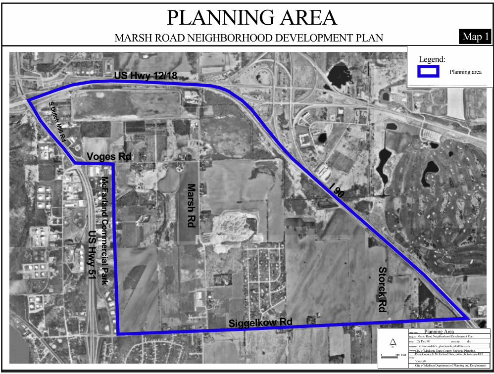
I 90
Voges Rd
Marsh Rd
Siggelkow Rd
Storck Rd
US Hwy 51
US Hwy 12/18
McFarland Comm
ercial Park
S Dutch Mill Rd
Map 1
Project:
Date: Drawn By:
Filename:Source:
Notes:
City of Madison Department of Planning and Development
Map Title: Planning AreaMarsh Road Neighborhood Development Plan28 Dec 98 slm
m:\arc\avdata\c_plan\marsh_rd\allthms.aprCity of Madison, Dane County Regional Planning, Dane County & McFarland Data, ortho photo taken 4/97
N
0 500 Feet
View #9
MARSH ROAD NEIGHBORHOOD DEVELOPMENT PLANPLANNING AREA
Planning areaLegend:
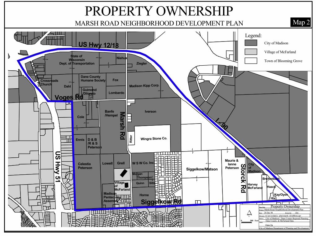
State of Wisconsin
Dept. of Transportation
DahlCrossroads Church
Guimond /Diloreto
Fox
Lombardo
NiehusZiegler
Madison Kipp Corp.
Cole
Ennis
W S W Co. Inc.
Iverson
Madison PentecostalAssembly
ThompsonQuinn Sitts
Horne
Morgan
Dane CountyHumane Society
Banfe/Hempel
GrellLowellCelestiaPeterson
D & B/R & SPeterson
Wingra Stone Co.
Maurie & Ianne
Peterson
Breitenbach
Kay/OyenHix
HaackHarveyMcFarland
Siggelkow/MatsonCity ofMadison
US Hwy 12/18
Marsh Rd
US Hwy 51
Siggelkow Rd
Storck Rd
I - 90
Voges Rd
Villageof McFarland
Ritte
r
S Dutch Mill Rd
PROPERTY OWNERSHIPMARSH ROAD NEIGHBORHOOD DEVELOPMENT PLAN
Project:
Date: Drawn By:
Filename:Source:
Notes:
City of Madison Department of Planning and Development
Map Title:Marsh Road Neighborhood Development Plan28 Dec 98 slm
m:\arc\avdata\c_plan\marsh_rd\allthms.aprCity of Madison , Dane County Regional Planning, Dane County, & McFarland Data
N
Property Ownership
0 500 Feet
View 2a
Map 2
City of Madison
Village of McFarland
Town of Blooming Grove
Legend:
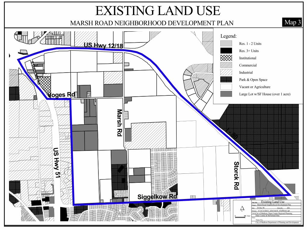
Map 3
US Hwy 12/18
Marsh Rd
US Hwy 51
Siggelkow Rd
Storck Rd
I - 90
Voges Rd
S Dutch Mill Rd
Project:
Date: Drawn By:
Filename:Source:
Notes:
City of Madison Department of Planning and Development
Map Title: Existing Land UseMarsh Road Neighborhood Development Plan28 Dec 98 slm
m:\arc\avdata\c_plan\marsh_rd\allthmes.aprCity of Madison, Dane County Regional Planning, Dane County & McFarland Data
N
0 500 Feet
View #1c
MARSH ROAD NEIGHBORHOOD DEVELOPMENT PLANEXISTING LAND USE
Res. 1 - 2 UnitsRes. 3+ UnitsInstitutionalCommercialIndustrialPark & Open SpaceVacant or AgricultureLarge Lot w/SF House (over 1 acre)
Legend:
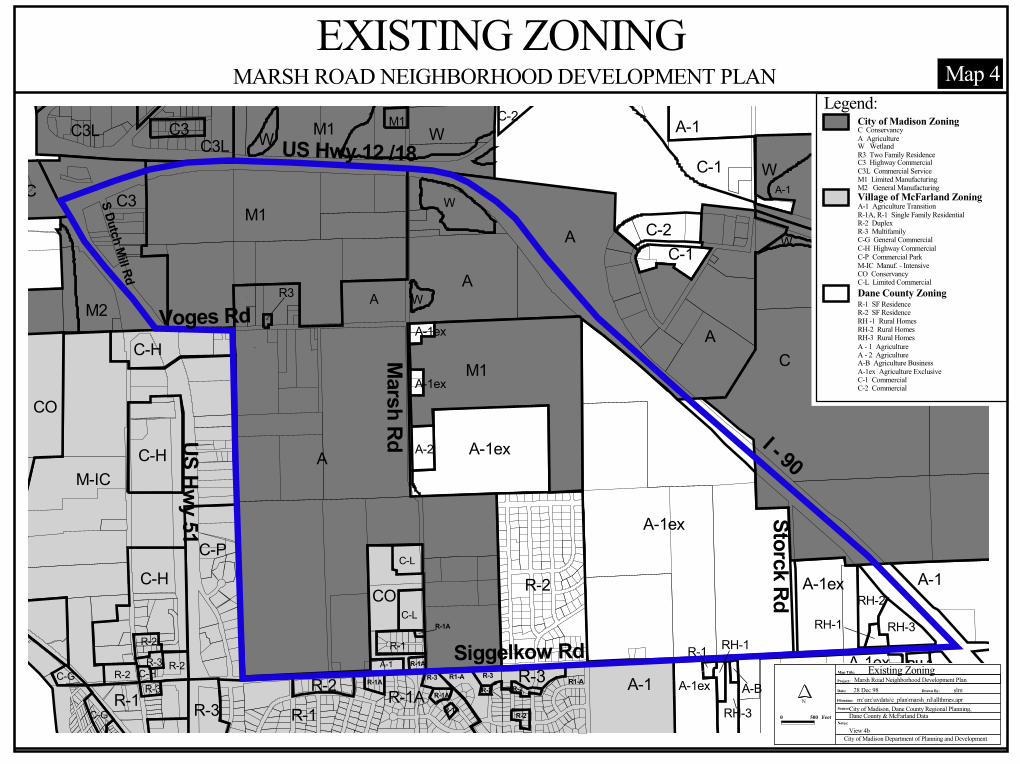
Map 4
C-L
C-L
R-1R-2R-3 R-2C-HR-2R-3
C-G
C-G
C-H
C-HM-IC
C-HC-P
R-1A-1R-1AR-3
CO
R-1R-3R-2
CO
A-1
A-1
C-1
C-1C-2
A-1ex
A-1ex A-1
RH-3
RH-2RH-1
R-2
A-1ex
A-1ex
A-1ex
A-2
C-2
A-1
C
W
W
M1
M1C3
C3L M1
A
C
M2
M1
R3 W
W
W
C3LC3 W
A
A
AA
R3
A A
A-1ex
RH-3
R-1 RH-1
A-BA-1ex
US Hwy 12 /18
Marsh RdUS Hwy 51
Siggelkow Rd
Storck Rd
I - 90
Voges Rd
R1-A
R-2R-1A
R-1AR-1A
R-1A
R-1A
R-2
R-3R-2
R1-AR-3RH-2
S Dutch Mill Rd
MARSH ROAD NEIGHBORHOOD DEVELOPMENT PLANEXISTING ZONING
Project:
Date: Drawn By:
Filename:Source:
Notes:
City of Madison Department of Planning and Development
Map Title: Existing ZoningMarsh Road Neighborhood Development Plan28 Dec 98 slm
m:\arc\avdata\c_plan\marsh_rd\allthmes.aprCity of Madison, Dane County Regional Planning, Dane County & McFarland Data
N
0 500 Feet
View 4b
City of Madison ZoningC ConservancyA AgricultureW WetlandR3 Two Family ResidenceC3 Highway CommercialC3L Commercial ServiceM1 Limited ManufacturingM2 General ManufacturingVillage of McFarland ZoningA-1 Agriculture TransitionR-1A, R-1 Single Family ResidentialR-2 DuplexR-3 MultifamilyC-G General CommercialC-H Highway CommercialC-P Commercial ParkM-IC Manuf. - IntensiveCO ConservancyC-L Limited CommercialDane County ZoningR-1 SF ResidenceR-2 SF ResidenceRH -1 Rural HomesRH-2 Rural HomesRH-3 Rural HomesA - 1 Agriculture
A-B Agriculture BusinessA-1ex Agriculture ExclusiveC-1 CommercialC-2 Commercial
A - 2 Agriculture
Legend:
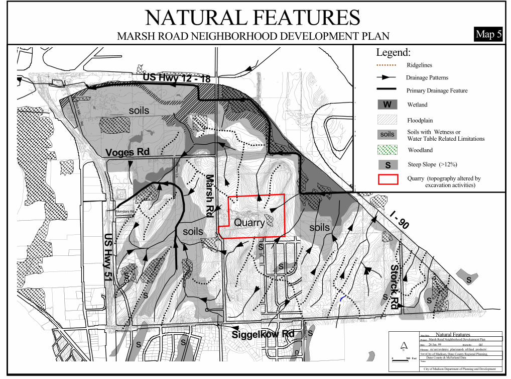
Quarry
Voges Rd
I - 90
Storck Rd
Siggelkow Rd
US Hwy 51
Marsh Rd
US Hwy 12 - 18
soils
soils
soils
S. Dutch Mill Rd.
Meinders Rd.
Tormey La.
Holscher Rd.
ss
s
ss
ss
s ss
Project:
Date: Drawn By:
Filename:
Source:
Notes:
City of Madison Department of Planning and Development
Map Title: Natural FeaturesMarsh Road Neighborhood Development Plan26 Jan. 99 dal
m:\arc\avdata\c_plan\marsh_rd\final_products\City of Madison, Dane County Regional Planning, Dane County & McFarland Data
N
0 500 Feet
NATURAL FEATURESMARSH ROAD NEIGHBORHOOD DEVELOPMENT PLAN
Wetland
Floodplain
Woodland
Steep Slope (>12%)SQuarry (topography altered by excavation activities)
RidgelinesDrainage Patterns
W
Soils with Wetness orWater Table Related Limitationssoils
Primary Drainage Feature
Legend:Map 5
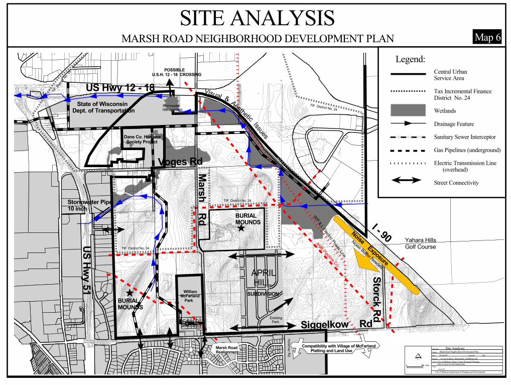
SUBDIVISION
APRIL HILL
WilliamMcFarland Park
State of WisconsinDept. of Transportation
Calico Ct.Subdivision
TIF D
istrict
No. 24
TIF District No. 24
TIF District No. 24
TIF District No. 24
ÊÚ
ÊÚ
Tormey La.
Holscher Rd.
ANR Pipeline Co.
WP & L Electric Power Line
Existing Park
Voges Rd
I - 90
Storck Rd
Siggelkow Rd
US Hwy 51
Marsh Rd
US Hwy 12 - 18
Compatibility with Village of McFarland Platting and Land UseMarsh Road
Realignment
Noise Exposure
StormwaterManagement
Noise Buffer Needed
Yahara HillsGolf Course
Visual & Aesthetic Issues
POSSIBLEU.S.H. 12 - 18 CROSSING
BURIALMOUNDS
BURIALMOUNDS
Stormwater Pipe10 inch
Dane Co. Humane Society Project
Project:
Date: Drawn By:
Filename:Source:
Notes:
City of Madison Department of Planning and Development
Map Title: Site AnalysisMarsh Road Neighborhood Development Plan25 Jan 99 dal
m:\arc\avdata\c_plan\marsh_rd\allthmes.aprCity of Madison, Dane County Regional Planning, Dane County & McFarland Data
N
0 500 Feetview #6
MARSH ROAD NEIGHBORHOOD DEVELOPMENT PLANSITE ANALYSIS
Map 6
Central UrbanService Area
Tax Incremental FinanceDistrict No. 24
Wetlands
Drainage Feature
Sanitary Sewer Interceptor
Gas Pipelines (underground)
Electric Transmission Line (overhead)
Street Connectivity
Legend:
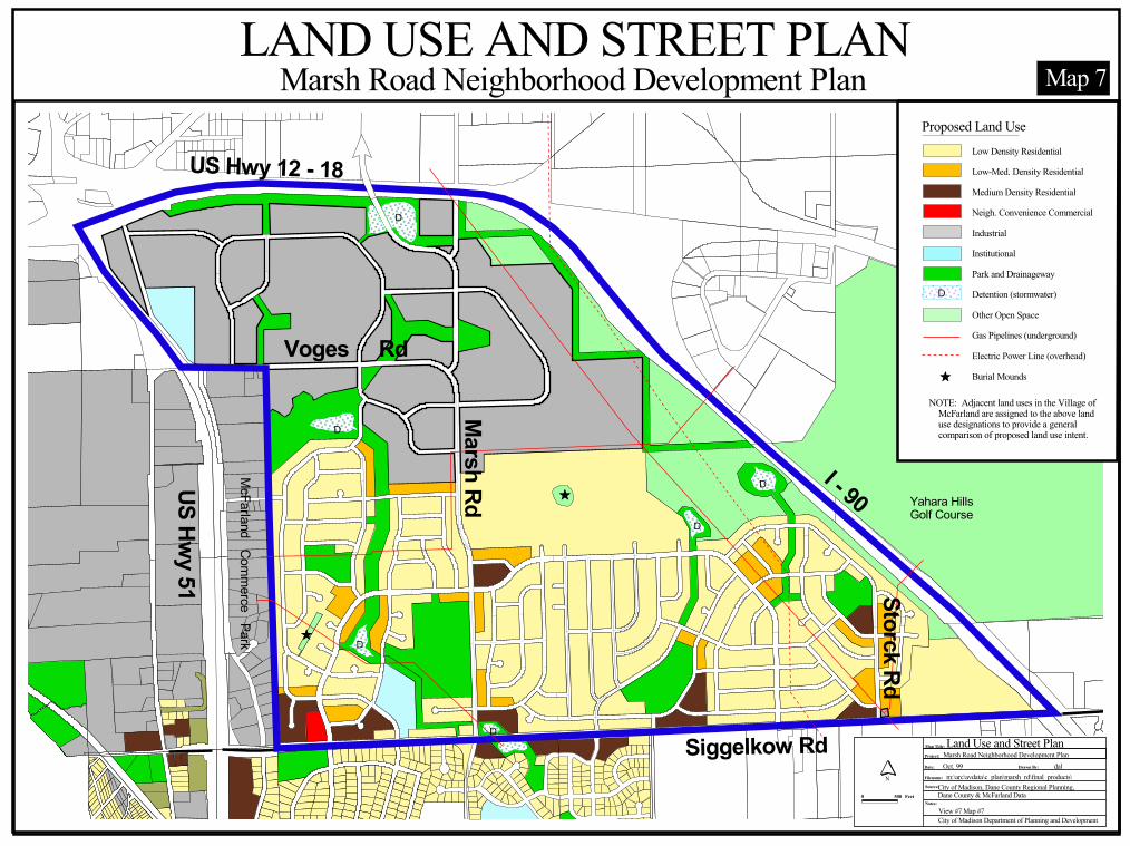
Yahara Hills Golf Course
US Hwy 12 - 18
Marsh RdUS Hwy 51
Siggelkow Rd
Storck Rd
I - 90
Voges Rd
D
D
D
D
D
DÊÚ
ÊÚ
McFarland Commerce Park
Project:
Date: Drawn By:
Filename:Source:
Notes:
City of Madison Department of Planning and Development
Map Title: Land Use and Street PlanMarsh Road Neighborhood Development PlanOct. 99 dal
m:\arc\avdata\c_plan\marsh_rd\final_products\City of Madison, Dane County Regional Planning, Dane County & McFarland Data
N
0 500 Feet
View #7 Map #7
Marsh Road Neighborhood Development PlanLAND USE AND STREET PLAN
NOTE: Adjacent land uses in the Village of McFarland are assigned to the above land use designations to provide a general comparison of proposed land use intent.
Low Density Residential
Low-Med. Density Residential
Medium Density Residential
Neigh. Convenience Commercial
Industrial
Institutional
Park and Drainageway
Detention (stormwater)
Other Open Space
Gas Pipelines (underground)
Electric Power Line (overhead)
Burial Mounds
D
ÊÚ
Proposed Land Use
Map 7
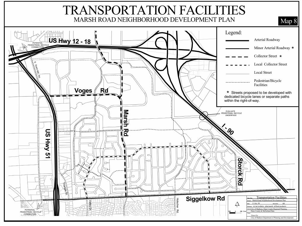
POTENTIALPEDESTRIAN / BICYCLE CONNECTION
EVALUATEPEDESTRIAN / BICYCLE UNDERPASS
Triangle St.
S. Dutch Mill Rd.
Storck Rd
Valley Dr.
Siggelkow RdHolscher Rd.
Voges Rd
I - 90US Hwy 51
Marsh Rd
US Hwy 12 - 18 POTENTIALPEDESTRIAN / BICYCLE CONNECTION
Project:
Date: Drawn By:
Filename:
Source:
Notes:
City of Madison Department of Planning and Development
Map Title: Transportation FacilitiesMarsh Road Neighborhood Development Plan11 Oct. 99 dal
m:\arc\avdata\c_plan\marsh_rd\final products\City of Madison, Dane County Regional Planning, Dane County & McFarland Data
N
300 0 300 Feet
View #1c
Legend:Arterial Roadway
Minor Arterial Roadway
Collector Street
Local Collector Street
Local Street
Pedestrian/Bicycle Facilities
*
**
Streets proposed to be developed withdedicated bicycle lanes or separate pathswithin the right-of-way.
MARSH ROAD NEIGHBORHOOD DEVELOPMENT PLAN Map 8TRANSPORTATION FACILITIES
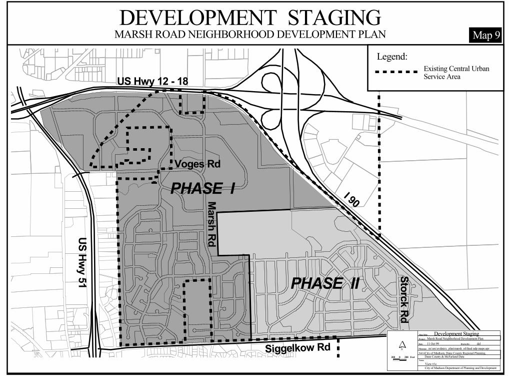
I 90
Voges Rd
Marsh Rd
Siggelkow Rd
Storck Rd
US Hwy 51
US Hwy 12 - 18
PHASE I
PHASE II
DEVELOPMENT STAGINGMARSH ROAD NEIGHBORHOOD DEVELOPMENT PLAN
Project:
Date: Drawn By:
Filename:
Source:
Notes:
City of Madison Department of Planning and Development
Map Title: Development StagingMarsh Road Neighborhood Development Plan11 Oct 99 dal
m:\arc\avdata\c_plan\marsh_rd\final ndp maps.aprCity of Madison, Dane County Regional Planning, Dane County & McFarland Data
N
200 0 200 Feet
View #1c
Map 9Legend:
Existing Central UrbanService Area
1
Appendix A: Long Range Transportation Planning Commission Minutes of 8/19/99
Note: This is an excerpt from the minutes of the Long Range Transportation Planning Commission meeting of August 19, 1999. This format is being utilized to focus on agenda item No. 6 regarding the Marsh Road Neighborhood Development Plan.
1. ROLL CALL
Members Present: Fred Arnold; Ann Falconer; Ald. Ken Golden; Ald. Steve Holtzman; Brett Hulsey; Rob Kennedy; Dale Nordeen; Ald. Kent Palmer; Ald. Gary Poulson; Dick Wagner.
Members Absent: Mike Rewey (notified).
Staff Present: Bill Fruhling (Planning Unit); Duane Hinz (Parking Utility); Brad Murphy
(Planning Unit); Larry Nelson (City Engineering); Mark Olinger (Director, Department of Planning and Development); Dave Trowbridge (Planning Unit).
Others Present: None.
6. SUBSTITUTE RESOLUTION ID 25062, “ADOPTING THE MARSH ROAD
NEIGHBORHOOD DEVELOPMENT PLAN AS AN ELEMENT OF THE MASTER PLAN FOR THE CITY OF MADISON TO BE USED AS A GUIDE FOR COMMUNITY PLANNING AND DEVELOPMENT, AND AMENDING THE CITY OF MADISON LAND USE PLAN TO INCORPORATE ITS RECOMMENDATIONS, AND AUTHORIZING THE CITY’S APPLICATION TO AMEND THE CENTRAL URBAN SERVICE AREA TO INCLUDE LANDS WITHIN THE MARSH ROAD NEIGHBORHOOD”: LRTPC DISCUSSION/CONSIDERATION
MINUTES
LONG-RANGE TRANSPORTATION PLANNING COMMISSION (LRTPC)
Thursday, August 19, 1999 Room LL-110, Madison Municipal Building
4:30 p.m.
Appendix A – Page 1
2
Dave Trowbridge introduced the next agenda item, which was Substitute Resolution ID 25062, adopting the Marsh Road Neighborhood Development Plan (NDP). Trowbridge introduced Bill Fruhling, Planner 4 in the City’s Planning Unit, and noted that Mr. Fruhling was instrumental in the preparation of the Marsh Road Plan. Trowbridge said that he has asked Fruhling to provide the Commission a brief overview of the planning process that took place and summarize the final recommendations contained in the Plan. Trowbridge also asked Fruhling to discuss some issues that are of special concern to the LRTPC. He reminded Commissioners of the issues discussed at the 7/15 LRTPC meeting, which focused on peripheral neighborhood development, associated street needs created by such peripheral developments. The 7/15 Commission discussion also focused on the transportation “connectivity” of these neighborhoods - connectivity both within the neighborhoods and connectivity to areas outside the neighborhoods. Trowbridge added that this review of the Marsh Road Plan might be a good case to examine how NDPs are developed, in principle, and how the final plan recommendations are arrived at (including street networks), given the numerous and varied planning challenges that often exist in peripheral areas.
Fruhling began his overview by pointing out that development of the Marsh Road NDP started in 1994, and noted that planning for the Marsh Road area was very complex and challenging, due to numerous factors. He showed the area on a map and noted that it was bounded by the Village of McFarland (south), the South Beltline (north), USH 51 and existing development (west) and I-90 (east). Fruhling also noted that the Marsh Road planning area has an existing subdivision and an existing McFarland park (with buildings) located within in.
Fruhling then pointed out some of the external transportation connectivity issues with the planning area, and noted that the major arterial highways bounding the planning area formed significant barriers for transportation. The Plan attempts to alleviate these as best possible. To the north, an “overpass” crossing of the Beltline is possible, which would be an extension of northbound Marsh Road (and construction of an S-curve through the planned industrial development area). Such a crossing, Fruhling added, would accommodate bicycles and pedestrians as well.
Brett Hulsey asked whether or not a trip generation evaluation had been done for the planning area. Fruhling responded that a formal analysis had not been done, but the recommended street system reflects a basic understanding of the nature and volumes of traffic that would be expected. Dick Wagner asked about the ownership of the planned industrial lands, just south of the Beltline (abutting the highway). Fruhling responded that the State of Wisconsin owns the land at this time. The land, he added, had been used as a dredge area during construction of the South Beltline, and would be sold in the future for development.
Fruhling continued by noting that Interstate 90, forming the eastern boundary of the planning area, was a tremendous barrier to points east. However, the Yahara Hills Golf Course and a small commercial area (near the bingo hall) are the only developments that exist to the east (before USH 12/18 forms yet another barrier), and it was decided that a street facility connecting the Marsh Road Neighborhood to these areas was not critical. Connections to numerous commercial developments in McFarland were judged to be more important to the Marsh Road Neighborhood. In addition, other options for accessing the Yahara Hills area are available. Finally, to the east, Siggelkow Road provides a connection under I-90.
Fruhling noted that, to the south, Siggelkow Road divides McFarland and the City of Madison, and an intergovernmental agreement between the two units of government establishes this “dividing line” for
Appendix A – Page 2
3
future annexation activities and development over the next approximately 20 years. Across Siggelkow Road to the south, there is a great deal of development and numerous street connections are provided from the Marsh Road Neighborhood. In fact, he added, 7 connections in about 1 ½ miles along Siggelkow Road are provided to McFarland developments to the south.
To the west, Fruhling continued, existing McFarland development forms a connectivity barrier to the Marsh Road planning area. The deve lopment is a small “commerce park” off of a frontage road, with numerous existing buildings. This existing development leaves Siggelkow Road and Voges Road as the only ways to access USH 51 to the west. Further west (to the western side of USH 51), the petroleum tank farms and Lake Waubesa area exist, which do not seem to be areas critical for connectivity.
Kennedy referred to the potential crossing to the north, the Dutch Mill crossing, and noted that this would be an important crossing to the Dutch Mill area. He added that pedestrian and bicycle connections would be especially important, especially in light of the poor crossing conditions at the USH 51/South Beltline interchange area. Fruhling said that this was recognized, and noted that this could be an area for a potential “transportation enhancement” project. Fruhling also noted that, although a street connection was not deemed to be necessary, a potential bicycle or pedestrian connection across I-90 to the east (to the bingo hall commercial area) could be explored. Ann Falconer mentioned that, with the potential Dutch Mill crossing to the north, an important link to the park-and-ride lot would be provided. Larry Nelson noted that the Dutch Mill crossing is a broad issue, and has many issues need to be addressed, such as linkages from McFarland (and the rail corridor) and connections through the City of Monona. Steve Holtzman added that, even without street connections, pedestrian and bicycle connections are important. He noted that in the Hill Farms area, in his aldermanic district, several paths and easements exist.
Kennedy asked about the recommended pathway on the Plan map, and why it meandered the way it was shown. Fruhling responded that it followed a creek and that a potential connection to the north was possible. Kennedy also asked about a planned residential area on the map. Fruhling responded that it is an existing quarry and that this limits opportunities to provide connections, particularly with streets. He added that he would be talking more about the internal street issues, and challenges, a bit later. Dick Wagner noted that the rail corridor/Siggelkow Road area may be an area where a potential bicycle linkage would be desirable.
Holtzman noted that the Marsh Road NDP seemed to have numerous external connectivity opportunities, particularly when compared to previous developments on the west side. However, he added, some “new urbanism” concepts were being proposed on the far west side, such as on a Frautschi-developed property. This planned development has a central civic area, with commercial land uses within walking distance of homes. This will theoretically reduce the number of auto trips per household. Holtzman wondered why these concepts didn’t seem to be included in the Marsh Road NDP. The red commercial areas (on the map) seemed to be located in isolation. Fruhling responded that the Marsh Road area is basically an infill development area between Madison and McFarland, which creates some challenges. At the beginning of the planning process, we wanted to create a village center and commercial node in the central part of the planning area. However, trying to locate this area ran into significant opposition from the existing population, neighbors who were opposed to an intense commercial development near them. In addition, an existing park, unsuitable land and limited connections to the potential area limited what could be done. Given these concerns
Appendix A – Page 3
4
and weighing the relative advantages and disadvantages, it was decided to recommend moving the commercial area onto Siggelkow Road, at the entrance of the neighborhood.
Holtzman noted that neighborhoods often react in a parochial fashion, and we should be sure that their opposition is not the only reason for altering our recommendations. Fruhling agreed, but responded that many constraints to planning purely new urbanism concepts, beyond simple neighborhood opposition, were in place - especially existing development in the area.
Ken Golden asked what the ultimate population of the neighborhood would be. Fruhling said that about 1,800 new dwelling units were being planned for, which Golden suggested would translate into about 4,200 persons. Golden said that, in looking at the Plan, community separation issues seemed to emerge. He added that it seemed like the residential areas in the Plan felt more like the Village of McFarland than the City of Madison, although he recognized the need for City industrial lands in this area (because of a shortage of such lands in the City). Fruhling said that they have been working with McFarland planners and they have been supportive of City efforts, in addition to the intergovernmental agreement. Larry Nelson added that the planned residential areas are within the Madison Metropolitan School District. Brad Murphy pointed out that negotiations regarding school districting took place, and it was determined that most of the Marsh Road neighborhood area would be served by City schools. Golden then surmised that neighborhood kids would attend Glendale Elementary and LaFollette High Schools. Kennedy pointed out the importance of the Dutch Mill connection, particularly in light of the school district issue.
Fruhling then discussed some of the internal transportation connectivity issues, and reiterated the point that the Marsh Road planning area has numerous challenges for planning and establishing a complete grid street pattern for internal neighborhood mobility. These challenges/constraints include:
- the existing April Hill subdivision in the Town of Blooming Grove; - an existing quarry in the center of the planning area; - an existing McFarland park with a number of buildings; - numerous scattered homes within the planning area; - numerous underground utilities and pipelines serving the nearby petroleum tank farms; - high-voltage power lines through the planning area; - existing sanitary sewer lines in the area; - significant drainageways; and, - existing Native American burial mounds.
Fruhling said that, in planning the internal street system, they started with a proper grid pattern and consideration of external connections. Then the physical challenges and constraints were factored in and the grid pattern was modified, over several iterations. The street pattern emerged after an evaluation of what made practical sense, and considering additional factors such as cost and minimizing the encroachment/crossing of the drainageways. In addition, a more complete connection to the west (through the commerce park to access USH 51) was considered, but not recommended because we did not want to encourage a lot of neighborhood traffic using that connection. This was due primarily to the limited design of the intersection of Voges Road and the USH 51 east frontage road (which would not be able to handle high traffic volumes) and our desire to not mix a great deal of residential and industrial traffic. However, physical access to the intersection was provided, as a “safety valve” of sorts, in case of an emergency situation.
Appendix A – Page 4
5
Kennedy asked about a potential bicycle and pedestrian connection through the existing park, and noted that this would help allow for more direct connectivity. Brad Murphy and Fruhling noted that these recommendations could be added, for purposes of connectivity.
Ken Golden expressed concerns about the language regarding internal street right-of-way (ROW), and said that 60 to 66 feet was too much. Fruhling responded that it is the developer’s option, but in the Marsh Road NDP case, reducing the ROW does not add any additiona l development parcels. Golden acknowledged the limitations in creating development parcels. Fruhling added that language contained in the Mid-Town Road Amendment to the High Point/Raymond NDP included language that was permissive, and allowed for less than 66 feet. Golden suggested that the text be modified to assume 56 foot internal street ROWs as the Plan recommendation, and if the developer or property owner wishes to change it to something greater, they will have to ask for that in the future.
Buzz Nordeen asked if the Town of Blooming Grove’s Land Use Plan was considered. Fruhling responded that the Blooming Grove Plan was still in draft form, but that they were working with them. Fruhling referred to the resolution, which contains language to that effect.
Rob Kennedy asked about the future implementation of the Marsh Road NDP, and whether or not there could be some assurance that the NDP is implemented properly and contains all of the important elements that are fundamental to a good plan. Dick Wagner responded that there is no guarantee that the Plan will be implemented fully as planned, and that modifications occur over time (as specific development proposals that are brought forward). Ken Golden added that it boils down to the will and backbone of the Plan Commission. The Plan Commission can either accept or reject variations from the original recommendations and concepts contained in the NDPs. Buzz Nordeen added that the NDPs are useful, serving as a guide to help the Plan Commission to review specific development proposals. Wagner added that the NDPs are good tools to help guide private investments, although some public infrastructure investment recommendations are contained within these plans.
Ken Golden said that the connection/crossing of the South Beltline was particularly critical to the Marsh Road Neighborhood. Ann Falconer stressed the importance of ensuring that these critically important linkages not be removed, as future development proposals are brought forward in the future. Kennedy agreed and asked what can be done to place a very high priority on some of these recommendations. He added that they are critically important to the health and functionality of this neighborhood. Golden replied that this is the $64,000 question. In fact, Golden said that he has asked Dave Trowbridge to conduct an evaluation/analysis of the Junction Road NDP. Specifically, Golden said that he would like to determine how and why that area has developed differently from originally recommended in the NDP. He would also like to try and isolate where the fundamental NDP’s recommendations were compromised. He said that we need to have a clear record of where critical decisions affecting the NDP area were made, and how they ultimately affected the area. Golden added that this would be useful information for future Plan Commission decision making.
Kennedy agreed and added that it would be useful to compile a list of key areas or recommendations of NDPs that cannot be compromised. Dick Wagner suggested developing a list of critical or fundamental elements of a NDP and specifying them clearly in the plans.
Brad Murphy said that City planners have tried to develop NDPs both ways in the past - (1) very specifically and (2) in a manner that includes only key elements (in concept only), and allows for some variation. There are advantages and disadvantages to both approaches. In general, providing
Appendix A – Page 5
6
more detail in the plans gives the developer some idea of what the City is likely to support (and gives them some conceptual basis to start with). More detail basically forces the developer to react to the original NDP recommendations. Kennedy still felt that it would be helpful to clearly identify the key fundamentals and principles of the plan, to help ensure that they are not compromised in the development review process.
Fred Arnold asked if there was any interest expressed in the planned industrial lands south of the Beltline. Fruhling responded that there was moderate interest. Arnold asked if the completion and adoption of NDPs helps to precipitate interest in the development of land in those areas. Brad Murphy responded that, if the NDP is adopted, this sends a message to the developer about the City’s goals for that area, and gives them some idea of what might be supported. If public services (such as sanitary sewer and water) are available, the existence of an NDP seems to spur development in some areas. In the Phase I development staging areas in the Marsh Road NDP, public services are available and it is likely to encourage development. In the Phase II areas, services are not yet available. Dick Wagner added that, in order to get an urban service area amendment, an NDP must be in place.
Nordeen submitted a motion (seconded by Kennedy) to approve Substitute Resolution ID 25062, subject to the inclusion of a discussion paper that summarizes the fundamental components of the Plan, to provide guidance for future Plan Commission decision making. Golden suggested that the attachment of the Minutes from this meeting as an appendix to the Marsh Road Neighborhood Development Plan should be sufficient to meet Nordeen’s intent. The Commission agreed and the motion was approved.
Appendix A – Page 6