Marine Geophysical
23
1 23 Marine Geophysical Research An International Journal for the Study of the Earth Beneath the Sea ISSN 0025-3235 Mar Geophys Res DOI 10.1007/s11001-013-9171-y The sedimentary, magmatic and tectonic evolution of the southwestern South China Sea revealed by seismic stratigraphic analysis Lu Li, Peter D. Clift & Hung The Nguygen
Transcript of Marine Geophysical

1 23
Marine Geophysical ResearchAn International Journal for the Study ofthe Earth Beneath the Sea ISSN 0025-3235 Mar Geophys ResDOI 10.1007/s11001-013-9171-y
The sedimentary, magmatic and tectonicevolution of the southwestern South ChinaSea revealed by seismic stratigraphicanalysis
Lu Li, Peter D. Clift & Hung TheNguygen

1 23
Your article is protected by copyright and all
rights are held exclusively by Springer Science
+Business Media Dordrecht. This e-offprint
is for personal use only and shall not be self-
archived in electronic repositories. If you
wish to self-archive your work, please use the
accepted author’s version for posting to your
own website or your institution’s repository.
You may further deposit the accepted author’s
version on a funder’s repository at a funder’s
request, provided it is not made publicly
available until 12 months after publication.
ORIGINAL RESEARCH PAPER
The sedimentary, magmatic and tectonic evolutionof the southwestern South China Sea revealed by seismicstratigraphic analysis
Lu Li • Peter D. Clift • Hung The Nguygen
Received: 16 November 2012 / Accepted: 20 February 2013
� Springer Science+Business Media Dordrecht 2013
Abstract The southwestern South China Sea represents an
area of continental crust frozen immediately before the onset
of seafloor spreading. Here we compile a grid of multi-
channel seismic reflection data to characterize the continent-
ocean transition just prior to full break-up. We identify a
major continental block separated from the shelf margin by a
basin of hyperextended crust. Oligocene-Early Miocene
rifting was followed by mild compression and inversion
prior to 16 Ma, probably linked to collision between the
Dangerous Grounds, a continental block to the east of the
study area, and Borneo. The timing of inversion supports
models of seafloor spreading continuing until around 16 Ma,
rather than becoming inactive at 20 Ma. The off-shelf banks
experienced uplift prior to 16 Ma in an area, which had
previously been a depocenter. The off-shelf banks continued
to extend after this time when the rest of the region is in a
phase of thermal subsidence. Post-rift magmatism is seen in
the form of scattered seamounts (*5–10 km across) within
or on the edge of the deeper basins, and are dated as Late
Miocene and Pliocene. They are not clearly linked to any
phase of tectonic activity. Further inversion of the off-shelf
banks occurred in the Pliocene resulting in a major uncon-
formity despite the lack of brittle faulting of that age. We
speculate that this is part of a wider pattern of scattered
magmatism throughout the South China Sea at this time.
Prograding clinoforms are seen to build out from the shelf
edge in the south of the study area during the Pliocene, after
5.3 Ma, and then more towards the north and east during the
Pleistocene. At the same time a trough south of the off-shelf
banks is filled with [1.35 km of mostly Pleistocene sedi-
ment. While we expect the bulk of the sediment to come
from the Mekong River, we also suggest additional sediment
supply from Borneo and the Malay Peninsula via the
Molengraaff River and its predecessors.
Keywords Seismic stratigraphy � Extension � Inversion �Seamounts � Clinoforms
Introduction
The rifting and break-up of continental crust to form oceanic
basins is a fundamental stage in the Wilson cycle of plate
tectonics, which also generates passive continental margins
that are valuable archives of sediment that record the evo-
lution of continental weathering and erosion conditions, as
well as being important locations for hydrocarbon accumu-
lations. While much research has been done on the processes
of rifting, the transition from continental extension into
seafloor spreading remains poorly understood. Although
there is an understanding that some rifted margins are very
magmatic and associated with flood basalt provinces (e.g.,
Northeast Atlantic, South Atlantic, NW Indian Ocean)
(White 1997; Franke et al. 2008), others are believed to be
almost amagmatic (e.g., Iberia-Newfoundland, South
Australia) (Tucholke et al. 2007; Peron-Pinvidic and
Manatschal 2009). While these differences have been linked
to mantle asthenospheric temperatures, finite element mod-
eling of the lithosphere extension now suggests that rates of
L. Li (&)
School of Geosciences, University of Aberdeen,
Aberdeen AB24 3UE, UK
e-mail: [email protected]
P. D. Clift
Department of Geology and Geophysics, Louisiana State
University, Baton Rouge, LA 70803, USA
H. T. Nguygen
Vietnam Petroleum Institute, Hanoi, Vietnam
123
Mar Geophys Res
DOI 10.1007/s11001-013-9171-y
Author's personal copy
extension are also critical (Huismans and Beaumont 2007).
The nature of strain accommodation during break-up is also
controversial and also potentially linked to strain rates
(Huismans et al. 2005). Amagmatic margins are often linked
to development of low-angle detachments prior to final
break-up (Reston et al. 1996), while extension may be more
uniform or even depth-dependent as extension increases
prior to break-up in other settings (Driscoll and Karner 1998;
Davis and Kusznir 2004). The nature of crust in the conti-
nent-ocean transition zone is often obscure and has variously
been described as continental mantle lithosphere, lower
crust, volcanic rocks, or upper continental rocks intruded by
syn-rift magmatism (White et al. 1987; Perez-Gussinye et al.
2001; Whitmarsh et al. 2001). Moving beyond these end-
member margin types, it is increasingly recognized that not
all margins fit neatly into these categories.
The South China Sea (Fig. 1) shows evidence for break-
up that does not neatly fit either magmatic or amagmatic end
members (Clift et al. 2001; Yan et al. 2001). It is, however, an
excellent natural laboratory for looking at the process of
break-up because the conjugate passive margins can be
readily matched and most importantly, the propagating rift is
preserved in the southwestern part of the basin (Huchon et al.
2001). In this area, seafloor spreading is evidenced by
magnetic anomalies, but also passes through a transition
zone between southern Vietnam and Borneo (Fig. 1). This
zone offers the opportunity to examine the transition
between moderately rifted crust under the Sunda Shelf and
the hyper-extended crust ahead of the seafloor spreading
center. While studies have been made of the propagating tip
and the basins of southern Vietnam (Huchon et al. 2001; Lee
et al. 2001; Fyhn et al. 2009), this study is the first that
extends the marine geophysical data coverage to survey the
transition zone between these crustal domains. In addition,
the region provides the opportunity to examine well devel-
oped, but enigmatic volcanism that is apparently not strongly
linked to the basin opening processes (Tu et al. 1991; Li et al.
1994; Shi et al. 2011).
The region is also well placed to examine the history of the
Mekong Delta. The Mekong River is one of the great rivers of
eastern Asia and originates in the Tibetan Plateau, flowing
through Indochina to the modern delta. However, it has been
suggested that the development of rivers in this region has been
influenced by the uplift of the topography since the start of
India-Asia collision (Brookfield 1998; Clark et al. 2004), likely
in the Eocene. In this type of model retilting of eastern Asia
towards the east since the Eocene (Wang 2004) has caused
major drainage reorganization, whose timing remains con-
troversial (Clift et al. 2006; Kong et al. 2012; Yan et al. 2012).
It has been suggested that the upper reaches of the Mekong
used to flow into the headwaters of the Red River and has
subsequently been captured away from that system (Clark et al.
2004). Knowing the timing of growth of the Mekong Delta
would be important for testing models for drainage evolution
and understanding how it might be linked to tectonic processes
in SE Asia. Because the submarine delta of the Mekong lies on
the outer Sunda Shelf, we also have the opportunity to provide
a minimum age for the timing of delta initiation and thus
potential headwater capture, which is presently unclear (Clift
et al. 2004; Murray and Dorobek 2004).
Geologic setting
The cause of opening of the South China Sea has long been
debated with the arguments falling into two categories. Some
workers propose that the South China Sea formed as the result
of the extrusion and rotation of Indochina relative to southern
China in response to the collision of India and Eurasia (Tap-
ponnier et al. 1986; Briais et al. 1993; Replumaz et al. 2001;
Replumaz and Tapponnier 2003; Leloup et al. 2007; Fyhn
et al. 2009). In contrast, others have argued that the South
China Sea is a marginal basin formed by subduction-related
stresses, similar to the Sea of Japan (Holloway 1982; Taylor
and Hayes 1983; Clift et al. 2008). In this case the extension
that formed the modern South China Sea was caused as the
southern margin was pulled south, away from southern China
by subduction of a paleo-South China Sea under northern
Borneo (Ru and Pigott 1986; Morley 2002). Most recently
Cullen et al. (2010) argued in favor of an origin incorporating
aspects of both extrusion and subduction related processes.
The rifting of the South China Sea is dated as being Eocene to
Early Oligocene (Ru and Pigott 1986) or maybe earlier in the
Cretaceous-Eocene (Su et al. 1989; Rangin and Silver 1991;
Schluter et al. 1996; Clift and Lin 2001). The extrusion model
is consistent with the left-lateral strike-slip motion along the
Red River Fault (Tapponnier et al. 1986; Briais et al. 1993;
Replumaz et al. 2001; Replumaz and Tapponnier 2003),
whereas the subduction model requires right-lateral motion
(Holloway 1982; Taylor and Hayes 1983).
In the Middle Oligocene (*30 Ma) rifting was followed
by seafloor spreading along the northern margin, although in
the Late Oligocene the ridge jumped to the south, out of the
Xisha Trough and seafloor spreading then continued, prop-
agating towards the southwest until the Middle Miocene,
although there is some dispute about whether spreading
continued until only 20 Ma (Barckhausen and Roeser 2004)
or whether it lasted until 16 Ma (Briais et al. 1993). Recently
published magnetic data suggest that the start of seafloor
spreading dates from *37 Ma in the most northerly parts of
the basin, immediately SW of Taiwan (Hsu and Sibuet 2004).
Our study area (Fig. 1) lies in the southwestern South
China Sea, straddling the edge of the continental margin
and extending into deep water. To the northwest the area is
bounded by the southern Vietnamese margin, and to the
Mar Geophys Res
123
Author's personal copy

northeast there is the continent-ocean transition zone linked
to the now inactive seafloor spreading center. To the south
lies central Borneo and to southeast is Sunda Shelf char-
acterized by two major NW–SE trending structures named
the West Baram Line and Lupar Line (Hutchison 2004),
Our study area mainly overlaps two tectonic provinces,
the Dangerous Grounds and the eastern shelf edge of the
Nam Con Son margin and Sunda Shelf (Fig. 1). The
Dangerous Grounds lie north of Borneo and is separated
from the island by the North Borneo Trough (Hutchison
2010). The main part of the Dangerous Grounds is com-
posed of continental crust and was extended during the
Eocene–Oligocene (Taylor and Hayes 1983; Schluter et al.
1996). The sediment deposited on the Dangerous Grounds
is supplied both from Borneo and from the Mekong River,
but is quite thin so that the tectonic structures are still well
exposed in the bathymetry (Hutchison and Vijayan 2010).
The Nam Con Son basin, together with the smaller Cuu
Long Basin to the north represent rift structures formed as a
result of the extension prior to seafloor spreading in the
southwestern South China Sea. These are mostly filled by
sediment close to sealevel and are presently supplied with
sediment by the Mekong River. The data for our study
cover the junction of the East Vietnam Transform margin
with the rifted Dangerous Grounds and the Sunda Shelf
(Figs. 1, 2). As a result the basin’s evolution has been
controlled by a number of processes, most notably strike-
slip forces driven by the East Vietnam Transform Zone,
and extensional stresses linked to the propagation of sea-
floor spreading during the Early to Middle Miocene
(Matthews et al. 1997; Huchon et al. 2001; Lee et al. 2001).
The early rifting stage of the Nam Con Son Basin starts in
the Eocene-Early Oligocene. Rifting accelerated during the
Miocene (Matthews et al. 1997; Lee et al. 2001), but in the
Fig. 1 Topographic and shaded bathymetric map of the South China
Sea showing the study area and its relationship with the Red River
faults Zone, Central Highlands of Vietnam, Nam Con Son basin and
with the Sunda Shelf. Solid white line indicates approximate location
of the continent-ocean transition (COT) based on seafloor spreading
anomalies of Briais et al. (1993). The numbers represent the seafloor
spreading anomalies. Blue lines on Sunda Shelf show route of
Molengraaff River system. Map generated by GeoMapApp
Mar Geophys Res
123
Author's personal copy
Middle Miocene extension and subsidence were interrupted
by inversion that also affected the West Natuna Basin and
Indonesian East Java Sea Basin (Matthews et al. 1997;
Hutchison 2004; Clift et al. 2008).
Although active extension has effectively ceased since
16 Ma, the South China Sea has been affected by moderate
degrees of magmatism of uncertain origin. Thick basalts were
emplaced in the Central Highlands of Vietnam around 8 Ma
(Carter et al. 2000) and Plio-Pleistocene volcanism has been
documented from Hainan Island and the adjacent Leizhou
Peninsula (Tu et al. 1991; Shi et al. 2011). Furthermore, young
volcanic seamounts have been observed on the northern margin
of the basin in seismic profiles, especially towards the northeast
edge of the basin (Yeh et al. 2012). While some workers have
suggested that this young, post-rift magmatism is the product of
a South China Sea plume, this has been hard to demonstrate
because the magmatism is much more widespread and without
the typical age progression seen in classic plume tracks such as
Hawaii. Moreover, analysis of dynamic topography in this area
indicates that the crust is depressed over a region of colder than
normal upper mantle, inconsistent with the presence of a typical
plume (Lithgow-Bertelloni and Gurnis 1997).
Datasets and methods
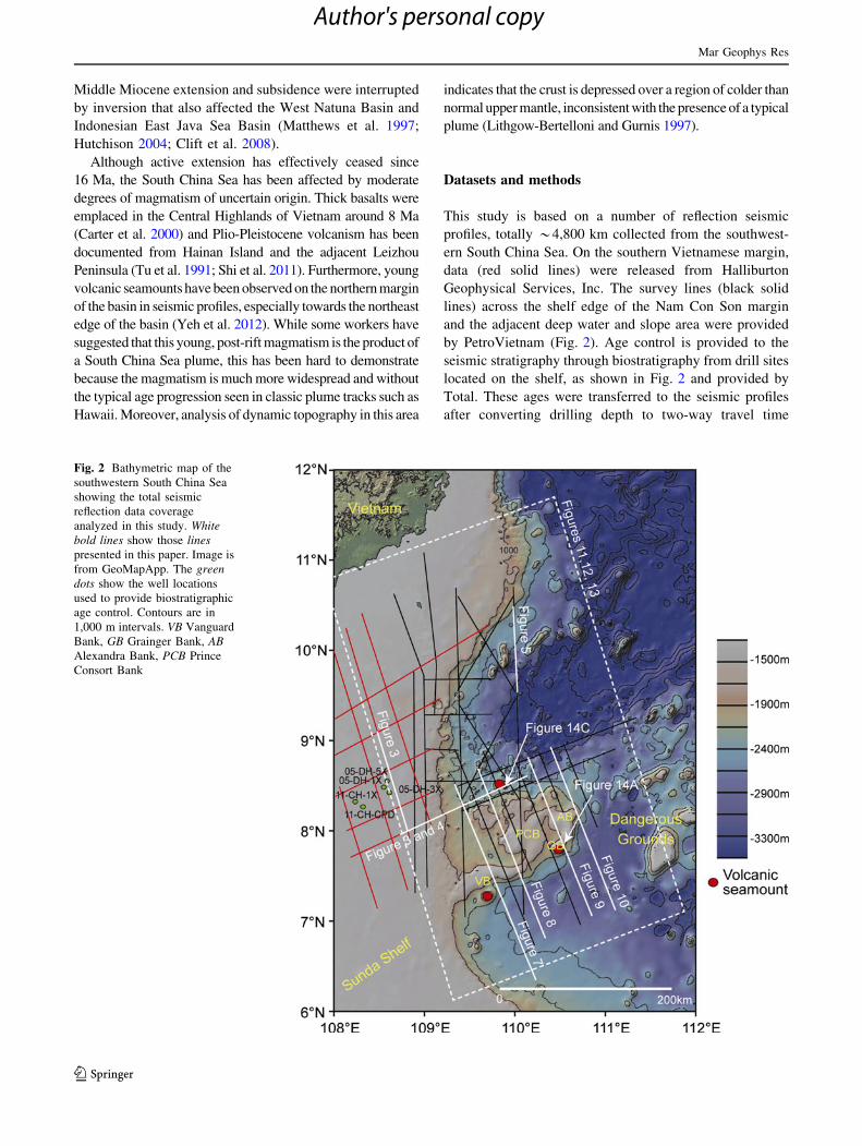
This study is based on a number of reflection seismic
profiles, totally *4,800 km collected from the southwest-
ern South China Sea. On the southern Vietnamese margin,
data (red solid lines) were released from Halliburton
Geophysical Services, Inc. The survey lines (black solid
lines) across the shelf edge of the Nam Con Son margin
and the adjacent deep water and slope area were provided
by PetroVietnam (Fig. 2). Age control is provided to the
seismic stratigraphy through biostratigraphy from drill sites
located on the shelf, as shown in Fig. 2 and provided by
Total. These ages were transferred to the seismic profiles
after converting drilling depth to two-way travel time
Fig. 2 Bathymetric map of the
southwestern South China Sea
showing the total seismic
reflection data coverage
analyzed in this study. Whitebold lines show those linespresented in this paper. Image is
from GeoMapApp. The greendots show the well locations
used to provide biostratigraphic
age control. Contours are in
1,000 m intervals. VB Vanguard
Bank, GB Grainger Bank, ABAlexandra Bank, PCB Prince
Consort Bank
Mar Geophys Res
123
Author's personal copy
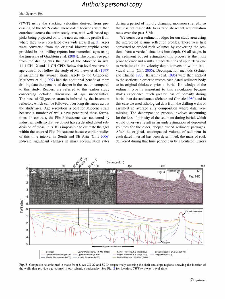
(TWT) using the stacking velocities derived from pro-
cessing of the MCS data. These dated horizons were then
correlated across the entire study area, with well-based age
picks being projected on to the nearest seismic profile from
where they were correlated over wide areas (Fig. 3). Ages
were converted from the original biostratigraphic zones
provided in the drilling reports into numerical ages using
the timescale of Gradstein et al. (2004). The oldest age pick
from the drilling was the base of the Miocene in well
11-1-CH-1X and 11-CH-CPD. Below that level we have no
age control but follow the study of Matthews et al. (1997)
in assigning the syn-rift strata largely to the Oligocene.
Matthews et al. (1997) had the additional benefit of more
drilling data that penetrated deeper in the section compared
to this study. Readers are referred to this earlier study
concerning detailed discussion of age uncertainties.
The base of Oligocene strata is inferred by the basement
reflector, which can be followed over long distances across
the study area. Age resolution is best for Miocene strata
because a number of wells have penetrated these forma-
tions. In contrast, the Plio-Pleistocene was not cored by
industrial wells so that we do not have a detailed dated sub-
division of those units. It is impossible to estimate the ages
within the uncored Plio-Pleistocene because earlier studies
of this time interval in South and SE Asia (Clift 2006)
indicate significant changes in mass accumulation rates
during a period of rapidly changing monsoon strength, so
that it is not reasonable to extrapolate recent accumulation
rates over the past 5 Ma.
We construct a sediment budget for our study area using
the interpreted seismic reflection profiles. These were first
converted to eroded rock volumes by converting the sec-
tions from a vertical time axis into depth. Of all stages in
the sediment budget estimation this process is the most
prone to error and results in uncertainties of up to 20 % due
to variations in the velocity-depth conversion within indi-
vidual units (Clift 2006). Decompaction methods (Sclater
and Christie 1980; Kusznir et al. 1995) were then applied
to the sections in order to restore each dated sediment body
to its original thickness prior to burial. Knowledge of the
sediment type is important to this calculation because
shales experience much greater loss of porosity during
burial than do sandstones (Sclater and Christie 1980) and in
this case we used lithological data from the drilling wells or
assumed an average silty composition where data were
missing. The decompaction process involves accounting
for the loss of porosity of the sediment during burial, which
would otherwise result in an underestimation of deposited
volumes for the older, deeper buried sediment packages.
After the original, uncompacted volume of sediment in
each dated interval has been determined, the mass of rock
delivered during that time period can be calculated. Errors
Fig. 3 Composite seismic profile made from Lines CN-27 and S9-D, respectively covering the shelf and slope regions, showing the location of
the wells that provide age control to our seismic stratigraphy. See Fig. 2 for location. TWT two-way travel time
Mar Geophys Res
123
Author's personal copy
in estimating sediment age, lithology and compaction his-
tory are much smaller than the time-depth conversion and
rarely exceed 5 %.
The process of decompaction was described in detail by
Clift et al. (2004), and followed routine basin analysis
methods, whose results are generally considered robust at the
first order level. In this study two-dimensional decompaction
was calculated using the program Flex-DecompTM (Kusznir
et al. 1995). A basin wide budget was then calculated by
adding together the five sections from across basin and
normalizing the rates for each dated interval in order to
match the calculated total volume of the basin. It must be
assumed that the analyzed profiles were representative of the
total mass flux on to the margin since the Oligocene. This is a
reasonable assumption because our lines cut across all the
major depocenters of the basin and we believe that our choice
of lines does yield a representative image of the total basin
volume. In the absence of 3-D seismic data any volume
calculations would be based on these long lines and no sig-
nificant error was introduced by taking this two dimensional
compiling approach, which follows the methodology laid out
in the regional mass calculation study of Clift (2006).
Results: seismic stratigraphic analysis
The sections were interpreted using the classic seismic
stratigraphic principles of Vail et al. (1977), with the major
depositional packages being defined by erosional sequence
boundaries, typically formed by sealevel fall, although in
this case also by erosion caused by tectonically-driven
uplift, most notably the Mid Miocene Deep Regional
Unconformity (DRU, Reflector B400) (Hazebroek and Tan
1993; Hutchison 1996). We define the following units.
Oligocene (*34–24.5 Ma; maximum
thickness *4.4 km)
This unit is defined as being between our seismic basement
(B600) and a poorly defined reflector within the tilted pre-
rift sequence (B500). The upper surface was picked on the
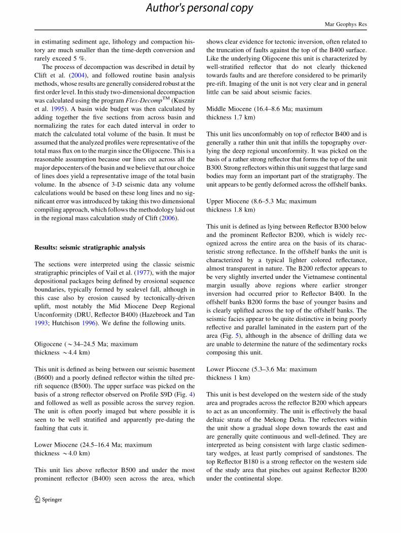
basis of a strong reflector observed on Profile S9D (Fig. 4)
and followed as well as possible across the survey region.
The unit is often poorly imaged but where possible it is
seen to be well stratified and apparently pre-dating the
faulting that cuts it.
Lower Miocene (24.5–16.4 Ma; maximum
thickness *4.0 km)
This unit lies above reflector B500 and under the most
prominent reflector (B400) seen across the area, which
shows clear evidence for tectonic inversion, often related to
the truncation of faults against the top of the B400 surface.
Like the underlying Oligocene this unit is characterized by
well-stratified reflector that do not clearly thickened
towards faults and are therefore considered to be primarily
pre-rift. Imaging of the unit is not very clear and in general
little can be said about seismic facies.
Middle Miocene (16.4–8.6 Ma; maximum
thickness 1.7 km)
This unit lies unconformably on top of reflector B400 and is
generally a rather thin unit that infills the topography over-
lying the deep regional unconformity. It was picked on the
basis of a rather strong reflector that forms the top of the unit
B300. Strong reflectors within this unit suggest that large sand
bodies may form an important part of the stratigraphy. The
unit appears to be gently deformed across the offshelf banks.
Upper Miocene (8.6–5.3 Ma; maximum
thickness 1.8 km)
This unit is defined as lying between Reflector B300 below
and the prominent Reflector B200, which is widely rec-
ognized across the entire area on the basis of its charac-
teristic strong reflectance. In the offshelf banks the unit is
characterized by a typical lighter colored reflectance,
almost transparent in nature. The B200 reflector appears to
be very slightly inverted under the Vietnamese continental
margin usually above regions where earlier stronger
inversion had occurred prior to Reflector B400. In the
offshelf banks B200 forms the base of younger basins and
is clearly uplifted across the top of the offshelf banks. The
seismic facies appear to be quite distinctive in being poorly
reflective and parallel laminated in the eastern part of the
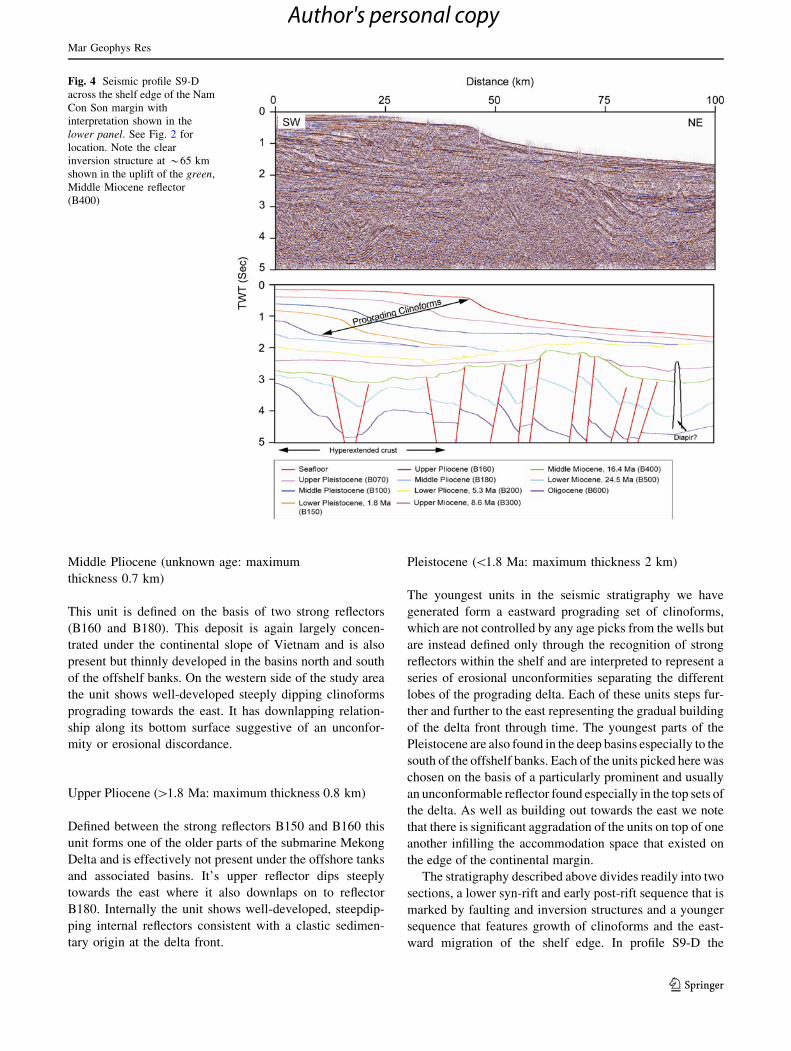
area (Fig. 5), although in the absence of drilling data we
are unable to determine the nature of the sedimentary rocks
composing this unit.
Lower Pliocene (5.3–3.6 Ma: maximum
thickness 1 km)
This unit is best developed on the western side of the study
area and progrades across the reflector B200 which appears
to act as an unconformity. The unit is effectively the basal
deltaic strata of the Mekong Delta. The reflectors within
the unit show a gradual slope down towards the east and
are generally quite continuous and well-defined. They are
interpreted as being consistent with large clastic sedimen-
tary wedges, at least partly comprised of sandstones. The
top Reflector B180 is a strong reflector on the western side
of the study area that pinches out against Reflector B200
under the continental slope.
Mar Geophys Res
123
Author's personal copy
Middle Pliocene (unknown age: maximum
thickness 0.7 km)
This unit is defined on the basis of two strong reflectors
(B160 and B180). This deposit is again largely concen-
trated under the continental slope of Vietnam and is also
present but thinnly developed in the basins north and south
of the offshelf banks. On the western side of the study area
the unit shows well-developed steeply dipping clinoforms
prograding towards the east. It has downlapping relation-
ship along its bottom surface suggestive of an unconfor-
mity or erosional discordance.
Upper Pliocene ([1.8 Ma: maximum thickness 0.8 km)
Defined between the strong reflectors B150 and B160 this
unit forms one of the older parts of the submarine Mekong
Delta and is effectively not present under the offshore tanks
and associated basins. It’s upper reflector dips steeply
towards the east where it also downlaps on to reflector
B180. Internally the unit shows well-developed, steepdip-
ping internal reflectors consistent with a clastic sedimen-
tary origin at the delta front.
Pleistocene (\1.8 Ma: maximum thickness 2 km)
The youngest units in the seismic stratigraphy we have
generated form a eastward prograding set of clinoforms,
which are not controlled by any age picks from the wells but
are instead defined only through the recognition of strong
reflectors within the shelf and are interpreted to represent a
series of erosional unconformities separating the different
lobes of the prograding delta. Each of these units steps fur-
ther and further to the east representing the gradual building
of the delta front through time. The youngest parts of the
Pleistocene are also found in the deep basins especially to the
south of the offshelf banks. Each of the units picked here was
chosen on the basis of a particularly prominent and usually
an unconformable reflector found especially in the top sets of
the delta. As well as building out towards the east we note
that there is significant aggradation of the units on top of one
another infilling the accommodation space that existed on
the edge of the continental margin.
The stratigraphy described above divides readily into two
sections, a lower syn-rift and early post-rift sequence that is
marked by faulting and inversion structures and a younger
sequence that features growth of clinoforms and the east-
ward migration of the shelf edge. In profile S9-D the
Fig. 4 Seismic profile S9-D
across the shelf edge of the Nam
Con Son margin with
interpretation shown in the
lower panel. See Fig. 2 for
location. Note the clear
inversion structure at *65 km
shown in the uplift of the green,
Middle Miocene reflector
(B400)
Mar Geophys Res
123
Author's personal copy
prograding clinoforms are especially well imaged and show
both aggradation and progradation to the east (Figs. 3, 4).
The clinoform sequences appear to be based on the reflector
B200, dated at 5.3 Ma. This seems to represent a relatively
uniform surface over which the clinoforms were built.
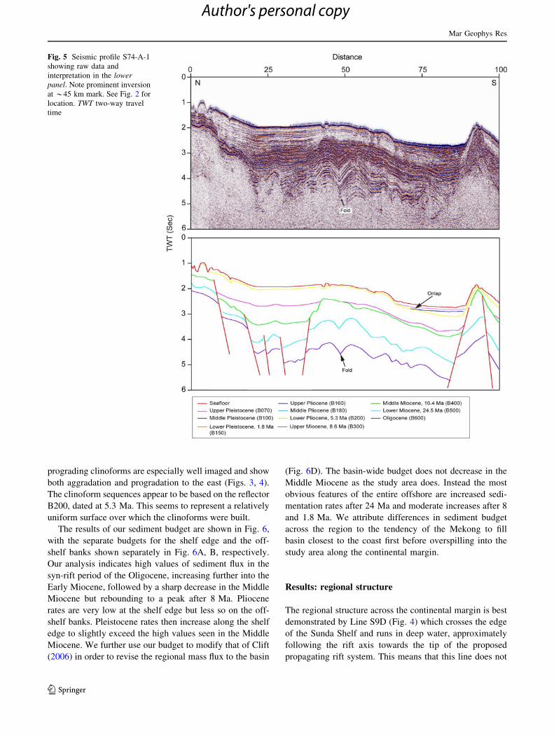
The results of our sediment budget are shown in Fig. 6,
with the separate budgets for the shelf edge and the off-
shelf banks shown separately in Fig. 6A, B, respectively.
Our analysis indicates high values of sediment flux in the
syn-rift period of the Oligocene, increasing further into the
Early Miocene, followed by a sharp decrease in the Middle
Miocene but rebounding to a peak after 8 Ma. Pliocene
rates are very low at the shelf edge but less so on the off-
shelf banks. Pleistocene rates then increase along the shelf
edge to slightly exceed the high values seen in the Middle
Miocene. We further use our budget to modify that of Clift
(2006) in order to revise the regional mass flux to the basin
(Fig. 6D). The basin-wide budget does not decrease in the
Middle Miocene as the study area does. Instead the most
obvious features of the entire offshore are increased sedi-
mentation rates after 24 Ma and moderate increases after 8
and 1.8 Ma. We attribute differences in sediment budget
across the region to the tendency of the Mekong to fill
basin closest to the coast first before overspilling into the
study area along the continental margin.
Results: regional structure
The regional structure across the continental margin is best
demonstrated by Line S9D (Fig. 4) which crosses the edge
of the Sunda Shelf and runs in deep water, approximately
following the rift axis towards the tip of the proposed
propagating rift system. This means that this line does not
Fig. 5 Seismic profile S74-A-1
showing raw data and
interpretation in the lowerpanel. Note prominent inversion
at *45 km mark. See Fig. 2 for
location. TWT two-way travel
time
Mar Geophys Res
123
Author's personal copy
cross many of the extensional faults that are believed to
accommodate much of the extension in the area (Huchon
et al. 2001). The oldest units of Early Miocene-Oligocene
age that underlie Reflector B400 are quite thick and show
on moderate thinning towards the NE. They are cut by
high-angle normal faults (typically *80–90�), as well as
by a small diaper (at *90 km). The older units thin
towards a pronounced seamount volcano at *120 km and
are capped by a sub-horizontal, undulating erosive
unconformity. The seamount itself deforms Relector B400
and older units, with younger ones onlapping the upturned
strata around the seamount. The strata of the Lower
Miocene-Oligocene are locally steeply dipping, especially
around 75 km. The B400 DRU surface is onlapped by a
thin Upper Miocene sequence. The youngest part of the
section is dominated by a large set of eastward migrating
clinoforms identified as the submarine Mekong Delta and
that build out into the basin across Reflector B200, dated as
base of the Pliocene. A number of sub-units are identified
within the Plio-Pleistocene, representing different stages of
delta growth. The toe of the delta foresets is now close to
the volcanic seamount edifice.
The margin structure to the north of the surveyed region is
shown by Line S74-A-1 (Fig. 5), which runs N–S sub-parallel
to the shelf break. The same units can be traced from the south
into this line. As before the Lower Miocene-Oligocene is cut
by high angle faulting and is relatively thick, although slightly
thinner than observed on Line S9-D (Fig. 4). This unit thins
sharply to the north onto a structural high. The DRU (B400) is
again well developed and clear with strong reflectors seen
under the surface compared to lighter reflectance in the
younger part of the section. The strata under B400 are also
clearly seen to be folded on a large scale, wavelength of
*10 km. This folding does not affect the strata lying above
Reflector B400. The Late Miocene infills the topography
above B400 and is itself deformed in an event post-dating
B200, base Pliocene. The youngest reflectors, B100 and B70
can be seen to onlap onto B200 suggesting that this has been
deformed and gently folded after the end of Late Miocene
sedimentation. The Pleistocene sediments are much reduced
in this section compared to that seen in Section S9-D.
We now consider the structure across the major bathy-
metric high that projects in a SW-NE direction from the edge
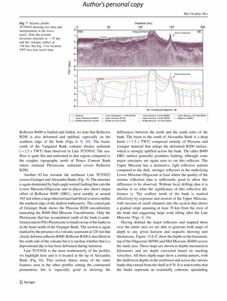
of the Sunda Shelf at around 8�N. Line TC93010 (Fig. 7)
crosses the ridge over the Vanguard Bank (Fig. 2), extending
into deep-water on either side. As before the Lower
Miocene-Oligocene is cut by high-angle (70–80�) faulting
and although it is thick under the central platform area these
units are seen to thin towards the south. Strong multiples
make it hard to clearly identify the basement under the
shallowest parts of the Vanguard Bank. The DRU at
Reflector B400 is identified and marks the end of strong
upper crustal faulting. The Late Miocene-Recent sequence is
relatively reduced in this area, especially over the crest of the
Vanguard Bank, and around a volcanic seamount observed at
*145 km, which is seen to have deformed Reflector B200
and all overlying sediments. The Pleistocene B70 and B100
reflectors lie undeformed with the sediments of these units
infilling the topography on either side of the bank by simply
ponding in the lowest parts of the basin.
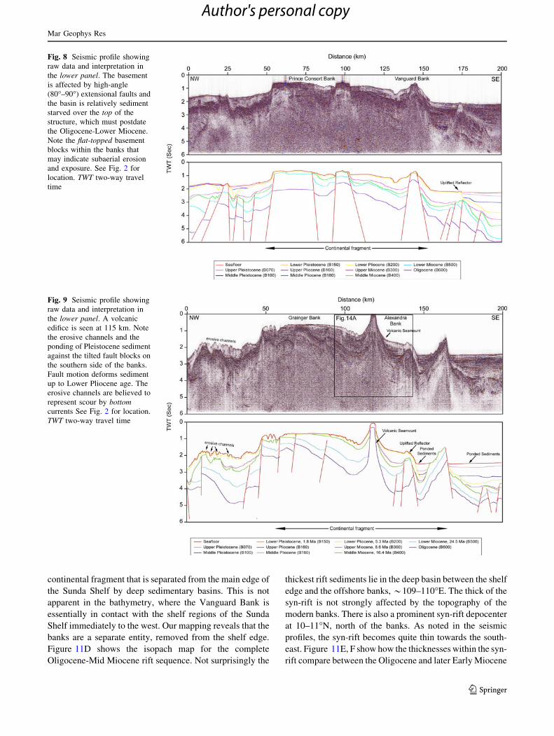
30 km east of Line TC93010, Line TC93014-2 crosses
both the eastern end of Vanguard Bank and the larger
Prince Consort Bank to the north (Fig. 8). The overall
structure is one of horsts and grabens separated by high
angle faults. While these mostly affect the Lower Miocene-
Oligocene this section is the first seen in which the fault
show major offset across Reflector B400, DRU. Again the
Oligocene is relatively thick (*1.5 s TWT) under modern
bathymetric highs and thins to the south. There is very little
Lower Miocene on Prince Consort Bank (*0.2 s TWT),
with the thickest sections seen north of the bank. Although
Fig. 6 Sedimentary budgets for A the area of the Sunda Shelf margin
considered in this study, B the region of the continental shelf edge
offshore the Nam Con Son basin, C the region of the off-shelf banks
and D the revised sediment budget for the entire Mekong Delta
offshore region, modified from Clift (2006) and adjusted with the new
volumes surveyed in this study
Mar Geophys Res
123
Author's personal copy
Reflector B400 is faulted and folded, we note that Reflector
B200 is also deformed and uplifted, especially on the
southern edge of the bank (Figs. 8, 9, 10). The basin,
south of the Vanguard Bank contains thicker sediment
(*2.5 s TWT) than observed in Line TC93010. The sea-
floor is quite flat and unformed in that region compared to
the rougher topography north of Prince Consort Bank
where minimal Pleistocene sediment covers Reflector
B200.
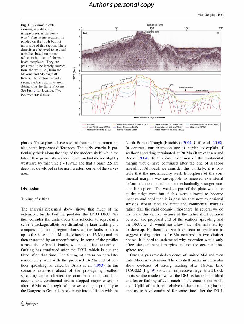
Another 62 km towards the northeast Line TC93022
crosses Grainger and Alexandra Banks (Fig. 9). The structure
is again dominated by high-angle normal faulting that cuts the
Lower Miocene-Oligocene and in places also shows major
offset of Reflector B400 (DRU), most notably at around
165 km where a large tilted normal fault block is seen to define
the southern edge of the shallow bathymetry. The central part
of Grainger Bank shows the Pliocene B200 unconformity
truncating the B400 Mid Miocene Unconformity. Only the
Pleistocene that has accumulated south of the bank is unde-
formed and no Plio-Pleistocene is found on top of the banks or
in the basin north of the Grainger Bank. The section is again
marked by the presence of a volcanic seamount at 120 km that
clearly deforms reflector B400. Reflector B300 is also tilted on
the south side of the volcano but it is unclear whether that is a
depositional dip or has been deformed during intrusion.
Line TC93026 is the most northeasterly of the profiles
we highlight here and it is located at the tip of Alexandra
Bank (Fig. 10). This section shares many of the same
features seen in the other profiles cutting the continental
promontory but is especially good at showing the
differences between the north and the south sides of the
bank. The basin to the south of Alexandra Bank is a deep
basin (*1.5 s TWT) composed entirely of Pliocene and
younger material that onlaps the deformed B200 surface,
which is strongly uplifted across the bank. The older B400
DRU surface generally postdates faulting, although some
major structures are again seen to cut this reflector. The
Upper Miocene has a distinctive, light reflective pattern
compared to the dark, stronger reflectors in the underlying
Lower Miocene-Oligocene at least where the quality of the
seismic reflection data is sufficiently good to allow this
difference to be observed. Without local drilling data it is
unclear to us what the significance of this reflective dif-
ference is. The seafloor north of the bank is marked
effectively by exposure and erosion of the Upper Miocene,
with incision of small channels into the section that shows
a gradual slope spanning at least 70 km from the crest of
the bank and suggesting large scale tilting after the Late
Miocene (Figs. 9, 10).
Having defined the major reflectors and mapped them
over the entire area we are able to generate both maps of
depth to any given horizon and isopachs showing unit
thicknesses. Figure 11A–C show the depths to the basement,
top of the Oligocene (B500) and Mid Miocene (B400) across
the study area. These maps are shown in depths measured in
kilometers and are depth converted based on stacking
velocities. All three depth maps show a similar pattern, with
the shallowest depths in the northwest and across the various
banks that extend from the shelf at 8�N. It is noteworthy that
the banks represent an essentially coherent, upstanding
Fig. 7 Seismic profile
TC93010 showing raw data and
interpretation in the lowerpanel. Note the tectonic
inversion structure at *35 km
and the volcanic edifice at
150 km. See Fig. 2 for location.
TWT two-way travel time
Mar Geophys Res
123
Author's personal copy
continental fragment that is separated from the main edge of
the Sunda Shelf by deep sedimentary basins. This is not
apparent in the bathymetry, where the Vanguard Bank is
essentially in contact with the shelf regions of the Sunda
Shelf immediately to the west. Our mapping reveals that the
banks are a separate entity, removed from the shelf edge.
Figure 11D shows the isopach map for the complete
Oligocene-Mid Miocene rift sequence. Not surprisingly the
thickest rift sediments lie in the deep basin between the shelf
edge and the offshore banks, *109–110�E. The thick of the
syn-rift is not strongly affected by the topography of the
modern banks. There is also a prominent syn-rift depocenter
at 10–11�N, north of the banks. As noted in the seismic
profiles, the syn-rift becomes quite thin towards the south-
east. Figure 11E, F show how the thicknesses within the syn-
rift compare between the Oligocene and later Early Miocene
Fig. 8 Seismic profile showing
raw data and interpretation in
the lower panel. The basement
is affected by high-angle
(80�–90�) extensional faults and
the basin is relatively sediment
starved over the top of the
structure, which must postdate
the Oligocene-Lower Miocene.
Note the flat-topped basement
blocks within the banks that
may indicate subaerial erosion
and exposure. See Fig. 2 for
location. TWT two-way travel
time
Fig. 9 Seismic profile showing
raw data and interpretation in
the lower panel. A volcanic
edifice is seen at 115 km. Note
the erosive channels and the
ponding of Pleistocene sediment
against the tilted fault blocks on
the southern side of the banks.
Fault motion deforms sediment
up to Lower Pliocene age. The
erosive channels are believed to
represent scour by bottomcurrents See Fig. 2 for location.
TWT two-way travel time
Mar Geophys Res
123
Author's personal copy
phases. These phases have several features in common but
also some important differences. The early syn-rift is par-
ticularly thick along the edge of the modern shelf, while the
later rift sequence shows sedimentation had moved slightly
westward by that time (*109�E) and that a basin 2.5 km
deep had developed in the northwestern corner of the survey
area.
Discussion
Timing of rifting
The analysis presented above shows that much of the
extension, brittle faulting predates the B400 DRU. We
thus consider the units under this reflector to represent a
syn-rift package, albeit one disturbed by later faulting and
compression. In this region almost all the faults continue
up to the base of the Middle Miocene (*16 Ma) and are
then truncated by an unconformity. In some of the profiles
across the offshelf banks we noted that extensional
faulting has continued after the DRU, which is cut and
tilted after that time. The timing of extension correlates
reasonablely well with the proposed 16 Ma end of sea-
floor spreading, as dated by Briais et al. (1993). In this
scenario extension ahead of the propagating seafloor
spreading center affected the continental crust and both
oceanic and continental crusts stopped major extension
after 16 Ma as the regional stresses changed, probably as
the Dangerous Grounds block came into collision with the
North Borneo Trough (Hutchison 2004; Clift et al. 2008).
In contrast, our extension age is harder to explain if
seafloor spreading terminated at 20 Ma (Barckhausen and
Roeser 2004). In this case extension of the continental
margin would have continued after the end of seafloor
spreading. Although we consider this unlikely, it is pos-
sible that the mechanically weak lithosphere of the con-
tinental margins was susceptible to renewed extensional
deformation compared to the mechanically stronger oce-
anic lithosphere. The weakest part of the plate would be
at the ridge crest but if this were allowed to become
inactive and cool then it is possible that new extensional
stresses would tend to affect the continental margins
rather than the rigid oceanic lithosphere. In general we do
not favor this option because of the rather short duration
between the proposed end of the seafloor spreading and
the DRU, which would not allow much thermal maturity
to develop. Furthermore, we have seen no evidence to
suggest rifting prior to 16 Ma occurred in two distinct
phases. It is hard to understand why extension would only
affect the continental margins and not the oceanic litho-
sphere too.
Our analysis revealed evidence of limited Mid and even
Late Miocene extension. The off-shelf banks in particular
show evidence of strong faulting after 16 Ma. Line
TC93022 (Fig. 9) shows an impressive large, tilted block
on its southern side in which the DRU is faulted and tilted
and lesser faulting affects much of the crust in the banks
area. Uplift of the banks relative to the surrounding basins
appears to have continued for some time after the DRU.
Fig. 10 Seismic profile
showing raw data and
interpretation in the lowerpanel. Pleistocene sediment is
ponded on the south but not
north side of this section. These
deposits are believed to be distal
turbidites based on strong
reflectors but lack of channel-
levee complexes. They are
presumed to be largely sourced
from the west, i.e., from the
Mekong and Molengraaff
Rivers. The section provides
strong evidence for inversion
dating after the Early Pliocene.
See Fig. 2 for location. TWTtwo-way travel time
Mar Geophys Res
123
Author's personal copy
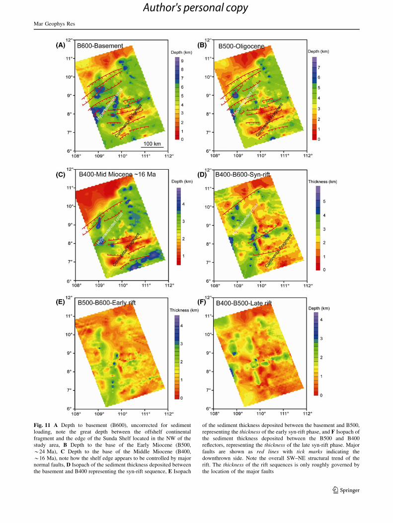
Fig. 11 A Depth to basement (B600), uncorrected for sediment
loading, note the great depth between the offshelf continental
fragment and the edge of the Sunda Shelf located in the NW of the
study area, B Depth to the base of the Early Miocene (B500,
*24 Ma), C Depth to the base of the Middle Miocene (B400,
*16 Ma), note how the shelf edge appears to be controlled by major
normal faults, D Isopach of the sediment thickness deposited between
the basement and B400 representing the syn-rift sequence, E Isopach
of the sediment thickness deposited between the basement and B500,
representing the thickness of the early syn-rift phase, and F Isopach of
the sediment thickness deposited between the B500 and B400
reflectors, representing the thickness of the late syn-rift phase. Major
faults are shown as red lines with tick marks indicating the
downthrown side. Note the overall SW–NE structural trend of the
rift. The thickness of the rift sequences is only roughly governed by
the location of the major faults
Mar Geophys Res
123
Author's personal copy
We note that the B200, Lower Pliocene reflector is
deformed and uplifted over the banks, but also floors the
basin to the south, suggesting that much of the topography,
at least on the southern edge of the banks has been gen-
erated during the Pliocene, although there is not much
evidence for large scale faulting of that age, or younger. It
is possible that much of the faulting could be at a sub-
seismic scale. Walsh et al. (1991) estimated that around
40 % of the total extension in faults is too small to be
imaged, but in this case we do not see any significant major
faults of Pliocene and younger ages, yet the onlapping
relationships between the basin fill and Reflector B200
require deformation in the Early Pliocene. Quite what is
driving that deformation is unknown but could be linked to
the young magmatism, discussed below.
There is clear evidence for compression and basin
inversion in many of the sections. The presence of thick
strata of Oligocene and Lower Miocene age in high fault
blocks in the center of the banks argues strongly that major
inversion has happened. The faults themselves indicate that
much of this inversion occurred just prior to the Reflector
B400, the DRU. Figure 5 shows a fold structure generated
within the Oligocene and Lower Miocene in the north of
the study area. Folding affects the two syn-rift sequences
equally indicating that the timing of folding must be at the
end of the active extensional period, *16 Ma. This
inversion event is by far the strongest seen in our survey
and correlates with other Mid Miocene inversion-related
unconformities throughout the southern South China Sea
(Matthews et al. 1997; Hutchison 2004, 2005). Later
inversion is less obvious but we do see evidence for uplift
across the Prince Consort Bank dating from the Pliocene
(Fig. 9). The erosional truncation of the B400/DRU surface
by Reflector B200 suggests that this bank was uplifted
above sealevel at that time, despite this being a time of
post-rift thermal subsidence. We note that our Pliocene
inversion correlates in time with that seen in the northern
margin of the South China Sea, where strike-slip faulting
has been invoked to generate the structural high of the
Dongsha Rise (Ludmann and Wong 1999) (Fig. 1). Quite
what is triggering this motion is unclear but was linked to
magmatism by Ludmann and Wong (1999). Hainan Island
is another dramatic example of linked magmatism and
uplift seen in the northern parts of the sea (Shi et al. 2011)
that result in major sediment flux to the ocean in the form
of large prograding foresets (Clift and Sun 2006). While
that mechanism may be appropriate in this area we can at
least discount the impact of mountain building in Taiwan
as a trigger, as has been suggested on the northern margin.
We further note that the uplift and exhumation of the
Vietnamese Central Highlands, which were dated to start at
*8 Ma by Carter et al. (2000) does not seem to have an
offshore equivalent, as there is little evidence of active
tectonism between Reflectors B200 and B300 in our
surveys.
Growth of the Mekong Delta
Proximity of the shelf to the mouth of the Mekong Delta
suggests that this is a primary source of sediment to the
continental margin and that the progradation represents the
gradual filling of accommodation space across the Sunda
Shelf, as first the Cuu Long and then the Nam Con Son
basins are filled and overspill (Lee et al. 2001).
This observation can be interpreted to indicate the start of
Mekong Delta sedimentation after 5.3 Ma. Conceivably
this could indicate a birth of the Mekong River in the
present location at that time following drainage capture in
Eastern Tibet/Yunnan. However, there may be other rea-
sons for the development of impressive clinoforms in this
place after 5.3 Ma. Deltas tend to prograde with time and it
is possible that the delta was in existence before 5.3 Ma but
located further north. Murray and Dorobek (2004) identi-
fied prograding foresets of presumed Mekong affinity
starting the Late Miocene of the Nam Con Son basin. After
the Cuu Long and Nam Con Son basins were filled, the
submarine clinoforms that represent the delta on the shelf
and which lie seaward of the river mouth would then have
prograded further to the SE into the location of our survey.
It is perhaps interesting to note that sedimentation rates
for the greater Mekong Delta region do not show a rapid
increase at the time at which we identify the start of
clinoform progradation. Instead sediment flux increase
after 24 Ma and again after 8 Ma, around the time that the
earliest clinoforms begin to deposit (Murray and Dorobek
2004). An alternative sediment budget published by
Metivier et al. (1999) favored a more progressive increase
in sediment delivery after 30 Ma with a peak in the Late
Miocene and slight decrease during the Plio-Pleistocene
which is not so dissimilar to our basin-wide budget
(Fig. 6D), given the modest age control available.
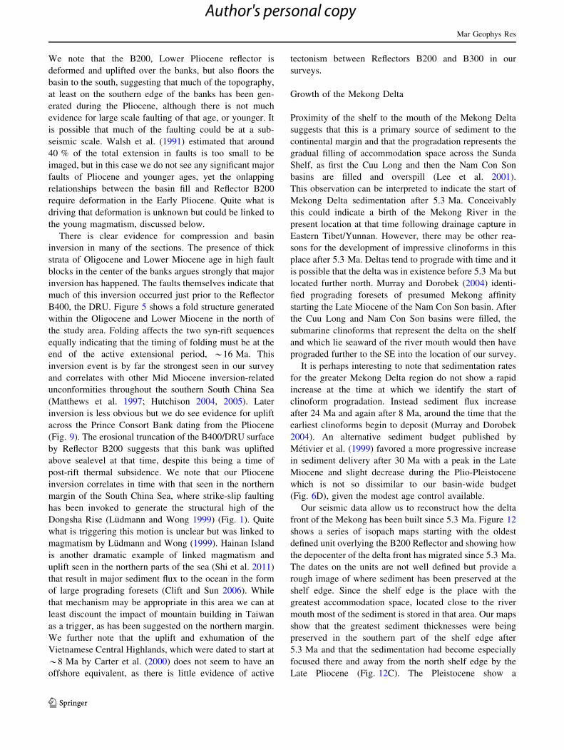
Our seismic data allow us to reconstruct how the delta
front of the Mekong has been built since 5.3 Ma. Figure 12
shows a series of isopach maps starting with the oldest
defined unit overlying the B200 Reflector and showing how
the depocenter of the delta front has migrated since 5.3 Ma.
The dates on the units are not well defined but provide a
rough image of where sediment has been preserved at the
shelf edge. Since the shelf edge is the place with the
greatest accommodation space, located close to the river
mouth most of the sediment is stored in that area. Our maps
show that the greatest sediment thicknesses were being
preserved in the southern part of the shelf edge after
5.3 Ma and that the sedimentation had become especially
focused there and away from the north shelf edge by the
Late Pliocene (Fig. 12C). The Pleistocene show a
Mar Geophys Res
123
Author's personal copy
significant change, with the main depocenter migrating
towards the east to a significant degree (Fig. 12D), as well
as supplying sediment more generally to the deeper water
regions and especially to the basins on the south side of the
Vanguard and Grainger Banks. The SE basin seems to be
particularly important depocenter during the Early
Fig. 12 Isopach maps showing the Pliocene to Recent sediment
thicknesses, largely reflecting building of the Mekong submarine delta
to the east from the shelf edge. The different packages mapped are not
all well dated but show a progressive eastern shift in the depocenter
from the oldest delta package (A) to the youngest mapped unit under
the seafloor (F). The reflectors are shown on Fig. 4. A B180-B200
Lower Pliocene, B B160-B180 Middle Pliocene, C B150-B160 Upper
Pliocene, D B100-B150 Lower Pleistocene, E B070-B100 Middle
Pleistocene, and F Seafloor-B070 Upper Pleistocene
Mar Geophys Res
123
Author's personal copy

Pleistocene, receiving [13.5 km in that period alone, after
receiving effectively no material during the Pliocene.
Figure 13 shows a second set of isopach maps that
display the progressive construction of the post-5.3 Ma
Mekong Delta. In this case the maps are also based on the
B200 Reflector but instead of showing each depositional
package they show how the total mass has been constructed
progressively. These maps show that the delta started to
Fig. 13 Isopach maps total sediment thickness through time about
the Lower Pliocene reflector at the base of the Mekong Delta
sequence. Each map showing the total thickness of the delta wedge as
it grows progressively through time with A being the first package
deposited and F the present thickness of the Mekong Delta wedge
Mar Geophys Res
123
Author's personal copy
form at the shelf edge in the southern part of the survey
region and then built towards first the north and then after
the start of the Pleistocene we observe faster growth to the
east and especially filling of the trough to the south of the
Vanguard and Grainger Banks. It is noteworthy that very
little sediment is supplied to the deep water north of the
Prince Consort and Alexandra Banks and that indeed these
is very little supply to the northern shelf edge. This may
reflect the patterns of sediment transport. Indeed, modern
sediment dispersal from the Mekong River Mouth is mostly
towards the SW, where the largest Holocene depocenter is
located (Xue et al. 2010). It is possible that the reversing
monsoon-driven currents on the Sunda Shelf may be
responsible for remobilizing sediment to the shelf edge
after that initial transport. However, it should be considered
that the source of sediment is not the Mekong alone for at
least part of the sealevel cycle because during lowstands
the entire Sunda Shelf was exposed and the margin was
receiving sediment from a SW to NE flowing river, known
the Molengraaff River that brought material close to the
southern edge of the survey region from source areas in
SW Borneo and the Malay Peninsula (Molengraaff and
Weber 1921; Hanebuth et al. 2002). If this system was
important, then this may explain why the basins south of
the off shelf banks are filled with sediment but not those
north of the banks.
Magmatism
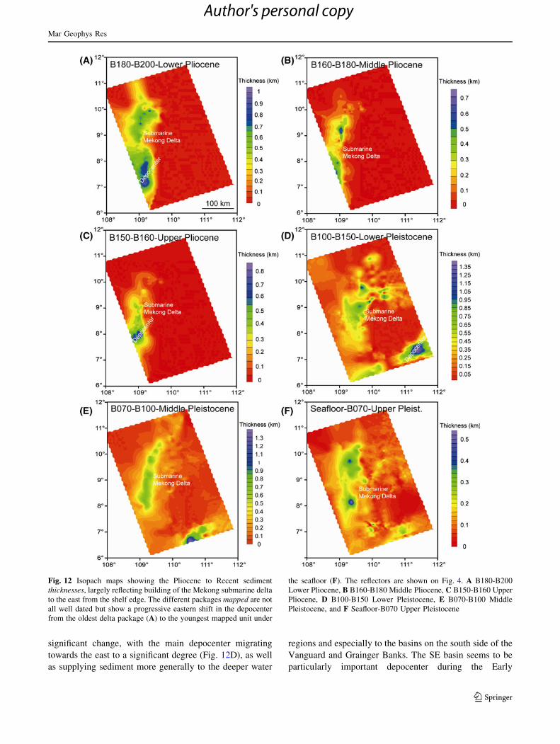
Our seismic profiles have revealed the presence of occa-
sional volcanic seamounts found mostly in the basin areas
offshore the shelf break (Figs. 3, 4, 7, 9). The volcanic
Fig. 14 Close-up images of
volcanic seamounts in south,
central part A and central
western parts of the basin
C. Parts B and D respectively
show the interpretation of the
lines and the deformation of the
pre-emplacement reflectors
around the intrusions followed
by passive onlapping of younger
sequences
Mar Geophys Res
123
Author's personal copy
edifices are apparently of quite limited extent, being
restricted to the seamounts which measured *5–10 km
wide but do not extend over a wider area. This shows that
the degree of melting is quite modest. Seamounts are only
found in the basin areas or on the sides of the off-shelf
banks, not on the bank crests or on the Sunda Shelf, sug-
gesting a link between thinning lithosphere and melting.
Figure 14 shows close-up seismic images of two volcanic
features in order to show their structure in detail. The
seismic does not provide much detail concerning the
internal structure but aprons of sediment around the vol-
canoes are visible. What is more obvious is the deforma-
tion of the surrounding strata, with sediment deposited
prior to intrusion bowed upwards against the side of the
seamount, while younger sediments lie passively against
the structure, allowing the timing of emplacement to be
determined (Figs. 4, 7, 9). The relationship between the
seamount volcanic rocks and the normal continental base-
ment is unclear. In Fig. 14A all reflectors from basement
(B600) to Lower Pliocene (B200) have been tilted against
the sides of the seamount, which suggests that the
seamount was generated after the Early Pliocene. In con-
trast, Fig. 14C shows that Reflector B300 (Late Miocene)
is gently ponded upon Reflector B400 (Middle Miocene).
In that case Reflector B300 is almost flat, which suggests
this volcano is relatively old and generated between the
Middle Miocene and Late Miocene. Upturned strata around
the seamounts may suggest syn-depostional growth of the
volcano, whereas nearly flat strata and may suggest real-
tively quick growth/formation of the seamount.
In all cases the volcanism is constrained as post-dating
the end of active seafloor spreading in the adjacent oceanic
lithosphere (Briais et al. 1993; Barckhausen and Roeser
2004) and we see that it also postdates the active extension
we have documented in the study area, with the exception
of some extensional faulting, mostly limited to the off-shelf
banks. We speculate that some of the later uplift of the
banks could linked to the magmatism. How any magma is
generated in such a setting is unclear because under normal
mantle conditions (i.e., asthenosphere *1,300 �C) signif-
icant extension is required to drive adiabatic upwelling,
with melting occurring when extension exceeds *200 %
(b = 3) (McKenzie and Bickle 1988). Our sections show
negligible extension at the time of emplacement after the
Middle Miocene. It is noteworthy that even when extension
was significant prior to 16 Ma there was no seamount
volcanism, while a brief inspection of the seismic profiles
provided in this study shows that even in the offshelf banks
deformation mostly involved folding and effectively zero
extension. In this respect the volcanic rocks in this region
are similar to those found in the regions between the
Dongsha Rise and Taiwan, as well as on Hainan Island and
the neighboring Leizhou Peninsula (Tu et al. 1991;
Shi et al. 2011). Our observations require either (1) hotter
than normal asthenospheric conditions, (2) thinning of the
mantle lithosphere that is not related to upper crustal
extension, (3) the presence of asthenospheric sources that
are more fertile than normal under the basins or (4) the
presence of aqueous fluids in the mantle that depress the
solidus in this region. With our present data set it is not
possible to distinguish between these alternative models,
only to note that the enigmatic South China Sea neo-
volcanic province extends as far south as the deep-water
Nam Con Son margin.
Conclusions
In this study we have made a structural and stratigraphic
synthesis of the southwestern parts of the South China Sea
(Fig. 15), immediately to the east of the Nam Con Son basin,
based on a grid of industry seismic reflection data tied to
boreholes near the shelf edge. The area is located immedi-
ately in front of a propagating oceanic spreading center and
allows us to examine the deformation related to both the
advancing extension and to the strike slip motion along the
East Vietnam margin. Our analysis shows that the sedi-
mentary section comprises a thick sequence of Oligocene-
Lower Miocene strata, which are affected mostly by rather
high-angle normal faults. Most of these faults terminate at an
unconformity dated as Middle Miocene (*16 Ma). Map-
ping of the depth to basement reveals the presence of a sig-
nificant continental block that is separated from the thicker
crust under the Sunda Shelf by a tract of hyperextended crust
that is mostly indistinguishable from the crust near the
propagating rift tip, at least in terms of its depth. This off-
shore block now takes the form of a series of shallow-water
banks that connect with the edge of the Sunda Shelf.
Extension in these off-shelf banks continued after the ces-
sation of brittle faulting within the main shelf, lasting well
into the Late Miocene. The off-shelf banks appear to have
been a depocenter during the Oligocene-Early Miocene but
were affected by an uplift event prior to the Middle Miocene
DRU, which we interpret to be a response to the collision
between the Dangerous Grounds and Borneo. There is also
evidence for late-stage uplift during the Pliocene when a
major unconformity is observed on the Prince Consort Bank.
This uplift does not affect the main Sunda Shelf. This late
stage uplift may be linked to continued magmatism in the
form of scattered seamounts, which postdate the period of
brittle upper crustal faulting and which are not clearly linked
to any regional extensional event. The trigger for this mag-
matism is presently unclear but this appears to be part of a
wider diffuse magmatic province throughout the South
China Sea.
Mar Geophys Res
123
Author's personal copy
Our survey also shows the eastward progradation of the
Mekong Delta, which we constrained to date from at least
5.3 Ma, slightly younger than the age of onset noted within
the more proximal Nam Con Son and Cuu Long Basins
(Murray and Dorobek 2004). This age is somewhat
younger than the proposed ages of major drainage capture
in southeastern Tibet in the Early Miocene (Clift et al.
2006; Hoang et al. 2009) and suggests that the present
location of the Mekong Delta is not principally governed
by drainage capture driven by continental tectonics,
although we cannot discount entirely the influence of uplift
during the Late Miocene of the Central Highlands of
Vietnam (Carter et al. 2000). Pliocene and younger sedi-
mentation is preferentially focused towards the southern
end of our study area, migrating slightly to the north but
mostly towards the east since 5.3 Ma. The most dramatic
progradation occurs during the Pleistocene when a deep
trough to the south of the off-shelf banks is filled with
sediment [1.35 km thick. The delta comprises a series of
clinoforms lobes whose primary source is presumed to be
the Mekong River although the filling of the deep-water
trough south of the off-shelf banks is suggestive of sig-
nificant sediment flux also from further east and south,
potentially via the Molengraaff River that dominates the
Sunda Shelf during sea level lowstand periods.
Acknowledgments We thank PetroVietnam and Total Exploration
and Production for providing data used in this study. The study
benefited from comments by Jean-Luc Auxietre and Gwang Hoon
Lee.
References
Barckhausen U, Roeser HA (2004) Seafloor spreading anomalies in
South China Sea revisited. In: Clift P, Wang P, Kuhnt W, Hayes
D (eds) Continent-ocean interactions within East Asian marginal
seas, vol 149., Geophysical MonographAmerican Geophysical
Union, Washington, DC, pp 121–125
Briais A, Patriat P, Tapponnier P (1993) Updated interpretation of
magnetic anomalies and seafloor spreading stages in the South
China Sea: implications for the Tertiary tectonics of Southeast
Asia. J Geophys Res 98:6299–6328
Brookfield ME (1998) The evolution of the great river systems of
southern Asia during the Cenozoic India-Asia collision; rivers
draining southwards. Geomorphology 22(3–4):285–312
Carter A, Roques D, Bristow CS (2000) Denudation history of
onshore central Vietnam: constraints on the Cenozoic evolution
of the western margin of the South China Sea. Tectonophysics
322:265–277
Clark MK, Schoenbohm LM, Royden LH, Whipple KX, Burchfiel
BC, Zhang X, Tang W, Wang E, Chen L (2004) Surface uplift,
tectonics, and erosion of eastern Tibet from large-scale drainage
patterns. Tectonics 23(TC1006)
Clift PD (2006) Controls on the erosion of Cenozoic Asia and the flux
of clastic sediment to the ocean. Earth Planet Sci Lett 241(3–4):
571–580
Clift P, Lin J (2001) Preferential mantle lithospheric extension under
the South China margin. Mar Pet Geol 18(8):929–945
Clift PD, Sun Z (2006) The sedimentary and tectonic evolution of the
Yinggehai-Song Hong Basin and the southern Hainan margin,
South China Sea; implications for Tibetan uplift and monsoon
intensification. J Geophys Res 111(B06405)
Clift PD, Lin J, ODP Leg 184 Scientific Party (2001) Patterns
of extension and magmatism along the continent-ocean
boundary, South China margin. In: Wilson RCL, Whitmarsh
RB, Taylor B, Froitzheim N (eds) Non-volcanic rifting of
continental margins: a comparison of evidence from land and
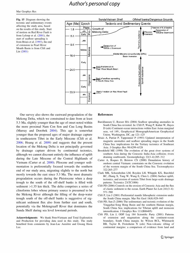
Fig. 15 Diagram showing the
tectonic and sedimentary events
affecting the study area, based
on the results of this study. Start
of motion on Red River Fault is
from Leloup et al. (2001), the
start of seafloor spreading is
from Briais et al. (1993), the end
of extension in Pearl River
Mouth Basin is from Clift and
Lin (2001)
Mar Geophys Res
123
Author's personal copy
sea, vol 187. Special Publication. Geological Society, London,
pp 489–510
Clift PD, Layne GD, Blusztajn J (2004) Marine sedimentary evidence
for monsoon strengthening, Tibetan uplift and drainage evolu-
tion in East Asia. In: Clift P, Kuhnt W, Wang P, Hayes D (eds)
Continent-ocean Interactions in the East Asian Marginal seas,
vol 149., Geophysical MonographAmerican Geophysical Union,
Washington, DC, pp 255–282
Clift PD, Blusztajn J, Nguyen DA (2006) Large-scale drainage
capture and surface uplift in eastern Tibet-SW China before
24 Ma inferred from sediments of the Hanoi Basin, Vietnam.
Geophys Res Lett 33(L19403)
Clift P, Lee GH, Nguyen AD, Barckhausen U, Hoang VL, Sun Z
(2008) Seismic evidence for a dangerous grounds mini-plate: no
extrusion origin for the South China Sea. Tectonics 27(TC3008)
Cullen A, Reemst P, Henstra G, Gozzard S, Ray A (2010) Rifting of
the South China Sea: new perspectives. Pet Geosci 16:273–282
Davis M, Kusznir NJ (2004) Depth-dependent lithospheric stretching
at rifted continental margins. In: Karner GD (ed) Proceedings of
NSF Rifted Margins Theoretical Institute. Columbia University
Press, New York, pp 92–136
Driscoll NW, Karner GD (1998) Lower crustal extension across the
Northern Carnarvon basin, Australia: evidence for an eastward
dipping detachment. J Geophys Res 103:4975–4991
Franke D, Barckhausen U, Heyde I, Tingay M, Ramli N (2008)
Seismic images of a collision zone offshore NW Sabah/Borneo.
Mar Pet Geol 25:606–624
Fyhn MBW, Boldreel LO, Nielsen LH (2009) Geological develop-
ment of the Central and South Vietnamese margin: implications
for the establishment of the South China Sea, Indochinese escape
tectonics and Cenozoic volcanism. Tectonophysics 478(3–4):
184–214
Gradstein FM, Ogg JG, Smith AG (2004) A Geologic Time Scale.
Cambridge University Press, Cambridge
Hanebuth TJ, Stattegger K, Saito Y (2002) The stratigraphic
architecture of the central Sunda Shelf (SE Asia) recorded by
shallow-seismic surveying. Geo-Mar Lett 22(2):86–94
Hazebroek HP, Tan DNK (1993) Tertiary tectonic evolution of the NW
Sabah continental margin. Bul Persat Geol Malays 33:195–210
Hoang LV, Wu FY, Clift PD, Wysocka A, Swierczewska A (2009)
Evaluating the evolution of the Red River system based on
in situ U-Pb dating and Hf isotope analysis of zircons. Geochem
Geophys Geosyst 10(11)
Holloway NH (1982) North Palawan Block, Philippines; its relation
to Asian mainland and role in evolution of South China Sea.
AAPG Bulletin 66:1355–1383
Hsu SK, Sibuet JC (2004) Continent-ocean transition of the northern
South China Sea and off southwestern Taiwan. Mar Geophys
Res 25(1–2):1–4
Huchon P, Nguyen TNH, Chamot-Rooke N (2001) Propagation of
continental break-up in the south-western South China Sea. In:
Wilson RCL, Whitmarsh RB, Taylor B, Froitzheim N (eds) Non-
volcanic rifting of continental margins: a comparison of
evidence from land and sea, vol 187., Special PublicationGeo-
logical Society, London, pp 31–50
Huismans RS, Beaumont C (2007) Roles of lithospheric strain
softening and heterogeneity in determining the geometry of rifts
and continental margins. In: Mapping and Modelling Continental
Lithosphere Extension and Breakup, vol 282. Special Publica-
tion. Geological Society of London, pp 111–138
Huismans RS, Buiter SJH, Beaumont C (2005) The Effect of plastic-
viscous layering and strain-softening on mode selection during
lithospheric extension. J Geophys Res 110(B02406)
Hutchison CS (1996) The ‘Rajang accretionary prism’ and ‘Lupar Line’
problem of Borneo. Geological Society, London, Special Publica-
tions, v. 106, pp. 247–261
Hutchison CS (2004) Marginal basin evolution; the southern South
China Sea. Mar Pet Geol 21(9):1129–1148
Hutchison CS (2005) Geology of North-West Borneo. Elsevier,
Amsterdam
Hutchison CS (2010) The North-West Borneo Trough. Mar Geol
271:32–43
Hutchison CS, Vijayan VR (2010) What are the Spratly Islands?
J Asian Earth Sci 39(5):371–385
Kong P, Zheng Y, Caffee MW (2012) Provenance and time
constraints on the formation of the first bend of the Yangtze
River. Geochem Geophys Geosyst 13(Q06017)
Kusznir NJ, Roberts AM, Morley CK (1995) Forward and reverse
modelling of rift basin formation. In: Lambiase JJ (ed) Hydro-
carbon habitat in rift basins, vol 80., Special PublicationGeo-
logical Society, London, pp 33–56
Lee GH, Lee K, Watkins JS (2001) Geologic evolution of the Cuu
Long and Nam Con Son basins, offshore southern Vietnam,
South China Sea. AAPG Bulletin 85(6):1055–1082
Leloup PH, Arnaud N, Lacassin R, Kienast JR, Harrison TM, Phan Trong
T, Replumaz A, Tapponnier P (2001) New constraints on the
structure, thermochronology, and timing of the Ailao Shan-Red
River shear zone, SE Asia. J Geophys Res 106(B4):6657–6671
Leloup PH, Tapponnier P, Lacassin R, Searle MP (2007) Discussion
on the role of the Red River shear zone, Yunnan and Vietnam, in
the continental extrusion of SE Asia Journal, Vol 163, 2006,
1025–1036. J Geol Soc 164(5):1253–1260
Li Z, Qiu Z, Qin S, Pang X, Liang D, Teng Y, Li Y (1994) A study on
the forming conditions of basalts in seamounts of the South
China Sea. Chin J Geochem 13(2):107–117
Lithgow-Bertelloni C, Gurnis M (1997) Cenozoic subsidence and
uplift of continents from time-varying dynamic topography.
Geology 25:735–738
Ludmann T, Wong HK (1999) Neotectonic regime on the passive
continental margin of the northern South China Sea. Tectono-
physics 311:113–138
Matthews SJ, Fraser AJ, Lowe S, Todd SP, Peel FJ (1997) Structure,
stratigraphy and petroleum geology of the SE Nam Con Son
Basin, offshore Vietnam. In: Fraser AJ, Matthews SJ, Murphy
RW (eds) Petroleum geology of Southeast Asia, vol 126.,
Special PublicationGeological Society, London, pp 89–106
McKenzie DP, Bickle MJ (1988) The volume and composition of melt
generated by extension of the lithosphere. J Petrol 29:625–679
Metivier F, Gaudemer Y, Tapponnier P, Klein M (1999) Mass
accumulation rates in Asia during the Cenozoic. Geophys J Int
137(2):280–318
Molengraaff GAF, Weber ME (1921) On the relation between the
Pleistocene glacial period and the origin of the Sunda Sea (Java
and South China Sea), and its influence on the distribution of
coral reefs and on the land- and freshwater fauna. Koninklijk
Akademie van Wetenschappen, Proc Sect Sci 23(1):395–439
Morley CK (2002) A tectonic model for the Tertiary evolution of
strike-slip faults and rift basins in SE Asia. Tectonophysics
347(4):189–215
Murray MR, Dorobek SL (2004) Sediment supply, tectonic
subsidence, and basin-filling patterns across the southwestern
South China Sea during Pliocene to Recent time. In: Clift P,
Wang P, Kuhnt W, Hayes D (eds) Continent-ocean interac-
tions within East Asian marginal seas, vol 149., Geophysical
MonographAmerican Geophysical Union, Washington, DC,
pp 235–254
Perez-Gussinye M, Reston T, Phipps Morgan J (2001) Serpentinized
and magmatism during extension at non-volcanic margins—
effects of initial lithosphere structure. In: Wilson RC (ed) Non-
volcanic rifting of continental margins: a comparison of
evidence from land and sea, vol 187., Special PublicationGeo-
logical Society, London, pp 551–576
Mar Geophys Res
123
Author's personal copy
Peron-Pinvidic G, Manatschal G (2009) The final rifting evolution at
deep magma-poor passive margins from Iberia-Newfoundland: a
new point of view. Int J Earth Sci 98:581–1597
Rangin C, Silver EA (1991) Neogene tectonic evolution of the
Celebes Sulu basins; new insights from Leg 124 drilling. Proc
ODP Sci Results 124:51–63
Replumaz A, Tapponnier P (2003) Reconstruction of the deformed
collision zone between India and Asia by backward motion of
lithospheric blocks. J Geophys Res 108(B6):2285
Replumaz A, Lacassin R, Tapponnier P, Leloup PH (2001) Large
river offsets and Plio-Quaternary dextral slip rate on the Red
River fault (Yunnan, China). Journal of Geophysical Research-
Solid Earth 106(B1):819–836
Reston TJ, Krawczyk CM, Klaeschen D (1996) The S-reflector west
of Galicia (Spain): evidence from prestack depth migration for
detachment faulting during continental breakup. J Geophys Res
101(B4):8075–8091
Ru K, Pigott JD (1986) Episodic rifting and subsidence in the South
China Sea. AAPG Bull 70(9):1136–1155
Schluter HU, Hinz K, Block M (1996) Tectono-stratigraphic terranes
and detachment faulting of the South China Sea and Sulu Sea.
Mar Geol 130:39–78
Sclater JG, Christie PAF (1980) Continental stretching: an explana-
tion of the post Mid-Cretaceous subsidence of the central North
Sea basin. J Geophys Res 85:3711–3739
Shi X, Kohn B, Spencer S, Guo X, Li Y, Yang X, Shi H, Gleadow A
(2011) Cenozoic denudation history of southern Hainan Island,
South China Sea: constraints from low temperature thermochro-
nology. Tectonophysics 504:100–115
Su D, White N, McKenzie D (1989) Extension and subsidence of the
Pearl River mouth basin, northern South China Sea. Basin Res
2:205–222
Tapponnier P, Peltzer G, Armijo R (1986) On the mechanics of the
collision between India and Asia. In: Coward M, Ries AC (eds)
Collision tectonics, vol 19., Special PublicationGeological
Society, London, pp 115–117
Taylor B, Hayes DE (1983) Origin and history of the South China Sea
basin. In: Hayes DE (ed) The tectonic and geologic evolution of
the Southeast Asian Seas and Islands, vol 27. American
Geophysical Union, Washington, DC, pp 23–56
Tu K, Flower MFJ, Carlson RW, Zhang M, Xie G (1991) Sr, Nd, and
Pb isotopic compositions of Hainan basalts (south China):
implications for a subcontinental lithosphere Dupal source.
Geology 19:567–569
Tucholke BE, Sawyer DS, Sibuet J-C (2007) Breakup of the
Newfoundland-Iberia Rift. In: Karner GD, Manatschal G,
Pinheiro LM (eds) Imaging, mapping and modelling continental
lithosphere extension and breakup, vol 282., Special Publica-
tionGeological Society, London, pp 9–46
Vail PR, Mitchum RM, Todd RG, Widmier JM, Thompson SI,
Sangree JB, Bubb JN, Hatlelid WG (1977) Seismic stratigraphy
and global changes of sea-level. In: Payton CE (ed) Seismic
stratigraphy–applications to hydrocarbon exploration, vol 26.,
MemoirAmerican Association of Petroleum Geologists, Tulsa,
pp 49–212
Walsh J, Watterson J, Yielding G (1991) The importance of small-
scale faulting in regional extension. Nature 351:391–393
Wang P (2004) Cenozoic deformation and the history of sealand
interactions in Asia. In: Clift P, Wang P, Kuhnt W, Hayes D (eds)
Continent-ocean interactions in the East Asian marginal seas, vol
149. American Geophysical Union, Washington, DC, pp 1–22
White RS (1997) Rift-plume interaction in the North Atlantic. Philos
Trans R Soc Lond A Math Phys Sci 355:319–339
White RS, Spence GD, Fowler SR, McKenzie DP, Westbrook GK,
Bowen AN (1987) Magmatism at rifted continental margins.
Nature 330:439–444
Whitmarsh RB, Manatschal G, Minshull TA (2001) Evolution of
magma-poor continental margins from rifting to seafoor spread-
ing. Nature 413:150–154
Xue Z, Liu JP, DeMaster D, Nguyen LV, Ta TKO (2010) Late
Holocene evolution of the Mekong subaqueous delta, Southern
Vietnam. Mar Geol 269(1–2):46–60
Yan P, Zhou D, Liu Z (2001) A crustal structure profile across the
northern continental margin of the South China Sea. Tectono-
physics 338:1–21
Yan Y, Carter A, Huang CY, Chan LS, Hu XQ, Lan Q (2012)
Constraints on Cenozoic regional drainage evolution of SW
China from the provenance of the Jianchuan Basin. Geophys
Geochem Geosyst 13(Q03001)
Yeh Y-C, Hsu S-K, Doo W-B, Sibuet J-C, Liu C-S, Lee C-S (2012)
Crustal features of the northeastern South China Sea: insights from
seismic and magnetic interpretations. Mar Geophys Res 1–20
Mar Geophys Res
123
Author's personal copy