MapSource CD-ROMs
16
MapSource ® CD-ROMs Detailed maps for your adventures on land and sea
Transcript of MapSource CD-ROMs
MapSource® CD-ROMs
Detailed maps for your adventures on
land and sea

Garmin even offers detailed cartography for your boating and
fishing pursuits. For offshore coverage, check out Garmin’s
exclusive BlueChart® cartography. BlueChart provides the detail of
paper charts in convenient electronic form—preprogrammed data
cards or CDs. The U.S. Recreational Lakes with Fishing Hot Spots®
CD offers inland coverage that includes general road and lake
detail throughout the U.S. The included Fishing Hot Spots data
provides lake profiles, fishing tips and information for select lakes.
There’s even coverage for those who fish the land of 10,000
lakes with the Minnesota LakeMaster® product.
O n t h e w a t e r

BlueChart®
BlueChart serves up the best offshorecartography around and works in seamlessintegration with a wide range of Garminchartplotters. It even offers limited compatibilitywith handhelds such as the eTrex® Legend,eTrex Vista, Rino® 120/130, GPSMAP® 60C/CS,GPSMAP 76 series and iQue® series. Map areasare shaded like paper charts so you can identifyintertidal zones, depth contours and more.BlueChart is available in three versions: Americas(North and South America), Atlantic (Europeand Africa) and Pacific (Asia, Australia and New Zealand).
• Shaded depth contours• Intertidal zones• Spot soundings• Navaids• Port plans• U.S. tide data• Wrecks, restricted areas, anchorages
BlueChart is object-oriented, which means on all Garminplotters, you can pan to an object on the map and instantlyview information about that point.

U.S. Recreational Lakes with Fishing Hot Spots®
This inland cartography is ideal for fishing,recreational boating or camping. Road detailhelps you navigate to the lake, and onceyou’re there, you’ll get shoreline detail, boatramps and more. The Fishing Hot Spots dataprovides valuable fishing tips and information,as well as depth contours for select lakes.Available in CD form (no unlock required) ordata cards containing Fishing Hot Spots detailonly. Both forms are divided into threeregions: East, Central and West. Compatiblewith most Garmin chartplotters; limitedcompatibility with eTrex® Legend, eTrex Vista,GPSMAP® 60C/CS, GPSMAP 76 series andRino® 120/130.
• County and access roads• Detailed lake maps• Lake profiles• Fishing tips & information
Minnesota LakeMaster®
Minnesota LakeMaster contains maps of 51of the most popular Minnesota lakes in thehighest detail available. The maps includehigh-definition, three-foot contours andunderwater structure detail created frommeticulous on-the-water surveys. Other mapfeatures include islands, reefs, points, bays,access points, marinas and more. Available on a single CD-ROM or a preprogrammeddata card.
• Depth contours• Structure• Islands• Marinas
Fishing Hot Spots detail provides lake profiles,fishing tips and more.

For those who prefer to experience the great outdoors on their
own two feet, we offer TOPO CDs with detailed topographic maps.
TOPO maps are ideal for outdoor adventurers who are into hiking,
hunting, camping, climbing and skiing. Both versions are compat-
ible with a wide range of Garmin receivers, including the eTrex®
Legend, eTrex Vista, GPS V, GPSMAP® 60C/CS, GPSMAP 76 series,
Rino® 120 and Rino 130.
O n t h e t r a i l
The main difference between these two
products is that TOPO 24K only covers
the U.S. National Parks, while the regular
TOPO has overall U.S. coverage.

TOPO 24K, National ParksThis CD provides detailed coverage of U.S.national parks, national forests and somestate parks. It also includes points of interestand park amenities. Maps are comparable to USGS 1:24,000 scale paper maps.Available for three regions: Western, Central and Eastern.
• Terrain contours• Coverage of national parks• Routable trails• Summit elevations and peaks• Vertical profile of trails and routes
TOPOThe TOPO series CDs provide topographicmaps with terrain contours, elevationinformation, some roads, trails, summits andsome bathymetric contours. These CDs arenot locked, so you have access to all thecoverage areas. Available in two versions:U.S. and Canada.
• Terrain contours• Elevation information• Roads & trails• Summits• Some bathymetric contours
TOPO 24K, National ParksU.S. TOPO

eTrex® Venture, GPS 72, GPS 76, Rino® 110• Points of Interest – locations of services such as food & drink, lodging, banks
eTrex Legend, eTrex Vista, GPSMAP® 76/76S,Rino 120, Rino 130• MetroGuide® — street-level maps with address lookup, points of interest
eTrex Legend, eTrex Vista, GPSMAP 60/60CS,GPSMAP 76 series, Rino 120, Rino 130• TOPO (all versions) — map detail for hiking, camping, climbing, skiing
• U.S. Recreational Lakes with Fishing Hot Spots® — road and lake detail, fishing tips and information
• BlueChart® — offshore marine cartography with depth contours, port plans, intertidal zones
Geko™ 201, Geko 301, GPS 12, eTrex, eTrex Summit• Trip & Waypoint Manager – transfers waypoints, routes and tracks between
GPS and PC, no map downloads
cf Que™, GPS V, GPSMAP 60C/CS, GPSMAP 76C/CS, 276C, iQue® series• City Select® – included with purchase (cf Que, GPS V and iQue only);
street-level maps with auto routing, address lookup, points of interest
StreetPilot® III, 2610, 2650• City Navigator™ – included with purchase; street-level maps with auto
routing, address lookup, points of interest
GPSMAP 172C, 176/176C, 178C, 182/182C, 188/188C,232, 238, 276C, 2006/2006C, 2010/2010C, 3006C/3010C• BlueChart® – offshore detail
• U.S. Recreational Lakes with Fishing Hot Spots® – inland detail
M a p S o u r c e ® C o m p a t i b i l i t y
Use the following listing to help you pair up your Garmin
unit with the recommended MapSource CD. Keep in mind
that units may be compatible with multiple titles, but this
information will help direct you to the CD that provides the
kind of detail your adventures demand. You can also visit the
Garmin Web site, www.garmin.com, for more help selecting
the appropriate MapSource CD.

If you’re looking for trails and terrain contours or navaids and
coastlines, you’ll find the map detail you need on Garmin’s
complete line of MapSource® CD-ROMs. Through a simple
connection to your PC, you can enhance the basemap on your
compatible Garmin GPS. Just select the map areas of interest,
and with the click of the mouse, the map detail quickly downloads
to your GPS or to programmable data cards which then plug into
your unit. When you’re traveling to another area, you can
download new maps to your unit or data card so you’ll always
have the best mapping detail wherever you go.
NAVTEQ ON BOARD is a registered trademark of Navigation Technologies Corporation.Copyright © 2004 Navigation Technologies Corporation, All Rights Reserved.
®
E x t r e m e m a p p i n g d e t a i l i s j u s t a c l i c k a w a y

Take a look at the MapSource titles available and choose the CD
that provides the kind of map detail your adventures demand.
Use our online map viewer program at www.garmin.com to see
the map detail contained on each CD-ROM.
G P S 1 5 2
To run MapSource on your PC, your system musthave these requirements:
• Pentium processor• Windows 98, Windows NT 4.0, Windows 2000,
Windows XP or Windows ME• At least 32 MB minimum RAM• 300 MB free hard disk space
(for compact installation)• CD-ROM drive• 256-color display adapter and monitor
(24-bit color recommended)• Mouse or other pointing device• PC interface or USB interface cable• Internet access recommended for certain
MapSource titles

For those who navigate the urban jungle, MapSource offers titles
with detailed street maps, address lookup and points of interest
listings. With this kind of data downloaded to your compatible
Garmin GPS, you can literally travel to a new city, look up your
hotel, restaurants, attractions and other services and use your
GPS to guide you there without ever stopping for directions.
Both City Select® and MetroGuide® offer automatic route capability
on the PC, which means you simply select a starting point and
destination and MapSource calculates a route, which you can then
download to your unit. City Select also offers auto routing directly
on compatible GPS units.
O n t h e r o a d
Screen shows route being created
across multiple states with dialog
box providing detailed directions
to destination.
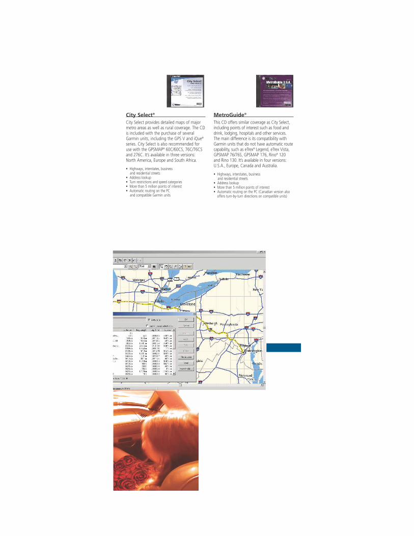
City Select®
City Select provides detailed maps of majormetro areas as well as rural coverage. The CDis included with the purchase of severalGarmin units, including the GPS V and iQue®
series. City Select is also recommended foruse with the GPSMAP® 60C/60CS, 76C/76CSand 276C. It’s available in three versions:North America, Europe and South Africa.
• Highways, interstates, business and residential streets
• Address lookup• Turn restrictions and speed categories• More than 5 million points of interest• Automatic routing on the PC
and compatible Garmin units
MetroGuide®
This CD offers similar coverage as City Select,including points of interest such as food anddrink, lodging, hospitals and other services.The main difference is its compatibility withGarmin units that do not have automatic routecapability, such as eTrex® Legend, eTrex Vista,GPSMAP 76/76S, GPSMAP 176, Rino® 120and Rino 130. It’s available in four versions: U.S.A., Europe, Canada and Australia.
• Highways, interstates, business and residential streets
• Address lookup• More than 5 million points of interest• Automatic routing on the PC (Canadian version also
offers turn-by-turn directions on compatible units)
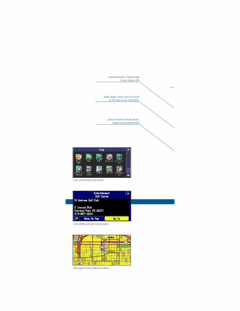
Look up attractions and services.
View address and get route guidance.
Map page showing MapSource detail.
vector based—move cursor to a point on the map to view information
points of interest include schools, shopping and entertainment
download button—transfer data to your Garmin GPS

map selection tool—click on the map areas you want to download to your GPS
route tool—create your own routes on the PC
waypoint tool—create waypoints and save to your Garmin GPS

WorldMapFor travel outside North America, Europe,South Africa and Australia, take a look at the WorldMap CD, which provides basicworldwide maps. Use the trip and waypointmanagement function to create routes andwaypoints for your trips and transfer them to your GPS. WorldMap is compatible withmost Garmin GPS units and is generallyrecommended only if no other coverage is available for the area.
• Cities worldwide• Political boundaries• Coastline detail• Major motorways

Points of InterestThis CD is designed for Garmin GPS units thatdo not have built-in road and street detail butdo accept points of interest data. Once thisdata is downloaded to your unit, you canlook up services and use your GPS to guideyou there. Points of Interest is recommendedfor use with the eTrex Venture, GPS 72, GPS76 and Rino 110.
• More than 1 million points of interest• Cities worldwide• Landmarks• Marine navaids
Once Points of Interest data isdownloaded to your GPS, youcan look up attractions and more.
Trip & Waypoint ManagerThis trip planning CD is designed for use withGarmin units that have no built-in map detailor city point database, such as the GPS 12,eTrex, eTrex Summit, Geko 201and Geko 301.
With this simple, affordable CD,you get the benefit of beingable to create waypoints androutes on your PC and thendownload them to your unit.You can also transfer waypoints,routes and tracks from yourouting back to your PC forrecall at a later date.
You will not be able to downloadmap detail to any Garmin GPSusing this product.
With a basic worldwide map as your background, you cancreate waypoints and routes on your PC screen and thendownload the points to your Garmin GPS.
Garmin International, Inc.1200 East 151st StreetOlathe, Kansas 66062phone: 913.397.8200fax: 913.397.8282www.garmin.com
© 2004 Garmin Ltd. or its subsidiaries 0504 M01-10166-00