MAPPING ASPHALT ROAD CONDITIONS WITH … · MAPPING ASPHALT ROAD CONDITIONS WITH HYPERSPECTRAL...
3
MAPPING ASPHALT ROAD CONDITIONS WITH HYPERSPECTRAL REMOTE SENSING Martin Herold a, and Dar A. Roberts b a ESA GOFC-GOLD Land Cover Project Office, Dep. of Geography, FSU Jena, Loebedergraben 32, 07743 Jena, Germany, [email protected]. b Dep. of Geography, University of California Santa Barbara, Ellison Hall, Santa Barbara, CA, 93106, USA, dar@geog.ucsb.edu. KEY WORDS: remote sensing, imaging spectrometry, asphalt road survey, hyperspectral, AVIRIS ABSTRACT: This study integrates ground spectrometry, imaging spectrometry, and in-situ pavement condition surveys for asphalt road assessment. There is strong spectral evidence for asphalt aging and deterioration processes, hence field spectra showed that asphalt aging and deterioration produce measurable changes in spectra as these surfaces undergo a transition from hydrocarbon dominated new roads to mineral dominated older roads. Spectral measures derived from field and image spectra correlated well with pavement quality indicators. Spectral confusion between pavement material aging and asphalt mix erosion on the one hand, and structural road damages (e.g. cracking) on the other, poses some limits to remote sensing based mapping. Both the “common practice” methods (Pavement management systems-PMS, in-situ vehicle inspections), and analysis using imaging spectrometry are effective in identifying roads in good and very good condition. Variance and uncertainty in all survey data (PMS, in-situ vehicle inspections, remote sensing) increases for road surfaces in poor condition and clear determination of specific (and expensive) surface treatment decisions remains problematic from these methods. 1. INTRODUCTION Detailed and accurate information about road infrastructure is the foundation for management and planning of transportation assets. Since the cost of frequent, comprehensive inspection is high, many jurisdictions limit their surveys to major roads, while minor roads are surveyed in 3 or 4-year cycles. For this purpose, a number of survey technologies have been applied to road condition mapping. The common practice today is extensive field observations by experts who characterize the aggregated measures such as the Pavement Condition Index (PCI) and the Structure Index (SI), based on established physical parameters such as cracking, rutting, raveling, etc. Other technologies are evolving such us the application of Pavement Management Systems (PMS); typically coupled with Global Positioning System (GPS) and Geographic Information System (GIS) technology and semi-automated in-situ pavement health surveys. Specially equipped vans capture exhaustive photographic and video logs of pavement quality (and at the same time asset inventory), while recording road geometry with GPS and Distance Measuring Instruments. This produces a detailed and georeferenced condition report, with PCI and SI ratings for every ~10 m of road. Nevertheless, this remains an expensive and troublesome survey, while cost and safety considerations require that it be done at regular intervals. Recent advances in imaging spectrometry offer the potential of improved road quality mapping over large areas. Imaging spectrometers are able to acquire a large number of spectral bands with narrow bandwidths. Such detailed spectral measurements allow for precise identification of the chemical and physical material properties as well as surface geometry of surfaces (Clark, 1999, Roberts and Herold, 2004). Early remote sensing studies in the 1970s dealt with the visual interpretation of physical surface distresses (e.g. cracks). The results showed that distresses are distinguishable but only in very large-scale aerial photographs. The potential of using imaging spectrometers to map pavement age and condition has been discussed previously (Gomez, 2002, Herold et al., 2004). However, this potential has only recently been explored by the National Consortium on Remote Sensing in Transportation (NCRST) at UC Santa Barbara (http://www.ncgia.ucsb.edu/ncrst/, Noronha et al., 2002). Central objectives of this research include an improved understanding of the spectral representation of road aging and deterioration processes, optimal spatial/spectral remote sensor configurations to acquire such phenomena, and the assessment of capabilities and limitations of remote sensing technology compared to other road survey techniques. An experiment in Goleta, California was conducted to explore imaging spectrometry capabilities in mapping asphalt road conditions. The roads were surveyed with “common practice” techniques by Roadware's ARAN survey vehicle and inspected by qualified pavement experts from Iowa State University, and California firms associated with the California Department of Transportation (Caltrans). The Santa Barbara County PMS provided additional spatial information about road conditions. A spectral library of road surfaces and distress was acquired using an ASD full range hand held spectrometer to evaluate the spectral characteristics of road conditions. The roads were sensed by the AVIRIS (4 m spatial resolution) and the HyperSpectir sub-meter hyperspectral sensor of Spectir Inc. We investigated the spectral properties of pavement distresses and compared the effectiveness of different survey methods. The ultimate goal was to explore relationships between remotely sensed parameters (i.e. spectral reflectance) and road condition parameters such as PCI and experts’ pavement management recommendations. 2. SUMMARY OF FINDINGS For the first time we were able to provide spectral evidence for the aging and degradation processes of in-situ asphalt pavements (Figure 1). New asphalt pavements are dominated by hydrocarbon absorptions. Pavement aging and erosion of the asphalt mix results in a gradual transition from hydrocarbon to mineral absorption characteristics with a general increase in brightness and changes in distinct small scale absorption
-
Upload
hoanghuong -
Category
Documents
-
view
218 -
download
0
Transcript of MAPPING ASPHALT ROAD CONDITIONS WITH … · MAPPING ASPHALT ROAD CONDITIONS WITH HYPERSPECTRAL...

MAPPING ASPHALT ROAD CONDITIONS WITH HYPERSPECTRAL REMOTE SENSING
Martin Herold a, and Dar A. Roberts b
a ESA GOFC-GOLD Land Cover Project Office, Dep. of Geography, FSU Jena, Loebedergraben 32, 07743 Jena,
Germany, [email protected]. b Dep. of Geography, University of California Santa Barbara, Ellison Hall, Santa Barbara, CA, 93106, USA,
KEY WORDS: remote sensing, imaging spectrometry, asphalt road survey, hyperspectral, AVIRIS ABSTRACT: This study integrates ground spectrometry, imaging spectrometry, and in-situ pavement condition surveys for asphalt road assessment. There is strong spectral evidence for asphalt aging and deterioration processes, hence field spectra showed that asphalt aging and deterioration produce measurable changes in spectra as these surfaces undergo a transition from hydrocarbon dominated new roads to mineral dominated older roads. Spectral measures derived from field and image spectra correlated well with pavement quality indicators. Spectral confusion between pavement material aging and asphalt mix erosion on the one hand, and structural road damages (e.g. cracking) on the other, poses some limits to remote sensing based mapping. Both the “common practice” methods (Pavement management systems-PMS, in-situ vehicle inspections), and analysis using imaging spectrometry are effective in identifying roads in good and very good condition. Variance and uncertainty in all survey data (PMS, in-situ vehicle inspections, remote sensing) increases for road surfaces in poor condition and clear determination of specific (and expensive) surface treatment decisions remains problematic from these methods.
1. INTRODUCTION
Detailed and accurate information about road infrastructure is the foundation for management and planning of transportation assets. Since the cost of frequent, comprehensive inspection is high, many jurisdictions limit their surveys to major roads, while minor roads are surveyed in 3 or 4-year cycles. For this purpose, a number of survey technologies have been applied to road condition mapping. The common practice today is extensive field observations by experts who characterize the aggregated measures such as the Pavement Condition Index (PCI) and the Structure Index (SI), based on established physical parameters such as cracking, rutting, raveling, etc. Other technologies are evolving such us the application of Pavement Management Systems (PMS); typically coupled with Global Positioning System (GPS) and Geographic Information System (GIS) technology and semi-automated in-situ pavement health surveys. Specially equipped vans capture exhaustive photographic and video logs of pavement quality (and at the same time asset inventory), while recording road geometry with GPS and Distance Measuring Instruments. This produces a detailed and georeferenced condition report, with PCI and SI ratings for every ~10 m of road. Nevertheless, this remains an expensive and troublesome survey, while cost and safety considerations require that it be done at regular intervals. Recent advances in imaging spectrometry offer the potential of improved road quality mapping over large areas. Imaging spectrometers are able to acquire a large number of spectral bands with narrow bandwidths. Such detailed spectral measurements allow for precise identification of the chemical and physical material properties as well as surface geometry of surfaces (Clark, 1999, Roberts and Herold, 2004). Early remote sensing studies in the 1970s dealt with the visual interpretation of physical surface distresses (e.g. cracks). The results showed that distresses are distinguishable but only in very large-scale aerial photographs. The potential of using imaging spectrometers to map pavement age and condition has been discussed previously (Gomez, 2002, Herold et al., 2004).
However, this potential has only recently been explored by the National Consortium on Remote Sensing in Transportation (NCRST) at UC Santa Barbara (http://www.ncgia.ucsb.edu/ncrst/, Noronha et al., 2002). Central objectives of this research include an improved understanding of the spectral representation of road aging and deterioration processes, optimal spatial/spectral remote sensor configurations to acquire such phenomena, and the assessment of capabilities and limitations of remote sensing technology compared to other road survey techniques. An experiment in Goleta, California was conducted to explore imaging spectrometry capabilities in mapping asphalt road conditions. The roads were surveyed with “common practice” techniques by Roadware's ARAN survey vehicle and inspected by qualified pavement experts from Iowa State University, and California firms associated with the California Department of Transportation (Caltrans). The Santa Barbara County PMS provided additional spatial information about road conditions. A spectral library of road surfaces and distress was acquired using an ASD full range hand held spectrometer to evaluate the spectral characteristics of road conditions. The roads were sensed by the AVIRIS (4 m spatial resolution) and the HyperSpectir sub-meter hyperspectral sensor of Spectir Inc. We investigated the spectral properties of pavement distresses and compared the effectiveness of different survey methods. The ultimate goal was to explore relationships between remotely sensed parameters (i.e. spectral reflectance) and road condition parameters such as PCI and experts’ pavement management recommendations.
2. SUMMARY OF FINDINGS
For the first time we were able to provide spectral evidence for the aging and degradation processes of in-situ asphalt pavements (Figure 1). New asphalt pavements are dominated by hydrocarbon absorptions. Pavement aging and erosion of the asphalt mix results in a gradual transition from hydrocarbon to mineral absorption characteristics with a general increase in brightness and changes in distinct small scale absorption
features. Structural road damages (e.g. cracks) indicate a somewhat contrary spectral variation.
Figure 1: Spectral effects of asphalt aging and deterioration
from the ASD ground spectral measurements. The individual road surfaces of Diagram A are labeled with age, Pavement Condition Index (PCI) and the Structure Index (SI) from the
Roadware vehicle observations. Diagram B compares Spectrum C with surfaces (same PCI and SI) with different severity
cracking (the major water vapor absorption bands are interpolated).
Cracking decreases the brightness and emphasizes hydrocarbon absorption features. In cracks deeper layers of the pavement with a higher content of the original asphalt mix are exposed, which results in increased expression of hydrocarbon absorption features. An aging road surface becomes brighter with decreasing hydrocarbon absorptions while structural distresses lower reflectance but increase the expression of hydrocarbon features. However, the reflectance difference and intensity of the hydrocarbon absorptions is less for cracks than for new asphalt surfaces
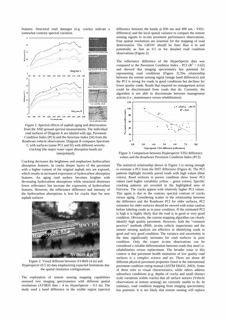
Figure 2: Visual different between AVIRIS (4 m) and
Hyperspectir (0.5 m) data emphasizing expected limitations due the spatial resolution configurations.
The exploration of remote sensing mapping capabilities assessed two imaging spectrometers with different spatial resolutions (AVIRIS data – 4 m; HyperSpectir – 0.5 m). The study used a band difference in the visible region (spectral
difference between the bands at 830 nm and 490 nm - VIS2-difference) and the local spatial variance to compare the remote sensing signals to in-situ pavement performance observations. Fine spatial resolutions are essential for the mapping of road deterioration. The GIFOV should be finer than 4 m and potentially as fine as 0.5 m for detailed road condition observations (Figure 2). The reflectance difference of the HyperSpectir data was compared to the Pavement Condition Index - PCI (R2 = 0.63) and showed that imaging spectrometry has potential for representing road conditions (Figure 3).The relationship between the remote sensing signal (image band difference) and the PCI is strong for roads in good conditions but declines for lower quality roads. Roads that required no management action could be discriminated from roads that do. Currently, the algorithm is not able to discriminate between management actions (i.e., maintenance versus rehabilitation).
Figure 3: Comparison between Hyperspectir VIS2 difference values and the Roadware Pavement Condition Index (PCI).
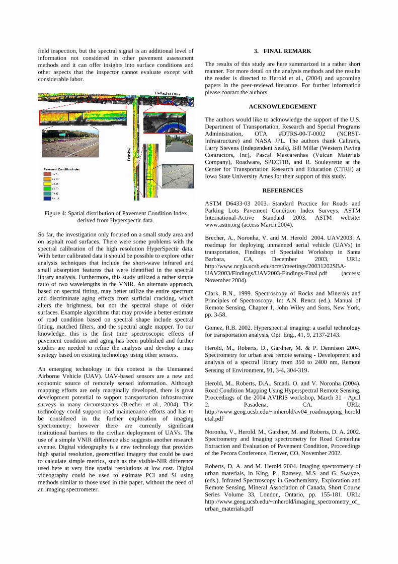
The statistical relationship shown in Figure 3 is strong enough to estimate a PCI from the HST difference (Figure 4). The PCI patterns highlight recently paved roads with high values (blue colors). Road surfaces in poorer condition show lower PCI values (and higher variability yellow – green colors). Specific cracking patterns are revealed in the highlighted area of Fairview. The cracks appear with relatively higher PCI values. This again is due to the contrary spectral contrast of cracks versus aging. Considering scatter in the relationship between the difference and the Roadware PCI for older surfaces, PCI estimates for older surfaces should be viewed with some caution before labeling roads as in poor condition. If the estimated PCI is high it is highly likely that the road is in good or very good condition. Obviously, the current mapping algorithm can clearly identify high quality pavement. However, both the “common practice” methods (PMS, in-situ vehicle inspections) and the remote sensing analysis are effective in identifying roads in good and very good condition. The variance and uncertainty in the data significantly increases for road surfaces in poor condition. Only the expert in-situ observations can be considered a reliable differentiation between roads that need i.e. rehabilitation versus replacement. The broader issue in this context is that pavement health estimation of low quality road surfaces is a complex science and art. There are about 40 different physical pavement properties listed in the international pavement condition rating manual (ASTM D6433, 2003). Some of these refer to visual characteristics, while others address subsurface conditions (e.g. depths of cracks and small distinct scale variations within cracks) that all surface sensors (Vehicle observations or remote sensing) are currently unable to do. In summary, road condition mapping from imaging spectrometry has potential. It is not likely that remote sensing will replace
field inspection, but the spectral signal is an additional level of information not considered in other pavement assessment methods and it can offer insights into surface conditions and other aspects that the inspector cannot evaluate except with considerable labor.
Figure 4: Spatial distribution of Pavement Condition Index
derived from Hyperspectir data.
So far, the investigation only focused on a small study area and on asphalt road surfaces. There were some problems with the spectral calibration of the high resolution HyperSpectir data. With better calibrated data it should be possible to explore other analysis techniques that include the short-wave infrared and small absorption features that were identified in the spectral library analysis. Furthermore, this study utilized a rather simple ratio of two wavelengths in the VNIR. An alternate approach, based on spectral fitting, may better utilize the entire spectrum and discriminate aging effects from surficial cracking, which alters the brightness, but not the spectral shape of older surfaces. Example algorithms that may provide a better estimate of road condition based on spectral shape include spectral fitting, matched filters, and the spectral angle mapper. To our knowledge, this is the first time spectroscopic effects of pavement condition and aging has been published and further studies are needed to refine the analysis and develop a map strategy based on existing technology using other sensors. An emerging technology in this context is the Unmanned Airborne Vehicle (UAV). UAV-based sensors are a new and economic source of remotely sensed information. Although mapping efforts are only marginally developed, there is great development potential to support transportation infrastructure surveys in many circumstances (Brecher et al., 2004). This technology could support road maintenance efforts and has to be considered in the further exploration of imaging spectrometry; however there are currently significant institutional barriers to the civilian deployment of UAVs. The use of a simple VNIR difference also suggests another research avenue. Digital videography is a new technology that provides high spatial resolution, georectified imagery that could be used to calculate simple metrics, such as the visible-NIR difference used here at very fine spatial resolutions at low cost. Digital videography could be used to estimate PCI and SI using methods similar to those used in this paper, without the need of an imaging spectrometer.
3. FINAL REMARK
The results of this study are here summarized in a rather short manner. For more detail on the analysis methods and the results the reader is directed to Herold et al., (2004) and upcoming papers in the peer-reviewd literature. For further information please contact the authors.
ACKNOWLEDGEMENT
The authors would like to acknowledge the support of the U.S. Department of Transportation, Research and Special Programs Administration, OTA #DTRS-00-T-0002 (NCRST-Infrastructure) and NASA JPL. The authors thank Caltrans, Larry Stevens (Independent Seals), Bill Millar (Western Paving Contractors, Inc), Pascal Mascarenhas (Vulcan Materials Company), Roadware, SPECTIR, and R. Souleyrette at the Center for Transportation Research and Education (CTRE) at Iowa State University Ames for their support of this study.
REFERENCES
ASTM D6433-03 2003. Standard Practice for Roads and Parking Lots Pavement Condition Index Surveys, ASTM International-Active Standard 2003, ASTM website: www.astm.org (access March 2004).
Brecher, A., Noronha, V. and M. Herold 2004. UAV2003: A roadmap for deploying unmanned aerial vehicle (UAVs) in transportation, Findings of Specialist Workshop in Santa Barbara, CA, December 2003, URL: http://www.ncgia.ucsb.edu/ncrst/meetings/20031202SBA-UAV2003/Findings/UAV2003-Findings-Final.pdf (access: November 2004).
Clark, R.N., 1999. Spectroscopy of Rocks and Minerals and Principles of Spectroscopy, In: A.N. Rencz (ed.). Manual of Remote Sensing, Chapter 1, John Wiley and Sons, New York, pp. 3-58.
Gomez, R.B. 2002. Hyperspectral imaging: a useful technology for transportation analysis, Opt. Eng., 41, 9, 2137-2143.
Herold, M., Roberts, D., Gardner, M. & P. Dennison 2004. Spectrometry for urban area remote sensing - Development and analysis of a spectral library from 350 to 2400 nm, Remote Sensing of Environment, 91, 3-4, 304-319.
Herold, M., Roberts, D.A., Smadi, O. and V. Noronha (2004). Road Condition Mapping Using Hyperspectral Remote Sensing, Proceedings of the 2004 AVIRIS workshop, March 31 - April 2, Pasadena, CA. URL: http://www.geog.ucsb.edu/~mherold/av04_roadmapping_heroldetal.pdf
Noronha, V., Herold. M., Gardner, M. and Roberts, D. A. 2002. Spectrometry and Imaging spectrometry for Road Centerline Extraction and Evaluation of Pavement Condition, Proceedings of the Pecora Conference, Denver, CO, November 2002.
Roberts, D. A. and M. Herold 2004. Imaging spectrometry of urban materials, in King, P., Ramsey, M.S. and G. Swayze, (eds.), Infrared Spectroscopy in Geochemistry, Exploration and Remote Sensing, Mineral Association of Canada, Short Course Series Volume 33, London, Ontario, pp. 155-181. URL: http://www.geog.ucsb.edu/~mherold/imaging_spectrometry_of_urban_materials.pdf