Mapping and Interpretation of the lithospheric magnetic … · 2 M.E. Purucker & D.A. Clark the...
20
Geophys. J. Int. (0000) 000, 000–000 Mapping and Interpretation of the lithospheric magnetic field Michael E. Purucker 1 & David A. Clark 2 1 Raytheon at Planetary Geodynamics Lab, Goddard Space Flight Center, Greenbelt, MD 20771 USA, [email protected] 2 CSIRO Materials Science and Engineering, PO Box 218, Lindfield 2070, NSW Australia, [email protected] 18 May 2010 SUMMARY We review some of the controversial and exciting interpretations of the magnetic field of the earth’s lithosphere occurring in the four year period ending with the IAGA meeting in So- pron in 2009. This period corresponds to the end of the Decade of Geopotential Research, an international effort to promote and coordinate a continuous monitoring of geopotential field variability in the near-Earth environment. One of the products of this effort has been the World Digital Magnetic Anomaly Map, the first edition of which was released in 2007. A second, im- proved, edition is planned for 2011. Interpretations of the lithospheric magnetic field that bear on impacts, tectonics, resource exploration, and lower crustal processes are reviewed. Future interpretations of the lithospheric field will be enhanced through a better understanding of the processes that create, destroy, and alter magnetic minerals, and via routine measurements of the magnetic field gradient. Key words: Earth’s magnetic field – Lithosphere 1 INTRODUCTION The magnetic field originating in the earth’s lithosphere is part of the earth’s magnetic field complex, a dynamic system (Friis- Christensen et al. 2009) dominated by the interaction of the earth’s magnetic field dynamo with that of the sun’s. The lithospheric field is dominated by static (on a human time scale) contributions that typically represents less than 1% of the overall magnitude of the magnetic field complex, and originate from rocks in the crust and locally, the uppermost mantle. Interpretation of the lithospheric magnetic field is used in 1) structural geology and geologic map- ping, and extrapolation of surface observations of composition and structure, 2) resource exploration and 3) plate tectonic reconstruc- tions and geodynamics. This article is designed as a review describing recent progress in mapping and interpreting the lithospheric magnetic field, and also includes some highlights from the 2009 IAGA meeting in So- pron, Hungary. Since IAGA meets every four years, we have de- signed this review to highlight progress in the four year period from 2005 through 2009. Several reviews of this and related subjects have appeared in this time. Review articles within books and ency- clopedias have included those within the Encyclopedia of Geomag- netism and Paleomagnetism (Gubbins and Herrero-Bervera 2007) and the Treatise of Geophysics (Schubert 2007). The Encyclopedia included articles on the Crustal Magnetic Field (D. Ravat), Depth to Curie temperature (M. Rajaram), Magnetic anomalies for Geology and Resources (C. Reeves and J. Korhonen), Magnetic Anomalies, Long Wavelength (M. Purucker), Magnetic Anomalies, Marine (J. Heirtzler), and Magnetic Anomalies, modeling (J. Arkani-Hamed). The Treatise of Geophysics included articles on ’Crustal Mag- netism’ (Purucker and Whaler 2007), on the ’Source of Oceanic Magnetic anomalies and the geomagnetic polarity timescale’ (Gee and Kent 2007) and on ’Plate Tectonics’ (Wessel and M¨ uller 2007). A series of workshops at the International Space Science Insti- tute (Bern, Switzerland) in 2008 and 2009 on Planetary Magnetism (2008) and Terrestrial Magnetism (2009) has resulted in a review article on the earth’s magnetic lithosphere (Langlais et al. in press). Reviews in journals in this time frame include those of Nabighian et al. (2005), Mandea and Purucker (2005), and Robinson et al. (2008). This review will highlight some of the controversial and excit- ing areas relating to the interpretation of the lithospheric magnetic field. We begin with the World Digital Magnetic Anomaly Mapping project (Korhonen et al. 2007), the first truly global compilation of lithospheric magnetic field observations. This sets the stage for the discussion of impact processes, and the magnetization and de- magnetization processes involved. After briefly reviewing the mag- netic record of terrestrial impact craters, we discuss recent quan- titative and theoretical work in the area, both terrestrial and extra- terrestrial. We then go on to review some of the new interpretations at the Vredefort, Lonar, and Sudbury structures, with possible im- plications for the extraterrestrial record, especially at Mars. We next review some of the interpretations of magnetic data for tectonics, and structural geology and geologic mapping. Included within this section is recent work suggesting that parts of the uppermost man- tle, especially in the vicinity of subduction zones, may be magnetic. If true, this may have important implications as a predictive tool for the spatial localization of large megathrust earthquakes and associ- ated tsunamis. Following this is a review of interpretations for re- source exploration, especially minerals, geothermal resources, and water. We also highlight some of the new developments in predic- tive mineral exploration models. This is followed by a review of
Transcript of Mapping and Interpretation of the lithospheric magnetic … · 2 M.E. Purucker & D.A. Clark the...

Geophys. J. Int. (0000) 000, 000–000
Mapping and Interpretation of the lithospheric magnetic field
Michael E. Purucker1 & David A. Clark21Raytheon at Planetary Geodynamics Lab, Goddard Space Flight Center, Greenbelt, MD 20771 USA, [email protected] Materials Science and Engineering, PO Box 218, Lindfield 2070, NSW Australia, [email protected]
18 May 2010
SUMMARYWe review some of the controversial and exciting interpretations of the magnetic field of theearth’s lithosphere occurring in the four year period ending with the IAGA meeting in So-pron in 2009. This period corresponds to the end of the Decade of Geopotential Research, aninternational effort to promote and coordinate a continuous monitoring of geopotential fieldvariability in the near-Earth environment. One of the products of this effort has been the WorldDigital Magnetic Anomaly Map, the first edition of which was released in 2007. A second, im-proved, edition is planned for 2011. Interpretations of the lithospheric magnetic field that bearon impacts, tectonics, resource exploration, and lower crustal processes are reviewed. Futureinterpretations of the lithospheric field will be enhanced through a better understanding of theprocesses that create, destroy, and alter magnetic minerals, and via routine measurements of themagnetic field gradient.
Key words: Earth’s magnetic field – Lithosphere
1 INTRODUCTION
The magnetic field originating in the earth’s lithosphere is partof the earth’s magnetic field complex, a dynamic system (Friis-Christensen et al. 2009) dominated by the interaction of the earth’smagnetic field dynamo with that of the sun’s. The lithospheric fieldis dominated by static (on a human time scale) contributions thattypically represents less than 1% of the overall magnitude of themagnetic field complex, and originate from rocks in the crust andlocally, the uppermost mantle. Interpretation of the lithosphericmagnetic field is used in 1) structural geology and geologic map-ping, and extrapolation of surface observations of composition andstructure, 2) resource exploration and 3) plate tectonic reconstruc-tions and geodynamics.
This article is designed as a review describing recent progressin mapping and interpreting the lithospheric magnetic field, andalso includes some highlights from the 2009 IAGA meeting in So-pron, Hungary. Since IAGA meets every four years, we have de-signed this review to highlight progress in the four year period from2005 through 2009. Several reviews of this and related subjectshave appeared in this time. Review articles within books and ency-clopedias have included those within the Encyclopedia of Geomag-netism and Paleomagnetism (Gubbins and Herrero-Bervera 2007)and the Treatise of Geophysics (Schubert 2007). The Encyclopediaincluded articles on the Crustal Magnetic Field (D. Ravat), Depth toCurie temperature (M. Rajaram), Magnetic anomalies for Geologyand Resources (C. Reeves and J. Korhonen), Magnetic Anomalies,Long Wavelength (M. Purucker), Magnetic Anomalies, Marine (J.Heirtzler), and Magnetic Anomalies, modeling (J. Arkani-Hamed).The Treatise of Geophysics included articles on ’Crustal Mag-netism’ (Purucker and Whaler 2007), on the ’Source of Oceanic
Magnetic anomalies and the geomagnetic polarity timescale’ (Geeand Kent 2007) and on ’Plate Tectonics’ (Wessel and Muller 2007).A series of workshops at the International Space Science Insti-tute (Bern, Switzerland) in 2008 and 2009 on Planetary Magnetism(2008) and Terrestrial Magnetism (2009) has resulted in a reviewarticle on the earth’s magnetic lithosphere (Langlais et al. in press).Reviews in journals in this time frame include those of Nabighianet al. (2005), Mandea and Purucker (2005), and Robinson et al.(2008).
This review will highlight some of the controversial and excit-ing areas relating to the interpretation of the lithospheric magneticfield. We begin with the World Digital Magnetic Anomaly Mappingproject (Korhonen et al. 2007), the first truly global compilationof lithospheric magnetic field observations. This sets the stage forthe discussion of impact processes, and the magnetization and de-magnetization processes involved. After briefly reviewing the mag-netic record of terrestrial impact craters, we discuss recent quan-titative and theoretical work in the area, both terrestrial and extra-terrestrial. We then go on to review some of the new interpretationsat the Vredefort, Lonar, and Sudbury structures, with possible im-plications for the extraterrestrial record, especially at Mars. We nextreview some of the interpretations of magnetic data for tectonics,and structural geology and geologic mapping. Included within thissection is recent work suggesting that parts of the uppermost man-tle, especially in the vicinity of subduction zones, may be magnetic.If true, this may have important implications as a predictive tool forthe spatial localization of large megathrust earthquakes and associ-ated tsunamis. Following this is a review of interpretations for re-source exploration, especially minerals, geothermal resources, andwater. We also highlight some of the new developments in predic-tive mineral exploration models. This is followed by a review of
2 M.E. Purucker & D.A. Clark
the interpretation of lower crustal processes, motivated by excitingnew work on ilmenite-hematite intergrowths by S. McEnroe andcolleagues, and on the effects of pressure on magnetization by S.Gilder and colleagues.
2 WORLD DIGITAL MAGNETIC ANOMALY MAP
The first version of the World Digital Magnetic Anomaly Map(WDMAM), published by the Commission for the Geologic Mapof the World (CGMW), summarizes our publicly available mappingknowledge of the lithospheric magnetic field of the Earth (Figure 1)as of 2007. Prior to that compilation, there had been publicly avail-able regional and continental scale digital compilations, and sev-eral global analog compilations. As befitting a subject with signifi-cant economic importance, commercial groups have also producedcompilations for the exploration community. The digital data andmetadata of the WDMAM are at 3 minutes of arc spacing, and5 km above the WGS84 ellipsoid. The are available in grid andmap form at http://ftp.gtk.fi/WDMAM2007. The map grewout of the peer review of several candidate models (Maus et al.2007b; Hamoudi et al. 2007; Hemant et al. 2007). The NOAAmodel (Maus et al. 2007b) was selected as the base model, andsubsequent changes were made to this base map prior to its publi-cation as the WDMAM (Korhonen et al. 2007). Two versions of theWDMAM are available, A and B. The A version fills areas with-out near-surface data with a downward-continued CHAMP model(Maus et al. 2007a) whereas the B version uses model data de-rived from marine ages to fill in marine areas without near-surfacedata (Purucker et al. 2007). The B version is shown in the printedmap available from the CGMW. The major data sets utilized forthe WDMAM, their spatial resolution, and online links are avail-able at http://www.agu.org/pubs/eos-news/supplements/2007/25-263.shtml and on the printed map. There are also a se-ries of products (equivalent source, RTP, and analytic signal) of theWDMAM that are available at http://dapple.geosoft.com.While the lithospheric field represented by the WDMAM may bequasi-static, the maps of that field continue to improve. Exam-ples include a new full spectrum magnetic anomaly grid of theUnited States (Ravat et al. 2009), and a new global marine mag-netic anomaly data set (Quesnel et al. 2009). We thus expect thatthere will be updates to the WDMAM, with both formally releasedproducts from the WDMAM organization, and informal releases ofinterim products from individual research groups, such as the recentreleases from NOAA at http://geomag.org. The next update isscheduled to be released in 2011.
3 IMPACTS
Impact cratering produces two classes of craters, the smaller ’sim-ple’ and the larger ’complex’ (Melosh 1989). The two types canbe distinguished based on their morphologies, and the transitionbetween the two occurs at diameters of between 2 and 4 km onthe Earth. Complex craters have central peaks, wall terraces, anda much smaller depth/diameter ratio than simple craters. Theyhave undergone more collapse than the simple craters, and thetransition diameter is inversely proportional to the local (plane-tary) gravitational acceleration. At even larger diameters the cen-tral peak evolves into a central peak ring. Multi-ring craters area type of complex crater characterized by multiple, large inward-facing scarps, and are most clearly developed on the Moon. Unlike
the transition from simple to complex, or from complex to peakring, multi-ring craters do not seem to scale with the local gravita-tional acceleration. The other crater type worthy of mention on theEarth is the ’inverted sombrero’ often seen in km-size terrestrialcraters and characterized by a disturbed central zone surroundedby a shallow moat. Atmospheric interactions may contribute to thisdistinctive shape, as discussed by Melosh (1989).
The magnetic signature of impact craters can be complex,but in general two types of features are often apparent (Pilkingtonand Hildebrand 2003). Short-wavelength, relatively intense mag-netic anomalies that occur near the center of the structure are thefirst of these types of features. Impact craters also disrupt the pre-existing magnetic signature, and that disruption is the second fea-ture that can sometimes be recognized (Spray et al. 2004). The rel-atively intense magnetic anomalies occurring within the crater canbe attributed to 1) uplifted magnetic lithologies, often basement, 2)magnetized impact melt rocks or breccia, 3) hydrothermal activity,4) shock remanent magnetization or demagnetization, or 5) somecombination of the above. Although variable, it is often the casethat terrestrial impact structures are characterized by broad mag-netic lows (Grieve and Pilkington 1996). Two useful guides to thevariability of the magnetic signature are provided by the works ofUgalde et al. (2005), and Cowan and Cooper (2005). Numericalmodeling using 2-D hydrocodes predict the distribution of pressureand temperature from which inferences can be made about the finalmagnetization distribution (Ugalde et al. 2005). While very use-ful, this model does not take into account later hydrothermal pro-cesses, which can significantly alter the magnetization distribution,and are often the source of significant ore deposits (Grant 1984;Clark 1997, 1999).
Recent work on the utility of the magnetic method over ter-restrial impacts includes the work of Pilkington and Hildebrand(2003) on estimating the size of the transient and disruption cavity.These sizes can be directly related to the energy release associatedwith impact. Weak lower and upper bounds are placed on thesequantities by establishing the sizes of two parameters: 1) the sizeof the relatively intense features in the interior of the crater, and 2)the size of the region where magnetic features have been disrupted.The authors suggest, based on 19 complex terrestrial structures, thatthe collapsed disruption cavity is about half the size of the crater di-ameter.
Of critical importance to the interpretation of the magnetic sig-nature is the coherence scale, or size of a region of coherent mag-netization (Lillis et al. in press; Carporzen et al. 2005). The high-frequency and relatively intense magnetic features seen in the inte-rior of impact basins, when upward-continued, often result in broadmagnetic lows because adjacent coherently magnetized regions ef-fectively cancel out. To complicate matters further, the coherencescale is often asymmetric. A simple example comes from the ter-restrial oceans, where strongly magnetized sea-floor ’stripes’ areoften very narrow (kms) in a direction perpendicular to the spread-ing axis, but very wide (thousands of kms) in the direction parallelto the spreading axis. When marine magnetic surveys of the oceansare upward-continued to satellite altitude they ’reveal’ that oceanicmagnetic fields are much weaker than continental magnetic fields(Hinze et al. 1991). The reality is more complex. Typical oceanicbasalts are much more magnetic than typical continental graniticrocks. Another example, discussed in depth below, comes from theVredefort impact crater (Carporzen et al. 2005) where aerial mea-surements of the magnetic field are lower than over surroundingregions, but surface magnetizations from within the crater are largeand variable on the cm scale. Finally, it should be noted that there

Mapping and Interpretation of the lithospheric magnetic field 3
Figure 1. Version B of the World Digital Magnetic Anomaly Map, with Mercator and polar stereographic projections, from Korhonen et al. (2007). Thedistribution of data sources is shown in the index map. Ridges, fracture zones, and trenches are shown in black.
may not be a single coherence scale for a particular region. Thecoherence scale is dictated by the physical process or processesat work, and multiple processes may result in multiple coherencescales. In certain idealized cases, it is often useful to employ theconcept of a matched filter (Syberg 1972; Phillips 1997) to esti-mate the depths of the principal magnetic sources, and to estimatecrudely what a map of the magnetic fields from those sources wouldresemble. Certain parameters are independent of coherence scale.Ideal body theory helps to establish bounds on quantities such asthe magnetization strength required to explain a magnetic field dis-tribution (Parker 1991, 2003; Purucker et al. 2009b).
The Vredefort impact in South Africa, Earth’s oldest andlargest impact crater, has been the subject of several recent stud-ies (Carporzen et al. 2005; Muundjua et al. 2007) and commen-tary (Dunlop 2005; Reimold et al. 2008; Muundjua et al. 2008).Carporzen et al. (2005) explain the elevated NRM intensities andQ-ratios typical of many of the exposed rocks at Vredefort as aconsequence of short-lived plasmas produced during the impact.They find that paleomagnetic directions from the shocked but un-melted bedrock exposed to these hypothetical plasmas have direc-tions which vary on scales of 10 cm or less. They explain the broadaeromagnetic low over the central portion of the impact (Figure 2)as a consequence of viewing this spatially incoherent magnetic sig-nal from an altitude of 150 m. Carporzen et al. (2005) also find
magnetic evidence for lightning in the surface rocks at Vredefort,another example of a plasma phenomenon. According to the au-thors, lightning can reproduce many, but not all, of the magneticfeatures of the surface rocks. As many as a quarter of their sampleshave been affected by lightning. Graham (1961) was the first todocument the pervasive magnetic effects of lightning on surfacerocks in South Africa. Carporzen et al. (2005) extrapolate theirVredefort results to the five youngest large impact basins on Mars(Lillis et al. in press) where very weak magnetic fields have beenmeasured. They suggest that a much smaller coherence wavelengthcharacterized these basins, and the measured magnetic fields do notrequire the absence of a planetary dynamo when they were created.The Martian observations had previously been taken as evidence(Acuna et al. 1999) that these basins had been demagnetized by theimpact, and that the magnetic dynamo had ceased by this time. Inaddition, it has been observed that the 14 oldest large impact basinson Mars have significant magnetic fields associated with them (Lil-lis et al. 2008), suggestive of the presence of a magnetic dynamoat this time (Figure 3. To explain the difference in terms of coher-ence wavelength, and not in terms of the presence or absence ofa magnetic dynamo, suggests that another process is at work, per-haps changes in the aqueous alteration environment Lillis et al. (inpress).
The 1.85 Ga impact that produced the Sudbury structure struck

4 M.E. Purucker & D.A. Clark
Figure 3. Magnetic anomaly map of Mars, adapted from Lillis et al. (in press). The circles represent the visually determined locations of the youngest largeimpact basins on Mars.
Figure 2. Aeromagnetic anomaly map of the Vredefort impact structure,from Muundjua et al. (2007).
a region of the southern Canadian shield characterized by lateArchean and early Proterozoic faulting, and dike emplacement.Spray et al. (2004) document the termination of the magnetic sig-nature of the 2.47 Ga Matachewan dike swarm as it reaches Ring 2of the impact structure, some 65 km from the center of the impact(Figure 4). Post impact magnetic dikes at 1.24 Ga are not termi-nated. The authors interpret these observation in terms of shockdemagnetization, and further interpret Ring 2 to correspond to ashock isobar pressure of between 1-10 Gpa, depending on whether
Figure 4. Distribution of magnetic dikes, and ring structures, from Spray etal.(2004).
the magnetism of the dikes is dominated by induced or remanentmagnetization.
A recent magnetic study of the Lonar impact structure(Louzada et al. 2008) document the magnetic processes active atthis simple, young (<50 ka) crater formed in the Deccan basalts.In this 1.88 km diameter crater, shocked ejecta blocks exhibit aslightly elevated coercivity. No evidence of shock remanent mag-netization (Gattacceca et al. 2008), shock demagnetization, ortransient, plasma-related processes, such as have been suggestedaround larger impact structure, were identified.
4 TECTONICS
Interpretations of magnetic field observations for tectonics, struc-tural geology, and geologic mapping have a long history (Reeves2007). One of its leading practitioners, the US Geological Survey,has an ongoing program to evaluate seismic hazards in the Seattle(USA) region. The shallow earthquakes in this active forearc basincan be devastating, and paleoseismology studies indicate the pres-ence of a M7+ earthquake some 1100 years ago on the Seattle fault,

Mapping and Interpretation of the lithospheric magnetic field 5
Figure 5. Highly simplified crust and upper mantle model of the Aleutiansubduction zone and related serpentinite mantle wedge, showing predictednear-surface contributions of the wedge to magnetic and gravity anomalies.
accompanied by a tsunami. Integrated magnetic studies (Blakelyet al. 2002) have focused on recognizing these shallow faults, andtracing them in areas of poor exposure. Recent work in the Pugetlowland (Sherrod et al. 2008) and to the west in the Olympic penin-sula (Blakely et al. 2009) continues to unravel the complexities, andhighlights the advances that can be made by an integrated geolog-ical and geophysical approach, which includes LIDAR, magnetics,gravity, and paleoseismological studies. For example, the SaddleMountain deformation zone (Blakely et al. 2009) in the Olympicpeninsula has been shown to have been active at approximately thesame time as the Seattle fault, some 1100 years ago, suggesting akinematic linkage between the two fault zones. The interpretationfavored by the authors suggests that the Seattle and Saddle Moun-tain zones form the boundaries of the northward advancing Seattleuplift.
Recent work (Blakely et al. 2005) suggests that parts of theuppermost mantle, especially in the vicinity of subduction zones,may be magnetic. At critical depths of 40 to 50 km, subductingocean crust goes through important metamorphic changes that re-lease large amounts of water into overriding mantle rocks. Intro-duction of water into the mantle produces serpentinite (Peacocket al. 2002), a highly magnetic, low-density rock (Figure 5).
Thermal models (Oleskevich et al. 1999) indicate that, in manyof the subduction zones of the world, this part of the mantle iscooler than the Curie temperature of magnetite, the most importantmagnetic mineral in serpentinite, and thus large volumes of mantlein subduction-margin settings should be magnetic. The World Dig-ital Magnetic Anomaly Map (Figure 6) does indeed show large-amplitude magnetic signatures over many of the world’s subduc-tion forearcs, including the Aleutian Islands, southern Alaska, Cas-cadia, Central America, and the Kurile Islands. Certainly thesenear-surface magnetic anomalies are caused in large part by uppercrustal lithologies, and they have been recognized since the time ofthe U.S satellite MAGSAT (Frey 1982). However, detailed analysisof a number of these subduction zones (Cascadia, Nankai, southernAlaska, Aleutians, and Central America) indicates that the mag-netic anomalies also include long-wavelength components originat-ing from mantle depths. These mantle-depth anomalies are thoughtto be caused by highly magnetic serpentinite in the mantle abovethe subducting slab (Blakely et al. 2005; Manea and Manea 2008).
Not all subduction zones exhibit high-amplitude magnetic
anomalies, reflecting geothermal and geochemical complexities.Part of this may be the result of inadequacies in the WDMAM maps(Thebault et al. in press), which form the background of several ofthe illustrations here. In the WDMAM, the oceanic component ofthe B map has been supplemented by models derived from the Dig-ital Age map of the oceans, and the polarity reversal timescale. Thedetails of both A and B maps, even in places where marine mag-netic surveys have been conducted, are compromised by the inabil-ity to separate spatial from temporal variations, a consequence ofthe absence of base stations in marine magnetic surveys. Futuregenerations of this map will result in a more objective and usefulproduct.
The presence of serpentinite in subduction margins has twoimportant links to large and giant earthquakes, and associatedtsunamis. First, dewatering the subducting slab is thought to em-brittle the slab, reactivate pre-existing faults and other structures,and produce within-slab earthquakes (Kirby et al. 1996; Peacocket al. 2002).Thus, we expect to see a spatial association betweenthis type of earthquake and mantle magnetic anomalies (Hyndmanand Peacock 2003; Blakely et al. 2005). Second, in cool subduc-tion margins, the down-dip limit of megathrust earthquakes (M 8.0-9.6) is controlled by the slab’s first encounter with serpentinizedmantle (Oleskevich et al. 1999). Again, we expect to see a spa-tial association between these devastating earthquakes and man-tle magnetic anomalies. For example, the devastating 2004 and2009 Sumatra-Andaman earthquakes are spatially associated withlong-wavelength magnetic anomalies and thus consistent with thepredicted pattern. Long recurrence intervals on megathrust earth-quakes make current seismic compilations an unreliable guide tothe location of past earthquakes, although non-volcanic tremors canbe used, at least in part.
The existence of serpentinized mantle is well demonstrated ina few subduction margins. At Cascadia, for example, anomalouslylow mantle velocities have been interpreted as evidence for ser-pentinization of the mantle wedge (Bostock et al. 2002; Brocheret al. 2003), and these low-velocity zones are located directly be-neath static long-wavelength magnetic anomalies (Blakely et al.2005). However, in many of the subduction zones of the world,including the Aleutian Islands (Figure 7), where a proposed mag-netic survey (Serpent) would be conducted, seismic data appropri-ate for these studies are unavailable. If it can be demonstrated thatlong-wavelength magnetic anomalies are a reliable predictor of thepresence of serpentinized mantle, then high-altitude magnetic sur-veys, such as the Serpent survey proposed to NASA by Puruckeret al. (2009a) provide the promise of mapping hydrated mantle atsubduction zones worldwide, thereby illuminating zones spatiallyand causally associated with both megathrust and within-slab earth-quakes.
In the Antarctic, aeromagnetic surveys play a much larger rolethan elsewhere in deciphering tectonics because exposures of base-ment rocks are rare. The interpretation of a new survey over theAdmiralty Block of the Transantarctic Mountains by Ferraccioliet al. (2009b) adds to our understanding of the relationships therebetween Cenozoic magmatism, faulting, and rifting. Fault zoneshere are defined by magnetic lineaments, and these help to de-fine transtensional fault systems which may have served to local-ize the McMurdo volcanics. Farther inland, interpretations of high-frequency aeromagnetic anomalies within the Wilkes subglacialbasin (Ferraccioli et al. 2009a) suggest the presence of large vol-umes of Jurassic tholeiites which may be related to rifting. By anal-ogy with the Cordillera of North America, the authors infer that theWilkes basin contains fold and thrust belts and a former backarc

6 M.E. Purucker & D.A. Clark
Figure 6. Magnetic anomalies of the Circum Pacific, showing the location of subduction zone magnetic anomalies. Source: World Digital Magnetic AnomalyMap (Korhonen et al. 2007)
basin. These features may represent the transition between the Pre-cambrian East Antarctic craton and the Ross orogenic belt. On theother side of the Antarctic continent, Shepherd et al. (2006) delin-eated subglacial geology via a combined aeromagnetic and radioecho sounding survey over three tributaries of Slessor Glacier inthe East Antarctic. They tentatively identified Jurassic dikes andsills intruding the Precambrian block here, and a post-Jurassic(?)sedimentary basin with a significant accumulation of sediment. Icemotion above the inferred sedimentary basin is seen to be differentin character, comprising basal sliding and/or a deforming layer ofsediment, than that above the remainder of the survey area.
In the Sinai peninsula, Rabeh and Miranda (2008) interpreta new high-resolution aeromagnetic survey, in conjunction withGPS and seismic data. They find systematic trends in the depthto the magnetic basement, and in the magnetically defined struc-tural trends. The depth to basement increases to the west and north,reaching some 4 km deep at the north end of the study area.
Aeromagnetic, gravity, geologic, and remote sensing datawere combined in the Eljufra region of Libya by Saadi et al. (2008)to define geologic structures and outline hydrothermally alteredbasalt. Analytic signal determinations of the magnetic field wereused to estimate the location and depths of magnetic contacts.
Aeromagnetic surveys often provide unparalleled views offaults in sedimentary basins. For example, Grauch and Hudson(2007) find that prominent low-amplitude (5-15 nT) linear anoma-lies are often associated with surficially hidden faults that offsetbasin-fill sediments in the central Rio Grande rift of north-centralNew Mexico (USA). They also find that the linear anomalies arenot the consequence of chemical processes acting within the faultzone, but rather due to the tectonic juxtaposition of magnetically
different strata across the fault. They develop a set of simple graph-ical, mathematical, and conceptual models to help them determineparameters of direct interest to structural geology.
Drenth and Finn (2007) have also recognized hidden faultingin the Pine Canyon caldera of Big Bend National Park, along theUS-Mexico border. The caldera-filling Pine Canyon rhyolite canbe used as a magnetic marker because it is reversely magnetized.The authors use this marker to assess the thickness of the calderafill, and suggest that it is controlled by buried faults evident in themagnetic survey.
Magnetic surveys, interpreted in conjunction with gravity andradiometric data, can also delineate basin architecture and tectonicevolution, as illustrated by the study of the Neocomian Rio do Peixebasin of NE Brazil (de Castro et al. 2007). The Rio do Peixe isa tripartite basin developed during the opening of the South At-lantic Ocean. Many pre-existing faults within the basement com-plex were reactivated during basin development, and the magneticsalso serves to delineate the thickness of the sedimentary packagesin these asymmetrical half-graben basins.
The utility of high-resolution airborne magnetic data in theinterpretation of tectonic processes is borne out by the analysis ofsuch a survey along a 120-km-long section of the Dead Sea Fault inJordan and Israel (ten Brink et al. 2007). This fault is poorly delin-eated on the basis of surface morphology, or micro-seismic activity,although damaging earthquakes have struck along this fault as re-cently as AD 1458. The fault is clearly seen on maps of the firstvertical derivative, indicating a shallow source for the anomalies.The authors interpret these 5-20 nT anomalies as originating fromthe alteration of magnetic minerals due to groundwater within thefault zone. Based on modeling of the magnetic observations, the
Mapping and Interpretation of the lithospheric magnetic field 7
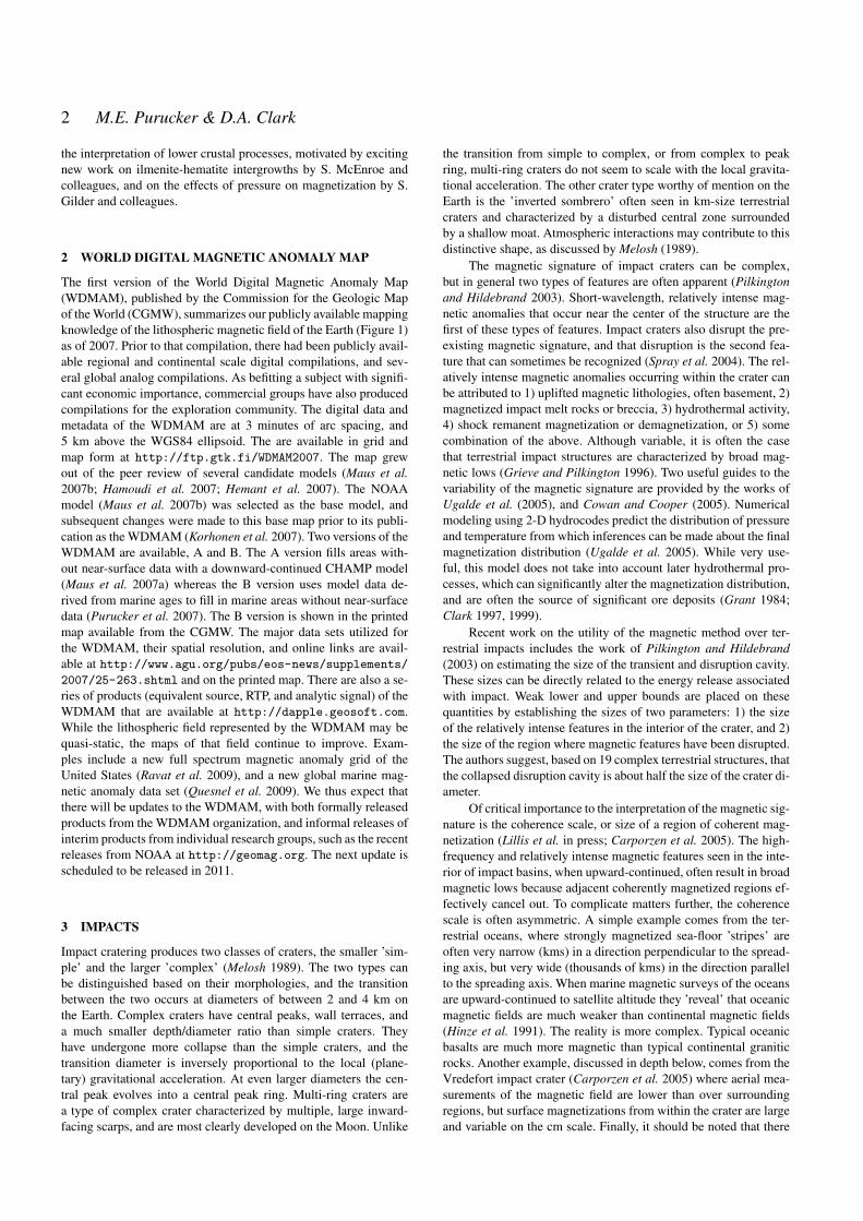
Figure 7. Proposed high altitude Global Hawk magnetic surveys (Purucker and SerpentTeam 2010) over the Aleutian Islands and surrounding regions, outlinedby the white polygon. Yellow triangles locate arc volcanoes, and white circles are historic megathrust earthquakes with magnitude greater than 8.0. The Amliafracture zone is indicated by the dotted white line. The color base map shows an approximation of magnetic anomalies observed at 20 km altitude. Anomalieswere calculated by analytically continuing the World Digital Magnetic Anomaly Map to 20 km altitude, from its nominal 5 km altitude.
width of the shallow fault zone is several hundred meters wide. Ona regional scale, the authors observe no igneous intrusions relatedto the fault zone, and confirm previous interpretations of 107-111km of left-lateral offset across the fault.
Magnetic techniques continue to play a major role in delin-eating plate tectonic processes in the marine realm. Maia et al.(2005) document the interaction between the Foundation hotspotand the Pacific-Antarctic ridge within the South Pacific. Analysisof the magnetic anomaly data document a difference between theage of hotspot-related seamounts, and the underlying oceanic crust.This difference suggests that the ridge has approached the hotspotat a rate of 40 km/Ma. This is in good agreement with publishedradiometric dates.
5 RESOURCE EXPLORATION
Over the last three decades there have been dramatic improvementsin the quality of magnetic surveys, accompanied by lowering of ac-quisition costs. Rapid developments in image processing, 3D visu-alization, computer-intensive enhancements of magnetic data andsemi-automated interpretation methods have ensured that magneticdata is routinely acquired and used by geologists as well as geo-physicists, at every stage of hard rock mineral exploration pro-grams, from regional area selection to prospect scale exploration.Recognition of the information about the sedimentary section, aswell as the crystalline basement, that is obtainable from modernhigh resolution magnetics has also led to greater use of magnetics inhydrocarbon exploration programs, although potential field meth-ods will always remain subsidiary to seismic methods in that arena.
Nabighian et al. (2005) have provided a comprehensive overviewof the historical development of magnetics in exploration and therecent state of the art. Accordingly, we will concentrate on somenew developments in magnetic exploration and some hitherto un-published work on magnetic signatures of mineralization.
Robinson et al. (2008) have reviewed magnetic and othergeophysical methods for hydrogeological research, with sugges-tions for future research directions. Tectonic and structural inter-pretations derived from aeromagnetic and Landsat thematic map-per (TM) data sets form the basis for an ambitious program ofgroundwater exploration (Ranganai and Ebinger 2008) in the aridsouthern Zimbabwe craton (Africa). The lack of primary perme-ability and porosity in this crystalline basement terrain results inpoor overall groundwater potential. However, available ground-water is localized by the presence of faults, fractures, dikes, anddeeply weathered regions. These features are often recognizablethrough enhanced aeromagnetic and/or thematic mapper observa-tions, and the authors utilize these to identify lineaments, and placethem in the context of the regional structural geology. They de-velop a model in which the aeromagnetic data is used to map faultsand fractures of considerable depth extent which may be open togroundwater (under tension) while the TM lineaments are typicallyclosed to groundwater (under compression) and define recharge ar-eas. The authors predict that coincident magnetic and TM linea-ments, and continuous structures associated with large catchmentbasins, will be most favorable for groundwater. The sparse recordof existing borehole data, some of which is of questionable quality,suggest a relationship between productivity and spatial proximityto faults and dikes, but proximity does not guarantee productivity.The trends of the NNE and NW sinistral faults in the Chilimanzi
8 M.E. Purucker & D.A. Clark
plutons can be traced from higher elevation areas in the north thatrepresent the watershed, to lower areas in the arid south. Since re-gional groundwater flows mostly follow the dominant topographicgradient, these structures were identified as the most promising interms of sustainable ground water resources.
Aeromagnetic data can also be utilized to infer heat flowwithin the crust, via determination of the depth to the Curieisotherm, the depth at which rocks lose their permanent and in-duced magnetism. When these determinations are from activegeothermal areas, they provide important constraints on the depthto the heat source, and its extent. Espinosa-Cardena and Campos-Enriquez (2008) make such a determination from the Cerro Pri-eto geothermal area of NW Mexico. They find that the Curie pointranges from 14 to 17 km depth, slightly deeper than previous stud-ies, but supported by seismic, gravity, and heat flow measurements.
Province- and continental-scale compilations of magnetic datasets provide a useful framework for identifying regional crustalstructures that control distribution of mineralization and favorablegeological environments (e.g., Hildenbrand et al. 2000; Chernicoffand Nash 2002; Chernicoff et al. 2002; Betts et al. 2004; Sandrinand Elming 2006; Airo and Mertanen 2008; Austin and Blenkinsop2008, 2009; Anand and Rajaram 2006; Anand et al. 2009), partic-ularly if these data sets are integrated with other geophysical data.
By utilizing magnetic and gravity data in an integrated geo-logical and geophysical study, Blakely et al. (2007) establish thatthe White River area of Washington exhibits many similarities tothe Goldfield mining district of Nevada, home to one of the largestepithermal gold deposits in North America. To date, White Riverhas produced only silica commercially, but deep weathering, youngsurficial deposits, and dense vegetation have hindered the evalua-tion of its economic potential for base and precious metals in thenear surface. The magnetic data was invaluable in defining struc-tural controls on hydrothermal alteration in both areas, but espe-cially at White River because of poor exposures. The deposits arepene-contemporaneous products of the Cascade Arc some 20 Maago. Gravity and magnetic data were instrumental in locating theintrusive body beneath both regions that presumably was the sourceof fluids and heat to the overlaying calc-alkaline volcanic rocks.Magnetic susceptibility measurements at White River demonstratethe destruction of magnetic minerals in the altered rocks, and pro-vide a way of estimating the depth extent of alteration (230-390 m).The White River altered area is located between two magneticallyidentified faults, in a temporary extensional stress regime.
Magnetic petrological studies of magnetic stratigraphy withinlayered intrusions (e.g., Ferre et al. 2009; McEnroe et al. 2009a)should improve detailed mapping within such intrusions, particu-larly beneath cover or between widely spaced drill holes, with evi-dent applications to exploration for such commodities as Cr, PGEs,Ni, Cu , V and Ti.
The magnetic properties of igneous rocks that are geneticallyrelated to metalliferous mineralization vary systematically with theore metals and deposit style (Clark 1999). Table 1 summarizesgeneralized results from a magnetic petrophysical database (Clarket al. 2004). Although for a given rock type the total range of sus-ceptibilities given in Table 1 can be quite large, the general trendsare clear. Within individual provinces, and in particular within spe-cific igneous suites, the variability is much less. Understanding themagnetic signatures of magmatic-hydrothermal systems associatedwith mineralization requires detailed consideration of the effects ofdifferent alteration types on a range of protoliths. Some examplesare given below.
Clark et al. (2004) produced a major study of the magnetic
signatures of porphyry copper deposits, volcanic-hosted epither-mal gold deposits, and iron-oxide copper-gold (IOCG) deposits.Although magnetic surveys are an integral part of exploration pro-grammes for porphyry, epithermal and IOCG deposits, the mag-netic signatures of these deposits and mineralized systems are ex-tremely variable and exploration that is based simply on search-ing for signatures that resemble those of known deposits is rarelysuccessful. However, the reasons for this variability are reasonablywell understood and are summarized below.
A number of well-known geological models of porphyry andepithermal deposits are routinely used in exploration, even thoughmost deposits fail to match the idealized models closely, due topost-emplacement tectonic disruption and rotations, asymmetric al-teration zoning due to emplacement along a contact between con-trasting country rock types, and so on. These complications aretaken into account by exploration geologists as geological infor-mation about a prospect accumulates. The variability of magneticsignatures of these deposits reflects strong dependence of magneticsignatures on local geological setting, departures of real mineral-ized systems from idealized geological models, the direction andintensity of the geomagnetic field, which varies over the Earth,and differing magnetic environments (host rock magnetization, re-gional gradients, interference from neighbouring anomalies etc.).To tackle this problem Clark et al. (2004) developed the concept ofpredictive magnetic exploration models that are specific to the lo-cal geological environment and history, and are based on magneticpetrological principles (Clark 1997, 1999) applied to standard ge-ological models, and on magnetic petrophysical data and detailedmodeling of selected deposits for which detailed magnetic and ge-ological data are available.
Significant geological factors that affect magnetic signaturesinclude tectonic setting and its influence on magma compositionand mode of emplacement; influence of pre-existing structures onthe geometry and depth of emplacement; and the crucial influenceof host rock composition on alteration assemblages, including sec-ondary magnetic minerals, and on the stability of primary magneticminerals.
Magnetic signatures reflect not only the local geological set-ting at the time of emplacement, but also post-emplacement modi-fication of deposits. Post-emplacement tilting of porphyry and ep-ithermal systems and dismemberment by faulting are very commonand drastically modify the geophysical signatures. Burial of a de-posit by younger sedimentary or volcanic rocks also modifies theanomaly pattern. Conversely, exhumation and partial erosion of thesystem produces a very different magnetic signature. In older de-posits, metamorphism can substantially modify the magnetic min-eralogy of the deposits and host rocks, with concomitant changesin the magnetic anomaly pattern. Although the majority of por-phyry and epithermal deposits are relatively young and, at most,weakly metamorphosed, some relatively ancient deposits in meta-morphosed terrains are known. There is a strong possibility thatsome older porphyry and epithermal deposits occur that have notbeen recognized, because effects of metamorphism and deforma-tion have obscured their true nature.
Given a comprehensive magnetic petrophysical database andthe understanding of the geological factors that create and de-stroy magnetic minerals in porphyry systems, however, the mag-netic effects of the above-mentioned geological complications arequite predictable. Variations in signatures due to varying geomag-netic inclination across the globe are best handled by calculat-ing reduced-to-pole (RTP) signatures that can be compared withRTP processed survey data from high and moderate latitudes or

Mapping and Interpretation of the lithospheric magnetic field 9
in low latitudes, where RTP processing is unstable, by calculatingreduced-to-equator (RTE) that can be compared with observed sig-natures, particularly if they are also reduced to the equator.
The porphyry copper model of Lowell and Guilbert (1970)has been highly influential in exploration programs and has beensuccessfully applied in many different areas. It should be remem-bered, however, that the model is based on a reconstruction of theSan Manuel and Kalamazoo porphyry deposits in Arizona, whichoriginally formed a single intrusion-centred orebody with concen-tric zoning, before being tilted and disrupted by faulting (Lowell1968; Force et al. 1995). The present disposition of intrusive rocksand alteration zones in and around these orebodies differs greatlyfrom the idealized model, but when the displacement along the SanManuel fault is removed and the intact porphyry system restoredto the vertical, it is apparent that the system originally conformedclosely to the model. Figure 8(a) shows a model of a Laramide typedeposit, associated with a high sulfur quartz monzonite magmathat intruded weakly magnetic felsic rocks and subsequently wastilted and dismembered by faulting in a similar fashion to the SanManuel-Kalamazoo system. The predicted magnetic signature isshown in Fig.8(b)-(d). This model, and those in subsequent figures,were created using the NoddyTM structural history modeling pro-gram (Jessel 2001).
Such post-emplacement disruption of porphyry systems iscommon. Wilkins and Heidrick (1995) report that approximately45% of the deposits of the southwestern North American porphyrycopper province have been significantly faulted, extended and ro-tated during Oligocene and Miocene time. Tilting through morethan 50◦ is common. Geissman et al. (1982) have quantified ro-tations in the Yerington district using paleomagnetism. A paleo-magnetic study of the Porgera Intrusive Complex by Schmidt et al.(1997) showed that the upper levels of this complex have beendisrupted by thin-skinned tectonics. The exposed intrusions haveundergone substantial, but varying, degrees of tilting and rotationabout vertical axes. Lum et al. (1991) point out the prevalence of lo-cal block rotations that distort outcrop patterns of high level intru-sions and porphyry and epithermal alteration systems in the tecton-ically very active SW Pacific. Rotation rates of 20◦-30◦ in 100,000years are unexceptional.
A more straightforward modification of a zoned alteration sys-tem is afforded by the giant Chuquicamata porphyry copper de-posit in Chile (Lindsay et al. 1995), which has been bisected bya major fault, leaving a mineralized system with zoned alterationjuxtaposed against unaltered intrusive rocks. Mineralized systemsare susceptible to dismemberment, because major faults that con-trolled emplacement of intrusions and flow of hydrothermal fluids,as at Chuquicamata, are often reactivated during or after depositionof mineralization.
Clark et al. (2004) summarized data from 50 deposits forwhich some information on magnetic signatures was available. Thequality of the data is highly variable, making definitive statisticalconclusions problematic. Taking the data at face value, however,they found that approximately 50% of deposits exhibited local RTPmagnetic highs associated with mineralizing intrusions, approxi-mately 70% had highs associated with alteration (usually potassicalteration with magnetite), approximately 70% also exhibited lo-cal magnetic lows over magnetite-destructive alteration zones, ap-proximately 20% had highs associated with skarns, and 40-60%of deposits were associated with magnetic lineaments that appearto represent structural controls on mineralization. Recognition ofstructural controls, in particular, is very sensitive to the quality ofthe data. Many deposits show more than one of these features, ac-
counting for the fact that the proportions add up to much more than100%.
Of the deposits for which high resolution magnetic data areavailable, 12 show well developed concentric zoning patterns. Tenof these, the majority from the Goonumbla cluster, New SouthWales, have ”doughnut” patterns, with central alteration low sur-rounded by an annular alteration high (Clark and Schmidt 2001).Two, the Bajo de la Alumbrera Cu-Au deposit and the AnabamaHill Cu prospect, have ”archery target” patterns, with central alter-ation highs surrounded by annular alteration lows.
Although the number of well-characterized empirical exam-ples of these types of zoned signature is low, the likely occurrenceof similar signatures can be inferred from other information, e.g.the distribution of magnetite reported for some deposits. Predictivemodels are designed to bridge the gap between purely geologicalmodels (both idealized models and detailed deposit descriptions)and empirical magnetic signatures. This process has suggested thefollowing conclusions for porphyry deposits that have not been sig-nificantly modified by post-emplacement tectonism or metamor-phism:
(i) The majority of gold-rich porphyry copper deposits (classicmorphology, quartz-monzonite zoning pattern) hosted by magneticmafic-intermediate volcanics are predicted to have large (>1000nT) bullseye high RTP anomalies over the potassic core, with in-cipient to prominent development of the archery target signature,depending on the extent of the phyllic zone, providing erosion hasexposed or nearly exposed the potassic zone. This signature shouldbe easily detectable beneath 100 m of sedimentary cover, and evenbeneath a similar thickness of magnetic volcanics.
(ii) For a completely buried, uneroded or slightly eroded, gold-rich porphyry copper system the signature is basically an alterationlow due to the large volume of magnetite-destructive alteration sur-rounding the deeply buried magnetic core. At intermediate levelsof exposure a more complex pattern of a central high surroundedby an alteration low occurs, with the relative amplitude of the highand low dependent on the erosion level.
(iii) Similar deposits emplaced into weakly magnetic felsicrocks or unreactive rocks, such as quartzites or shales, are char-acterized by a strong bullseye high, without a surrounding low.
(iv) If emplaced into limestone the bullseye high associated withthe potassically altered intrusion is likely to be supplemented byskarn anomalies (possibly remanently magnetized) associated withproximal magnetite-garnet skarn in favourable horizons, with dis-crete anomalies associated with distal skarn bodies, developed nearthe marble interface in structurally controlled zones. The skarn sig-nature should be more strongly developed if the host rocks aredolomitic.
(v) Alkalic porphyry Cu-Au deposits typically exhibit dioritemodel zonation, with poorly developed phyllic zones, and producestrong bullseye highs over the potassic core.
(vi) In areas of greater crustal influence on magmas (e.g. theLaramide province), those magmas with relatively high sulphurcontent generate large volumes of magnetite-destructive alteration,in contrast to low sulfur magmas, for which magnetite is associatedwith potassic alteration. Porphyry Cu and Cu-Au deposits of theformer type are associated with alteration lows, if emplaced intomagnetic host rocks, or very weak signatures if emplaced into non-magnetic host rocks.
(vii) Giant porphyry copper deposits of the Atacama desert arecharacterized by large volumes of magnetite-destructive alteration,with locally developed magnetite-bearing potassic alteration, and

10 M.E. Purucker & D.A. Clark
Figure 8. (a) Laramide type quartz monzonite porphyry model with concentric zoning, emplaced vertically into felsic rocks and subsequently tilted andfaulted. Alteration zones are inner potassic core (red), outer potassic (orange), ore shell (pink), phyllic/argillic (yellow), strong propylitic (dark green), andweak propylitic (light green), (b) calculated RTP magnetic signature of model, (c) calculated analytic signal amplitude of RTP magnetic signature, (d) profileof calculated RTP magnetic signature across model.
thick overlying supergene blankets. The signature of such deposits,when hosted by moderately magnetic rocks, is an areally extensivealteration low, with a typical amplitude of approximately 100 nT.Such deposits will be visible to magnetics if they are covered bynon-magnetic overburden, but cover by magnetic volcanics rendersthem difficult to see. When hosted by non-magnetic rocks the mag-netic signature is inconspicuous, apart from local highs associatedwith remnant zones of potassic alteration within the broad zones ofphyllic overprinting. These deposits are ringed by chargeable zonesdue to pyrite-bearing propylitic halos.
(viii) Phyllic alteration produced by magmatic, rather than me-teoric, fluids (e.g. the Goonumbla, New South Wales, deposits)tends to be ”inside-out” with respect to the potassic zone, produc-ing a doughnut magnetic signature. Another source of this reversezoning pattern may be structurally controlled access of meteoricfluids to deeper portions of a deposit. This type of signature is tobe expected in two main settings: Volcanic morphological models,with small intrusive spines within comagmatic volcanics, tappedoff a large mother magma chamber (e.g. Goonumbla), and plu-tonic/batholithic porphyry deposits.
(ix) Reduced porphyry Au-(Cu) and reduced intrusion-relatedgold deposits are characterized by incomplete doughnut signatureson a scale of kilometers, due to distal pyrrhotite-bearing mineral-ization developed in favourable sites, around a weakly magneticintrusion.
As an illustration of a specific category of predictive magnetic
exploration model we will discuss gold-rich porphyry copper de-posits, which have been intensively studied and for which genesis,structural controls, overall morphology and alteration zoning pat-terns are quite well understood (Sillitoe 2000).
Predictive magnetic models for gold-rich porphyry copper de-posits illustrated here conform to general geological models of thistype of deposit and are closely based on deposits that may be re-garded as archetypes for particular settings. In particular, the modeladopted for mafic-intermediate host rocks is based upon the Bajode la Alumbrera deposit in Argentina (Guilbert 1995), and themodel for carbonate host rocks is based upon Grasberg/Ertsberg(Papua New Guinea) (MacDonald and Arnold 1994; McDowellet al. 1996; Potter 1996). The assumed zoning is concentric witha magnetite-rich potassic core surrounded by a shell of phyllic al-teration passing outwards into propylitic alteration (in silicate hostrocks) or zoned skarn alteration (in a carbonate host).
The geometry of a gold-rich porphyry copper model, hostedby intermediate-mafic oxidized igneous rocks (nominally andesite),with a magnetite-rich potassic core is shown in Fig.9(a). This typeof model is mostly applicable to relatively mafic systems in islandarc environments, or to those associated with alkaline (e.g. high-Kcalc-alkaline to shoshonitic) magmatism in continental settings. InFig.9(a) there has been insufficient erosion to expose the deposit.The top of the mineralization lies 500 m below the surface andthe only sign of the mineralized system at the surface is a patchof propylitic alteration that could easily be overlooked or, if ob-served, assumed to be of little significance. The inner potassic zone

Mapping and Interpretation of the lithospheric magnetic field 11
Figure 9. Examples of canonical exploration models and their predicted magnetic signatures. (a) Gold-rich porphyry copper with magnetite-rich potassic core,emplaced into mafic-intermediate volcanics, uneroded, (b) RTP magnetic signature of model (a), (c) profile of RTP magnetic signature across model (a), (d)Same as model (a), with 500 m removed by erosion, (e) RTP magnetic signature of model (d), (f) profile of RTP magnetic signature across model (d), (g) Asfor model (a), with less secondary magnetite in potassic core, (h) RTP magnetic signature of model (g), (i) profile of RTP magnetic signature across model(g), (j) Gold-rich porphyry copper with magnetite-rich potassic core, emplaced into felsic igneous rocks, uneroded, (k) RTP magnetic signature of model (j),(l) profile of RTP magnetic signature across model (j).

12 M.E. Purucker & D.A. Clark
is strongly mineralized and magnetite-rich. It is surrounded by anouter potassic zone that contains less abundant, but still significant,magnetite. The inner potassic zone represents relatively intense de-velopment of quartz-magnetite-K feldspar veins, whereas the outerpotassic zone corresponds to biotite-K feldspar-quartz-magnetitealteration. A shell of magnetite-destructive phyllic alteration withvery low susceptibility envelops the potassic zones. At upper lev-els this alteration may grade into intermediate argillic and shallowadvanced argillic alteration, but the magnetic properties are equiv-alent for these alteration types and a single shell is sufficient tomodel the effects. The phyllic zone is surrounded by a zone of in-tense propylitic alteration, which is partially magnetite-destructive,which passes out into weak propylitic alteration and then into unal-tered andesite. The dimensions and susceptibilities of the zones aregiven below. The predicted reduced-to-pole (RTP) magnetic signa-ture of this model is shown in Fig.9(b)-(c).
After 500m of erosion (Fig.9(d)) a patch of phyllic, sur-rounded by propylitic, alteration is exposed, but the mineralizationis only subcropping. Removal of a 1 km thickness of rock exposesthe mineralized core of the system and its surrounding alterationzones, as at Bajo de la Alumbrera.
An alternative model with lesser secondary magnetite isshown in Fig.9(g). Its RTP magnetic signature is shown in Fig.9(h)-(i). This model type is generally applicable to less strongly oxidizedor relatively felsic systems, or to low-medium K calc-alkaline as-sociations, typically in areas with thick continental crust.
Other models include deposits hosted by different countryrocks, including weakly magnetic felsic igneous (or metaigneous)rocks, as shown in Fig.9(j)-(l), unreactive sedimentary rocks (e.g.quartzites), and carbonates. Quartzites (unaltered and within thepropylitic and phyllic zones) and unaltered carbonates have essen-tially zero susceptibility.
The predicted RTP magnetic signatures for many deposit typesdepend strongly on the level of exposure. For exposed systemswithin magnetic intermediate-mafic igneous host rocks, as at Bajode la Alumbrera, a strong central high is surrounded by a relativelyweak annular low over the phyllic zone, gradually returning tobackground levels over the propylitic zone. For a completely buriedsystem, however, the signature is basically an alteration low dueto the large volume of magnetite-destructive alteration surroundingthe deeply buried magnetic core. At intermediate levels of expo-sure a more complex pattern of a central high surrounded by analteration low occurs, with the relative amplitude of the high andlow dependent on the erosion level.
For quartzites and similar host rocks, on the other hand, thesignature is a simple high over the mineralized, potassically alteredintrusion, for all levels of exposure. The anomaly becomes gradu-ally weaker and broader with increasing depth of burial of the mag-netic core. The signature for moderately magnetic felsic host rocksis intermediate between the signatures for mafic hosts and unreac-tive sedimentary host rocks, but the annular low around the centralhigh is poorly developed, due to the relatively low magnetizationcontrast between the magnetite-destructive alteration zones (phyl-lic and strong propylitic) and the unaltered felsic rocks. Carbonatehost rocks have the central high, with highs also developed overmagnetite-rich proximal Cu-(Au) skarns, in the inner garnet-richzone, and distal Au skarns, near the marble contact. These skarnstends to occur as discrete magnetite-bearing skarn bodies, devel-oped within favourable horizons and localized by overall zonationpatterns and by structural controls.
Figure 10(a)-(c) shows effects of burial under a significantthickness of magnetic volcanics of the deposit model shown in
Fig.9(a), demonstrating that such deposits should be clearly de-tectable beneath volcanic cover. Fig.10(d)-(f) shows distortion ofthe magnetic signature produced by post emplacement tilting. Fig-ure 10(g)-(i) illustrates a porphyry system similar to that of Fig.9(a)but emplaced into carbonate rocks, and Fig.10(j)-(l) shows the ef-fects of asymmetric alteration zoning produced by emplacementinto a contact between magnetic mafic rocks and carbonates.
With regard to epithermal gold deposits, intense epithermal-style alteration, whether low- or high-sulphidation, is invariablymagnetite-destructive. The magnetic signature is strongly depen-dent on the host rocks. Epithermal alteration systems hosted bymagnetic volcanic rocks are characterized by smooth, flat mag-netic low zones within the overall busy magnetic texture (Irvineand Smith 1990; Feebrey et al. 1998). Similar systems within non-magnetic sedimentary rocks have negligible magnetic expression.High sulphidation systems may have a diffuse intrusion + alter-ation high due to a deeper porphyry system within a few hundredmeters to a few kilometres of the deposit. This may be more promi-nent if post-formation faulting has brought the intrusion closer tothe surface, or the porphyry and epithermal systems are telescopedby rapid uplift during formation. Upward continuation of mag-netic maps may help identify deep intrusions, beneath magneticvolcanics, that are possible sources for mineralizing fluids (Gunnet al. 2009). Magnetics can also be useful for detecting structuralcorridors and fluid pathways that are related to more localized ep-ithermal systems. Radiometrics can detect K-rich alteration (e.g.adularia-sericite) associated with some exposed or subcropping ep-ithermal deposits. Although in favourable circumstances magneticsis a useful tool for defining hydrothermal systems that are prospec-tive for volcanic-hosted epithermal gold deposits, delineation of theore zones is not possible. Electrical methods are generally moreuseful for detecting conductive or chargeable mineralization anddefining resistive zones of silicification. Gravity methods are some-times useful for defining lower density alteration, or in some casesenhanced density due to silicification of porous rocks.
Smith (2002) has reviewed geophysical signatures of IOCGdeposits, with an emphasis on magnetics and gravity. Due to thehigh densities of iron oxide minerals, IOCG deposits are invariablyassociated with gravity highs, up to 20 mgal for large deposits.The magnetic signatures of IOCG deposits, and their relationshipsto the gravity anomalies, depend on the geological history and aremuch more variable. The iron oxide zonation pattern of IOCG sys-tems (Hitzman et al. 1992; Wall and Gow 1995) indicates that themagnetic sources overall tend be deeper and more laterally ex-tensive than the gravity sources. For this reason detailed analysisof the anomalies should reveal a somewhat deeper and/or broadermagnetic zone than the anomalous density distribution, as at thearchetypical Olympic Dam, South Australia, deposit (Esdale et al.2003). Thus a better term for the relationship between the magneticand gravity anomalies is ”superposed”, rather than ”coincident”,anomalies.
Redox conditions during deposition and alteration overprint-ing, which controls the abundances and proportions of magnetiteand hematite in IOCG deposits and their alteration envelopes area crucial control on the magnetic signatures. Magnetite, formedunder relatively reducing conditions, has very high susceptibilitycompared to hematite. Hematite has low susceptibility and alsohas fairly weak remanence, unless it has formed at, or been takento, very high temperatures and thereby acquired a thermoremanentmagnetization. Monoclinic pyrrhotite, formed under reducing con-ditions with moderate sulphur fugacity, has moderate susceptibil-ity, but tends to carry intense remanence. The oxidation state of the

Mapping and Interpretation of the lithospheric magnetic field 13
Figure 10. Examples of canonical exploration models and their predicted magnetic signatures. (a) RTP magnetic signature of model in Fig.9(a), buried beneath100 m of magnetic volcanics (b) As for (a), but upper 1000 m of deposit removed by erosion, then covered by 100 m of magnetic volcanics (c) Analytic signalamplitude (total gradient) of RTP magnetic signature in (a), (d) Model of Fig.9(a), with post-formation tilt through 60 degrees, (e) RTP magnetic signature ofmodel (d), (f) profile of RTP magnetic signature across model (d), (g) Gold-rich porphyry copper, emplaced into carbonate rocks with magnetite-rich potassiccore plus proximal and distal skarns, eroded 500 m, (h) RTP magnetic signature of model (g), (i) profile of RTP magnetic signature across model (g), (j)Gold-rich porphyry copper with magnetite-rich potassic core, emplaced into contact between mafic volcanics and carbonate rocks, eroded 500 m, (k) RTPmagnetic signature of model (j), (l) profile of RTP magnetic signature across model (j).
14 M.E. Purucker & D.A. Clark
host sequence appears to influence the oxidation state of the IOCGdeposits, as well as the redox state of the source (e.g. magmatic flu-ids) and the paleodepth (more oxidized at shallow depths). IOCGdeposits tend to occur in relatively oxidized crustal provinces,characterized by strong anomalies and complex magnetic patterns(Haynes 2000). Within the regional magnetic variability, the de-posits lie within or near relatively strong magnetic highs, associatedwith semi-regional magnetite-producing sodic and sodic-calcic al-teration systems.
In a typical vertically zoned IOCG system, magnetite-destructive, hematite-rich hematite-sericite-chlorite-carbonate(HSCC) alteration dominates upper levels, whereas magnetite-richalteration (potassic at intermediate depths, grading into deepersodic or sodic-calcic alteration) dominates at depth. Thus the cur-rent erosion level determines whether the exposed or near-surfaceportions of the system are hematite-rich or magnetite-rich. If thelevel of exposure is sufficiently deep, overprinting magnetite-richpotassic alteration tends to be more focussed around the deposits,enhancing the magnetic highs. On the other hand, if upper levels ofthe system have been retained, magnetite-destructive hematite-richalteration hosts the mineralization. In this case the signature isa relatively smooth pattern, which can be a local magnetic low(depending on the host rock magnetization) within the overallbroad high associated with deeper and/or more laterally extensivemagnetite-dominant alteration. Tilting of a vertically zoned system,or upfaulting of the deeper magnetite-rich portion, may juxtaposethe magnetite and hematite zones, producing juxtaposed, ratherthan ”coincident” gravity and magnetic anomalies.
High grade regional or contact metamorphism of hematite-rich zones can impart an intense thermoremanence to the hematite,which can cause large magnetic anomalies. This appears to explainthe strong magnetic anomalies exhibited by massive hematite bod-ies of the Mount Woods Inlier that have been contact metamor-phosed, such as the Peculiar Knob deposit (Schmidt et al. 2007),whereas similar unmetamorphosed massive hematite at ProminentHill produces no discernible magnetic anomaly.
At continent to province scale favourable tectonic settings forancient deposits may be recognisable from regional potential fielddata sets, supplemented by seismic, magnetotelluric or other deep-penetrating methods. Ancient buried subduction zones are charac-terized by arc-parallel linear belts of magnetic highs, correspond-ing to magnetite-series granitoid provinces, and lows, correspond-ing to ilmenite-series granitoid provinces or sedimentary basins.Subduction-related magnetite-series belts are much more prospec-tive for IOCG and porphyry copper-(gold) deposits. Belts of re-duced, ilmenite-series granitoids are prospective for Sn-(W) andalso for intrusive-related Au and reduced porphyry Au-(Cu) de-posits. Within belts of magnetite-series granitoids, Cu-Au is asso-ciated with more magnetic magmatic-hydrothermal systems thanCu-Mo; W-Mo-Bi and Au in tin provinces is much less magnetic.In oxidized Au-bearing systems, Au mineralization is often associ-ated with the felsic end of magmatic evolution and is then associ-ated locally with a weaker magnetic character and higher radioele-ment contents. Continental rift settings, which are also prospectivefor IOCG deposits, may be associated with rift-parallel regionalgravity and magnetic highs along the ancient continental margin,with a quiet magnetic zone outboard of the regional highs and rel-atively busy magnetic patterns inboard of the margin (Gunn 1997).Large intrusions associated with bimodal magmatism, which ischaracteristic of anorogenic environments, including several IOCGprovinces, can be seen in magnetic and gravity images, due to thecontrasting physical properties of mafic and felsic intrusions.
At a regional scale major structures that control the emplace-ment of mineralizing or heat-engine magmas, or which channelflow of crustal fluids, are often evident in suitably processed grav-ity and magnetic data sets (e.g., Sandrin et al. 2007). These fea-tures may also be visible in satellite imagery. Intersections of lin-eaments appear to be particularly favourable for IOCG mineraliza-tion. Structural controls at a range of scales, from semiregional toprospect scale, may be evident in detailed magnetic data. Identifi-cation of favourable orientations of structures may be possible ifsenses of movement, block rotations etc. are known. Anomaly off-sets and abrupt changes of trend in magnetic images can help to de-fine tectonic movements. Paleomagnetic studies can also be usefulfor defining rotations and tilting within and around deposits (Geiss-man et al. 1982; Force et al. 1995; Schmidt et al. 1997) and to de-fine distinct magmatic and hydrothermal alteration events recordedby remanent magnetization (Schmidt et al. 1997; Clark and Lackie2003; Astudillo et al. 2010).
A large range of magma compositions within a comagmaticsuite is indicative of substantial fractional crystallization, whichcan partition metals into late stage fluids, potentially concentrat-ing them to levels that can produce economic ore deposits. Forthis reason fractional crystallization is favourable for developmentof intrusive-related mineralization. Strongly zoned oxidized intru-sions produced by fractional crystallization exhibit zoned magneticsignatures and, if exposed or subcropping, zoned radiometric pat-terns. Similarly, multiple/nested intrusions, with a substantial rangeof magnetic properties, densities and radioelement contents, par-ticularly when there are geophysical indications of an underlyingmagma chamber, are also favourable indicators of fractional crys-tallization.
Well-developed contact aureoles around intrusions are indica-tive of emplacement of high-temperature, melt-rich magma ca-pable of undergoing substantial fractional crystallization. Strongcontact aureole effects produce substantial mineralogical changesin the metamorphosed and metasomatized host rocks, often withpronounced changes in magnetic susceptibility (particularly in-creased susceptibility due to creation of secondary magnetiteand/or pyrrhotite). Strong remanent magnetization of contact au-reoles is also suggestive of high temperature emplacement or sub-stantial metasomatism. Prominent contact aureole magnetic signa-tures, particularly if they are clearly zoned or show strong localoverprinting are therefore also favorable indicators of potentiallymineralized magmatic-hydrothermal systems.
Future advances in magnetic exploration will rely firstly onbetter understanding of the processes that create, destroy and altermagnetic minerals in mineralized environments, based on magneticpetrological studies, accompanied by more comprehensive mag-netic property databases and detailed case studies of magnetic sig-natures of mineralized environments. Secondly, improvements inacquisition, processing and interpretation of the crustal magneticfield will enable more geological information to be extractable frommagnetic surveys. Although small incremental improvements inconventional surveys will continue, the most dramatic advances arelikely to involve gradiometry, particularly measurements of the fullgradient tensor by new generation highly sensitive instruments, toobtain more detailed information about structures and subtly vary-ing magnetization patterns in the shallow crust.
In a seminal paper Pedersen and Rasmussen (1990) discussin some detail the practical problems encountered in the collectionand processing of gradient tensor data and the benefits obtainablefrom acquisition of tensor data. For instance, these workers pointout that resolution is enhanced compared to conventional magnetic

Mapping and Interpretation of the lithospheric magnetic field 15
surveys and that rotational invariants calculated from tensor datahave attractive properties for interpretation. Christensen and Ra-jagopalan (2000) suggested that the next breakthrough in magneticexploration is likely to be the measurement of the gradient tensorand demonstrated the utility of analytic signal amplitudes (total gra-dients) of vector components, which can be derived directly fromgradient tensor components, for locating boundaries and interpret-ing source geometries in the presence of remanence. Schmidt andClark (2006) have summarized the multiple benefits of gradiometryin general and tensor gradiometry in particular.
Recently the first practical low temperature (liquid heliumcooled) SQUID-based system for geophysical gradient tensor sur-veys has been developed by the Jena (Germany) group (Stolz et al.2006). The intrinsic noise of the LTS planar gradiometers devel-oped by this group is 0.2 pT/m (integrated between 0.01Hz and10Hz). Noise spectral density of the full tensor gradiometer systemin motion is about 1 − 10pT/m/
√Hz over a frequency range of
0.1− 2Hz in a bird towed beneath a helicopter and approximatelyten times higher for installation on a fixed wing aircraft.
The discovery of high temperature (liquid nitrogen tempera-tures and above) superconducting materials in the late 1980s hascreated opportunities for cheaper, smaller devices that can be read-ily transported and refilled, but retain very high sensitivities. Liquidnitrogen cooled SQUIDs and gradiometers are very sensitive, withnoise levels that are about an order of magnitude higher than thoseof low T SQUIDs. Clark et al. (1998) suggested the use of com-bined vector field and gradient tensor measurements, using high Tsuperconducting devices, for separating contributions of inducedand remanent magnetization to magnetic anomalies and for infer-ring source properties, such as total magnetization direction, rema-nence direction and Koenigsberger ratio.
A number of tensor gradiometer systems, based on a widerange of different technologies including high temeprature SQUIDdevices, are under development (e.g., Clem et al. 2001; Humphreyet al. 2005; Leslie et al. 2007; Wiegert et al. 2007; Sunderland et al.2009; Keenan et al. 2010). We anticipate that over the next decadefull gradient tensor systems will be commercialized and be rou-tinely used in next generation magnetic surveys for exploration.
6 INTERPRETATION OF LOWER CRUSTALPROCESSES
Lower crustal processes are dominated by increasing temperatures,and an important temperature is that associated with the Curiepoint of magnetite (580◦C), above which it loses its permanentand induced magnetism. To the extent that other magnetic mineralsdominate in the lower crust, the temperatures of those other mag-netic phases will be important for interpretation. Ilmenite-hematite,hematite-magnetite, or titanomagnetite-rich, phases exhibit differ-ent Curie, Neel, or unblocking temperatures from pure magnetite(McEnroe et al. 2004), and they extend to 670◦C for hematite-richcompositions. Fine-scale exsolution of ilmenite-hematite phases(McEnroe et al. 2009b), and possibly also magnetite-hematitephases (Schmidt et al. 2007), significantly increases the magneticremanence and coercivity from typical multi-domain values. Ifthese lamellae are not resorbed by temperature and pressure condi-tions in the lower crust, then a much greater range of magnetic min-eral phases may be present. Experiments by McEnroe et al. (2004)suggest that the lamellae may be stable at lower crustal tempera-tures and pressures.
Increasing pressures also have an effect on the magnetic prop-
erties of single and multi-domain magnetite (Gilder et al. 2004) andtitanomagnetite (Gilder and Le Goff 2008). Both saturation rema-nent magnetization and coercivity increase markedly in titanomag-netites at typical lower crustal pressures. The percentage of Ti inthe titanomagnetite structure seems to control the increase in mag-netization and coercivity, with the highest increases associated withthe highest amounts of Ti.
Much work continues to be devoted to the difficult questionof determining the depth to the Curie and Neel isotherms, andwith comparing results from different approaches. Works utiliz-ing standard approaches (Spector and Grant 1970) include thoseof Bilim (2007), Bektas et al. (2007), and Maden (2009) in Turkey,Trifonova et al. (2009) in Bulgaria, ChunFeng et al. (2009) andXu-Zhi et al. (2006) in China, Prutkin and Saleh (2009) in Egypt,and Stampolidis et al. (2005) in Albania. A fractal approach basedon the formulation of Maus et al. (1997) was used in the westernUnited States by Bouligand et al. (2009), and a similar approachwas used in California by Ross et al. (2006). Ravat et al. (2007)compares several spectral approaches, while Rajaram et al. (2009)compares the spectral approach with an approach that integratesseismic, heat flow, and satellite magnetic data sets (Purucker et al.2007).
7 SUMMARY
The interpretation of terrestrial impact structures continues to gar-ner much attention because of its relevance to the interpretation ofextraterrestrial impacts. These impacts are the targets of robotic ex-ploration by NASA, ESA, and the national space agencies of Japan,India, and China.
The importance of the coherence scale, or size of a region ofcoherent magnetization, can not be overemphasized, both in the ter-restrial and extraterrestrial examples. It is often the case that obser-vations of a feature are made from only a single altitude. A changein that altitude can often make a dramatic difference in what fea-tures are available for interpretation, and ’color’ the interpretationin subtle ways.
Future advances in magnetic exploration are critically depen-dent on a better understanding of the processes that create, de-stroy, and alter magnetic minerals. Comprehensive magnetic prop-erty databases are also a requirement for future advances in mag-netic exploration.
The magnetic technique has often been faulted as having toolittle resolution. Recent advances in the measurement, process-ing, and interpretation of gradient data utilizing high temperatureSQUID devices on helicopters and fixed-wing aircraft offer theprospect of dramatic improvements in the resolution of our mag-netic imagery. Similar improvements in our view of the magneticlithosphere from near-Earth space will be inaugurated with theSwarm constellation (Friis-Christensen et al. 2009). Swarm willutilize highly sensitive Helium and fluxgate magnetometers flyingin constellation to make its gradient field measurements.
8 ACKNOWLEDGMENTS
We would like to acknowledge the support of the SERPENT pro-posal team, especially R. Blakely (USGS) for Figure 5, Figure 6,and Figure 7 and R. Bracken (USGS) for Figure 7.

16 M.E. Purucker & D.A. Clark

Mapping and Interpretation of the lithospheric magnetic field 17
REFERENCES
Acuna, M., et al., Global distribution of crustal magnetization discov-ered by the Mars Global Surveyor MAG/ER experiment, SCIENCE,284(5415), 790–793, 1999.
Airo, M., and S. Mertanen, Magnetic signatures related to orogenic goldmineralization, JOURNAL OF APPLIED GEOPHYSICS, 64, 14–24,2008.
Anand, S., and M. Rajaram, Aeromagnetic data analysis for the identifica-tion of concealed uranium deposits: a case history from Singhbhum ura-nium province, India, EARTH PLANETS AND SPACE, 58, 1099–1103,2006.
Anand, S., M. Rajaram, T. Majumdar, and R. Bhattacharyya, Structure andtectonics of 85 E Ridge from analysis of Geopotential data, TECTONO-PHYSICS, 478, 100–110, 2009.
Astudillo, N., P. Roperch, B. Townley, C. Arriagada, and A. Chauvin,Magnetic polarity zonation within the El Teniente copper-molybdenumporphyry deposit, central Chile, MINERALIUM DEPOSITA, 45, 23–41,2010.
Austin, J., and T. Blenkinsop, The Cloncurry Lineament: Geophysical andgeological evidence for a deep crustal structure in the Eastern Successionof the Mount Isa Inlier, PRECAMBRIAN RESEARCH, 163, 50–68, 2008.
Austin, J., and T. Blenkinsop, Local to regional scale structural controlson mineralization and the importance of a major lineament in the easternMount Isa Inlier, Australia: Review and analysis with autocorrelation andweights of evidence, ORE GEOLOGY REVIEWS, 35, 298–316, 2009.
Bektas, O., D. Ravat, A. Bueyueksarac, F. Bilim, and A. Ates, Regionalgeothermal characterisation of East Anatolia from aeromagnetic, heatflow and gravity data, PURE AND APPLIED GEOPHYSICS, 164(5),975–998, doi:{10.1007/s00024-007-0196-5}, 2007.
Betts, P., J. Barraud, J. Lumley, and M. Davies, Aeromagnetic patterns ofhalf-graben and basin inversion: implications for sediment-hosted mas-sive sulfide Pb-Zn-Ag exploration, JOURNAL OF STRUCTURAL GE-OLOGY, 26, 1137–1156, 2004.
Bilim, F., Investigations into the tectonic of Kutahya-Denizli region, linea-ments and thermal structure western Anatolia, from using aeromagnetic,gravity and seismological data, PHYSICS OF THE EARTH AND PLAN-ETARY INTERIORS, 165(3-4), 135–146, doi:{10.1016/j.pepi.2007.08.007}, 2007.
Blakely, R., R. Wells, C. Weaver, and S. Johnson, Location, structure,and seismicity of the Seattle fault zone, Washington: Evidence fromaeromagnetic anomalies, geologic mapping, and seismic-reflection data,GEOLOGICAL SOCIETY OF AMERICA BULLETIN, 114(2), 169–177,2002.
Blakely, R., T. Brocher, and R. Wells, Subduction-zone magnetic anoma-lies and implications for hydrated forearc mantle, GEOLOGY, 33(6),445–448, doi:{10.1130/G21447.1}, 2005.
Blakely, R. J., D. A. John, S. E. Box, B. R. Berger, R. J. Fleck, R. P.Ashley, G. R. Newport, and G. R. Heinemeyer, Crustal controls onmagmatic-hydrothermal systems: A geophysical comparison of WhiteRiver, Washington, with Goldfield, Nevada, GEOSPHERE, 3(2), 91–107, doi:{10.1130/GES00071.1}, 2007.
Blakely, R. J., B. L. Sherrod, J. F. Hughes, M. L. Anderson, R. E. Wells,and C. S. Weaver, Saddle Mountain fault deformation zone, OlympicPeninsula, Washington: Western boundary of the Seattle uplift, GEO-SPHERE, 5(2), 105–125, doi:{10.1130/GES00196.1}, 2009.
Bostock, M., R. Hyndman, S. Rondenay, and S. Peacock, An invertedcontinental Moho and serpentinization of the forearc mantle, NATURE,417(6888), 536–538, 2002.
Bouligand, C., J. M. G. Glen, and R. J. Blakely, Mapping Curie tem-perature depth in the western United States with a fractal model forcrustal magnetization, JOURNAL OF GEOPHYSICAL RESEARCH-SOLID EARTH, 114, doi:{10.1029/2009JB006494}, 2009.
Brocher, T., T. Parsons, A. Trehu, C. Snelson, and M. Fisher, Seismic evi-dence for widespread serpentinized forearc upper mantle along the Cas-cadia margin, GEOLOGY, 31(3), 267–270, 2003.
Carporzen, L., S. Gilder, and R. Hart, Palaeomagnetism of the Vrede-fort meteorite crater and implications for craters on Mars, NATURE,
435(7039), 198–201, doi:{10.1038/nature03560}, 2005.Chernicoff, C., and C. Nash, Geological interpretation of Landsat TM im-
agery and aeromagnetic survey data, northern Precordillera region, Ar-gentina, JOURNAL OF SOUTH AMERICAN EARTH SCIENCES, 14,813–820, 2002.
Chernicoff, C., J. Richards, and E. Zappettini, Crustal lineament control onmagmatism and mineralization in northwestern Argentina: geological,geophysical and remote sensing evidence, ORE GEOLOGY REVIEWS,21, 127–155, 2002.
Christensen, A., and S. Rajagopalan, The magnetic vector and gradienttensor in mineral and oil exploration, PREVIEW, p. 77, 2000.
ChunFeng, L., C. Bing, and Z. ZuYi, Deep crustal structures of east-ern China and adjacent seas revealed by magnetic data, SCIENCE INCHINA SERIES D-EARTH SCIENCES, 52(7), 984–993, doi:{10.1007/s11430-009-0096-x}, 2009.
Clark, D., Magnetic petrophysics and magnetic petrology: aids to geologicinterpretation of magnetic surveys, AGSO JOURNAL AUSTRALIAN GE-OLOGY AND GEOPHYSICS, 17, 83–103, 1997.
Clark, D., Magnetic petrology of igneous intrusions: implications for ex-ploration and magnetic interpretation, EXPLORATION GEOPHYSICS,30, 5–26, 1999.
Clark, D., and M. Lackie, Palaeomagnetism of the Early Permian MountLeyshon Intrusive Complex and Tuckers Igneous Complex, NorthQueensland, Australia, GEOPHYSICAL JOURNAL INTERNATIONAL,153(3), 523–547, doi:{10.1046/j.1365-246x.2003.01907.x}, 2003.
Clark, D., and P. Schmidt, Petrophysical properties of the Goonumbla Vol-canic Complex, NSW: Implications for magnetic and gravity signaturesof porphyry Cu-Au mineralization, EXPLORATION GEOPHYSICS, 32,171–175, 2001.
Clark, D., P. Schmidt, D. Coward, and M. Huddleston, Remote determi-nation of magnetic properties and improved drill targeting of magneticanomaly sources by Differential Vector Magnetometry (DVM), EXPLO-RATION GEOPHYSICS, 29, 312–319, 1998.
Clark, D., S. Geuna, and P. Schmidt, Predictive magnetic exploration mod-els for porphyry, epithermal, and iron oxide copper-gold deposits: impli-cations for exploration, P700 Final Report, AMIRA International Ltd.,2004.
Clem, T., D. Overway, J. Purpura, J. Bono, R. Koch, J. Rozen, G. Keefe,S. Willen, and R. Mohling, High-Tc SQUID gradiometer for mobilemagnetic anomaly detection, IEEE TRANS. APPL. SUPERCOND., 11,871–875, 2001.
Cowan, D., and G. Cooper, Enhancement of magnetic signatures of impactcraters modeling and petrophysics, in Large meteorite impacts III, editedby Kenkmann, T. and Horz, F. and Deutsch, A., pp. 51–65, GeologicalSociety of America Special Paper 384, 2005.
de Castro, D. L., D. C. de Oliveira, and R. M. Gomes Castelo Branco,On the tectonics of the Neocomian Rio do Peixe Rift Basin, NE Brazil:Lessons from gravity, magnetics, and radiometric data, JOURNAL OFSOUTH AMERICAN EARTH SCIENCES, 24(2-4), 184–202, doi:{10.1016/j.jsames.2007.04.001}, 2007.
Drenth, B. J., and C. A. Finn, Aeromagnetic mapping of the structureof Pine Canyon caldera and Chisos Mountains intrusion, Big BendNational Park, Texas, GEOLOGICAL SOCIETY OF AMERICA BUL-LETIN, 119(11-12), 1521–1534, 2007.
Dunlop, D., Planetary science - Magnetic impact craters, NATURE,435(7039), 156–157, doi:{10.1038/435156a}, 2005.
Esdale, D., D. Pridmore, J. Coggon, P. Muir, P. William, and F. Fritz,Olympic Dam copper-uranium-gold-silver-rare earth element deposit,South Australia: A geophysical case history, in Geophysical signaturesof South Australian Mineral Deposits, edited by Dentith, MC, pp. 147–168, Centre for Global Metallogeny, University of Western Australia,Publication 31, 2003.
Espinosa-Cardena, J. M., and J. O. Campos-Enriquez, Curie point depthfrom spectral analysis of aeromagnetic data from Cerro Prieto geother-mal area, Baja California, Mexico, JOURNAL OF VOLCANOLOGYAND GEOTHERMAL RESEARCH, 176(4), 601–609, doi:{10.1016/j.jvolgeores.2008.04.014}, 2008.
Feebrey, C., H. Hishida, K. Yoshioka, and K. Nakayama, Geophysical ex-
18 M.E. Purucker & D.A. Clark
pression of low sulphidation epithermal Au-Ag deposits and explorationimplications-examples from the Hokusatsu region of SW Kyushu, Japan,RESOURCE GEOLOGY, 48, 75–86, 1998.
Ferraccioli, F., E. Armadillo, T. Jordan, E. Bozzo, and H. Corr, Aero-magnetic exploration over the East Antarctic Ice Sheet: A new viewof the Wilkes Subglacial Basin, TECTONOPHYSICS, 478(1-2, Sp. Iss.SI), 62–77, doi:{10.1016/j.tecto.2009.03.013}, General Assembly ofthe International-Association-of-Geodesy/24th General Assembly of theInternational-Union-of-Geodesy-and-Geophysics, Perugia, ITALY, JUL02-13, 2007, 2009a.
Ferraccioli, F., E. Armadillo, A. Zunino, E. Bozzo, S. Rocchi, andP. Armienti, Magmatic and tectonic patterns over the Northern Victo-ria Land sector of the Transantarctic Mountains from new aeromag-netic imaging, TECTONOPHYSICS, 478(1-2, Sp. Iss. SI), 43–61, doi:{10.1016/j.tecto.2008.11.028}, General Assembly of the International-Association-of-Geodesy/24th General Assembly of the International-Union-of-Geodesy-and-Geophysics, Perugia, ITALY, JUL 02-13, 2007,2009b.
Ferre, E., S. Maes, and K. Butak, The magnetic stratification of layeredmafic intrusions: Natural examples and numericalmodels, LITHOS, 111,83–94, 2009.
Force, E., W. Dickinson, and J. Hagstrum, Tilting history of theSan Manuel-Kalamazoo porphyry system, southeastern Arizona, ECO-NOMIC GEOLOGY, 90, 67–80, 1995.
Frey, H., MAGSAT Scalar anomaly distribution-The global perspective,GEOPHYSICAL RESEARCH LETTERS, 9(4), 277–280, 1982.
Friis-Christensen, E., H. Luhr, G. Hulot, R. Haagmans, and M. Pu-rucker, Geomagnetic Research from Space, EOS TRANSACTIONS AGU,90(25), 213–214, 2009.
Gattacceca, J., L. Berthe, M. Boustie, F. Vadeboin, P. Rochette, andT. De Resseguier, On the efficiency of shock magnetization processes,PHYSICS OF THE EARTH AND PLANETARY INTERIORS, 166(1-2),1–10, doi:{10.1016/j.pepi.2007.09.005}, 2008.
Gee, J., and D. Kent, Source of Oceanic Magnetic Anomalies and the Ge-omagnetic Polarity Timescale, in Geomagnetism, edited by Kono, M, pp.5.12, 455–508, Treatise of Geophysics, Volume 5, Elsevier, 2007.
Geissman, J., R. Van der Voo, and H. KL, A paleomagnetic study of thestructural deformation in the Yerington district, Nevada, AMERICANJOURNAL OF SCIENCE, 282, 1042–1109, 1982.
Gilder, S., M. LeGoff, J. Chervin, and J. Peyronneau, Magnetic proper-ties of single and multi-domain magnetite under pressures from 0 to6 GPa, GEOPHYSICAL RESEARCH LETTERS, 31(10), doi:{10.1029/2004GL019844}, 2004.
Gilder, S. A., and M. Le Goff, Systematic pressure enhancement of ti-tanomagnetite magnetization, GEOPHYSICAL RESEARCH LETTERS,35(10), doi:{10.1029/2008GL033325}, 2008.
Graham, K., The Re-magnetization of a Surface Outcrop by LightningCurrents, GEOPHYSICAL JOURNAL OF THE ROYAL ASTRONOMI-CAL SOCIETY, 6(1), 85–102, 1961.
Grant, F., Aeromagnetics, Geology, and ore environments, I. Magnetite inigneous, sedimentary, and metamorphic rocks: An overview, GEOEX-PLORATION, 23, 303–333, 1984.
Grauch, V. J. S., and M. R. Hudson, Guides to understanding the aeromag-netic expression of faults in sedimentary basins: Lessons learned fromthe central Rio Grande rift, New Mexico, GEOSPHERE, 3(6), 596–623,doi:{10.1130/GES00128.1}, 2007.
Grieve, R. A. F., and M. Pilkington, The signature of terrestrial impacts,JOURNAL of AUSTRALIAN GEOLOGY & GEOPHYSICS, 16, 399–420,1996.
Gubbins, D., and E. Herrero-Bervera (Eds.), Encyclopedia of Geomag-netism and Paleomagnetism, Springer, The Netherlands, 2007.
Guilbert, J., Geology, alteration, mineralization and genesis of the Bajode la Alumbrera porphyry copper-gold deposit, Catamarca Province, Ar-gentina, in Porphyry Copper Deposits of the American Cordillera, editedby Pierce, FW and Bolm, JG, pp. 646–656, Arizona Geological SocietyDigest 20, 1995.
Gunn, P., Regional magnetic and gravity responses of extensional sedi-mentary basins, AGSO JOURNAL OF AUSTRALIAN GEOLOGY AND
GEOPHYSICS, 17(2), 115–131, 1997.Gunn, P., T. Mackey, and A. Meixner, Magnetic exploration, Tech. rep.,
Pacific Islands Applied Geoscience Commission, SOPAC Technical Bul-letin 11, 2009.
Hamoudi, M., E. Thebault, V. Lesur, and M. Mandea, GeoForschungsZen-trum Anomaly Magnetic Map (GAMMA): A candidate model forthe World Digital Magnetic Anomaly Map, GEOCHEMISTRY GEO-PHYSICS GEOSYSTEMS, 10, doi:{10.1029/2007GC001638}, 2007.
Haynes, D., Iron oxide copper(-gold) deposits: their position in the ore de-posit spectrum and modes of origin, in Hydrothermal Iron Oxide Copper-Gold and related deposits: A Global Perspective, edited by Porter, TM,pp. 71–90, Volume 1, PGC Publishing, Adelaide, 2000.
Hemant, K., E. Thebault, M. Mandea, D. Ravat, and S. Maus, Mag-netic anomaly map of the world: merging satellite, airborne, marine andground-based data, EARTH AND PLANETARY SCIENCE LETTERS,260, 56–71, 2007.
Hildenbrand, T., B. Berger, R. Jachens, and S. Ludington, Regional crustalstructures and their relationship to the distribution of ore deposits in thewestern United States, based on magnetic and gravity data, ECONOMICGEOLOGY, 95, 1583–1603, 2000.
Hinze, W., R. Von Frese, and D. Ravat, Mean magnetic contrasts be-tweeen oceans and continents, TECTONOPHYSICS, 192(1-2), 117–127,doi:{10.1016/0040-1951(91)90250-V}, 1991.
Hitzman, M., N. Oreskes, and E. MT, Geological chracteristics and tec-tonic setting of Proterozoic iron oxide (cu-U-Au-REE) deposits, PRE-CAMBRIAN RESEARCH, 1, 1, 1992.
Humphrey, K., T. Horton, and M. Keene, Detection of mobile targetsfrom a moving platform using an actively shielded, adaptively balancedSQUID gradiometer, IEEE TRANS.APPL.SUPERCOND., 15(2), 753–756, 2005.
Hyndman, R., and S. Peacock, Serpentinization of the forearc mantle,EARTH AND PLANETARY SCIENCE LETTERS, 212(3-4), 417–432,doi:{10.1016/S0012-821X(03)00263-2}, 2003.
Irvine, R., and M. Smith, Geophysical exploration for epithermal gold sys-tems, JOURNAL OF GEOCHEMICAL EXPLORATION, 36, 375–412,1990.
Jessel, M., Three-dimensional geological modeling of potential-field data,COMPUTERS AND GEOSCIENCES, 27, 455–465, 2001.
Keenan, T., J. Young, C. Foley, and J. Du, A high-Tc flip-chip SQUID gra-diometer for mobile underwater magnetic sensing, SUPERCONDUC-TOR SCIENCE AND TECHNOLOGY, 23, 025,029, 7 pp, 2010.
Kirby, S., E. Engdahl, and R. Denlinger, Intermediate-depth intraslabearthquakes and arc volcanism as physical expressions of crustal and up-permost mantle metamorphism in subducting slabs, in Subduction: Topto Bottom, edited by Bebout, G.E. et al., pp. 195–214, American Geo-physical Union Geophysical Monograph 96, 1996.
Korhonen, J., et al., Magnetic Anomaly map of the World, and associ-ated DVD, Commission for the Geological Map of the World, UNESCO,Paris, France, Scale:1:50,000,000, 2007.
Langlais, B., V. Lesur, M. Purucker, J. Connerney, and M. Mandea, Crustalmagnetic fields of Terrestrial Planets, SPACE SCIENCE REVIEWS, doi:{10.1007/s11214-009-9557-y}, in press.
Leslie, K., K. Blay, D. Clark, P. Schmidt, D. Tilbrook, M. Bick, and C. Fo-ley, Helicopter trial of magnetic tensor gradiometer, in ASEG 19th Inter-national Conference, Perth, Australia, 2007.
Lillis, R. J., H. V. Frey, M. Manga, D. L. Mitchell, R. P. Lin, M. H. Acuna,and S. W. Bougher, An improved crustal magnetic field map of Marsfrom electron reflectometry: Highland volcano magmatic history and theend of the martian dynamo, ICARUS, 194(2), 575–596, doi:{10.1016/j.icarus.2007.09.032}, 2008.
Lillis, R. J., M. E. Purucker, H. J.S., K. Louzada, Stewart-Mukhopadhyay,M. Manga, and H. Frey, Study of impact demagnetization on Mars usingMonte Carlo modeling and multiple altitude data, JOURNAL OF GEO-PHYSICAL RESEARCH-PLANETS, in press.
Lindsay, D., M. Zentilli, and J. Rojas de la Rivera, Evolution of an activeductile to brittle shear system controlling mineralization at the Chuquica-mata porphyry copper deposit, northern Chile, INT.GEOL.REVIEW, 37,945–958, 1995.

Mapping and Interpretation of the lithospheric magnetic field 19
Louzada, K. L., B. P. Weiss, A. C. Maloof, S. T. Stewart, N. L. Swanson-Hysell, and S. A. Soule, Paleomagnetism of Lonar impact crater, India,EARTH AND PLANETARY SCIENCE LETTERS, 275(3-4), 308–319,doi:{10.1016/j.epsl.2008.08.025}, 2008.
Lowell, J., Geology of the Kalamazoo orebody, San Manuel District, Ari-zona, ECONOMIC GEOLOGY, 63, 645–654, 1968.
Lowell, J., and J. Guilbert, Lateral and vertical alteration-mineralizationzoning in porphyry copper deposits, ECONOMIC GEOLOGY, 65, 373–408, 1970.
Lum, J., A. Clark, and P. Coleman, Gold potential of the southwest Pa-cific:Papua New Guinea, Solomon Islands, Vanuatu, and Fiji, Tech. rep.,East-West Center, Honolulu, 1991.
MacDonald, G., and L. Arnold, Geological and geochemical zoning of theGrasberg Igneous complex, Irian Java, Indonesia, JOURNAL OF GEO-CHEMICAL EXPLORATION, 50, 179–202, 1994.
Maden, N., Crustal Thermal Properties of the Central Pontides (North-ern Turkey) Deduced from Spectral Analysis of Magnetic Data, TURK-ISH JOURNAL OF EARTH SCIENCES, 18(3), 383–392, doi:{10.3906/yer-0803-7}, 2009.
Maia, M., J. Dyment, and D. Jouannetaud, Constraints on age and con-struction process of the Foundation chain submarine volcanoes frommagnetic modeling, EARTH AND PLANETARY SCIENCE LETTERS,235(1-2), 183–199, doi:{10.1016/j.epsl.2005.02.044}, 2005.
Mandea, M., and M. Purucker, Observing, modeling, and interpretingmagnetic fields of the solid Earth, SURVEYS IN GEOPHYSICS, 26(4),415–459, doi:{10.1007/s10712-005-3857-x}, 2005.
Manea, M., and V. C. Manea, On the origin of El Chichon volcano andsubduction of Tehuantepec Ridge: A geodynamical perspective, JOUR-NAL OF VOLCANOLOGY AND GEOTHERMAL RESEARCH, 175(4,Sp. Iss. SI), 459–471, doi:{10.1016/j.jvolgeores.2008.02.028}, 2008.
Maus, S., D. Gordon, and D. Fairhead, Curie-temperature depth estimationusing a self-similar magnetization model, GEOPHYSICAL JOURNALINTERNATIONAL, 129(1), 163–168, 1997.
Maus, S., H. Luehr, M. Rother, K. Hemant, G. Balasis, P. Ritter,and C. Stolle, Fifth-generation lithospheric magnetic field model fromCHAMP satellite measurements, GEOCHEMISTRY GEOPHYSICSGEOSYSTEMS, 8, doi:{10.1029/2006GC001521}, 2007a.
Maus, S., T. Sazonova, K. Hemant, J. Fairhead, and D. Ravat, NationalGeophysical Data Center Candidate for the World Digital MagneticAnomaly Map, GEOCHEMISTRY GEOPHYSICS GEOSYSTEMS, 8(6),doi:{10.1029/2007GC001643}, 2007b.
McDowell, F., T. McMahon, P. Warren, and M. Cloos, Pliocene Cu-Au-bearing igneous intrusions of the Gunung Bijih (Ertsberg) district, IrianJava, Indonesia: K-Ar geochronology, JOURNAL OF GEOLOGY, 104,327–340, 1996.
McEnroe, S., F. Langenhorst, P. Robinson, G. Bromiley, and C. Shaw,What is magnetic in the lower crust?, EARTH AND PLANETARYSCIENCE LETTERS, 226(1-2), 175–192, doi:{10.1016/j.epsl.2004.07.020}, 2004.
McEnroe, S., L. Brown, and P. Robinson, Remanent and induced magneticanomalies over a layered intrusion: Effects from crystal fractionation andmagma recharge, TECTONOPHYSICS, 478, 119–134, 2009a.
McEnroe, S., K. Fabian, P. Robinson, C. Gaina, and L. L. Brown, CrustalMagnetism, Lamellar Magnetism and Rocks That Remember, ELE-MENTS, 5(4), 241–246, doi:{10.2113/gselements.5.4.241}, 2009b.
Melosh, H., Impact cratering: A geologic process, Oxford UniversityPress, New York, 1989.
Muundjua, M., R. J. Hart, S. A. Gilder, L. Carporzen, and A. Galdeano,Magnetic imaging of the Vredefort impact crater, South Africa, EARTHAND PLANETARY SCIENCE LETTERS, 261(3-4), 456–468, doi:{10.1016/j.epsl.2007.07.044}, 2007.
Muundjua, M., A. Galdeano, L. Carporzen, S. A. Gilder, R. J. Hart,M. A. G. Andreoli, and M. Tredoux, Reply to comment by WU Reimold,RL Gibson, and H. Henkel on Muundjua et al. (2007), “Magnetic imag-ing of the Vredefort impact crater, South Africa”, EPSL 261, pp 456-468Discussion, EARTH AND PLANETARY SCIENCE LETTERS, 273(3-4),397–399, doi:{10.1016/j.epsl.2008.06.044}, 2008.
Nabighian, M., V. Grauch, R. Hansen, T. LaFehr, Y. Li, J. Peirce,
J. Phillips, and M. Ruder, 75th Anniversary - The historical developmentof the magnetic method in exploration, GEOPHYSICS, 70(6), 33ND–61ND, doi:{10.1190/1.2133784}, 2005.
Oleskevich, D., R. Hyndman, and K. Wang, The updip and downdip limitsto great subduction earthquakes: Thermal and structural models of Cas-cadia, south Alaska, SW Japan, and Chile, JOURNAL OF GEOPHYSI-CAL RESEARCH-SOLID EARTH, 104(B7), 14,965–14,991, 1999.
Parker, R., A theory of Ideal bodies for Seamount magnetism, JOURNALOF GEOPHYSICAL RESEARCH-SOLID EARTH, 96(B10), 1991.
Parker, R., Ideal bodies for Mars magnetics, JOURNAL OF GEOPHYS-ICAL RESEARCH-PLANETS, 108(E1), doi:{10.1029/2001JE001760},2003.
Peacock, S., K. Wang, and A. McMahon, Thermal structure and metamor-phism of subducting oceanic crust: Insight into Cascadia intraslab earth-quakes and processes, and earthquake hazards, Open-file Report 02-328,17-24, U.S. Geological Survey, 2002.
Pedersen, L., and T. Rasmussen, The gradient tensor of potential fieldanomalies: Some implications on data collection and data processing ofmaps, GEOPHYSICS, 55, 1558–1566, 1990.
Phillips, J., Potential-field geophysical software for the PC-version 2.2,Open-file Report 97-725, U.S. Geological Survey, 1997.
Pilkington, M., and A. Hildebrand, Transient and disruption cavity di-mensions of complex terrestrial impact structures derived from mag-netic data, GEOPHYSICAL RESEARCH LETTERS, 30(21), doi:{10.1029/2003GL018294}, 2003.
Potter, D., What makes Grasberg anomalous, implications for future ex-ploration, in Porphyry Related Copper and Gold deposits of the AsiaPacific Region, Australian Mineral Foundation, pp. 10.1–10.13, 1996.
Prutkin, I., and A. Saleh, Gravity and magnetic data inversion for 3D to-pography of the Moho discontinuity in the northern Red Sea area, Egypt,JOURNAL OF GEODYNAMICS, 47(5), 237–245, doi:{10.1016/j.jog.2008.12.001}, 2009.
Purucker, M., and M. SerpentTeam, Magnetic signatures of serpentinizedmantle and mesoscale variability along the Alaska/Aleutian subductionzone, in Abstract book of the European Geoscience Union, Vienna, Aus-tria, 2010.
Purucker, M., and K. Whaler, Crustal Magnetism, in Geomagnetism,edited by Kono, M, pp. 5.06, 195–236, Treatise of Geophysics, Volume5, Elsevier, 2007.
Purucker, M., T. Sabaka, G. Le, J. A. Slavin, R. J. Strangeway, andC. Busby, Magnetic field gradients from the ST-5 constellation: Improv-ing magnetic and thermal models of the lithosphere, GEOPHYSICALRESEARCH LETTERS, 34(24), doi:{10.1029/2007GL031739}, 2007.
Purucker, M., N. Olsen, T. Sabaka, and H. R., Geomagnetism mission con-cepts after Swarm, in Abstract book of the Int. Assoc. Geomag. Aeronom.11th Scientific Assembly, p. p. 105, Sopron, Hungary, 2009a.
Purucker, M. E., T. J. Sabaka, S. C. Solomon, B. J. Anderson, H. Korth,M. T. Zuber, and G. A. Neumann, Mercury’s internal magnetic field:Constraints on large- and small-scale fields of crustal origin, EARTHAND PLANETARY SCIENCE LETTERS, 285(3-4, Sp. Iss. SI), 340–346,doi:{10.1016/j.epsl.2008.12.017}, 2009b.
Quesnel, Y., M. Catalan, and T. Ishihara, A new global marine magneticanomaly data set, JOURNAL OF GEOPHYSICAL RESEARCH-SOLIDEARTH, 114(B04106), doi:{10.1029/2008JB006144}, 2009.
Rabeh, T., and M. Miranda, A tectonic model of the Sinai Peninsula basedon magnetic data, JOURNAL OF GEOPHYSICS AND ENGINEERING,5(4), 469–479, doi:{10.1088/1742-2132/5/4/010}, 2008.
Rajaram, M., S. P. Anand, K. Hemant, and M. E. Purucker, Curie isothermmap of Indian subcontinent from satellite and aeromagnetic data, EARTHAND PLANETARY SCIENCE LETTERS, 281(3-4), 147–158, doi:{10.1016/j.epsl.2009.02.013}, 2009.
Ranganai, R. T., and C. J. Ebinger, Aeromagnetic and Landsat TM struc-tural interpretation for identifying regional groundwater exploration tar-gets, south-central Zimbabwe Craton, JOURNAL OF APPLIED GEO-PHYSICS, 65(2), 73–83, doi:{10.1016/j.jappgeo.2008.05.009}, 2008.
Ravat, D., et al., A preliminary, full spectrum magnetic anomaly grid ofthe United States with improved long wavelengths for studying conti-nental dynamics: A website for distribution of data, Open-file Report

20 M.E. Purucker & D.A. Clark
2009-1258, U.S. Geological Survey, 2009.Ravat, D., A. Pignatelli, I. Nicolosi, and M. Chiappini, A study of spec-
tral methods of estimating the depth to the bottom of magnetic sourcesfrom near-surface magnetic anomaly data, GEOPHYSICAL JOURNALINTERNATIONAL, 169(2), 421–434, doi:{10.1111/j.1365-246X.2007.03305.x}, 2007.
Reeves, C., The role of airborne geophysical reconnaissance in explorationgeoscience, FIRST BREAK, 19(9), 501–508, 2007.
Reimold, W. U., R. L. Gibson, and H. Henkel, Scientific comment on“Muundjua et al., 2007: Magnetic imaging of the Vredefort impactcrater, South Africa, EPSL 261, 456-468” Discussion, EARTH ANDPLANETARY SCIENCE LETTERS, 273(3-4), 393–396, doi:{10.1016/j.epsl.2008.06.046}, 2008.
Robinson, D., et al., Advancing process-based watershed hydrological re-search using near-surface geophysics: a vision for, and review of, electri-cal and magnetic geophysical methods, HYDROLOGICAL PROCESSES,22, 3604–3635, 2008.
Ross, H. E., R. J. Blakely, and M. D. Zoback, Testing the use of aero-magnetic data for the determination of Curie depth in California, GEO-PHYSICS, 71(5), L51–L59, doi:{10.1190/1.2335572}, 2006.
Saadi, N. M., K. Watanabe, A. Imai, and H. Saibi, Integrating poten-tial fields with remote sensing data for geological investigations in theEljufra area of Libya, EARTH PLANETS AND SPACE, 60(6), 539–547,2008.
Sandrin, A., and S. Elming, Geophysical and petrophysical study of aniron oxide copper gold deposit in northern Sweden, ORE GEOLOGYREVIEWS, 29, 1–18, 2006.
Sandrin, A., R. Berggren, and S. Elming, Geophysical targeting of Fe-oxide Cu-(Au) deposits west of Kiruna, Sweden, JOURNAL OF AP-PLIED GEOPHYSICS, 61, 92–101, 2007.
Schmidt, P., and D. Clark, THE LEADING EDGE, The magnetic gradienttensor: Its properties and uses in source characterization, 25(1), 75–78,2006.
Schmidt, P., D. Clark, and K. Logan, Paleomagnetism, magnetic petro-physics and magnetic signature of the Porgera Intrusive Complex, PapuaNew Guinea, EXPLORATION GEOPHYSICS, 28, 276–280, 1997.
Schmidt, P. W., S. A. McEnroe, D. A. Clark, and P. Robinson, Magneticproperties and potential field modeling of the Peculiar Knob metamor-phosed iron formation, South Australia: An analog for the source of theintense Martian magnetic anomalies?, JOURNAL OF GEOPHYSICALRESEARCH-SOLID EARTH, 112(B3), doi:{10.1029/2006JB004495},2007.
Schubert, G. (Ed.), Treatise on Geophysics, Elsevier, Amsterdam, 2007.Shepherd, T., J. Bamber, and F. Ferraccioli, Subglacial geology in Coats
Land, East Antarctica, revealed by airborne magnetics and radar sound-ing, EARTH AND PLANETARY SCIENCE LETTERS, 244(1-2), 323–335, doi:{10.1016/j.epsl.2006.01.068}, 2006.
Sherrod, B. L., R. J. Blakely, C. S. Weaver, H. M. Kelsey, E. Barnett,L. Liberty, K. L. Meagher, and K. Pape, Finding concealed active faults:Extending the southern whidbey Island fault across the Puget Low-land, Washington, JOURNAL OF GEOPHYSICAL RESEARCH-SOLIDEARTH, 113(B5), doi:{10.1029/2007JB005060}, 2008.
Sillitoe, R., Gold-rich porphyry deposits:Descriptive and genetic modelsand their role in exploration and discovery , in Gold in 2000, vol. 13,edited by Hagemann, SG and Brown, PE, pp. 315–345, Reviews of Eco-nomic Geology, 2000.
Smith, R., Geophysics of iron oxide copper-gold deposits, in Hydrother-mal Iron Oxide Copper-Gold and related deposits: A Global Perspective,edited by Porter, TM, pp. 123–136, Volume 2, PGC Publishing, Ade-laide, 2002.
Spector, A., and F. Grant, Statistical models for interpreting aeromagneticdata, GEOPHYSICS, 35(2), 293–302, 1970.
Spray, J., H. Butler, and L. Thompson, Tectonic influences on the mor-phometry of the Sudbury impact structure: Implications for terrestrialcratering and modeling, METEORITICS & PLANETARY SCIENCE,39(2), 287–301, 2004.
Stampolidis, A., I. Kane, G. Tsokas, and P. Tsourlos, Curie point depthsof Albania inferred from ground total field magnetic data, SURVEYS
IN GEOPHYSICS, 26(4), 461–480, doi:{10.1007/s10712-005-7886-2},2005.
Stolz, R., A. Chwala, V. Zakosarenko, M. Schulz, L. Fritzsch, andH. Meyer, SQUID technology for geophysical exploration, in SEG Ex-panded abstracts 25, pp. 894–898, 2006.
Sunderland, A., H. Golden, W. McRae, A. Veryaskin, and D. Blair, Re-sults from a novel direct magnetic gradiometer, EXPLORATION GEO-PHYSICS, 40, 222–226, 2009.
Syberg, F., A Fourier method for the regional-residual of potential fields,GEOPHYSICAL PROSPECTING, 20, 47–75, 1972.
ten Brink, U. S., M. Rybakov, A. S. Al-Zoubi, and Y. Rotstein, Magneticcharacter of a large continental transform: An aeromagnetic survey ofthe Dead Sea Fault, GEOCHEMISTRY GEOPHYSICS GEOSYSTEMS,8, doi:{10.1029/2007GC001582}, 2007.
Thebault, E., M. Purucker, K. Whaler, B. Langlais, and T. Sabaka, Themagnetic field of the Earth’s lithosphere, SPACE SCIENCE REVIEWS,in press.
Trifonova, P., Z. Zhelev, T. Petrova, and K. Bojadgieva, Curie point depthsof Bulgarian territory inferred from geomagnetic observations and itscorrelation with regional thermal structure and seismicity, TECTONO-PHYSICS, 473(3-4), 362–374, doi:{10.1016/j.tecto.2009.03.014}, 2009.
Ugalde, H., N. Artemieva, and B. Milkereit, Magnetization on impactstructures-Constraints from numerical modeling and petrophysics, inLarge meteorite impacts III, edited by Kenkmann, T. and Horz, F. andDeutsch, A., pp. 25–42, Geological Society of America Special Paper384, 2005.
Wall, V., and P. Gow, Some copper-gold ore-forming systems: iron(ic)connections, in Giant Ore Deposits-II, Controls on the Scale or OrogenicMagmatic-Hydrothermal Mineralization, edited by Clark, AH, pp. 557–582, Proceedings of the Second Giant Ore Deposits Workshop, Kingston,Ontario, Canada, 1995.
Wessel, P., and R. Muller, Plate Tectonics, in Crust and Lithosphere Dy-namics, edited by Watts, AB, pp. 6.02, 49–98, Treatise of Geophysics,Volume 6, Elsevier, 2007.
Wiegert, R., J. Oeschger, and E. Tuovila, Demonstration of a novel man-portable magnetic STAR technology for real time localization of unex-ploded ordnance, in Proceedings of MTS/IEEE Oceans 2007, 2007.
Wilkins, J., and T. Heidrick, Post Laramide extension and rotation of por-phyry copper deposits, southwestern United States, in Porphyry CopperDeposits of the American Cordillera, edited by Pierce, FW and Bolm,JG, pp. 109–127, Arizona Geological Society Digest 20, 1995.
Xu-Zhi, H., X. Ming-Jie, X. Xiao-An, W. Liang-Shu, Z. Qing-Long,L. Shao-Wen, X. Guo-Ai, and F. Chang-Ge, A characteristic analysis ofaeromagnetic anomalies and Curie point isotherms in Northeast China,CHINESE JOURNAL OF GEOPHYSICS-CHINESE EDITION, 49(6),1674–1681, 2006.